Embed Size (px)
Citation preview

21
Introduction A range of classic coastal features stretch over 50km, from the chalk cliffsof Flamborough, through the plain of Holderness, to Spurn Head where alarge spit guards the entrance to the Humber estuary. The combination ofclay geology and a high-energy environment has helped make this part ofthe Yorkshire coast one of the most rapidly eroding coastlines in Europe.Historical records show that some twenty-nine villages have fallen intothe sea since Roman times (Fig. 1). This problem continues to challengecoastal engineers and as the pressure from population growth, economicdevelopment and recreation grows, choosing an appropriate managementstrategy is proving to be an increasingly difficult task.
What physical factors are at work along this coastline?A wide range of contributory factors is shown in Fig. 1, and three of themost important are outlined below:
• Weather – Winter storms produce stronger waves and higher sealevels (surge). In addition, the rain they bring intensifies land-based(sub aerial) processes. The saturated clay cliffs suffer increasedrunoff leading to slumping and other forms of mass-movement.
Fig. 1 Physical factors that help create features along theHolderness Coast.
• Waves – The dominant waves are from the north east which is alsothe direction of the largest fetch. Destructive waves erode the beachesand attack the foot of the cliffs, removing the clay in suspension.Longshore drift then carries this material southward. Tides and thelower energy environment of the Humber estuary allow sediments tocollect forming a spit, mudflats and sand dunes near to Spurn Head.
• Geology - The two main types of rock found along the coast are chalkand boulder clay. The more resistant chalk has survived large-scaleerosion and this has created the classic features of Flamborough Head(see Fig. 2, page 2). The boulder clay cliffs to the south are moreeasily eroded and their retreat has formed the sweeping bay ofHolderness. It is this differential rate of erosion that has given thecoastline its distinctive shape.
What features and processes make this coastline so distinctive?Three distinctive features stand out along this coastline: • the impressive chalk headland and cliffs near Flamborough• the retreating clay cliffs of the Holderness Bay • the 6km spit at Spurn Point
G FJanuary 2003 Number 141
eo actsheetCoastal Management – An UpdateCase Study of The Holderness Coast, Yorkshire
www.curriculumpress.co.uk
Scarborough
Filey
Bridlington
Auburn
Hyde
Hornsea BeckHornsea
Old AldboroughMonkwell
Old WithernseaWithernsea
Out NewtonDimlington
SunthorpeRavenser Odd
Hull
The “lost villages of EastYorkshire”
Based on maps by Sheppard, Tate, Singleton and others
Holderness CliffsMappleton is a good example. Moreeasily eroded boulder clay cliffs facingthe combined effects of sea (cliff-foot)erosion and land (cliff-face) processes.Waves and longshore drift are alsomoving material southwards.
Hornsea
Bridlington
Withernsea
Mud flats
Little beach so wavesbreak through in winter
Refraction concentrateswave attack on headland
Maximum fetch
Dominant wave direction
Groynes trap sediment
Destructive wavesattack narrow beach
Rip currentscreate ‘ords’
LONGSHORE DRIFT
Hull
MappletonGreat Cowden
Barmston
Shelteredwide beach
Easington
Dun
es
CH
AL
K
CHA
LK
Spurn HeadSediments brought here by longshoredrift are deposited where the winds,waves and the river estuary havecreated a large but fragile recurved spit.Humber Estuary
Has helped wind, tides and riverprocesses to develop ecosystemsof dunes, mudflats and saltmarsh.
Flamborough HeadA resistant chalk headland whichillustrates how wave erosion canproduce classic arch, stack andwave-cut platform features.
River &
tidal scour
BOULDER CLAY
0 6 12 18km
N
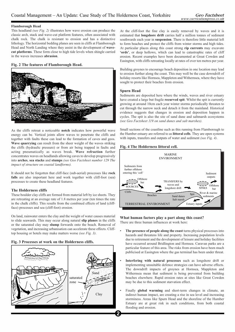
Flamborough HeadThis headland (see Fig. 2) illustrates how wave erosion can produce theclassic arch, stack and wave-cut platform features, often associated withchalk rock. The chalk is resistant to erosion and has a distinctivelithology. The horizontal bedding planes are seen in cliffs at FlamboroughHead and North Landing where they assist in the development of wave-cut platforms. These form close to high tide levels when shingle carriedin the waves increases abrasion.
Fig. 2 The features of Flamborough Head.
As the cliffs retreat a noticeable notch indicates how powerful waveenergy can be. Vertical joints allow waves to penetrate the cliffs andtogether with faults these can lead to the formation of caves and geos.Wave quarrying can result from the sheer weight of the waves strikingthe cliffs (hydraulic pressure) or from air being trapped in faults andacting pneumatically as waves break. Wave refraction furtherconcentrates waves on headlands allowing caves to develop progressivelyinto arches, sea stacks and stumps (see Geo Factsheet number 129 Theimpact of structure on coastal landforms).
It should not be forgotten that cliff-face (sub-aerial) processes like rockfalls are also important here and work together with cliff-foot (sea)processes to create these headland features.
The Holderness cliffs These boulder clay cliffs are formed from material left by ice sheets. Theyare retreating at an average rate of 1.8 metres per year (ten times the ratein the chalk cliffs). This results from the combined effects of land (cliff-face) processes and sea (cliff-foot) erosion.
On land, rainwater enters the clay and the weight of water causes materialto slide seawards. This may occur along natural slip planes in the cliffsor the saturated clay may slump forwards onto the beach. Removal ofvegetation, and increasing urbanisation can accelerate these effects. Cliff-top housing or hotels may make matters worse (see Fig. 3).
Fig. 3 Processes at work on the Holderness cliffs.
At the cliff-foot the fine clay is easily removed by waves and it isestimated that longshore drift carries half a million tonnes of sedimentsouthwards each year in suspension. There is therefore little material leftto form beaches and protect the cliffs from winter storms and high tides.At particular places along this coast strong rip currents may excavate‘ords’, or deep hollows, which can lead to catastrophic rates of clifferosion. Recent examples have been documented at Great Cowden andEasington, with cliffs retreating locally at rates of over ten metres per year.
Building groynes to encourage beach deposition in one location may leadto erosion further along the coast. This may well be the case downdrift ofholiday resorts like Hornsea, Mappleton and Withernsea, where they havesought to protect their beaches from erosion.
Spurn HeadSediments are deposited here where the winds, waves and river estuaryhave created a large but fragile recurved spit. Whilst the spit is currentlygrowing at around 10cm each year winter storms periodically threaten tocut through the narrow neck and detach it from the mainland. Historicalevidence suggests that changes in erosion and deposition happen incycles. The spit is also the site of sand dune and saltmarsh ecosystems(see Geo Factsheet 119 on sand dunes and salt marshes).
Small sections of the coastline such as this running from Flamborough tothe Humber estuary are referred to as littoral cells. They are open systemswith inputs, transfers and outputs of water and sediment (see Fig. 4).
Fig. 4 The Holderness littoral cell.
What human factors play a part along this coast?There are three human influences at work here:
• The presence of people along the coast turns physical processes intohazards and threatens life and property. Increasing population levelsdue to retirement and the development of leisure and holiday facilitieshave occurred around Bridlington and Hornsea. Caravan parks are aparticular feature of this area. The risks from erosion have been muchpublicised at Easington where the gas terminal has been under threat.
• Interfering with natural processes such as longshore drift orimplementing unsuitable defence strategies can have adverse effects.The downdrift impacts of groynes at Hornsea, Mappleton andWithernsea mean that sediment is being prevented from buildingbeaches elsewhere. Rapid erosion rates at sites like Great Cowdenmay be due to this sediment starvation effect.
• Finally global warming and short-term changes in climate, anindirect human impact, are creating a rise in sea level and increasingstorminess. Areas like Spurn Head and the shoreline of the HumberEstuary are at great risk in such conditions, from both coastalflooding and erosion.
2
Geo Factsheetwww.curriculumpress.co.uk
2
Coastal Management – An Update: Case Study of The Holderness Coast, Yorkshire
Sediments fromfurther offshore
entering this ‘cell’ Sedimentoutputs
MARINE ENVIRONMENT
TRANSFERS bywaves and
longshore drift
Offshorebar
SOURCES
CliffsBeaches
TERRESTRIAL ENVIRONMENT Estuary inputs
Sand dunesSalt marsh
Spit
SINKS
River & marinesediments
Sand
Clay
Offshorebar
saturated zone slipping
2
Geo Factsheetwww.curriculumpress.co.uk
3
Coastal Management – An Update: Case Study of The Holderness Coast, Yorkshire
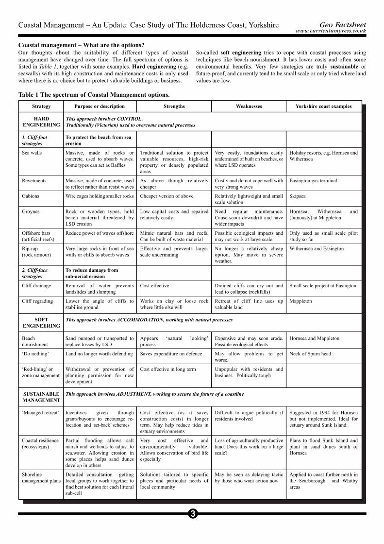
Coastal management – What are the options? Our thoughts about the suitability of different types of coastalmanagement have changed over time. The full spectrum of options islisted in Table 1, together with some examples. Hard engineering (e.g.seawalls) with its high construction and maintenance costs is only usedwhere there is no choice but to protect valuable buildings or business.
Table 1 The spectrum of Coastal Management options.
So-called soft engineering tries to cope with coastal processes usingtechniques like beach nourishment. It has lower costs and often someenvironmental benefits. Very few strategies are truly sustainable orfuture-proof, and currently tend to be small scale or only tried where landvalues are low.
Strategy
HARDENGINEERING
1. Cliff-footstrategies
Sea walls
Revetments
Gabions
Groynes
Offshore bars(artificial reefs)
Rip-rap(rock armour)
2. Cliff-facestrategies
Cliff drainage
Cliff regrading
SOFTENGINEERING
Beachnourishment
‘Do nothing’
‘Red-lining’ orzone management
SUSTAINABLEMANAGEMENT
‘Managed retreat’
Coastal resilience(ecosystems)
Shorelinemanagement plans
Purpose or description
To protect the beach from seaerosion
Massive, made of rocks orconcrete, used to absorb waves.Some types can act as Baffles
Massive, made of concrete, usedto reflect rather than resist waves
Wire cages holding smaller rocks
Rock or wooden types, holdbeach material threatened byLSD erosion
Reduce power of waves offshore
Very large rocks in front of seawalls or cliffs to absorb waves
To reduce damage from sub-aerial erosion
Removal of water preventslandslides and slumping
Lower the angle of cliffs tostabilise ground
Sand pumped or transported toreplace losses by LSD
Land no longer worth defending
Withdrawal or prevention ofplanning permission for newdevelopment
Incentives given throughgrants/buyouts to encourage re-location and ‘set-back’ schemes
Partial flooding allows saltmarsh and wetlands to adjust tosea.water. Allowing erosion insome places helps sand dunesdevelop in others
Detailed consultation gettinglocal groups to work together tofind best solution for each littoralsub-cell
Strengths
Traditional solution to protectvaluable resources, high-riskproperty or densely populatedareas
As above though relativelycheaper
Cheaper version of above
Low capital costs and repairedrelatively easily
Mimic natural bars and reefs.Can be built of waste material
Effective and prevents large-scale undermining
Cost effective
Works on clay or loose rockwhere little else will
Appears ‘natural looking’process
Saves expenditure on defence
Cost effective in long term
Cost effective (as it savesconstruction costs) in longerterm. May help reduce tides inestuary environments
Very cost effective andenvironmentally valuable.Allows conservation of bird lifeespecially
Solutions tailored to specificplaces and particular needs oflocal community
Weaknesses
Very costly, foundations easilyundermined of built on beaches, orwhere LSD operates
Costly and do not cope well withvery strong waves
Relatively lightweight and smallscale solution
Need regular maintenance.Cause scour downdrift and havewider impacts
Possible ecological impacts andmay not work at large scale
No longer a relatively cheapoption. May move in severeweather.
Drained cliffs can dry out andlead to collapse (rockfalls)
Retreat of cliff line uses upvaluable land
Expensive and may soon erode.Possible ecological effects
May allow problems to getworse.
Unpopular with residents andbusiness. Politically tough
Difficult to argue politically ifresidents involved
Loss of agriculturally productiveland. Does this work on a largescale?
May be seen as delaying tacticby those who want action now
Yorkshire coast examples
Holiday resorts, e.g. Hornsea andWithernsea
Easington gas terminal
Skipsea
Hornsea, Withernsea and(famously) at Mappleton
Only used as small scale pilotstudy so far
Withernsea and Easington
Small scale project at Easington
Mappleton
Hornsea and Mappleton
Neck of Spurn head
Suggested in 1994 for Hornseabut not implemented. Ideal forestuary around Sunk Island.
Plans to flood Sunk Island andplant in sand dunes south ofHornsea
Applied to coast further north inthe Scarborough and Whitbyareas
This approach involves ADJUSTMENT, working to secure the future of a coastline
This approach involves CONTROL .Traditionally (Victorian) used to overcome natural processes
This approach involves ACCOMMODATION, working with natural processes
How are coastal management decisions made?Decisions about how to defend each section of a coast can be taken usingvarious types of assessments:
• Cost-benefit analysis considers the social and economic aspects of astrategy. The benefits of a scheme (new businesses or jobs andsavings in lives and property) are divided by the costs of building andmaintaining it.
• Environmental impact assessments try to assess the effects anystrategy will have upon an area. It is especially important along coastlinesas attractive scenery and ecosystems are valuable tourist assets.
• Feasibility studies look at the technical merits of a particular schemeand site. Is the engineering planned suited to the local geology orcoastal processes?
• Risk assessment involves taking decisions in the light of the likelyrecurrence interval and what is at risk. Insurance and legal claims willmake this an important consideration in the future.
• Shoreline management plans (see Table 1, page 3) try to decideupon the most appropriate scheme for each part of a littoral cell, indiscussion with all parties. The mechanism is set out below (Fig. 5).
Fig. 5 Setting up a Shoreline Management Plan.
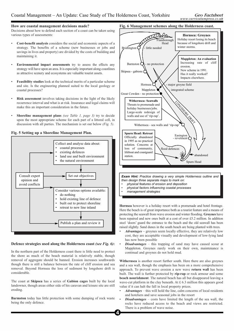
Defence strategies used along the Holderness coast (see Fig. 6):
In the northern part of the Holderness coast there is little need to protectthe shore as much of the beach material is relatively stable, thoughremoval of aggregate should be banned. Erosion increases southwardsthough there is still a balance between the rate of cliff erosion and searemoval. Beyond Hornsea the loss of sediment by longshore drift isconsiderable.
The coast at Skipsea has a series of Gabion cages built by the locallandowner, though areas either side of his caravan and leisure site are stilleroding.
Barmston today has little protection with some dumping of rock wastebeing the only defence.
Fig. 6 Management schemes along the Holderness coast.
Hornsea however is a holiday resort with a promenade and hotel frontage.Here the beach is of great importance both as a tourist feature and a means ofprotecting the seawall from wave erosion and winter flooding. Groynes havebeen repaired and new ones built at a cost of over £5.2 million. In additionsteel ‘doors’ guard the entrance to the beach and the old seawall has beenraised slightly. Sand dunes in the south beach are being planted with trees.• Advantages – groynes seem locally effective, they are relatively low
cost, they are acceptable visually and development of low-lying landhas now been possible
• Disadvantages – this trapping of sand may have caused scour atMappleton. Groynes rarely work on their own, maintenance iscontinual and groynes do not hold mud.
Withernsea is another resort further south. Here there are also groynesand a sea wall, though the emphasis has been on a more comprehensiveapproach. To prevent wave erosion a new wave return wall has beenbuilt. The wall is further protected by rip-rap or rock armour and somebeach nourishment. The natural beach has all but disappeared leaving awave-cut platform in the clay beneath. At £ 6.3 million this appears goodvalue if it can halt the fall in local property prices.• Advantages – this will hold the line, calm concerns of local residents
and hoteliers and save seasonal jobs in the resort• Disadvantages – costs have limited the length of the sea wall, the
rocks have reduced access to the beach and views are restricted.There is a problem of wave noise.
2
Geo Factsheetwww.curriculumpress.co.uk
4
Coastal Management – An Update: Case Study of The Holderness Coast, Yorkshire
Consult expertopinion and
avoid conflicts
Set out objectives
Collect and analyse data about:• coastal processes• existing defences• land use and built environment• the natural environment
Consider various options available:• do nothing• hold existing line of defence• built out to protect shoreline• retreat to new line inland
Publish a plan and review it
Exam Hint: Practice drawing a very simple Holderness outline andthen design three separate maps to mark on:• physical features of erosion and deposition• physical factors influencing coastal processes• management strategies
Bridlington - little needed
Barmston - no protection
Skipsea - gabions
Hornsea - major groyne field
Mappleton - integrated schemeGreat Cowden - no protection
Withernsea - sea walls and ‘rip-rap’
Easington - revetment
flood defences
abandoned
Spurn Head
Mappleton: An evaluationIncreasing rate of clifferosion. New scheme in 1991. Has it really worked?Impacts elsewhere.
Withernsea: SeawallsThreats to promenade andholiday businesses/jobs. Large-scale redesign ofwalls and use of ‘rip-rap’.
Spurn Head: RetreatOfficially abandonedin 1995 as no practicalsolution. Concerns atloss of community,lifeboat and coastguardstation.
FlamboroughHead
LONGSHOREDRIFT
Hornsea: GroynesHoliday resort losing its beachbecause of longshore drift andwinter storms.
Easington is the latest location to receive help. A revetment of rockarmour has been placed at the foot of the cliffs to protect this natural gasterminal which handles 25% of North Sea production. This recent £4.5million scheme remains untested. Though the site qualified for protectionas ‘being in the national interest’, the scheme fails to protect the actualvillage despite a public enquiry. There are important SSSI sites to thesouth and there is considerable conflict with environmental groups.
Spurn Head is a rather different environment from the rest of thecoastline though here again the problem is one of erosion. Themanagement strategy here is perhaps best described as ‘abandonment’.Following successive winters when storms enabled the sea to wash overthe neck of the spit, Holderness Borough Council decided that it could nolonger afford to repair the damage. It was officially abandoned in 1995.• Advantages – the growing annual costs of protection were saved,
some evidence suggests that it may repair itself, and not allenvironmental groups were against it becoming an island. There maybe no other long term solution.
• Disadvantages – the community of lifeboat men and coastguards andtheir families may have to move elsewhere. There may be loss of a‘heritage coast’ site and an important bird habitat (Yorkshire WildlifeTrust)
In the Humber estuary the problem is one of flooding. The predicted risein sea level threatens the half a million or so people who live less thantwo metres above current sea level. In addition the decreasing supplies ofsediment from the Holderness cell and the Humber catchment arereducing the formation of new land. More sustainable solutions such asmanaged retreat near Sunk Island and selective breaching of saltmarshembankments will be needed to reverse recent increases in erosion,salinity and pollution.
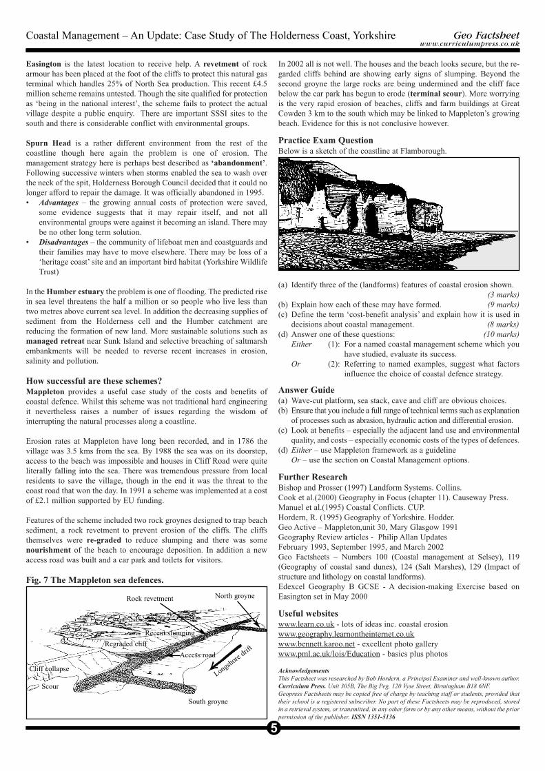
How successful are these schemes?Mappleton provides a useful case study of the costs and benefits ofcoastal defence. Whilst this scheme was not traditional hard engineeringit nevertheless raises a number of issues regarding the wisdom ofinterrupting the natural processes along a coastline.
Erosion rates at Mappleton have long been recorded, and in 1786 thevillage was 3.5 kms from the sea. By 1988 the sea was on its doorstep,access to the beach was impossible and houses in Cliff Road were quiteliterally falling into the sea. There was tremendous pressure from localresidents to save the village, though in the end it was the threat to thecoast road that won the day. In 1991 a scheme was implemented at a costof £2.1 million supported by EU funding.
Features of the scheme included two rock groynes designed to trap beachsediment, a rock revetment to prevent erosion of the cliffs. The cliffsthemselves were re-graded to reduce slumping and there was somenourishment of the beach to encourage deposition. In addition a newaccess road was built and a car park and toilets for visitors.
Fig. 7 The Mappleton sea defences.
In 2002 all is not well. The houses and the beach looks secure, but the re-garded cliffs behind are showing early signs of slumping. Beyond thesecond groyne the large rocks are being undermined and the cliff facebelow the car park has begun to erode (terminal scour). More worryingis the very rapid erosion of beaches, cliffs and farm buildings at GreatCowden 3 km to the south which may be linked to Mappleton’s growingbeach. Evidence for this is not conclusive however.
Practice Exam QuestionBelow is a sketch of the coastline at Flamborough.
(a) Identify three of the (landforms) features of coastal erosion shown. (3 marks)
(b) Explain how each of these may have formed. (9 marks)(c) Define the term ‘cost-benefit analysis’ and explain how it is used in
decisions about coastal management. (8 marks)(d) Answer one of these questions: (10 marks)
Either (1): For a named coastal management scheme which you have studied, evaluate its success.
Or (2): Referring to named examples, suggest what factors influence the choice of coastal defence strategy.
Answer Guide(a) Wave-cut platform, sea stack, cave and cliff are obvious choices.(b) Ensure that you include a full range of technical terms such as explanation
of processes such as abrasion, hydraulic action and differential erosion.(c) Look at benefits – especially the adjacent land use and environmental
quality, and costs – especially economic costs of the types of defences.(d) Either – use Mappleton framework as a guideline
Or – use the section on Coastal Management options.
Further ResearchBishop and Prosser (1997) Landform Systems. Collins.Cook et al.(2000) Geography in Focus (chapter 11). Causeway Press.Manuel et al.(1995) Coastal Conflicts. CUP.Hordern, R. (1995) Geography of Yorkshire. Hodder.Geo Active – Mappleton,unit 30, Mary Glasgow 1991Geography Review articles - Philip Allan UpdatesFebruary 1993, September 1995, and March 2002Geo Factsheets – Numbers 100 (Coastal management at Selsey), 119(Geography of coastal sand dunes), 124 (Salt Marshes), 129 (Impact ofstructure and lithology on coastal landforms).Edexcel Geography B GCSE - A decision-making Exercise based onEasington set in May 2000
Useful websiteswww.learn.co.uk - lots of ideas inc. coastal erosionwww.geography.learnontheinternet.co.ukwww.bennett.karoo.net - excellent photo gallerywww.pml.ac.uk/lois/Education - basics plus photos
AcknowledgementsThis Factsheet was researched by Bob Hordern, a Principal Examiner and well-known author. Curriculum Press. Unit 305B, The Big Peg, 120 Vyse Street, Birmingham B18 6NF. Geopress Factsheets may be copied free of charge by teaching staff or students, provided thattheir school is a registered subscriber. No part of these Factsheets may be reproduced, storedin a retrieval system, or transmitted, in any other form or by any other means, without the priorpermission of the publisher. ISSN 1351-5136
2
Geo Factsheetwww.curriculumpress.co.uk
5
Coastal Management – An Update: Case Study of The Holderness Coast, Yorkshire
Longshore drif
t
Scour
Cliff collapse
Regraded cliff
Recent slumping
South groyne
North groyne
Access road
Rock revetment