Embed Size (px)
Citation preview
© PCI Geomatics Inc. All rights reserved.
Results
Other OBIA Applications
Why Use Object Analyst?
Case Study: Geomatica Object AnalystFeasibility Study on Per Parcel Stormwater Taxation
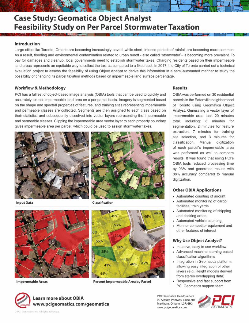
Impermeable Areas
Input Data Classification
Percent Impermeable Area by Parcel
Learn more about OBIAwww.pcigeomatics.com/geomatica
OBIA was performed on 30 residential parcels in the Eatonville neighborhood of Toronto using Geomatica Object Analyst. Generating a vector layer of impermeable area took 20 minutes total, including: 8 minutes for segmentation, 2 minutes for feature extraction, 7 minutes for training site selection, and 3 minutes for classification. Manual digitization of each parcel’s impermeable area was performed as well to compare results. It was found that using PCI’s OBIA tools reduced processing time by 93% and generated results with 88% accuracy compared to manual digitization.
• Automated counting of aircraft• Automated monitoring of cargo
facilities, train yards• Automated monitoring of shipping
and docking areas• Automated vehicle counting• Monitor competitor equipment and
other features of interest
• Intuative, easy to use workflow• Advanced machine learning based
classification algorithms• Integration in Geomatica platform,
allowing easy integration of other layers (e.g. Height models derived from stereo overlapping data)
• Responsive and fast support from PCI Geomatics support team
PCI Geomatics Headquarters 90 Allstate Parkway, Suite 501Markham, Ontario L3R 6H3www.pcigeomatics.com
PCI has a full set of object-based image analysis (OBIA) tools that can be used to quickly and accurately extract impermeable land area on a per parcel basis. Imagery is segmented based on the shape and spectral properties of features, and training sites representing impermeable and permeable classes are collected. Segments are then assigned to each class based on their statistics and subsequently dissolved into vector layers representing the impermeable and permeable classes. Clipping the impermeable area vector layer to each property boundary gives impermeable area per parcel, which could be used to assign stormwater taxes.
Workflow & Methodology
Large cities like Toronto, Ontario are becoming increasingly paved, while short, intense periods of rainfall are becoming more common. As a result, flooding and environmental contamination related to urban runoff - also called “stormwater”- is becoming more prevalent. To pay for damages and cleanup, local governments need to establish stormwater taxes. Charging residents based on their impermeable land areas represents an equitable way to collect the tax, as compared to a fixed cost. In 2017, the City of Toronto carried out a technical evaluation project to assess the feasibility of using Object Analyst to derive this information in a semi-automated manner to study the possibility of changing its parcel taxation methods based on impermeable land surface percentage.
Introduction