Embed Size (px)
Citation preview
Arizona Geological Surveyazgs.arizona.edu | repository.azgs.az.gov
September 2018
CONTRIBUTED REPORT CR-18-J
Jonathan E. FullerDavid P. Meyer
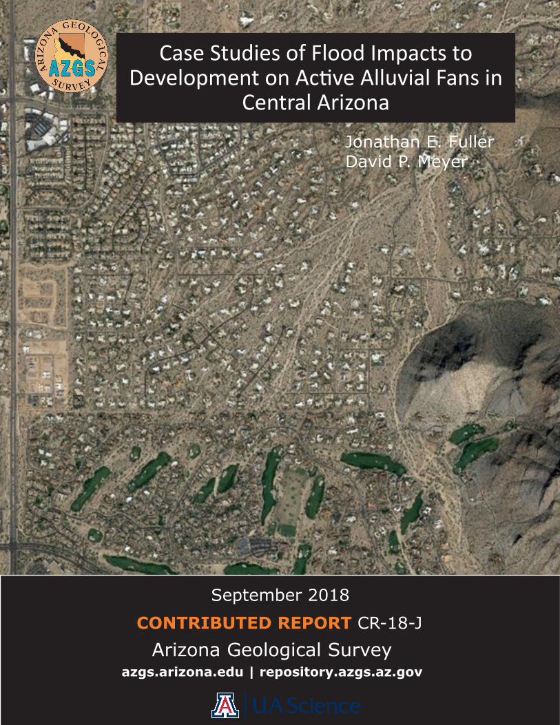
Case Studies of Flood Impacts to Development on Active Alluvial Fans in
Central Arizona
Arizona Geological Survey
Philip A. Pearthree, Director
Manuscript approved for publication in September 2018 Printed by the Arizona Geological Survey
All rights reserved
For an electronic copy of this publication: www.repository.azgs.az.gov
For information on the mission, objectives, or geologic products of the Arizona Geological Survey visit azgs.arizona.edu
This publication was prepared by a department of the University of Arizona. The Univer-sity of Arizona, or any department thereof, or any of their employees, makes no warranty, expressed or implied, or assumes any legal liability or responsibility for the accuracy, completeness, or usefulness of any information, apparatus, product, or process disclosed in this report. Any use of trade, product, or firm names in this publication is for descriptive purposes only and does not imply endorsement by the University of Arizona
Arizona Geological Survey Contributed Report series provides non-AZGS authors with a forum for publishing documents concerning Arizona geology. While review comments may have been incorporated, this document does not necessarily conform to AZGS technical, editorial, or policy standards. The Arizona Geological Survey issues no warranty, expressed or implied, regarding the suitability of this product for a particular use. Moreover, the Arizona Geological Survey shall not be liable under any circumstances for any direct, indi-rect, special, incidental, or consequential damages with respect to claims by users of this product. The author(s) is solely responsible for the data and ideas expressed herein.
___________________________
Recommended Citation: Fuller J.E. and Meyer, D.P., 2018, Case Studies of Flood Impacts to Development on Active Alluvial Fans in Central Arizona. Arizona Geological Survey Contributed Report CR-18-J, 107 p.
Case Studies of Flood Impacts to Development on Active Alluvial Fans in Central AZ p. i
Abstract
Flooding issues and drainage problems associated with historical development on four active alluvial fan
study sites in central Arizona were examined to document the effectiveness of engineered flood protection
measures and floodplain management policies. The study sites are located in the metropolitan Phoenix
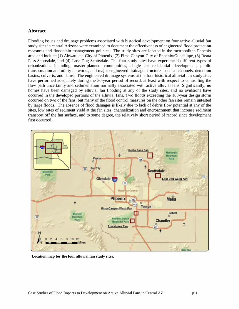
area and include (1) Ahwatukee-City of Phoenix, (2) Pima Canyon-City of Phoenix/Guadalupe, (3) Reata
Pass-Scottsdale, and (4) Lost Dog-Scottsdale. The four study sites have experienced different types of
urbanization, including master-planned communities, single lot residential development, public
transportation and utility networks, and major engineered drainage structures such as channels, detention
basins, culverts, and dams. The engineered drainage systems at the four historical alluvial fan study sites
have performed adequately during the 30-year period of record, at least with respect to controlling the
flow path uncertainty and sedimentation normally associated with active alluvial fans. Significantly, no
homes have been damaged by alluvial fan flooding at any of the study sites, and no avulsions have
occurred in the developed portions of the alluvial fans. Two floods exceeding the 100-year design storm
occurred on two of the fans, but many of the flood control measures on the other fan sites remain untested
by large floods. The absence of flood damages is likely due to lack of debris flow potential at any of the
sites, low rates of sediment yield at the fan sites, channelization and encroachment that increase sediment
transport off the fan surface, and to some degree, the relatively short period of record since development
first occurred.
Location map for the four alluvial fan study sites.
Case Studies of Flood Impacts to Development on Active Alluvial Fans in Central AZ p. 1-1
Table of Contents
1. Introduction .......................................................................................................................... 1-2 1.1 Study Purpose ................................................................................................................ 1-2 1.2 Study Methodology ....................................................................................................... 1-2 1.3 Study Sites ..................................................................................................................... 1-3
2. Ahwatukee Alluvial Fan Site ............................................................................................... 2-1 2.1 Site Description ............................................................................................................. 2-1 2.2 Flood History................................................................................................................. 2-5 2.3 FEMA Alluvial Fan Assessment ................................................................................... 2-5 2.4 Development History .................................................................................................. 2-13
2.5 Flood Hazard Mitigation Measures ............................................................................. 2-18 2.6 Assessment of Flood Control Measures ...................................................................... 2-22
2.7 Conclusions ................................................................................................................. 2-24
3. Pima Canyon Wash Fan Site................................................................................................ 3-1 3.1 Site Description ............................................................................................................. 3-1 3.2 Flood History................................................................................................................. 3-5 3.3 FEMA Alluvial Fan Assessment ................................................................................... 3-5
3.4 Development History .................................................................................................. 3-12 3.5 Flood Hazard Mitigation Measures ............................................................................. 3-18
3.6 Assessment of Flood Control Measures ...................................................................... 3-24 3.7 Conclusions ................................................................................................................. 3-25
4. Reata Pass Fan Site .............................................................................................................. 4-1
4.1 Site Description ............................................................................................................. 4-1 4.2 Flood History................................................................................................................. 4-5
4.3 FEMA Alluvial Fan Assessment ................................................................................... 4-5 4.4 Development History .................................................................................................. 4-13
4.5 Flood Hazard Mitigation Measures ............................................................................. 4-21 4.6 Assessment of Flood Control Measures ...................................................................... 4-27
4.7 Conclusions ................................................................................................................. 4-28 5. Lost Dog Wash Fan Site ...................................................................................................... 5-1
5.1 Site Location ................................................................................................................. 5-1
5.2 Flood History................................................................................................................. 5-5 5.3 FEMA Alluvial Fan Assessment ................................................................................... 5-5 5.4 Development History .................................................................................................. 5-11
5.5 Flood Hazard Mitigation Measures ............................................................................. 5-16 5.6 Assessment of Flood Control Measures ...................................................................... 5-20
5.7 Conclusions ................................................................................................................. 5-20 6. Conclusions .......................................................................................................................... 6-1 7. References ............................................................................................................................ 7-4
Case Studies of Flood Impacts to Development on Active Alluvial Fans in Central AZ p. 1-2
1. Introduction
1.1 Study Purpose
This report documents flooding issues and drainage problems associated with historical
development on active alluvial fans in central Arizona. Active alluvial fans are thought to experience
ultrahazardous flood conditions including debris flows, high velocity flow, excessive sediment
deposition, channel avulsions, channel scour and bank erosion, and unconfined sheet flooding (FEMA,
2002). The Federal Emergency Management Agency (FEMA) requires that communities participating in
the National Flood Insurance Program (NFIP) enforce special development regulations and engineering
design standards to mitigate the risk of these ultrahazardous alluvial fan flooding conditions. However,
some active alluvial fans in Arizona were urbanized prior to implementation of FEMA or local alluvial
fan floodplain management policies and development standards or where not identified as active alluvial
fans during the development process, and therefore were built without specific consideration of special
FEMA or local alluvial fan design guidelines. This study was performed to document if and what types
of flood damages have occurred on four urbanized active alluvial fans, and to determine the level of
effectiveness of the flood protection measures used at each site.
1.2 Study Methodology
The locations of urbanized active alluvial fans in the Phoenix metropolitan area were identified
using historical and recent aerial photographs. The pre-development alluvial fan landforms were then
evaluated using FEMA Stage 1 and Stage 2 classification techniques (FEMA, 2002) to determine whether
they were active alluvial fans prior to urbanization. The study sites selected included active alluvial fans
with dense urbanization, master-planned communities, single lot development, developments with major
structural drainage measures, and/or areas with minimal drainage infrastructure. Study sites were selected
that covered the longest available time periods since their initial development to maximize the chance of
including a wide range of flood magnitudes and frequencies, and to extend the cumulative period of
record.
Systemic and anecdotal information regarding the performance of drainage structures,
maintenance problems, or flood damages was obtained from interviews with local floodplain managers,
maintenance staff, long-term residents, and homeowner’s associations (HOA). In addition, historical and
recent aerial photographs, available construction plans, rainfall and stream gauge records, historical and
recent topography, and field data were evaluated to document the flood history of each study site. The
Case Studies of Flood Impacts to Development on Active Alluvial Fans in Central AZ p. 1-3
evaluation focused on the occurrence of the unique types of flood damages commonly attributed to active
alluvial fan flooding, such as excessive sediment deposition, channel avulsions, unconfined flooding
outside of the defined channel network, and high velocity flooding and erosion.
1.3 Study Sites
The following four study sites were selected (Figure 1-1):
(1) Ahwatukee. The Ahwatukee study site was a relatively small active alluvial fan prior to its
urbanization as part of the Ahwatukee Foothills, a master-planned community located in the southeast
portion of the city of Phoenix. Development on the fan surface included mass grading of active (and
inactive) portions of the piedmont, construction of single-family homes, two large public schools, and
a peak-scalping roller-compacted concrete (RCC) dam, a detention-sedimentation basin, and
channelization of the primary flooding source in a concrete-lined channel. The flood control
measures used are typical of the full structural control approach to alluvial fan floodplain
management, although there is no evidence that the flood control design specifically considered the
existence of potential active alluvial fan flooding processes.
(2) Pima Wash. The Pima Wash study site was a moderate-sized active alluvial fan with a well-
documented history of flood damages prior to its urbanization. The site is located within the city of
Phoenix adjacent to the Town of Guadalupe. Urbanization of the site included construction of
Interstate-10 (I-10), a major regional flood control dam and detention basin called the Guadalupe
Flood Retarding Structure (FRS), a resort and golf course, and several clusters of high-density
townhomes and apartment complexes. The flood control plan for this site included a combination of
full structural engineering and open space approaches to floodplain management.
(3) Reata Pass. The Reata Wash study site is located on a large active alluvial fan in north Scottsdale
that has experienced a range of development types. Near the most active parts of the fan near the
hydrographic apex, development consists of large lot luxury homes laid out in a dispersed pattern that
roughly parallels the alignment of the distributary channels on the fan surface. The medial and distal
parts of the fan have been fully urbanized by large, master-planned communities of varying densities
and which included very detailed engineered flood control plans. In addition, there is a large
subdivision that was platted prior to the implementation of modern floodplain management practices.
The Reata Pass alluvial fan has a complex history of proposed full-fan structural flood control
measures that have not yet been implemented.
Case Studies of Flood Impacts to Development on Active Alluvial Fans in Central AZ p. 1-4
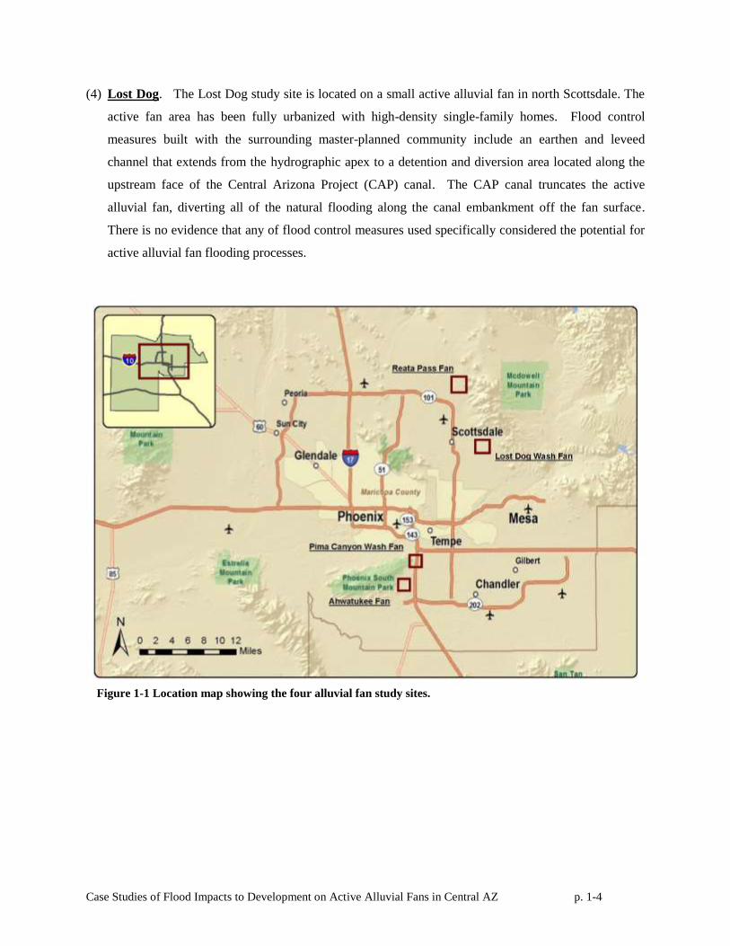
(4) Lost Dog. The Lost Dog study site is located on a small active alluvial fan in north Scottsdale. The
active fan area has been fully urbanized with high-density single-family homes. Flood control
measures built with the surrounding master-planned community include an earthen and leveed
channel that extends from the hydrographic apex to a detention and diversion area located along the
upstream face of the Central Arizona Project (CAP) canal. The CAP canal truncates the active
alluvial fan, diverting all of the natural flooding along the canal embankment off the fan surface.
There is no evidence that any of flood control measures used specifically considered the potential for
active alluvial fan flooding processes.
Figure 1-1 Location map showing the four alluvial fan study sites.
Case Studies of Flood Impacts to Development on Active Alluvial Fans in Central AZ p. 2-1
2. Ahwatukee Alluvial Fan Site
2.1 Site Description
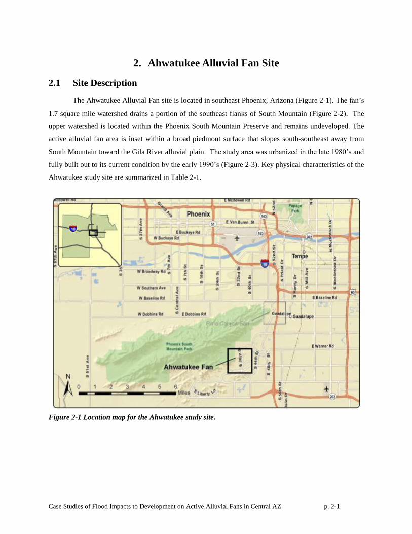
The Ahwatukee Alluvial Fan site is located in southeast Phoenix, Arizona (Figure 2-1). The fan’s
1.7 square mile watershed drains a portion of the southeast flanks of South Mountain (Figure 2-2). The
upper watershed is located within the Phoenix South Mountain Preserve and remains undeveloped. The
active alluvial fan area is inset within a broad piedmont surface that slopes south-southeast away from
South Mountain toward the Gila River alluvial plain. The study area was urbanized in the late 1980’s and
fully built out to its current condition by the early 1990’s (Figure 2-3). Key physical characteristics of the
Ahwatukee study site are summarized in Table 2-1.
Figure 2-1 Location map for the Ahwatukee study site.
Case Studies of Flood Impacts to Development on Active Alluvial Fans in Central AZ p. 2-2
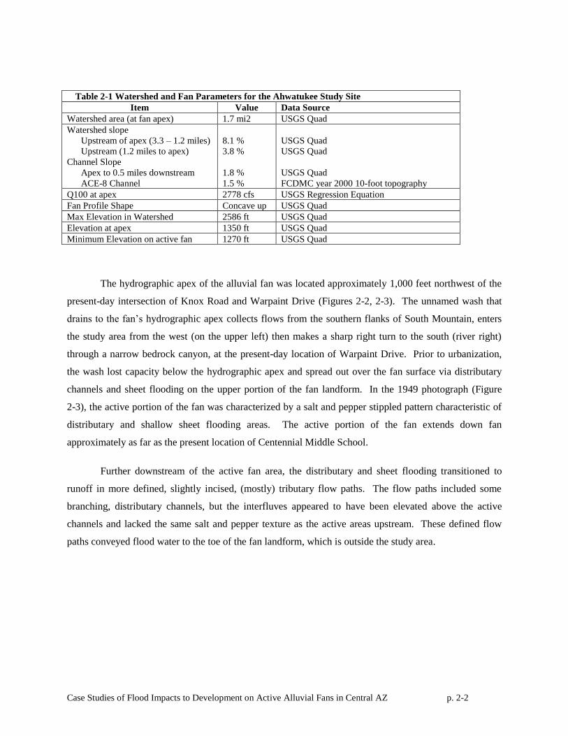
Table 2-1 Watershed and Fan Parameters for the Ahwatukee Study Site
Item Value Data Source
Watershed area (at fan apex) 1.7 mi2 USGS Quad
Watershed slope
Upstream of apex (3.3 – 1.2 miles)
Upstream (1.2 miles to apex)
Channel Slope
Apex to 0.5 miles downstream
ACE-8 Channel
8.1 %
3.8 %
1.8 %
1.5 %
USGS Quad
USGS Quad
USGS Quad
FCDMC year 2000 10-foot topography
Q100 at apex 2778 cfs USGS Regression Equation
Fan Profile Shape Concave up USGS Quad
Max Elevation in Watershed 2586 ft USGS Quad
Elevation at apex 1350 ft USGS Quad
Minimum Elevation on active fan 1270 ft USGS Quad
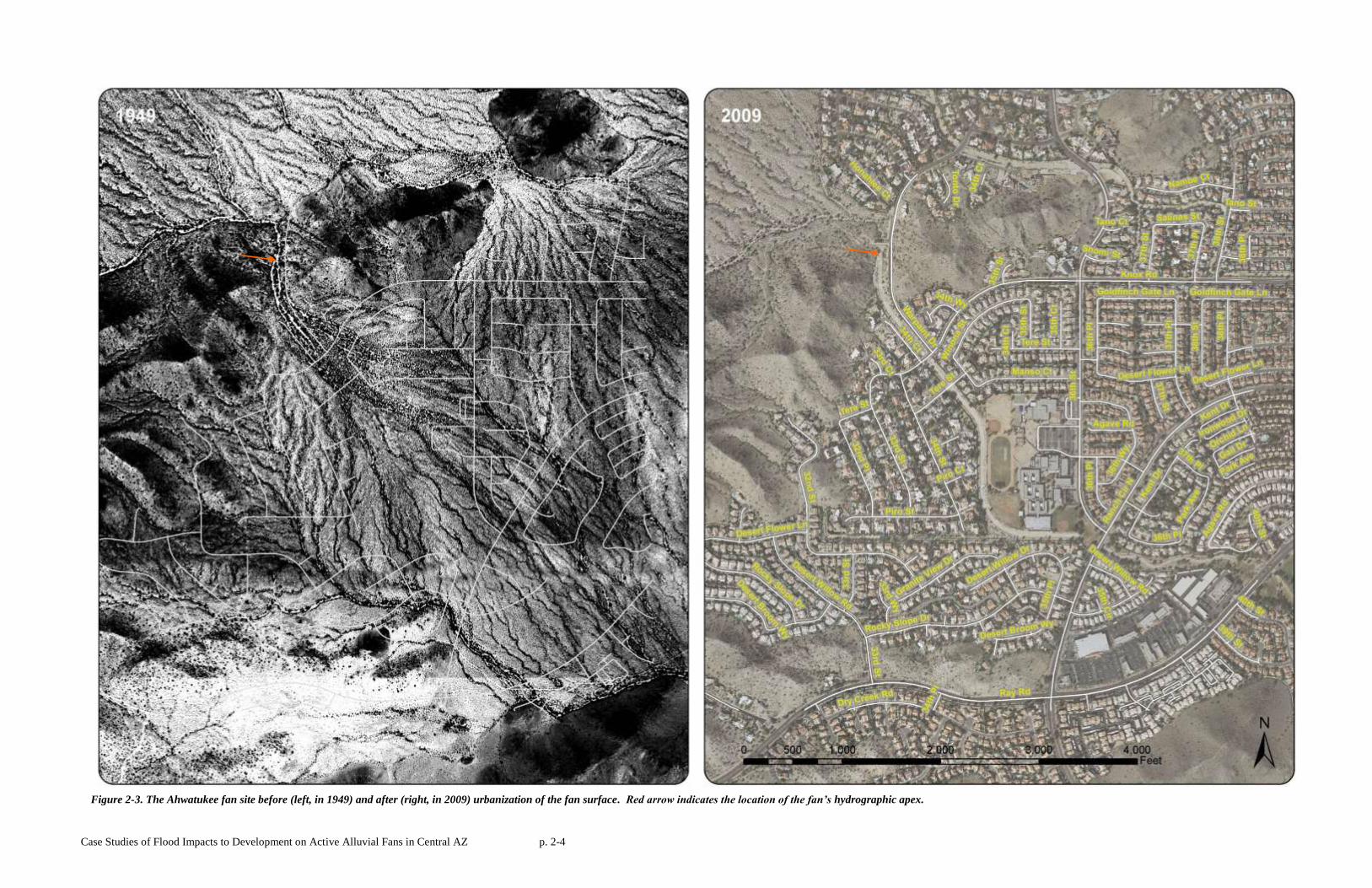
The hydrographic apex of the alluvial fan was located approximately 1,000 feet northwest of the
present-day intersection of Knox Road and Warpaint Drive (Figures 2-2, 2-3). The unnamed wash that
drains to the fan’s hydrographic apex collects flows from the southern flanks of South Mountain, enters
the study area from the west (on the upper left) then makes a sharp right turn to the south (river right)
through a narrow bedrock canyon, at the present-day location of Warpaint Drive. Prior to urbanization,
the wash lost capacity below the hydrographic apex and spread out over the fan surface via distributary
channels and sheet flooding on the upper portion of the fan landform. In the 1949 photograph (Figure
2-3), the active portion of the fan was characterized by a salt and pepper stippled pattern characteristic of
distributary and shallow sheet flooding areas. The active portion of the fan extends down fan
approximately as far as the present location of Centennial Middle School.
Further downstream of the active fan area, the distributary and sheet flooding transitioned to
runoff in more defined, slightly incised, (mostly) tributary flow paths. The flow paths included some
branching, distributary channels, but the interfluves appeared to have been elevated above the active
channels and lacked the same salt and pepper texture as the active areas upstream. These defined flow
paths conveyed flood water to the toe of the fan landform, which is outside the study area.
Case Studies of Flood Impacts to Development on Active Alluvial Fans in Central AZ p. 2-3
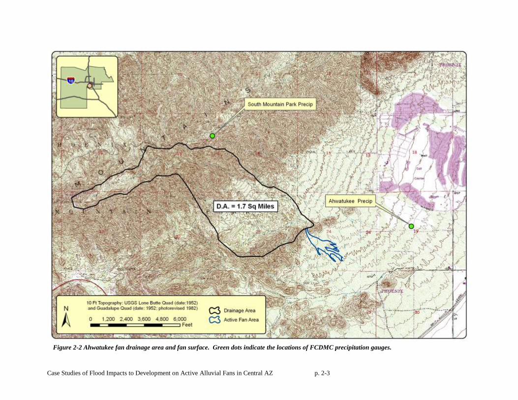
Figure 2-2 Ahwatukee fan drainage area and fan surface. Green dots indicate the locations of FCDMC precipitation gauges.
Case Studies of Flood Impacts to Development on Active Alluvial Fans in Central AZ p. 2-4
Figure 2-3. The Ahwatukee fan site before (left, in 1949) and after (right, in 2009) urbanization of the fan surface. Red arrow indicates the location of the fan’s hydrographic apex.
Case Studies of Flood Impacts to Development on Active Alluvial Fans in Central AZ p. 2-5
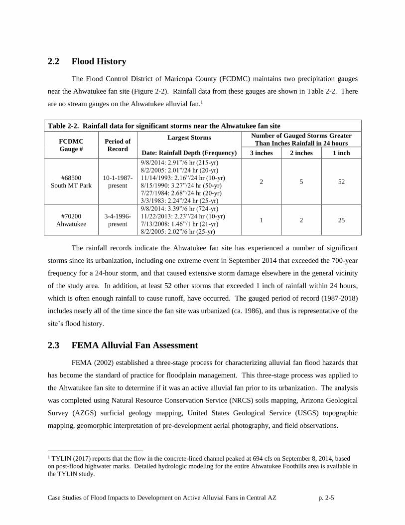
2.2 Flood History
The Flood Control District of Maricopa County (FCDMC) maintains two precipitation gauges
near the Ahwatukee fan site (Figure 2-2). Rainfall data from these gauges are shown in Table 2-2. There
are no stream gauges on the Ahwatukee alluvial fan.1
Table 2-2. Rainfall data for significant storms near the Ahwatukee fan site
FCDMC
Gauge #
Period of
Record
Largest Storms
Date: Rainfall Depth (Frequency)
Number of Gauged Storms Greater
Than Inches Rainfall in 24 hours
3 inches 2 inches 1 inch
#68500
South MT Park
10-1-1987-
present
9/8/2014: 2.91”/6 hr (215-yr)
8/2/2005: 2.01”/24 hr (20-yr)
11/14/1993: 2.16”/24 hr (10-yr)
8/15/1990: 3.27”/24 hr (50-yr)
7/27/1984: 2.68”/24 hr (20-yr)
3/3/1983: 2.24”/24 hr (25-yr)
2 5 52
#70200
Ahwatukee
3-4-1996-
present
9/8/2014: 3.39”/6 hr (724-yr)
11/22/2013: 2.23”/24 hr (10-yr)
7/13/2008: 1.46”/1 hr (21-yr)
8/2/2005: 2.02”/6 hr (25-yr)
1 2 25
The rainfall records indicate the Ahwatukee fan site has experienced a number of significant
storms since its urbanization, including one extreme event in September 2014 that exceeded the 700-year
frequency for a 24-hour storm, and that caused extensive storm damage elsewhere in the general vicinity
of the study area. In addition, at least 52 other storms that exceeded 1 inch of rainfall within 24 hours,
which is often enough rainfall to cause runoff, have occurred. The gauged period of record (1987-2018)
includes nearly all of the time since the fan site was urbanized (ca. 1986), and thus is representative of the
site’s flood history.
2.3 FEMA Alluvial Fan Assessment
FEMA (2002) established a three-stage process for characterizing alluvial fan flood hazards that
has become the standard of practice for floodplain management. This three-stage process was applied to
the Ahwatukee fan site to determine if it was an active alluvial fan prior to its urbanization. The analysis
was completed using Natural Resource Conservation Service (NRCS) soils mapping, Arizona Geological
Survey (AZGS) surficial geology mapping, United States Geological Service (USGS) topographic
mapping, geomorphic interpretation of pre-development aerial photography, and field observations.
1 TYLIN (2017) reports that the flow in the concrete-lined channel peaked at 694 cfs on September 8, 2014, based
on post-flood highwater marks. Detailed hydrologic modeling for the entire Ahwatukee Foothills area is available in
the TYLIN study.
Case Studies of Flood Impacts to Development on Active Alluvial Fans in Central AZ p. 2-6
The FEMA three-stage methodology includes the following steps:
• Stage 1: Landform Determination – This analysis consists of identifying if whether the study area is
an alluvial fan landform or some other type of geomorphic landform, such as an alluvial plain, stable
distributary flow area, pediment, or riverine floodplain. Alluvial fan landforms are identified by their
composition (composed of alluvium), morphology (a fan shape, either partially or fully extended),
and a topographic break (e.g., a mountain front or other loss of lateral containment).
• Stage 2: Active/Inactive Fan Surface Delineation – This analysis consists of identifying geomorphic
surfaces (active) on the alluvial fan landform that are subject to recent (Holocene-aged) alluvial fan
processes such as flood inundation, sediment deposition, channel avulsions, and debris flows, from
inactive surfaces on the fan landform where such processes no longer occur.
• Stage 3: 100-Year Floodplain Delineation. Stage 3 of the FEMA delineation process involves
mapping the 100-year floodplain limits on the active alluvial fan using special, non-riverine mapping
techniques. No Stage 3 delineation was performed for this study, though it is likely that the pre-
development 100-year floodplain was nearly coincident with the active alluvial fan boundaries
identified in the Stage 2 analysis at all four study sites.2
2.3.1 NRCS Soils Mapping
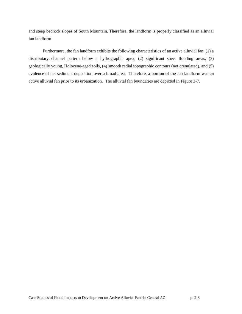
Figure 2-4 shows NRCS (1974) soil survey information for the Ahwatukee Fan study area. In
Figure 2-4, the historically active alluvial fan area delineated from the 1949 aerial is included as a blue
outline on the 2009 aerial photograph background for reference. NRCS soil survey units shown in Figure
2-4 are labeled individually but are grouped by color for each major landform type associated with the
NRCS soil unit.
There are two NRCS soil units found upstream of the fan: Ro (Rock Land) and Ru (Rough
Broken Land). Both these units have been shaded brown in the figure and classified as ‘Mountain
Slopes.’ Rock Land consists of areas that are 50 to 70 percent exposed rock, on steep sloping bedrock
mountain slopes. Rough Broken Land (Ru) is moderately sloping to very steep and is dissected by
intermittent V-shaped natural channels separated by irregular narrow ridges.
The entire alluvial fan landform at the Ahwatukee study site is underlain by the Antho gravelly
sandy loam unit (AoB) and bordered on each side by Tremant gravelly loam (TrB). Antho gravelly sandy
2 Of the four active alluvial fan sites considered in this study, a FEMA alluvial fan floodplain delineation had been
completed prior to urbanization (by others) only for the Reata Pass site.
Case Studies of Flood Impacts to Development on Active Alluvial Fans in Central AZ p. 2-7
loam (AoB) forms on gentle, 1-3 percent slopes, on the upper portions of alluvial fan landforms. Tremant
gravelly loam (TrB) consists of well drained soils on relict and inactive alluvial fans. In Figure 2-4, the
(AoB) Antho Series has been shaded yellow to depict active alluvial fans while the (TrB) Tremant Series
has been shaded blue to depict older, inactive alluvial fans. The Ahwatukee alluvial fan area is composed
of soils typically found on alluvial fans and bordered by older fan terrace soils.
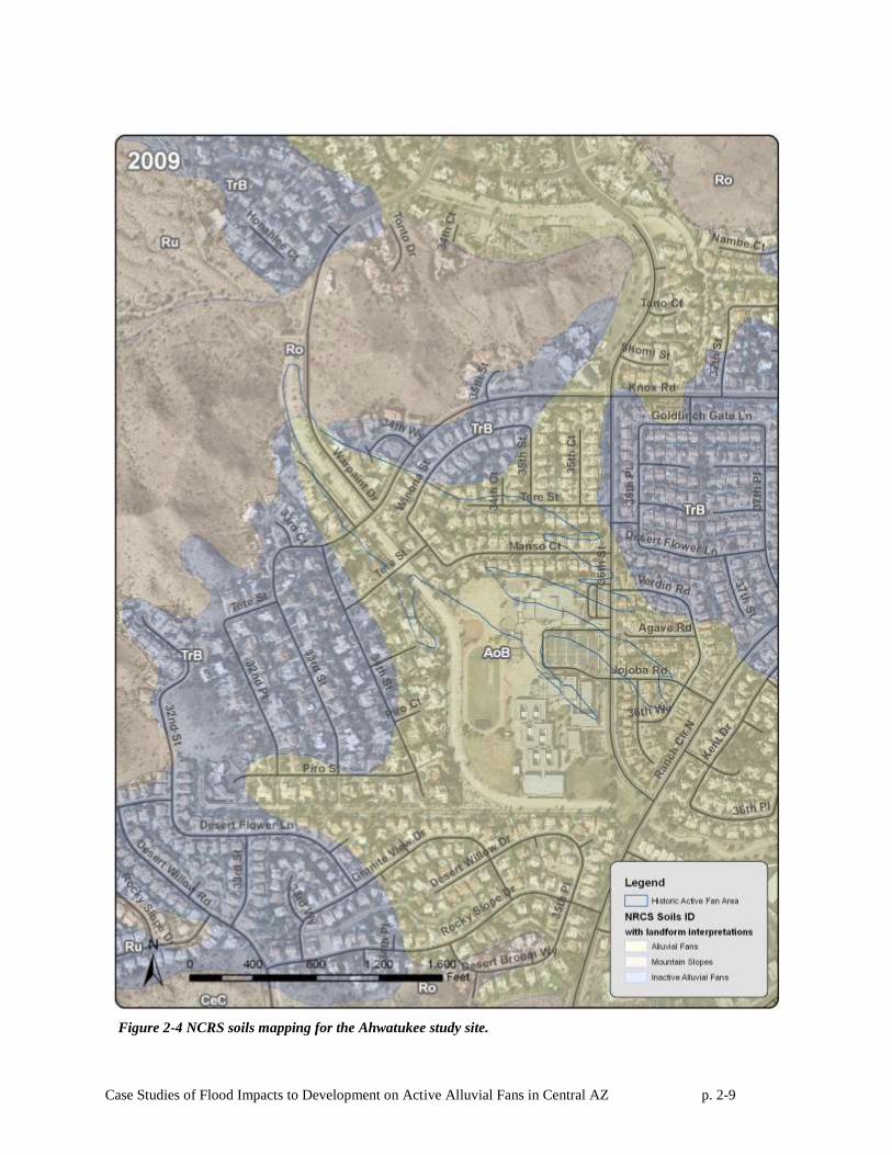
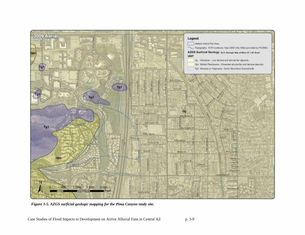
2.3.2 AZGS Surficial Geologic Mapping
Figure 2-5 shows AZGS surficial geologic mapping for the study area (Reynolds and Skotnicki,
1997). Bedrock units in the upper watershed of the study area consist of granite and breccia (Tg and
Tcb). Tg (Tertiary Granite) composes most of the South Mountain Range. Most of the Ahwatukee study
site is underlain by Qy surfaces (Quaternary Young Alluvium), which is described as Holocene-aged, low
terrace and alluvial fan deposits. The Qy unit is bounded by older upper to middle Pleistocene-aged Qm2
surfaces on both the east and the west sides. Qm2 is described as alluvium found on inactive alluvial fan
surfaces.
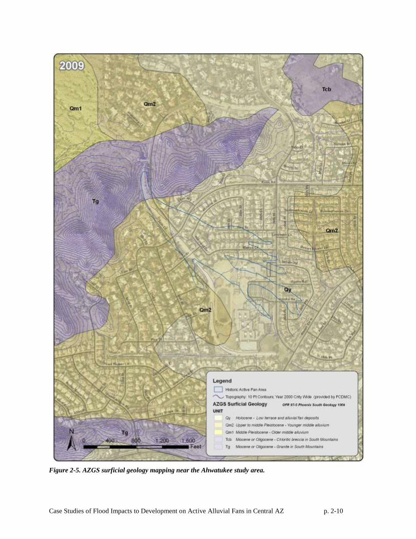
2.3.3 USGS Topographic Mapping
Figure 2-6 shows (pre-development) USGS 10-foot contour interval topographic mapping for the
Ahwatukee study area. The contours immediately downstream of the hydrographic apex of the fan are
smooth, radial in shape and bend in the downstream direction, indicative of an active alluvial fan.
Outside of the active area, the topographic contours become more crenulated indicating more defined
flow paths and older, inactive geomorphic surfaces.
Neither the NRCS or AZGS mapping are of sufficient resolution to accurately map the
boundaries of the active and inactive portions of the alluvial fan landform at the Ahwatukee study area.
Therefore, the delineation was based primarily on the USGS topographic mapping, and geomorphic
interpretation of the pre-development historical aerial photographs.
2.3.4 FEMA Stage 1-Stage 2 Alluvial Fan Classification
Based on the NRCS soils data, AZGS surficial mapping, USGS topographic mapping, and
interpretation of historical aerial photographs, the Ahwatukee alluvial fan was classified as an alluvial fan
landform with active and inactive fan areas using FEMA (2002) guidelines. The site is composed of
alluvium, as shown by the NRCS soils and AZGS mapping. USGS topographic mapping indicate the
presence of radial topographic contours characteristic of a partially extended fan shape. The site is
located at a lateral and vertical topographic break formed where the main wash exits the narrow canyon
Case Studies of Flood Impacts to Development on Active Alluvial Fans in Central AZ p. 2-8
and steep bedrock slopes of South Mountain. Therefore, the landform is properly classified as an alluvial
fan landform.
Furthermore, the fan landform exhibits the following characteristics of an active alluvial fan: (1) a
distributary channel pattern below a hydrographic apex, (2) significant sheet flooding areas, (3)
geologically young, Holocene-aged soils, (4) smooth radial topographic contours (not crenulated), and (5)
evidence of net sediment deposition over a broad area. Therefore, a portion of the fan landform was an
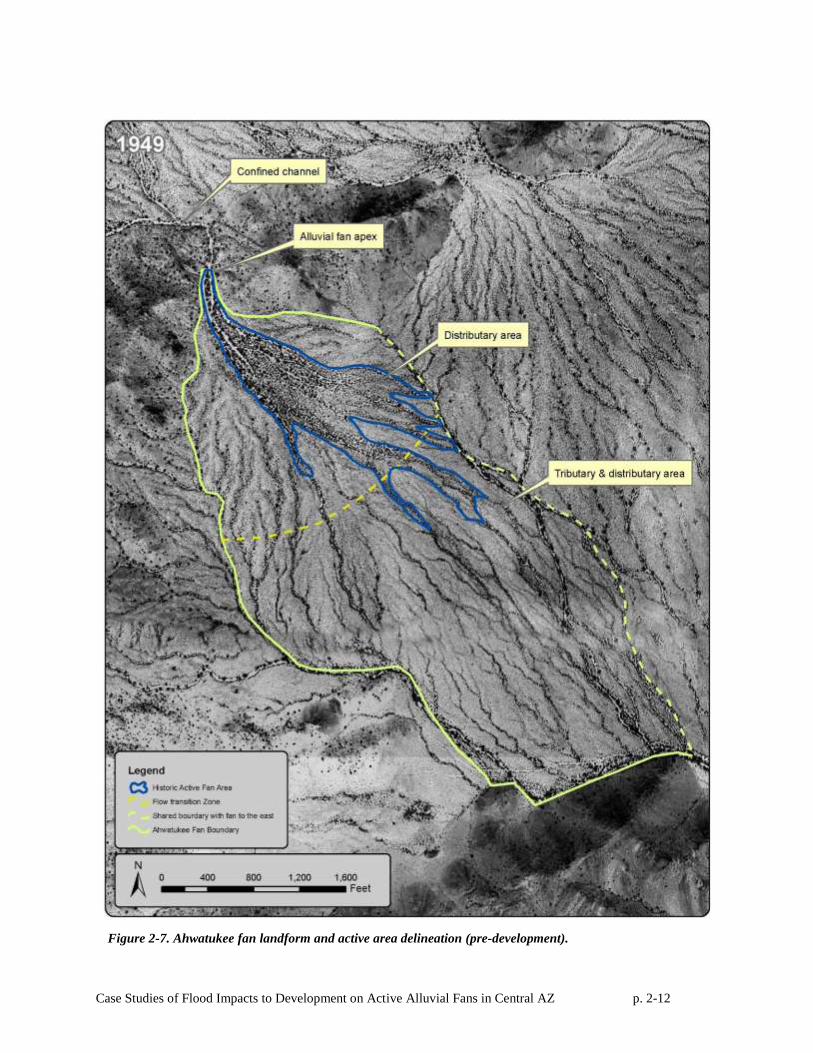
active alluvial fan prior to its urbanization. The alluvial fan boundaries are depicted in Figure 2-7.
Case Studies of Flood Impacts to Development on Active Alluvial Fans in Central AZ p. 2-9
Figure 2-4 NCRS soils mapping for the Ahwatukee study site.
Case Studies of Flood Impacts to Development on Active Alluvial Fans in Central AZ p. 2-10
Figure 2-5. AZGS surficial geology mapping near the Ahwatukee study area.
Case Studies of Flood Impacts to Development on Active Alluvial Fans in Central AZ p. 2-11
Figure 2-6. USGS topographic mapping near the Ahwatukee study area.
Active Fan Area
Inactive Fan Area
Case Studies of Flood Impacts to Development on Active Alluvial Fans in Central AZ p. 2-12
Figure 2-7. Ahwatukee fan landform and active area delineation (pre-development).
Case Studies of Flood Impacts to Development on Active Alluvial Fans in Central AZ p. 2-13
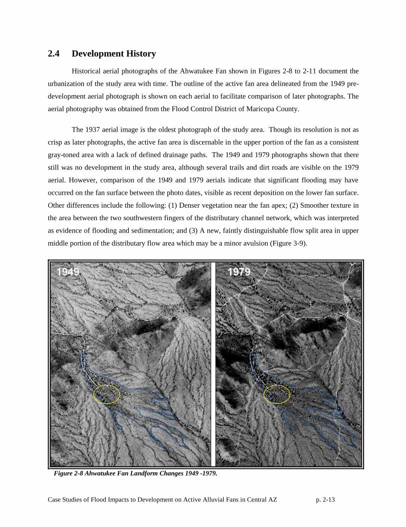
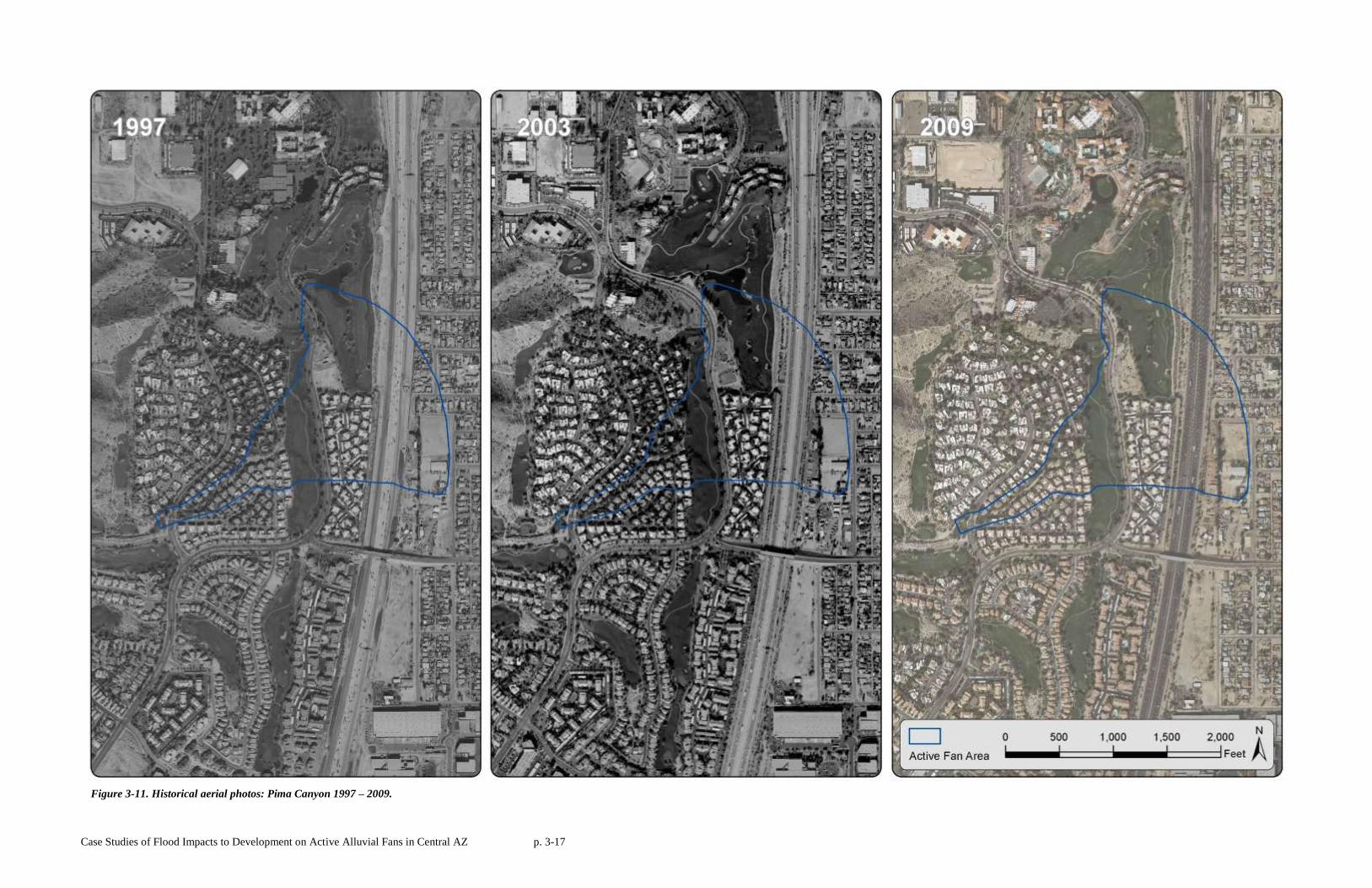
2.4 Development History
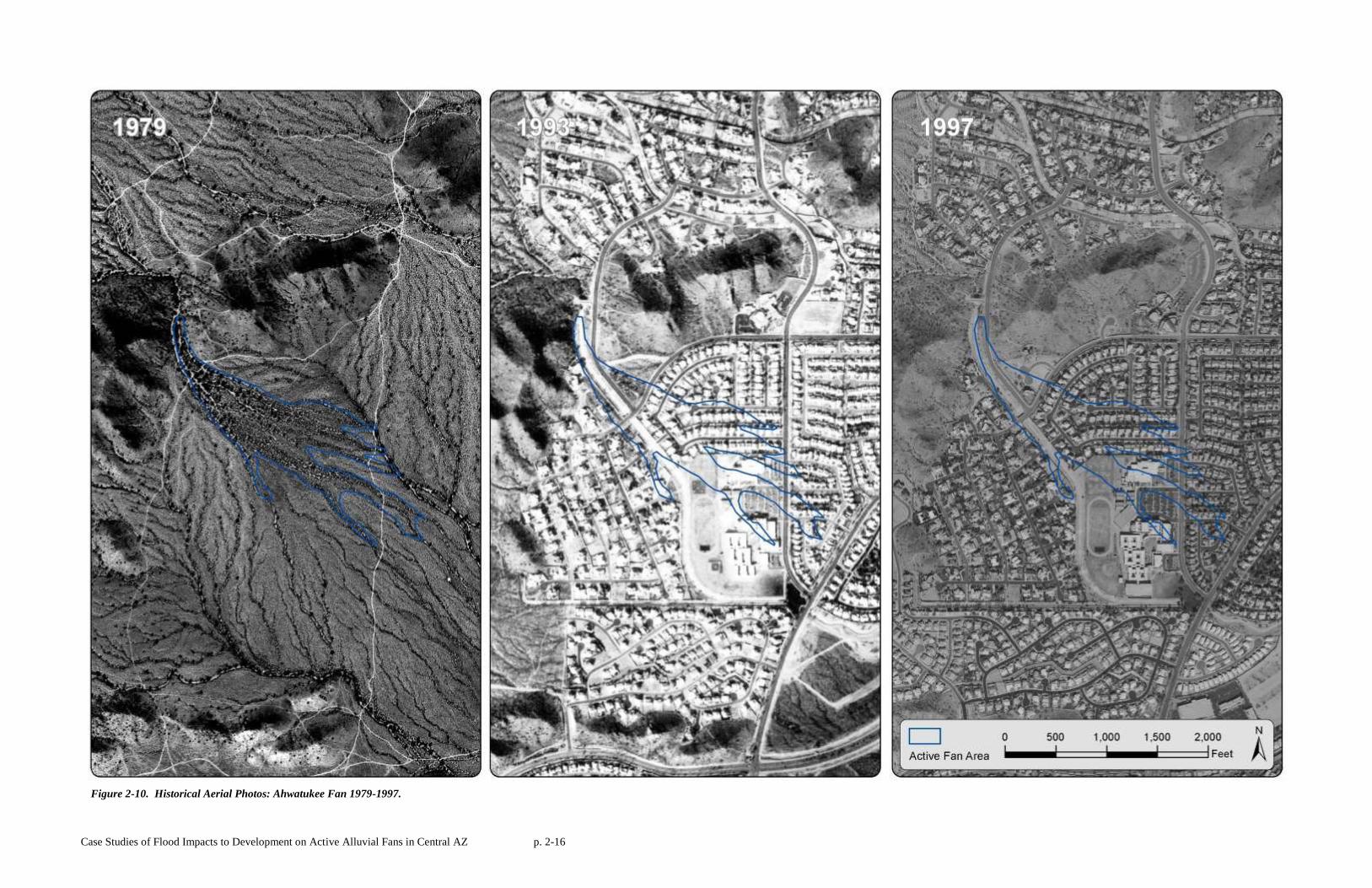
Historical aerial photographs of the Ahwatukee Fan shown in Figures 2-8 to 2-11 document the
urbanization of the study area with time. The outline of the active fan area delineated from the 1949 pre-
development aerial photograph is shown on each aerial to facilitate comparison of later photographs. The
aerial photography was obtained from the Flood Control District of Maricopa County.
The 1937 aerial image is the oldest photograph of the study area. Though its resolution is not as
crisp as later photographs, the active fan area is discernable in the upper portion of the fan as a consistent
gray-toned area with a lack of defined drainage paths. The 1949 and 1979 photographs shown that there
still was no development in the study area, although several trails and dirt roads are visible on the 1979
aerial. However, comparison of the 1949 and 1979 aerials indicate that significant flooding may have
occurred on the fan surface between the photo dates, visible as recent deposition on the lower fan surface.
Other differences include the following: (1) Denser vegetation near the fan apex; (2) Smoother texture in
the area between the two southwestern fingers of the distributary channel network, which was interpreted
as evidence of flooding and sedimentation; and (3) A new, faintly distinguishable flow split area in upper
middle portion of the distributary flow area which may be a minor avulsion (Figure 3-9).
Figure 2-8 Ahwatukee Fan Landform Changes 1949 -1979.
Case Studies of Flood Impacts to Development on Active Alluvial Fans in Central AZ p. 2-14
The Ahwatukee Foothills master-planned community was constructed in the late 1980’s and was
fully built out by the time the 1993 aerial was taken. By 1993, the entire active fan surface was covered
by single family homes, with major roads and channelization measures for storm water conveyance.
Brooks Hersey & Associates Inc. (BHA), the engineering firm listed on the July 1985 Final Plat for
“Ahwatukee Custom Estates-8” (ACE-8) did not have any drainage reports or engineering plan sheets for
the channel, which is identified as “Drainage Tract A” on the Final Plat. Similarly, engineering plans for
a dam built above the hydrographic apex could not be located, but the engineer of record for the
development recalled that the purpose of the roller-compacted concrete (RCC) dam was to reduce flood
peaks to 1600 cfs (Brooks, 2009).
Kyrene de la Colina Elementary School and Centennial Middle School were built on the margins
of the active fan area in 1990, adjacent to the concrete-lined channel. The public school grounds are
maintained by the Kyrene School District, but the homes and drainage channel in the project area are
managed by an HOA called the Ahwatukee Board of Management (ABM).
The 1997 photograph shows continued development south of the project area, with additional
road improvements to 34th Way, which is northeast of the intersection of Knox Road and Warpaint Drive.
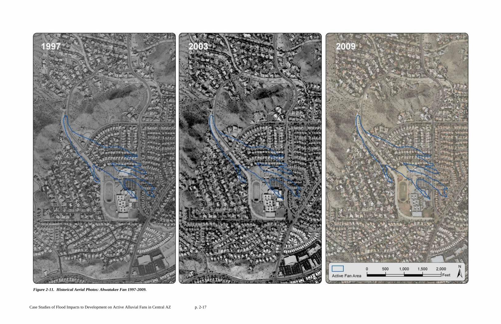
By 2003, the study area had been completely built-out. The study area today is similar to the early 2000’s
and is substantially unchanged with respect to the drainage system.
Case Studies of Flood Impacts to Development on Active Alluvial Fans in Central AZ p. 2-15
Figure 2-9. Historical Aerial Photos: Ahwatukee Fan 1937-1979.
Case Studies of Flood Impacts to Development on Active Alluvial Fans in Central AZ p. 2-16
Figure 2-10. Historical Aerial Photos: Ahwatukee Fan 1979-1997.
Case Studies of Flood Impacts to Development on Active Alluvial Fans in Central AZ p. 2-17
Figure 2-11. Historical Aerial Photos: Ahwatukee Fan 1997-2009.
Case Studies of Flood Impacts to Development on Active Alluvial Fans in Central AZ p. 2-18
2.5 Flood Hazard Mitigation Measures
When the Ahwatukee study site was developed, an engineered drainage system was constructed
across the fan surface that extended from upstream of the hydrograph apex to below the active fan
surface. However, there is no indication that the drainage design specifically considered the fact that the
developed area included an active alluvial fan.
The drainage design included a small, peak-scalping roller-compacted concrete (RCC) dam
upstream of the hydrographic apex and a concrete-lined trapezoidal channel that traverses the fan
landform. The exact year the dam was completed is not known, nor is any of the dam design data
available.3 Neither the design plans nor the party who has jurisdiction over the dam were identified. Both
the City of Phoenix and the homeowner’s association (HOA) deny having jurisdiction over the dam,
although both entities are aware of its existence. From field observations, the RCC dam appears to be
about 20 feet wide at the top, approximately 15 feet high, 120 feet long, and is covered by a thin veneer of
soil that supports a variety of desert scrub vegetation. A two-cell concrete box culvert serves as the
principal outlet and meters flow into the concrete channel located downstream. The dam serves as the
dividing point between the natural wash in the upstream watershed and the engineered channel
downstream.
At the time of our 2009 site visit, there were 10 to 20 boulders each weighing an estimated ton or
more lying in the channel at the dam outlet. Several of these boulders are imbedded in the concrete of
the channel bottom and sides, but others are not. The intended purpose of these boulders at the outlet of
the culverts is not known for certain, but the imbedded ones were probably placed there as energy
dissipaters.
The concrete trapezoidal channel downstream of the dam is locally referred to as the ACE-8
channel, as it runs through the Ahwatukee Custom Estates No.8 Subdivision. The ACE-8 channel crosses
under Knox Road in a concrete box culvert, over Tere Street in a paved dip crossing, and passes west of
Centennial Middle School heading first due south and then due east. As the channel takes a 90 degree
turn left going from south to east it picks up flow from the Piro Channel which joins it from the west.
The Piro channel, runs parallel to Piro St., and picks up local runoff from the development directly west
3 The City of Phoenix does not retain development plans older than 20 years. Thus, development plans for the study
area are not readily available. The Ahwatukee Foothills Area Drainage Master Study (TYLIN, 2017) mentions the
existence of the dam and channel, but provides no engineering analysis of either structure, except to note that the
channel appears to have been designed for supercritical flow. The ADMS does, however, note that N. Ranch Circle
Drive is overtopped by the 100-year flood and recommends flood control improvements at that location.
Case Studies of Flood Impacts to Development on Active Alluvial Fans in Central AZ p. 2-19
of the active fan area. After the channel turns east at the south side of Centennial Middle School, the
channel drops into an engineered grass-lined, multi-use detention basin. The channel entrance to the
detention basin was designed and built with a four-foot drop structure.
Downstream of Ranch Circle Drive, flow enters an engineered rip-rap-lined channel owned by
Mountain Park Ranch HOA. From there, the flow is conveyed across the lower piedmont for
approximately two miles through a series of channels owned by HOA’s, ultimately daylighting south of
Pecos Road, at which point the channel flows into fallow agricultural rangeland on Gila River Indian
Community land (GRIC) that lacks any engineered drainage facilities or obvious natural flow paths.
Interestingly, while the concrete-lined channel upstream of Ranch Circle North follows the natural
channel alignment immediately downstream of the apex, it deviates significantly from the natural channel
alignment after about 2,000 feet and follows a completely man-made alignment thereafter.
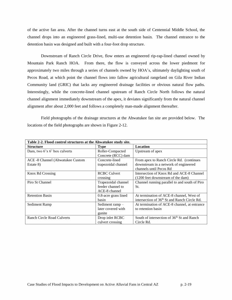
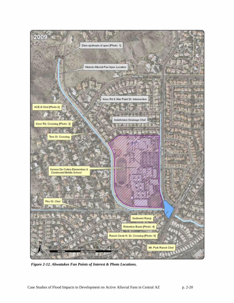
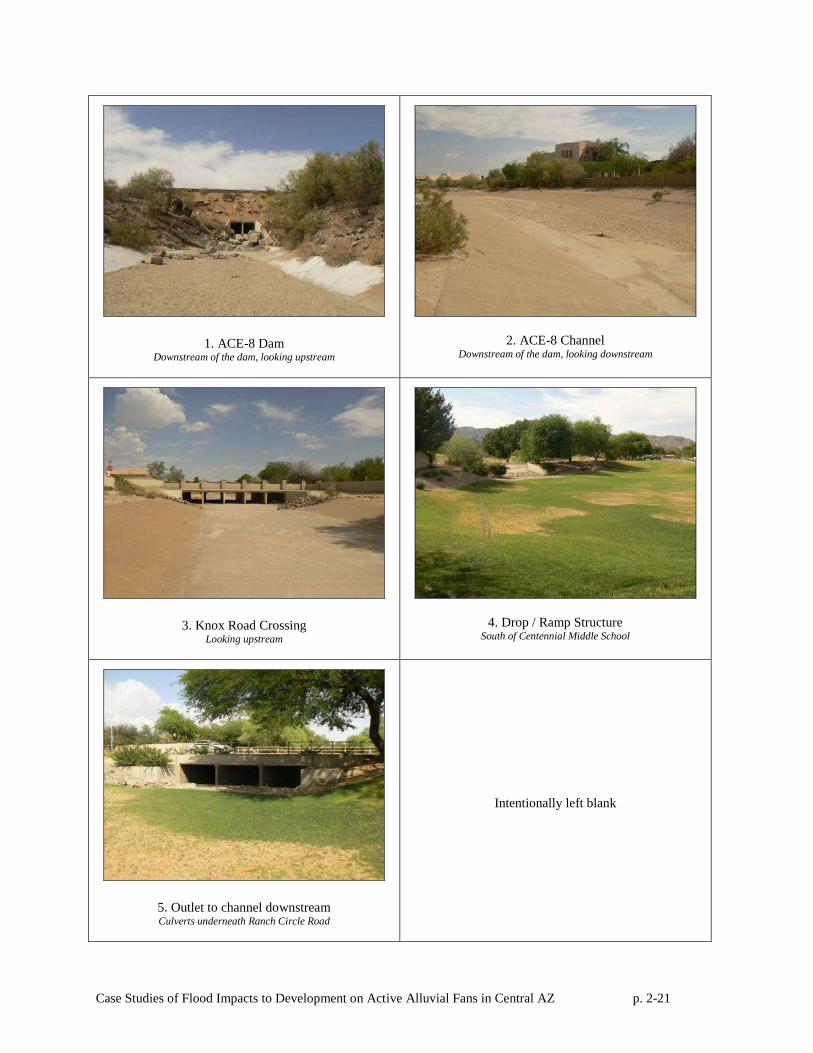
Field photographs of the drainage structures at the Ahwatukee fan site are provided below. The
locations of the field photographs are shown in Figure 2-12.
Table 2-2. Flood control structures at the Ahwatukee study site.
Structure Type Location
Dam, two 6’x 6’ box culverts Roller-Compacted
Concrete (RCC) dam
Upstream of apex
ACE -8 Channel (Ahwatukee Custom
Estate 8)
Concrete-lined
trapezoidal channel
From apex to Ranch Circle Rd. (continues
downstream in a network of engineered
channels until Pecos Rd
Knox Rd Crossing RCBC Culvert
crossing
Intersection of Knox Rd and ACE-8 Channel
(1200 feet downstream of the dam)
Piro St Channel Trapezoidal channel
feeder channel to
ACE-8 channel
Channel running parallel to and south of Piro
St.
Retention Basin
0.8-acre grass lined
basin
At termination of ACE-8 channel, West of
intersection of 36th St and Ranch Circle Rd.
Sediment Ramp Sediment ramp –
later covered with
gunite
At termination of ACE-8 channel, at entrance
to retention basin
Ranch Circle Road Culverts Drop inlet RCBC
culvert crossing
South of intersection of 36th St and Ranch
Circle Rd.
Case Studies of Flood Impacts to Development on Active Alluvial Fans in Central AZ p. 2-20
Figure 2-12. Ahwatukee Fan Points of Interest & Photo Locations.
Case Studies of Flood Impacts to Development on Active Alluvial Fans in Central AZ p. 2-21
1. ACE-8 Dam Downstream of the dam, looking upstream
2. ACE-8 Channel Downstream of the dam, looking downstream
3. Knox Road Crossing Looking upstream
4. Drop / Ramp Structure South of Centennial Middle School
5. Outlet to channel downstream Culverts underneath Ranch Circle Road
Intentionally left blank
Case Studies of Flood Impacts to Development on Active Alluvial Fans in Central AZ p. 2-22
2.6 Assessment of Flood Control Measures
The drainage facilities at the Ahwatukee study site have a documented history of sediment
maintenance and localized flood damage, although the system seems to have performed adequately and
without damage to individual homes and without major interruptions of public and private infrastructure.
The drainage system has been tested by at least two large storm event that approached the magnitude of a
100-year event based on crude post-flood stage estimates, though rainfall measurements at the FCDMC
gages during one of these events were significantly less than 100-year depths.
The RCC dam appears to have functioned as designed. Interestingly, unlike the downstream
concrete-lined channel, there has been no sediment deposition in the impoundment area and no known
sediment maintenance upstream of the dam, even after the 700-year flood in 2014. The lack of sediment
deposition above the dam is probably due to the 6’x6’ size of the RCB culvert outlets that only rarely
create backwater conditions that would induce sediment deposition and allow sediment flushing to occur
during smaller events.
Downstream of the dam for approximately 100 yards, sediment drops out in a series of sandy
deltaic deposits within the concrete-lined channel. The privately-run ABM is responsible for the ACE-8
channel maintenance from the dam outlet to where the wash crosses East Ranch Circle North. According
to ABM staff, routine maintenance on the channel is done twice a year and involves removing sediment
from the channel and inspecting for damage and debris. Sediment is removed from the channel bottom
and graded out onto the overbank area, effectively removing it from the channel system. It is estimated
that 10 - 15 cubic yards of sediment are removed from the channel per year. Sediment deposition in the
ACE-8 channel is somewhat surprising, given that the channel is quite steep (~2%), is of uniform width,
and was designed to flow at supercritical velocities. The sediment deposition apparently has not resulted
in any substantive loss of channel capacity during floods, since it has reportedly never overtopped, even
during the extreme event in 2014.
However, in 2005 the flow had enough force to displace and carry as many as ten 6-8 ton
boulders from the rock dissipater at the dam outlet a distance of about 1,500 feet downstream, as well as
many smaller 3-4 ton boulders downstream as far as Centennial Middle School, several thousand feet
downstream of the dam. One large boulder was still lodged in the culvert under North Ranch Circle
Drive five years after the 2005 event. In addition, approximately 200 feet of the channel bottom and sides
were ripped out and damaged by the floodwaters and a large quantity of sediment was also deposited in
the channel. In the 2014 event, nearly 20 truckloads of sediment were removed from the channel after the
flood.
Case Studies of Flood Impacts to Development on Active Alluvial Fans in Central AZ p. 2-23
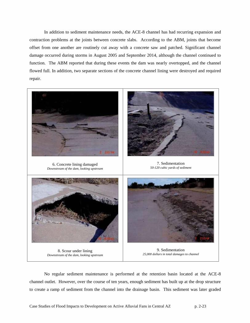
In addition to sediment maintenance needs, the ACE-8 channel has had recurring expansion and
contraction problems at the joints between concrete slabs. According to the ABM, joints that become
offset from one another are routinely cut away with a concrete saw and patched. Significant channel
damage occurred during storms in August 2005 and September 2014, although the channel continued to
function. The ABM reported that during these events the dam was nearly overtopped, and the channel
flowed full. In addition, two separate sections of the concrete channel lining were destroyed and required
repair.
6. Concrete lining damaged Downstream of the dam, looking upstream
7. Sedimentation 50-120 cubic yards of sediment
8. Scour under lining Downstream of the dam, looking upstream
9. Sedimentation 25,000 dollars in total damages to channel
No regular sediment maintenance is performed at the retention basin located at the ACE-8
channel outlet. However, over the course of ten years, enough sediment has built up at the drop structure
to create a ramp of sediment from the channel into the drainage basin. This sediment was later graded
Case Studies of Flood Impacts to Development on Active Alluvial Fans in Central AZ p. 2-24
and gunite was laid over the ramp, effectively eliminating the drop structure. The volume of sediment
stored in the ramp structure is estimated at about 7.4 cubic yards.
The channel downstream of the ACE-8 channel is a trapezoidal rock-lined channel. The
downstream channel owner, Mountain Park Ranch HOA, did not report sedimentation problems or
maintenance needs with their section of the channel.
2.7 Conclusions
Based on our analysis, we conclude that the engineered drainage system has performed
adequately during the nearly 30-year period of record, at least with respect to controlling the flow
uncertainty and sedimentation associated with active alluvial fan flooding. No homes or structures on or
around the fan have been flooded in the past 20 years. The concrete-lined channel, despite flowing full
and being damaged during the August 2005 and September 2014 events, has never overtopped.
Sedimentation in the channel and expansion / contraction issues surrounding the channel joints are
problems that are addressed routinely by a private homeowner’s association. Sediment maintenance
reported is only required in the upper portion of the channel system, with no maintenance reported
downstream of North Ranch Circle Drive.
Case Studies of Flood Impacts to Development on Active Alluvial Fans in Central AZ p. 3-1
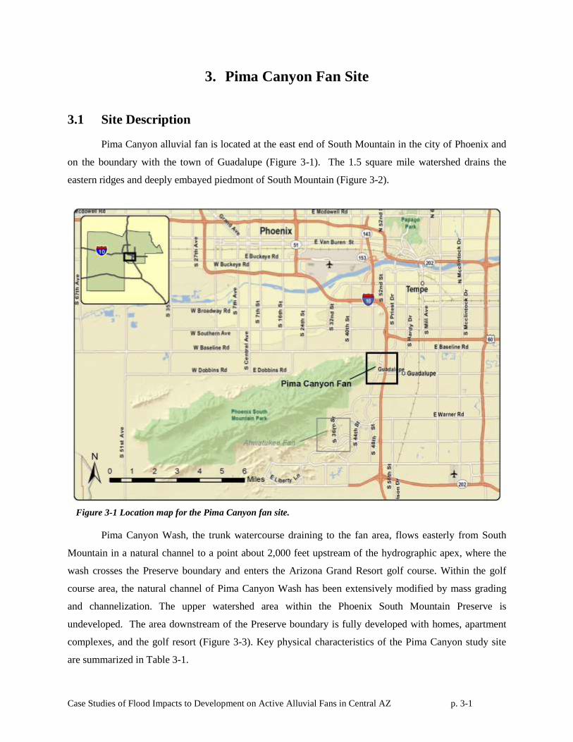
3. Pima Canyon Fan Site
3.1 Site Description
Pima Canyon alluvial fan is located at the east end of South Mountain in the city of Phoenix and
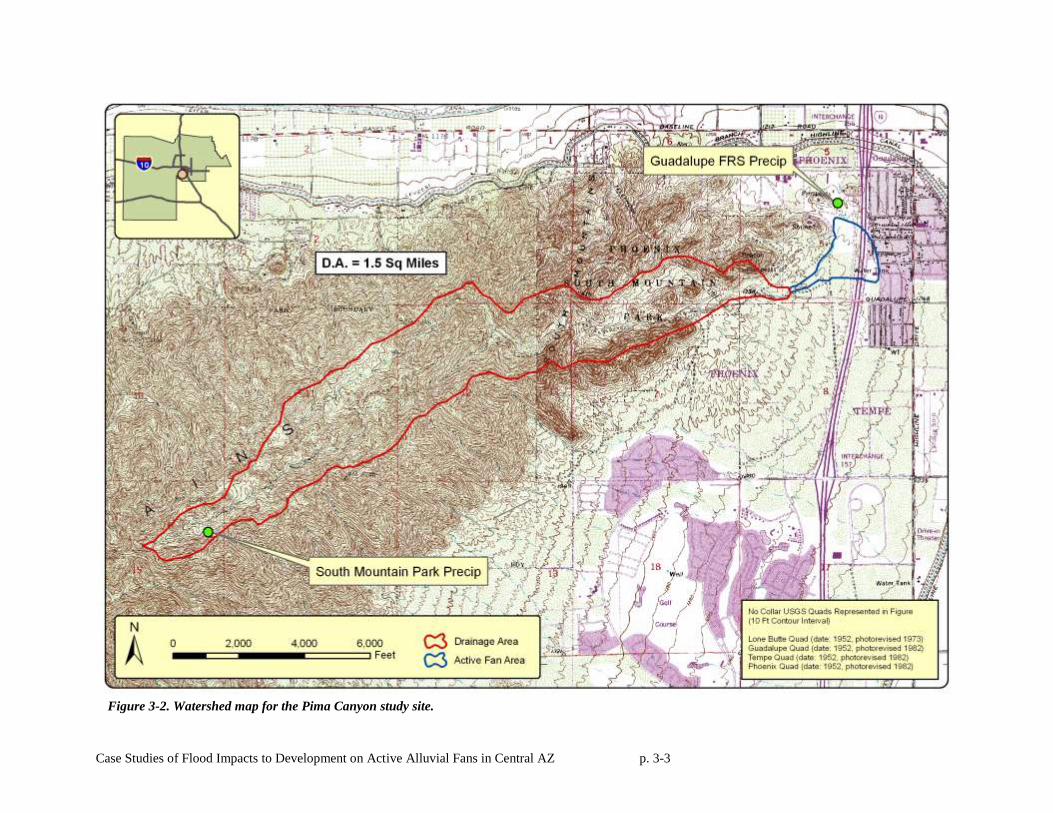
on the boundary with the town of Guadalupe (Figure 3-1). The 1.5 square mile watershed drains the
eastern ridges and deeply embayed piedmont of South Mountain (Figure 3-2).
Figure 3-1 Location map for the Pima Canyon fan site.
Pima Canyon Wash, the trunk watercourse draining to the fan area, flows easterly from South
Mountain in a natural channel to a point about 2,000 feet upstream of the hydrographic apex, where the
wash crosses the Preserve boundary and enters the Arizona Grand Resort golf course. Within the golf
course area, the natural channel of Pima Canyon Wash has been extensively modified by mass grading
and channelization. The upper watershed area within the Phoenix South Mountain Preserve is
undeveloped. The area downstream of the Preserve boundary is fully developed with homes, apartment
complexes, and the golf resort (Figure 3-3). Key physical characteristics of the Pima Canyon study site
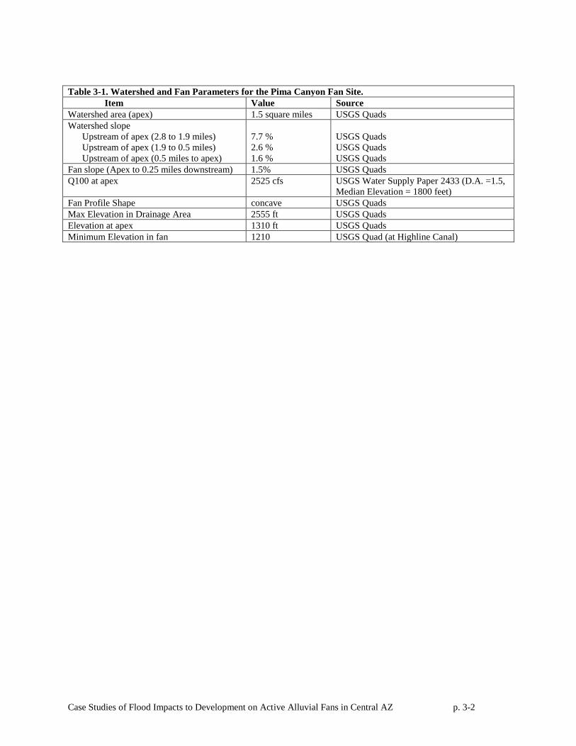
are summarized in Table 3-1.
Case Studies of Flood Impacts to Development on Active Alluvial Fans in Central AZ p. 3-2
Table 3-1. Watershed and Fan Parameters for the Pima Canyon Fan Site.
Item Value Source
Watershed area (apex) 1.5 square miles USGS Quads
Watershed slope
Upstream of apex (2.8 to 1.9 miles)
Upstream of apex (1.9 to 0.5 miles)
Upstream of apex (0.5 miles to apex)
7.7 %
2.6 %
1.6 %
USGS Quads
USGS Quads
USGS Quads
Fan slope (Apex to 0.25 miles downstream) 1.5% USGS Quads
Q100 at apex 2525 cfs USGS Water Supply Paper 2433 (D.A. =1.5,
Median Elevation = 1800 feet)
Fan Profile Shape concave USGS Quads
Max Elevation in Drainage Area 2555 ft USGS Quads
Elevation at apex 1310 ft USGS Quads
Minimum Elevation in fan 1210 USGS Quad (at Highline Canal)
Case Studies of Flood Impacts to Development on Active Alluvial Fans in Central AZ p. 3-3
Figure 3-2. Watershed map for the Pima Canyon study site.
Case Studies of Flood Impacts to Development on Active Alluvial Fans in Central AZ p. 3-4
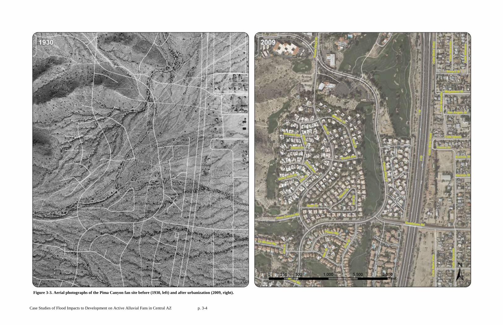
Figure 3-3. Aerial photographs of the Pima Canyon fan site before (1930, left) and after urbanization (2009, right).
Case Studies of Flood Impacts to Development on Active Alluvial Fans in Central AZ p. 3-5
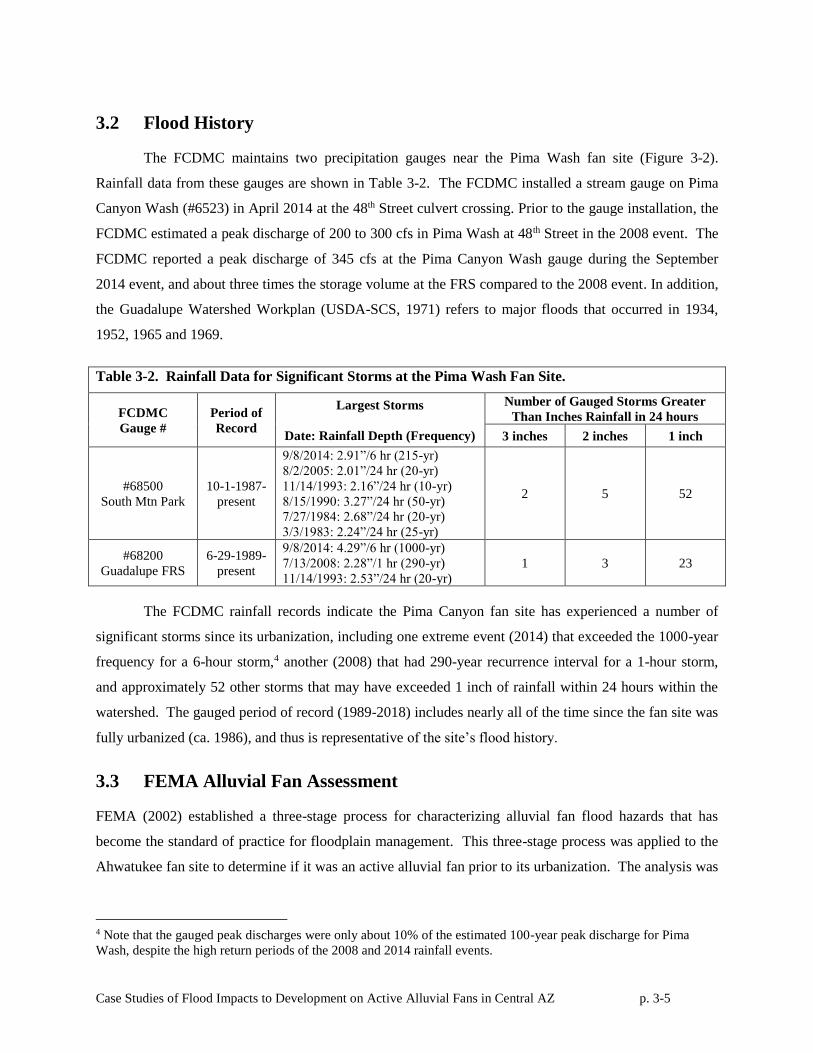
3.2 Flood History
The FCDMC maintains two precipitation gauges near the Pima Wash fan site (Figure 3-2).
Rainfall data from these gauges are shown in Table 3-2. The FCDMC installed a stream gauge on Pima
Canyon Wash (#6523) in April 2014 at the 48th Street culvert crossing. Prior to the gauge installation, the
FCDMC estimated a peak discharge of 200 to 300 cfs in Pima Wash at 48th Street in the 2008 event. The
FCDMC reported a peak discharge of 345 cfs at the Pima Canyon Wash gauge during the September
2014 event, and about three times the storage volume at the FRS compared to the 2008 event. In addition,
the Guadalupe Watershed Workplan (USDA-SCS, 1971) refers to major floods that occurred in 1934,
1952, 1965 and 1969.
Table 3-2. Rainfall Data for Significant Storms at the Pima Wash Fan Site.
FCDMC
Gauge #
Period of
Record
Largest Storms
Date: Rainfall Depth (Frequency)
Number of Gauged Storms Greater
Than Inches Rainfall in 24 hours
3 inches 2 inches 1 inch
#68500
South Mtn Park
10-1-1987-
present
9/8/2014: 2.91”/6 hr (215-yr)
8/2/2005: 2.01”/24 hr (20-yr)
11/14/1993: 2.16”/24 hr (10-yr)
8/15/1990: 3.27”/24 hr (50-yr)
7/27/1984: 2.68”/24 hr (20-yr)
3/3/1983: 2.24”/24 hr (25-yr)
2 5 52
#68200
Guadalupe FRS
6-29-1989-
present
9/8/2014: 4.29”/6 hr (1000-yr)
7/13/2008: 2.28”/1 hr (290-yr)
11/14/1993: 2.53”/24 hr (20-yr)
1 3 23
The FCDMC rainfall records indicate the Pima Canyon fan site has experienced a number of
significant storms since its urbanization, including one extreme event (2014) that exceeded the 1000-year
frequency for a 6-hour storm,4 another (2008) that had 290-year recurrence interval for a 1-hour storm,
and approximately 52 other storms that may have exceeded 1 inch of rainfall within 24 hours within the
watershed. The gauged period of record (1989-2018) includes nearly all of the time since the fan site was
fully urbanized (ca. 1986), and thus is representative of the site’s flood history.
3.3 FEMA Alluvial Fan Assessment
FEMA (2002) established a three-stage process for characterizing alluvial fan flood hazards that has
become the standard of practice for floodplain management. This three-stage process was applied to the
Ahwatukee fan site to determine if it was an active alluvial fan prior to its urbanization. The analysis was
4 Note that the gauged peak discharges were only about 10% of the estimated 100-year peak discharge for Pima
Wash, despite the high return periods of the 2008 and 2014 rainfall events.

Case Studies of Flood Impacts to Development on Active Alluvial Fans in Central AZ p. 3-6
completed using NRCS soils mapping, AZGS surficial geology mapping, USGS topographic mapping,
geomorphic interpretation of pre-development aerial photography, and field observations.
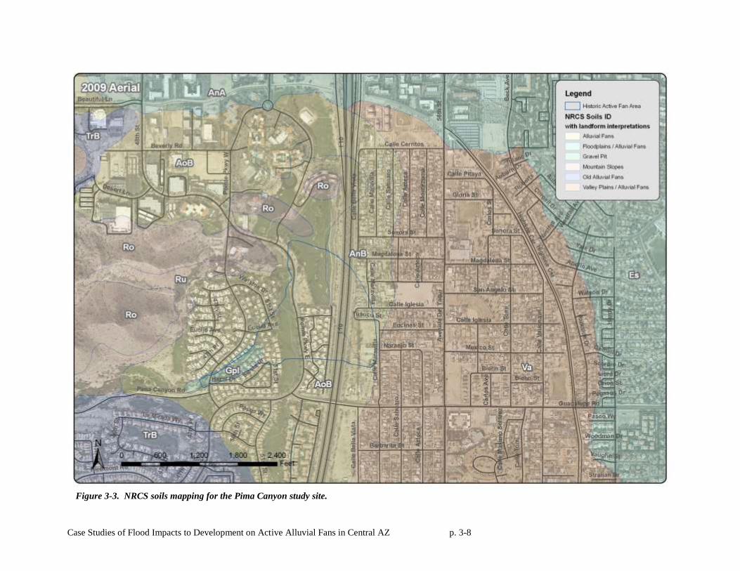
3.3.1 NRCS Soils Mapping
Figure 3-3 shows the NRCS (1974) soils mapping for the Pima Canyon study area. In Figure 3-3,
individual NRCS soil units are labeled individually, but are grouped by color into the major landform
categories associated with the NRCS soil units. The entire alluvial fan landform is underlain by the Antho
soil series, AoB and AnB. The Antho series is typically found on alluvial fans and consists of well-
drained soils with shallow slopes (0-3%). AnB (Antho sandy loam), found at the toe of the fan, typically
forms on alluvial fans. AoB (Antho gravelly sandy loam), while very similar to AnB, has between 15-35
% gravel by volume and is typically found on the upper portions of alluvial fans. The Antho series is
bordered on the east by the Valencia sandy loam (Va), a well-drained soil series found on valley plains
and alluvial fans, and to the southwest by the Tremant gravelly loam (TrB), a well-drained soil on
inactive alluvial fans. The TrB is shaded light blue on Figure 3-4.
The upper watershed is underlain by Rock Land ‘Ro’ and Rough Broken Land ‘Ru’ soil units.
Both these units have been shaded brown on Figure 3-4 to represent mountain slopes. Rock Land
consists of areas that are 50 to 70 percent exposed rock occurring on steep bedrock mountains slopes.
The (Ro) unit occurs on moderate to steep slopes and is dissected by intermittent V-shaped drainage
channels separated by irregular narrow ridges. The green soil unit (Gpl) mapped along the throat of the
fan near the hydrographic apex is a former gravel pit. Mining in the gravel pit started in the late 1950’s
and the pit remained a geomorphic feature on the fan until development reclaimed the pit in the early
1980’s.
3.3.2 AZGS Surficial Geologic Mapping
Figure 3-5 shows the surficial geology for the Pima Canyon study area (Pearthree and
Huckleberry, 1994). The granodioritic bedrock unit (Tgl) that lies just to the west and north of the study
area is the unit that composes most of the South Mountain Range. The Pima Canyon alluvial fan
landform is mapped as Quaternary Young Alluvium (Qy). The Holocene-aged Qy unit is found on low
terrace and alluvial fan deposits. The Qy unit is bounded by the older Quaternary Middle Alluvium
(Qm). Qm is an upper to middle Pleistocene alluvium, and often found on dissected, inactive alluvial fans
and terraces.
Case Studies of Flood Impacts to Development on Active Alluvial Fans in Central AZ p. 3-7
3.3.3 USGS Topographic Mapping
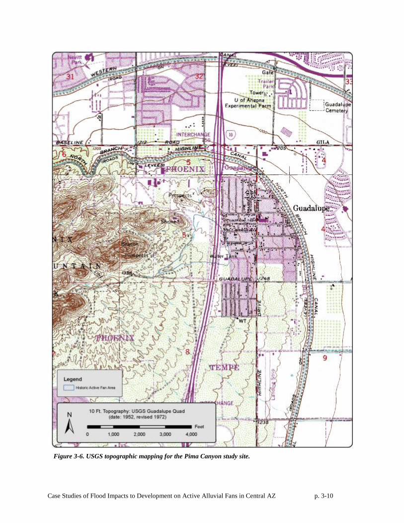
USGS topographic mapping is shown in Figure 3-6. The mapping clearly shows the radial
contours of a fully extended alluvial fan landform underlying the study site.
3.3.4 Interpretation of Historical Aerial Photography
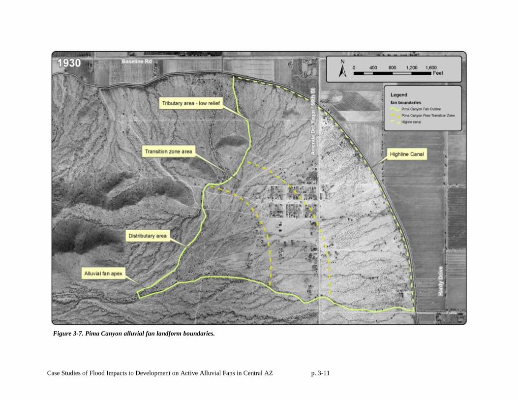
The 1930 aerial photograph shows Pima Canyon Wash flowing in a northeasterly direction away
from of South Mountain toward the hydrographic apex on the fan surface (Figures 3-3 and 3-8). At the
apex of the fan, the primary channel (Pima Wash) splits into roughly three less well-defined channels.
The first channel flowed north-toward Baseline Road, the second channel northeast toward the Town of
Guadalupe and the third channel flowed east. Several break outs from each of these channels are visibile
as they extend to the toe of the fan. At these break outs and other locations where the channels lose
capacity, flood waters probably extended over the fan as sheet flooding. The surface of the fan in 1930
appears to be relatively smooth with minimal lateral relief. This smooth surface characteristic is a
distinctive contrast from the tributary incised drainage that can be seen on older fan terraces on both sides
and upstream of the study area.
3.3.5 FEMA Stage 1-Stage 2 Alluvial Fan Classification
Based on the NRCS soils data, AZGS surficial mapping, USGS topographic mapping, and
interpretation of historical aerial photographs, the Pima Canyon alluvial fan was classified as an alluvial
fan landform with active and inactive fan areas using FEMA (2002) guidelines. The site is composed of
alluvium, as shown by the NRCS soils and AZGS mapping. USGS topographic mapping indicate the
presence of radial topographic contours characteristic of a partially extended fan shape. The site is
located at a lateral and vertical topographic break formed where the main wash exits the embayed
mountain front of South Mountain. Therefore, the landform is properly classified as an alluvial fan
landform.
Furthermore, the fan landform exhibits the following characteristics of an active alluvial fan: (1) a
distributary and sheet flooding channel pattern below a hydrographic apex, (2) significant sheet flooding
areas, and (3) geologically young, Holocene-aged soils. Therefore, a portion of the fan landform was an
active alluvial fan prior to its urbanization. Fan landform boundaries are depicted in Figure 3-7. The
active area is shown on Figure 3-8.
Case Studies of Flood Impacts to Development on Active Alluvial Fans in Central AZ p. 3-8
Figure 3-3. NRCS soils mapping for the Pima Canyon study site.
Case Studies of Flood Impacts to Development on Active Alluvial Fans in Central AZ p. 3-9
Figure 3-5. AZGS surficial geologic mapping for the Pima Canyon study site.
Case Studies of Flood Impacts to Development on Active Alluvial Fans in Central AZ p. 3-10
Figure 3-6. USGS topographic mapping for the Pima Canyon study site.
Case Studies of Flood Impacts to Development on Active Alluvial Fans in Central AZ p. 3-11
Figure 3-7. Pima Canyon alluvial fan landform boundaries.
Case Studies of Flood Impacts to Development on Active Alluvial Fans in Central AZ p. 3-12
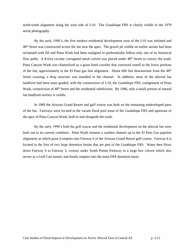
3.4 Development History
The oldest aerial image of the study area is from 1930 (Figure 3-7). However, development near
the Pima Canyon study site predates the aerial photography, starting around the time of construction of
the Highline Canal along the toe of the alluvial fan landform in 1891. In 1907, Yaqui Indians who had
fled persecution in Mexico, built homes upstream of the Highline Canal on the middle portion of the fan
landform. This early development included virtually no flood protection measures and was subject to
period flood damages when Pima Canyon Wash flowed.
By 1930, there were about 15 homes built within the active fan limits in the Town of Guadalupe,
though there were no major roads except Baseline Road, which is located north of the study area. By
1949, there were approximately 50 homes within the study area, mostly within the town of Guadalupe.
The three natural channels that split at the hydrographic apex appear to have become more well defined
by 1949, and the northeast channel has a wider bottom width than it did in 1930, probably in response to a
major flood in 1934 (Guadalupe Watershed Work Plan, p. 10). By 1959, a gravel pit had been dug near
the apex, as mapped on the NRCS Soil surveys. The Town of Guadalupe continued to expand to both the
north and the south. Also visible across the fan in 1959 is the El Paso Gas line excavation scar. The gas
line bisected the fan in a north-south alignment in the middle of the photograph.
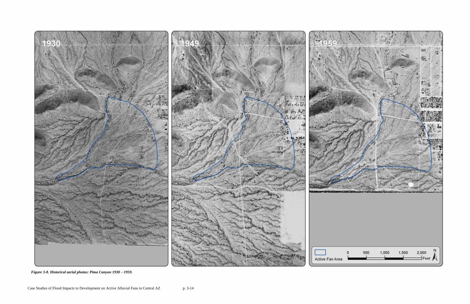
By 1969, I-10 had been built across the eastern part of the fan. The Guadalupe Watershed
Workplan 1971 contains the following description of how the I-10 construction affected drainage
downstream through the Town of Guadalupe.
“The…construction of the Highway altered the paths of any flooding that occurred in
past years so that flooding that will occur in the future will be different from what it has been in
the past. The I-10 Highway provides for drainage from water running off of the upper portion of
the watershed; however, there are no confined channels below the outlets of the culverts so when
water leaves the end of the culvert it will again spread out to a fan flood condition” (Guadalupe
Watershed Workplan, p. 52).
Large storms on September 14 and 16, 1969 caused extensive flooding in Guadalupe, damaging
homes, businesses, canals, and ditches, inundating crops, and damaging railroads and industrial property
(Guadalupe Watershed Workplan, p. 12). In response, the Guadalupe FRS (Flood Retarding Structure)
was built by the NRCS in the early 1970’s to reduce flood damage in Guadalupe. The FRS was built on a
Case Studies of Flood Impacts to Development on Active Alluvial Fans in Central AZ p. 3-13
north-south alignment along the west side of I-10. The Guadalupe FRS is clearly visible in the 1979
aerial photography.
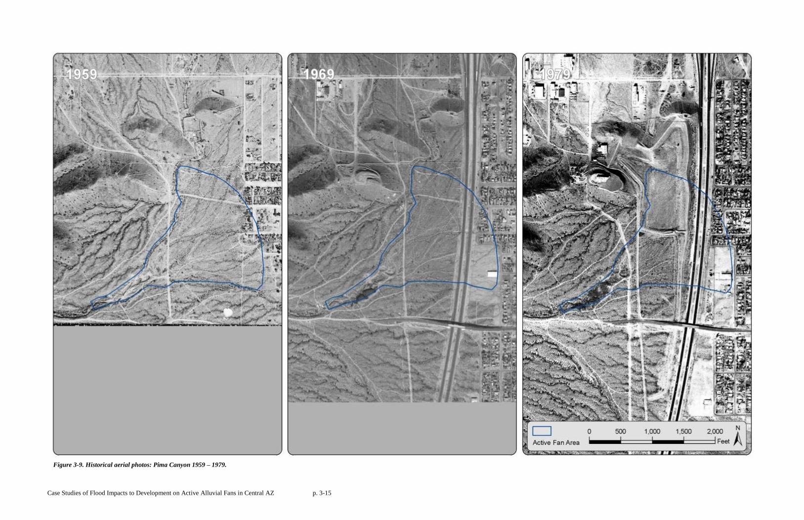
By the early 1980’s, the first modern residential development west of the I-10 was initiated and
48th Street was constructed across the fan near the apex. The gravel pit visible on earlier aerials had been
reclaimed with fill and Pima Wash had been realigned to preferentially follow only one of its historical
flow paths. A 8-foot circular corrugated metal culvert was placed under 48th Street to convey the wash.
Pima Canyon Wash was channelized as a grass-lined corridor that conveyed runoff to the lower portions
of the fan, approximately to the El Paso gas line alignment. About 600 feet downstream from the 48th
Street crossing, a drop structure was installed in the channel. In addition, most of the alluvial fan
landform had been mass graded, with the construction of I-10, the Guadalupe FRS, realignment of Pima
Wash, construction of 48th Street and the residential subdivision. By 1986, only a small portion of natural
fan landform surface is visible.
In 1989 the Arizona Grand Resort and golf course was built on the remaining undeveloped parts
of the fan. Fairways were located in the vacant flood pool areas of the Guadalupe FRS and upstream of
the apex of Pima Canyon Wash, both in and alongside the wash.
By the early 1990’s both the golf course and the residential development on the alluvial fan were
built out to its current condition. Pima Wash remains a earthen channel up to the El Paso Gas pipeline
alignment, at which point it empties into Fairway 6 of the Arizona Grand Resort golf course. Fairway 6 is
located in the first of two large detention basins that are part of the Guadalupe FRS. Water then flows
down Fairway 6 to Fairway 5, crosses under South Pointe Parkway in a large box culvert which also
serves as a Golf Cart tunnel, and finally empties into the main FRS detention basin.
Case Studies of Flood Impacts to Development on Active Alluvial Fans in Central AZ p. 3-14
Figure 3-8. Historical aerial photos: Pima Canyon 1930 – 1959.
Case Studies of Flood Impacts to Development on Active Alluvial Fans in Central AZ p. 3-15
Figure 3-9. Historical aerial photos: Pima Canyon 1959 – 1979.
Case Studies of Flood Impacts to Development on Active Alluvial Fans in Central AZ p. 3-16
Figure 3-10. Historical aerial photos: Pima Canyon 1979 – 1997.
Case Studies of Flood Impacts to Development on Active Alluvial Fans in Central AZ p. 3-17
Figure 3-11. Historical aerial photos: Pima Canyon 1997 – 2009.
Case Studies of Flood Impacts to Development on Active Alluvial Fans in Central AZ p. 3-18
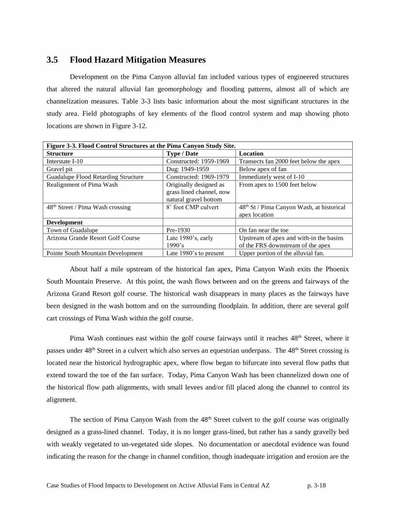
3.5 Flood Hazard Mitigation Measures
Development on the Pima Canyon alluvial fan included various types of engineered structures
that altered the natural alluvial fan geomorphology and flooding patterns, almost all of which are
channelization measures. Table 3-3 lists basic information about the most significant structures in the
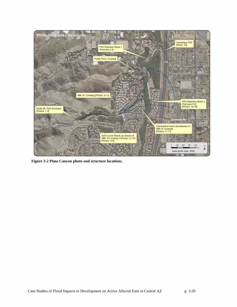
study area. Field photographs of key elements of the flood control system and map showing photo
locations are shown in Figure 3-12.
Figure 3-3. Flood Control Structures at the Pima Canyon Study Site.
Structure Type / Date Location
Interstate I-10 Constructed: 1959-1969 Transects fan 2000 feet below the apex
Gravel pit Dug: 1949-1959 Below apex of fan
Guadalupe Flood Retarding Structure Constructed: 1969-1979 Immediately west of I-10
Realignment of Pima Wash Originally designed as
grass lined channel, now
natural gravel bottom
From apex to 1500 feet below
48th Street / Pima Wash crossing 8’ foot CMP culvert 48th St / Pima Canyon Wash, at historical
apex location
Development
Town of Guadalupe Pre-1930 On fan near the toe
Arizona Grande Resort Golf Course Late 1980’s, early
1990’s
Upstream of apex and with-in the basins
of the FRS downstream of the apex
Pointe South Mountain Development Late 1980’s to present Upper portion of the alluvial fan.
About half a mile upstream of the historical fan apex, Pima Canyon Wash exits the Phoenix
South Mountain Preserve. At this point, the wash flows between and on the greens and fairways of the
Arizona Grand Resort golf course. The historical wash disappears in many places as the fairways have
been designed in the wash bottom and on the surrounding floodplain. In addition, there are several golf
cart crossings of Pima Wash within the golf course.
Pima Wash continues east within the golf course fairways until it reaches 48th Street, where it
passes under 48th Street in a culvert which also serves an equestrian underpass. The 48th Street crossing is
located near the historical hydrographic apex, where flow began to bifurcate into several flow paths that
extend toward the toe of the fan surface. Today, Pima Canyon Wash has been channelized down one of
the historical flow path alignments, with small levees and/or fill placed along the channel to control its
alignment.
The section of Pima Canyon Wash from the 48th Street culvert to the golf course was originally
designed as a grass-lined channel. Today, it is no longer grass-lined, but rather has a sandy gravelly bed
with weakly vegetated to un-vegetated side slopes. No documentation or anecdotal evidence was found
indicating the reason for the change in channel condition, though inadequate irrigation and erosion are the
Case Studies of Flood Impacts to Development on Active Alluvial Fans in Central AZ p. 3-19
likely explanations. In many places along the channel, vertical retaining walls bounding residential yards
now form or extend the channel banks. Interestingly, the northern historical flow path on the fan is
preserved in the present-day topography, even though it is now cut off from the current alignment of Pima
Canyon Wash by a levee and by subdivision roads with no designed drainage crossings.
A small grade control structure is located on Pima Canyon Wash approximately 600 feet
downstream of the 48th Street crossing. This structure was built in the early 1980’s and consists of a two-
foot, vertical stair-step drop in bed elevation. Pima Wash continues downstream of the grade control
structure for another 500 feet before it outfalls into a fairway on the Arizona Grand Resort Golf Course
via a 16-foot, steeply-sloped drop from the channel to the fairway. The historical alignment of the El-
Paso gas line lies immediately upstream of the 16-foot sloped drop. While no design drawings were
available for either the channel or the gas line, it is assumed that the wash grade was dictated by gas-line
elevation. After the channel crosses the pipeline, it appears to have been allowed drop significantly into
the upstream detention basin on the golf course that was built as part of the Guadalupe FRS. There is no
evidence of any structural grade control or erosion protection at the outfall where the channel empties
onto the fairway over the steep embankment. Once on the fairway, any evidence of the historical wash
disappears, and runoff follows golf course grades to the Guadalupe FRS primary embankment adjacent to
the I-10 corridor.
The primary embankment of the Guadalupe FRS is located near the toe of the fan just upstream
of the I-10 corridor. There is one principal gated outlet for the FRS that, when opened, releases water
north to the Highline Canal.
Case Studies of Flood Impacts to Development on Active Alluvial Fans in Central AZ p. 3-20
Figure 3-2 Pima Canyon photo and structure locations.
Case Studies of Flood Impacts to Development on Active Alluvial Fans in Central AZ p. 3-21
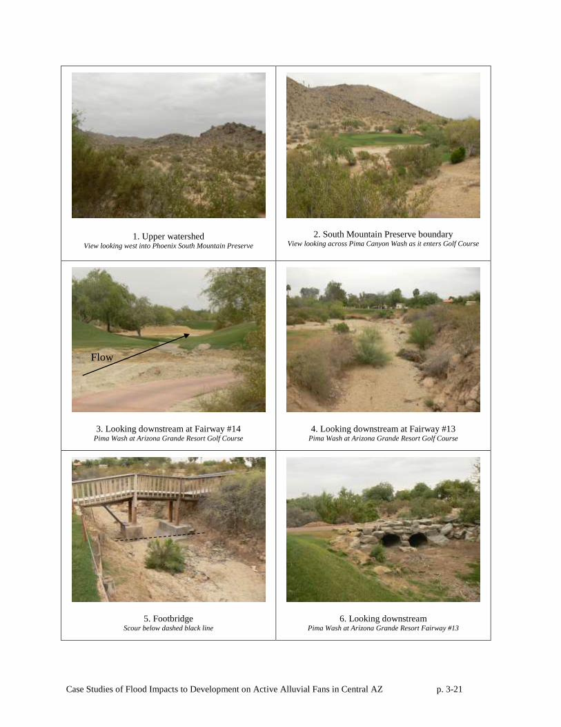
1. Upper watershed View looking west into Phoenix South Mountain Preserve
2. South Mountain Preserve boundary View looking across Pima Canyon Wash as it enters Golf Course
3. Looking downstream at Fairway #14 Pima Wash at Arizona Grande Resort Golf Course
4. Looking downstream at Fairway #13 Pima Wash at Arizona Grande Resort Golf Course
5. Footbridge Scour below dashed black line
6. Looking downstream Pima Wash at Arizona Grande Resort Fairway #13
Flow
Case Studies of Flood Impacts to Development on Active Alluvial Fans in Central AZ p. 3-22
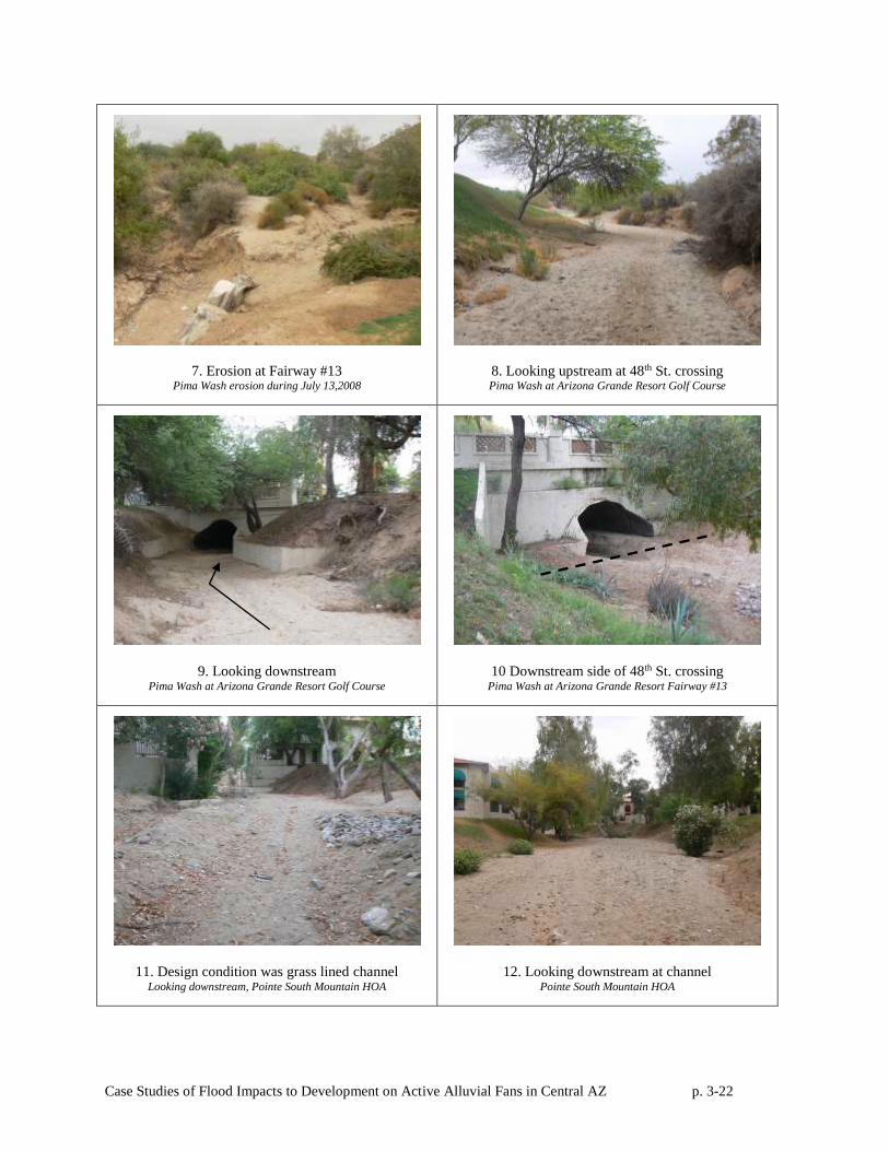
7. Erosion at Fairway #13 Pima Wash erosion during July 13,2008
8. Looking upstream at 48th St. crossing Pima Wash at Arizona Grande Resort Golf Course
9. Looking downstream Pima Wash at Arizona Grande Resort Golf Course
10 Downstream side of 48th St. crossing Pima Wash at Arizona Grande Resort Fairway #13
11. Design condition was grass lined channel Looking downstream, Pointe South Mountain HOA
12. Looking downstream at channel Pointe South Mountain HOA
Case Studies of Flood Impacts to Development on Active Alluvial Fans in Central AZ p. 3-23
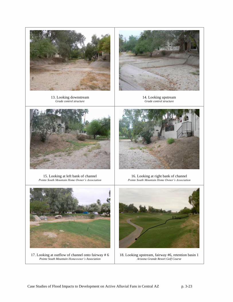
13. Looking downstream Grade control structure
14. Looking upstream Grade control structure
15. Looking at left bank of channel Pointe South Mountain Home Owner’s Association
16. Looking at right bank of channel Pointe South Mountain Home Owner’s Association
17. Looking at outflow of channel onto fairway # 6 Pointe South Mountain Homeowner’s Association
18. Looking upstream, fairway #6, retention basin 1 Arizona Grande Resort Golf Course
Flow
Case Studies of Flood Impacts to Development on Active Alluvial Fans in Central AZ p. 3-24
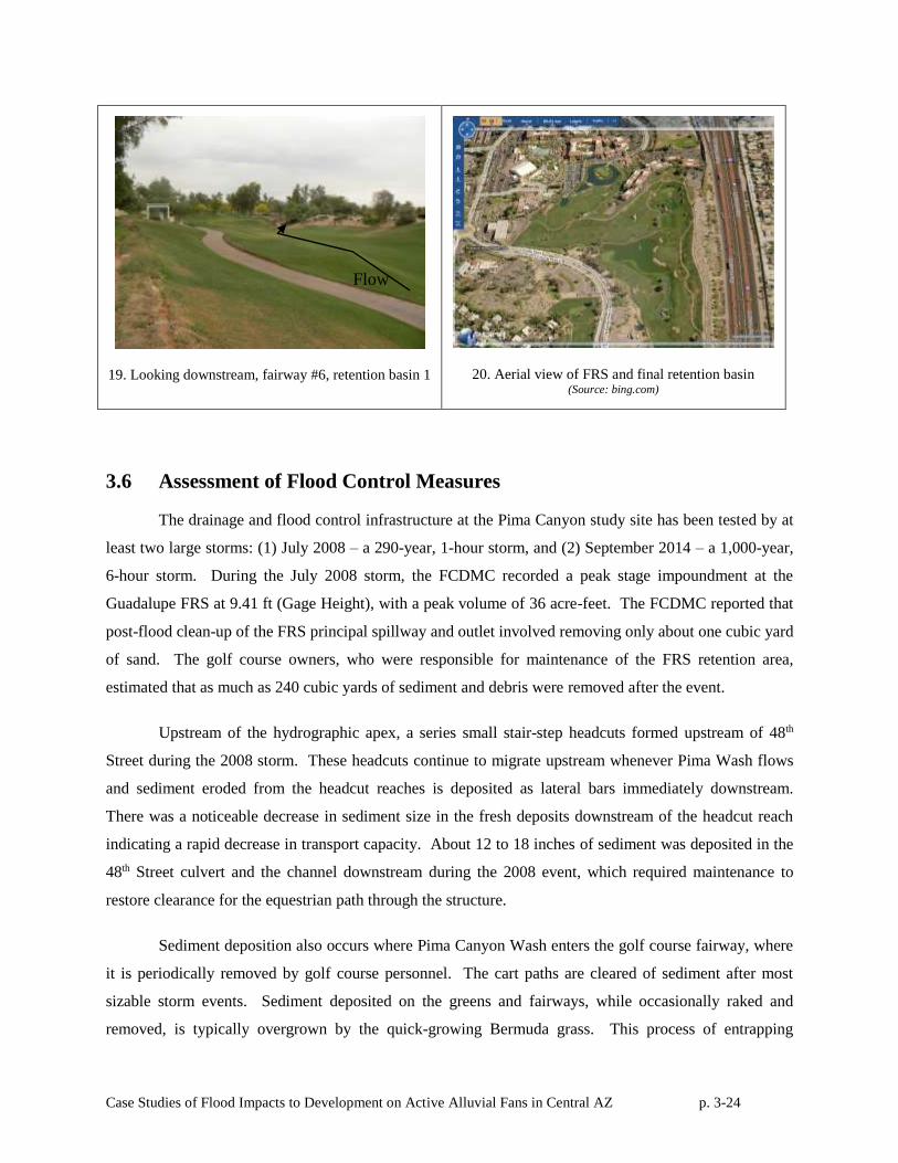
19. Looking downstream, fairway #6, retention basin 1
20. Aerial view of FRS and final retention basin (Source: bing.com)
3.6 Assessment of Flood Control Measures
The drainage and flood control infrastructure at the Pima Canyon study site has been tested by at
least two large storms: (1) July 2008 – a 290-year, 1-hour storm, and (2) September 2014 – a 1,000-year,
6-hour storm. During the July 2008 storm, the FCDMC recorded a peak stage impoundment at the
Guadalupe FRS at 9.41 ft (Gage Height), with a peak volume of 36 acre-feet. The FCDMC reported that
post-flood clean-up of the FRS principal spillway and outlet involved removing only about one cubic yard
of sand. The golf course owners, who were responsible for maintenance of the FRS retention area,
estimated that as much as 240 cubic yards of sediment and debris were removed after the event.
Upstream of the hydrographic apex, a series small stair-step headcuts formed upstream of 48th
Street during the 2008 storm. These headcuts continue to migrate upstream whenever Pima Wash flows
and sediment eroded from the headcut reaches is deposited as lateral bars immediately downstream.
There was a noticeable decrease in sediment size in the fresh deposits downstream of the headcut reach
indicating a rapid decrease in transport capacity. About 12 to 18 inches of sediment was deposited in the
48th Street culvert and the channel downstream during the 2008 event, which required maintenance to
restore clearance for the equestrian path through the structure.
Sediment deposition also occurs where Pima Canyon Wash enters the golf course fairway, where
it is periodically removed by golf course personnel. The cart paths are cleared of sediment after most
sizable storm events. Sediment deposited on the greens and fairways, while occasionally raked and
removed, is typically overgrown by the quick-growing Bermuda grass. This process of entrapping
Flow
Case Studies of Flood Impacts to Development on Active Alluvial Fans in Central AZ p. 3-25
sediment in the growing grass has effectively raised the bed of Pima Wash in several places by as much
as 12 inches along the main flow path of Pima Wash over the fairway.
The local HOA also reports that sedimentation in the local storm drains is also an issue within the
developed parts of the fan surface, but this deposition is not related to flood processes directly connected
to Pima Wash or alluvial fan flooding.
3.7 Conclusions
Based on our analysis, we conclude that the engineered drainage system has performed
adequately during the 30- year period of record, at least with respect to controlling the flow uncertainty
and sedimentation associated with active alluvial fans. No homes or structures on or around the formerly
active portions of the fan have been flooded by alluvial fan flooding in the past 30 years. There is no
record that the earthen channel has ever overtopped or significantly eroded its banks. The sediment
deposition that occurs during floods and rare flows from Pima Wash appears to be adequately handled by
the private HOA and golf course maintenance.
Case Studies of Flood Impacts to Development on Active Alluvial Fans in Central AZ p. 4-1
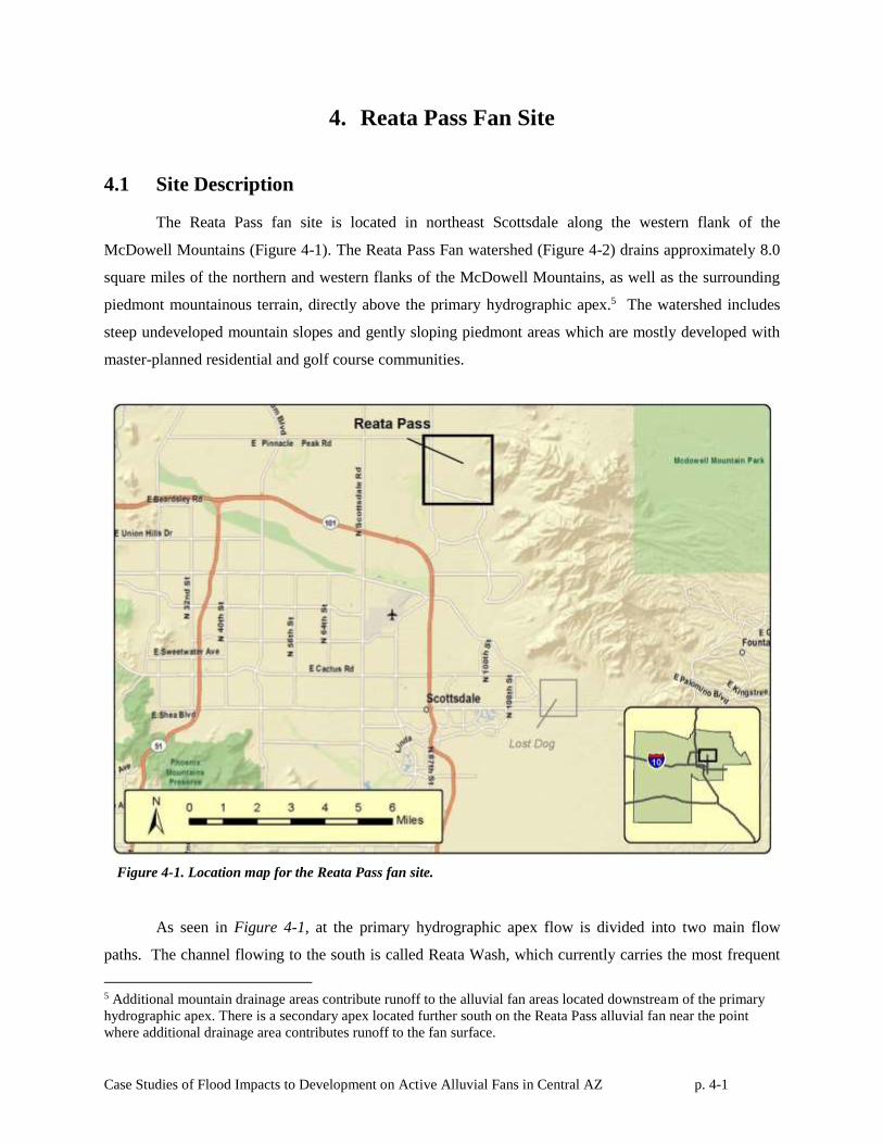
4. Reata Pass Fan Site
4.1 Site Description
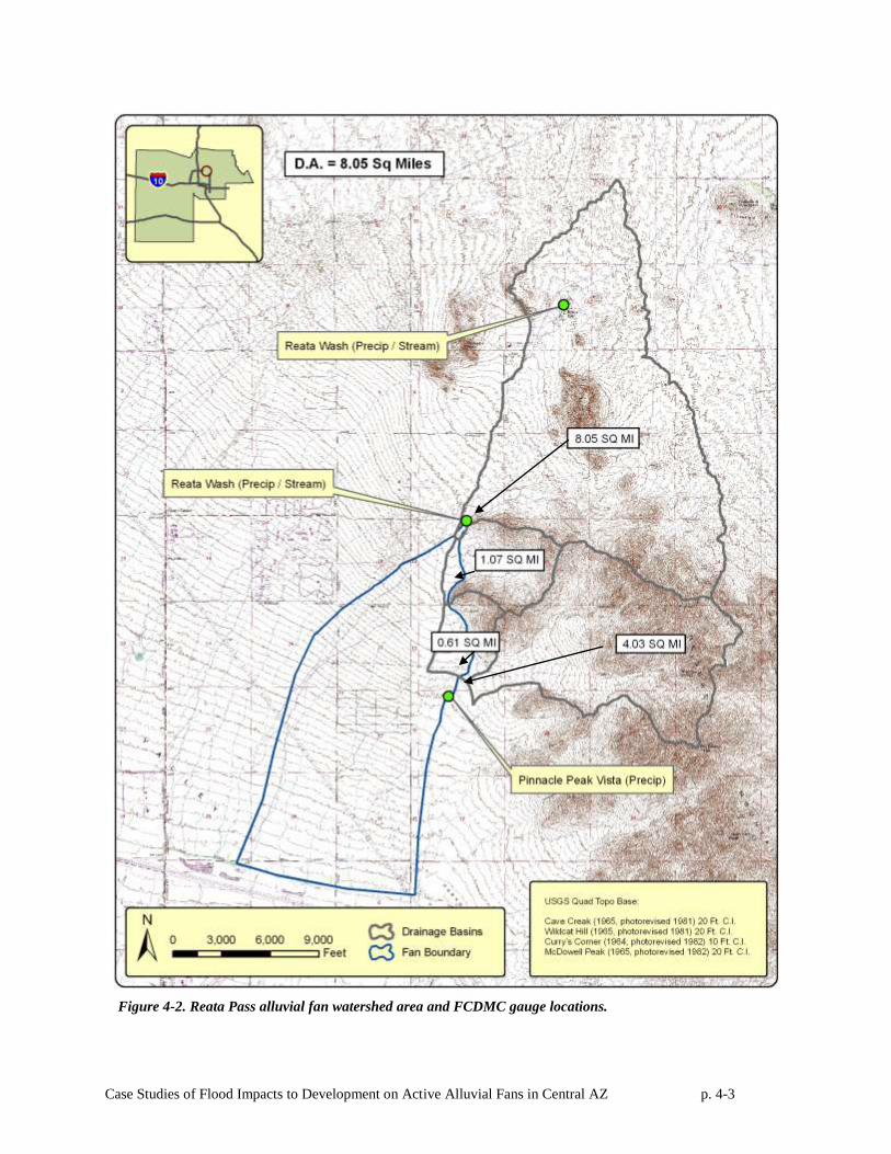
The Reata Pass fan site is located in northeast Scottsdale along the western flank of the
McDowell Mountains (Figure 4-1). The Reata Pass Fan watershed (Figure 4-2) drains approximately 8.0
square miles of the northern and western flanks of the McDowell Mountains, as well as the surrounding
piedmont mountainous terrain, directly above the primary hydrographic apex.5 The watershed includes
steep undeveloped mountain slopes and gently sloping piedmont areas which are mostly developed with
master-planned residential and golf course communities.
Figure 4-1. Location map for the Reata Pass fan site.
As seen in Figure 4-1, at the primary hydrographic apex flow is divided into two main flow
paths. The channel flowing to the south is called Reata Wash, which currently carries the most frequent
5 Additional mountain drainage areas contribute runoff to the alluvial fan areas located downstream of the primary
hydrographic apex. There is a secondary apex located further south on the Reata Pass alluvial fan near the point
where additional drainage area contributes runoff to the fan surface.
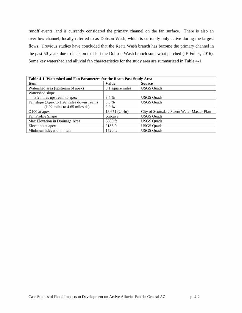
Case Studies of Flood Impacts to Development on Active Alluvial Fans in Central AZ p. 4-2
runoff events, and is currently considered the primary channel on the fan surface. There is also an
overflow channel, locally referred to as Dobson Wash, which is currently only active during the largest
flows. Previous studies have concluded that the Reata Wash branch has become the primary channel in
the past 50 years due to incision that left the Dobson Wash branch somewhat perched (JE Fuller, 2016).
Some key watershed and alluvial fan characteristics for the study area are summarized in Table 4-1.
Table 4-1. Watershed and Fan Parameters for the Reata Pass Study Area
Item Value Source
Watershed area (upstream of apex) 8.1 square miles USGS Quads
Watershed slope
3.2 miles upstream to apex
3.4 %
USGS Quads
Fan slope (Apex to 1.92 miles downstream)
(1.92 miles to 4.65 miles ds)
3.3 %
2.0 %
USGS Quads
Q100 at apex 13,671 (24-hr) City of Scottsdale Storm Water Master Plan
Fan Profile Shape concave USGS Quads
Max Elevation in Drainage Area 3880 ft USGS Quads
Elevation at apex 2185 ft USGS Quads
Minimum Elevation in fan 1520 ft USGS Quads
Case Studies of Flood Impacts to Development on Active Alluvial Fans in Central AZ p. 4-3
Figure 4-2. Reata Pass alluvial fan watershed area and FCDMC gauge locations.
Case Studies of Flood Impacts to Development on Active Alluvial Fans in Central AZ p. 4-4
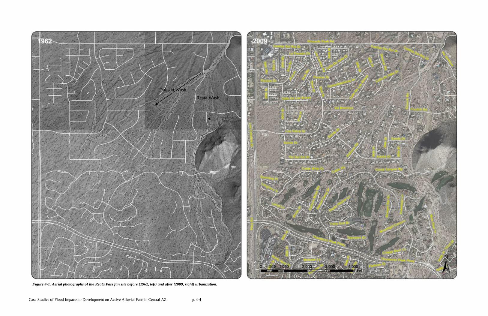
Figure 4-1. Aerial photographs of the Reata Pass fan site before (1962, left) and after (2009, right) urbanization.
Reata Wash
Dobson Wash
Case Studies of Flood Impacts to Development on Active Alluvial Fans in Central AZ p. 4-5
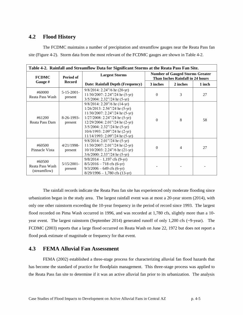
4.2 Flood History
The FCDMC maintains a number of precipitation and streamflow gauges near the Reata Pass fan
site (Figure 4-2). Storm data from the most relevant of the FCDMC gauges are shown in Table 4-2.
Table 4-2. Rainfall and Streamflow Data for Significant Storms at the Reata Pass Fan Site.
FCDMC
Gauge #
Period of
Record
Largest Storms
Date: Rainfall Depth (Frequency)
Number of Gauged Storms Greater
Than Inches Rainfall in 24 hours
3 inches 2 inches 1 inch
#60000
Reata Pass Wash
5-15-2001-
present
9/8/2014: 2.24”/6 hr (20-yr)
11/30/2007: 2.24”/24 hr (5-yr)
3/5/2004: 2.32”/24 hr (5-yr)
0 3 27
#61200
Reata Pass Dam
8-26-1993-
present
9/8/2014: 2.20”/6 hr (14-yr)
1/26/2013: 2.56”/24 hr (5-yr)
11/30/2007: 2.24”/24 hr (5-yr)
1/27/2008: 2.24”/24 hr (5-yr)
12/29/2004: 2.01”/24 hr (2-yr)
3/5/2004: 2.32”/24 hr (5-yr)
10/6/1993: 2.09”/24 hr (2-yr)
11/14/1993: 2.09”/24 hr (5-yr)
0 8 58
#60500
Pinnacle Vista
4/21/1998-
present
9/8/2014: 2.01”/24 hr (5-yr)
11/30/2007: 2.01”/24 hr (2-yr)
10/10/2003: 2.24”/6 hr (21-yr)
3/6/2000: 2.33”/24 hr (5-yr)
0 4 27
#60500
Reata Pass Wash
(streamflow)
5/15/2001-
present
9/8/2014 – 1,197 cfs (9-yr)
8/5/2016 – 718 cfs (6-yr)
9/3/2006 – 649 cfs (6-yr)
8/29/1996 – 1,780 cfs (13-yr)
- - -
The rainfall records indicate the Reata Pass fan site has experienced only moderate flooding since
urbanization began in the study area. The largest rainfall event was at most a 20-year storm (2014), with
only one other rainstorm exceeding the 10-year frequency in the period of record since 1993. The largest
flood recorded on Pima Wash occurred in 1996, and was recorded at 1,780 cfs, slightly more than a 10-
year event. The largest rainstorm (September 2014) generated runoff of only 1,200 cfs (~9-year). The
FCDMC (2003) reports that a large flood occurred on Reata Wash on June 22, 1972 but does not report a
flood peak estimate of magnitude or frequency for that event.
4.3 FEMA Alluvial Fan Assessment
FEMA (2002) established a three-stage process for characterizing alluvial fan flood hazards that
has become the standard of practice for floodplain management. This three-stage process was applied to
the Reata Pass fan site to determine if it was an active alluvial fan prior to its urbanization. The analysis
Case Studies of Flood Impacts to Development on Active Alluvial Fans in Central AZ p. 4-6
was completed using NRCS soils mapping, AZGS surficial geology mapping, USGS topographic
mapping, geomorphic interpretation of pre-development aerial photography, and field observations.
4.3.1 NRCS Soils Mapping
Figure 4-3 shows the NRCS soil survey mapping for the Reata Pass Fan study area. The fan
surface from the apex to Thompson Peak Parkway consists of four soil units. The apex, Reata Wash and
the upper Dobson Wash area are composed of the Arizo cobbly sandy loam (NRCS Unit 8), which is
characterized as well-drained drainageway and floodplain soils. Further downstream, the area along the
Dobson Wash flow path is underlain by the Anthony-Arizo complex (NRCS Unit 6), which is also found
on floodplains and drainageways. Between the Reata and Dobson Wash corridors, the area is underlain by
the Tres Hermanos-Anthony complex (NRCS Unit 121). This soil unit is found on fan terraces, stream
terraces, and their associated floodplains. The distal portions of the study area are underlain by the
Momoli gravelly sandy loam (NRCS Unit 90), which is characterized as a deep well-drained soil on fan
terraces. The McDowell Mountain upland areas are mapped as rock outcrop (NRCS Unit 31).
4.3.2 AZGS Surficial Geology
Figure 4-4 presents AZGS surficial geology mapping for the Reata Fan study area (Richard and
Spencer, 1998). The bedrock units of the McDowell Mountains east of the study area are composed of
early Proterozoic Quartzite (Xsq). The three geologic units that compose the fan itself are: Qy, Qm and
Ql. Approximately half the study area is composed of the Qy unit (Quaternary Young Alluvium) a
Holocene-aged surface which is found on low terraces and alluvial fan deposits, and underlies the main
drainageways on the alluvial fan surface. The remaining parts of the Reata Pass study area are underlain
by the Qm and Ql surfaces, both of which Pleistocene in age. These units are typically found on
moderately dissected to dissected portions of alluvial fans and fan terraces. A middle to early
Pleistocene-aged unit (Qmo) bounds the younger units and represents even older inactive alluvial fan
surfaces.
4.3.3 Topography
USGS topographic mapping for the study area is shown in Figure 4-5. The topographic mapping
shows the partially extended fan shape of an alluvial fan, as well as distinct differences in contour
crenulation that demark active and inactive portions of the fan. The topographic data also show that the
Reata Pass alluvial fan has the steepest surface slope of the four historical fan sites studied.
Case Studies of Flood Impacts to Development on Active Alluvial Fans in Central AZ p. 4-7
4.3.4 FEMA Stage 1-Stage 2 Alluvial Fan Classification
Based on the NRCS soils data, AZGS surficial mapping, USGS topographic mapping, and
interpretation of historical aerial photographs, the Reata Pass alluvial fan was classified as an alluvial fan
landform with active and inactive fan areas using FEMA (2002) guidelines. The site is composed of
alluvium, as shown by the NRCS soils and AZGS mapping. USGS topographic mapping indicate the
presence of radial topographic contours characteristic of a partially extended fan shape. The site is
located at a lateral and vertical topographic break formed where the main wash exits the embayed
mountain front of the McDowell Mountains. Therefore, the landform is properly classified as an alluvial
fan landform.
Furthermore, the fan landform exhibits the following characteristics of an active alluvial fan: (1) a
distributary and sheet flooding channel pattern below a hydrographic apex, (2) significant sheet flooding
areas, (3) geologically young, Holocene-aged soils, and (4) smooth contour crenulations. Therefore, a
portion of the fan landform can be classified as an active alluvial fan. Fan landform boundaries are
depicted on Figure 4-6. The most active portions of the fan are located near the primary hydrographic
apex, along the Reata Wash alignment, and along the upper Dobson Wash alignment (Figure 4-7).
Further refinement of the active area delineation is beyond the needs of this study, but likely exclude the
Ql surfaces in the central portion of the fan shown on Figure 4-7, as well as some of the distal portions of
the landform not shown on Figure 4-7.
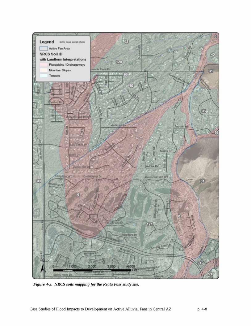
Case Studies of Flood Impacts to Development on Active Alluvial Fans in Central AZ p. 4-8
Figure 4-3. NRCS soils mapping for the Reata Pass study site.
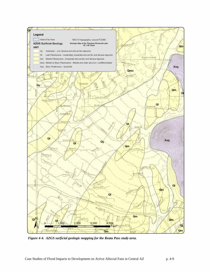
Case Studies of Flood Impacts to Development on Active Alluvial Fans in Central AZ p. 4-9
Figure 4-4. AZGS surficial geologic mapping for the Reata Pass study area.
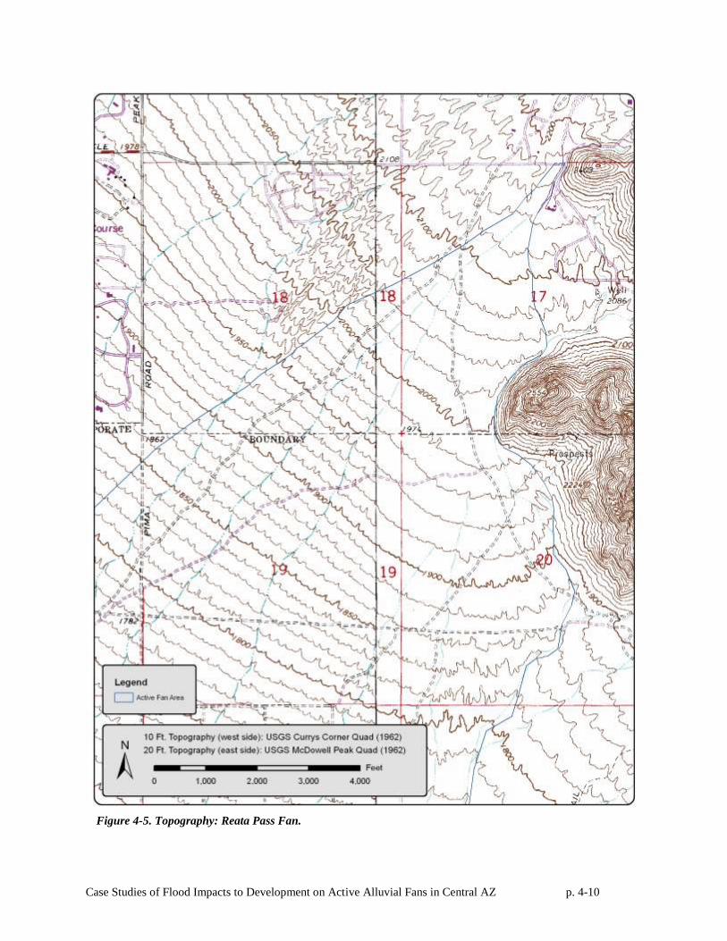
Case Studies of Flood Impacts to Development on Active Alluvial Fans in Central AZ p. 4-10
Figure 4-5. Topography: Reata Pass Fan.
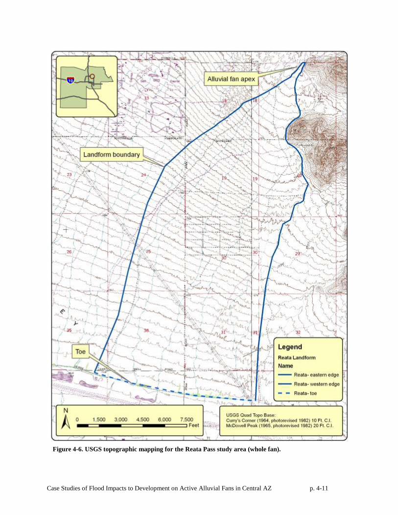
Case Studies of Flood Impacts to Development on Active Alluvial Fans in Central AZ p. 4-11
Figure 4-6. USGS topographic mapping for the Reata Pass study area (whole fan).
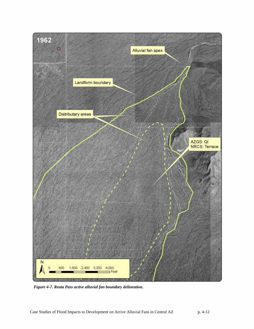
Case Studies of Flood Impacts to Development on Active Alluvial Fans in Central AZ p. 4-12
Figure 4-7. Reata Pass active alluvial fan boundary delineation.
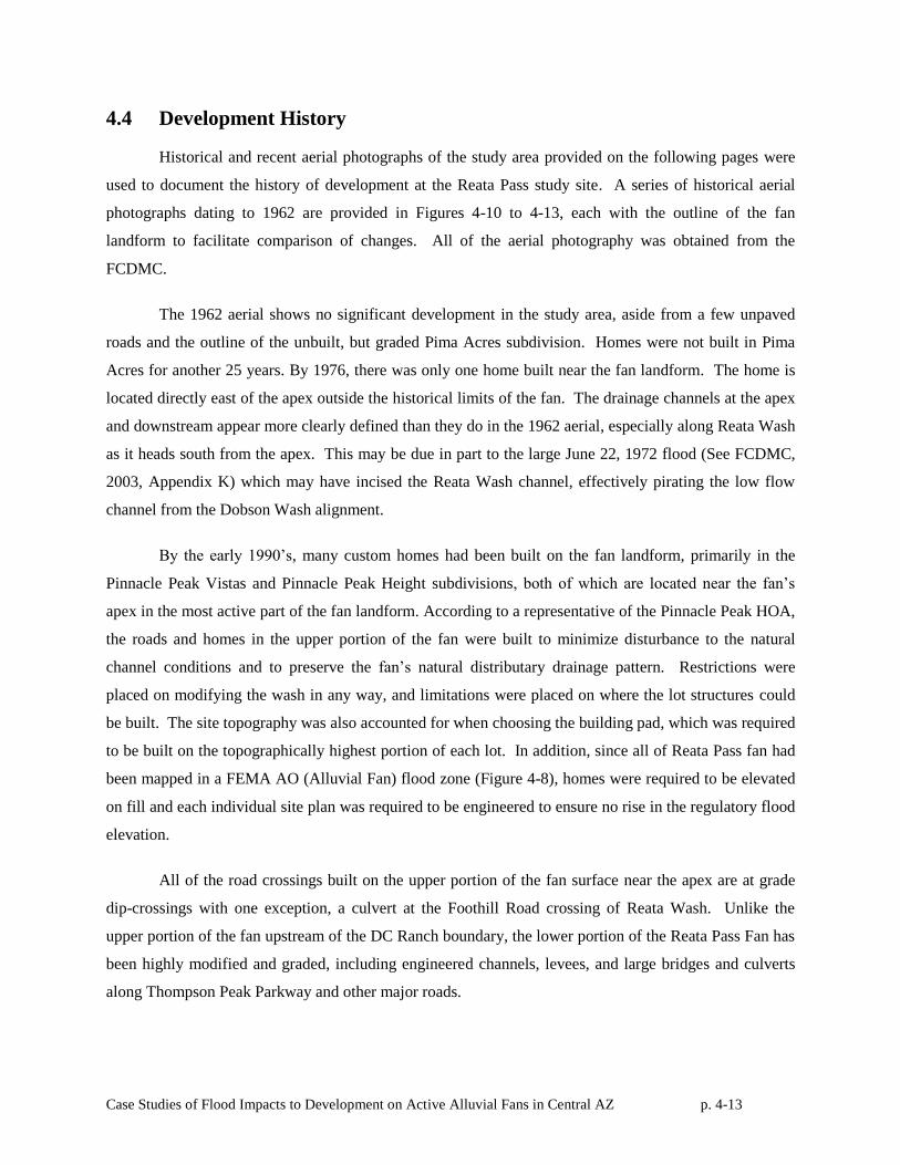
Case Studies of Flood Impacts to Development on Active Alluvial Fans in Central AZ p. 4-13
4.4 Development History
Historical and recent aerial photographs of the study area provided on the following pages were
used to document the history of development at the Reata Pass study site. A series of historical aerial
photographs dating to 1962 are provided in Figures 4-10 to 4-13, each with the outline of the fan
landform to facilitate comparison of changes. All of the aerial photography was obtained from the
FCDMC.
The 1962 aerial shows no significant development in the study area, aside from a few unpaved
roads and the outline of the unbuilt, but graded Pima Acres subdivision. Homes were not built in Pima
Acres for another 25 years. By 1976, there was only one home built near the fan landform. The home is
located directly east of the apex outside the historical limits of the fan. The drainage channels at the apex
and downstream appear more clearly defined than they do in the 1962 aerial, especially along Reata Wash
as it heads south from the apex. This may be due in part to the large June 22, 1972 flood (See FCDMC,
2003, Appendix K) which may have incised the Reata Wash channel, effectively pirating the low flow
channel from the Dobson Wash alignment.
By the early 1990’s, many custom homes had been built on the fan landform, primarily in the
Pinnacle Peak Vistas and Pinnacle Peak Height subdivisions, both of which are located near the fan’s
apex in the most active part of the fan landform. According to a representative of the Pinnacle Peak HOA,
the roads and homes in the upper portion of the fan were built to minimize disturbance to the natural
channel conditions and to preserve the fan’s natural distributary drainage pattern. Restrictions were
placed on modifying the wash in any way, and limitations were placed on where the lot structures could
be built. The site topography was also accounted for when choosing the building pad, which was required
to be built on the topographically highest portion of each lot. In addition, since all of Reata Pass fan had
been mapped in a FEMA AO (Alluvial Fan) flood zone (Figure 4-8), homes were required to be elevated
on fill and each individual site plan was required to be engineered to ensure no rise in the regulatory flood
elevation.
All of the road crossings built on the upper portion of the fan surface near the apex are at grade
dip-crossings with one exception, a culvert at the Foothill Road crossing of Reata Wash. Unlike the
upper portion of the fan upstream of the DC Ranch boundary, the lower portion of the Reata Pass Fan has
been highly modified and graded, including engineered channels, levees, and large bridges and culverts
along Thompson Peak Parkway and other major roads.
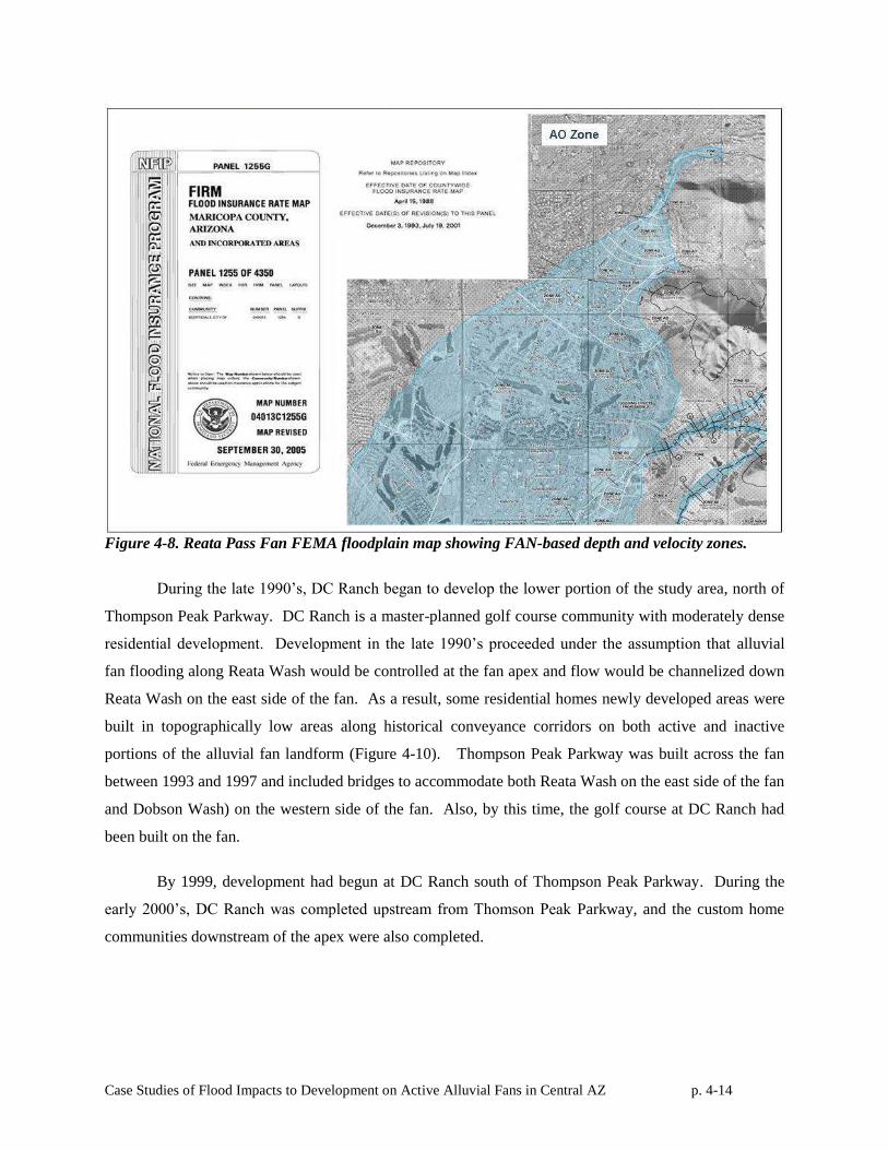
Case Studies of Flood Impacts to Development on Active Alluvial Fans in Central AZ p. 4-14
Figure 4-8. Reata Pass Fan FEMA floodplain map showing FAN-based depth and velocity zones.
During the late 1990’s, DC Ranch began to develop the lower portion of the study area, north of
Thompson Peak Parkway. DC Ranch is a master-planned golf course community with moderately dense
residential development. Development in the late 1990’s proceeded under the assumption that alluvial
fan flooding along Reata Wash would be controlled at the fan apex and flow would be channelized down
Reata Wash on the east side of the fan. As a result, some residential homes newly developed areas were
built in topographically low areas along historical conveyance corridors on both active and inactive
portions of the alluvial fan landform (Figure 4-10). Thompson Peak Parkway was built across the fan
between 1993 and 1997 and included bridges to accommodate both Reata Wash on the east side of the fan
and Dobson Wash) on the western side of the fan. Also, by this time, the golf course at DC Ranch had
been built on the fan.
By 1999, development had begun at DC Ranch south of Thompson Peak Parkway. During the
early 2000’s, DC Ranch was completed upstream from Thomson Peak Parkway, and the custom home
communities downstream of the apex were also completed.
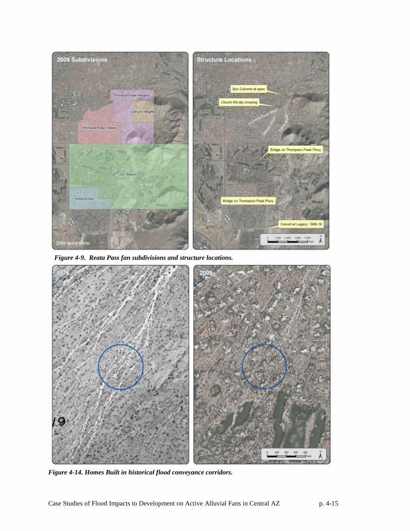
Case Studies of Flood Impacts to Development on Active Alluvial Fans in Central AZ p. 4-15
Figure 4-9. Reata Pass fan subdivisions and structure locations.
Figure 4-14. Homes Built in historical flood conveyance corridors.
Case Studies of Flood Impacts to Development on Active Alluvial Fans in Central AZ p. 4-16
Much of the recent development in the Reata Pass study area is tied up in the history of the City
of Scottsdale’s Desert Greenbelt project, a circa 1990 channelization plan intended to remove the FEMA
alluvial fan floodplain designation from the Reata Pass alluvial fan. The Desert Greenbelt project would
have effectively channelized Reata Wash beginning at the hydrographic apex and continuing down the
Reata Wash corridor on the east side of the fan. Much of the urbanization planned during the late 1980’s
and early 1990’s was built assuming the Desert Greenbelt would provide 100-year protection from
alluvial fan flooding. However, for a variety of reasons, the citizens of Scottsdale and its City Council
abandoned the Reata Pass elements of the Desert Greenbelt project and it was never built, creating at least
a perceived gap in the typical standard of flood protection for some of the more recently built
development.
.
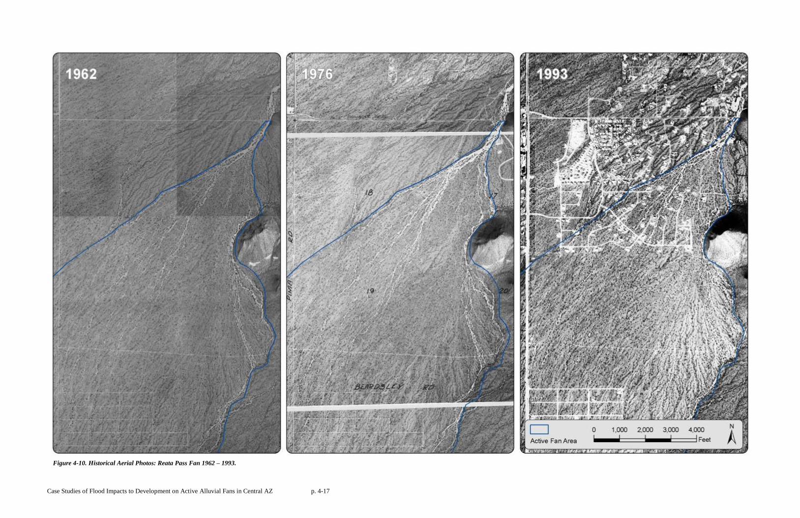
Case Studies of Flood Impacts to Development on Active Alluvial Fans in Central AZ p. 4-17
Figure 4-10. Historical Aerial Photos: Reata Pass Fan 1962 – 1993.
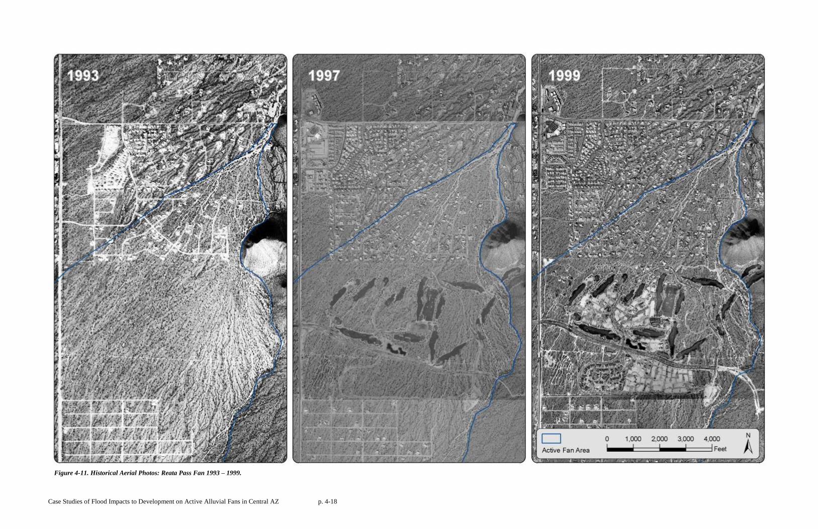
Case Studies of Flood Impacts to Development on Active Alluvial Fans in Central AZ p. 4-18
Figure 4-11. Historical Aerial Photos: Reata Pass Fan 1993 – 1999.
Case Studies of Flood Impacts to Development on Active Alluvial Fans in Central AZ p. 4-19
Figure 4-12. Historical Aerial Photos: Reata Pass Fan 1999 – 2003.
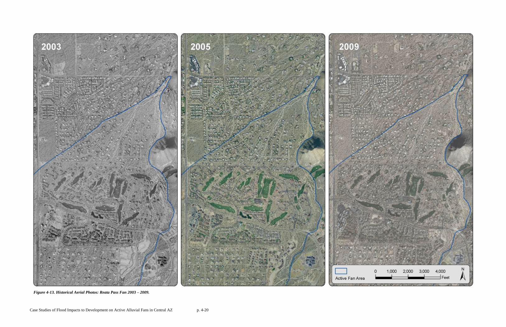
Case Studies of Flood Impacts to Development on Active Alluvial Fans in Central AZ p. 4-20
Figure 4-13. Historical Aerial Photos: Reata Pass Fan 2003 – 2009.
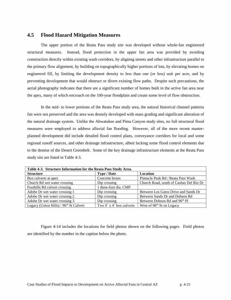
Case Studies of Flood Impacts to Development on Active Alluvial Fans in Central AZ p. 4-21
4.5 Flood Hazard Mitigation Measures
The upper portion of the Reata Pass study site was developed without whole-fan engineered
structural measures. Instead, flood protection in the upper fan area was provided by avoiding
construction directly within existing wash corridors, by aligning streets and other infrastructure parallel to
the primary flow alignment, by building on topographically higher portions of lots, by elevating homes on
engineered fill, by limiting the development density to less than one (or less) unit per acre, and by
preventing development that would obstruct or divert existing flow paths. Despite such precautions, the
aerial photography indicates that there are a significant number of homes built in the active fan area near
the apex, many of which encroach on the 100-year floodplain and create some level of flow obstruction.
In the mid- to lower portions of the Reata Pass study area, the natural historical channel patterns
fan were not preserved and the area was densely developed with mass grading and significant alteration of
the natural drainage system. Unlike the Ahwatukee and Pima Canyon study sites, no full structural flood
measures were employed to address alluvial fan flooding. However, all of the more recent master-
planned development did include detailed flood control plans, conveyance corridors for local and some
regional runoff sources, and other drainage infrastructure, albeit lacking some flood control elements due
to the demise of the Desert Greenbelt. Some of the key drainage infrastructure elements at the Reata Pass
study site are listed in Table 4-3.
Table 4-3. Structure Information for the Reata Pass Study Area.
Structure Type / Date Location
Box culverts at apex Concrete boxes Pinnacle Peak Rd / Reata Pass Wash
Church Rd wet water crossing Dip crossing Church Road, south of Casitas Del Rio Dr
Foothills Rd culvert crossing 1 three-foot dia. CMP
Adobe Dr wet water crossing 1 Dip crossing Between Los Gatos Drive and Sands Dr
Adobe Dr wet water crossing 2 Dip crossing Between Sands Dr and Dobson Rd
Adobe Dr wet water crossing 3 Dip crossing Between Dobson Rd and 96th Pl
Legacy (Union Hills) / 96th St Culvert Two 8’ x 4’ box culverts West of 96th St on Legacy
Figure 4-14 includes the locations for field photos shown on the following pages. Field photos
are identified by the number in the caption below the photo.
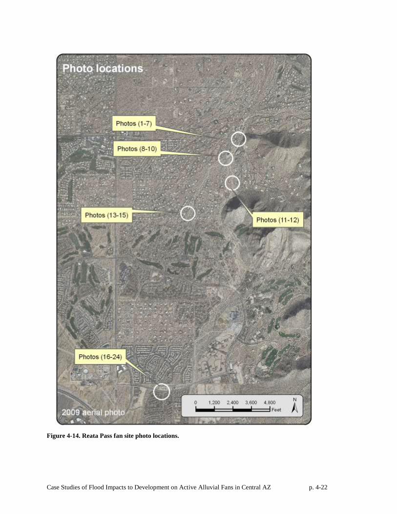
Case Studies of Flood Impacts to Development on Active Alluvial Fans in Central AZ p. 4-22
Figure 4-14. Reata Pass fan site photo locations.
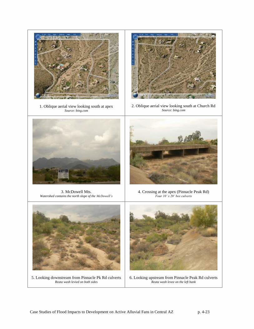
Case Studies of Flood Impacts to Development on Active Alluvial Fans in Central AZ p. 4-23
1. Oblique aerial view looking south at apex Source: bing.com
2. Oblique aerial view looking south at Church Rd Source: bing.com
3. McDowell Mts. Watershed contains the north slope of the McDowell’s
4. Crossing at the apex (Pinnacle Peak Rd) Four 10’ x 20’ box culverts
5. Looking downstream from Pinnacle Pk Rd culverts Reata wash levied on both sides
6. Looking upstream from Pinnacle Peak Rd culverts Reata wash levee on the left bank
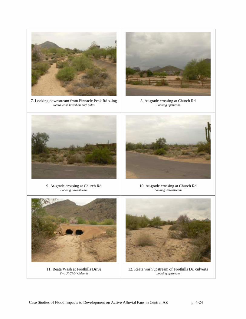
Case Studies of Flood Impacts to Development on Active Alluvial Fans in Central AZ p. 4-24
7. Looking downstream from Pinnacle Peak Rd x-ing Reata wash levied on both sides
8. At-grade crossing at Church Rd Looking upstream
9. At-grade crossing at Church Rd Looking downstream
10. At-grade crossing at Church Rd Looking downstream
11. Reata Wash at Foothills Drive Two 3’ CMP Culverts
12. Reata wash upstream of Foothills Dr. culverts Looking upstream
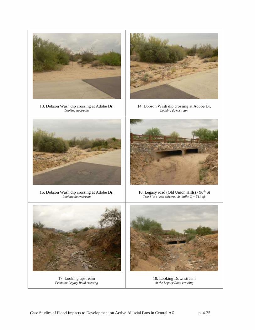
Case Studies of Flood Impacts to Development on Active Alluvial Fans in Central AZ p. 4-25
13. Dobson Wash dip crossing at Adobe Dr. Looking upstream
14. Dobson Wash dip crossing at Adobe Dr. Looking downstream
15. Dobson Wash dip crossing at Adobe Dr. Looking downstream
16. Legacy road (Old Union Hills) / 96th St Two 8’ x 4’ box culverts, As-built: Q = 511 cfs
17. Looking upstream From the Legacy Road crossing
18. Looking Downstream At the Legacy Road crossing
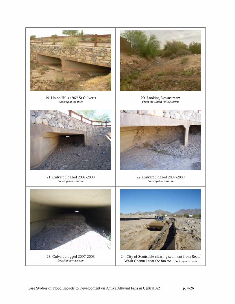
Case Studies of Flood Impacts to Development on Active Alluvial Fans in Central AZ p. 4-26
19. Union Hills / 96th St Culverts Looking at the inlet
20. Looking Downstream From the Union Hills culverts
21. Culvert clogged 2007-2008 Looking downstream
22. Culvert clogged 2007-2008 Looking downstream
23. Culvert clogged 2007-2008 Looking downstream
24. City of Scottsdale clearing sediment from Reata
Wash Channel near the fan toe. Looking upstream
4-27
4.6 Assessment of Flood Control Measures
Despite the lack of full-fan structural flood control measures in the upper active fan area and the
gap created by the demise of the Desert Greenbelt project, there have been no instances of significant
flood damages at the Reata Pass study area in the past 40 years. However, it is important to note that the
largest floods in the study area have peaked at less than 10% of the predicted 100-year discharge for
Reata Wash.
The biggest flood-related problems the City of Scottsdale has had on the Reata Pass fan is with
debris, vegetation or obstructions in the washes created, as well as sedimentation and scour at undersized
culverts and at-grade road crossings. Obstructions have included landscaping and other debris dumped in
washes, and residents building small levees or flood walls within the floodplain, and in some cases
building stables and horse facilities in the washes. To address these potential problems, the city of
Scottsdale has taken a pro-active approach, employing full time drainage-inspectors who patrol the
washes in Scottsdale looking for violations, writing up citations in order to restore the wash to its natural
unrestricted capacity as soon as possible.
Scottsdale’s Drainage and Street Operations Department also routinely maintains certain culverts
that frequently clog with sediment during small flow events and at-grade crossings that must be swept
clear of sediment after floods. In some cases, flow through at-grade crossings and undersized culverts
creates overflows that are traffic hazards or that cause downstream scour and bank erosion which require
periodic maintenance. To date, the maintenance issues have been relatively routine and did not involve
any flooding of private homes.
The most significant known flooding problems have occurred in the Pima Acres subdivision
downstream of Thompson Peak Parkway (Figure 4-15). At the time it was developed, no drainage
infrastructure was constructed in Pima Acres to deal with regional flooding through the area. Recently,
the City designed interim measures to help mitigate flooding by intercepting the flow along the northern
edge of the subdivision. The red dots, on the right side of the figure below depict the at-grade crossings
on Reata Pass alluvial fan, the majority of which are within Pima Acres. Flooding problems in Pima
Acres include sediment deposition and erosion on roads, damage to landscaping and flood debris.
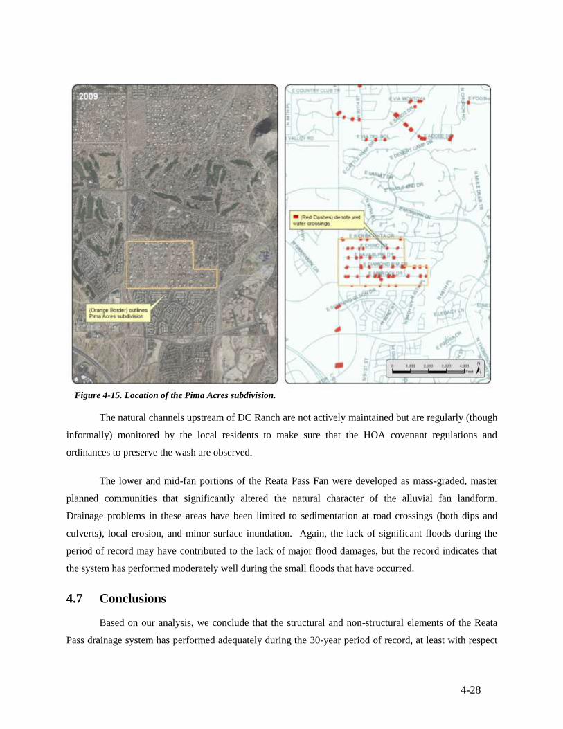
4-28
Figure 4-15. Location of the Pima Acres subdivision.
The natural channels upstream of DC Ranch are not actively maintained but are regularly (though
informally) monitored by the local residents to make sure that the HOA covenant regulations and
ordinances to preserve the wash are observed.
The lower and mid-fan portions of the Reata Pass Fan were developed as mass-graded, master
planned communities that significantly altered the natural character of the alluvial fan landform.
Drainage problems in these areas have been limited to sedimentation at road crossings (both dips and
culverts), local erosion, and minor surface inundation. Again, the lack of significant floods during the
period of record may have contributed to the lack of major flood damages, but the record indicates that
the system has performed moderately well during the small floods that have occurred.
4.7 Conclusions
Based on our analysis, we conclude that the structural and non-structural elements of the Reata
Pass drainage system has performed adequately during the 30-year period of record, at least with respect

4-29
to controlling the flow uncertainty and sedimentation associated with active alluvial fans. No homes on
the fan have been flooded in the past 20 years. Sedimentation at road crossings is addressed routinely by
homeowner’s association or the City of Scottsdale, though at some cost to taxpayers and residents.
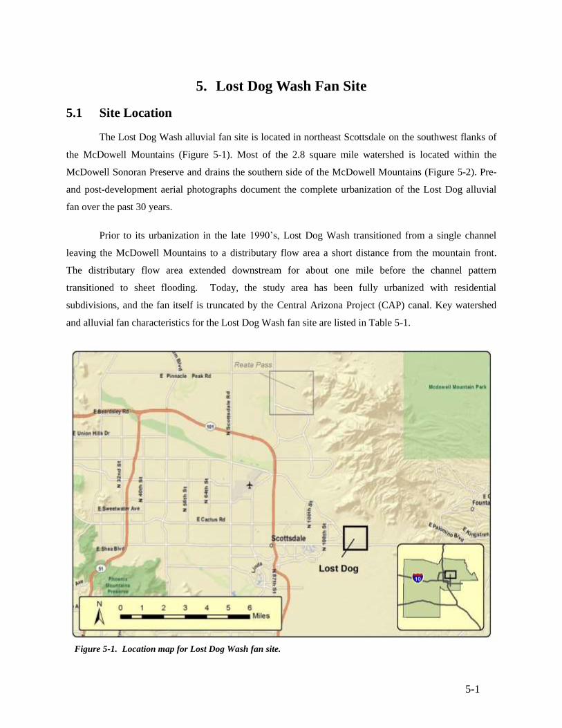
5-1
5. Lost Dog Wash Fan Site
5.1 Site Location
The Lost Dog Wash alluvial fan site is located in northeast Scottsdale on the southwest flanks of
the McDowell Mountains (Figure 5-1). Most of the 2.8 square mile watershed is located within the
McDowell Sonoran Preserve and drains the southern side of the McDowell Mountains (Figure 5-2). Pre-
and post-development aerial photographs document the complete urbanization of the Lost Dog alluvial
fan over the past 30 years.
Prior to its urbanization in the late 1990’s, Lost Dog Wash transitioned from a single channel
leaving the McDowell Mountains to a distributary flow area a short distance from the mountain front.
The distributary flow area extended downstream for about one mile before the channel pattern
transitioned to sheet flooding. Today, the study area has been fully urbanized with residential
subdivisions, and the fan itself is truncated by the Central Arizona Project (CAP) canal. Key watershed
and alluvial fan characteristics for the Lost Dog Wash fan site are listed in Table 5-1.
Figure 5-1. Location map for Lost Dog Wash fan site.
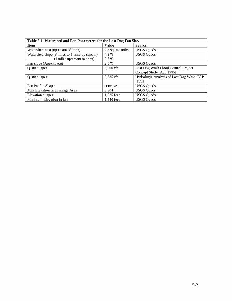
5-2
Table 5-1. Watershed and Fan Parameters for the Lost Dog Fan Site.
Item Value Source
Watershed area (upstream of apex) 2.8 square miles USGS Quads
Watershed slope (3 miles to 1-mile up stream)
(1 miles upstream to apex)
4.2 %
2.7 %
USGS Quads
Fan slope (Apex to toe) 2.5 % USGS Quads
Q100 at apex 5,000 cfs Lost Dog Wash Flood Control Project
Concept Study [Aug 1995]
Q100 at apex 3,735 cfs Hydrologic Analysis of Lost Dog Wash CAP
[1991]
Fan Profile Shape concave USGS Quads
Max Elevation in Drainage Area 3,804 USGS Quads
Elevation at apex 1,625 feet USGS Quads
Minimum Elevation in fan 1,440 feet USGS Quads
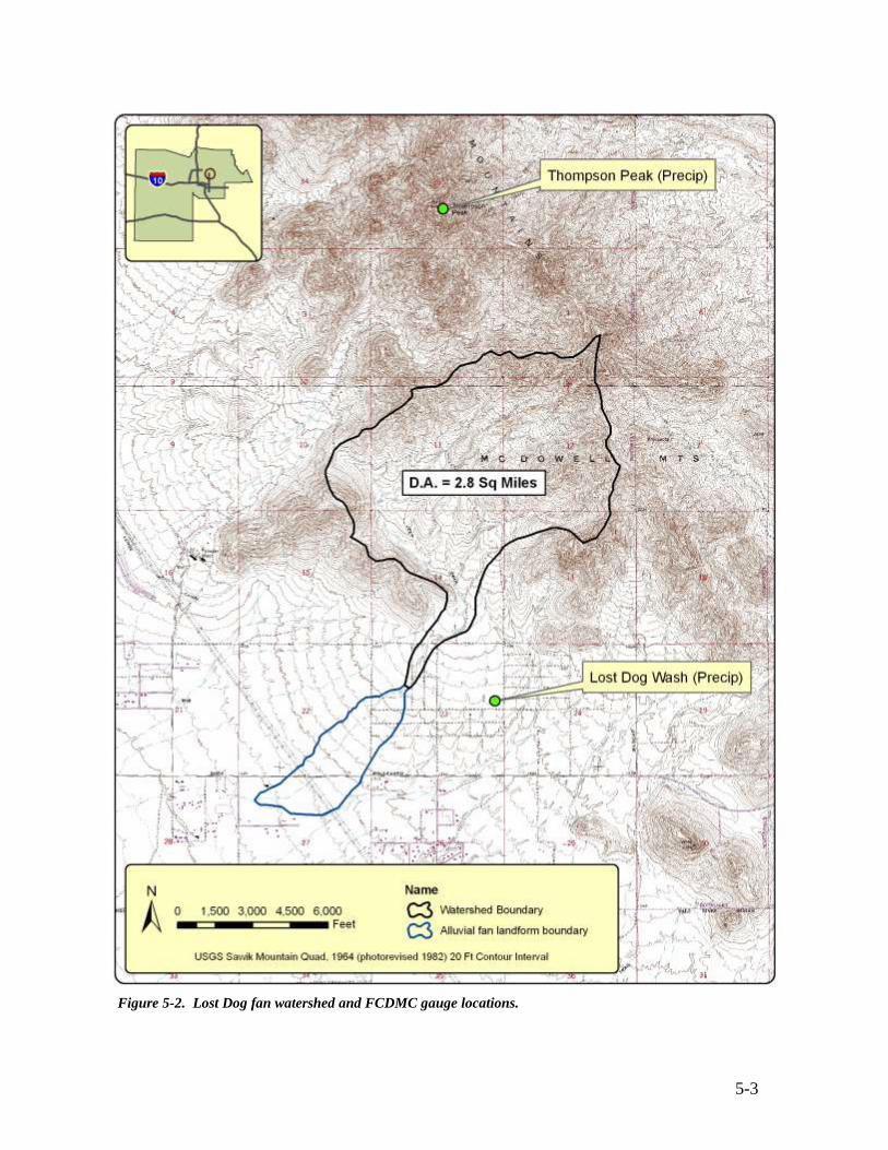
5-3
Figure 5-2. Lost Dog fan watershed and FCDMC gauge locations.
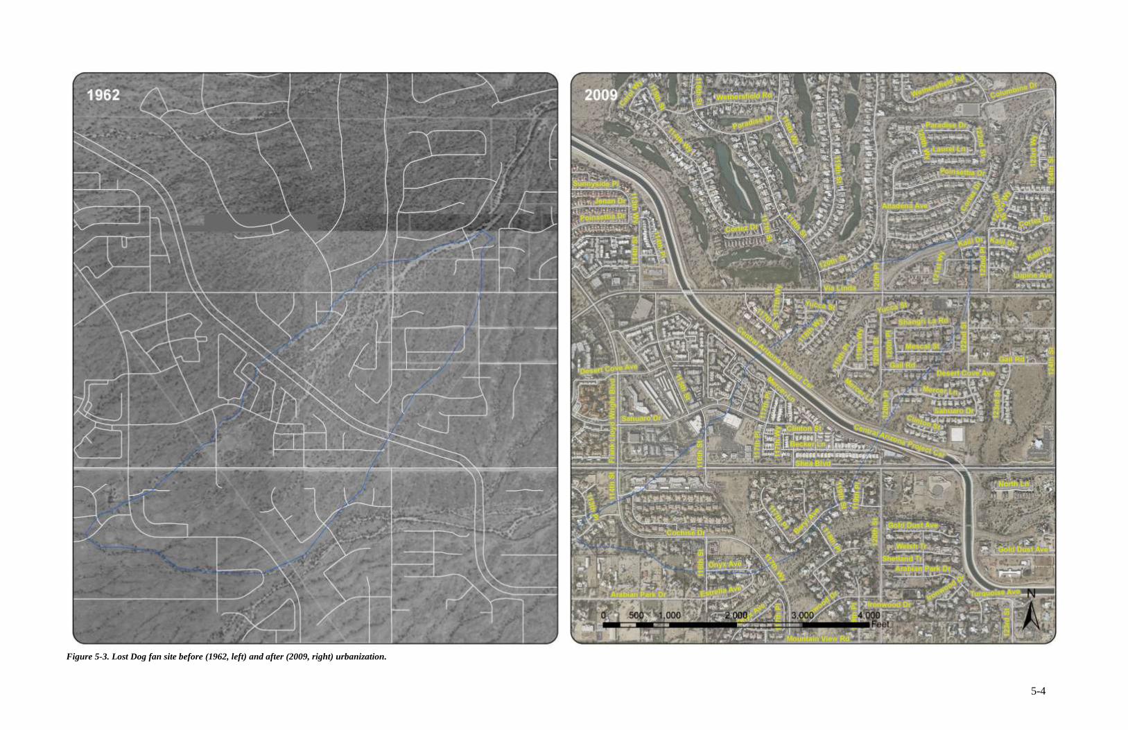
5-4
Figure 5-3. Lost Dog fan site before (1962, left) and after (2009, right) urbanization.
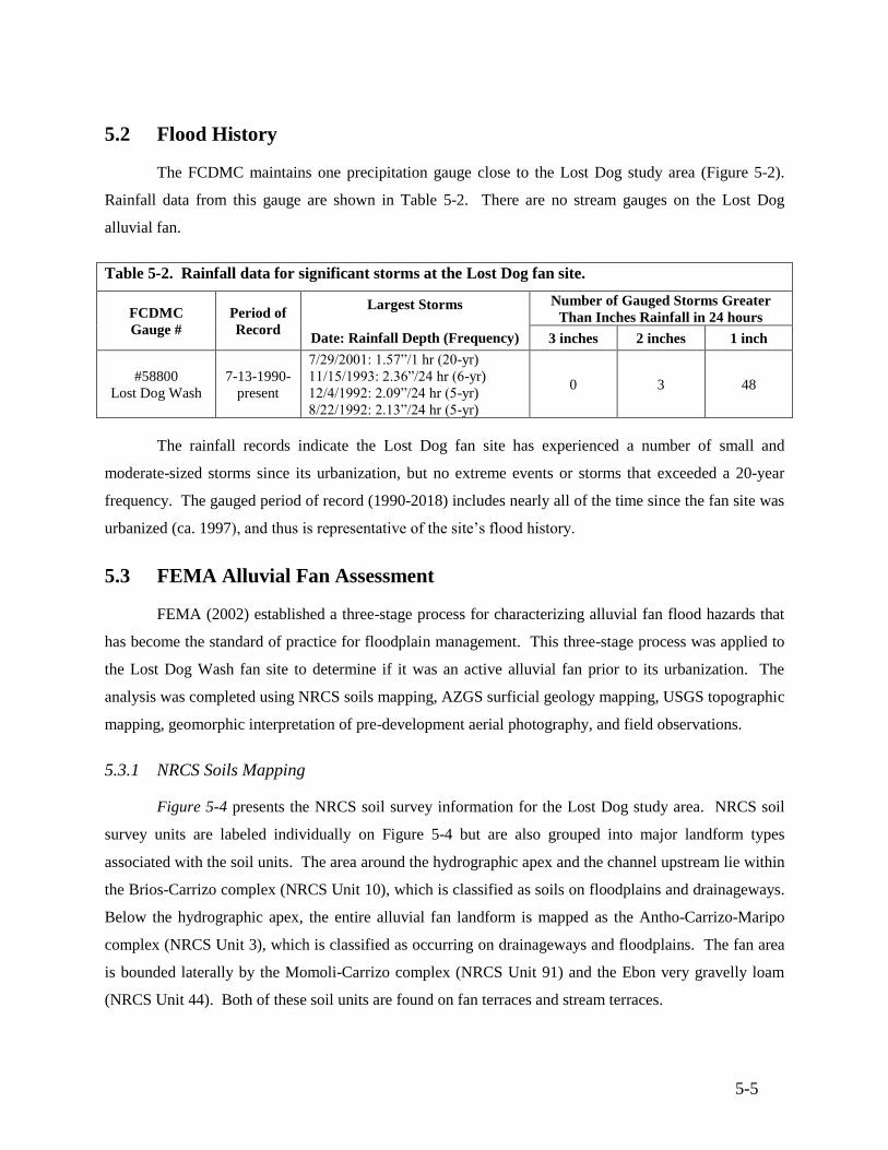
5-5
5.2 Flood History
The FCDMC maintains one precipitation gauge close to the Lost Dog study area (Figure 5-2).
Rainfall data from this gauge are shown in Table 5-2. There are no stream gauges on the Lost Dog
alluvial fan.
Table 5-2. Rainfall data for significant storms at the Lost Dog fan site.
FCDMC
Gauge #
Period of
Record
Largest Storms
Date: Rainfall Depth (Frequency)
Number of Gauged Storms Greater
Than Inches Rainfall in 24 hours
3 inches 2 inches 1 inch
#58800
Lost Dog Wash
7-13-1990-
present
7/29/2001: 1.57”/1 hr (20-yr)
11/15/1993: 2.36”/24 hr (6-yr)
12/4/1992: 2.09”/24 hr (5-yr)
8/22/1992: 2.13”/24 hr (5-yr)
0 3 48
The rainfall records indicate the Lost Dog fan site has experienced a number of small and
moderate-sized storms since its urbanization, but no extreme events or storms that exceeded a 20-year
frequency. The gauged period of record (1990-2018) includes nearly all of the time since the fan site was
urbanized (ca. 1997), and thus is representative of the site’s flood history.
5.3 FEMA Alluvial Fan Assessment
FEMA (2002) established a three-stage process for characterizing alluvial fan flood hazards that
has become the standard of practice for floodplain management. This three-stage process was applied to
the Lost Dog Wash fan site to determine if it was an active alluvial fan prior to its urbanization. The
analysis was completed using NRCS soils mapping, AZGS surficial geology mapping, USGS topographic
mapping, geomorphic interpretation of pre-development aerial photography, and field observations.
5.3.1 NRCS Soils Mapping
Figure 5-4 presents the NRCS soil survey information for the Lost Dog study area. NRCS soil
survey units are labeled individually on Figure 5-4 but are also grouped into major landform types
associated with the soil units. The area around the hydrographic apex and the channel upstream lie within
the Brios-Carrizo complex (NRCS Unit 10), which is classified as soils on floodplains and drainageways.
Below the hydrographic apex, the entire alluvial fan landform is mapped as the Antho-Carrizo-Maripo
complex (NRCS Unit 3), which is classified as occurring on drainageways and floodplains. The fan area
is bounded laterally by the Momoli-Carrizo complex (NRCS Unit 91) and the Ebon very gravelly loam
(NRCS Unit 44). Both of these soil units are found on fan terraces and stream terraces.
5-6
5.3.2 AZGS Surficial Geologic Mapping
AZGS surficial geologic mapping (Richard & Spencer, 1998) for the study area is shown in
Figure 5-5. The Qy unit (Holocene-aged alluvium) corresponds to the study site boundaries and consists
of low terraces and alluvial fan deposits. The Qy surfaces are bounded by the Qm, Ql and Qmo units, all
of which are Pleistocene-aged (Ql late Pleistocene; Qm-middle Pleistocene; Qmo middle to early
Pleistocene) fans and fan terraces of increasing age.
5.3.3 USGS Topographic Mapping
As seen in Figure 5-6, the USGS topographic contours bow slightly in the downstream direction
near the apex, indicating the shape of a partially extended fan. An area of smooth radial contours is inset
within a much broader area of more crenulated contours that correspond to the active and inactive
portions of the fan landform. The small size of the active fan surface makes the distinction between
contour crenulation somewhat subtle at the scale of the USGS mapping.
5.3.4 FEMA Stage 1-Stage 2-Alluvial Fan Classification
Based on the NRCS soils data, AZGS surficial mapping, USGS topographic mapping, and
interpretation of historical aerial photographs, the Lost Dog alluvial fan was classified as an alluvial fan
landform with active and inactive fan areas using FEMA (2002) guidelines. The site is composed of
alluvium, as shown by the NRCS soils and AZGS mapping. USGS topographic mapping indicate the
presence of radial topographic contours characteristic of a partially extended fan shape. The site is
located at a lateral and vertical topographic break formed where the main wash exits the embayed
mountain front of the McDowell Mountains. Therefore, the landform is properly classified as an alluvial
fan landform.
Furthermore, the fan landform exhibits the following characteristics of an active alluvial fan: (1) a
distributary and sheet flooding channel pattern below a hydrographic apex, (2) significant sheet flooding
areas, (3) geologically young, Holocene-aged soils, and (4) smooth contour crenulations. Therefore, a
portion of the fan landform can be classified as an active alluvial fan. Fan landform boundaries are
depicted on Figure 5-7.
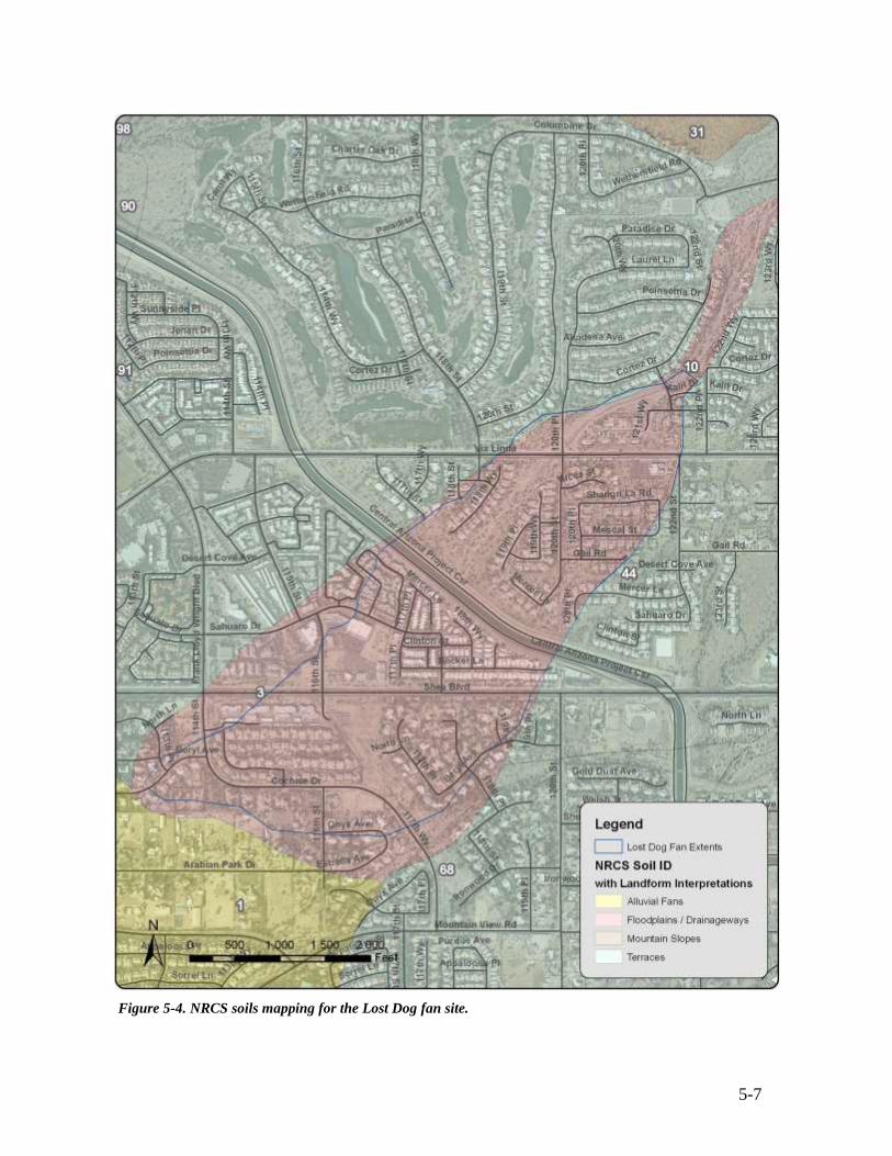
5-7
Figure 5-4. NRCS soils mapping for the Lost Dog fan site.
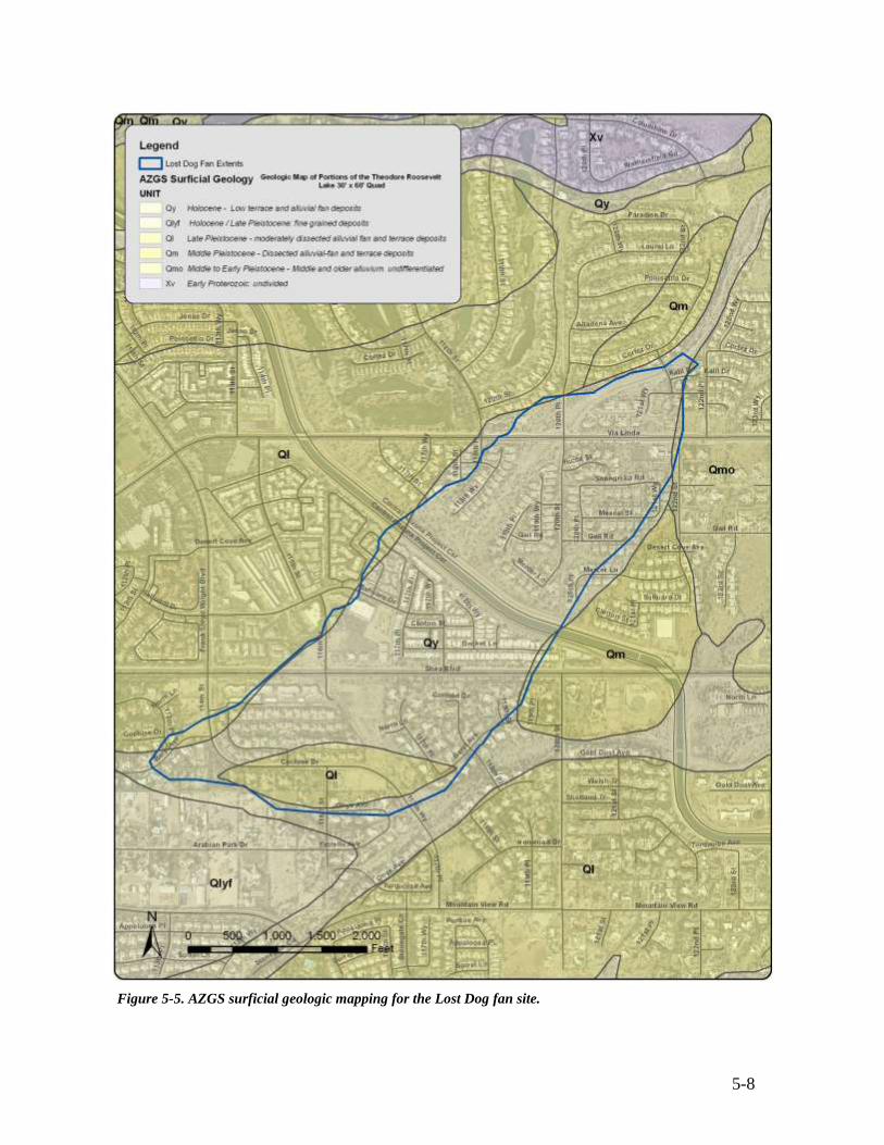
5-8
Figure 5-5. AZGS surficial geologic mapping for the Lost Dog fan site.
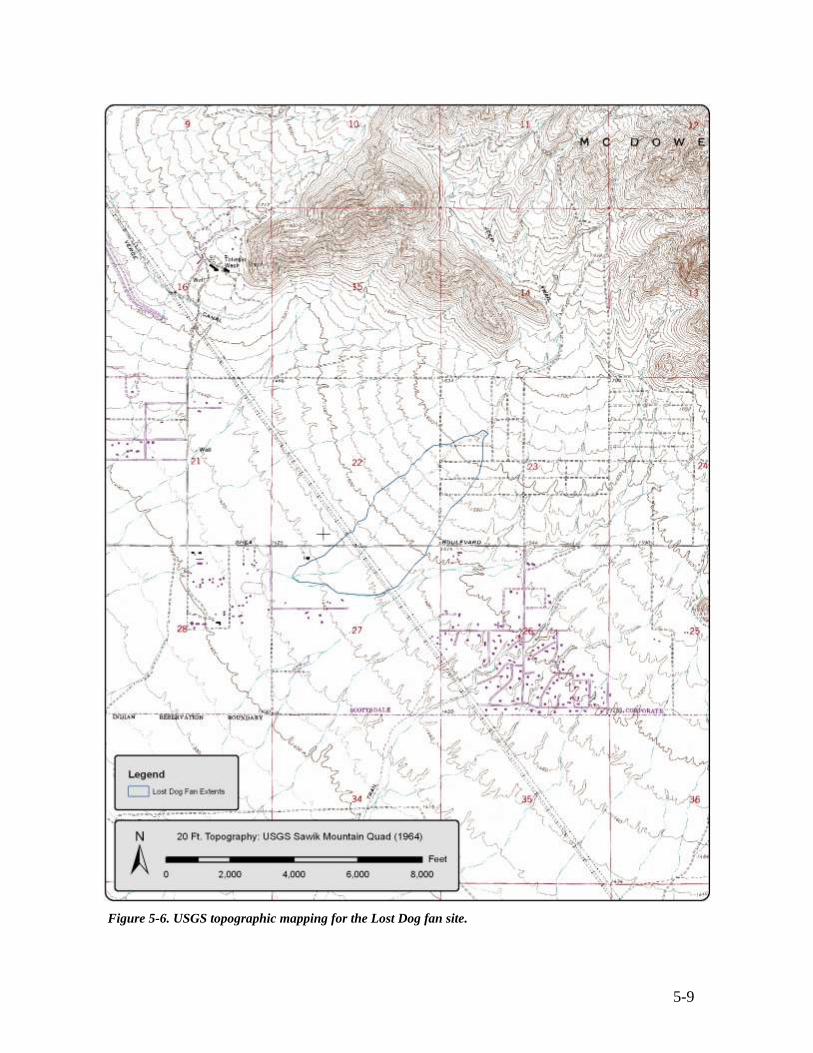
5-9
Figure 5-6. USGS topographic mapping for the Lost Dog fan site.
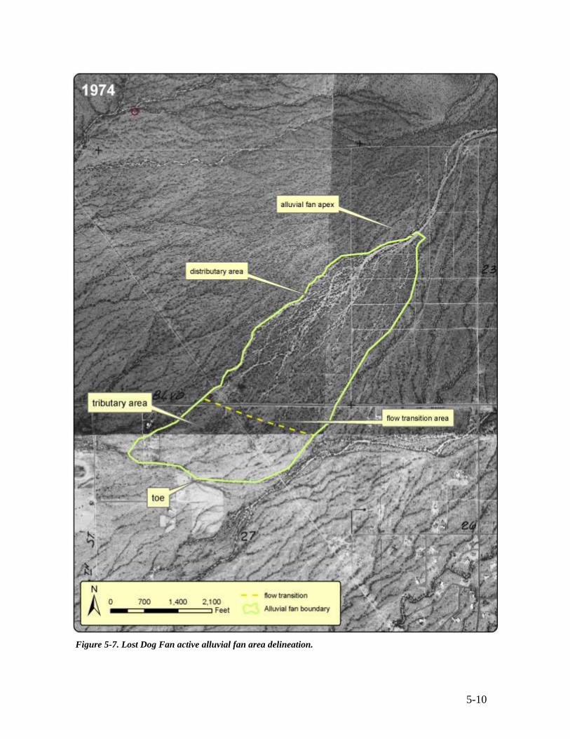
5-10
Figure 5-7. Lost Dog Fan active alluvial fan area delineation.
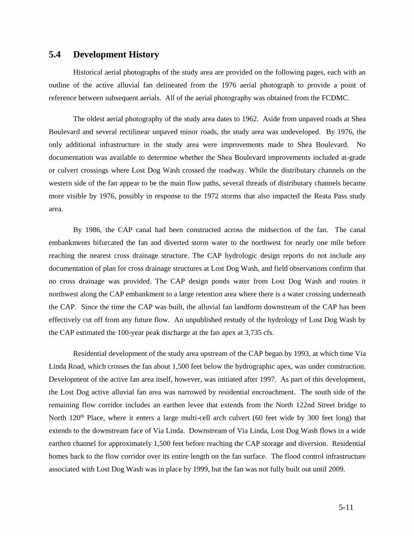
5-11
5.4 Development History
Historical aerial photographs of the study area are provided on the following pages, each with an
outline of the active alluvial fan delineated from the 1976 aerial photograph to provide a point of
reference between subsequent aerials. All of the aerial photography was obtained from the FCDMC.
The oldest aerial photography of the study area dates to 1962. Aside from unpaved roads at Shea
Boulevard and several rectilinear unpaved minor roads, the study area was undeveloped. By 1976, the
only additional infrastructure in the study area were improvements made to Shea Boulevard. No
documentation was available to determine whether the Shea Boulevard improvements included at-grade
or culvert crossings where Lost Dog Wash crossed the roadway. While the distributary channels on the
western side of the fan appear to be the main flow paths, several threads of distributary channels became
more visible by 1976, possibly in response to the 1972 storms that also impacted the Reata Pass study
area.
By 1986, the CAP canal had been constructed across the midsection of the fan. The canal
embankments bifurcated the fan and diverted storm water to the northwest for nearly one mile before
reaching the nearest cross drainage structure. The CAP hydrologic design reports do not include any
documentation of plan for cross drainage structures at Lost Dog Wash, and field observations confirm that
no cross drainage was provided. The CAP design ponds water from Lost Dog Wash and routes it
northwest along the CAP embankment to a large retention area where there is a water crossing underneath
the CAP. Since the time the CAP was built, the alluvial fan landform downstream of the CAP has been
effectively cut off from any future flow. An unpublished restudy of the hydrology of Lost Dog Wash by
the CAP estimated the 100-year peak discharge at the fan apex at 3,735 cfs.
Residential development of the study area upstream of the CAP began by 1993, at which time Via
Linda Road, which crosses the fan about 1,500 feet below the hydrographic apex, was under construction.
Development of the active fan area itself, however, was initiated after 1997. As part of this development,
the Lost Dog active alluvial fan area was narrowed by residential encroachment. The south side of the
remaining flow corridor includes an earthen levee that extends from the North 122nd Street bridge to
North 120th Place, where it enters a large multi-cell arch culvert (60 feet wide by 300 feet long) that
extends to the downstream face of Via Linda. Downstream of Via Linda, Lost Dog Wash flows in a wide
earthen channel for approximately 1,500 feet before reaching the CAP storage and diversion. Residential
homes back to the flow corridor over its entire length on the fan surface. The flood control infrastructure
associated with Lost Dog Wash was in place by 1999, but the fan was not fully built out until 2009.
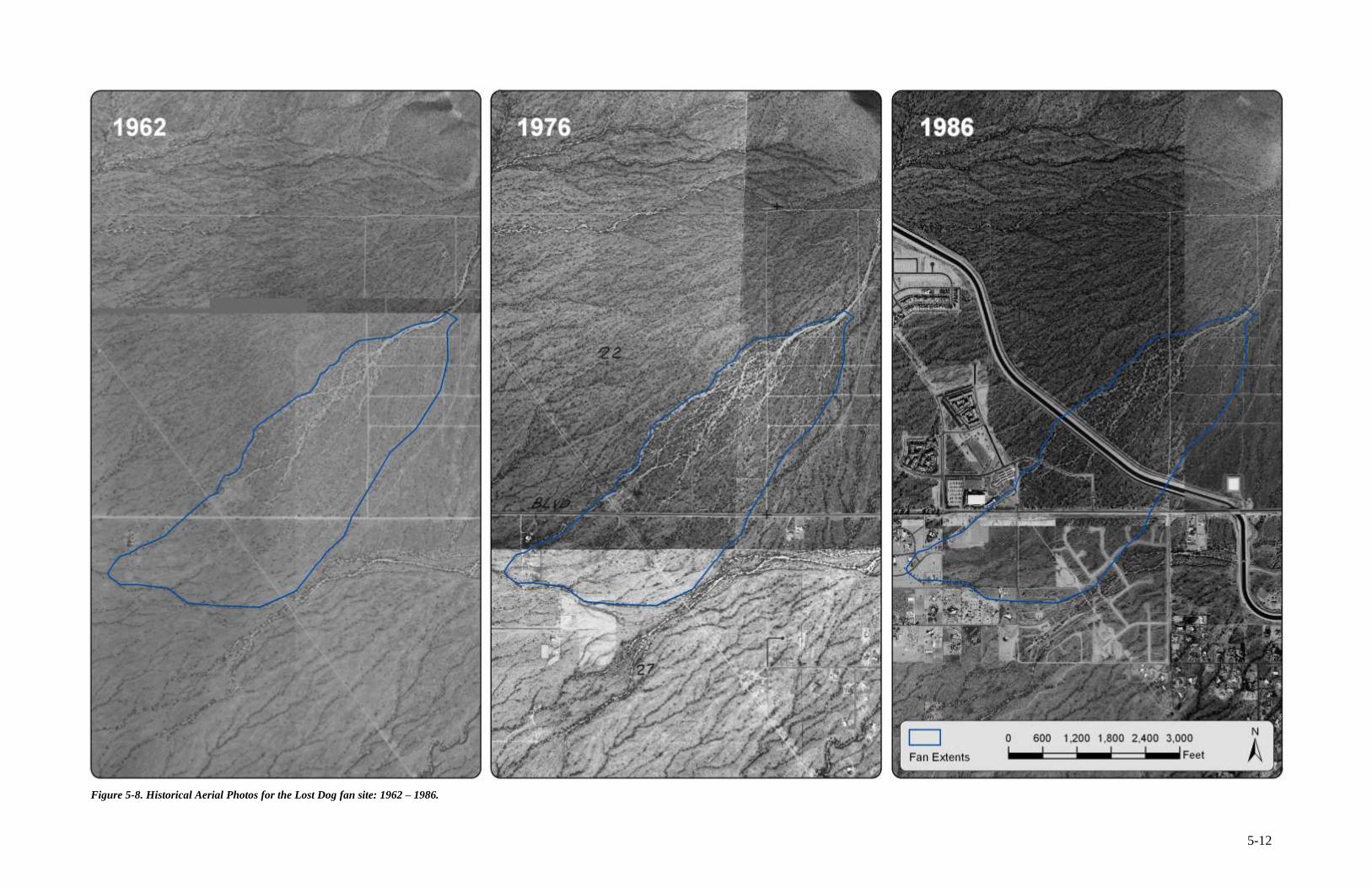
5-12
Figure 5-8. Historical Aerial Photos for the Lost Dog fan site: 1962 – 1986.
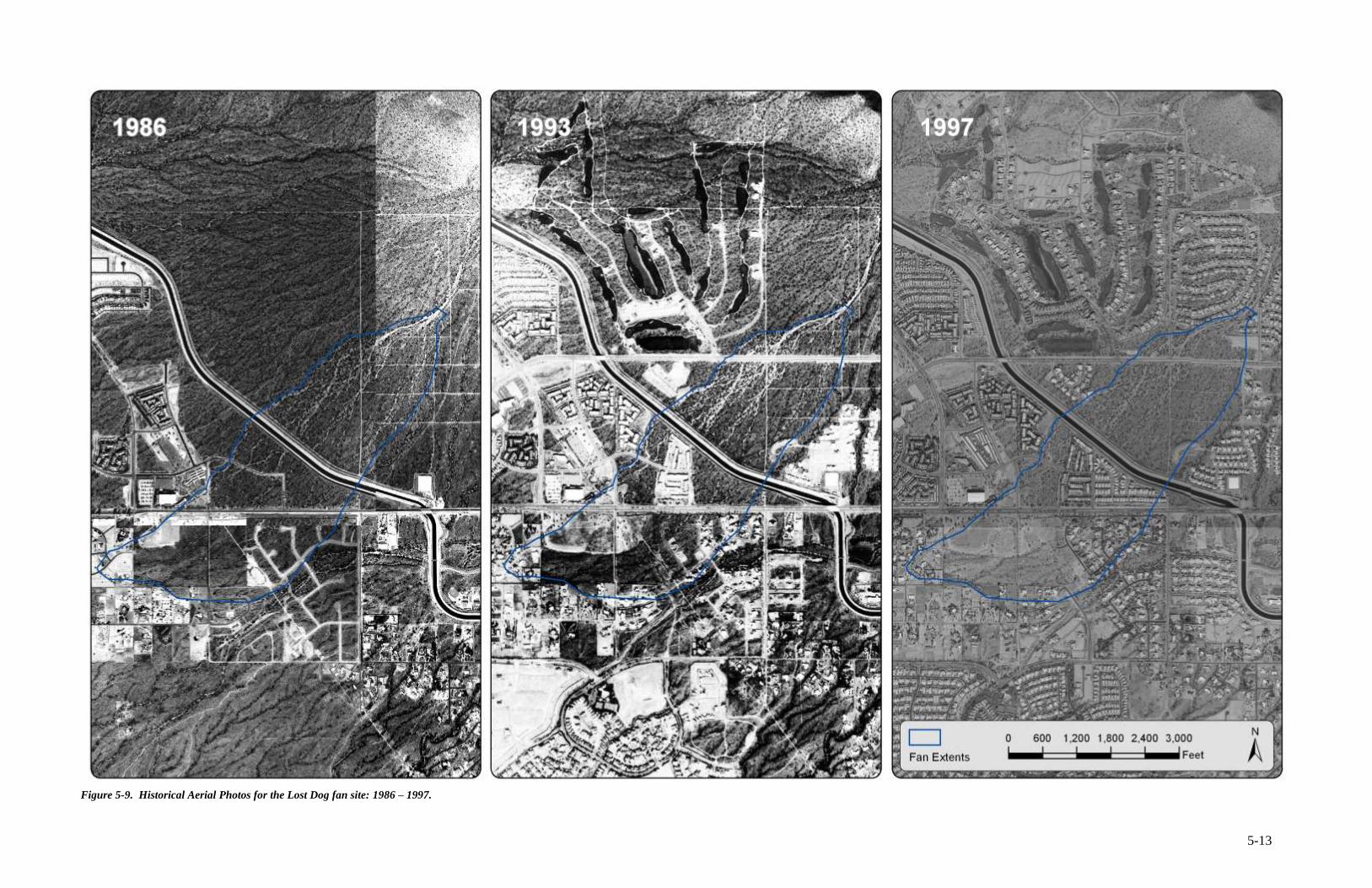
5-13
Figure 5-9. Historical Aerial Photos for the Lost Dog fan site: 1986 – 1997.
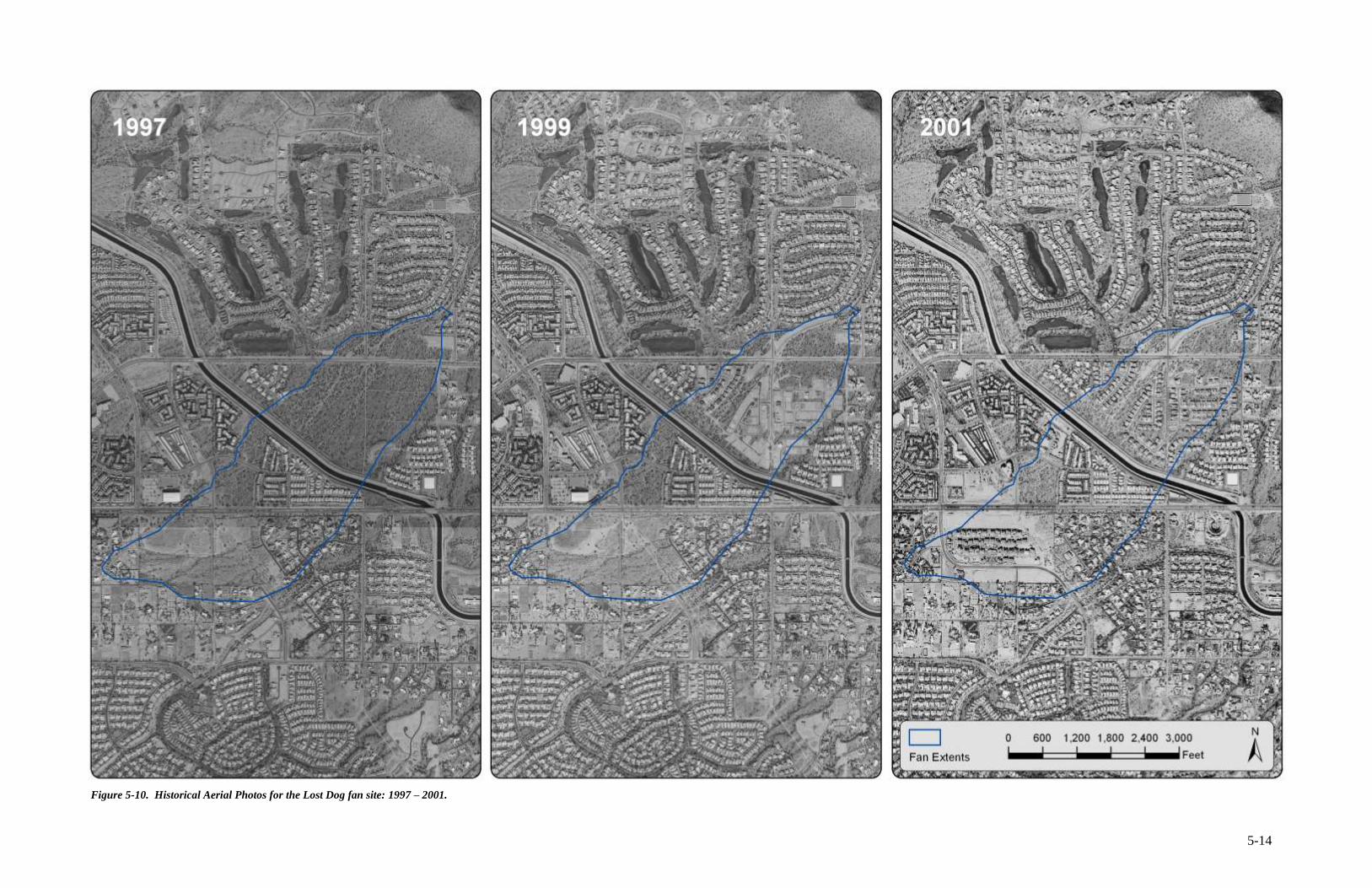
5-14
Figure 5-10. Historical Aerial Photos for the Lost Dog fan site: 1997 – 2001.
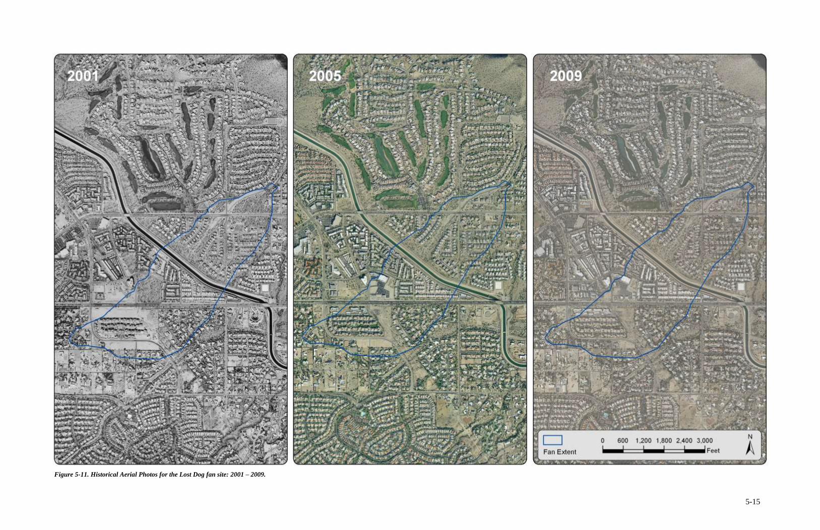
5-15
Figure 5-11. Historical Aerial Photos for the Lost Dog fan site: 2001 – 2009.
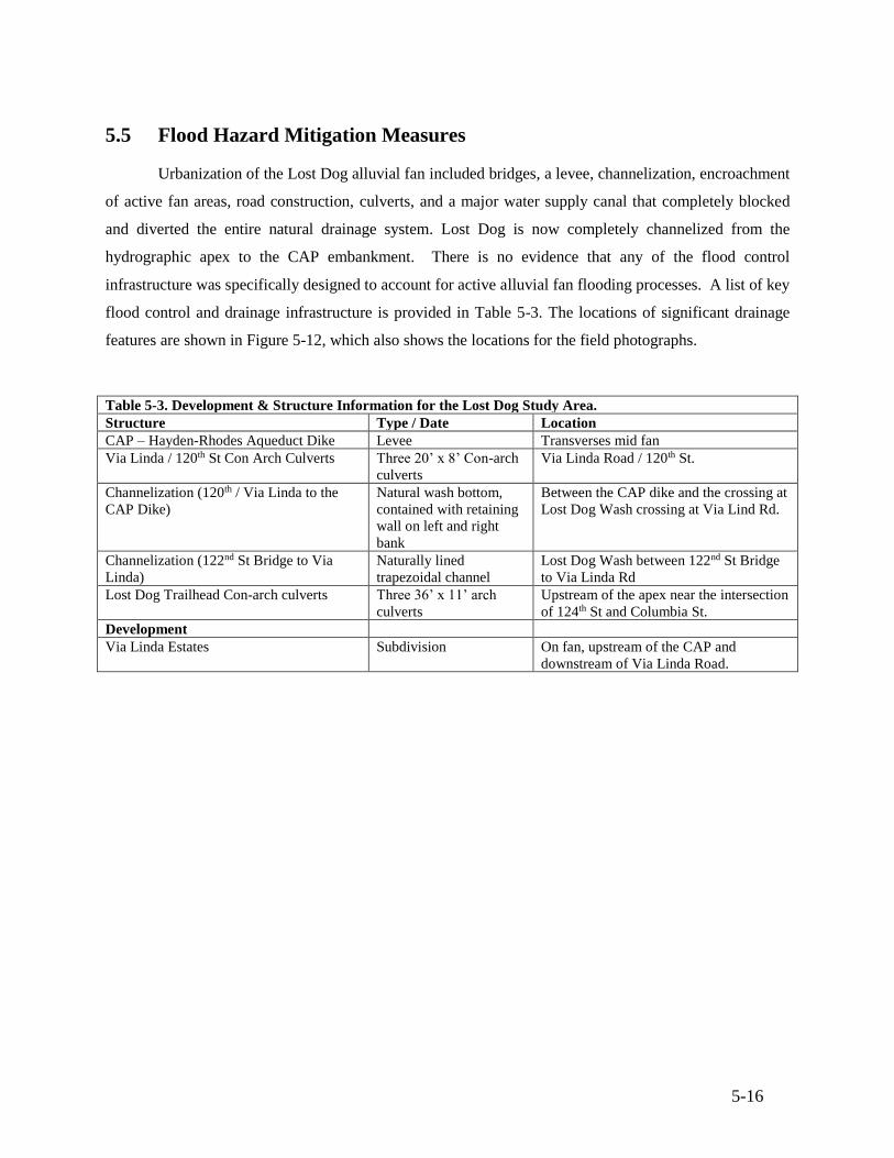
5-16
5.5 Flood Hazard Mitigation Measures
Urbanization of the Lost Dog alluvial fan included bridges, a levee, channelization, encroachment
of active fan areas, road construction, culverts, and a major water supply canal that completely blocked
and diverted the entire natural drainage system. Lost Dog is now completely channelized from the
hydrographic apex to the CAP embankment. There is no evidence that any of the flood control
infrastructure was specifically designed to account for active alluvial fan flooding processes. A list of key
flood control and drainage infrastructure is provided in Table 5-3. The locations of significant drainage
features are shown in Figure 5-12, which also shows the locations for the field photographs.
Table 5-3. Development & Structure Information for the Lost Dog Study Area.
Structure Type / Date Location
CAP – Hayden-Rhodes Aqueduct Dike Levee Transverses mid fan
Via Linda / 120th St Con Arch Culverts Three 20’ x 8’ Con-arch
culverts
Via Linda Road / 120th St.
Channelization (120th / Via Linda to the
CAP Dike)
Natural wash bottom,
contained with retaining
wall on left and right
bank
Between the CAP dike and the crossing at
Lost Dog Wash crossing at Via Lind Rd.
Channelization (122nd St Bridge to Via
Linda)
Naturally lined
trapezoidal channel
Lost Dog Wash between 122nd St Bridge
to Via Linda Rd
Lost Dog Trailhead Con-arch culverts Three 36’ x 11’ arch
culverts
Upstream of the apex near the intersection
of 124th St and Columbia St.
Development
Via Linda Estates Subdivision On fan, upstream of the CAP and
downstream of Via Linda Road.
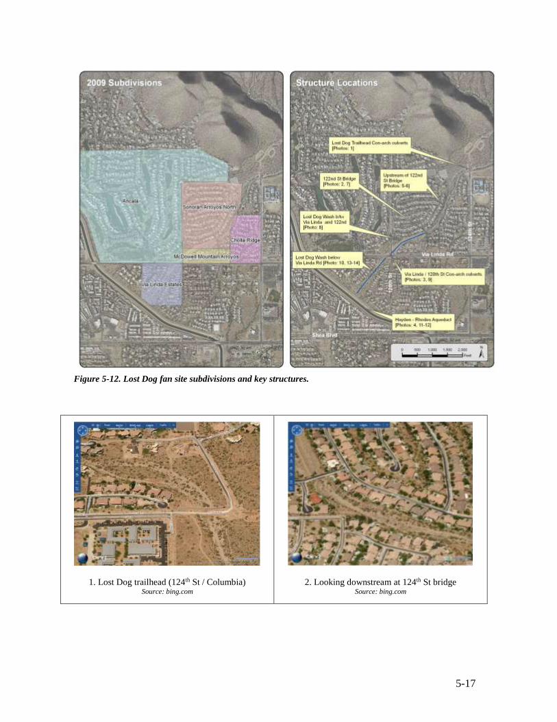
5-17
Figure 5-12. Lost Dog fan site subdivisions and key structures.
1. Lost Dog trailhead (124th St / Columbia) Source: bing.com
2. Looking downstream at 124th St bridge Source: bing.com
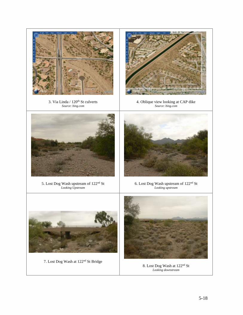
5-18
3. Via Linda / 120th St culverts Source: bing.com
4. Oblique view looking at CAP dike Source: bing.com
5. Lost Dog Wash upstream of 122nd St Looking Upstream
6. Lost Dog Wash upstream of 122nd St Looking upstream
7. Lost Dog Wash at 122nd St Bridge
8. Lost Dog Wash at 122nd St Looking downstream
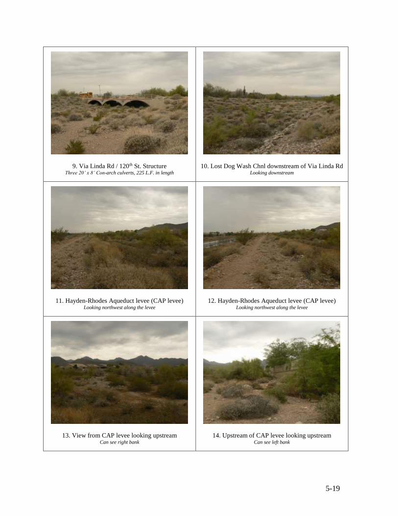
5-19
9. Via Linda Rd / 120th St. Structure Three 20’ x 8’ Con-arch culverts, 225 L.F. in length
10. Lost Dog Wash Chnl downstream of Via Linda Rd Looking downstream
11. Hayden-Rhodes Aqueduct levee (CAP levee) Looking northwest along the levee
12. Hayden-Rhodes Aqueduct levee (CAP levee) Looking northwest along the levee
13. View from CAP levee looking upstream Can see right bank
14. Upstream of CAP levee looking upstream Can see left bank
5-20
5.6 Assessment of Flood Control Measures
Besides the CAP dike, the largest engineered structures on the fan are the two channelized
sections of the wash with the Via Linda culvert crossing connecting the two. The Via Linda crossing is
located at the intersection of Via Linda Rd and 120th St. It consists of three 20’ x 8’ concrete arch
culverts. The city of Scottsdale Street / Field Operations Department inspects the structure once per year
and is not aware of any flooding or sedimentation issues associated with that structure.
Representatives from the local HOA, which are responsible for maintenance of the channel
corridors on the Lost Dog fan site report that they contract out the maintenance services, but the
maintenance companies report that they perform no work in the wash itself. Neither the HOA’s, the
service companies, nor the city of Scottsdale report any sedimentation, erosion, or flooding issues related
to Lost Dog Wash. The City of Scottsdale Street / Field Operations is also unaware of any maintenance
issues associated with the drainage crossings on Lost Dog Wash. Similarly, the CAP was unaware of any
damage to the CAP embankment, diversion channel, or storage area related the truncated Lost Dog Wash
fan crossing
5.7 Conclusions
Based on our analysis, we conclude that the engineered drainage system for the Lost Dog alluvial
fan has performed adequately during the 20-year period of record, at least with respect to controlling the
flow uncertainty and sedimentation associated with active alluvial fans. No homes or structures on or
around the fan have been flooded during the period of record. No sediment or erosion concern were
reported or identified in this study. However, it is noted that, like the Reata Pass study area, the Lost Dog
fan site has not experience many significant rainfall / runoff events since the fan has been developed that
would have fully tested its drainage infrastructure.
6-1
6. Conclusions
None of the four alluvial fan study sites have experienced any significant flood damages to homes
or the engineered flood control infrastructure since they were urbanized. With the exception of localized
failures of the ACE-8 concrete channel at the Ahwatukee site, which was unrelated to active alluvial fan
flood processes, only routine maintenance of post-flood sedimentation and scour has been reported at any
of the four study sites.
The four sites represent a combined 110 years of record since they were fully built out. Two of
the sites have experienced greater-than 100-year frequency rainfall at least once during the period of
record. The lack of reported flood damages on these active alluvial fans since their urbanization is even
more significant, given that the flood mitigation measures employed for three of the study sites
(Ahwatukee, Pima Canyon, Lost Dog) were not specifically designed to address ultrahazardous active
alluvial fan flooding. That is, the flood control systems were designed only to address normal (non-fan)
flood hazards. At the fourth site (Reata Pass), non-structural flood control measures for active alluvial fan
flooding were used in the area closest to the hydrographic apex, which presumably would experience the
most hazardous flood conditions. For the rest of the Reata Pass fan area, non-fan flood control measures
were used. At one site (Pima Canyon), flood damages at the toe of the fan prior to urbanization of the
more active part of the fan surface were significant enough that the NRCS designed and built a major
flood control dam (Guadalupe FRS) to protect the town of Guadalupe.
It is important to note that despite the occurrence of several greater than 100-year rainfall events,
only the Ahwatukee fan site experienced floods that approximated a 100-year design flow. Even though
the large floods at the Ahwatukee fan site damaged the concrete-lined flood control channel, the damage
was localized and did not result in damage to any homes or public infrastructure and was quickly repaired
by the private HOA which owns and maintains the channel.
The lack of significant post-development flood damage at the four active alluvial fan study sites
is attributed to the following factors:
(1) Flood Hazard Type. None of the four study sites are subject to debris flows. The floods that occur on
most active alluvial fans in central Arizona are water floods. Most floods on active alluvial fans in
central Arizona carry high sediment loads (> 5% concentration), but the rare debris flow activity near
the sites is limited to the steeper terrain in the upper watersheds well above the hydrographic apex on
6-2
the active fan surface. Without debris flow impacts to the active fan areas, the potential for channel
avulsions is lower as is the potential for rapid aggradation of the fan surface. Furthermore, standard
non-fan flood control measures are more likely to withstand water-based flood processes, particularly
where development guidelines require consideration of scour and sedimentation impacts.
(2) Low Sedimentation Rate. Given that most of the sediment supplied to the active fan surfaces is
delivered by water floods, rather than debris flows, the actual rate of sediment aggradation is
relatively low compared to fans that also experience debris flows. For the larger study sites, such as
the Reata Pass, the ratio of fan surface area to sediment yield is quite high, indicating a potential for
even large sediment loads to be distributed thinly over large areas, i.e., minimal aggradation occurs
over engineering time scales. In addition, subsequent sediment removal by rainfall falling directly on
the fan surface, as opposed to originating in the watershed above the fan apex, is higher for fans with
large surface areas because the on-fan watersheds are relatively large and can generate erosive flows.
(3) Increased On-Fan Sediment Conveyance. For most of the fan areas studied, development included
channelization and overall encroachment of the active fan surface, both of which would result in
increased sediment transport rates on the fan surface as well as a decrease in the potential for
sediment deposition on the fan surface. Increased sediment transport off the fan surface would also
be caused by increased impervious cover in developed areas, more frequent (clear-water) runoff from
impervious areas, increased flow velocities in channels and in encroached areas, decreased infiltration
and flow attenuation of flows over the fan surface, and physical removal of sediment by maintenance
crews.
(4) Flow Obstruction by Development and/or Flood Control Measures. The engineered flood control
systems, as well as the physical space occupied by the development itself, built at the four study sites
seem to have prevented the occurrence of channel avulsions, even where avulsions were known to
have occurred prior to urbanization (Reata Pass, Ahwatukee). That is, the presence of homes, solid
property boundary walls, roads, and other physical obstructions may exert a strong degree of control
over where water is able to flow, which therefore controls where (and whether) avulsions can occur.
It is likely that the mere presence of dense urbanization may preclude the occurrence of some kinds of
alluvial fan channel avulsions, at least where water-floods rather than debris flows are more likely.
(5) Elevation on Fill. For some alluvial fans subject only to water floods, elevation on fill may be
sufficient to significantly reduce flood risk, such as in the active portion of the Reata Pass site near
the hydrographic apex. Note that the elevations of homes on the Reata Pass site were based on flood
6-3
depths derived from the FEMA FAN model, and consequently may be significantly underestimated
(Fuller, 2012a; 2012b). Nevertheless, elevation of homes on fill reduces the potential for those homes
to be inundated by flooding.
(6) Lack of Major Floods. Three of the four study sites have not experienced a 100-year or greater flood.
Therefore, the lack of flood damage must be considered in light of the actual record of small to
medium-sized floods that peaked, at most, at about 10 percent of the predicted 100-year flood peak.
The lack of major floods, despite relatively significant rainfall and a combined 110-year period of
record, may call into question the accuracy of the 100-year peak discharge predictions based on
rainfall-runoff models, but such questions are beyond the scope of this analysis. The lack of large
floods may be particularly significant for the Reata Pass study site, where single lot development near
the fan apex appears to be most at risk of future flood damage. Conversely, the record may indicate
that traditional non-fan flood protection measures are sufficient for small to minor floods on active
alluvial fans.
(7) Short Period of Record. While the combined post-development period of record totals 110 years, the
individual periods for each site are coincident and include some notable years of drought conditions.
Therefore, it is possible that the study sample is biased toward years of low flood potential.
It is not the conclusion of this report that active alluvial fans in central Arizona have low flood
risk or flood damage potential, or that the flood risk on active alluvial fans is equivalent to that found on
riverine floodplains. Nor is it the conclusion of this report that riverine flood protection measures should
be used on active alluvial fans. Rather, we conclude that engineering design of structures on active
alluvial fans in central Arizona should carefully consider the potential for the unique hazards of active
alluvial fan flooding processes such as channel avulsion, sediment deposition, scour, flow path
uncertainty, and high velocity flows, as well as less frequently found hazards such as debris flows.
However, the performance record for development at the four active alluvial fan sites examined in this
study suggest that different degrees of flood hazards, flood risk, and flooding types exist on different
alluvial fans, and engineering protection should be designed for each fan’s unique suite of hazard types,
rather than using a one-size-fits-all ultrahazardous classification implied in current FEMA guidelines.
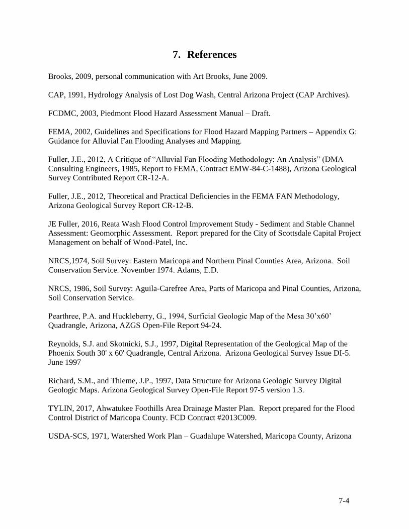
7-4
7. References
Brooks, 2009, personal communication with Art Brooks, June 2009.
CAP, 1991, Hydrology Analysis of Lost Dog Wash, Central Arizona Project (CAP Archives).
FCDMC, 2003, Piedmont Flood Hazard Assessment Manual – Draft.
FEMA, 2002, Guidelines and Specifications for Flood Hazard Mapping Partners – Appendix G:
Guidance for Alluvial Fan Flooding Analyses and Mapping.
Fuller, J.E., 2012, A Critique of “Alluvial Fan Flooding Methodology: An Analysis” (DMA
Consulting Engineers, 1985, Report to FEMA, Contract EMW-84-C-1488), Arizona Geological
Survey Contributed Report CR-12-A.
Fuller, J.E., 2012, Theoretical and Practical Deficiencies in the FEMA FAN Methodology,
Arizona Geological Survey Report CR-12-B.
JE Fuller, 2016, Reata Wash Flood Control Improvement Study - Sediment and Stable Channel
Assessment: Geomorphic Assessment. Report prepared for the City of Scottsdale Capital Project
Management on behalf of Wood-Patel, Inc.
NRCS,1974, Soil Survey: Eastern Maricopa and Northern Pinal Counties Area, Arizona. Soil
Conservation Service. November 1974. Adams, E.D.
NRCS, 1986, Soil Survey: Aguila-Carefree Area, Parts of Maricopa and Pinal Counties, Arizona,
Soil Conservation Service.
Pearthree, P.A. and Huckleberry, G., 1994, Surficial Geologic Map of the Mesa 30’x60’
Quadrangle, Arizona, AZGS Open-File Report 94-24.
Reynolds, S.J. and Skotnicki, S.J., 1997, Digital Representation of the Geological Map of the
Phoenix South 30' x 60' Quadrangle, Central Arizona. Arizona Geological Survey Issue DI-5.
June 1997
Richard, S.M., and Thieme, J.P., 1997, Data Structure for Arizona Geologic Survey Digital
Geologic Maps. Arizona Geological Survey Open-File Report 97-5 version 1.3.
TYLIN, 2017, Ahwatukee Foothills Area Drainage Master Plan. Report prepared for the Flood
Control District of Maricopa County. FCD Contract #2013C009.
USDA-SCS, 1971, Watershed Work Plan – Guadalupe Watershed, Maricopa County, Arizona