Embed Size (px)
Citation preview
1
DISTRICT COURT, WATER DIVISION NO. 2, COLORADO --------------------------------------------------------------------------------------------------------------------- RESUME OF CASES FILED DURING DECEMBER 2006 INVITATION TO JOIN SUBSTITUTE WATER SUPPLY PLAN NOTIFICATION LIST --------------------------------------------------------------------------------------------------------------------- TO: ALL INTERESTED PARTIES Pursuant to C.R.S. 37-92-302, you are hereby notified that the following is a resume of application and certain amendments filed during December 2006, in Water Division No. 2. The names and addresses of applicants, description of water rights or conditional water rights involved and description of ruling sought as reflected by said applications, or amendments, are as follows: --------------------------------------------------------------------------------------------------------------------- CASE NO. 88CW21 – PURGATOIRE RIVER WATER CONSERVANCY DISTRICT, 315 West Main Street, Trinidad, CO 81082, in its own right, and pursuant to contracts with BACA IRRIGATING DITCH COMPANY, CHICOSA IRRIGATING DITCH COMPANY, CHILILI DITCH COMPANY, EL MORO DITCH COMPANY, ENLARGED SOUTHSIDE DITCH COMPANY, HOEHNE DITCH COMPANY, JOHN FLOOD DITCH COMPANY, LUJAN IRRIGATING DITCH COMPANY, MODEL LAND AND IRRIGATION (JOHN FLOOD RIGHTS), MODEL LAND AND IRRIGATION COMPANY (MODEL DITCH RIGHTS), NORTH SIDE IRRIGATING DITCH COMPANY, EL MORO WATER USERS, JOHN FLOOD DITCH WATER USERS, R. LACEY INCORPORATED (RIVER CANON RANCH), THE CITY OF TRINIDAD, and their successors and assigns (Julianne M. Woldridge, MacDougall, Woldridge & Worley, PC, Attorneys for Applicant, 530 Communication Circle, Suite 204, Colorado Springs, Colorado 80905; 719-520-9288) Amended Application to Change Water Rights LAS ANIMAS COUNTY 2. Structures for which changes are sought: The District owns or has contractual rights to manage certain water rights of the Trinidad Dam & Reservoir Project (“Project”), as listed in the original application. The Project Water Rights to be changed are: a. Model Reservoir Right (owned by Applicant) - 20,000 acre-feet, priority no.10, appropriation date 1/22/1908; b. Joint Use Capacity, Trinidad Reservoir Right (owned by Applicant) – 39,000 acre-feet, appropriation date 5/6/1989. Since the original application was filed in this matter, the Silt Control Section water right, decreed in Case No. 87CW45, was canceled by this Court. A new water right has been decreed in its place for the Joint Use Capacity, Trinidad Reservoir, Case No. 92CW30, District Court, Water Div. No. 2. This amended application amends the original application to seek changes to the current decreed water right from Case no. 92CW30. c. the following “Ditch Rights” (managed by Applicant):
2
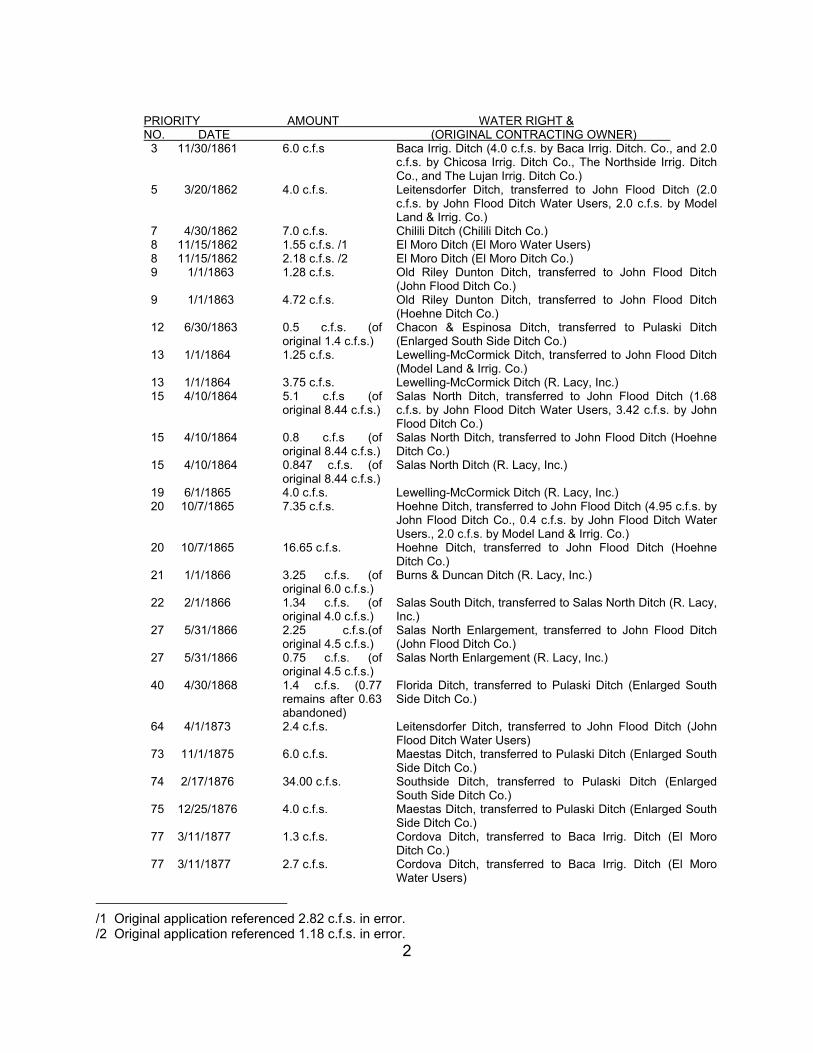
PRIORITY AMOUNT WATER RIGHT & NO. DATE (ORIGINAL CONTRACTING OWNER)
3 11/30/1861 6.0 c.f.s Baca Irrig. Ditch (4.0 c.f.s. by Baca Irrig. Ditch. Co., and 2.0 c.f.s. by Chicosa Irrig. Ditch Co., The Northside Irrig. Ditch Co., and The Lujan Irrig. Ditch Co.)
5 3/20/1862 4.0 c.f.s. Leitensdorfer Ditch, transferred to John Flood Ditch (2.0 c.f.s. by John Flood Ditch Water Users, 2.0 c.f.s. by Model Land & Irrig. Co.)
7 4/30/1862 7.0 c.f.s. Chilili Ditch (Chilili Ditch Co.) 8 11/15/1862 1.55 c.f.s. /1 El Moro Ditch (El Moro Water Users) 8 11/15/1862 2.18 c.f.s. /2 El Moro Ditch (El Moro Ditch Co.) 9 1/1/1863 1.28 c.f.s. Old Riley Dunton Ditch, transferred to John Flood Ditch
(John Flood Ditch Co.) 9 1/1/1863 4.72 c.f.s. Old Riley Dunton Ditch, transferred to John Flood Ditch
(Hoehne Ditch Co.) 12 6/30/1863 0.5 c.f.s. (of
original 1.4 c.f.s.) Chacon & Espinosa Ditch, transferred to Pulaski Ditch (Enlarged South Side Ditch Co.)
13 1/1/1864 1.25 c.f.s. Lewelling-McCormick Ditch, transferred to John Flood Ditch (Model Land & Irrig. Co.)
13 1/1/1864 3.75 c.f.s. Lewelling-McCormick Ditch (R. Lacy, Inc.) 15 4/10/1864 5.1 c.f.s (of
original 8.44 c.f.s.) Salas North Ditch, transferred to John Flood Ditch (1.68 c.f.s. by John Flood Ditch Water Users, 3.42 c.f.s. by John Flood Ditch Co.)
15 4/10/1864 0.8 c.f.s (of original 8.44 c.f.s.)
Salas North Ditch, transferred to John Flood Ditch (Hoehne Ditch Co.)
15 4/10/1864 0.847 c.f.s. (of original 8.44 c.f.s.)
Salas North Ditch (R. Lacy, Inc.)
19 6/1/1865 4.0 c.f.s. Lewelling-McCormick Ditch (R. Lacy, Inc.) 20 10/7/1865 7.35 c.f.s. Hoehne Ditch, transferred to John Flood Ditch (4.95 c.f.s. by
John Flood Ditch Co., 0.4 c.f.s. by John Flood Ditch Water Users., 2.0 c.f.s. by Model Land & Irrig. Co.)
20 10/7/1865 16.65 c.f.s. Hoehne Ditch, transferred to John Flood Ditch (Hoehne Ditch Co.)
21 1/1/1866 3.25 c.f.s. (of original 6.0 c.f.s.)
Burns & Duncan Ditch (R. Lacy, Inc.)
22 2/1/1866 1.34 c.f.s. (of original 4.0 c.f.s.)
Salas South Ditch, transferred to Salas North Ditch (R. Lacy, Inc.)
27 5/31/1866 2.25 c.f.s.(of original 4.5 c.f.s.)
Salas North Enlargement, transferred to John Flood Ditch (John Flood Ditch Co.)
27 5/31/1866 0.75 c.f.s. (of original 4.5 c.f.s.)
Salas North Enlargement (R. Lacy, Inc.)
40 4/30/1868 1.4 c.f.s. (0.77 remains after 0.63 abandoned)
Florida Ditch, transferred to Pulaski Ditch (Enlarged South Side Ditch Co.)
64 4/1/1873 2.4 c.f.s. Leitensdorfer Ditch, transferred to John Flood Ditch (John Flood Ditch Water Users)
73 11/1/1875 6.0 c.f.s. Maestas Ditch, transferred to Pulaski Ditch (Enlarged South Side Ditch Co.)
74 2/17/1876 34.00 c.f.s. Southside Ditch, transferred to Pulaski Ditch (Enlarged South Side Ditch Co.)
75 12/25/1876 4.0 c.f.s. Maestas Ditch, transferred to Pulaski Ditch (Enlarged South Side Ditch Co.)
77 3/11/1877 1.3 c.f.s. Cordova Ditch, transferred to Baca Irrig. Ditch (El Moro Ditch Co.)
77 3/11/1877 2.7 c.f.s. Cordova Ditch, transferred to Baca Irrig. Ditch (El Moro Water Users)
/1 Original application referenced 2.82 c.f.s. in error. /2 Original application referenced 1.18 c.f.s. in error.

3
80 4/7/1877 18.6 c.f.s. Florida Ditch, (Enlarged South Side Ditch Co.) 93 12/15/1882 4.0 c.f.s. Maestas Ditch, transferred to Pulaski Ditch (Enlarged South
Side Ditch Co.) 95 11/4/1883 14.38 c.f.s. Baca Irrig. Ditch (Chicosa Irrig. Ditch Co., The Northside
Irrigat. Ditch Co., and The Lujan Irrig. Ditch Co.) 96 11/23/1883 16.84 c.f.s. Sandoval Ditch, transferred to Pulaski Ditch (Enlarged South
Side Ditch Co.) 98 4/30/1884 60.0 c.f.s. Pulaski Ditch (Enlarged South Side Ditch Co.) 103 6/21/1886 14.73 c.f.s. Baca Irrig. Ditch (Chicosa Irrig. Ditch Co., The Northside
Irrig. Ditch Co., and The Lujan Irrig. Ditch Co.) 104 10/21/1886 10.0 c.f.s. Lewelling-McCormick Ditch (R. Lacy, Inc.) 106 3/12/1887 15.0 c.f.s. Baca Irrig. Ditch (Chicosa Irrig. Ditch Co., The Northside
Irrig. Ditch Co., and The Lujan Irrig. Ditch Co.) 108 2/15/1888 9.7 c.f.s. Sandoval Ditch, transferred to Pulaski Ditch (Enlarged South
Side Ditch Co.) 109 3/1/1888 8.0 c.f.s. Maestas Ditch, transferred to Pulaski Ditch (Enlarged South
Side Ditch Co.) 145 10/20/1902 100.0 c.f.s. John Flood Ditch (John Flood Ditch Co.) 168 1/22/1908 200.00 c.f.s. Model Ditch (Model Land & Irrig. Co.) 242½ 6/12/1920 45.56 c.f.s. J.M. Baca Flood Ditch (Chicosa Irrig. Ditch Co., The
Northside Irrig. Ditch Co., and The Lujan Irrig. Ditch Co.) 3. Prior decrees for these water rights: a. Model Reservoir Right and Ditch Rights - Civil Action No. 19793, District Court, Las Animas County, decree entered 4/15/1965, which was subsequently the subject of Case No. 27962, Colorado Supreme Court, Purgatoire River Water Conservancy District, et al. v. Kuiper, 197 Colo. 200, 593 P.2d 333 (1979); a portion were changed in Case No. 88CW61, Water Div. No. 2, decree entered June 22, 2001; and, a portion were changed in Case No. 03CW108, Water Div. No. 2, decree entered Dec. 30, 2005; and b. Joint Use Capacity, Trinidad Reservoir Right - Case No. 92CW30, as further decreed in Case No. 02CW82, District Court, Water Division No. 2 and as further governed by the Operating Principles and Operating Criteria of the Trinidad Project. 3. The Project Water Rights are stored in Trinidad Reservoir, in Sections 21, 26, 27, 28, 29, 30, 31, 32, 33, and 34, T.33S., R.64W., 6th P.M., Las Animas County, CO, and/or are diverted at the respective ditches named above. 4. Source: Purgatoire River and its tributaries. 5. Uses: domestic, irrigation, stock watering, municipal, industrial, maintenance of Permanent Fishery Pool of Trinidad Reservoir, recreation and fish propagation, replacement of evaporation and seepage from Permanent Fishery Pool of Trinidad Reservoir, including storage for release of delayed return flows. 6. Proposed changes: a. Conform the decrees in Case 19793 and Case No. 92CW30 to Operating Principles Amendments: Applicant seeks to conform the decrees in Case No. 19793, District Court, Las Animas County, and in Case No. 92CW30, District Court, Water Div. No. 2 to reflect Operating Principle amendments recommended by the Bureau of Reclamation. In paragraph 10(f) of the Decree in Case 19793, the Court retained jurisdiction to (among other things) make the Decree in that case “conform to such future modifications, deletions, or additions as may be made to said operating principles”, upon notice thereof to all parties to said Case 19793. A copy of the Decree in Case 19793 is attached to the original Application filed in this matter. The persons or entities who were parties to Case 19793, or who are, upon information and belief, their successors are stated in the original Application filed in this matter, and have been provided with notice of this amended application. In paragraph 16 of the Decree in Case No. 92CW30, the Court retained jurisdiction to “review and approve or disapprove any amendments to the Compact or Operating
4
Principles, so far as they change the regimen of the stream in the exercise of this Decree and thereby cause material injury to the vested rights of any party to this case…” Parties to that case are also parties to the present case and have been provided with notice of this amended application. In the course of a Review of the Trinidad Operating Principles conducted by the U.S. Department of Interior, Bureau of Reclamation, as provided in Condition No. 4 proposed by the State of Kansas and approved by Resolution of Applicant dated 1/26/1967, and by the Director, Region 7, U.S. Bureau of Reclamation, 2/1/1967, (a copy of the 3/20/1967 letter of said Director setting forth the “Operating Principles, Trinidad Dam and Reservoir Project”, and the “Five Conditions, State of Kansas” is attached to the original Application filed in this matter), the Bureau of Reclamation recommended amendments to the Operating Principles. In a December, 1987 Draft Report, the Bureau of Reclamation, U.S. Department of Interior, has recommended certain amendments to the Operating Principles as listed in the original Application filed in this matter. A copy of the Bureau’s December, 1987 Draft Report is on file with the Court in this matter. Since the original application was filed in this matter, some of the amendments or changes identified in that application have resulted in amendments to the Operating Principles. Other proposed amendments or changes identified in that application have yet to result in amendments to the Operating Principles. This amended application amends the original application by withdrawing some of the claims that have not yet resulted in amendments to the Operating Principles. Thus, Applicant now requests changes to conform the respective decrees to amendments that have been made as follows: 1). In its Review of the Operating Principles, the Bureau of Reclamation recommended that the Operating Principles be amended “to permit irrigation of the Class 6W lands and to permit more flexibility in shifting irrigated lands among the ditches”. The Operating Principles were amended to allow irrigation of “contracted lands lying within the District Boundaries and deleting restrictions to certain Classes of land; and 2). In its Review of the Operating Principles, the Bureau of Reclamation recommended that the Operating Principles be amended “to reduce the maximum irrigated acreage to 19,439 acres.” The Bureau has since amended this figure to 19,499. Article IV, Sections B.1 and 2. of the Operating Principles was amended to define “District Irrigable Area” as “only 19,499 acres of the contracted lands lying within the District’s Boundaries and to identify the District irrigable area ‘as nearly as practicable’ by the acreage identified in contracts with the District under individual ditches” and describing the numbers of acres under each such contract. b. Clarify decree to conform to Supreme Court Ruling: The Colorado Supreme Court, in Purgatoire River Water Conservancy District v. Kuiper, 197 Colo. 200, 593 P.2d 333 (1979) ruled as follows: Highland has contended that the 1965 transfer decree [Case No. 19793] merely changed the place of use of storage of the Model Storage Right to Trinidad Reservoir and did not change to storage the winter direct flow use of the Project ditches…The clear effect of the transfer decree was to make the changes as set forth in [House Document 325 and the Operating Principles]. So far as the persons who are bound by that transfer decree are concerned, the effect was to change both the place of storage and the use of winter direct flow.” The effect of this ruling is such that the decrees do not need to be changed to conform to the an Operating Principle amendment so proposed by the Bureau. Applicant, however, requests confirmation that the decrees for the subject water rights already conform in
5
this respect. The “storage of direct flows” is the subject of the Bureau’s recommendation that “[i]f storage of winter water under any right other than the model storage right [sic] is going to be continued, then amend the operating principles to specifically recognize this practice”. Clarifying the Decree in Case 19793 to conform to the Supreme Court Ruling will reduce confusion caused by the several documents involved. c. Delete condition10(e) of decree in Case 19793: One of the conditions of the Decree in Case 19793 is as follows: “that the Petitioners’ storage of water in the Trinidad Reservoir under the Model Reservoir Right shall be regulated in such a manner that the quantity of water occurring in the Las Animas or Purgatoire River at a gauging station on said River below Von Bremmer Arroya shall remain and be the same, as determined by the State Engineer, during any period of ten consecutive years reckoned in continuing progressive series beginning with January 1, 1954 as it would have been had the Model Reservoir Right not been transferred to the Trinidad Reservoir.” (herein referred to as the “10-year average”). It has not been possible to find a satisfactory method to determine the “10-year average” as required by this condition. The “10-year average” is not required by the Operating Principles. This condition should be deleted. d. Conform the decrees in Case 19793 and Case No. 92CW30 to other amendments to the Operating Principles that have occurred since the original application: 1). The Operating Principles were amended to provide for stock water allowances as follows: During the non-irrigation season the District may provide an annual allowance for stock watering purposes of not more than 1,200 acre feet measured at the headgates of Project ditches. If the stream gains below the Trinidad Dam are insufficient to fulfill this allowance, water may be released from the reservoir at any rate within the parameters of the Water Control Manual as needed to efficiently satisfy stock water demands within the allowance. Any water accumulated but not released for stock watering purposes as of April 1 shall be accounted as part of the annual District storage right; and 2) Article IV, Section A. 1. of the Operating Principles was amended to correct the list of water rights assigned to Applicant for administration as part of the Project, The water rights are as listed above; and e. Clarify that certain of the water rights were changed in Case Nos. 88CW61 and 03CW108, District Court, Water Division No. 2 on June 22, 2001, and conform the decrees in Case Nos. 19793 and 92CW30 to reflect corresponding changes in the Operating Principles. Future changes of the water rights related to regulation of summer flows and flood flows as described in House Document 325 and in the original application filed in this matter may still be desirable and may be the subject of future amendments and future case filings as stated in the original application filed in this matter, but are not being sought at this time. Applicant, therefore, prays for a decree changing the water rights as requested above and determining that such changes will not injuriously affect the owners of or persons entitled to use water under a vested water right or a conditional water right, and for such further relief as the Court deems appropriate. (Amended Application, 10 pages) ---------------------------------------------------------------------------------------------------------------------

6
------------------------------------------------------------------------------------------------------------ CASE NO. 01CW146 – CITY OF FOUNTAIN (herein “Fountain”), c/o Larry Patterson, Utilities Director, 116 South Main Street, Fountain, CO 80817 (Direct all pleadings to: Cynthia F. Covell, Alperstein & Covell, P.C., Attorneys for Applicant, 1600 Broadway, Suite 2350, Denver, CO 80202, 303-894-8191) Third Amended Application for Change of Water Rights and Plan for Augmentation, Including Exchanges EL PASO AND PUEBLO COUNTIES 2. Fountain hereby amends Paragraph 7 of its application filed December 28, 2001, as amended October 9, 2003 and December 27, 2004 (the “original application”), by adding new subparagraphs H - O, as follows: H. Name of Structure: City of Fountain Well No. 19, Well Permit: To be applied for, Previous decrees: None. Location SW1/4 of the SW1/4 of Section 9, Township 16 South, Range 65 West of the 6th P.M. at a point 190 feet from the south section line and 10 feet from the west section line of said Section 9, in El Paso County, Colorado. Uses: Municipal, including domestic, irrigation, fire protection, sewage disposal, sprinkling of lawns, trees, shrubs, flowers and gardens, recreational and aesthetic, manufacturing, commercial and industrial uses, augmentation and exchange. Source: This well is tributary to Fountain Creek. Capacity: 600 gpm (1.34 cfs). Owner: City of Fountain. Owner of property on which well is located: City of Fountain. I. Name of Structure: City of Fountain Well No. 20. Well Permit: To be applied for. Previous decrees: None. Location: NW1/4 of the NW1/4 of Section 16, Township 16 South, Range 65 West of the 6th P.M. at a point 70 feet from the north section line and 940 feet from the west section line of said Section 16, in El Paso County, Colorado. Uses: Municipal, including domestic, irrigation, fire protection, sewage disposal, sprinkling of lawns, trees, shrubs, flowers and gardens, recreational and aesthetic, manufacturing, commercial and industrial uses, augmentation and exchange. Source: This well is tributary to Fountain Creek. Capacity: 600 gpm (1.34 cfs). Owner: City of Fountain. Owner of property on which well is located: CV Moonlit Family Partnership LLLP. J. Name of Structure: City of Fountain Well No. 21. Well Permit: To be applied for. Previous decrees: None. Location: NE1/4 of the NW1/4 of Section 16, Township 16 South, Range 65 West of the 6th P.M. at a point 70 feet from the north section line and 1,340 feet from the west section line of said Section 16, in El Paso County, Colorado. Uses: Municipal, including domestic, irrigation, fire protection, sewage disposal, sprinkling of lawns, trees, shrubs, flowers and gardens, recreational and aesthetic, manufacturing, commercial and industrial uses, augmentation and exchange. Source: This well is tributary to Fountain Creek. Capacity: 600 gpm (1.34 cfs). Owner: City of Fountain. Owner of property on which well is located: CV Moonlit Family Partnership LLLP. K. Name of Structure: City of Fountain Well No. 22. Well Permit: To be applied for. Previous decrees: None. Location: NE1/4 of the NW1/4 of Section 16, Township 16 South, Range 65 West of the 6th P.M. at a point 70 feet from the north section line and 1,740 feet from the west section line of said Section 16, in El Paso County, Colorado. Source: This well is tributary to Fountain Creek. Uses: Municipal, including domestic, irrigation, fire protection, sewage disposal, sprinkling of lawns, trees, shrubs, flowers and gardens,

7
recreational and aesthetic, manufacturing, commercial and industrial uses, augmentation and exchange. Capacity: 600 gpm (1.34 cfs). Owner: City of Fountain. Owner of property on which well is located: CV Moonlit Family Partnership LLLP. L. Name of Structure: City of Fountain Well No. 23. Well Permit: To be applied for. Previous decrees: None. Location: NW1/4 of the NW 1/4 of Section 16, Township 16 South, Range 65 West of the 6th P.M., at a point 870 feet from the north section line and 870 feet from the west section line of said Section 16, in El Paso County, Colorado. Source: This well is tributary to Fountain Creek. Uses: Municipal, including domestic, irrigation, fire protection, sewage disposal, sprinkling of lawns, trees, shrubs, flowers and gardens, recreational and aesthetic, manufacturing, commercial and industrial uses, augmentation and exchange. Capacity: 600 gpm (1.34 cfs). Owner: City of Fountain. Owner of property on which well is located: CV Moonlit Family Partnership LLLP. M. Name of Structure: City of Fountain Well No. 24. Well Permit: To be applied for. Previous decrees: None. Location: SE 1/4 of the NW1/4 of Section 16, Township 16 South, Range 65 West of the 6th P.M., at a point 1,740 feet from the north section line and 1,740 feet from the west section line of said Section 16, in El Paso County, Colorado. Source: This well is tributary to Fountain Creek. Uses: Municipal, including domestic, irrigation, fire protection, sewage disposal, sprinkling of lawns, trees, shrubs, flowers and gardens, recreational and aesthetic, manufacturing, commercial and industrial uses, augmentation and exchange. Capacity: 600 gpm (1.34 cfs). Owner: City of Fountain. Owner of property on which well is located: CV Moonlit Family Partnership LLLP. N. Name of Structure: Delbert Wells Well No. 1. Well Permit: Permit No. R-20110-1 (A new permit will be obtained for uses and quantities decreed pursuant to this application.) Previous decree: Decreed in Case No. W-2273, Water Court, Water Division No. 2, for 654 gpm (1.46 cfs) for irrigation use with an appropriation date of December 31, 1937. Location: NW1/4 of the SE1/4 of Section 8, Township 16 South, Range 65 West of the 6th P.M. at a point 2,570 feet from the south section line and 1,550 feet from the east section line of said Section 8, in El Paso County, Colorado. Source: This well is tributary to Fountain Creek. Planned Uses: Irrigation, and municipal, including domestic, irrigation, fire protection, sewage disposal, sprinkling of lawns, trees, shrubs, flowers and gardens, recreational and aesthetic, manufacturing, commercial and industrial uses, augmentation and exchange. Capacity: 654 gpm (1.46 cfs). Owner of decreed water right: Estate of Delbert Wells. Owner of property on which well is located: Nicholson Property Investments LLC owns the land on which the well is located, and the Delbert Wells Trust and Emma Wells Trust own an easement for the wellsite and access thereto. Remarks: Fountain is presently negotiating the purchase of this well, and it is included in this application subject to consummation of the purchase contract. O. Name of Structure: Delbert Wells Well No. 2. Well Permit: Permit No. R-20110-2 (A new permit will be obtained for uses and quantities decreed pursuant to this application.). Previous decree: Decreed in Case No. W-2273, Water Court, Water Division No. 2, for 490 gpm (1.09 cfs) for irrigation use with an appropriation date of December 31, 1939. Location: NW1/4 of the SE1/4 of Section 8, Township 16 South, Range 65 West of the 6th P.M. at a point 2,550 feet from the south section line and 2,150 feet from the east section line of

8
said Section 8, in El Paso County, Colorado. Source: This well is tributary to Fountain Creek. Planned Uses: Irrigation and municipal, including domestic, irrigation, fire protection, sewage disposal, sprinkling of lawns, trees, shrubs, flowers and gardens, recreational and aesthetic, manufacturing, commercial and industrial uses, augmentation and exchange. Capacity: 490 gpm (1.09 cfs). Owner of decreed water right: Estate of Delbert Wells. Owner of property on which well is located: Nicholson Property Investments LLC owns the land on which the well is located, and the Delbert Wells Trust and Emma Wells Trust own an easement for the wellsite and access thereto. Remarks: Fountain is presently negotiating the purchase of this well, and it is included in this application subject to consummation of the purchase contract. (See Figure 1 attached to the Application. All exhibits mentioned herein are incorporated by reference and may be inspected at the office of the Clerk of this Court). 3. Paragraph 8 of the original application is hereby amended by the addition of a new subparagraph D as follows: D. Augmentation Water Stored in Pueblo Reservoir. Together, the decrees in Augmentation Plan I and Augmentation Plan II grant Fountain the right to take augmentation credit for consumptive use associated with Fountain Mutual Irrigation Company (“FMIC”) shares and return flows attributable to Project water that has been delivered to Fountain through the Fountain Valley Conduit, and used in Fountain’s municipal water delivery system. The Augmentation Plan II decree contains a detailed method for calculating the timing and amount of such return flows and credits. In this case, Fountain seeks a decree allowing it to take augmentation credit under the terms and conditions decreed in Augmentation Plan II for consumptive use associated with additional FMIC shares. To the extent reusable Project water return flows or other fully-consumable water is delivered to Fountain Creek and/or the Arkansas River and is not required for augmentation at the time it is delivered, the exchanges herein applied for and applied for in Case No. 01CW108 and Case No. 06CW122, filed contemporaneously herewith, permit such excess augmentation credits to be exchanged to storage in Pueblo Reservoir, and reused by Fountain for municipal uses including augmentation. All water lawfully stored by or on behalf of Fountain in Pueblo Reservoir, and decreed for augmentation uses may also be used for augmentation by direct release from Pueblo Reservoir to the Arkansas River to augment depletions on the Arkansas River, with appropriate accounting for such releases, provided, however, that such releases shall be consistent with the Intergovernmental Agreement among the City of Pueblo, the City of Aurora, the Southeastern Colorado Water Conservancy District, the City of Fountain, the City of Colorado Springs, and the Board of Water Works of Pueblo, Colorado, which was signed by the parties thereto on May 27, 2004 (“Six Party IGA”),whereby the parties thereto, including Fountain, agreed to the Arkansas River Flow Management Program, which applies to all exchanges of water rights of the parties thereto, and certain changes of water rights that reduce flows in the Arkansas River between the Above Pueblo Gage and the confluence of the Arkansas River and Fountain Creek. 4. Paragraph 13 of the original application is amended by the addition of the following paragraphs: Name and address of owner of land on which Fountain Well No. 19 is located: City of Fountain, c/o Larry Patterson, Utilities Director, 116 South Main Street, Fountain, CO 80817. Name and address of owner of

9
land on which Fountain Wells Nos. 20-24 are located: CV Moonlit Family Partnership LLLP, c/o Neal Johnson, 2069 S. Macon Way, Littleton, CO 80014. Name and address of owner of land on which Delbert Wells Well No. 1 and No. 2 are located is: Nicholson Property Investments LLC, 1680 Dell Avenue, Campbell, CA 95008. Easements for the wellsites and access thereto are owned by Delbert Wells Trust and Emma Wells Trust, c/o Toby Wells, 11120 Old Pueblo Road, Fountain, CO 80817. Except as herein amended, the original Application filed December 28, 2001, as amended October 9, 2003 and December 27, 2004, remains unchanged. All statements of opposition heretofore filed shall be deemed applicable to this Third Amended Application without the need to file additional or supplemental statements of opposition. (Ten pages with one attachment.) ------------------------------------------------------------------------------------------------------------ CASE NO. 06CW105 – UNITED STATES OF AMERICA, c/o Thomas R. Graf, Special Assistant United States Attorney, Office of the Solicitor, U.S. Department of the Interior, Rocky Mountain Region, 755 Parfet Street, Suite 151, Lakewood, CO 80215; 303-231-5353, ext. 551 Application for Surface Water Rights FREMONT COUNTY 2. Name of structures: Short Creek Spring 3. Legal description of each point of diversion: Located on public lands in the SW/4 SW/4 SW/4, Section 28, T48N R11E, New Mexico P.M., approximately 216 feet north of the south section line and 141 feet east of the west section line. UTM Coordinates: Zone 13 433303mE 4247869mN NAD 83. 4. Source: Unnamed ephemeral tributary to Arkansas River 5. A. Date of appropriation: 8/31/2006 B. How appropriation was initiated: BLM inventoried the quantity and quality of water available at the spring for livestock use. C. Date water applied to beneficial use: 08/31/2006 6. Amount claimed: 0.011 cfs, absolute. 7. Uses: Livestock watering. The spring provides water for a herd of up to 100 cattle in the Short Creek Grazing Allotment. 8. Name and address of owner of land on which point of diversion and place of use is located: United States Department of the Interior, Bureau of Land Management, Royal Gorge Field Office, 3170 E. Main St., Canon City, CO 81212. (Application and attachments, 5 pages) ------------------------------------------------------------------------------------------------------------ CASE NO. 06CW106 – UNITED STATES OF AMERICA, c/o Thomas R. Graf, Special Assistant United States Attorney, Office of the Solicitor, U.S. Department of the Interior, Rocky Mountain Region, 755 Parfet Street, Suite 151, Lakewood, CO 80215; 303-231-5353, ext. 551 Application for Surface Water Rights HUERFANO COUNTY 2. Name of structures: Cisneros #9 Spring 3. Legal description of each point of diversion: Located on public lands in the NE/4 SE/4, Section 25, T27S R71W, Sixth P.M., approximately 2,200 feet north of the south section line and 450 feet west of the east section line. 4. Source: Unnamed tributary to Palo Duro Creek / Huerfano River. 5. A. Date of appropriation: 06/28/1934 B. How appropriation was initiated:
10
BLM authorized use of Grazing Allotment 05923 and its associated water sources by grazing permittees. C. Date water applied to beneficial use: 06/28/1934 6. Amount claimed: 0.0066 cfs, absolute 7. Uses: Livestock watering. The spring provides water for a herd of up to 58 cattle in Grazing Allotment 05923. 8. Name(s) and address(es) of owner(s) of land on which point of diversion and place of use(s) is (are) located: United States Department of the Interior, Bureau of Land Management, Royal Gorge Field Office, 3170 E. Main St., Canon City, CO 81212. (Application and attachments, 5 pages) ------------------------------------------------------------------------------------------------------------ CASE NO. 06CW107 – AGUIRRE FAMILY TRUST, R. STEPHEN AGUIRRE, TRUSTEE, P. O. Box 274, La Veta, CO 81055; RALPH GARCIA, JR., 3100 Azalea, Pueblo, CO 81005; ALLENE FAY GARCIA-CHAVEZ, 2378 Lexington Valley Lane, Colorado Springs, CO 80916; ELIZABETH J. GARCIA, 115 McKinney Avenue, Alamosa, CO 81101; and LOUELLA L. LENBERG, 715 Lambert Drive, Alamosa, CO 81101 (Please mail all correspondence and pleadings to: Felix D. Valdez, Attorney for Applicants, 500 Main Street, P. O. Box 62, La Jara, CO 81140-0062) Application for Surface Water Rights HUERFANO COUNTY 2. Name of structure: St. Jude Spring. 3. Legal description of point of diversion: Huerfano County, NW ¼ of the SE ¼ Section 17, Township 26 South, Range 68 West, 6th P.M. Distance from section lines: 2010 feet from S; 2180 feet from E. 4. Source: Spring. 5. Date of initiation of appropriation: December 14, 1966. B. How appropriation initiated: Engineering firm of Douglas, Corey & Fisk commenced work on survey of pipeline. C. Date water applied to beneficial use: No later than January 1, 1969. 6. Amount claimed: .011 cfs absolute. 7. Use or proposed use: Saint Jude Spring provides water for livestock and domestic purposes. 8. Names and addresses of owners or reported owners of land upon which any new diversion or storage structure or modification to the existing storage pool: United States of America, United States Forest Service, 2840 Kachina Drive, Pueblo, CO 81008; United States of America, Bureau of Land Management, Royal Gorge Field Office, 3170 East Main Street, Canon City, CO 81212. (Application and attachments, 4 pages) ------------------------------------------------------------------------------------------------------------ CASE NO. 06CW108(83CW146) – FOREST LAKES METROPOLITAN DISTRICT, Ann Nichols, District Manager, 2 North Cascade, Suite 1280, Colorado Springs, CO 80903 (Steven T. Monson and David M. Shohet, Felt, Monson & Culichia, LLC, Attorneys for Applciant, 319 North Weber Street, Colorado Springs, CO 80903; 719-471-1212) Application for Finding of Diligence EL PASO COUNTY 2. Name of Structures: Well QAL-1; Well QAL-2; Well QAL-4; Well QAL-5. 3. Description of conditional water rights: A. Date of Original Decree: November 17, 1987. Case No.: 83CW146. Court: District Court, Water Division 2. B. Legal Description: 1. Well QAL-1: In the SE 1/4 SE 1/4, Section 29, Township 11 South,

11
Range 67 West, 6th P.M., at a point approximately 551 feet west of the east section line and 337 feet north of the south section line. 2. Well QAL-2: In the NE 1/4 SW 1/4, Section 35, Township 11 South, Range 67 West, 6th P.M., at a point approximately 1449 feet east of the west section line and 1497 feet north of the south section line. 3. Well QAL-4: In the SE 1/4 SE 1/4, Section 35, Township 11 South, Range 67 West, 6th P.M., at a point approximately 479 feet west of the east section line and 38 feet north of the south section line. 4. Well QAL-5: In the SW 1/4 SE 1/4, Section 27, Township 11 South, Range 67 West, 6th P.M., at a point approximately 1388 feet west of the east section line and 8 feet north of the south section line. C. Sources: 1. Well QAL-1: Alluvium tributary to Beaver Creek. 2. Well QAL-2: Alluvium tributary to Monument Creek. 3. Well QAL-4: Alluvium tributary to Monument Creek. 4. Well QAL-5: Alluvium tributary to Beaver Creek. D. Appropriation Date for each well: December 30, 1983. E. Amounts claimed: 100 g.p.m. for each well. F. Uses: Each well will divert water to be used in a unified municipal water system to be used, reused, successively used and otherwise disposed of for all beneficial purposes including the use for municipal, domestic, livestock, stock watering, commercial, recreational, fish and wildlife, industrial, irrigation, fire protection, by direct use, by storage for subsequent application to such uses, for exchange purposes, for replacement of depletions resulting from the use of water from other sources and for all other augmentation purposes. 4. Provide a detailed outline of what has been done toward completion or for completion of the appropriation and application of water to a beneficial use as conditionally decreed, including expenditures: In Case No. 83CW146, the Court decreed to Forest Lakes Metropolitan District (“Applicant”) the use of Well QAL-1, Well QAL-2, Well QAL- 4, and Well QAL-5 (“QAL Wells”) for the above stated uses through the Applicant’s unified municipal water system. The two Beaver Creek wells (QAL 1 and QAL 5) are decreed as alternative points of diversion for each other and the two Monument Creek Wells (QAL 2 and QAL 4) are decreed as alternative points of diversion for each other. The Court has approved a plan of augmentation for these wells in Case No. 84CW19. Applicant will replace out of priority depletions from QAL Wells by the commitment of its decreed argumentation sources. Diligence has been maintained on the QAL Wells in Case Nos. 93CW74 and 00CW32, District Court, Water Division 2, decreed April 12, 1995 and December 6, 2000, respectively. During this diligence period, the Applicant, in connection with the development of the District’s service area and as part of the integrated water supply system, has spent substantial time and money on engineering costs of the integrated system infrastructure, administering their water rights, water supply planning, permitting processes and land use approvals. In connection with engineering of the integrated system, Applicant, as part of the master plan for water service devised during this diligence period, has hired engineering consultants to provide engineering and design service for the water, sewer, drainage, and water transmission lines. Additionally, engineers have designed roads, trails, and public infrastructure needed for the service area. Furthermore, Applicant hired engineers and engineers have completed final engineering and design for a surface water treatment plant. Applicant has also commissioned and received a market study of timing of the potential build-out, timing of the water service demands, and the
12
sufficiency of water supply for the anticipated build-out of the service area. In regards to administering and developing their water rights as part of the integrated system, Applicant has hired a full time caretaker as well as engineers and a hydrologist who have managed and monitored the Applicant’s resources and water rights that constitute a part of the integrated water supply system as well as retain legal counsel to provide legal services with respect to the District’s water resources. The Applicant has engaged in numerous discussions and meetings with the District 10 water commissioner and senior water rights holders regarding the water right’s administration of upper Beaver Creek waters, with the parties coming to terms on a set of administrative procedures for upper Beaver Creek flows. Applicant, in cooperation with other water users, has installed a measuring weir on Beaver Creek to accurately measure water and govern the creek’s water rights administration. Applicant has further entered into an agreement with a senior water right holder on Beaver Creek concerning winter diversions and administration on Beaver Creek. In October 2003, Applicant executed an assignment and assumption agreement with the City of Colorado Springs and the property developer to accept the assignment to the Applicant of the Return Flow Agreement with the City regarding the 660 annual acre feet of replacement water supplied by Colorado Springs. The developer of the service area conveyed the property encompassing the integrated water supply system to Applicant. As part of developing the water right of the integrated water supply system, Applicant was granted and has drilled an Arapahoe Aquifer well pursuant to its water rights decrees. Applicant has also entered into a $2.948 million contract with contractors to build all utilities necessary to provide water and wastewater services to the first phase of development. This agreement includes construction of a raw water pipeline from a re-drilled well to the site of the groundwater treatment plant. In addition to obtaining engineering reports on the sufficiency of water supply for the anticipated build-out of the service area, in July 2003, Applicant’s engineers have prepared a comprehensive water supply reliability report to determine Applicant’s ability to provide sufficient water for residential lots in the process of being platted and the use of the water supply as a source for the service area build out. Engineers have conducted a comprehensive appraisal of the Denver Basin water rights underlying the Applicant’s property and the Applicant’s water rights under the return flow agreement with Colorado Springs. Engineers and contractors were hired to construct lift stations necessary to provide wastewater service. Consultants have also conduct an analysis of the alternatives for water supply treatment. Applicant has further expended considerable time and resources devising the most efficient way to develop and finance the integrated water supply system for the service area. As part of this analysis, the District has split the service area into a dual district structure, with the Board of County Commissioners of El Paso County approving the restructure on July 24, 2003. Additionally, applicant has hired consultants and a general contractor to provide construction services for the off-site water lines, sewer lines, force main, a groundwater treatment plant, and a one-million gallon water storage water tank as part of the integrated water supply system. The Applicant has executed a letter of intent with a firm for underwriting services in connection with financing the Applicant’s integrated water system. Applicant has further executed an amendment to an 1989 Intergovernmental
13
Agreement with the Town of Monument concerning water infrastructure fees on property located within the Town but serviced by Applicant. To construct portions of the water system, Applicant has entered into an agreement with Union Pacific to drill under rail lines to lay sewer and water pipes. Bond and tax counsel, as well as the underwriting services, have been retained by applicant in conjunction with issuance of tax exempt municipal bonds to finance the majority of the public infrastructure, including the integrated water supply system, needed for the Service Area. As part of the integrated system, Applicant submitted its Technical, Managerial and Financial Capacity Manual to the Colorado Department of Health and Environment to obtain permitting as a public water system and receive approval for the Applicant’s well head treatment plant. The Colorado Department of Public Health and Environment has subsequently approved Applicants’ Technical, Managerial and Financial Capacity Manual, approved the plans and specifications of the public water system and has granted a permit to construct a groundwater treatment plant. Applicant has retained the services of contractors to build and construct the ground water treatment plant. During this diligence period, concerning the above matters Applicant has spent $112,927.23 on district engineering, dam monitoring and water management; $96,815.15 on other consulting related to the development of the service area; $3,428,219.74 on water system capital; $288,909.53 on district restructure and legal counsel; $189,800.00 on district management; and $38,634.11on legal fees. 5. Name and address of the owners of land on which structure is located, upon which water is or will be stored, or upon which water is or will be placed to beneficial use: Applicant owns the land where the QAL Wells are located and the beneficial use of the water will be within the Applicant’s service area. (Application, 6 pages) ------------------------------------------------------------------------------------------------------------ CASE NO. 06CW109(W-76) – THE BOARD OF WATER WORKS OF PUEBLO, COLORADO, c/o Alan C. Hamel, Executive Director, 319 West Fourth Street, Pueblo, CO 81002 (William A. Paddock and Beth Ann J. Parsons, Carlson, Hammond & Paddock, LLC, Attorneys for Applicant, 1700 Lincoln Street, Suite 3900, Denver, CO 80203; 303-861-9000) Application to Make Conditional Water Rights Absolute or in the Alternative for a Finding of Reasonable Diligence PUEBLO COUNTY 2. Name of Structure: The Hobson Ditch. 3. Description of conditional water rights: A. Date of Original Decree: The original decree for the Hobson Ditch was entered on March 23, 1896, in Civil Action No. 2535, District Court, Tenth Judicial District, Water District No. 14. The Board of Water Works of Pueblo, Colorado (the “Board”) acquired the water right on September 11, 1970, and subsequently changed the use, place, and point of diversion in Case No. W-76, decreed on February 4, 1972, District Court, Water Division No. 2, State of Colorado. B. Legal Description: At the option of the Board, the water right may be diverted at any of the following points of diversion: (1) Southside Diversion: At a point on the south side of the Arkansas River in Pueblo County, Colorado, which is located south 58 degrees, 4 minutes west, a distance of 1456 feet from the northwest corner of the southwest quarter of the northeast quarter of Section

14
34, Township 20 South, Range 65 West, 6th P.M. (2) Northside Diversion: At a point on the north side of the Arkansas River in Pueblo County, Colorado, in the northwest quarter of the northeast quarter of Section 33, Township 20 South, Range 65 West, 6th P.M. which is located at or near a point which lies south 74 degrees, 14 minutes 30 seconds, west a distance of 2673.9 feet from the northeast corner of said Section 33. (3) Pueblo Reservoir: At the lower end of the outlet tube from the Pueblo Dam (an on-stream dam impounding the waters of the Arkansas River) which is located at or near a point from whence the northeast corner of Section 36, Township 20 South, Range 66 West, 6th P.M. bears north 49 degrees, east a distance of 2891 feet (this point is referred to herein as the alternate point of diversion at the Pueblo Dam Municipal Outlet). The Decree in Case No. W-76 is absolute as to all beneficial uses and diversions through the Southside and Northside alternate points of diversion. The Decree is conditional as to diversions at the Pueblo Dam Municipal Outlet. C. Source: Arkansas River. D. Appropriation Dates: Priority No. 30, March 1871. Priority No. 51, April 1, 1886. E. Amount: Priority No. 30 for 1.6 c.f.s. Priority No. 51 requantified by decree entered in Case No. W-76 for 2.46 c.f.s. Total of 4.06 c.f.s. all absolute in amount, conditional as to the point of diversion at the Pueblo Dam Municipal Outlet. F. Uses: Municipal purposes, including, but not limiting the generality of the foregoing term, domestic, manufacturing, power, mechanical, industrial, irrigation of lawns, trees, gardens, and parks, sewage disposal, flushing of sewers, street sprinkling and flushing thereof, and fire protection and storage for the aforesaid purposes. The water right is absolute as to each beneficial use. 4. The Board seeks to make absolute the conditional water rights for the Pueblo Dam Municipal Outlet conditional alternate point of diversion. On July 29, 2002, the Board first diverted and put to beneficial use the Hobson Ditch water rights at the Pueblo Dam Municipal Outlet by diversions at the rate of 1.60 c.f.s. Since then the Board has diverted a total of 1,970.40 acre-feet of the Hobson Ditch water rights through the Pueblo Dam Municipal Outlet at a diversion rate of up to 4.06 cfs (the full decreed amount). An accounting sheet showing diversions in May 2003 at the rate of 4.06 c.f.s. is attached to the Application as Exhibit A. All exhibits mentioned herein are incorporated by reference and may be inspected at the office of the Clerk of this Court. 5. Provide a detailed outline of what has been done toward completion or for completion of the appropriation and application of water to a beneficial use as conditionally decreed, including expenditures. a. The Board operates an integrated municipal water supply system within the meaning of § 37-92-301(4)(b), C.R.S., of which the Hobson Ditch and Pueblo Dam Municipal Outlet is a part. A pipeline connecting the Board’s raw water treatment plant to the Pueblo Dam Municipal Outlet has been constructed and, therefore, the Hobson Ditch water right may now be, and has been, exercised at the Pueblo Dam Municipal Outlet alternate point of diversion; the water so diverted has been applied to beneficial use in the Board’s municipal water system. b. During the diligence period in this case, the Board has spent a substantial amount of money and devoted many thousands of man hours to the development, operation, maintenance, and improvement of its integrated municipal water supply system. As a part of this overall effort, the Board retained engineering consultants and attorneys to assist it in the acquisition, operation, maintenance,
15
improvement, and protection of this system. The Board also spent money on engineering and construction of improvements to its water supply collection, storage, and transmission system. Water diverted at the Pueblo Dam Municipal Outlet alternate point of diversion is integrated into the Board’s system. In addition, during the Diligence Period, the Board filed applications for and completed a number of adjudications of water rights that are part of the Board’s unified and integrated water supply system. This includes, but is not limited to: (1) obtaining a finding of reasonable diligence in Case No. 04CW14 (formerly 93CW86) (HARP), Water Division No. 2; (2) obtaining a finding of reasonable diligence in the non-sewered portion of the exchange and reuse plans in Case No. 01CW80 (formerly Consolidated Case Nos. 84CW177(B) and 86CW111(B)), Water Division No. 2; (3) obtaining a finding of reasonable diligence in the sewered portion of the exchange and reuse plans in Case No. 05CW87 (formerly 86CW111A), Water Division No. 2; and (5) filing an application for enlargement of Clear Creek Reservoir in Case No. 04CW130, Water Division No. 2. The Board also has acted to preserve and protect all of its water rights by filing statements of opposition to and participating in a number of other judicial proceedings in Water Division 2 and Water Division No. 5. Finally, during the Diligence Period, the Board has negotiated agreements related to the use and development of its water rights. These agreements include, among others, (1) the Intergovernmental Agreement among the City of Pueblo, the City of Colorado Springs and the Board of Water Works of Pueblo, Colorado, entered on March 1, 2004; (2) the Intergovernmental Agreement among the City of Pueblo, the City of Aurora, the Southeastern Colorado Water Conservancy District, the City of Fountain, the City of Colorado Springs, and the Board of Water Works of Pueblo, Colorado, entered May 18, 2004; (3) the Agreement between the Board of Water Works of Pueblo, Colorado and Public Service Company of Colorado for delivery of water to the Comanche Power Plant, dated July 19th, 2005; and (4) Memorandum of Understanding for Settlement of Case No. 04CW129. During the subject diligence period, the Board has expended more than $ 8,600,000.00 related to the above activities. c. With particular regard to the conditional alternate point of diversion of the Hobson Ditch water right, during the Diligence Period the Board has completed the construction of a pipeline that delivers water from the Pueblo Dam Municipal Outlet, also known as the Pueblo Dam South Outlet Works, to the Board’s raw water treatment plant, and began diverting water from that alternate point of diversion on July 29, 2002. During the Diligence Period the Board expended $13,380,382.00 related to the Pueblo Dam Municipal Outlet. The work performed and actions taken by the Board during the Diligence Period demonstrate the Board’s continuing intent to develop the conditional alternate point of diversion for the Hobson Ditch at Pueblo Dam. The Board has shown that it can and will divert, store, or otherwise capture, possess, or control and beneficially use the Hobson Ditch water right at the conditional alternate point of diversion, and that this alternate point of diversion can and will be completed and exercised with diligence and within a reasonable time. 6. Names and addresses of owners or reputed owners of the land upon which any new diversion or storage structure, or modification of any existing diversion or storage structure is or will be constructed or upon which water is or will be stored, including any

16
modification to the existing storage pool: Not applicable. The Board requests the Court to enter a decree: 1. Making absolute the conditional alternate point of diversion at the Pueblo Dam Municipal Outlet at a diversion rate of 4.06 c.f.s. 2. In the alternative, if the Court finds that any or all of the conditional alternate point of diversion at the Pueblo Dam Municipal Outlet has not been made absolute, then, to the extent that such right is not made absolute, the Board seeks a finding that: a. The Hobson Ditch and Pueblo Dam Municipal Outlet are part of the Board’s integrated municipal water system; and b. The Board has shown reasonable diligence in development of the conditional alternate point of diversion decreed in Case No. W-76 and that it has met all applicable legal requirements, and is entitled to a decree continuing the conditional rights in good standing and fixing a date when the next application for a finding of reasonable diligence is required. (Application, 7 pages) ------------------------------------------------------------------------------------------------------------ CASE NO. 06CW110 – THE NAVIGATORS, c/o Peter Udall, P. O. Box 6000, Colorado Springs, CO 80934 (Julianne M. Woldridge, MacDougall, Woldridge & Worley, P.C., Attorneys for Applicant, 530 Communication Circle, Suite 204, Colorado Springs, CO 80905-1743; 719-520-9288) Application for Surface Water Right and Storage Rights EL PASO COUNTY 2. Surface water right claimed: Navigators Pipeline #1. a. Legal description of point of diversion: One or more points in the NE¼, Sec. 28 or the NW¼, Sec. 27, T.13S., R.67W., 6th P.M., El Paso County. Multiple points of diversion within this area may be operated as alternate points of diversion for this water right, in part depending on the hydraulics that occur as a result of the final design of the reservoirs. b. Source: Camp Creek. c. Date of initiation of appropriation: Dec. 22, 2005. How appropriation was initiated: By corporate resolution passed by The Navigators on Dec. 22, 2005 and posting of notice at the diversion site. d. Amount claimed: full flow of Camp Creek up to 25 c.f.s. conditional, including the right to use, reuse, and fully consume the water. e. Uses or proposed uses: augmentation and replacement for all beneficial uses, irrigation, commercial, industrial, and domestic. 3. Navigators Lower Pond storage right: a. Location of dam: NW¼, Section 27, T.13S., R.67W., 6th P.M., approximately located by GPS at 104º 52’ 51.8”, 38º 53’ 34.8”; b. Source: on-stream, Camp Creek, a tributary of Fountain Creek; c. Date of initiation of appropriation: Dec. 22, 2005. How appropriation was initiated: By corporate resolution passed by The Navigators on Dec. 22, 2005 and posting of notice at the diversion site; d. Amount (total capacity): 21.4 a.f., conditional with right to fill and refill; e. Surface area: approximately 2.14 acres; f. Approximate dam measurements – unknown at this time; 4. Navigators East Box Canyon Pond storage right: a. Location of dam: NW¼, Section 27, T.13S., R.67W., 6th P.M., approximately located by GPS at 104º 52’ 56.2”, 38º 53’ 45.6”; b. Source: off-stream, to be supplied by pumping water from Camp Creek and the Navigators Pipeline diversion located as described above; c. Date of initiation of appropriation: Dec. 22, 2005. How appropriation was initiated: By corporate resolution passed by The Navigators on Dec. 22, 2005 and posting of notice at the diversion site; d. Amount (total capacity): 30 a.f., conditional with right to fill

17
and refill; e. Surface area: approximately 1.8 acres; f. Approximate dam measurements: height could exceed 40 feet; approximate width 260 feet; and 5. Navigators West Box Canyon Pond storage right. a. Location of dam: NW¼, Section 27 T.13S., R.67W., 6th P.M., approximately located by GPS at 104º53’ 1.5”, 38º 53’ 42”. b. Source: off-stream, to be supplied by pumping water from Camp Creek and the Navigators Pipeline located as described above; c. Date of initiation of appropriation: Dec. 22, 2005. How appropriation was initiated: By corporate resolution passed by The Navigators on Dec. 22, 2005 and posting of notice at the diversion site; d. Amount (total capacity): 34 a.f., conditional with right to fill and refill; e. Surface area: approximately 2.0 acres; and f. Approximate dam measurements: approximate height 35 feet; approximate width 280 feet. 6. Additional information on use of water and storage rights: Applicant may use the water to irrigate approximately 723 acres of Applicant’s property located in the NE¼ and SE¼ of Sec. 28, Sec. 27, and the SW¼ of Sec. 22, T. 13 S., R. 67 W., 6th P.M., El Paso County, Colorado. Applicant may use the water for approximately 320 acres of Applicant’s property located at Eagle Lake Camp located in the NW¼ of Sec. 12, NE¼ of Sec. 11, T. 13S., R.68W., 6th P.M., and the SW¼SW¼ of Sec. 1 and SE¼SE¼ of Sec. 2, T.13S., R. 68W., 6th P.M.,, and approximately 300 acres owned by a third party with whom Applicant has a contract located in the SW¼SW¼ of Sec. 25, Sec. 26, the E½ of Sec. 27, the NE¼ of Sec. 34, and the N½ of Sec. 35, T. 13 S., R. 67 W., 6th P.M., El Paso County, Colorado. Applicant may use the water for any of the claimed uses at these sites. In addition, Applicant may sell or lease such water to other users for use at other locations, subject to amendment to this application to identify such places or further court or administrative approval as required by law. 7. Owner of the land upon which the diversion structure and reservoir sites will sit: Applicant. Applicant, therefore, requests adjudication of the above-referenced water rights. 8. Remarks: The water rights and storage rights shall be administered according to Colorado law, including but not limited to C.R.S. § 37-92-502 which provides for continued diversions when water is not required by persons entitled to use water under senior water rights or when diversion are not causing or will not cause material injury to senior water rights. (Application, 5 pages) ------------------------------------------------------------------------------------------------------------ CASE NO. 06CW111 – MICHAEL J. HUGHES and LYNN A. HUGHES, P. O. Box 5208, Buena Vista, CO 81211 (James W. Culichia and David M. Shohet, Felt, Monson & Culichia, LLC, Attorneys for Applicants, 319 North Weber Street, Colorado Springs, CO 80903; 719-471-1212) Application for Water Storage Right CHAFFEE COUNTY 2. Name of Reservoir: Hughes Pond. 3. Legal Description of Location of Pond: The Hughes Pond is located on Lot 3, Four Elk Camp Subdivision (Amended), Chaffee County, Colorado. Lot 3 is located in the NW 1/4, NE 1/4, Section 22, Township 13 South, Range 79 West, 6th P.M. Chaffee County, Colorado. The center of the north shoreline of Hughes Pond is located approximately 150 feet south from the north section line of Section 22 and 2145 feet west from the east section line of Section 22. A
18
map of Lot 3 depicting the location and dimensions of the Hughes Pond is attached to the Application as Exhibit A. All exhibits mentioned herein are incorporated by reference and may be inspected at the office of the Clerk of this Court. 5. Source: Hughes Pond is an on-channel reservoir which impounds the waters of Four Elk Creek, a tributary to the Arkansas River. 6. Date of Appropriation: June 1, 1970. Appropriation was initiated by construction of the pond structure by the subdivision developer and by impounding the waters of Four Elk Creek for beneficial uses, including but not limited to storage for wildlife habitat, recreation, piscatorial, fish propagation, landscape irrigation, and fire protection. Water was applied to beneficial use on this same date. 7. Amount Claimed in Acre Feet: 0.6 acre feet, absolute. 8. Use: Fire protection, wildlife, piscatorial, recreation, landscape irrigation of not more than one acre of land located upon Lot 3 mapped in Exhibit A, and fish propagation. 9. Pond Specifications: The maximum surface area at the high water line of this pond is approximately 0.13 acres. There is no dam structure associated with the Hughes Pond, as the pond was constructed via excavation below grade. No groundwater is intercepted. 10. Total Capacity of Reservoir: 0.6 acre feet. 0.6 acre feet dead storage. 11. Names and Addresses of Owners Upon Which Any Structure is or will be Located: Applicant owns the land where Hughes Pond is located. (Application and attachments, 4 pages) ------------------------------------------------------------------------------------------------------------ CASE NO. 06CW112 – R.E. MONKS CONSTRUCTION COMPANY, R.E. Monks, 8355 Volmer Road, P. O. Box 25579, Colorado Springs, CO 80936 (All pleadings should be directed to: Michael F. Browning, Porzak Browning & Bushong, LLP, Attorneys for Applicant, 929 Pearl Street, Suite 300, Boulder, CO 80302; 303-443-6800) Application for Underground Water Rights from the Denver and Laramie-Fox Hills Aquifers, Approval of Plan for Augmentation, and Amendment to Decree EL PASO COUNTY 2. Jurisdiction. The Water Court has jurisdiction over the subject matter of this application pursuant to C.R.S. §37-92-302(2) and §37-90-137(6). 3. Overview. Applicant owns 35 acres of land located within the NE1/4 of Section 5, Township 13 South, Range 65 West of the 6th P.M., El Paso County, Colorado described on Exhibit A attached to the Application (the “Property”). A map of the Property is attached to the Application as Exhibit B. All exhibits mentioned herein are incorporated by reference and may be inspected at the office of the Clerk of this Court. By Decree of this Court entered in Case No. 84CW73 on October 28, 1986 (the “1986 Decree”) the Court determined that ownership of the Property entitled Applicant to withdraw an annual average amount from the Laramie Fox Hills aquifer of 6.6 acre feet per year. The 1986 Decree, however, noted that the State Engineer had recently revised upward the specific yields and saturated thickness for Laramie Fox Hills aquifer, and that the Applicant retained the right to initiate proceedings to adjudicate the additional quantities of water available to it as a result. One purpose of this Application is to obtain a decree for such additional quantity of water from the Laramie Fox Hills aquifer. The 1986 Decree noted that Applicant had originally also claimed an entitlement from the Denver formation underlying the Property, but that this claim had been withdrawn based on the

19
State Engineer’s determination that the water had already been appropriated by virtue of Well Permit No. 19961-F (replaced in 1986 by 19961-RF) issued to Pioneer Sand and Gravel Company (the “Pioneer Well Permit”). The Pioneer Well Permit had been issued to Pioneer in 1975 when Pioneer owned both the Property and an additional 132 acres (for a total of 167 acres), entitling Pioneer to withdraw an annual average of 58 acre feet from the Denver aquifer. Based on interpretation of the on-site geophysical log for Well No. 26943-F, the Denver aquifer sand thickness should be 326 feet, resulting in an average annual amount of 7.25 acre feet to now be available for Applicant from the Denver formation underlying the Property. The Applicant seeks to adjudicate this entitlement, to be withdrawn from either or both of the two existing Denver aquifer wells located on the Property as described in Section 4 below. Finally, the Denver aquifer is now deemed by the State Engineer to be not nontributary beneath the Property. Accordingly, Applicant seeks to obtain judicial approval of an augmentation plan to replace the actual estimated stream depletions that result from pumping the Applicant’s Denver wells. 4. Description of Existing Denver Wells: The following wells currently exist within the Property completed into the Denver aquifer: (A) Denver Permit 256473. A 455 foot deep well having Permit No. 256473 is located in the SW1/4NE1/4 of Section 5, Township 13 South, Range 65 West of the 6th P.M., 2400 feet from the North Section line and 2420 from the East section line of said Section 5. The location of the well is depicted on Exhibit B. The well is completed into the Denver aquifer. The existing permit limited use of the well to fire protection, ordinary household purposes inside not more than three single family dwellings, the irrigation of not more than one acre of home gardens and lawns, and the watering of domestic animals. (B) Unpermitted Denver Well. An unpermitted Denver aquifer well is located in the SW1/4NE1/4 of Section 5, Township 13 South, Range 65 West of the 6th P.M., 1915 feet from the North Section line and 1720 from the East section line of said Section 5. The location of the well is depicted on Exhibit B. The well is completed into the Denver aquifer at a depth of 463 feet. 5. Amounts Claimed. Applicant claims the right to divert the following average annual amounts of water from the Denver and Laramie Fox Hills aquifers, based on the aquifer characteristics set forth below: Aquifer Specific Yield Saturated Thickness Average Annual Entitlement Denver 17% 326 feet 7.25 acre feet Laramie Fox Hills 15% 190 feet 10.0 acre feet The 7.25 acre feet claimed from the Denver aquifer is based on a total of 92.6 acre feet per year being available from the entirety of the original 167 Pioneer acres, less the 58 acre feet to which Pioneer is entitled under Pioneer Well Permit 19961-RF, times 35/167 acres. The above average annual entitlements would amend and supersede those set forth in the 1986 Decree with respect to the Laramie Fox Hills aquifer. Applicant will initially withdraw its entitlement from the Denver aquifer through either or both of the Denver wells described in Section 4 above. Applicant also claims the right to withdraw through wells in the same aquifer, including any additional wells, an amount of water in excess of the amount decreed for average annual withdrawal from that aquifer, so long as the sum of the total volume of water withdrawn from said wells does not
20
exceed the product of the number of years since the earlier to occur of (a) date of issuance of the original well permits and (b) the date of entry of a decree herein with respect to the Denver aquifer or the 1986 Decree with respect to the Laramie Fox Hills aquifer, times the average annual amount of withdrawal which Applicants are entitled to withdraw from that aquifer. 6. Additional Wells. Applicant may need to construct additional wells to recover the entire amount of water available to it from the subject aquifers. As additional wells are required, well permit applications therefor will be filed and issued in accordance with C.R.S. §37-90-137(10). Applicant requests that all wells, including additional wells, located on the Subject Property that are completed in the same aquifer be allowed to operate as a “well field” as that term is described in the Statewide Nontributary Ground Water Rules, 2 CCR 402-7, Rule 4.A.1 and Rule 4. 7. Proposed Uses. Applicant seeks the right to use, reuse, successively use, lease, sell or otherwise dispose of the water withdrawn from the subject aquifers for domestic, industrial, commercial, irrigation, livestock watering, recreational, fish and wildlife, fire protection and any other beneficial purposes. Such water will be produced for immediate application for such uses, both on and off the Property; for storage and subsequent application for such uses; for exchange purposes; for replacement of depletions resulting from the use of water from other sources, and for augmentation purposes, including taking credit for all return flows resulting from the use of said water as augmentation for or as an offset against any out of priority tributary or not nontributary depletions. 8. Augmentation Plan. Applicant seeks a determination that no augmentation plan is required with respect to water withdrawn from the nontributary Laramie-Fox Hills aquifer, subject to the 2% relinquishment requirement of Rule 8 of the Denver Basin Rules, 2 CCR 406-2. Applicants seek approval of the following augmentation plan with respect to the withdrawal of water from the not nontributary Denver aquifer, pursuant to CRS §37-90-137(9)(c)(1). The well(s) to be completed in the Denver aquifer will be less than one mile from any point of contact with any natural stream including its alluvium on which water rights may be injuriously affected by any stream depletion. Accordingly, pursuant to CRS §37-90-137(9)(c) Applicant will provide for the replacement of the actual computer generated depletion amounts pursuant to the depletion factors listed in Exhibit C to the Application. To meet this obligation, Applicants will insure that the annual depletive amounts are replaced into the shallow alluvial aquifer that underlies the Subject Property, either as a result of septic system return flows or direct discharge from Applicant’s not nontributary or nontributary wells. To replace depletions following pumping, Applicant will reserve an adequate amount of water from its entitlement from the Laramie-Fox Hills aquifer to meet any post-pumping augmentation requirements. Applicant reserves the right to replace any such depletions with any other judicially acceptable source of augmentation water upon application and notice as required by law. 9. Ownership and Encumbrances. Applicant is the record owner of the Property. There are no liens, mortgages or deeds of trust on the Subject Property. Accordingly, no notifications are required under CRS §37-90-137(4)(b.5). WHEREFORE, Applicant seeks entry of a decree: (A) Granting this application, awarding the water rights claimed herein and determining that no findings of reasonable diligence are required with respect to such water rights; (B) Retaining jurisdiction
21
pursuant to CRS §37-92-305(11) to provide for the adjustment of the annual amount of withdrawals allowed to conform to actual local aquifer characteristics from adequate information obtained from well drilling to test holes; (C) Determining that the groundwater underlying the Property in the Denver aquifer is not nontributary and is less than one mile from any point of contact with any natural stream including its alluvium; (D) Determining that the groundwater underlying the Property in the Laramie Fox Hills aquifer is nontributary groundwater and can be withdrawn and used without a plan of augmentation; (E) Approving the plan of augmentation described above with respect to withdrawals of groundwater from the Denver aquifer; (F) Amending the 1986 Decree as set forth herein; (G) Determining that the vested or conditionally decreed water rights of others will not be materially injured by the withdrawals of groundwater proposed; (H) Granting such other and further relief as may be appropriate. (Application and attachments, 9 pages) ------------------------------------------------------------------------------------------------------------ CASE NO. 06CW113 – JAMES G. FELT and HEATHER L. FELT, 8585 Snowslide Trail, Rye, CO 81069 (Chris D. Cummins, Felt, Monson & Culichia, LLC, Attorneys for Applicants, 319 North Weber Street, Colorado Springs, CO 80903; 719-471-1212) Application for Surface and Underground Water Rights PUEBLO COUNTY Application for Surface Water Right: A. Names of Structure: Snowslide Ditch. B. Legal Description: In the NE 1/4 SE 1/4, Section 7, Township 24 South, Range 68 West, 6th P.M., and being 260 feet from the east line and 2,466 feet from the south line of said Section 7, Pueblo County, Colorado. The street address is 8585 Snowslide Trail, Rye, CO 81069, and the ditch is located on Lot 10, Pope’s Snowslide Valley Ranch. C. Source: Unnamed water course, tributary to the Little St. Charles Creek, tributary to the St. Charles River, tributary to the Arkansas River. D. (1) Date of initiation of appropriation: April 28, 2003. (2) How appropriation was initiated: diversion of water in existing ditch. (3) Date water applied to beneficial use: April 28, 2003. E. Amount claimed: 0.25 c.f.s. absolute. F. Use: Livestock and wildlife watering and irrigation. G. Number of acres proposed to be irrigated: 10. H. Legal description of acreage: 10 acres located in the NE¼ SE1/4, Section 7, Township 24 South, Range 68 West, 6th P.M. See map attached to application. All exhibits mentioned herein are incorporated by reference and may be inspected at the office of the Clerk of this Court. I. Remarks: Water is overflow from an existing livestock water tank. 3. Application for Underground Water Right: A. Name of Structure: Snowslide Well - State Engineer Permit No. 248281. B. Legal Description: The well is located in the SE 1/4 NE 1/4, Section 7, Township 24 South, Range 68 West, 6th P.M., Pueblo County, Colorado, being 2,590 feet from the north line and 260 feet from the east line of said Section 7. The street address is 8585 Snowslide Trail, Rye, CO 81069, and the well is located on Tract 10, Pope’s Snowslide Valley Ranch. C. Source: fractured granite, depth 100 feet. D. (1) Date of appropriation: March 7, 2003. (2) How appropriation was initiated: issuance of Well Permit No. 248281. (3) Date water applied to beneficial use: October 7, 2004. E. Amount claimed: 15 g.p.m. absolute. F. Uses: Domestic use in one single family residence, livestock, fire

22
protection, irrigation of one acre of home gardens and lawns. These uses are claimed absolute. Domestic use in one single family residence is requested to be decreed conditional. G. Number of acres proposed to be irrigated: The well has historically irrigated one acre of home lawns and gardens. H. Remarks: This is an adjudication of State Engineer Well Permit No. 248281 issued as an exempt well pursuant to C.R.S. § 37-92-602(3)(b)(II)(A); copy attached to application. 4. Name and address or owners: Both structures and all places of use are located on lands of the Applicants. WHEREFORE, the Applicants request that their Application for Surface Water Rights and Storage Rights, as stated and set forth herein, be granted and a decree entered, and for such other and further relief as the Court deems appropriate. (Application and attachments, 6 pages) ------------------------------------------------------------------------------------------------------------ CASE NO. 06CW114 – ANDREW AND KAREN LASHER, 9080 C.R. #165, Salida, CO 81201 (Anthony L. Martinez, Attorney for Applicants, 249 E. Street, P. O. Box 767, Salida, CO 81201; 719-539-5375) Application for Surface Water Rights CHAFFEE COUNTY Name of Structure: Tom and Jerry’s Ditch and Collection Pond. 2. Legal description of point of diversion: Chaffee County, NE ¼ of the NW ¼ Section 34, Township 50 North, Range 8 East, NMPM, 275 feet from North line and 2200 feet from West line. Street Address: 9080 C.R. 165, Salida, CO 81201. 3. Source: Ephemeral drainage tributary to the Arkansas River. 4. A. Date of initiation of appropriation: June 1, 1970. B. How appropriation was initiated: Construction of pond and ditch. C. Date water applied to beneficial use: June 1, 1970. 5. Amount claimed: 25 gpm Absolute. Use or proposed use: Irrigation, wildlife, livestock and piscatorial. A. If irrigation, complete the following: Number of acres historically irrigated: 2 acres; Proposed to be irrigated: 2 acres. Legal description of acreage: NE ¼ NW ¼ of Section 34, T50N, R8E, NMPM. B. If non-irrigation, describe purpose fully. Watering of livestock and wildlife. 7. Name and address of owner or reputed owner of the land upon which any new diversion or storage structure, or modification to any existing diversion or storage structure is or will be constructed or upon which water is or will be stored, including any modification to the existing storage pool: Applicants. 8. Remarks: Water is diverted and conveyed by ditch to the collection pond to be pumped for irrigation purposes. (Application and attachments, 4 pages) ------------------------------------------------------------------------------------------------------------ CASE NO. 06CW115 – ROUND MOUNTAIN WATER AND SANITATION DISTRICT, c/o C. E. Piquette, Manager, P. O. Box 86, Westcliffe, CO 81252-0086 (Robert F. T. Krassa, Krassa & Miller, LLC, 2344 Spruce Street, Suite A, Boulder, CO 80302-4672; 303-442-2156) Application for Appropriative Rights of Exchange CUSTER, FREMONT AND PUEBLO COUNTIES, COLORADO
23
2. Appropriative Rights of Exchange. Applicant seeks to adjudicate the following appropriative rights of exchange pursuant to the relevant provisions of the law, including but not limited to §37-80-120, §37-83-104, §37-92-302(1)(a) and §37-92-305(10), C.R.S. The water to be exchanged will be any water lawfully stored by Round Mountain in Pueblo Reservoir, including by way of example and not by way of limitation, any water purchased from the Upper Arkansas Water Conservancy District or from any other person or entity, water released from storage in Round Mountain’s Benoni Jarvis Reservoir which Round Mountain may prefer to store temporarily in Pueblo reservoir, and any other water originating in Round Mountain’s water rights in the Grape Creek stream system which Round Mountain is unable for any reason to directly store in DeWeese Reservoir, or water which Round Mountain has previously stored in DeWeese Reservoir. 3. Termini of Exchanges. (Please see map attached to the Application as Exhibit A). a. Downstream terminus: the dam of Pueblo Reservoir. Pueblo Reservoir is located in all or portions of Sections 7, 18, 19, 20, 21, 22, 25, 26, 27, 28, 29, 30, 31, 32, 33, 34, 35 and 36 in Township 20 South, Range 66 West, and Sections 1, 2, 3, 4, 5, 9, 10 and 11, in Township 21 South, Range 66 West, and Sections 5, 8, 9, 13, 14, 15, 16, 22, 23 and 25, in Township 20 South, Range 67 West, all from the 6th P.M. in Pueblo County, Colorado. The Pueblo Reservoir Dam axis and the center line of the Arkansas River intersect at a point in Section 36, Township 20 South, Range 66 West of the 6th P.M., from which the Northeast corner of said Section bears North 61 ̊ 21' 20" East, a distance of 2,511.05', all more particularly described in the decree in Case No. B-42135, District Court, Pueblo County, Colorado. b. Upstream terminus: DeWeese Reservoir, which Reservoir is located within Sections 20, 29 and 30, Township 21 South, Range 72 West of the 6th P.M., the axis of the dam of which intersects the thread of Grape Creek at a point in the NE 1/4 SE 1/4 Section 20, Township 21 South, Range 72 West of the 6th P.M. in Custer County, at a point whence the SE corner of said Section 20 bears South 12 degrees East 2350 feet. 4. Exchange reaches are further described as commencing at said Pueblo Reservoir, thence upstream along the Arkansas River to the confluence with Grape Creek, thence upstream to the dam of the said DeWeese Reservoir. 5. Appropriation date: October 13, 1998. Notice under C.R.C.P. 89 - the priority for these exchange rights may antedate earlier adjudicated water rights. The water rights claimed by this application may affect in priority any water right claimed or heretofore adjudicated within this division and owners of affected rights must appear to object and protest within the time provided by statute or be forever barred. How appropriation was initiated: By the overt acts of exercising the exchange, by action of Applicant's Board of Directors approving acquisition of storage space in said DeWeese Reservoir for the purposes described in this application, subsequently confirmed by further Board action approving the purchase of water on the Arkansas River mainstem and the exchange thereof to DeWeese Reservoir starting at Noon on August 31, 2006 at the rate of 10 cfs, and by filing this application. Round Mountain claims an absolute exchange at the rate of 10 cfs. Round Mountain claims that this existing exchange antedates other water rights for which application was filed during calendar years 1999 and subsequently, and shall be administered as if this application had been filed during

24
calendar year 1999, pursuant to C.R.S. 37-92-305(10). 6. Rate of exchange: 10 cfs, absolute plus 25 cfs, conditional. 7. Description of exchange operation: Applicant may exchange water from storage in Pueblo Reservoir upstream to DeWeese Reservoir, so long as all senior water rights in the exchange reach with a lawful requirement for water according to their respective priorities are satisfied, without any additional requirements for live stream conditions, except that Round Mountain shall not operate such exchanges so as to reduce the flow in the Arkansas River at the discharge of the Fremont County Wastewater Treatment Plant, which treatment plant is located in the NE/4, Section 23, Township 19 South, Range 69 West of the 6th P.M., to less than 190 c.f.s. Applicant shall provide the Water Commissioner with 24 hours notice prior to commencing any exchange. 8. Ownership. Round Mountain owns the right to store water in said DeWeese Reservoir. DeWeese Reservoir is located on land owned by the DeWeese-Dye Ditch and Reservoir Company, 1411 Walnut Street, Cañon City, CO 81212. Pueblo Reservoir is owned by the United States Department of the Interior, Bureau of Reclamation, Eastern Colorado Area Office, 11056 W. County Road 18-E, Loveland, CO 80537. Round Mountain has a lease with the U.S. Bureau of Reclamation for storage of water in Pueblo Reservoir. Round Mountain acknowledges that any decree in this matter in and of itself does not create any right, title or interest in the use of Pueblo Reservoir or any other facilities of the Fryingpan-Arkansas Project. Any use of Project facilities must be pursuant to contracts with the United States and/or the Southeastern Colorado Water Conservancy District. 9. Water Service Entitlements. Nothing herein is intended to create any implication that the granting of the present application will affect the entitlement of any person to receive water service from Round Mountain. Rights to water service will continue to be governed by the applicable Inclusion Agreements, other Contracts and Agreements, and Round Mountain's Rules and Regulations. 10. Records. Round Mountain will maintain such records and make such measurements of water as may be reasonably required by the Division Engineer. 11. Exhibit. Exhibit A hereof is incorporated herein by reference and may be examined at the office of the clerk of this Court. (Application, 5 pages) ----------------------------------------------------------------------------------------------------------- CASE NO. 06CW116 – CLIFFORD and MARIE PRIDEMORE, P. O. Box 246, Coaldale, CO 81222 (Anthony L. Martinez, Attorney for Applicants, P. O. Box 767, Salida, CO 81201; 719-539-5375) Application for Surface Water Rights FREMONT COUNTY 1. Name of structure: Spring. 2. Legal description of point of diversion: Chaffee County, NW ¼ of the SE ¼ Section 3, Township 47 North, Range 11 East, NMPM, 2990 feet from North line and 1950 feet from East line. Street Address: 0244 C.R.. #40, Coaldale, CO 81222. Subdivision: Replat of Hidden Valley Subdivision; Lot: 10. 3. Source: Spring tributary to Big Cottonwood Creek, a tributary of the Arkansas River. 4. A. Date of initiation of appropriation: June 1, 2006. B. How appropriation was initiated: Developing spring collection gallery. C. Date water applied to beneficial use: June 30, 2006. C. Date water applied to beneficial use: June 30, 2006. 5.

25
Amount claimed: .03 cfs Absolute. Use or proposed use: irrigation. A. If irrigation, complete the following: Number of acres historically irrigated: 0; Proposed to be irrigated: 3 acres. Legal description of acreage: NW ¼ SE ¼ of Section 3, T47N, R11E, NMPM. B. If non-irrigation, describe purpose fully. __. 7. Name and address of owner or reputed owner of the land upon which any new diversion or storage structure, or modification to any existing diversion or storage structure is or will be constructed or upon which water is or will be stored, including any modification to the existing storage pool: Applicants. (Application and attachments, 4 pages) ------------------------------------------------------------------------------------------------------------ CASE NO. 06CW117 – SECURITY WATER DISTRICT, c/o Roy Heald, Manager, 231 Security Boulevard, Colorado Springs, CO 80911; and OCHS BROTHERS, Co-Applicant, c/o Kenneth P. Ochs, P. O. Box 603, Colorado Springs, CO 80903 (Please send all correspondence and pleadings to: Steven T. Monson, Felt, Monson & Culicihia, LLC, Attorneys for Applicant, 319 North Weber Street, Colorado Springs, CO 80903; 719-471-1212) Application for Changes of Water Right, Plan for Augmentation, and Exchange EL PASO COUNTY III. Background and Summary of Application. Security Water District (“District”) has entered into a Purchase Agreement with the Ochs Brothers (“Ochs Brothers”) for the purchase of a one-fourth interest in the Lock Ditch water rights (“Subject Water Rights”) diverting from Fountain Creek in El Paso County, Colorado, as hereinafter described. The District seeks to change the historical consumptive use of the Subject Water Rights from irrigation use to use within the District’s municipal water system and to augment depletions from the District’s municipal well diversions located upstream on Fountain Creek. IV. Application for Changes of Water Right. A. Name of Structure. The name of the structure for which the change of water right is sought is the Lock Ditch and the Lock Ditch No. 2 (collectively “Lock Ditch”). B. Information from Previous Decree. 1. Date Entered. The Lock Ditch was decreed on February 15, 1882 by the District Court of El Paso County in the Matter of the Priority of Water Rights and Irrigation in District No. 10, State of Colorado, in Case No. 751. 2. Decreed Point of Diversion. The original decrees for the Lock Ditch do not provide a specific legal description for the location of the headgate on Fountain Creek. The existing location for the Lock Ditch headgate (river takeout) is in the SW 1/4 of the SE1/4 of Section 6, Township 16 South, Range 65 West, 6th P.M., a distance of 850 feet from the south line of said section and 1670 feet from the east line of said section (“Lock Ditch Headgate”), as generally shown on the Exhibit A map attached to the Application. All exhibits mentioned herein are incorporated by reference and may be inspected at the office of the Clerk of this Court. 3. Source. The source of water for the Lock Ditch is Fountain Creek, tributary to Fountain Creek, tributary to the Arkansas River. The source of supply for the Lock Ditch is also claimed to be Sand Creek, believed to be present day Jimmy Camp Creek, tributary to Fountain Creek. 4. Appropriation Date/Amounts. The appropriation dates and decreed amounts for the Lock Ditch are as follows:

26
Water Right Name
Adjudication Date
Appropriation Date
Local Priority #
Full Water Right (cfs)
Subject Water Rights (cfs)
Lock Ditch Feb 15, 1882 Dec 31, 1863 15 6.30 1.575
Lock Ditch No. 2 Feb 15, 1882 Dec 31, 1864 22 8.38 2.095
Lock Ditch No. 2 Feb 15, 1882 Dec 31, 1880 45 5.02 1.255
Totals 19.70 4.925 C. Historical Use. Based on investigation by the District’s water resource engineer during a study period of 1911 through 1999, the Subject Water Rights have historically been used for the irrigation of up to 250 acres with average diversions attributable to the Subject Water Rights of approximately 428 acre feet. Based upon the crop records and application of the Blaney Criddle methodology applied to the local climate data, the historical diversions by the Subject Water Rights resulted in average stream depletions of approximately 167 annual acre feet during the irrigation season of March through October. A summary of the historical diversion records is attached to the Application as Exhibit B. D. Changes Sought. The District seeks to change the type of use, place of diversion and place of use for the historical consumptive use of the Subject Water Rights to allow those water rights to be used in the District’s municipal water supply system and to also be used as augmentation to replace the District’s well depletions as set forth later in the plan for augmentation. The change in type of use of the subject water rights is from direct flow for irrigation use to direct flow and storage for the District’s municipal uses including augmentation, exchange and replacement purposes. The amount of changed historical consumptive use is to be used, reused and successively used to extinction by the District. Storage may be in reservoirs intended to be constructed on District property as part of its recharge operations and also in Big Johnson Reservoir (a.k.a. Fountain Valley Reservoir No. 2) owned by FMIC and located within Sections 7, 8, 17 and 18, Township 15 South, Range 65 West, 6th P.M. There will be no use of the Big Johnson Reservoir without FMIC’s written agreement. The change in place of diversion would be from the Lock Ditch Headgate to the headgate of the Fountain Mutual Irrigation Company Ditch located in the SW¼ of Section 20, Township 14 S, Range 66 West, 6th P.M. and to the headgate of the Stubbs and Miller Ditch located in the NE¼ SW¼ of Section 3, Township 15 South, Range 66 West, 6th P.M., all as shown on the Exhibit A map. From these points the historical consumptive use of the Subject Water Rights would be diverted for treatment and direct municipal use or for treatment and then to be recharged and withdrawn from the reaches of the Widefield Aquifer as a supplemental source under the terms and provisions of the Widefield Aquifer Management Agreement under Case No. W-116 and the District’s pending application for recharge and plan for augmentation in said Case No. 01CW149. The diversion of the Subject Water Right’s consumptive use at the headgate of the Fountain Mutual Irrigation Company (“FMIC”) is covered by an existing carriage agreement with FMIC. The diversion of the consumptive use water at the Stubbs and Miller Ditch would not be implemented without an agreement from the City of Colorado Springs, as the owner of the Stubbs and Miller Ditch. The historical consumptive use

27
under the Subject Water Rights are also claimed for credit for augmentation and replacement purposes on Fountain Creek at the Lock Ditch point of administration near the historical Lock Ditch Headgate. The change in place of use would be from the historical irrigated lands under the Lock Ditch water rights in Sections 16, 17, 20 and 21 of Township 16 South, Range 65 West, 6th P.M., as shown on Exhibit A to the District’s existing boundaries and its future inclusions and service areas (“District Service Area”). The District’s current boundaries and general future service area are generally described as lying within Sections, 1, 2, 3, 11, 12, 13, 14 and 24 in Township 15 South, Range 66 West, and within Sections 6 and 7 in Township 15 South, Range 65 West, 6th P.M., El Paso County, Colorado. The Subject Water Rights will no longer be used, and can no longer be used, on the historically irrgated lands, which constitutes effective dry up of the historically irrigated property under the subject water rights. E. Additional Information. A 75 percent interest in the Lock Ditch water rights was changed to the Chilcott Ditch headgate in Case No. 85CW38. F. Names and Addresses of Owners of Land Upon Which Structures are Located. The Stubbs and Miller Ditch is owned by the City of Colorado Springs and is located upon land owned by the City whose address is c/o Mark Shea, 121 South Tejon Street, 4th Floor, South Tower, Colorado Springs, Colorado 80903. The District has the consent of the City of Colorado Springs to name the Stubbs and Miller Ditch as an alternate point of diversion for the use of the Lock Ditch water rights. The Fountain Mutual Ditch is located upon land or easements owned by FMIC whose address is c/o Gary Steen, P.E., 487 Anaconda Drive, Colorado Springs, CO 80919. Big Johnson Reservoir is also owned by FMIC and is located upon its property. IV. Plan for Augmentation. A. Structures to be Augmented. The structures to be augmented with the consumptive use from the Subject Water Rights are the District’s municipal wells within the District’s Service Area within the Widefield Aquifer and the Windmill Gulch Aquifer as decreed in Case Nos. W-112, W-400, W-3174, W-4766, W-347, W-1551, 84CW130, and as covered in the District’s existing plans for augmentation in W-4212 and 90CW28, and included within the District’s pending plan for augmentation in Case No. 01CW149. Those wells and their locations are identified in Exhibit C to the Application. B. Water Rights to be Used for Augmentation. The water rights to be used for augmentation, in addition to the District’s other replacement water under its plans for augmentation, consist of the approximately 167 annual acre feet of consumptive use requested to be adjudicated for the District’s purposes under the Subject Water Rights. C. Statement of Plan for Augmentation. The consumptive use attributable to the Subject Water Rights shall be committed to the plan for augmentation to replace the out of priority depletions associated with diversions from the District’s municipal well fields in the Widefield Aquifer and the Windmill Gulch Aquifer, as previously described. Depletions from the District’s municipal wells in the Widefield Aquifer and Windmill Gulch Aquifer are to be calculated in the same manner as under the existing augmentation decree in Case No. 90CW28 considering the system wide municipal depletion percentages, the lagged aquifer depletions from the District’s wells, and the administration of the Widefield Aquifer Management Agreement. The release or dedication of the Subject Water Right’s consumptive use water will be used as replacement of these out of priority well
28
depletions to be made in accordance with the terms of the District’s existing and pending augmentation decrees. The Subject Water Rights as changed herein for augmentation purposes already have been permanently removed from the historical use for irrigation and will be committed to replace well depletions under this plan for augmentation. D. Names and Addresses of Owners of Land Upon Which Structures are Located. The District’s municipal wells are located upon land or easements owned by the District. V. Exchange. A. Exchange Requested. The District requests the exchange of the consumptive use under the Lock Ditch water rights from the point of the historical Lock Ditch Headgate to the location of the point of depletion on Fountain Creek of the District’s Widefield Aquifer wells and Windmill Gulch Aquifer wells. The place of the District’s well depletions to Fountain Creek is generally located in the NE1/4 of Section 25, Township 15 South, Range 66 West, of the 6th P.M., as generally shown on the Exhibit A map. The exchange will correspond in the amount and timing with the historic availability of the adjudicated consumptive use under the Lock Ditch water rights. B. Water to be Exchanged. The water rights to be exchanged is the consumptive use of the Subject Water Rights as adjudicated in this case. C. Exchange Right. The exchange on Fountain Creek is to be operated from the historical headgate of the Lock Ditch as described herein and generally shown on Exhibit A and from this point up Fountain Creek to the point of the District’s depletion to Fountain Creek of the District’s Widefield Aquifer and Windmill Gulch Aquifer wells as described in Paragraph V.A. above and shown on Exhibit A. D. Uses. The District will use the exchanged water for augmentation and replacement purposes, including for initial use, reuse and successive use until extinction. E. Appropriation Date. The appropriation date of this exchange is December 28, 2006 which is the date of the filing of this Application with the District Court for Water Division 2 thereby confirming, implementing and demonstrating the District’s intent and actions to initiate and appropriate these water rights for the beneficial uses as set forth herein. F. Amount of Exchange. The amount of the exchange within the exchange reach is an annual demand of 167 annual acre feet of water with a maximum exchange rate of 1.58 cfs. All of the exchange amount is requested as a conditional water right. VI. Terms and Conditions. The Applicants propose the following terms and conditions to prevent injury to other vested water rights. A. Use of the Subject Water Rights under the change of water right, plan for augmentation and exchange is limited to the timing of the historic availability of those water rights under their historic irrigation practices. To avoid conflict with the winter water storage program, the District proposes that the consumptive use availability be limited to March 15 through October 31 of each year. B. Future diversions of the subject water rights should be limited to the extent that water is determined to be physically and legally available at the historical Lock Ditch Headgate. C. Diversions available under the subject water rights will be limited on an annual and monthly basis by a consecutive 10 year rolling average and will also be subject to monthly maximum diversion limits based on averages of historical in priority diversions. D. The District’s consumptive use entitlement under the Subject Water Rights during the irrigation season will be determined by historical depletions percentages applied to available in priority diversions. The portion of allowed diversions not associated with this historical

29
consumptive use shall remain in Fountain Creek. E. The exchange and alternate points of diversion may be operated only when there is a live stream maintained between the original headgate and the upstream alternate point of diversion and/or point of exchange. F. The District will replace historical winter return flow obligations of the Subject Water Rights from the District’s water resources decreed for replacement purposes under its existing decrees. G. The exchanges and alternate points of diversion may only be operated to the extent that other vested water rights in existence at the time of this application are not deprived of water to which they would be entitled in the absence of such exchanges and/or alternative point of diversion, with consideration of the call of the Subject Water Rights. H. The Applicant will participate and fit the operation and administration of this decree within the Fountain Creek transit loss model. (Application and attachments, 11 pages) ------------------------------------------------------------------------------------------------------------ CASE NO. 06CW118 – CONCERNING THE APPROVAL OF THE RULES GOVERNING THE ARKANSAS RIVER WATER BANK PROGRAM PROMULGATED BY THE STATE ENGINEER (Chad M. Wallace, Assistant Attorney General, Attorney for State Engineer, 1525 Sherman Street, 7th Floor, Denver, CO 80203) AUTHORIZATION. These rules are promulgated pursuant to the authority granted the State Engineer in sections 37-80.5-101 et seq., C.R.S. to implement a water banking program in the Arkansas River Basin. ORDER OF THE STATE ENGINEER: IT IS ORDERED that the following rules governing the Arkansas River Water Bank Program are adopted by the State Engineer. RULE 12.1 TITLE. The title of these rules is “The Rules Governing the Arkansas River Water Bank Program.” The short title for these rules is “Water Bank Rules” and they may be referred to herein collectively as the “rules” or individually as a “rule.” RULE 12.2 SCOPE AND PURPOSE. A. These rules apply to the establishment and operation of a water bank for owners of stored water in the Arkansas River Basin and its tributaries. B. The purpose of these rules is to implement a water bank that simplifies and facilitates water leasing, loans and exchanges, including interruptible supply agreements, of stored water within the Arkansas River Basin; and to reduce the costs associated with such transactions. Further, it is also the purpose of these rules to increase the availability of water-related information and assist farmers and ranchers by developing a mechanism to realize the value of their water right assets without forcing the permanent severance of those water rights from the land. C. These rules shall not permit any expansion of use of stored water deposited into and leased, loaned, optioned or exchanged through the water bank. D. Nothing in these rules is intended to restrict the ability of the holder of a water right to sell, lease, option or exchange that water right in any other manner that is currently permitted under Colorado law. These rules shall not be implemented in a manner that would cause material injury to the owner of or persons entitled to use water under a vested water right or a decreed conditional water right. RULE 12.3 DEFINITIONS. A. As used in these rules: 1. “Bankable water” means any Legally Stored Water that meets the necessary criteria established by these rules. Direct flow water rights are not included in this definition. 2. “Article Il water" means Legally Stored Water stored within individual Water District 67 ditch accounts pursuant to Section II of
30
the Resolution Concerning an Operating Plan for John Martin Reservoir adopted by the Arkansas River Compact Administration on April 24, 1980 (as amended) and accounted as "winter stored water" under "Agreement B" dated November 1984. 3. “Beneficial consumptive use” means the amount of water actually consumed in applying the water right to its legal use. 4. “Deposit account” means the amount of Legally Stored Water a person or entity places in the water bank. 5. “Interruptible supply” means the temporary cessation of the historic use of stored water and the temporary use of such water at another location, and/or for a different use, and/or at a different time. Such temporary cessation/use may be during a full or partial season of historic use. 6. “Legally stored water” means water legally stored pursuant to a water court decree, statutory provision, or an existing authorization of the Arkansas River Compact Administration, and that is physically in such storage within 60 days of deposit/enrollment in the Water Bank. 7. “Option agreement” means an agreement by which a buyer pays a seller for the option to use a specified amount of stored water and pays for the right, but is not obligated, to purchase a defined amount of banked water at a specified price within a fixed time period. The buyer of the option may be required to pay a defined premium to the seller for this right. An option agreement may authorize the water bank operator to release deposited water for the seller’s use at times when the water is available for use and the buyer is not exercising the option, or allow the seller to use the stored water until the option is exercised. 8. “Return flow(s)” means the amount of the water that is not consumed and returns to the stream following a legal use of a given amount of water. 9. “Transit loss” means the amount of water deducted by the Division Engineer in the delivery of water from one point to another due to stream and environmental conditions. 10. “Water bank” means the Arkansas River Water Bank, which is a program authorized by the Colorado General Assembly to receive and safeguard legally stored water for exchange, lease, options or loans and to facilitate such transactions. 11. “Water banking” means temporarily placing legally stored water into an account within the Water Bank whereby that water is then leased, loaned, optioned or exchanged to another user. 12. “Transaction fee” may include a percentage of water in lieu of monetary compensation. 13. “Water bank operator” means the State Engineer, a delegated public entity or a delegated public-private partnership who administers the water bank and is entitled to charge a transaction fee for deposits, withdrawals, or both, sufficient to cover the bank’s administrative costs. 14. “Winter water” means water stored using the Winter Water Storage Program as described in Case No. 84CW179, Water Division 2. B. Any term used in these Water Bank Rules that is defined in sections 37-90-103 or 37-92-103, C.R.S. shall have the same meaning given therein. C. The terms “buyer” and “seller” are used generally in these rules and are intended to encompass lessors and lessees and any other type of party entering into a transaction through the water bank. D. Any term used in these Water Bank Rules not defined herein that is defined in other Rules and Regulations of the State Engineer shall have the same meaning given therein. RULE 12.4 DELEGATION OF ADMINISTRATION OF WATER BANK. A. Pursuant to section 37-80.5-104.5(1)(d), the State Engineer delegates administration and operation of the Water Bank to the Upper Arkansas Water Conservancy District. Said District has full
31
authority to administer the Water Bank’s operations pursuant to section 37-80.5-104.5, including any power to act outside the geographic boundaries of the District when necessary to administer the Water Bank. B. As administrator and operator of the water bank, the District is authorized to charge a transaction fee for deposits, withdrawals, or both, sufficient to cover the Water Bank’s administration costs. RULE 12.5 LIMITATIONS ON THE WATER BANK. A. Leases, exchanges and loans of water through the Water Bank may only occur within Water Division 2 and cannot operate in a manner so as to increase water diverted from another water division as set forth in section 37-92-201, C.R.S. B. Nothing in these rules shall be construed to authorize any lease, exchange, option, or loan of water below John Martin Reservoir to points of diversion or storage above John Martin Reservoir without the approval of the Arkansas River Compact Administration. C. No transfer of water from the bank to instream flow uses as provided in section 37-92-102(3), C.R.S. is allowed except where such transfer, lease, loan, option, exchange or sale is to the Colorado Water Conservation Board. D. The water bank shall not be used to export water out of state. E. “Winter water” stored in Pueblo Reservoir shall only be bankable if deposited before August 1 following the winter storage program period during which such water was stored. F. Article II “winter stored water” can be used in the water bank. No Article II “summer stored water” can be used in the bank. G. Any deposit of water into the water bank and any leases, loans, options or exchanges through the water bank must comply with all state and/or federal: 1. statutory and regulatory requirements; 2. operating principles; and 3. contractual requirements governing the use of federally authorized projects in the Arkansas River basin to the extent such project facilities are utilized in banking operations. Operations of the water bank shall not in any way harm or compromise the Fryingpan-Arkansas Project purposes as defined in the Fryingpan-Arkansas Project Act. H. The bank shall operate within the existing requirements of Colorado water law, including the Arkansas River Compact, the Colorado Ground Water Management Act, (see sections 37-90-101, et seq. C.R.S.), and the Water Rights Determination and Administration Act (see sections 37-92-101, et seq., C.R.S.). However, upon approval by the State Engineer, adjudication of the temporary use of the water right is not required pursuant to sections 37-80.5-104(1)(a)(IV) and 104.5(1)(a)(III), C.R.S. I. Ground water shall not be deemed bankable water for the Water Bank. J. Leases, loans, options or exchanges of water may be for more than one year, subject to (1) appropriate terms and conditions to facilitate annual operation and administration by the State Engineer, and (2) available storage space and water supply, which may vary from year to year. No lease, loan, option or exchange can extend beyond date limitations set forth in any enabling legislation for the Water Bank. RULE 12.6 PROCEDURES FOR PLACING WATER INTO THE WATER BANK. A. To apply to deposit water into the water bank, a prospective depositor must pay any transaction fees required by the water bank and must provide the following information to the water bank operator: 1. Written agreement that the owner or operator of any non-federal reservoirs from which the water will be released for use in the Water Bank has approved such use of the water and will properly account for the water in the reservoir, and cooperate in regulating its delivery. 2. When the transaction of water in the water bank requires the use of federal
32
facilities other than John Martin Reservoir, the water bank operator or one or both of the parties will be required to have a storage and/or exchange contract with the United States. 3. Proof of ownership, lease or contract that includes the right to use and control the disposition of the water. 4. The amount of legally stored water that will be deposited into the water bank. 5. A description of the point of diversion, place of storage and historic place of use of the water. Sufficient descriptions may include maps, legal descriptions, and/or aerial photographs. 6. If the subject water historically has been used for irrigation, a description of the proposed use of the historically irrigated land, including proposed sources of irrigation water and methods of irrigating the land, if any. Such description must establish that no expansion of water use shall result from the deposit of the subject water into the bank. 7. Unless utilizing the factors provided in Rule 10 herein, an estimate of the available historic consumptive use and return flows, and documentation of how that estimate was derived, prepared by a registered professional engineer with a minimum of five years of experience in the field of water resources engineering. 8. Anticipated terms that may apply to the lease, loan, option or exchange of the water, including, but not limited to: a. Applicable time frames, parameters and/or limitations for and on use of the water. b. The minimum price the depositor will accept for the water. c. The amount of stored water the depositor is willing to lease, loan, option or exchange. 9. Contact information, including name, address, phone number and email address (if available). 10. The information set forth in 6(A)1 through 9 above is also required to proceed under the expedited procedures set forth in Rule 9. 11. Any other relevant information requested by the water bank. B. Based upon its review of the above information, the water bank, in consultation with the Division Engineer, shall determine whether the stored water is eligible for deposit in the bank. If the water bank determines that the water is not eligible, it shall notify the prospective depositor to address any impediments to the water’s eligibility. C. A “suggested minimum asking price” shall be determined by the Water Bank Operator based on relevant sales or leases of water within the basin. The “suggested minimum asking price” shall be included by the water bank operator as a term and condition of eligibility. D. Upon determination that a prospective depositor’s stored water is eligible for deposit into the water bank, the water bank and the depositor shall negotiate and enter into a deposit agreement. The terms of the deposit agreement shall include, but not be limited to: 1. Authorization of the water bank by the depositor to advertise and market the water placed into the deposit account. 2. The depositor’s agreement that the water bank shall have the exclusive right to market, lease, loan, option or exchange the deposited water on behalf of the depositor for the term of the deposit agreement, and that the depositor shall not independently market, lease, loan, option or exchange the deposited water during the time that the deposit agreement is in effect. 3. A provision that the depositor may remove the deposited water from the water bank for the depositor’s own use or for permanent sale by the depositor at any time prior to an actual water bank transaction in which control of all or a portion of the deposited water is transferred pursuant to terms of the deposit agreement. Such removal may be subject to early withdrawal penalties. 4. A provision addressing procedures to be followed upon a breach of the deposit agreement by either party.
33
The terms of the deposit agreement may include early withdrawal penalties. 5. Any other terms not listed herein deemed necessary by the water bank operator and the depositor to facilitate water bank transactions pursuant to Article 80.5, Title 37, C.R.S. and these rules. Rule 12.7 LISTING AND BIDDING PROCESS. A. Upon finalization of the deposit agreement, the water bank shall list the availability of the water on the water bank’s web site. Listings of availability shall also be available at any State or Division Engineer field office locations. B. The listing shall include, at a minimum, the amount of water available, the stored location of the water, the source of water, the minimum acceptable price and the historic type of use. C. If the minimum acceptable price is not offered, the seller may withdraw the water from the bank or leave the water in the bank for the bank to market. D. The water bank operator shall establish a process for registration of qualified bidders who may participate in the bidding process. E. The water bank operator shall establish and maintain a Water Bank Notification List. Within thirty (30) days after the effective date of these rules and annually thereafter, the water bank operator shall publish in the Division 2 water court resume and in a newspaper or newspapers as necessary to obtain general circulation once in every county affected, an invitation to be included on the Water Bank Notification List. Persons on the List shall receive notice of all proposed water bank transactions as set forth in Rules 12.8 and 12.9 herein, and may elect to receive such notice by first class mail or by electronic mail. Persons may be required to pay a fee, not to exceed twelve dollars per year, to be placed on the Water Bank Notification List to cover administrative costs. RULE 12.8 TRANSACTIONAL PROCEDURES. A. After the water bank operator negotiates a lease or option agreement between the seller and buyer of the deposited water, the water bank operator will provide the State and Division Engineer with a signed agreement describing the transaction, including but not limited to the amount of water, the place of use, and the proposed time of use. (If needed, the bank will provide a standard agreement form). If the proposed lease/option shall require delivery of water into a different distribution system, the seller or buyer shall provide written consent of the owner or operator of the receiving facility or system, including any terms or conditions related to the use of such facility or system. The lease or option agreement also shall include a provision addressing procedures to be followed upon a breach of the agreement by either party. B. Within two (2) business days of sending the lease or option agreement to the State and Division Engineers, the water bank operator shall provide written notice of the proposed transaction by first class mail or electronic mail to all persons who have subscribed to the Water Bank Notification List, and shall provide proof of such notice to the State and Division Engineers. The notice shall include the names and addresses of the parties to the transaction, a description of the water right involved, and a description of the proposed transaction, including but not limited to the amount of water, the historic place of use, the proposed new place of use, the proposed time of use, and the proposed type of use. The water bank also shall post the notice on its website. C. The State and Division Engineers shall allow persons or entities thirty (30) days after the date of mailing of the notice in Rule 12.8.B to file written comments on the transaction. Such comments shall include any claim of injury or any terms and conditions that should be imposed upon the transaction to prevent injury to a
34
party’s water rights, and any other information the person or entity wishes the State and Division Engineers to consider in reviewing the proposed transaction. D. Within five (5) business days after the close of the comment period described in Rule 12.8.C, the State and Division Engineers, after consideration of the comments received on the transaction, will provide the seller and buyer, and any person or entity who has submitted written comments, with terms and conditions necessary for implementing the agreement. The terms and conditions shall include any necessary and/or desirable limitations upon the time, place or type of use of the water made available through the water bank, or other terms and conditions as deemed necessary to prevent injury to vested water rights, including dry-up provisions where applicable. In making the determinations necessary to developing such terms and conditions, the State and Division Engineers shall not be required to hold or conduct any formal hearings or proceedings, but may hold or conduct a hearing or formal proceeding if the State and Division Engineers find it necessary to address the issues. Any such hearing shall be held pursuant to the Division of Water Resources Procedural Regulations, 2 CCR-402-5. E. Upon acceptance by the buyer and seller of the State and Division Engineers’ terms and conditions, the water bank operator may finalize the agreement between the seller and buyer. Once the agreement is finalized and all parties, including the water bank, have been properly compensated, the water bank will notify the Division Engineer of the completion of the transaction. F. A seller of deposited water shall comply with all state and local laws and regulations regarding land use and vegetation (i.e. weed control). RULE 12.9 EXPEDITED TRANSACTION PROCEDURES FOR CERTAIN WATER RIGHTS. A. The expedited transaction procedures set forth in this rule shall apply to water rights that have been decreed by a court of competent jurisdiction that the water available under such water rights, or portions thereof, are fully consumable or reusable. Prior to utilizing these expedited transaction procedures, proof of such determination by the courts must be provided to the State and Division Engineers and the water bank operator. Upon the State and Division Engineers’ acceptance of such proof, the transaction may proceed under the process set forth under Rule 12.9, B-E below, subject to compliance with the information requirement provisions set forth in Rule 12.6(A). B. After the water bank operator negotiates a lease or option agreement between the seller and buyer of the deposited water, the water bank operator will provide the State and Division Engineer with a signed agreement describing the transaction, including but not limited to the amount of water, the place of use, and the proposed time of use. (If needed, the bank will provide a standard agreement form). If the proposed lease/option shall require delivery of water into a different distribution system, the seller or buyer shall provide written consent of the owner or operator of the receiving facility or system, including any terms or conditions related to the use of such facility or system. The lease or option agreement also shall include a provision addressing procedures to be followed upon a breach of the agreement by either party. C. Within two (2) business days of sending the lease or option agreement to the State and Division Engineers, the water bank operator shall provide written notice of the proposed transaction by first class mail or electronic mail to all persons who have subscribed to the Water Bank Notification List, and shall provide proof of such notice to

35
the State and Division Engineers. The notice shall include the names and addresses of the parties to the transaction, a description of the water right involved, and a description of the proposed transaction, including but not limited to the amount of water, the historic place of use, the proposed new place of use, the proposed time of use, and the proposed type of use. The water bank also shall post the notice on its website. D. Within seven (7) business days after providing notice as described in Rule 12.9.C, the State and Division Engineers will provide the seller and buyer with terms and conditions necessary for implementing the agreement. The terms and conditions shall include any necessary and/or desirable limitations upon the time, place or type of use of the water made available through the water bank, or other terms and conditions as deemed necessary to prevent injury to vested water rights. E. Upon acceptance by the buyer and seller of the State and Division Engineers’ terms and conditions, the water bank operator may finalize the agreement between the seller and buyer. Once the agreement is finalized and all parties, including the water bank, have been properly compensated, the water bank operator will notify the Division Engineer of the completion of the transaction. RULE 12.10 QUANTIFICATION PROCEDURES FOR WATER TO BE RELEASED FROM THE BANK. A. Acceptable Factors. Table A of these rules sets forth acceptable values for stored water deposited in the water bank that was historically applied to lands within a ditch service area as “winter water,” Article II water, and/or releases of water pursuant to appropriative storage rights from vessels outside of the ditch service area. These factors are applicable to gross quantities of stored water. To claim values differing from those listed below, parties must submit to the State and/or the Division Engineer(s) a historic consumptive use analysis for consideration.
Table A Ditch Transit
Loss Canal
and Lateral Loss
+ Tail Water
+ Deep Perc.*
= Total Return Flows
C.U. Factor**
Bessemer 0.0000 0.1348 0.0523 0.2212 0.4083 0.5916 Colorado 0.0280 0.1618 0.0477 0.1267 0.3363 0.6356 Highline 0.0300 0.2244 0.0414 0.1490 0.4148 0.5553 Oxford 0.0300 0.0889 0.0549 0.3535 0.4972 0.4728 Catlin 0.0560 0.1051 0.0516 0.3239 0.4806 0.4634 Holbrook 0.0620 0.1133 0.0504 0.1972 0.3608 0.5771 Fort Lyon (P***) 0.0790 0.2563 0.0350 0.1204 0.4117 0.5094 Consolidated (P) 0.0960 0.0874 0.0507 0.2305 0.3687 0.5353 Fort Lyon (J****) 0.0000 0.2783 0.0380 0.1307 0.4470 0.5530 Consolidated (J) 0.0000 0.0967 0.0561 0.2555 0.4079 0.5921 Keesee 0.0040 0.0659 0.0590 0.2214 0.3463 0.6497 Fort Bent 0.0040 0.1203 0.0535 0.2094 0.3832 0.6127 Amity 0.0110 0.2363 0.0414 0.1426 0.4203 0.5687 Lamar 0.0200 0.1047 0.0540 0.3390 0.4976 0.4823 Hyde 0.0220 0.0647 0.0579 0.1991 0.3218 0.6562
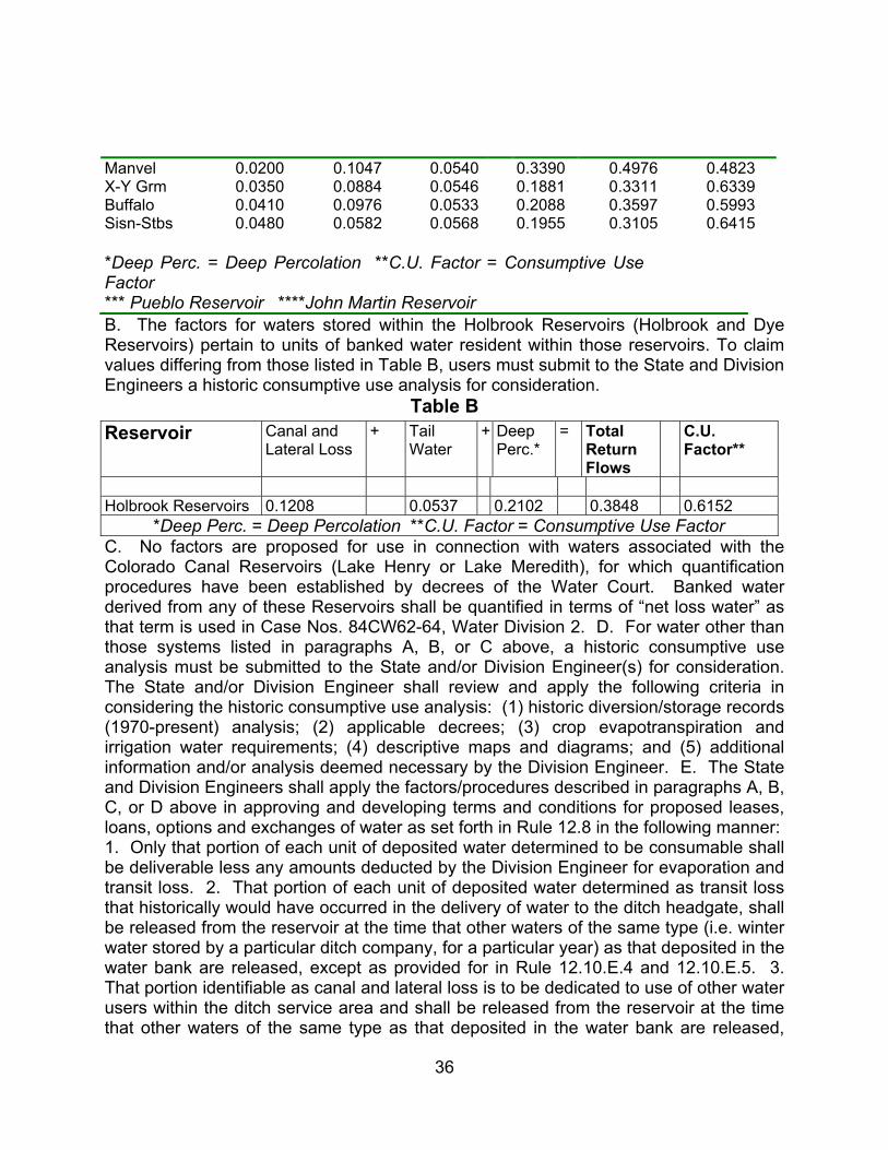
36
Manvel 0.0200 0.1047 0.0540 0.3390 0.4976 0.4823 X-Y Grm 0.0350 0.0884 0.0546 0.1881 0.3311 0.6339 Buffalo 0.0410 0.0976 0.0533 0.2088 0.3597 0.5993 Sisn-Stbs 0.0480 0.0582 0.0568 0.1955 0.3105 0.6415 *Deep Perc. = Deep Percolation **C.U. Factor = Consumptive Use Factor
*** Pueblo Reservoir ****John Martin Reservoir B. The factors for waters stored within the Holbrook Reservoirs (Holbrook and Dye Reservoirs) pertain to units of banked water resident within those reservoirs. To claim values differing from those listed in Table B, users must submit to the State and Division Engineers a historic consumptive use analysis for consideration.
Table B Reservoir Canal and
Lateral Loss + Tail
Water + Deep
Perc.* = Total
Return Flows
C.U. Factor**
Holbrook Reservoirs 0.1208 0.0537 0.2102 0.3848 0.6152 *Deep Perc. = Deep Percolation **C.U. Factor = Consumptive Use Factor C. No factors are proposed for use in connection with waters associated with the Colorado Canal Reservoirs (Lake Henry or Lake Meredith), for which quantification procedures have been established by decrees of the Water Court. Banked water derived from any of these Reservoirs shall be quantified in terms of “net loss water” as that term is used in Case Nos. 84CW62-64, Water Division 2. D. For water other than those systems listed in paragraphs A, B, or C above, a historic consumptive use analysis must be submitted to the State and/or Division Engineer(s) for consideration. The State and/or Division Engineer shall review and apply the following criteria in considering the historic consumptive use analysis: (1) historic diversion/storage records (1970-present) analysis; (2) applicable decrees; (3) crop evapotranspiration and irrigation water requirements; (4) descriptive maps and diagrams; and (5) additional information and/or analysis deemed necessary by the Division Engineer. E. The State and Division Engineers shall apply the factors/procedures described in paragraphs A, B, C, or D above in approving and developing terms and conditions for proposed leases, loans, options and exchanges of water as set forth in Rule 12.8 in the following manner: 1. Only that portion of each unit of deposited water determined to be consumable shall be deliverable less any amounts deducted by the Division Engineer for evaporation and transit loss. 2. That portion of each unit of deposited water determined as transit loss that historically would have occurred in the delivery of water to the ditch headgate, shall be released from the reservoir at the time that other waters of the same type (i.e. winter water stored by a particular ditch company, for a particular year) as that deposited in the water bank are released, except as provided for in Rule 12.10.E.4 and 12.10.E.5. 3. That portion identifiable as canal and lateral loss is to be dedicated to use of other water users within the ditch service area and shall be released from the reservoir at the time that other waters of the same type as that deposited in the water bank are released,

37
except as provided for in Rule 12.10.E.4 and 12.10.E.5. 4. In the event that all of the waters of a given type have been deposited in the water bank, then the timing of release of the transit loss and canal/lateral loss components of the deposited water shall be the same as that determined for the tail-water and deep percolation components in Rule 12.10.E.5. 5. The remaining tail-water and deep percolation components shall be released to the river by the Division Engineer to maintain historic return flow patterns. These releases shall reflect the return flow response resulting from historic patterns of use and shall be implemented starting at the time of completion of the transaction and continuing for a twelve (12) month period. RULE 12.11 PROCEDURES FOR DELIVERING WATER FROM STORAGE FACILITIES. A. The user of banked water must notify the Division Engineer at least 24 hours prior to a request for delivery of water from the bank. Such notification must include the account number, date, time and location of release. The Division Engineer will administer the delivery of water per the terms and conditions of approval for the account and the agreement being implemented. B. In cooperation with the State and Division Engineers, the water bank shall develop credit and debit accounting for each reservoir used to store banked water. C. The State Engineer will determine all transit losses pursuant to sections 37-87-102(4) and 37-83-104, C.R.S. D. The State Engineer shall determine all evaporative losses pursuant to section 37-87-102(4), C.R.S. E. Exchange operations necessary for the delivery of water made available through the water bank shall be evaluated and approved in accordance with 37-83-104, C.R.S. RULE 12.12 REPORTING REQUIREMENTS. The bank, in cooperation with the State and/or Division Engineers, will publish monthly summaries of the bank’s transactions on the water bank’s and Colorado Division of Water Resource’s web sites. Paper copies of such summaries will also be made available to the public at the State Engineer’s Office main office in Denver as well as the Water Division 2 Field Office in Pueblo. RULE 12.13 WATER BANK TIME LIMITATION. A. These rules effectuate the laws set forth in Article 80.5 of Title 37, C.R.S. Pursuant to section 37-80.5-107, these rules are repealed automatically on July 1, 2007. Any water left in the bank at that time shall immediately revert back to the owner of record. B. If, after reviewing the State Engineer’s report on the effectiveness of the Arkansas River Water Bank, the legislature extends the water banking program for three (3) years or more, or authorizes a permanent water bank, the State Engineer shall review and revise these Rules to address issues related to the continued operation of the water bank. If the legislature extends the water banking program for less than three (3) years, the State Engineer may review and revise these Rules as necessary to address issues related to the continued operation of the water bank. RULE 12.14 If any part of these rules is found to be invalid by a court of law, the remaining rules shall remain in full force and effect. RULE 12.15 EFFECTIVE DATES. These rules shall take effect on November 17, 2006 and shall remain in effect until the latter of either June 30, 2007 or the date specified for repeal of rules promulgated pursuant to article 80.5, title 37 of the Colorado Revised Statutes. IT IS FURTHER ORDERED that any person wishing to protest these rules may do so in the manner provided in sections 24-4-101 et seq., C.R.S., (the State Administrative Procedure Act); however, any protest of

38
these Rules must be filed with the Water Court for Water Division No. 2 in Pueblo, Colorado. (Rules, 11 pages) --------------------------------------------------------------------------------------------------------------------- CASE NO. 06CW119 – CITY OF FOUNTAIN, 116 South Main Street, Fountain, CO 80817 and SECURITY WATER DISTRICT, P. O. Box 5156, Colorado Springs, CO 80931 (Serve all pleadings on: Cynthia F. Covell, Esq., Alperstein & Covell, P.C., Attorney for Applicant City of Fountain, 1600 Broadway, Suite 2350, Denver, CO 80202-4923, (303) 894-8191 and Jeffrey J. Kahn, Esq., Bermard, Lyons, Gaddis & Kahn, P.C., Attorney for Applicant Security Water District, P. O. Box 978, Longmont, CO 80502-0978, (303) 776-9900) Application for Change of Water Rights EL PASO COUNTY 2. Decreed Name of Structure for which Change is Sought: Chilcott Ditch. 3. Description of Previous Decrees: A. In an original adjudication proceeding, former Water District 10, District Court, El Paso County, decreed on February 15, 1882, as Fountain Creek Priority No. 27, 27.0 c.f.s. with an appropriation date of March 21, 1866. In that same adjudication proceeding, former Water District 10, District Court, El Paso County, decreed on February 15, 1882, as Fountain Creek Priority No. 39, 20.63 c.f.s. with an appropriation date of March 21, 1874. In Case No. 10146, District Court, El Paso County, decreed on June 2, 1919, as Fountain Creek Priority No. 172, 30.95 c.f.s. with an appropriation date of December 18, 1905. B. Decreed point of diversion: the point of diversion is at a point on the north bank of Fountain Creek in the SE ¼ of Section 25, Township 15 South, Range 66 West of the 6th P.M. in El Paso County, Colorado. C. Source: Fountain Creek. D. Appropriation dates: March 21, 1866 in the amount of 27.0 c.f.s.; March 21, 1874 in the amount of 20.63 c.f.s.; and December 18, 1905 in the amount of 30.95 c.f.s. E. Historic Use: The water rights decreed to the Chilcott Ditch and described above (“the Chilcott Ditch Water Rights”) historically irrigated 2,628 acres of lands on the north, east and southeast sides of the City of Fountain in El Paso County, Colorado as shown in Exhibit A attached to the Application. All exhibits mentioned herein are incorporated by reference and may be inspected at the office of the Clerk of this Court. The crops grown were alfalfa, pasture grass and corn (silage). The State of Colorado diversion records for the Ditch headgate from 1950 through 1974 are attached to the Application as Exhibit B. 4. Proposed Changes: A. Change of Use: Applicants have a contract to purchase 20.5 shares out of 105 shares in the Chilcott Ditch Company which owns the Chilcott Ditch. Applicants seek to change the water rights represented by 20.5 shares of the Chilcott Ditch Company (“Subject Water Rights) to add, in addition to the existing irrigation use, all municipal uses by the City of Fountain (“Fountain”) and the Security Water District (“Security”) including but not limited to domestic, irrigation, commercial, industrial, recreational, fishery, piscatorial, wildlife, augmentation, replacement and substitution and exchange. The Subject Water Rights may be used directly for beneficial use or first stored and then beneficially used. B. Plan of Operation: The Subject Water Rights will continue to be diverted at the Chilcott Ditch headgate. Water attributable to the Subject Water Rights

39
less assessed ditch loss, will be delivered to an existing augmentation structure on the Chilcott Ditch and returned to the Fountain Creek. C. Change in Place of Use: The Subject Water Rights will be used to meet present and future municipal needs of users from Fountain’s system and under Security’s system, as those areas may exist from time to time. D. Return Flows: Return flows from the Subject Water Rights have historically been to Fountain Creek. Applicants will replace historical return flows in time, location, and amount as necessary to prevent injury to other water rights. E. Ditch Wide Historic Use Analysis: Applicants seek to determine the historic consumptive use of the Subject Water Rights based on a ditch wide historic use analysis. Applicant’s water resource consultants, W.W. Wheeler and Associates, Inc., have completed a ditch wide historic use analysis of the Chilcott Ditch Water Rights. The ditch-wide historic average consumptive use per share of the Chilcott Ditch Company is 24.4 acre-feet per year. The use of the 20.5 shares of the Chilcott Ditch Company resulted in an average of 500 acre feet of historic consumptive use per year. The amount of historic consumptive use from the Subject Water Rights varies from year to year, depending on the amount of water available for diversion under the Chilcott Ditch Water Rights. 5. Name(s) and address(es) of owner(s) or reputed owners of the land upon which any new diversion or storage structure, or modification to any existing diversion or storage structure is or will be constructed or upon which water is or will be stored, including any modification to the existing storage pool: N/A. 6. Comments: Applicants reserve the right to claim re-use, successive use and use to extinction of all return flows after initial use of the subject water rights, including but not limited to lawn irrigation return flows and sewer return flows. (Application and attachments, 7 pages) ------------------------------------------------------------------------------------------------------------ CASE NO. 06CW120 – THE CITY OF AURORA ACTING BY AND THROUGH ITS UTILITY ENTERPRISE, Director of Utilities, 15151 East Alameda Parkway, Suite 3600, Aurora, CO 80012; THE CITY OF COLORADO SPRINGS ACTING THROUGH COLORADO SPRINGS UTILITIES, c/o Brett C. Gracely, P. O. Box 1103, Mail Code 1328, Colorado Springs, CO 80947-1328; THE CITY OF FOUNTAIN ACTING THROUGH ITS UTILITIES ENTERPRISE, Director of Utilities, 116 South Main Street, Fountain, CO 80817; THE PUEBLO BOARD OF WATER WORKS, Attn: Alan C. Hamel, Executive Director, 319 West Fourth Street, Pueblo, CO 81003; and THE SOUTHEASTERN COLORADO WATER CONSERVANCY DISTRICT, c/o James Broderick, Executive Director, 31717 United Avenue, Pueblo, CO 81001 (Direct all pleadings to: John M. Dingess, Duncan, Ostrander & Dingess, P.C., Attorney for Applicant City of Aurora, 4600 South Ulster St., Suite 1111, Denver, Colorado 80237-2875, Phone: (303) 779-0200; John A. Fredell, Deputy City Attorney- Utilities, Mark D. Shea, Attorney for Applicant City of Colorado Springs, City Attorney’s Office - Utilities Division, Colorado Springs Utilities, P.O. Box 1103, MC 940, Colorado Springs, CO 80947-0940, Phone: (719) 668-8050); Cynthia F. Covell, Alperstein & Covell P.C., Attorney for Applicant City of Fountain, 1600 Broadway, Suite 1600, Denver, Colorado 80202, Phone: (303) 894-9191); Stephen H. Leonhardt, Lee E. Miller, Burns, Figa & Will, P.C., Attorneys for Applicant Southeastern Colorado Water Conservancy District,
40
6400 S. Fiddlers Green Circle, Suite 1000, Greenwood Village, Colorado 80111, Phone: (303) 796-2626); and William A. Paddock and Beth Ann Parsons, Carlson, Hammond & Paddock, L.L.C., Attorneys for Applicant Board of Water Works of Pueblo, Colorado, 1700 Lincoln Street, Suite 3900, Denver, Colorado 80203-4539, Phone: (303) 861-9000). APPLICATION FOR APPROPRIATIVE RIGHT OF SUBSTITUTION AND EXCHANGE CROWLEY, OTERO, PUEBLO, FREMONT, CHAFFEE AND LAKE COUNTIES 2. Introduction. This application is being filed as part of the implementation of the Intergovernmental Agreement among the City of Pueblo, the City of Aurora, the Southeastern Colorado Water Conservancy District, the City of Fountain, the City of Colorado Springs, and the Board of Water Works of Pueblo, Colorado, which was signed by the Applicants and the City of Pueblo on May 27, 2004 (“May 2004 IGA”) and the Intergovernmental Agreement among the City of Pueblo, the City of Colorado Springs, and the Board of Water Works of Pueblo, Colorado, entered into on March 1, 2004 (“March 2004 IGA”). As part of both IGAs, the parties thereto agreed to the Arkansas River Flow Management Program, attached to the Application as Exhibit 1. All exhibits mentioned herein are incorporated by reference and may be inspected at the office of the Clerk of this Court. Pursuant to the IGAs, Arkansas River Flow Management Program applies to all exchanges of water rights of the Applicants and certain changes of water rights that reduce flows in the Arkansas River between the Above Pueblo Gage and the confluence of the Arkansas River and Fountain Creek. The exchanges or changes of water rights of the Applicants that are subject to the Flow Management Program are known as the “Subject Exchanges.” The water not diverted by the Subject Exchanges to comply with the Flow Management Program is defined in the IGAs as the “Foregone Diversions.” The Foregone Diversions, generally speaking, is water, the in-priority annual diversion or exchange of which is initially foregone by the Applicants under the Subject Exchanges in order to accommodate the Flow Management Program. The term “Foregone Diversions” is defined more specifically in the May 2004 IGA and the November 7, 2006 “IGA Letter Agreement” entered into among the Applicants and the City of Pueblo, and no alternation of this definition is intended by this application. The IGAs contemplate that the Applicants who initially forego diversions under the Subject Exchanges will recapture those initially Foregone Diversions at or below the confluence of the Arkansas River and Fountain Creek (“Recapture of Yield” or “ROY Storage”) and then move that water back upstream by exchange when stream flow conditions permit. The Applicants seek a decree for both an absolute and conditional appropriative right of exchange pursuant to which initially Foregone Diversions that are stored in (1) Lake Henry, Lake Meredith, Holbrook Reservoir No. 1, Dye Lake Reservoir, the Arkansas Gravel Pit Reservoir, or (2) any subsequently constructed water storage vessel along the Exchange Stream Reach, will be delivered to the Arkansas River for use by the downstream calling water right and an equivalent quantity of water will be stored by exchange in Pueblo, Twin Lakes, Clear Creek, and/or Turquoise Reservoirs. 3. Description of Appropriative Right of Exchange. a. Stream Reach Affected: The appropriative right of exchange will operate on the Arkansas River and its tributaries. The downstream terminus of the
41
exchange will be the confluence of Holbrook Outlet Canal and the Arkansas River located in the NE¼ of the SE¼, Section 24, Township 23 South, Range 56 West of the 6th P.M. The upstream termini of the exchange will include (1) Pueblo Reservoir, including the proposed Pueblo Reservoir Enlargement, the point of diversion of Pueblo Reservoir is at a point at the intersection of the Pueblo Dam axis and the Arkansas River whence the Northeast corner of Section 36, Township 20 South, Range 66 West of the 6th P.M., bears North 61°21'20" East a distance of 2,511.05 feet, said reservoir inundates all or portions of Sections 7, 18, 19, 20, 21, 22, 25, 26, 27, 28, 29, 30, 31, 32, 33, 34, 35, and 36, Township 20 South, Range 66 West of the 6th P.M.; Sections 1, 2, 3, 4, 5, 9, 10, and 11, Township 21 South, Range 66 West of the 6th P.M.; and Sections 5, 8, 9, 13, 14, 15, 16, 22, 23, 24 and 25, Township 20 South, Range 67 West of the 6th P.M; (2) Twin Lakes Reservoir, with its embankment located on Lake Creek in Lake County in Section 23, Township 11 South, Range 80 West of the 6th Principal Meridian, as described in the decree in Case No. 80CW6 (District Court, Water Division No. 2), dated October 23, 1980; (3) Clear Creek Reservoir, including the proposed 2nd enlargement, the point of diversion for which is located on Clear Creek in Sections 7 and 8, Township 12 South, Range 79 West of the 6th Principal Meridian, and Section 12, Township 12 South, Range 80 West of the 6th Principal Meridian, in Chaffee County; and (4) Turquoise Lake, including the proposed Turquoise Lake Enlargement, the point of diversion for which is formed by a dam across Lake Fork Creek in Lake County in Section 19, Township 9 South, Range 80 West of the 6th Principal Meridian as described in the decree in Case No. 80CW6 (District Court, Water Division No. 2), dated October 23, 1980. The stream reach affected by the appropriative right of exchange is referred to herein as the “Exchange Stream Reach.” b. Points of Exchange Within the Exchange Stream Reach: In addition to the specifically described locations, the Applicants claim the right to conduct exchanges from any point within the Exchange Stream Reach from which water can be diverted from or delivered to the Arkansas River and located at or downstream of the confluence of the Arkansas River and Fountain Creek, and then upstream to Pueblo, Twin Lakes, Clear Creek, and/or Turquoise Reservoirs. c. Manner of Operation of Exchange: The exchange will be operated at times when the flows in the Arkansas River meet the flow requirements of the Flow Management Program, there is sufficient additional flow for an exchange, and all other lawful requirements of an exchange are satisfied. 4. Structures Involved in the Exchange. The structures to be used by the Applicants in conducting this exchange include, but are not limited to, the following existing or proposed structures: a. Excelsior Ditch, headgate located in the SE¼ of the SE¼ of Section 30, Township 20 South, Range 64 West, 6th P.M. in Pueblo County, Colorado. b. Colorado Canal, headgate located on the north side of the Arkansas River approximately 15 miles downstream of Pueblo near Boone, Colorado. The originally decreed point of diversion is in the NE¼ of Section 10, Township 21 South, Range 62 West of the 6th P.M. at a point bearing South 0°58' West 426 feet from the S.W. corner of Section 2, Township 21 South, Range 62 West of the 6th P.M. The river has shifted and relicted to the northeast to the extent that the center of the diversion gates is located slightly `more than 300 feet northeasterly at a point in the NW¼ of the NW¼ of Section 11, Township 21 South,
42
Range 62 West of the 6th P.M. at a point bearing South 63°14' East a distance 117.3 feet from the S.W. corner of said Section 2. The Arkansas River is in excess of 500 feet wide at the Colorado Canal diversion dam and either point, one on the bank, and one further out in the river, accurately describe the headgate of the Colorado Canal as originally decreed and constructed. c. Lake Henry Reservoir, located in all or portions of Sections 31 and 32, Township 20 South, Range 56 West, and Sections 5 and 6, Township 21 South, Range 56 West, all from the 6th P.M., in Crowley County, Colorado; the primary outlet works for Lake Henry Reservoir are located in the South ½ of said Section 6 and the Lake Henry Reservoir dam axis and the centerline of the outlet canal intersect at a point on the West line of the SE¼ of said Section 6, a distance of 512 feet south of the center of Section 6, Township 21 South, Range 56 West of the 6th P.M., in Crowley County, Colorado. Lake Henry is decreed to store 6,355 acre-feet at a rate of 756 c.f.s. under a priority of 1891; to store 2,000 acre-feet at a rate of 756 c.f.s. under a priority of September 10, 1900; and to store 3,561 acre-feet at a rate of 756 c.f.s. under a priority of May 15, 1909. d. Lake Meredith Reservoir, located in all or portions of Sections 15, 16, 19, 20, 21, 22, 27, 28, 29, 30, 31, 32, and 33 in Township 21 South, Range 56 West, Sections 1 and 12 in Township 22 South, Range 57 West, Section 6 in Township 22 South, Range 56 West, and Sections 24, 25, and 36 in Township 21 South, Range 57 West, all from the 6th P.M., in Crowley County, Colorado. Lake Meredith Reservoir dam axis and the centerline of the outlet canal intersect at a point located in the NW¼ of the SW¼ of Section 12, Township 22 South, Range 57 West of the 6th P.M., at a point from which the West Quarter Corner of said Section 12 bears North 27° 14' West a distance of 564.30 feet. Lake Meredith is authorized to store 26,028.4 acre-feet at a rate of 756.28 c.f.s. under a priority of March 9, 1898. e. Lake Meredith Outlet Canal, waters released from Lake Meredith Reservoir are carried through the Outlet Canal to a point in the S½ of Section 21, Township 22 South, Range 57 West of the 6th P.M., where they can be released to the Holbrook Canal and/or discharged into the Fort Lyon Storage Canal whence they are carried southeasterly approximately one-half mile in the Fort Lyon Storage Canal to a point at which they either continue in said Fort Lyon Storage Canal or are discharged through a headgate on its southerly bank in the SW¼ of Section 22, Township 22 South, Range 57 West of the 6th P.M., in Crowley County, Colorado, whence they travel south-southeast approximately one mile to discharge into the Arkansas River in the SE¼ of Section 27, Township 22 South, Range 57 West of the 6th P.M., in Otero County, Colorado. f. Holbrook Canal, point of diversion located on the north bank of the Arkansas River in the Northeast 1/4, Section 24, Township 22 South, Range 58 West of the 6th P.M., Crowley County, Colorado. g. Dye Lake Reservoir, is filled through the Holbrook Canal. Dye Lake inundates portions of Sections 32 and 33, Township 22 South, Range 56 West, 6th P.M., Otero County, Colorado. Dye Lake is decreed for a total storage volume of 7,986 acre-feet as adjudicated in Bent County District Court on February 3, 1927. h. Dye Reservoir Outlet Canal, located in SE¼, Section 5, Township 23 South, Range 56 West, 6th P.M., Otero County, Colorado. The diversion into the reservoir from the canal, which can also act as a release back to the storage canal, in NE¼, Section 5, Township 23 South, Range 56 West, 6th P.M., Otero County, Colorado. i. Holbrook
43
Reservoir No. 1, Holbrook Reservoir No. 1 inundates portions of Sections 6, 7, and 8, Township 23 South, Range 55 West, 6th P.M., Otero County, Colorado. Holbrook No. 1 is decreed for a total storage volume of 7,472 acre-feet as adjudicated in Bent County District Court on April 8, 1905 and February 3, 1927. j. Holbrook Outlet Canal, Holbrook No. 1 Outlet Canal originates in NE¼ of the SE¼, Section 7, Township 23 South, Range 55 West, 6th P.M., Otero County, Colorado, and delivers such water to the Arkansas River in NE¼ of the SE¼, Section 24, Township 23 South, Range 56 West, 6th P.M., Otero County, Colorado. k. Rocky Ford Ditch, the headgate of which is located on the south bank of the Arkansas River in the NW¼ NE¼, Section 30, Township 22 South, Range 57 West, 6th P.M., in Otero County, Colorado. l. Arkansas Gravel Pit Reservoir (“AGPR”), the AGPR will receive water from the main stem of the Arkansas River via the Excelsior Ditch with the headgate located in the SE¼ of the SE¼ of Section 30, Township 20 South, Range 64 West, 6th P.M. in Pueblo County, Colorado. The AGPR will return water to the main stem of the Arkansas River via a return outlet to be located in the SE¼ of the SE¼ of Section 34, Township 20 South, Range 63 West of the 6th P.M. in Pueblo County, Colorado. Storage of water diverted will occur in any facility that can use the receiving and returning facilities including a facility located as follows: A portion of the S½ of Section 34; and a portion of the SW¼ of the SW¼ of Section 35, Township 20 South, Range 63 West; and portions of the N½ of Section 2 and Section 3, Township 21 South, Range 63 West of the 6th P.M., all in Pueblo County, Colorado. m. Pueblo Reservoir, location described above. The current decreed and existing capacity is 357,678 acre-feet. Applicant Southeastern’s engineers have estimated that up to 7,738 acre-feet of this capacity may have been lost due to silting. The volume of the proposed enlargement is 75,000 acre-feet, conditional, pending in Case No. 2000CW138, Water Division No. 2. n. Confluence of Timpas Creek and the Arkansas River located in the N½ of the NW¼ of Section 25, Township 23 South, Range 56 West of the 6th P.M. o. Twin Lakes Reservoir, location described above. p. Clear Creek Reservoir, location described above, The Current decreed capacity is 11,439 acre-feet. The volume of the proposed 2nd enlargement is 18,561 acre-feet, conditional, pending in Case No. 04CW130, Water Division No. 2. q. Turquoise Reservoir, location described above. The current existing and decreed capacity is 129,432 acre-feet. The volume of the proposed enlargement is 19,600 acre-feet, conditional, pending in Case No. 2000CW139, Water Division No. 2. r. Any other point of diversion and/or storage located along the Exchange Stream Reach now existing or hereafter constructed and available for use by one or more of the Applicants. 5. Appropriation Date. May 27, 2004. 6. How Appropriation was Initiated: Signing of the IGAs and carrying out of exchanges. 7. Source of Water for Exchanges. All initially Foregone Diversions by the Parties of water available from the following sources: a. The sources of water used by the City of Aurora in the exchange are all of the sources of water identified in the decrees in Water Division 2, Cases Nos. 83CW18, 87CW63, 99CW169(A), 99CW170(A&B), 84CW62, 84CW63 and 84CW64 and the applications pending in Water Division 2, Case Nos. 01CW145 and 05CW105, District Court, Water Division No. 2. b. The sources of water used by Colorado Springs Utilities in the exchange are all of the sources of reusable water identified in all of the decrees in

44
Water Division 2, Cases No. 84CW202, 84CW203, 86CW118 (both sewered and non-sewered phases for each decree), 89CW36, Colorado Springs’ interests in the water rights subject to the decrees in Cases No. 84CW62, 84CW63 and 84CW64, and the application pending in Case No. 05CW96, District Court, Water Division No. 2. c. The sources of water used by the City of Fountain in the exchanges are all of the sources of water identified in the applications pending in Water Division 2, Cases No. 01CW108 and 01CW146, District Court, Water Division No. 2. d. The sources of water used by the Board of Water Works of Pueblo in the exchanges are all of the sources of water identified in the decrees in Water Division 2, Cases No. 84CW177 and 86CW111 (both sewered and non-sewered phases for each decree), District Court, Water Division No. 2. e. The sources of water used by the Southeastern Colorado Water Conservancy District are the sources of water identified in the applications pending in Water Division 2, Cases No. 01CW151 and 06CW08, District Court, Water Division No. 2, and the decree in Civil Action No. 4613, Water Division No. 5, entered on June 28, 1958, (and its Supplemental Decree entered on August 3, 1959, along with subsequent diligence decrees) in the District Court in and for the County of Garfield, State of Colorado, in the proceeding captioned “In the Matter of the Supplemental Adjudication of the Priorities of the Appropriation of Water for All Beneficial Purposes in Water District No. 38 in the State of Colorado; Robert L. Bridges, Executor of the Estate of Tucker McClure, Deceased and M. Stanley Pings, Petitioners,” the decree in Case No. W-829-76 (District Court, Water Division No. 5) dated November 27, 1979; the decree in Case No. 83CW352, (District Court, Water Division No. 5) dated May 31, 1985; the decree in Civil Action No. 5141 (District Court, Chaffee County) dated July 9, 1969; and the decree in Civil Action No. B-42135 (District Court, Pueblo County) dated June 25, 1962. 8. Amount Claimed. a. The quantity of water subject to the exchange will be all initially Foregone Diversions by the Parties made under the IGAs to comply with the Flow Management Program. b. The maximum rate of exchange will be the maximum rate of flow at which water would have been released from upstream receiving reservoir(s), in excess of the requirements of the Flow Management Program, had no exchange been made and had no water storage right junior to the exchange been exercised to store water in the upstream receiving reservoir(s). The rate of upstream exchange will not exceed the combined outlet capacity of the existing and future downstream storage structures from which the Foregone Diversions will be released, a rate estimated to be 2,000 c.f.s. c. Amount Absolute: i. From Meredith Outlet to Pueblo Reservoir: 232.86 c.f.s., as of May 25, 2005. ii. From Holbrook Outlet to Pueblo Reservoir: 60.6 c.f.s., as of May 31, 2005. d. Amount Conditional: i. Lake Meredith Outlet Canal to Pueblo Reservoir - Flow**; ii. Dye Reservoir Outlet Canal to Pueblo Reservoir - Flow**; iii. Holbrook Outlet Canal to Pueblo Reservoir - Flow**; iv. Arkansas Gravel Pit Reservoir to Pueblo Reservoir - Flow**; v. Any other point of delivery from storage located in the Exchange Stream Reach hereafter constructed and available for use by one or more of the Applicants to Pueblo Reservoir - Flow**. **The maximum rate of exchange will be the maximum rate of flow at which water would have been released from the upstream receiving reservoir(s), in excess of the requirements of the Flow Management Program and intervening water rights entitled to divert water released from the reservoir(s), had
45
no exchange been made and had no water storage right junior to the exchange been exercised to store water in the upstream receiving reservoir(s). 9. Use: The beneficial uses for which the initially Foregone Diversions are lawfully decreed. 10. Names and Address of Owners of Land on Which Water is or Will be Stored. The following are the owners of the existing structures and the right to store water therein that are the subject of this application: e. Arkansas Gravel Pit Reservoir: This site and the site of the water return therefor is owned by Lafarge West, Inc., a Colorado Corporation, 1590 West 12th Avenue, Denver, Colorado 80204. Co-applicant Aurora currently holds an option to purchase this property. f. Holbrook and Dye Reservoirs, the Holbrook Canal Headgate and Holbrook Reservoir Outlet: are all owned by the Holbrook Mutual Irrigating Company, P.O. Box 511, La Junta, Colorado 81050-0511. According to the real property records of Crowley County, Colorado, the land underlying the Holbrook Canal Headgate is owned by William Stewart Carle, 3 Mirada Road, Colorado Springs, Colorado 80906. According to the real property records of Otero County, Colorado, portions of the land inundated by Dye Lake are owned by Quarter Circle LT, Inc., 2475 Lane 16, Ordway, Colorado 81063; and Raymond E. and Frances A. Carter, 17248 County Road HH.50, Rocky Ford, Colorado 81067. According to the real property records of Otero County, Colorado, portions of the land underlying the Dye Lake outlet are owned by Frank Minor Blackford, P.O. Box 293, La Junta, Colorado 81050. According to the real property records of Otero County, Colorado, portions of the land inundated by Holbrook Reservoir No. 1 are owned by the State of Colorado, John W. Suthers, Esq., Colorado Attorney General, 1525 Sherman Street, 5th Floor, Denver, Colorado 80203. According to the real property records of Otero County, Colorado, portions of the land underlying the outlet for Holbrook Reservoir No. 1 are owned by Dale L. and Muriel M. McClelland, 14102 E. Linvale Place, Apt. 112, Aurora, Colorado 80014-3710. According to the real property records of Otero County, Colorado, portions of the land underlying the Holbrook No. 1 outlet to the Arkansas River are owned by Larry N. and Nancy A. McElroy, P.O. Box 471, Swink, Colorado 81077. g. Lake Meredith and Lake Henry Reservoirs: The Lake Meredith and Lake Henry Reservoir Companies, c/o Allen Ringle, Superintendent, 331 Main Street, Ordway, Colorado 81063. h. Pueblo, Twin Lakes and Turquoise Reservoirs: United States Department of Interior, Bureau of Reclamation, Eastern Colorado Area Office, 11056 West County Road 18-E, Loveland, Colorado 80537-9711. Applicant Southeastern holds the water rights and decrees for Pueblo Reservoir as part of the Congressionally-authorized Fryingpan-Arkansas Project pursuant to Contract No. 5-07-70-W0086, as amended, with the United States. i. Clear Creek Reservoir: The Board of Water Works of Pueblo, address stated above. j. Excelsior Ditch headgate: James H. and Mary E. Kirkland, P.O. Box 354, Rye, Colorado, 81069. Water will not be diverted by or stored in any structure not owned or controlled by the Applicants or which the Applicants do not have a right of use without the Applicants first acquiring the right to use such structure. This application does not seek to change any of the decrees mentioned herein. The rights

46
requested herein are not intended to modify or amend the terms of the March 2004 IGA or the May 2004 IGA. (Application, 12 pages) --------------------------------------------------------------------------------------------------------------------- CASE NO. 06CW121 – TOM SMITH, P. O. Box 189, Poncha Springs, CO 81242 (Send all pleadings to: John R. Hill, Jr., Bratton Hill, LLC, Attorneys for Applicant, 232 W. Tomichi Avenue, Suite 202, Gunnison, CO 81230; 970-641-1903) Application for Storage Water Right and Appropriative Right of Exchange CHAFFEE COUNTY FIRST CLAIM (Application for Conditional Storage Right). Name of Reservoir: Droz Creek Reservoir First Enlargement. Legal description of location of dam: Outlet works are located at a point in the SW¼NE¼ Section 6, Township 48 North, Range 8 East, N.M.P.M. approximately 1700 feet west of the east line and 1800 feet south of the north line of said Section 6. UTM coordinates NAD 27 402149 E 4255469 N. Source: Droz Creek, a tributary of Poncha Creek, a tributary of the South Arkansas River. Appropriation initiated by formation of intent to irrigate lawn and landscaping out of reservoir on September 1, 2006. Appropriation date claimed: September 1, 2006. Amount claimed is 1.3 acre-feet conditional for irrigation of approximately 1.46 acres of lawn and landscaping in the SE¼NE¼ Section 6 Township 48 North, Range 8 East, N.M.P.M. The surface area at high water line is 15.3 acres, the maximum height of dam is 26.25 feet and the length of dam is 748.5 feet. Remarks: The capacity of Droz Creek Reservoir being decreed in pending Consolidated Cases Nos. 01CW1 and 01CW114 is 120 acre-feet with no dead storage. A corrected stage-capacity table shows the total capacity as 121.3 acre-feet. This application is to store water in the space in excess of the 120 acre-feet being decreed in Case Nos. 01CW1 and 01CW114. SECOND CLAIM (Application for Appropriative Right of Exchange). Water rights to be used for exchange: 2.46 shares of common stock in The Twin Lakes Reservoir and Canal Company (“Twin Lakes”). Twin Lakes Reservoir is located in all or portions of Sections 14, 15, 16, 17, 18, 19, 20, 21, 22, 23 and 30 in Township 11 South, Range 81 West of the 6th P.M., in Lake County, Colorado. The Twin Lakes dam axis and the centerline of Lake Creek intersect at a point whence the Southeast corner of Section 23, Township 11 South, Range 81 West of the 6th P.M., bears South 54° 13'08" East a distance of 3,803.10 feet, all as more particularly described in the decree in Civil Action No. 5141 (District Court, Chaffee County, Colorado). Twin Lakes shares consist of storage and direct flow rights for water diverted from another basin which are available for 100 percent consumptive use and reuse and are available for augmentation. Twin Lakes shares also have a native water component of which approximately 80 percent is consumptive. The water rights producing the pro rata interest of Applicant are: 1) Colorado River Water Rights: Case No. 3802, District Court, Garfield County, August 25, 1963 and Case No. W-1901, District Court, Water Div. No. 5, May 12, 1976; priority: August 23, 1930, No. 431; source: Roaring Fork River and its tributaries, all tributaries of the Colorado River in
47
Water Div. No. 5; use: direct flow and storage purposes for irrigation, domestic, commercial, industrial, municipal, and all beneficial uses; amount: direct flow amount for diversions 12 through transmountain tunnels of 625 c.f.s., with an annual limit of 68,000 acre-feet, a running ten year limit of 570,000 acre-feet; 2) Arkansas River Water Rights: Case No. 2346, District Court, Chaffee County, July 14, 1913 as modified in Case No. W-3965, District Court, Water Div. No. 2, April 19, 1974; priorities: December 15, 1896, No. 3 and March 25, 1897, No. 4; source: Lake Creek and its tributaries, tributary to the Arkansas River; use: storage for irrigation, domestic, commercial, industrial, and municipal purposes on any site in the Arkansas River Basin of Colorado below the Twin Lakes Reservoir which are capable of being served by water by diversion from said Arkansas River; amount: 54,452 acre-feet (20,645.3 acre-feet for Priority No. 3 and 33,806.7 acre-feet for Priority No. 4. The average yield of Twin Lakes Shares used by the Division Engineer where the uses being augmented are “curtailable” is 0.94 acre-feet. The transit loss assessed by the Division Engineer for the 58 miles from Twin Lakes Reservoir to Salida is 4.09%. Applicant irrigates 1.46 acres of lawn and landscaping by pumping the water out of the pool of Droz Creek Reservoir First Enlargement. Irrigation efficiency is 80%. Using the Twin Lakes Shares yield of 0.94 acre-feet per share, the irrigation efficiency of 80% and transit loss of 4.09%, 2.46 Twin Lakes Shares will replace the depletions. Name of Exchange: Twin Lakes-Droz Creek Reservoir First Enlargement Exchange. Amount Claimed: Up to 3.0 acre-feet at the rate determined to be necessary to replace depletions. Appropriation Date: September 1, 2006. Appropriation was initiated by intent to exchange yield of Twin Lakes using existing structures to irrigate lawn and landscaping. Operation of exchange: When exchange opportunity exists, Applicant will exchange Twin Lakes water to the intake of the lawn irrigation system in Droz Creek Reservoir. Applicant will also exchange into storage in the First Enlargement up to the limit of the 2.46 shares. Name(s) and address(es) of owner(s) or reputed owners of the land upon which any new diversion or storage structure, or modification to any existing diversion or storage structure is or will be constructed or upon which water is or will be stored, including any modification to the existing pool: No changes will be made to any structures. Applicant is the owner of the land upon which water will be stored and beneficially used. (Application and attachments, 5 pages) --------------------------------------------------------------------------------------------------------------------- CASE NO. 06CW122 – CITY OF FOUNTAIN, c/o Larry Patterson, Utilities Director, 116 South Main Street, Fountain, CO 80817 (Direct all pleadings to: Cynthia F. Covell, Esq., Alperstein & Covell, P.C., Attorneys for Applicant, 1600 Broadway, Suite 2350, Denver, CO 80202; 303-894-8191) Application for Change of Water Rights and Appropriative Right of Exchange EL PASO AND PUEBLO COUNTIES 2. Background. Fountain supplies water to its customers from its wells located on Fountain Creek and Jimmy Camp Creek, in El Paso County, Colorado and from

48
Fryingpan-Arkansas Project water (“Project Water”) purchased from the Southeastern Colorado Water Conservancy District through the auspices of the Fountain Valley Authority, a water authority public entity of the State of Colorado of which Fountain is a member. Well depletions are augmented pursuant to augmentation plans decreed in Case Nos. W-4396 and W-4559 (Augmentation Plan I) and Case No. 85CW110 (Augmentation Plan II), and Case No. 91CW121 (which incorporates an additional well into Augmentation Plan II), using consumptive use credits from shares of Fountain Mutual Irrigation Company (“FMIC”) and Project Water return flows. In Case No. 01CW146 (Augmentation Plan III), presently pending in this Court, Fountain seeks decree of a supplemental augmentation plan that includes additional wells and FMIC shares acquired since Augmentation Plan II was decreed. Fountain owns FMIC shares (“Fountain’s FMIC Shares”) and reusable return flows from Project Water. In addition, Fountain has purchased and will in the future purchase other water rights that it plans to change to municipal, augmentation, substitution and exchange uses. In Case No. 01CW108, presently pending in this Court, Fountain has applied for an exchange to enable it to exchange certain Fountain Mutual Shares and reusable Project Water return flows to storage in Pueblo Reservoir when and to the extent such water is not required for use pursuant to the decrees in its augmentation plans. Case No. 01CW146 seeks to change and exchange additional FMIC shares acquired by Fountain. In this case, Fountain seeks a decree for exchange of: (1) any water it owns or controls in Pueblo Reservoir, now or in the future; (2) Fountain’s FMIC Shares; (3) Project Water, including reusable Project Water return flows; and (4) other fully-consumable water (including additional FMIC shares) that may be owned or controlled by Fountain in the future, and delivered to Fountain Creek or the Arkansas River, to locations upstream of Pueblo Reservoir on the Arkansas River as herein described. CONFIRMATION OF CHANGE OF WATER RIGHTS TO INCLUDE EXCHANGE. 3. Water Rights to be Changed. a. Fountain Mutual Shares. In Augmentation Plans I and II, Fountain changed the use of certain FMIC shares to municipal uses and as augmentation. Such uses, as well as “exchange and substitution” are sought for Fountain’s FMIC Shares in Case Nos. 01CW108 and 01CW146, but the exchanges therein sought are to Pueblo Reservoir only. Here, Fountain seeks confirmation that the decreed use “exchange” for Fountain’s FMIC Shares includes other exchanges as well. The FMIC water rights, which include Fountain’s FMIC Shares, are described as follows.
Fountain Mutual Irrigation Company Direct Flow Rights Fountain Creek Priority
Priority Date
Decree Date
Total Decree (cfs)
4
9/21/1861
3/6/1882
9.84 (5.38)*
7
4/1/1862
3/6/1882
1.125
11
2/1/1863
3/6/1882
16.69
17
12/31/1863
3/6/1882
4.25 (2.125)**
21
12/31/1864
3/6/1882
4.65

49
28
12/31/1866
3/6/1882
8.48
29
12/31/1867
3/6/1882
6.45
41
9/21/1874
3/6/1882
17.05
168
1/31/1903
6/2/1919
343.2
* FMIC’s claimed interest in Priority No. 4 ** Described as “Janitell’s Right”; the Ditch Company has ½ interest so long as Janitell carries #17 in ditch) Storage Right Reservoir
Priority Date
Decree Date
Total Decree (a.f.)
Fountain Valley No. 2 (a/k/a Big Johnson)
3/18/1903
6/2/1919
10,000
4. Additional Use. Fountain seeks to confirm “exchange” as an authorized use in addition to the decreed uses of Fountain’s FMIC Shares as set forth in Augmentation Plans I, II and III, and to confirm that Fountain’s FMIC Shares may be exchanged pursuant to any decree entered upon the applications in Case No. 01CW108, Case No. 01CW146, this case, and any other decree that may be entered upon any other application for exchange filed in the future for exchange of Fountain’s FMIC Shares. 5. Historic Use. The historic use of 358 of Fountain’s FMIC Shares was determined in the decrees for Augmentation Plan I and Augmentation Plan II. As described in the application in Case No. 01CW146, the remaining FMIC shares owned by Fountain were historically used for irrigation. The amount of consumptive use under such shares varies from year to year, depending on the amount of water available for diversion under those rights. Therefore, the actual amount of stream depletion associated with the rights is variable, and is most fairly represented by using a percentage of the actual amount of water delivered by FMIC to its shareholders. In various determinations, this Court has found that each FMIC share yielded 0.7 acre-foot of net consumptive use per year for replacement purposes, based on historic use of the Company’s water rights, and that figure was confirmed by the Colorado Supreme Court in Williams v. Midway Ranches Property Owners’ Association, 938 P.2d 515, 521 (Colo. 1997), and in numerous change cases involving shares of FMIC that have been decreed since the Midway Ranches decision. In Case No. 01CW146 and in this case, Fountain proposes to quantify the consumptive use associated with the New Fountain Mutual Shares in the same manner (0.7 acre-foot of net consumptive use per share per year for replacement purposes) and is aware of no changed circumstances that would alter this quantification. Since the historic use and consumptive use have been determined for the shares of FMIC as a whole, it is not necessary to attach diversion records or a map. 6. Terms and Conditions. Fountain’s FMIC Shares shall remain subject to the operational constraints of the Fountain Mutual Irrigation Company and Fountain’s available capacity therein, and the terms and conditions of the decrees in Augmentation Plan I, Augmentation Plan II and any decrees entered in Case Nos. 01CW108 and 01CW146. Therefore, the additional use for exchange of Fountain’s

50
FMIC Shares will not injure vested water rights or decreed conditional water rights. APPROPRIATIVE RIGHTS OF EXCHANGE. 7. Description of Exchanges: Water to be exchanged pursuant to the exchanges listed below is generally described as any water owned or controlled by Fountain that is (1) fully-consumable water delivered to Fountain Creek or the Arkansas River and not required for augmentation purposes at the time of delivery; or (2) stored in Pueblo Reservoir; (3) delivered by Fountain to the Arkansas River by the proposed SDS Alternative 7 Return Flow Pipeline; or (4) stored in Brush Hollow Reservoir. Water exchanged pursuant to the exchanges listed below may be diverted, stored, delivered and used for all municipal purposes, including augmentation, further reuse and exchange to extinction. The exchanges may be operated by Fountain when and to the extent the water to be exchanged is not required for augmentation pursuant to a decreed augmentation plan at the time the water is to be exchanged. The exchanges may be operated so long as there is exchange potential in the exchange reach and so long as exchanges from locations downstream of Pueblo Reservoir to Pueblo Reservoir or to other points described herein that are upstream of Pueblo Reservoir are operated consistently with the Intergovernmental Agreement among the City of Pueblo, the City of Aurora, the Southeastern Colorado Water Conservancy District, the City of Fountain, the City of Colorado Springs, and the Board of Water Works of Pueblo, Colorado, which was signed by the parties thereto on May 27, 2004 (“Six Party IGA”). The parties to the Six Party IGA, including Fountain, agreed to the Arkansas River Flow Management Program, described in the Six Party IGA, which applies to all exchanges of water rights of the parties thereto, and certain changes of water rights that reduce flows in the Arkansas River between the Above Pueblo Gage and the confluence of the Arkansas River and Fountain Creek. The exchanges are described as follows: a. Exchange No. 1. Fountain seeks an appropriative right of exchange in order to exchange to Pueblo Reservoir fully consumable water, delivered to Fountain Creek or the Arkansas River downstream of Pueblo Reservoir, that is legally available to Fountain, and not already included in any exchanges that may be decreed upon the applications filed in Case Nos. 01CW108 and 01CW146, for later delivery through the Fountain Valley Conduit, the planned Southern Delivery System (SDS) Pipeline from Pueblo Reservoir, augmentation or further exchange upstream as herein described or as may be decreed in future exchanges. b. Exchange No. 2. Fountain seeks an appropriative right of exchange in order to exchange Fountain’s FMIC Shares (both the direct flow and storage components thereof), reusable Project Water return flows, and other fully-consumable water from Fountain Creek or the Arkansas River that is legally available to Fountain, to the diversion point for the SDS Alternative 7 Delivery Pipeline. c. Exchange No. 3. Fountain seeks an appropriative right of exchange in order to exchange Fountain’s FMIC Shares (both the direct flow and storage components thereof) and reusable Project Water return flows stored in Pueblo Reservoir by exchange pursuant to Case Nos. 01CW108 and 01CW146, when decreed, as well as any other water owned or controlled by Fountain in Pueblo Reservoir, including Project Water, to the diversion point for the SDS Alternative 7 Delivery Pipeline. d. Exchange No. 4. Fountain seeks an appropriative right of exchange in order to exchange Fountain’s FMIC Shares (both the direct flow and storage components thereof), reusable Project Water return flows, and fully consumable water from Fountain Creek or the Arkansas River that is legally
51
available to Fountain, from the SDS Alternative 7 Return Flow Pipeline to the diversion point for the SDS Alternative 7 Delivery Pipeline. e. Exchange No. 5. Fountain seeks an appropriative right of exchange in order to exchange water owned or controlled by Fountain in Pueblo Reservoir, including Fountain’s FMIC Shares (both the direct flow and storage components thereof), reusable Project Water return flows, Project Water and non-Project Water, to the planned Brush Hollow - Phantom Canyon Storage Project. f. Exchange No. 6. Fountain seeks an appropriative right of exchange in order to exchange Fountain’s FMIC Shares (both the direct flow and storage components thereof), Project Water, reusable Project Water return flows, and other fully consumable water from Fountain Creek or the Arkansas River that is legally available to Fountain, to the planned Brush Hollow - Phantom Canyon Storage Project. g. Exchange No. 7. Depending upon the final location of the SDS Alternative 7 Delivery Pipeline in relation to the Brush Hollow - Phantom Canyon Storage Project, Fountain seeks an appropriative right of exchange in order to exchange Fountain’s FMIC Shares (both the direct flow and storage components thereof), Project Water, reusable Project Water return flows, and other water owned or controlled by Fountain in Brush Hollow Reservoir, from Brush Hollow Reservoir to the SDS Alternative 7 Delivery Pipeline. h. Exchange No. 8. Depending upon the final location of the SDS Alternative 7 Return Flow Pipeline in relation to the Brush Hollow - Phantom Canyon Storage Project, Fountain seeks an appropriative right of exchange in order to exchange Fountain’s FMIC Shares (both the direct flow and storage components thereof), Project Water, reusable Project Water return flows, and other water owned or controlled by Fountain in Brush Hollow Reservoir, from the SDS Alternative 7 Return Flow Pipeline to Brush Hollow Reservoir. 8. Locations Where Water Will Be Released for Exchange (“Exchange From” Points). Water may be released for exchange from the following locations (the “Exchange From” points) for exchange to the “exchange to” points described in paragraph 9 below. a. Cruse Gulch Augmentation Station. The Cruse Gulch Augmentation Station is located at the confluence of Cruse Gulch and Fountain Creek in Section 24, Township 15, South, Range 66 West of the 6th P.M. in El Paso County, as shown on the map attached to the Application as Exhibit A; All exhibits mentioned herein are incorporated by reference and may be inspected at the office of the Clerk of this Court. b. Fountain Sanitation District Wastewater Treatment Plant Outfall. The outfall is located on Fountain Creek in the NW1/4 of Section 17, Township 16 South, Range 65 West of the 6th P.M. in El Paso County, as shown on Exhibit A; c. Widefield Sanitation District Wastewater Treatment Plant Outfall, The outfall is located on Fountain Creek in the NE 1/4 of Section 25, Township 15 South, Range 66 West of the 6th P.M., in El Paso County, as shown on Exhibit A; d. Future Regional Wastewater Treatment Plant Outfall. A regional wastewater treatment plant that is planned to be constructed in Section 33, Township 16 South, with an anticipated discharge in Section 4, Township 17 South, Range 65West of the 6th P.M. in El Paso County, as shown on Exhibit A; e. Chilcott Ditch Augmentation Station. The augmentation station is located in the SW 1/4 of Section 30, Township 15 South, Range 65 West of the 6th P.M. In El Paso County, as shown on Exhibit A. f. Irrigation Return Flows in Fountain Creek. Reusable irrigation return flows from Project Water and other fully consumable water to Fountain Creek will be calculated and released to Fountain Creek as provided in Fountain’s augmentation plan decrees. g. Pueblo
52
Reservoir. Pueblo Reservoir is an on-channel reservoir formed by the intersection of Pueblo Dam and the Arkansas River at a point whence the Northeast corner of Section 36, Township 20 South, Range 66 West of the 6th P.M. bears North 61º 21' 20" East a distance of 2,511.05 feet. Pueblo Reservoir inundates all or portions of Sections 7, 18-22, and 25-36, Township 20 South, Range 66 West of the 6th P.M. and Sections 5, 8, 9, 13-16, 22, 23, and 25, Township 20 South, Range 67 West of the 6th P. M. in Pueblo County, as shown on Exhibit B to the Application. h. SDS Alternative 7 Return Flow Pipeline. The exact location of this point will be based upon engineering analysis and other site selection criteria, developed in part in connection with an alternative configuration of the SDS project designated as Alternative 7 by the United States Bureau of Reclamation. The furthest point upstream where it may be located is on the Arkansas River at the headgate of the Canon City Hydraulic Ditch, a point South 80° 30’ East a distance of 648 feet from the Southwest corner of Section 31, Township 18 South, Range 70 West of the 6th P.M., and the furthest point downstream where it may be located is on the Arkansas River at the Pueblo County-Fremont County line, a point in the SE1/4 of the NE1/4 of Section 1, Township 20 South, Range 68 West of the 6th P.M., as shown on Exhibit B. i. Brush Hollow Reservoir. The point of diversion is the point of the Brush Hollow Power Diversion, in the Northeast 1/4, Northeast 1/4, Section 12, Township 19 South, Range 69 West of the 6th P.M., being 1,149 feet from the north section line and 880 feet from the east section line of said Section 12, together with an alternate point of diversion located at the confluence of Brush Hollow Creek and the Arkansas River located in the Northeast 1/4, Section 13, Township 19 South, Range 69 West of the 6th P.M. 9. Locations to which water may be exchanged (“Exchange To” Points). a. Pueblo Reservoir, described in paragraph 8(g) above. b. Brush Hollow Reservoir, described in paragraph 8(i) above. c. SDS Alternative 7 Delivery Pipeline. The exact location of this point will be based upon engineering analysis and other site selection criteria, developed in part in connection with an alternative configuration of the SDS project designated as Alternative 7 by the United States Bureau of Reclamation. The furthest point upstream where it may be located is on the Arkansas River at the headgate of the Canon City Hydraulic Ditch, a point South 80° 30’ East a distance of 648 feet from the Southwest corner of Section 31, Township 18 South, Range 70 West of the 6th P.M., and the furthest point downstream where it may be located is on the Arkansas River at the Pueblo County-Fremont County line, a point in the SE1/4 of the NE1/4 of Section 1, Township 20 South, Range 68 West of the 6th P.M., as shown on Exhibit B. 10. Description of Exchange Reaches (See map attached to the Application as Exhibit B). Exchange No. 1: Downstream Terminus: The downstream terminus of the exchange reach is the confluence of Fountain Creek and the Arkansas River, in the NE1/4 of Section 6, Township 21 South, Range 64 West of the 6th P.M. in Pueblo County, Colorado, the location at which the water released from locations on Fountain Creek reaches the Arkansas River. Upstream Terminus: The upstream terminus of the exchange reach is located on the Arkansas River at Pueblo Reservoir in Section 36, Township 20 South, Range 66 West of the 6th P.M. in Pueblo County, Colorado. Exchange No. 2: Downstream Terminus: The downstream terminus of the exchange reach is the confluence of Fountain Creek and the Arkansas River, in the NE1/4 of Section 6, Township 21 South, Range 64 West of the 6th P.M. in Pueblo County, Colorado, the location at which the water released from locations along
53
Fountain Creek reaches the Arkansas River. Upstream Terminus: The upstream terminus of the exchange reach will be the diversion point for the SDS Alternative 7 Delivery Pipeline. The exact location of this point will be based upon engineering analysis and other site selection criteria, developed in part in connection with an alternative configuration of the SDS project designated as Alternative 7 by the United States Bureau of Reclamation. The furthest point upstream where it may be located is on the Arkansas River at the headgate of the Canon City Hydraulic Ditch, a point South 80° 30’ East a distance of 648 feet from the Southwest corner of Section 31, Township 18 South, Range 70 West of the 6th P.M., and the furthest point downstream where it may be located is on the Arkansas River at the Pueblo County-Fremont County line, a point in the SE1/4 of the NE1/4 of Section 1, Township 20 South, Range 68 West of the 6th P.M. Exchange No. 3: Downstream Terminus: The downstream terminus of the exchange reach is located on the Arkansas River at Pueblo Reservoir in Section 36, Township 20 South, Range 66 West of the 6th P.M. in Pueblo County, Colorado. Upstream Terminus: The upstream terminus of the exchange reach will be the diversion point for the SDS Alternative 7 Delivery Pipeline. The exact location of this point will be based upon engineering analysis and other site selection criteria, developed in part in connection with an alternative configuration of the SDS project designated as Alternative 7 by the United States Bureau of Reclamation. The furthest point upstream where it may be located is on the Arkansas River at the headgate of the Canon City Hydraulic Ditch, a point South 80° 30’ East a distance of 648 feet from the Southwest corner of Section 31, Township 18 South, Range 70 West of the 6th P.M., and the furthest point downstream where it may be located is on the Arkansas River at the Pueblo County-Fremont County line, a point in the SE1/4 of the NE1/4 of Section 1, Township 20 South, Range 68 West of the 6th P.M. Exchange Reach No. 4: Downstream Terminus: The downstream terminus of the exchange reach will be the SDS Alternative 7 Return Flow Pipeline. The proposed return flow pipeline is envisioned as being co-located with, but immediately downstream from, the SDS Alternative 7 Delivery Pipeline. The exact location of this point will be based upon engineering analysis and other site selection criteria, developed in part in connection with an alternative configuration of the SDS project designated as Alternative 7 by the United States Bureau of Reclamation. The furthest point upstream where it may be located is on the Arkansas River at the headgate of the Canon City Hydraulic Ditch, a point South 80° 30’ East a distance of 648 feet from the Southwest corner of Section 31, Township 18 South, Range 70 West of the 6th P.M., and the furthest point downstream where it may be located is on the Arkansas River at the Pueblo County-Fremont County line, a point in the SE1/4 of the NE1/4 of Section 1, Township 20 South, Range 68 West of the 6th P.M. Upstream Terminus: The upstream terminus of the exchange reach will be the diversion point for the SDS Alternative 7 Delivery Pipeline. The exact location of this point will be based upon engineering analysis and other site selection criteria, developed in part in connection with an alternative configuration of the SDS project designated as Alternative 7 by the United States Bureau of Reclamation. The furthest point upstream where it may be located is on the Arkansas River at the headgate of the Canon City Hydraulic Ditch, a point South 80° 30’ East a distance of 648 feet from the Southwest corner of Section 31, Township 18 South, Range 70 West of the 6th P.M., and the furthest point downstream where it may be located is on the Arkansas River at
54
the Pueblo County-Fremont County line, a point in the SE1/4 of the NE1/4 of Section 1, Township 20 South, Range 68 West of the 6th P.M. Exchange Reach No. 5: Downstream Terminus: Pueblo Reservoir, described in paragraph 8(g) above. Upstream Terminus: Brush Hollow Reservoir, described in paragraph 8(i) above. Exchange Reach No. 6: Downstream Terminus: The downstream terminus of the exchange reach is the confluence of Fountain Creek and the Arkansas River, in the NE1/4 of Section 6, Township 21 South, Range 64 West of the 6th P.M. in Pueblo County, Colorado, the location at which the water released from locations on Fountain Creek reaches the Arkansas River. Upstream Terminus: Brush Hollow Reservoir, described in paragraph 8(i) above. Exchange Reach No. 7: Downstream Terminus: Brush Hollow Reservoir, described in paragraph 8(i) above. Upstream Terminus: SDS Alternative 7 Delivery Pipeline described in paragraph 9(c) above. Exchange Reach No. 8: Downstream Terminus: SDS Alternative 7 Return Flow Pipeline described in paragraph 8(h) above. Upstream Terminus: Brush Hollow Reservoir, described in paragraph 8(i) above. 11. Operation of Exchanges. The water delivered for exchange at the locations described in paragraph 8 above is water not required for augmentation or exchange pursuant to any decreed augmentation plan operated by Fountain. Such water may be exchanged to storage in Pueblo Reservoir pursuant to a decree in this case or the decrees to be entered in Case No. 01CW108 and 01CW146, to storage in Brush Hollow Reservoir, or to the SDS Alternative 7 Delivery Pipeline. Exchange, pursuant to the appropriative rights of exchange described herein, of any water derived from sources other than Fountain’s FMIC Shares, Project Water available to Fountain, Project Water return flows available to Fountain, or other fully-consumable water owned or controlled by Fountain in Pueblo Reservoir or Brush Hollow Reservoir will require a further order or decree of this Court. Fountain does not, by this application, seek to exchange any water that it does not own, control, acquire, or have the right to use. (a) Excess Augmentation Credits. Available Excess Augmentation Credits from Fountain’s FMIC Shares and Project Water return flows are calculated daily as the difference between (1) amounts exchanged to Fountain’s wells plus (2) the augmentation supplies required to augment Fountain’s well depletions, computed in accordance with Augmentation Plans I, II, and any decree which may be entered in Case No. 01CW146, and the amount of augmentation credit available from Fountain’s FMIC Shares and Project Water return flows, also determined as provided in said augmentation plans. Such Excess Augmentation Credits may be exchanged to the “exchange to” points at such time as there is a live stream between the intended “exchange from” and “exchange to” points, and the planned exchange can be operated consistent with the Six Party IGA and the Flow Management Program described therein, and without injury to senior water rights. Fountain anticipates that Excess Augmentation Credits will generally be exchanged to Pueblo Reservoir pursuant to decrees entered in Case Nos. 01CW108 and 01CW146. However, when Fountain acquires and changes additional FMIC shares or other water rights that generate Excess Augmentation Credits, such water rights may be decreed for exchange on a separate water court application, and may be exchanged to Pueblo Reservoir pursuant to this application. All fully-consumable water stored by or on behalf of Fountain in Pueblo Reservoir pursuant to this exchange or exchanges decreed in Case Nos. 01CW108 or 01CW146 will be held in Pueblo Reservoir for later augmentation release from Pueblo Reservoir, for later
55
delivery through the Fountain Valley Conduit and/or the planned Southern Delivery Pipeline System from Pueblo Reservoir, or for later exchange to Brush Hollow Reservoir or the SDS Alternative 7 Delivery Pipeline. Such water may be used for all municipal purposes, including augmentation, exchange and further reuse to extinction. Excess Augmentation Credits exchanged to Brush Hollow Reservoir pursuant to a decree entered upon this application will be held in that reservoir for municipal use, including exchange and augmentation by the City of Fountain, for delivery to storage in Pueblo Reservoir, or, depending upon the final location of the SDS Alternative 7 Delivery Pipeline in relation to the Brush Hollow Reservoir, water may be held and released from the Brush Hollow Reservoir for later exchange to or delivery through the SDS Alternative 7 Delivery Pipeline. Any water stored in Brush Hollow Reservoir on behalf of the City of Fountain as provided in this application, or released or exchanged therefrom may be used for all municipal purposes, including augmentation, exchange and further reuse to extinction. Excess Augmentation Credits water exchanged to the SDS Alternative 7 Delivery Pipeline may be used for all municipal purposes, including storage, augmentation, exchange and further reuse to extinction. (b) Fryingpan-Arkansas Project Water Stored in Pueblo Reservoir and Reusable Return Flows from Fountain’s Project Water. Fountain has the contractual right to annual delivery of up to 2,000 acre-feet of water developed from the Fryingpan-Arkansas Project (“Project Water”), delivered from Pueblo Reservoir though the Fountain Valley Conduit pursuant to an agreement dated July 10, 1979, and related contracts. Fountain also intends to store Project and non-Project Water in Pueblo Reservoir. Southeastern Colorado Water Conservancy District (“Southeastern”), which operates the Fryinpan-Arkansas Project, currently makes Project Water available to Fountain under the contract dated July 10, 1979, and related contractual relationships concerning the Fryingpan-Arkansas Project, the Fountain Valley Conduit, the Fountain Valley Authority. In addition, Fountain is participating with Colorado Springs in the design of the Southern Delivery Pipeline system, to deliver water from the Arkansas River and/or Pueblo Reservoir to Fountain, Security Water District, and the City of Colorado Springs. Fountain also has the right to acquire from Southeastern, through the Fountain Valley Authority, all rights to reuse and successively use the Project Water after its initial use. Use of the Project Water (including reusable return flows) pursuant to the exchanges herein applied for will be pursuant to and subject to the July 10, 1979 Agreement and related contracts referred to above, as well as the decrees for the Fryingpan-Arkansas Project, and all lawful rules, regulations, policies, and contract obligations of Southeastern, as well as the Six Party IGA and the Flow Management Program. The Fryingpan-Arkansas Project is decreed as follows: West Slope Decrees: The Fryingpan-Arkansas Project diverts water from the headwaters of Hunter Creek and the Fryingpan River and its tributaries in Pitkin County, Colorado. The principal water rights were adjudicated by the decrees in C.A. 4613 (District Court, Garfield County, Colorado) dated June 20, 1958 and August 3, 1959, and were modified by the decree in Case No. W-829-76 (District Court, Water Division 5, Colorado) dated November 27, 1979, and were supplemented by the decree in Case No. 83-CW-352 (District Court, Water Division No. 5), dated May 31, 1985. These water rights have an appropriation date of July 29, 1957. Water diverted under these decrees travels under the Continental Divide through Boustead Tunnel, which empties into Turquoise Reservoir.

56
This water may be stored in Turquoise Reservoir, Twin Lakes Reservoir, and elsewhere, and applied to beneficial use within the boundaries of the Southeastern Colorado Water Conservancy District. Because the water is imported from another river basin, it is fully consumable in Water Division No. 2. East Slope Decrees: The Fryingpan-Arkansas Project also diverts and stores surface water from the Arkansas River and its tributaries in Lake, Chaffee, Fremont and Pueblo Counties. Such water rights are decreed for use, exchange, reuse and successive use to extinction for beneficial uses within Southeastern’s District boundaries. The principal rights were adjudicated by the following decrees: Civil Action No. 5141 (District Court, Chaffee County, Colorado) dated July 9, 1969, and Civil Action No. B-42135 (District Court, Pueblo County), dated June 25, 1962. The water rights were modified and supplemented by the judgment and decree in Case No. 80-CW-6 (District Court, Water Division No. 2), dated October 23, 1980. These water rights include storage in Turquoise Reservoir, Twin Lakes Reservoir and elsewhere, with an appropriation date of February 10, 1939. Project Water may be used, and has historically been used, for all beneficial uses within Southeastern’s boundaries. Fountain’s water service area is located within Southeastern’s boundaries. Any decree which may be entered on this Application will not modify Southeastern’s decrees for the Project Water rights. Neither this Application nor any decree entered in this case gives Fountain any rights to use Fryingpan-Arkansas Project structures, or any rights of ownership or rights to purchase or receive allocation of Project Water or return flows therefrom; however, this application does not limit any existing rights Fountain may otherwise have. Fountain may use and exchange Project Water only if, when, and to the extent such water is legally available to it, and is not required for use pursuant to Fountain’s decreed augmentation plans. (c) Other Water Supplies. Pursuant to these exchanges, Fountain may also exchange water from lawfully available sources that may be owned by Fountain or acquired in the future and decreed for exchange. Exchange of such other water will require further order or decree of the water court, provided, however, that Fountain may exchange any fully-consumable water owned or controlled by it in Pueblo Reservoir or Brush Hollow Reservoir pursuant to this exchange without further decree of this Court. 12. Appropriation: (a) Date of initiation of appropriation: (1) All exchanges of measured municipal reusable Project Water return flows: February 10, 1939, as provided in Southeastern’s east slope decrees described above, and subject to the terms of Southeastern’s stipulation dated January 12, 1989, with Colorado Springs, Pueblo Board of Water Works, and Arkansas Valley Ditch Association in Case Nos. 88CW43 and 84CW56, Water Division 2 (the “1989 Stipulation”). (2) All exchanges of unmeasured lawn irrigation return flows attributable to Project Water: January 12, 1989. (3) Non-Project Water A) Exchanges to Pueblo Reservoir: Exchanges of non-Project Water to Pueblo Reservoir other than exchanges that may be decreed in Case Nos. 01CW108 and 01CW146: December 29, 2006. (B) Exchanges to SDS Alternative 7 Delivery Pipeline and Exchanges from SDS Alternative 7 Return Flow Pipeline to SDS Alternative 7 Delivery Pipeline: December 22, 2005. (C) Exchanges to and from Brush Hollow Reservoir: December 29, 2006. (b) How Appropriation Initiated: (1) Exchanges of Project Water return flows: The reusable Project Water return flows are decreed for use, reuse and successive use to extinction within Southeastern’s
57
boundaries (within which Fountain’s service area is located), and, together with other decrees and agreements, establish dates and mechanisms for utilizing such return flows. (2) Exchanges of non-Project Water to Pueblo Reservoir and Exchanges of non-Project Water to and from Brush Hollow Reservoir: To the extent such exchanges are not decreed in Case Nos. 01CW108 and 01CW146, the appropriation was initiated by forming the intent to appropriate such exchanges following numerous City of Fountain Water Resource Committee meetings, development of a master plan, and filing this application. (3) Exchanges of non-Project Water to SDS Alternative 7 Delivery Pipeline and Exchanges from SDS Alternative 7 Return Flow Pipeline to SDS Alternative 7 Delivery Pipeline. The intent to appropriate these exchanges was formed by Colorado Springs’ filing of Case Nos. 05CW95 and 05CW96, which seek approval of exchanges by Colorado Springs to the SDS Alternative 7 Delivery Pipeline. Fountain is a partner with Colorado Springs in the SDS Project; so intent by Colorado Springs to appropriate exchanges to SDS facilities also constitutes intent by Fountain to appropriate similar exchanges. (c) Amount claimed: 20 cfs, conditional. 13. Uses: Water exchanged to Pueblo Reservoir or to the SDS Alternative 7 Delivery Pipeline or Brush Hollow Reservoir pursuant to the exchanges in this application may be delivered from storage in Pueblo Reservoir or Brush Hollow Reservoir back to Fountain to be used for all municipal purposes, including domestic, irrigation, recreation, storage, piscatorial, commercial, and industrial uses, as well as replacement, substitution, augmentation, and further exchange to extinction, and storage and release from storage for all the foregoing purposes. In addition, water stored in Pueblo Reservoir or Brush Hollow Reservoir may be released directly for augmentation, or further exchanged as provided herein. 14. Names and addresses of owners of land on which structures are located: Fountain Sanitation District Wastewater Treatment Plant Outfall. Fountain Sanitation District, 901 S. Santa Fe Avenue, Fountain, CO 80817. Widefield Water and Sanitation District Wastewater Treatment Plant Outfall, Widefield Water and Sanitation District, 37 Widefield Blvd., Colorado Springs, CO 80911. Chilcott Ditch Augmentation Station. Chilcott Ditch Company, c/o Glen Ermel, 10465 R.E.A. Road, Fountain, CO 80817. Pueblo Reservoir: United States Department of Interior, Bureau of Reclamation, 11056 West County Road 18E, Loveland, CO 80537. Fountain Valley Conduit: Fountain Valley Authority, c/o Ann Nichols, President, P.O. Box 1103, Colorado Springs, CO 80947. Southern Delivery Pipeline System: When constructed, the Southern Delivery Pipeline System will be located on property owned or controlled by the City of Colorado Springs and/or the City of Fountain. Brush Hollow/Phantom Canyon Reservoir: United States Bureau of Land Management, Royal Gorge Field Office, 3170 East Main Street, Canon City, CO 81212. (17 pages and 2 exhibits). --------------------------------------------------------------------------------------------------------------------- CASE NO. 06CW123 – SECURITY WATER DISTRICT, c/o Roy Heald, Manager, 231 Security Boulevard, Colorado Springs, CO 80911 (Direct all correspondence and pleadings to: Steven T. Monson, Felt, Monson & Culichia, LLC, Attorneys for Applicant, 319 North Weber Street, Colorado Springs, CO 80903; 719-471-1212) Application for Appropriative Right of Exchange EL PASO, FREMONT AND PUEBLO COUNTIES II. Application for Appropriative Right of Exchange. A. Summary of Application. Applicant requests an exchange of its water rights from Pueblo Reservoir to an
58
upstream alternative point of takeout from the Arkansas River for the Southern Delivery System (SDS”) in which the Applicant is participating with the City of Colorado Springs and the City of Fountain for the delivery of water by this conduit to the Applicant’s municipal service area. The Applicant is also a member of the FVA which entity purchases and transports to the Applicant and other FVA members, through the Fountain Valley Conduit, the participant’s allocation of water from the Fryingpan-Arkansas Project (“Project Water”) managed and operated by the Southeastern Colorado Water Conservancy District (“Southeastern District”). In Applicant’s pending case to the Water Court in Case No. 01CW149 it seeks to use the Southeastern District’s existing February 10, 1939, exchange in order to exchange its sewered return flow Project Water to Pueblo Reservoir for delivery through SDS. This exchange case is to further exchange Applicant’s Project Water and other water rights within the exchange reach from Pueblo Reservoir to an alternate point of delivery under the SDS system in Fremont County. B. Water Rights to Be Exchanged. The Project Water which is to be exchanged under this case is described as follows: 1. West Slope Decrees: The Fryingpan-Arkansas Project diverts surface water from the headwaters of Hunter Creek and the Fryingpan River and their tributaries in Pitkin County. The principal water rights were adjudicated by the decrees in Civil Action No. 4613 (District Court, Garfield County) dated June 20, 1958, and August 3, 1959; and were modified by the Decree in Case No. W-829-76 (District Court, Water Division No. 5) dated November 27, 1979; and were supplemented by the Decree in Case No. 83CW352 (District Court, Water Division No. 5) dated May 31, 1985. These water rights have an appropriation date of July 29, 1957. Water diverted under these decrees travel under the Continental Divide through Boustead Tunnel, which empties into Turquoise Reservoir. This water may be stored in Turquoise Reservoir, Twin Lakes Reservoir and elsewhere, and applied to beneficial use within Southeastern’s District boundaries. Because the water is imported from another river basin, it is fully consumable in Water Division 2. 2. East Slope Decrees: The Fryingpan-Arkansas Project also diverts and stores surface water from the Arkansas River and its tributaries in Lake, Chaffee, Fremont and Pueblo Counties. The principal water rights were adjudicated by the decrees in Civil Action No. 5141 (District Court, Chaffee County) dated July 9, 1969; and Civil Action No. B-42135 (District Court, Pueblo County) dated June 25, 1962; and were modified and supplemented by the Decree in Case No. 80CW6 (District Court, Water Division No. 2), dated October 23, 1980. These water rights include storage in Turquoise Reservoir, Twin Lakes Reservoir, Pueblo Reservoir and elsewhere, with an appropriation date of February 10, 1939, and are expressly decreed for reuse and exchange for beneficial use within Southeastern’s District boundaries. Under these decrees, Turquoise Reservoir and Twin Lakes Reservoir may store native water or imported water, directly or by exchange with each other or with Pueblo Reservoir. The Applicant is eligible to receive annual allocations of Project Water from the Southeastern District. The Southeastern District allocates Project Water annually based on its principles, policies, rules and regulations. Any and all use of Project Water and return flows therefrom will be pursuant to and subject to the above-referenced decrees for the Fryingpan-Arkansas Project, and to all lawful rules, regulations, policies, and contract obligations of the Southeastern District. Any decree entered in this case will not give Applicant any rights to use Fryingpan-Arkansas Project structures, or any rights
59
of ownership or rights to purchase or receive allocations of Project Water or return flows therefrom, but will not alter the existing rights, including allocation rights, held by Applicant. Applicant will use Project Water and return flows therefrom only if, and when, and to the extent they have purchased Project Water after it is allocated to them by the Southeastern District. The water rights which are to be exchanged are to consist of the sewered return flow Project Water, as repurchased by the Applicant from the Southeastern District under its right of first refusal, and is also to consist of first use Project Water under Applicant’s allocation by the Southeastern District. The water rights to be exchanged will also consist of other fully consumable water rights and reusable return flows owned and/or leased by Applicant that are available at Pueblo Reservoir or which are available at the SDS Alternative 7 Return Flow Pipeline or elsewhere within the exchange reach. Those other water rights include, without limitation, Applicant’s Fountain Mutual Irrigation Company shares as set forth in its pending Case No. 01CW149, Applicant’s Lock Ditch water rights under its pending Case No. 06CW117, and Applicant’s Chilcott Ditch water rights under its pending Case No. 06CW119. The sewered return flow Project Water will accrue from Applicant’s use, reuse, and successive use of the Applicant’s Project Water allocation from the Southeastern District through the FVA which is not otherwise used by the Applicant under its decrees. As included in Applicant’s pending Case No. 01CW149, the Applicant will track and account for its sewered return flow Project Water down Fountain Creek under the Fountain Creek Transit Loss Model and the exchange for those sewered return flows to the location of Pueblo Reservoir under the existing February 10, 1939, exchange decreed to the Southeastern District for Project Water return flows in Case No. 80CW6. In the use of said exchange the Applicant will comply with all the terms and provisions of said decree and the stipulation among the Southeastern District, the City of Colorado Springs, Pueblo Board of Water Works and AVDA in Case Nos. 84CW56 and 88CW43 defining the extent of the decreed exchange of this project water. The Project Water sewered return flows will then be further exchanged under this case. C. Exchange Right. The Applicant requests an appropriate right of exchange on the mainstem of the Arkansas River from Pueblo Reservoir located in Section 36, Township 20 South, Range 66 West of the 6th P.M. in Pueblo County, and from this point up the Arkansas River to the upstream terminus of the exchange which will be the diversion point for the SDS Alternative 7 Delivery Pipeline. The location of Pueblo Reservoir is further described in the corresponding exchange filed by the City of Colorado Springs in pending Case No. 05CW95. The exact location of the upstream terminus will be based upon engineering analysis and other site selection criteria, developed in part in connection with an alternative configuration of the SDS project designated as Alternative 7 by the United States Bureau of Reclamation. The furthest point upstream where it may be located is on the Arkansas River at the headgate of the Canon City Hydraulic Ditch, a point South 80º 30' East a distance of 648 feet from the Southwest corner of Section 31, Township 18 South, Range 70 West of the 6th P.M., and the furthest point downstream where it may be located is on the Arkansas River at the Pueblo County-Fremont County line, a point in the SE1/4 of the NE1/4 of Section 1, Township 20 South, Range 68 West of the 6th P.M. Within the above described exchange reach, the exchange will also be operated to the SDS Alternative 7 Delivery Pipeline from a downstream point identified as the SDS Alternative 7 Return Flow

60
Pipeline. The proposed return flow pipeline is envisioned as being located with, but immediately downstream from, the SDS Alternative 7 Delivery Pipeline. The exact location of the return flow pipeline will be based upon engineering analysis and other site selection criteria, developed in part in connection with an alternative configuration of the SDS project designated as Alternative 7 by the United States Bureau of Reclamation. The furthest point upstream where it may be located is on the Arkansas River at the headgate of the Canon City Hydraulic Ditch as described above, and the furthest point downstream where it may be located is on the Arkansas River at the Pueblo County-Fremont County line as also described above. This exchange is in addition to any and all existing decreed exchanges of the Southeastern District for Project Water and Project Water return flows which the Applicant may be entitled to use under its allocation of Project Water. D. Uses. Applicant will use the exchanged water for all municipal uses as part of its integrated water supply system for the District’s municipal service area, with such uses including, without limitation, domestic, irrigation, fire protection, recreational purposes, fish and wildlife propagation, commercial and industrial, and for augmentation, exchange and replacement purposes. Such uses may be for immediate application or placed into storage for subsequent beneficial use. These beneficial uses are to include use, reuse, and successive use to extinction. E. Appropriation Date. The intent to appropriate the exchange was formed and the appropriation was initiated following the Colorado Springs City Council’s approval of a resolution on December 13, 2005, that directed the filing of Case Nos. 05CW95 and 05CW96, and by Colorado Springs’ subsequent filing of these cases. Case Nos. 05CW95 and 05CW96 seek approval of exchanges on the same reaches of the Arkansas River by Colorado Springs to the point of the SDS Alternative 7 Delivery Pipeline. The Applicant is a participant with Colorado Springs in the SDS Project, and Colorado Springs is the SDS project manager, and as a result the intent and actions by Colorado Springs to appropriate exchanges to SDS facilities also constitutes the intent and actions by the Applicant and other SDS participants to appropriate the corresponding exchanges as set forth herein. F. Amount of Exchange. The amount of the exchange within the exchange reach is an annual demand of 1,500 acre feet of water which equals the Applicant’s participation in the SDS, at a maximum exchange rate of 10.0 cfs. All of the exchange amount is to be a conditional water right. G. Remarks. The upstream terminus of the exchange, being the SDS Alternative 7 Pipeline, may also serve as a direct takeout of Project Water as released from upstream storage by the Applicant or the Southeastern District. The Applicant requests the right to operate the exchange to any point within the designated exchange reach. H. Terms and Conditions. The operation of the exchange will be limited to the timing of the availability of the water rights to be exchanged within the exchange reach. The exchange may be operated only when there is a live stream maintained between the point of the exchange and the upstream terminus of the exchange. The exchange may only be operated to the extent that other vested water rights senior to this exchange are not deprived of water to which they would have been entitled in the absence of such exchange. III. Name and Address of Owners of Land on Which Structures are Located. A. The upstream terminus described as the point of diversion for the SDS Alternative 7 Delivery Pipeline may be located at the Lester and Attebery Ditch headgate. This structure is located on land owned by the United States of America,
61
Bureau of Land Management and the Grisenti family. The Bureau of Land Management’s address is Attn: Roy Masinton, Field Manager, 3170 East Main Street, Canon City, Colorado 81212. The Grisenti family address is Brush Hollow Partnership, Attn: James J. Grisenti, 15000 Highway 115, Florence, Colorado 81226. B. When constructed, the Southern Delivery Pipeline System will be located on property owned or controlled by the City of Colorado Springs and/or the Security Water District. C. Pueblo Reservoir is located on land owned by the United States of America, Bureau of Reclamation. The Bureau of Reclamation’s address is Attn: Fred Ore, Area Manager, Eastern Colorado Area Office, 11056 W. County Road 18E, Loveland, Colorado, 80537-9711. (Application, 6 pages) --------------------------------------------------------------------------------------------------------------------- CASE NO. 06CW124 – SNOWY RANGE RESERVOIR CO. (“Applicant or “Snowy Range”), 11411 Highway 12, La Veta, CO 81055 (Send all pleadings to: John R. Hill, Jr., Bratton Hill, LLC, Attorney for Applicants, 232 West Tomichi Avenue, Suite 202, Gunnison, CO 81230; 970-641-1903) Application for Change of Water Right and Storage Right HUERFANO COUNTY BACKGROUND Applicant acquired the water rights decreed in Case No. 82CW132 (hereinafter “82CW132") from the original applicant, J. Lowell Goemmer, as evidenced by the Order on Motion to Substitute Party, entered in 82CW132 on June 26, 2006 and the Notice of Implementation of Phase II filed on June 8, 2006 in said case. Case No. 82CW132 was a three part decree to change certain water rights so that the stream credit for said water rights could be utilized for multiple uses and eventually stored and released as augmentation water for various individuals. Said water rights are as follows: Priority No. 2. Out of the Cucharas River decreed to the Calf Pasture Ditch. The decreed headgate location of the Calf Pasture Ditch is in the Cucharas River in the NW1/4 SW1/4, Section 21, T.29S., R.68W., 6th P.M. at a point 40 feet west of the inter-section of Oak Street and Ryus Avenue in the Town of La Veta, Huerfano County, Colorado, 0.3 cfs out of 1.5 cfs decreed for irrigation uses in an unnumbered decree designated the "Read Decree" in the District Court in and for Huerfano County, entered on June 12, 1889 with an appropriation date of June 15, 1863. Priority No. 9. Out of the Cucharas River decreed to the Oso Ditch. Present point of diversion located in the Cucharas River in the NW1/4 SW1/4, Section 21, T.29S., R.68W., 6th P.M. at a point 40 feet west of the intersection of Oak Street and Ryus Avenue in the town of La Veta, Huerfano County, Colorado, 1.5 cfs out of 3.0 cfs decreed for irrigation use in an unnumbered decree designated the "Read Decree" in the District Court in and for Huerfano County entered on June 12, 1889 with an appropriation date of May 3, 1868. The point of diversion was changed for 1.5 cfs from the Coler Ditch to its present location at the Calf Pasture Ditch, described above, in Case No. W-1137 in the District Court for Water Division No. 2 on April 16, 1973. Priority No. 12. Out of the Cucharas River decreed to the Romero Ditch. Present point of diversion located in the Cucharas River in the NW1/4 SW1/4, Section 21, T.29S., R.68W., 6th P.M., at a point 40 feet west of the intersection of Oak Street and Ryus Avenue in the Town of La Veta, Huerfano County, Colorado, 0.6 cfs out of 1.2 cfs decreed for irrigation use in an unnumbered decree designated the "Read Decree" in the District Court in and for Huerfano County entered on June 12, 1889 with an appropriation date of April 1, 1869. The point of

62
diversion was changed for 0.6 cfs from the Coler Ditch to its present location at the Calf Pasture Ditch in Case No. W-1137 in the District Court for Water Division No. 2 on April 16, 1973. Priority No. 59. Out of Middle Creek tributary to the Cucharas River decreed to the Dep Ditch. Present point of diversion located at a point on the North bank of Middle Creek in the NW1/4 SW1/4, Section 21, T.29S., R.68W., 6th P.M., being 1,000 feet from the West line and 800 feet from the North line of said Section 21, 0.3 cfs out of 0.6 cfs decreed for irrigation use in an unnumbered decree designated the "Read Decree" in the District Court in and for Huerfano County entered on June 12, 1889 with an appropriation date of May 12, 1882. This water right was originally awarded Priority No. 58 but was changed to Priority No. 59 in Case No. G.D. 582 in the District Court in and for Huerfano County on February 16, 1894. The original decreed point of diversion was out of Middle Creek. An alternate point of diversion, which is described above, was awarded in Case No. 79CW40 in the District Court for Water Division No. 2 on May 8, 1981; and as to each of the above listed water rights, all other points to which they have been decreed for diversion in Case Nos. 82CW132 and 85CW10 by the District Court, Water Division No. 2, State of Colorado; and further, as to each of the above listed water rights, the change of those water rights to stream credit, consumptive use and other beneficial uses and appropriative right of exchange decreed with a priority date of September 9, 1982, in Case No. 82CW132 by the District Court, Water Division No. 2, State of Colorado. The above-described water rights have been used historically to irrigate at least 169 acres of hay and pasture grass in Section 16 and 21, T.29S., R.68W., 6th P.M. Additionally, 82CW132 and 85CW10 established alternate points of diversion for the above listed water rights to the following locations: a point on the North bank of Baker Creek, a tributary to the Cucharas River, which is 850 feet easterly of the center of Section 17, Township 31 South, Range 69 West, 6th P.M.; The intake to the Cuchara Sanitation and Water District’s treatment facilities on the Cucharas River at a point in Section 22, Township 31 South, Range 69 West, 6th P.M., from which the West quarter corner of Section 15, Township 31 South, Range 69 West, 6th P.M., bears North 14º25’ West, a distance of 5,770 feet; and a point on the left bank of the Cucharas River located in the SW¼ of Section 19, Township 30 South, Range 68 West, 6th P.M. at a point approximately 180 feet from the West line and 1940 feet from the South line of said Section 19 for the purpose of filling an offstream reservoir. This Application seeks to establish another alternate point of diversion at the John G. Cozad Ditch (Ditch No. 41) f/k/a Cucharas-McCaskill Ditch which is located at a point on the right bank of the Cucharas River whence the West quarter corner of Section 19, Township 30 South, Range 68 West, 6th P.M., bears South 88º32’ West, a distance of 278 feet more or less. Secondly, Phase II of 82CW132 was to be implemented when the original applicant built the Goemmer Reservoir, which storage right was obtained in Case No. 83CW122. Said right was subsequently conveyed by the original applicant to an unrelated third party. 82CW132 allowed the applicant to implement the change of water rights in phases, and Snowy Range is now in Phase II of the Decree, which contemplates moving the consumptive use amounts into storage. Applicant will implement the storage phase of the project by constructing three ponds in place of the reservoir contemplated in 82CW132. See Exhibit A, on file at the office of the Clerk of this Court. To date, Applicant has built Pond No. 1 and is in the process of building Ponds Nos. 2 and 3. CLAIM NO. 1 (Application for Additional Alternate Point of Diversion) Decreed
63
name of structure for which change is sought: John G. Cozad Ditch (Ditch No. 41) f/k/a Cucharas-McCaskill Ditch. From previous Decree: Applicant seeks to add an additional alternate point of diversion to those decreed in Case No. 82CW132 on February 18, 1985 in the District Court, Water Division No. 2, State of Colorado, as modified by Case No. 85CW10 on August 23, 1985 in the District Court, Water Division No. 2, State of Colorado. The original points of diversion are listed above. Applicant’s proposed alternate point of diversion is the John G. Cozad Ditch (Ditch No. 41) f/k/a Cucharas-McCaskill Ditch which is located at a point on the right bank of the Cucharas River whence the West quarter corner of Section 19, Township 30 South, Range 68 West, 6th P.M., bears South 88º32’ West, a distance of 278 feet more or less, for the purpose of filling a reservoir. CLAIM NO. 2 (Application for Conditional Storage Right) Name of reservoir: Snowy Range Reservoir Ponds Nos. 1-3. Description: Applicant will construct three interconnected off-stream ponds known as the Snowy Range Reservoir Company Ponds Nos. 1-3 to store its Phase II and Phase III water decreed in 82CW132 and 85CW10, as well as any unappropriated water available for diversion. Said ponds will be generally located on the following tract of land: A parcel of land located in the NW¼ of Section 19, Township 30 South, Range 68 West, 6th P.M., Huerfano County, Colorado, being more particularly described as follows: Beginning at the NW corner of said Section 19; thence South 14º06’19” East, (the Basis of Bearings for the herein described parcel is South 00º11’20” East, along the West line of said Section 19) a distance of 2238.07 feet, to the Point of Beginning; thence North 07º50’08” West, a distance of 315.41 feet; thence North 34º32’05” East, a distance of 323.03 feet; thence North 46º42’22” East, a distance of 475.68 feet; thence South 89º11’35” East, a distance of 203.18 feet; thence North 42º18’58” East, a distance of 259.27 feet; thence South 13º34’13” East, a distance of 170.73 feet; thence South 27º10’52” West, a distance of 238.03 feet; thence South 48º44’35” West, a distance of 216.95 feet; thence South 09º59’41” West, a distance of 263.45 feet; thence South 63º15’00” West, a distance of 250.00 feet; thence South 07º14’40” West, a distance of 339.24 feet; thence North 67º03’39” West, a distance of 348.06 feet, to the Point of Beginning. Containing 10.97 Acres, More or Less. County of Huerfano, State of Colorado. The Snowy Range Reservoir Ponds Nos. 1-3 will be constructed by excavation below grade and construction of dams less than 10 feet high. The total surface area will be approximately 9 acres with an average depth of 10 feet. Of the total approximately 90 acre-feet of storage, approximately 90 acre-feet will be live storage and 0 acre-feet will be dead storage. Facts of appropriation: Appropriation was initiated on July 7, 2006 by the filing of a Notice of Intent to Construct a Non-Jurisdictional Water Impoundment Structure with the office of the Division of Water Resources. Priority date: July 7, 2006. Amount claimed: 90 acre-feet conditional. Proposed Uses: Recreation, piscatorial and fire suppression; and to be used to store consumptive use water decreed in 82CW132, described above. Remarks: Claim No. 2 will allow Applicant to capture and store the Phase II and III water decreed in Case No. 82CW132 and 85CW10, as well as any unappropriated water when it is existing in the Cucharas River, to simplify administration in years where additional water exists for appropriation. Name(s) and address(es) of owner(s) or reputed owner(s) of the land upon which any new diversion or storage structure, or modification to any existing diversion or storage structure is or will be constructed or upon which

64
water is or will be stored, including any modification to the existing storage pool: No changes will be made to any structures not owned by Applicant, address above. (Application and attachments, 8 pages) --------------------------------------------------------------------------------------------------------------------- CASE NO. 06CW125 – TRI LAZY W RANCH, c/o Jay R. Wilson, President, 11100 County Road 270, Nathrop, CO 81236 (Direct all pleadings to: Gilbert Y. Marchand, Jr., Gilbert Y. Marchand, Jr., P.C., 2737 Mapleton Avenue, Suite 202, Boulder, CO 80304; 303-444-4256) Application for Surface Water Rights CHAFFEE COUNTY 2. Summary of application and names of structures: By this application, applicant seeks to adjudicate water rights for various springs that arise on applicant’s land and that have historically been used for irrigation and stock watering purposes thereon. The names of the springs are: Wilson 1; George 1; George 2; Jane 1; Jane 2; Horse 1; Marble 1; Marble 2; Stephanie 1; Marsha 1; Tricia 1; Tyler 1; Logan 1; Ryan 1; Bull 1; Bull 2; and a spring reach referred to as the Gas Creek Seepage consisting of about 5 springs named Gas 1, Gas 2, Gas 3, Gas 4, and Gas 5. 3. Wilson 1: 3.A. Location: in the NE1/4NE1/4 of Section 9, Township 51 North, Range 8 East, N.M.P.M., Chaffee County, Colorado, within 200 feet of a point described as approximately 280 feet from the north line and approximately on the east line of said section 9. 3.B. Source: spring, tributary to Browns Creek, tributary to the Arkansas River. 3.C. Amount: approximately 7 gallons per minute (“gpm”), absolute. 3.D. Use: irrigation. 4. George 1: 4.A. Location: in the NE1/4NE1/4 of Section 9, Township 51 North, Range 8 East, N.M.P.M., Chaffee County, Colorado, within 200 feet of a point described as approximately 280 feet from the north line and 125 feet from the east line of said section 9. 4.B. Source: spring, tributary to Browns Creek, tributary to the Arkansas River. 4.C. Amount: approximately 6 gpm, absolute. 4.D. Use: stock watering. 5. George 2: 5.A. Location: in the NE1/4NE1/4 of Section 9, Township 51 North, Range 8 East, N.M.P.M., Chaffee County, Colorado, within 200 feet of a point described as approximately 280 feet south of the north line and 250 feet west of the east line of said section 9. 5.B. Source: spring, tributary to Browns Creek, tributary to the Arkansas River. 5.C. Amount: approximately 9 gpm, absolute. 5.D. Use: irrigation. 6. Jane 1: 6.A. Location: in the NE1/4NE1/4 of Section 9, Township 51 North, Range 8 East, N.M.P.M., Chaffee County, Colorado, within 200 feet of a point described as approximately 280 feet south of the north line and 375 feet west of the east line of said section 9. 6.B. Source: spring, tributary to Browns Creek, tributary to the Arkansas River. 6.C. Amount: approximately 7 gpm, absolute. 6.D. Use: irrigation. 7. Jane 2: 7.A. Location: in the NE1/4NE1/4 of Section 9, Township 51 North, Range 8 East, N.M.P.M., Chaffee County, Colorado, within 200 feet of a point described as approximately 280 feet south of the north line and 500 feet west of the east line of said section 9. 7.B. Source: spring, tributary to Browns Creek, tributary to the Arkansas River. 7.C. Amount: approximately 4 gpm, absolute. 7.D. Use: irrigation. 8. Horse 1: 8.A. Location: in the NE1/4NE1/4 of Section 9, Township 51 North, Range 8 East, N.M.P.M., Chaffee County, Colorado, within 200 feet of a point described as approximately 280 feet south of the north line and 640 feet west of the east line of said section 9. 8.B. Source: spring, tributary to Browns Creek, tributary to the Arkansas
65
River. 8.C. Amount: approximately 3 gpm, absolute. 8.D. Use: irrigation. 9. Marble 1: 9.A. Location: in the NE1/4NE1/4 of Section 9, Township 51 North, Range 8 East, N.M.P.M., Chaffee County, Colorado, within 200 feet of a point described as approximately 250 feet south of the north line and 1,050 feet west of the east line of said section 9. 9.B. Source: spring, tributary to Browns Creek, tributary to the Arkansas River. 9.C. Amount: approximately 1 gpm, absolute. 9.D. Use: stock water. 10. Marble 2: 10.A. Location: in the NE1/4NE1/4 of Section 9, Township 51 North, Range 8 East, N.M.P.M., Chaffee County, Colorado, within 200 feet of a point described as approximately 280 feet south of the north line and 1,285 feet west of the east line of said section 9. 10.B. Source: spring, tributary to Browns Creek, tributary to the Arkansas River. 10.C. Amount: approximately 8 gpm, absolute. 10.D. Use: stock water. 11. Stephanie 1: 11.A. Location: in the NW1/4NE1/4 of Section 9, Township 51 North, Range 8 East, N.M.P.M., Chaffee County, Colorado, within 200 feet of a point described as approximately 280 feet south of the north line and 1,525 feet west of the east line of said section 9. 11.B. Source: spring, tributary to Browns Creek, tributary to the Arkansas River. 11.C. Amount: approximately 6 gpm, absolute. 11.D. Use: irrigation. 12. Marsha 1: 12.A. Location: in the NW1/4NE1/4 of Section 9, Township 51 North, Range 8 East, N.M.P.M., Chaffee County, Colorado, within 200 feet of a point described as approximately 280 feet south of the north line and 1,800 feet west of the east line of said section 9. 12.B. Source: spring, tributary to Browns Creek, tributary to the Arkansas River. 12.C. Amount: approximately 20 gpm, absolute. 12.D. Use: stock water and irrigation. 13. Tricia 1: 13.A. Location: in the NW1/4NE1/4 of Section 9, Township 51 North, Range 8 East, N.M.P.M., Chaffee County, Colorado, within 200 feet of a point described as approximately 280 feet south of the north line and 2,100 feet west of the east line of said section 9. 13.B. Source: spring, tributary to Browns Creek, tributary to the Arkansas River. 13.C. Amount: approximately 2 gpm, absolute. 13.D. Use: stock water and irrigation. 14. Tyler 1: 14.A. Location: in the NW1/4NE1/4 of Section 9, Township 51 North, Range 8 East, N.M.P.M., Chaffee County, Colorado, within 200 feet of a point described as approximately 320 feet south of the north line and 2,450 feet west of the east line of said section 9. 14.B. Source: spring, tributary to Browns Creek, tributary to the Arkansas River. 14.C. Amount: approximately 2 gpm, absolute. 14.D. Use: stock water and irrigation. 15. Logan 1: 15.A. Location: in the NE1/4NW1/4 of Section 9, Township 51 North, Range 8 East, N.M.P.M., Chaffee County, Colorado, within 200 feet of a point described as approximately 320 feet south of the north line and 2,700 feet west of the east line of said section 9. 15.B. Source: spring, tributary to Browns Creek, tributary to the Arkansas River. 15.C. Amount: approximately 2 gpm, absolute. 15.D. Use: stock water and irrigation. 16. Ryan 1: 16.A. Location: in the NE1/4NW1/4 of Section 9, Township 51 North, Range 8 East, N.M.P.M., Chaffee County, Colorado, within 200 feet of a point described as approximately 320 feet south of the north line and 2,950 feet west of the east line of said section 9. 16.B. Source: spring, tributary to Browns Creek, tributary to the Arkansas River. 16.C. Amount: approximately 5 gpm, absolute. 16.D. Use: stock water and irrigation. 17. Bull 1: 17A. Location: in the SE1/4SW1/4 of Section 35, Township 15 South, Range 78 West, 6th P.M., Chaffee County, Colorado, at or within 200 feet of a point described as approximately 1,250 feet from the south line and 3,080
66
feet from the east line of said section 35. 17.B. Source: spring, tributary to Browns Creek, tributary to the Arkansas River. 17.C. Amount: approximately 2 gpm, absolute. 17.D. Use: stock water. 18. Bull 2: 18.A. Location: in the NE1/4SW1/4 of Section 35, Township 15 South, Range 78 West, 6th P.M., Chaffee County, Colorado, at or within 200 feet of a point described as approximately 1,985 feet from the south line and 3,560 feet from the east line of said section 35. 18.B. Source: spring, tributary to Browns Creek, tributary to the Arkansas River. 18.C. Amount: approximately 1 gpm, absolute. 18.D. Use: stock water. 19. Gas Creek Seepage, comprised of a spring reach with approximately 5 springs, referred to as Gas 1, Gas 2, Gas 3, Gas 4, and Gas 5: 19.A. Location: the spring reach is in the NE1/4SW1/4 of Section 34, Township 15 South, Range 78 West, 6th P.M., Chaffee County, Colorado, beginning at or within 200 feet of a point described as approximately 1,600 feet from the south line and 3,450 feet from the east line of said section 34, and extending from there for approximately 300 feet in a northwesterly direction, ending at or within 200 feet of a point described as approximately 2,000 feet from the south line and 3,500 feet from the east line of said section 34. 19.B. Source: springs and seepage, tributary to Gas Creek, tributary to the Arkansas River. 19.C. Amount: from the beginning point of the reach extending northwesterly to the end of the reach, the 5 springs have the following flow rates: Gas 1: 1 gpm, absolute; Gas 2: 1 gpm, absolute; Gas 3: 3 gpm, absolute; Gas 4: 8 gpm, absolute; Gas 5: 4 gpm, absolute. 19.D. Use: stock water. 20. Amount and location of irrigated acreage: The water rights described herein for which irrigation is a claimed use irrigate a total of approximately 20 acres located south of said water rights in the north half of Sections 9 and 10, Township 51 North, Range 8 East, N.M.P.M., Chaffee County, Colorado. 21. Appropriation dates: The appropriations for all the water rights claimed herein were initiated by actual diversion and application of water to irrigation and/or stock watering uses. June 1, 1971 is the claimed date of initiation and date water was applied to beneficial use for the water rights described herein as Wilson 1; George 1; George 2; Jane 1; Jane 2; Horse 1; Marble 1; Marble 2; Stephanie 1; Marsha 1; Tricia 1; Tyler 1; Logan 1; Ryan 1; Bull 1; and Bull 2. June 1, 1965 is the claimed date of initiation and date water was applied to beneficial use for the water rights described herein as Gas Creek Seepage consisting of the springs and seepage named Gas 1, Gas 2, Gas 3, Gas 4, and Gas 5. 22. Names and addresses of owners of the land upon which any new diversion or storage structure, or modification to any existing diversion or storage structure is or will be constructed or upon which water is or will be stored, including any modification to the existing storage pool: same as applicant described above. 23. Remarks: The locations of the water rights described herein are unsurveyed and are based on the best available information. Applicant claims the right to refine and modify one or more of the locations if better information becomes available, and to include such refined or modified locations in the final decree without further publication or amendment of the application, provided that all such locations remain within either: the northeast quarter or northwest quarter of Section 9 (for the water rights described in sections 3 through 16 above), or the northwest quarter of section 10 (for the most easterly water rights described in sections 3, 4, and 5 above), all in Township 51 North, Range 8 East, N.M.P.M., Chaffee County, Colorado; the southwest quarter of Section
67
35, Township 15 South, Range 78 West, 6th P.M., Chaffee County, Colorado (for the water rights described in sections 17 and 18 above); or Section 34, Township 15 South, Range 78 West, 6th P.M., Chaffee County, Colorado (for the water rights described in section 19 above). A map depicting the locations of the water rights claimed herein is being filed with this application. WHEREFORE, applicant, Tri Lazy W Ranch, respectfully requests the court to enter a decree: confirming the absolute water rights for stock watering and irrigation purposes claimed herein for the springs and seepage described herein and granting such other relief as may be appropriate. (Application and attachments, 10 pages) --------------------------------------------------------------------------------------------------------------------- CASE NO. 06CW126 – SECURITY WATER DISTRICT, c/o Roy Heald, Manager, 231 Security Boulevard, Colorado Springs, CO 80911 (Send all correspondence and pleadings to: Steven T. Monson, Felt, Monson & Culichia, LLC, Attorneys for Applicant, 319 North Weber Street, Colorado Springs, CO 80903; 719-471-1212) Application for Appropriative Right of Exchange EL PASO COUNTY II. Application for Appropriative Right of Exchange. A. Water Rights to be Exchanged. The water rights to be exchanged are the 250 annual acre feet of consumptive use water to be adjudicated to the Applicant’s 10.5 shares of the Chilcott Ditch Company in pending Case No. 06CW119 (“Subject Water Rights”). The Chilcott Ditch water rights are described as follows: 1. Adjudications: In an original adjudication proceeding, former Water District 10, District Court, El Paso County, the water rights were decreed on February 15, 1882, as Fountain Creek Priority No. 27 for 27.0 c.f.s. with an appropriation date of March 21, 1866. In that same adjudication proceeding, former Water District 10, District Court, El Paso County, the water rights were decreed on February 15, 1882, as Fountain Creek Priority No. 39 for 20.63 c.f.s. with an appropriation date of March 21, 1874. In Case No. 10146, District Court, El Paso County, the water rights were decreed on June 2, 1919, as Fountain Creek Priority No. 172 for 30.95 c.f.s. with an appropriation date of December 18, 1905. 2. Decreed point of diversion: The point of diversion is at a point on the north bank of Fountain Creek in the SE¼ of Section 25, Township 15 South, Range 66 West, 6th P.M. in El Paso County, Colorado. 3. Source: Fountain Creek. 4. Appropriation dates: March 21, 1866 in the amount of 27.0 c.f.s.; March 21, 1874 in the amount of 20.63 c.f.s.; and December 18, 1905 in the amount of 30.95 c.f.s. B. Exchange Requested. The Applicant requests the exchange of the historical consumptive use under its Subject Water Rights from the point of the Chilcott Ditch headgate upstream to the location of the point of depletion on Fountain Creek of the District’s Widefield Aquifer wells and Windmill Gulch Aquifer wells as decreed in Case Nos. W-112, W-400, W-3174, W-4766, W-347, W-1551, 84CW130, and as covered in the District’s existing plans for augmentation in Case Nos. W-4212 and 90CW28, and included within the District’s pending plan for augmentation in Case No. 01CW149. Those wells and their locations are identified in Exhibit A. All exhibits mentioned herein are incorporated by reference and may be inspected at the office of the Clerk of this Court. The location of the headgate of the Chilcott Ditch is described above and is shown on the Exhibit B map. The place of the District’s well depletions to Fountain Creek is generally located in the NE¼ of Section 25, Township 15 South, Range 66 West, 6th P.M, as generally
68
shown on the Exhibit B map. The exchange is also requested from the headgate of the Chilcott Ditch to the headgate of the Fountain Mutual Irrigation Company Ditch located in the SW¼ of Section 20, Township 14 South, Range 66 West, 6th P.M. and to the headgate of the Stubbs and Miller Ditch located in the NE¼ SW¼ of Section 3, Township 15 South, Range 66 West, 6th P.M., all as shown on the Exhibit B map. From these points the historical consumptive use of the Subject Water Rights will be diverted for treatment and direct municipal use or for treatment and then to be recharged and withdrawn from the reaches of the Widefield Aquifer as a supplemental source under the terms and provisions of the Widefield Aquifer Management Agreement under Case No. W-116 and the District’s pending application for recharge and plan for augmentation in said Case No. 01CW149. The diversion of the Subject Water Right’s consumptive use at the headgate of the Fountain Mutual Irrigation Company (“FMIC”) is covered by an existing carriage agreement with FMIC. The diversion of the consumptive use water at the Stubbs and Miller Ditch would not be implemented without an agreement from the City of Colorado Springs, as the owner of the Stubbs and Miller Ditch. C. Uses. The Applicant will use the exchanged water for all municipal uses as part of its integrated water supply system for its municipal service area which such uses including without limitation, domestic, irrigation, fire protection, recreational purposes, aquifer recharge, commercial and industrial, and for augmentation, exchange and replacement purposes. Such uses may be for immediate application or placed in to storage for subsequent beneficial use. These beneficial uses are to include use, reuse, and successive use to extinction. Storage may be in reservoirs intended to be constructed on District property as part of its aquifer recharge operations and also in Big Johnson Reservoir (a.k.a. Fountain Valley Reservoir No. 2) owned by FMIC and located within Sections 7, 8, 17 and 18, Township 15 South, Range 65 West, 6th P.M. There will be no use of the Big Johnson Reservoir without FMIC’s written agreement. D. Appropriation Date. The appropriation date for this exchange is December 29, 2006, which is the date of filing of this Application with the District Court for Water Division 2, thereby confirming, implementing and demonstrating the Applicant’s intent and actions to initiate and appropriate these water rights for the beneficial uses set forth herein. E. Amount of the Exchange. The amount of the exchange within the exchange reach is an annual demand of 250 acre feet of water with the maximum exchange rate of 2.0 c.f.s. All of the exchange amount requested is a conditional water right. G. Terms and Conditions. The operation of the exchange will be limited to the timing and the availability of the Subject Water Rights to be exchanged within the exchange reach. The exchange will be operated only when there is a live stream maintained between the point of the exchange and the upstream terminus of the exchange. The exchange will only be operated to the extent that other vested water rights senior to this exchange are not deprived of water to which they would have been entitled to in the absence of such exchange, with consideration for the call of the Subject Water Rights. III. Names and Addresses of Owners of Land Upon Which Structures are Located: The Stubbs and Miller Ditch is owned by the City of Colorado Springs and is located upon land owned by the City whose address is c/o Mark Shea, 121 South Tejon Street, 4th Floor, South Tower, Colorado Springs, Colorado 80903. The District has the consent of the City of Colorado Springs to name the Stubbs and Miller Ditch as an alternate point of diversion for the use of the Chilcott Ditch water rights. The Fountain Mutual Ditch is

69
located upon land or easements owned by FMIC whose address is c/o Gary Steen; P.E., 487 Anaconda Drive, Colorado Springs, Colorado 80919. Big Johnson Reservoir is owned by FMIC and is located upon its property. The Applicant has the consent of FMIC to name Big Johnson Reservoir as a place of storage for the Subject Water Rights. WHEREFORE, the Applicant requests that this Application for Appropriative Right of Exchange be granted as requested herein, and for such other and further relief as the Court deems appropriate under the circumstances. (Application and attachments, 8 pages) --------------------------------------------------------------------------------------------------------------------- THE WATER RIGHTS CLAIMED BY THE FOREGOING APPLICATION(S) MAY AFFECT IN PRIORITY ANY WATER RIGHTS CLAIMED OR HERETOFORE ADJUDICATED WITHIN THIS DIVISION AND OWNERS OF AFFECTED RIGHTS MUST APPEAR TO OBJECT AND PROTEST WITHIN THE TIME PROVIDED BY STATUTE, OR BE FOREVER BARRED. YOU ARE HEREBY NOTIFIED that any party who wishes to oppose an application, or application as amended, may file with the Water Clerk a verified statement of opposition setting forth facts as to why the application should not be granted, or why it should be granted only in part or on certain conditions, such statement of opposition must be filed by the last day of February 2007, (forms available at Clerk’s office or at www.courts.state.co.us, must be submitted in quadruplicate, after serving parties and attaching a certificate of mailing, filing fee $70.00). The foregoing are resumes and the entire application, amendments, exhibits, maps and any other attachments filed in each case may be examined in the office of the Clerk for Water Division No. 2, at the address shown below. --------------------------------------------------------------------------------------------------------- Witness my hand and the seal of this Court this 10th day of January, 2007. /s/ Mardell R. DiDomenico ________________________________ Mardell R. DiDomenico, Clerk District Court Water Div. 2 203 Judicial Bldg., 320 W. 10th Street Pueblo, CO 81003 Tel. 583-7048 (Court seal) Published: January ____, 2007
70
INVITATION TO JOIN SUBSTITUTE WATER SUPPLY PLAN NOTIFICATION LIST
Section 37-92-308, C.R.S. (2006) directs the State Engineer to establish a notification list for each water division to notify interested parties of requests for approval of: substitute water supply plans (§37-92-308), loans for an instream flow (§37-83-105), and interruptible water supply agreements (§37-92-309). To receive this information for calendar year 2007, specify whether you prefer to receive the information by first-class mail or electronic mail and send your name, mailing address, e-mail address, daytime telephone number, and water division(s) to: Substitute Water Supply Plan Notification List, Colorado Division of Water Resources, 1313 Sherman Street, Room 818, Denver, Colorado 80203 or e-mail to: [email protected]. Additional information regarding Substitute Water Supply Plans is available on the Division of Water Resources' website at http://water.state.co.us/. Questions may be directed to the Division of Water Resources at (303) 866-3581 or [email protected].