1
NATIONAL FOREST NATIONAL FOREST JACKSON RIVER COWPASTURE RIVER CRAIG CREEK CATAWBA CREEK BUFFALO CREEK JAMES RIVER JAMES RIVER MAURY RIVER MAURY RIVER SOUTH RIVER KERRS CREEK HEAD OF THE JAMES RIVER ROCKBRIDGE COUNTY ALLEGHANY COUNTY BOTETOURT COUNTY ROCKBRIDGE COUNTY ROCKBRIDGE COUNTY AMHERST COUNTY CLIFTON FORGE IRON GATE GLEN WILTON GALA EAGLE ROCK FINCASTLE BUCHANAN I-64 EXIT 27 633 622 622 688 BLUE RIDGE PARKWAY BLUE RIDGE PARKWAY PEAKS OF OTTER BLUE RIDGE PARKWAY BLUE RIDGE PARKWAY I-81 EXIT 167 I-81 EXIT 162 Rocky Run Road Gilmers Mill Road River Road 614 614 614 635 635 BOTETOURT COUNTY PARKS AND RECREATION 16 East Main Street, Box 4 Fincastle, VA 24090 (540) 928-2130 www.botetourtva.gov 630 630 I-81 EXIT 168 I-81 EXIT 175 I-81 EXIT 188 I-81 EXIT 180 I-64 EXIT 24 622 501 501 501 60 60 60 39 130 608 609 622 622 708 782 759 703 BUENA VISTA VISITOR CENTER 595 East 29th Street Buena Vista, VA 24416 (540) 261-8004 lexingtonvirginia.com 663 608 LEXINGTON VISITOR CENTER 106 East Washington Street Lexington, VA 24450 (540) 463-3777 lexingtonvirginia.com 5 0 10 15 20 25 30 35 40 45 50 55 5 10 15 20 60 65 APPALACHIAN TRAIL TROUTVILLE DALEVILLE OUTDOOR TRAILS Botetourt Commons, 28 Kingston Drive Daleville, Virginia 24083 (540) 992-5850 www.outdoortrails.com ARCADIA ALPINE NATURAL BRIDGE STATION NATURAL BRIDGE GLASGOW BUENA VISTA LEXINGTON SNOWDEN BIG ISLAND Section One IRON GATE to GLEN WILTON Section Three GALA to CRAIG CREEK Section Two GLEN WILTON to GALA Section Five HORSESHOE BEND to SPRINGWOOD Section Seven BUCHANAN to ARCADIA Section Four CRAIG CREEK to HORSESHOE BEND Section Eight ARCADIA to ALPINE Section Nine ALPINE to GLASGOW Section Six SPRINGWOOD to BUCHANAN Section Ten GLASGOW to SNOWDEN Section Eleven GLEN MAURY PARK to GLASGOW IRON GATE/LICK RUN Shoreline Access 2 Glen Wilton Road Eagle Rock, VA 24085 Latitude: 37° 46' 26" Longitude: -79° 46' 58" CRAIG CREEK Shoreline Access 11 Patterson Trail Eagle Rock, VA 24085 Latitude: 37° 38' 45" Longitude: -79° 48' 52" ALPINE Shoreline Access 3180 Gilmers Mill Road Buchanan, VA 24066 Latitude: 37° 34’ 54.29” Longitude: -79° 36’ 10.14” ROUTE 60 ACCESS Shoreline Access Stuartsburg Road Buena Vista, VA 24416 Latitude: 37° 44’ 47.55” Longitude: -79° 22’ 20.05” GALA Shoreline Access 16025 Botetourt Road Eagle Rock, VA 24085 Latitude: 37° 41’ 29.59” Longitude: -79° 48’ 45.13” GLEN WILTON Shoreline Access 81 Bridge Street Eagle Rock, VA 24085 Latitude: 37°45' 02.9" Longitude: -79°48' 57.5” EVANS TRACT Shoreline Access 4697 McKinney Hollow Rd. Clifton Forge, VA 24422 Latitude: 37° 47’ 38.04” Longitude: -79° 45’ 29.88” LOW MOOR Shoreline Access State Rt. 1101 Low Moor, VA 24457 Latitude: 37° 48’ 0.25” Longitude: -79° 52’ 16.51” CLIFTON FORGE RIVER ACCESS Boat Ramp 444 Verge St. Clifton Forge, VA 24422 Latitude: 37° 48’ 44.51” Longitude: -79° 49’ 18.38” SHARON PARK & RIVER ACCESS Shoreline Access 4017 Nicelytown Rd. Clifton Forge, VA 24422 Latitude: 37° 49’ 6.30” Longitude: -79° 44’ 27.08” HORSESHOE BEND Concrete Ramp 6847 Narrow Passage Road Eagle Rock, VA 24085 Latitude: 37° 35' 21" Longitude: -79° 43' 40" SPRINGWOOD Concrete Ramp 131 Thrasher Road Buchanan, VA 24066 Latitude: 37° 32' 52" Longitude: -79° 44' 33" GLASGOW (JAMES) Canoe/Kayak Slide Latitude: 37° 37' 24.8" Longitude: -79° 26' 45.3" Natural Bridge State Park BUCHANAN Concrete Ramp, Shallow Water 645 Lowe Street Buchanan, VA 24066 Latitude: 37° 31' 48" Longitude: -79° 40' 46" ARCADIA Shoreline Access 1738 Arcadia Road Buchanan, VA 24066 Latitude: 37° 33' 17" Longitude: -79° 38' 14" JORDAN’S POINT Shoreline Access Jordan’s Point Park Lexington, VA 24450 Latitude: 37° 47' 36.24" Longitude: -79° 25' 52.97" SNOWDEN Concrete Ramp Snowden Boat Ramp Big Island, VA 24526 Latitude: 37° 35' 44.3" Longitude: -79° 23' 22.9" GLASGOW (MAURY) Concrete Ramp 6 Jarvis Trail Glasgow, VA 24555 Latitude: 37° 37' 28.95" Longitude: -79° 26' 40.01" GLEN MAURY PARK Shoreline Access 101 Maury River Drive Buena Vista, VA 24416 Latitude: 37° 43' 35.15" Longitude: -79° 21' 56.96" .8 4 11.3 28.9 32.5 37.3 43.5 48 59 0.1 12 13 20.5 63.7 15.2 Yogi Bear’s Jellystone Park at Natural Bridge DAM WITH PORTAGE DAM NO PORTAGE DAM NO PORTAGE DAM NO PORTAGE DAM NO PORTAGE TWIN RIVER OUTFITTERS 653 Lowe Street Buchanan, VA 24066 (540) 261-7334 www.canoevirginia.net H&H OUTDOORS 17518 Main Street Buchanan, VA 24066 (540) 254-2420 www.handhoutdoors.com ARCADIA ADVENTURES 130 Arcadia Road Buchanan, VA 24066 (540) 817-4624 DEAD DRIFT OUTFITTERS (540) 521-9214 [email protected] www.deaddriftva.com ROCK-ON CHARTERS (844) FISHNVA rockoncharters.net BLANE CHOCKLETT FISHING (540) 354-1774 [email protected] blanechocklettfishing.com WILDERNESS CANOE COMPANY 631 James River Road Natural Bridge Station, VA 24579 (540) 291-2295 wildernesscanoecompany.com WALKABOUT OUTFITTER 15 West Washington Street Lexington, VA 24450 (540) 464-4453 www.walkaboutoutfitter.com River and Streams National Forest Public River Access Class 1 Rapids Class 2 Rapids Class 3 Rapids River Gauge River Mile Marker Campsites Outfitters, Guides & Retailers Main Roads Bridges Lodging Fuel Food Wineries River Hazard Appalachian Trail LEGEND V I R G I N I A 0 1 2 Miles Icon locations are approximate. Refer to listed addresses & GPS coordinates for exact locations. * For info on paddling the Jackson or Cowpasture rivers, please visit AlleghanyHighlandsBlueway.com The Upper James River Water Trail meanders through beautiful Botetourt and Rockbridge Counties. The trail is organized into sections, each offering a unique river experience. Select a section to explore and experience unspoiled natural beauty as you float through scenic valleys and rolling farmland. Keep your eyes and ears open for wildlife and enjoy views of the Blue Ridge Mountains. Some Class I, II and III rapids along your journey will provide thrills for all members of the family. RIVER SAFETY TIPS · Always wear a life jacket. · Alcohol and paddling do not mix. · Know the river level – avoid paddling in high water. · Recognize hazards such as fallen trees and debris. · Never paddle alone. · Know and be prepared for the weather. · Don’t paddle after dark. · Know the section of river you are paddling and don’t paddle sections beyond your skill level. BOATING ETIQUETTE · Respect private property. · Don’t litter – pack out all trash. · Paddlers should pass fisherman quietly with lots of room so they can enjoy their trip. · Boating parking lots get crowded, especially on weekends. Consider carpooling or paddling on weekdays. · Ramps and access points should not be blocked – they are for launching and retrieving boats only.

Section One - James River · national forest national forest jackson river cowpasture river craig creek catawba creek buffalo creek james river james river maury river maury river

Embed Size (px)

Citation preview

NATIONAL FOREST

NATIONAL FOREST

JACKSON RIVER

COWPASTURE RIVER

CRAIG CREEK

CATAWBA CREEK

BUFFALO CREEK

JAMES RIVER

JAMES RIVER

MAURY RIVER

MAURY RIVER

SOUTH RIVER

KERRS CREEK

HEAD

OF THE

JAMES RIVER

ROCK

BRID

GE C

OUN

TY

ALLE

GHAN

Y CO

UNTY

BOTETOURT COUNTY

ROCKBRIDGE COUNTY

ROCKBRIDGE COUNTY

AMHERST COUNTY

CLIFTON FORGE

IRON GATE

GLEN WILTON

GALA

EAGLE ROCK

FINCASTLE

BUCHANAN

I-64EXIT 27

633622

622

688

BLUE RIDGE PARKWAY

BLUE RIDGE PARKWAYPEAKS OF OTTER

BLUE RIDGE PARKWAY

BLUE RIDGE PARKWAY

I-81EXIT 167

I-81EXIT 162

Rocky Run Road

Gilmers Mill Road

River Road

614

614

614

635

635

BOTETOURT COUNTY PARKS AND RECREATION 16 East Main Street, Box 4Fincastle, VA 24090(540) 928-2130www.botetourtva.gov

630

630

I-81EXIT 168

I-81EXIT 175

I-81EXIT 188

I-81EXIT 180

I-64EXIT 24

622

501

501

501

60

60

60 39

130

608

609

622

622

708

782

759

703

BUENA VISTA VISITOR CENTER 595 East 29th StreetBuena Vista, VA 24416(540) 261-8004lexingtonvirginia.com

663

608

LEXINGTON VISITOR CENTER 106 East Washington StreetLexington, VA 24450 (540) 463-3777lexingtonvirginia.com

5

0

10

15

20

25

30

35

40

45

50

55

5

10

15

20

60

65

APPALACHIAN TRAIL

TROUTVILLEDALEVILLE

OUTDOOR TRAILSBotetourt Commons, 28 Kingston DriveDaleville, Virginia 24083(540) 992-5850www.outdoortrails.com

ARCADIA

ALPINE

NATURAL BRIDGE STATION

NATURAL BRIDGE GLASGOW

BUENA VISTA

LEXINGTON

SNOWDEN

BIG ISLAND

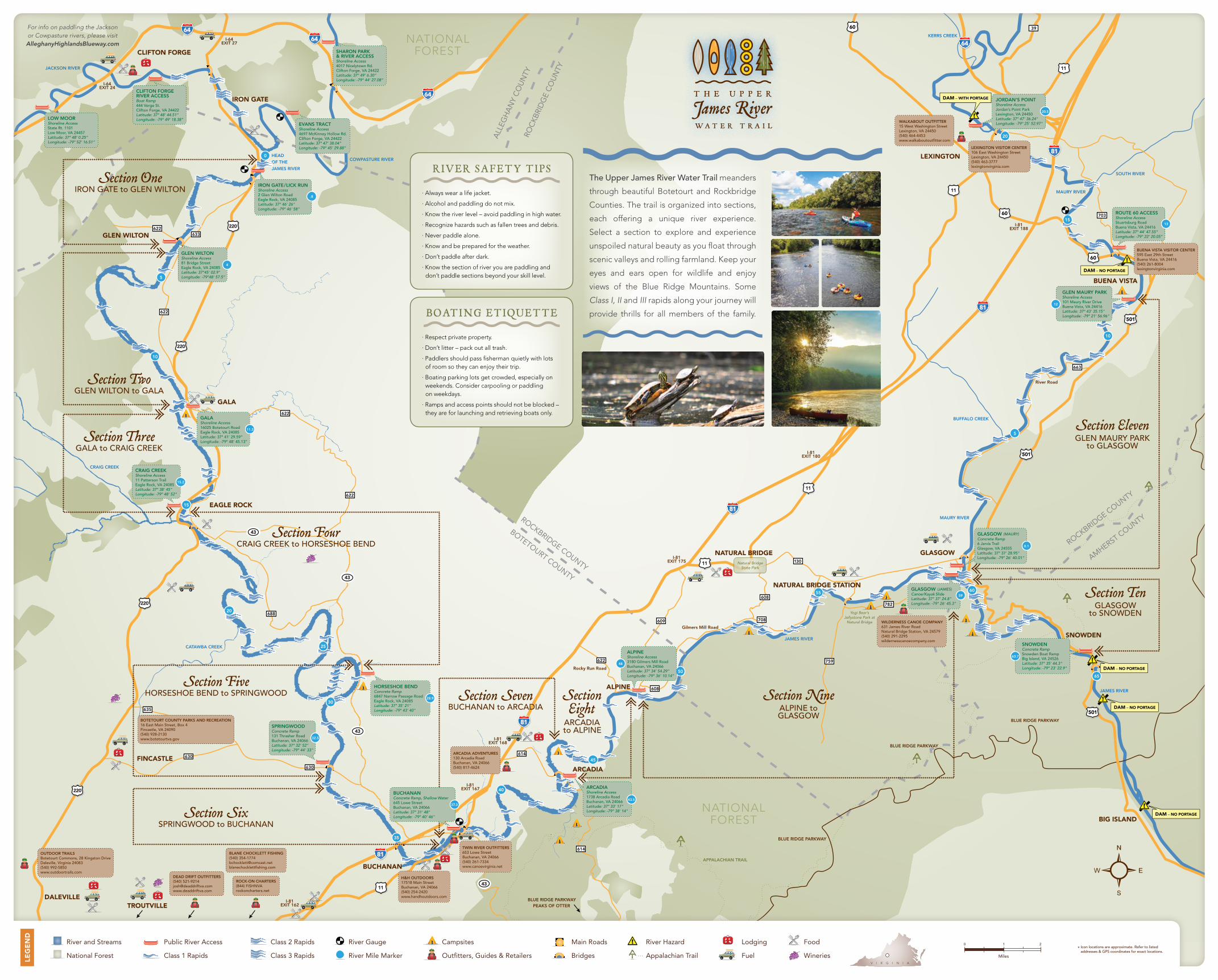
Section OneIRON GATE to GLEN WILTON

Section ThreeGALA to CRAIG CREEK

Section TwoGLEN WILTON to GALA

Section FiveHORSESHOE BEND to SPRINGWOOD Section Seven

BUCHANAN to ARCADIA

Section FourCRAIG CREEK to HORSESHOE BEND

SectionEight

ARCADIA to ALPINE

Section NineALPINE toGLASGOW

Section SixSPRINGWOOD to BUCHANAN

Section TenGLASGOW

to SNOWDEN

Section ElevenGLEN MAURY PARK

to GLASGOW

IRON GATE/LICK RUNShoreline Access2 Glen Wilton RoadEagle Rock, VA 24085Latitude: 37° 46' 26"Longitude: -79° 46' 58"

CRAIG CREEKShoreline Access11 Patterson TrailEagle Rock, VA 24085Latitude: 37° 38' 45" Longitude: -79° 48' 52"

ALPINEShoreline Access3180 Gilmers Mill RoadBuchanan, VA 24066Latitude: 37° 34’ 54.29” Longitude: -79° 36’ 10.14”

ROUTE 60 ACCESSShoreline AccessStuartsburg RoadBuena Vista, VA 24416Latitude: 37° 44’ 47.55” Longitude: -79° 22’ 20.05”

GALAShoreline Access16025 Botetourt RoadEagle Rock, VA 24085Latitude: 37° 41’ 29.59” Longitude: -79° 48’ 45.13”

GLEN WILTONShoreline Access81 Bridge StreetEagle Rock, VA 24085Latitude: 37°45' 02.9" Longitude: -79°48' 57.5”

EVANS TRACTShoreline Access4697 McKinney Hollow Rd.Clifton Forge, VA 24422Latitude: 37° 47’ 38.04” Longitude: -79° 45’ 29.88”

LOW MOORShoreline AccessState Rt. 1101Low Moor, VA 24457Latitude: 37° 48’ 0.25” Longitude: -79° 52’ 16.51”

CLIFTON FORGERIVER ACCESS Boat Ramp444 Verge St.Clifton Forge, VA 24422Latitude: 37° 48’ 44.51”Longitude: -79° 49’ 18.38”

SHARON PARK & RIVER ACCESSShoreline Access4017 Nicelytown Rd.Clifton Forge, VA 24422Latitude: 37° 49’ 6.30” Longitude: -79° 44’ 27.08”

HORSESHOE BENDConcrete Ramp6847 Narrow Passage RoadEagle Rock, VA 24085Latitude: 37° 35' 21"Longitude: -79° 43' 40"

SPRINGWOODConcrete Ramp131 Thrasher RoadBuchanan, VA 24066Latitude: 37° 32' 52"Longitude: -79° 44' 33"

GLASGOW (JAMES)Canoe/Kayak SlideLatitude: 37° 37' 24.8"Longitude: -79° 26' 45.3"

Natural BridgeState Park

BUCHANANConcrete Ramp, Shallow Water645 Lowe StreetBuchanan, VA 24066Latitude: 37° 31' 48" Longitude: -79° 40' 46"

ARCADIAShoreline Access1738 Arcadia RoadBuchanan, VA 24066 Latitude: 37° 33' 17" Longitude: -79° 38' 14"

JORDAN’S POINTShoreline AccessJordan’s Point ParkLexington, VA 24450Latitude: 37° 47' 36.24" Longitude: -79° 25' 52.97"

SNOWDENConcrete RampSnowden Boat RampBig Island, VA 24526Latitude: 37° 35' 44.3" Longitude: -79° 23' 22.9"

GLASGOW (MAURY)Concrete Ramp6 Jarvis TrailGlasgow, VA 24555Latitude: 37° 37' 28.95" Longitude: -79° 26' 40.01"

GLEN MAURY PARKShoreline Access101 Maury River DriveBuena Vista, VA 24416Latitude: 37° 43' 35.15" Longitude: -79° 21' 56.96"

.8

4

11.3

28.9

32.5

37.3

43.5

48

59

0.1

12

13

20.5

63.7

15.2

Yogi Bear’s Jellystone Park at

Natural Bridge

DAM – WITH PORTAGE

DAM – NO PORTAGE

DAM – NO PORTAGE

DAM – NO PORTAGE

DAM – NO PORTAGE

TWIN RIVER OUTFITTERS653 Lowe StreetBuchanan, VA 24066(540) 261-7334www.canoevirginia.net

H&H OUTDOORS17518 Main StreetBuchanan, VA 24066(540) 254-2420www.handhoutdoors.com

ARCADIA ADVENTURES130 Arcadia RoadBuchanan, VA 24066(540) 817-4624

DEAD DRIFT OUTFITTERS(540) [email protected]

ROCK-ON CHARTERS(844) FISHNVArockoncharters.net

BLANE CHOCKLETT FISHING (540) [email protected]

WILDERNESS CANOE COMPANY631 James River RoadNatural Bridge Station, VA 24579(540) 291-2295wildernesscanoecompany.com

WALKABOUT OUTFITTER15 West Washington Street Lexington, VA 24450(540) 464-4453www.walkaboutoutfitter.com

River and Streams

National Forest

Public River Access

Class 1 Rapids

Class 2 Rapids

Class 3 Rapids

River Gauge

River Mile Marker

Campsites

Outfitters, Guides & Retailers

Main Roads

Bridges

Lodging

Fuel

Food

Wineries

River Hazard

Appalachian Trail

LEG

EN

D

V I R G I N I A

0 1 2

Miles

Icon locations are approximate. Refer to listed addresses & GPS coordinates for exact locations.

*

For info on paddling the Jackson or Cowpasture rivers, please visit AlleghanyHighlandsBlueway.com

The Upper James River Water Trail meanders

through beautiful Botetourt and Rockbridge

Counties. The trail is organized into sections,

each offering a unique river experience.

Select a section to explore and experience

unspoiled natural beauty as you float through

scenic valleys and rolling farmland. Keep your

eyes and ears open for wildlife and enjoy

views of the Blue Ridge Mountains. Some

Class I, II and III rapids along your journey will

provide thrills for all members of the family.

RIVER SAFETY TIPS

· Always wear a life jacket.

· Alcohol and paddling do not mix.

· Know the river level – avoid paddling in high water.

· Recognize hazards such as fallen trees and debris.

· Never paddle alone.

· Know and be prepared for the weather.

· Don’t paddle after dark.

· Know the section of river you are paddling and don’t paddle sections beyond your skill level.

BOATI NG ETIQUETTE

· Respect private property.

· Don’t litter – pack out all trash.

· Paddlers should pass fisherman quietly with lots of room so they can enjoy their trip.

· Boating parking lots get crowded, especially on weekends. Consider carpooling or paddling on weekdays.

· Ramps and access points should not be blocked – they are for launching and retrieving boats only.