Embed Size (px)
Citation preview
CARDINAL'S FLIGHT FOR
SAFE TRAVEL PLAN
Prepared For:
Colerain Township
3500 Springdale Road Colerain Township, OH 45251
In cooperation with:
Northwest Local School District
4240 Banning Road Cincinnati, OH 45239
MAY 15, 2009
INDEX
SECTION 1: THE SAFE ROUTES TO SCHOOL TEAM .............................................. 1 SECTION 2: INTRODUCTION................................................................................... 2-4 SECTION 3: PUBLIC INPUT PROCESS ................................................................... 5-6 SECTION 4: DESCRIPTION OF SCHOOLS ............................................................. 6-7 SECTION 5: SCHOOL DEMOGRAPHICS................................................................. 7-9 SECTION 6: CURRENT SCHOOL TRAVEL ENVIRONMENT .............................. 10-11 SECTION 7: BARRIERS TO ACTIVE TRANSPORTATION .................................. 12-14 SECTION 8: CREATING SOLUTIONS AND COUNTERMEASURES................... 15-17 SECTION 9: IMPROVEMENTS MAPPING................................................................. 18 SECTION 10: THE ACTION PLAN .......................................................................... 19-20 SECTION 11: PLAN ENDORSEMENTS.................................................................. 21-22 SECTION 12: SUPPORTING DOCUMENTATION .................................................. 23-26
APPENDIX A – SURVEY RESULTS APPENDIX B – ENGINEERING REPORT
Cardinal’s Flight for JUNE 30, 2009 Safe Travel Plan
1
SECTION 1: THE SAFE ROUTES TO SCHOOL TEAM The Colerain School Travel Plan Task Force consists of: Township/Engineering Frank Birkenhauer Assistant Administrator / Director of Development Gregory S. Algie Colerain Township Intern School/Education & Encouragement Matt Piening Assistant Principal Colerain Middle School Margaret Stapleton School Nurse Public Safety/Enforcement & Education Sgt. Scott Owen Colerain Township Police Department Lt. Mark Unger Colerain Township Police Department Lt. Bill Smith Colerain Township Police Department School/Evaluation Paulette Crowley Northwest Local School District Community/Education & Encouragement Greg Thielmeyer Team Cycling & Fitness The primary contact for the project is: Frank Birkenhauer
Assistant Administrator / Director of Development Colerain Township 4200 Springdale Road
Cincinnati, Ohio 45251 Phone: 513-385-7500 Fax: 513-245-6503 Email: [email protected]
Cardinal’s Flight for JUNE 30, 2009 Safe Travel Plan
2
SECTION 2: INTRODUCTION Colerain Township Colerain Township has an estimated population of 60,000 residents and occupies 45 square miles of land area. Colerain Township is committed to developing a School Travel Plan (STP) and to the development of infrastructure improvements for sidewalks/paths and surface improvements to provide approximately 700 school age children with direct and safe access to between the three schools and a YMCA community center. It will provide over 60,000 community residents with a safer and livable community Colerain Township, one of the largest Townships in Ohio in both land area and in population is being proactive in developing a safe and pedestrian friendly community for its school age children and residents by developing a Safe Routes to School Plan and pedestrian infrastructure improvements. The Township has undertaken steps to Improve the Pedestrian Environment and it considers pedestrian and bicyclist safety a top priority for community livability. The Colerain Township Comprehensive plan of 2003 includes pedestrian connectivity projects and safety as goals for a more livable community. The Township has also invested in a 9 acre 2 mile community bike and trail path that connects several subdivisions, the Township administration Building, the community Senior Center a and a large retail shopping area located south of I-275, west of Colerain Avenue and north of Springdale Road. This Bike/Pedestrian trail is located within the two mile radius of Colerain Elementary and Colerain Middle Schools. The STP process will evaluate ways to provide safer existing pedestrian systems and create new pedestrian systems to encourage walking/biking to school.
Colerain Township has approximately 1,400 K-8 students in two schools (Colerain Elementary School and Colerain Middle School) that are in need of effective countermeasures and infrastructure to encourage children and parents to consider walking/biking to school. Over 700 of the 1400 K-8 students are eligible to walk but the conditions are generally unfavorable. Most of the 700 children attending noted above live within 1.5 miles of the school and therefore by the school district’s transportation policy, are not eligible for bus service. This is creating more parent drop-offs and not encouraging pedestrian mobility in transporting to school. There is a need for continuous sidewalk pavement - bike paths, bicycle racks, transportation policies, enforcement systems, educational information, and crossing guards for arriving and leaving school safely and consistently via a pedestrian mode.
Northwest Local School District The mission of the Northwest Local School District (NWLSD) is to champion life-long learning, affording all students the knowledge and skills necessary to realize their full potential in life. Their vision is to provide quality and innovation in educational programming and instruction, enabling all students to successfully confront the challenges of the future. The school district is heavily involved in the community and is
Cardinal’s Flight for JUNE 30, 2009 Safe Travel Plan
3
a strong proponent of the Safe Walks to School program. This in turn will establish a healthier and safer lifestyle for students. The Northwest Local School District is located in Hamilton County, approximately 12 miles from downtown Cincinnati, Ohio, and covers an area of 56 square miles. It serves pupils from Colerain, Green, Ross and Springfield Townships, with Colerain Township serving as its nucleus. A major driving force behind the district’s success is the community of caring stakeholders. Along with a successful Business Partnership Program, active Booster and Alumni Programs, and a partnership with the Clippard YMCA, the Northwest Local School District has an outstanding faculty and staff who have crafted a progressive educational agenda to guide the work of the district. The School District recently participated in the New Balance “Girls on the Run” program that encourages preteen girls to develop self-respect and healthy lifestyles through running. Specific programs are noted throughout the community and are detailed below. Colerain Township Police & Fire Department programs: The Citizen’s Police Academy Drive program - The CPA members go out in the mornings and observe transportation near schools in a marked car. Bike Helmet program - Teach elementary school kids about bike safety and provide helmets through Children’s Hospital Community Safety Meetings - Public street/block watch programs along with bike inspections and/or bike registrations. Safety Town - Provides a hands-on safety education for children, usually of kindergarten or first grade ages. Safety Town can consist of a child sized town which may have working traffic signals, miniature buildings, cross walks, complete with personal traffic provided by the children on tractors, depending on the host and location. The goals of Safety Town are to provide the children with proper decision making skills when faced with dangerous situations. This is done through a hands-on experience for the children. The children are instructed on when, where, and how to cross the street. They are taught bike safety, pedestrian safety, school bus safety, fire safety, seat belt safety, 911 emergency calls, stranger danger and what to do if they find a gun. This program is also geared towards getting children to be comfortable around Law Enforcement and many other important agencies and what the many different uniforms and cars may look like. Colerain Elementary has a number of safety/health related programs in place:
• Walking Club – a wellness activity headed by a PTA parent – students utilize the park walking path and neighborhood sidewalks to track distances and miles walked.
Cardinal’s Flight for JUNE 30, 2009 Safe Travel Plan
4
• Walking safety/bicycle safety classes are taught in Physical Education class by Colerain Township Fire Officer Amy Naehring.
• HANDS Health and Safety Fair is open to all NWLSD elementary families – all types of child safety issues are addressed at this event. The Fire Dept. showcases “Safety Town” at this event.
• Coaches and student athletes are provided safety training for running their practice routes on the streets.
• Colerain Elementary draws students from areas that are patrolled by Neighborhood Resource Officers of Colerain Township. They are tracking safety issues in surrounding neighborhoods.
Clippard Family YMCA Teaches and instruct children at the YMCA in the importance of safety helmets in riding bicycles.
Cardinal’s Flight for JUNE 30, 2009 Safe Travel Plan
5
SECTION 3: PUBLIC INPUT PROCESS The Task Force held a Kickoff Meeting on July 16, 2008 in the Colerain Township offices. This meeting reviewed the SRTS program and discussed how the Task Force will move forward to complete the School Travel Plan. Parent and classroom surveys were conducted in May of 2008. Classroom tallies and parental surveys have been tabulated. The surveys have been sent to the National Clearinghouse for input into the national database. DGL’s review of the surveys provided the following comments:
“I think walking to school is a wonderful idea for health reasons, but the township is not safe for them to walk. We do not have sidewalks and the roads are curvy for them to be truly safe. I see kids walking and really worry about their safety. I do not blame the school district for this, but the residents for not passing the levies.” “Sidewalks would connect our neighborhoods (and to school/park). They would be better for the environment.” “If we had bike trails, I would bike with my child to school.”
“Crosswalks and guards are needed.”
“I do not understand why there is no crosswalk or flashing 20mph signs.” “While we live too far for it to make a difference, I think any school which requires students to walk or bike to school (i.e. Doesn’t provide busing for said students) along a busy street should be required to at least provide a crossing guard (for example at the corner of Poole and Springdale in front of the elementary school). I also think that sidewalks are needed for the safety of these children. While it will cause minor traffic problems during installation, I believe the safety of the students should come first.” “Crossing Colerain, no way! Colerain Ave. + lots of children walk/bike = accident.”
Many of the surveys indicated that a levy was passed to provide bus service and they feel this program is letting the school district off the hook. There were also comments regarding the cost of fuel and not wanting to bus children to reduce costs. Colerain Township will need to effectively communicate the goals of the Safe Routes to School Program through their newsletter, website and other media opportunities. The Walkability Audit took place on October 1, 2008 with 5 community representatives and ODOT representation.
Cardinal’s Flight for JUNE 30, 2009 Safe Travel Plan
6
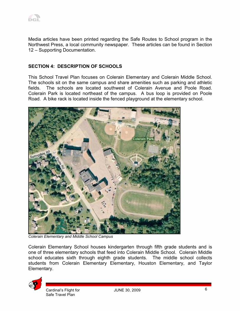
Media articles have been printed regarding the Safe Routes to School program in the Northwest Press, a local community newspaper. These articles can be found in Section 12 – Supporting Documentation. SECTION 4: DESCRIPTION OF SCHOOLS This School Travel Plan focuses on Colerain Elementary and Colerain Middle School. The schools sit on the same campus and share amenities such as parking and athletic fields. The schools are located southwest of Colerain Avenue and Poole Road. Colerain Park is located northeast of the campus. A bus loop is provided on Poole Road. A bike rack is located inside the fenced playground at the elementary school.
Colerain Elementary and Middle School Campus
Colerain Elementary School houses kindergarten through fifth grade students and is one of three elementary schools that feed into Colerain Middle School. Colerain Middle school educates sixth through eighth grade students. The middle school collects students from Colerain Elementary Elementary, Houston Elementary, and Taylor Elementary.
Cardinal’s Flight for JUNE 30, 2009 Safe Travel Plan
7
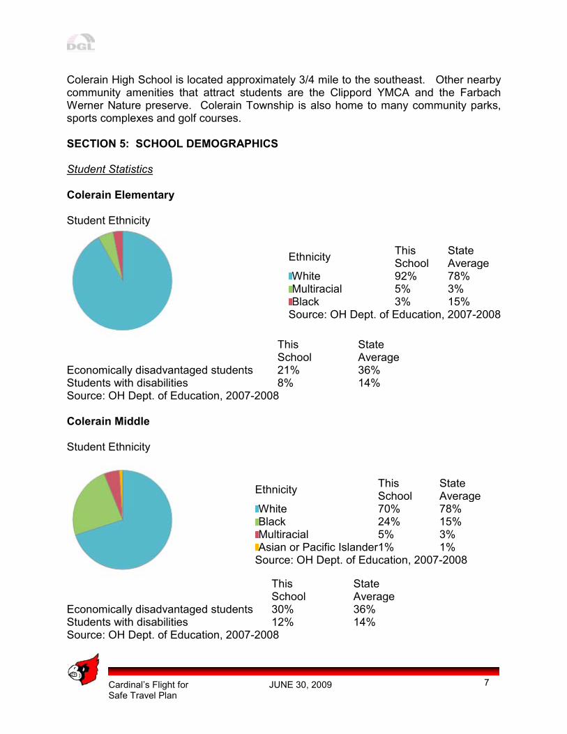
Colerain High School is located approximately 3/4 mile to the southeast. Other nearby community amenities that attract students are the Clippord YMCA and the Farbach Werner Nature preserve. Colerain Township is also home to many community parks, sports complexes and golf courses. SECTION 5: SCHOOL DEMOGRAPHICS Student Statistics Colerain Elementary Student Ethnicity
Ethnicity This School
State Average
White 92% 78% Multiracial 5% 3% Black 3% 15% Source: OH Dept. of Education, 2007-2008
This School
State Average
Economically disadvantaged students 21% 36% Students with disabilities 8% 14% Source: OH Dept. of Education, 2007-2008 Colerain Middle Student Ethnicity
Ethnicity This School
State Average
White 70% 78% Black 24% 15% Multiracial 5% 3% Asian or Pacific Islander 1% 1% Source: OH Dept. of Education, 2007-2008
This School
State Average
Economically disadvantaged students 30% 36% Students with disabilities 12% 14% Source: OH Dept. of Education, 2007-2008
Cardinal’s Flight for JUNE 30, 2009 Safe Travel Plan
8
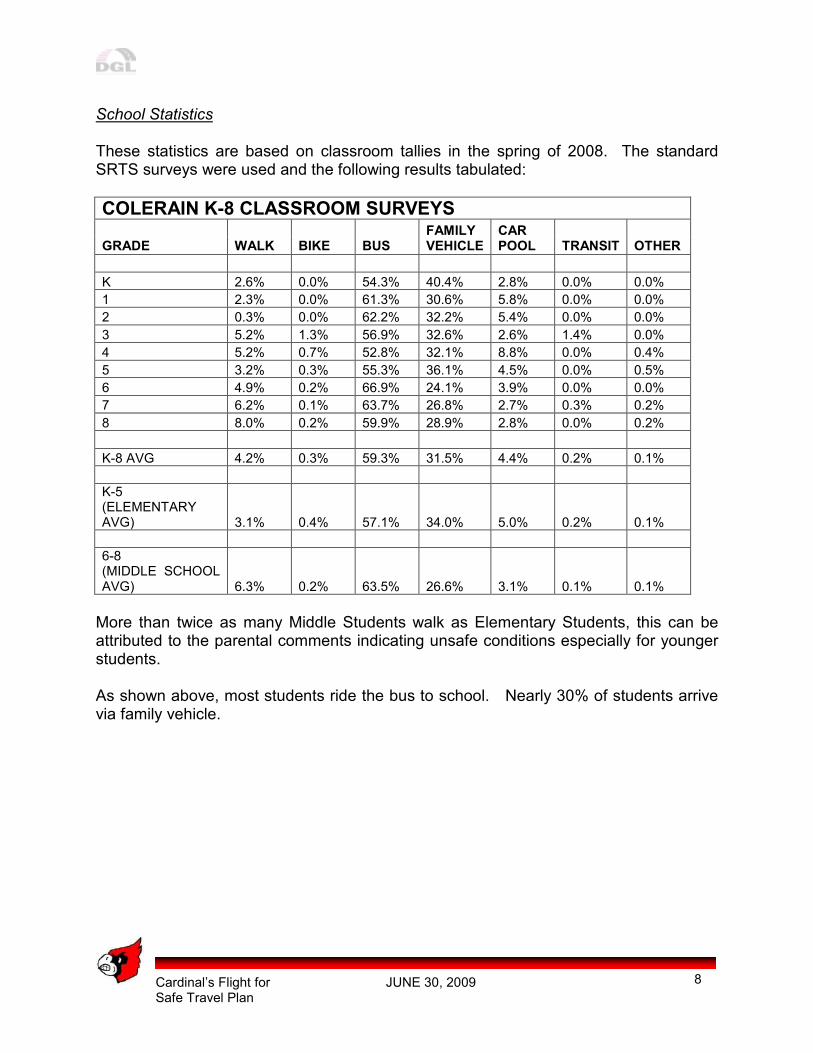
School Statistics These statistics are based on classroom tallies in the spring of 2008. The standard SRTS surveys were used and the following results tabulated:
COLERAIN K-8 CLASSROOM SURVEYS
GRADE WALK BIKE BUS FAMILY VEHICLE
CAR POOL TRANSIT OTHER
K 2.6% 0.0% 54.3% 40.4% 2.8% 0.0% 0.0%
1 2.3% 0.0% 61.3% 30.6% 5.8% 0.0% 0.0%
2 0.3% 0.0% 62.2% 32.2% 5.4% 0.0% 0.0%
3 5.2% 1.3% 56.9% 32.6% 2.6% 1.4% 0.0%
4 5.2% 0.7% 52.8% 32.1% 8.8% 0.0% 0.4%
5 3.2% 0.3% 55.3% 36.1% 4.5% 0.0% 0.5%
6 4.9% 0.2% 66.9% 24.1% 3.9% 0.0% 0.0%
7 6.2% 0.1% 63.7% 26.8% 2.7% 0.3% 0.2%
8 8.0% 0.2% 59.9% 28.9% 2.8% 0.0% 0.2%
K-8 AVG 4.2% 0.3% 59.3% 31.5% 4.4% 0.2% 0.1%
K-5 (ELEMENTARY AVG) 3.1% 0.4% 57.1% 34.0% 5.0% 0.2% 0.1%
6-8 (MIDDLE SCHOOL AVG) 6.3% 0.2% 63.5% 26.6% 3.1% 0.1% 0.1%
More than twice as many Middle Students walk as Elementary Students, this can be attributed to the parental comments indicating unsafe conditions especially for younger students. As shown above, most students ride the bus to school. Nearly 30% of students arrive via family vehicle.
Cardinal’s Flight for JUNE 30, 2009 Safe Travel Plan
9
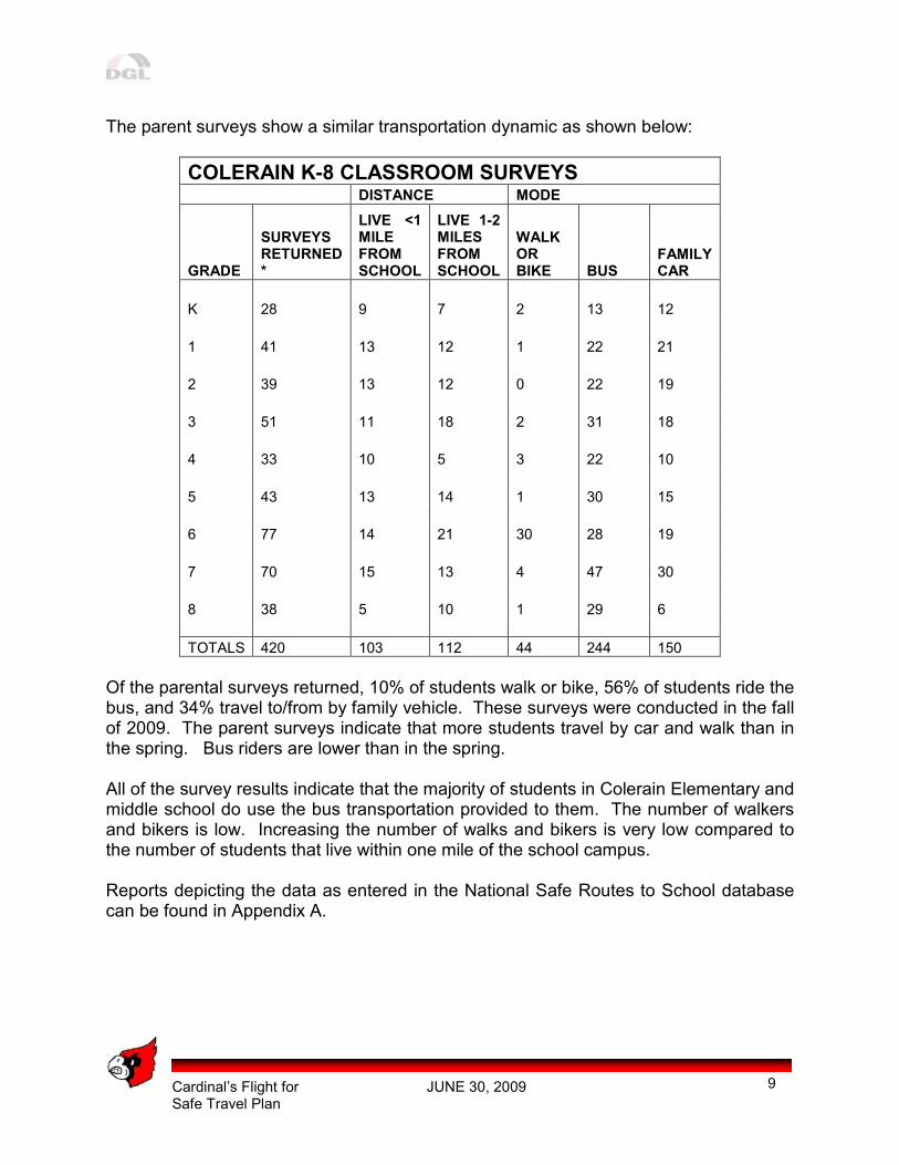
The parent surveys show a similar transportation dynamic as shown below:
COLERAIN K-8 CLASSROOM SURVEYS DISTANCE MODE
GRADE
SURVEYS RETURNED *
LIVE <1 MILE FROM SCHOOL
LIVE 1-2 MILES FROM SCHOOL
WALK OR BIKE BUS
FAMILY CAR
K 28 9 7 2 13 12
1 41 13 12 1 22 21
2 39 13 12 0 22 19
3 51 11 18 2 31 18
4 33 10 5 3 22 10
5 43 13 14 1 30 15
6 77 14 21 30 28 19
7 70 15 13 4 47 30
8 38 5 10 1 29 6
TOTALS 420 103 112 44 244 150
Of the parental surveys returned, 10% of students walk or bike, 56% of students ride the bus, and 34% travel to/from by family vehicle. These surveys were conducted in the fall of 2009. The parent surveys indicate that more students travel by car and walk than in the spring. Bus riders are lower than in the spring. All of the survey results indicate that the majority of students in Colerain Elementary and middle school do use the bus transportation provided to them. The number of walkers and bikers is low. Increasing the number of walks and bikers is very low compared to the number of students that live within one mile of the school campus. Reports depicting the data as entered in the National Safe Routes to School database can be found in Appendix A.
Cardinal’s Flight for JUNE 30, 2009 Safe Travel Plan
10
SECTION 6: CURRENT SCHOOL TRAVEL ENVIRONMENT Arrival/Dismissal Procedures Colerain Middle School (CMS) School Hours: 7:30AM - 2:20PM
� Buses drop off students in the A.M. on the south side of the CMS building. Buses enter off Springdale Road behind Colerain Elementary. Buses pick up students in the P.M. in two locations – half of the buses pick up on the south side of the CMS building – half of the buses pick up in the semi circle in front of Colerain Elementary School.
� Parents drop off students in the semi circle in the A.M. Parents pick up students
in the south side parking lot – there is a traffic pattern set up that parents follow with staff supervision at all times in the A.M. and P.M.
� Students are dismissed at the same time – CMS is one of the first school pick-
ups so the buses are waiting at dismissal. Colerain Elementary School (CES) School Hours: 9:05 a.m. - 3:35 p.m.
� At Colerain Elementary, buses drop off in the A.M. behind the building.
� In the P.M., buses pick up behind the building.
� Parents drop off students in the front semi circle and pick up students in semi circle.
� Notes are needed for parent pick up.
� Stagger dismissal with Y Kids Day Care, car riders and walkers first. Teachers
then walk students to their buses.

Cardinal’s Flight for JUNE 30, 2009 Safe Travel Plan
11
Transportation Policies Northwest Local School District buses students that live at distance greater than 1 mile from school. Board Policy EH Transportation Eligibility The Board of Education will provide transportation to all pupils, K-8, living more than one mile from the school, they are required to attend. Transportation of Special Education Students Upon the recommendation of the Superintendent, the transportation of handicapped children is authorized through the use of regular buses and, where necessary, private vehicles. Such vehicles shall deviate from the authorized route in order to pick up and deliver such handicapped children. (O.R.C. 3323.10, 3327.01) When the Northwest Local School District does not provide classes for handicapped children, the Board of Education will pay actual transportation costs according to the state formula for such pupils to and from such special schools outside the District.
Cardinal’s Flight for JUNE 30, 2009 Safe Travel Plan
12
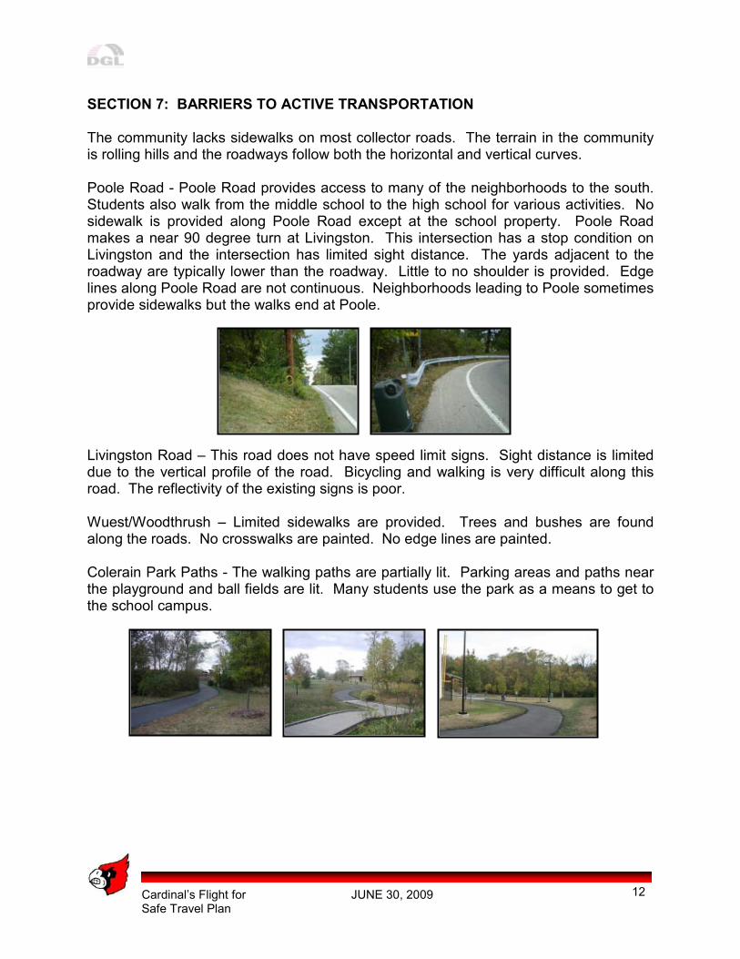
SECTION 7: BARRIERS TO ACTIVE TRANSPORTATION The community lacks sidewalks on most collector roads. The terrain in the community is rolling hills and the roadways follow both the horizontal and vertical curves. Poole Road - Poole Road provides access to many of the neighborhoods to the south. Students also walk from the middle school to the high school for various activities. No sidewalk is provided along Poole Road except at the school property. Poole Road makes a near 90 degree turn at Livingston. This intersection has a stop condition on Livingston and the intersection has limited sight distance. The yards adjacent to the roadway are typically lower than the roadway. Little to no shoulder is provided. Edge lines along Poole Road are not continuous. Neighborhoods leading to Poole sometimes provide sidewalks but the walks end at Poole. Livingston Road – This road does not have speed limit signs. Sight distance is limited due to the vertical profile of the road. Bicycling and walking is very difficult along this road. The reflectivity of the existing signs is poor. Wuest/Woodthrush – Limited sidewalks are provided. Trees and bushes are found along the roads. No crosswalks are painted. No edge lines are painted. Colerain Park Paths - The walking paths are partially lit. Parking areas and paths near the playground and ball fields are lit. Many students use the park as a means to get to the school campus.
Cardinal’s Flight for JUNE 30, 2009 Safe Travel Plan
13
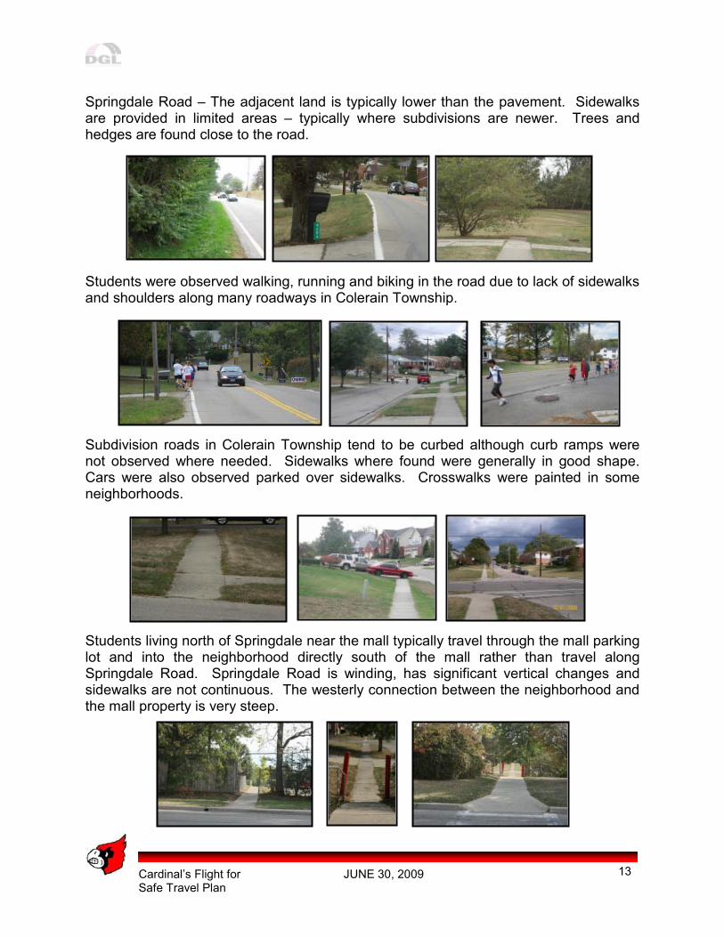
Springdale Road – The adjacent land is typically lower than the pavement. Sidewalks are provided in limited areas – typically where subdivisions are newer. Trees and hedges are found close to the road.
Students were observed walking, running and biking in the road due to lack of sidewalks and shoulders along many roadways in Colerain Township. Subdivision roads in Colerain Township tend to be curbed although curb ramps were not observed where needed. Sidewalks where found were generally in good shape. Cars were also observed parked over sidewalks. Crosswalks were painted in some neighborhoods. Students living north of Springdale near the mall typically travel through the mall parking lot and into the neighborhood directly south of the mall rather than travel along Springdale Road. Springdale Road is winding, has significant vertical changes and sidewalks are not continuous. The westerly connection between the neighborhood and the mall property is very steep.

Cardinal’s Flight for JUNE 30, 2009 Safe Travel Plan
14
Cardinal’s Flight for JUNE 30, 2009 Safe Travel Plan
15
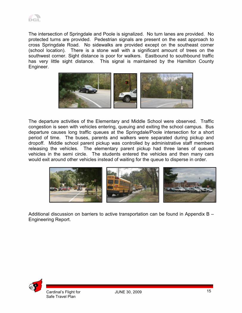
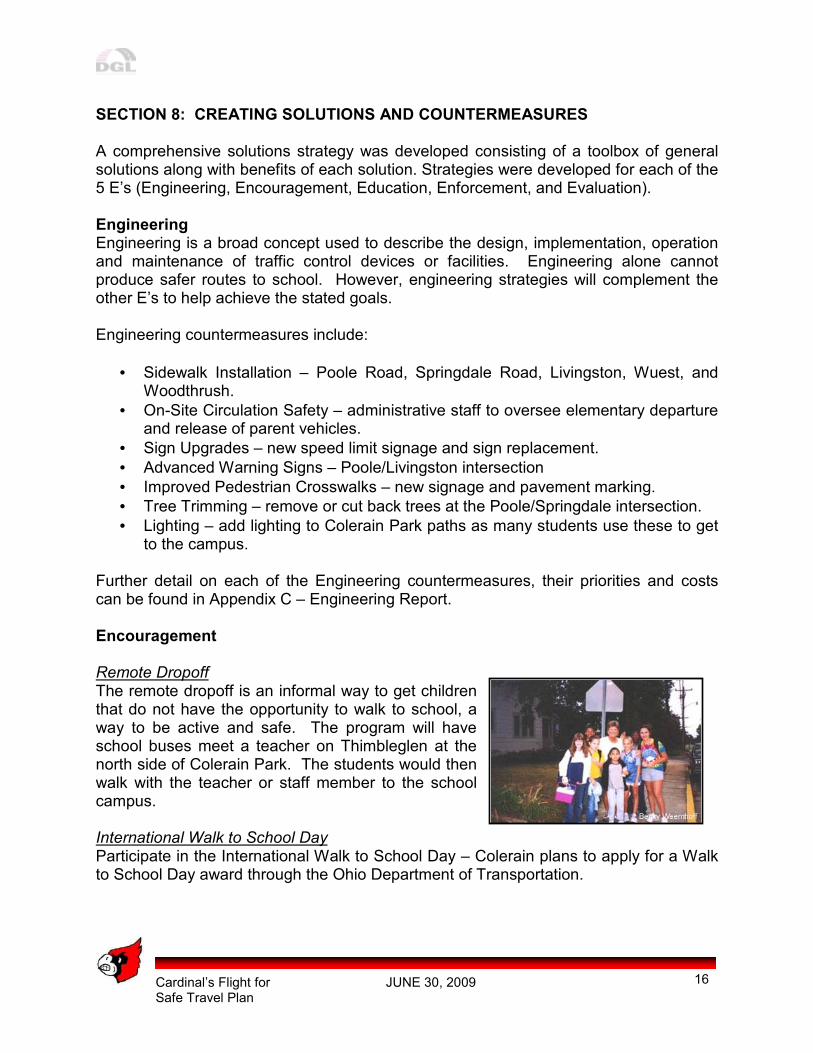
The intersection of Springdale and Poole is signalized. No turn lanes are provided. No protected turns are provided. Pedestrian signals are present on the east approach to cross Springdale Road. No sidewalks are provided except on the southeast corner (school location). There is a stone wall with a significant amount of trees on the southwest corner. Sight distance is poor for walkers. Eastbound to southbound traffic has very little sight distance. This signal is maintained by the Hamilton County Engineer. The departure activities of the Elementary and Middle School were observed. Traffic congestion is seen with vehicles entering, queuing and exiting the school campus. Bus departure causes long traffic queues at the Springdale/Poole intersection for a short period of time. The buses, parents and walkers were separated during pickup and dropoff. Middle school parent pickup was controlled by administrative staff members releasing the vehicles. The elementary parent pickup had three lanes of queued vehicles in the semi circle. The students entered the vehicles and then many cars would exit around other vehicles instead of waiting for the queue to disperse in order. Additional discussion on barriers to active transportation can be found in Appendix B – Engineering Report.
Cardinal’s Flight for JUNE 30, 2009 Safe Travel Plan
16
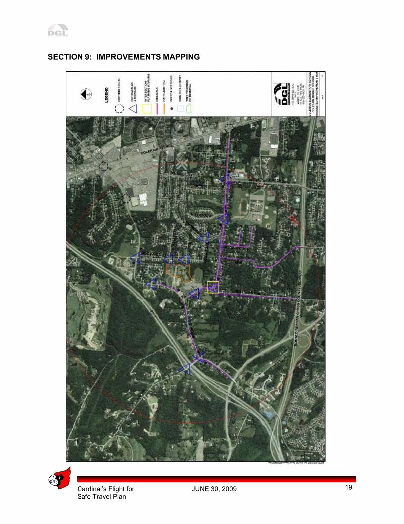
SECTION 8: CREATING SOLUTIONS AND COUNTERMEASURES A comprehensive solutions strategy was developed consisting of a toolbox of general solutions along with benefits of each solution. Strategies were developed for each of the 5 E’s (Engineering, Encouragement, Education, Enforcement, and Evaluation). Engineering Engineering is a broad concept used to describe the design, implementation, operation and maintenance of traffic control devices or facilities. Engineering alone cannot produce safer routes to school. However, engineering strategies will complement the other E’s to help achieve the stated goals. Engineering countermeasures include:
• Sidewalk Installation – Poole Road, Springdale Road, Livingston, Wuest, and Woodthrush.
• On-Site Circulation Safety – administrative staff to oversee elementary departure and release of parent vehicles.
• Sign Upgrades – new speed limit signage and sign replacement.
• Advanced Warning Signs – Poole/Livingston intersection
• Improved Pedestrian Crosswalks – new signage and pavement marking.
• Tree Trimming – remove or cut back trees at the Poole/Springdale intersection.
• Lighting – add lighting to Colerain Park paths as many students use these to get to the campus.
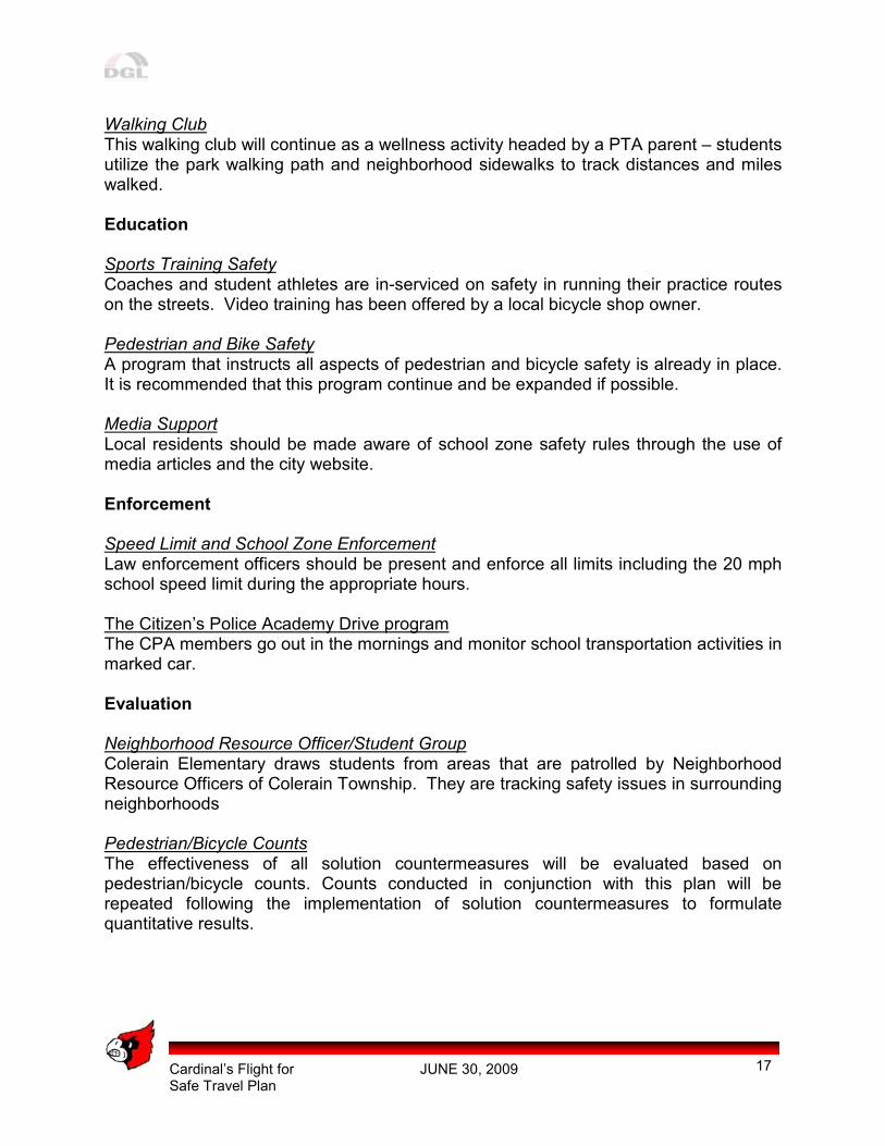
Further detail on each of the Engineering countermeasures, their priorities and costs can be found in Appendix C – Engineering Report. Encouragement Remote Dropoff The remote dropoff is an informal way to get children that do not have the opportunity to walk to school, a way to be active and safe. The program will have school buses meet a teacher on Thimbleglen at the north side of Colerain Park. The students would then walk with the teacher or staff member to the school campus. International Walk to School Day Participate in the International Walk to School Day – Colerain plans to apply for a Walk to School Day award through the Ohio Department of Transportation.
Cardinal’s Flight for JUNE 30, 2009 Safe Travel Plan
17
Walking Club This walking club will continue as a wellness activity headed by a PTA parent – students utilize the park walking path and neighborhood sidewalks to track distances and miles walked. Education Sports Training Safety Coaches and student athletes are in-serviced on safety in running their practice routes on the streets. Video training has been offered by a local bicycle shop owner. Pedestrian and Bike Safety A program that instructs all aspects of pedestrian and bicycle safety is already in place. It is recommended that this program continue and be expanded if possible. Media Support Local residents should be made aware of school zone safety rules through the use of media articles and the city website. Enforcement
Speed Limit and School Zone Enforcement Law enforcement officers should be present and enforce all limits including the 20 mph school speed limit during the appropriate hours. The Citizen’s Police Academy Drive program The CPA members go out in the mornings and monitor school transportation activities in marked car. Evaluation Neighborhood Resource Officer/Student Group Colerain Elementary draws students from areas that are patrolled by Neighborhood Resource Officers of Colerain Township. They are tracking safety issues in surrounding neighborhoods Pedestrian/Bicycle Counts The effectiveness of all solution countermeasures will be evaluated based on pedestrian/bicycle counts. Counts conducted in conjunction with this plan will be repeated following the implementation of solution countermeasures to formulate quantitative results.
Cardinal’s Flight for JUNE 30, 2009 Safe Travel Plan
18
Speed Data The effectiveness of infrastructure solutions will be evaluated, in part, by the collection of speed data. Speed counts will be conducted at or near locations where solution countermeasures have been implemented and where previous speed data information is available. Before and after data will be compared to determine possible benefits, such as lower traffic speeds and/or traffic volumes. Detailed countermeasure information can be found in Appendix B – Engineering Report.
Cardinal’s Flight for JUNE 30, 2009 Safe Travel Plan
19
SECTION 9: IMPROVEMENTS MAPPING
Cardinal’s Flight for JUNE 30, 2009 Safe Travel Plan
20
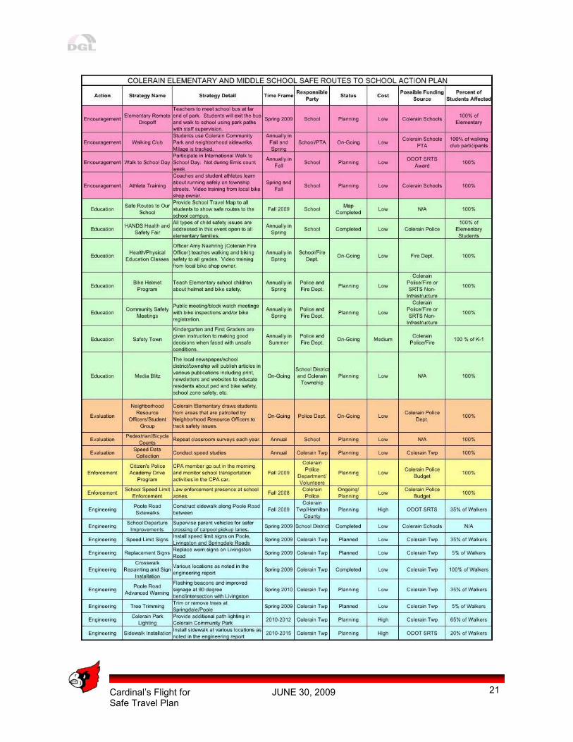
SECTION 10: ACTION PLAN The following page offers a list of actions that are in progress or in the planning stages to improve safety for pedestrians and bicyclists in Colerain Township. The actions employ encouragement to use safe and active transportation through awards and special events, education about safety and health in terms of using active transportation, enforcement of traffic guidelines and school transportation policies, engineering to address infrastructure improvements and evaluation of the action plan items to determine effectiveness. The actions listed are a collaboration of the public, the Safe Routes to School Task force and DGL Consulting Engineers. These represented stakeholders include Colerain Township, Northwest Local School District, Colerain Middle School, Colerain Elementary School, Colerain Township Police Department and Team Cycling and Fitness. The action plan was created to encourage students and adults alike to participate in active transportation through fun and information events. Priority projects include all on-going tasks and completing the installation of sidewalk along Poole Road. Colerain Township has already completed the repainting of all crosswalks in the community. Plans to provide upgraded signage will be undertaken in 2009 along with Poole Road Advanced Warning Improvement in 2010. Colerain Elementary has completed the school departure improvements by working with staff members to coordinate student to vehicle access and vehicle release from the semi circle. The programs will be evaluated on at least an annual basis. As the program moves forward, there may be action items that lose their effectiveness or new ideas that come to school or Township attention that would complement into the Colerain Cardinal’s Flight for Safe Travel plan. The document is intended to be modified over the life of the program as needed.
Cardinal’s Flight for JUNE 30, 2009 Safe Travel Plan
21
Cardinal’s Flight for JUNE 30, 2009 Safe Travel Plan
22
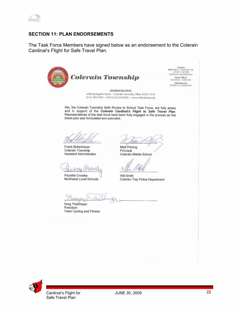
SECTION 11: PLAN ENDORSEMENTS The Task Force Members have signed below as an endorsement to the Colerain Cardinal’s Flight for Safe Travel Plan.
Cardinal’s Flight for JUNE 30, 2009 Safe Travel Plan
23
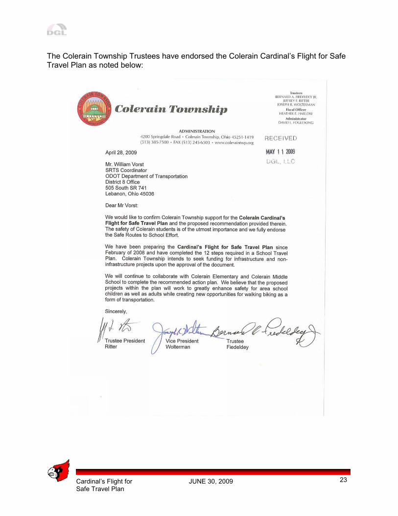
The Colerain Township Trustees have endorsed the Colerain Cardinal’s Flight for Safe Travel Plan as noted below:
Cardinal’s Flight for JUNE 30, 2009 Safe Travel Plan
24
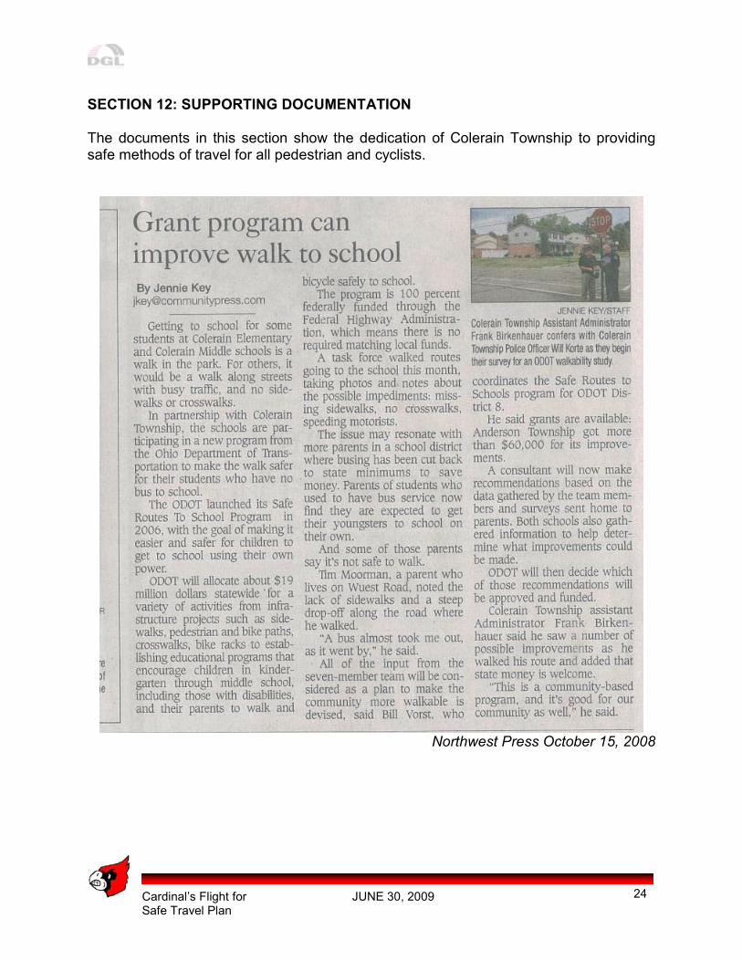
SECTION 12: SUPPORTING DOCUMENTATION The documents in this section show the dedication of Colerain Township to providing safe methods of travel for all pedestrian and cyclists.
Northwest Press October 15, 2008
Cardinal’s Flight for JUNE 30, 2009 Safe Travel Plan
25
Cardinal’s Flight for JUNE 30, 2009 Safe Travel Plan
26
Cardinal’s Flight for JUNE 30, 2009 Safe Travel Plan
A
APPENDIX A
Classroom and Parent Survey Summaries
Cardinal’s Flight for JUNE 30, 2009 Safe Travel Plan
B
APPENDIX B
Engineering Report