Embed Size (px)
Citation preview
Surigao del Norte
Brief History
The winds of change that swept the province from the four corners of the world has witnessed the meeting of diverse local and foreign influences which nurtured the emergence of a unique and distinct Surigaonon culture.
In 1538, the eastern coast of Mindanao which included the present province of Surigao del Norte was visited by the Portuguese explorer Francisco de Castro, who found the place inhabited by the Caraga tribe who were believed to be Visayan of origin.
Five years later, Ruy Lopez de Villabos landed in the same region. His navigator, Bernardo de la Torre, named it Cesaria Caroli in honor of the reigning Spanish Monarch, Carlos V. The name, however persisted since the Spaniards preferred to call it Caraga after its chief inhabitants.
The Jesuit Missionaries in 1597 tried to evangelize the people of Butuan (Agusan) and Caraga (Surigao), with much difficulty and intermittent success. They were followed in 1622 by the Agustinian Recollects who established parishes in Tandag and Bislig in 1642. The Recollects stayed until 1875, then the secular priest took over followed by the Benedictine Monks from 1893 to 1908.
The ancient district of Caraga, which was established in 1609, comprised all of Surigao del Norte, Surigao del Sur, the Northern part of Davao Oriental and Eastern Misamis Oriental, Agusan del Norte and Agusan del Sur.
In 1860, six military districts were established in Mindanao. Surigao and Agusan, including the territory lying between Butuan and Caraga Bays, formed the third district called the East District which was changed in 1870 to Distrito de Surigao.
By the end of the Spanish rule in 1898, the two Agusan provinces were organized as a single politico-military commandancia named Butuan, with the administrative jurisdiction of Surigao. In 1901, this commandancia became a sub-province of Surigao, and in 1907, Agusan became a separate province.It was on June 19, 1960, through Republic Act 2766 that Surigao province was divided to form Surigao del Sur and Surigao del Norte.
The Land
With a total of 273,902 hectares or 2,739.02 square kilometers, Surigao del Norte ranks third in the Caraga Region in terms of land area which is equal to 0.99% of the total land area of the Philippines.
Political Subdivision
Surigao del Norte is a group of islands at the rim of the Asian continental shelf. It is located at the northeastern tip of Mindanao facing the Philippine Deep. It is bounded on the north and east by the vast Pacific Ocean, on the south by the Provinces of Agusan del Norte and Surigao del Sur, and on the west by the historic Surigao Strait.
It is composed of 27 municipalities where Surigao City is the provincial capital.
The Resources
The province boasts of lush virgin forests, a long stretch of white sand beaches with world-class surfing sites, magnificent rock formations, and abundant marine life.
Surigao del Norte has the biggest deposits of nickel, gold, chromite, iron, gravel and sand, limestone and sillica.
The rich and fertile land predominantly produces agricultural crops such as rice, coconut and rootcrops. Livestock and poultry-raising are also the main source of livelihood.
Population
While the Philippine population is growing at 2.32% from 1990-1995, the provinces’ population has been growing at a slower rate of 0.70% per annum during the same period. As of 1995, Surigao del Norte has a population of 337, 294.
Accessibility
Since the capital of the province is Surigao City, access to the entire province is essentially the same as the access to its capital. Please refer to the rate and schedule of air, land and sea transportation.
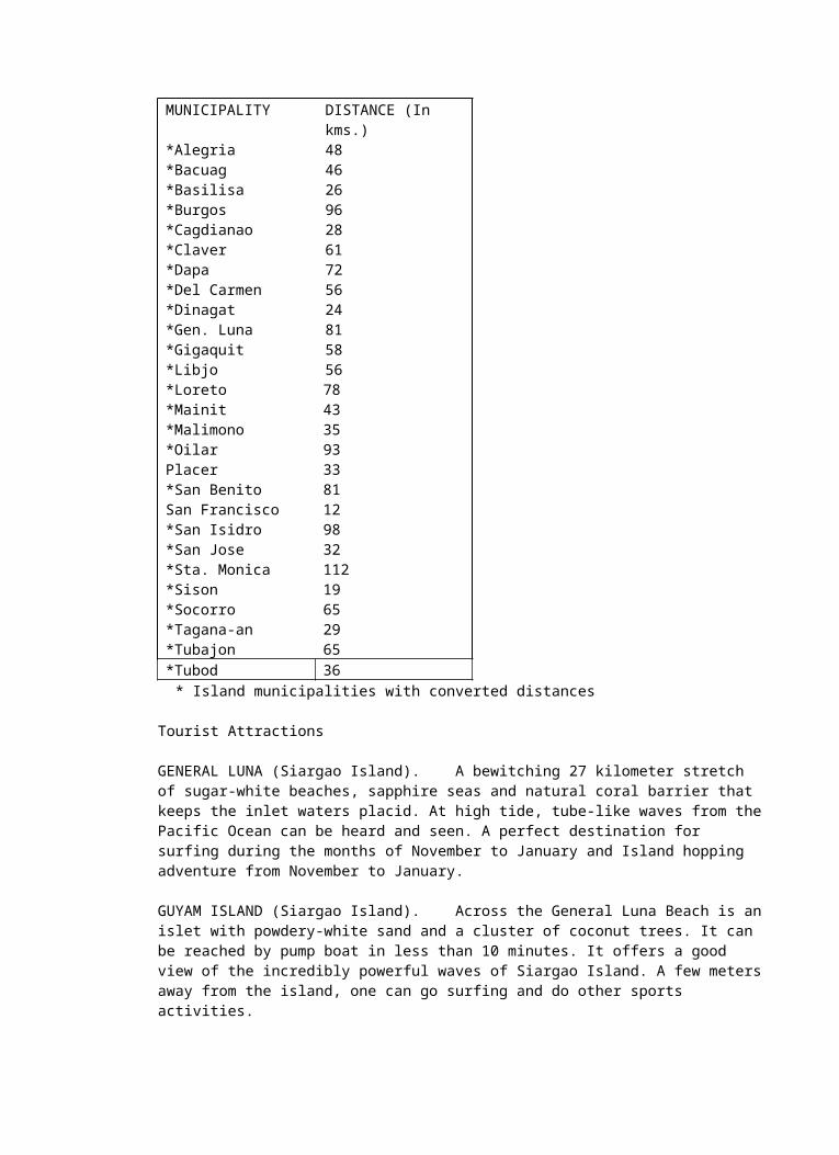
Distance of Municipalities from the Provincial Capital PROVINCE: SURIGAO DEL NORTE CAPITAL : SURIGAO CITY
MUNICIPALITY DISTANCE (In kms.)*Alegria 48*Bacuag 46*Basilisa 26*Burgos 96*Cagdianao 28*Claver 61*Dapa 72*Del Carmen 56*Dinagat 24*Gen. Luna 81*Gigaquit 58*Libjo 56*Loreto 78*Mainit 43*Malimono 35*Oilar 93Placer 33*San Benito 81San Francisco 12*San Isidro 98*San Jose 32*Sta. Monica 112*Sison 19*Socorro 65*Tagana-an 29*Tubajon 65*Tubod 36
* Island municipalities with converted distances
Tourist Attractions
GENERAL LUNA (Siargao Island). A bewitching 27 kilometer stretch of sugar-white beaches, sapphire seas and natural coral barrier that keeps the inlet waters placid. At high tide, tube-like waves from the Pacific Ocean can be heard and seen. A perfect destination for surfing during the months of November to January and Island hopping adventure from November to January.
GUYAM ISLAND (Siargao Island). Across the General Luna Beach is an islet with powdery-white sand and a cluster of coconut trees. It can be reached by pump boat in less than 10 minutes. It offers a
good view of the incredibly powerful waves of Siargao Island. A few meters away from the island, one can go surfing and do other sports activities.
DAKU ISLAND (Siargao Island). A wonderful island adjacent to Guyam Island which only takes about 5 minutes by pump boat. It is an ideal location for swimming, snorkeling, and sunbathing.
DEL CARMEN (Del Carmen). The Crocodile Sanctuary of the Philippines. It is the home of the biggest crocodiles in the country. These crocodiles can be usually found in Del Carmen’s vast and preserved mangrove forest.
SOHUTON CAVE (Bucas Grande Island). This enchanting cave is half-submerged in water most of the time and accessible only during low tide. Inside is a lagoon with countless islets and crystal waters that sparkle with the bright reflection of the sun. Lush vegetation abound in its periphery.
MAGPUPUNGKO BEACH (Siargao Island). Situated in a cove facing the Pacific, the place is surrounded by limestone and granite sculptures. During low tide, its pockmarked limestone floor reveal pools of assorted shapes and sizes resembling basins, barrels, tubs and ponds.
Lake Bababu (Basilisa, Dinagat). Situated between Puerto Princesa and Melgar in Basilisa, this mountain lake is a sight to behold, the steep descent (and ascent) add thrill to an avid adventurer. Surrounded by huge wall of granite, small caves are in great abundance. Lush vegetation dominates the virginal periphery.
Santa Monica Waterfalls (Sta. Monica, Siargao). A gentle burst of falling water amid the tranquillity of a tropical forest - this is an apt description of this waterfalls. The well preserved natural environment is another come-on.
Aling Cayao Island (Claver). A solitary island just 21 km. away from the poblacion of Claver. It stands in the deep blue seas like a sentinel in the southern portion of the province. The corals are well-preserved and the beach is pristine white.
U.S. LANDING AVENUE. A Strategic area in the Municipality of Loreto where U.S. Liberators landed and fought against the Japanese Imperial Army stationed in the place. A few miles from the island is Surigao Strait - the historical landmark where hundreds of Japanese Naval Ships sank due to massive bombardments by the U.S. Air Force during World War II.
PIG-OT HIDE AWAY RESORT. A cluster of islets that look like broken emeralds slapped on the aquamarine surface of the water. The islets are connected with a wooden bridge. As one strolls, he/she will witness the different aquatic species gliding and hiding behind coral reefs. This hideaway is indeed heavenly specially for the adventurous, leisure seekers, and nature lovers.MINI-DAM PARK (San Jose, Dinagat). Seven dams of graduated elevations are carved out of cliffs. Stones are perfectly laid out and fitted by human hands. The whole mountain is exquisitely landscaped adding beauty to the place.
SURIGAONON HERITAGE MINI-MUSEUM. (PPA-Surigao City). A collection of ancient archaeological diggings like burial coffins jars and antique Chinese kitchen wares are showcased in that mini-museum. Some of these artifacts were unearthed in Panhutungan, Placer.
Other Tourism Attractions
Rock Formations (Pilar and Libjo)Hot Spring (Mainit and Placer)Mountain Lake (Tubod)Waterfalls (Alegria, Bacuag, Tubod, San Francisco and SisonLake Mainit (Alegria and Mainit)
Sports Activities / Special Interests
SCUBA DIVING. For adventurous divers, the coasts of Surigao offer interesting dive site while the islands of Sagisi and Corregidor are excellent for snorkeling activities.
SPELUNKING. Guano Cave & Lagoon, Libjo. Situated on a mountain, it has a lagoon within which remains unexplored. Steep climbs are expected on the way to the cave.
SURFING. Lying at the veritable edge of the Philippine archipelago, Siargao is reputed as the Surfing Capital of the Philippines that host the annual international surfing event. Its waves combine the best quality features of top-rated waves of Hawaii’s fabled “ pipeline” and the top-billed wave of Indonesia. The huge and powerful “pacific rollers” has been ranked among the top five breaks in the world, including the “Cloud Nine” which is considered one of the world’s top surfing waves.. For more information about Siargao Island, please refer to ANNEX 6.
SEA KAYAKING. Siargao first became famous for its surf, so kayakers who like big waves have a field day here. There are also mangrove swamps in the island where you can paddle both in the main channel and through narrow passages in the mangroves while seeing some wildlife and enjoying the serenity of the place. The first is just behind the Pansukian Tropical Resort while the other one is in del Carmen, where the largest contiguous mangrove forest in the Philippines is located. The “must see” place in Caraga where you can paddle around spectacular limestone formation to a point where you can enter a narrow channel which soon becomes a cave is in Sohoton Cave and lagoon in Bucas Grande Island, which is more than an hour boat ride from Siargao. Since the sport is new here, only Pansukian Tropical Resort offer kayak tours in several locations around Siargao.
MOUNTAIN BIKING. Great trails run all around Surigao del Norte. There are regular cross- country and downhill competitions done in the area which are participated by local and international bikers. Butuan or Surigao- based bikers regularly tour the rugged terrain of the region and are eager to show their routes to new comers.
Events & Festivals.
SIARGAO INTERNATIONAL SURFING CUP. (Last week of September or First Week of October / General Luna, Siargao Island). Some of the most spectacular surfs in the world are found in Siargao, which hosts this annual international competition.
SIARGAO INTERNATIONAL MOUNTAIN BIKE COMPETITION. (Every Palm Sunday / General Luna, Siargao Island). The “Surf Island” of Siargao hosts its annual international cross country and downhill mountain biking competition.
LORETO LANDING. (Loreto, Surigao del Norte).
Tourism Facilities
The province has available standard hotels, inns, lodging houses, convention facilities, recreational facilities, shopping centers, souvenir shops, travel agencies, communication facilities, and other support services. Most of the tourism related establishments are found in Surigao City while some are widely distributed in selected towns of Surigao del Norte. Please refer to ANNEX 5 & ANNEX 6 for the list of tourism related establishments
Whom to inquire?
Anybody contemplating a trip to Surigao should contact the Department of Tourism, Caraga Regional Office at the Ground Floor, Grateful Realty Corporation Bldg. at #088 Pili Drive, Butuan City with telephone numbers: (063-85)341-8413 or (085)225-5712 or (telefax) (085) 815-6040. You can send an e-mail to [email protected] or [email protected]
You can also coordinate directly with the local tourism offices listed below or with the local officials in a specific locality.
Tourism Assistance Center, Luneta Park, Surigao City, Tel.No. (086) 826-8064 or Telefax at (086) 826-4131.
Provincial Tourism Officer-Surigao del Norte, Provincial Capitol, Surigao City, Tel.No. (086) 231-9271, Fax No. (086) 826-4371.
AGUSAN DEL SUR
Brief History
The province of Agusan del Sur once shared one governance with its sister province, Agusan del Norte. However, Republic Act 4969, enacted on June 17, 1967, divided the Agusan province into two: Agusan del Sur and Agusan del Norte.
Agusan’s pre-hispanic history was greatly influenced by the Madjapahit Empire. This can be attested through the discovery of the Golden Tara in 1960, in one of its towns, which is Maasam, Esperanza. The 8-inches gold image, that was retrieved along the river of Esperanza, originated from the Madjapahit Empire.
The aborigines of Agusan were the ancestors of the present-day Mamanwas who were driven to the hinterlands by the waves of Malay immigrants from nearby Borneo, Celebes and Malaysia. These people, in turn, sought the protection of the interior jungles because of the forays and the constant raids of Moros. Being a sea-faring people, they confined themselves to the coastal areas where they started settlements, leaving the forestall area to the other native tribes.
Population
As of 1995, the population count for Agusan del Sur is 514,736. It is composed of 99, 048 households with an average household size of 5.3. The province population growth is 3.85% with a population density of 59.75.
People
Based on the records of the National Integration Commission, the Aeta, Mamanwa, Bagobo, Banwaon, and Manobo are the five tribes who are found in Agusan del Sur. However, most of the Agusanon speak Cebuano while some use Boholano and Ilonggo. English is usually spoken in conversations with foreigners, in offices, and educational institutions.
Among the five existing tribes in the province, only Manobo and Banwaon or Higaonon Tribes are distinctly identified since they live along the National Highway and river towns of Davao del Norte while others live in the town of Esperanza towards the boundaries of Misamis Oriental and Bukidnon.
The Manobo
The Manobos have medium built/stout bodies with light brown-straight hair and brown eyes. This was the result of the inter-marriages among Duyag-Batang, Talaandig and Mamanwa aborigines and the Indonesians during the reign of the Madjapahit Empire, plus the inter-marriages of the natives with the Malay River people during the Sri Visayan Empire and the Chinese traders who came to Agusan in the 11th and 12th Centuries. The coming of the Spaniards had also contributed to this racial and cultural marriages.
The manobos have their own dialect, which is a mixture of a native dialect and an acquired foreign language. The name “Manobo” is influence by the Malay River People. These people are called “Mansuba”, from the word “suba”, the malayan term for river. Therefore, “Mansuba” literally means
“people living near or in the river (most of them live on floating houses). Later on, Mansuba is shortened to Manuba, which eventually took its masculine gender which is Manobo.
The Higaonon-Banwaon Tribe
Higaonon-Banwaon Tribe is the second largest indigenous community in Agusan del Sur. Higaonon is derived from the native word “gaon”, which means mountain or literally, it means “The mountain people”. They are somewhat nomadic, traveling from one mountain to another, looking for fertile soil for a better harvest.
The Higaonons have medium built bodies with an average height of 5 ft. & 2 inches tall and a lighter skin complexion as compared with the other tribes in the province. Quite a number of them have a recognizable European features, aqualine nose, deep-set eyes and prominent cheeks, a legacy of the intermarriage between the natives and the spanish conquiestadores. Generally, they are warm and friendly people but when intimidated, they are the fiercest warrior. Higaonons are good hunters and farmers.
The Banwaon is a relative to the Manobo tribe. Banwaon is derived from the word “banwa”, meaning village or country or they are called the village settlers. So, while the Higaonons occupy the mountains of Esperanza, the Banwaons live in the lowlands and upstream of Maasam, Libang and Adgawan Rivers. Just like the Manobos, they are adept in fishing and farming and they have similar features with the Manobos.
Being neighbors, these two tribes were constantly in conflict with each other. In order to resolved the tribal differences, the datus of the two tribes allowed their constituents to intermarry. Eventually, the intermarriages between Higaonon and Banwaon had resolved the conflict, bringing forth the Higaonon-Banwaon Tribe.
The Land
It has a total land area of 896,550 hectares or 8,965.50 square kilometers, with flat and rolling topography crisscrossed with rivers. The Agusan River is the largest and cuts the province into two along North-South direction.
Political Subdivision
Agusan del Sur occupies a portion of the Northern Mindanao Region bounded on the north by Agusan del Norte, on the east by Surigao del Sur, on the South by Davao del Norte and on the west by Misamis Oriental and Bukidnon.
The entire province has a lone congressional district, which is composed of 14 municipalities and 314 barangays. Its capital town is Prosperidad where the Provincial Government Center is situated.
The Resources
Agusan del Sur is maybe one of the country’s richest gold deposits. It contributes to the estimated 5.5 billion metric tons of metallic and non-metallic ore reserves Caraga region possesses. Other minerals found in the area are limestone, marble, gypsum, manganese, phosphate rock, coal, andesite rock, chromite, quartz, gold, white clay, and sand & gravel.
As part of Caraga region, it is also known to have the largest established timberland hectarage nationwide. In fact, it is envisioned to be the next timber corridor and food bowl in the region. Its major forestry and agricultural products are exotic tree species, rice, corn, coconut, cacao, coffee, banana, palm oil, and other agricultural resources.
Accessibility
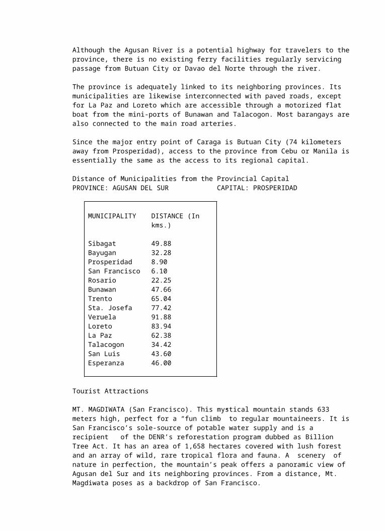
The province is landlocked and can be reached only by land transportation through the Davao-Butuan National Highway. Three minor roads also provide access for travelers coming from Tandag, Lianga, Barobo, and Bislig in Surigao del Sur. One road connects the southwestern part of the province and Asuncion, Davao del Norte. Although the Agusan River is a potential highway for travelers to the province, there is no existing ferry facilities regularly servicing passage from Butuan City or Davao del Norte through the river.
The province is adequately linked to its neighboring provinces. Its municipalities are likewise interconnected with paved roads, except for La Paz and Loreto which are accessible through a motorized flat boat from the mini-ports of Bunawan and Talacogon. Most barangays are also connected to the main road arteries.
Since the major entry point of Caraga is Butuan City (74 kilometers away from Prosperidad), access to the province from Cebu or Manila is essentially the same as the access to its regional capital.
Distance of Municipalities from the Provincial CapitalPROVINCE: AGUSAN DEL SUR CAPITAL: PROSPERIDAD
MUNICIPALITY DISTANCE (In kms.)
Sibagat 49.88Bayugan 32.28Prosperidad 8.90San Francisco 6.10Rosario 22.25Bunawan 47.66Trento 65.04Sta. Josefa 77.42Veruela 91.88Loreto 83.94La Paz 62.38Talacogon 34.42San Luis 43.60Esperanza 46.00
Tourist Attractions
MT. MAGDIWATA (San Francisco). This mystical mountain stands 633 meters high, perfect for a “fun climb” to regular mountaineers. It is San Francisco’s sole-source of potable water supply and is a recipientof the DENR’s reforestation program dubbed as Billion Tree Act. It has an area of 1,658 hectares covered with lush forest and an array of wild, rare tropical flora and fauna. A scenery of nature in perfection, the mountain’s peak offers a panoramic view of Agusan del Sur and its neighboring provinces. From a distance, Mt. Magdiwata poses as a backdrop of San Francisco.
BINABA FALLS. A 10-minute motorboat ride from the mini-wharf of the Gibong Recreation Center where the crystal clear water displays the nakedness of nature’s uninhibited wealth.
MT. DIWATA HOT & COLD SPRING. Surrounded by nature’s preserved forest, the area is a 4 kilometer hiking distance from the Maharlika Highway. It offers not only an impressive scenery but a natural medicine to tired urbanites and nature lovers.
AGUSAN MARSH. The largest marshland in the Philippines holding up to 15% of the country’s freshwater. This mystical wetland is the home of indigenous Manobo people who live in clusters of wood and bamboo houses built on rafts of floating logs. For bird watchers, the marsh is “a must visit” destination. Purple herons, storks, sea eagles, wild ducks and other migratory wetland birds from the
Southeast Asia Region will be seen during the months of November to January. Exotic flora and fauna and other endangered species like the dinata, a soft-shelled giant turtle, and sailfin lizard also exist in this wildlife sanctuary.
LAKE HIMBANG. It is more than an hour drive from the Maharlika Highway going to Lake Himbang in Talacogon. The lake is an alternative destination of Agusan Marsh. The thrill of riding a motorized small boat or a wooden-boat (made of a log) while admiring the tranquility and view of the lake plus a relaxing meal at the floating cottage are some of its attractions, which you would never want to miss.
MT. DIWATA PARK AND CAMPSITE. A preserved watershed forest three kilometers from San Francisco, it is known to have a virgin tropical forest areas.
Sports Activities / Special Interest
MOUNTAIN CLIMBING / TREKKING (Mt. Magdiwata, San Francisco). A minor climb with a height of about 633 meters above sea level, it provides a scenery of nature in perfection.
BIRDWATCHING (Agusan Marsh). Being a home to migrant birds during winter time, flocks of birds such as purple herons, storks, sea eagles, wild ducks and many endangered species can be seen in the area particularly during the months of November, December, and January. Agusan Marsh is accessible by boat through the Simulao River at Bunawan.
SHOOTING (Patin-ay, Prosperidad). There is an available shooting range located at the PNP Provincial Headquarters, Patin-ay, Prosperidad. Accommodations can be done through the office of the Provincial Directorate, PNP, Agusan del Sur.
Events and Festivals
NALIYAGAN (June 12-17, Government Center, Prosperidad). The festival depicts the Agusanon culture and heritage. Natives from far-flung areas of the province participate in the festivity by displaying their skills and gracefulness in a natural way. A trade fair showcasing the province’s own products also takes place at the Naliyagan Plaza.
SANTIKAN (June 12-15, Trento). Santikan is a Manobo word which means “to strike” or “ the striking of two hard objects to create fiction or fire”. It is to this essence that the festival is highlighted by different friendly competitions throughout its duration.
KAHIMUNAN (First Sunday of January, Bayugan). Local version of Sinulog of Cebu, the main attraction of this particular festival is the street dancing. The dances are focused on Agusan del Sur’s indigenous culture.
KAAMULAN (September 23, Salug, Esperanza). This is a yearly convergence of all tribal leaders in Agusan del Sur. The festival’s highlight is the performance of authentic tribal rituals by the tribal priests.
LAKE HIMBANG FESTIVAL ( October, Talacogon).
Accommodation/ Other Tourism Facilities
Agusan del Sur has a very limited type of accommodation facilities. There are no hotels or pension houses in the area but this is not a reason of not going there because there are many lodging houses and homestays at very affordable rates.
Convention/Function Facilities
PROVINCIAL TRAINING CENTERGovernment Center, Prosperidad, Agusan del Sur
MUNICIPAL GYMNASIUMSan Francisco, Agusan del Sur
Travel Agencies
At present, there are no existing travel agencies in the province. However, the proximity of Agusan del Sur to Butuan City facilitates any travel arrangements of the guests or tourists who want to explore the province. Further, the Regional Tourism office in Butuan City will also assist travelers going to any part of Agusan del Sur.
Other Information
FILIPINAS PALMOIL PLANTATION & PROCESSING, INC. (Agusan del Sur). This is the largest oil palm plantation in the Philippines with an area of 8,000 hectares. It also operates an oil mill inside the plantation that processes the produce or fruits harvested from the oil palm plantation.
The oil palm tree is a native of Africa. At present, Malaysia has the biggest land area planted to oil palm with Indonesia running second and fast catching up. The oil palm tree thrives in areas with continuous rainfall and adequate sunlight throughout the year. The oil palm tree bears fruit three (3) years after planting and has an economic life of at least 25 years. The products derived from oil palm are crude palm oil (CPO) and palm kernel (PK).
PROVIDENT TREE FARMS, INC. OR PTFI (Talacogon & San Luis, Agusan del Sur). Since 1967, PTFI has been in the forefront of tree plantation development, forest protection and scientific research in the Philippines. In the process, the company converts degraded forest areas and brush land into flourishing and productive plantations. These activities have a positive impact on the lives of the natives, their families and the surrounding community. It also supports environmental protection through the management of ecologically sound and viable forest plantations as a renewable source of forest products. It was in 1991 that PTFI started its operations in Agusan del Sur covering a total land area of 20,770 hectares.
Whom to inquire?
Anybody contemplating a trip to any cities or provinces of Caraga should contact the Department of Tourism, Caraga Region-XIII, Ground Floor, Grateful Realty Corporation Bldg. #088 Pili Drive, Butuan City with telephone numbers: (085) 341-8413 or (telefax) (085) 815-6040. You can send an e-mail to [email protected] or [email protected].
You can also coordinate directly with the local tourism office in Patin-ay Prosperidad, Agusan del Sur at Tel.Nos. (085) 3437268 & 3437369 or with the local officials in a specific locality.
Brief History
Old folks still like to recount how some Visayan fishermen, forced by strong currents in what is now Surigao Strait, sought refuge in one of the huts somewhere in the province. The locals or Mamanwas thought the fisherman wanted to take the hut by force or “agaw”. This term was given the prefix “suri” and “suriagaw” was formed. In time it was shortened to Surigao.
Still another recounts that, before the Spaniards came, the original inhabitants were the Mamanwas and the Manobos. The Visayans then came and settled on the island with the natives. One of the natives was Saliagao, who lived by the mouth of the river. From his name came “Surigao”.
But now, no matter how Surigao got its name, it is a fact that Surigao del Sur, being a marvel in terms of natural resources, is already an indispensable part of the Philippine map.
Surigao del Sur was created as the 56th independent Philippine province on June 19, 1960 by virtue of House Bill No. 3058 also known as Republic Act No. 2786 authored by then Representative Reynaldo P. Honrado. It was formally created and inaugurated on September 18, 1960 at the capital town of Tandag, the seat of the Provincial Government. Its first appointed and elected Governor was the late Recaredo B. Castillo, followed by the late Governor Adela Serra Ty.
Geography
Surigao del Sur is naturally advantaged. It is located in the northeastern coast of Mindanao facing the Pacific Ocean. It is approximately 300 kilometers in length and 50 kilometers at its widest stretch.
It is bounded on the northwest by the province of Surigao del Norte, on the southeast by Davao Oriental; on the east by the Pacific Ocean; and on the west and southwest by the province of Agusan del Norte and Agusan del Sur. The Diwata Mountain Ranges lines the northwestern boundaries of the province.
Profile
Capital town - TandagLand Area - 4,552.16 sq. kms.Population - 501,808 (2000)Population Density - 110Population Growth - 1.26Literacy Rate - 94%Languages and dialects - English, Cebuano, Filipino and Surigaonon
Provincial Delineation
No. of Municipalities - 18 mostly located along coastal areasNo. of City - 1No. of Barangays - 309Congressional Districts - 2Income Class - 2nd
Political Subdivisions
Municipalities are grouped into three clusters based on their common resource potentials, proximity and accessibility to common trade and service centers, the BIBAHILITA (Bislig, Barobo, Hinatuan, Lingig and Tagbina), the MACASALTABAYAMI (Marihatag, Cagwait, San Agustin, Lianga, Bayabas, Tago and San Miguel) and CARCANMADCARLANCORTAN (Carrascal, Cantilan, Madrid, Carmen, Lanuza, Cortes and Tandag).
Climate
The province falls under the second type of climate in the Philippines characterized by rainfall that is distributed throughout the year. Months with low level of rainfall are from July to October with September as the driest month. Wet months are from November to June with January as the wettest month.
TOURIST DESTINATIONS
Religious, Cultural and Historical Attractions
Aside from its wealth of natural resources, the province of Surigao del Sur boast of century-old structures, monuments and churches to satisfy the discerning taste of history and culture buffs.
The 175-year old Church of San Agustin in the town of Hinatuan, the San Nicolas de Tolentino Cathedral in Tandag, the municipal halls and town plazas backed up by rich and colorful stories of how these edifices were able to stand the ravages of time, are just some of the cultural/historical attractions which the province has to offer.
Station of the Cross – located at Kabiton-an, Brgy. Consuelo, Cantilan, this place is really ideal to those who want to reflect on how the Lord Almighty sacrificed himself to save mankind. It is a climb uphill with a chapel atop the mountain partly overlooking the majestic Pacific Ocean. Praying in every station is not just healthy for the soul but for one’s physical health considering that the last station and the chapel is located hundreds of feet above sea level.
Immaculate Conception Parish – One of the best designed Catholic Churches in the country. It is located at the heart of Cantilan. Beside it is a remnant of an old church constructed in the 1700’s which was converted into a park.
Old Tribunal Building – it is the old tribunal of Cantilan built in 1879 which was now converted into a Municipal Hall of Cantilangnons.
Municipal Park of Cantilan – it is where you can see the 21/2 meter cannon with 130 cm. in diameter placed as historic relic. It is one of the 100 cannons brought from Jolo and Borneo by the natives of Cantilan during the Spanish regime as a tool against Muslim pirates.
Shrine of World War II Heroes – it is where the names of the Cantilan heroes were engraved.
BEACHES
Adhika Beach – located in Barangay Habag in the Municipality of Lanuza. It is a privately-owned beach resort with cottages and rest house for visitors who will rest overnight (RON).
Barcelona Beach – it is a unique black sand beach with picnic huts located just 30 minutes away by pumpboat from Mangagoy, Bislig City.
Baucawe Beach and Winding Road – it is a beach resort situated in Lianga. The winding road leading to the beach serves as its unique attraction.
Cagwait White Beach – it is a U-shaped beach with powdery white sand and a wind swept sea with crystal clear water baptized by the famous pilot Charles Lindberg as the “Waikiki Beach” of the Philippines. This is the site of the annual “Kaliguan Festival”. It is a 40-minute ride from the capital town of Tandag.
Dapdap Beach – located in Dapdap, in the Municipality of Barobo.
Mahayag Beach – situated just 8 kilometers north from the capital town of Tandag. Mahayag is a coastline purok of Barangay Buenavista. The beach resort is one end of the cove occupying about a hectare in area. The place is ideal for holding seminars or family reunions. One can idle the time away by boating, fishing or swimming on the man-made pools at the sea.
Tandag Beach – located right in the capital town of Tandag, it is guaranteed to enchant all beach lovers with its grey sand and crystal clear waters. It is a nature lover’s paradise, a promised adventure for snorkels and diving enthusiasts.
CAVES
Campamento Cave – Located in Silop, Gamuton in the municipality of Lanuza
Hercules Wall – Located in San Jose in Bislig City, it is a 2-3 meters wide passage in between solid high rocks, stones and other natural grown trees in the area.
Pagbutuanan Cave – located in Brgy. Wakat, Barobo.
Tagbina Cave – Located underneath a rocky mountain where the Municipal Hall of Tagbina town is perched, overlooking the expanse of territory comprising the jurisdiction of the town. The portal of the cave is visibly seen as one goes uphill on the concrete road leading to the Town Hall. The cave has long been in existence as one product of nature and has been a haven for birds and other forms of life that dwell in labyrinth-like places. Other caves are the San Isidro Cave and the Km. 3 Cave both located in Bislig City.
FALLS
Balinganga Falls – it is located in the communal forest of Barangay Cancavan in Carmen streamlining the verdant and sprawling mountain. It is unique in CARCANMADCARLAN considering that one could only and truly enjoy the cool and refreshing crystal clear water and see the splendor and awesome beauty of nature after a breathtaking trek.
Bao-bao Falls – it is located in Lianga. Once developed, kayaking is the ideal activity at this beautiful and challenging clear water. The site offers a natural splendor of an unspoiled environment.
Busay de Mabuhay Falls – located in Barangay San Roque in San Miguel. It is like a pitcher-full of water poured over a cup-like place where very deep, cool fresh water invites one to take a swim. Located in the midst of the jungle, this waterfall offers a mini cave underneath the flowing water that can accommodate 3 to 4 persons.
Tinuy-an Falls – located in Barangay Borboanan in Bislig City. It is known to be the “little Niagara Falls”. It signifies the multi-layered river bed of stones skillfully crafted by the “Unseen Hands”. Tinuy-an is the widest waterfall in the entire Mindanao. It is a 3-tiered waterfall in the middle of a thick forest. It is like a 4-storey building with the expanse of a cathedral and a pool in the bottom, the size of a football field.
Magkawas Falls – located in the Municipality of Lanuza. A five-minute hike from the national highway is an eco-destination that offers a gradual accelerando of nature’s beauty. This wonderful falls makes one irresistible to take a refreshing dip.
Sipangpang Falls – located in Barangay Cabangahan in the municipality of Cantilan. A hydro-power potential considering its waterfall cascading from a height of 22 meters.
OTHER FALLS :
1. Ave Maria Falls - Carrascal2. Canlumawag Falls - San Jose, Bislig City3. Kambawi Falls - Pamanlinan, Bislig City 4. Mendezona Falls - San Jose, Bislig City5. Secret Falls - Burboanan, Bislig City 6. Sian Falls - Sta.Cruz, Bislig City7. Sibaroy Falls - Sibaroy, Bislig City
ISLANDS
Ayoke Islet – this is part of Barangay Isla General Luna (General Island), an island barangay of Cantilan. It is famous for “kolo”, a fruit similar to langka but different in taste. It is where the lighthouse of the town is located to guide fishermen and passenger ships passing the area.
Bag-ong Banwa (Double B) – this is also part of General Island fronting the Pacific Ocean. Its shoreline is covered with very fine white sand. It has cottages to accommodate visitors. A big cave
can also be found where stalactites and stalagmites are so abundant. This is a 30-minute boat ride from Cantilan Wharf.
Bat Island – also known as Mangkagangi Island. It is located just two miles east of Tandag. It has enticing white beach, guano-filled caves and bats inside, offering a unique experience to all adventure seekers. Just a few meters from the island is a deep, blue sea which is ideal for scuba diving.
Britania Islands – located in the municipality of San Agustin. It is composed of more than a dozen beautiful islets with splendid vegetation and white beaches. The intact coral formation offers a beautiful snorkeling and scuba diving sports activities.
Casarica Island – a pristine white beach with crystal clear waters which is only a 10-minute ride by pump boat from Consuelo Port.
Hagonoy Island – a 1.7 hectare island with a perimeter white sand. It is a 20 minute ride by a motorized banca from Mangagoy, Bislig City. An island filled with coconut and green trees, it is surrounded by a beautiful white beach and a blue, crystal clear and calm water ideal for swimming.
Huyamao Island – presently owned by the nine heirs of the late Teodoro Urbiztondo, this private majestic island is covered with very fine white sand. This is located in front of Baybay, Cantilan shoreline. From there, one would not fail to notice the white sand along the mountain island that is compatible to the sand bar of Camiguin. Its water is so pristine; one can even clearly see the sea bed while riding a banca.
Kabgan Island – located in Sua in the municipality of Barobo. A mile long pristine white sand beach, multicolored reefs, good for scuba diving, swimming and fishing.
Turtle Island – it is located in the municipality of Barobo. It is an 8 hectare beach where multicolored reefs abound. It has white sand, blue waters teeming with marine life. Viewed from a distance, the shape and formation of this island is like a huge turtle floating in the Pacific Ocean. It is ideal for snorkeling and scuba diving. It is accessible by pump boat for about 30 minutes.
2 Linongaw Islands – These are big and small islands that tower over Tandag. These are veritable havens of white sand, multi-faced rocks fringed with skyscraping trees dominated by monkeys and singing birds, being the habitat of age-old bats.
LAGOON
Blue Lagoon – situated in General Island, Cantilan, this province, the lagoon has a deep blue crystal clear water safely enclosed by an island.LAKES
Danao Lake – Located atop the mountain of General Island. This is good for those who love hiking, nature tripping and swimming.
PARKS
Forester’s Park – located in Bislig City. It has a vast tree plantation of different dipterocarp species such as falcata, bagras, mangium, etc. and natural grown trees.
Mini Forest Park – located in front of the municipal hall of San Miguel.
Municipal Tree Park – located in Marihatag.
RIVERS
Caguyao River – located in Caguyao, Bislig City, it is good for swimming and picnics. It is surrounded with natural scenic beauty along its meandering river channel.
Dinayhugan River – utilized as a dam of the National Irrigation Administration in the 1990’s, it is now best enjoyed by picnickers, rafters and cruisers. Rafts are available at the site. There is a cave nearby that holds large deposits of guano and treasure trove of relics. Fossils, artifacts and other anthropological curiosities which include tell-tale remains of the ancient church are also found inside the cave.
Enchanted River – Located in Talisay, Hinatuan, it is an awesome deep river inside a thick forest with very cool, placid blue waters which allows the viewing of beautiful fishes underneath. This river inspired the composition of the song “Enchanted River” by a local composer.
Suhoton Underground River – located in San Vicente, Bislig City. It is an underground river from a spring.
Tago River – the longest river in Surigao del Sur. It snakes up to the heart of the Diwata Mountain in the west passing the hinterland town of San Miguel. It’s approximately 60 kilometers in length from the mouth of Tago to the municipality of Cabadbaran in Agusan del Norte.
SPRINGS
Bogac Spring – Located in Barangay Poblacion in Barobo. It has clear brackish water with scenic background and swimming area.
Malinawa Cool Spring – it is located in the municipality of Cantilan. A very cool spring surrounded by beautifully arranged big flat white rocks around the pool equipped with hower rooms, cottages and a mini convention center. The spring is constantly flowing 90 liters of fresh water per second. It is a 5 minute ride from the national highway.
Marga Hot and Cold Spring – located in Brgy. Castillo in the municipality of San Miguel. An amazing source of hot water sprouting from underneath the ground flowing side by side with a cold spring. The heterogeneous mixture of water is an ideal medicinal treatment for those with health problems. It is where one can find hot spring all year round.
Libuac Spring – located in Tagbina.
OTHER DESTINATIONS
Estuarine Wetland Park – located in Baybay, Bunga, Lanuza.
Iron Mountain Road – it is locally known as “Noventa”. It is the site of the biggest iron deposit in the whole country. It is a 25 kilometers serpentine road, with an altitude of about 900 feet above sea level. The road leads to the highway boundary of Surigao del Sur and Surigao del Norte.
Laswitan – Art materials-made pools with clear undiluted seawater. They abound with a variety of fish. Laswitan is quietly nestled in between a mountain. The seawater enter the three pools during high tide through a narrow passage and through the frequent splashing of the giant waves that push the mountain rock. Laswitan is located in Barangay Madrelino some five kilometers away from the poblacion. To reach the area from the main road, one would walk nearly half kilometer and pass through steep slope.
Lanuza Marine Park and Sanctuary – located in Cagmino, Sibahay, Lanuza
Lanuza Surfing Paradise – located at Zone I, IV, Habag and Sibahay in the municipality of Lanuza.
OTHER PLACES OF INTEREST
Ancestral House – located in Barangay Poblacion, Lanuza.
Carac-an Bridge – The longest bridge in Surigao del Sur and Surigao del Norte. Its length is 481 meters and located in the municipality of Madrid.
Rizal Fish Port – located in Rizal, Barobo.
Subterranean Canal – this canal is found in Madrid with the bridge and tunnel as its attractions.
FESTIVALS
Ka’liga Festival - SDS-every June 19 - a thanksgiving dance festival of the Manobo Tribe
Diwatahan Festival - Tandag-Every 3rd Sunday of January
-A Tandag version of Sinulog in Cebu City
Kaliguan Festival - Cagwait-A yearly activity in honor of St.John the Baptist highlighted by beach dancing and a search for Perlas ng Kaliguan beauty pageant. There are also sports activities at the beach which include pinoy games, ball games, swimming and boat racing.
Taephag - Tagbina- Every 27th of June
-A common Manobo ritual used for opening a kaingin, rice planting, harvesting and other farming activities.
Pahinungod -CarrascalFestival -Every 14th-16th of July-This is the mardigras which is performed around the streets of Carrascal. The dancers with an array of select ethnic dance steps and a kaleidoscope of costumes would offer their movements and songs to their beloved Patronness, Our Lady of Mount Carmel.
Paladong Festival -Hinatuan- Every 28th of August
-The art of performing the ritual of “ladong” conducted by a “ladongan”, a person who has the power and ability to cure as medium to call the spirits abian and relay the wishes to the clients through an offering.
Kalumunan -San AgustinFestival - Every 28th of August-A reunion of relatives and friends during town fiesta of San Agustin celebrated through street dancing, “tabo” of farm products and a choral competition participated by neighboring towns.
Kadagatan - CortesFestival - Every 25th of July-A yearly festival of Cortesanons done through street dancing, to promote continuing awareness of people in the conservation and protection of natural resources especially marine life.
Sirong Festival -Cantilan-Every 15th day of August
-War dance between Muslims and Christians reflecting the Christianization of the early Cantilangnons. Uniquely portrayed here is the “Escrima” (Arnis) and “Alabacion” (Chanting to a Goddess).
CHURCH SERVICES
Carrascal - Our Lady of Mt. Carmel ParishCantilan - Immaculate Conception ParishMadrid - San Isidro Labrador ParishCarmen - Saint Vincent ParishLanuza - San Antonio de Padua ParishCortes - Saint Louise de Gonzaga ParishTandag - San Nicolas de Tolentino ParishTago - La Purisima Concepcion ParishSan Miguel - San Miguel Archangel Parish Bayabas - San Ignacio de Loyola ParishAras-asan - San Antonio de Padua ParishMarihatag - Santo Nino ParishSan Agustin - San Agustin ParishLianga - Santo Nino Parish Diatagon - Saint John the Baptist Parish Barobo - Mother of Mercy ParishTagbina - Mother of Perpetual Help Parish Hinatuan - San Agustin ParishLingig - Santo Nino ParishBislig City - Saint Thomas de Villanueva ParishForest Drive - Saint Joseph the Worker Parish
SPORTS FACILITIES
GPM Sports Complex – located at the heart of Tandag, was named after the former governor of the province Gregorio P. Murillo. The sports complex is equipped with modern facilities. It has an Olympic size swimming pool including basketball, volleyball and sipa courts, an oval and a grandstand.
COMMUNICATION FACILITIES
One can reach other parts of the country and the world through internet, fax, landline (TETCO, PLDT, PHILCOM, SANAGTEL and RCPI) and wireless communication (SMART and GLOBE). Major courier companies like LBC, JRS have branches in Tandag and Bislig City.
Radio Stations
AM -DXJS Radyo ng Bayan – Capitol Hills, Tandag, Surigao del SurFM -DXJR Planet Energy – Paradise Heights, Telaje, Tandag, Surigao del Sur -DXAR Alternative Radio – Osmena St., Tandag, Surigao del Sur -DXJB Alternative Radio – Osmena St., Tandag, Surigao del Sur INTERNET SERVICE PROVIDERS– 12 provincewide
MEDICAL AND HEALTH FACILITIES
Clarit Medical Clinic - Medical Mission GroupViemma Medical Clinic - Adela Serra Ty Memorial Medical CenterCuartero Hospital - Tandag Doctor’s ClinicPolymedic Hospital in Cantilan - Madrid District HospitalMarihatag District Hospital - Lianga District HospitalHinatuan District Hospital - Bislig District HospitalCortes Community Hospital - San Miguel Community HospitalLingig Community Hospital
SEMINAR / TRAINING FACILITIES
TJ Oasis Beach View Resort - CarrascalShacene and Pension House & KTV Bar - TandagMuyco’s Resort by the Bay - TandagPlaya Pacifico Beach Resort - TandagMalinawa Cool Spring and Mini-Convention Center - CantilanKansilad Beach Resort - LiangaSelades Apartelle & Catering Services - TandagZyphora Garden Hotel - CantilanExtreme Beach Resort - CagwaitCagwait Beach Resort - CagwaitMahayag Beach Resort and Apartelle - Tandag
Best Buys
TT & Co. Inc. - TandagUltra Star Marketing - TandagFedy Mart - TandagV. Guerra - TandagCPD Collections - TandagSunlight Marketing - TandagBright Star Inc. - Tandag De Lara Agsam Crafts - LanuzaVG Lambo Magkono Woodcraft - Aras-asan, Cagwait NKC Office - CagwaitSmartshop - TandagWSS - Tandag Saralee - Tandag Natasha - Tandag Raffles and Co. - Tandag Avon - Tandag Sundance - Tandag Ferdhome Business Venture - Tandag
Entertainment
Y Bar - TandagKaptayn’s Bar and Grill - TandagSidlakan Beach Resort - TandagExpat’s Café - CantilanHillary’s Café - CantilanShacene Pension House, Restaurant and KTV - Tandag
SURIGAO DEL NORTE & SIARGAO ISLAND
Surfing Siargao
SIARGAO ISLAND, Surigao del Norte. The unspoiled teardrop shaped island called Siargao is the shangrila of adventurers and nature lovers. It is the surfing capital of the Philippines, which is 800 kilometers Southeast of Manila.
Siargao, which many surfers claim has the best and most consistent surf in the Philippines, has made an eccentric entry into the world of surfing arena. Through the success of the First International Surfing Cup in 1996, Siargao is now one of the world’s great frontiers for surf exploration. Its most popular break is “cloud nine”. Surfing is best from July to November when strong waves are in constant motion.
Siargao is the largest of a group of islands emerging as one of the finest water sport destinations in the country. Aside from the surfing, there is sea kayaking, long stretch of white sand beaches, hidden caves and lagoons, mangrove swamps, magnificent rock formations, and mountain lakes.
The most striking feature of the island is the existence of several endangered and rare species of flora & fauna such as the well known Philippine Crocodile, marine turtles, sea cow, the attractive fire and century orchids and the “iron wood” or magcono. It has the biggest mangrove reserve in the Philippines covering 8,760 hectares and vast areas of coral reef with rich marine resources.
In 1992, the island was proclaimed a protected area (Protected Landscape and Seascape Category) under Republic Act 7586 (NIPAS Act of 1992), which will provide the legal basis for pursuing plans for the conservation and continuous protection of the island’s natural resources.
Location
Siargao Island is politically under the jurisdiction of Surigao del Norte, a province located at the Northeastern portion of Mindanao which lies between 125 50’ East Longitude and betweem 9 30’ and 10 0.5’ North Latitude. It is bounded on the north by Dinagat Island, on the south by mainland part of the Province of Surigao del Norte, on the east by Hinatuan Passage, and on the west by Surigao Strait and the province of Southern Leyte. Stretching along its southeastern coast is the Philippine Deep, the greatest known depth within Philippine waters at 11,094 meters below sea level.
Area
Siargao Island has an approximate land area of 67,726 hectares including Bucas Grande Island Island and all coastal barangays. It consists of nine (9) municipalities with 131 barangays.
Breakdown of the areas as follows:
MUNICIPALITY AREA (IN HECTARES) NO. OF BARANGAYS
BURGOS 3293 6DAPA 9808 29DEL CARMEN 13994 19GENERAL LUNA 4126 20PILAR 7706 15SAN BENITO 3970 6SAN ISIDRO 5834 12SOCORRO 12445 13SANTA MONICA 6550 11TOTAL 67276 131
Climate
The prevailing climate type of the island falls under Type II which is characterized by no pronounced dry season but with a very pronounced maximum rainfall from November to January. Siargao receives the highest amount of rainfall during December while June is the driest month.
Religion
The five major dominant religions of the island are Roman Catholic, Philippine Independent Church, Iglesia Ni Cristo, United Church of Christ in the Philippines, and Jehovah’s Witness.
Population
Siargao Island has a total population of 83,100 comprising 19.16% of the total population of Surigao del Norte with 15,109 households (as of 1995). As the commercial and trade center, Dapa town has the highest population among the municipalities with 15,500 inhabitants having 2,818 households while General Luna, which is known as the tourist destination in the island, has 12,500 with 2,273 households.
Communication Facilities
Communication facilities are limited in the area. The form of communication widely used by the municipalities is the telegraphic transfers through Radio Telecommunication, postal services and incoming radio broadcast. Recently, direct long distance calls can be done through the following:
RCPI – DapaDapa, Siargao Island, Surigao del Norte
PT&T - DapaDapa, Siargao Island, Surigao del Norte
.TelecommunicationDapa, Siargao Island, Surigao del Norte
TelecommunicationGeneral Luna, Siargao Island, Surigao del Norte
Transportation
There are inter-island water vessels plying between Siargao/Bucas Grande Islands and Surigao City. Passenger jeepneys, motorized boats, and “habal-habal” or motorcycles serve commuters bound to any point of destination in the island.
Some Surf Spots in Surigao
CLOUD NINE (General Luna). A world-Class right hand break that offers machine like barreling perfection. It works on any swell with southwest winds. The waves have big thick peaks that rise abruptly, hallow out and break heavily in just two meters of water. When the swell is from the right hand direction, the peak produces an equally good left break.
PILAR. This is a series of lefts in front of the town wharf, but it needs huge swells on the reef before it starts working. This is an alternative surfing area when the swells are too big in other areas.
NEIL’S SPOT (Pilar). A well shaped right hand break at the base of a small island near the town of Pilar. Protected from big swells and northeastern winds, the waves are usually 40% smaller than the outer reef breaks like cloud 9. It is a good alternative when the outer swells are too huge and risky.
ROCK ISLAND (General Luna). Another right hand break. The swell wraps around the base of a small rock island about 1.5 kms. offshore. It hallows out and bowls over into superbly into high speed sections that will sometimes deliver 2 m rides. It is an excellent high performance wave that can hold swells up to a double overhead. It is at its best at 2 to 3 meters.
PANSUKIAN REEF (General Luna). Located just 20 minutes by banca south of General Luna, this reef offers an open right hand break that needs a swell of 2 meters or more to work. When the wave is big, it has a great inside barrel section. However, one has to keep watch of strong currents.
LA JANOSA ISLAND (General Luna). There are some fun lefts in front of La Janosa barrio and some powerful lefts on the east coast.
ANTOKON ISLAND (General Luna). A perfect left wraps 180 degrees around tiny Antokon Island. Large swells are needed before waves break cleanly. The breaks are less powerful from the usual intensity of the bigger waves from other breaks. There is also an excellent right hand break on the opposite side of Antokon Island.
TUASON POINT (General Luna). There are long powerful lefts on a shallow reef at the base of Tuason Point. In bigger swells, expect board snapping power. This surfing area is for experienced surfers only. Tuason Point works well at any swell size, but is best at 2 to 3 meters.
General Luna : The Surfing Capital of the Philippines(Source: General Luna Community-Based Tourism Master Plan)
History
Legends have it that this town had been known as CABUNTOG in ancient times. There was even a popular legend of a huge bell of a local church that when rung it can be heard as far as the mainland in Mindanao. Its sound allegedly summoned the Muslim raiders. To protect itself against this depredation, the local folks decided to get rid of the bell. They did so by dumping the same at the Campujong River. Dumping is “buntog” in the local dialect, hence, the name.
Records, however, tell a different tale. General Luna, then known as Cabuntog, enjoyed a peaceful as well as a bloody era. The original inhabitants of the place belong to the group of people known as the “Caragans”. They subsisted on fishing and farming. They lived a life that was relatively peaceful until the arrival of the Spanish colonizers and other colonizers sometime in the 15th century.
August 1, 1929 marked as the official day of the formal entry of General Luna as an organized unit of government in the modern Philippine Government System. The succeeding years saw the peaceful change of government through the electoral processes except during the Japanese occupation and EDSA revolution.
Geographic Location
Mainland General Luna is situated at the southern side of Siargao Island, Province of Surigao del Norte. It is bounded on the north by the Municipality of Pilar, on the south by the small islands of Daku and La Januza, on the west by the Municipality of Dapa and on the east by the Philippine Sea. It is 16 kilometers away from the Municipality of Dapa (the entry point to the island) and approximately 40 nautical miles from Surigao City.
Land Area
General Luna, the newly discovered surfing paradise, occupies a total land area of 5,998 hectares and sea area of approximately 21,847 hectares. The town has nineteen (19) barangays with puroks 1-5 considered as poblacion barangays, with inland and coastal barangays namely: Anajawan, Babitoonan, Consuelo, Corazon, La Januza, Daku, Libertad, Magsaysay, Malinao, Santa Cruz, Santa Fe, Suyangan, and Tawin-tawin. The mainland barangays comprise 87.25% of the municipal’s total land area while the island barangays occupy 765 hectares or 12.75%. Barangay Consuelo has the biggest area with an estimated land area of 769 hectares or 12.82% and the smallest barangay is Poblacion 1 with an estimated area of only 94 hectares or 1.56%. (Source: DENR-13/ 1998 / Provincial Assesor).
Climate
General Luna has a Type II climate characterized by no pronounced dry season but with maximum rain period from November to February. Dry period is from May to September. The municipality experiences an average of 12-25 rainy days per month.
Population: 12,554 (as of 1995).
Where to stay?
NAME& ADDRESSContact Person & no.
No. and type of rooms No. ofRoom/
No. of Extra
Rates per day
beds Bedsbuntog Lodge & CottagesTakbo,General Luna, Siargao IslandSurigao del Norte
(beach front)Mayor Cecilia L. RusillonMobile No. 0919-5021662 or call Miriam PodaderaCell # 09193632507Or Mr. Vic Solloso, Cell No. 09196708193
-3 de luxe aircon cottages(4 pax/cottage)-2 ordinary airconcottages good for2 pax-1 aircon log cabin for 10 pax-1 aircon log cabin for 20 pax-20 non-aircon rooms with beds (bunkhouse)
2
10
20
3
15
2
5
5
15
1,650/cottage200/extra pax880/cottage150/extra pax
2,500/cottage200/extra pax5,000/cottage
165.00
Cheri Nicole Beach ResortGeneral Luna, Siargao IslandSurigao del Norte(bech front)Ignacia TesadoCell No. 0918-2444407
-4 aircon rooms with toilet & bath-2 rooms w/ electric fan & toilet and bath-1 native cottage with T&B and 3 beds
14/22 8 1,200/2 pax
1,000/2 pax
400/pax
Drop Inn Beach ResortGeneral Luna, Siargao Island Surigao del Norte (surf site)Malou RyanCell # 0918-5789739
- 5 non-aircon rooms with double beds
5 5 800/2 pax300/pax min(non-peak)100/extra
Jade Star Beach ResortGeneral Luna, Siargao IslandSurigao del Norte(beach front)Delfin QuintasMobile # 0919-2344367
- 2 aircon rooms- 5 non aircon
1,500/5 pax165/pax110/extra bed/foam
Villa Ernesto Beach ResortGeneral Luna, Siargao IslandSurigao del Norte (beach front)Simeon CastrenceCell # 0919-3750399
-2 units aircon rooms (seaside)-1 room aircon-7 rooms /4 pax with electric fan-1 non aircon 10/pax-4 US tents/5 pax
11/721000/2 pax1200/3 pax1500/family1500/6 pax200/extra pax150/pax500/tent
Acoy and JoyGeneral Luna, Siargao Island, Surigao del Norte (beach front)Joy Escamillan
-3 non aircon rooms with ceiling fan, toilet & bath
2 165.00/pax
Sagana Beach Resort General Luna, Siargao Island, Surigao del Norte (surf site)Gerry & Susan Degan. Cell Nos.09198095769
-2 Big room good for 4 pax/ room--2 aircon rooms good for 2 pax/room-2 small non-aircon room
2
2
2
2,000
2,000
1,500
09195142693 or good for 3/pax per room Shat’s Guest HouseGeneral Luna, Siargao Island, Surigao del Norte (beach front)Jocelyn AbadillaCell # 09202175726
-1 A/C cottage for 4 pax-1 A/C room(twin sharing)-2 non A/C rooms-attic room
7/22 6 1,500/cottage
1,000/room
500/room165/pax
Traveller’s Pension HouseGeneral Luna, Siargao IslandSurigao del NorteMila CamingueCell # 09195648185
-3 aircon rooms
-3 non-aircon rooms
1,500/rm/5 pax100/extra pax750 for 4 pax100/extra pax
N & M Lodge Beach ResortGeneral Luna, Siargao IslandSurigao del Norte(beach front)Marife NoguerraCell # 09191684716Or 09205612855
-3 non-aircon rooms3 pax per room
3/3 6 500/room/3 pax150/extra pax
Traveller’s Beach ResortGeneral Luna, SiargaoIsland, SDN (beach front)Mila CamingueCell # 09195648185
4 aircon rooms4 non-aircon rooms
14/80 6 1,500/room750/room
Tuazon Point CottagesCatangnan, General Luna, Siargao Island, Surigao del Norte(surf site)Prop.Teresa de LeonMgr. Charlita DavidCell # 09196878396
2 front cottages/3 pax
-2 duplex/2 pax/room
6/14 6 1,000/cottage(150/extra)800/room(150/extra)
Jungle Reef Surf ResortCatangnan, General Luna, Siargao Island, Surigao del NorteEmilito AdolfoCell # 09198095774
-1 duplex 2 rooms-2 cottages-1 bunkhouse
550 for 2 pax550 for 2 pax200/pax
Lyn Lyn Lodging House & Beach Resort Catangnan,General Luna, Siargao Island, Surigao del Norte (beach front)Prop. Marcelinda E. CagadasCaretaker, Pilar CrisologoCell # 09194855890
-1 cottage w/ 3 beds/ 3 pax-4 cottages w/ 2 beds/ 2 pax (with electric fan)
150/pax
150/pax
Patrick’s On The BeachGeneral Luna, Siargao Island Surigao del Norte (beach front)Elizabeth T. MikoleiczikCell # 09204024356or 09203311472
-6 cottages 9/15 18 100 to 150/pax300 / cottage
Ocean 101 Bar, Restaurant &AccommodationGeneral Luna, Siargao Island, SDN, (surf site)
-1 aircon room/2 pax-3 ordinary room /pax
15/15 15 1,000700
Pelopy AlipayoCell # 09198268837Pansukian Tropical ResortGeneral Luna, Siargao IslandSDN (beach front)Erlinda EscosuraCell # 09189039055Or 09194130751Website: http://www.Skynet.net/travel vision/pansukian
-3 non-aircon garden cottages
-6 aircon tropical pagoda cottages
9/24 6 -US$150/pax (single)-$120/pax (double)-$100/pax (triple)-$210/pax (single)-$180/pax (double)-$150/pax(triple)
Wildrock Surf Camp, Resort& CottageGeneral Luna, Siargao IslandSurigao del NorteMayet LimboCell # 09196522680
-3 aircon rooms/4 pax/room-3 non-aircon 2 pax / room
12/23 20 1,500/room
500/room
Siargao Pacific View Lodge(Homestay)General Luna, Siargao IslandSurigao del NorteMrs. Daisy O. RaveloCell # 09203160612
-6 rooms-1 family room (8 pax)
7/20 8 50.00 to 100.00/pax (4 pax)
Satur & Honor Lodging HouseGeneral Luna, Siargao Island,SDN (beach front)Honorina Escamillan
-1 aircon room/3 pax-1 cottage/4 pax-1 duplex cottage
4/15 1,000/2 pax550/cottage165/pax
Lodging Houses / Inns / Resorts
Cloud 9 Green Room Siargao Pensionne HouseGen. Luna, Surigao del Norte Gen. Luna, Surigao del Norte
Blue Room-Cove Surf Camp Maite’s Beach ResortGen. Luna, Surigao del Norte Gen. Luna, Surigao del Norte
BRC Beach Resort Tuazon Point Beach ResortGen. Luna, Surigao del Norte Gen. Luna, Surigao del Norte
Jadestar Lodging Pisangan Beach ResortGen. Luna, Surigao del Norte Gen. Luna, Surigao del Norte
The Surfer’s Choice Siargao Pacific Beach ResortGen. Luna, Surigao del Norte Gen. Luna, Surigao del Norte
Latitude 9 Pig-ot Hide-Away Beach ResortDapa, Surigao del Norte Libjo, Surigao del Norte
Tranquility Beach ResortBacuag, Surigao del Norte
How to get there?
From Manila, there are daily flights to Cebu, then connect with either the Supercat fast ferry or any regular passenger boats to Surigao City. There is also a daily flight to nearby Butuan City via Philippine Airlines , then a 2 ½ hr.-bus ride to Surigao City.
Upon reaching Surigao City, there are daily fast craft transfers to Dapa town in Surigao Island; then a short jeepney or motorcycle ride to General Luna town, the surf site.
Boats also ply the Manila-Surigao and Cebu-Surigao route.
Where to dine?
San Miguel Beach Club/CaféGeneral Luna, Siargao Island, Surigao del Norte
Maridel’s RestaurantGeneral Luna, Siargao Island, Surigao del Norte
Tabing DagatDapa, Siargao Island, Surigao del Norte
Isla KamayanDapa, Siargao Island, Surigao del Norte
Health Services
There are four district hospitals in Siargao Island located at 1) Dapa, 75 beds, 2) Socorro, 10 beds 3) Del Carmen, 10 beds, and Pilar, 25 beds.
Whom to inquire?
Anybody contemplating a trip to Surigao should contact the Department of Tourism, Caraga Region-XIII, Ground Floor, Grateful Realty Corporation Building, # 088 Pili Drive, Butuan City with telephone number: (063-85) 341-8413 or (telefax) 815-6040. You can send an e-mail to [email protected] or [email protected]
You can also coordinate directly with the local tourism offices listed below or with the local officials in a specific locality.
City Tourism Assistance Center, Luneta Park, Surigao City, Tel.No. (086) 8268064, Fax No. (086) 8264131.
Provincial Tourism Officer-Surigao del Norte, Provincial Capitol, Surigao City, Tel.No. (086) 2319271, Fax No. (086) 8264259.