Embed Size (px)
Citation preview

Caol & Lochyside Flood Protection Scheme: Design Justification Report
Final Report
November 2017
The Highland Council
Drummuie House
Golspie
Sutherland
KW10 6TA
i
JBA Project Manager Angus Pettit BSc MSc CEnv CSci MCIWEM C.WEM Unit 2.1, Quantum Court Research Avenue South Heriot Watt Research Park Riccarton Edinburgh
Revision History
Revision Ref / Date Issued Amendments Issued to
Draft / June 2017 The Highland Council
Final v1.0 / November 2017 Addressed THC comments The Highland Council
Final v1.1 / November 2017 Minor text amendments The Highland Council
Contract This report describes work commissioned by Garry Smith, on behalf of The Highland Council, by a letter dated 2 August 2013. Highland Council’s representative for the contract was Garry Smith. A multi-Disciplinary team led by Angus Pettit of JBA Consulting carried out this work.
Prepared by ................................................... Sean Brandon BEng
Technical Assistant
Prepared by ................................................... Nadeia Tourigny BSc MSc
Assistant Engineer
Prepared by ................................................... Iain Ferguson BEng MSc CEng MICE
Senior Chartered Engineer
Prepared by ................................................... Mark McMillan MEng
Senior Engineer
Checked by .................................................... Angus Pettit BSc MSc CEnv CSci MCIWEM C.WEM
Technical Director
Reviewed by ................................................. David Bassett BSc MSc CEnv MCIWEM C.WEM
Director
Purpose This document has been prepared as the Caol & Lochyside Flood Protection Scheme Design Justification Final Report for The Highland Council. JBA Consulting accepts no responsibility or liability for any use that is made of this document other than by the Client for the purposes for which it was originally commissioned and prepared.
JBA Consulting has no liability regarding the use of this report except to The Highland Council.

ii
Acknowledgements JBA wishes to thank The Highland Council and all who participated in the consultation process for
their contribution to this document.
Copyright © Jeremy Benn Associates Limited 2017
Carbon Footprint A printed copy of the main text in this document will result in a carbon footprint of 206g if 100% post-consumer recycled paper is used and 262g if primary-source paper is used. These figures assume the report is printed in black and white on A4 paper and in duplex.
JBA is aiming to reduce its per capita carbon emissions.
iii
Executive Summary The Caol & Lochyside areas north of Fort William have historically been subject to flooding from both tidal and fluvial sources. The last significant flood event occurred in 2005 because of high sea levels. The Highland Council (THC) in response to this historic flooding has commissioned several studies to investigate flood risk in this area and has developed an outline Flood Protection Scheme(FPS). It is now the intention of THC to develop this further into a FPS under the Flood Risk Management (Scotland) Act 2009.
The FPS consists of three main types of flood defence. An embankment along the foreshore to protect from coastal flooding, a wall along the River Lochy to protect from fluvial flooding and pumping stations to protect from surface water flooding. JBA Consulting has been commissioned by THC to aid in the development of a FPS for the Caol & Lochyside areas of Fort William. JBA has already carried out several tide-surge studies of Loch Linnhe for SEPA and THC. This report provides a justification for the development of the Flood Protection Scheme. The report will also assess what impact the scheme may have on residents and to the surrounding environment.
Due to the complexity of river and coastal interactions a SWAN (Simulating Wave Nearshore) model and an ISIS model were developed to represent as closely as possible scenarios for different return periods. Due to uncertainties in the previous modelling survey data, a completely new survey (cross sections) of the River Lochy and the estuary was undertaken for use in the ISIS model.
Flood mapping has been prepared using LiDAR data and based on several independent and joint probability model runs (tidal and wave run-up, fluvial, joint probability tide and fluvial). The impacts of climate change have also been considered and mapped for the independent flood mechanisms. Flood mapping suggests that the previous defence alignment (from the 2007 feasibility report) is still applicable although the 200-year flood elevations and extents are now predicted to be larger, with implications for the extent of works required.
The previous analysis considered a Flood Protection Scheme providing protection up to a 100-year event, either with or without an allowance for climate change. Current guidance and best practice suggests that the scheme should be designed to provide a 200-year standard of protection although other standards can be considered subject to economic appraisal.
Flood damages have been derived for two joint probability scenarios: 1) High tide and wave run-up and 2) fluvial and tidal (without waves). The former joint probability scenario has only been applied to the area that would likely to be impacted by a combined tide and wave event (the frontage of Caol back to Kilmallie Road (B8006)) as this wave run-up analysis is not applicable behind the spit that protects the estuary. The latter joint probability scenario assumes only a tidal downstream boundary (without the impact of waves) for the same reason.
The anticipated costs of the scheme have been updated and are expected to be in the order of £9.7 million. These costs allow for detailed design, construction and service relocations, however; they are based on limited information and should be updated as the design is refined. Analysis of flood benefits to Caol & Lochyside is estimated to be in the region of £12.2m. Thus, the scheme offers a good benefit-cost ratio and is cost effective.
The scheme has been developed through sustained and ongoing consultation with stakeholders and the public since 2015. The concerns and opportunities provided by the consultation process have been considered and where possible incorporated into the flood protection scheme to provide a high standard of protection whilst providing environmental improvements and wider amenity benefits to the local community. The main change was the removal of the concrete wall along Erracht Drive to improve resident’s views and access to the beach. This change resulted in the scheme providing a 200 year standard of protection, but without any allowance for future sea level rise due to climate change. However, the defence has been designed such that the wall could be added at a later date when more certainty with regards to future sea level rise is available. Furthermore, some aspects of the design make allowance for climate change (such as the sizing of rock armour) to avoid costly adjustments to the design if and when the scheme is updated to incorporate the impacts of rising sea levels.
It is the opinion of THC that the proposed flood protection scheme provides the best technical and economical solution to flood risk management in Caol & Lochyside.
Contents
1
Executive Summary ............................................................................................................ iii
1 Introduction ............................................................................................................ 1
1.1 General background ........................................................................................................... 1 1.2 Study area .......................................................................................................................... 1 1.3 Legislative framework ........................................................................................................ 2 1.4 Aims and objectives ........................................................................................................... 2 1.5 Previous Reports ................................................................................................................ 3
2 Flooding issues ...................................................................................................... 4
2.1 Flooding Background ......................................................................................................... 4 2.2 Flood Impacts..................................................................................................................... 4 2.3 Current Management Approach ......................................................................................... 5 2.4 Consequences of Doing Nothing........................................................................................ 5 2.5 Flood sources and mechanisms......................................................................................... 5 2.6 Overall flood risk ................................................................................................................ 8 2.7 Flood impact....................................................................................................................... 8 2.8 Climate change .................................................................................................................. 8 2.9 Post-scheme flood risk ....................................................................................................... 8
3 Hydraulic Modelling and Analysis .......................................................................... 9
3.1 Flood Estimation Approach ................................................................................................ 9 3.2 Extreme sea level and wave conditions ............................................................................. 10 3.3 Wave Modelling.................................................................................................................. 11 3.4 Fluvial modelling ................................................................................................................ 12 3.5 Hydraulic model ................................................................................................................. 15 3.6 Joint probability analysis .................................................................................................... 16 3.7 Wave overtopping modelling .............................................................................................. 19 3.8 Design defence levels ........................................................................................................ 21 3.9 Surface Water Modelling .................................................................................................... 22 3.10 Flood mapping ................................................................................................................... 22
4 Development of the Scheme ................................................................................. 24
4.1 Standard of Flood Protection Objective .............................................................................. 24 4.2 Key Scheme Objectives ..................................................................................................... 24 4.3 Flood Risk Management Constraints ................................................................................. 25 4.4 FPS works to achieve long term goals ............................................................................... 25 4.5 Geotechnical Review ......................................................................................................... 25 4.6 Rock Armour ...................................................................................................................... 26 4.7 Operation 1 Embankment .................................................................................................. 27 4.8 Secondary Drainage .......................................................................................................... 27
5 Social and Environmental Impact Assessment of the Scheme ............................. 29
5.1 Environmental Impact Assessment .................................................................................... 29 5.2 Cultural Heritage ................................................................................................................ 30 5.3 Public and Statutory Consultation ...................................................................................... 31 5.4 Major Development Pre-Application Consultation with Statutory Consultees .................... 31 5.5 Public Exhibition and Consultation ..................................................................................... 32 5.6 Response to the Pre-Submission and Public Consultations .............................................. 33 5.7 Other statutory consents .................................................................................................... 34
6 Caol & Lochyside Flood Protection Scheme Description ...................................... 36
6.1 Scheme Sustainability ........................................................................................................ 36 6.2 Canal Parks ....................................................................................................................... 37 6.3 Foreshore - Glenkingie to Glenmallie Street ...................................................................... 38 6.4 Riverfront – Glenmallie Street to Kilmallie Road ................................................................ 41 6.5 Surface Water Drainage Design......................................................................................... 43
7 Summary and Conclusions .................................................................................... 45

CL-JBA-00-00-RP-C-0001 – Draft Report 0.1 1
List of Figures Figure 1-1: Caol location map............................................................................................ 1
Figure 1-2: Study area shown in red, extent of river reach shown in purple ..................... 2
Figure 2-1: Existing surface water flood risk to Caol (1 in 200 year 60 minute storm event) 6
Figure 2-2: Aerial view of channel split downstream of foot and rail bridge ...................... 7
Figure 2-3: Erosion and deposition in channel from 1939 to present ................................ 7
Figure 3-1: Wave transformation model extent .................................................................. 12
Figure 3-2: Surveyed cross sections - figure 1 of 2 ............................................................ 13
Figure 3-3: Surveyed cross sections - figure 2 of 2 ............................................................ 13
Figure 3-4: Surveyed and LiDAR extended cross sections figure 1 of 2 ............................ 14
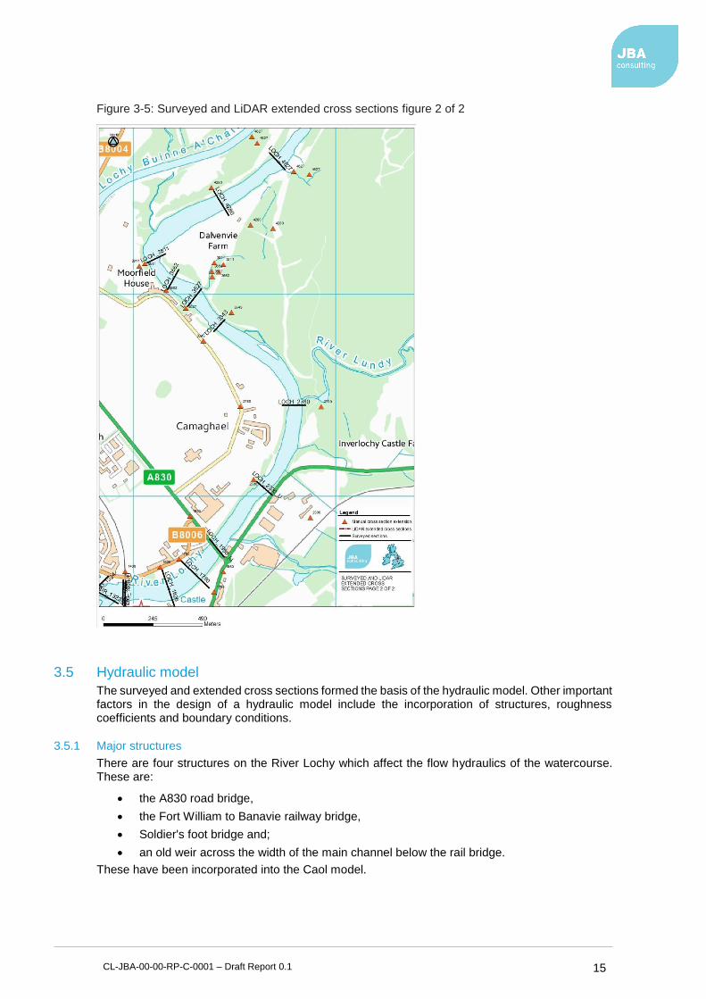
Figure 3-5: Surveyed and LiDAR extended cross sections figure 2 of 2 ............................ 15
Figure 3-6: The railway and footbridge downstream (taken from right bank) ..................... 16
Figure 3-7: Joint probability results between Extreme Wind Speeds and Extreme Sea Levels (ESLs) .................................................................................................... 17
Figure 3-8: Defensive toe locations and overtopping rate with Council drawing ................ 20
Figure 3-9: Flood extents for a 0.5% AP (200-year flood) SWL + Run-Up. ...................... 23
Figure 3-10: Flood extents for 0.5% AP (200-year flood) Fluvial event on the River Lochy ........................................................................................................................... 23
Figure 3-11: Surface water flood risk to Caol with proposed FPS flood defences included (but no SW mitigation measures) ...................................................................... 24
Figure 5-1: A public consultation notification sign on display (left) and the mock-up embankment with wall (right) ............................................................................ 32
Figure 5-2: Mock-up wall heights along the river side ........................................................ 33
List of Tables Table 2-1: Recorded flood events ...................................................................................... 4
Table 2-2: Properties at risk in the Do.-Nothing scenario for the 200-year dual joint probability scenario ........................................................................................... 8
Table 3-1: Flood flow estimates using the statistical method ............................................. 9
Table 3-2: Extreme wind speed calculations ...................................................................... 10
Table 3-3: Extreme sea-levels accounting for climate change ........................................... 11
Table 3-4: Worst case run-up results ................................................................................. 17
Table 3-5: Worst case joint probability tidal/fluvial combinations ....................................... 18
Table 3-6: Water level elevations comparison between JBA 1:100, 1:200,1:500-year model (m AOD) ............................................................................................................ 19
Table 3-7: Present day overtopping without a wave return wall ......................................... 21

CL-JBA-00-00-RP-C-0001 – Draft Report 0.1 2
Abbreviations
2D ................................... Two Dimensional
AP ................................... Annual probability
CC ................................... Climate Change
CAR ................................ Controlled Activities Regulation
CFBD .............................. Coastal flood boundary dataset
DEM ................................ Digital elevation map
DTM ................................ Digital Terrain Model
EA ................................... Environment Agency
ESL ................................. Extreme sea-level
FEH ................................. Flood Estimation Handbook
FPS ................................. Flood Protection Scheme
FRM ................................ Flood Risk Management
GIS .................................. Geographical information system
GCL ................................. Geosynthetic Clay Liner
ICM ................................. Integrated Catchment Model (software developed by Innovyze)
LiDAR .............................. Light detection and ranging
mAOD ............................. Metres above ordnance datum
MHWS ............................ Mean High Water Springs
MS LOT ........................... Marine Scotland Licensing Operations Team
PDI .................................. Planning, Development and Infrastructure (Committee)
RSPB .............................. Royal Society for the Protection of Birds
SBES .............................. Single Beam Echo Sounder
SEPA .............................. Scottish Environmental Protection Agency
SNH ................................ Scottish Natural Heritage
SoP ................................ Standard of Protection
SWAN ............................. Simulating Waves Nearshore
SWL ................................ Still water level
THC ................................. The Highland Council
UKCP09 .......................... UK climate projections 09
CL-JBA-00-00-RP-C-0001 – Draft Report 0.1 1
1 Introduction
1.1 General background
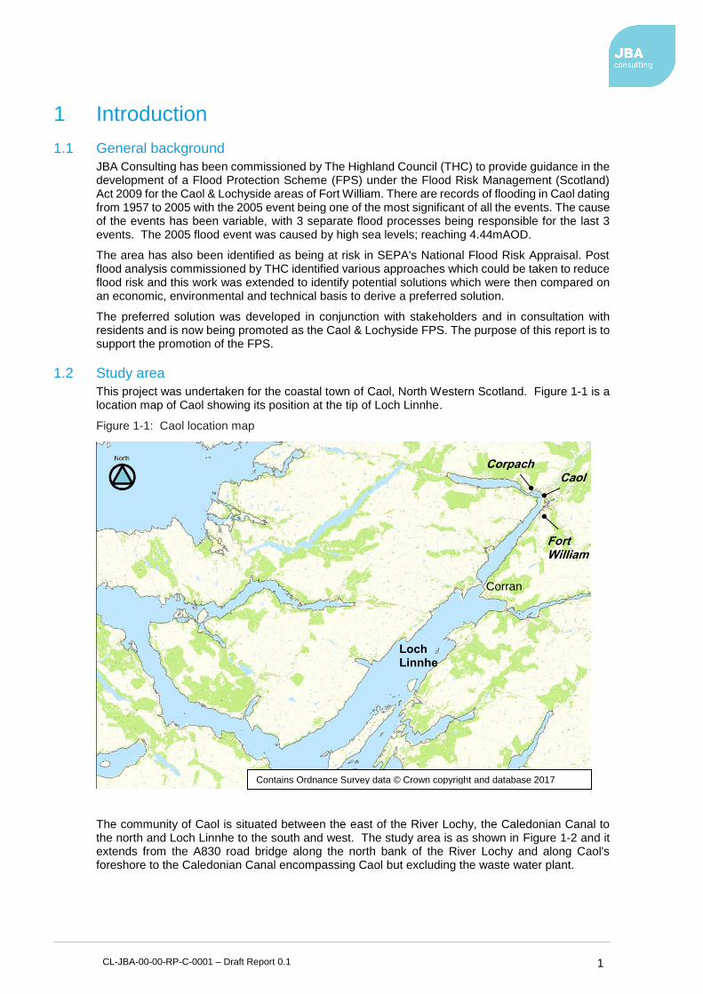
JBA Consulting has been commissioned by The Highland Council (THC) to provide guidance in the development of a Flood Protection Scheme (FPS) under the Flood Risk Management (Scotland) Act 2009 for the Caol & Lochyside areas of Fort William. There are records of flooding in Caol dating from 1957 to 2005 with the 2005 event being one of the most significant of all the events. The cause of the events has been variable, with 3 separate flood processes being responsible for the last 3 events. The 2005 flood event was caused by high sea levels; reaching 4.44mAOD.
The area has also been identified as being at risk in SEPA's National Flood Risk Appraisal. Post flood analysis commissioned by THC identified various approaches which could be taken to reduce flood risk and this work was extended to identify potential solutions which were then compared on an economic, environmental and technical basis to derive a preferred solution.
The preferred solution was developed in conjunction with stakeholders and in consultation with residents and is now being promoted as the Caol & Lochyside FPS. The purpose of this report is to support the promotion of the FPS.
1.2 Study area
This project was undertaken for the coastal town of Caol, North Western Scotland. Figure 1-1 is a location map of Caol showing its position at the tip of Loch Linnhe.
Figure 1-1: Caol location map
The community of Caol is situated between the east of the River Lochy, the Caledonian Canal to the north and Loch Linnhe to the south and west. The study area is as shown in Figure 1-2 and it extends from the A830 road bridge along the north bank of the River Lochy and along Caol's foreshore to the Caledonian Canal encompassing Caol but excluding the waste water plant.
Fort William
Caol Corpach
Loch Linnhe
Corran
Contains Ordnance Survey data © Crown copyright and database 2017

CL-JBA-00-00-RP-C-0001 – Draft Report 0.1 2
Figure 1-2: Study area shown in red, extent of river reach shown in purple
1.3 Legislative framework
The Flood Risk Management (Scotland) Act 2009 provides THC with general powers to manage flood risk in its area and to carry out flood protection work. The Caol & Lochyside FPS is being promoted by THC under Part 4 of the Act.
1.4 Aims and objectives
The aim of this report is to describe the development of the scheme origins and to provide a description of the extent and scale of the Flood Protection Scheme. The report will also assess what impact the scheme may have on residents and to the surrounding environment. This report should be read in conjunction with the drawings and other Caol & Lochyside FPS documents.
This report is used to:
• Support the notification and confirmation of the FPS as per Flood Risk Management (Scotland) Act 2009, Schedule 2,
• Support the promotion of the Caol & Lochyside FPS to Scottish Ministers in the event of Ministerial call-in as per Flood Risk Management (Scotland) Act 2009, Schedule 2.

CL-JBA-00-00-RP-C-0001 – Draft Report 0.1 3
1.5 Previous Reports
A number of previous and supporting documents are available. These are listed in Table 1-1.
Table 1-1: Previous reports
Title, author & date Description
Surface Water Analysis (JBA Consulting, May 2016) (Draft)
Surface water modelling
Caol Lochyside Ground Investigation Report (JBA Consulting, March 2016)
Geotechnical assessment of ground conditions at Caol & Lochyside
River Lochy and Caol FPS (The Highland Council, March 2016) (Draft)
Details of the proposed method of construction of the Flood Protection Scheme
Caol Coastal Frontage Overtopping Design Appraisal (JBA Consulting, February 2016)
Analysis of the proposed defence strategy against coastal frontages.
Scoping Survey Report, River Lochy – Caol Flood Protection Scheme (Arborteering Limited, March 2015)
Analysis of the effect the proposed scheme will have on trees in the study area.
Caol & Lochyside Flood Protection Scheme Appraisal (JBA Consulting, October 2014)
Analysis of all tidal, wave and hydrological inputs to identify properties at risk from joint probability flood events from Loch Linnhe (tidal) and the River Lochy (fluvial) and to assess the economic feasibility of a Flood Protection Scheme.
Phase 1 Habitat Survey (Dr Mary Elliot, January 2014)
Analysis of habitat in ecological area of study including invasive non-native species
Inventory of coastal vegetated shingle in Scotland (Scottish natural heritage, 2011)
Inventory of coastal vegetated shingle
Tide-Surge Modelling for the Firth of Lorne / Loch Linnhe System – Extreme Sea Level and Modelling Report (JBA Consulting, February 2009)
Numerical modelling of tide – surge and derivation of extreme sea levels for various points around the Firth of Lorne and Loch Linnhe
Fort William Flood Study, Caol & Lochyside – Feasibility Report (Draft) (Scott Wilson, October 2007)
Analysis of extreme sea levels, joint probability analysis, flood level assessment, flood mapping, flood damage assessment, outline FPS design, desktop GI, initial environmental screening, costing of FPS, and economic assessment
River Lochy Flooding, Fort William and Caol, Flood Risk Mapping / Pre-Feasibility Study (Mott Macdonald, September 2005)
Fluvial modelling, preliminary analysis of extreme sea levels, indicative flood mapping, & initial economic assessment
Fort William Flood Prevention Scheme, Surface Water Drainage for New and Future Housing Developments at Caol / Lochyside (Mott Macdonald, March 1993)
Examines the interaction between surface water drainage from Caol / Lochyside / Blar Mhor and fluvial flooding in the River Lochy
Fort William Flood Study, Review of 1992 Flood (Mott Macdonald, September 1992)
Review of flooding against previous work and updates to river modelling completed previously
Fort William Flood Study, Review of Flooding at Bentalla Nursery, Banavie (Mott Macdonald, May 1992)
Review of flooding and investigation of possible solutions
Fort William Flood Study, Flood Alleviation Measures for Ben Nevis Distillery (Mott Macdonald, April 1992)
Determination of solutions for flood alleviation
Fort William Flood Study (Mott Macdonald, June 1991)
Fluvial modelling of the River Lochy, investigation of flood alleviation options, investigation of flooding at Caol and Blar Mhor
Fort William Flood Study, Report of Initial Investigations (Mott Macdonald, 1990)
Summary of previous flooding, initial hydrological analysis, recommendation for further study

CL-JBA-00-00-RP-C-0001 – Draft Report 0.1 4
2 Flooding issues
2.1 Flooding Background
Caol has witnessed a variety of flooding events in the past. Table 2-1 lists the historic flood events affecting Caol & Lochyside from 1957 to the present. Previous assessments have followed on from high river flows on the River Lochy, although the most recent flood was caused by high sea levels. The table below illustrates the complex interaction between coastal and fluvial processes acting in Caol.
Table 2-1: Recorded flood events
Date Reference Conditions Flooding extent in study area
2005 The Highland Council
High sea level (4.44mAOD). River Lochy flow of between 400m3/s and 500m3/s.
Water level above grass bank between beach and road resulting in flooding to approximately 20 properties, gardens and a number of vehicles
1992 Highland Regional Council, Fort William Flood Study Report (September 1992)
High river flows (previously estimated to be 1,525m3/s) and heavy rainfall (105mm in 24hrs)
Reached the road level at Lochyside and Mossfield (recorded level of 3.71mAOD) but did not flood properties
1989 Highland Regional Council, Fort William Flood Study Report (February 1990)
High river flows (previously estimated to be 1,400m3/s) and heavy rainfall (80mm in 24hrs)
23 houses at the rear of Caol – caused by surface water drainage infrastructure being overwhelmed. Flooding reported on the B8006 and reportedly “…rose to within 50mm of flooding houses in Mossfield Drive” (however 1992 report (below) reports recorded levels of 3.65mAOD)
1981/2
Highland Regional Council, Fort William Flood Study Report (February 1990)
No records Flooding reported in the Mossfield Drive area – no further details given
1974 Highland Regional Council, Fort William Flood Study Report (February 1990)
High tides and high winds
Flooding reported on the B8006 and reportedly “…reached the doors of houses” in Mossfield area. Flooding may have also affected houses in Caol (no written records found)
1957 SEPA Interview with long term resident of Corpach
High tides and high winds
Anecdotal record of flooding, but may have caused some flooding in Caol
2.2 Flood Impacts
Caol & Lochyside are currently at risk of flooding. There are a variety of hydraulic processes which could cause flooding within the area. The area has flooded once in the last 20 years and three times in the last 50. The most recent event which occurred in 2005 directly affecting 20 houses and was caused by high sea levels which reached 4.44mAOD. The most catastrophic event to date occurred in 1989 when severe rainfall coupled with high flows in the River Lochy caused the surface water drainage system to become overwhelmed. It is believed that the flap gates at the end of the drainage system were closed due to high waters in the River Lochy causing the surface water to rise through the system. There were reportedly 23 houses at the rear of Caol directly affected by the problem.

CL-JBA-00-00-RP-C-0001 – Draft Report 0.1 5
Several post flood analysis reports have been commissioned since then, some of which included the identification of sustainable solutions for detailed consideration to reduce flood risk within the study area. This report and the selection of the preferred approach follows on from these previous assessments.
2.3 Current Management Approach
The Gillibhrath Burn is the only watercourse in Caol which is currently inspected with respect to flood risk. Following implementation of the scheme an inspection programme will be put in place to make sure that assets are inspected and managed appropriately.
2.4 Consequences of Doing Nothing
Currently Caol & Lochyside are at flood risk. Flooding within Caol can occur due to four processes; extreme sea-levels surging into the Loch, wind-generated waves breaking over the foreshore, river flows exceeding the bank level of the River Lochy and inundating the surrounding floodplain and finally from surface water. Each process could occur in isolation or, during some cases, occur simultaneously to produce extreme flooding.
Doing nothing would continue to leave several properties at risk of flooding from the 20% annual probability (AP) (5-year flood) event, and over 296 at risk for a 0.5% AP (200 year) extreme flood. In addition, climate change is likely to gradually increase the vulnerability to flood events. To provide the community with a sufficiently robust level of protection large scale works are required which need to be progressed as a Flood Protection Scheme.
2.5 Flood sources and mechanisms
2.5.1 Coastal
Loch Linnhe is connected to the Atlantic Ocean via the Firth of Lorne to the south and the Sound of Mull to the south-west. The Loch is approximately 50km long and has a funnel shaped form. To the south, between Port Appin and Duror, the width of the loch spans up to 7km, while north of Corran the width reduces from less than 2km to approximately 1km adjacent to Fort William.
The geometry of Loch Linnhe is believed to have a major influence on the local drivers for coastal inundation. The Loch is protected from large open sea waves propagating towards Caol, thus reducing the potential for high wave overtopping. The funnel like shape of the Loch acts to converge storm surges leading to increasing elevations upstream. The long straight water body of the Loch, results in a long fetch, which can 'push' water further into the channel through a process known as wind setup, and can produce locally generated wind waves that can exacerbate flood risk at Caol, or other communities within the northern loch. Finally, flooding can be observed at a distance inland, even if there is not an overland connection; the mechanism for this flooding is thought to be the penetration of sea water into un-flapped storm water drainage systems.
2.5.2 Wave
A second aspect of coastal flood risk is due to wave run-up. Wave run-up can occur when wind-generated waves propagate to a shoreline, break over the foreshore and run up and into the community. As this occurs, the waves have the potential to cause damage to any infrastructure located behind the foreshore, either through scour, inundation or high flows. Wave run-up is a complex process controlled by the state of the sea (water depth and wave properties) and the geometry of the beach and foreshore. It is often the case that wave run-up can lead to inundation above the still-water level, and can reach an elevation higher than the height of the wave. For example, the maximum wave run-up during a sea-level of two metres and a wave height of one metre can exceed three metres.
2.5.3 Fluvial
The settlement of Caol lies at the base of three river catchments; the River Lochy, the River Lundy and the Allt a' Mhuilinn catchment. The Lochy is by far the largest catchment covering an area of 1264km2 compared to an area of 37km2 and 11km2 for the River Lundy and Allt a' Mhuilinn, respectively. The Lochy catchment is mainly rough grazing, montane habitats and moorland with some forestation. The catchment contains four large lochs which are controlled by 3 dams for hydropower generation. The upper catchment topography is steep and mountainous with a
CL-JBA-00-00-RP-C-0001 – Draft Report 0.1 6
maximum elevation of 987mAOD. The bedrock geology is predominantly impermeable bedrock with approximately 50% coverage of superficial deposits.
The Caledonian Canal lies to the north of Caol and connects the Scottish east coast at Inverness with the west coast at Corpach. It was constructed in the early nineteenth century.
2.5.4 Surface Water
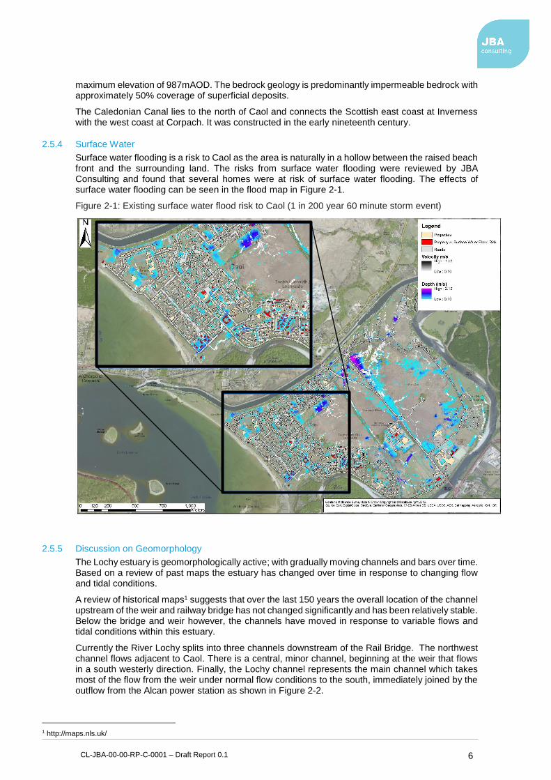
Surface water flooding is a risk to Caol as the area is naturally in a hollow between the raised beach front and the surrounding land. The risks from surface water flooding were reviewed by JBA Consulting and found that several homes were at risk of surface water flooding. The effects of surface water flooding can be seen in the flood map in Figure 2-1.
Figure 2-1: Existing surface water flood risk to Caol (1 in 200 year 60 minute storm event)
2.5.5 Discussion on Geomorphology
The Lochy estuary is geomorphologically active; with gradually moving channels and bars over time. Based on a review of past maps the estuary has changed over time in response to changing flow and tidal conditions.
A review of historical maps1 suggests that over the last 150 years the overall location of the channel upstream of the weir and railway bridge has not changed significantly and has been relatively stable. Below the bridge and weir however, the channels have moved in response to variable flows and tidal conditions within this estuary.
Currently the River Lochy splits into three channels downstream of the Rail Bridge. The northwest channel flows adjacent to Caol. There is a central, minor channel, beginning at the weir that flows in a south westerly direction. Finally, the Lochy channel represents the main channel which takes most of the flow from the weir under normal flow conditions to the south, immediately joined by the outflow from the Alcan power station as shown in Figure 2-2.
1 http://maps.nls.uk/

CL-JBA-00-00-RP-C-0001 – Draft Report 0.1 7
The northwest channel is very susceptible to deposition and a large gravel bar can be seen across the entrance to the channel. Deposition is also occurring to a lesser extent in the central channel.
Figure 2-3 has been produced by digitising maps from 1939, 1955-1961 and 2005. Although the older maps cannot be relied on to give a truly accurate bank location they none the less provide a good indication of the channel location and how it has changed over time.
Figure 2-2: Aerial view of channel split downstream of foot and rail bridge
Figure 2-3: Erosion and deposition in channel from 1939 to present
Figure 2-3 above shows that the central channel formed after 1961. It also shows that the channel has migrated north over time and has in 2005 returned to its location from 1939. The spit of land
CL-JBA-00-00-RP-C-0001 – Draft Report 0.1 8
separating the estuary from the sea has been eroded on its eastern side but its alignment is relatively stable.
The above analysis illustrates the long-term changes occurring within the channel and estuary. Whilst these changes are to be anticipated and are a natural process, there may be several anthropogenic drivers for these changes including:
• Presence and gradual erosion of the weir
• Presence of the Alcan outfall that enters the Lochy downstream of the weir
• Presence of waste water treatment works and any associated stabilisation works on the spit
• Bridge crossings
Whilst is it difficult to anticipate future changes to the layout of channels and the above influences, the channels appear to generally be constrained and only reworking mobile bars within the wider estuary extents. Despite this, there is the possibility that changes to the geometry of the channels could increase flood levels in certain locations over the long term.
Whether this is occurring, and if there is any medium-term net aggregation or deposition along the line of defences proposed is uncertain and can only be validated through long term monitoring. The baseline survey carried out for this project can of course be used as a first baseline against which to compare changes in the future.
2.6 Overall flood risk
The overall flood risk of Caol & Lochyside is identified in the Local Flood Risk Management Plan, which also indicates a scheme is the preferred solution. The hydraulic models estimate that there are currently 7 properties at risk from the 5-year joint probability event (20% annual probability) and that up to 296 are at risk by the 200-year joint probability event (0.5% annual probability).
2.7 Flood impact
Hydraulic modelling was used to determine the number of properties affected for a range of flood events. The number of properties flooded in the Do-Nothing scenario is tabled below;
Table 2-2: Properties at risk in the Do.-Nothing scenario for the 200-year dual joint probability scenario
Return Period (years) 2 5 10 30 50 100 200 500
Properties at risk 0 7 30 50 93 171 296 387
2.8 Climate change
The magnitude and frequency of flooding is expected to increase due to the influence of climate change. The effects are expected to lead to changes in sea-levels and weather patterns. To estimate the expected impact of climate change to flooding within Caol, the extreme sea-levels have been altered to reflect the latest UK climate change guidance.
2.9 Post-scheme flood risk
After the cause and extent of flood risk was determined, several measures were proposed which are intended to work to reduce the flood risk. The principal measures are:-
• An earthworks flood embankment which will protect the housing from the western end from the Caledonian Canal to Glenmallie Road.
• A concrete flood wall is proposed from Glenmallie Road to Castle Drive.
• To mitigate against the increased surface water flood risk created by these measures, it is proposed to construct a new surface water sewer system and pumping stations to manage the increase in surface water ponding. Construction of three new pumping stations are proposed located at the points most affected by the proposed defences

CL-JBA-00-00-RP-C-0001 – Draft Report 0.1 9
These measures form the Flood Protection Scheme which is intended to reduce the flood risk to properties in Caol & Lochyside at risk from fluvial and tidal sources up to a 0.5% AP (200-year flood) event.
3 Hydraulic Modelling and Analysis The following chapter describes, in brief, the hydraulic models that were developed and how information from these models was derived and interpreted. The following chapter is a summary of previous reports on Caol & Lochyside.
3.1 Flood Estimation Approach
To provide a comprehensive assessment of flood risk, both fluvial flood flows and tidal flood levels were derived for a variety of return period floods. Due to the presence of a flow gauge at the River Lochy at Camisky, the statistical method was chosen to generate design flood events for input into the hydraulic model.
SEPA are currently working towards a common extrapolation for Camisky but have not yet finalised the rating curve. The provisional curve (27MP1) was made available to JBA Consulting. A flood growth curve was then generated by applying a probability distribution to the dataset and used to extrapolate more unlikely events.
Important inputs into flood risk assessment are the analysis of historic floods (where data is available), and estimation of flood flows for a range of annual probabilities or ‘design’ events.
Flood estimates were calculated using the statistical method for the three main watercourses:
1. The Lochy (at Camisky gauging station).
2. The River Lundy (at the Lochy confluence
3. The Allt a Mhuillin (at the Lochy confluence).
The flood estimates are shown in Table 3-1.
Table 3-1: Flood flow estimates using the statistical method
River Lochy flow estimates (m3/s)
Allt a Mhullin flow estimates (m3/s)
River Lundy flow estimates (m3/s)
1:50 year 1,607 35 107
1:100 year 1,830 40 122
1:200 year 2,078 45 140
1:500 year 2,449 52 166
1:200 year + climate change
2,494 54 168
3.1.1 Fluvial climate change allowance
Typically for flood studies, the potential effects of climate change are considered by up scaling design flood flows by a factor of 20%.
For the purposes of this assessment data from UKCP092 was analysed and the impact on flood flows was estimated for several intervals until 2080. The best estimate of climate change for 2080 was adopted for design. When a catchment weighted average is applied, the 90th percentile value is 21%.
More recent guidance from SEPA suggests a range of climate change uplifts on flow between 15% and 60%. As the scheme has been modified to exclude the impacts of climate change, the current guidance should be reviewed as part of any scheme adaptation in the future.
2 Environment Agency (2011). Adapting to Climate Change: Advice for Flood and Coastal Erosion Risk Management
Authorities

CL-JBA-00-00-RP-C-0001 – Draft Report 0.1 10
3.2 Extreme sea level and wave conditions
3.2.1 Extreme sea-levels
The estimation of flood extents requires quantification of extreme sea-level and wave conditions. Each of these elements has a given probability of occurring which is proportional to their magnitude.
For this study a range of return periods have been used, ranging from the 1:1-year to the 1:1000-year flood events. This section describes the methods used to either select or calculate the extreme sea-level, wave conditions and river flows for this study.
3.2.2 Adopted extreme sea-levels
This project utilised the new statistical methods developed as part of the Coastal Flood Boundary (CFBD)3 project, which was used to extend the extreme sea-level estimates into much of the coastal lochs in Scotland. The extreme Still Water Levels (SWLs) produced by the Coastal Flood Hazard Study4 were extracted at the closest possible location to Caol and represent the most contemporary and reliable estimates available for Caol.
3.2.3 Extreme wave and wind conditions
To calculate the nearshore wave heights at Caol, a third-generation SWAN (Simulating WAves Nearshore) wind-wave model was used. Table 3-2 shows the extreme wind speed values.
Table 3-2: Extreme wind speed calculations
Return period (years) Wind speed (m/s)
T1 21.89
T2 24.25
T5 27.11
T10 28.75
T20 30.38
T50 32.67
T100 34.30
T200 35.93
T500 38.25
3.2.4 Sea-level due to climate change
The magnitude and frequency of coastal flooding is expected to increase due to the influence of climate change. The effects on the world climate will lead to changes to sea-levels and weather patterns. To estimate the expected impact of climate change to flooding within Caol, the extreme sea-levels have been altered to reflect the latest UK climate change guidance.
Sea-level rise due to climate change is required to predict future impacts on flooding. UK Climate Projections 09 (UKCP09)6 has been used to determine climate change allowance for sea-level rise. Under the medium emissions scenario, the present day sea-level (or extreme SWL) is expected to increase by 0.66m over the next 100-years to 2113 at Caol. Table 3-3 shows the resulting extreme SWL including climate change at Caol.
3 Environment Agency (2011), 'Coastal flood boundary conditions for UK mainland and island's, Project: SC060064/TR2: Design sea-levels. Environment Agency, Feb 2011. 4 Coastal Flood Hazard Study, 2012
6 UK climate projections, 2009

CL-JBA-00-00-RP-C-0001 – Draft Report 0.1 11
Table 3-3: Extreme sea-levels accounting for climate change
Return Period (years) Climate change SWL (mAOD) (present day SWL + 0.66m)
T1 3.89
T2 4.06
T5 4.29
T10 4.48
T20 4.67
T50 4.93
T100 5.14
T200 5.35
T500 5.64
T1000 5.87
3.3 Wave Modelling
A wave transformation model was required to simulate how waves change or 'transform' as they propagate from deep water to shallow water. The wave heights calculated at the nearshore were then used to calculate run-up heights and flood inundation extents at Caol.
3.3.1 Modelling approach
All storm scenarios calculated in the coastal joint probability analysis were modelled using the SWAN spectral wave model, run through the Deltares D-WAVE modelling shell.
3.3.2 Computational mesh
A computational curvilinear grid was developed for Loch Linnhe using a varying grid resolution. The grid resolution ranged from 150m at the offshore southern boundary, where depths vary between 85m to 100m and increased towards the study area to ensure a resolution of no greater than 15m in the nearshore zone adjacent to Caol.
3.3.3 Bathymetry
A seamless DEM was created by merging the offshore bathymetry from FINDmaps with the land topography data supplied by THC. Where the offshore and topographic data overlapped, the higher resolution topographic data were used.
The computational mesh and the bathymetry for the study site are shown Figure 3-1.

CL-JBA-00-00-RP-C-0001 – Draft Report 0.1 12
Figure 3-1: Wave transformation model extent
For each simulation, the wave model produced a set of gridded results across the model domain as well as nearshore conditions for the output site located 100m offshore. The key nearshore conditions extracted from the wave model are:
• Hs – Significant wave height (m)
• Dir – Mean wave direction using the nautical convention (degrees from north)
• Tp – Peak wave period (s).
These outputs were then used as inputs for run-up calculations.
3.3.4 Run-up
Wave conditions for run-up calculations have been extracted from the wave transformation model directly offshore of Caol (refer to Figure 3-1). The bathymetry has been extracted from the LiDAR DEM. This section discusses the steps taken to calculate run-up at Caol.
A slope of 1:12 was used to represent the run-up slope at Caol. This was calculated by extracting three profiles of the beach along the Caol foreshore and taking an average of the profiles.
The SWAN model has been used to calculate nearshore wave conditions based on the results of the joint probability sea-level and wind speed analysis. Following wave modelling, the calculated nearshore wave heights were then used to calculate the maximum wave run-up for each return period.
3.4 Fluvial modelling
The chosen river modelling package used for this investigation was ISIS/Flood Modeller, developed by CH2M.
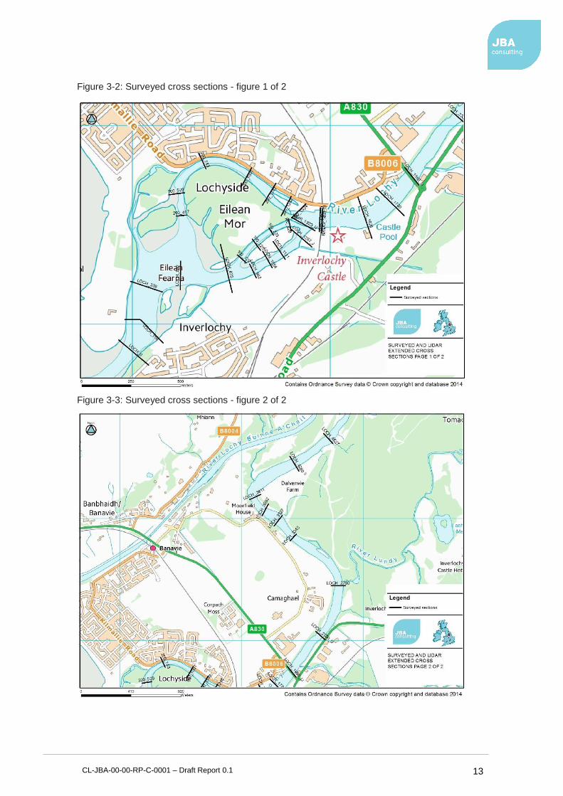
3.4.1 Survey data
To create a model that represents current channel conditions a new topographic survey was undertaken by JBA Consulting and supported by Aspect, Land and Hydrographic Surveyors in February 2014. Aspect provided a Z-boat SBES System to aid the survey. The Z-boat is an innovative survey system which utilising a remote-control boat to undertake a single beam bathymetric survey. JBA Consulting carried out the land based portion of the survey and compiled the channel bed data collected by the Z-boat.
CL-JBA-00-00-RP-C-0001 – Draft Report 0.1 13
Figure 3-2: Surveyed cross sections - figure 1 of 2
Figure 3-3: Surveyed cross sections - figure 2 of 2
CL-JBA-00-00-RP-C-0001 – Draft Report 0.1 14
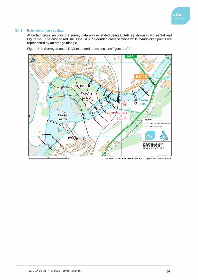
3.4.2 Extension of survey data
At certain cross sections the survey data was extended using LiDAR as shown in Figure 3-4 and Figure 3-5. The dashed red line is the LiDAR extended cross sections whilst handpicked points are represented by an orange triangle.
Figure 3-4: Surveyed and LiDAR extended cross sections figure 1 of 2
CL-JBA-00-00-RP-C-0001 – Draft Report 0.1 15
Figure 3-5: Surveyed and LiDAR extended cross sections figure 2 of 2
3.5 Hydraulic model
The surveyed and extended cross sections formed the basis of the hydraulic model. Other important factors in the design of a hydraulic model include the incorporation of structures, roughness coefficients and boundary conditions.
3.5.1 Major structures
There are four structures on the River Lochy which affect the flow hydraulics of the watercourse. These are:
• the A830 road bridge,
• the Fort William to Banavie railway bridge,
• Soldier's foot bridge and;
• an old weir across the width of the main channel below the rail bridge.
These have been incorporated into the Caol model.

CL-JBA-00-00-RP-C-0001 – Draft Report 0.1 16
Figure 3-6: The railway and footbridge downstream (taken from right bank)
3.5.2 Manning's 'n' roughness
A Manning's 'n' value of 0.03 was used for the river channel. Manning’s ‘n’ values of 0.03 to 0.10 were used for floodplain areas, depending upon location. The nature of the floodplain ranged from grazed grass land to dense woodland. A Manning’s ‘n’ value of 0.06 was used as the value for vegetated banks.
3.5.3 Tidal boundary derivation
The tidal boundaries used for the joint probability simulations were generated based on tidal predictions for the Oban region. It considers the daily variations combined with storm surge and extreme sea water level. To be able to consider the volume of water during an event, as opposed to just the peak overtopping rate, a full tidal harmonic was required.
3.6 Joint probability analysis
Flooding in the Caol area may come from either coastal or fluvial sources or the interdependence of the two. The coastal sources can be broken into two separate elements:
• Still water sea level (SWL)
• Wave run up
The previous chapters have derived peak fluvial flows, peak still water sea level and maximum wave run-up for a range of return periods. This chapter discusses the interaction one element has on the other and derives the joint probability outcome from pairings of these elements.
The three pairings that have been considered are:
• Wave run-up and SWL
• Fixed fluvial return periods against still water sea level.
• Fixed still water sea level against fluvial flows
Wave run-up and fluvial flows are independent of each other so have not been paired.

CL-JBA-00-00-RP-C-0001 – Draft Report 0.1 17
3.6.1 Wave and water levels
The analysis has been undertaken using the probability data described in the previous sections for extreme sea-levels, waves (based on wind conditions) and river flows.
Due to the location of Loch Linnhe joint probability analysis was performed on extreme storm surge to represent extreme still-water levels, and extreme wind speeds to represent extreme wave heights which can be seen in Figure 3-7. The level of dependence between each of the two variables has been adopted based on a statistical regression analysis of the recorded surge measured at the Corpach water level gauge and the historic offshore wind conditions based on the hindcast dataset.
Figure 3-7: Joint probability results between Extreme Wind Speeds and Extreme Sea Levels
(ESLs)
3.6.2 Run-up results
The results of the coastal joint probability scenarios have been assessed to find the worst-case run-up for each return period for the present day and present day plus climate change, as shown in Table 3-4.
Table 3-4: Worst case run-up results
Return Period (years) Maximum run-up + present day still water level (mAOD)
Maximum run-up + still water level + climate change
(mAOD)
T1 3.48 4.15
T2 3.72 4.40
T5 3.97 4.65
T10 4.24 4.91
T20 4.45 5.12
T50 4.74 5.48
T100 4.97 5.71
T200 5.27 5.94
T500 5.58 6.26
10.00
15.00
20.00
25.00
30.00
35.00
40.00
2.00 3.00 4.00 5.00 6.00
Extr
em
e w
ind
sp
eed
s (m
)
ESLs (m)
2
5
10
20
50
100
200
500
Return period
(years)

CL-JBA-00-00-RP-C-0001 – Draft Report 0.1 18
3.6.3 Flow and sea levels
Flooding in the Caol area may come from either tidal or fluvial sources or a combination of the two. To examine the degree of dependence between these two sources of flooding, published Defra and Environment Agency7 guidance was consulted. This guidance uses the measure χ as an indication of dependence, where low values of χ indicate low correlation and high values of χ indicate strong correlation. A modest correlation was assumed and a χ value of 0.03 used (from SEPA gauging station 86001 at Little Eachaig at Dalinlongart as reported in the Defra/EA guidance).
3.6.4 Design model runs
Design model runs have been carried out in three batches to produce a set of:
• Fluvial flood flows with and without the influence of climate change.
• Coastal flood maps with the combined influence of maximum wave run-up and maximum still water level with and without the influence of climate change.
• Joint probability flood depth mapping which selected the maximum flood depth of each of the joint probability fluvial and coastal flood depths for each return period.
Table 3-5 provides the inputs to each set of joint probability runs. The combined joint probability events were run through the hydraulic model to generate the water level estimates at each location summarised in Table 3-6. The worst case water level was selected from the set of results at each model location and for each return period.
Table 3-5: Worst case joint probability tidal/fluvial combinations
Joint probability tidal/fluvial combinations
Return period Tide (mAOD) Fluvial (m3/s) Tide (mAOD) Fluvial (m3/s)
1:2 3.40 140 2.73 741
1:5 3.63 140 2.73 989
1:10 3.82 140 2.73 1,163
1:20 4.07 140 2.73 1,405
1:50 4.27 140 2.73 1,607
1:75 4.39 140 2.73 1,734
1:100 4.48 140 2.73 1,830
1:200 4.69 140 2.80 2,078
1:500 4.98 140 3.03 2,449
Note: The fluvial flows were calculated based on 1:25 year return period event while coastal events where based on 1:20 year event. To compare like for like the 1:25 year fluvial flows were classified as 1:20 year flows. This produces a conservative answer for this return period event.
7 Defra / Environment Agency Flood and Coastal Defence R&D Programme Use of Joint Probability Methods in Flood Management A Guide to Best Practice R&D Technical Report FD2308/TR2 March 2005

CL-JBA-00-00-RP-C-0001 – Draft Report 0.1 19
Table 3-6: Water level elevations comparison between JBA 1:100, 1:200,1:500-year model (m AOD)
Cross Section JBA 1:100 year (mAOD)
1,830m3/s
JBA 1:200 year (mAOD)
2,078m3/s
JBA 1:500 year (mAOD)
2,449m3/s
LOCH_1950_U 6.65 7.34 8.37
LOCH_1626 6.43 7.22 8.18
BRIDG_1408_U 5.98 6.79 7.77
BRID_1395 5.01 5.20 5.45
200_1248 4.69 4.91 5.18
200_1001 4.79 5.02 5.20
200_743 4.62 4.84 4.99
200_529 4.53 4.75 4.99
LOCH_338 4.49 4.69 4.98
LOCH_158 4.48 4.69 4.98
3.6.5 Impact of volume displacement within Loch Linnhe
The impact of the scheme in terms of displacement of flood volumes is not normally considered for coastal sites due to the infinite availability of coastal flood volumes. However, a check has been undertaken based on the displaced volume behind the defence against the available volume within Loch Linnhe. A 200 year plus climate change volume behind the defences equates to approximately 84,000m3. Assuming a total Loch Linnhe area of 36,110,000m2, the total displacement is in the order of 2mm and therefore considered negligible.
3.7 Wave overtopping modelling
A final test was undertaken to ensure that the final design of shorefront defence restricted overtopping discharges to within standard tolerances. The empirical-based model used within the industry standard EurOtop8 manual is the most suitable methodology for evaluating wave overtopping for composite defences such as seawall structures and rock armour.
Using the Neural Network model, the average rate of overtopping can be calculated for a beach or defence cross-section and the outputs compared against the standard tolerances for overtopping rates (up to 10 l/s/m as defined by the EurOtop manual).
The section of Caol coastal frontage modelled is exposed to incoming wave action from the south west. At present the shoreline consists of a footpath fronted by natural shrub vegetation and a wide shingle beach. The proposals are for a new coastal frontage along the shoreline, between the beach and Erracht Drive. Wave heights and SWL were obtained from toe outputs from the joint probability model described in Section 3, with the most extreme values available (from the north-western end of the proposed defence) used in the modelling.
The selection of the highest wave heights allows contingency to be integrated into the modelling, which is necessary due to the integral uncertainties present. The current coastal frontage and a range of potential options were schematised using the 15 Neural Network parameters, with the options based on schematic diagrams developed as part of the scheme. The contemporary shoreline and the proposed options were considered uniform along the shoreline for the purpose of this analysis.
Initially, a number of options were tested including grass embankments, berms, recurve walls, rock armour and combinations thereof. Given the modelled prevalence of waves greater than 0.75m8, grass options were considered impractical given the risk of scour during storm events and feedback from The Highland Council.
8 EurOtop (2010) “Wave Overtopping of Sea Defence and Related Structures: Assessment Manual”, Overtopping Course Edition, November 2010. HR Wallingford.

CL-JBA-00-00-RP-C-0001 – Draft Report 0.1 20
3.7.1 Model Outputs
Outputs from the Delft 3D SWAN model were used in the analysis. Three toes were selected at appropriate positions along the beach face with modelled wave heights. The locations of these model output locations can be seen in Figure 3-8 along with the modelled maximum wave heights for present day and climate change scenarios. The maximum wave heights were modelled at Toe 5 (1.36 m for a 1 in 200 year event, with climate change). Toes 19 and 29 output lower, on average wave heights.
Figure 3-8: Defensive toe locations and overtopping rate with Council drawing
As a basis for overtopping calculations a schematised version of drawings provided by the Highland Council was evaluated. The calculations assume rock armour frontage 3:1 slope, topped with a 1.2m sea wall, yielding a crest height of 6.54m. For the purpose of the Eurotop calculations the armour crest was taken to be 5.35 (above the maximum 1 in 200 year SWL).
The outputs from the wave overtopping were used to assess the Standard of Protection (SoP) of the defence options. A SoP of 10 l/s/m was taken as a threshold value, above which the proposed coastal frontage design was considered unsafe as per the guidelines. It was also assumed that overtopping rates below 10l/s/m could be drained by accompanying drainage infrastructure.
All the coastal frontage options schematised overcome the issue of SWL flooding currently experienced by Caol. This has been done through setting the defence height at 6.54mAOD which reduces the risk of inundation resulting from extreme SWL with an allowance for climate change and freeboard.
3.7.2 Adaptation options
The Highland Council requested that alternative designs and the removal of the wave wall be investigated that would be less expensive and provide adaptive solutions to climate change uncertainties. A test was therefore carried out for the following options:
1. Removal of wave return wall
2. Reduction of wave return wall height and increase slope or rock armour (1:2)
Whilst both options were tested, the removal of the wave return wall was the preferred option following consultation with the public. For this option the wave return wall was completely removed

CL-JBA-00-00-RP-C-0001 – Draft Report 0.1 21
from the schematisations leaving the crest of the defences at a height of 5.35mAOD, taking the original, council proposed embankment footprint of 12.86m (including footpath) and rock armour slope of 1:3.
Overtopping rates for this design rates were well within acceptable rates of 10 l/s/m for present day SWL producing a short-term standard of protection for present day return periods. The overtopping rates for each toe location can be seen in Table 3-7 with the maximum overtopping rate observed as 5.14l/s/m for a 1 in 200 year event at the southern toe.
In order for this design to match the specified SOP for a 1 in 200 year plus climate change event, a wall of height 700mm must be added to the crest of the defence. However, the removal of the wall would provide a 200 year standard of protection to current conditions.
Table 3-7: Present day overtopping without a wave return wall
Return Period Toe 5 Toe 19 Toe 29
1 0 0 0
2 0 0 0
5 0 0 0
10 0 0 0
20 0.00 0.01 0.01
50 0.08 0.16 0.26
100 0.59 1.08 1.53
200 2.51 3.90 5.14
The above table illustrates that there is additional resilience built into the design for design exceedance events and climate change as the maximum overtopping for the 200 year event is below the acceptable rate of 10 l/s/m.
3.8 Design defence levels
Following consultation with the public, the decision was made to reduce the defence heights to ease public concern over the height of the defences, particularly along the foreshore. The decision was made to provide a 200 year standard of protection without an allowance for climate change. Design defence levels have been determined as follows:
• Canal park - 4.99mAOD
• Sea front - 5.35mAOD
• Croft land - 5.05mAOD
• River bank - 5.14 – 5.38mAOD
The results of the overtopping analysis suggested that the proposed top of embankment level of 5.35mAOD would provide a 200 year standard (extreme sea levels, surge and wave) within the acceptable level of overtopping volumes.
The embankment on the Canal Park could be lowered to 4.99mAOD (the 200 year ESL + 300mm freeboard) as wave run-up does not apply to this defence.
For the sections adjacent to the River Lochy, the joint probability fluvial/tidal levels take precident as follows:
• For the croft land the level would be 5.05mAOD (assuming 300mm freeboard)
• For the start of the wall along Kilmallie Road the level would be 5.14mAOD (assuming 300mm freeboard).
• For the end of the wall along Kilmallie Road the level would be 5.38mAOD (assuming 300mm freeboard).
The use of a 300mm freeboard provides additional resilience for above design events and climate change although this is primarily used to cater for uncertainties in the hydrology and modelling.
CL-JBA-00-00-RP-C-0001 – Draft Report 0.1 22
3.9 Surface Water Modelling
To understand the impact of the proposed flood defences on the surface water flood risk to Caol a surface water hydraulic model was created in InfoWorks ICM (Integrated Catchment Modeling) for the existing (current day) and proposed (with flood defences) scenarios. The local drainage network has not been included in this modelling. It has been assumed that the local drainage network is under capacity and unlikely to cope with short duration, high intensity events and that there will not be a free discharge from the system during periods of extreme coastal or fluvial events
The inputs into the model are a Digital Terrain Model (DTM) and design rainfall hyetographs. The design rainfall hyetographs are generated within the software using Flood Estimation Handbook (FEH) techniques, using catchment descriptors exported from the FEH CD-ROM. Hyetographs can be produced for different return periods and storm durations and profiles. At this stage, a conservative approach has been taken to assess the outline design of any mitigation measures required. The contributing catchment is a combination of urban and rural areas, however the area directly behind the defences is an urban area. Therefore, in line with SEPA guidance for runoff from urban areas, a runoff coefficient of 70% has been adopted for the entirety of the catchment. This will over estimate runoff from the rural areas of the catchment.
The DTM was created using LiDAR information for the River Lochy combined with freely available contour data for the surrounding area as shown on Figure 2-1. For surface water modelling, ICM creates a 2D mesh from the DTM. This allows for a varying 2D element area where relatively flat areas require less resolution than areas where ground levels fluctuate. In order to maintain, realistic flow paths, the roads and buildings in the area were also incorporated into the 2D mesh. The roads were used as "mesh zones" which maintains their geometry. The properties were represented using porous polygons. These allow a fraction of the water to flow through the property once a certain depth has been achieved. For the purposes of this study a universal threshold of 150 mm was applied. Once this has been exceeded 10% of flows would be able to pass through the property.
To understand to potential scenarios in which surface water flood risk could be exacerbated, an analysis of the interdependence of fluvial, coastal and pluvial events was undertaken. This showed five scenarios equivalent to a 1 in 200 year event as stated below which were then assessed in the hydraulic model.
• 1 in 200 year 60 minute storm event
• 1 in 37 year 60 minute storm event with a 0.05 year Tide (MHWS)
• 1 in 2 year 60 minute storm event with a 1 year Tide
• 1 in 1 year 60 minute storm event with a 2 year Tide
• 1 in 10 year 1140 minute storm event with a 200 year fluvial event
Of the above scenarios the 1 in 200 year 60 minute storm event and the 1 in 10 year 1140 minute storm event with a 200 year fluvial event were considered the worst case scenarios for surface water flood risk following completion of the proposed flood defences. For the 1 in 10 year 1140 minute event the impact on surface water flooding as a result of the proposed defences is unclear in this scenario. Under existing conditions, the town would be inundated by extreme flows in the River Lochy. The resultant high levels in the river would drown out existing surface water outfalls causing sewers in the town to contribute to the flooding. Once the fluvial defences are in place, flooding from the river will be mitigated, however flooding from the existing sewer system will still be likely. Along Kilmallie Road, Scottish Water Records indicate 4 outfalls; a Ø825 mm, a Ø1175 mm, a Ø300 mm and a Ø225 mm. During a pluvial event these will carry significant flows which will be unable to discharge due to high levels in the River Lochy.
3.10 Flood mapping
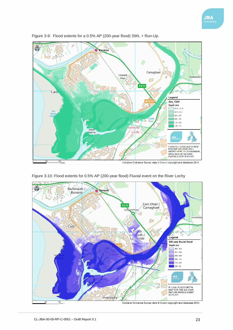
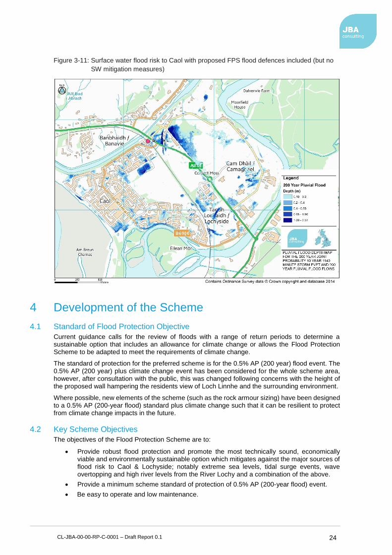
Flood depth maps were generated from water levels at cross sections. GIS software was used to generate a digital water surface elevation based on these extended cross sections. The digital terrain model was then subtracted from the extended water surface elevation to give a flood depth at any point. The flood maps produced for coastal, fluvial and surface water flooding can be seen in figure 3-9, 3-10 and 3-11 respectively.
CL-JBA-00-00-RP-C-0001 – Draft Report 0.1 23
Figure 3-9: Flood extents for a 0.5% AP (200-year flood) SWL + Run-Up.
Figure 3-10: Flood extents for 0.5% AP (200-year flood) Fluvial event on the River Lochy
CL-JBA-00-00-RP-C-0001 – Draft Report 0.1 24
Figure 3-11: Surface water flood risk to Caol with proposed FPS flood defences included (but no
SW mitigation measures)
4 Development of the Scheme
4.1 Standard of Flood Protection Objective
Current guidance calls for the review of floods with a range of return periods to determine a sustainable option that includes an allowance for climate change or allows the Flood Protection Scheme to be adapted to meet the requirements of climate change.
The standard of protection for the preferred scheme is for the 0.5% AP (200 year) flood event. The 0.5% AP (200 year) plus climate change event has been considered for the whole scheme area, however, after consultation with the public, this was changed following concerns with the height of the proposed wall hampering the residents view of Loch Linnhe and the surrounding environment.
Where possible, new elements of the scheme (such as the rock armour sizing) have been designed to a 0.5% AP (200-year flood) standard plus climate change such that it can be resilient to protect from climate change impacts in the future.
4.2 Key Scheme Objectives
The objectives of the Flood Protection Scheme are to:
• Provide robust flood protection and promote the most technically sound, economically viable and environmentally sustainable option which mitigates against the major sources of flood risk to Caol & Lochyside; notably extreme sea levels, tidal surge events, wave overtopping and high river levels from the River Lochy and a combination of the above.
• Provide a minimum scheme standard of protection of 0.5% AP (200-year flood) event.
• Be easy to operate and low maintenance.
CL-JBA-00-00-RP-C-0001 – Draft Report 0.1 25
4.3 Flood Risk Management Constraints
A range of environmental, infrastructure and structural constraints in developing the scheme have been identified. In summary, they are:
• Infrastructure:
o Roads and railways
o Existing housing
o Proposed future development
o Scottish Water treatment works
• Environmental constraints:
o Protected areas
o Protected species
o Non-native invasive species.
o Cultural and heritage
o Hydromorphological constraints
4.4 FPS works to achieve long term goals
The proposed scheme has two main types of flood defences. An earthworks flood embankment will protect the housing from the western end at the Caledonian Canal to Kilmallie Road. Along Kilmallie Road to Castle Drive, a concrete flood wall is proposed along the bank of the River Lochy.
The shoreline area consists of an earthworks embankment with rock armour face. The section is designed to a height in line with the estimates for the 0.5% AP (200 -year) event. The design allows for a shared cycleway / footpath to be provided along the seafront. One of the effects of the scheme is that it will reduce access for the community to the beach and the river bank. To maintain access, several beach access ramps and viewing platforms have been integrated into the design.
The flood defence in the section adjacent to the River Lochy presents a more challenging problem. The corridor between the B8006 and the river is narrow and steep. The slope has a covering of trees and bushes to the water’s edge, which shall be removed to facilitate construction. It is proposed to install a concrete flood wall in this location. The walls position is complicated by competing design considerations, of wall height and road safety. The position of the wall must not be too close to the road, compromising forward visibility of road users, or too far away and the wall height increases and more tree clearance is required.
To mitigate the loss of access for the public to the riverside a shared footpath/cycleway runs along the riverside of the floodwall. Flood gates are to be installed at the entrance points to the new shared path. The flood gates will generally be open unless a flood warning is in place. SEPA’s Firth of Lorn and Loch Linnhe and Lochy flood warning systems give sufficient time to allow planned closure of these access points when required. Discussion with SEPA to confirm operational levels will be required.
Surface water modelling has shown Caol to be at risk of surface water flooding. The implementation of the main flood defences could cause further surface water flooding in Caol. To mitigate against this increased flood risk, it is proposed to construct new surface water sewers and pumping stations to manage the increase in surface water ponding. It is proposed to construct three pumping stations located at the low points most effected by the proposed defences, namely; Erracht Drive, near the community centre; the corner of Erracht Drive and Glenmallie Road and; on Kilmallie Road, adjacent to the ‘Caol in Bloom’ flower bed.
4.5 Geotechnical Review
A geotechnical assessment has been made of the scheme for stability of the flood embankment and wall; as well as seepage below the wall and embankment. A summary of which is presented below.
4.5.1 Seepage
A review of the ground investigation revealed that the construction of an effective vertical seepage barrier by means of a concrete cut-off or cut-off piles would be challenging and instead a

CL-JBA-00-00-RP-C-0001 – Draft Report 0.1 26
Geosynthetic Clay Liner (GCL) has been incorporated within the engineered fill to create a seepage barrier where required. In some locations due to the embankment configuration and water levels a seepage barrier is not required.
The GCL will be laid with a minimum 600mm of cover to ensure sufficient downward pressure in a rapid drawdown scenario.
4.5.2 Embankment Stability
The proposed embankments have been analysed for two scenarios; flood conditions and a rapid drawdown scenario, both of which maintain a factor of safety (FOS) above 1 and are therefore stable according to Eurocode 7 design recommendations.
The slopes on the wet-side of the FPS along the river are also stable. However, until slopes that are not protected by rock armour have sufficient vegetation established there is a risk of failure. This is considered to be minimal with the incorporation of biodegradable matting to help prevent soil erosion and encourage vegetation growth.
4.5.3 Flood Wall Stability
The flood wall has been checked for geotechnical stability under two scenarios: during a flood with water reaching the top of the wall and under non-flood conditions.
The flood conditions included water up to the top of the wall, porewater pressures beneath the wall of 5kPa across the width of the wall and an over-dig allowance of 0.2 (>10% retained height). As there is a flood, no surcharge was applied on the wet side footpath/cycleway.
In non-flood conditions, the flood wall acts as a retaining wall. The groundwater table is below the base of the wall so a conservative assumption of setting the water level at the top of the base of the wall on the active side and at the bottom of the base on the passive side was taken. A surcharge of 5kN/m2 was applied on the footpath/cycleway as it could be used outside of flood events.
The wall design for the various wall geometries along Kilmallie Road proved to be stable under both conditions (flood and non-flood).
4.6 Rock Armour
The necessary rock armour to protect the flood embankment and riverbanks has been designed taking into account wave action for the foreshore and modelled velocities for the riverside to ensure no erosion will occur.
4.6.1 Foreshore
Two key design elements were taken into account for the design of the rock armour along the shore: the overtopping threshold defined by the structure geometry and the stability defined by the rock grading.
The rock profile was calculated so that overtopping would be reduced to 10l/s/m. The rocks to be used for the rock armour should have a grading of 1 to 3 tonnes and be laid to incorporate:
• 2 layers of rock along the slope
• 2 level rocks on the toe
• 1m toe depth below bed level
• 1 in 3 slope on the face.
A geotextile acting as a filter membrane has also been included in the base of the structure.
4.6.2 River
The Escarameia and May (1992) equation was used to obtain the rock grading for the rock armour along the river. The rock armour grading to be used is HMB300/1000 with an average mass of 650kg and a D50 of approximately 0.6m.
The rock armour should be laid in a minimum of two layers in order to take full advantage of interlocking stones equating to a thickness of approximately 1.15m.
The adopted slope is 1:2 to ensure its long-term stability. The perimeter of scour protection systems including the toe is at particular risk of failure because of erosion of the natural bed or bank adjacent to the protection and can lead to undermining. A falling apron has been designed to guard against

CL-JBA-00-00-RP-C-0001 – Draft Report 0.1 27
this type of failure and includes additional loose material that can deploy and follow the shape of the developing scour hole.
The falling apron was designed as follows:
• 3 layers of rocks thickness on top
• 2 level rocks width at the bottom
• 1:1 side slopes
4.7 Operation 1 Embankment
The design of the western most (Op1) embankment presents two particular issues. The flood embankment needs to tie into the Caledoniain Canal embankment, to prevent flood flows from circumventing the flood defences. However, this necessitates the diversion of the canals toe drain.
The construction of the flood embankment presents an opportunity to create a link for the shared cycle/footpath that will run along the flood defences to tie in with the Caledonian Canal towpath.
4.7.1 Ditch Diversion
It is proposed to divert the ditch along the wet side of the embankment with culverts beneath the access tracks. There was some difficulty in determining a design flow as the natural catchment is severed by the Caledonian Canal and a very small area seemed to be draining to the drain. It was decided to conservatively design the new channel to convey that of the existing channel, approximately 0.4ms-3. conveyed through the existing ditch which was higher than the calculated flows and the channel was modelled using HEC-RAS.
The base of the channel was set to be 1000mm wide for ease of construction, with side slopes of 1:4 for ease of maintenance. There is a 200mm freeboard to the right bank, when viewed looking downstream, and the right bank has been set 150mm lower than the left bank to ensure excess water would flow towards the shinty pitches rather than towards the FPS as an additional fail safe measure.
Additionally, the channel is to be constructed with a minimum offset of 1m from the toe of the embankment to the top of the drainage channel to avoid affecting the structural stability of the embankment.
Standard precast culverts and headwalls will be utilised to simplify construction and reduce costs along with screens to reduce the risks associated with unauthorised access. The proposed channel diversion is further detailed in a separate design/modelling report.
4.7.2 Ramp to the Caledonian Canal
A number of options for the inclusion of a link between the Caledonian Canal and the Caol shorefront are documented in a separate report. The option adopted includes a w-shaped ramp to the Caledonian Canal from the top of the flood embankment.
A significant level difference between the top of the embankment and the Caledonian Canal footpath (approximately 3.6m) necessitated ramps with resting platforms to allow access for a wide range of visitors including wheelchair users and parents pushing prams.
The width of the ramp was set at 2.5m which gives enough space for two wheelchairs and a pedestrian and the slope of the ramps was set at 1:17. To reduce the need for large side slopes and reduce the visual impact; the ramps are constructed with retaining walls on each side.
The lower ramp is positioned on the dry side of the embankment so that it will be protected by the FPS during flood events and to avoid encroaching on the channel diversion.
4.8 Secondary Drainage
Caol is currently subject to surface water flooding, that occurs during times of high river flows or sea levels due to surcharged outfalls. The surface water flooding currently only contributes to the flooding but once the FPS is constructed, protecting the town from coastal and fluvial flooding, the problem will become more evident. Construction of the FPS is also to exacerbate surface water flooding by preventing water from freely running towards the watercourse/foreshore. Various options to alleviate surface flooding were therefore investigated including linear drainage and pumping stations.

CL-JBA-00-00-RP-C-0001 – Draft Report 0.1 28
4.8.1 Layout
A secondary drainage network is proposed including piped drainage and three pumping stations. The drainage network is composed of two sets of pipes. The first runs along the coast on Glenkingie Street, Erracht Drive and Erracht Terrace; to be joined by a pipe run from Glenmallie Street. The other pipe network runs along the river on Kilmallie Street.
Three pumping stations are proposed to discharge surface water during floods when the outfalls are tide locked. The use of three pumping stations, rather than one or two, allows for smaller, shallower pipe runs and for more of the flows to be discharged by gravity and not pumped.
The three pumping stations have been incorporated at low points currently flooding from surface water at:
• Glenkingie Street, in front of the community centre and adjacent to the North Play Area.
• Erracht Terrace, near the junction with Glenmallie Street.
• Kilmallie Road, near the “Caol in Bloom” sign (E211230.8 N775789.1)
4.8.2 Existing Service Clashes
Service records were available and used to inform the design of the secondary drainage. It should be noted that service records can be of questionable accuracy and some services had unknown depths.
A number of services will have to be locally diverted or protected. A 900mm diameter raw water supply pipe, which is believed to be disused, crosses the flood embankment on the foreshore. The pipe runs from the aluminium smelter on the south side of the River Lochy to the Timber Mill in Corpach. It is proposed to either remove the watermain or grout fill it below the flood embankment.
The most constrained area is Kilmallie Road, where it will be necessary to combine the existing surface water drainage with the new drainage at two points within manholes to facilitate the new pipework. It is proposed that the manholes will utilise existing low level outfalls to the river and once the drainage surcharges the higher pipes will take the flows to the proposed pumping stations.
The drainage network was combined in two points with a manhole:
• At the intersection of Kilmallie Road and Riverside Park
• East of the intersection of Kilmallie Road and Mossfield Drive
4.8.3 Analysis
The proposed drainage network was modelled in InfoWorks ICM for the combined tidal/flow and rainfall events described in Section 3.9. This was undertaken to confirm that the pump capacities were of sufficient capacity for the design 200 year 60 minute storm event, and to assess residual risk from other joint probability scenarios.
The design rainfall event simulated is a 200 year 60 minutes rainfall event with a summer profile with no concurrent coastal or fluvial flood event. Such short term high intensity events are appropriate to ensure the pipes used in the drainage network are sized sufficiently to cope with what is expected to be the worst case scenario under normal circumstances. Results showed that the drainage pipes were sized sufficiently to cope with the overland flows ponding behind the defences.
The worst case rainfall event modelled is a 10 year 19 hours rainfall event with a winter profile and concurrent 200 year fluvial flooding. Whilst betterment has been shown, for this longer duration pluvial event the outfalls from existing drainage would be surcharged and unable to discharge; there therefore remains a residual flood risk. The need to increase pump sizes to eliminate this secondary risk needs to be balanced against the availability of pump station footprint, increased capital costs, maintenance and possible upgrading of the electricity network to fuel the pumps as well as increasing visual impact.
The surface water modelling was undertaken with little information regarding the existing sewer network. It is recommended that a fully integrated drainage model is developed to understand the complex interaction of overland flow and urban drainage, which would allow the design of the secondary flooding mitigation measures to be finalised.
CL-JBA-00-00-RP-C-0001 – Draft Report 0.1 29
5 Social and Environmental Impact Assessment of the Scheme The environmental and social impacts of the preferred scheme have been considered. This section describes how environmental impacts and the concerns of statutory stakeholders and the wider public were identified and assessed during development of the outline design.
5.1 Environmental Impact Assessment
A Screening Opinion from the planning authority confirmed that an Environmental Impact Assessment would not be required.
Although an Environmental Impact Assessment is not required, the potential environmental impacts mentioned in the opinion have been considered in developing the scheme. The screening opinion called, mainly, for the following environmental aspects to be considered:
• Characteristics of the development. This included items such as physical size, cumulation with other development, use of natural resources, production of waste, pollution and nuisances, risk of accidents with impacts on people or environment and other impacts.
• Location of the development and including items such as existing land use, status of natural resources in the area and absorption capacity of the natural environment,
• Significance of environmental effects. The main considerations are; extent of impact, probability of impact, duration, frequency and reversibility of impact and magnitude and complexity of the impacts.
Pre-design surveys were done to establish baselines and this work is described below while the actions taken to mitigate impacts are described in Chapter 6.
5.1.1 Environmental aspects
Environmental aspects were investigated by means of a desk based survey examining existing records and site walkover surveys.
An Environmental designations check was carried out using the Magic and SNH websites and showed no impact on Biosphere Reserves, National Nature Reserves, Ramsar Sites, Special Areas of Conservation, Special Protection Areas, Sites of Special Scientific Interest, RSPB Reserves, National Parks nor National Scenic Areas.
An FRM Screening opinion was conducted in early 2015 to consider the views of SEPA, SNH, Scottish Water, the Highland Council Planning Department and Marine Scotland.
As the scheme is located on the coastline and coastal reach of the River Lochy, SEPA did not expect any adverse impact on flood risk elsewhere and welcomed the fact that works within the water environment would be limited. SEPA did however raise the issue of a potential breach as failure of the defences and the impact this could have on areas immediately behind the defences. They asked for additional information on residual risk and information on how the scheme would stand up to an overtopping or above-design event and the impact of climate change on the scheme's lifetime along with maintenance requirements.
Potential pollution risks also had to be investigated and a Schedule of Mitigation was advised as part of the finalised scheme documents.
The response from SNH indicated that no significant environmental effects on natural heritage sites were expected but drew attention to possible disruption of European Protected Species such as otters or trees that may hold bat roosts.
Scottish Water confirmed there was no Drinking Water Protected Areas that may be affected by the development however several outflows and outfalls to the sea were present at this location and could not be compromised in any way.
5.1.2 Ecological surveys
As part of the preparation for the River Lochy & Caol Flood Protection Scheme, THC commissioned Dr Mary Elliott to carry out a survey for European protected species in the Area of Ecological Survey. This includes a mammal survey carried out in June 2015 and a Habitat Survey in January 2015.
CL-JBA-00-00-RP-C-0001 – Draft Report 0.1 30
Conclusions from the surveys are shown here. No signs of European or UK legally-protected mammal species were found as part of the Mammal Survey however, otters have been seen at other times at the mouth of the River Lochy or south of the Caledonian Canal. Therefore, mitigation measures and further investigation at the time of the works starting were recommended to avoid disturbance during the works. Ramps were also advised if steep-sided holes were left overnight to allow animal to escape should they enter therein.
Juvenile Sandpiper and Common Gull birds were observed in large numbers in the exposed river shingle, suggesting that rat numbers are not high in these areas.
The Habitat Survey identified ten main habitats, most of which show signs of modifications by human activities. No habitats with possible European or Biodiversity Action Plan rankings and Groundwater-dependant Terrestrial Ecosystems were identified and the habitats surveyed were deemed to have low or negligible nature conservation sensitivities.
The SNH coastal vegetation report also provides information on the vegetation present on the Caol shore.
A tree survey was required to assess whether the trees on the line of the proposed Caol & Lochyside FPS were to be removed or protected. A Tree Schedule and a Tree Constraints Plan were completed by Arborteering Ltd. Trees were graded as per their quality and should be protected including their root expected footprint. A Tree Protection Plan was developed which shows the recommendations on how to deal with each tree or group of trees.
Most of the trees located near the Caledonian Canal are to be protected, fenced prior to the commencement of the works and arboricultural supervision is needed while the works are undertaken. Other trees are mainly protected, some of them requiring arboricultural supervision and/ or fencing, except for some poor quality trees and the narrow river bank strip where all the trees need to be removed to build the FPS.
5.1.3 Invasive species
Two Invasive Species Reports were carried out in proximity to the scheme, including a report by Dr Mary Elliott and another report by Lochaber Fisheries Trust. Invasive species are present along the FPS and include Japanese Knotweed, Giant Knotweed and Himalayan Knotweed. All species of knotweed are considered to pose a threat to native biodiversity as they tend to form dense monocultures that exclude other plant species and create a poor habitat for native wildlife. These needed to be identified and mapped to take the necessary precautions before the works would start to reduce the risk of colonisation. Any soil containing Japanese Knotweed is to be treated as contaminated waste and excavated soil should be either kept in place or sent to a licenced waste management facility. Ground also should not be disturbed within 10m of knotweed.
THC decided a treatment programme would be contracted to reduce or eradicate the knotweed prior to any construction.
Snowberry, Himalayan balsam, bamboo and skunk cabbage were also recorded in the area but in small, isolated stands.
5.2 Cultural Heritage
Parts of the proposed FPS requires consent from Scottish Ministers as portions of the works are to be carried out near the Caledonian Canal, which is a Scheduled Monument. This consent was granted on the 25th of August 2015 for the flood protection scheme works along the Caol foreshore and along the bank of the River Lochy.

CL-JBA-00-00-RP-C-0001 – Draft Report 0.1 31
5.3 Public and Statutory Consultation
The Flood Protection Scheme was taken to both a pre-application consultation on 18th March 2015 and a public exhibition on 25th May 2015 and 24th March 2016 at Kilmallie Free Church, Caol. The revised draft FPS was presented to the Planning Development an Infrastructure (PDI) Committee on Nov 4th 2015 to seek approval to proceed with formal notification / consultation on the scheme. Approval by the committee was given on that date. A summary of both consultation processes is given below.
5.4 Major Development Pre-Application Consultation with Statutory Consultees
A Pre-Application meeting for the Caol & Lochyside Flood Protection Scheme was held on 18 March 2015 as part of statutory consultation for the flood protection order process. A Pre-Application Advice Pack document was produced by The Highland Council Planning Department reflecting the opinions of the officers that were present at that meeting and to guide future progress of the application. The main concerns and issues that were identified are listed below:
As the scheme is being promoted under the powers of the Flood Risk Management (Scotland) Act 2009, a formal planning application will not be required as confirmation of the scheme, if confirmed, will benefit from deemed planning permission from the Scottish Ministers. The proposed scheme broadly accords with the Council's Development Plan however the success of the scheme depends on appropriate mitigation of key impacts including, visual impact, woodland impact, impact on residential amenity. The main outcomes from the public consultation were;
• Impact on woodland and any impact on protected species because of loss of woodland.
• Impact on residential amenity.
• Impact on public access (Great Glen Way), particularly during construction phase.
• Visual impact of the proposed structures on the surrounding landscape.
• Cognisance should be taken of the likely design and routing of Caol Link Road.
• Impacts to local transport networks during construction and for ongoing maintenance needs.
• Road safety implications of the flood wall to the B8006 Kilmallie Road, for all road users including cyclists.
• Confirm the need for vehicle impact loading and the level of approval needed from the Councils’ Structural Engineering Team.
• Investigate opportunities to improve the experience of using the Great Glen Way along the B8006 Kilmallie Road.
5.4.1 SEPA comments
SEPA provided pre-application advice on this development to JBA Consulting and none of the information provided within this consultation changed that advice.
With respect to their interests, Environmental Impact Assessment is not required for the above proposal. Whether or not Environmental Impact Assessment is required, they requested that the following key issues are addressed as part of the development of the scheme and would welcome continued involvement as the scheme progresses:
• Assessing Flood Risk and design of the scheme
• Pollution prevention and environmental management
• Regulatory advice for the applicant
5.4.2 Historic Scotland comments
The development proposal does not appear to raise significant issues for their interests. The assessment should particularly focus on the following scheduled monument which is near the scheme: Caledonian Canal (Index No’s 6491 & 5297).
5.4.3 Transport Scotland
It is noted that the scheme does not cross the trunk road and as such will not impact the trunk road network directly. Therefore, a request was made that an impact assessment be provided which identifies the potential effects of construction traffic.
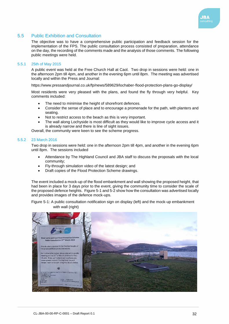
CL-JBA-00-00-RP-C-0001 – Draft Report 0.1 32
5.5 Public Exhibition and Consultation
The objective was to have a comprehensive public participation and feedback session for the implementation of the FPS. The public consultation process consisted of preparation, attendance on the day, the recording of the comments made and the analysis of those comments. The following public meetings were held.
5.5.1 25th of May 2015
A public event was held at the Free Church Hall at Caol. Two drop in sessions were held: one in the afternoon 2pm till 4pm, and another in the evening 6pm until 8pm. The meeting was advertised locally and within the Press and Journal:
https://www.pressandjournal.co.uk/fp/news/589629/lochaber-flood-protection-plans-go-display/
Most residents were very pleased with the plans, and found the fly through very helpful. Key comments included:
• The need to minimise the height of shorefront defences.
• Consider the sense of place and to encourage a promenade for the path, with planters and seating.
• Not to restrict access to the beach as this is very important.
• The wall along Lochyside is most difficult as they would like to improve cycle access and it is already narrow and there is line of sight issues.
Overall, the community were keen to see the scheme progress.
5.5.2 23 March 2016
Two drop in sessions were held: one in the afternoon 2pm till 4pm, and another in the evening 6pm until 8pm. The sessions included
• Attendance by The Highland Council and JBA staff to discuss the proposals with the local community;
• Fly-through simulation video of the latest design; and
• Draft copies of the Flood Protection Scheme drawings.
The event included a mock-up of the flood embankment and wall showing the proposed height, that had been in place for 3 days prior to the event, giving the community time to consider the scale of the proposed defence heights. Figure 5-1 and 5-2 show how the consultation was advertised locally and provides images of the defence mock-ups.
Figure 5-1: A public consultation notification sign on display (left) and the mock-up embankment
with wall (right)

CL-JBA-00-00-RP-C-0001 – Draft Report 0.1 33
Figure 5-2: Mock-up wall heights along the river side
5.5.3 Monday 11 April 2016
Community council held a public question and answer session in Caol on Monday 11 April, attended by Garry Smith, Principal Engineer for the project design unit of Highland Council’s development and infrastructure department. The session was attended by approximately 25 local residents. Originally, a concrete wall was proposed on top of a new embankment, however following objections from local people, the wall was removed from the design.
The public consultation event was reported in The Press and Journal website9 on the 14 April 2016. The following is a summary of the article:
“The flood defences will still be able to cope with a 200-year flood event but does not compensate for the potential impacts of climate change. The height of the embankment has been reduced from about 6ft to 3ft 3ins, however, should sea levels rise significantly, the current design allows for a wall to be constructed as was proposed in the original design.
Councillor Ben Thompson was reported to have said that the reduction in height was a “good compromise”, but warned that climate change may be “happening more quickly than we might expect”. He also pointed out that the council had taken on board the locals views.”
5.6 Response to the Pre-Submission and Public Consultations
Changes were made to the scheme design to accommodate the concerns of both groups of stakeholders which had been consulted. In summary, they are;
Pre-Application Meeting
• Protected species surveys to be carried out prior to construction.
• Study being carried out on replacement of play areas, seating areas to be provided.
• Access to the shore is provided in the scheme, a link to the Great Glen Way will be provided during construction.
• Embankment to have a shallow gradient typically 1:2.5, the wall shall make use of coloured additives in the concrete.
• Route of the Caol Link road is not affected by the scheme.
• Traffic management to be put in place during construction.
• Footpath/cyclepath to go behind the wall on the riverbank side to provide protection from road traffic.
• Vehicle impact loading to be discussed with Structures team.
• The flood protection scheme will provide new footpaths and cyclepaths along this section from the shinty club to Soldier’s bridge.
9https://www.pressandjournal.co.uk/fp/news/highlands/888486/flood-defences-to-be-lowered-following-complaints-from-local-residents/
CL-JBA-00-00-RP-C-0001 – Draft Report 0.1 34
First Public Exhibition
• A consultant was appointed to work with the community to assess the best options for play area provision in terms of location and equipment. The consultant has been seeking opinions from the residents and has also been working with a local group which has formed to progress the requirements for play in Caol.
• Access to the shore was revisited and further access points were included in the flood protection structure model including vehicle access for shore clean ups and small boat launches.
• Work was done at the Lochyside section of the scheme to remodel the design so that a new footpath/cyclepath could be included on the riverbank side of the wall, taking it away from the road.
Landowner
• Instructions were passed on to the Council’s Estates Department to begin negotiations with some of the landowners.
• The design of the scheme was amended to lessen the impact on the croft land it passes through.
Stakeholders
• Further amendments were made to the access to the shore at Caol and the river bank at Lochyside. Traffic management will form part of the instructions for the contractor.
• A colour additive to be added to the concrete for the wall.
• DDA compliant footpaths throughout the scheme.
• Seating and viewing areas to be included in the detailed design.
• Footpath to continue along the embankment to the front of the shinty club house.
• The operation manual for the flood scheme is currently under preparation.
• Play park consultant working with the community.
• Additional parking removed following discussions with the group.
Second Public Exhibition
• A review of the design was undertaken and THC Project Leader attended the next Community Council meeting to explain the options and implications of reducing the height to a level which was acceptable to the community.
5.7 Other statutory consents
5.7.1 SEPA licencing
The scheme requires SEPA authorisation to comply with the Water Environment (Controlled Activities) (Scotland) Regulations 2011. Under the Controlled Activity Regulations (CAR), SEPA has a duty to ensure efficient and sustainable use of the water environment. SEPA have been consulted throughout the development of the scheme and an application has been made to SEPA for a CAR licence.
5.7.2 Marine Scotland licensing
Marine Scotland Licensing Operation Team (MS ) is the regulatory authority under The Marine (Scotland) Act 2010 and The Marine Works (Environmental Impact Assessment) Regulations 2007.
As most of the planned works are above Mean High Water Springs (MHWS), MS does not consider a full Environmental Impact Assessment (EIA) to be required for the elements of the works for which we have regulatory competence under the Marine (Scotland) Act 2010. However, as some of the works are below the MHWS level, a marine licence from MS will be required.
5.7.3 Waste Management Licence
A waste management licence is normally required for movement and disposal of waste material including excess soils from construction sites under the Waste Management Licencing (Scotland) Regulations 2011. SEPA has adopted a regulatory position where it will not require a licence or

CL-JBA-00-00-RP-C-0001 – Draft Report 0.1 35
exemption for the reuse of greenfield soils10. The SEPA position is set out in the guidance entitled ‘Promoting the sustainable reuse of Greenfield soils in construction’. The exemption applies where the producers and users comply with the guidance and where the soil meets the description of greenfield soil in the guidance. In addition, the soil must either be reused on the site on which it arose or be reused on other sites as described in the guidance.
It is expected that the project will have a net import fill, therefore most soils are anticipated to be reused under SEPA regulations. Soil will need to be investigated to demonstrate that it is covered by their guidance.
10 Promoting the sustainable reuse of greenfield soils in construction. SEPA, 2010
CL-JBA-00-00-RP-C-0001 – Draft Report 0.1 36
6 Caol & Lochyside Flood Protection Scheme Description The flood protection scheme was revised to accommodate the outcomes of the Pre-Application and public consultations. This chapter describes the modified scheme which is now being promoted and should be read in conjunction with the scheme drawings and the operations shown therein. Overall scheme sustainability is addressed in Section 6.1. The revised scheme changes are summarised in sections 6.2-6.5.
Construction related issues are outlined including future maintenance and have been considered for each individual zone. The description relating to construction of the works is intended to give the reader an appreciation for how the works might be constructed and resulting construction related issues. This description does not in any way suggest that this is how the works should be constructed and the contractor remains free to carry out the works in the way they think most suitable. The location and elevation of structures may vary from the position shown in plan within limits as defined in the Caol & Lochyside FPS document. The duration of the works is likely to be more than 12 months. Impacts on the natural environment, landscape and amenity are outlined along with the mitigation measures taken and any additional benefits provided.
6.1 Scheme Sustainability
Sustainability in the scheme has been considered in line with The Highland Council Sustainable Design Guide. This has informed the outline design philosophy which is briefly described in the following sub-sections.
6.1.1 Conserving and enhancing the character of the Highland area.
The layout and profile of the embankment have been integrated into their park settings and profiling the embankments so they do not appear regular and geometric. Landscaping and recreational facilities will blend with the foreshore setting of the structures. New planting will reflect species typical of the local area, increasing biodiversity.
6.1.2 Minimising the environmental impact of the scheme.
The nature of the works will permanently change the tidal environment and interaction between the foreshore and set back recreational land between the foreshore and road. Impacts on the wider environment such as those from transport pollution and carbon footprint have been considered in the design and mitigated by choosing solutions which minimise transport. Short term damage that could be caused by construction activities has been minimised by using natural rock armour instead of concrete wherever possible and minimising use of in-situ concrete by using precast concrete where possible.
6.1.3 Enhancing the viability of Highland communities.
The purpose of the scheme is to reduce risk to life and other economic damage from flooding. Along with making the area safer for existing residents it will allow for sustainable future residential settlement in the area.
6.1.4 Landscape and visual amenity.
The proposals look to incorporate the shoreline as a natural focal point within the landscape, providing interest through integrating the shoreline path into public spaces or parks, these benefits can offer an opportunity for people to appreciate a wider range of natural environments.
6.1.5 Providing good quality parks and spaces to accommodate activity
Getting more people onto the shoreline walkway helps develop a more extensive Green Infrastructure, which can result in wider social, environmental and economic benefits, including health and wellbeing, education, training, social interaction and cohesion and sustainable transport. Greater visitor numbers also encourage better informal surveillance, resulting in less antisocial behaviour. The new promenade and footpath alongside the Lochy will provide an improved path for part of the Great Glen way.
CL-JBA-00-00-RP-C-0001 – Draft Report 0.1 37
6.2 Canal Parks
6.2.1 Purpose
The purpose of this set of works is to form the western edge of the flood protection scheme.
6.2.2 Description
OP01 – Operations are to be carried out to construct a flood defence earthwork between the Caledonian Canal embankment and the southern corner of Canal Park adjacent to the Kilmallie Shinty Club. The flood embankment will continue for a length of 125m or thereby and shall have grassed side slopes formed to a 1:3 side slope with a 4.2m wide berm on the top. A shared 2.5m wide cycle/footpath will be constructed on top of the embankment which shall be linked to the canal towpath by an access ramp. The defence level shall be 5.05m above ordnance datum (AOD) and shall be constructed an average of 0.5m above the existing ground level or thereby. A ramped vehicle access will be provided adjacent to and parallel with the canal embankment to tie into the existing unsurfaced track on the northern boundary of Canal Parks. The existing surface water drain along the toe of the Caledonian Canal will be sealed where it passes under the flood defence embankment. An alternative surface water outfall to the sea will be provided as part of OP01.
OP02 – Operations are to be carried out to construct a flood defence earthwork. The flood embankment should have side slopes of 1:3 and provide a defence level of 5.26mAOD and shall be constructed with an average height of 0.25m above the existing ground level or thereby. A ramped road path will provide vehicle access to the southern corner of Canal Parks and form a shared cycle path and footpath on the Great Glen Way.
6.2.3 Construction process
A possible construction sequence is outlined below. This sequence is illustrative only and does not pre-empt how a contractor might set-up and carry out the works.
OP01
• Create temporary footpath diversion & exclude public from site
• Site clearance to remove any trees
• Remove fence at Kilmallie Shinty club
• Clear and grub area of construction
• Excavate to subgrade level
• Import fill material and construct embankment
• Add topsoil and seed
• Reinstate canal path and fencing at shinty club
OP02
• Clear and grub area of construction
• Excavate to subgrade level
• Import fill material and construct embankment
• Add topsoil and seed
• Construct path for vehicles and pedestrians
6.2.4 Maintenance and Operation
• Embankment slopes set at 1:2.5 to allow for grass cutting and vegetation clearance
• General Landscaping
6.2.5 Environmental and natural heritage issues
Otters have been seen south of the Caledonian Canal. Therefore, mitigation measures and further investigation at the time of the works starting should be taken to avoid disturbance during the works. Ramps should also be provided if steep-sided holes are left overnight to allow animals to escape should they enter therein. There is also the potential for bats to be roosting within the area, particularly within trees and care should be taken to check any trees for roosts before removal. The Caledonian Canal is also an area of interest and an assessment of the impact this section will have on the Caledonian Canal should be carried out. Knotweed has also been highlighted in this area. THC have agreed to reduce or eliminate areas affected by knotweed before the construction phase.
CL-JBA-00-00-RP-C-0001 – Draft Report 0.1 38
Should knotweed be present at the time of construction, precautions should be taken to prevent transport or disturbance.
6.2.5.1 Assessment of tree stock
Large individual trees are present in this area where it is proposed that the flood embankment starts adjacent to the Caledonian Canal. There is potential for damage of some trees due to the construction of the embankment therefore precautions should be taken to prevent any unnecessary destruction or damage to trees.
6.2.6 Landscape and amenity
Operation 1 works proceeds directly through Kilmallie shinty clubs park segregating the club house from the pitches during the construction. A temporary access should be maintained during construction to mitigate the impact of the construction.
6.3 Foreshore - Glenkingie to Glenmallie Street
6.3.1 Purpose
To defend the shoreline from high sea levels and wave run-up based on 200-year joint-probability event.
6.3.2 Description
OP03 – Operations are to be carried out to construct a flood defence earthwork. The flood embankment will continue for a length of 51m or thereby. The outer seawards slope shall be rock armour formed to a 1:3 side slope and shall have a toe constructed into the existing beach and foreshore to prevent scour. The defence level shall be 5.35m AOD and shall be constructed 0.75m above the existing ground level or thereby. A 3m wide shared cycleway and footpath with 1.0m verge shall be constructed on top of the embankment. This shared cycleway and footpath will form part of the Great Glen Way. The landward side slope will be formed in grass at a maximum of 1:2.5 side slope to tie into the existing foreshore level.
OP04 – Operations are to be carried out to construct a concrete access ramp from the top of the flood embankment to the existing beach level. The access ramp shall be protected by rock armour.
OP05 – Operations are to be carried out to construct a flood defence earthwork. The flood embankment will continue for a length of 185m or thereby. The outer seawards slope shall be rock armour formed to a 1:3 side slope and shall have a toe constructed into the existing beach and foreshore to prevent scour. The defence level shall be 5.35m AOD and shall be constructed 0.75m above the existing ground level or thereby. A seating area will be formed with a 3m wide shared cycle path and footpath with 1.0m verge shall be constructed on top of the embankment. This footpath will form part of the Great Glen Way. The landward side slope will be formed in grass at a 1:2.5 side slope to tie into the existing foreshore level.
OP06 – Operations are to be carried out to construct viewing platform at the flood embankment level. The surface finish shall be asphalt to match the shared cycle/foot path.
OP07 – Operations are to be carried out to construct a flood defence earthwork. The flood embankment will continue for a length of 35m or thereby. The outer seawards slope shall be rock armour formed to a 1:3 side slope and shall have a toe constructed into the existing beach and foreshore to prevent scour. The defence level shall be 5.35m AOD and shall be constructed 2.3m above the existing ground level or thereby. A 3m wide shared cycle path and footpath with 0.5m verge shall be constructed on top of the embankment. This footpath will form part of the Great Glen Way. The landward side slope will be formed in grass at a 1:2.5 side slope to tie into the existing foreshore level.
OP08 – Operations are to be carried out to construct a concrete access ramp from the top of the flood embankment to the existing beach level. The access ramp shall be protected by rock armour.
OP09 – Operations are to be carried out to construct a flood defence earthwork. The flood embankment will continue for a length of 240m or thereby. The outer seawards slope shall be rock armour formed to a 1:3 side slope and shall have a toe constructed into the existing beach and foreshore to prevent scour. The defence level shall be 5.35mAOD and shall be constructed 1.4m above the existing ground level or thereby. A 3m wide shared cycle path and footpath with 0.5m verge shall be constructed on top of the embankment. This footpath will form part of the Great Glen

CL-JBA-00-00-RP-C-0001 – Draft Report 0.1 39
Way. The landward side slope will be formed in grass at a 1:2.5 side slope to tie into the existing foreshore level.
OP10 – Operations are to be carried out to construct a viewing platform at the flood embankment level. The surface finish shall be asphalt to match the shared cycle/foot path. A concrete access ramp will be constructed from the top of the flood embankment to the existing beach level. The access ramp shall be protected by rock armour.
OP11 – Operations are to be carried out to construct a flood defence earthwork. The flood embankment will continue for a length of 270m or thereby. The outer seawards slope shall be rock armour formed to a 1:3 side slope and shall have a toe constructed into the existing beach and foreshore to prevent scour. The defence level shall be 5.35mAOD and shall be constructed 1.4m above the existing ground level or thereby. A 3m wide shared cycle path and footpath with 0.5m verge shall be constructed on top of the embankment. This footpath will form part of the Great Glen Way. The landward side slope will be formed in grass at a 1:2.5 side slope to tie into the existing foreshore level.
OP12 – Operations are to be carried out to construct a flood defence earthwork. The flood embankment will continue for a length of 90m or thereby. The outer seawards slope shall be rock armour formed to a 1:3 side slope and shall have a toe constructed into the existing beach and foreshore to prevent scour. The defence level shall be 5.35mAOD and shall be constructed 1.4m above the existing ground level or thereby. A 3m wide shared cycle path and footpath with 0.5m verge shall be constructed on top of the embankment. This footpath will form part of the Great Glen Way and a concrete access ramp will be constructed from the top of the flood embankment to the existing beach level. The landward side slope will be formed in grass at a 1:2.5 side slope to tie into the existing foreshore level. An access track will be included to the Scottish Water Waste Water Treatment Works and Tigh a Chladaich House.
6.3.3 Construction process
A possible construction sequence is outlined below. This sequence is illustrative only and does not pre-empt how a contractor might set-up and carry out the works.
OP03
• Clear and grub area of construction
• Excavate to sub-grade level
• Fill operation – place rock armour along shore to sub-grade level
• Fill operation – place rock armour and embankment fill in tandem
• Construct cycle path/footpath
• Apply topsoil and seed
OP04
• Construct vehicle access road
• Construct beach access ramp
OP05
• Remove playground
• Clear and grub area of construction
• Excavate to sub-grade level
• Fill operation – place rock armour along shore to sub-grade level
• Fill operation – place rock armour and embankment fill in tandem
• Construct cycle path/footpath
• Apply topsoil and seed
OP06
• Construct beach viewing platform
OP07
• Clear and grub area of construction
• Excavate to sub-grade level
• Fill operation – place rock armour along shore to sub-grade level
• Fill operation – place rock armour and embankment fill in tandem
• Construct cycle path/footpath
• Apply topsoil and seed
CL-JBA-00-00-RP-C-0001 – Draft Report 0.1 40
OP08
• Construct beach access ramp
OP09
• Clear and grub area of construction
• Excavate to sub-grade level
• Fill operation – place rock armour along shore to sub-grade level
• Fill operation – place rock armour and embankment fill in tandem
• Construct cycle path/footpath
• Apply topsoil and seed
OP10
• Construct beach viewing platform
• Construct beach access ramp
OP11
• Clear and grub area of construction
• Excavate to sub-grade level
• Fill operation – place rock armour along shore to sub-grade level
• Fill operation – place rock armour and embankment fill in tandem
• Construct cycle path/footpath
• Apply topsoil and seed
OP12
• Clear and grub area of construction
• Excavate to sub-grade level
• Fill operation – place rock armour along shore to sub-grade level
• Fill operation – place rock armour and embankment fill in tandem
• Construct access road to Scottish Water WWTW
• Construct beach access ramp
• Construct access to Tigh A Chladaich house.
• Construct cycle path/footpath
• Apply topsoil and seed
Note: Access must be made available always for Scottish Water WWTW. They access provision will depend on consultation and agreement with Scottish Water. Access will also need to be provided for Tigh A Chladaich house.
6.3.4 Maintenance and Operation
• Embankment slopes set at minimum of 1:2.5 to allow for grass cutting and vegetation clearance.
• General Landscaping
6.3.5 Environmental and natural heritage issues
Otters have been seen at other times at the mouth of the River Lochy or south of the Caledonian Canal. Therefore, mitigation measures and further investigation at the time of the works starting were should be taken to avoid disturbance during the works. Ramps should also be put in place if steep-sided holes are left overnight to allow animals to escape should they enter therein. Knotweed has also been highlighted in this area. The Highland Council have agreed to reduce or eliminate areas affected by knotweed before the construction phase. Should knotweed be present at the time of construction, precautions should be taken to prevent transport or disturbance.
6.3.5.1 Assessment of tree stock
The flood embankment should not have little effect on any trees in this area as there are only two trees present, both of which are not substantial.
6.3.6 Landscape and amenity
Two playparks within the area are to be removed so that construction can proceed. The Community Council and Caol Play, following public consultation have agreed to relocate the foreshore play areas to an alternative location to the south of the Gaelic school. There is also a pre-existing water

CL-JBA-00-00-RP-C-0001 – Draft Report 0.1 41
pumping station and subsequent pipes which will need to be considered during construction. Any works on or around the pre-existing pump will firstly have to be agreed upon with Scottish Water.
6.4 Riverfront – Glenmallie Street to Kilmallie Road
6.4.1 Purpose
To protect Caol from fluvial flooding from the River Lochy.
6.4.2 Description
OP13 - Operations are to be carried out to construct a flood defence earthwork. The flood embankment will continue for a length of 210m or thereby. The outer and inner slopes shall be grassed and formed to a 1:2.5 side slope. The defence level shall be 5.06mAOD and shall be constructed 1.0m above the existing ground level or thereby.
OP14 – Operations are to be carried out to construct a flood defence wall between approximately the dwelling ‘Siaulei’ and Mossfield Drive. The flood wall will continue for a length of 220m or thereby. The wall will be approximately 1.0m above the existing ground and will have a defence level of around 5.1mAOD.
OP15 - Operations are to be carried out to construct a flood defence gate. The flood gate will have a clear opening width of 2.5m and shall be 0.7m high to provide a defence level of 5.17mAOD and shall be constructed 1.2m above the existing ground level or thereby.
OP16 – Operations are to be carried out to construct a flood defence wall between the two proposed flood gates opposite Mossfield Drive. The flood wall will continue for a length of 21m or thereby. The wall will be approximately 1.2m above the existing ground and will have a defence level of 5.17mAOD. The river side of the wall will have a 2.5m wide shared cycleway and footway, the side slope of the existing river bank will be strengthened to prevent scour.
OP17 - Operations are to be carried out to construct a flood defence gate. The flood gate will have a clear opening width of 2.5m and shall be 0.7m high to provide a defence level of 5.17mAOD and shall be constructed 1.2m above the existing ground level or thereby.
OP18 – Operations are to be carried out to construct a flood defence wall between the eastern most flood gate at Mossfield Drive and the Kilmallie Road bus stop. The flood wall will continue for a length of 425m or thereby. The wall will be approximately 1.1m above the existing ground and will have a defence level of approximately 5.3mAOD. The river side of the wall will have a 2.5m wide shared cycleway and footway, the side slope of the existing river bank will be strengthened to prevent scour.
OP19 - Operations are to be carried out to construct a flood defence gate. The flood gate will have a clear opening width of 2.5m and shall be 0.5m high to provide a defence level of 5.37mAOD and shall be constructed 0.8m above the existing ground level or thereby.
OP20 – Operations are to be carried out to construct a flood defence wall between the Kilmallie Road bus stop and Castle Drive. The flood wall will continue for a length of 126m or thereby. The wall will be approximately 0.5m above the existing ground and will have a defence level of 5.37mAOD. The landward side of the wall will have a 2.5m wide shared cycleway and footway adjacent to Kilmallie Road.
OP22 - Operations are to be carried out to construct a 2.5m wide shared cycleway and footway from the eastern end of the flood protection scheme along Kilmallie Road to tie in with the access ramp to soldier’s bridge. The path will continue for a length of 120m or thereby. The riverbank will be widened to facilitate its construction at a similar level to the existing verge and with 1:2 slopes extending to the existing ground level.
6.4.3 Maintenance and Operation
• Embankment slopes set at minimum of 1:2.5 to allow for grass cutting and vegetation clearance.
• Flood gates will need to be manually put in place when a flood warning is issued
• General landscaping
6.4.4 Construction process
A possible construction sequence is outlined below. This sequence is illustrative only and does

CL-JBA-00-00-RP-C-0001 – Draft Report 0.1 42
not pre-empt how a contractor might set-up and carry out the works.
OP13
• Clear and grub area of construction
• Excavate to sub-grade
• Import material and construct embankment
• Topsoil and seed
OP14
• Clear trees to facilitate works
• Clear and grub area of construction
• Excavate to sub-grade
• Install Geotextile Clay Liner (as required) and backfill
• Construct concrete flood wall
• Backfill to finished profiles
• Construct foot/cyclepath
• Topsoil and seed
OP15
• Install flood gate
OP16
• Clear trees to facilitate works
• Clear and grub area of construction
• Excavate to sub-grade
• Install Geotextile Clay Liner and backfill
• Construct concrete flood wall
• Backfill to finished profiles
• Construct foot/cyclepath
• Topsoil and seed
OP17
• Install flood gate
OP18
• Clear trees to facilitate works
• Clear and grub area of construction
• Excavate to sub-grade
• Install Geotextile Clay Liner and backfill
• Construct concrete flood wall
• Backfill to finished profiles
• Construct foot/cyclepath
• Topsoil and seed
OP19
• Fix gate and frame to wall
OP20
• Clear trees to facilitate works
• Clear and grub area of construction
• Excavate to sub-grade
• Install Geotextile Clay Liner and backfill
• Construct concrete flood wall
• Backfill to finished profiles
• Construct foot/cyclepath
• Topsoil and seed
OP22
• Clear trees to facilitate works
• Clear and grub area of construction
• Excavate to sub-grade
• Install Geotextile Clay Liner and backfill
• Backfill to finished profiles
CL-JBA-00-00-RP-C-0001 – Draft Report 0.1 43
• Construct foot/cyclepath
• Topsoil and seed
6.4.5 Environmental and natural heritage issues
Otters have been seen at other times at the mouth of the River Lochy. Therefore, mitigation measures and further investigation at the time of the works starting should be in place to avoid disturbance during the works. Ramps should also be in place if steep-sided holes were to be left overnight to allow animals to escape should they enter. There is also the potential for bats to be roosting within the area, particularly within trees and care should be taken to check any trees for roosts before removal. Knotweed has also been highlighted in this area. THC have agreed to reduce or eliminate areas affected by knotweed before the construction phase. Should knotweed be present at the time of construction, precautions should be taken to prevent transport or disturbance.
6.4.5.1 Assessment of tree stock
The scheme involves the safeguarding and clearance of a number of tress which are identified on the FPS drawings and within the tree protection plan. It has been agreed in principle that compensatory tree planting will be undertaken within the Caol area as part of the implementation of the scheme. The exact location and nature of the planting will be agreed with the Planning department in consultation with the local community.
6.4.6 Landscape and amenity
Operation 12 directly affects access to the local WWTW operated by Veolia. Scottish Water and Veolia shall be consulted pre-construction to understand their access needs and arrangements shall be made to accommodate their requirements. Operation 20 works will affect the bus stop on Kilmallie Road. A temporary bus stop shall be provided to ensure an appropriate and safe place for the bus to stop with minimal disruption.
6.5 Surface Water Drainage Design
6.5.1 Purpose
To mitigate the impact of surface water flooding in the Caol area caused by surface water being trapped by the new flood defences, that would previously have run overland into the River Lochy or Loch Linnhe.
6.5.2 Description
OP21 - A linear pipe network is proposed as part of the scheme. The pipe network will normally drain by gravity to new outfalls that discharge into the River Lochy or Loch Linnhe. The pipe network will also drain towards three new pumping stations that will discharge the surface water to the River Lochy or Loch Linnhe when the gravity outfalls are tide-locked. The pipe network to be installed will be approximately 1980m long.
OP23 - A pumping Station will be installed at Glenkingie Street, in front of the community centre and adjacent to the pre-existing North Play Area.
OP24 - A pumping Station will be installed at Erracht Terrace, near the corner of Glenmallie Street.
OP25 - A pumping Station will be installed at Kilmallie Road adjacent to the ‘Caol in Bloom’ welcome sign.
6.5.3 Maintenance and operation
• The pumps will need to be checked/maintained on a regular basis, especially after intense periods of rain/flooding, and replaced as per manufacturers recommended cycle.
• Pipework should be checked for blockages and have jetting performed as required.
6.5.4 Construction Process
A possible construction sequence is outlined below. This sequence is illustrative only and does not pre-empt how a contractor might set-up and carry out the works.
OP21
• Implement traffic management, including any required diversions
• Excavate to foundation level
CL-JBA-00-00-RP-C-0001 – Draft Report 0.1 44
• Install Pipe
• Backfill
• Reinstate the road
OP23/24/25
• Excavate down to foundation level
• Construct reinforced concrete pumping station
• Backfill, topsoil + seed
• Install pumps
• Install pumped outfall
• Test and commission pumping station Although the surface water drainage design is listed as a separate operation, it is recommended that they are carried out concurrently with other operations in the same location.
6.5.5 Environmental and natural heritage issues
Otters have been seen at other times at the mouth of the River Lochy. Therefore, mitigation measures and further investigation at the time of the works starting should be in place to avoid disturbance during the works. Ramps should also be in place if steep-sided holes were to be left overnight to allow animals to escape should they enter. There is also the potential for bats to be roosting within the area, particularly within trees and care should be taken to check any trees for roosts before removal. Knotweed has also been highlighted in this area. THC have agreed to reduce or eliminate areas affected by knotweed before the construction phase. Should knotweed be present at the time of construction, precautions should be taken to prevent transport or disturbance.
6.5.5.1 Assessment of tree stock
No tree clearance is anticipated to be required for construction of the secondary drainage scheme.
6.5.6 Landscape and amenity
A traffic management plan should be implemented before the works take place to minimise their impact on the residents of Caol. Prior to the works commencing services will need to be relocated to allow the secondary drainage scheme to be constructed. The landscaping in the area around the proposed site of the Kilmallie Road pumping station will be agreed with the local community prior to construction activities taking place to ensure a high standard of reinstatement around this gateway to Caol.

CL-JBA-00-00-RP-C-0001 – Draft Report 0.1 45
7 Summary and Conclusions The Caol & Lochyside Flood Protection Scheme is being promoted by The Highland Council under the powers delegated to them through the Flood Risk Management (Scotland) Act 2009.
The proposed Flood Protection Scheme will provide a 0.5% (200-year flood) event standard of protection against fluvial, tidal and wave flooding. Where possible structural elements of the scheme have been designed to a higher standard and include for possible effects of climate change up to an additional 20% in line with predictions from UKCP09.
The scheme has been developed through sustained and ongoing consultation with stakeholders and the public since 2015. The concerns and opportunities provided by the consultation process have been considered and where possible incorporated into the flood protection scheme to provide a high standard of protection whilst providing environmental improvements and wider amenity benefits to the local community.
It is the opinion of The Highland Council that the proposed flood protection scheme provides the best technical and economical solution to flood risk management in Caol & Lochyside.
The community are encouraged to engage with this consultation and are key to the mitigation of objections to the scheme during the Statutory Approval Process. If any valid objections to the scheme arise during the statutory consultation period, The Highland Council will try and resolve these and work with persons to remove objections. If the Council are not able to conclude the satisfactory withdrawal of any valid objections received, then the scheme will need to be referred to the Scottish Ministers who will consider the scheme further and may be required to hold a public local enquiry.

Offices at Coleshill
Doncaster
Dublin
Edinburgh
Exeter
Glasgow
Haywards Heath
Isle of Man
Limerick
Newcastle upon Tyne
Newport
Peterborough
Saltaire
Skipton
Tadcaster
Thirsk
Wallingford
Warrington
Registered Office South Barn
Broughton Hall
SKIPTON
North Yorkshire
BD23 3AE
United Kingdom
t:+44(0)1756 799919
Jeremy Benn Associates Ltd
Registered in England 3246693
Visit our website
www.jbaconsulting.com