Embed Size (px)
Citation preview
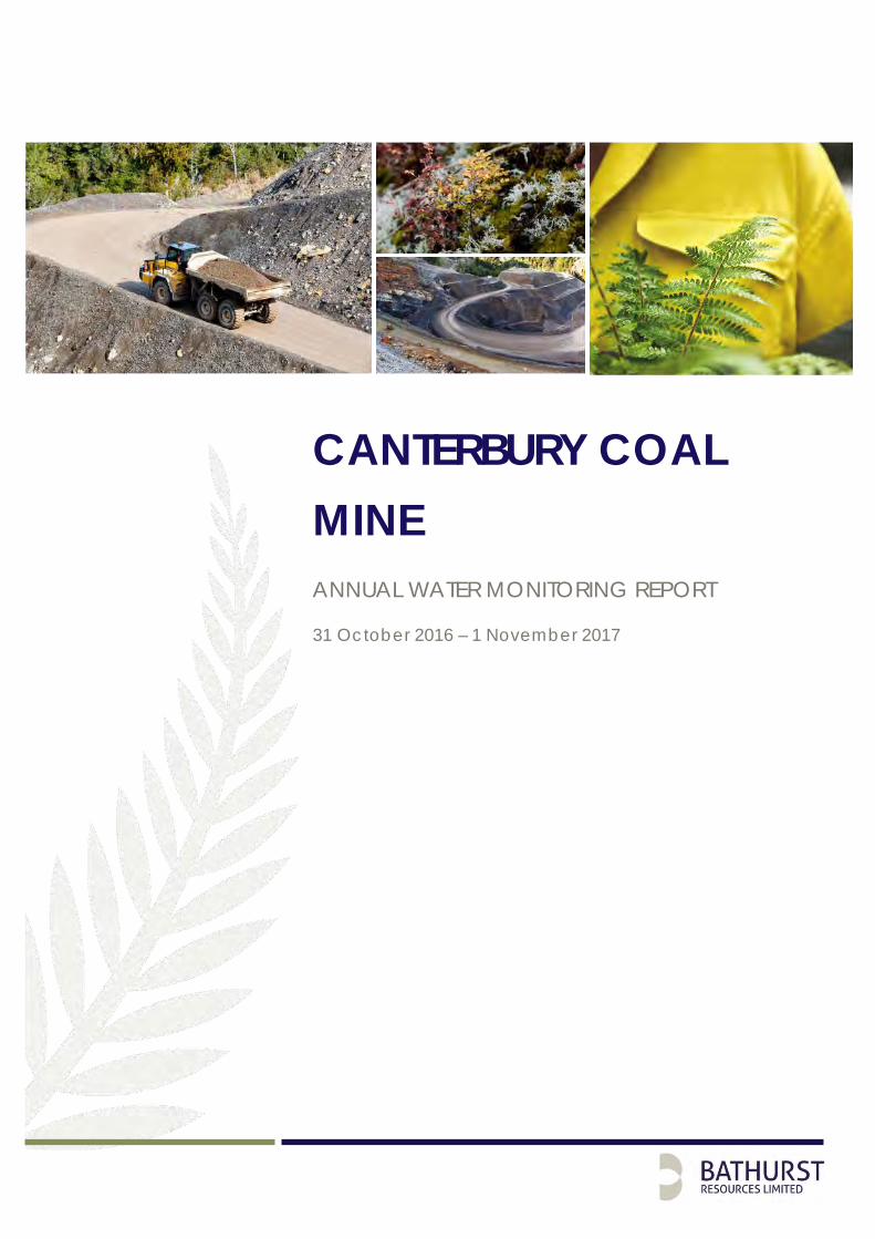
CANTERBURY COAL MINE ANNUAL WATER MONITORING REPORT
31 October 2016 – 1 November 2017
CCM-ENV-RPT-001 |Oct 2017 Page iii Printed versions of this document are uncontrolled
Table of Contents
1.0 Introduction .......................................................................................................................... 5
2.0 Purpose and Scope ............................................................................................................. 6
3.0 CRC170541 Discharge treated mine water into Tara Stream ........................................ 7
3.1 CRC170541 Condition 24(a) – (c) and CRC173823 Condition 35(a) – (c) ........... 7
3.2 CRC170541 Condition 24(d) and CRC173823 Condition 35(d) ............................. 8
3.3 CRC170541 Condition 24(e) and CRC173823 Condition 35(e) ............................. 8
3.3.1 CRC170541 Tara Gully pH ............................................................................... 8
3.3.2 CRC170541 Tara Gully Turbidity ...................................................................... 8
3.3.3 CRC170541 Tara Gully Electrical Conductivity (EC) .................................... 9
3.3.4 CRC170541 Tara Gully Boron .......................................................................... 9
3.3.5 CRC170541 Tara Gully Manganese (Mn) ...................................................... 9
3.3.6 CRC170541 Tara Gully Nickel (Ni) .................................................................. 9
3.3.7 CRC170541 Tara Gully Zinc (Zn)...................................................................... 9
3.3.8 CRC170541 Tara Gully Iron (Fe) ...................................................................... 9
3.3.9 CRC170541 Tara Gully Aluminium (Al) ........................................................... 9
3.3.10 CRC173823 Bush Gully pH ............................................................................. 10
3.3.11 CRC173823 Bush Gully Turbidity ................................................................... 10
3.3.12 CRC173823 Bush Gully Electrical Conductivity (EC) .................................. 10
3.3.13 CRC173823 Bush Gully Boron (B) .................................................................. 10
3.3.14 CRC173823 Bush Gully Manganese (Mn) ................................................... 10
3.3.15 CRC173823 Bush Gully Nickel (Ni) ................................................................ 11
3.3.16 CRC173823 Bush Gully Zinc (Zn) ................................................................... 11
3.3.17 CRC173823 Bush Gully Iron (Fe) .................................................................... 11
3.3.18 CRC173823 Bush Gully Aluminium (Al) ........................................................ 11
3.4 CRC173823 Condition 35(f) ...................................................................................... 11
3.5 CRC170541 Condition 24(f) and CRC173823 Condition 35(g) ............................ 11
Figures
Figure 1: The Canterbury Coal Mine coal deposit and location (Modified by Seale (2006) from Duff and Barry (1989).......................................................................... 5
CCM-ENV-RPT-001 |Oct 2017 Page iv Printed versions of this document are uncontrolled
Tables
Table 1: CRC 170541 Reporting Conditions ........................................................................... 6
Table 2: CRC 173823 Reporting Conditions ........................................................................... 7
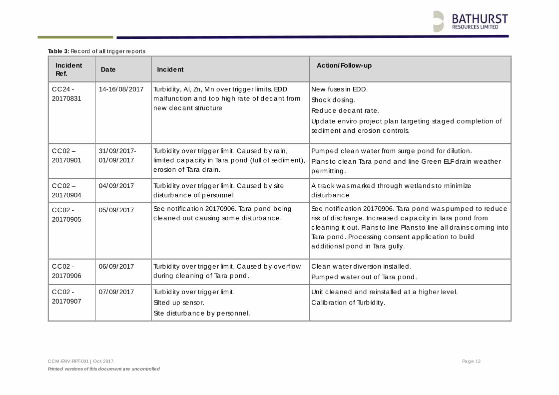
Table 3: Record of all trigger reports .................................................................................... 12
Appendices
Appendix 1: O’Kane Consultants Analysis of Water Monitoring Results .......................... 27
Appendix II: CRC170541 (Bush Gully) Laboratory Analysis Results .................................. 44
Appendix III: CRC173823 (Tara Gully) Laboratory Analysis Results .................................. 58
Appendix IV: Trigger Value Exceedance Reports Tara Gully ........................................... 81
Appendix V: Trigger Value Exceedance Reports Bush Gully .......................................... 148
CCM-ENV-RPT-001 |Oct 2017 Page 5 Printed versions of this document are uncontrolled
1.0 Introduction
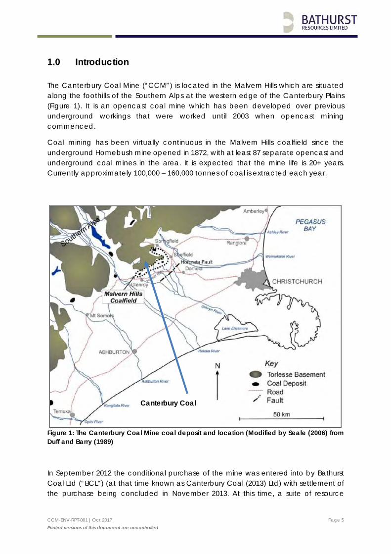
The Canterbury Coal Mine (“CCM”) is located in the Malvern Hills which are situated along the foothills of the Southern Alps at the western edge of the Canterbury Plains (Figure 1). It is an opencast coal mine which has been developed over previous underground workings that were worked until 2003 when opencast mining commenced.
Coal mining has been virtually continuous in the Malvern Hills coalfield since the underground Homebush mine opened in 1872, with at least 87 separate opencast and underground coal mines in the area. It is expected that the mine life is 20+ years. Currently approximately 100,000 – 160,000 tonnes of coal is extracted each year.
Figure 1: The Canterbury Coal Mine coal deposit and location (Modified by Seale (2006) from Duff and Barry (1989)
In September 2012 the conditional purchase of the mine was entered into by Bathurst Coal Ltd (“BCL”) (at that time known as Canterbury Coal (2013) Ltd) with settlement of the purchase being concluded in November 2013. At this time, a suite of resource
Canterbury Coal
CCM-ENV-RPT-001 |Oct 2017 Page 6 Printed versions of this document are uncontrolled
consents from both Environment Canterbury (“ECAN”) and Selwyn District Council (“SDC”) were transferred over to BCL.
2.0 Purpose and Scope
This is the first annual report to be issued to ECAN as per conditions 35 of CRC 173823 and condition 24 of CRC 17054. This report covers the period since consents were granted (May 2017) up until 31 October 2017. The reporting requirements of these conditions are included in Table 1 below. A copy of this report will also be forwarded to both Te Taumutu Runanga and Te Ngai Tuahuriri Runanaga as required by the conditions of these consents.
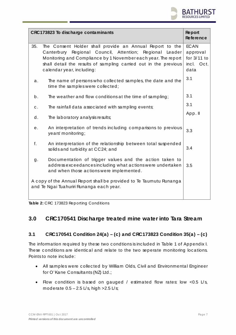
CRC170541 To discharge treated mine water into Tara Stream. Report Reference
24. The Consent Holder shall provide an Annual Report to the Canterbury Regional Council, Attention; Regional Leader Monitoring and Compliance by 1 November each year. The report shall detail the results of sampling carried out in the previous calendar year, including:
a. The name of persons who collected samples, the date and the time the samples were collected;
b. The weather and flow conditions at the time of sampling;
c. The rainfall data associated with sampling events; An interpretation of trends including comparisons to previous years' monitoring; and
d. The laboratory analysis results;
e. An interpretation of trends including comparisons to previous years’ monitoring; and
f. Documentation of trigger values and the action taken to address exceedances including what actions were undertaken and when those actions were implemented.
A copy of the Annual Report shall be provided to Te Taumutu Runanga and Te Ngai Tuahuriri Runanga each year.”
ECAN approval for 3/11 to incl. Oct. data
3.1.
3.1
3.1
App. II
3.3
3.5
Table 1: CRC 170541 Reporting Conditions
CCM-ENV-RPT-001 |Oct 2017 Page 7 Printed versions of this document are uncontrolled
CRC173823 To discharge contaminants Report Reference
35. The Consent Holder shall provide an Annual Report to the Canterbury Regional Council, Attention; Regional Leader Monitoring and Compliance by 1 November each year. The report shall detail the results of sampling carried out in the previous calendar year, including:
a. The name of persons who collected samples, the date and the time the samples were collected;
b. The weather and flow conditions at the time of sampling;
c. The rainfall data associated with sampling events;
d. The laboratory analysis results;
e. An interpretation of trends including comparisons to previous years' monitoring;
f. An interpretation of the relationship between total suspended solids and turbidity at CC24; and
g. Documentation of trigger values and the action taken to address exceedances including what actions were undertaken and when those actions were implemented.
A copy of the Annual Report shall be provided to Te Taumutu Runanga and Te Ngai Tuahuriri Runanga each year.
ECAN approval for 3/11 to incl. Oct. data
3.1
3.1
3.1
App. II
3.3
3.4
3.5
Table 2: CRC 173823 Reporting Conditions
3.0 CRC170541 Discharge treated mine water into Tara Stream
3.1 CRC170541 Condition 24(a) – (c) and CRC173823 Condition 35(a) – (c)
The information required by these two condtions is included in Table 1 of Appendix I. These conditions are identical and relate to the two seperate monitoring locations. Points to note include:
• All samples were collected by William Olds, Civil and Environmental Engineer for O’Kane Consultants (NZ) Ltd.;
• Flow condition is based on gauged / estimated flow rates: low <0.5 L/s, moderate 0.5 – 2.5 L/s, high >2.5 L/s;
CCM-ENV-RPT-001 |Oct 2017 Page 8 Printed versions of this document are uncontrolled
• Rainfall depths are extracted from the Environment Canterbury Data Catalogue for the Whitecliffs Monitoring Site (315910).
The CCM is in the process of installing a telemetered and calibrated weather station at the site. Annecdotal observations suggest that the Whitecliffs site is a close approximation of rainfall received at the mine site.
3.2 CRC170541 Condition 24(d) and CRC173823 Condition 35(d)
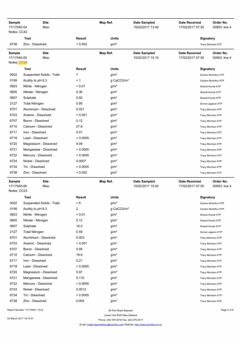
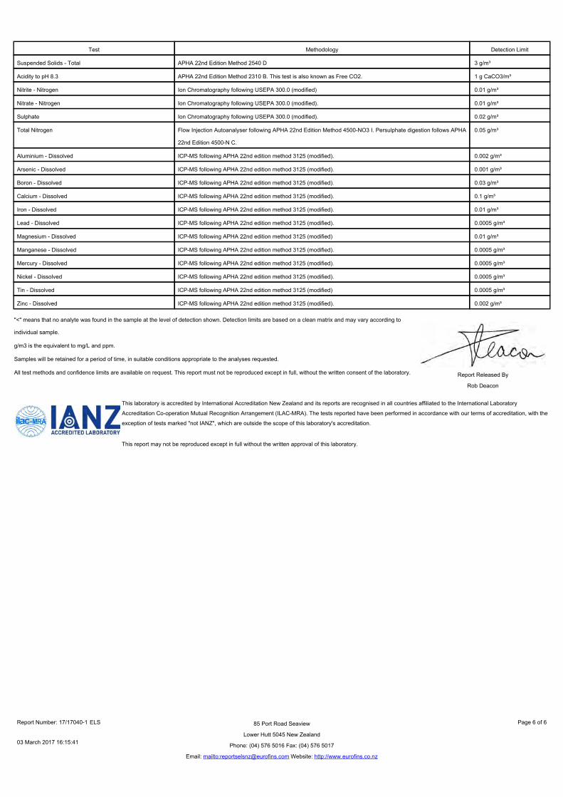
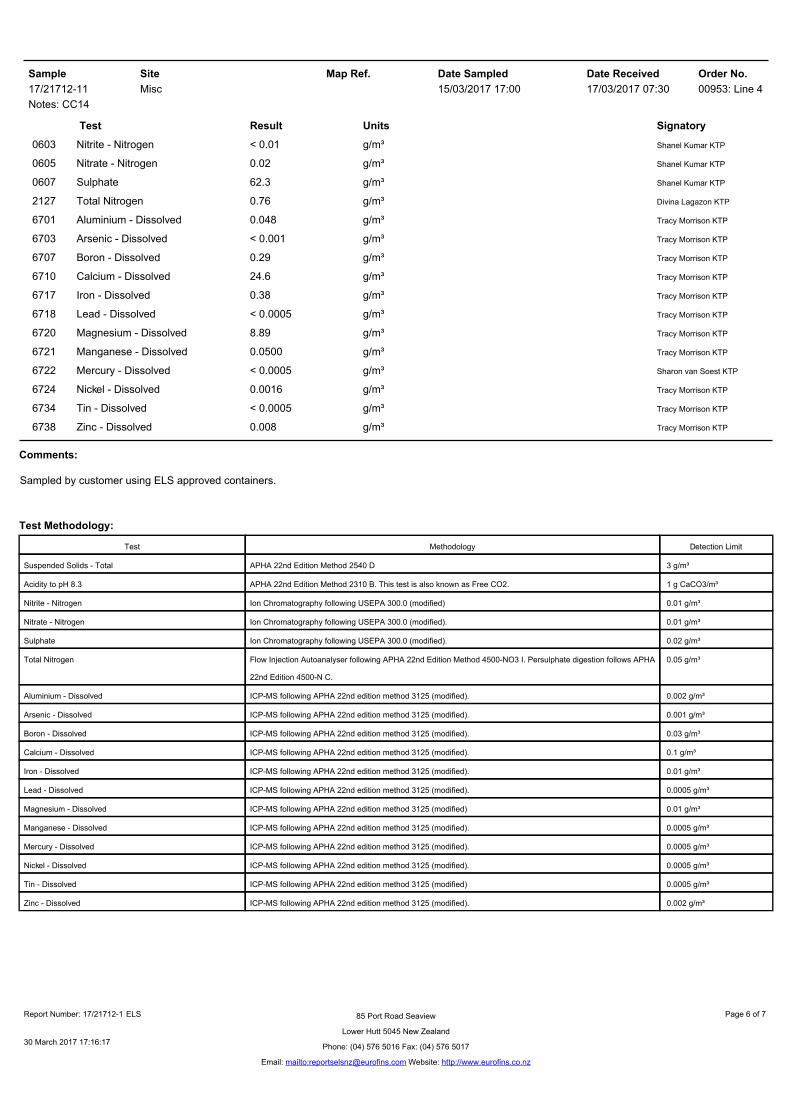
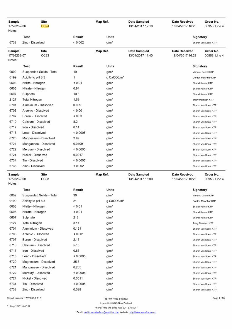
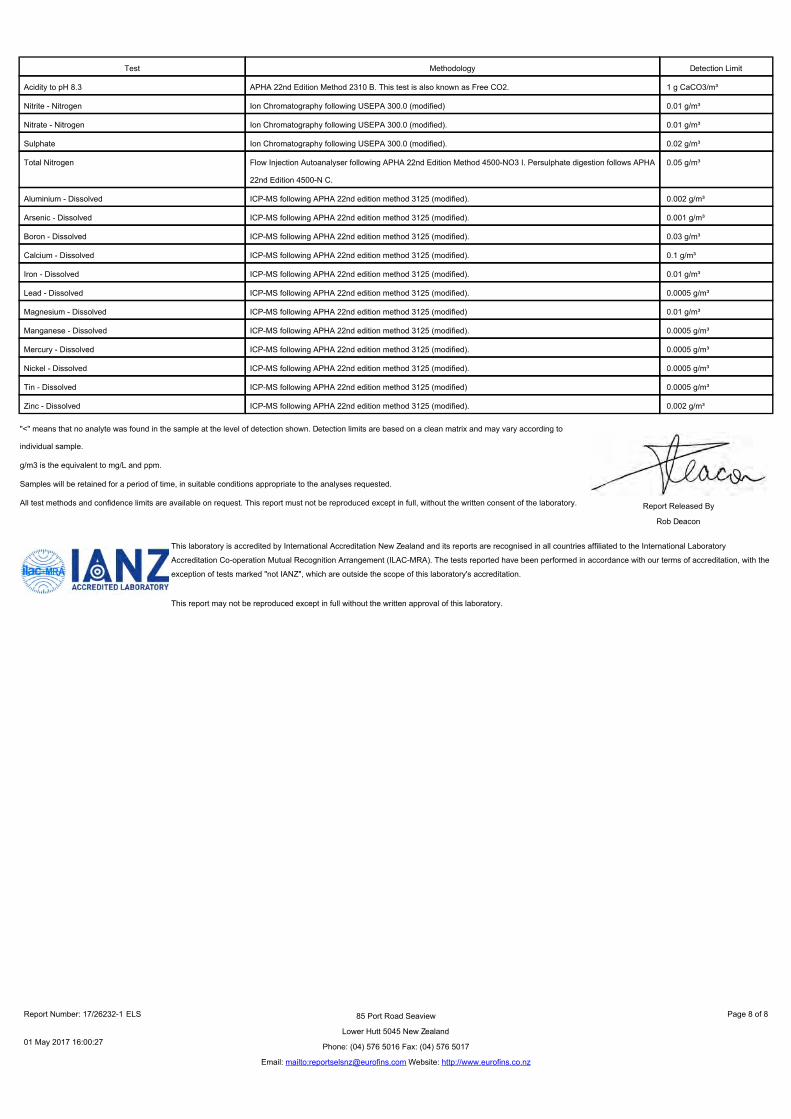
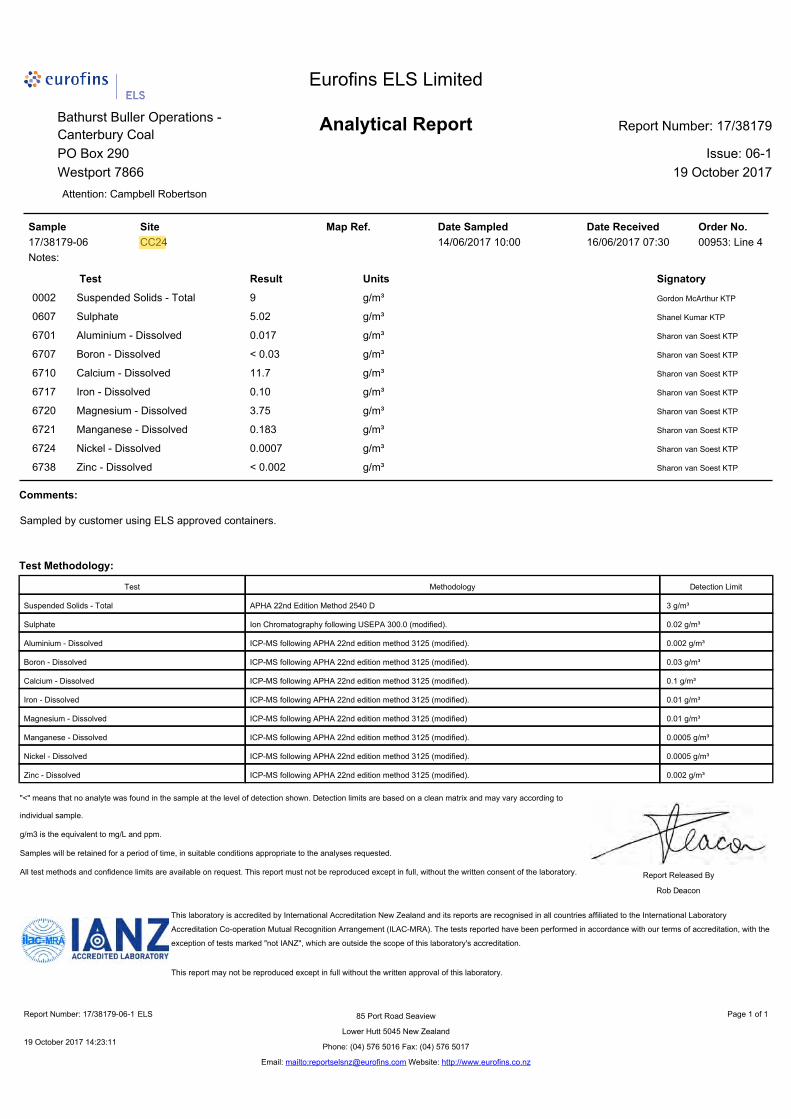
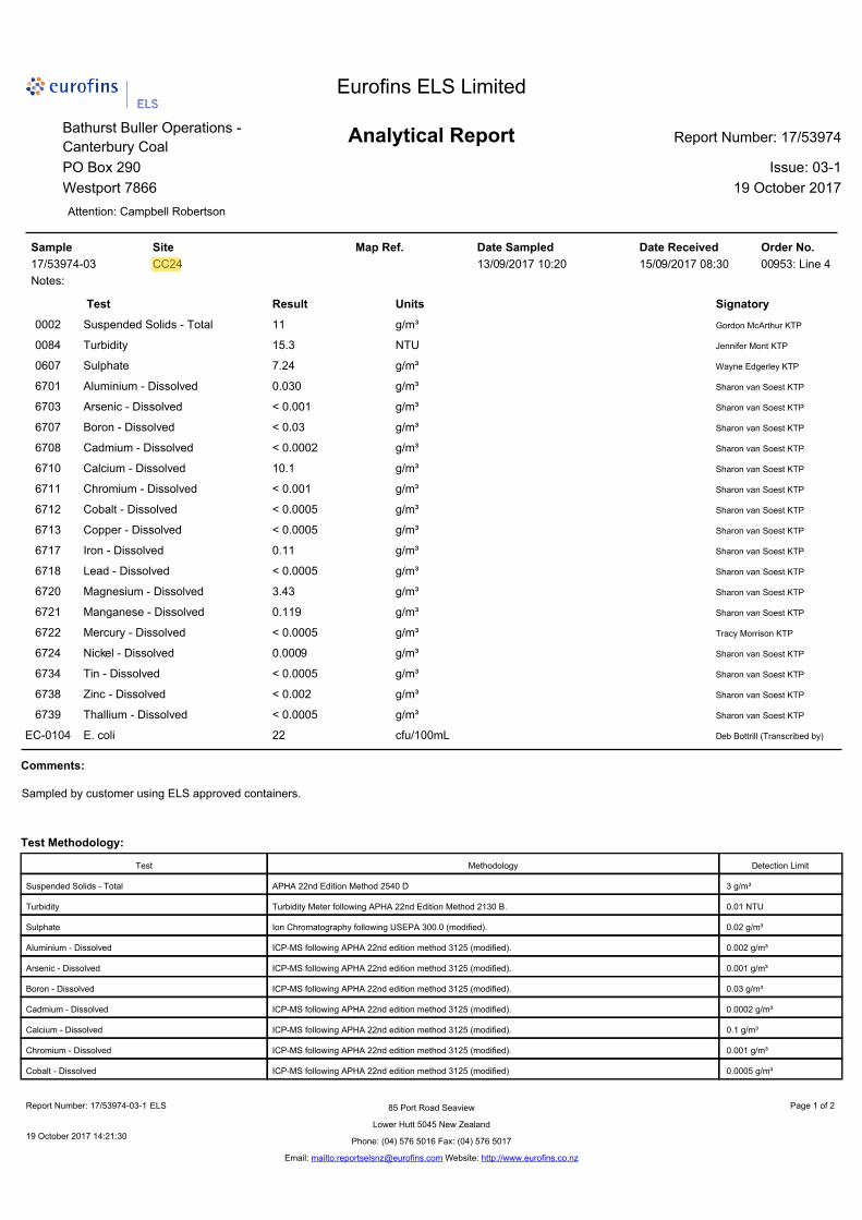
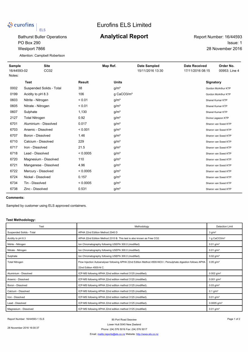
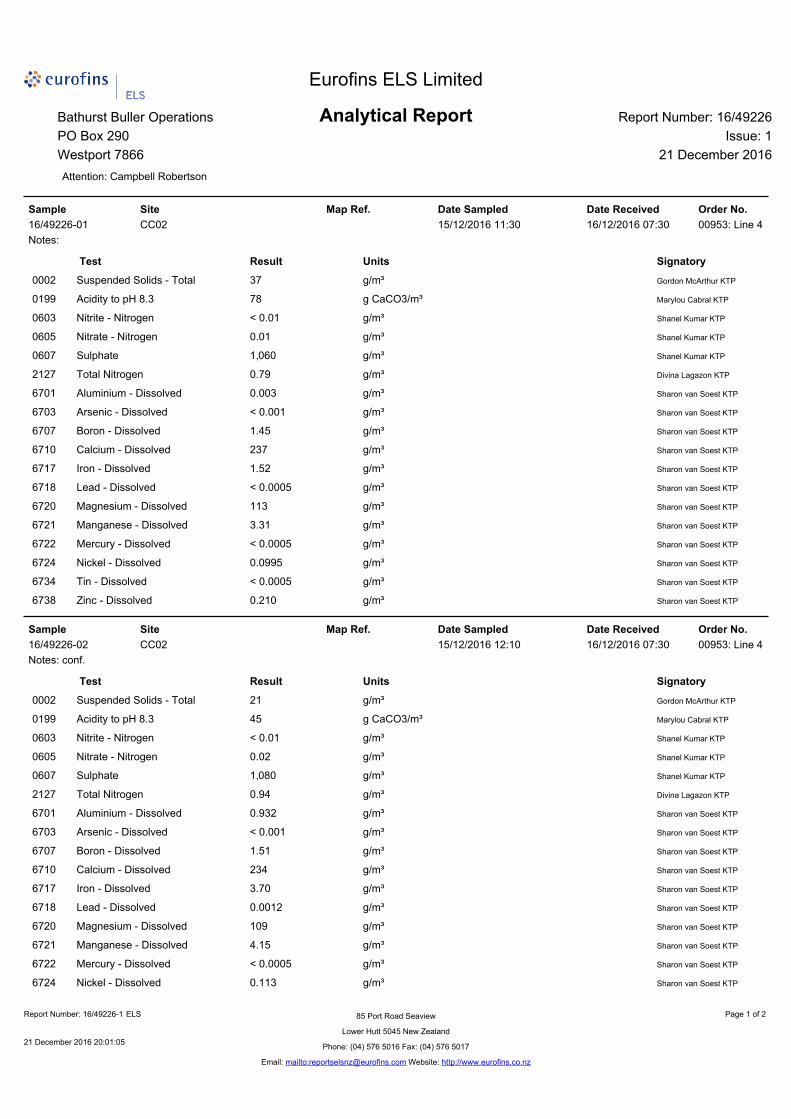
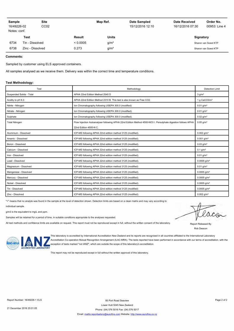
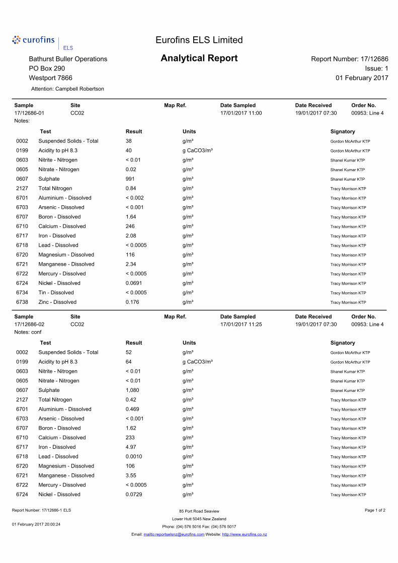
All laboratory results are included in Appendix II (CRC170541) and Appendix III (CRC173823). As per the condition of the consents (CRC173823 condition 22(d) and CRC170541 conditin 13(d)), all laboratory analysis was undertaken by Eurofins ELS Limited which is fully IANZ accredited and a statement of such, including methodology is included with each set of results.
3.3 CRC170541 Condition 24(e) and CRC173823 Condition 35(e)
Figures 2 to 7 in Appendix I show the trends for each of the key parameters.
3.3.1 CRC170541 Tara Gully pH
Figure 2 shows the range and fluctuation in pH at the Tara Gully site. The results stem back to October 2015 which pre-date the current consent. As noted in the O’Kane Report, the sampling location has changed slightly and is now aligned to the location specified in the consents and adjacent to the telemetred site.
Low pH readings, that is, less than the trigger value of pH 6 have were consistent prior to the consent being granted and also for a period following approval. Some of the recent readings have increased to meet compliance and this is generally a result of active treatment on-site (Ca(OH)2 dosing) or installation of the passive mussel shell bioreactor.
The apparent drop in pH for July and August appears to correlate with a slip in dosing. Systems are now in place and with additional staff resources, that these non-compliances are less likely to occur.
3.3.2 CRC170541 Tara Gully Turbidity
Turbidity results show a general compliance, although there have been a number of incidents where turbidity has exceeded the compliance trigger value. These incidents are primarily related to rainfall events and a lack or failure of on-site sediment control mechanisms. There has been a signficiant investment in measures to manage sediment and improve the quality of any discharges, particularly for sediment. This is discussed more in section 3.5.
CCM-ENV-RPT-001 |Oct 2017 Page 9 Printed versions of this document are uncontrolled
3.3.3 CRC170541 Tara Gully Electrical Conductivity (EC)
The trend for EC since October 2015 shows a general decline, with some fluctuations. This decline is most likely a result of dilution due to improved water management controls collecting surface run-off and directing it to the Tara Gully. Improved water treatment may also be a driver for reduced EC.
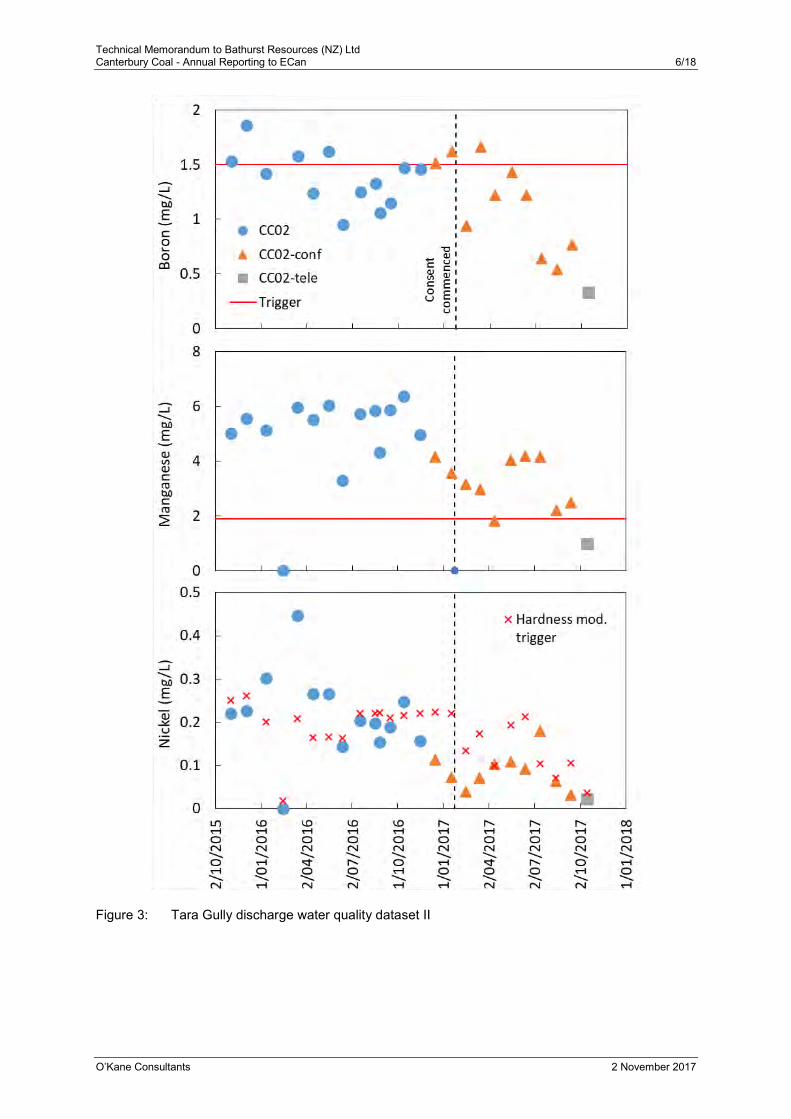
3.3.4 CRC170541 Tara Gully Boron
Boron concentrations are relatively steady with some month on month fluctuation but no apparent trend. The recent decline is most likely related to a change in the surface water management system at the site. The Green ELF construction is completed and rehabilitation undertaken. All water is being directed to the Tara Gully pond and there may be better dilution occuring which is the most reasonable treatment for boron. Tara Gully discharge boron concentration has been consistently compliant with CRC170541, Condition 14 limits (three month rolling median limit of 1.5 mg/L) since April 2017.
3.3.5 CRC170541 Tara Gully Manganese (Mn)
There has been a slight decline in manganese concentrations since recordings commenced. The increase shown for the three readings in May-July correlates with the increased acidity (lowered pH) at this time. With better acidity management going forward, we anticiapte a further reduction in Mn concentrations
3.3.6 CRC170541 Tara Gully Nickel (Ni)
Nickel concentrations are also showing a slightly reducing trend. With inclusion of the the hardness modified trigger most records are within compliance.
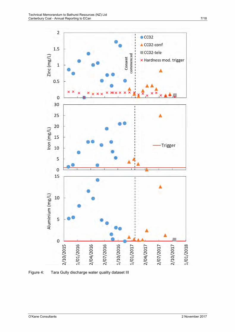
3.3.7 CRC170541 Tara Gully Zinc (Zn)
Zinc is showing less variability than prior to the commencement of the consent, but it still remains above the compliance limit.
3.3.8 CRC170541 Tara Gully Iron (Fe)
There are less records for iron as condition 11 only requires monitoring for iron ph is less than 4.5.
3.3.9 CRC170541 Tara Gully Aluminium (Al)
Aluminium is also showing a similar trend to the other dissolved metals.
Overall, there is a general trend of reduction in metal concentrations at the Tara Gully site that appears to correlate with water treatment. The site has recently replenished
CCM-ENV-RPT-001 |Oct 2017 Page 10 Printed versions of this document are uncontrolled
the existing mussel shell reactor, and is the process of installing a second, slightly larger one. Once coupled with Ca(OH)2 treatment it is anticipated that the pH will increase further and dissolved metals concentrations drop to below the compliance trigger limit.
3.3.10 CRC173823 Bush Gully pH
Figure 5 shows that pH at the compliance point is compliant with the consent conditions and sits in the 6-8 range.
Condition 30 of the consent enables the consent holder to apply to vary the trigger limits for pH at this site once a suitable dataset has been obtained. An application to do so will be lodged to tie in with the application to vary the boron limits (condition 24) as it appeaers that at times the natural background pH is below the 6-9 trigger value and is most likely a result of the underlying geology of this area.
3.3.11 CRC173823 Bush Gully Turbidity
The trend for turbidity generally shows compliance, although this is variable and dependent on site activities, rainfall events and stream flow. The upstream land use activities in the Bush Gully are also a source of sediment that is reflected in the readings at CC24_Turb.
As discussed in Section 3.5, efforts to improve site sediment controls have resulted in an improvement in the water quality discharges. This work is ongoing, but is expected to result in an improvement to the turbidity readings.
Work is also being undertaken to determine the most accurate and appropriate site to measure site discharges and gauge the likely impacts from discharges on the receiving environment. This will most likely result in an application to ammend the trigger limits, and monitoring location for this consent.
3.3.12 CRC173823 Bush Gully Electrical Conductivity (EC)
There does not appear to be any trend in the EC results and the range is below any level of concern.
3.3.13 CRC173823 Bush Gully Boron (B)
Boron readings are well below the trigger limit and five of the eight readings have been less than the detection limit.
3.3.14 CRC173823 Bush Gully Manganese (Mn)
While there is some fluctuation in the manganese results all are an order of magnitude below the trigger limit and are most likely a reflection of the near-neutral pH.
CCM-ENV-RPT-001 |Oct 2017 Page 11 Printed versions of this document are uncontrolled
3.3.15 CRC173823 Bush Gully Nickel (Ni)
While there is some fluctuation in the nickel recordings all are an order of magnitude below the trigger limit.
3.3.16 CRC173823 Bush Gully Zinc (Zn)
All but one of the readings for zinc have been undetectable. The one detectable sample was below the trigger limit.
3.3.17 CRC173823 Bush Gully Iron (Fe)
All of the iron readings are below the trigger limit and are most likely related to the pH readings for this location
3.3.18 CRC173823 Bush Gully Aluminium (Al)
All of the aluminium readings are below the trigger limit and are most likely a result of the pH being within the compliance range for this location.
3.4 CRC173823 Condition 35(f)
A correlation of the turbidity and susspended solids is shown in Figure 8 of Appendix i. There appears to be a strong correlation between the two, with NTU turbidity values double the mg/L TSS value.
3.5 CRC170541 Condition 24(f) and CRC173823 Condition 35(g)
A reporting template and procedure was established for all exceedences and this was implemented in August 2017. Since this time all exceedances of the trigger values have been reported to ECAN as they have occurred and are included in Appendix IV for completeness.
A summary of these exceedences is included in the table below. The majority of incidents relate to elevated sediment discharges. The causes vary but some are due to inadequate controls being in place, whereas others are due to equipment failures. Some exceedences are 15 minute spikes in the readings which may be erroneous readings or the result of an unmangeable event such as stock walking through the stream above the sondes.
CCM-ENV-RPT-001 |Oct 2017 Page 12 Printed versions of this document are uncontrolled
Table 3: Record of all trigger reports
Incident Ref. Date Incident Action/Follow-up
CC24 - 20170831
14-16/08/2017 Turbidity, Al, Zn, Mn over trigger limits. EDD malfunction and too high rate of decant from new decant structure
New fuses in EDD. Shock dosing. Reduce decant rate. Update enviro project plan targeting staged completion of sediment and erosion controls.
CC02 – 20170901
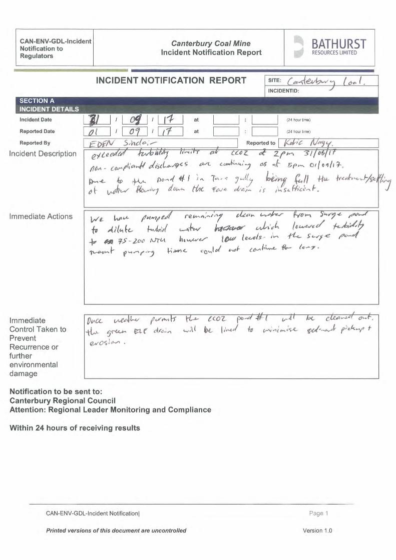
31/09/2017-01/09/2017
Turbidity over trigger limit. Caused by rain, limited capacity in Tara pond (full of sediment), erosion of Tara drain.
Pumped clean water from surge pond for dilution. Plans to clean Tara pond and line Green ELF drain weather permitting.
CC02 – 20170904
04/09/2017 Turbidity over trigger limit. Caused by site disturbance of personnel
A track was marked through wetlands to minimize disturbance
CC02 - 20170905
05/09/2017 See notification 20170906. Tara pond being cleaned out causing some disturbance.
See notification 20170906. Tara pond was pumped to reduce risk of discharge. Increased capacity in Tara pond from cleaning it out. Plans to line Plans to line all drains coming into Tara pond. Processing consent application to build additional pond in Tara gully.
CC02 - 20170906
06/09/2017 Turbidity over trigger limit. Caused by overflow during cleaning of Tara pond.
Clean water diversion installed. Pumped water out of Tara pond.
CC02 - 20170907
07/09/2017 Turbidity over trigger limit. Silted up sensor. Site disturbance by personnel.
Unit cleaned and reinstalled at a higher level. Calibration of Turbidity.
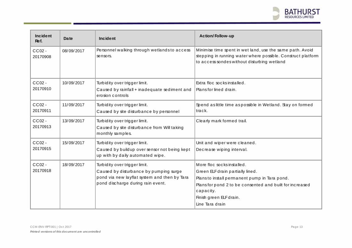
CCM-ENV-RPT-001 |Oct 2017 Page 13 Printed versions of this document are uncontrolled
Incident Ref. Date Incident Action/Follow-up
CC02 - 20170908
08/09/2017 Personnel walking through wetlands to access sensors.
Minimise time spent in wet land, use the same path. Avoid stepping in running water where possible. Construct platform to access sondes without disturbing wetland
CC02 - 20170910
10/09/2017 Turbidity over trigger limit. Caused by rainfall + inadequate sediment and erosion controls
Extra floc socks installed. Plans for lined drain.
CC02 - 20170911
11/09/2017 Turbidity over trigger limit. Caused by site disturbance by personnel
Spend as little time as possible in Wetland. Stay on formed track.
CC02 - 20170913
13/09/2017 Turbidity over trigger limit. Caused by site disturbance from Will taking monthly samples.
Clearly mark formed trail.
CC02 - 20170915
15/09/2017 Turbidity over trigger limit. Caused by buildup over sensor not being kept up with by daily automated wipe.
Unit and wiper were cleaned. Decrease wiping interval.
CC02 - 20170918
18/09/2017 Turbidity over trigger limit. Caused by disturbance by pumping surge pond via new layflat system and then by Tara pond discharge during rain event.
More floc socks installed. Green ELF drain partially lined. Plans to install permanent pump in Tara pond. Plans for pond 2 to be consented and built for increased capacity. Finish green ELF drain. Line Tara drain
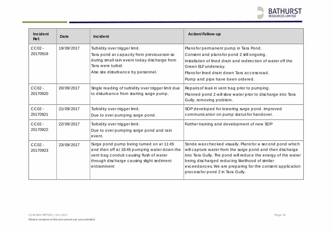
CCM-ENV-RPT-001 |Oct 2017 Page 14 Printed versions of this document are uncontrolled
Incident Ref. Date Incident Action/Follow-up
CC02 - 20170919
19/09/2017 Turbidity over trigger limit. Tara pond at capacity from previous rain so during small rain event today discharge from Tara were turbid. Also site disturbance by personnel.
Plans for permanent pump in Tara Pond. Consent and plans for pond 2 still ongoing. Installation of lined drain and redirection of water off the Green ELF underway. Plans for lined drain down Tara access road. Pump and pipe have been ordered.
CC02 - 20170920
20/09/2017 Single reading of turbidity over trigger limit due to disturbance from starting surge pump.
Repairs of leak in vent bag prior to pumping. Planned pond 2 will slow water prior to discharge into Tara Gully, removing problem.
CC02 - 20170921
21/09/2017 Turbidity over trigger limit. Due to over pumping surge pond.
SOP developed for lowering surge pond. Improved communication on pump status for handover.
CC02 - 20170922
22/09/2017 Turbidity over trigger limit. Due to over pumping surge pond and rain event.
Further training and development of new SOP
CC02 - 20170923
23/09/2017 Surge pond pump being turned on at 11:45 and then off at 18:45 pumping water down the vent bag conduit causing flush of water through discharge causing slight sediment entrainment
Sonde was checked visually. Plans for a second pond which will capture water from the surge pond and then discharge into Tara Gully. The pond will reduce the energy of the water being discharged reducing likelihood of similar exceedances. We are preparing for the consent application process for pond 2 in Tara Gully.
CCM-ENV-RPT-001 |Oct 2017 Page 15 Printed versions of this document are uncontrolled
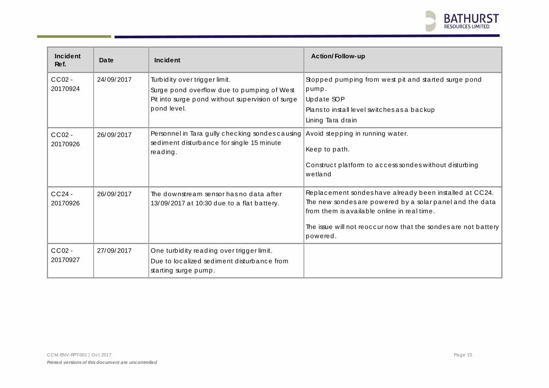
Incident Ref. Date Incident Action/Follow-up
CC02 - 20170924
24/09/2017 Turbidity over trigger limit. Surge pond overflow due to pumping of West Pit into surge pond without supervision of surge pond level.
Stopped pumping from west pit and started surge pond pump. Update SOP Plans to install level switches as a backup Lining Tara drain
CC02 - 20170926
26/09/2017 Personnel in Tara gully checking sondes causing sediment disturbance for single 15 minute reading.
Avoid stepping in running water.
Keep to path.
Construct platform to access sondes without disturbing wetland
CC24 - 20170926
26/09/2017 The downstream sensor has no data after 13/09/2017 at 10:30 due to a flat battery.
Replacement sondes have already been installed at CC24. The new sondes are powered by a solar panel and the data from them is available online in real time.
The issue will not reoccur now that the sondes are not battery powered.
CC02 - 20170927
27/09/2017 One turbidity reading over trigger limit. Due to localized sediment disturbance from starting surge pump.
CCM-ENV-RPT-001 |Oct 2017 Page 16 Printed versions of this document are uncontrolled
Incident Ref. Date Incident Action/Follow-up
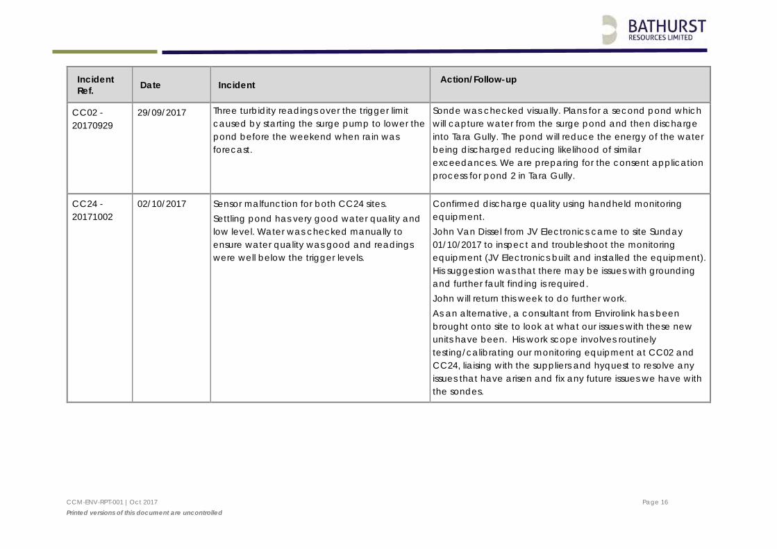
CC02 - 20170929
29/09/2017 Three turbidity readings over the trigger limit caused by starting the surge pump to lower the pond before the weekend when rain was forecast.
Sonde was checked visually. Plans for a second pond which will capture water from the surge pond and then discharge into Tara Gully. The pond will reduce the energy of the water being discharged reducing likelihood of similar exceedances. We are preparing for the consent application process for pond 2 in Tara Gully.
CC24 - 20171002
02/10/2017 Sensor malfunction for both CC24 sites. Settling pond has very good water quality and low level. Water was checked manually to ensure water quality was good and readings were well below the trigger levels.
Confirmed discharge quality using handheld monitoring equipment. John Van Dissel from JV Electronics came to site Sunday 01/10/2017 to inspect and troubleshoot the monitoring equipment (JV Electronics built and installed the equipment). His suggestion was that there may be issues with grounding and further fault finding is required. John will return this week to do further work. As an alternative, a consultant from Envirolink has been brought onto site to look at what our issues with these new units have been. His work scope involves routinely testing/calibrating our monitoring equipment at CC02 and CC24, liaising with the suppliers and hyquest to resolve any issues that have arisen and fix any future issues we have with the sondes.
CCM-ENV-RPT-001 |Oct 2017 Page 17 Printed versions of this document are uncontrolled
Incident Ref. Date Incident Action/Follow-up
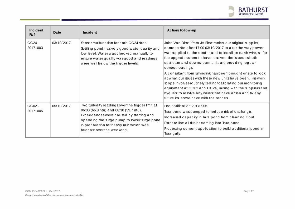
CC24 - 20171003
03/10/2017 Sensor malfunction for both CC24 sites. Settling pond has very good water quality and low level. Water was checked manually to ensure water quality was good and readings were well below the trigger levels.
John Van Dissel from JV Electronics, our original supplier, came to site after 17:00 03/10/2017 to alter the way power was supplied to the sondes and to install an earth wire, so far the upgrades seem to have resolved the issues as both upstream and downstream units are providing regular correct readings. A consultant from Envirolink has been brought onsite to look at what our issues with these new units have been. His work scope involves routinely testing/calibrating our monitoring equipment at CC02 and CC24, liaising with the suppliers and hyquest to resolve any issues that have arisen and fix any future issues we have with the sondes.
CC02 - 20171005
05/10/2017 Two turbidity readings over the trigger limit at 06:00 (66.8 ntu) and 08:30 (59.7 ntu). Exceedances were caused by starting and operating the surge pump to lower surge pond in preparation for heavy rain which was forecast over the weekend.
See notification 20170906. Tara pond was pumped to reduce risk of discharge. Increased capacity in Tara pond from cleaning it out. Plans to line all drains coming into Tara pond. Processing consent application to build additional pond in Tara gully.
CCM-ENV-RPT-001 |Oct 2017 Page 18 Printed versions of this document are uncontrolled
Incident Ref. Date Incident Action/Follow-up
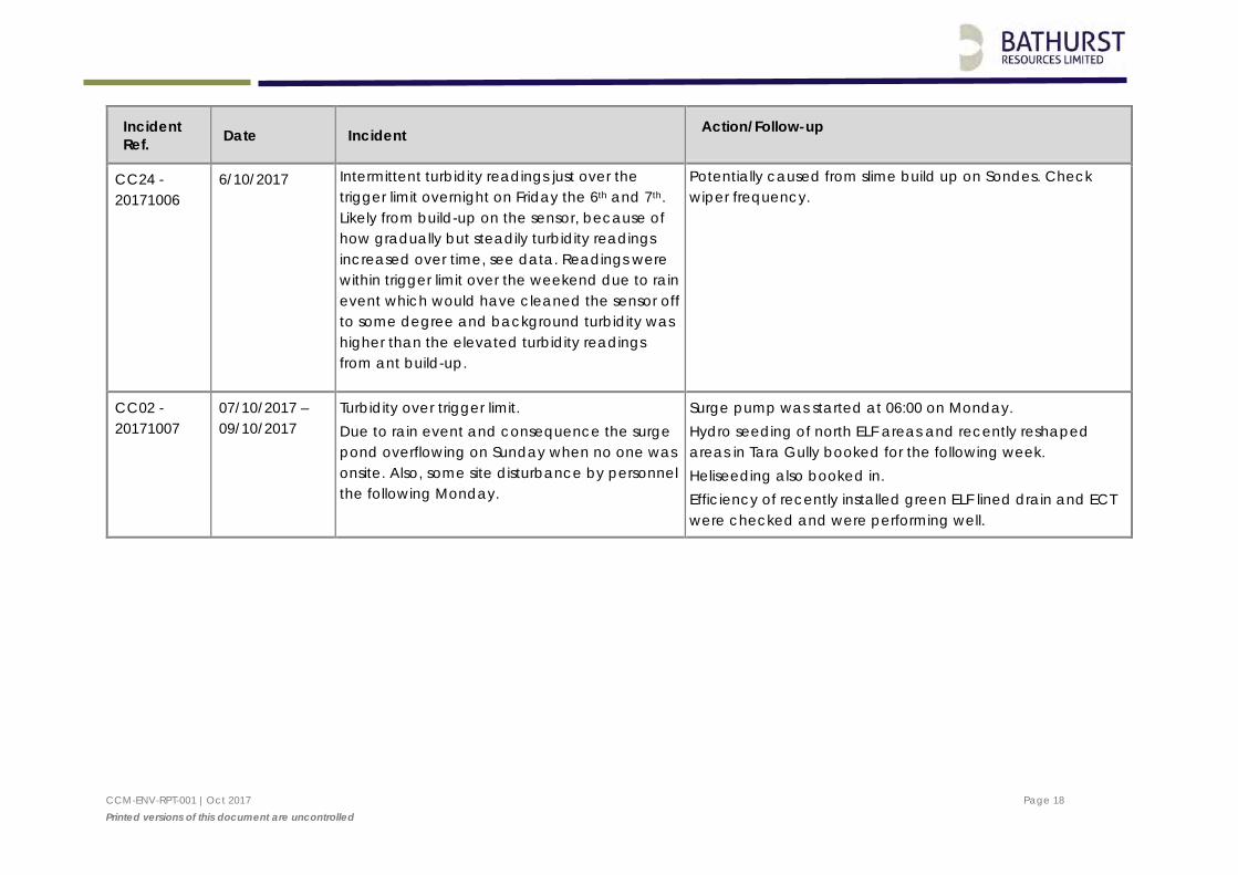
CC24 - 20171006
6/10/2017 Intermittent turbidity readings just over the trigger limit overnight on Friday the 6th and 7th. Likely from build-up on the sensor, because of how gradually but steadily turbidity readings increased over time, see data. Readings were within trigger limit over the weekend due to rain event which would have cleaned the sensor off to some degree and background turbidity was higher than the elevated turbidity readings from ant build-up.
Potentially caused from slime build up on Sondes. Check wiper frequency.
CC02 - 20171007
07/10/2017 – 09/10/2017
Turbidity over trigger limit. Due to rain event and consequence the surge pond overflowing on Sunday when no one was onsite. Also, some site disturbance by personnel the following Monday.
Surge pump was started at 06:00 on Monday. Hydro seeding of north ELF areas and recently reshaped areas in Tara Gully booked for the following week. Heliseeding also booked in. Efficiency of recently installed green ELF lined drain and ECT were checked and were performing well.
CCM-ENV-RPT-001 |Oct 2017 Page 19 Printed versions of this document are uncontrolled
Incident Ref. Date Incident Action/Follow-up
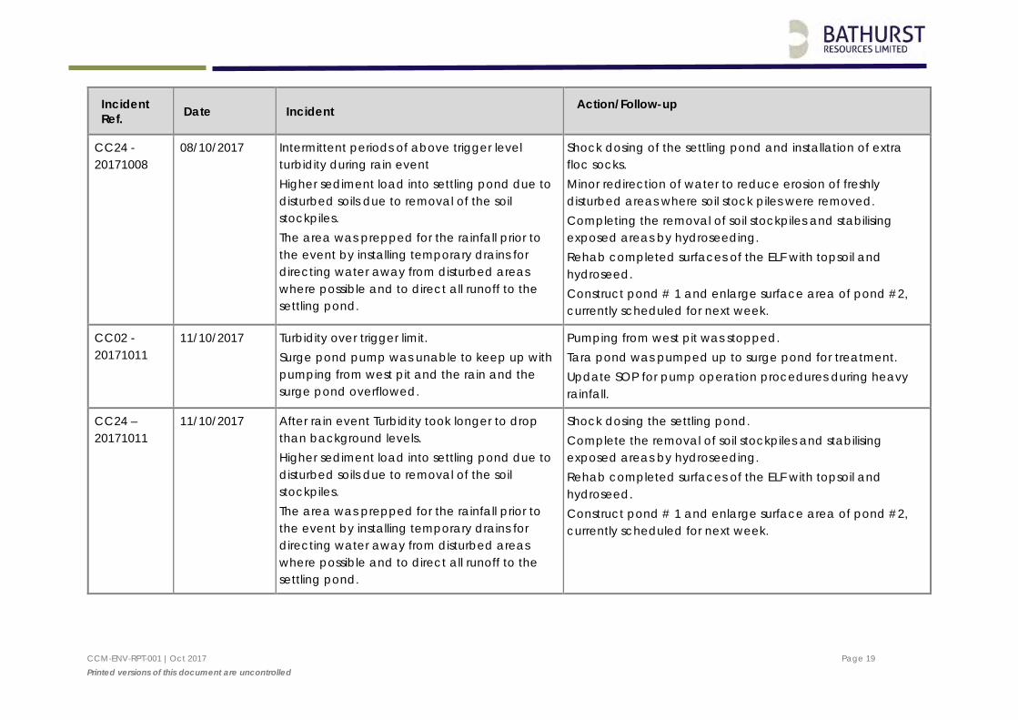
CC24 - 20171008
08/10/2017 Intermittent periods of above trigger level turbidity during rain event Higher sediment load into settling pond due to disturbed soils due to removal of the soil stockpiles. The area was prepped for the rainfall prior to the event by installing temporary drains for directing water away from disturbed areas where possible and to direct all runoff to the settling pond.
Shock dosing of the settling pond and installation of extra floc socks. Minor redirection of water to reduce erosion of freshly disturbed areas where soil stock piles were removed. Completing the removal of soil stockpiles and stabilising exposed areas by hydroseeding. Rehab completed surfaces of the ELF with topsoil and hydroseed. Construct pond # 1 and enlarge surface area of pond #2, currently scheduled for next week.
CC02 - 20171011
11/10/2017 Turbidity over trigger limit. Surge pond pump was unable to keep up with pumping from west pit and the rain and the surge pond overflowed.
Pumping from west pit was stopped. Tara pond was pumped up to surge pond for treatment. Update SOP for pump operation procedures during heavy rainfall.
CC24 – 20171011
11/10/2017 After rain event Turbidity took longer to drop than background levels. Higher sediment load into settling pond due to disturbed soils due to removal of the soil stockpiles. The area was prepped for the rainfall prior to the event by installing temporary drains for directing water away from disturbed areas where possible and to direct all runoff to the settling pond.
Shock dosing the settling pond. Complete the removal of soil stockpiles and stabilising exposed areas by hydroseeding. Rehab completed surfaces of the ELF with topsoil and hydroseed. Construct pond # 1 and enlarge surface area of pond #2, currently scheduled for next week.

CCM-ENV-RPT-001 |Oct 2017 Page 20 Printed versions of this document are uncontrolled
Incident Ref. Date Incident Action/Follow-up
CC02 - 20171012
12/10/2017 Turbidity over trigger limit. Surge pond was over pumped during night shift.
Pump was stopped at 04:00.
CC02 - 20171015
15/10/2017 Turbidity over trigger limit. Heavy rain. Recently rehabilitated areas generated some sediment and two readings of turbidity 40 ntu over the trigger level correspond to surge pump starting
Sediment and erosion controls in Tara Gully were checked. Paul Feaver was onsite on Sunday specifically to run the surge pump to ensure surge pond did not overflow. Hydroseeding booked in for this Friday (20th Oct)
CC24 - 20171015
15/10/2017 Intermittent turbidity readings just over the trigger limit from the afternoon of the 13th until 02:00 on the 15th. Reduced capacity in pond 1 causing a higher sediment load entering pond 2. The single high reading (1,100 ntu) around 19:00 on the 14th is anomalous and likely corresponds to debris passing sensor.
A digger has been arranged to empty the temporary upper pond today. Construction and increase capacity of pond 1 and increasing capacity of pond 2 is scheduled for the next week if we get a dry period.
CCM-ENV-RPT-001 |Oct 2017 Page 21 Printed versions of this document are uncontrolled
Incident Ref. Date Incident Action/Follow-up
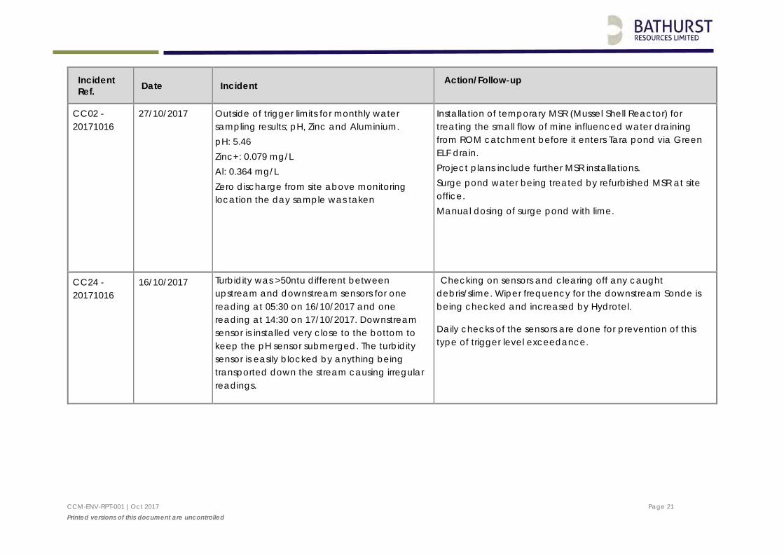
CC02 - 20171016
27/10/2017 Outside of trigger limits for monthly water sampling results; pH, Zinc and Aluminium. pH: 5.46 Zinc+: 0.079 mg/L Al: 0.364 mg/L Zero discharge from site above monitoring location the day sample was taken
Installation of temporary MSR (Mussel Shell Reactor) for treating the small flow of mine influenced water draining from ROM catchment before it enters Tara pond via Green ELF drain. Project plans include further MSR installations. Surge pond water being treated by refurbished MSR at site office. Manual dosing of surge pond with lime.
CC24 - 20171016
16/10/2017 Turbidity was >50ntu different between upstream and downstream sensors for one reading at 05:30 on 16/10/2017 and one reading at 14:30 on 17/10/2017. Downstream sensor is installed very close to the bottom to keep the pH sensor submerged. The turbidity sensor is easily blocked by anything being transported down the stream causing irregular readings.
Checking on sensors and clearing off any caught debris/slime. Wiper frequency for the downstream Sonde is being checked and increased by Hydrotel.
Daily checks of the sensors are done for prevention of this type of trigger level exceedance.
CCM-ENV-RPT-001 |Oct 2017 Page 22 Printed versions of this document are uncontrolled
Incident Ref. Date Incident Action/Follow-up
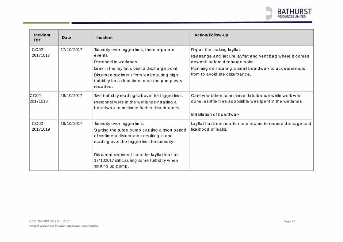
CC02 - 20171017
17/10/2017 Turbidity over trigger limit, three separate events. Personnel in wetlands. Leak in the layflat close to discharge point. Disturbed sediment from leak causing high turbidity for a short time once the pump was restarted.
Repair the leaking layflat. Rearrange and secure layflat and vent bag where it comes downhill before discharge point. Planning on installing a small boardwalk to access sensors from to avoid site disturbance.
CC02 - 20171018
18/10/2017 Two turbidity readings above the trigger limit. Personnel were in the wetlands installing a boardwalk to minimise further disturbances.
Care was taken to minimise disturbance while work was done, as little time as possible was spent in the wetlands. Installation of boardwalk
CC02 - 20171019
19/10/2017 Turbidity over trigger limit. Starting the surge pump causing a short period of sediment disturbance resulting in one reading over the trigger limit for turbidity. Disturbed sediment from the layflat leak on 17/102017 still causing some turbidity when starting up pump.
Layflat has been made more secure to reduce damage and likelihood of leaks.
CCM-ENV-RPT-001 |Oct 2017 Page 23 Printed versions of this document are uncontrolled
Incident Ref. Date Incident Action/Follow-up
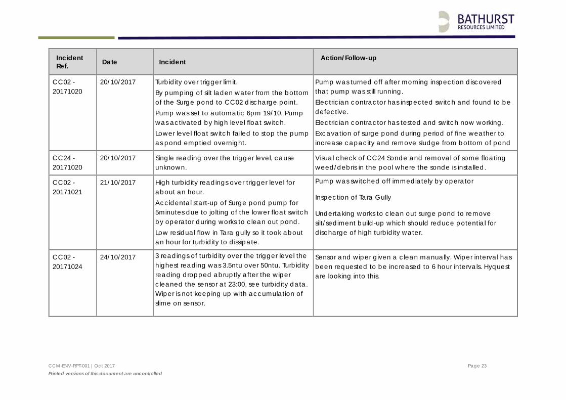
CC02 - 20171020
20/10/2017 Turbidity over trigger limit. By pumping of silt laden water from the bottom of the Surge pond to CC02 discharge point. Pump was set to automatic 6pm 19/10. Pump was activated by high level float switch. Lower level float switch failed to stop the pump as pond emptied overnight.
Pump was turned off after morning inspection discovered that pump was still running. Electrician contractor has inspected switch and found to be defective. Electrician contractor has tested and switch now working. Excavation of surge pond during period of fine weather to increase capacity and remove sludge from bottom of pond
CC24 - 20171020
20/10/2017 Single reading over the trigger level, cause unknown.
Visual check of CC24 Sonde and removal of some floating weed/debris in the pool where the sonde is installed.
CC02 - 20171021
21/10/2017 High turbidity readings over trigger level for about an hour. Accidental start-up of Surge pond pump for 5minutes due to jolting of the lower float switch by operator during works to clean out pond. Low residual flow in Tara gully so it took about an hour for turbidity to dissipate.
Pump was switched off immediately by operator
Inspection of Tara Gully
Undertaking works to clean out surge pond to remove silt/sediment build-up which should reduce potential for discharge of high turbidity water.
CC02 - 20171024
24/10/2017 3 readings of turbidity over the trigger level the highest reading was 3.5ntu over 50ntu. Turbidity reading dropped abruptly after the wiper cleaned the sensor at 23:00, see turbidity data. Wiper is not keeping up with accumulation of slime on sensor.
Sensor and wiper given a clean manually. Wiper interval has been requested to be increased to 6 hour intervals. Hyquest are looking into this.
CCM-ENV-RPT-001 |Oct 2017 Page 24 Printed versions of this document are uncontrolled
Incident Ref. Date Incident Action/Follow-up
CC24 - 20171024
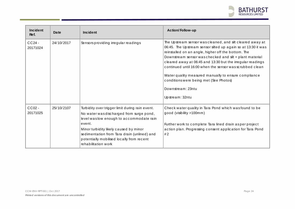
24/10/2017 Sensors providing irregular readings
The Upstream sensor was cleaned, and silt cleared away at 06:45. The Upstream sensor silted up again so at 13:30 it was reinstalled on an angle, higher off the bottom. The Downstream sensor was checked and silt + plant material cleared away at 06:45 and 13:30 but the irregular readings continued until 16:00 when the sensor was scrubbed clean
Water quality measured manually to ensure compliance conditions were being met (See Photos)
Downstream: 23ntu
Upstream: 32ntu
CC02 - 20171025
25/10/2107 Turbidity over trigger limit during rain event. No water was discharged from surge pond, level was low enough to accommodate rain event. Minor turbidity likely caused by minor sedimentation from Tara drain (unlined) and potentially mobilised locally from recent rehabilitation work
Check water quality in Tara Pond which was found to be good (visibility >100mm) Further work to complete Tara lined drain as per project action plan. Progressing consent application for Tara Pond #2
CCM-ENV-RPT-001 |Oct 2017 Page 25 Printed versions of this document are uncontrolled
Incident Ref. Date Incident Action/Follow-up
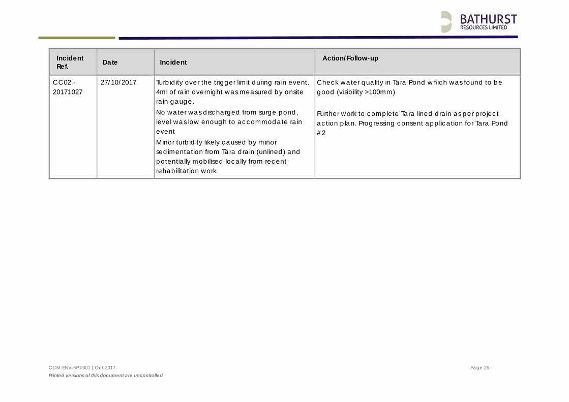
CC02 - 20171027
27/10/2017 Turbidity over the trigger limit during rain event. 4ml of rain overnight was measured by onsite rain gauge. No water was discharged from surge pond, level was low enough to accommodate rain event Minor turbidity likely caused by minor sedimentation from Tara drain (unlined) and potentially mobilised locally from recent rehabilitation work
Check water quality in Tara Pond which was found to be good (visibility >100mm) Further work to complete Tara lined drain as per project action plan. Progressing consent application for Tara Pond #2
CCM-ENV-RPT-001 |Oct 2017 Page 26 Printed versions of this document are uncontrolled
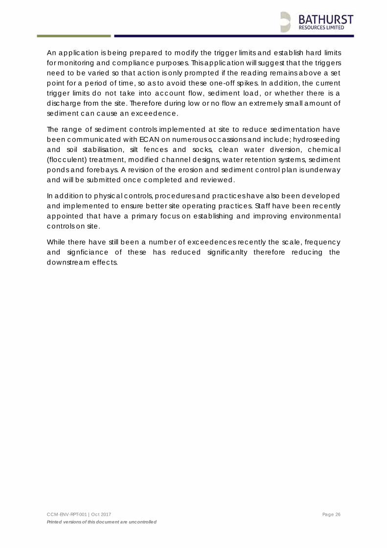
An application is being prepared to modify the trigger limits and establish hard limits for monitoring and compliance purposes. This application will suggest that the triggers need to be varied so that action is only prompted if the reading remains above a set point for a period of time, so as to avoid these one-off spikes. In addition, the current trigger limits do not take into account flow, sediment load, or whether there is a discharge from the site. Therefore during low or no flow an extremely small amount of sediment can cause an exceedence.
The range of sediment controls implemented at site to reduce sedimentation have been communicated with ECAN on numerous occassions and include; hydroseeding and soil stabilisation, silt fences and socks, clean water diversion, chemical (flocculent) treatment, modified channel designs, water retention systems, sediment ponds and forebays. A revision of the erosion and sediment control plan is underway and will be submitted once completed and reviewed.
In addition to physical controls, procedures and practices have also been developed and implemented to ensure better site operating practices. Staff have been recently appointed that have a primary focus on establishing and improving environmental controls on site.
While there have still been a number of exceedences recently the scale, frequency and signficiance of these has reduced significanlty therefore reducing the downstream effects.

CCM-ENV-RPT-001 |Oct 2017 Page 27 Printed versions of this document are uncontrolled
Appendix 1: O’Kane Consultants Analysis of Water Monitoring Results
Integrated Mine Waste Management and Closure Services Specialists in Geochemistry and Unsaturated Zone Hydrology
O'Kane Consultants (NZ) Ltd PO Box 8257 Riccarton, Christchurch 8440 New Zealand www.okc-sk.com
Memorandum To: Campbell Robertson – Environmental Manager, Bathurst Resources (NZ) Ltd
From: William Olds, Civil / Environmental Engineer
Cc: Paul Weber – O'Kane Consultants
Our ref: 895-9-10
Date: 2 November 2017
Re: Canterbury Coal - Annual Reporting to ECan 2017
Introduction
O’Kane Consultants (NZ) Ltd (OKC) were retained by Bathurst Resources Limited (BRL) to assist with compilation of the annual water monitoring report for Environment Canterbury (ECan) for both the Tara (CRC170541) and Bush Gully (CRC173823) resource consents. This memorandum addresses some of the requirements in those consents.
Background
OKC have provided consultancy services at the Canterbury Coal Mine (CCM) since the mine was purchased by BRL in late 2013. OKC started routine monthly water quality monitoring within the Tara Gully catchment in August 2015. In August 2016 routine monitoring was extended to include sites within the Bush Gully Catchment. The typical monitoring programme includes:
Field measurements (by OKC) – pH, conductivity, turbidity; and
Laboratory analysis (Eurofins ELS Limited) of water samples – dissolved metals, sulfate, and TSS. Eurofins is an IANZ accredited laboratory.
OKC have developed a database of water quality results at a number of investigation sites across the CCM. This memorandum summarises available water quality data for the year from 1 November 2016 to 1 November 2017.
Resource Consents
Both of BRL’s consents to discharge water have conditions requiring annual reporting of monitoring data. The annual reporting requirements are listed below.
BRL have asked OKC to comment on all consent annual reporting requirements, except for describing ‘what actions were undertaken and when those actions were implemented’ to address exceedances (Tara Gully – CRC170541, condition 24f; Bush Gully CRC173823, condition 35g). OKC understand these activities will be described by CCM in a separate document.
Consent conditions a, b, and c of consent CRC170541, condition 24; and CRC173823, condition 35 are the same for both sites and are therefore presented together.
Technical Memorandum to Bathurst Resources (NZ) Ltd Canterbury Coal - Annual Reporting to ECan 2/18
O’Kane Consultants 2 November 2017
Tara Gully
Discharge within the Tara Gully catchment is governed by CRC170541. Condition 24 of that consent states:
“The Consent Holder shall provide an Annual Report to the Canterbury Regional Council, Attention; Regional Leader Monitoring and Compliance by 1 November each year. The report shall detail the results of sampling carried out in the previous calendar year, including:
a. The name of persons who collected samples, the date and the time the samples were collected;
b. The weather and flow conditions at the time of sampling;
c. The rainfall data associated with sampling events;
d. The laboratory analysis results;
e. An interpretation of trends including comparisons to previous years' monitoring; and
f. Documentation of trigger values and the action taken to address exceedances including whatactions were undertaken and when those actions were implemented.
A copy of the Annual Report shall be provided to Te Taumutu Runanga and Te Ngai Tuahuriri Runanga each year.”
Bush Gully
Discharge within the Bush Gully catchment is governed by CRC173823. Condition 35 of that consent states:
“The Consent Holder shall provide an Annual Report to the Canterbury Regional Council, Attention; Regional Leader Monitoring and Compliance by 1 November each year. The report shall detail the results of sampling carried out in the previous calendar year, including:
a. The name of persons who collected samples, the date and the time the samples were collected;
b. The weather and flow conditions at the time of sampling;
c. The rainfall data associated with sampling events;
d. The laboratory analysis results;
e. An interpretation of trends including comparisons to previous years' monitoring;
f. An interpretation of the relationship between total suspended solids and turbidity at CC24; and
g. Documentation of trigger values and the action taken to address exceedances including whatactions were undertaken and when those actions were implemented.
A copy of the Annual Report shall be provided to Te Taumutu Runanga and Te Ngai Tuahuriri Runanga each year.”
Technical Memorandum to Bathurst Resources (NZ) Ltd Canterbury Coal - Annual Reporting to ECan 3/18
O’Kane Consultants 2 November 2017
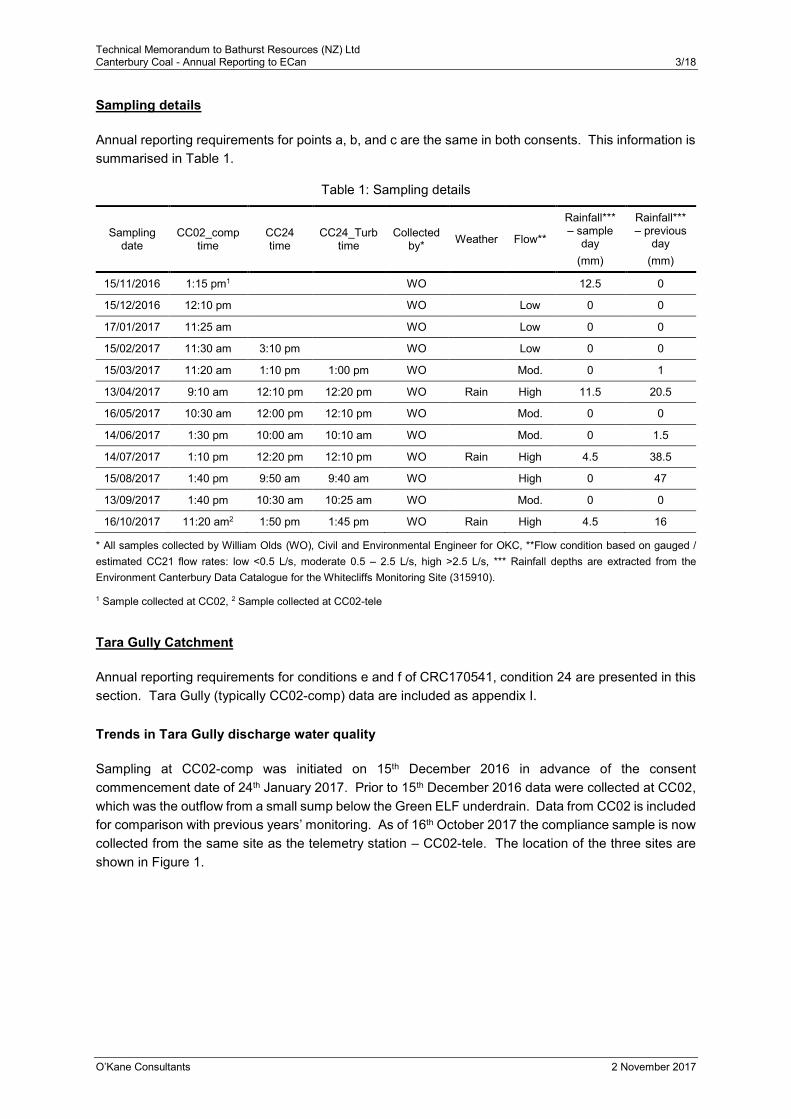
Sampling details
Annual reporting requirements for points a, b, and c are the same in both consents. This information is summarised in Table 1.
Table 1: Sampling details
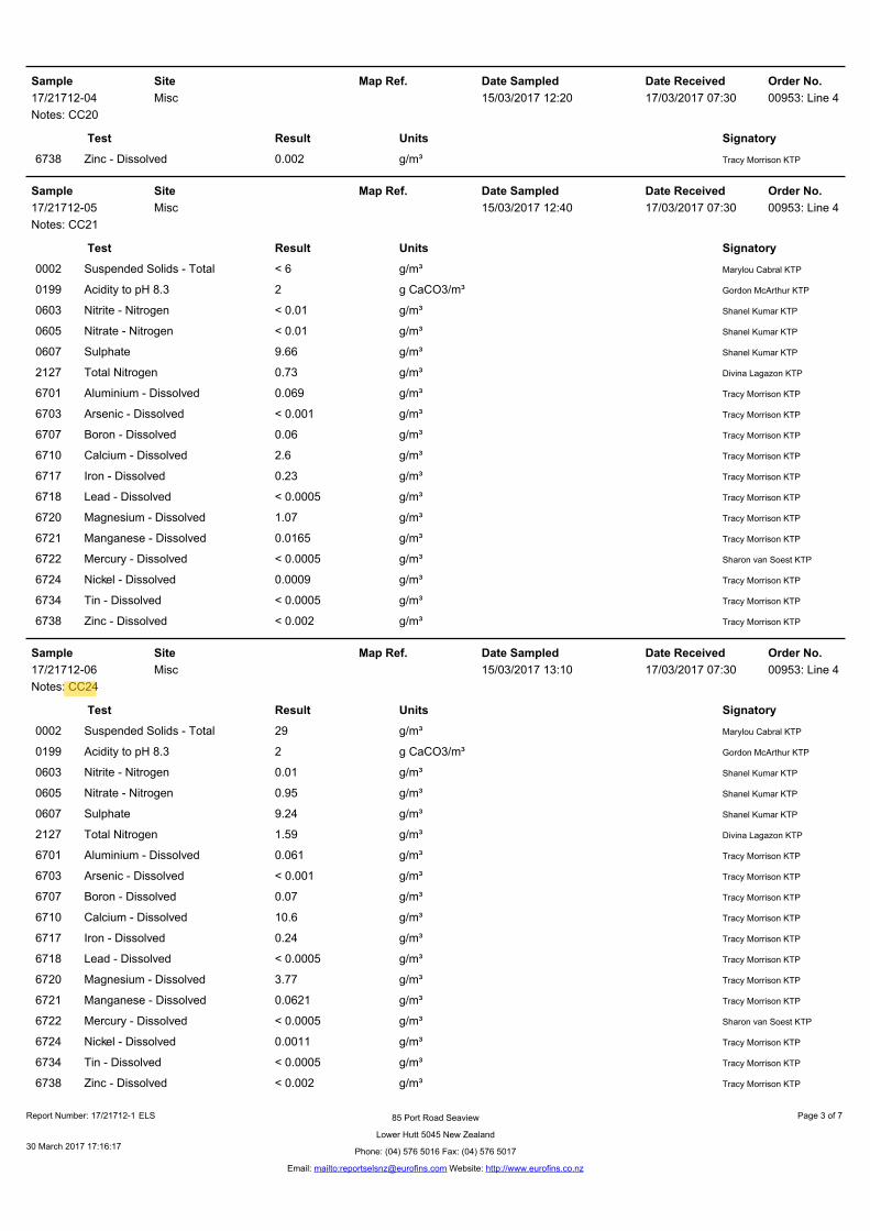
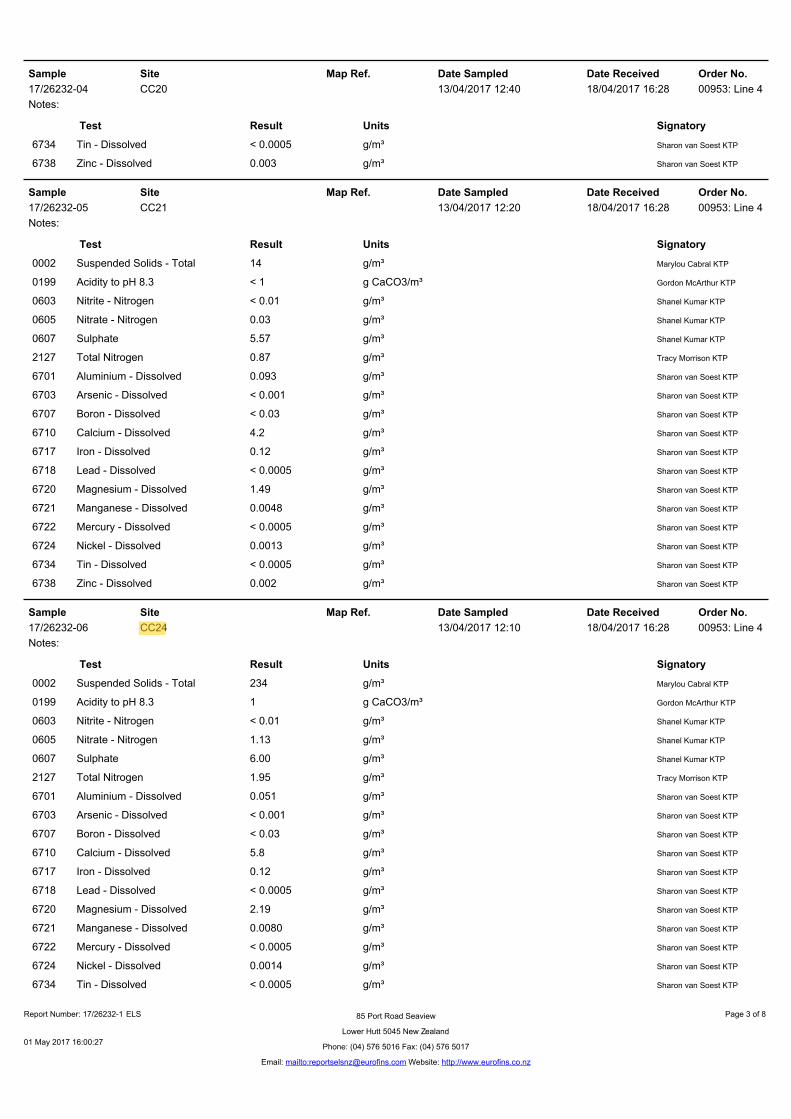
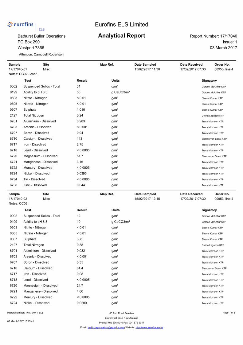
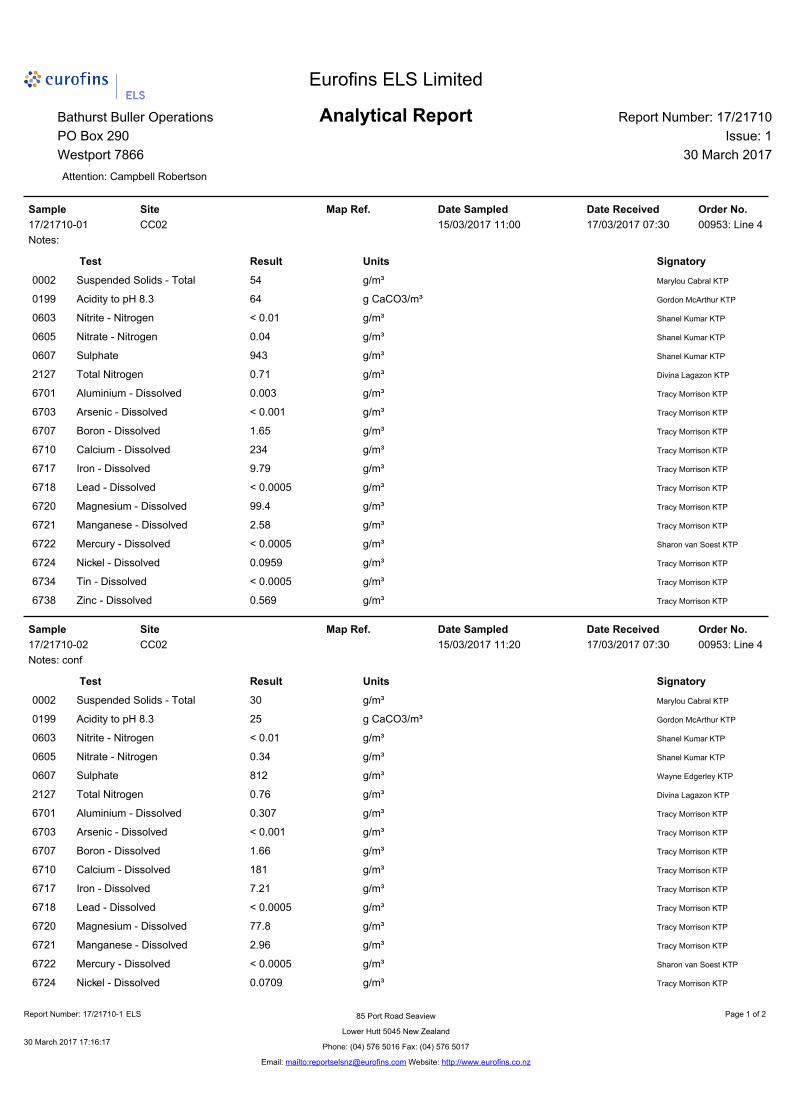
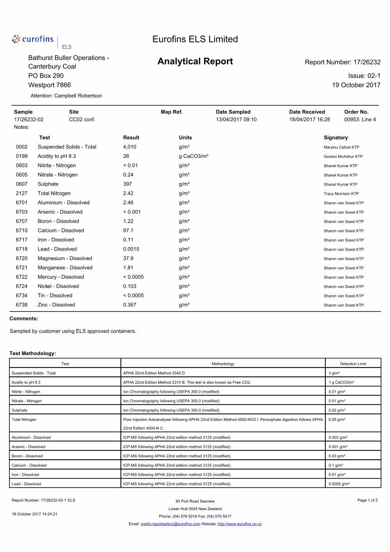
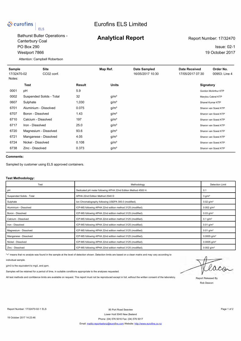
Sampling date
CC02_comp time
CC24 time
CC24_Turb time
Collected by* Weather Flow**
Rainfall*** – sample
day (mm)
Rainfall*** – previous
day (mm)
15/11/2016 1:15 pm1 WO 12.5 0
15/12/2016 12:10 pm WO Low 0 0
17/01/2017 11:25 am WO Low 0 0
15/02/2017 11:30 am 3:10 pm WO Low 0 0
15/03/2017 11:20 am 1:10 pm 1:00 pm WO Mod. 0 1
13/04/2017 9:10 am 12:10 pm 12:20 pm WO Rain High 11.5 20.5
16/05/2017 10:30 am 12:00 pm 12:10 pm WO Mod. 0 0
14/06/2017 1:30 pm 10:00 am 10:10 am WO Mod. 0 1.5
14/07/2017 1:10 pm 12:20 pm 12:10 pm WO Rain High 4.5 38.5
15/08/2017 1:40 pm 9:50 am 9:40 am WO High 0 47
13/09/2017 1:40 pm 10:30 am 10:25 am WO Mod. 0 0
16/10/2017 11:20 am2 1:50 pm 1:45 pm WO Rain High 4.5 16
* All samples collected by William Olds (WO), Civil and Environmental Engineer for OKC, **Flow condition based on gauged / estimated CC21 flow rates: low <0.5 L/s, moderate 0.5 – 2.5 L/s, high >2.5 L/s, *** Rainfall depths are extracted from the Environment Canterbury Data Catalogue for the Whitecliffs Monitoring Site (315910).
1 Sample collected at CC02, 2 Sample collected at CC02-tele
Tara Gully Catchment
Annual reporting requirements for conditions e and f of CRC170541, condition 24 are presented in this section. Tara Gully (typically CC02-comp) data are included as appendix I.
Trends in Tara Gully discharge water quality
Sampling at CC02-comp was initiated on 15th December 2016 in advance of the consent commencement date of 24th January 2017. Prior to 15th December 2016 data were collected at CC02, which was the outflow from a small sump below the Green ELF underdrain. Data from CC02 is included for comparison with previous years’ monitoring. As of 16th October 2017 the compliance sample is now collected from the same site as the telemetry station – CC02-tele. The location of the three sites are shown in Figure 1.
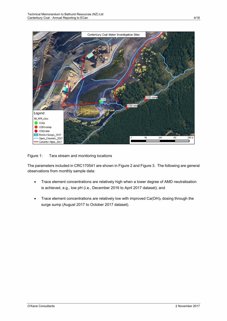
Technical Memorandum to Bathurst Resources (NZ) Ltd Canterbury Coal - Annual Reporting to ECan 4/18
O’Kane Consultants 2 November 2017
Figure 1: Tara stream and monitoring locations
The parameters included in CRC170541 are shown in Figure 2 and Figure 3. The following are general observations from monthly sample data:
Trace element concentrations are relatively high when a lower degree of AMD neutralisation is achieved, e.g., low pH (i.e., December 2016 to April 2017 dataset); and
Trace element concentrations are relatively low with improved Ca(OH)2 dosing through the surge sump (August 2017 to October 2017 dataset).
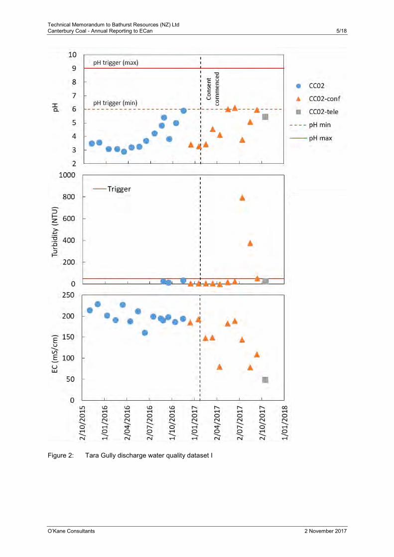
Technical Memorandum to Bathurst Resources (NZ) Ltd Canterbury Coal - Annual Reporting to ECan 5/18
O’Kane Consultants 2 November 2017
Figure 2: Tara Gully discharge water quality dataset I
Technical Memorandum to Bathurst Resources (NZ) Ltd Canterbury Coal - Annual Reporting to ECan 6/18
O’Kane Consultants 2 November 2017
Figure 3: Tara Gully discharge water quality dataset II
Technical Memorandum to Bathurst Resources (NZ) Ltd Canterbury Coal - Annual Reporting to ECan 7/18
O’Kane Consultants 2 November 2017
Figure 4: Tara Gully discharge water quality dataset III
Technical Memorandum to Bathurst Resources (NZ) Ltd Canterbury Coal - Annual Reporting to ECan 8/18
O’Kane Consultants 2 November 2017
Tara Gully compliance record
Monthly water quality sample data have been compared against the CRC170541, Condition 14 trigger values. Trigger values for Ni and Zn have been hardness modified using the consented algorithm:
𝐻𝑀𝑇𝑉 = 𝑇𝑉(𝐻/30)0.85
Where: HMTV is the hardness modified trigger value (mg/L);
TV is the Condition 14 trigger value; and
H is the water hardness (mg CaCO3/L).
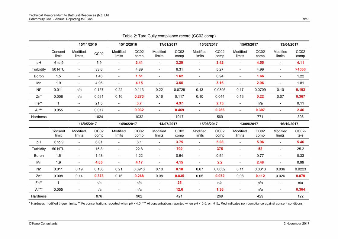
The measured water quality data are compared against trigger values and modified trigger values in Table 2. Over the past six months (16th May 2017 onwards) there have been regular non-compliance for pH, turbidity, Mn, and Zn.
Technical Memorandum to Bathurst Resources (NZ) Ltd Canterbury Coal - Annual Reporting to ECan 9/18
O’Kane Consultants 2 November 2017
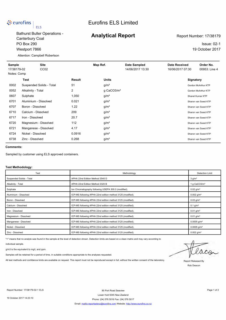
Table 2: Tara Gully compliance record (CC02 comp)
15/11/2016 15/12/2016 17/01/2017 15/02/2017 15/03/2017 13/04/2017
Consent limit
Modified limits CC02 Modified
limits CC02 comp
Modified limits
CC02 comp
Modified limits
CC02 comp
Modified limits
CC02 comp
Modified limits
CC02 comp
pH 6 to 9 - 5.9 - 3.41 - 3.29 - 3.42 - 4.55 - 4.11
Turbidity 50 NTU - 33.6 - 4.89 - 6.31 - 5.27 - 4.99 - >1000
Boron 1.5 - 1.46 - 1.51 - 1.62 - 0.94 - 1.66 - 1.22
Mn 1.9 - 4.96 - 4.15 - 3.55 - 3.16 - 2.96 - 1.81
Ni* 0.011 n/a 0.157 0.22 0.113 0.22 0.0729 0.13 0.0395 0.17 0.0709 0.10 0.103
Zn* 0.008 n/a 0.531 0.16 0.273 0.16 0.117 0.10 0.044 0.13 0.22 0.07 0.367
Fe** 1 - 21.5 - 3.7 - 4.97 - 2.75 - n/a - 0.11
Al*** 0.055 - 0.017 - 0.932 - 0.469 - 0.283 - 0.307 - 2.46
Hardness 1024 1032 1017 569 771 398
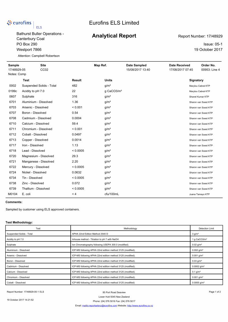
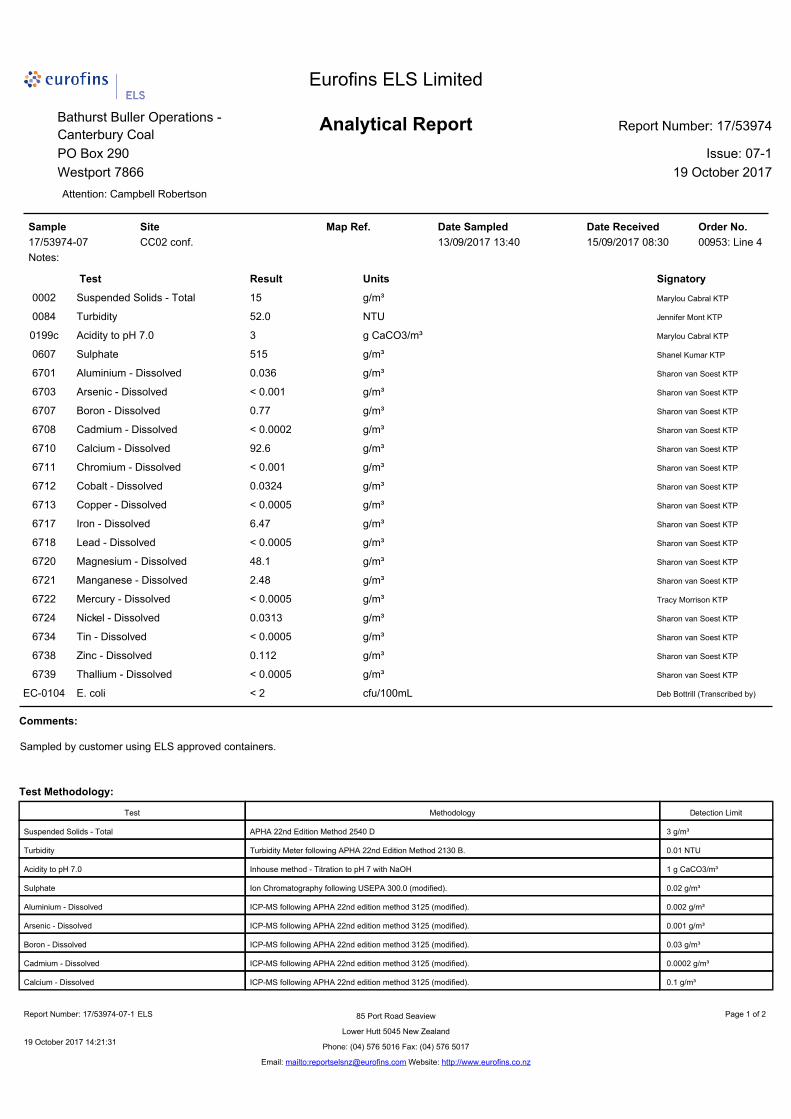
16/05/2017 14/06/2017 14/07/2017 15/08/2017 13/09/2017 16/10/2017
Consent limit
Modified limits
CC02 comp
Modified limits
CC02 comp
Modified limits
CC02 comp
Modified limits
CC02 comp
Modified limits
CC02 comp
Modified limits
CC02-tele
pH 6 to 9 - 6.01 - 6.1 - 3.75 - 5.08 - 5.96 - 5.46
Turbidity 50 NTU - 15.8 - 22.8 - 792 - 375 - 52 - 25.2
Boron 1.5 - 1.43 - 1.22 - 0.64 - 0.54 - 0.77 - 0.33
Mn 1.9 - 4.05 - 4.17 - 4.15 - 2.2 - 2.48 - 0.99
Ni* 0.011 0.19 0.108 0.21 0.0916 0.10 0.18 0.07 0.0632 0.11 0.0313 0.036 0.0223
Zn* 0.008 0.14 0.373 0.16 0.268 0.08 0.835 0.05 0.072 0.08 0.112 0.026 0.079
Fe** 1 - n/a - n/a - 25 - n/a - n/a - n/a
Al*** 0.055 - n/a - n/a - 12.6 - 1.36 - n/a - 0.364
Hardness 876 982 421 269 429 122
* Hardness modified trigger limits, ** Fe concentrations reported when pH <4.5, *** Al concentrations reported when pH < 5.5, or >7.5., Red indicates non-compliance against consent conditions.
Technical Memorandum to Bathurst Resources (NZ) Ltd Canterbury Coal - Annual Reporting to ECan 10/18
O’Kane Consultants 2 November 2017
Bush Gully Catchment
Annual reporting requirements for conditions e, f, and g of consent CRC173823, condition 35 are presented in this section. Bush Gully (CC24) data are included as Appendix II.
Trends in Bush Gully discharge water quality
Sampling in the upper Bush Gully catchment was initiated on 17th August 2016 to gather baseline data prior to the North ELF construction. Sampling at CC24 (and CC24_Turb) was initiated on 15th February 2017 to gather data prior to commencement of CRC173823 on 2nd May 2017. Earthworks on the North ELF started early June 2017.
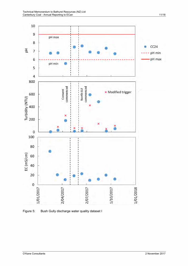
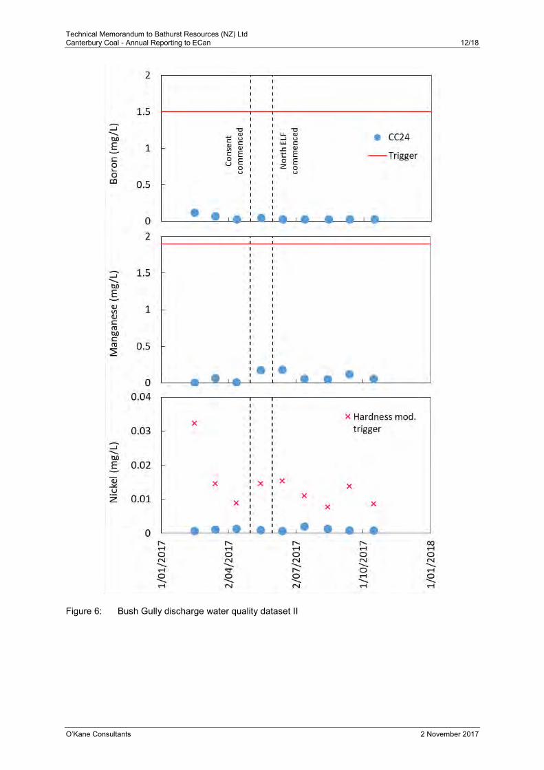
The parameters included in CRC173823 are shown in Figure 5 and Figure 6. The following are general observations from monthly sample data:
pH and metal concentrations have been compliant at CC24; and
Turbidity trigger values have been exceeded on a number of occasions.
Technical Memorandum to Bathurst Resources (NZ) Ltd Canterbury Coal - Annual Reporting to ECan 11/18
O’Kane Consultants 2 November 2017
Figure 5: Bush Gully discharge water quality dataset I
Technical Memorandum to Bathurst Resources (NZ) Ltd Canterbury Coal - Annual Reporting to ECan 12/18
O’Kane Consultants 2 November 2017
Figure 6: Bush Gully discharge water quality dataset II
Technical Memorandum to Bathurst Resources (NZ) Ltd Canterbury Coal - Annual Reporting to ECan 13/18
O’Kane Consultants 2 November 2017
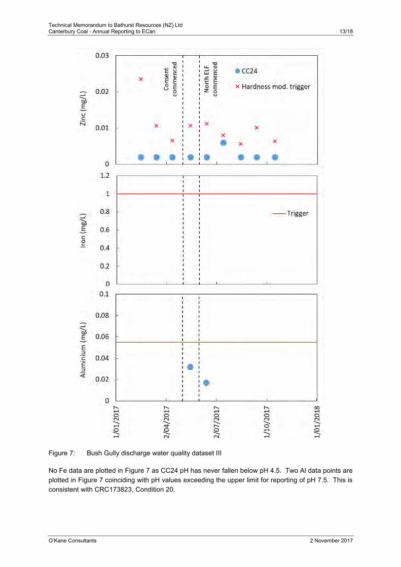
Figure 7: Bush Gully discharge water quality dataset III
No Fe data are plotted in Figure 7 as CC24 pH has never fallen below pH 4.5. Two Al data points are plotted in Figure 7 coinciding with pH values exceeding the upper limit for reporting of pH 7.5. This is consistent with CRC173823, Condition 20.
Technical Memorandum to Bathurst Resources (NZ) Ltd Canterbury Coal - Annual Reporting to ECan 14/18
O’Kane Consultants 2 November 2017
Bush Gully compliance record
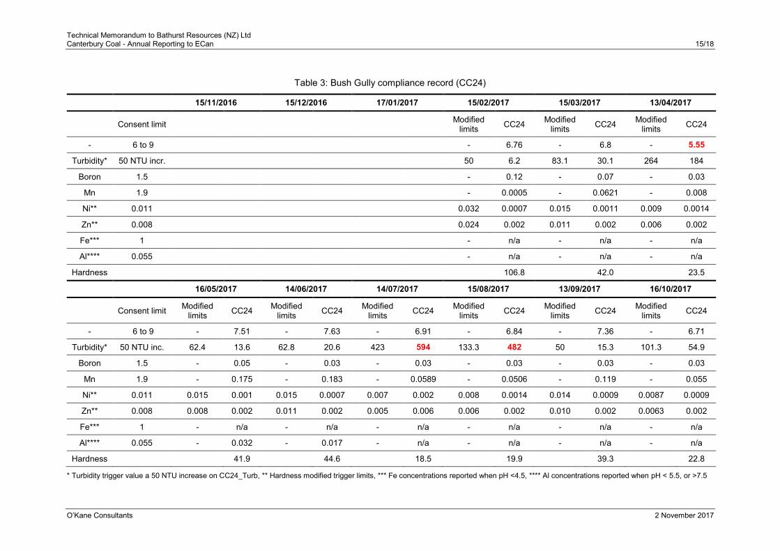
Monthly water quality data have been compared against the CRC173823, Condition 23 trigger values. The CC24 turbidity trigger is based on a maximum 50 NTU increase from the upstream CC24_Turb site. Trigger values for Ni and Zn have been hardness modified using the consented algorithm:
𝐻𝑀𝑇𝑉 = 𝑇𝑉(𝐻/30)0.85
Where HMTV is the hardness modified trigger value (mg/L);
TV is the Condition 23 trigger value; and
H is the water hardness (mg CaCO3/L).
The measured water quality data are compared against trigger values and modified trigger values in Table 3. Over the past five months (14th June 2017 onwards) there has been occasional non-compliance for turbidity during monthly sampling, typically during rain events.
Technical Memorandum to Bathurst Resources (NZ) Ltd Canterbury Coal - Annual Reporting to ECan 15/18
O’Kane Consultants 2 November 2017
Table 3: Bush Gully compliance record (CC24)
15/11/2016 15/12/2016 17/01/2017 15/02/2017 15/03/2017 13/04/2017
Consent limit Modified limits CC24 Modified
limits CC24 Modified limits CC24
- 6 to 9 - 6.76 - 6.8 - 5.55
Turbidity* 50 NTU incr. 50 6.2 83.1 30.1 264 184
Boron 1.5 - 0.12 - 0.07 - 0.03
Mn 1.9 - 0.0005 - 0.0621 - 0.008
Ni** 0.011 0.032 0.0007 0.015 0.0011 0.009 0.0014
Zn** 0.008 0.024 0.002 0.011 0.002 0.006 0.002
Fe*** 1 - n/a - n/a - n/a
Al**** 0.055 - n/a - n/a - n/a
Hardness 106.8 42.0 23.5
16/05/2017 14/06/2017 14/07/2017 15/08/2017 13/09/2017 16/10/2017
Consent limit Modified limits CC24 Modified
limits CC24 Modified limits CC24 Modified
limits CC24 Modified limits CC24 Modified
limits CC24
- 6 to 9 - 7.51 - 7.63 - 6.91 - 6.84 - 7.36 - 6.71
Turbidity* 50 NTU inc. 62.4 13.6 62.8 20.6 423 594 133.3 482 50 15.3 101.3 54.9
Boron 1.5 - 0.05 - 0.03 - 0.03 - 0.03 - 0.03 - 0.03
Mn 1.9 - 0.175 - 0.183 - 0.0589 - 0.0506 - 0.119 - 0.055
Ni** 0.011 0.015 0.001 0.015 0.0007 0.007 0.002 0.008 0.0014 0.014 0.0009 0.0087 0.0009
Zn** 0.008 0.008 0.002 0.011 0.002 0.005 0.006 0.006 0.002 0.010 0.002 0.0063 0.002
Fe*** 1 - n/a - n/a - n/a - n/a - n/a - n/a
Al**** 0.055 - 0.032 - 0.017 - n/a - n/a - n/a - n/a
Hardness 41.9 44.6 18.5 19.9 39.3 22.8
* Turbidity trigger value a 50 NTU increase on CC24_Turb, ** Hardness modified trigger limits, *** Fe concentrations reported when pH <4.5, **** Al concentrations reported when pH < 5.5, or >7.5
Technical Memorandum to Bathurst Resources (NZ) Ltd Canterbury Coal - Annual Reporting to ECan 16/18
O’Kane Consultants 2 November 2017
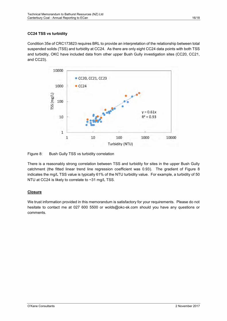
CC24 TSS vs turbidity
Condition 35e of CRC173823 requires BRL to provide an interpretation of the relationship between total suspended solids (TSS) and turbidity at CC24. As there are only eight CC24 data points with both TSS and turbidity, OKC have included data from other upper Bush Gully investigation sites (CC20, CC21, and CC23).
Figure 8: Bush Gully TSS vs turbidity correlation
There is a reasonably strong correlation between TSS and turbidity for sites in the upper Bush Gully catchment (the fitted linear trend line regression coefficient was 0.93). The gradient of Figure 8 indicates the mg/L TSS value is typically 61% of the NTU turbidity value. For example, a turbidity of 50 NTU at CC24 is likely to correlate to ~31 mg/L TSS.
Closure
We trust information provided in this memorandum is satisfactory for your requirements. Please do not hesitate to contact me at 027 600 5500 or [email protected] should you have any questions or comments.

CCM-ENV-RPT-001 |Oct 2017 Page 44 Printed versions of this document are uncontrolled
Appendix II: CRC170541 (Bush Gully) Laboratory Analysis Results

CCM-ENV-RPT-001 |Oct 2017 Page 58 Printed versions of this document are uncontrolled
Appendix III: CRC173823 (Tara Gully) Laboratory Analysis Results

CCM-ENV-RPT-001 |Oct 2017 Page 81 Printed versions of this document are uncontrolled
Appendix IV: Trigger Value Exceedance Reports Tara Gully
CAN-ENV-GDL-Incident Notification| December 2014
Page 1
Printed versions of this document are uncontrolled Version 1.0
CAN-ENV-GDL-Incident Notification to Regulators
Canterbury Coal Mine
Incident Notification Report
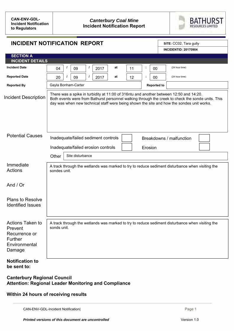
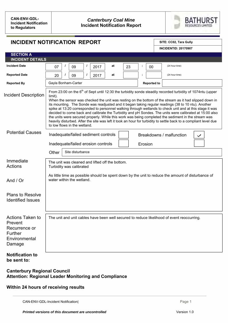
INCIDENT NOTIFICATION REPORT SITE: CC02, Tara gully INCIDENTID: 20170904
SECTION A INCIDENT DETAILS
Incident Date / / at : (24 hour time)
Reported Date / / at : (24 hour time)
Reported By Reported to
Incident Description
Potential Causes
Immediate Actions And / Or Plans to Resolve Identified Issues
Actions Taken to Prevent Recurrence or Further Environmental Damage
Notification to be sent to: Canterbury Regional Council Attention: Regional Leader Monitoring and Compliance Within 24 hours of receiving results
Erosion Inadequate/failed erosion controls
A track through the wetlands was marked to try to reduce sediment disturbance when visiting the sonds unit.
Other
A track through the wetlands was marked to try to reduce sediment disturbance when visiting the sondes unit.
Site disturbance
Gayla Bonham-Carter
Breakdowns / malfunction Inadequate/failed sediment controls
09
09 2017 11 00
00 12 2017 20
04
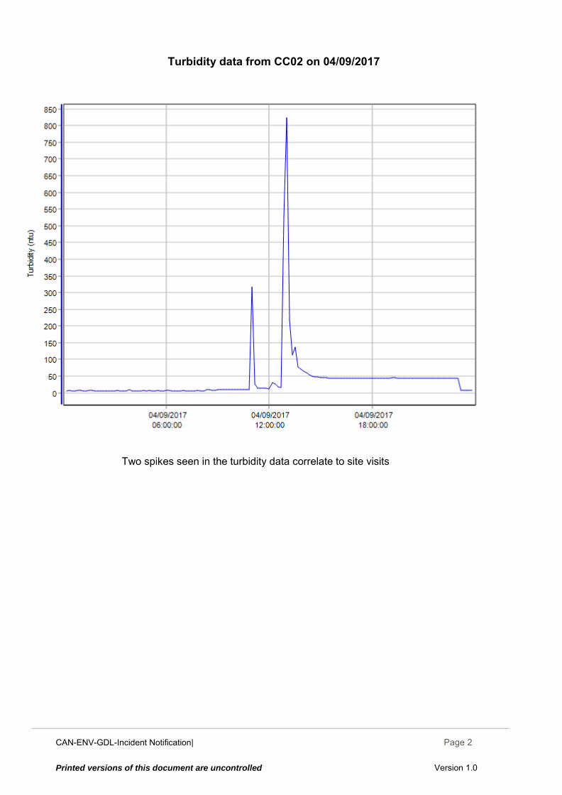
There was a spike in turbidity at 11:00 of 316ntu and another between 12:50 and 14:20. Both events were from Bathurst personnel walking through the creek to check the sonde units. This day was when new technical staff were being shown the site and how the sondes unit works.
CAN-ENV-GDL-Incident Notification| December 2014
Page 2
Printed versions of this document are uncontrolled Version 1.0
Turbidity data from CC02 on 04/09/2017
Two spikes seen in the turbidity data correlate to site visits
CAN-ENV-GDL-Incident Notification| December 2014
Page 1
Printed versions of this document are uncontrolled Version 1.0
CAN-ENV-GDL-Incident Notification to Regulators
Canterbury Coal Mine
Incident Notification Report
INCIDENT NOTIFICATION REPORT SITE: CC02, Tara Gully
INCIDENTID: 20170907
SECTION A INCIDENT DETAILS
Incident Date / / at : (24 hour time)
Reported Date / / at : (24 hour time)
Reported By Reported to
Incident Description
Potential Causes
Immediate Actions And / Or Plans to Resolve Identified Issues
Actions Taken to Prevent Recurrence or Further Environmental Damage
Notification to be sent to: Canterbury Regional Council Attention: Regional Leader Monitoring and Compliance Within 24 hours of receiving results
Erosion Inadequate/failed erosion controls
The unit and unit cables have been well secured to reduce likelihood of event reoccurring.
Other
The unit was cleaned and lifted off the bottom. Turbidity was calibrated As little time as possible should be spent down by the unit to reduce the amount of disturbance of water within the wetland.
Site disturbance
Gayla Bonham-Carter
Breakdowns / malfunction Inadequate/failed sediment controls
09
09 2017 23 00
2017 20
07
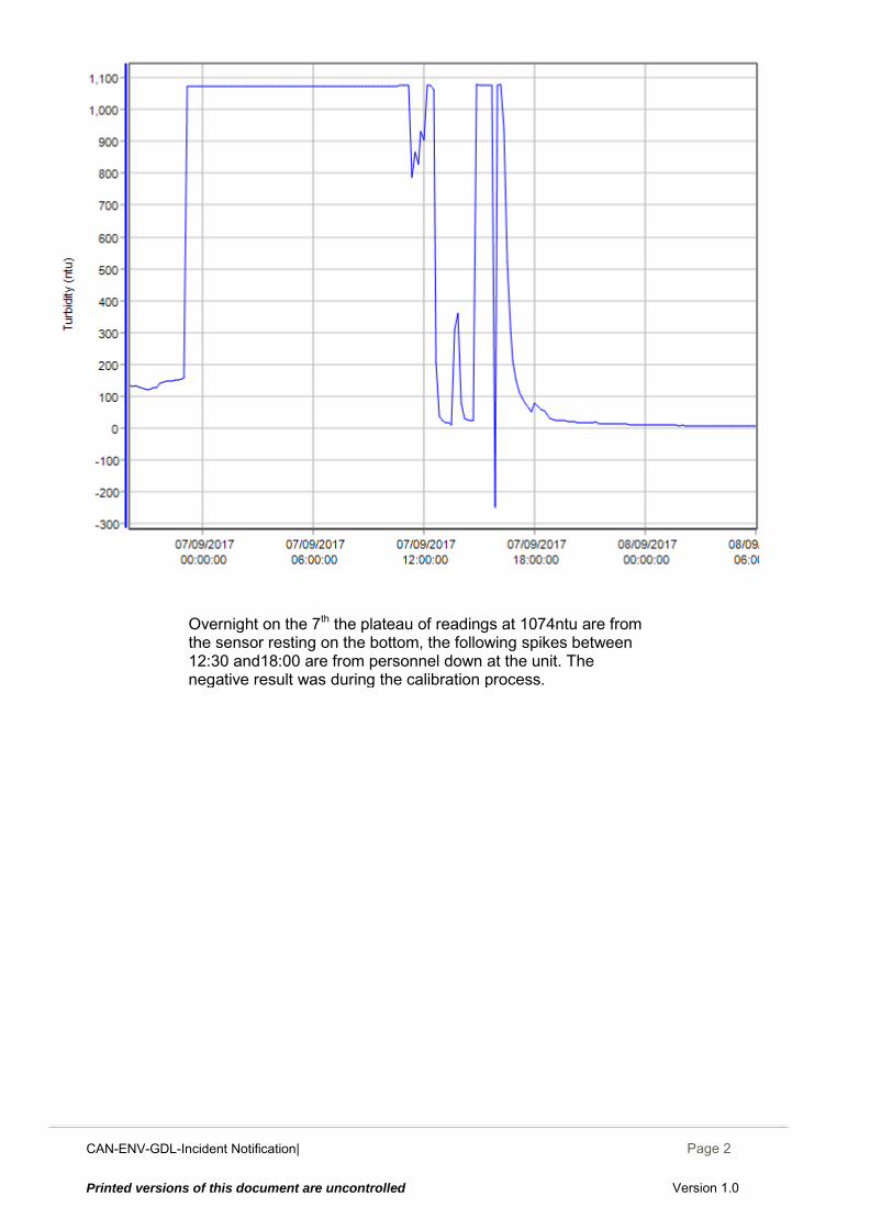
From 23:00 on the 6th of Sept until 12:30 the turbidity sonde steadily recorded turbidity of 1074ntu (upper limit). When the sensor was checked the unit was resting on the bottom of the stream as it had slipped down in its mounting. The Sonde was readjusted and it began taking regular readings (38 to 10 ntu). Another spike at 13:20 corresponded to personnel walking through wetlands to check unit and at this stage it was decided to come back and calibrate the Turbidity and pH Sondes. The units were calibrated at 15:00 also the units were secured properly. While this work was being completed the sediment in the stream was heavily disturbed. After the site was left it took an hour for turbidity to settle back to a compliant level due to low flows in the wetland.
CAN-ENV-GDL-Incident Notification| December 2014
Page 2
Printed versions of this document are uncontrolled Version 1.0
Overnight on the 7th the plateau of readings at 1074ntu are from the sensor resting on the bottom, the following spikes between 12:30 and18:00 are from personnel down at the unit. The negative result was during the calibration process.
CAN-ENV-GDL-Incident Notification| December 2014
Page 1
Printed versions of this document are uncontrolled Version 1.0
CAN-ENV-GDL-Incident Notification to Regulators
Canterbury Coal Mine
Incident Notification Report
INCIDENT NOTIFICATION REPORT SITE: CC02, Tara Gully
INCIDENTID: 20170910
SECTION A INCIDENT DETAILS
Incident Date / / at : (24 hour time)
Reported Date / / at : (24 hour time)
Reported By Reported to
Incident Description
Potential Causes
Immediate Actions And / Or Plans to Resolve Identified Issues
Actions Taken to Prevent Recurrence or Further Environmental Damage
Notification to be sent to: Canterbury Regional Council Attention: Regional Leader Monitoring and Compliance Within 24 hours of receiving results
Inadequate/failed erosion controls Erosion
Plan to line drain to limit future exceedances.
Other
Increased flocculent dosing by adding additional floc socks
Site disturbance
Gayla Bonham-Carter
Breakdowns / malfunction Inadequate/failed sediment controls
09
09 2017 13 10
2017 20
10
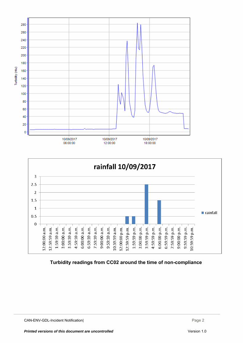
Across the non-compliance period (Sunday between 13:10 – 23:00) there were 5 spikes of 120, 102, 236, 283 and 169ntu respectively. Between spikes there was a regular reading of around 50ntu. Peaks correspond to higher intensity rainfall that occurred. Shortly after the rain stopped the turbidity dropped back below trigger levels.
CAN-ENV-GDL-Incident Notification| December 2014
Page 2
Printed versions of this document are uncontrolled Version 1.0
Turbidity readings from CC02 around the time of non-compliance
CAN-ENV-GDL-Incident Notification| December 2014
Page 1
Printed versions of this document are uncontrolled Version 1.0
CAN-ENV-GDL-Incident Notification to Regulators
Canterbury Coal Mine
Incident Notification Report
INCIDENT NOTIFICATION REPORT SITE: CC02, Tara Gully
INCIDENTID: 20170911
SECTION A INCIDENT DETAILS
Incident Date / / at : (24 hour time)
Reported Date / / at : (24 hour time)
Reported By Reported to
Incident Description
Potential Causes Immediate Actions And / Or Plans to Resolve Identified Issues
Actions Taken to Prevent Recurrence or Further Environmental Damage
Notification to be sent to: Canterbury Regional Council Attention: Regional Leader Monitoring and Compliance Within 24 hours of receiving results
Inadequate/failed erosion controls
As little time as possible was spent walking through the wetland.
Erosion
Other
.
Site disturbance
Gayla Bonham-Carter
Breakdowns / malfunction Inadequate/failed sediment controls
09
09 2017 12 40
30 17 2017 20
11
One reading of 155ntu at 12:40 which coincided with personnel walking through the wet land to check the sonds after the non-compliance occurrences over the weekend. (see incident report 20170910)
CAN-ENV-GDL-Incident Notification| December 2014
Page 2
Printed versions of this document are uncontrolled Version 1.0
Turbidity data from CC02 during the non-compliance
CAN-ENV-GDL-Incident Notification| December 2014
Page 1
Printed versions of this document are uncontrolled Version 1.0
CAN-ENV-GDL-Incident Notification to Regulators
Canterbury Coal Mine
Incident Notification Report
INCIDENT NOTIFICATION REPORT SITE: CC02, Tara Gully
INCIDENTID: 20170913
SECTION A INCIDENT DETAILS
Incident Date / / at : (24-hour time)
Reported Date / / at : (24-hour time)
Reported By Reported to
Incident Description
Potential Causes
Immediate Actions And / Or Plans to Resolve Identified Issues
Actions Taken to Prevent Recurrence or Further Environmental Damage
Notification to be sent to: Canterbury Regional Council Attention: Regional Leader Monitoring and Compliance Within 24 hours of receiving results
Inadequate/failed erosion controls Erosion
Other
Mark a trail through wetland to avoid disturbing sediment as much as possible.
Site disturbance
Gayla Bonham-Carter
Breakdowns / malfunction Inadequate/failed sediment controls
09
09 2017 13 40
00 13 2017 21
13
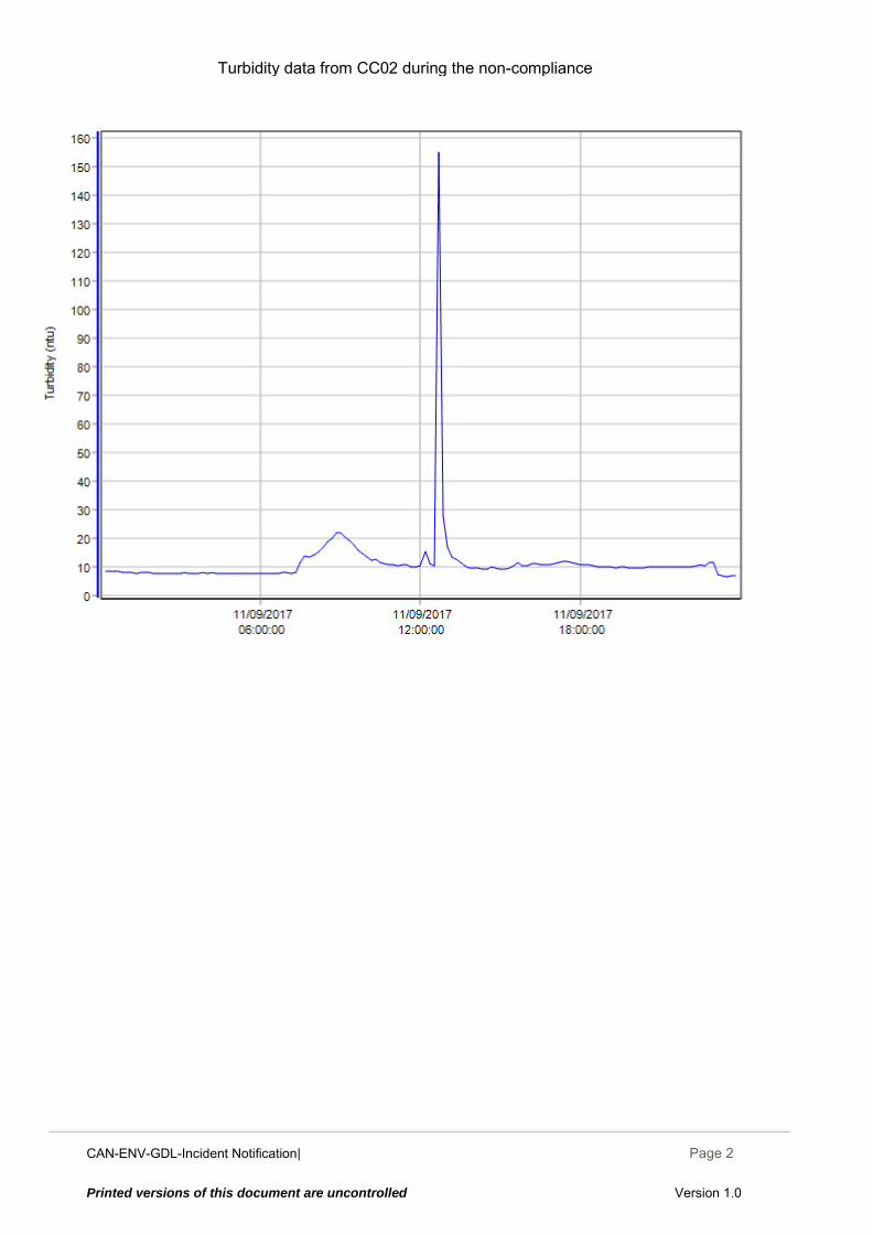
One reading over the turbidity trigger limit (466ntu). This reading coincided with when Will Olds from O’Kane consultants was walking through the wetlands near the sensor to collect monthly water samples.
CAN-ENV-GDL-Incident Notification| December 2014
Page 1
Printed versions of this document are uncontrolled Version 1.0
CAN-ENV-GDL-Incident Notification to Regulators
Canterbury Coal Mine
Incident Notification Report
INCIDENT NOTIFICATION REPORT SITE: CC02, Tara Gully
INCIDENTID: 20170915
SECTION A INCIDENT DETAILS
Incident Date / / at : (24-hour time)
Reported Date / / at : (24-hour time)
Reported By Reported to
Incident Description
Potential Causes Immediate Actions And / Or Plans to Resolve Identified Issues
Actions Taken to Prevent Recurrence or Further Environmental Damage
Notification to be sent to: Canterbury Regional Council Attention: Regional Leader Monitoring and Compliance Within 24 hours of receiving results
Areas of erosion
Inadequate/failed erosion controls
Inadequate/failed erosion controls
Decreasing the interval that the brush cleans the sensor will help avoid this issue in the future.
Erosion
Other
At 09:15 the unit and brush were given a clean and readings settled to normal levels. Decreasing the interval that the brush cleans the sensor will help avoid this issue in the future.
Gayla Bonham-Carter
Breakdowns / malfunction
Inadequate/failed sediment controls
09
09 2017 22 50
00 17 2017 21
15
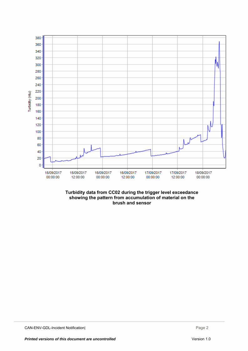
22:50 – 23:00 readings of 50.1 and 50.4ntu then the readings drop abruptly to 22.7ntu. After 23:00 every day a brush spins around and cleans the sensor to clean any build up off the sensor to get accurate readings. Due to this pattern being repeated on the 16th, 17th at 23:00 with progressively higher turbidity readings the brush was likely needing a clean as well as the unit.
CAN-ENV-GDL-Incident Notification| December 2014
Page 2
Printed versions of this document are uncontrolled Version 1.0
Turbidity data from CC02 during the trigger level exceedance showing the pattern from accumulation of material on the
brush and sensor
CAN-ENV-GDL-Incident Notification| December 2014
Page 1
Printed versions of this document are uncontrolled Version 1.0
CAN-ENV-GDL-Incident Notification to Regulators
Canterbury Coal Mine
Incident Notification Report
INCIDENT NOTIFICATION REPORT SITE: CC02, Tara gully
INCIDENTID:
SECTION A INCIDENT DETAILS
Incident Date / / at : (24 hour time)
Reported Date / / at : (24 hour time)
Reported By Reported to
Incident Description
Potential Causes Immediate Actions
And / Or
Plans to Resolve Identified Issues
Actions Taken to Prevent Recurrence or Further Environmental Damage
Notification to be sent to: Canterbury Regional Council Attention: Regional Leader Monitoring and Compliance Within 24 hours of receiving results
Inadequate/failed erosion controls
A pump and HDPE pipe system has been ordered for installation in Tara pond. The pipe will be onsite tomorrow. Water will be pumped up the hill into the larger sediment treatment ponds at the top of the hill during heavy rain events to avoid discharging storm water More Floc Socks installed. Organise labour to install the controls that are planned for directing the water into the pond, without picking up excess sediment on the way.
Erosion
Other
5 extra Floc Socks were installed into the open drains that enter Tara pond. The partially lined drain west of Tara pond was made use of in a temporary fashion so much of the run off was contained in the drain despite the drain not being fully installed. We plan to have a pump permanently installed to pump water up to the main treatment ponds during storm events. Consent for a second pond is ongoing, this would increase capacity and resident time allowing for larger volumes of surface water from green ELF to be treated. Work is still undergoing lining drains and putting nova flow in to catch and direct water off the Green ELF and along Tara Gully road.
Nature of the wetland
Gayla Bonham-Carter
Breakdowns / malfunction Inadequate/failed sediment controls
09
09 2017 11 20
2017 19
18
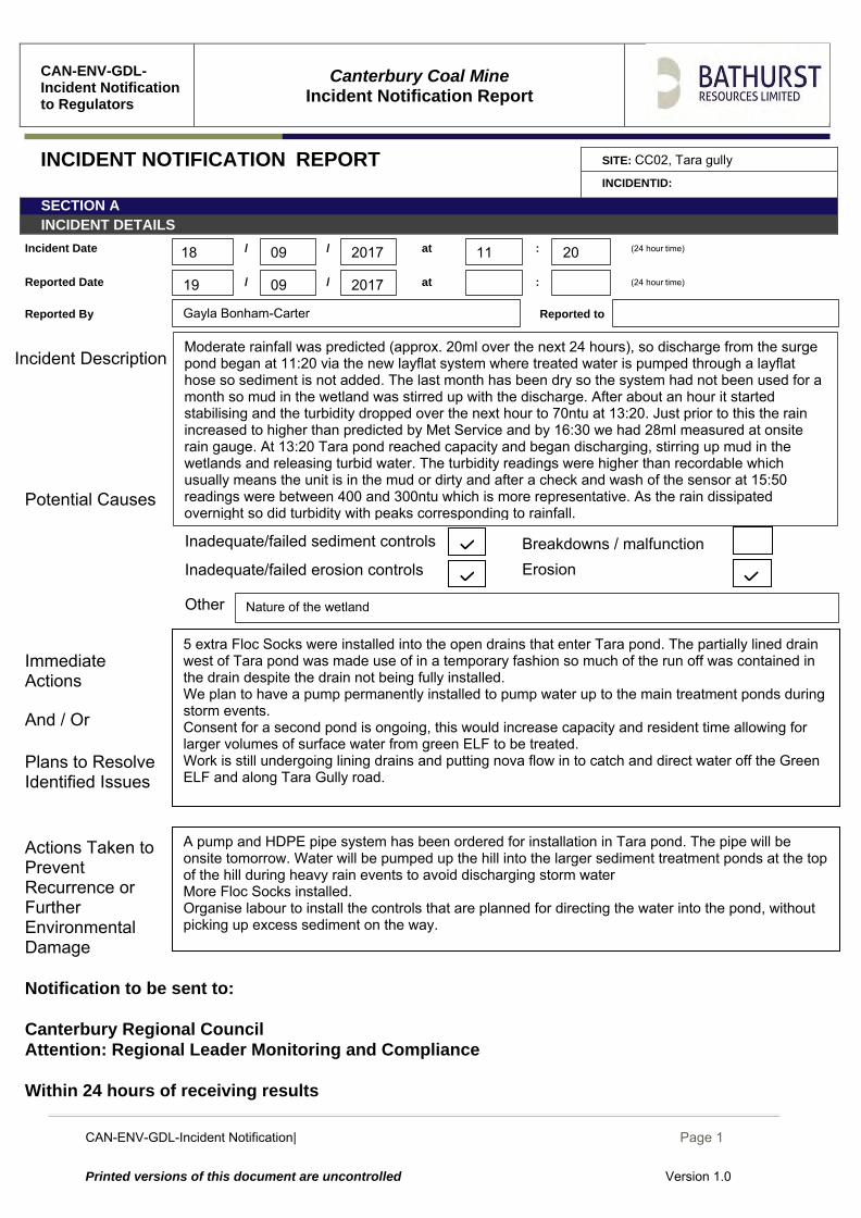
Moderate rainfall was predicted (approx. 20ml over the next 24 hours), so discharge from the surge pond began at 11:20 via the new layflat system where treated water is pumped through a layflat hose so sediment is not added. The last month has been dry so the system had not been used for a month so mud in the wetland was stirred up with the discharge. After about an hour it started stabilising and the turbidity dropped over the next hour to 70ntu at 13:20. Just prior to this the rain increased to higher than predicted by Met Service and by 16:30 we had 28ml measured at onsite rain gauge. At 13:20 Tara pond reached capacity and began discharging, stirring up mud in the wetlands and releasing turbid water. The turbidity readings were higher than recordable which usually means the unit is in the mud or dirty and after a check and wash of the sensor at 15:50 readings were between 400 and 300ntu which is more representative. As the rain dissipated overnight so did turbidity with peaks corresponding to rainfall.
CAN-ENV-GDL-Incident Notification| December 2014
Page 1
Printed versions of this document are uncontrolled Version 1.0
CAN-ENV-GDL-Incident Notification to Regulators
Canterbury Coal Mine
Incident Notification Report
INCIDENT NOTIFICATION REPORT SITE: CC02, Tara gully INCIDENTID: 20170919
SECTION A INCIDENT DETAILS
Incident Date / / at : (24 hour time)
Reported Date / / at : (24 hour time)
Reported By Reported to
Incident Description
Potential Causes
Immediate Actions And / Or Plans to Resolve Identified Issues
Actions Taken to Prevent Recurrence or Further Environmental Damage
Notification to be sent to: Canterbury Regional Council Attention: Regional Leader Monitoring and Compliance Within 24 hours of receiving results
Inadequate/failed erosion controls Erosion
A pump and HDPE system has been ordered for installation in Tara pond. Water will be pumped up the hill into the larger sediment treatment ponds at the top of the hill during heavy rain events to avoid discharging storm water.
Other
We plan to have a pump permanently installed to pump water up to the main treatment ponds during storm events. BRL are working towards Consenting a second pond in Tara, this would increase capacity and resident time allowing for larger volumes of surface water from green ELF to be treated. Work is still undergoing lining drains and putting nova flow in to catch and direct water off the Green ELF and along Tara Gully road. Plan to increase dosing by increasing number of floc socks installed on green elf drain and tara drain.
Site disturbance
Gayla Bonham-Carter
Breakdowns / malfunction Inadequate/failed sediment controls
09
09 2017 06 30
2017 20
19
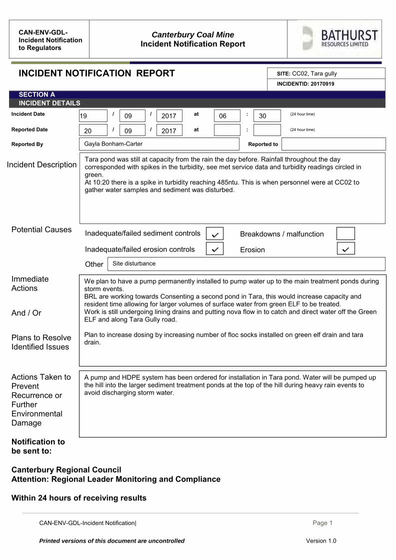
Tara pond was still at capacity from the rain the day before. Rainfall throughout the day corresponded with spikes in the turbidity, see met service data and turbidity readings circled in green. At 10:20 there is a spike in turbidity reaching 485ntu. This is when personnel were at CC02 to gather water samples and sediment was disturbed.
CAN-ENV-GDL-Incident Notification| December 2014
Page 2
Printed versions of this document are uncontrolled Version 1.0
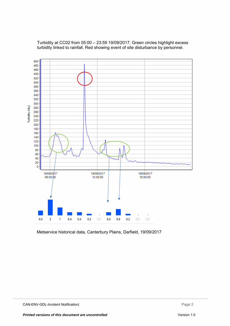
Metservice historical data, Canterbury Plains, Darfield, 19/09/2017
Turbidity at CC02 from 05:00 – 23:59 19/09/2017. Green circles highlight excess turbidity linked to rainfall. Red showing event of site disturbance by personnel.
CAN-ENV-GDL-Incident Notification| December 2014
Page 1
Printed versions of this document are uncontrolled Version 1.0
CAN-ENV-GDL-Incident Notification to Regulators
Canterbury Coal Mine
Incident Notification Report
INCIDENT NOTIFICATION REPORT SITE: CC02, Tara gully INCIDENTID: 170920
SECTION A INCIDENT DETAILS
Incident Date / / at : (24 hour time)
Reported Date / / at : (24 hour time)
Reported By Reported to
Incident Description
Potential Causes
Immediate Actions And / Or Plans to Resolve Identified Issues
Actions Taken to Prevent Recurrence or Further Environmental Damage
Notification to be sent to: Canterbury Regional Council Attention: Regional Leader Monitoring and Compliance Within 24 hours of receiving results
Inadequate/failed erosion controls Erosion
Propose to construct second pond for surge pond water to discharge into prior to flowing evenly into wetland.
Other
Repairs had been made to a leak in the vent bag today prior to beginning pumping No further immediate actions taken
E Sinclair
Breakdowns / malfunction Inadequate/failed sediment controls
09
09 2017
2017 13 00
00 17 2017 20
20
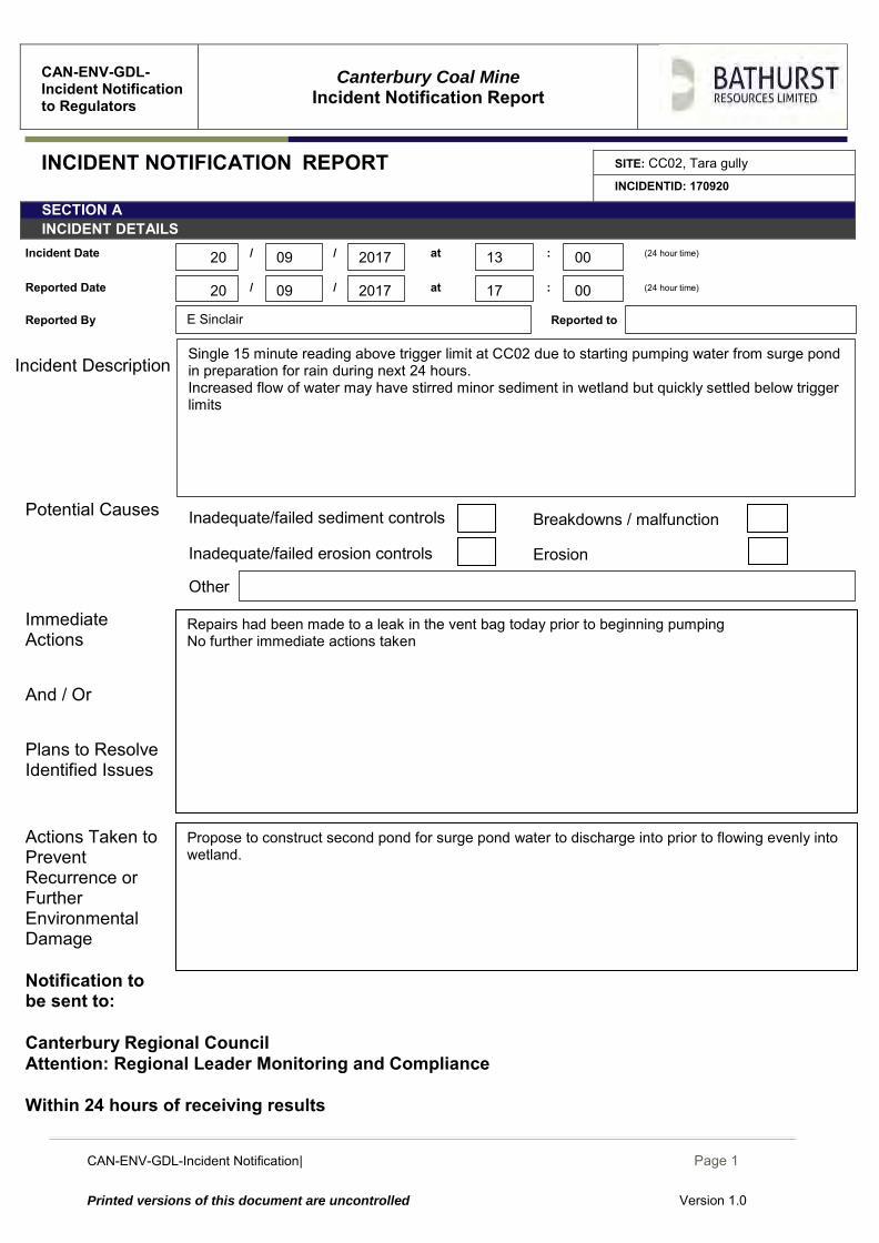
Single 15 minute reading above trigger limit at CC02 due to starting pumping water from surge pond in preparation for rain during next 24 hours. Increased flow of water may have stirred minor sediment in wetland but quickly settled below trigger limits
CAN-ENV-GDL-Incident Notification| December 2014
Page 2
Printed versions of this document are uncontrolled Version 1.0
CAN-ENV-GDL-Incident Notification| December 2014
Page 1
Printed versions of this document are uncontrolled Version 1.0
CAN-ENV-GDL-Incident Notification to Regulators
Canterbury Coal Mine
Incident Notification Report
INCIDENT NOTIFICATION REPORT SITE: CC02, Tara Gully
INCIDENTID: 20170921
SECTION A INCIDENT DETAILS
Incident Date / / at : (24-hour time)
Reported Date / / at : (24-hour time)
Reported By Reported to
Incident Description
Potential Causes
Immediate Actions And / Or Plans to Resolve Identified Issues
Actions Taken to Prevent Recurrence or Further Environmental Damage
Notification to be sent to: Canterbury Regional Council Attention: Regional Leader Monitoring and Compliance Within 24 hours of receiving results
Inadequate/failed erosion controls Erosion
Communication to staff onsite while the surge pond is being lowered should be improved. Further develop procedure for lowering the surge pond to include avoiding pumping in the dark when possible and monitoring of turbidity data during pumping process. Pump installation at Tara pond is at the top of action priority list.
Other
HDPE pipe is arriving onsite today or tomorrow, it has arrived in Darfield yesterday afternoon. Communication to staff onsite while the surge pond is being lowered should be improved. Further develop procedure for lowering the surge pond to include avoiding pumping in the dark when possible. Supervisor must monitor telemetered turbidity data as pumping is undertaken and stop pumping if trigger limits are exceeded
Failed procedures/process
Gayla Bonham-Carter
Breakdowns / malfunction Inadequate/failed sediment controls
09
09 2017 12 40
30 11 2017 22
21
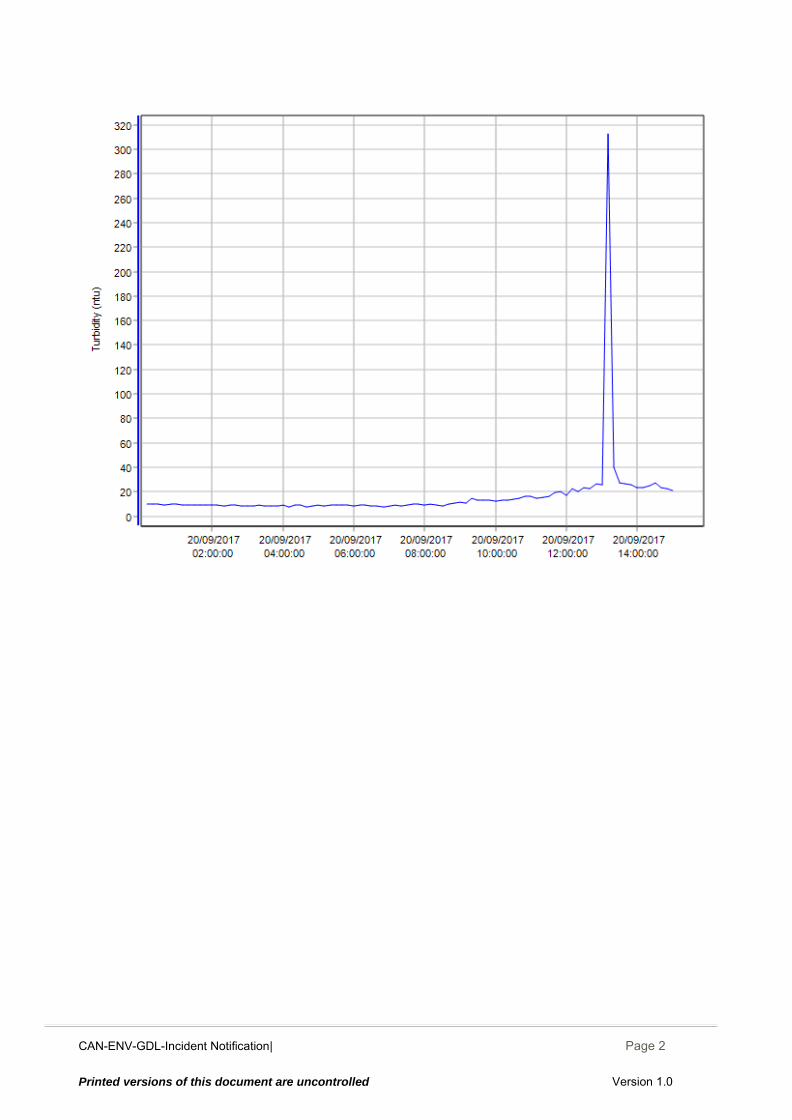
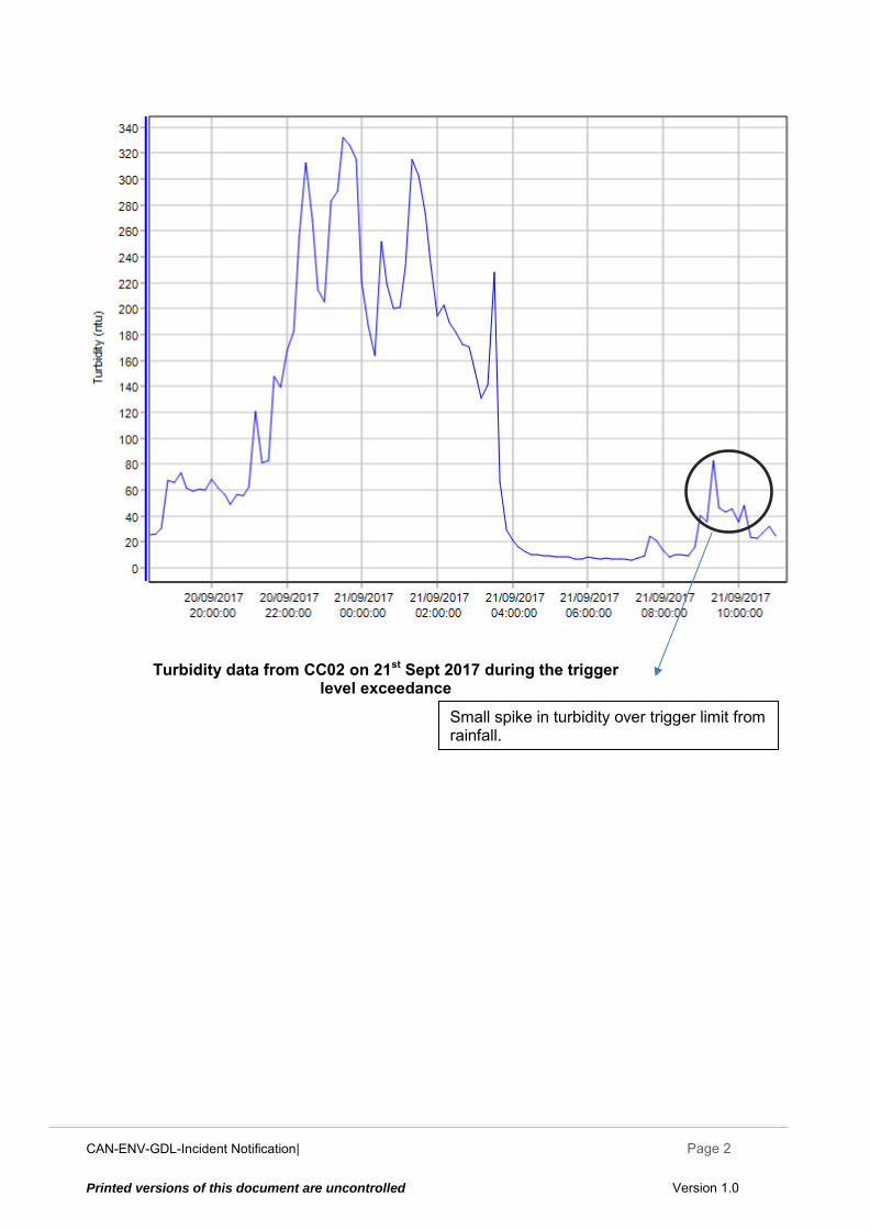
Overnight the surge pond was pumped to lower water levels for today’s rain event as per procedure. The pump was run for too long and the pump began to discharge sediment laden water as the level in the surge pond decreased. This caused discharges over the turbidity trigger limit to be released until the pump was turned off at 03:30. In the dark visually assessing the water for suitability to pump is not possible. Later in the morning there was a small spike in the turbidity above the trigger limit corresponding to increased rainfall. Tara pond has still been unable to be lowered until the pump/HDPE pipe arrives.
CAN-ENV-GDL-Incident Notification| December 2014
Page 2
Printed versions of this document are uncontrolled Version 1.0
Turbidity data from CC02 on 21st Sept 2017 during the trigger level exceedance
Small spike in turbidity over trigger limit from rainfall.
CAN-ENV-GDL-Incident Notification| December 2014
Page 1
Printed versions of this document are uncontrolled Version 1.0
CAN-ENV-GDL-Incident Notification to Regulators
Canterbury Coal Mine
Incident Notification Report
INCIDENT NOTIFICATION REPORT SITE: CC02, Tara Gully
INCIDENTID: 20170922
SECTION A INCIDENT DETAILS
Incident Date / / at : (24-hour time)
Reported Date / / at : (24-hour time)
Reported By Reported to
Incident Description
Potential Causes
Immediate Actions And / Or Plans to Resolve Identified Issues
Actions Taken to Prevent Recurrence or Further Environmental Damage
Notification to be sent to: Canterbury Regional Council Attention: Regional Leader Monitoring and Compliance Within 24 hours of receiving results
Inadequate/failed erosion controls Erosion
Communication to staff onsite while the surge pond is being lowered should be improved. Further develop procedure for lowering the surge pond to include avoiding pumping in the dark when possible and monitoring of turbidity data during pumping process. SOP for lowering the Surge pond was updated.
Other
Communication to staff onsite while the surge pond is being lowered should be improved. Further develop procedure for lowering the surge pond to include avoiding pumping in the dark when possible and improved communication to night shift. Supervisor must monitor telemetered turbidity data as pumping is undertaken and stop pumping if trigger limits are exceeded
Gayla Bonham-Carter
Breakdowns / malfunction Inadequate/failed sediment controls
09
09 2017 01 00
2017 22
22
Overnight the surge pond was pumped to lower water levels for today’s rain event as per procedure. The pump was run for too long and the pump began to discharge sediment laden water as the level in the surge pond decreased. This caused discharges over the turbidity trigger limit to be released until the pump was turned off at 06:30. Pumping started at 17:30 on 21/09/2017. A second set of readings over the trigger limit for turbidity occurred at 10:00, this coincided with increased precipitation.
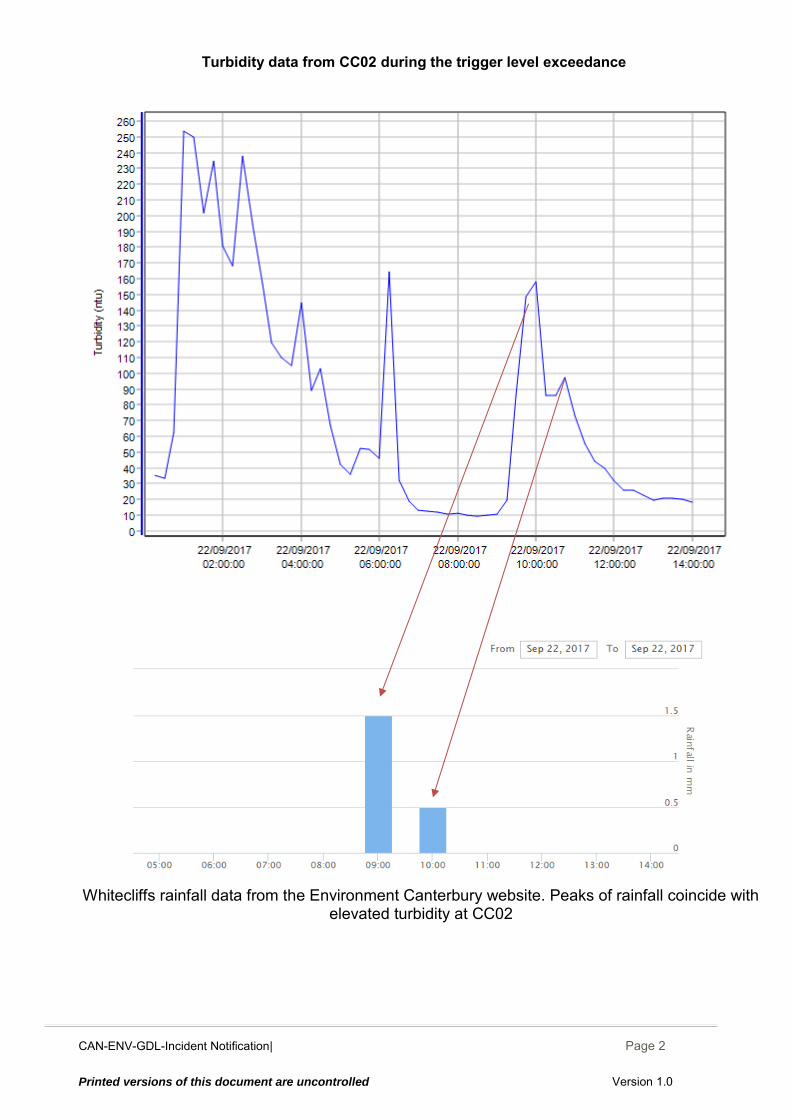
CAN-ENV-GDL-Incident Notification| December 2014
Page 2
Printed versions of this document are uncontrolled Version 1.0
Whitecliffs rainfall data from the Environment Canterbury website. Peaks of rainfall coincide with
elevated turbidity at CC02
Turbidity data from CC02 during the trigger level exceedance
CAN-ENV-GDL-Incident Notification| December 2014
Page 1
Printed versions of this document are uncontrolled Version 1.0
CAN-ENV-GDL-Incident Notification to Regulators
Canterbury Coal Mine
Incident Notification Report
INCIDENT NOTIFICATION REPORT SITE: CC02, Tara Gully
INCIDENTID: 20170924
SECTION A INCIDENT DETAILS
Incident Date / / at : (24-hour time)
Reported Date / / at : (24-hour time)
Reported By Reported to
Incident Description
Potential Causes
Immediate Actions And / Or Plans to Resolve Identified Issues
Actions Taken to Prevent Recurrence or Further Environmental Damage
Notification to be sent to: Canterbury Regional Council Attention: Regional Leader Monitoring and Compliance Within 24 hours of receiving results
Erosion Inadequate/failed erosion controls
Installation of a level switch this will turn on if the pond level is too high and in danger of overflowing and switch the pump off when the level is low to reduce likelihood of discharging high turbidity water.
Other
As soon as the overflowing surge pond was seen in the morning the surge pond dewatering pump was turned on and pumping from the pit into the surge pond was stopped. Installing a level switch for the surge pond is planned and going through approvals now. Completion of the lined Tara drain is a high priority and will allow natural spilling of water from the surge pond
Site disturbance
Gayla Bonham-Carter
Breakdowns / malfunction Inadequate/failed sediment controls
09
09 2017 17 00
2017 25
24
The West pit was pumped without monitoring the level of the surge pond and the surge pond overflowed clean water at 15:45 Sunday 24 September, picking up sediment minor before being treated in Tara pond #1 and then discharging into Tara Gully. Pumping from the pit was stopped and the surge pond pump was started when the shift started early Monday 25 September at 05:00. The spikes in turbidity of 125ntu at 08:00 on the 25th corresponding with personnel working around the tara discharge to install sediment and flocculent socks and to assess Tara Gully and check the sondes, and to check the discharge from surge pond.
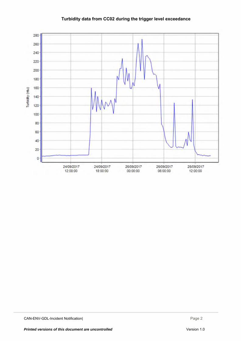
CAN-ENV-GDL-Incident Notification| December 2014
Page 2
Printed versions of this document are uncontrolled Version 1.0
Turbidity data from CC02 during the trigger level exceedance
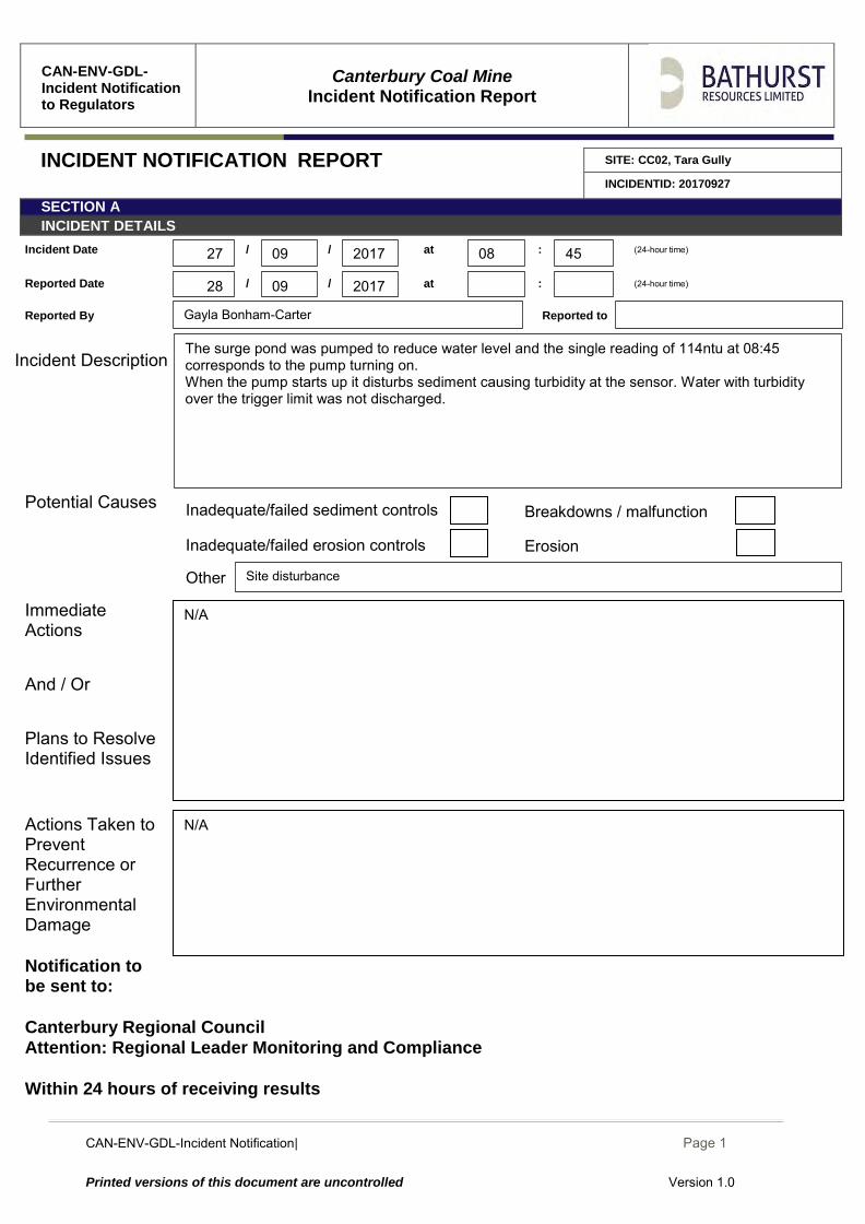
CAN-ENV-GDL-Incident Notification| December 2014
Page 1
Printed versions of this document are uncontrolled Version 1.0
CAN-ENV-GDL-Incident Notification to Regulators
Canterbury Coal Mine
Incident Notification Report
INCIDENT NOTIFICATION REPORT SITE: CC02, Tara Gully
INCIDENTID: 20170927
SECTION A INCIDENT DETAILS
Incident Date / / at : (24-hour time)
Reported Date / / at : (24-hour time)
Reported By Reported to
Incident Description
Potential Causes Immediate Actions And / Or Plans to Resolve Identified Issues
Actions Taken to Prevent Recurrence or Further Environmental Damage
Notification to be sent to: Canterbury Regional Council Attention: Regional Leader Monitoring and Compliance Within 24 hours of receiving results
Inadequate/failed erosion controls
N/A
Erosion
Other
N/A
Site disturbance
Gayla Bonham-Carter
Breakdowns / malfunction Inadequate/failed sediment controls
09
09 2017 08 45
2017 28
27
The surge pond was pumped to reduce water level and the single reading of 114ntu at 08:45 corresponds to the pump turning on. When the pump starts up it disturbs sediment causing turbidity at the sensor. Water with turbidity over the trigger limit was not discharged.
CAN-ENV-GDL-Incident Notification| December 2014
Page 2
Printed versions of this document are uncontrolled Version 1.0
Turbidity data from CC02 during the trigger level exceedance
CAN-ENV-GDL-Incident Notification| December 2014
Page 1
Printed versions of this document are uncontrolled Version 1.0
CAN-ENV-GDL-Incident Notification to Regulators
Canterbury Coal Mine
Incident Notification Report
INCIDENT NOTIFICATION REPORT SITE: CC02, Tara Gully
INCIDENTID: 20171007
SECTION A INCIDENT DETAILS
Incident Date / / at : (24-hour time)
Reported Date / / at : (24-hour time)
Reported By Reported to
Incident Description
Potential Causes Immediate Actions And / Or Plans to Resolve Identified Issues
Actions Taken to Prevent Recurrence or Further Environmental Damage
Notification to be sent to: Canterbury Regional Council Attention: Regional Leader Monitoring and Compliance Within 24 hours of receiving results
Areas of erosion Inadequate/failed erosion controls
Complete Tara Drain using drain liner Install level float switch for the surge pond pump Finalise consent application for Tara gully pond #2 and submit
The surge pond pump started at 6am 09/10/2017, Checked efficiency of ECT installation and performance of drains. Hydroseeding the exposed slopes will reduce future erosion, is booked in for this week
(Wednesday through Friday weather dependant). Heliseeding is also booked for this week.
Gayla Bonham-Carter
Inadequate/failed erosion controls Erosion
Other
Breakdowns / malfunction Inadequate/failed sediment controls
10
10 2017 07 00
00 08 2017 10
07-09
82mm of rain from 07/10/2017 to 09/10/2017 Some disturbed areas due to works completing Green ELF lined drain and rehab of disturbed
slopes with installed erosion controls to minimise sedimentation Erosion controls helped keep turbidity levels minimal and stopped major erosion throughout
event although still caused minor exceedances. On Sunday no personnel were onsite to operate the pump on surge pond and it started
overflowing from 12:30pm 08/10/2017 until 6am Monday morning when the pump was started. Spikes in Turbidity on Monday correspond with rainfall and site disturbance by personnel.
CAN-ENV-GDL-Incident Notification| December 2014
Page 2
Printed versions of this document are uncontrolled Version 1.0
Turbidity data from CC02 7th to the 10th of November 2017 during the trigger level exceedance
CAN-ENV-GDL-Incident Notification| December 2014
Page 3
Printed versions of this document are uncontrolled Version 1.0
Photos of erosion controls installed before the rain Event
Figure 1 (Above) ECT being installed along the newly constructed Green ELF lined drain. 6 were installed in total and pegged in later that day.
Hydroseeding is schedualed for all exposed soils here.
Figure 2 (Above) Lined drain and flume entry into Tara pond from Green ELF. White geotextile visible across pond is old entry point for water coming down Tara access road that water has been directed away from until a new entry is installed. Hydroseeding is schedualed for all exposed soils here.
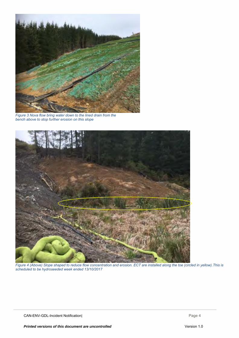
CAN-ENV-GDL-Incident Notification| December 2014
Page 4
Printed versions of this document are uncontrolled Version 1.0
Figure 3 Nova flow bring water down to the lined drain from the bench above to stop further erosion on this slope
Figure 4 (Above) Slope shaped to reduce flow concentration and erosion. ECT are installed along the toe (circled in yellow).This is scheduled to be hydroseeded week ended 13/10/2017
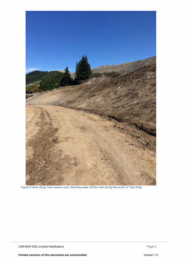
CAN-ENV-GDL-Incident Notification| December 2014
Page 5
Printed versions of this document are uncontrolled Version 1.0
Figure 5 drain along Tara access road. Directing water off the road during the works in Tara Gully.
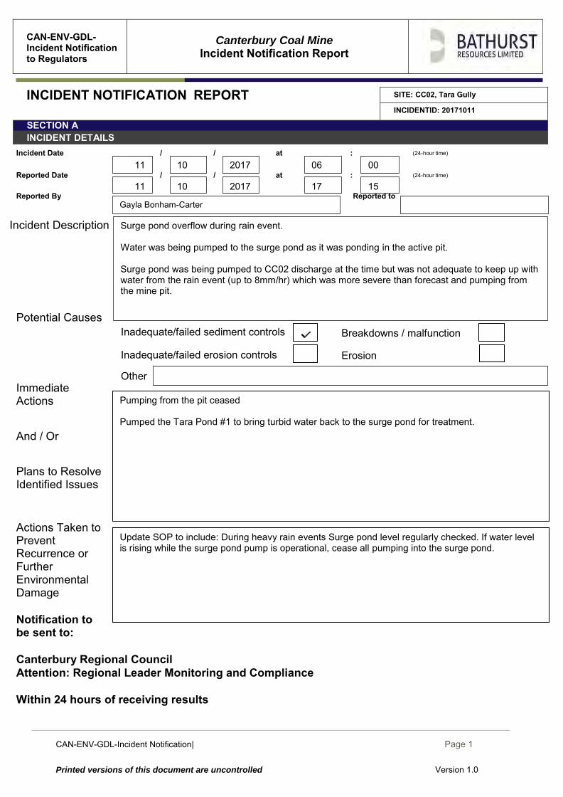
CAN-ENV-GDL-Incident Notification| December 2014
Page 1
Printed versions of this document are uncontrolled Version 1.0
CAN-ENV-GDL-Incident Notification to Regulators
Canterbury Coal Mine
Incident Notification Report
INCIDENT NOTIFICATION REPORT SITE: CC02, Tara Gully
INCIDENTID: 20171011
SECTION A INCIDENT DETAILS
Incident Date / / at : (24-hour time)
Reported Date / / at : (24-hour time)
Reported By Reported to
Incident Description
Potential Causes Immediate Actions And / Or Plans to Resolve Identified Issues
Actions Taken to Prevent Recurrence or Further Environmental Damage
Notification to be sent to: Canterbury Regional Council Attention: Regional Leader Monitoring and Compliance Within 24 hours of receiving results
Areas of erosion Inadequate/failed erosion controls Inadequate/failed erosion controls
Update SOP to include: During heavy rain events Surge pond level regularly checked. If water level is rising while the surge pond pump is operational, cease all pumping into the surge pond.
Erosion
Other
Pumping from the pit ceased Pumped the Tara Pond #1 to bring turbid water back to the surge pond for treatment.
Gayla Bonham-Carter
Breakdowns / malfunction Inadequate/failed sediment controls
10
10 2017 06 00
15 17 2017 11
11
Surge pond overflow during rain event. Water was being pumped to the surge pond as it was ponding in the active pit. Surge pond was being pumped to CC02 discharge at the time but was not adequate to keep up with water from the rain event (up to 8mm/hr) which was more severe than forecast and pumping from the mine pit.
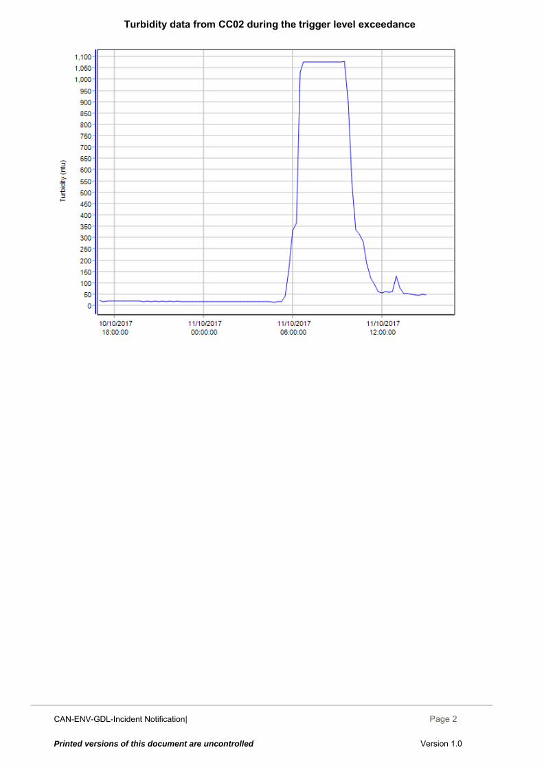
CAN-ENV-GDL-Incident Notification| December 2014
Page 2
Printed versions of this document are uncontrolled Version 1.0
Turbidity data from CC02 during the trigger level exceedance
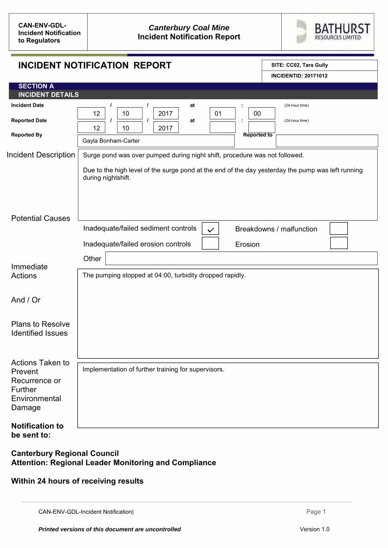
CAN-ENV-GDL-Incident Notification| December 2014
Page 1
Printed versions of this document are uncontrolled Version 1.0
CAN-ENV-GDL-Incident Notification to Regulators
Canterbury Coal Mine
Incident Notification Report
INCIDENT NOTIFICATION REPORT SITE: CC02, Tara Gully
INCIDENTID: 20171012
SECTION A INCIDENT DETAILS
Incident Date / / at : (24-hour time)
Reported Date / / at : (24-hour time)
Reported By Reported to
Incident Description
Potential Causes Immediate Actions And / Or Plans to Resolve Identified Issues
Actions Taken to Prevent Recurrence or Further Environmental Damage
Notification to be sent to: Canterbury Regional Council Attention: Regional Leader Monitoring and Compliance Within 24 hours of receiving results
Areas of erosion Inadequate/failed erosion controls Inadequate/failed erosion controls
Implementation of further training for supervisors.
Erosion
Other
The pumping stopped at 04:00, turbidity dropped rapidly.
Gayla Bonham-Carter
Breakdowns / malfunction Inadequate/failed sediment controls
10
10 2017 01 00
2017 12
12
Surge pond was over pumped during night shift, procedure was not followed. Due to the high level of the surge pond at the end of the day yesterday the pump was left running during nightshift.
CAN-ENV-GDL-Incident Notification| December 2014
Page 2
Printed versions of this document are uncontrolled Version 1.0
Turbidity data from CC02 during the trigger level exceedance
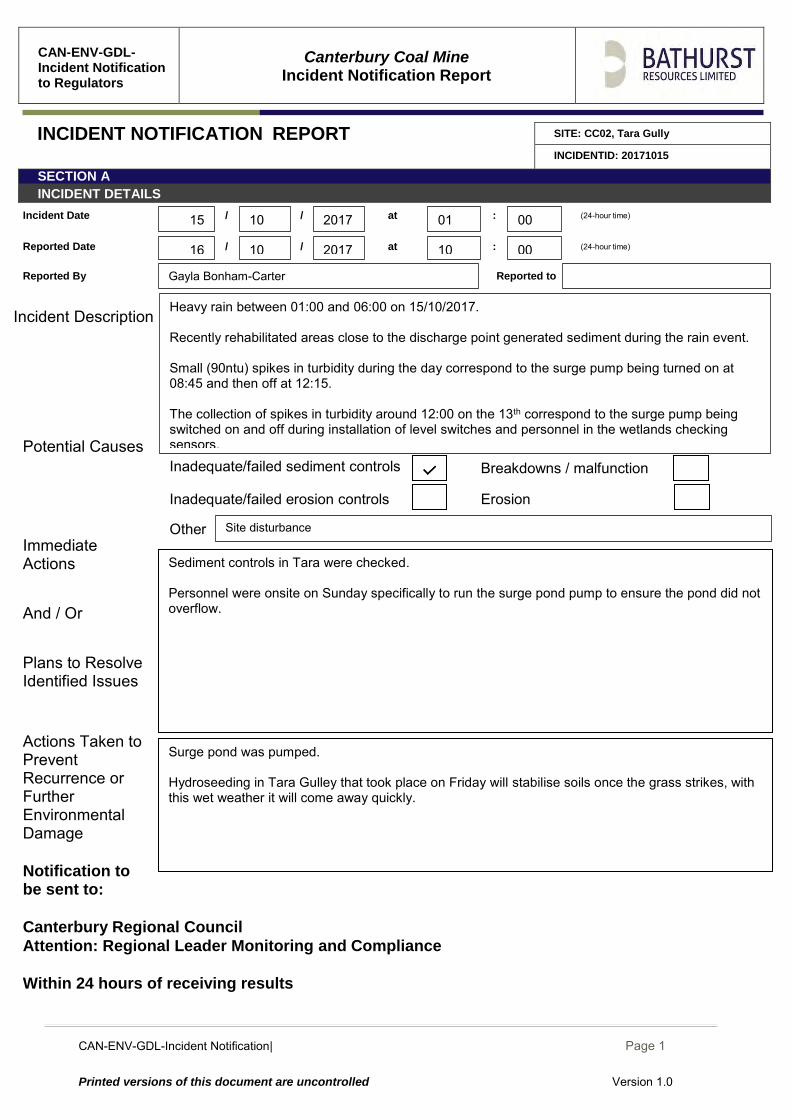
CAN-ENV-GDL-Incident Notification| December 2014
Page 1
Printed versions of this document are uncontrolled Version 1.0
CAN-ENV-GDL-Incident Notification to Regulators
Canterbury Coal Mine
Incident Notification Report
INCIDENT NOTIFICATION REPORT SITE: CC02, Tara Gully
INCIDENTID: 20171015
SECTION A INCIDENT DETAILS
Incident Date / / at : (24-hour time)
Reported Date / / at : (24-hour time)
Reported By Reported to
Incident Description
Potential Causes Immediate Actions And / Or Plans to Resolve Identified Issues
Actions Taken to Prevent Recurrence or Further Environmental Damage
Notification to be sent to: Canterbury Regional Council Attention: Regional Leader Monitoring and Compliance Within 24 hours of receiving results
Surge pond was pumped. Hydroseeding in Tara Gulley that took place on Friday will stabilise soils once the grass strikes, with this wet weather it will come away quickly.
Sediment controls in Tara were checked. Personnel were onsite on Sunday specifically to run the surge pond pump to ensure the pond did not overflow.
Inadequate/failed erosion controls Erosion
Other Site disturbance
Breakdowns / malfunction Inadequate/failed sediment controls
Gayla Bonham-Carter
10
10 2017 01 00
00 10 2017 16
15
Heavy rain between 01:00 and 06:00 on 15/10/2017. Recently rehabilitated areas close to the discharge point generated sediment during the rain event. Small (90ntu) spikes in turbidity during the day correspond to the surge pump being turned on at 08:45 and then off at 12:15. The collection of spikes in turbidity around 12:00 on the 13th correspond to the surge pump being switched on and off during installation of level switches and personnel in the wetlands checking sensors.
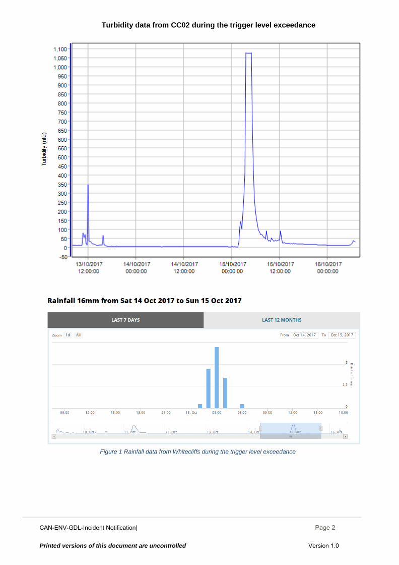
CAN-ENV-GDL-Incident Notification| December 2014
Page 2
Printed versions of this document are uncontrolled Version 1.0
Figure 1 Rainfall data from Whitecliffs during the trigger level exceedance
Turbidity data from CC02 during the trigger level exceedance
CAN-ENV-GDL-Incident Notification| December 2014
Page 1
Printed versions of this document are uncontrolled Version 1.0
CAN-ENV-GDL-Incident Notification to Regulators
Canterbury Coal Mine
Incident Notification Report
INCIDENT NOTIFICATION REPORT SITE: CC02, Tara Gully
INCIDENTID: 20171017
SECTION A INCIDENT DETAILS
Incident Date / / at : (24-hour time)
Reported Date / / at : (24-hour time)
Reported By Reported to
Incident Description
Potential Causes Immediate Actions And / Or Plans to Resolve Identified Issues
Actions Taken to Prevent Recurrence or Further Environmental Damage
Notification to be sent to: Canterbury Regional Council Attention: Regional Leader Monitoring and Compliance Within 24 hours of receiving results
Repair the leaking layflat. Rearrange and secure layflat and vent bag where it comes downhill before discharge point
Repair the leaking layflat. Rearrange and secure layflat and vent bag where it comes downhill before discharge point Planning on installing a small boardwalk to access sensors from to avoid site disturbance.
Inadequate/failed erosion controls Erosion
Other Site disturbance
Breakdowns / malfunction Inadequate/failed sediment controls
Gayla Bonham-Carter
10
10 2017 06 45
00 14 2017 17
17
First spike was Personnel in wetlands to service the sondes. The second spike was surge pond pump being turned and the discovery of a leak in the layflat just before discharge point. Work was done to fix the leak and adjust where the pipe and vent bag went down the hill before discharging. Due to this when the pump was started again sediment was disturbed at discharge point causing high turbidity for a short time.
CAN-ENV-GDL-Incident Notification| December 2014
Page 2
Printed versions of this document are uncontrolled Version 1.0
Turbidity data from CC02 during the trigger level exceedance

CAN-ENV-GDL-Incident Notification| December 2014
Page 1
Printed versions of this document are uncontrolled Version 1.0
CAN-ENV-GDL-Incident Notification to Regulators
Canterbury Coal Mine
Incident Notification Report
INCIDENT NOTIFICATION REPORT SITE: CC02 Tara Gully
INCIDENTID: 20171018
SECTION A INCIDENT DETAILS
Incident Date / / at : (24-hour time)
Reported Date / / at : (24-hour time)
Reported By Reported to
Incident Description
Potential Causes Immediate Actions And / Or Plans to Resolve Identified Issues
Actions Taken to Prevent Recurrence or Further Environmental Damage
Notification to be sent to: Canterbury Regional Council Attention: Regional Leader Monitoring and Compliance Within 24 hours of receiving results
Areas of erosion Inadequate/failed erosion controls
Installation of boardwalk
Care was taken to minimise disturbance while work was done, as little time as possible was spent in the wetlands.
Inadequate/failed erosion controls Erosion
Other Site disturbance
Breakdowns / malfunction Inadequate/failed sediment controls
Gayla Bonham-Carter
10
10 2017 13 15
2017 19
18
Two turbidity readings above the trigger limit. Personnel were in the wetlands installing a boardwalk to minimise further disturbances.
CAN-ENV-GDL-Incident Notification| December 2014
Page 2
Printed versions of this document are uncontrolled Version 1.0
Turbidity data from CC02, 18/10/2017 showing the two readings over the trigger level
CAN-ENV-GDL-Incident Notification| December 2014
Page 1
Printed versions of this document are uncontrolled Version 1.0
CAN-ENV-GDL-Incident Notification to Regulators
Canterbury Coal Mine
Incident Notification Report
INCIDENT NOTIFICATION REPORT SITE: CC02 Tara Gully
INCIDENTID: 20170919
SECTION A INCIDENT DETAILS
Incident Date / / at : (24-hour time)
Reported Date / / at : (24-hour time)
Reported By Reported to
Incident Description
Potential Causes Immediate Actions And / Or Plans to Resolve Identified Issues
Actions Taken to Prevent Recurrence or Further Environmental Damage
Notification to be sent to: Canterbury Regional Council Attention: Regional Leader Monitoring and Compliance Within 24 hours of receiving results
Areas of erosion Inadequate/failed erosion controls
Layflat has been made more secure to reduce damage and likelihood of leaks.
Layflat has been made more secure to reduce damage and likelihood of leaks.
Inadequate/failed erosion controls Erosion
Other
Breakdowns / malfunction Inadequate/failed sediment controls
Gayla Bonham-Carter
10
10 2017 07 15
10 17 2017 19
19
Starting the surge pump causing a short period of sediment disturbance resulting in one reading over the trigger limit for turbidity. Disturbed sediment from the layflat leak on 17/102017 still causing some turbidity when starting up pump.
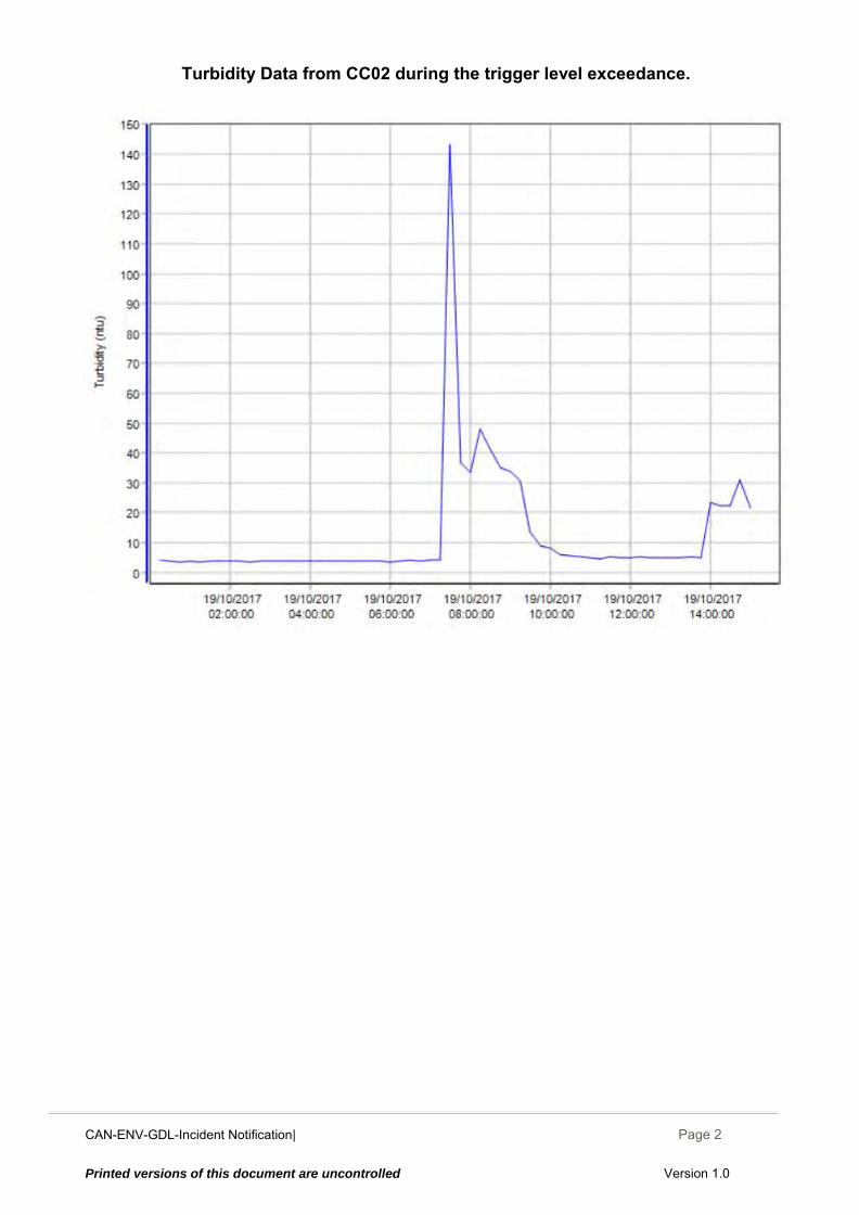
CAN-ENV-GDL-Incident Notification| December 2014
Page 2
Printed versions of this document are uncontrolled Version 1.0
Turbidity Data from CC02 during the trigger level exceedance.
CAN-ENV-GDL-Incident Notification| December 2014
Page 1
Printed versions of this document are uncontrolled Version 1.0
CAN-ENV-GDL-Incident Notification to Regulators
Canterbury Coal Mine
Incident Notification Report
INCIDENT NOTIFICATION REPORT SITE: CC02, Tara Gully
INCIDENTID: 20171020
SECTION A INCIDENT DETAILS
Incident Date / / at : (24-hour time)
Reported Date / / at : (24-hour time)
Reported By Reported to
Incident Description
Potential Causes Immediate Actions And / Or Plans to Resolve Identified Issues
Actions Taken to Prevent Recurrence or Further Environmental Damage
Notification to be sent to: Canterbury Regional Council Attention: Regional Leader Monitoring and Compliance Within 24 hours of receiving results
Areas of erosion Inadequate/failed erosion controls
Electrician contractor has tested and switch now working. Excavation of surge pond during period of fine weather to increase capacity and remove sludge from bottom of pond
Pump was turned off after morning inspection discovered that pump was still running. Electrician contractor has inspected switch and found to be defective.
Inadequate/failed erosion controls Erosion
Other
Breakdowns / malfunction Inadequate/failed sediment controls
Gayla Bonham-Carter
10
10 2017 00 30
30 14 2017 20
20
Pumping of silt laden water from the bottom of the Surge pond to CC02 discharge point. Pump was set to automatic 6pm 19/10. Pump was activated by high level float switch. Lower level float switch failed to stop the pump as pond emptied overnight.
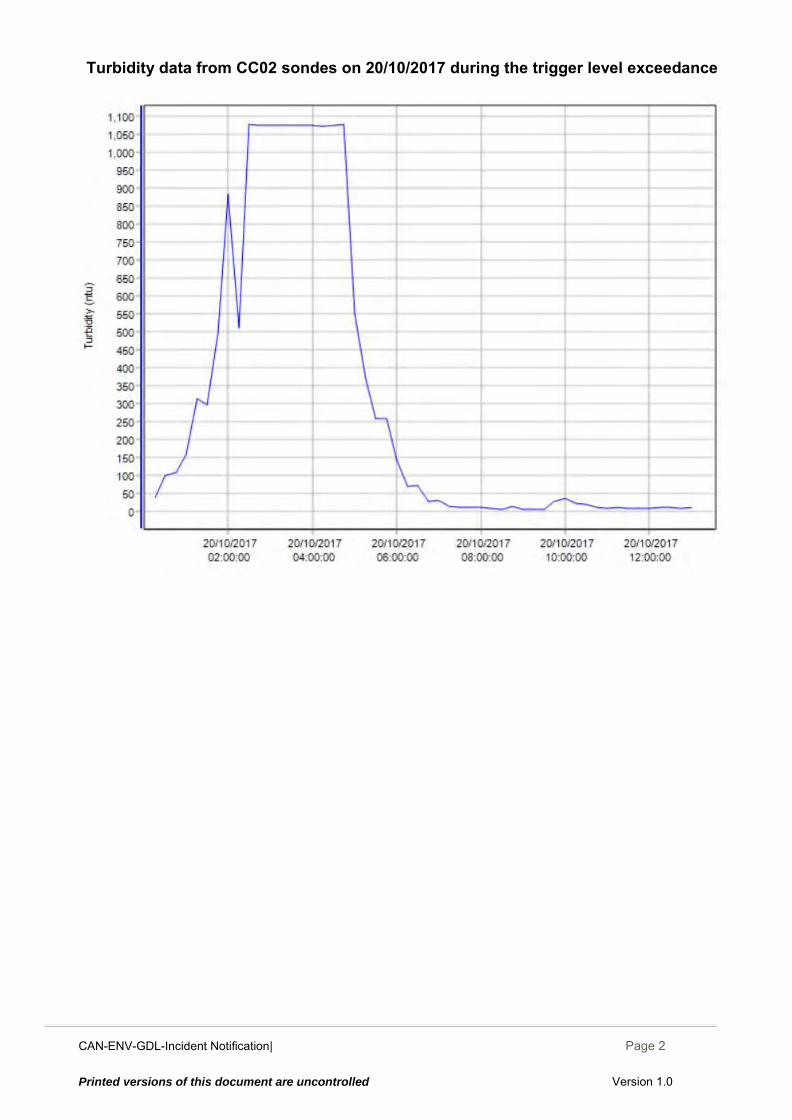
CAN-ENV-GDL-Incident Notification| December 2014
Page 2
Printed versions of this document are uncontrolled Version 1.0
Turbidity data from CC02 sondes on 20/10/2017 during the trigger level exceedance
CAN-ENV-GDL-Incident Notification| December 2014
Page 1
Printed versions of this document are uncontrolled Version 1.0
CAN-ENV-GDL-Incident Notification to Regulators
Canterbury Coal Mine
Incident Notification Report
INCIDENT NOTIFICATION REPORT SITE: CC02 Tara Gully
INCIDENTID: 20171021
SECTION A INCIDENT DETAILS
Incident Date / / at : (24-hour time)
Reported Date / / at : (24-hour time)
Reported By Reported to
Incident Description
Potential Causes Immediate Actions And / Or Plans to Resolve Identified Issues
Actions Taken to Prevent Recurrence or Further Environmental Damage
Notification to be sent to: Canterbury Regional Council Attention: Regional Leader Monitoring and Compliance Within 24 hours of receiving results
Areas of erosion Inadequate/failed erosion controls
Undertaking works to clean out surge pond to remove silt/sediment build up which should reduce potential for discharge of high turbidity water.
Pump was switched off immediately by operator Inspection of Tara Gully
Inadequate/failed erosion controls Erosion
Other
Breakdowns / malfunction Inadequate/failed sediment controls
Gayla Bonham-Carter
10
10 2017 08 15
00 10 2017 24
21
Accidental start-up of Surge pond pump for 5minutes due to jolting of the lower float switch by operator during works to clean out pond. Low residual flow in Tara gully so it took about an hour for turbidity to dissipate. High turbidity readings over trigger level for about an hour.
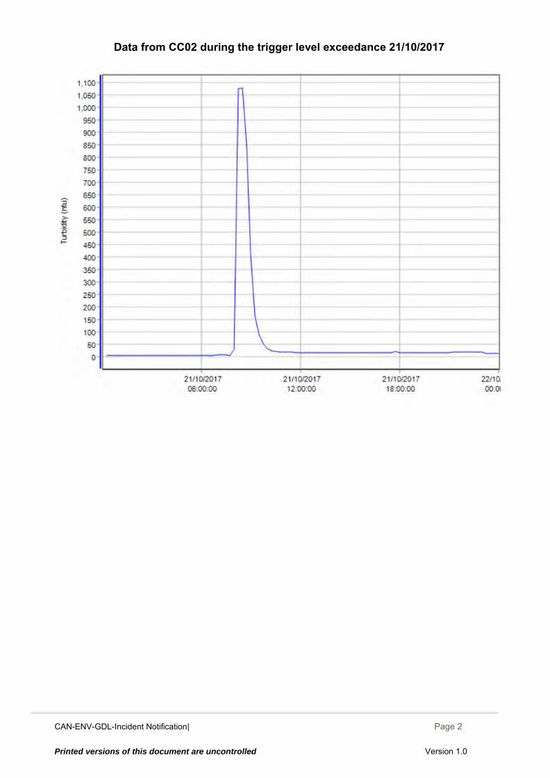
CAN-ENV-GDL-Incident Notification| December 2014
Page 2
Printed versions of this document are uncontrolled Version 1.0
Data from CC02 during the trigger level exceedance 21/10/2017
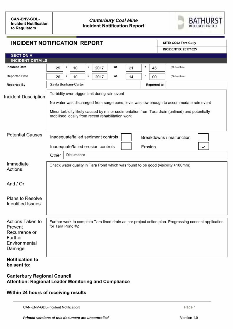
CAN-ENV-GDL-Incident Notification| December 2014
Page 1
Printed versions of this document are uncontrolled Version 1.0
CAN-ENV-GDL-Incident Notification to Regulators
Canterbury Coal Mine
Incident Notification Report
INCIDENT NOTIFICATION REPORT SITE: CC02 Tara Gully
INCIDENTID: 20171025
SECTION A INCIDENT DETAILS
Incident Date / / at : (24-hour time)
Reported Date / / at : (24-hour time)
Reported By Reported to
Incident Description
Potential Causes Immediate Actions And / Or Plans to Resolve Identified Issues
Actions Taken to Prevent Recurrence or Further Environmental Damage
Notification to be sent to: Canterbury Regional Council Attention: Regional Leader Monitoring and Compliance Within 24 hours of receiving results
Areas of erosion Inadequate/failed erosion controls
Further work to complete Tara lined drain as per project action plan. Progressing consent application for Tara Pond #2
Check water quality in Tara Pond which was found to be good (visibility >100mm)
Inadequate/failed erosion controls Erosion
Other Disturbance
Breakdowns / malfunction Inadequate/failed sediment controls
Gayla Bonham-Carter
10
10 2017 21 45
00 14 2017 26
25
Turbidity over trigger limit during rain event No water was discharged from surge pond, level was low enough to accommodate rain event Minor turbidity likely caused by minor sedimentation from Tara drain (unlined) and potentially mobilised locally from recent rehabilitation work
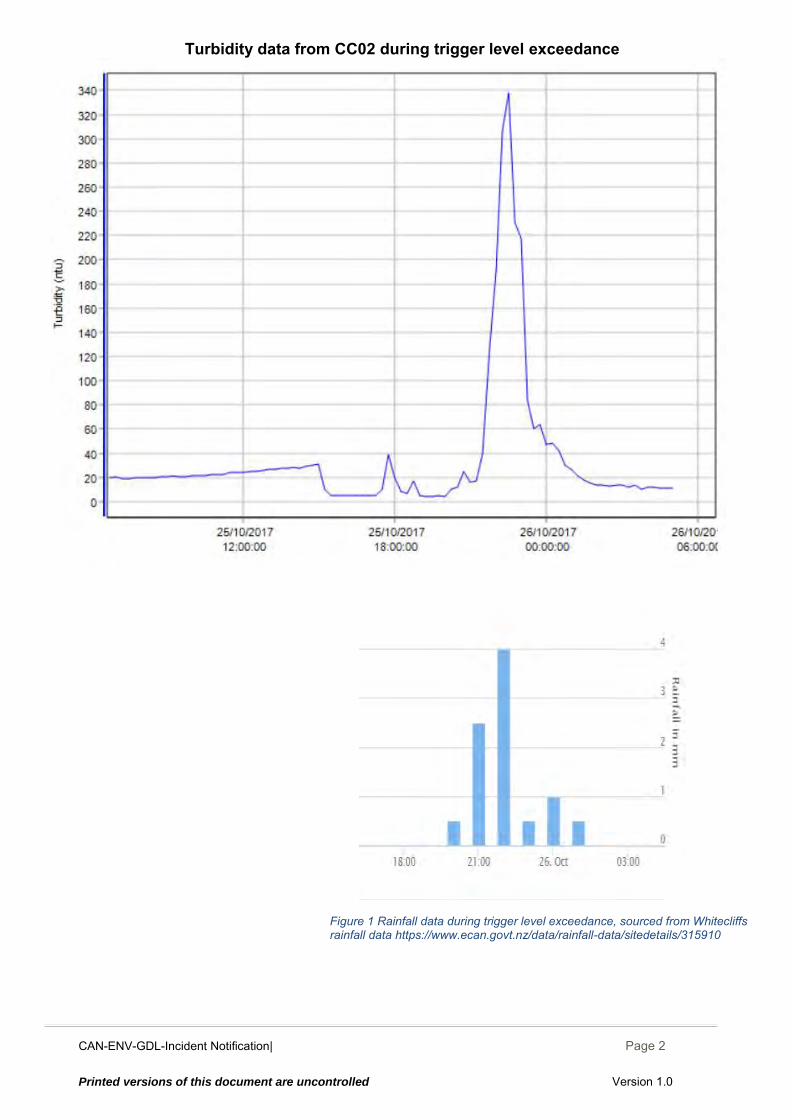
CAN-ENV-GDL-Incident Notification| December 2014
Page 2
Printed versions of this document are uncontrolled Version 1.0
Figure 1 Rainfall data during trigger level exceedance, sourced from Whitecliffs rainfall data https://www.ecan.govt.nz/data/rainfall-data/sitedetails/315910
Turbidity data from CC02 during trigger level exceedance
CAN-ENV-GDL-Incident Notification| December 2014
Page 1
Printed versions of this document are uncontrolled Version 1.0
CAN-ENV-GDL-Incident Notification to Regulators
Canterbury Coal Mine
Incident Notification Report
INCIDENT NOTIFICATION REPORT SITE: CC02 Tara Gully
INCIDENTID: 20171027
SECTION A INCIDENT DETAILS
Incident Date / / at : (24-hour time)
Reported Date / / at : (24-hour time)
Reported By Reported to
Incident Description
Potential Causes Immediate Actions And / Or Plans to Resolve Identified Issues
Actions Taken to Prevent Recurrence or Further Environmental Damage
Notification to be sent to: Canterbury Regional Council Attention: Regional Leader Monitoring and Compliance Within 24 hours of receiving results
Areas of erosion Inadequate/failed erosion controls
Further work to complete Tara lined drain as per project action plan. Progressing consent application for Tara Pond #2
Check water quality in Tara Pond which was found to be good (visibility >100mm)
Inadequate/failed erosion controls Erosion
Other Disturbance
Breakdowns / malfunction Inadequate/failed sediment controls
Gayla Bonham-Carter
10
10 2017 21 45
00 14 2017 27
26
Turbidity over the trigger limit during rain event. 4ml of rain overnight was measured by onsite rain gauge. No water was discharged from surge pond, level was low enough to accommodate rain event Minor turbidity likely caused by minor sedimentation from Tara drain (unlined) and potentially mobilised locally from recent rehabilitation work
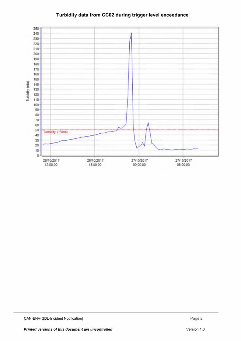
CAN-ENV-GDL-Incident Notification| December 2014
Page 2
Printed versions of this document are uncontrolled Version 1.0
Turbidity data from CC02 during trigger level exceedance
CAN-ENV-GDL-Incident Notification| December 2014
Page 1
Printed versions of this document are uncontrolled Version 1.0
CAN-ENV-GDL-Incident Notification to Regulators
Canterbury Coal Mine
Incident Notification Report
INCIDENT NOTIFICATION REPORT SITE: CC02, Tara Gully
INCIDENTID: 20171016
SECTION A INCIDENT DETAILS
Incident Date / / at : (24-hour time)
Reported Date / / at : (24-hour time)
Reported By Reported to
Incident Description
Potential Causes Immediate Actions And / Or Plans to Resolve Identified Issues
Actions Taken to Prevent Recurrence or Further Environmental Damage
Notification to be sent to: Canterbury Regional Council Attention: Regional Leader Monitoring and Compliance Within 24 hours of receiving results
Areas of erosion Inadequate/failed erosion controls
Installation of temporary MSR (Mussel Shell Reactor) catching the small flow from culvert for treatment before it enters Tara pond via Green ELF drain Checking MSR treating mine influenced water entering surge pond is effective by measuring pH and conductivity of water exiting MSR at 11:10 on 25/10/2017. pH = 6.26 Conductivity = 36 µS/cm Results show water is being treated effectively.
Installation of temporary MSR (Mussel Shell Reactor) for treating the small flow of mine influenced water draining from ROM catchment before it enters Tara pond via Green ELF drain Project plans include further MSR installations Surge pond water being treated by refurbished MSR at site office Manual dosing of surge pond with lime
Inadequate/failed erosion controls Erosion
Other
Breakdowns / malfunction Inadequate/failed sediment controls
Gayla Bonham-Carter
10
10 2017
2017 26
16
Outside of trigger limits for monthly water sampling results; pH, Zinc and Aluminium. pH: 5.46 Zinc+: 0.079 mg/L Al: 0.364 mg/L Zero discharge from site above monitoring location the day sample was taken
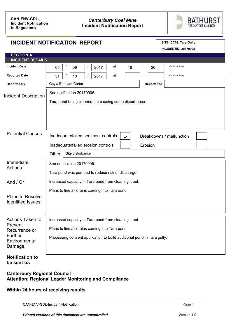
CAN-ENV-GDL-Incident Notification| December 2014
Page 1
Printed versions of this document are uncontrolled Version 1.0
CAN-ENV-GDL-Incident Notification to Regulators
Canterbury Coal Mine
Incident Notification Report
INCIDENT NOTIFICATION REPORT SITE: CC02, Tara Gully
INCIDENTID: 20170905
SECTION A INCIDENT DETAILS
Incident Date / / at : (24 hour time)
Reported Date / / at : (24 hour time)
Reported By Reported to
Incident Description
Potential Causes
Immediate Actions And / Or Plans to Resolve Identified Issues
Actions Taken to Prevent Recurrence or Further Environmental Damage
Notification to be sent to: Canterbury Regional Council Attention: Regional Leader Monitoring and Compliance Within 24 hours of receiving results
Inadequate/failed erosion controls
Increased capacity in Tara pond from cleaning it out. Plans to line all drains coming into Tara pond. Processing consent application to build additional pond in Tara gully.
Erosion
Other
See notification 20170906. Tara pond was pumped to reduce risk of discharge. Increased capacity in Tara pond from cleaning it out. Plans to line all drains coming into Tara pond.
Site disturbance
Gayla Bonham-Carter
Breakdowns / malfunction Inadequate/failed sediment controls
10
09 2017 18 20
2017 31
05
See notification 20170906. Tara pond being cleaned out causing some disturbance.
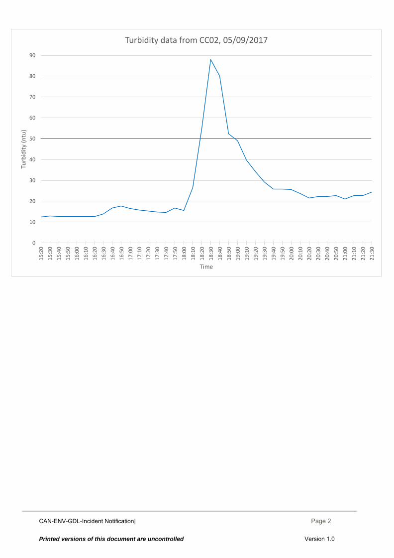
CAN-ENV-GDL-Incident Notification| December 2014
Page 2
Printed versions of this document are uncontrolled Version 1.0
0
10
20
30
40
50
60
70
80
90
15
:20
15
:30
15
:40
15
:50
16
:00
16
:10
16
:20
16
:30
16
:40
16
:50
17
:00
17
:10
17
:20
17
:30
17
:40
17
:50
18
:00
18
:10
18
:20
18
:30
18
:40
18
:50
19
:00
19
:10
19
:20
19
:30
19
:40
19
:50
20
:00
20
:10
20
:20
20
:30
20
:40
20
:50
21
:00
21
:10
21
:20
21
:30
Turb
idit
y (n
tu)
Time
Turbidity data from CC02, 05/09/2017
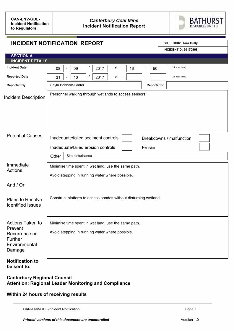
CAN-ENV-GDL-Incident Notification| December 2014
Page 1
Printed versions of this document are uncontrolled Version 1.0
CAN-ENV-GDL-Incident Notification to Regulators
Canterbury Coal Mine
Incident Notification Report
INCIDENT NOTIFICATION REPORT SITE: CC02, Tara Gully
INCIDENTID: 20170908
SECTION A INCIDENT DETAILS
Incident Date / / at : (24 hour time)
Reported Date / / at : (24 hour time)
Reported By Reported to
Incident Description
Potential Causes
Immediate Actions And / Or Plans to Resolve Identified Issues
Actions Taken to Prevent Recurrence or Further Environmental Damage
Notification to be sent to: Canterbury Regional Council Attention: Regional Leader Monitoring and Compliance Within 24 hours of receiving results
Erosion Inadequate/failed erosion controls
Minimise time spent in wet land, use the same path. Avoid stepping in running water where possible.
Other
Minimise time spent in wet land, use the same path. Avoid stepping in running water where possible. Construct platform to access sondes without disturbing wetland
Site disturbance
Gayla Bonham-Carter
Breakdowns / malfunction Inadequate/failed sediment controls
10
09 2017 16 50
2017 31
08
Personnel walking through wetlands to access sensors.

CAN-ENV-GDL-Incident Notification| December 2014
Page 2
Printed versions of this document are uncontrolled Version 1.0
0
10
20
30
40
50
60
70
80
90
15
:20
15
:30
15
:40
15
:50
16
:00
16
:10
16
:20
16
:30
16
:40
16
:50
17
:00
17
:10
17
:20
17
:30
17
:40
17
:50
18
:00
18
:10
18
:20
18
:30
18
:40
18
:50
19
:00
19
:10
19
:20
19
:30
19
:40
19
:50
20
:00
20
:10
20
:20
20
:30
20
:40
20
:50
21
:00
21
:10
21
:20
21
:30
Turb
idit
y (n
tu)
Time
Turbidity data from CC02, 05/09/2017
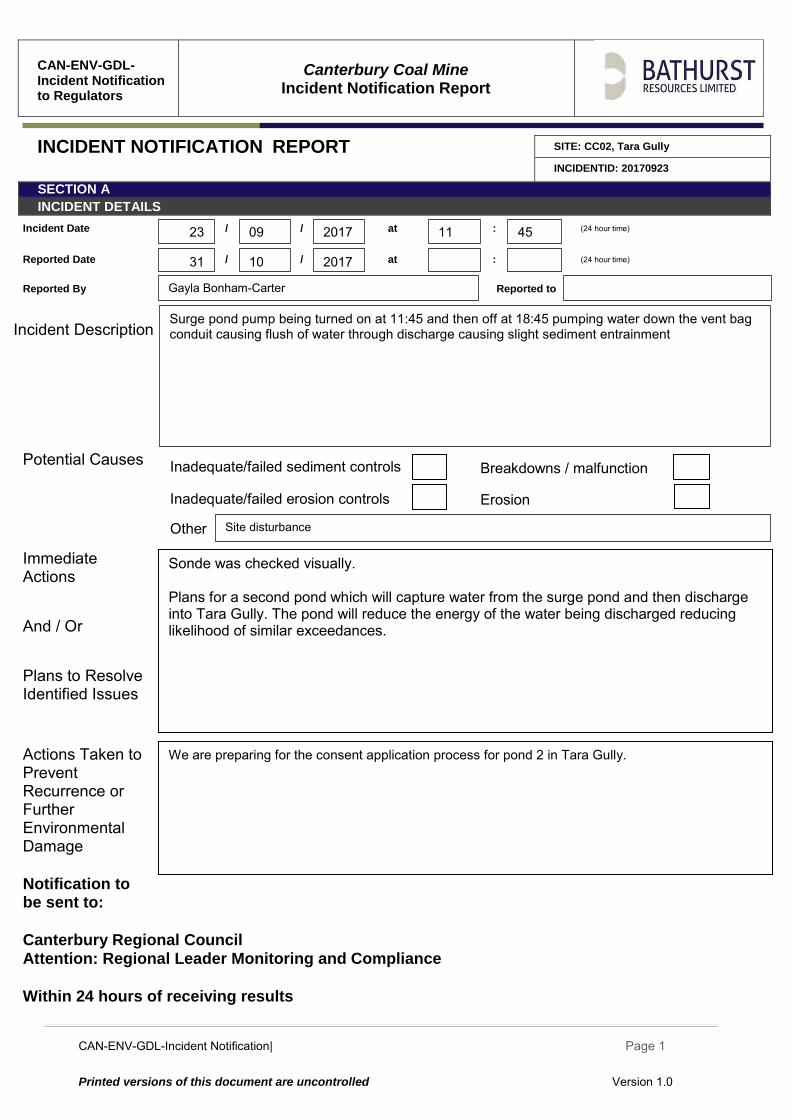
CAN-ENV-GDL-Incident Notification| December 2014
Page 1
Printed versions of this document are uncontrolled Version 1.0
CAN-ENV-GDL-Incident Notification to Regulators
Canterbury Coal Mine
Incident Notification Report
INCIDENT NOTIFICATION REPORT SITE: CC02, Tara Gully
INCIDENTID: 20170923
SECTION A INCIDENT DETAILS
Incident Date / / at : (24 hour time)
Reported Date / / at : (24 hour time)
Reported By Reported to
Incident Description
Potential Causes
Immediate Actions And / Or Plans to Resolve Identified Issues
Actions Taken to Prevent Recurrence or Further Environmental Damage
Notification to be sent to: Canterbury Regional Council Attention: Regional Leader Monitoring and Compliance Within 24 hours of receiving results
Inadequate/failed erosion controls Erosion
We are preparing for the consent application process for pond 2 in Tara Gully.
Other
Sonde was checked visually. Plans for a second pond which will capture water from the surge pond and then discharge into Tara Gully. The pond will reduce the energy of the water being discharged reducing likelihood of similar exceedances.
Site disturbance
Gayla Bonham-Carter
Breakdowns / malfunction Inadequate/failed sediment controls
10
09 2017 11 45
2017 31
23
Surge pond pump being turned on at 11:45 and then off at 18:45 pumping water down the vent bag conduit causing flush of water through discharge causing slight sediment entrainment
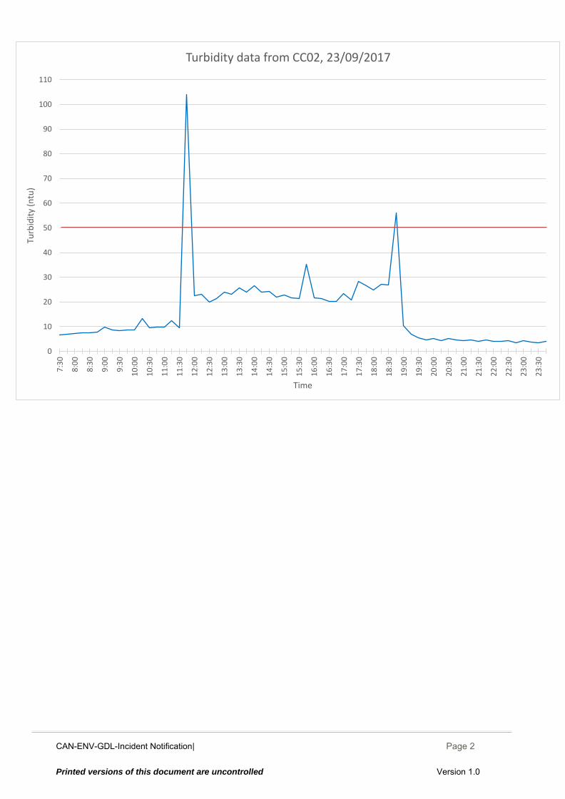
CAN-ENV-GDL-Incident Notification| December 2014
Page 2
Printed versions of this document are uncontrolled Version 1.0
0
10
20
30
40
50
60
70
80
90
100
110
7:3
0
8:0
0
8:3
0
9:0
0
9:3
0
10
:00
10
:30
11
:00
11
:30
12
:00
12
:30
13
:00
13
:30
14
:00
14
:30
15
:00
15
:30
16
:00
16
:30
17
:00
17
:30
18
:00
18
:30
19
:00
19
:30
20
:00
20
:30
21
:00
21
:30
22
:00
22
:30
23
:00
23
:30
Turb
idit
y (n
tu)
Time
Turbidity data from CC02, 23/09/2017
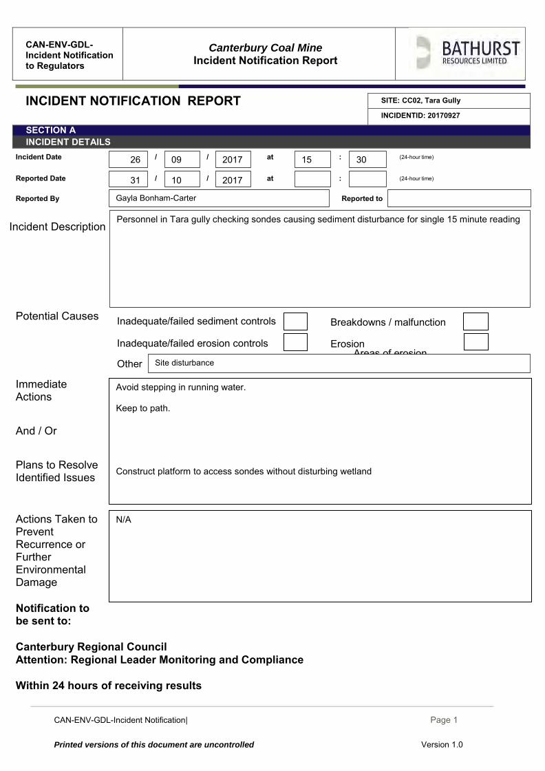
CAN-ENV-GDL-Incident Notification| December 2014
Page 1
Printed versions of this document are uncontrolled Version 1.0
CAN-ENV-GDL-Incident Notification to Regulators
Canterbury Coal Mine
Incident Notification Report
INCIDENT NOTIFICATION REPORT SITE: CC02, Tara Gully
INCIDENTID: 20170927
SECTION A INCIDENT DETAILS
Incident Date / / at : (24-hour time)
Reported Date / / at : (24-hour time)
Reported By Reported to
Incident Description
Potential Causes
Immediate Actions And / Or Plans to Resolve Identified Issues
Actions Taken to Prevent Recurrence or Further Environmental Damage
Notification to be sent to: Canterbury Regional Council Attention: Regional Leader Monitoring and Compliance Within 24 hours of receiving results
Inadequate/failed erosion controls Areas of erosion
N/A
Erosion
Other
Avoid stepping in running water. Keep to path. Construct platform to access sondes without disturbing wetland
Site disturbance
Gayla Bonham-Carter
Breakdowns / malfunction Inadequate/failed sediment controls
10
09 2017 15 30
2017 31
26
Personnel in Tara gully checking sondes causing sediment disturbance for single 15 minute reading
CAN-ENV-GDL-Incident Notification| December 2014
Page 2
Printed versions of this document are uncontrolled Version 1.0
0
10
20
30
40
50
60
70
80
90
100
1101
1:3
0
11
:45
12
:00
12
:15
12
:30
12
:45
13
:00
13
:15
13
:30
13
:45
14
:00
14
:15
14
:30
14
:45
15
:00
15
:15
15
:30
15
:45
16
:00
16
:15
16
:30
16
:45
17
:00
17
:15
17
:30
17
:45
18
:00
18
:15
18
:30
18
:45
19
:00
19
:15
19
:30
19
:45
20
:00
Turb
idit
y (n
tu)
Time
Turbidity data from CC02, 26/09/2017
CAN-ENV-GDL-Incident Notification| December 2014
Page 1
Printed versions of this document are uncontrolled Version 1.0
CAN-ENV-GDL-Incident Notification to Regulators
Canterbury Coal Mine
Incident Notification Report
INCIDENT NOTIFICATION REPORT SITE: CC02, Tara Gully
INCIDENTID: 20170929
SECTION A INCIDENT DETAILS
Incident Date / / at : (24-hour time)
Reported Date / / at : (24-hour time)
Reported By Reported to
Incident Description
Potential Causes Immediate Actions And / Or Plans to Resolve Identified Issues
Actions Taken to Prevent Recurrence or Further Environmental Damage
Notification to be sent to: Canterbury Regional Council Attention: Regional Leader Monitoring and Compliance Within 24 hours of receiving results
We are preparing for the consent application process for pond 2 in Tara Gully.
Sonde was checked. Plans for a second pond which will capture water from the surge pond and then discharge into Tara Gully. The pond will reduce the energy of the water being discharged reducing likelihood of similar exceedances.
Gayla Bonham-Carter
Inadequate/failed erosion controls Erosion
Other Disturbance
Breakdowns / malfunction Inadequate/failed sediment controls
10
09 2017 13 45
2017 31
29
Three turbidity readings over the trigger limit caused by starting the surge pump to lower the pond before the weekend when rain was forecast.
CAN-ENV-GDL-Incident Notification| December 2014
Page 2
Printed versions of this document are uncontrolled Version 1.0
0
10
20
30
40
50
60
70
80
90
100
110
120
10
:00
10
:30
11
:00
11
:30
12
:00
12
:30
13
:00
13
:30
14
:00
14
:30
15
:00
15
:30
16
:00
16
:30
17
:00
17
:30
18
:00
18
:30
19
:00
19
:30
20
:00
20
:30
21
:00
21
:30
Turb
idit
y (n
tu)
Time
Turbidity data from CC02, 29/09/2017
CAN-ENV-GDL-Incident Notification| December 2014
Page 1
Printed versions of this document are uncontrolled Version 1.0
CAN-ENV-GDL-Incident Notification to Regulators
Canterbury Coal Mine
Incident Notification Report
INCIDENT NOTIFICATION REPORT SITE: CC02, Tara Gully
INCIDENTID: 20171005
SECTION A INCIDENT DETAILS
Incident Date / / at : (24-hour time)
Reported Date / / at : (24-hour time)
Reported By Reported to
Incident Description
Potential Causes Immediate Actions And / Or Plans to Resolve Identified Issues
Actions Taken to Prevent Recurrence or Further Environmental Damage
Notification to be sent to: Canterbury Regional Council Attention: Regional Leader Monitoring and Compliance Within 24 hours of receiving results
We are preparing for the consent application process for pond 2 in Tara Gully.
Sonde was checked. Plans for a second pond which will capture water from the surge pond and then discharge into Tara Gully. The pond will reduce the energy of the water being discharged reducing likelihood of similar exceedances.
Gayla Bonham-Carter
Inadequate/failed erosion controls Erosion
Other Disturbance
Breakdowns / malfunction Inadequate/failed sediment controls
10
10 2017 06 00
2017 31
05
Two turbidity readings over the trigger limit at 06:00 (66.8 ntu) and 08:30 (59.7 ntu). Exceedances were caused by starting and operating the surge pump to lower surge pond in preparation for heavy rain which was forecast over the weekend.
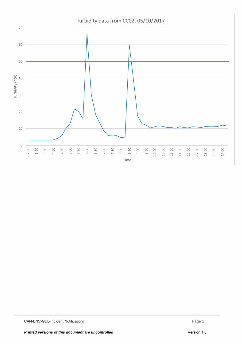
CAN-ENV-GDL-Incident Notification| December 2014
Page 2
Printed versions of this document are uncontrolled Version 1.0
0
10
20
30
40
50
60
702
:30
3:0
0
3:3
0
4:0
0
4:3
0
5:0
0
5:3
0
6:0
0
6:3
0
7:0
0
7:3
0
8:0
0
8:3
0
9:0
0
9:3
0
10
:00
10
:30
11
:00
11
:30
12
:00
12
:30
13
:00
13
:30
14
:00
Turb
idit
y (n
tu)
Time
Turbidity data from CC02, 05/10/2017
CAN-ENV-GDL-Incident Notification| December 2014
Page 1
Printed versions of this document are uncontrolled Version 1.0
CAN-ENV-GDL-Incident Notification to Regulators
Canterbury Coal Mine
Incident Notification Report
INCIDENT NOTIFICATION REPORT SITE: CC02, Tara Gully
INCIDENTID: 20171024
SECTION A INCIDENT DETAILS
Incident Date / / at : (24-hour time)
Reported Date / / at : (24-hour time)
Reported By Reported to
Incident Description
Potential Causes Immediate Actions And / Or Plans to Resolve Identified Issues
Actions Taken to Prevent Recurrence or Further Environmental Damage
Notification to be sent to: Canterbury Regional Council Attention: Regional Leader Monitoring and Compliance Within 24 hours of receiving results
Areas of erosion Inadequate/failed erosion controls
N/A
Sensor and wiper given a clean manually. Wiper interval has been requested to be increased to 6 hour intervals. Hyquest are looking into this.
Inadequate/failed erosion controls Erosion
Other
Breakdowns / malfunction Inadequate/failed sediment controls
Gayla Bonham-Carter
10
10 2017 22 30
2017 31
24
3 readings of turbidity over the trigger level the highest reading was 3.5ntu over 50ntu. Turbidity reading dropped abruptly after the wiper cleaned the sensor at 23:00, see turbidity data. Wiper is not keeping up with accumulation of slime on sensor.
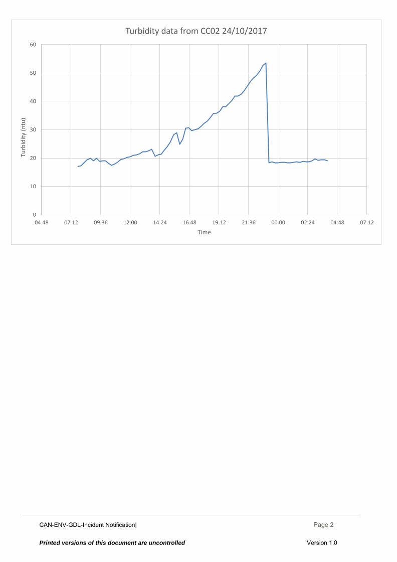
CAN-ENV-GDL-Incident Notification| December 2014
Page 2
Printed versions of this document are uncontrolled Version 1.0
0
10
20
30
40
50
60
04:48 07:12 09:36 12:00 14:24 16:48 19:12 21:36 00:00 02:24 04:48 07:12
Turb
idit
y (n
tu)
Time
Turbidity data from CC02 24/10/2017

CCM-ENV-RPT-001 |Oct 2017 Page 148 Printed versions of this document are uncontrolled
Appendix V: Trigger Value Exceedance Reports Bush Gully
CAN-ENV-GDL-Incident Notification| December 2014
Page 1
Printed versions of this document are uncontrolled Version 1.0
CAN-ENV-GDL-Incident Notification to Regulators
Canterbury Coal Mine
Incident Notification Report
INCIDENT NOTIFICATION REPORT SITE: CC24, Bush Gully
INCIDENTID: 20170926
SECTION A INCIDENT DETAILS
Incident Date / / at : (24-hour time)
Reported Date / / at : (24-hour time)
Reported By Reported to
Incident Description
Potential Causes
Immediate Actions And / Or Plans to Resolve Identified Issues
Actions Taken to Prevent Recurrence or Further Environmental Damage
Notification to be sent to: Canterbury Regional Council Attention: Regional Leader Monitoring and Compliance Within 24 hours of receiving results
Erosion Inadequate/failed erosion controls
The issue will not reoccur now that the sondes are not battery powered.
Other
Replacement sondes have already been installed at CC24. The new sondes are powered by a solar panel and the data from them is available online in real time. The issue will not reoccur now that the sondes are not battery powered.
Gayla Bonham-Carter
Breakdowns / malfunction Inadequate/failed sediment controls
09
09 2017 15 00
2017 26
26
Rental Sondes from CC24 were pulled out and the data downloaded today. The downstream sensor has no data after 13/09/2017 at 10:30 due to a flat battery.
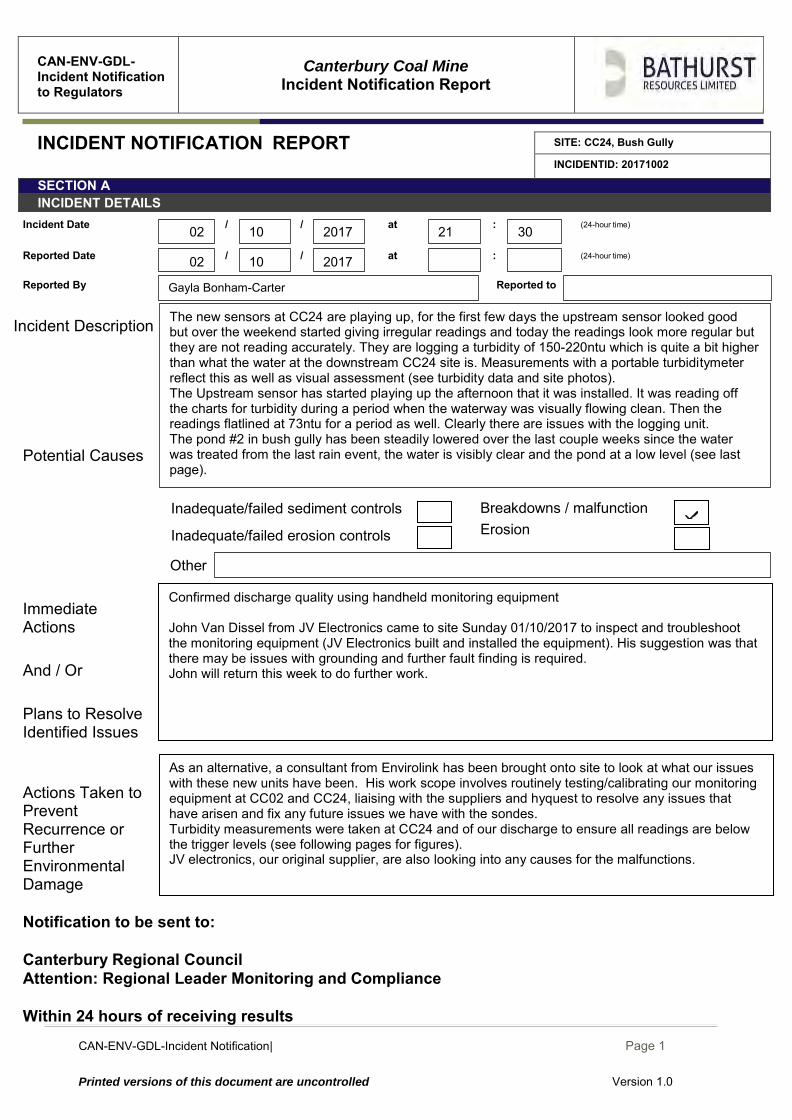
CAN-ENV-GDL-Incident Notification| December 2014
Page 1
Printed versions of this document are uncontrolled Version 1.0
CAN-ENV-GDL-Incident Notification to Regulators
Canterbury Coal Mine
Incident Notification Report
INCIDENT NOTIFICATION REPORT SITE: CC24, Bush Gully
INCIDENTID: 20171002
SECTION A INCIDENT DETAILS
Incident Date / / at : (24-hour time)
Reported Date / / at : (24-hour time)
Reported By Reported to
Incident Description
Potential Causes
Immediate Actions
And / Or
Plans to Resolve Identified Issues
Actions Taken to Prevent Recurrence or Further Environmental Damage
Notification to be sent to: Canterbury Regional Council Attention: Regional Leader Monitoring and Compliance Within 24 hours of receiving results
Areas of erosion
Inadequate/failed erosion controls
Inadequate/failed erosion controls
As an alternative, a consultant from Envirolink has been brought onto site to look at what our issues with these new units have been. His work scope involves routinely testing/calibrating our monitoring equipment at CC02 and CC24, liaising with the suppliers and hyquest to resolve any issues that have arisen and fix any future issues we have with the sondes. Turbidity measurements were taken at CC24 and of our discharge to ensure all readings are below the trigger levels (see following pages for figures). JV electronics, our original supplier, are also looking into any causes for the malfunctions.
Erosion
Other
Confirmed discharge quality using handheld monitoring equipment John Van Dissel from JV Electronics came to site Sunday 01/10/2017 to inspect and troubleshoot the monitoring equipment (JV Electronics built and installed the equipment). His suggestion was that there may be issues with grounding and further fault finding is required. John will return this week to do further work.
Gayla Bonham-Carter
Breakdowns / malfunction Inadequate/failed sediment controls
10
10 2017 21 30
2017 02
02
The new sensors at CC24 are playing up, for the first few days the upstream sensor looked good but over the weekend started giving irregular readings and today the readings look more regular but they are not reading accurately. They are logging a turbidity of 150-220ntu which is quite a bit higher than what the water at the downstream CC24 site is. Measurements with a portable turbiditymeter reflect this as well as visual assessment (see turbidity data and site photos). The Upstream sensor has started playing up the afternoon that it was installed. It was reading off the charts for turbidity during a period when the waterway was visually flowing clean. Then the readings flatlined at 73ntu for a period as well. Clearly there are issues with the logging unit. The pond #2 in bush gully has been steadily lowered over the last couple weeks since the water was treated from the last rain event, the water is visibly clear and the pond at a low level (see last page).
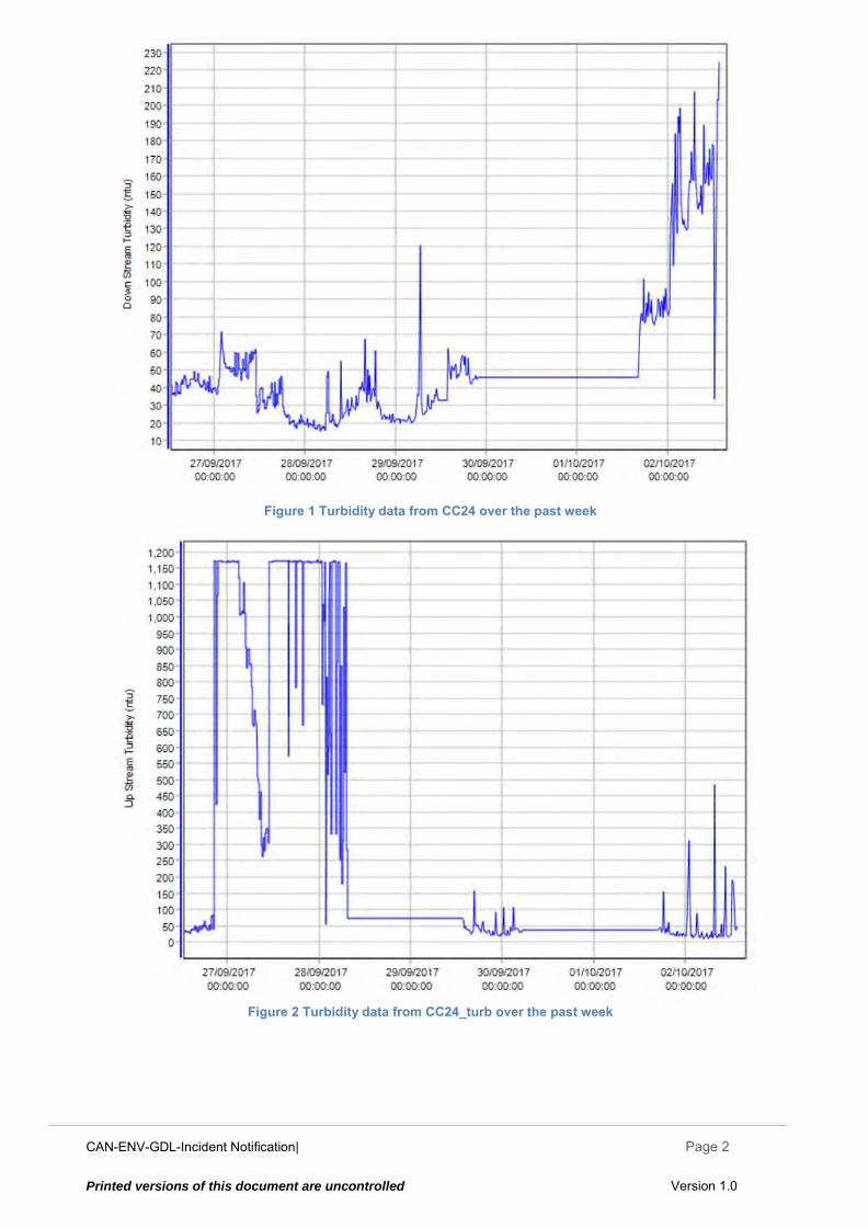
CAN-ENV-GDL-Incident Notification| December 2014
Page 2
Printed versions of this document are uncontrolled Version 1.0
Figure 1 Turbidity data from CC24 over the past week
Figure 2 Turbidity data from CC24_turb over the past week
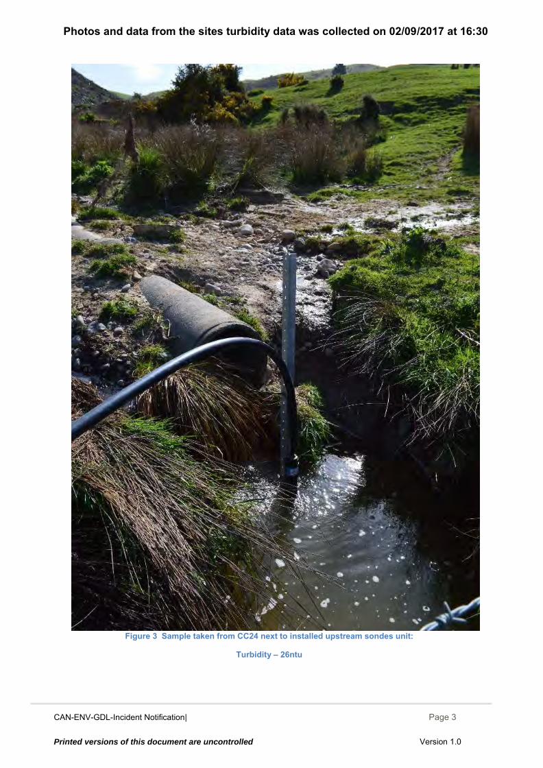
CAN-ENV-GDL-Incident Notification| December 2014
Page 3
Printed versions of this document are uncontrolled Version 1.0
Photos and data from the sites turbidity data was collected on 02/09/2017 at 16:30
Figure 3 Sample taken from CC24 next to installed upstream sondes unit:
Turbidity – 26ntu
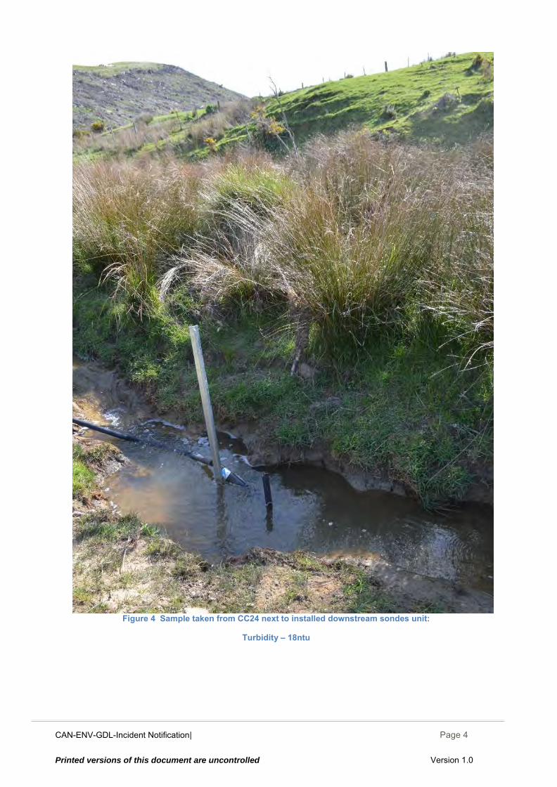
CAN-ENV-GDL-Incident Notification| December 2014
Page 4
Printed versions of this document are uncontrolled Version 1.0
Figure 4 Sample taken from CC24 next to installed downstream sondes unit:
Turbidity – 18ntu
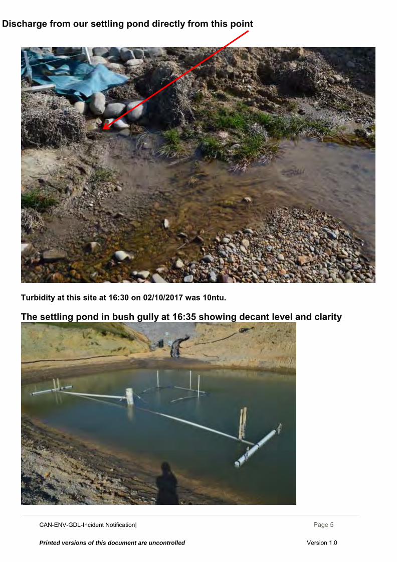
CAN-ENV-GDL-Incident Notification| December 2014
Page 5
Printed versions of this document are uncontrolled Version 1.0
Discharge from our settling pond directly from this point
Turbidity at this site at 16:30 on 02/10/2017 was 10ntu. The settling pond in bush gully at 16:35 showing decant level and clarity
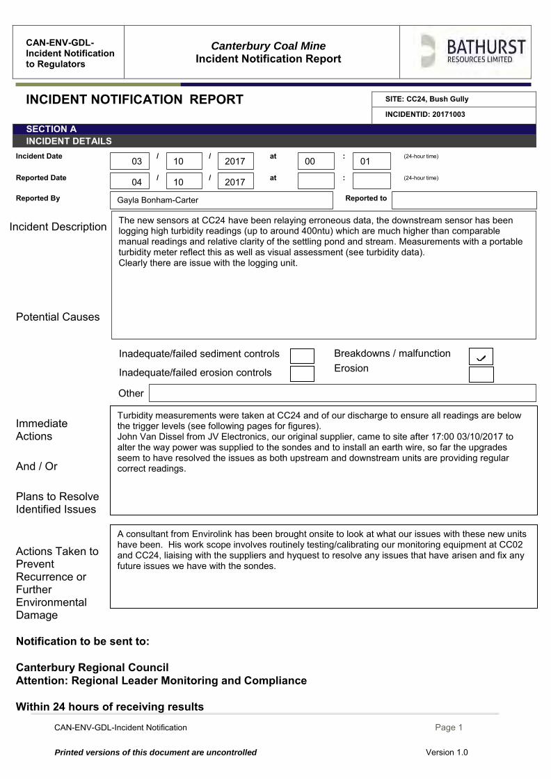
CAN-ENV-GDL-Incident Notification Page 1
Printed versions of this document are uncontrolled Version 1.0
CAN-ENV-GDL-Incident Notification to Regulators
Canterbury Coal Mine
Incident Notification Report
INCIDENT NOTIFICATION REPORT SITE: CC24, Bush Gully
INCIDENTID: 20171003
SECTION A INCIDENT DETAILS
Incident Date / / at : (24-hour time)
Reported Date / / at : (24-hour time)
Reported By Reported to
Incident Description
Potential Causes
Immediate Actions
And / Or
Plans to Resolve Identified Issues
Actions Taken to Prevent Recurrence or Further Environmental Damage
Notification to be sent to: Canterbury Regional Council Attention: Regional Leader Monitoring and Compliance Within 24 hours of receiving results
Areas of erosion
Inadequate/failed erosion controls
Inadequate/failed erosion controls
A consultant from Envirolink has been brought onsite to look at what our issues with these new units have been. His work scope involves routinely testing/calibrating our monitoring equipment at CC02 and CC24, liaising with the suppliers and hyquest to resolve any issues that have arisen and fix any future issues we have with the sondes.
Erosion
Other
Turbidity measurements were taken at CC24 and of our discharge to ensure all readings are below the trigger levels (see following pages for figures). John Van Dissel from JV Electronics, our original supplier, came to site after 17:00 03/10/2017 to alter the way power was supplied to the sondes and to install an earth wire, so far the upgrades seem to have resolved the issues as both upstream and downstream units are providing regular correct readings.
Gayla Bonham-Carter
Breakdowns / malfunction Inadequate/failed sediment controls
10
10 2017 00 01
2017 04
03
The new sensors at CC24 have been relaying erroneous data, the downstream sensor has been logging high turbidity readings (up to around 400ntu) which are much higher than comparable manual readings and relative clarity of the settling pond and stream. Measurements with a portable turbidity meter reflect this as well as visual assessment (see turbidity data). Clearly there are issue with the logging unit.
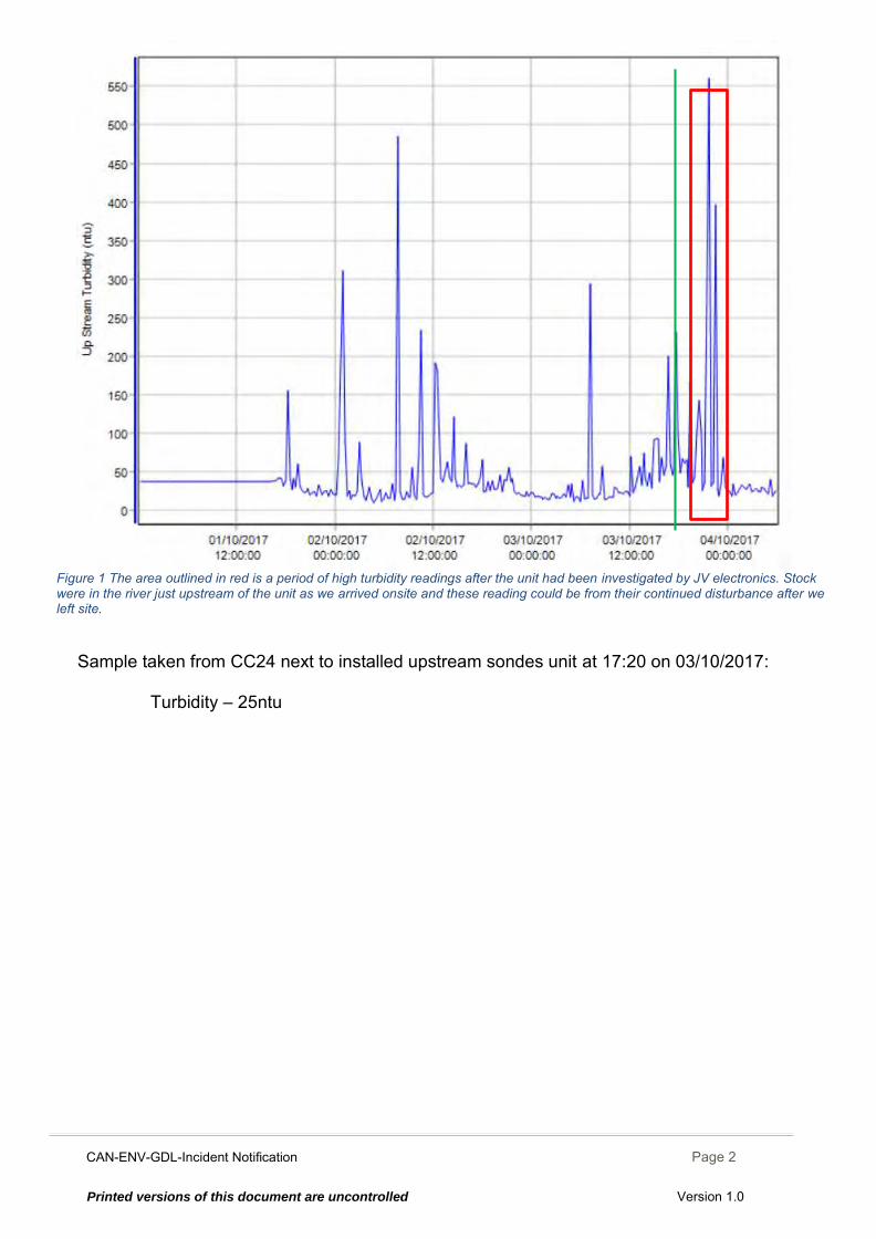
CAN-ENV-GDL-Incident Notification Page 2
Printed versions of this document are uncontrolled Version 1.0
Figure 1 The area outlined in red is a period of high turbidity readings after the unit had been investigated by JV electronics. Stock were in the river just upstream of the unit as we arrived onsite and these reading could be from their continued disturbance after we left site.
Sample taken from CC24 next to installed upstream sondes unit at 17:20 on 03/10/2017:
Turbidity – 25ntu
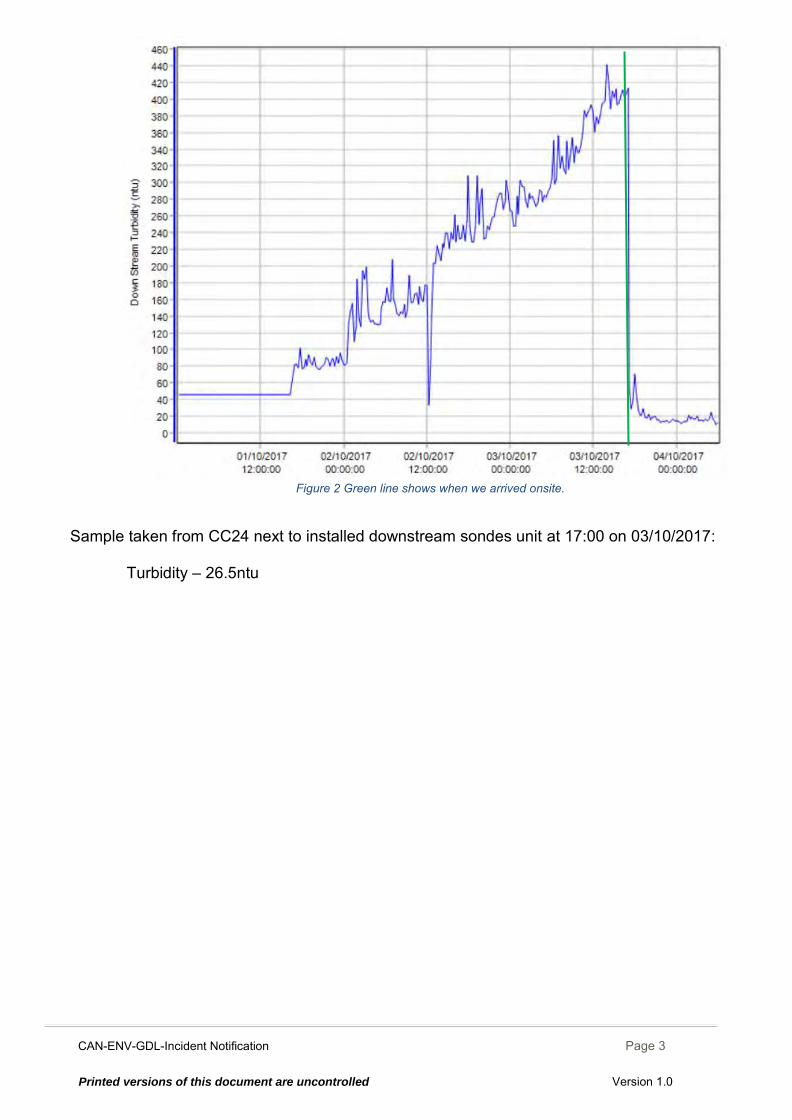
CAN-ENV-GDL-Incident Notification Page 3
Printed versions of this document are uncontrolled Version 1.0
Figure 2 Green line shows when we arrived onsite.
Sample taken from CC24 next to installed downstream sondes unit at 17:00 on 03/10/2017:
Turbidity – 26.5ntu

CAN-ENV-GDL-Incident Notification Page 4
Printed versions of this document are uncontrolled Version 1.0
The settling pond in bush gully at 16:35 on 02/10/17 showing decant level and clarity
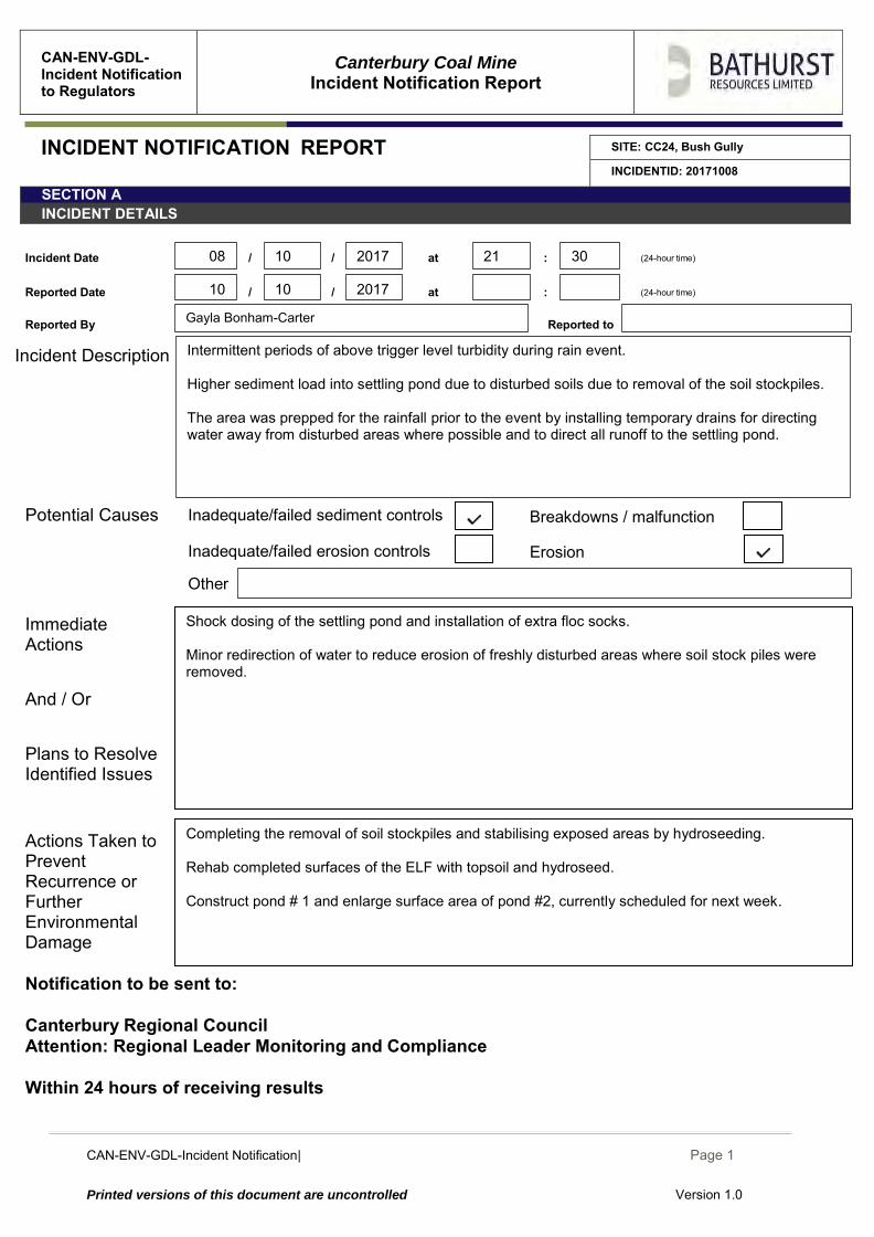
CAN-ENV-GDL-Incident Notification| December 2014
Page 1
Printed versions of this document are uncontrolled Version 1.0
CAN-ENV-GDL-Incident Notification to Regulators
Canterbury Coal Mine
Incident Notification Report
INCIDENT NOTIFICATION REPORT SITE: CC24, Bush Gully
INCIDENTID: 20171008
SECTION A INCIDENT DETAILS
Incident Date / / at : (24-hour time)
Reported Date / / at : (24-hour time)
Reported By Reported to
Incident Description
Potential Causes Immediate Actions And / Or Plans to Resolve Identified Issues
Actions Taken to Prevent Recurrence or Further Environmental Damage
Notification to be sent to: Canterbury Regional Council Attention: Regional Leader Monitoring and Compliance Within 24 hours of receiving results
Areas of erosion Inadequate/failed
erosion controls
Completing the removal of soil stockpiles and stabilising exposed areas by hydroseeding. Rehab completed surfaces of the ELF with topsoil and hydroseed. Construct pond # 1 and enlarge surface area of pond #2, currently scheduled for next week.
Shock dosing of the settling pond and installation of extra floc socks. Minor redirection of water to reduce erosion of freshly disturbed areas where soil stock piles were removed.
Gayla Bonham-Carter
Inadequate/failed erosion controls Erosion
Other
Breakdowns / malfunction Inadequate/failed sediment controls
10
10 2017 21 30
2017 10
08
Intermittent periods of above trigger level turbidity during rain event. Higher sediment load into settling pond due to disturbed soils due to removal of the soil stockpiles. The area was prepped for the rainfall prior to the event by installing temporary drains for directing water away from disturbed areas where possible and to direct all runoff to the settling pond.
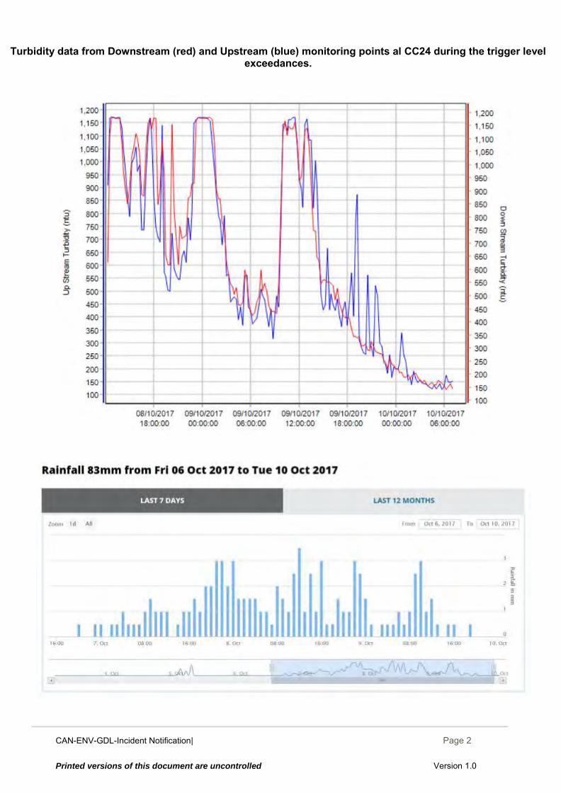
CAN-ENV-GDL-Incident Notification| December 2014
Page 2
Printed versions of this document are uncontrolled Version 1.0
Turbidity data from Downstream (red) and Upstream (blue) monitoring points al CC24 during the trigger level exceedances.
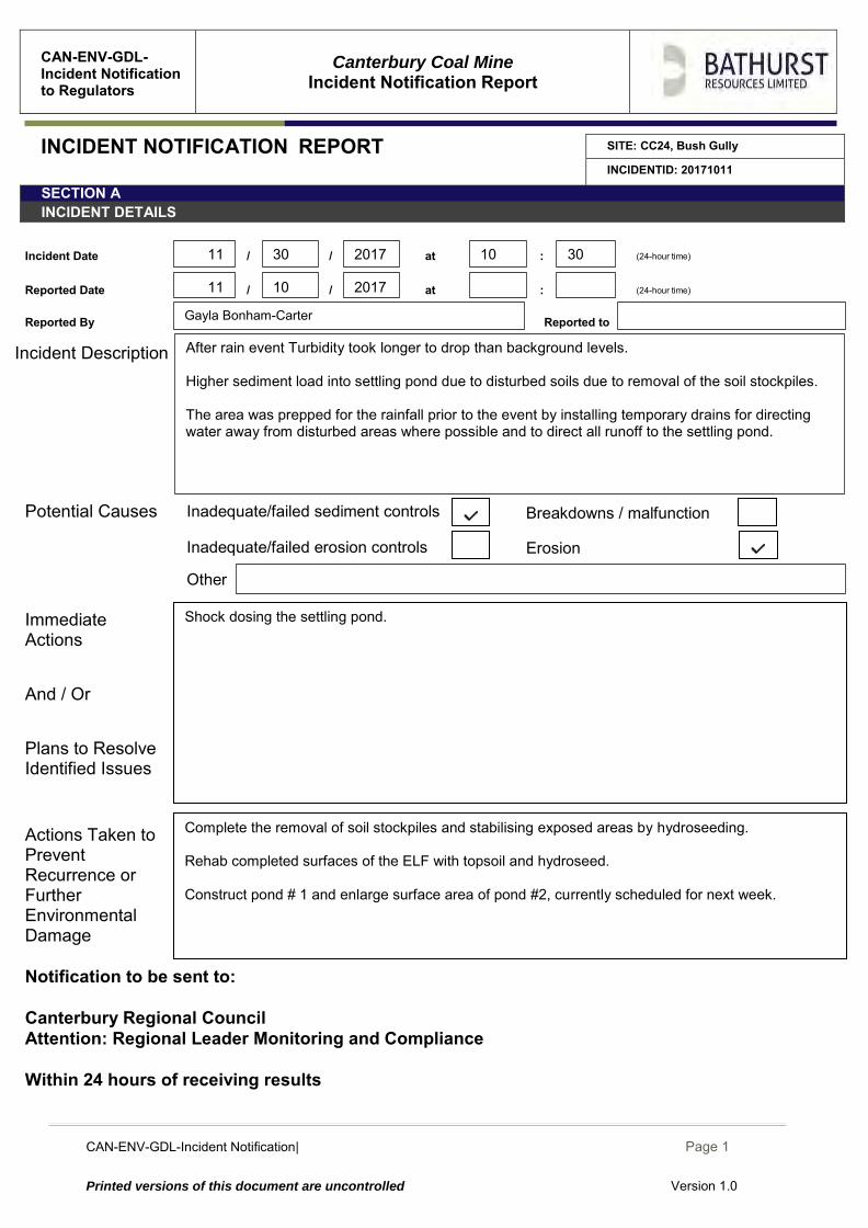
CAN-ENV-GDL-Incident Notification| December 2014
Page 1
Printed versions of this document are uncontrolled Version 1.0
CAN-ENV-GDL-Incident Notification to Regulators
Canterbury Coal Mine
Incident Notification Report
INCIDENT NOTIFICATION REPORT SITE: CC24, Bush Gully
INCIDENTID: 20171011
SECTION A INCIDENT DETAILS
Incident Date / / at : (24-hour time)
Reported Date / / at : (24-hour time)
Reported By Reported to
Incident Description
Potential Causes Immediate Actions And / Or Plans to Resolve Identified Issues
Actions Taken to Prevent Recurrence or Further Environmental Damage
Notification to be sent to: Canterbury Regional Council Attention: Regional Leader Monitoring and Compliance Within 24 hours of receiving results
Areas of erosion Inadequate/failed
erosion controls
Complete the removal of soil stockpiles and stabilising exposed areas by hydroseeding. Rehab completed surfaces of the ELF with topsoil and hydroseed. Construct pond # 1 and enlarge surface area of pond #2, currently scheduled for next week.
Shock dosing the settling pond.
Gayla Bonham-Carter
Inadequate/failed erosion controls Erosion
Other
Breakdowns / malfunction Inadequate/failed sediment controls
10
30 2017 10 30
2017 11
11
After rain event Turbidity took longer to drop than background levels. Higher sediment load into settling pond due to disturbed soils due to removal of the soil stockpiles. The area was prepped for the rainfall prior to the event by installing temporary drains for directing water away from disturbed areas where possible and to direct all runoff to the settling pond.
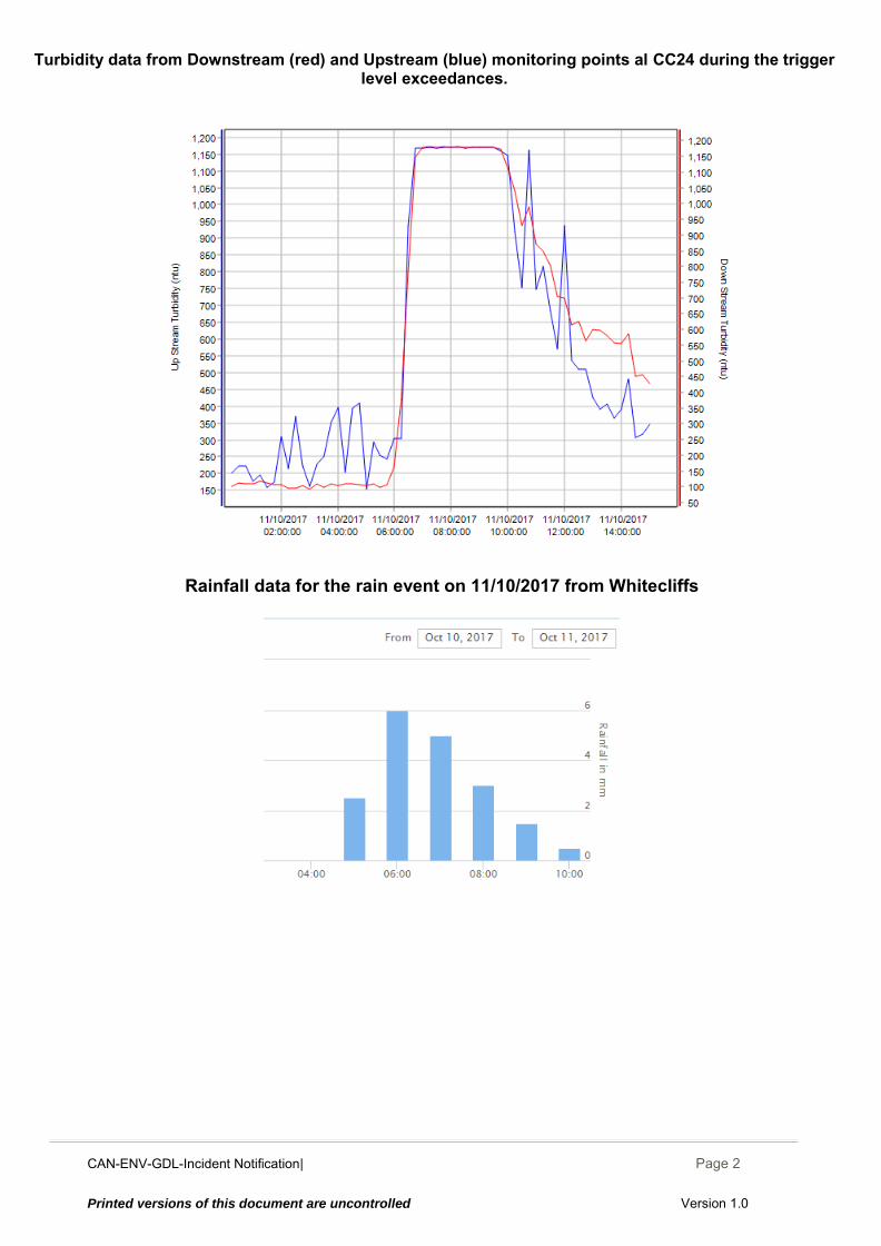
CAN-ENV-GDL-Incident Notification| December 2014
Page 2
Printed versions of this document are uncontrolled Version 1.0
Turbidity data from Downstream (red) and Upstream (blue) monitoring points al CC24 during the trigger
level exceedances.
Rainfall data for the rain event on 11/10/2017 from Whitecliffs
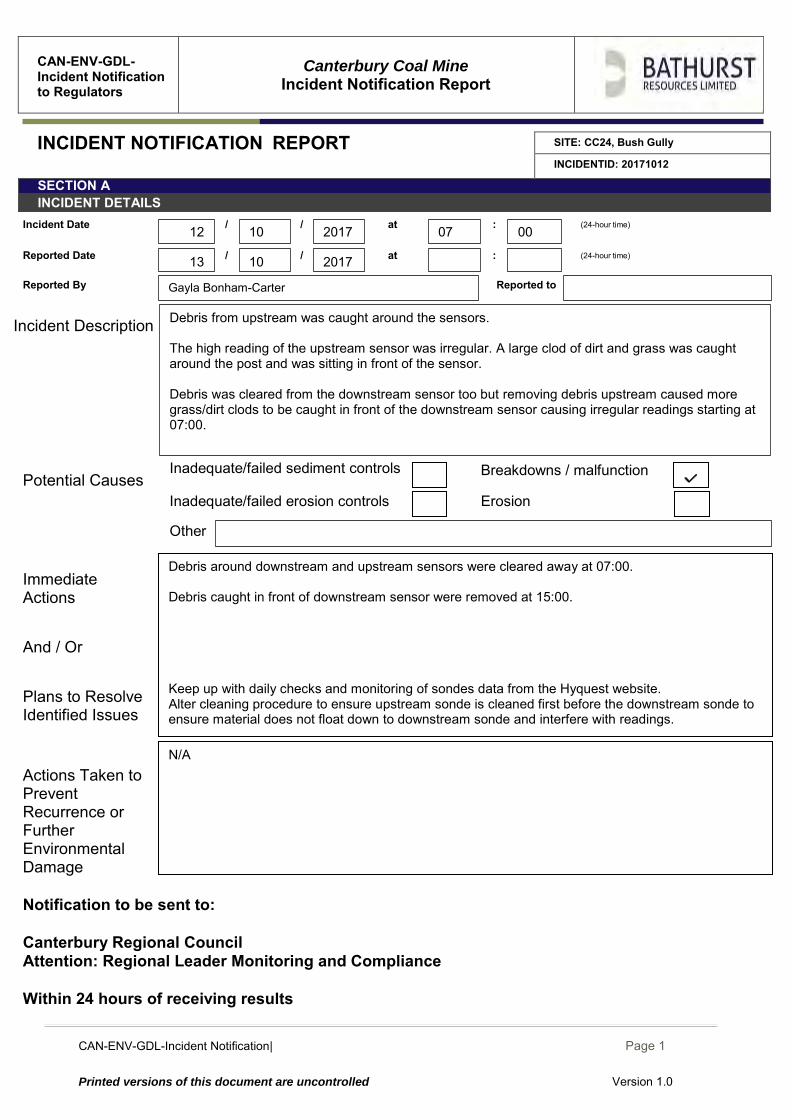
CAN-ENV-GDL-Incident Notification| December 2014
Page 1
Printed versions of this document are uncontrolled Version 1.0
CAN-ENV-GDL-Incident Notification to Regulators
Canterbury Coal Mine
Incident Notification Report
INCIDENT NOTIFICATION REPORT SITE: CC24, Bush Gully
INCIDENTID: 20171012
SECTION A INCIDENT DETAILS
Incident Date / / at : (24-hour time)
Reported Date / / at : (24-hour time)
Reported By Reported to
Incident Description
Potential Causes Immediate Actions And / Or Plans to Resolve Identified Issues
Actions Taken to Prevent Recurrence or Further Environmental Damage
Notification to be sent to: Canterbury Regional Council Attention: Regional Leader Monitoring and Compliance Within 24 hours of receiving results
Areas of erosion Inadequate/failed erosion controls
N/A
Debris around downstream and upstream sensors were cleared away at 07:00. Debris caught in front of downstream sensor were removed at 15:00. Keep up with daily checks and monitoring of sondes data from the Hyquest website. Alter cleaning procedure to ensure upstream sonde is cleaned first before the downstream sonde to ensure material does not float down to downstream sonde and interfere with readings.
Gayla Bonham-Carter
Inadequate/failed erosion controls Erosion
Other
Breakdowns / malfunction Inadequate/failed sediment controls
10
10 2017 07 00
2017 13
12
Debris from upstream was caught around the sensors. The high reading of the upstream sensor was irregular. A large clod of dirt and grass was caught around the post and was sitting in front of the sensor. Debris was cleared from the downstream sensor too but removing debris upstream caused more grass/dirt clods to be caught in front of the downstream sensor causing irregular readings starting at 07:00.

CAN-ENV-GDL-Incident Notification| December 2014
Page 2
Printed versions of this document are uncontrolled Version 1.0
Turbidity data from Upstream (blue) and Downstream (red) Sondes at CC24 during the trigger level exceedance
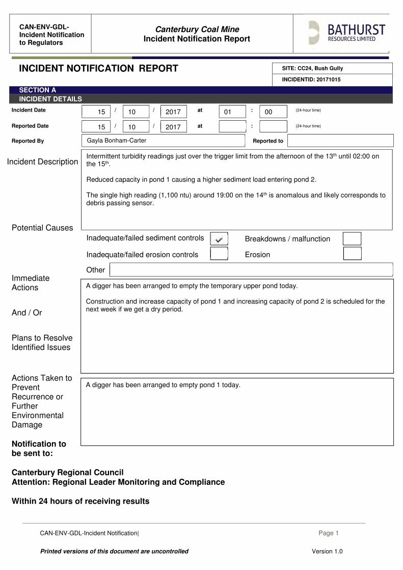
CAN-ENV-GDL-Incident Notification| December 2014
Page 1
Printed versions of this document are uncontrolled Version 1.0
CAN-ENV-GDL-Incident Notification to Regulators
Canterbury Coal Mine
Incident Notification Report
INCIDENT NOTIFICATION REPORT SITE: CC24, Bush Gully
INCIDENTID: 20171015
SECTION A
INCIDENT DETAILS
Incident Date / / at : (24-hour time)
Reported Date / / at : (24-hour time)
Reported By Reported to
Incident Description
Potential Causes
Immediate Actions
And / Or
Plans to Resolve Identified Issues
Actions Taken to Prevent Recurrence or Further Environmental Damage
Notification to be sent to: Canterbury Regional Council Attention: Regional Leader Monitoring and Compliance Within 24 hours of receiving results
A digger has been arranged to empty pond 1 today.
A digger has been arranged to empty the temporary upper pond today. Construction and increase capacity of pond 1 and increasing capacity of pond 2 is scheduled for the next week if we get a dry period.
Inadequate/failed erosion controls Erosion
Other
Breakdowns / malfunction Inadequate/failed sediment controls
Gayla Bonham-Carter
10
10 2017 01 00
2017 15
15
Intermittent turbidity readings just over the trigger limit from the afternoon of the 13th until 02:00 on the 15th. Reduced capacity in pond 1 causing a higher sediment load entering pond 2. The single high reading (1,100 ntu) around 19:00 on the 14th is anomalous and likely corresponds to debris passing sensor.
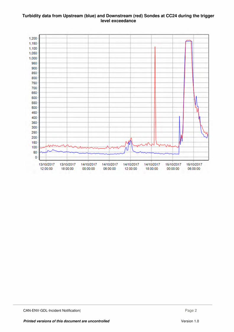
CAN-ENV-GDL-Incident Notification| December 2014
Page 2
Printed versions of this document are uncontrolled Version 1.0
Turbidity data from Upstream (blue) and Downstream (red) Sondes at CC24 during the trigger
level exceedance
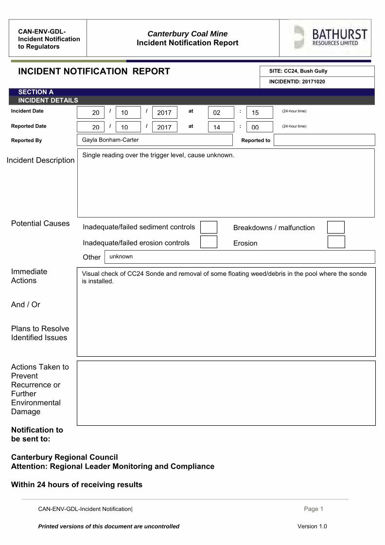
CAN-ENV-GDL-Incident Notification| December 2014
Page 1
Printed versions of this document are uncontrolled Version 1.0
CAN-ENV-GDL-Incident Notification to Regulators
Canterbury Coal Mine
Incident Notification Report
INCIDENT NOTIFICATION REPORT SITE: CC24, Bush Gully
INCIDENTID: 20171020
SECTION A INCIDENT DETAILS
Incident Date / / at : (24-hour time)
Reported Date / / at : (24-hour time)
Reported By Reported to
Incident Description
Potential Causes Immediate Actions And / Or Plans to Resolve Identified Issues
Actions Taken to Prevent Recurrence or Further Environmental Damage
Notification to be sent to: Canterbury Regional Council Attention: Regional Leader Monitoring and Compliance Within 24 hours of receiving results
Areas of erosion Inadequate/failed erosion controls
Visual check of CC24 Sonde and removal of some floating weed/debris in the pool where the sonde is installed.
Inadequate/failed erosion controls Erosion
Other unknown
Breakdowns / malfunction Inadequate/failed sediment controls
Gayla Bonham-Carter
10
10 2017 02 15
00 14 2017 20
20
Single reading over the trigger level, cause unknown.
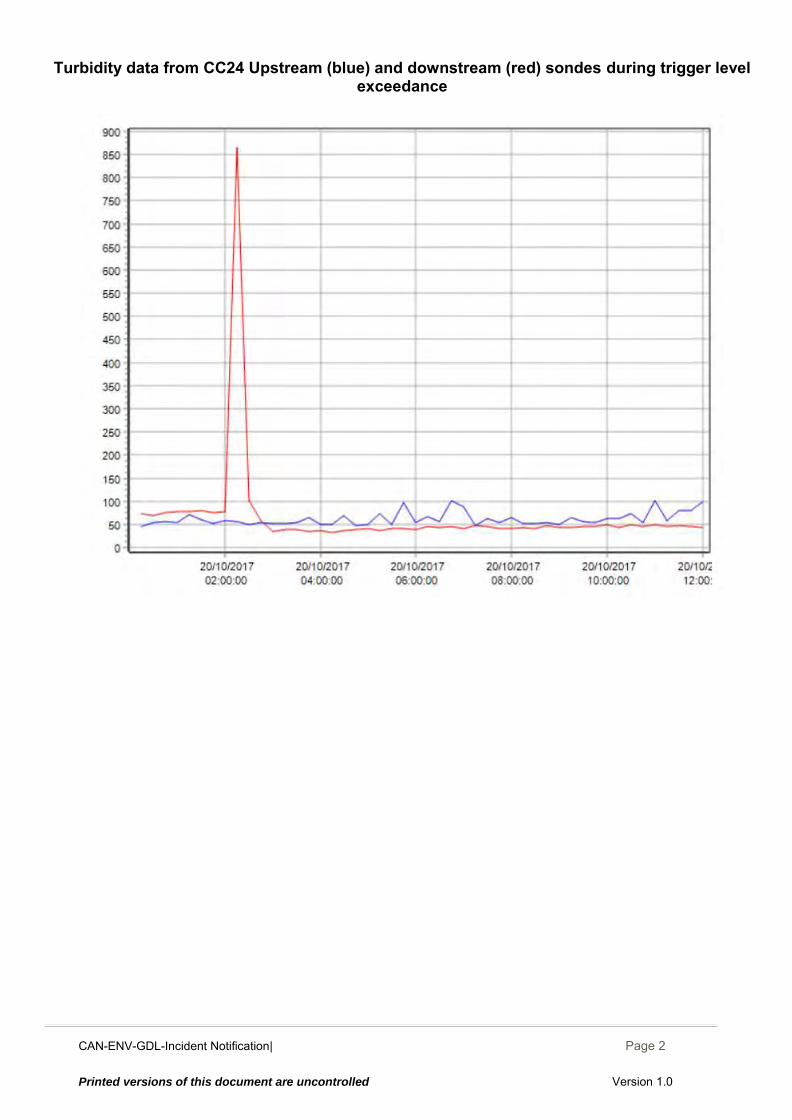
CAN-ENV-GDL-Incident Notification| December 2014
Page 2
Printed versions of this document are uncontrolled Version 1.0
Turbidity data from CC24 Upstream (blue) and downstream (red) sondes during trigger level
exceedance
CAN-ENV-GDL-Incident Notification| December 2014
Page 1
Printed versions of this document are uncontrolled Version 1.0
CAN-ENV-GDL-Incident Notification to Regulators
Canterbury Coal Mine
Incident Notification Report
INCIDENT NOTIFICATION REPORT SITE: CC24 Bush Gully
INCIDENTID: 20171024
SECTION A INCIDENT DETAILS
Incident Date / / at : (24-hour time)
Reported Date / / at : (24-hour time)
Reported By Reported to
Incident Description
Potential Causes Immediate Actions And / Or Plans to Resolve Identified Issues
Actions Taken to Prevent Recurrence or Further Environmental Damage
Notification to be sent to: Canterbury Regional Council Attention: Regional Leader Monitoring and Compliance Within 24 hours of receiving results
Upstream sensor was reinstalled on an angle, higher off the bottom
The Upstream sensor was cleaned and silt cleared away at 06:45 The Upstream sensor silted up again so at 13:30 it was reinstalled on an angle, higher off the bottom The Downstream sensor was checked and silt + plant material cleared away at 06:45 and 13:30 but the irregular readings continued until 16:00 when the sensor was scrubbed clean Water quality measured manually to ensure compliance conditions were being met (See Photos) Downstream: 23ntu Upstream: 32ntu
Inadequate/failed erosion controls Erosion
Other
Breakdowns / malfunction Inadequate/failed sediment controls
Gayla Bonham-Carter
10
10 2017 14 00
00 12 2017 25
24
Sensors providing irregular readings
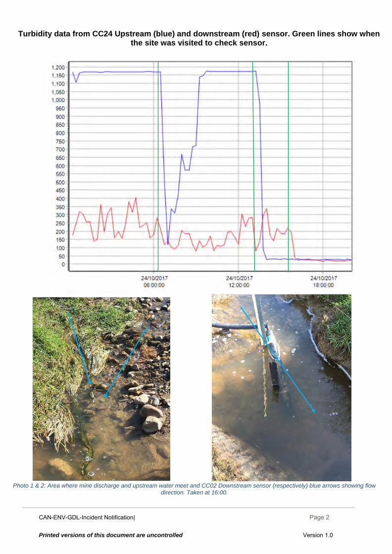
CAN-ENV-GDL-Incident Notification| December 2014
Page 2
Printed versions of this document are uncontrolled Version 1.0
Turbidity data from CC24 Upstream (blue) and downstream (red) sensor. Green lines show when
the site was visited to check sensor.
Photo 1 & 2: Area where mine discharge and upstream water meet and CC02 Downstream sensor (respectively) blue arrows showing flow
direction. Taken at 16:00.
CAN-ENV-GDL-Incident Notification| December 2014
Page 1
Printed versions of this document are uncontrolled Version 1.0
CAN-ENV-GDL-Incident Notification to Regulators
Canterbury Coal Mine
Incident Notification Report
INCIDENT NOTIFICATION REPORT SITE: CC24, Bush Gully
INCIDENTID: 20171028
SECTION A INCIDENT DETAILS
Incident Date / / at : (24-hour time)
Reported Date / / at : (24-hour time)
Reported By Reported to
Incident Description
Potential Causes Immediate Actions And / Or Plans to Resolve Identified Issues
Actions Taken to Prevent Recurrence or Further Environmental Damage
Notification to be sent to: Canterbury Regional Council Attention: Regional Leader Monitoring and Compliance Within 24 hours of receiving results
Areas of erosion Inadequate/failed erosion controls
Automatic alert was sent to site management who then came to site to investigate cause. No discharge was occurring from the site due to North ELF pond decant being raised while Pond #1 construction activities are completed. No action was required.
Inadequate/failed erosion controls Erosion
Other Site disturbance by livestock
Breakdowns / malfunction Inadequate/failed sediment controls
Gayla Bonham-Carter
10
10 2017 04 30
2017 30
28
One turbidity reading over the trigger level. No water was discharging from site at the time. Livestock have access to the stream where the downstream sensor is installed.
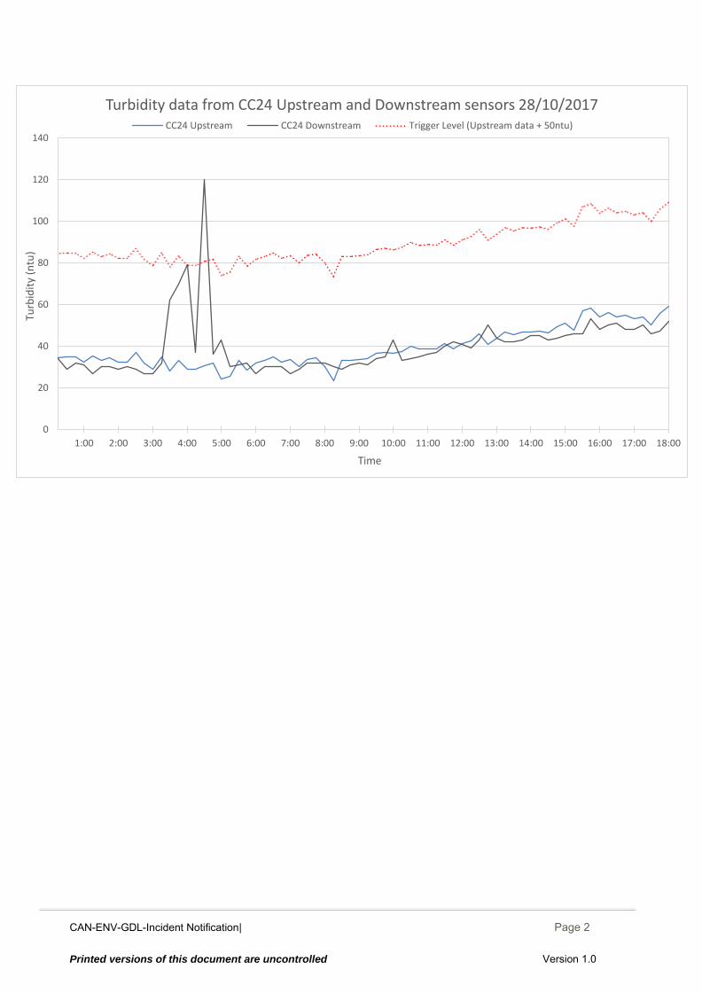
CAN-ENV-GDL-Incident Notification| December 2014
Page 2
Printed versions of this document are uncontrolled Version 1.0
0
20
40
60
80
100
120
140
18:0017:0016:0015:0014:0013:0012:0011:0010:009:008:007:006:005:004:003:002:001:00
Turb
idit
y (n
tu)
Time
Turbidity data from CC24 Upstream and Downstream sensors 28/10/2017 CC24 Upstream CC24 Downstream Trigger Level (Upstream data + 50ntu)
CAN-ENV-GDL-Incident Notification| December 2014
Page 1
Printed versions of this document are uncontrolled Version 1.0
CAN-ENV-GDL-Incident Notification to Regulators
Canterbury Coal Mine
Incident Notification Report
INCIDENT NOTIFICATION REPORT SITE: CC24, Bush Gully
INCIDENTID: 20171030
SECTION A INCIDENT DETAILS
Incident Date / / at : (24-hour time)
Reported Date / / at : (24-hour time)
Reported By Reported to
Incident Description
Potential Causes Immediate Actions And / Or Plans to Resolve Identified Issues
Actions Taken to Prevent Recurrence or Further Environmental Damage
Notification to be sent to: Canterbury Regional Council Attention: Regional Leader Monitoring and Compliance Within 24 hours of receiving results
Sensors were checked and cleaned. Water quality at the sensors was checked; >500mm visibility. Water quality in the North ELF settling pond was good; >500mm visibility. Position of decant tower was checked and is still raised above water level, verifying there has been no discharge.
Inadequate/failed erosion controls Erosion
Other Potentially Livestock
Breakdowns / malfunction Inadequate/failed sediment controls
Gayla Bonham-Carter
10
10 20176
15 00
2017 31
30
Turbidity was >50ntu different between upstream and downstream sensors at 15:00 and 17:00. No discharge from site since the 25th of October. Downstream sensor is installed very close to the bottom to keep the pH sensor submerged. The turbidity sensor is easily blocked by anything being transported down the stream causing irregular readings.
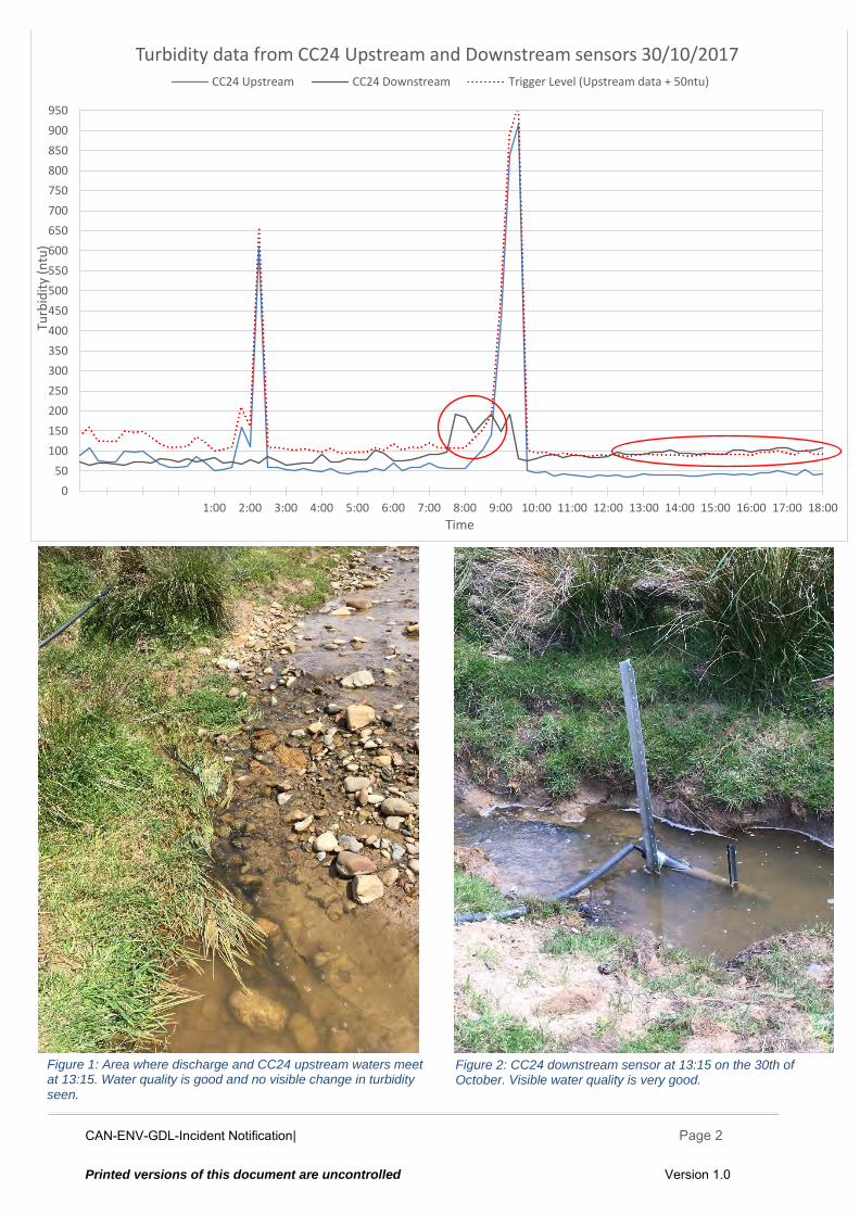
CAN-ENV-GDL-Incident Notification| December 2014
Page 2
Printed versions of this document are uncontrolled Version 1.0
0
50
100
150
200
250
300
350
400
450
500
550
600
650
700
750
800
850
900
950
18:0017:0016:0015:0014:0013:0012:0011:0010:009:008:007:006:005:004:003:002:001:00
Turb
idit
y (n
tu)
Time
Turbidity data from CC24 Upstream and Downstream sensors 30/10/2017CC24 Upstream CC24 Downstream Trigger Level (Upstream data + 50ntu)
Figure 2: CC24 downstream sensor at 13:15 on the 30th of October. Visible water quality is very good.
Figure 1: Area where discharge and CC24 upstream waters meet at 13:15. Water quality is good and no visible change in turbidity
seen.
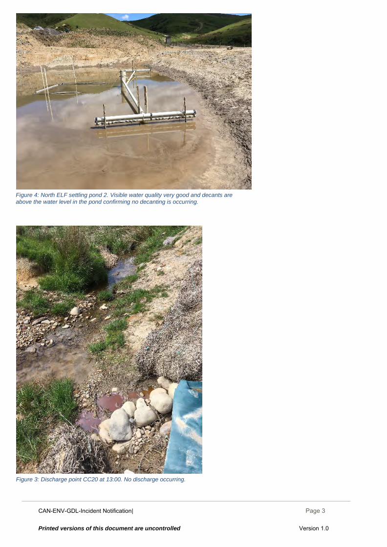
CAN-ENV-GDL-Incident Notification| December 2014
Page 3
Printed versions of this document are uncontrolled Version 1.0
Figure 3: Discharge point CC20 at 13:00. No discharge occurring.
Figure 4: North ELF settling pond 2. Visible water quality very good and decants are above the water level in the pond confirming no decanting is occurring.
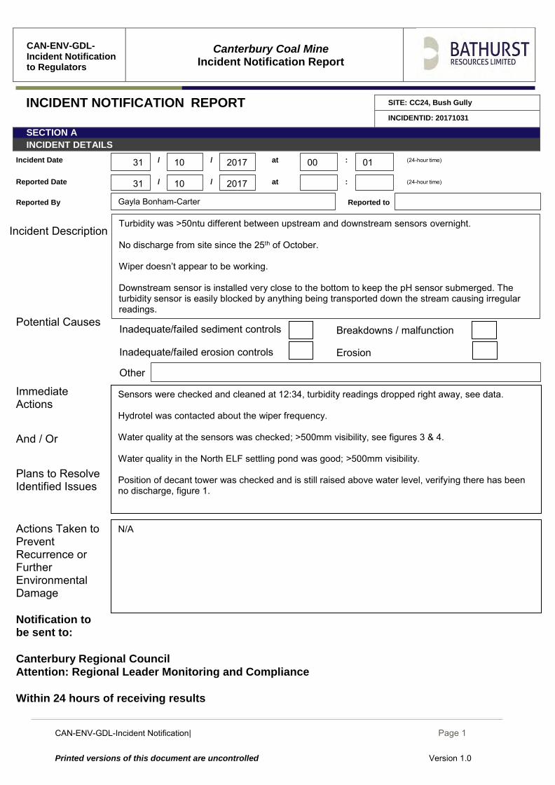
CAN-ENV-GDL-Incident Notification| December 2014
Page 1
Printed versions of this document are uncontrolled Version 1.0
CAN-ENV-GDL-Incident Notification to Regulators
Canterbury Coal Mine
Incident Notification Report
INCIDENT NOTIFICATION REPORT SITE: CC24, Bush Gully
INCIDENTID: 20171031
SECTION A INCIDENT DETAILS
Incident Date / / at : (24-hour time)
Reported Date / / at : (24-hour time)
Reported By Reported to
Incident Description
Potential Causes Immediate Actions And / Or Plans to Resolve Identified Issues
Actions Taken to Prevent Recurrence or Further Environmental Damage
Notification to be sent to: Canterbury Regional Council Attention: Regional Leader Monitoring and Compliance Within 24 hours of receiving results
N/A
Sensors were checked and cleaned at 12:34, turbidity readings dropped right away, see data. Hydrotel was contacted about the wiper frequency. Water quality at the sensors was checked; >500mm visibility, see figures 3 & 4. Water quality in the North ELF settling pond was good; >500mm visibility. Position of decant tower was checked and is still raised above water level, verifying there has been no discharge, figure 1.
Inadequate/failed erosion controls Erosion
Other
Breakdowns / malfunction Inadequate/failed sediment controls
Gayla Bonham-Carter
10
10 20176
00 01
2017 31
31
Turbidity was >50ntu different between upstream and downstream sensors overnight. No discharge from site since the 25th of October. Wiper doesn’t appear to be working. Downstream sensor is installed very close to the bottom to keep the pH sensor submerged. The turbidity sensor is easily blocked by anything being transported down the stream causing irregular readings.
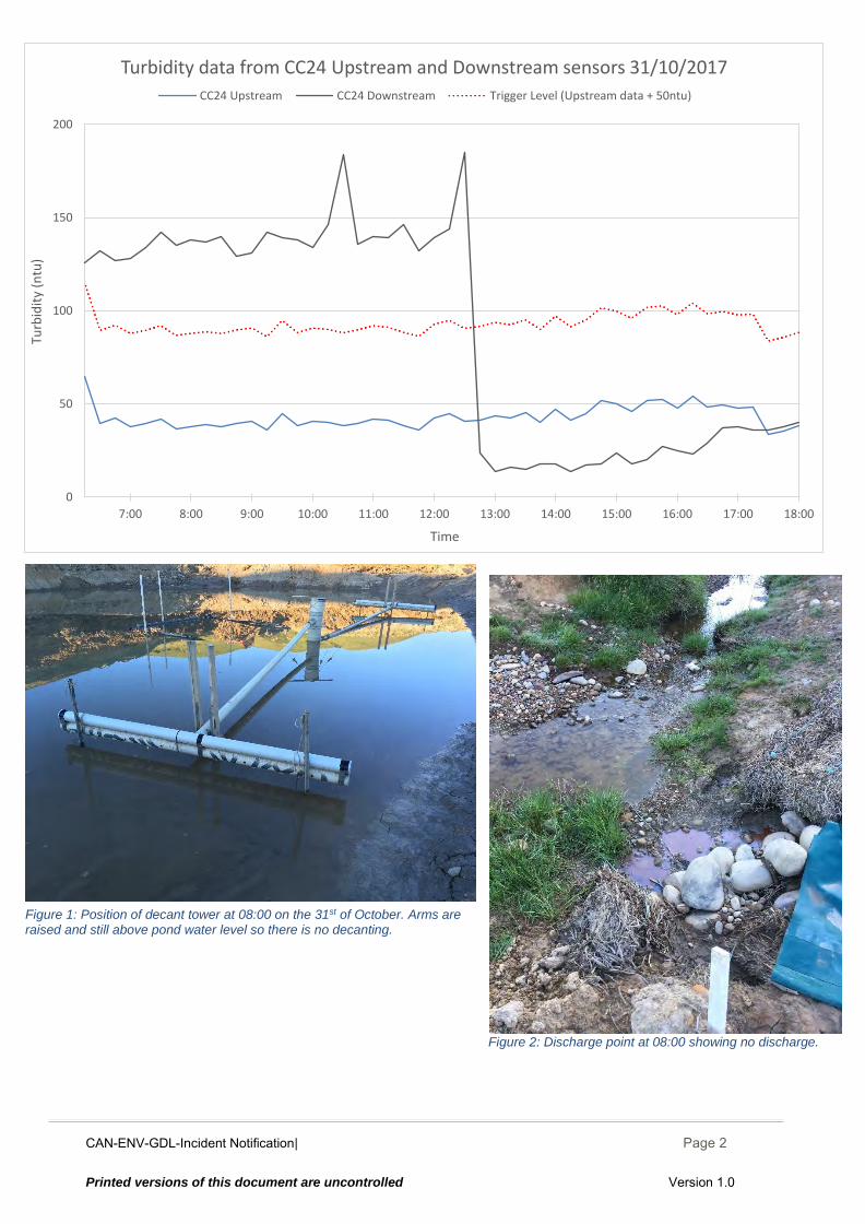
CAN-ENV-GDL-Incident Notification| December 2014
Page 2
Printed versions of this document are uncontrolled Version 1.0
Figure 2: Discharge point at 08:00 showing no discharge.
0
50
100
150
200
18:0017:0016:0015:0014:0013:0012:0011:0010:009:008:007:00
Turb
idit
y (n
tu)
Time
Turbidity data from CC24 Upstream and Downstream sensors 31/10/2017
CC24 Upstream CC24 Downstream Trigger Level (Upstream data + 50ntu)
Figure 1: Position of decant tower at 08:00 on the 31st of October. Arms are raised and still above pond water level so there is no decanting.
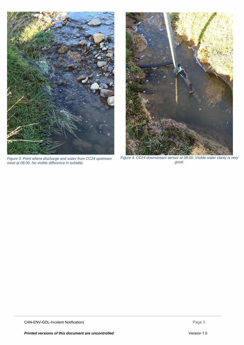
CAN-ENV-GDL-Incident Notification| December 2014
Page 3
Printed versions of this document are uncontrolled Version 1.0
Figure 4: CC24 downstream sensor at 08:00. Visible water clarity is very
good. Figure 3: Point where discharge and water from CC24 upstream meet at 08:00. No visible difference in turbidity.
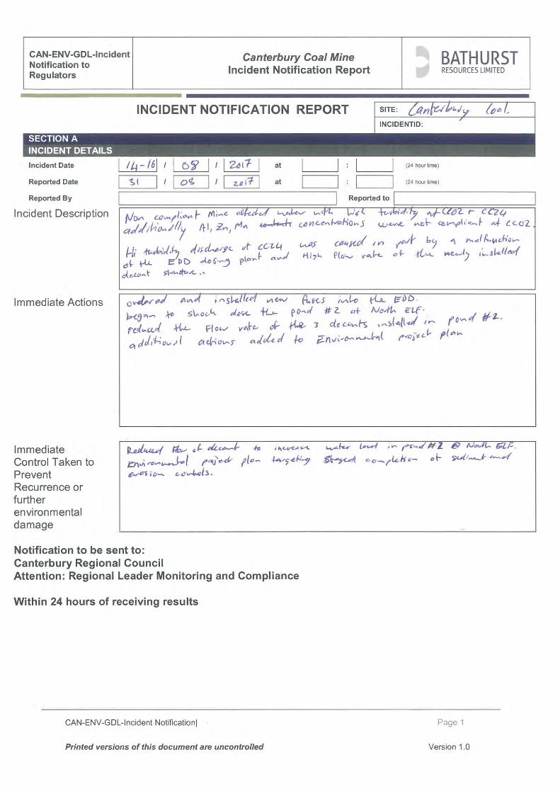
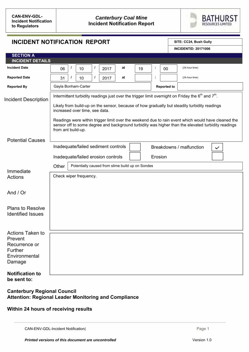
CAN-ENV-GDL-Incident Notification| December 2014
Page 1
Printed versions of this document are uncontrolled Version 1.0
CAN-ENV-GDL-Incident Notification to Regulators
Canterbury Coal Mine
Incident Notification Report
INCIDENT NOTIFICATION REPORT SITE: CC24, Bush Gully
INCIDENTID: 20171006
SECTION A INCIDENT DETAILS
Incident Date / / at : (24-hour time)
Reported Date / / at : (24-hour time)
Reported By Reported to
Incident Description
Potential Causes Immediate Actions And / Or Plans to Resolve Identified Issues
Actions Taken to Prevent Recurrence or Further Environmental Damage
Notification to be sent to: Canterbury Regional Council Attention: Regional Leader Monitoring and Compliance Within 24 hours of receiving results
Areas of erosion Inadequate/failed erosion controls
Check wiper frequency.
Inadequate/failed erosion controls Erosion
Other Potentially caused from slime build up on Sondes
Breakdowns / malfunction Inadequate/failed sediment controls
Gayla Bonham-Carter
10
10 2017 19 00
2017 31
06
Intermittent turbidity readings just over the trigger limit overnight on Friday the 6th and 7th. Likely from build-up on the sensor, because of how gradually but steadily turbidity readings increased over time, see data. Readings were within trigger limit over the weekend due to rain event which would have cleaned the sensor off to some degree and background turbidity was higher than the elevated turbidity readings from ant build-up.
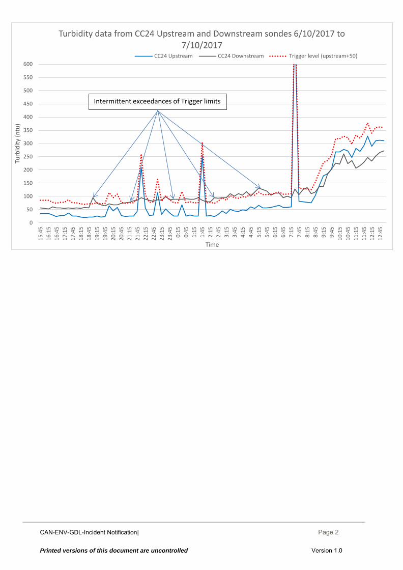
CAN-ENV-GDL-Incident Notification| December 2014
Page 2
Printed versions of this document are uncontrolled Version 1.0
0
50
100
150
200
250
300
350
400
450
500
550
600
15
:45
16
:15
16
:45
17
:15
17
:45
18
:15
18
:45
19
:15
19
:45
20
:15
20
:45
21
:15
21
:45
22
:15
22
:45
23
:15
23
:45
0:1
5
0:4
5
1:1
5
1:4
5
2:1
5
2:4
5
3:1
5
3:4
5
4:1
5
4:4
5
5:1
5
5:4
5
6:1
5
6:4
5
7:1
5
7:4
5
8:1
5
8:4
5
9:1
5
9:4
5
10
:15
10
:45
11
:15
11
:45
12
:15
12
:45
Turb
idit
y (n
tu)
Time
Turbidity data from CC24 Upstream and Downstream sondes 6/10/2017 to 7/10/2017
CC24 Upstream CC24 Downstream Trigger level (upstream+50)
Intermittent exceedances of Trigger limits
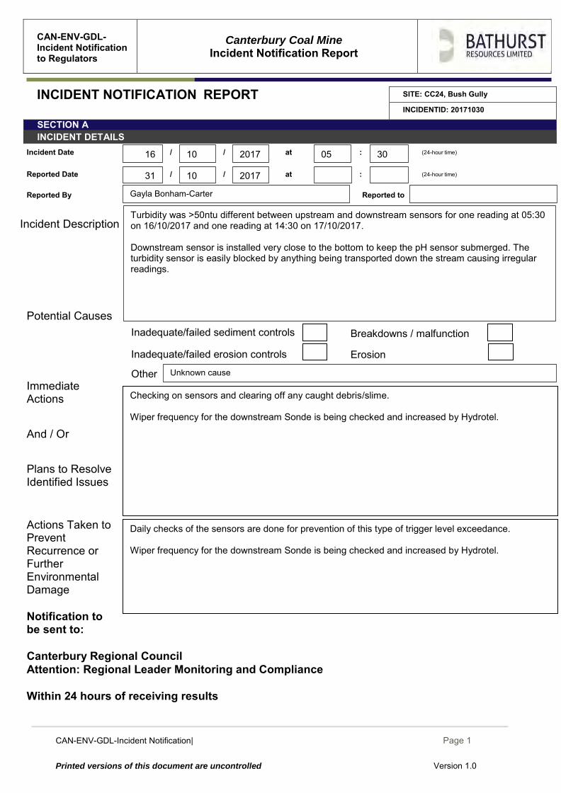
CAN-ENV-GDL-Incident Notification| December 2014
Page 1
Printed versions of this document are uncontrolled Version 1.0
CAN-ENV-GDL-Incident Notification to Regulators
Canterbury Coal Mine
Incident Notification Report
INCIDENT NOTIFICATION REPORT SITE: CC24, Bush Gully
INCIDENTID: 20171030
SECTION A INCIDENT DETAILS
Incident Date / / at : (24-hour time)
Reported Date / / at : (24-hour time)
Reported By Reported to
Incident Description
Potential Causes Immediate Actions And / Or Plans to Resolve Identified Issues
Actions Taken to Prevent Recurrence or Further Environmental Damage
Notification to be sent to: Canterbury Regional Council Attention: Regional Leader Monitoring and Compliance Within 24 hours of receiving results
Areas of erosion Inadequate/failed erosion controls
Daily checks of the sensors are done for prevention of this type of trigger level exceedance. Wiper frequency for the downstream Sonde is being checked and increased by Hydrotel.
Checking on sensors and clearing off any caught debris/slime. Wiper frequency for the downstream Sonde is being checked and increased by Hydrotel.
Inadequate/failed erosion controls Erosion
Other Unknown cause
Breakdowns / malfunction Inadequate/failed sediment controls
Gayla Bonham-Carter
10
10 20176
05 30
2017 31
16
Turbidity was >50ntu different between upstream and downstream sensors for one reading at 05:30 on 16/10/2017 and one reading at 14:30 on 17/10/2017. Downstream sensor is installed very close to the bottom to keep the pH sensor submerged. The turbidity sensor is easily blocked by anything being transported down the stream causing irregular readings.
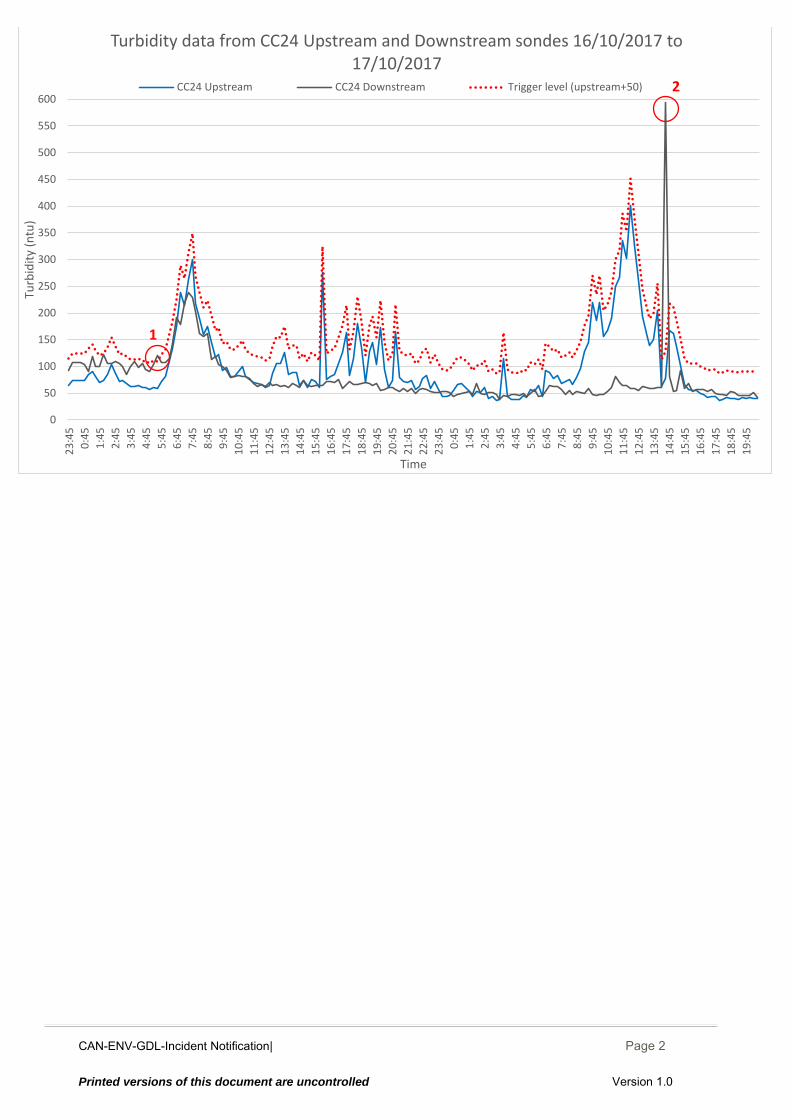
CAN-ENV-GDL-Incident Notification| December 2014
Page 2
Printed versions of this document are uncontrolled Version 1.0
0
50
100
150
200
250
300
350
400
450
500
550
600
23
:45
0:4
5
1:4
5
2:4
5
3:4
5
4:4
5
5:4
5
6:4
5
7:4
5
8:4
5
9:4
5
10
:45
11
:45
12
:45
13
:45
14
:45
15
:45
16
:45
17
:45
18
:45
19
:45
20
:45
21
:45
22
:45
23
:45
0:4
5
1:4
5
2:4
5
3:4
5
4:4
5
5:4
5
6:4
5
7:4
5
8:4
5
9:4
5
10
:45
11
:45
12
:45
13
:45
14
:45
15
:45
16
:45
17
:45
18
:45
19
:45
Turb
idit
y (n
tu)
Time
Turbidity data from CC24 Upstream and Downstream sondes 16/10/2017 to 17/10/2017
CC24 Upstream CC24 Downstream Trigger level (upstream+50)
1
2

CCM-ENV-RPT-001 |Oct 2017 Page 29 Printed versions of this document are uncontrolled
Appendix III: CRC173823 (Tara Gully) Laboratory Analysis Results

CCM-ENV-RPT-001 |Oct 2017 Page 30 Printed versions of this document are uncontrolled
Appendix IV: Trigger Value Exceedance Reports Tara Gully

CCM-ENV-RPT-001 |Oct 2017 Page 31 Printed versions of this document are uncontrolled
Appendix V: Trigger Value Exceedance Reports Bush Gully