Embed Size (px)
Citation preview
Live the adventure
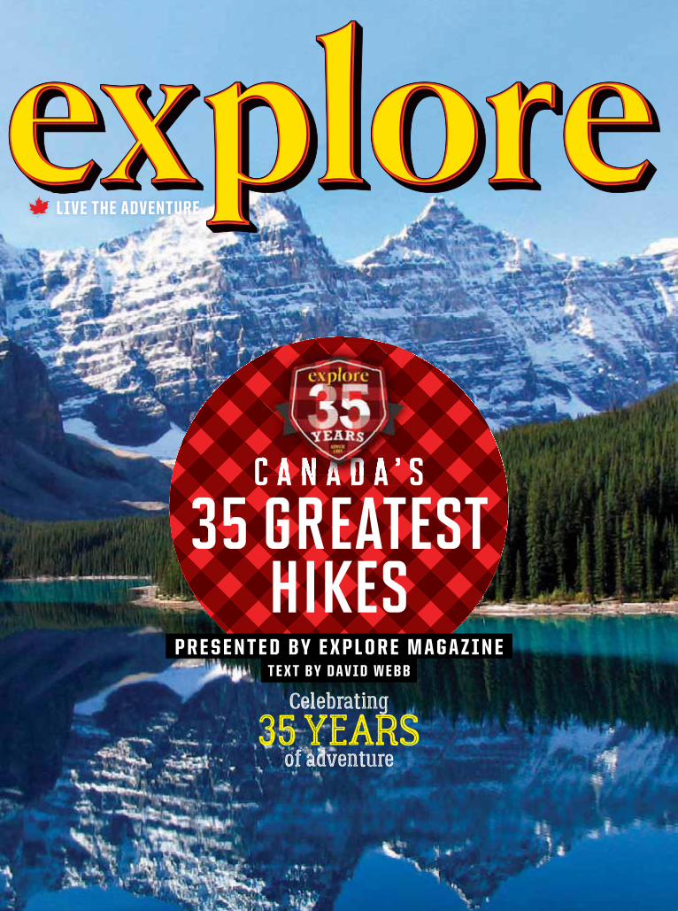
C a n a d a ’ s 35 greatest
hikest e x t b y d a v i d W e b b
P r e s e n t e d b y e x P L o r e M a g a z i n e
C a n a d a ’ sC a n a d a ’ sC a n a d a ’ sC a n a d a ’ sC a n a d a ’ sC a n a d a ’ sC a n a d a ’ sC a n a d a ’ sC a n a d a ’ sC a n a d a ’ sC a n a d a ’ sC a n a d a ’ sC a n a d a ’ sC a n a d a ’ sC a n a d a ’ sC a n a d a ’ sC a n a d a ’ sC a n a d a ’ sC a n a d a ’ sC a n a d a ’ sC a n a d a ’ s
Celebrating
35 years of adventure
contents
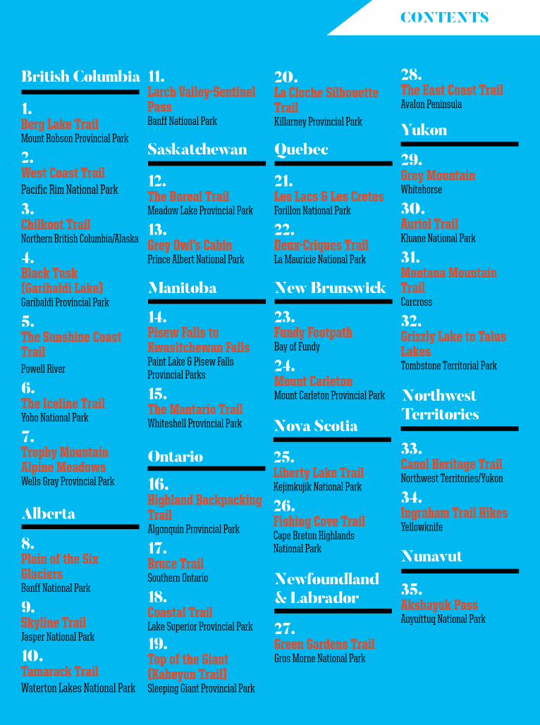
British columbia
Alberta
saskatchewan
Manitoba
ontario
Quebec
new Brunswick
nova scotia
newfoundland & Labrador
Yukon
northwest territories
nunavut
35. Akshayuk PassAuyuittuq National Park
1. Berg Lake TrailMount Robson Provincial Park
2. West Coast TrailPacific Rim National Park
3. Chilkoot TrailNorthern British Columbia/Alaska
4. Black Tusk (Garibaldi Lake)Garibaldi Provincial Park
5. The Sunshine Coast TrailPowell River
6. The Iceline TrailYoho National Park
7. Trophy Mountain Alpine MeadowsWells Gray Provincial Park
8. Plain of the Six GlaciersBanff National Park
9. Skyline TrailJasper National Park
10. Tamarack TrailWaterton Lakes National Park
12. The Boreal TrailMeadow Lake Provincial Park
13. Grey Owl’s CabinPrince Albert National Park
14. Pisew Falls to Kwasitchewan FallsPaint Lake & Pisew Falls Provincial Parks
15. The Mantario TrailWhiteshell Provincial Park
16. Highland Backpacking TrailAlgonquin Provincial Park
17. Bruce TrailSouthern Ontario
18. Coastal TrailLake Superior Provincial Park
19. Top of the Giant (Kabeyun Trail)Sleeping Giant Provincial Park
21. Les Lacs & Les CretesForillon National Park
22. Deux-Criques TrailLa Mauricie National Park
23. Fundy FootpathBay of Fundy
24. Mount CarletonMount Carleton Provincial Park
25. Liberty Lake TrailKejimkujik National Park
26. Fishing Cove TrailCape Breton Highlands National Park
27. Green Gardens TrailGros Morne National Park
29. Grey MountainWhitehorse
30. Auriol TrailKluane National Park
31. Montana Mountain TrailCarcross
32. Grizzly Lake to Talus LakesTombstone Territorial Park
33. Canol Heritage TrailNorthwest Territories/Yukon
34. Ingraham Trail HikesYellowknife
11. Larch Valley-Sentinel PassBanff National Park
20. La Cloche Silhouette TrailKillarney Provincial Park
28. The East Coast TrailAvalon Peninsula

Think back to the moment on your last hike when you stood in quiet awe of a view so perfect the world seemed to pause as you marvelled at its beauty. Remember the way the air smelled, perhaps scented by woodland foliage or ocean mist. Visualize the serenity of the forest, alpine or coastline. Think of how every drop of sweat was so worth it to experience this one mindful moment.
To commemorate explore’s 35th anniversary, we’ve compiled 35 ways for you to feel that sensation again.
Canada is a big, beautiful country with boundless options for hiking in our vast parks and wild spaces. It’s often challenging just to find a trail, let alone hoof it, so we’ve done the grunt-work for you with this guide to Canada’s 35 Greatest Hikes.
By no means an exhaustive list of all of Canada’s best hikes, let this guidebook serve as an entry point to a world of outdoor wonder. From here, you’ll soon discover a plethora of additional hikes in every region.
We hope you enjoy these trails—35 of our favourites from 35 years of publishing Canada’s number-one outdoor adventure magazine: explore.
SINCE 1981
YEARS
introduction
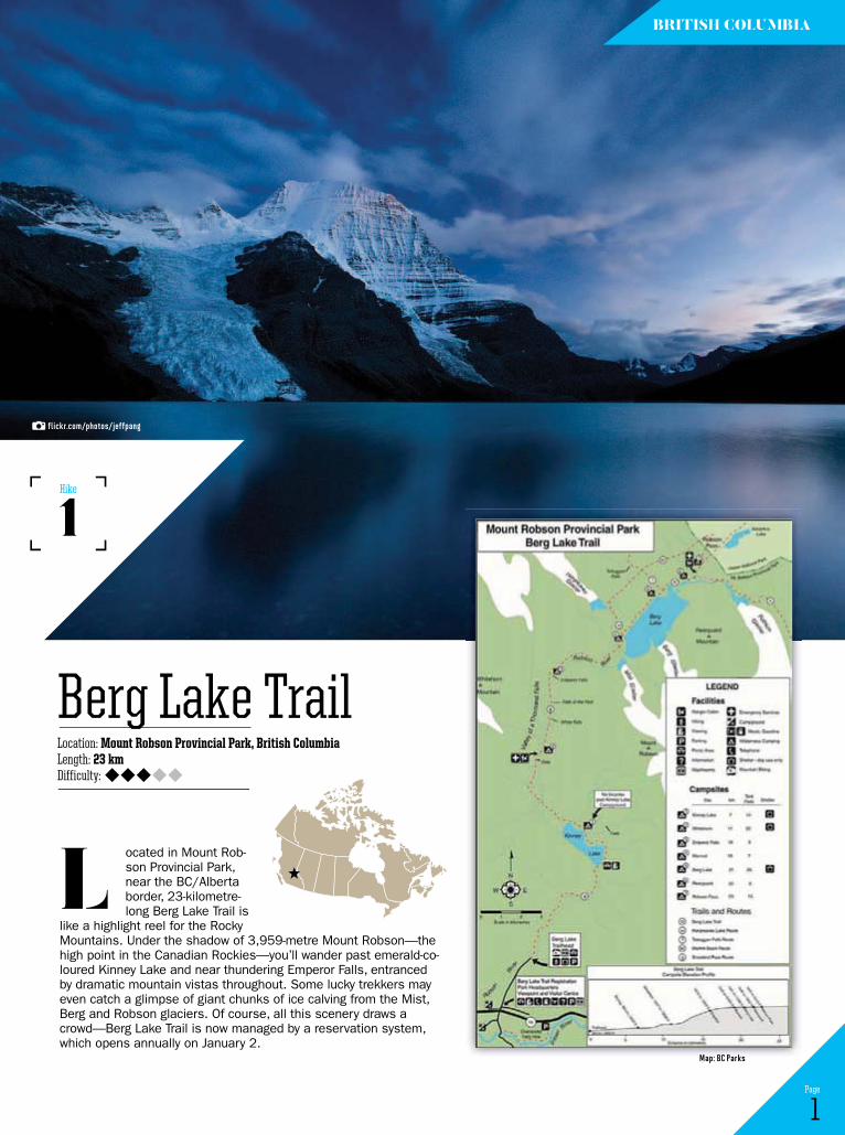
ocated in Mount Rob-son Provincial Park, near the BC/Alberta border, 23-kilometre-long Berg Lake Trail is
like a highlight reel for the Rocky Mountains. Under the shadow of 3,959-metre Mount Robson—the high point in the Canadian Rockies—you’ll wander past emerald-co-loured Kinney Lake and near thundering Emperor Falls, entranced by dramatic mountain vistas throughout. Some lucky trekkers may even catch a glimpse of giant chunks of ice calving from the Mist, Berg and Robson glaciers. Of course, all this scenery draws a crowd—Berg Lake Trail is now managed by a reservation system, which opens annually on January 2.
L
1 Page
Location: Mount Robson Provincial Park, British ColumbiaLength: 23 kmDifficulty:
Berg Lake Trail
1Hike
British coLuMBiA
flickr.com/photos/jeffpang
Map: BC Parks
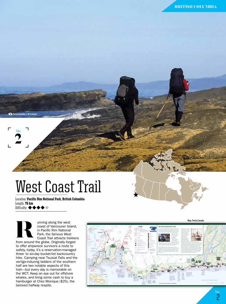
unning along the west coast of Vancouver Island, in Pacific Rim National Park, the famous West Coast Trail attracts trekkers
from around the globe. Originally forged to offer shipwreck survivors a route to safety, today, it’s a reservation-managed three- to six-day bucket-list backcountry hike. Camping near Tsusiat Falls and the vertigo-inducing ladders of the southern half are two notable aspects of this trail—but every day is memorable on the WCT. Keep an eye out for offshore whales, and bring some cash to buy a hamburger at Chez Monique ($25), the beloved halfway respite.
r
2 Page
Location: Pacific Rim National Park, British ColumbiaLength: 76 kmDifficulty:
West Coast Trail
2Hike
British coLuMBiA
Entrance Anchorage
SachawilHelby Is
MackenzieAnchorage
DiannaIsland
Hamilton Point
Voss Pt
Taylor Is
Haines Is
Whittlestone PtTapaltos Bay
Lawton Pt
Keeha Bay
P A C I FI C O C E A N
Keeh Ba each
Kicha TSL
Sachsa
Peni
nsul
a
BradyBeach
Bamfield
Inlet
Bamfield
Aguilar PtSelf Pt
3RUW� ' � VLU�
Clutus Pt
Seabird Rocks
Pachena
Bay
AnaclaTSL
Calamity Lake
Pachena
River
Black
ClonardCreek
Lake
BlackRiverMalsit
TSLMalsitTSL
Michigan
Creek
Pac
hena
Pt
P
ache
naLi
ghth
ouse
DarlingRiver
Orange
JuiceCk
Tsocowis
Creek
Vale
ncia
Bl
uffs
BillyGoat
Creek
TrestleCreek
Klanawa
River
LittleTsusiat
Lake
TsusiatFalls
Hobiton
HobitonLakeLake
CreekTsusiatTsusiat
LakeLake
Tsus
iat P
t
River
Tsusiat
L i t t leSqual icum
Lake
L i t t leSqual icum
Lake
Squal icum
Creek
Tsuquadra Lake
IR 2
TsuquadraPt
Nitinat
Narrows
IR 7
SqualicumLake
ClutusTSL
IR 1
Mud Cove
extensive mud flats at low tidepassable attides 6ft/1.8m
extensive mud flats at low tidepassable attides 6ft/1.8m
Deadm
an
Cove
headlands betweenPachena Access and Michigan Creekare impassable
passableat tides below
9ft/2.7m
ladders to main trail
passable attides below7ft/2.1 m
JUAN DE FUCA STRAIT
TrevorC
hannel
derelict donkey enginederelict grader
anchoron rocks
WCT InformationCentre - register onand off the trail here.0 D\ � � � � � � 6HSW� � �
WCT InformationCentre - register onand off the trail here.0 D\ � � � � � � 6HSW� � �
Cape Beale
Mills
Cape Beale LighthouseCape Beale Lighthouse
trail from DarlingRiver east to thispoint passable attides below 9ft/2.7m
Pachena Beach
Burts Is
BurloIs
Pachena Access
KichhaLake
30 km
28 km
26 km24 km
22 km
20 km
18 km16
km
14 km
12 km
10 km
8 km
6 km
4 km
3.5 km
4 km
2 km
2 km
6 km
7 km
2 km
3 masted schooner"VESTA" 286 tons,December 1897,no loss of life.
true northm
agne
tic n
orth
24o
Please note, park boundaries are approximate.
passableat tides below
8ft/2.4m
sea lion
haul out rock
(Bamfield = 5km)(Bamfield = 5km)
"NEREUS" 4070-tonGreek freighterAug. 1937, outof Kobe for Point Alberni, no lossof life.
"BRUCE 1", seiner Feb. 1976, crew of four, twocrew lost. American barque
"CHARLES B. KINNEY"Nov. 1886, with lumberout of Port Townsendfor Australia, no survivors.
Wooden steamer "ALASKAN"150 tons, Jan. 1923 out ofVictoria loaded with saltfor the salteries in BarkleySound, entire crew lost.
767 ton wooden schooner"SEQUEL", Jan. 1909, outof Callao in ballast, captain'swife and 3 year old daughterlost, all others survived.
3 masted barque"SARAH", 1206 tons,Nov. 1891, a Britishship from Manila in ballast for PugetSound, 2 crew lost. 3 masted ship
"BECHERDASS-AMBIADASS"1386 tons, July 1879,in ballast from Shanghaito Moodyville to loadlumber, no loss of life.
"MICHIGAN" a woodensteamship, Jan. 1893,no loss of life.Steamer "MASCOTTE" to salvage "MICHIGAN" destroyed by fire Aug. 1893, no loss of life.Remnant boiler still on-shore.
"UZBEKISTAN"a Russian freighter,April 1943, loaded with lend-lease cargo,no loss of life
Motor fishing vessel"VARSITY", 90 tons,February 1940,7 crew, 3 survivors.
"VALENCIA", 1600 ton, 253 foot iron steamer,Jan. 1906, out of SanFrancisco for Victoriaand Vancouver, out of a total of 160 passengers and crew, more than 125 lives were lost.
Barque"JANETCOWAN"2497 tonwindjammer,Jan. 1896,out of Cape Town inballast forHastingsMill, froma contingentof 27, 7 diedwaiting for rescue.
4 masted schooner"ROBERTLEWERS"732 tons,April 1923,inbound in ballast fromHonolulu forBellingham,no loss of life.
Steamship "WOODSIDE"built in Sooke, providedregular service betweenVictoria, Port Renfrew,Barkley Sound andAlberni Canal, March 1888,no lives lost
3 masted barkentine
"UNCLE JOHN",314 tons, Oct. 1899,
in ballast fromHonolulu for
Port Townsend to load lumber,no loss of life.
120
30
210
120
420
300
570
240
150
150
90
60
90
90
30
30
90
90
60
240
150
90
210 120
60
90
60
180
240
150
300
360300
270210
150
150
270240
240
210
150
150
150
120
150
90
60
30
390
120
50
90120
120
180
30
30
60
90
30
30
90
60
60
30
30
30
120
60
30
60
30
0 0.5 1 2 miles
0 1 2 3 kilometres
GC
GC
IR 12
LEGEND
24km
1414
swampy area
Indian Reserve
buildings
sand, foreshore flatsrocky ledge, rocky reefshipwreck, general location only
campsite - all campsites are locatedon the beaches
West Coast Trail Information Centre- register on and off
Pacific Rim National Park Reserve
Pacific Rim National Park ReserveMarine Zone
difficult surge channel
viewpoint, point of interest
Guardian cabin
Ditidaht luxury tent
contour interval - 30m
outhouse
access
beach access
parking
cable car
impassable headland
highwayall-weather roadWest Coast Trail forest route distance in km from Pachena AccessWest Coast Trail - beach route
Tide heights quoted on the face of the map are approximate andassume calm seas; use tide tables for Tofino, B.C. Add one hourduring summer months for Pacific Daylight Saving Time.
photographs courtesyParks Canada2016 edition
TSUNAMI HAZARD ZONE
IN CASE OF EARTHQUAKE, GOTO HIGH GROUND OR INLAND
GC
TSL Treaty Settlement Lands
Huu-ay-aht Place Name(HFN)Ditidaht Place Name (DFN)Pacheedaht Place Name(PFN)
Food locker
West CoastTrail Map Bamfield to Port Renfrew, Vancouver Island
The West Coast Trail is recommended for experienced backpackers only.
Juan de Fuca Strai t
Strai t of Georgia
Cape Flattery
West Coast Trail
Broken Group Islands
Long Beach
Ucluele
t
Bamfie
ld
PortAlberni
Tofin
o
Parksville
Nanaimo
Victoria
Regional Setting
Sooke
Duncan
1
Pacif ic Ocean
N
1414
191944
Sidney
Vancouver Island
Port Renfrew
Lake Cowichan
The story behind the trail:The Huu-ay-aht, Ditidaht and Pacheedaht First Nations However, after the wreck
The Valenciahave always lived along Vancouver Island's west coast. of the Valencia in 1906, These nations used trails and paddling routes for trade with the loss of 133 lives, and travel long before foreign sailing ships reached this the public demanded
region over 200 the government do years ago. Over the more to help mariners century following along this coastline. contact sailors In response the brought the government built beginning of a Pachena Lighthouse, changing world to established lifesaving the First Nations. stations and improved Trade increased, and the telegraph route to become a life saving trail for
many sailing ships met a tragic fate navigating in these shipwreck victims and their rescuers. With improvements unfamiliar and hazardous waters. Sailors soon referred to technology the frequency of shipwrecks decreased and to this coastline as the “Graveyard of the Pacific”. the life saving trail was gradually abandoned. In 1973 the
trail became part of the newly established Pacific Rim Between 1888 and 1890 the government erected a National Park Reserve. Today, hiking the West Coast Trail telegraph line along the coastline. The line was an attempt is about exploring Vancouver Island’s temperate rainforest to establish communications between the west coast and wild coastline, experiencing a fabled land recounted villages, the newly established Cape Beale and Carmanah in traditional histories, walking in the steps of shipwreck lighthouses, and larger communities in hopes of saving victims, and appreciating the beauty of territories that mariner lives. First Nation people continue to call home.
Parks Canada/J. McCulloch
Map: Parks Canada
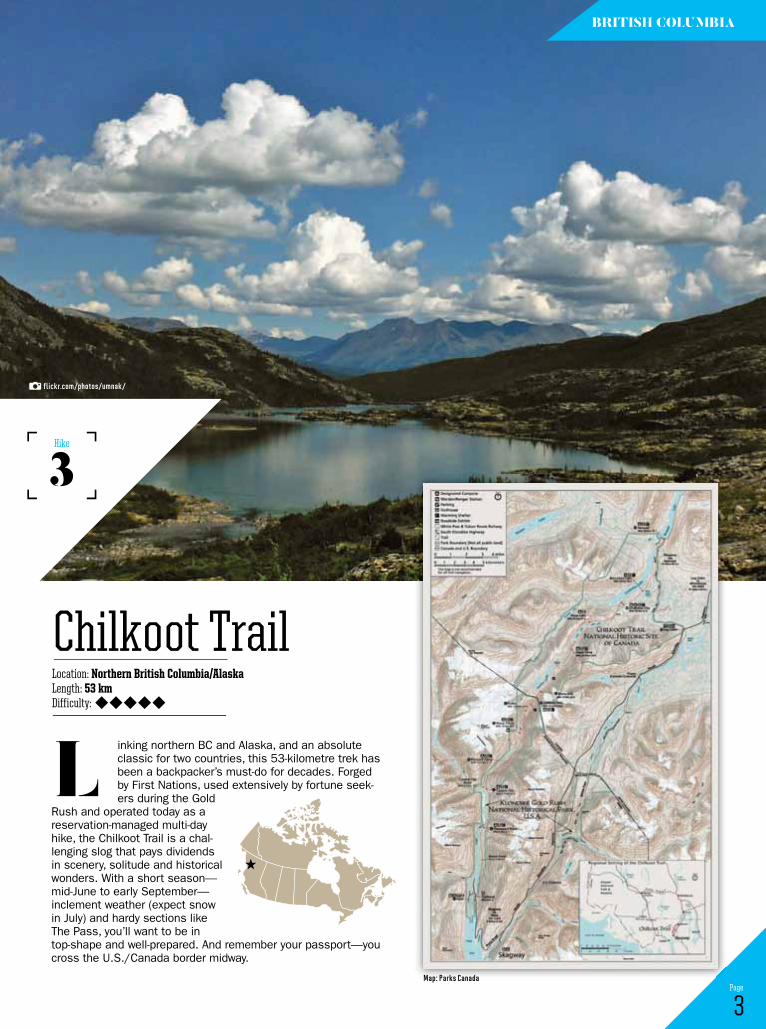
inking northern BC and Alaska, and an absolute classic for two countries, this 53-kilometre trek has been a backpacker’s must-do for decades. Forged by First Nations, used extensively by fortune seek-ers during the Gold
Rush and operated today as a reservation-managed multi-day hike, the Chilkoot Trail is a chal-lenging slog that pays dividends in scenery, solitude and historical wonders. With a short season—mid-June to early September—inclement weather (expect snow in July) and hardy sections like The Pass, you’ll want to be in top-shape and well-prepared. And remember your passport—you cross the U.S./Canada border midway.
L
3 Page
Location: Northern British Columbia/AlaskaLength: 53 kmDifficulty:
Chilkoot Trail
3Hike
British coLuMBiA
flickr.com/photos/umnak/
Map: Parks Canada

he skeleton of an ancient volcano, Black Tusk is the most recognizable prominence in Garibaldi Park. See it up close on a multi-day wilder-ness trek accessed via the Black
Tusk/Garibaldi Lake Area, 40 kilometres north of Squamish. The route to Garibaldi Lake is nine kilometres of picturesque, moderately challenging switchbacks; at the lake, you’ll find 50 tent sites, four cooking shelters and pit toilets. Pitch a tent here and fuel up before tackling the seven-kilome-tre trek (850 metres of elevation gain) to the base of Black Tusk. It is possible to climb the Tusk, but only skilled mountaineers should attempt this. Camp overnight at Garibaldi Lake and return to your car in the morning, or stay several days and explore the region’s copious trails.
t
4 Page
Location: Garibaldi Provincial Park, British ColumbiaLength: 32 kmDifficulty:
Black Tusk (Garibaldi Lake)
4Hike
British coLuMBiA
!
! !
!
!
!
!
!
!
!
!
!
!
!
! !
!
!
!
!
!
!
!
!
!
!
!
!
!
!
!
!
!
!
^
^
^^^
^
^
^
^
^
^
^^
^
^
^
^
^
^
^
^^ ^
^
^
^
^
^
Ro
e
Cr
BRANDYWINE FALLSPROVINCIAL PARK
Alexander Falls
C a l l a g h a n
C r e e k
Ma
de
le
yC
r
RainbowLake
GreenLake
AltaLake
WHISTLER
Alta Lake
Gondola
Nita Lake
Ch
ea
ka
m u s R i v e r
JaneLakes
BrandywineFalls
CALLAGHAN LAKEPROVINCIAL PARK
Brew Lake
Wh
i st le
rC
r ee
k The RoundHouse
Whistler Village
B l a c k c o m b eC
r e e kHors tmanCr
F i t z s i m m o n sC r e e k
BLACKCOMBSKI AREA
WhistlerSki Area
We
d g eC r e e k
WedgePass
R e t h e l C r e e k
WedgemountLake
Wea
rtG
laci
e r
Gr e
en
Ri v
er
M y s t e r y C r e e k
W e d g e m o u n t C r
To Pemberton
H I BAT C
HI
RID
GE
Berma Lake
Shat
ter G
laci
e r
Shud
der G
l.
BLACKCOMB GLACIERPROVINCIAL PARK
Phalanx Glacier
F I T Z S I M M O N S
R A N G E
SPEARHEAD RANG E
SINGING PASSAREA
alpi n
er ou te
ieC
r ee
k
CorrieLake
He
l mC
r
Mons
McGuireSuspension Bridge
Br a n d y w i n
eC r e e k
P e r t i co
at
Cr e
ek
Lake
C h ea k amu s
L a ke
B i l l y g o a tC
r ee
k
Wedgemount Glacier
!
!Hwy99
!
Mt. Moe
The Owls
Mt. Iago
Oasis Mtn
Wedge Mtn
Decker Mtn.
Eureka MtnRethel Mtn.
Mt. Macbeth
Quiver Peak
Tremor Mtn.
Fissle Mtn.
Oboe
Phalanx Mtn.
Whistler Mtn
Carcajou Peak
Parkhurst Mtn.
Blackcomb Peak
Piccolo
Cheakamus Mtn.
Mt. Brew
Mt. CookMt. Weart
Mt. Pattison
Flute
Overlord Mtn.
Mt. Fitzsimmons
Lesser Wedge Mtn
0 5 10
Kilometers
Legend
GARIBALDIPROVINCIAL PARK
Park Boundary
Glacier
Major Highway
Local Road, paved
Local Road, gravel
Trail
Hiking Trail
Mountain Biking Trail
Cross-Country SkiingTrail
Ski Lift!
!
Vehicle/Tent Camping
Walk-in/WildernessCamping
Swimming
Group Camping
Shelter
Day-use Area
No Camping
Day Shelter
Parking
Ranger Station
Sani-station
Wheelchair Access
Showers
Electric Hookup
Playground
Toilets
Point of Interest
Information
Hwy99
Hwy99
arran Yates
Map: BC Parks
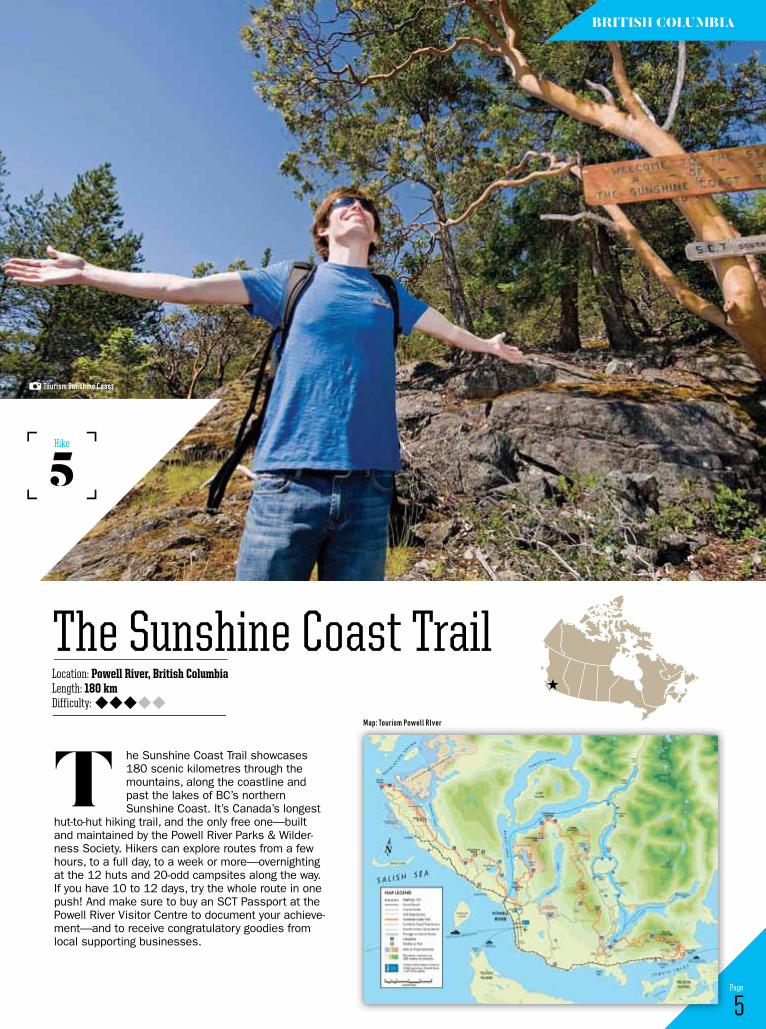
he Sunshine Coast Trail showcases 180 scenic kilometres through the mountains, along the coastline and past the lakes of BC’s northern Sunshine Coast. It’s Canada’s longest
hut-to-hut hiking trail, and the only free one—built and maintained by the Powell River Parks & Wilder-ness Society. Hikers can explore routes from a few hours, to a full day, to a week or more—overnighting at the 12 huts and 20-odd campsites along the way. If you have 10 to 12 days, try the whole route in one push! And make sure to buy an SCT Passport at the Powell River Visitor Centre to document your achieve-ment—and to receive congratulatory goodies from local supporting businesses.
t
5 Page
Location: Powell River, British ColumbiaLength: 180 kmDifficulty:
The Sunshine Coast Trail
5Hike
British coLuMBiA
tourism sunshine Coast
Map: tourism Powell river
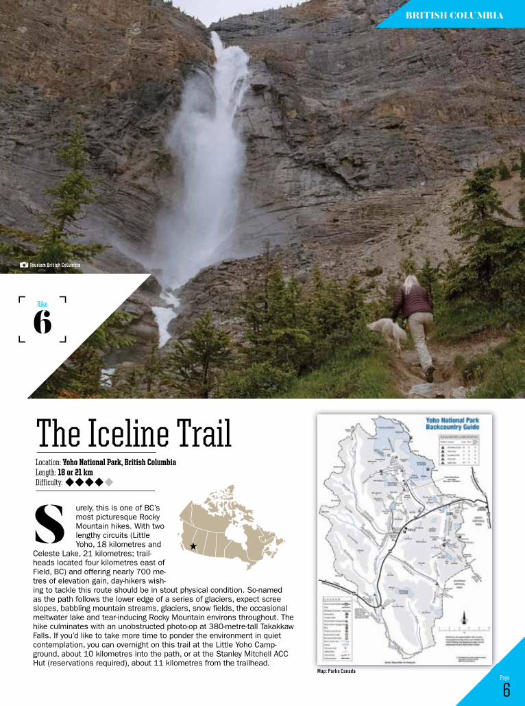
urely, this is one of BC’s most picturesque Rocky Mountain hikes. With two lengthy circuits (Little Yoho, 18 kilometres and
Celeste Lake, 21 kilometres; trail-heads located four kilometres east of Field, BC) and offering nearly 700 me-tres of elevation gain, day-hikers wish-ing to tackle this route should be in stout physical condition. So-named as the path follows the lower edge of a series of glaciers, expect scree slopes, babbling mountain streams, glaciers, snow fields, the occasional meltwater lake and tear-inducing Rocky Mountain environs throughout. The hike culminates with an unobstructed photo-op at 380-metre-tall Takakkaw Falls. If you’d like to take more time to ponder the environment in quiet contemplation, you can overnight on this trail at the Little Yoho Camp-ground, about 10 kilometres into the path, or at the Stanley Mitchell ACC Hut (reservations required), about 11 kilometres from the trailhead.
s
6 Page
Location: Yoho National Park, British ColumbiaLength: 18 or 21 kmDifficulty:
The Iceline Trail
6Hike
British coLuMBiA
tourism British Columbia
Map: Parks Canada

prawling Wells Gray Provincial Park is one of BC’s Thompson Region gems—
offering thick evergreen forest, azure lakes (including Murtle, the world’s largest canoe-only lake), robust Helmcken Falls and hikes galore. The Trophy Mountain area, a 6,900-hectare portion of the park, is accessed via Bear Creek Correctional Cen-tre Road (gravel), north of the town of Clearwater. Within an hour of setting out, you’ll be in flowery sub-alpine meadow, followed by alpine spruce and
s
7 Page
Location: Wells Gray Provincial Park, British ColumbiaLength: 12 kmDifficulty:
Trophy Mountain Alpine Meadows
7Hike
British coLuMBiA
fir trees and even more mead-ow as you meander to Sheila Lake. A light scramble from there leads you to the broad views of Skyline Ridge, about three hours after you started. Enjoy the mountain air and surrounding 2,500-plus-metre peaks before retracing your path to your car.
flickr.com/photos/7147684@n03
Map: BC Parks
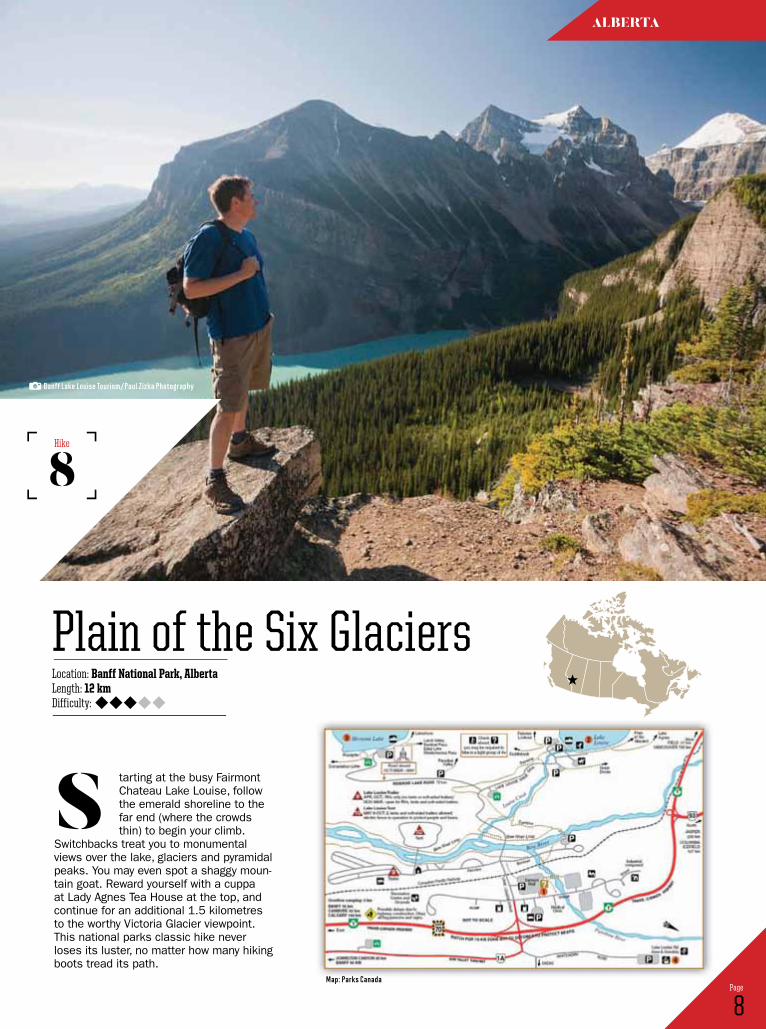
tarting at the busy Fairmont Chateau Lake Louise, follow the emerald shoreline to the far end (where the crowds thin) to begin your climb.
Switchbacks treat you to monumental views over the lake, glaciers and pyramidal peaks. You may even spot a shaggy moun-tain goat. Reward yourself with a cuppa at Lady Agnes Tea House at the top, and continue for an additional 1.5 kilometres to the worthy Victoria Glacier viewpoint. This national parks classic hike never loses its luster, no matter how many hiking boots tread its path.
s
8 Page
Location: Banff National Park, AlbertaLength: 12 kmDifficulty:
Plain of the Six Glaciers
8Hike
ALBertA
Banff Lake Louise tourism/Paul Zizka Photography
Map: Parks Canada
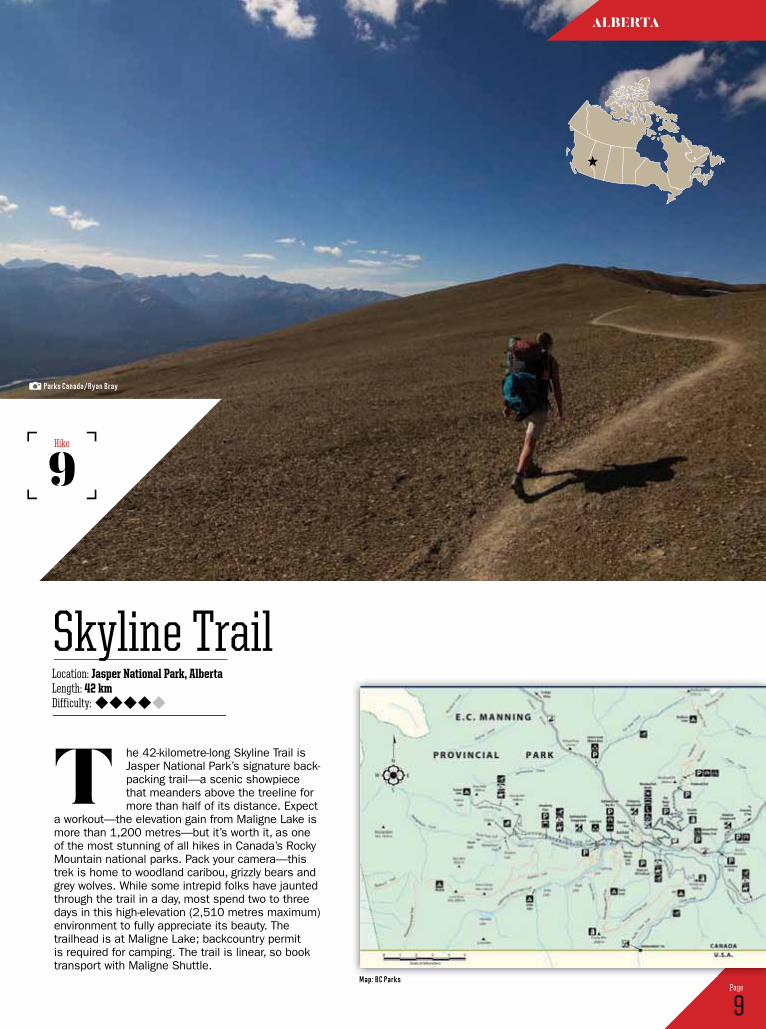
he 42-kilometre-long Skyline Trail is Jasper National Park’s signature back-packing trail—a scenic showpiece that meanders above the treeline for more than half of its distance. Expect
a workout—the elevation gain from Maligne Lake is more than 1,200 metres—but it’s worth it, as one of the most stunning of all hikes in Canada’s Rocky Mountain national parks. Pack your camera—this trek is home to woodland caribou, grizzly bears and grey wolves. While some intrepid folks have jaunted through the trail in a day, most spend two to three days in this high-elevation (2,510 metres maximum) environment to fully appreciate its beauty. The trailhead is at Maligne Lake; backcountry permit is required for camping. The trail is linear, so book transport with Maligne Shuttle.
t
9 Page
Location: Jasper National Park, AlbertaLength: 42 kmDifficulty:
Skyline Trail
9Hike
ALBertA
Parks Canada/ryan Bray
Map: BC Parks
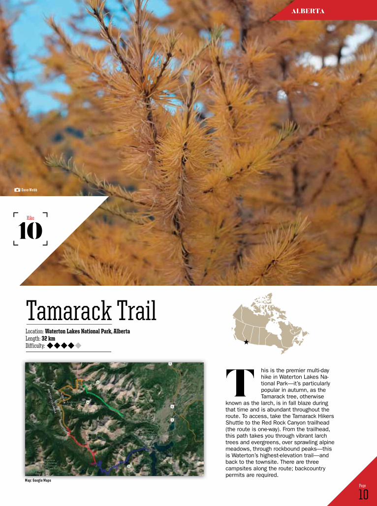
his is the premier multi-day hike in Waterton Lakes Na-tional Park—it’s particularly popular in autumn, as the Tamarack tree, otherwise
known as the larch, is in fall blaze during that time and is abundant throughout the route. To access, take the Tamarack Hikers Shuttle to the Red Rock Canyon trailhead (the route is one-way). From the trailhead, this path takes you through vibrant larch trees and evergreens, over sprawling alpine meadows, through rockbound peaks—this is Waterton’s highest-elevation trail—and back to the townsite. There are three campsites along the route; backcountry permits are required.
t
10 Page
Location: Waterton Lakes National Park, AlbertaLength: 32 kmDifficulty:
Tamarack Trail
10Hike
ALBertA
dave Webb
Map: google Maps
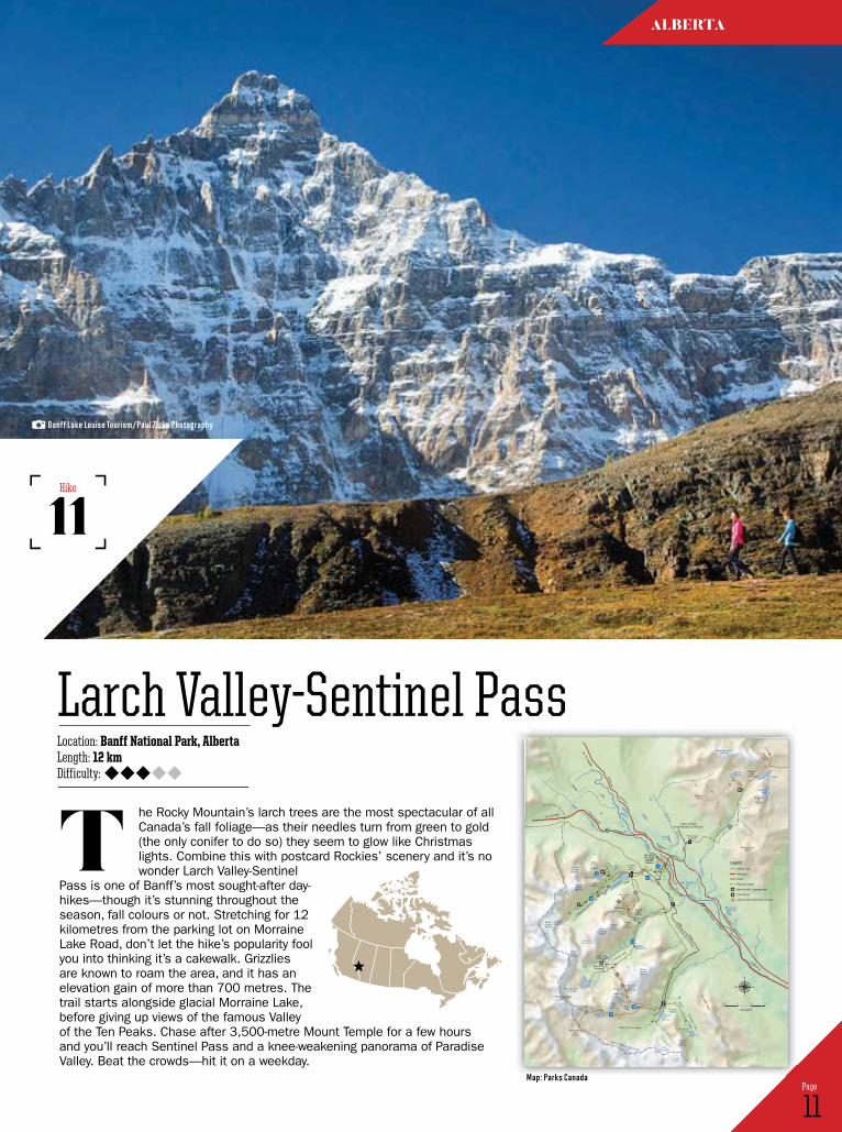
he Rocky Mountain’s larch trees are the most spectacular of all Canada’s fall foliage—as their needles turn from green to gold (the only conifer to do so) they seem to glow like Christmas lights. Combine this with postcard Rockies’ scenery and it’s no wonder Larch Valley-Sentinel
Pass is one of Banff’s most sought-after day-hikes—though it’s stunning throughout the season, fall colours or not. Stretching for 12 kilometres from the parking lot on Morraine Lake Road, don’t let the hike’s popularity fool you into thinking it’s a cakewalk. Grizzlies are known to roam the area, and it has an elevation gain of more than 700 metres. The trail starts alongside glacial Morraine Lake, before giving up views of the famous Valley of the Ten Peaks. Chase after 3,500-metre Mount Temple for a few hours and you’ll reach Sentinel Pass and a knee-weakening panorama of Paradise Valley. Beat the crowds—hit it on a weekday.
t
11 Page
Location: Banff National Park, AlbertaLength: 12 kmDifficulty:
Larch Valley-Sentinel Pass
11Hike
ALBertA
1
1
93
1A
1A
Lake Louise
1730 m
Lake Agnes
LakeAnnette
IslandLake
Mud Lake
KingfisherLake
HerbertLake
Bath
Creek
HiddenLake
RedoubtLake
PtarmiganLake
MirrorLake
TempleLake
Eiffel Lake
MoraineLake 1887 m
FAYGLACIER
HORSESHOEGLACIER
LEFROYGLACIER
VICTORIAGLACIER
WENKCHEMNA GLACIER
Consolation Lakes
MinnestimmaLakes Babel
Creek
Mora
ine
Creek
Creek
Para
dise
BO
W
RIVER
Pipestone
River
Cor
ral
Cre
ek
MountTemple3543 m
GiantSteps
HorseshoeMeadow
MountAberdeen3152 m
HaddoPeak
3070 m
SaddlePeak
2436 m
Saddleback
MORAINE
Whitehorn
Slate Road
Roa
d
LAKEOpen mid-May to mid-OctoberROAD
Fairview Mt.2744 m
SheolMt.
2779 m
BigBeehive
LittleBeehive
1.5
1.0
7.1
1.5
2.4
1.3
1.1
0.2
4.1
2.3
0.8
1.91.5
2.4
2.9
1.4
2.9
3.7
1.3
1.0
1.0
0.7
2.0
1.3
2.3
1.3
3.2
1.5
4.1
1.1
0.4
2.7
2.70.8
1.5
0.8
1.2
1.5
1.0
0.9
1.8
3.0
3.53.5
MountWhyte2983 m
MountNiblock2976 m
MountSt. Piran2649 m
Whitehorn2637 m
Mount Richardson3086 m Deception
Pass
Fish CreekTrailhead
RedoubtMt.
2902 m
Mount Lipalian2728 m
BoulderPass
2332 m
Paradise Valley
Consolation ValleyValley of the Ten Peaks
EiffelPeak
3084 m
PinnacleMt.
3067 m
MountLefroy
3423 m
MountVictoria3464 m
MountBabel
3101 m
WenkchemnaPass
2600 m
Mount Hungabee3493 m
WenkchemnaPeak Tower of
Babel
Panorama Ridge
LarchValley
SentinelPass2611 m
Plain of Six G
laciers
VILLAGEOF LAKELOUISE1536 m
TRANS-CANADA
TRANS-CANADA
HIGHWAY
HIGHWAY
ICEFIELDS
PARKWAY
PARKWAY
BOW VALLEY
LAKE LOUISESIGHTSEEING GONDOLA
To Banff
0 1 2 3
Kilometres
26
27
28
41
40
37
38
24
25
31
31
39
35
36
30
23
34
33
22
29
CHATEAULAKE
LOUISE
32
To Jasper
To Field
Hiking Trail
Highway
Road
Park Boundary
Backcountry Campground
Tea House
Lake Louise Information Centre
Legend30
Banff Lake Louise tourism/Paul Zizka Photography
Map: Parks Canada
The Boreal TrailLocation: Meadow Lake Provincial Park, SaskatchewanLength: 120 kmDifficulty:
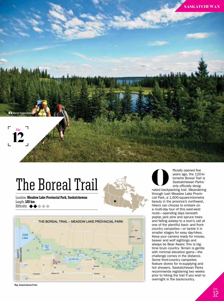
fficially opened five years ago, the 120-ki-lometre Boreal Trail is Saskatchewan Parks’ only officially desig-
nated backpacking trail. Meandering through lush Meadow Lake Provin-cial Park, a 1,600-square-kilometre beauty in the province’s northwest, hikers can choose to embark on a multi-day tour of this east-west route—spending days beneath poplar, jack pine and spruce trees and falling asleep to a loon’s call at one of the plentiful back- and front-country campsites—or tackle it in smaller stages for easy day-hikes. Keep your camera ready for moose, beaver and wolf sightings and always be Bear Aware; this is big-time bruin country. Terrain is gentle with minimal elevation gains—the challenge comes in the distance. Some front-country campsites feature stores for re-supplying and hot showers. Saskatchewan Parks recommends registering two weeks prior to hiking the trail if you wish to overnight in the backcountry.
o
12 Page
sAskAtchewAn
12Hike
tourism saskatchewan
Map: saskatchewan Parks
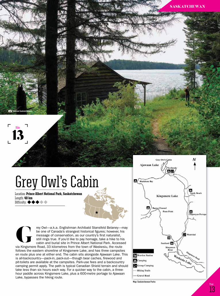
rey Owl—a.k.a. Englishman Archibald Stansfeld Belaney—may be one of Canada’s strangest historical figures; however, his message of conservation, as our country’s first naturalist, still rings true. If you’d like to pay homage, take a hike to his cabin and burial site in Prince Albert National Park. Accessed
via Kingsmere Road, 33 kilometres from the town of Waskesiu, the route follows the eastern shoreline of Kingsmere Lake, and has three campsites en route plus one at either end. The cabin sits alongside Ajawaan Lake. This is all-backcountry—pack-in, pack-out—though bear caches, firewood and pit-toilets are available at the campsites. Park-use fees and a backcountry camping permit apply. The path is typical Canadian Shield terrain and should take less than six hours each way. For a quicker way to the cabin, a three-hour paddle across Kingsmere Lake, plus a 600-metre portage to Ajawaan Lake, bypasses the hiking route.
G
13 Page
Location: Prince Albert National Park, SaskatchewanLength: 40 kmDifficulty:
Grey Owl’s Cabin
13Hike
sAskAtchewAn
tourism saskatchewan
Map: saskatchewan Parks
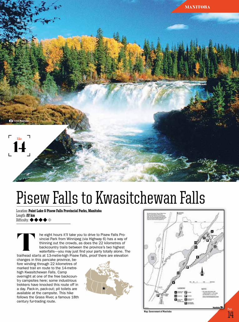
he eight hours it’ll take you to drive to Pisew Falls Pro-vincial Park from Winnipeg (via Highway 6) has a way of thinning out the crowds, as does the 22 kilometres of backcountry trails between the province’s two highest waterfalls—you may just find your party totally alone. The
trailhead starts at 13-metre-high Pisew Falls, proof there are elevation changes in this pancake province, be-fore winding through 22 kilometres of marked trail en route to the 14-metre-high Kwasitchewan Falls. Camp overnight at one of the free backcoun-try campsites here; some industrious trekkers have knocked this route off in a day. Pack-in, pack-out; pit toilets are available at the campsite. This hike follows the Grass River, a famous 18th century fur-trading route.
t
14 Page
Location: Paint Lake & Pisew Falls Provincial Parks, ManitobaLength: 22 kmDifficulty:
Pisew Falls to Kwasitchewan Falls
14Hike
MAnitoBA
travel Manitoba
Map: government of Manitoba
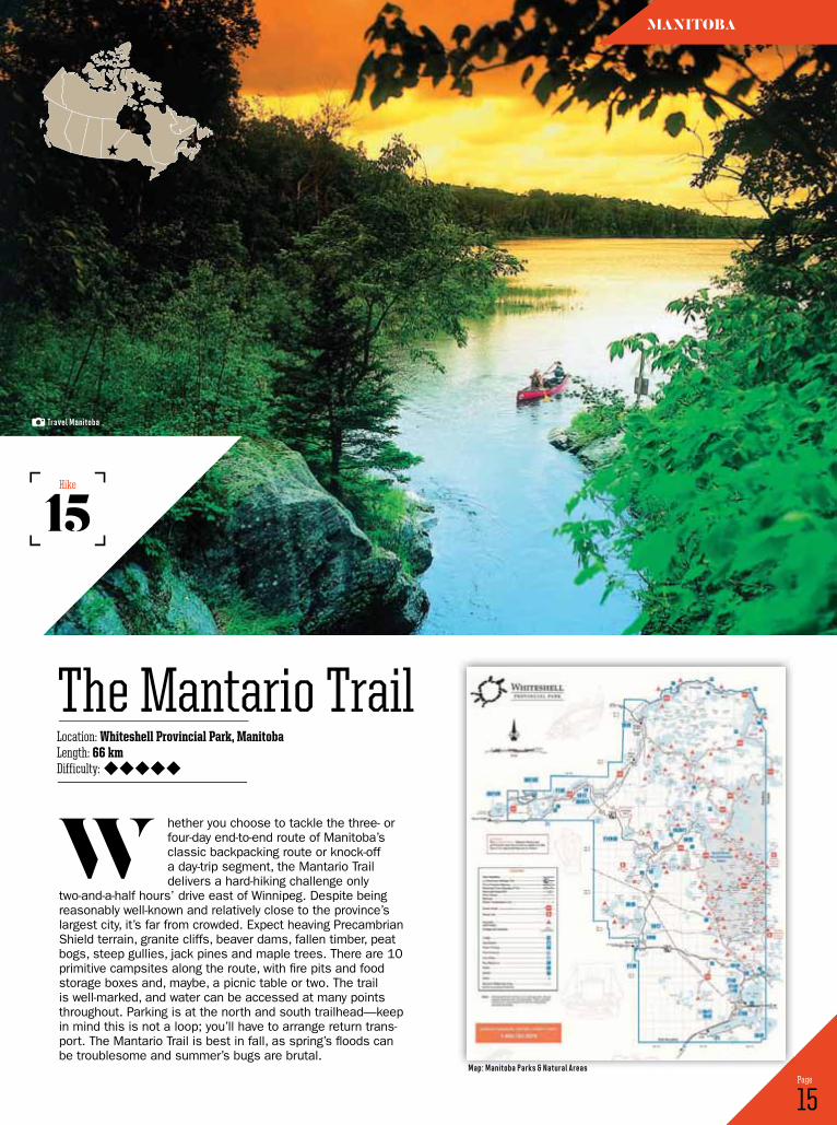
hether you choose to tackle the three- or four-day end-to-end route of Manitoba’s classic backpacking route or knock-off a day-trip segment, the Mantario Trail delivers a hard-hiking challenge only
two-and-a-half hours’ drive east of Winnipeg. Despite being reasonably well-known and relatively close to the province’s largest city, it’s far from crowded. Expect heaving Precambrian Shield terrain, granite cliffs, beaver dams, fallen timber, peat bogs, steep gullies, jack pines and maple trees. There are 10 primitive campsites along the route, with fire pits and food storage boxes and, maybe, a picnic table or two. The trail is well-marked, and water can be accessed at many points throughout. Parking is at the north and south trailhead—keep in mind this is not a loop; you’ll have to arrange return trans-port. The Mantario Trail is best in fall, as spring’s floods can be troublesome and summer’s bugs are brutal.
w
15 Page
Location: Whiteshell Provincial Park, ManitobaLength: 66 kmDifficulty:
The Mantario Trail
15Hike
MAnitoBA
travel Manitoba
Map: Manitoba Parks & natural areas
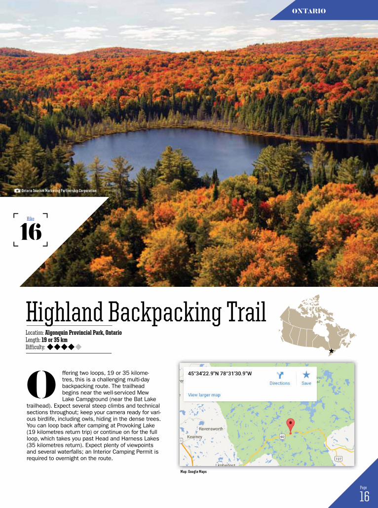
ffering two loops, 19 or 35 kilome-tres, this is a challenging multi-day backpacking route. The trailhead begins near the well-serviced Mew Lake Campground (near the Bat Lake
trailhead). Expect several steep climbs and technical sections throughout; keep your camera ready for vari-ous birdlife, including owls, hiding in the dense trees. You can loop back after camping at Provoking Lake (19 kilometres return trip) or continue on for the full loop, which takes you past Head and Harness Lakes (35 kilometres return). Expect plenty of viewpoints and several waterfalls; an Interior Camping Permit is required to overnight on the route.
o
16 Page
Location: Algonquin Provincial Park, OntarioLength: 19 or 35 kmDifficulty:
Highland Backpacking Trail
16Hike
ontArio
Ontario tourism Marketing Partnership Corporation
Map: google Maps
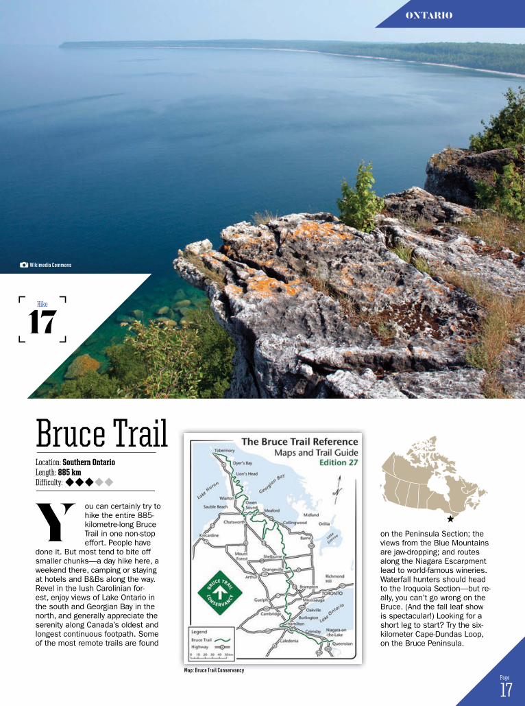
ou can certainly try to hike the entire 885- kilometre-long Bruce Trail in one non-stop effort. People have
done it. But most tend to bite off smaller chunks—a day hike here, a weekend there, camping or staying at hotels and B&Bs along the way. Revel in the lush Carolinian for-est, enjoy views of Lake Ontario in the south and Georgian Bay in the north, and generally appreciate the serenity along Canada’s oldest and longest continuous footpath. Some of the most remote trails are found
Y
17 Page
Location: Southern OntarioLength: 885 kmDifficulty:
Bruce Trail
17Hike
ontArio
on the Peninsula Section; the views from the Blue Mountains are jaw-dropping; and routes along the Niagara Escarpment lead to world-famous wineries. Waterfall hunters should head to the Iroquoia Section—but re-ally, you can’t go wrong on the Bruce. (And the fall leaf show is spectacular!) Looking for a short leg to start? Try the six-kilometer Cape-Dundas Loop, on the Bruce Peninsula.
Wikimedia Commons
Map: Bruce trail Conservancy

ne of Ontario’s most scenic hikes, the Coastal Trail follows the rocky shores of Lake
Superior for just over 60 kilometres, treating trekkers to expansive vistas, secluded cobblestone or sandy beaches, dizzying lookouts and challenging terrain. Access the Coastal Trail at Agawa Bay if you’d like to hike the whole route, or, day-hikes can be done from points along the trail, such as Sinclair Cove, Katherine Cove or Agawa, but you’ll have to retrace your steps; there are no loops. The trail is well-marked by blue-diamond signs; it generally follows the coastline if you get sidetracked. Almost all of the backcoun-try campsites feature sunset views; bald eagles are particularly abundant along the trail. Warp and Gargantua Bays are especially worthy of exploration; set up camp here and enjoy day’s worth of side trips, if you can spare the time.
o
18 Page
Location: Lake Superior Provincial Park, OntarioLength: 60 kmDifficulty:
Coastal Trail
18Hike
ontArio
Ontario tourism Marketing Partnership Corporation
Map: Ontario Parks

his is the signature hike of Sleeping Giant Provincial Park. Located near Thunder Bay, on Highway 587, ensure you’ve packed plenty of water and your cardio is up to snuff before tackling this
heavy-duty hike—the reward is a panorama of Lake Supe-rior from one of the highest points in Ontario. Featuring 300 metres of elevation gain, this hike starts at the South Kabeyun trailhead, which meanders alongside the lake until Tee Harbour; but don’t be fooled by the relatively easy start. After this seven-kilometre jaunt, you’ll hit the Talus Lake Trail, and the route will begin to slope decidedly
t
19 Page
Location: Sleeping Giant Provincial Park, OntarioLength: 22 kmDifficulty:
Top of the Giant (Kabeyun Trail)
19Hike
ontArio
upwards. The next section is a steep, zigzagging route, followed by a slightly less intense cool-down path to the lookout. Eat your picnic lunch next to the 200-metre cliffs and stand in awe of colossal, deep-blue Lake Superior. Return the way you came. Note: if you want to expedite your trek, mountain bike along the Kabeyun Trail, then hike from Tee Harbour onward.
Ontario tourism Marketing Partnership Corporation
Map: google Maps
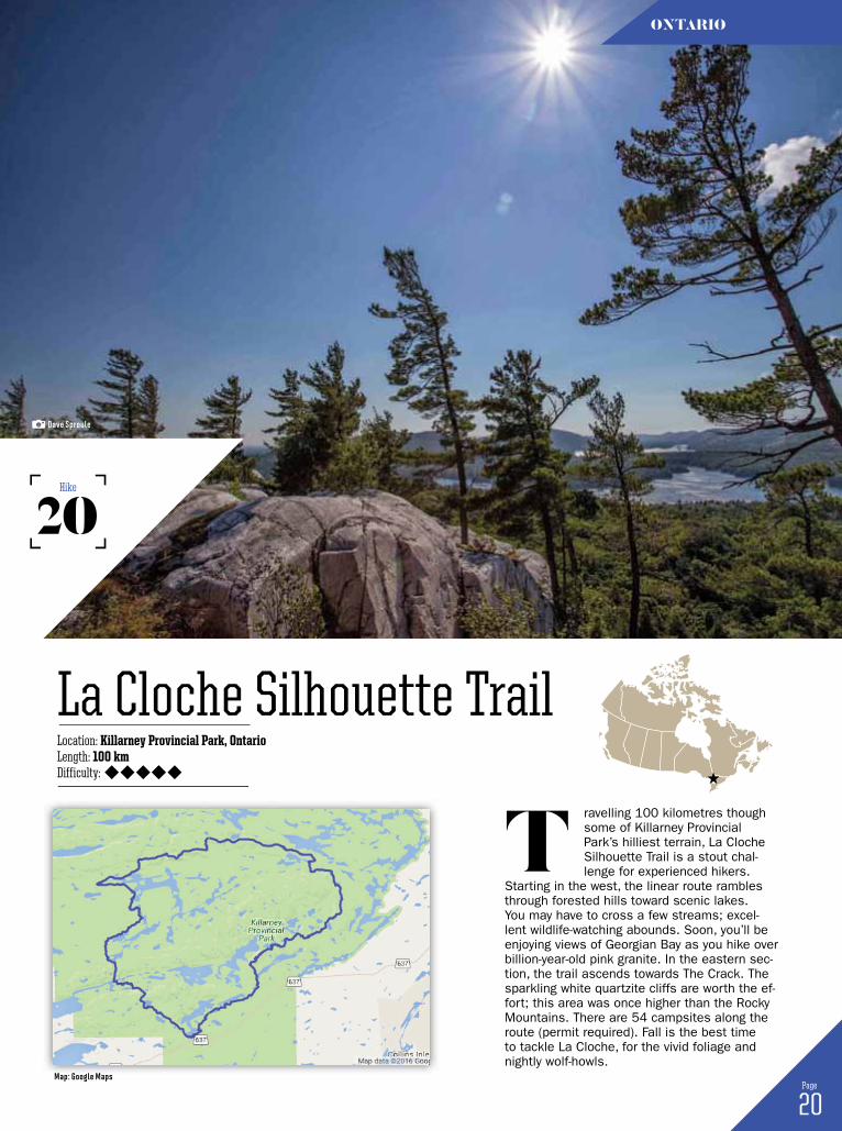
ravelling 100 kilometres though some of Killarney Provincial Park’s hilliest terrain, La Cloche Silhouette Trail is a stout chal-lenge for experienced hikers.
Starting in the west, the linear route rambles through forested hills toward scenic lakes. You may have to cross a few streams; excel-lent wildlife-watching abounds. Soon, you’ll be enjoying views of Georgian Bay as you hike over billion-year-old pink granite. In the eastern sec-tion, the trail ascends towards The Crack. The sparkling white quartzite cliffs are worth the ef-fort; this area was once higher than the Rocky Mountains. There are 54 campsites along the route (permit required). Fall is the best time to tackle La Cloche, for the vivid foliage and nightly wolf-howls.
t
20 Page
Location: Killarney Provincial Park, OntarioLength: 100 kmDifficulty:
La Cloche Silhouette Trail
20Hike
ontArio
dave sproule
Map: google Maps
Les Lacs & Les CretesLocation: Forillon National Park, QuebecLength: 16 to 17 kmDifficulty:
21 Page
QueBec
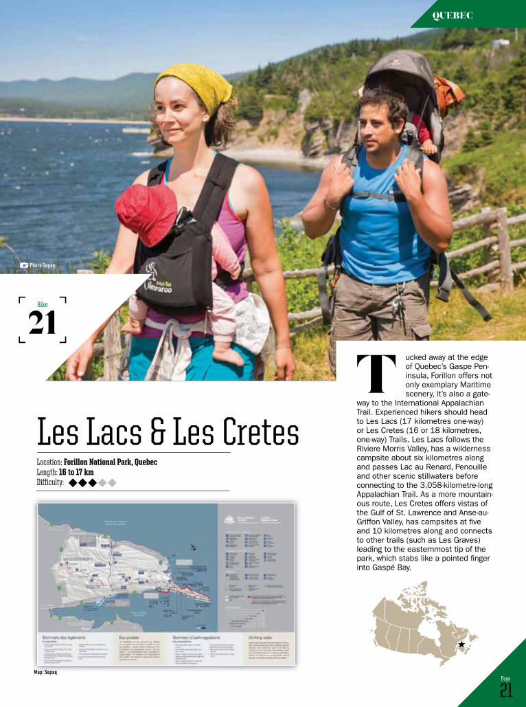
ucked away at the edge of Quebec’s Gaspe Pen-insula, Forillon offers not only exemplary Maritime scenery, it’s also a gate-
way to the International Appalachian Trail. Experienced hikers should head to Les Lacs (17 kilometres one-way) or Les Cretes (16 or 18 kilometres, one-way) Trails. Les Lacs follows the Riviere Morris Valley, has a wilderness campsite about six kilometres along and passes Lac au Renard, Penouille and other scenic stillwaters before connecting to the 3,058-kilometre-long Appalachian Trail. As a more mountain-ous route, Les Cretes offers vistas of the Gulf of St. Lawrence and Anse-au-Griffon Valley, has campsites at five and 10 kilometres along and connects to other trails (such as Les Graves) leading to the easternmost tip of the park, which stabs like a pointed finger into Gaspé Bay.
t21
Hike
Photo sepaq
Map: sepaq
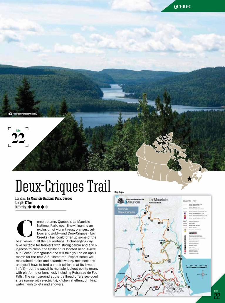
ome autumn, Quebec’s La Mauricie National Park, near Shawinigan, is an explosion of vibrant reds, oranges, yel-lows and gold—and Deux-Criques (Two Creeks) Trail could offer up some of the
best views in all the Laurentians. A challenging day-hike suitable for trekkers with strong cardio and a will-ingness to climb, the trailhead is located near Riviere a la Peche Campground and will take you on an uphill march for the next 8.5 kilometres. Expect some well-maintained stairs and scramble-worthy rock sections and you’ll have to ford a creek (which is at its lowest in fall)—but the payoff is multiple lookout points (many with platforms or benches), including Ruisseau de Fou Falls. The campground at the trailhead offers secluded sites (some with electricity), kitchen shelters, drinking water, flush toilets and showers.
c
22 Page
Location: La Mauricie National Park, QuebecLength: 17 kmDifficulty:
Deux-Criques Trail
22Hike
QueBec
flickr.com/photos/mikeab/
Map: sepaq
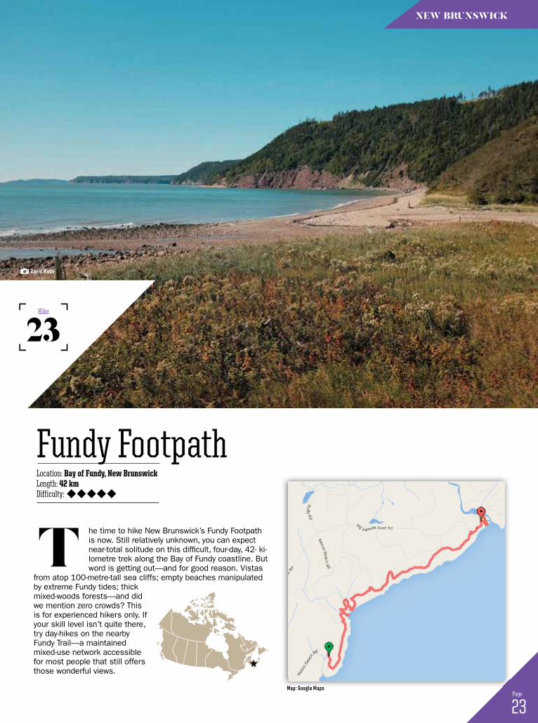
he time to hike New Brunswick’s Fundy Footpath is now. Still relatively unknown, you can expect near-total solitude on this difficult, four-day, 42- ki-lometre trek along the Bay of Fundy coastline. But word is getting out—and for good reason. Vistas
from atop 100-metre-tall sea cliffs; empty beaches manipulated by extreme Fundy tides; thick mixed-woods forests—and did we mention zero crowds? This is for experienced hikers only. If your skill level isn’t quite there, try day-hikes on the nearby Fundy Trail—a maintained mixed-use network accessible for most people that still offers those wonderful views.
t
23 Page
Location: Bay of Fundy, New BrunswickLength: 42 kmDifficulty:
Fundy Footpath
23Hike
new Brunswick
david Webb
Map: google Maps
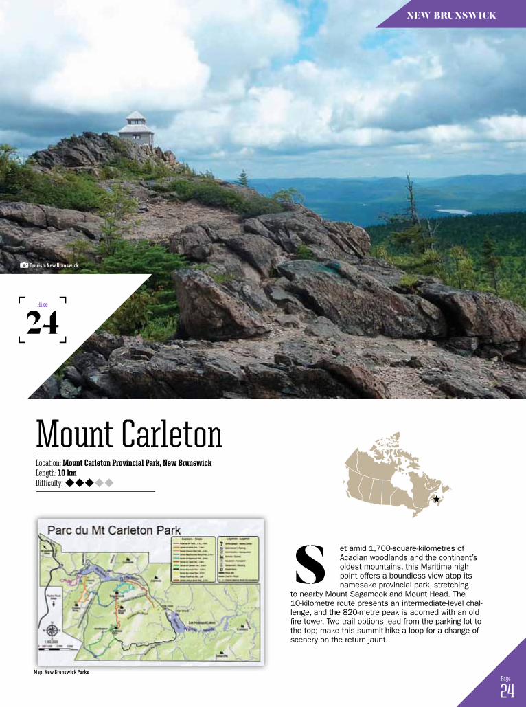
et amid 1,700-square-kilometres of Acadian woodlands and the continent’s oldest mountains, this Maritime high point offers a boundless view atop its namesake provincial park, stretching
to nearby Mount Sagamook and Mount Head. The 10-kilometre route presents an intermediate-level chal-lenge, and the 820-metre peak is adorned with an old fire tower. Two trail options lead from the parking lot to the top; make this summit-hike a loop for a change of scenery on the return jaunt.
s
24 Page
Location: Mount Carleton Provincial Park, New BrunswickLength: 10 kmDifficulty:
Mount Carleton
24Hike
new Brunswick
tourism new Brunswick
Map: new Brunswick Parks
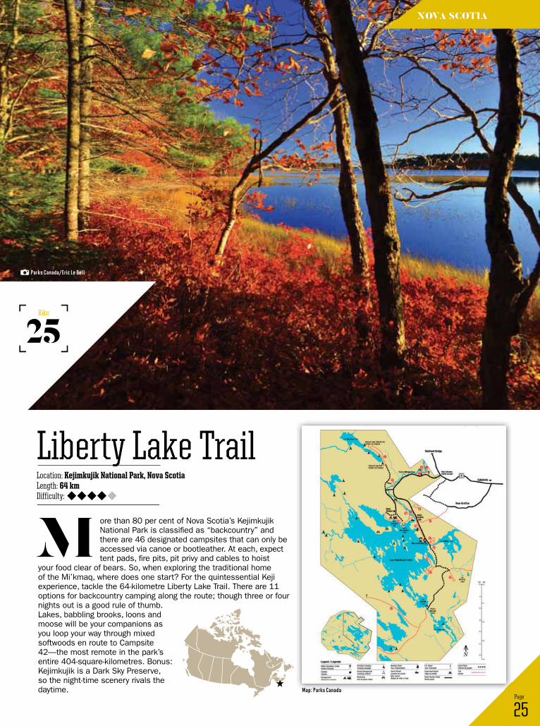
ore than 80 per cent of Nova Scotia’s Kejimkujik National Park is classified as “backcountry” and there are 46 designated campsites that can only be accessed via canoe or bootleather. At each, expect tent pads, fire pits, pit privy and cables to hoist
your food clear of bears. So, when exploring the traditional home of the Mi’kmaq, where does one start? For the quintessential Keji experience, tackle the 64-kilometre Liberty Lake Trail. There are 11 options for backcountry camping along the route; though three or four nights out is a good rule of thumb. Lakes, babbling brooks, loons and moose will be your companions as you loop your way through mixed softwoods en route to Campsite 42—the most remote in the park’s entire 404-square-kilometres. Bonus: Kejimkujik is a Dark Sky Preserve, so the night-time scenery rivals the daytime.
M
25 Page
Location: Kejimkujik National Park, Nova ScotiaLength: 64 kmDifficulty:
Liberty Lake Trail
25Hike
novA scotiA
Parks Canada/eric Le Bell
Map: Parks Canada
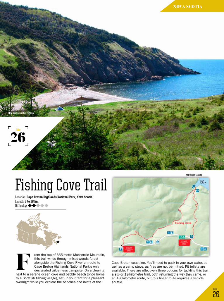
rom the top of 355-metre Mackenzie Mountain, this trail winds through mixed-woods forest alongside the Fishing Cove River en route to Cape Breton Highlands National Park’s only designated wilderness campsite. On a clearing
next to a serene ocean cove and pebble beach (once home to a Scottish fishing village), set up your tent for a pleasant overnight while you explore the beaches and inlets of the
F26 Page
Location: Cape Breton Highlands National Park, Nova ScotiaLength: 6 to 18 kmDifficulty:
Fishing Cove Trail
26Hike
nova scotia
Cape Breton coastline. You’ll need to pack in your own water, as well as a camp stove, as fires are not permitted. Pit toilets are available. There are effectively three options for tackling this trail: a six- or 12-kilometre trail, both returning the way they came, or an 18- kilometre route, but this linear route requires a vehicle shuttle.
Destination Cape Breton
Map: Parks Canada
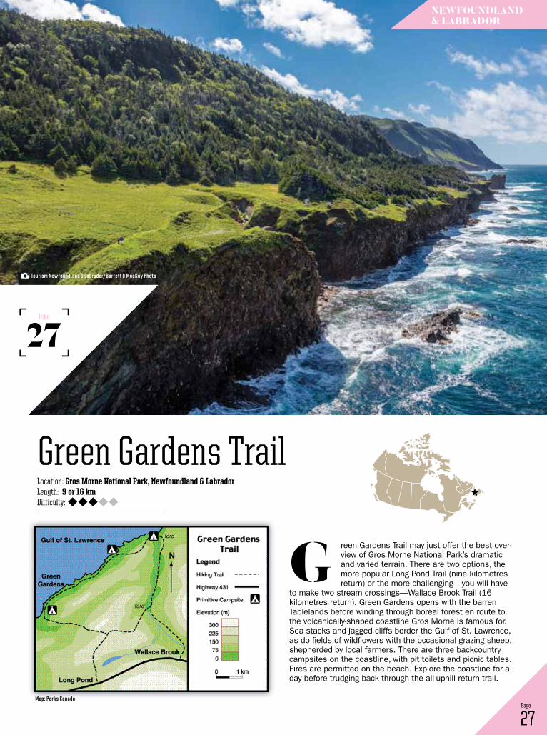
reen Gardens Trail may just offer the best over-view of Gros Morne National Park’s dramatic and varied terrain. There are two options, the more popular Long Pond Trail (nine kilometres return) or the more challenging—you will have
to make two stream crossings—Wallace Brook Trail (16 kilometres return). Green Gardens opens with the barren Tablelands before winding through boreal forest en route to the volcanically-shaped coastline Gros Morne is famous for. Sea stacks and jagged cliffs border the Gulf of St. Lawrence, as do fields of wildflowers with the occasional grazing sheep, shepherded by local farmers. There are three backcountry campsites on the coastline, with pit toilets and picnic tables. Fires are permitted on the beach. Explore the coastline for a day before trudging back through the all-uphill return trail.
G
27 Page
Location: Gros Morne National Park, Newfoundland & LabradorLength: 9 or 16 kmDifficulty:
Green Gardens Trail
27Hike
newFoundLAnd & LABrAdor
tourism newfoundland & Labrador/Barrett & Mackay Photo
Map: Parks Canada
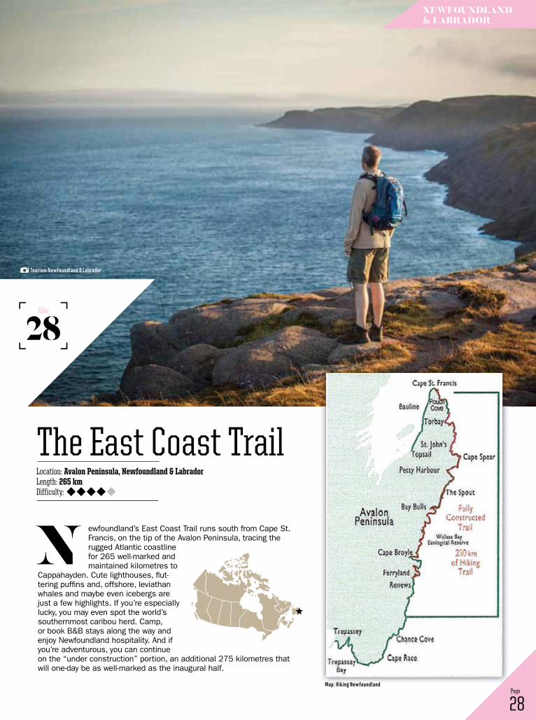
ewfoundland’s East Coast Trail runs south from Cape St. Francis, on the tip of the Avalon Peninsula, tracing the rugged Atlantic coastline for 265 well-marked and maintained kilometres to
Cappahayden. Cute lighthouses, flut-tering puffins and, offshore, leviathan whales and maybe even icebergs are just a few highlights. If you’re especially lucky, you may even spot the world’s southernmost caribou herd. Camp, or book B&B stays along the way and enjoy Newfoundland hospitality. And if you’re adventurous, you can continue on the “under construction” portion, an additional 275 kilometres that will one-day be as well-marked as the inaugural half.
n
28 Page
Location: Avalon Peninsula, Newfoundland & LabradorLength: 265 kmDifficulty:
The East Coast Trail
28Hike
newFoundLAnd & LABrAdor
tourism newfoundland & Labrador
Map: hiking newfoundland
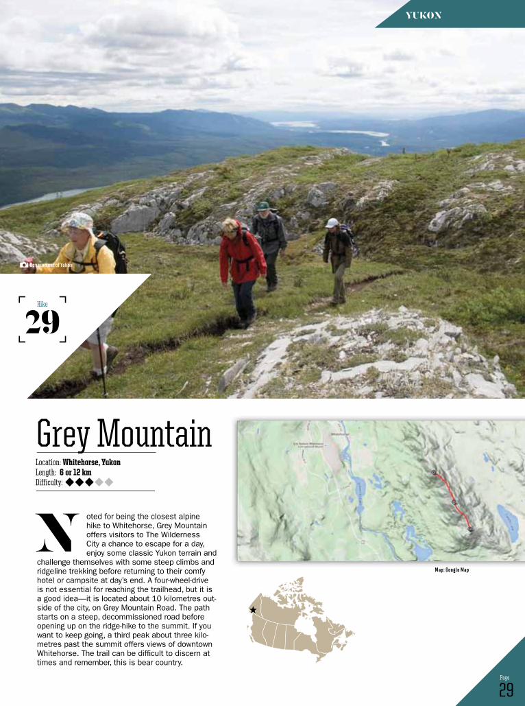
oted for being the closest alpine hike to Whitehorse, Grey Mountain offers visitors to The Wilderness City a chance to escape for a day, enjoy some classic Yukon terrain and
challenge themselves with some steep climbs and ridgeline trekking before returning to their comfy hotel or campsite at day’s end. A four-wheel-drive is not essential for reaching the trailhead, but it is a good idea—it is located about 10 kilometres out-side of the city, on Grey Mountain Road. The path starts on a steep, decommissioned road before opening up on the ridge-hike to the summit. If you want to keep going, a third peak about three kilo-metres past the summit offers views of downtown Whitehorse. The trail can be difficult to discern at times and remember, this is bear country.
n
29 Page
Location: Whitehorse, YukonLength: 6 or 12 kmDifficulty:
Grey Mountain
29Hike
Yukon
government of Yukon
Map: google Map

or an introduction to Kluane National Park, hike the popular Auriol Trail, located about seven kilo-metres southwest of Haines Junction. (By “pop-ular,” we mean perhaps 20 to 30 people in the area at one time, during peak summer season.)
This trail carves a 15-kilometre loop into the Auriol Mountain Range’s sub-alpine, with a optional two-kilometre offshoot that climbs into the alpine for an outstanding mountain view. With only 400 metres of elevation gain, it’s an easy entry to Kluane’s wilderness; expect to spend about five hours on the hike. One backcountry campsite is located on the trail. In the winter, it is also used as a cross-country ski and snowshoe trail.
F
30 Page
Location: Kluane National Park, YukonLength: 15 or 19 kmDifficulty:
Auriol Trail
30Hike
Yukon
david Webb
Map: Parks Canada
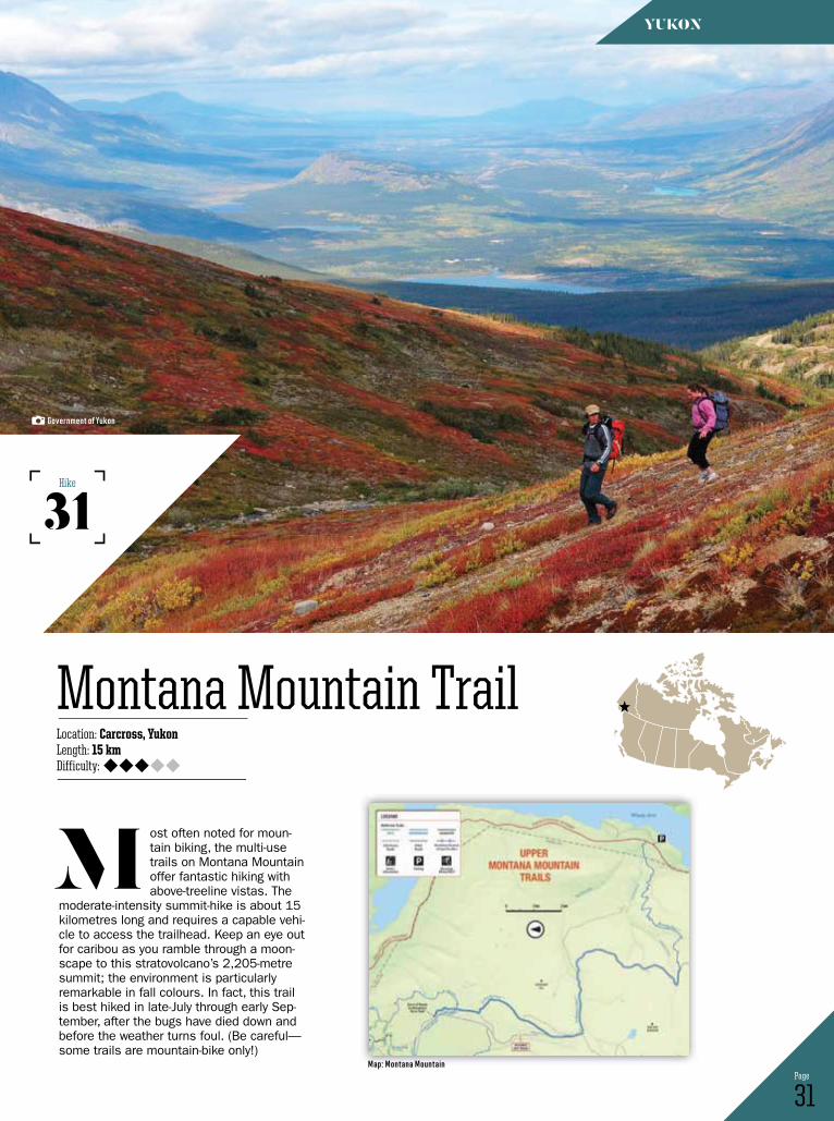
ost often noted for moun-tain biking, the multi-use trails on Montana Mountain offer fantastic hiking with above-treeline vistas. The
moderate-intensity summit-hike is about 15 kilometres long and requires a capable vehi-cle to access the trailhead. Keep an eye out for caribou as you ramble through a moon-scape to this stratovolcano’s 2,205-metre summit; the environment is particularly remarkable in fall colours. In fact, this trail is best hiked in late-July through early Sep-tember, after the bugs have died down and before the weather turns foul. (Be careful—some trails are mountain-bike only!)
M
31 Page
Location: Carcross, YukonLength: 15 kmDifficulty:
Montana Mountain Trail
31Hike
Yukon
government of Yukon
Map: Montana Mountain

et the stunning, broken-glass peaks of the Tombstone Mountains be your motivation as you sweat through this off-trail backpack-ing route. You’ll start in boreal forest before reaching scrubby birch and willow trees and
finally into the tundra. Over the next two days, veiwpoints from Glissade and Grizzly pass are your rewards for the often-challenging conditions. Watch out for grizzlies, and you may even spot migrating caribou. There are three campsites along the trail: Grizzly, Divide and Talus Lakes. Truly, this is one of Yukon’s signature hikes.
L
32 Page
Location: Tombstone Territorial Park, YukonLength: 45 km (or more)Difficulty:
Grizzly Lake to Talus Lakes
32Hike
Yukon
government of Yukon
Map: gooogle Map
33 Page
Location: Northwest Territories/YukonLength: 350 kmDifficulty:
Canol Heritage Trail
33Hike
northwest territories/Yukon
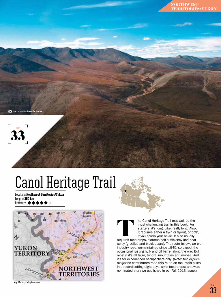
he Canol Heritage Trail may well be the most challenging trail in this book. For starters, it’s long. Like, really long. Also, it requires either a fly-in or fly-out, or both, if you sprain your ankle. It also usually
requires food drops, extreme self-sufficiency and bear spray (grizzlies and black bears). The route follows an old industry road, unmaintained since 1945, so expect the occasional rusting hulk and oil barrel along the way. But mostly, it’s all taiga, tundra, mountains and moose. And it’s for experienced backpackers only. (Note: two explore magazine contributors rode this route on mountain bikes in a record-setting eight days, sans food drops; an award-nominated story we published in our Fall 2013 issue.)
t
spectacular northwest territories
+
Map: Motorcycleexplorer.com
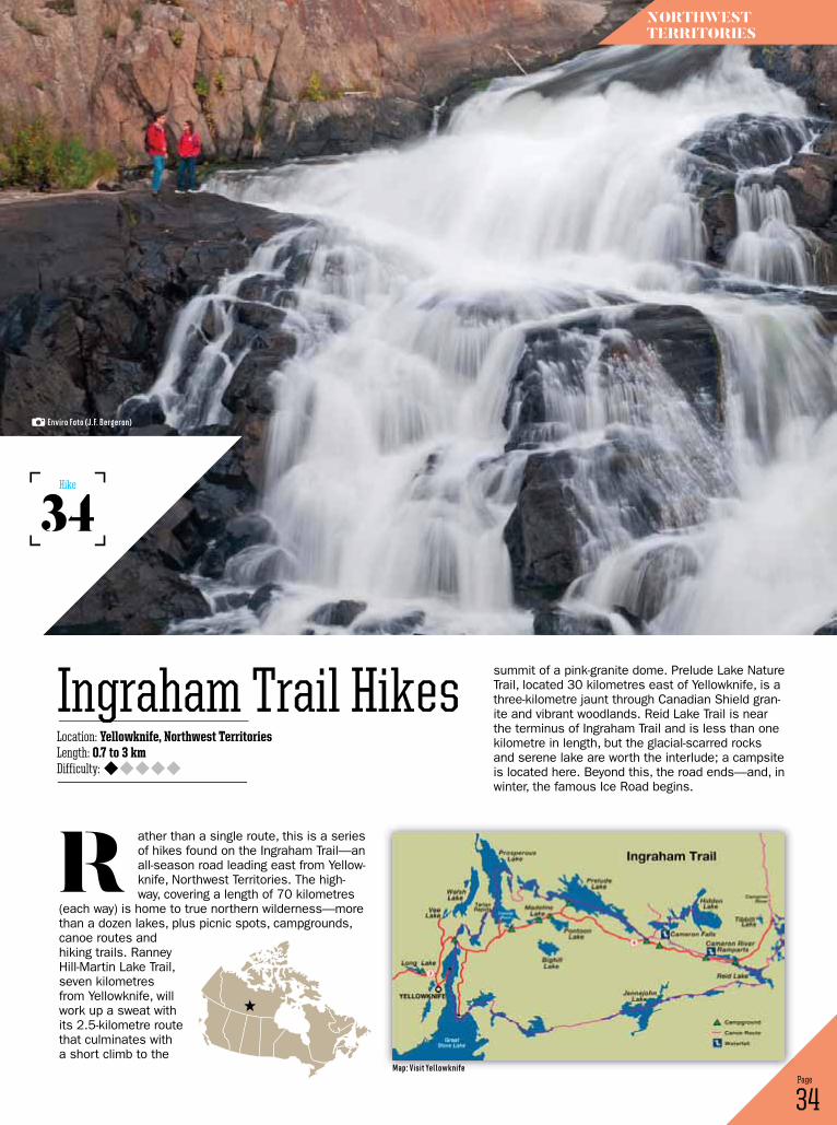
ather than a single route, this is a series of hikes found on the Ingraham Trail—an all-season road leading east from Yellow-knife, Northwest Territories. The high-way, covering a length of 70 kilometres
(each way) is home to true northern wilderness—more than a dozen lakes, plus picnic spots, campgrounds, canoe routes and hiking trails. Ranney Hill-Martin Lake Trail, seven kilometres from Yellowknife, will work up a sweat with its 2.5-kilometre route that culminates with a short climb to the
r
34 Page
Location: Yellowknife, Northwest TerritoriesLength: 0.7 to 3 kmDifficulty:
Ingraham Trail Hikes
34Hike
northwest territories
summit of a pink-granite dome. Prelude Lake Nature Trail, located 30 kilometres east of Yellowknife, is a three-kilometre jaunt through Canadian Shield gran-ite and vibrant woodlands. Reid Lake Trail is near the terminus of Ingraham Trail and is less than one kilometre in length, but the glacial-scarred rocks and serene lake are worth the interlude; a campsite is located here. Beyond this, the road ends—and, in winter, the famous Ice Road begins.
enviro Foto (J.F. Bergeron)
Map: Visit Yellowknife
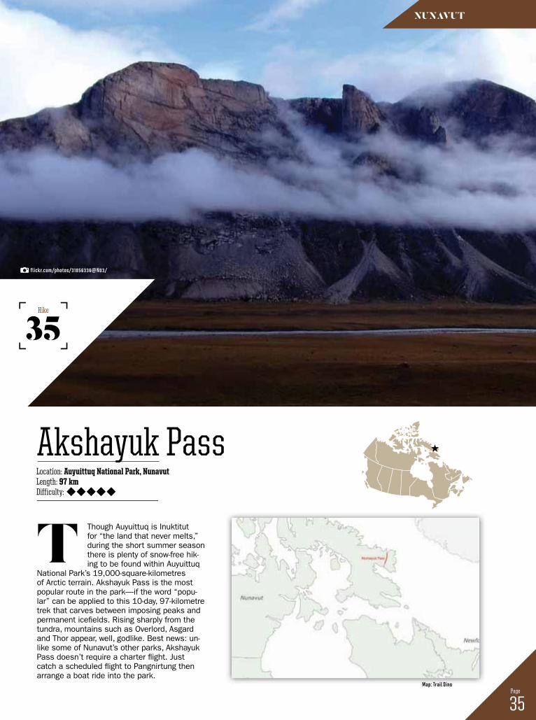
Though Auyuittuq is Inuktitut for “the land that never melts,” during the short summer season there is plenty of snow-free hik-ing to be found within Auyuittuq
National Park’s 19,000-square-kilometres of Arctic terrain. Akshayuk Pass is the most popular route in the park—if the word “popu-lar” can be applied to this 10-day, 97-kilometre trek that carves between imposing peaks and permanent icefields. Rising sharply from the tundra, mountains such as Overlord, Asgard and Thor appear, well, godlike. Best news: un-like some of Nunavut’s other parks, Akshayuk Pass doesn’t require a charter flight. Just catch a scheduled flight to Pangnirtung then arrange a boat ride into the park.
t
35 Page
Location: Auyuittuq National Park, NunavutLength: 97 kmDifficulty:
Akshayuk Pass
35Hike
nunAvut
flickr.com/photos/31856336@n03/
Map: trail dino