Embed Size (px)
Citation preview
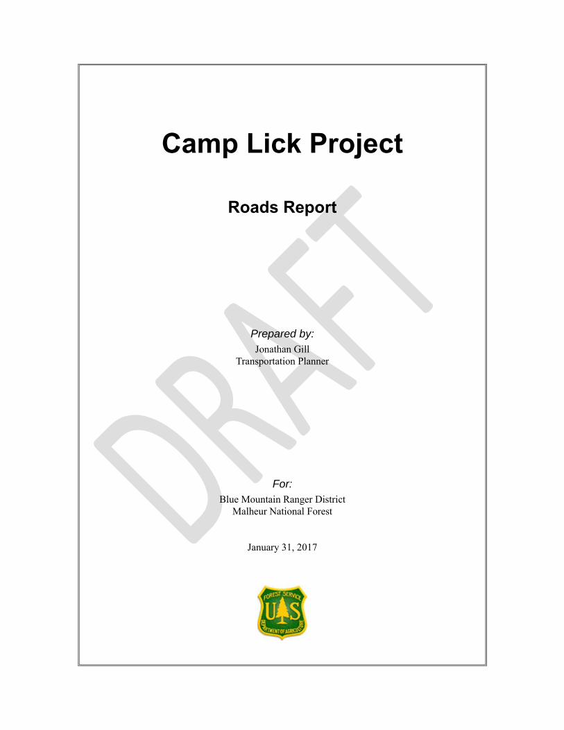
Camp Lick Project
Roads Report
Prepared by:
Jonathan Gill
Transportation Planner
For:
Blue Mountain Ranger District
Malheur National Forest
January 31, 2017
In accordance with Federal civil rights law and U.S. Department of Agriculture (USDA) civil
rights regulations and policies, the USDA, its Agencies, offices, and employees, and institutions
participating in or administering USDA programs are prohibited from discriminating based on
race, color, national origin, religion, sex, gender identity (including gender expression), sexual
orientation, disability, age, marital status, family/parental status, income derived from a public
assistance program, political beliefs, or reprisal or retaliation for prior civil rights activity, in any
program or activity conducted or funded by USDA (not all bases apply to all programs).
Remedies and complaint filing deadlines vary by program or incident.
Persons with disabilities who require alternative means of communication for program
information (e.g., Braille, large print, audiotape, American Sign Language, etc.) should contact
the responsible Agency or USDA’s TARGET Center at (202) 720-2600 (voice and TTY) or contact
USDA through the Federal Relay Service at (800) 877-8339. Additionally, program information
may be made available in languages other than English.
To file a program discrimination complaint, complete the USDA Program Discrimination
Complaint Form, AD-3027, found online at http://www.ascr.usda.gov/complaint_filing_cust.html
and at any USDA office or write a letter addressed to USDA and provide in the letter all of the
information requested in the form. To request a copy of the complaint form, call (866) 632-9992.
Submit your completed form or letter to USDA by: (1) mail: U.S. Department of Agriculture,
Office of the Assistant Secretary for Civil Rights, 1400 Independence Avenue, SW, Washington,
D.C. 20250-9410; (2) fax: (202) 690-7442; or (3) email: [email protected].
USDA is an equal opportunity provider, employer, and lender.
Camp Lick Project Roads Report
i
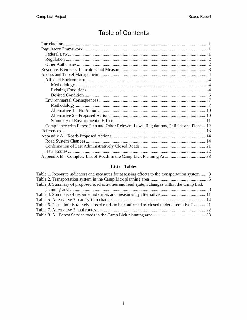
Table of Contents
Introduction ................................................................................................................................. 1 Regulatory Framework ............................................................................................................... 1
Federal Law ............................................................................................................................. 1 Regulation ............................................................................................................................... 2 Other Authorities ..................................................................................................................... 2
Resource, Elements, Indicators and Measures ............................................................................ 3 Access and Travel Management ................................................................................................. 4
Affected Environment ............................................................................................................. 4 Methodology ...................................................................................................................... 4 Existing Conditions ............................................................................................................ 4 Desired Condition............................................................................................................... 6
Environmental Consequences ................................................................................................. 7 Methodology ...................................................................................................................... 7 Alternative 1 – No Action ................................................................................................ 10 Alternative 2 – Proposed Action ...................................................................................... 10 Summary of Environmental Effects ................................................................................. 11
Compliance with Forest Plan and Other Relevant Laws, Regulations, Policies and Plans ... 12 References ................................................................................................................................. 13 Appendix A – Roads Proposed Actions .................................................................................... 14
Road System Changes ........................................................................................................... 14 Confirmation of Past Administratively Closed Roads .......................................................... 21 Haul Routes ........................................................................................................................... 22
Appendix B – Complete List of Roads in the Camp Lick Planning Area ................................. 33
List of Tables
Table 1. Resource indicators and measures for assessing effects to the transportation system ...... 3 Table 2. Transportation system in the Camp Lick planning area .................................................... 5 Table 3. Summary of proposed road activities and road system changes within the Camp Lick
planning area ........................................................................................................................... 8 Table 4. Summary of resource indicators and measures by alternative ........................................ 11 Table 5. Alternative 2 road system changes .................................................................................. 14 Table 6. Past administratively closed roads to be confirmed as closed under alternative 2 .......... 21 Table 7. Alternative 2 haul routes ................................................................................................. 22 Table 8. All Forest Service roads in the Camp Lick planning area ............................................... 33
Camp Lick Project Roads Report
1
Introduction This report describes the existing condition and effects of the proposed action on access and
travel management of National Forest System roads in the Camp Lick planning area. Road
maintenance, temporary road construction, re-opening closed roads, road closures, and
decommissioning are the proposed activities that would potentially affect access and travel
management and maintenance. The agency’s top priority is to provide a road system that is
responsive to public needs, safe and environmentally sound, and affordable and efficient to
manage.
The primary access to the Camp Lick planning area is County road 18 to the south and County
road 20 on the north end. Other main access roads are National Forest System (NFS) roads 3600,
3620, 3640, 3645, 3650, 3660, 3670, 3675, 3690, and 2045, which are all either maintenance
level (ML) 2 or ML 3 roads with an aggregate or improved surface. These roads are considered
part of the primary road system and are shown in Appendix A in the Malheur National Forest
Roads Analysis dated March 2005 as part of the Minimum Road System (MRS). Project level
roads analysis strives to meet long range road density goals established in the Malheur Forest
Plan by identifying opportunities to reduce both open road densities and total road densities,
while balancing needs for public and administrative access. Efforts focus on reducing the amount
of funding needed for road maintenance, reducing road related impacts to fish and wildlife, and
reducing the spread of non-native invasive plants.
Regulatory Framework
Federal Law
1. National Forest Roads and Trails Act of October 13, 1964, as amended (16 U.S.C. 532-
538). Authorizes road and trail systems for the national forests. Authorizes granting of
easements across National Forest System (NFS) lands, construction and financing of
maximum economy roads (Forest Service Manual [FSM] 7705), and imposition of
requirements on road users for maintaining and reconstructing roads, including
cooperative deposits for that work.
2. Highway Safety Act of 1966 (23 U.S.C. 402). Authorizes state and local governments
and participating federal agencies to identify and survey accident locations; to design,
construct, and maintain roads in accordance with safety standards; to apply sound traffic
control principles and standards; and to promote pedestrian safety.
3. Surface Transportation Assistance Act of 1978, as amended (23 U.S.C. 101a, 201-205).
Supersedes the Forest Highway Act of 1958. Authorizes appropriations for forest
highways and public lands highways. Establishes criteria for forest highways; defines
forest roads, forest development roads, and forest development trails (referred to as “NFS
roads” and “NFS trails” in Forest Service regulations and directives); and limits the size
of projects performed by Forest Service employees on forest roads. Establishes the
Federal Lands Highway Program.
4. National Forest Management Act. The National Forest Management Act requires projects
to be consistent with the Forest Land and Resource Management Plan and to make the
following findings [16 U.S.C. 1604 (g)(3)(E)]:
Camp Lick Project Roads Report
2
A. Soil, slope, or other watershed conditions will not be irreversibly damaged;
B. Protection is provided for streams, streambanks, shorelines, lakes, wetlands and
other bodies of water from detrimental changes in water temperatures, blockages
of water courses, and deposits of sediment, where harvests are likely to seriously
and adversely affect water conditions or fish habitat.
The Forest Service will comply with the National Best Management Practices (BMP) for Water
Quality Management on National Forest System Lands (USDA Forest Service 2012). Will
develop site-specific BMP prescriptions for the following practices, as appropriate or when
required, using State BMPs, Forest Service regional guidance, land management plan direction,
BMP monitoring information, and professional judgment.
1. Use applicable practices of BMP Plan-2 (Project Planning and Analysis) and BMP Plan-3
(Aquatic Management Zone [AMZ] Planning) when conducting travel management
planning and analysis.
2. Use interdisciplinary coordination for travel planning and project-level transportation
analysis, including engineers, hydrologists, soil scientists, and other resource specialists
as needed, to balance protection of soil, water quality, and riparian resources with
transportation and access needs.
3. Design the transportation system to meet long-term land management plan desired
conditions, goals, and objectives for access, rather than to access individual sites.
4. Limit roads to the minimum practicable number, width, and total length consistent with
the purpose of specific operations, local topography, geology, and climate to achieve land
management plan desired conditions, goals, and objectives for access and water quality
management.
Regulation
1. Travel Management (36 CFR Part 212, Subparts A, B, and C). Subpart A of these
regulations establishes requirements for administration of the forest transportation
system, including roads, trails, and airfields, and contains provisions for acquisition of
rights-of-way. Subpart A also requires identification of the minimum road system needed
for safe and efficient travel and for administration, utilization, and protection of NFS
lands and use of a science-based roads analysis at the appropriate scale in determining the
minimum road system. Subpart B describes the requirements for designating roads, trails,
and areas for motor vehicle use and for identifying designated roads, trails, and areas on a
motor vehicle use map (MVUM). Subpart C provides for regulation of use of over-snow
vehicles on NFS roads, on NFS trails, and in areas on NFS lands.
2. Prohibitions (36 CFR Part 261, Subpart A). These regulations establish prohibitions on
use of NFS lands, including prohibitions on possession and operation of motor vehicles
on NFS roads, on NFS trails, and in areas on NFS lands.
Other Authorities
1. Executive Order 11644 (“Use of Off-Road Vehicles on the Public Lands”), dated
February 8, 1972, as amended by Executive Order 11989, dated May 24, 1977. Provides
Camp Lick Project Roads Report
3
for developing regulations governing use of off-road vehicles on federal lands to protect
natural resources, promote public safety, and minimize conflicts among uses.
2. Forest Service Directives. Gives direction on travel analysis, travel management, and
designation of roads, trails, and areas for motor vehicle use resides in this chapter, FSM
7710, and FSH 7709.55. Direction on management and maintenance of roads resides in
FSM 7730 and FSH 7709.59
3. Memorandum of Understanding on Administration of the Emergency Relief for Federally
Owned Roads (ERFO) Program for Federal Roads off the Federal Aid System.
Establishes procedures for the Federal Highway Administration and the Forest Service to
administer funding for emergency relief for federally owned roads under the jurisdiction
of the Forest Service (FSM 1535.12).
4. Memorandum of Understanding between the Forest Service and the Bureau of Land
Management on Rights-of-Way and Road Use. Includes provisions for granting
temporary and long-term rights-of-way between the agencies. Provides for a license
agreement to be issued to timber and mineral purchasers of one agency using roads under
the jurisdiction of another agency (FSM 1531.12f and 5465.1).
5. Memorandum of Understanding between the Forest Service and the Federal Highway
Administration. Provides guidance on the applicability of 49 U.S.C. 303 and 23 U.S.C.
138 to National Forest Scenic Byways (FSM 1535.14).
6. Memorandum of Understanding between the Forest Service and the Federal Highway
Administration. Pursuant to section 1309 of the Transportation Equity Act for the 21st
Century, provides guidance for a coordinated environmental review process between the
two agencies to expedite federal highway and transit projects.
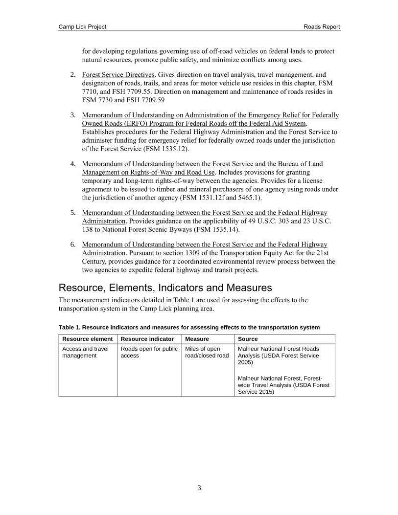
Resource, Elements, Indicators and Measures The measurement indicators detailed in Table 1 are used for assessing the effects to the
transportation system in the Camp Lick planning area.
Table 1. Resource indicators and measures for assessing effects to the transportation system
Resource element Resource indicator Measure Source
Access and travel management
Roads open for public access
Miles of open road/closed road
Malheur National Forest Roads Analysis (USDA Forest Service 2005)
Malheur National Forest, Forest-wide Travel Analysis (USDA Forest Service 2015)
Camp Lick Project Roads Report
4
Access and Travel Management
Affected Environment
Methodology
Each road in the planning area was field checked and the road condition was recorded to reflect
existing conditions. Information sources for transportation analysis include the transportation
geographic information system (GIS) records which house the spatial data for road locations. An
inventory of road attributes for National Forest System (NFS) roads is maintained on the National
Forest through the infrastructure application (Infra) database. The data is clipped through a
process performed by Region 6 Data Resources Management (DRM). (See reference: Clip
INFRA Road data to a planning area). A complete list of road attributes and definitions of these
attributes is located in the project record.
The Camp Lick interdisciplinary team reviewed each road in the planning area to provide
recommendations on whether to open, close, or decommission that road based on the road’s
condition, the access it provides, and how the road is impacting forest resources. This
determination was based on the guidelines included in Forest Level Roads Analysis (USDA
Forest Service 2004) and the Forest-wide Travel Analysis (USDA Forest Service 2015). These
analysis were designed to provide the decision-maker with the information needed to develop
road systems that are safe and responsive to public needs and desires, are affordable and
efficiently managed, have minimal adverse ecological effects on the land, and are more in balance
with available funding for needed management actions.
Existing Conditions
In 1908, the Malheur National Forest was established and a slow but steady road-building
program began. Most of these roads were established to facilitate fire protection and other
administrative duties. A limited number of roads were constructed primarily to expedite
recreational use of the Forest. By 1928 there were 383.5 miles of road on the Forest (Mosgrove
1980). This was sufficient, in theory, to allow firefighters to reach any fire reported on the Forest
within one hour. The pace of road building increased in the 1930s through the 1980s as larger
networks of roads were developed to support commercial timber harvest and, to a lesser extent,
recreation on the Forest. By the late 1980s, over 8,000 miles of road existed on the Malheur
National Forest (Malheur National Forest Plan 1990: Appendix I). Most roads on the Forest were
originally constructed for commercial access purposes including grazing, timber, and mineral
extraction. Other roads were developed to access administrative sites, private property, recreation
facilities, trailheads, power line corridors, or for other administration purposes.
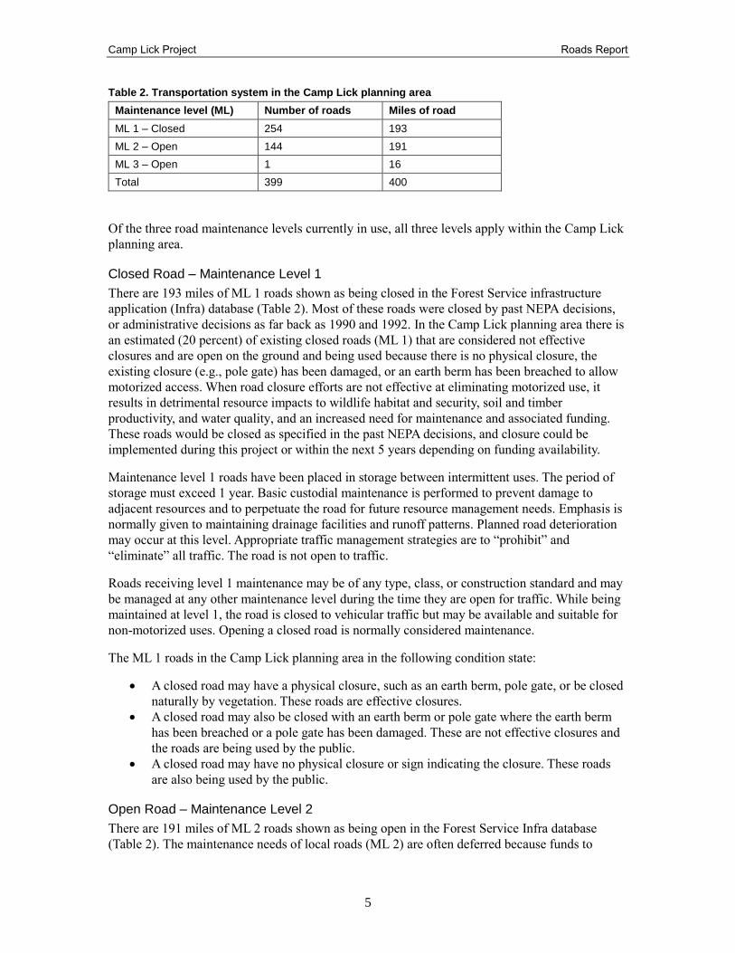
The transportation system associated with the Camp Lick Project consists of 399 roads in the
planning area totaling 400 miles, under Forest Service jurisdiction. Approximately 1 road totaling
16 miles (4 percent), is a ML 3 road. Approximately 144 roads totaling 193 miles (48 percent),
are ML 2 roads. Approximately 254 roads totaling 191 miles (48 percent), are ML 1 roads; these
roads were closed to the public under previous NEPA decisions or administratively closed. The
Camp Lick planning area encompasses approximately 40,000 acres in the Camp Creek and Lick
Creek subwatersheds, which equals 62.5 square miles. The existing total road density is 6.4
miles/square mile for ML 1, 2, and 3 roads. Table 2 lists the current number and total mileage of
roads, by maintenance level, in the Camp Lick planning area.
Camp Lick Project Roads Report
5
Table 2. Transportation system in the Camp Lick planning area
Maintenance level (ML) Number of roads Miles of road
ML 1 – Closed 254 193
ML 2 – Open 144 191
ML 3 – Open 1 16
Total 399 400
Of the three road maintenance levels currently in use, all three levels apply within the Camp Lick
planning area.
Closed Road – Maintenance Level 1
There are 193 miles of ML 1 roads shown as being closed in the Forest Service infrastructure
application (Infra) database (Table 2). Most of these roads were closed by past NEPA decisions,
or administrative decisions as far back as 1990 and 1992. In the Camp Lick planning area there is
an estimated (20 percent) of existing closed roads (ML 1) that are considered not effective
closures and are open on the ground and being used because there is no physical closure, the
existing closure (e.g., pole gate) has been damaged, or an earth berm has been breached to allow
motorized access. When road closure efforts are not effective at eliminating motorized use, it
results in detrimental resource impacts to wildlife habitat and security, soil and timber
productivity, and water quality, and an increased need for maintenance and associated funding.
These roads would be closed as specified in the past NEPA decisions, and closure could be
implemented during this project or within the next 5 years depending on funding availability.
Maintenance level 1 roads have been placed in storage between intermittent uses. The period of
storage must exceed 1 year. Basic custodial maintenance is performed to prevent damage to
adjacent resources and to perpetuate the road for future resource management needs. Emphasis is
normally given to maintaining drainage facilities and runoff patterns. Planned road deterioration
may occur at this level. Appropriate traffic management strategies are to “prohibit” and
“eliminate” all traffic. The road is not open to traffic.
Roads receiving level 1 maintenance may be of any type, class, or construction standard and may
be managed at any other maintenance level during the time they are open for traffic. While being
maintained at level 1, the road is closed to vehicular traffic but may be available and suitable for
non-motorized uses. Opening a closed road is normally considered maintenance.
The ML 1 roads in the Camp Lick planning area in the following condition state:
A closed road may have a physical closure, such as an earth berm, pole gate, or be closed
naturally by vegetation. These roads are effective closures.
A closed road may also be closed with an earth berm or pole gate where the earth berm
has been breached or a pole gate has been damaged. These are not effective closures and
the roads are being used by the public.
A closed road may have no physical closure or sign indicating the closure. These roads
are also being used by the public.
Open Road – Maintenance Level 2
There are 191 miles of ML 2 roads shown as being open in the Forest Service Infra database
(Table 2). The maintenance needs of local roads (ML 2) are often deferred because funds to
Camp Lick Project Roads Report
6
maintain roads to standards are unavailable. The overall result is that most of the Forest road
system is in a deteriorating condition; this is particularly true for many ML 2 roads that remain
open despite receiving little maintenance. Most of the roads in the Camp Lick planning area
would need to receive maintenance to meet current road maintenance objectives and classification
standards. There are also (15 percent) of open roads that are physically closed on the ground by
natural vegetation overgrowth or no sign of design roadway.
Maintenance level 2 is assigned to roads open for high clearance vehicles. Passenger car traffic,
user comfort, and user convenience are not considerations. Traffic is normally minor, usually
consisting of one or a combination of administrative, permitted, dispersed recreation, or other
specialized uses. Motorists should have no expectations of being alerted to potential hazards
while driving these roads. Route markers and regulation signs are in place and useable. The road
is open to traffic.
The ML 2 roads in the Camp Lick planning area are either in fair or poor condition as described
below:
Fair condition of the roadbed would have an aggregate, improved, or native surface with
good drainage features.
Poor condition of the roadbed would mean there are not enough drainage features and
major rutting of the roadway is present. Drainage features such as cross drains and water
bars are not always present or not functioning correctly, causing erosion rutting and
damaging the road surface.
Poor condition could also be physically closed on the ground by natural vegetation
overgrowth or no sign of the designed roadway due to no public or administrative use.
Open Road – Maintenance Level 3
There are 16 miles of ML 3 roads shown as being opened in the Forest Service infrastructure
application database (INFRA) (Table 2). The maintenance needs of local roads (ML 3) are usually
annual. Maintenance level 3 is assigned to roads open and maintained for travel by a prudent
driver in a standard passenger car. User comfort and convenience are not considered priorities.
Roads in this maintenance level are typically low speed with single lanes and turnouts.
Surveys in the Camp Lick planning area have found ML 3 roads in the following condition state:
Open, good to fair condition
Desired Condition
The Malheur Forest Plan goal for the transportation system is to plan, design, construct, and
maintain a safe and economical transportation system providing efficient access for the
movement of people and materials involved in the use and protection of the National Forest lands.
Maintain roads to the minimum level necessary to meet resource objectives including, but not
limited to, objectives for timber harvest and removal, big game habitat needs (including security
needs), high quality recreation opportunities, and firewood cutting opportunities.
Forest Service Handbook (FSH) 7709.59 – Road Systems Operations and Maintenance Handbook
also provides guidance for road system management and maintenance. Resource management
needs are largely based on land resource management plan direction, including management area
prescriptions.
Camp Lick Project Roads Report
7
Environmental Consequences
Methodology
Effects to the transportation system are determined by the existing conditions of similar roads and
the occurrence of past maintenance and management activities similar to those proposed for the
project and the transportation specific assumptions noted below. Effects to individual roadways
can vary depending on the maintenance level, site conditions, traffic volumes, and extraordinary
events. The only activities expected to have an effect on the roads are the road maintenance
activities and road proposed actions. Therefore, no other activities will be discussed in this
analysis. Field verification was conducted to conclude the effects of areas under management
similar to the proposed action are consistent with the findings of this report.
Spatial and Temporal Context for Effects Analysis
Spatial Boundary
The analysis area for considering the cumulative effects on the transportation system is defined
by the planning area boundary. The existing road system within the planning area boundary
consists of collector, local, and closed roads. The needed transportation system is primarily
confined to the planning area boundary with little or no impact to, on, or from adjacent areas.
Therefore the planning area boundary provides a suitable boundary for the analysis of cumulative
effects related to the transportation system. In addition, there would be a small portion of the
existing road system used for log haul that is outside the planning area boundary.
Temporal Boundary
The time period for measuring cumulative effects is 10 years forward to encompass the time
needed to implement and realize the effects of the road actions completed for the project. The
time period for measuring cumulative effects includes considerations for the restoration and
vegetation of temporary roads and landings. In this report, past activities and events are included
in the existing condition description. The current environmental conditions reflect the aggregate
impact of all prior human actions and natural events that have affected the environment and might
contribute to cumulative effects and are a proxy for the impacts of past actions.
The existing transportation system would facilitate the transportation needs for the project with
maintenance and the road actions described under the proposed haul routes (Table 7). Past
activities that contributed to the existing condition of the transportation system include timber
harvest activities in the late 19th and early 20th century and reconstruction over the decades
through additional timber harvest and plantation activities. The transportation system as it
currently exists has not significantly changed in the past 20 years.
Past, Present, and Reasonably Foreseeable Future Actions Relevant to Cumulative Effects Analysis
Past, present, and reasonably foreseeable future actions relevant to the cumulative effects analysis
for the transportation system include use and maintenance of National Forest System roads,
which includes road blading, brushing, cleaning ditches, and cleaning culverts. There are also
roads to be decommissioned inside the planning area that will be covered under the Aquatic
Restoration Decision.
Camp Lick Project Roads Report
8
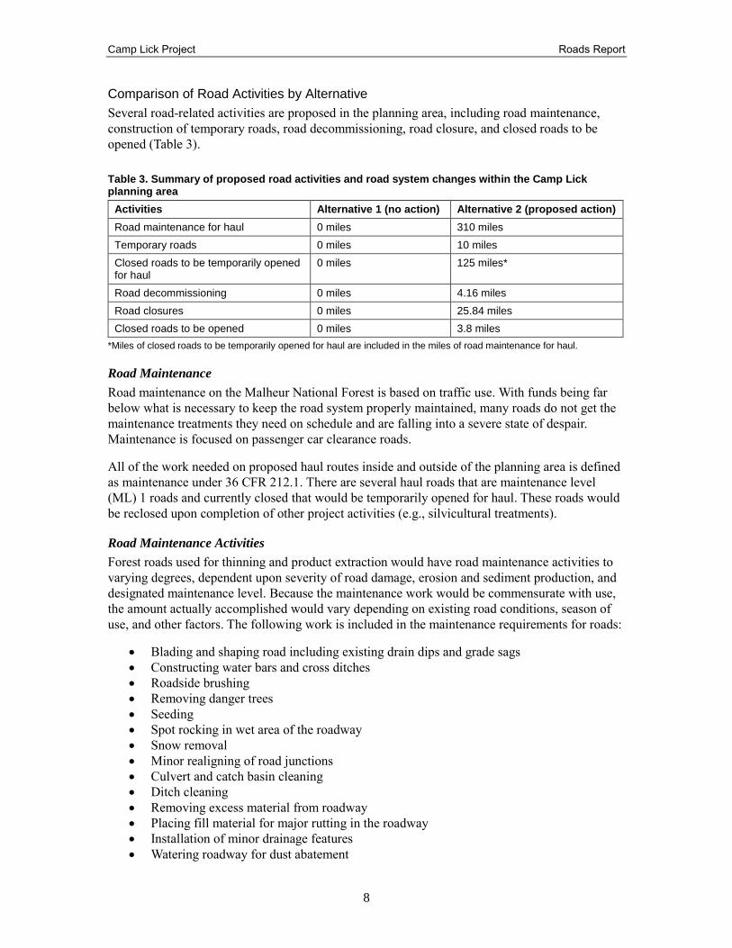
Comparison of Road Activities by Alternative
Several road-related activities are proposed in the planning area, including road maintenance,
construction of temporary roads, road decommissioning, road closure, and closed roads to be
opened (Table 3).
Table 3. Summary of proposed road activities and road system changes within the Camp Lick planning area
Activities Alternative 1 (no action) Alternative 2 (proposed action)
Road maintenance for haul 0 miles 310 miles
Temporary roads 0 miles 10 miles
Closed roads to be temporarily opened for haul
0 miles 125 miles*
Road decommissioning 0 miles 4.16 miles
Road closures 0 miles 25.84 miles
Closed roads to be opened 0 miles 3.8 miles
*Miles of closed roads to be temporarily opened for haul are included in the miles of road maintenance for haul.
Road Maintenance
Road maintenance on the Malheur National Forest is based on traffic use. With funds being far
below what is necessary to keep the road system properly maintained, many roads do not get the
maintenance treatments they need on schedule and are falling into a severe state of despair.
Maintenance is focused on passenger car clearance roads.
All of the work needed on proposed haul routes inside and outside of the planning area is defined
as maintenance under 36 CFR 212.1. There are several haul roads that are maintenance level
(ML) 1 roads and currently closed that would be temporarily opened for haul. These roads would
be reclosed upon completion of other project activities (e.g., silvicultural treatments).
Road Maintenance Activities
Forest roads used for thinning and product extraction would have road maintenance activities to
varying degrees, dependent upon severity of road damage, erosion and sediment production, and
designated maintenance level. Because the maintenance work would be commensurate with use,
the amount actually accomplished would vary depending on existing road conditions, season of
use, and other factors. The following work is included in the maintenance requirements for roads:
Blading and shaping road including existing drain dips and grade sags
Constructing water bars and cross ditches
Roadside brushing
Removing danger trees
Seeding
Spot rocking in wet area of the roadway
Snow removal
Minor realigning of road junctions
Culvert and catch basin cleaning
Ditch cleaning
Removing excess material from roadway
Placing fill material for major rutting in the roadway
Installation of minor drainage features
Watering roadway for dust abatement
Camp Lick Project Roads Report
9
In addition, re-construction requirements would be used for roads requiring the following work:
Major realignment or repair
Constructing drain dips
Constructing and installing wood pole or steel gate closure device
Widening of roadbed to meet safety standards
Culvert replacement
Other work listed in haul route table
Under alternative 2, danger trees would be felled along haul roads. This would result in increased
user safety during project activities as well as increased public safety on roads that are open to
public access after activities are complete.
Temporary Roads
A temporary road is a short-term system road constructed and rehabilitated under the terms of the
contract. If the road will be needed for future resource management subsequent to the contract
termination day, it must be constructed as a specified road. Temporary roads are roads authorized
by contract, permit, lease, or other written authorization or emergency operation not intended to
be part of the forest transportation system and not necessary for long-term resource management.
Temporary roads are not intended to be included as part of the forest transportation system, as
they are managed by the projects or activities under which they are authorized and
decommissioned at the conclusion of the authorized activity. Rehabilitating a temporary road
would be considered a permanent closure. Soil compaction would be reduced where feasible and
cut or fill slopes may be returned to natural contours.
Decommissioning Roads
Decommissioned roads are roads permanently closed by official actions and no longer on the
transportation map. These roads would be permanently removed from the Forest transportation
system, either because there is no reasonably foreseeable need for the road or because continued
use of the road is not compatible with aquatic habitat protection needs. The goal is to establish a
condition that will not require custodial maintenance in the future, through stabilization and
restoration to a more natural state. Some road segments proposed for decommission may not
require any ground disturbance because the existing condition of the road prism has begun to
return to its natural vegetated state. Road segments that do not require on the ground action would
be administratively removed from the transportation system.
Closing Roads
Closures are proposed when there is no short-term management need for the road and/or closing
the road is needed to address other resource concerns or needs such as wildlife habitat protection
and water quality. Roads that receive a closure status (ML1) are placed in long term storage for
future use. Roads that are currently closed and roads that are proposed for closure may receive
physical closure barriers such as wood pole gates, steel gates, earth berms, and rock berms. In
order to keep closed roads in long term storage and hydrologically functioning drainage features
may be added such are water bars and drain dips.
Camp Lick Project Roads Report
10
Alternative 1 – No Action
Direct and Indirect Effects
Open Road – Maintenance Level 2 and 3
Under the no action alternative, all existing open roads would remain open in their current
condition. Access would be provided at existing levels; however, there would be no opportunity
to close or decommission roads or to improve drainage by installing additional drainage dips,
water bars, or cross ditches.
The no action alternative would leave total miles of open road unchanged. Road maintenance and
motorized access would continue at current levels. This alternative has the least impact on current
access but in the future access would be reduced due to funding for road maintenance being
spread across a large road system.
Alternative 1 (no action) would not bring this area closer to meeting the standards and guidelines
in the Malheur Forest Plan for road densities.
Closed Road – Maintenance Level 1
Under the no action alternative there would be no direct or indirect effects on closed roads, all
existing closed roads would remain closed in their current condition. Miles of closed road would
remain unchanged.
The outcome of the no action alternative would be continued sediment delivery into streams at
the current level or higher, and continued maintenance costs to the federal government to meet
road maintenance standards. Alternative 1 would not provide opportunities to fund maintenance,
and miles of deferred maintenance on the Forest would continue to grow in magnitude.
Cumulative Effects
The no action alternative would have no direct or indirect effects on the total miles of road within
the Camp Lick planning area, therefore there would be no cumulative effects. However, there are
approximately 19 miles of closed (ML 1) roads to be decommissioned under the Aquatic
Restoration Decision within mostly category 4 Riparian Habitat Conservation Areas (RHCAs).
There are currently 400 total miles of road in the Camp Lick planning area. The total miles of
road after effects from past, present, and reasonably foreseeable future actions would be
approximately 381 miles inside the planning area. Effects from future actions would be short term
where re-contouring, water barring, and culvert removal would occur. Outcomes related to road
maintenance costs for the entire road system would remain the same.
Alternative 2 – Proposed Action
Direct and Indirect Effects
Open Road – Maintenance Level 2 and 3
Implementation of the proposed action would result in a temporary increase in miles of open road
in and adjacent to the planning area during the periods when roads are being used for timber haul
and project activities (e.g., silvicultural treatments). Approximately 10 miles of temporary roads
would be constructed under this alternative. Temporary roads would be restored to ensure soil
productivity is reestablished, the road has adequate drainage and ground cover to prevent erosion,
the road is no longer drivable, and the road is not highly visible after approximately 5 years
Camp Lick Project Roads Report
11
following completion of project activities. The condition of haul routes would be improved by
maintenance activities associated with timber harvest. Direct beneficial effects from the proposed
action would include improved road drainage and surface conditions. Maintenance activities
would have limited adverse effects on the use of roads, as roads would remain open during
project activities. To bring the roads up to a standard needed for commercial haul, road
maintenance activities are proposed on approximately 310 miles of road in alternative 2. In order
to provide recreation and public access approximately 3.8 miles of road is proposed to be re-
opened permanently in alternative 2. After project activities are complete, there would be
approximately 181 miles of open road inside the planning area boundaries for motorized use by
the public under this alternative.
Closed Road – Maintenance Level 1
Approximately 125 miles of closed roads would be temporarily re-opened for project activities
including log haul under this alternative. Closed roads that are opened for project activities would
be re-closed long-term with the same type of closure devices that were present before, using
earthen berms or gates and roadway slash. There are approximately 25.84 miles of road proposed
to be closed and 4.16 miles of road proposed to be decommissioned under this alternative. These
actions would decrease road density in the planning area, which would potentially help secure
wildlife habitat and reduce the amount of sediment released into the streams. There would be
approximately 215 miles of closed roads in the planning area following implementation under
this alternative.
Silvicultural treatments, riparian and upland watershed restoration treatments, prescribed burning
and unplanned ignitions, interpretive sign installation, and range fence construction would not
directly impact the road system. However, these activities could indirectly impact road condition
through use of the roads during implementation of the project activities.
Cumulative Effects
The cumulative effects of the proposed road maintenance, road closures, road re-opening, and
road decommissioning combined with foreseeable annual road maintenance activities and road
closures would be fewer roads to maintain, less money needed for maintenance, and improved
road conditions on open roads for all forest users.
There are approximately 19 miles of roads to be decommissioned under the Aquatic Restoration
Decision within mostly category 4 RHCAs that would complement the proposed
decommissioning within the Camp Lick Project proposal. There are currently 400 total miles of
road in the Camp Lick planning area. The total miles after effects from the proposed action and
from past and present projects would be approximately 377 miles inside the planning area.
Effects would be short-term where re-contouring, water barring, and culvert removal would
occur.
Summary of Environmental Effects
Table 4 summarizes the miles of open and closed roads based on direct effects of alternatives in
the Camp Lick planning area.
Table 4. Summary of resource indicators and measures by alternative
Resource indicator Measure Alternative 1 Alternative 2
Open road –maintenance level 2 and 3 Miles of open road 207 181
Closed road –maintenance level 1 Miles of closed road 193 215
Camp Lick Project Roads Report
12
Compliance with Forest Plan and Other Relevant Laws, Regulations, Policies and Plans
Alternatives 2 meets Malheur Forest Plan standards for road density and moves the planning area
toward meeting the overall desired condition for road density in big game summer and winter
range by the proposals of road closures and road decommissions.
Specific Malheur Forest Plan standards and desired future conditions are:
To maintain roads and trails to the minimum level required to meet integrated land
management objectives; and minimize tie-through roads (USDA Forest Service 1990,
Forest-wide standard 157, page IV–42).
To limit the disturbance to big game, the open road density in big game summer range
will be 3.2 miles per square mile by 1999 (USDA Forest Service 1990, Forest-wide
standard 33, page IV–29).
To limit disturbance to big game, the road density in big game winter range will be 2.2
miles per square mile by 1999 (USDA Forest Service, Standard 24, MA-4A, page IV–
22).
Overall desired condition in the Malheur Forest Plan is 1.5 miles per square mile in
summer range and 1.0 miles per square mile in winter range (USDA Forest Service 1990,
Desired Future Condition, fish and wildlife, page IV–6).
Camp Lick Project Roads Report
13
References Mosgrove, J.L. 1980. The Malheur National Forest: an ethnographic history. John Day, OR: U.S.
Department of Agriculture, Forest Service, Region 6, Malheur National Forest. 253 p.
USDA Forest Service. 1990. Malheur National Forest Land and Resource Management Plan.
John Day, OR: U.S. Department of Agriculture, Forest Service, Malheur National Forest.
Available online at: http://www.fs.usda.gov/main/malheur/landmanagement/planning.
USDA Forest Service. 2004. The Malheur National Forest Roads Analysis Report. John Day, OR:
Malheur National Forest.
USDA Forest Service. 2009 (update). Forest Service Handbook (FSH) 7709.59 – Road systems
operations and maintenance handbook.
USDA Forest Service 2012. National Best Management Practices for Water Quality Management
on National Forest System Lands Volume 1: National Core BMP Technical Guide (FS-
990a); April 2012.
USDI Fish and Wildlife Service [USFWS]. 2013. Programmatic Biological Opinion for Aquatic
Restoration Activities in the States of Oregon, Washington and portions of California,
Idaho and Nevada (ARBO II). [FWS reference: 01EOFW00-2013-F-0090]. Portland,
OR: Oregon Fish and Wildlife Office. 465 p.
USDA Forest Service. 2015. The Malheur National Forest Forest-wide Travel Analysis. John
Day, OR: Malheur National Forest.
Camp Lick Project Roads Report
14
Appendix A – Roads Proposed Actions
Road System Changes
The following road activities would occur to update the road system in the Camp Lick planning
area. Table 5 captures the road system changes under alternative 2 for the Camp Lick planning
area. There are no known RS2477 (right-of-way) claims for any roads proposed for access
changes in the planning area.
Table 5. Alternative 2 road system changes
Road number
Beginning mile post
Ending mile post
Miles in planning area
Current maintenance level
Proposed change
Rationale for proposed change
1800312 0.00 0.32 0.32 2 Close The road is in an area that is a priority closure for elk habitat.
1800313 0.00 0.3 0.3 2 Close The road is in an area that is a priority closure for elk habitat.
1800339 0.00 0.2 0.2 2 Close The road is redundant to other roads that provide access in the area.
1800500 0.00 0.9 0.9 2 Close Due to deferred maintenance the road is starting to return to its natural state with vegetation overgrowth and would be placed in long term storage for future use.1
1800533 0.00 1.69 1.69 2 Close The road is located in Big-Game Winter Range (MA4A) and is a priority closure for elk habitat.
3600105 0.00 0.11 0.11 2 Close The road is located in Big-Game Winter Range (MA4A).
3600106 0.00 0.1 0.1 2 Close The road is located in Big-Game Winter Range (MA4A).
3600145 0.00 0.22 0.22 2 Decommission Due to deferred maintenance the road is starting to return to its natural state with vegetation overgrowth.
3600189 0.00 0.93 0.93 2 Decommission The road is in close proximity to the stream, and is at high risk for sediment
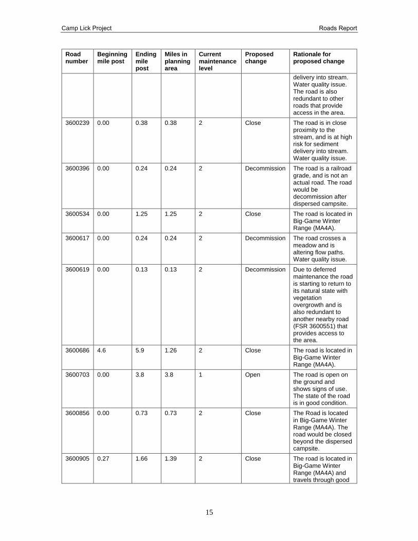
Camp Lick Project Roads Report
15
Road number
Beginning mile post
Ending mile post
Miles in planning area
Current maintenance level
Proposed change
Rationale for proposed change
delivery into stream. Water quality issue. The road is also redundant to other roads that provide access in the area.
3600239 0.00 0.38 0.38 2 Close The road is in close proximity to the stream, and is at high risk for sediment delivery into stream. Water quality issue.
3600396 0.00 0.24 0.24 2 Decommission The road is a railroad grade, and is not an actual road. The road would be decommission after dispersed campsite.
3600534 0.00 1.25 1.25 2 Close The road is located in Big-Game Winter Range (MA4A).
3600617 0.00 0.24 0.24 2 Decommission The road crosses a meadow and is altering flow paths. Water quality issue.
3600619 0.00 0.13 0.13 2 Decommission Due to deferred maintenance the road is starting to return to its natural state with vegetation overgrowth and is also redundant to another nearby road (FSR 3600551) that provides access to the area.
3600686 4.6 5.9 1.26 2 Close The road is located in Big-Game Winter Range (MA4A).
3600703 0.00 3.8 3.8 1 Open The road is open on the ground and shows signs of use. The state of the road is in good condition.
3600856 0.00 0.73 0.73 2 Close The Road is located in Big-Game Winter Range (MA4A). The road would be closed beyond the dispersed campsite.
3600905 0.27 1.66 1.39 2 Close The road is located in Big-Game Winter Range (MA4A) and travels through good
Camp Lick Project Roads Report
16
Road number
Beginning mile post
Ending mile post
Miles in planning area
Current maintenance level
Proposed change
Rationale for proposed change
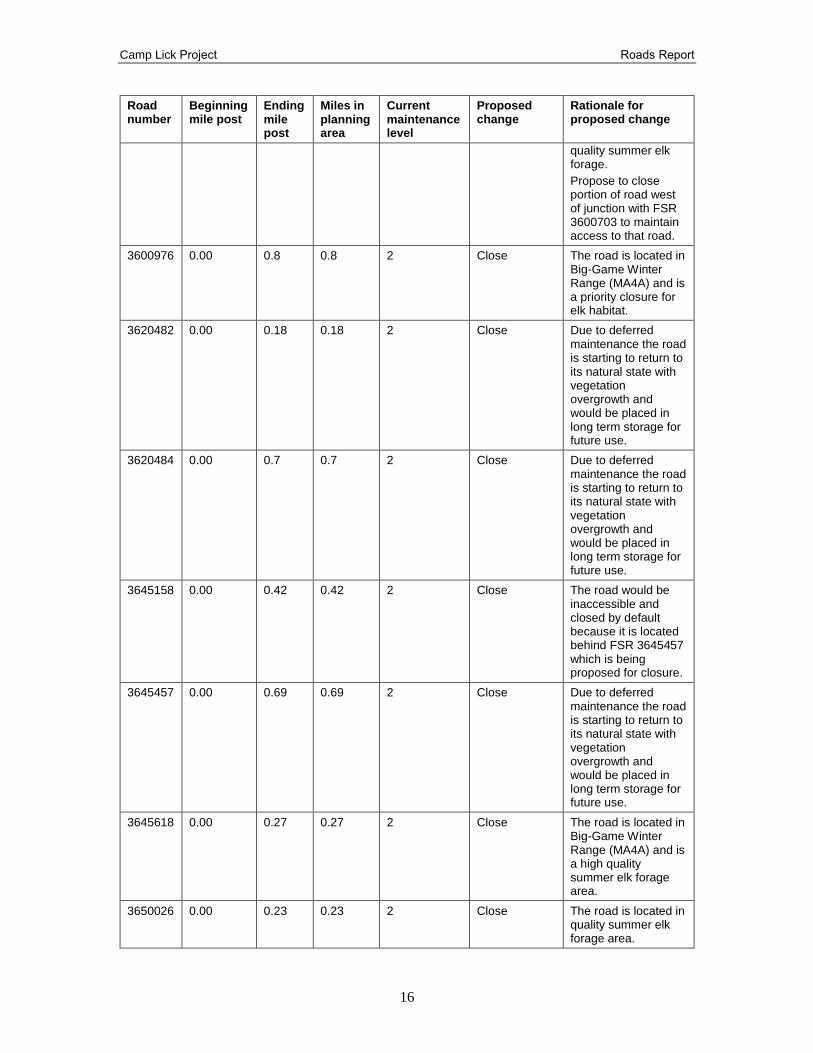
quality summer elk forage.
Propose to close portion of road west of junction with FSR 3600703 to maintain access to that road.
3600976 0.00 0.8 0.8 2 Close The road is located in Big-Game Winter Range (MA4A) and is a priority closure for elk habitat.
3620482 0.00 0.18 0.18 2 Close Due to deferred maintenance the road is starting to return to its natural state with vegetation overgrowth and would be placed in long term storage for future use.
3620484 0.00 0.7 0.7 2 Close Due to deferred maintenance the road is starting to return to its natural state with vegetation overgrowth and would be placed in long term storage for future use.
3645158 0.00 0.42 0.42 2 Close The road would be inaccessible and closed by default because it is located behind FSR 3645457 which is being proposed for closure.
3645457 0.00 0.69 0.69 2 Close Due to deferred maintenance the road is starting to return to its natural state with vegetation overgrowth and would be placed in long term storage for future use.
3645618 0.00 0.27 0.27 2 Close The road is located in Big-Game Winter Range (MA4A) and is a high quality summer elk forage area.
3650026 0.00 0.23 0.23 2 Close The road is located in quality summer elk forage area.
Camp Lick Project Roads Report
17
Road number
Beginning mile post
Ending mile post
Miles in planning area
Current maintenance level
Proposed change
Rationale for proposed change
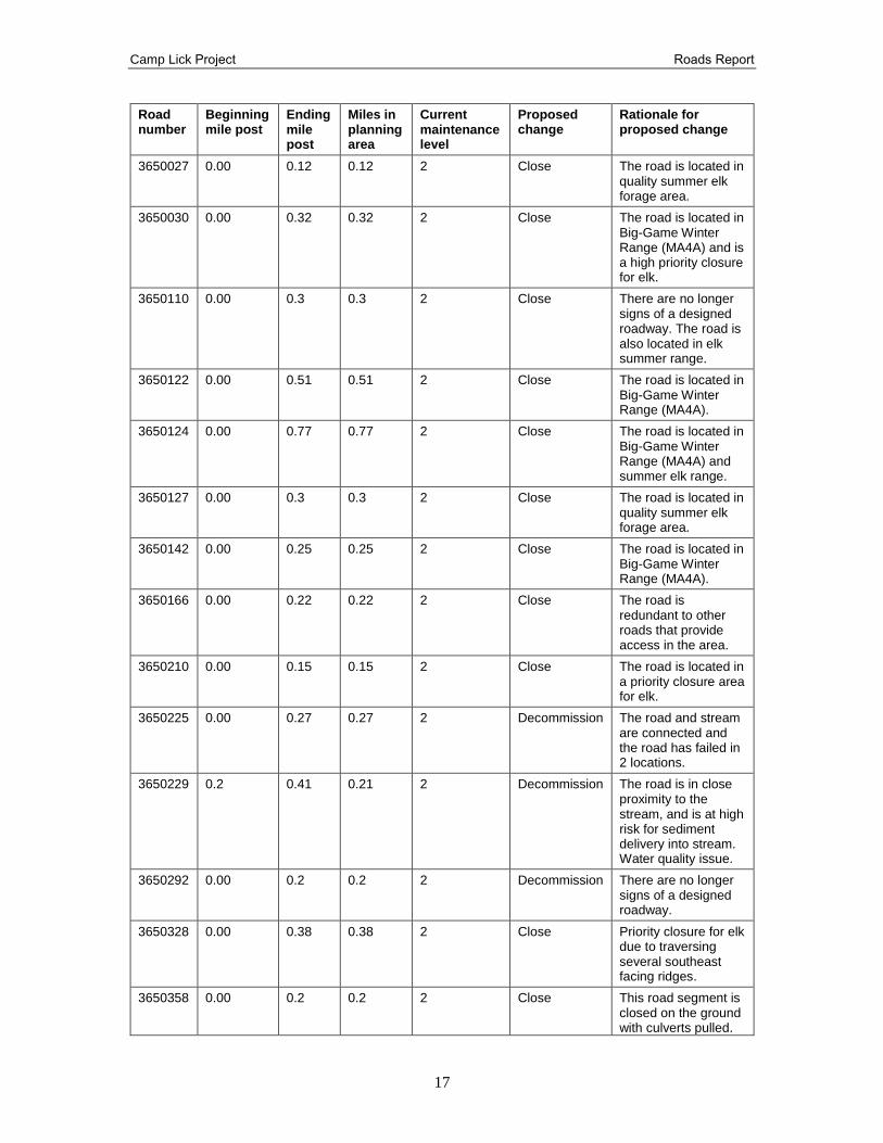
3650027 0.00 0.12 0.12 2 Close The road is located in quality summer elk forage area.
3650030 0.00 0.32 0.32 2 Close The road is located in Big-Game Winter Range (MA4A) and is a high priority closure for elk.
3650110 0.00 0.3 0.3 2 Close There are no longer signs of a designed roadway. The road is also located in elk summer range.
3650122 0.00 0.51 0.51 2 Close The road is located in Big-Game Winter Range (MA4A).
3650124 0.00 0.77 0.77 2 Close The road is located in Big-Game Winter Range (MA4A) and summer elk range.
3650127 0.00 0.3 0.3 2 Close The road is located in quality summer elk forage area.
3650142 0.00 0.25 0.25 2 Close The road is located in Big-Game Winter Range (MA4A).
3650166 0.00 0.22 0.22 2 Close The road is redundant to other roads that provide access in the area.
3650210 0.00 0.15 0.15 2 Close The road is located in a priority closure area for elk.
3650225 0.00 0.27 0.27 2 Decommission The road and stream are connected and the road has failed in 2 locations.
3650229 0.2 0.41 0.21 2 Decommission The road is in close proximity to the stream, and is at high risk for sediment delivery into stream. Water quality issue.
3650292 0.00 0.2 0.2 2 Decommission There are no longer signs of a designed roadway.
3650328 0.00 0.38 0.38 2 Close Priority closure for elk due to traversing several southeast facing ridges.
3650358 0.00 0.2 0.2 2 Close This road segment is closed on the ground with culverts pulled.
Camp Lick Project Roads Report
18
Road number
Beginning mile post
Ending mile post
Miles in planning area
Current maintenance level
Proposed change
Rationale for proposed change
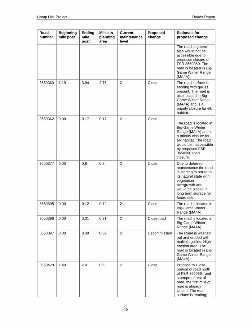
The road segment also would not be accessible due to proposed closure of FSR 3650360. The road is located in Big-Game Winter Range (MA4A).
3650360 1.19 3.94 2.75 2 Close The road surface is eroding with gullies present. The road is also located in Big-Game Winter Range (MA4A) and is a priority closure for elk habitat.
3650362 0.00 0.17 0.17 2 Close The road is located in Big-Game Winter Range (MA4A) and is a priority closure for elk habitat. The road would be inaccessible by proposed FSR 3650360 road closure.
3650377 0.00 0.8 0.8 2 Close Due to deferred maintenance the road is starting to return to its natural state with vegetation overgrowth and would be placed in long term storage for future use.
3650395 0.00 0.12 0.12 2 Close The road is located in Big-Game Winter Range (MA4A).
3650396 0.00 0.31 0.31 2 Close road The road is located in Big-Game Winter Range (MA4A).
3650397 0.00 0.39 0.39 2 Decommission The Road is washed out and eroded with multiple gullies. High erosion area. The road is located in Big-Game Winter Range (MA4A).
3650428 1.40 2.0 0.6 2 Close Propose to Close portion of road north of FSR 3650394 and stormproof rest of road, the first mile of road is already closed. The road surface is eroding;
Camp Lick Project Roads Report
19
Road number
Beginning mile post
Ending mile post
Miles in planning area
Current maintenance level
Proposed change
Rationale for proposed change
culvert washed out; 3 foot trees growing on roadbed. The road is also located in Big-Game Winter Range (MA4A).
3650430 0.00 0.56 0.56 2 Close The road is located in Big-Game Winter Range (MA4A) and ends in an elk forage area.
3650625 0.00 1.67 1.67 2 Close The road is located in Big-Game Winter Range (MA4A) and traverses ridges and high priority elk nursery and occupancy area.
3650690 0.00 0.52 0.52 2 Close The road is located in Big-Game Winter Range (MA4A) and is a priority closure for elk habitat.
3650699 0.00 0.38 0.38 2 Decommission The road is in close proximity to the stream, and is at high risk for sediment delivery into stream. Water quality issue.
3650700 0.00 0.06 0.06 2 Close Due to deferred maintenance the road is starting to return to its natural state with vegetation overgrowth and would be placed in long term storage for future use. The road is located in Big-Game Winter Range (MA4A).
3650712 0.00 0.33 0.33 2 Decommission The road is in close proximity to the stream, and is at high risk for sediment delivery into stream. The road is located in Big-Game Winter Range (MA4A).
3650715 0.00 0.41 0.41 2 Close The road is located in Big-Game Winter Range (MA4A) and is a high priority closure for elk security and elk nursery.
Camp Lick Project Roads Report
20
Road number
Beginning mile post
Ending mile post
Miles in planning area
Current maintenance level
Proposed change
Rationale for proposed change
3650716 0.00 0.09 0.09 2 Decommission The road is located in a valley bottom causing fine sediment production. Water quality issue.
3650845 0.00 0.28 0.28 2 Close Due to deferred maintenance the road is starting to return to its natural state with vegetation overgrowth and would be placed in long term storage for future use.
3660020 0.00 0.36 0.36 2 Close Due to deferred maintenance the road is starting to return to its natural state with vegetation overgrowth and would be placed in long term storage for future use.
3660042 0.00 0.3 0.3 2 Close Due to deferred maintenance the road is starting to return to its natural state with vegetation overgrowth and would be placed in long term storage for future use.
3660240 0.00 0.23 0.23 2 Close The road is located in Big-Game Winter Range (MA4A).
3660565 0.00 0.53 0.53 2 Decommission Propose to decommission portion of road between FSRs 3660630 to 3660 (parallels a stream, erosion issue)
3660565 0.53 1.591 1.06 2 Close The road is in close proximity to the stream, and is at high risk for sediment delivery into stream. Water quality issue.
3660851 0.00 0.2 0.2 2 Close The road is located in Big-Game Winter Range (MA4A).
1Deferred maintenance is defined as “Maintenance that was not performed when it should have been or when it was scheduled and which, therefore, was put off or delayed for future period.
Camp Lick Project Roads Report
21
Confirmation of Past Administratively Closed Roads
Within the Camp Lick planning area, there are road segments identified in the road system
database as closed by previous administrative actions. These road segments, identified as ML 1,
are included in this project so they can be documented as closed through the Camp Lick NEPA
process. The existing conditions of these road segments were found to be in one or more of the
following condition state: currently overgrown with natural vegetation; physically blocked with a
gate or earthen berm; the road prism is no longer visible: or the road prism has no physical
closure barrier present. The interdisciplinary team analyzed each road segment to determine its
current use and future access need for the public and administration. Through this analysis,
approximately 12.8 miles of road are proposed for official closure and long-term storage for
future use in alternative 2 and are listed in Table 6.
Table 6. Past administratively closed roads to be confirmed as closed under alternative 2
Road number
Beginning mile post
Ending mile post
Miles Current and proposed maintenance level
2045871 0.00 0.18 0.18 1
3600506 0.00 0.19 0.19 1
3600559 0.00 0.10 0.10 1
3600568 0.00 0.78 0.78 1
3600602 0.00 0.47 0.47 1
3640064 0.00 0.55 0.55 1
3640067 0.00 0.20 0.20 1
3640130 0.00 0.40 0.40 1
3640461 0.00 0.09 0.09 1
3650107 0.00 1.05 1.05 1
3650108 0.00 0.42 0.42 1
3650125 0.00 0.45 0.45 1
3650141 0.00 0.28 0.28 1
3650227 0.00 0.38 0.38 1
3650228 0.00 0.61 0.61 1
3650282 0.00 0.06 0.06 1
3650359 0.00 0.16 0.16 1
3650429 0.00 0.30 0.30 1
3650477 0.00 0.33 0.33 1
3650481 0.00 1.37 1.37 1
3650482 0.00 0.17 0.17 1
3650483 0.00 0.59 0.59 1
3650484 0.00 0.14 0.14 1
3650709 0.00 0.37 0.37 1
3650710 0.00 0.22 0.22 1
3650713 0.00 0.59 0.59 1
3650840 0.00 0.38 0.38 1
3670347 0.00 0.48 0.48 1
3690238 0.00 1.44 1.44 1
Camp Lick Project Roads Report
22
Road number
Beginning mile post
Ending mile post
Miles Current and proposed maintenance level
3660450-Y 0.00 0.09 0.09 1
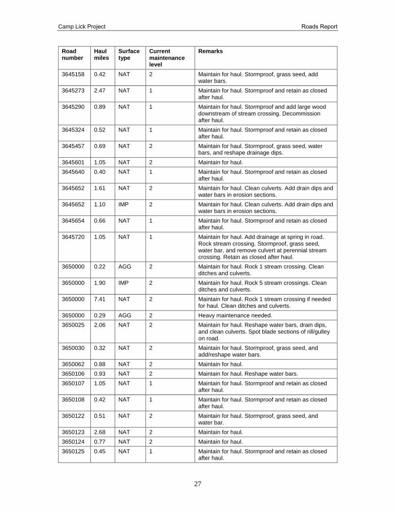
Haul Routes
The roads listed in Table 7 below is a full listing of proposed haul roads for the Camp Lick
Project under alternative 2. In order to safely use these roads and reduce environmental impacts,
these roads may receive maintenance and/or reconstruction during implementation of Camp Lick
Project.
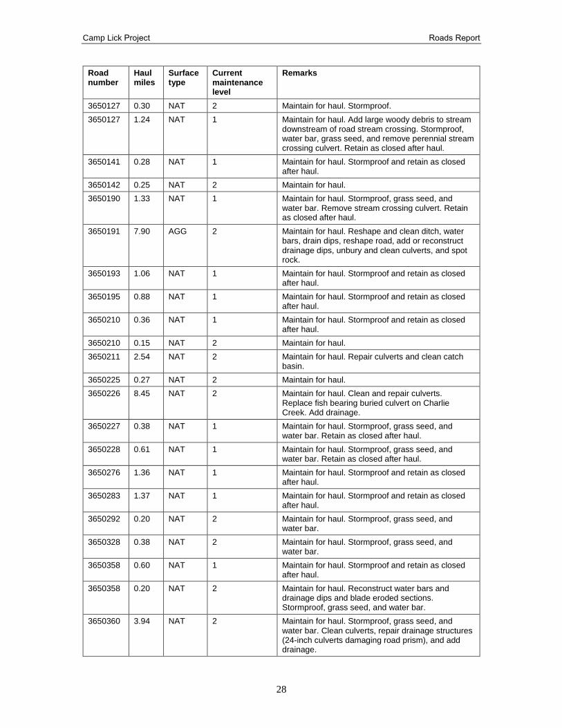
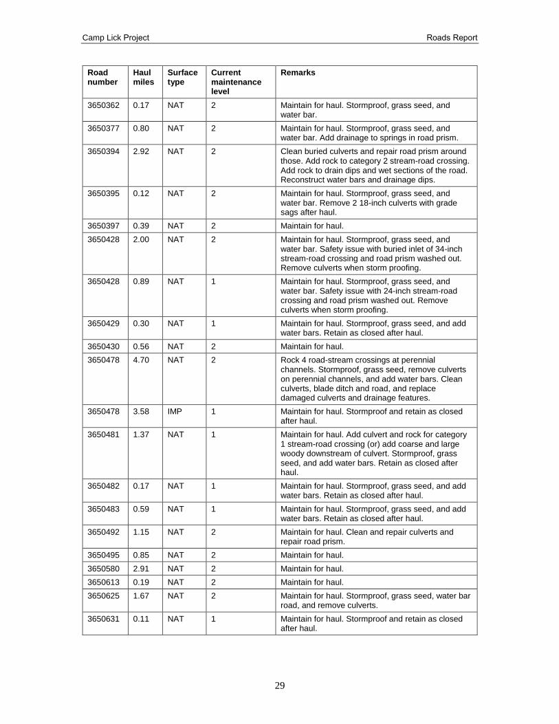
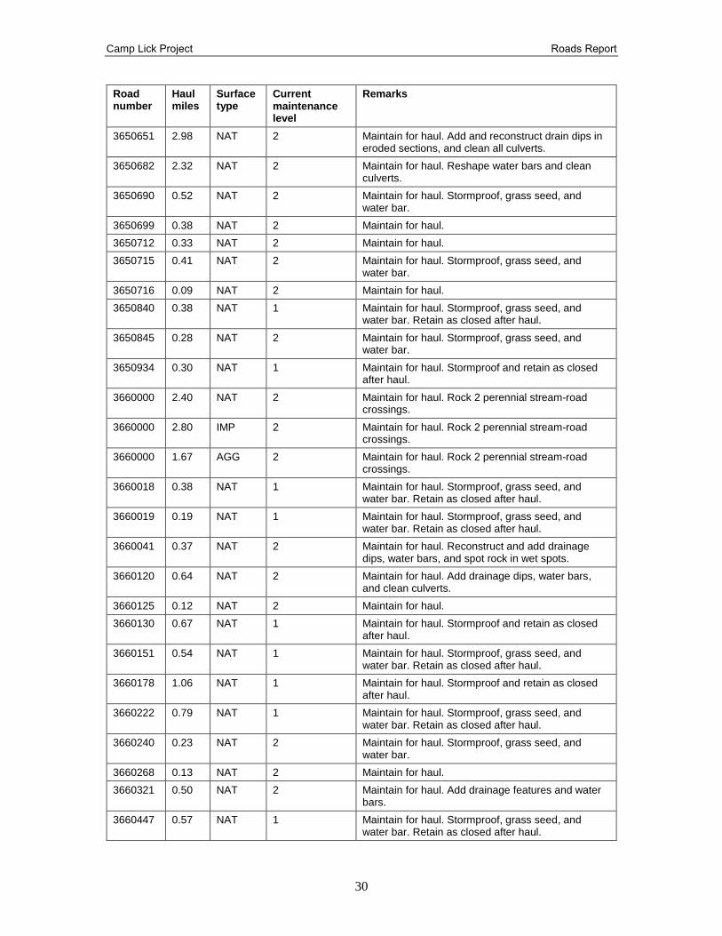
Table 7. Alternative 2 haul routes
Road number
Haul miles
Surface type
Current maintenance level
Remarks
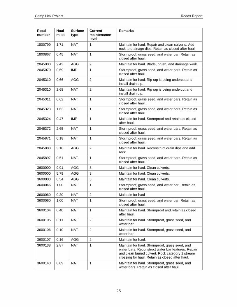
1800087 1.34 NAT 2 Maintain for haul. Reconstruct drain dips and clean culverts. Rock stream crossing.
1800091 0.65 NAT 1 Reconstruct drain dip and clean culverts. Stormproof with water bars and grass seed. Reconstruct fish crossing or remove. Rock stream crossing. Retain as closed after haul.
1800130 0.82 NAT 1 Maintain for haul. Stormproof and add water bars and grass seed. Reshape road in rill/gulley locations. Retain as closed after haul.
1800312 0.32 NAT 2 Stormproof, water bar, and grass seed.
1800313 0.30 NAT 2 Stormproof, water bar, and grass seed.
1800358 1.99 NAT 1 Maintain for haul. Stormproof and retain as closed after haul.
1800499 1.20 IMP 2 Maintain for haul. Retain as closed after haul.
1800499 2.17 NAT 1 Stormproof and add drainage and water bars. Retain as closed after haul.
1800500 0.90 NAT 2 Maintain for haul.
1800550 0.40 NAT 1 Stormproof, grass seed, water bar, and remove culverts. Rock crossings. Retain as closed after haul.
1800550 0.25 NAT 2 Maintain for haul.
1800637 0.37 NAT 1 Maintain for haul. Stormproof and retain as closed after haul.
1800754 0.30 NAT 2 Maintain for haul.
1800754 0.70 AGG 2 Maintain for haul.
1800755 0.99 NAT 1 Maintain for haul. Stormproof and retain as closed after haul.
1800765 1.93 IMP 1 Stormproof, remove fish barrier culvert, remove culverts, grass seed, and water bar. Retain as closed after haul.
1800771 1.35 NAT 1 Stormproof, grass seed, and water bar. Retain as closed after haul.
1800772 0.23 NAT 1 Stormproof, grass seed, and water bar. Retain as closed after haul.
1800785 2.04 AGG 2 Hand clean culverts and replace/repair 1 culvert. Rock stream crossing.
Camp Lick Project Roads Report
23
Road number
Haul miles
Surface type
Current maintenance level
Remarks
1800799 1.71 NAT 1 Maintain for haul. Repair and clean culverts. Add rock to drainage dips. Retain as closed after haul.
1800867 0.45 NAT 1 Stormproof, grass seed, and water bar. Retain as closed after haul.
2045000 2.43 AGG 2 Maintain for haul. Blade, brush, and drainage work.
2045070 0.69 IMP 1 Stormproof, grass seed, and water bars. Retain as closed after haul.
2045310 0.66 AGG 2 Maintain for haul. Rip rap is being undercut and install drain dip.
2045310 2.68 NAT 2 Maintain for haul. Rip rap is being undercut and install drain dip.
2045311 0.62 NAT 1 Stormproof, grass seed, and water bars. Retain as closed after haul.
2045323 1.63 NAT 1 Stormproof, grass seed, and water bars. Retain as closed after haul.
2045324 0.47 IMP 1 Maintain for haul. Stormproof and retain as closed after haul.
2045372 2.65 NAT 1 Stormproof, grass seed, and water bars. Retain as closed after haul.
2045871 0.18 NAT 1 Stormproof, grass seed, and water bars. Retain as closed after haul.
2045888 3.18 AGG 2 Maintain for haul. Reconstruct drain dips and add rock.
2045897 0.51 NAT 1 Stormproof, grass seed, and water bars. Retain as closed after haul.
3600000 9.91 AGG 3 Maintain for haul. Clean culverts.
3600000 5.79 AGG 3 Maintain for haul. Clean culverts.
3600000 0.54 AGG 3 Maintain for haul. Clean culverts.
3600046 1.00 NAT 1 Stormproof, grass seed, and water bar. Retain as closed after haul.
3600060 0.20 NAT 2 Maintain for haul
3600060 1.00 NAT 1 Stormproof, grass seed, and water bar. Retain as closed after haul.
3600104 0.40 NAT 1 Maintain for haul. Stormproof and retain as closed after haul.
3600105 0.11 NAT 2 Maintain for haul. Stormproof, grass seed, and water bar.
3600106 0.10 NAT 2 Maintain for haul. Stormproof, grass seed, and water bar.
3600107 0.16 AGG 2 Maintain for haul.
3600138 2.87 NAT 1 Maintain for haul. Stormproof, grass seed, and water bars. Reconstruct water bar features. Repair and clean buried culvert. Rock category 1 stream crossing for haul. Retain as closed after haul.
3600140 0.89 NAT 1 Maintain for haul. Stormproof, grass seed, and water bars. Retain as closed after haul.
Camp Lick Project Roads Report
24
Road number
Haul miles
Surface type
Current maintenance level
Remarks
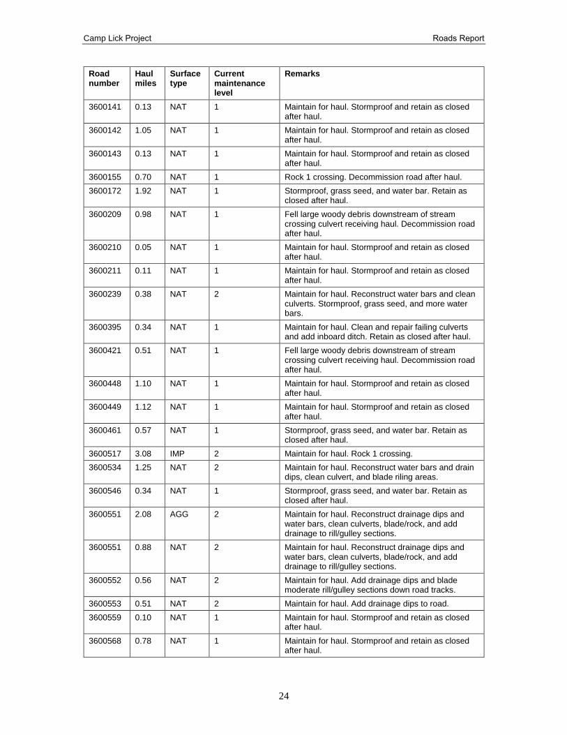
3600141 0.13 NAT 1 Maintain for haul. Stormproof and retain as closed after haul.
3600142 1.05 NAT 1 Maintain for haul. Stormproof and retain as closed after haul.
3600143 0.13 NAT 1 Maintain for haul. Stormproof and retain as closed after haul.
3600155 0.70 NAT 1 Rock 1 crossing. Decommission road after haul.
3600172 1.92 NAT 1 Stormproof, grass seed, and water bar. Retain as closed after haul.
3600209 0.98 NAT 1 Fell large woody debris downstream of stream crossing culvert receiving haul. Decommission road after haul.
3600210 0.05 NAT 1 Maintain for haul. Stormproof and retain as closed after haul.
3600211 0.11 NAT 1 Maintain for haul. Stormproof and retain as closed after haul.
3600239 0.38 NAT 2 Maintain for haul. Reconstruct water bars and clean culverts. Stormproof, grass seed, and more water bars.
3600395 0.34 NAT 1 Maintain for haul. Clean and repair failing culverts and add inboard ditch. Retain as closed after haul.
3600421 0.51 NAT 1 Fell large woody debris downstream of stream crossing culvert receiving haul. Decommission road after haul.
3600448 1.10 NAT 1 Maintain for haul. Stormproof and retain as closed after haul.
3600449 1.12 NAT 1 Maintain for haul. Stormproof and retain as closed after haul.
3600461 0.57 NAT 1 Stormproof, grass seed, and water bar. Retain as closed after haul.
3600517 3.08 IMP 2 Maintain for haul. Rock 1 crossing.
3600534 1.25 NAT 2 Maintain for haul. Reconstruct water bars and drain dips, clean culvert, and blade riling areas.
3600546 0.34 NAT 1 Stormproof, grass seed, and water bar. Retain as closed after haul.
3600551 2.08 AGG 2 Maintain for haul. Reconstruct drainage dips and water bars, clean culverts, blade/rock, and add drainage to rill/gulley sections.
3600551 0.88 NAT 2 Maintain for haul. Reconstruct drainage dips and water bars, clean culverts, blade/rock, and add drainage to rill/gulley sections.
3600552 0.56 NAT 2 Maintain for haul. Add drainage dips and blade moderate rill/gulley sections down road tracks.
3600553 0.51 NAT 2 Maintain for haul. Add drainage dips to road.
3600559 0.10 NAT 1 Maintain for haul. Stormproof and retain as closed after haul.
3600568 0.78 NAT 1 Maintain for haul. Stormproof and retain as closed after haul.
Camp Lick Project Roads Report
25
Road number
Haul miles
Surface type
Current maintenance level
Remarks
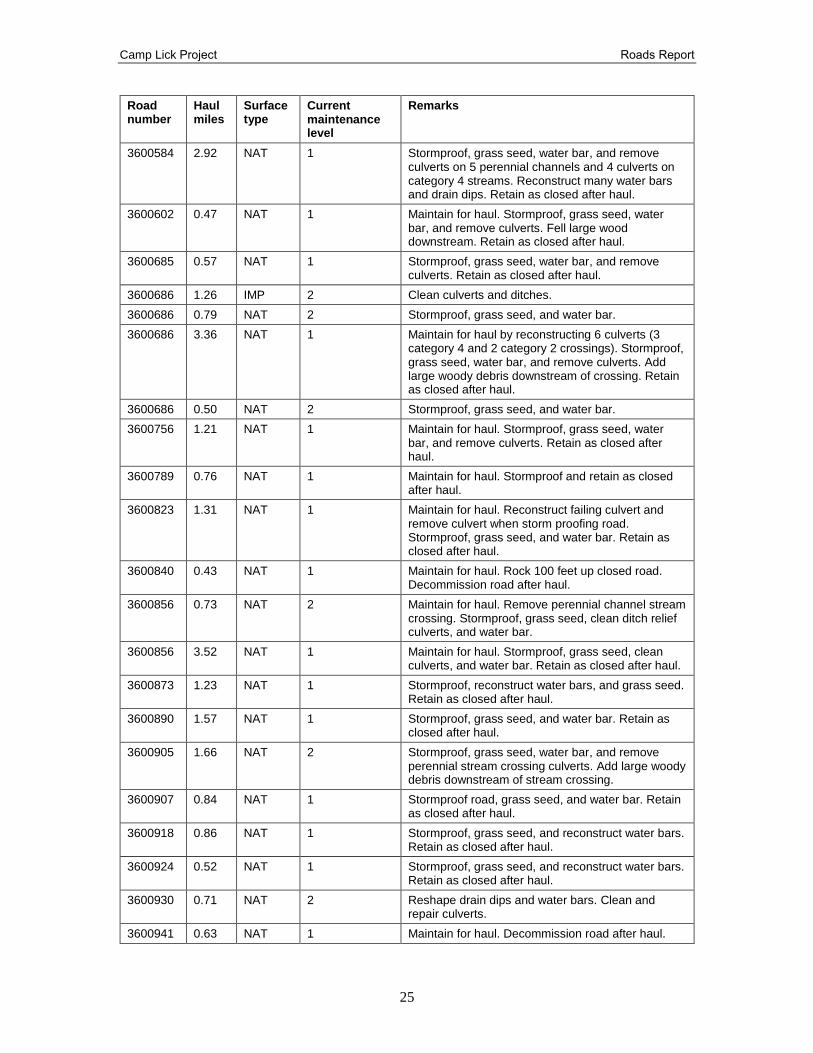
3600584 2.92 NAT 1 Stormproof, grass seed, water bar, and remove culverts on 5 perennial channels and 4 culverts on category 4 streams. Reconstruct many water bars and drain dips. Retain as closed after haul.
3600602 0.47 NAT 1 Maintain for haul. Stormproof, grass seed, water bar, and remove culverts. Fell large wood downstream. Retain as closed after haul.
3600685 0.57 NAT 1 Stormproof, grass seed, water bar, and remove culverts. Retain as closed after haul.
3600686 1.26 IMP 2 Clean culverts and ditches.
3600686 0.79 NAT 2 Stormproof, grass seed, and water bar.
3600686 3.36 NAT 1 Maintain for haul by reconstructing 6 culverts (3 category 4 and 2 category 2 crossings). Stormproof, grass seed, water bar, and remove culverts. Add large woody debris downstream of crossing. Retain as closed after haul.
3600686 0.50 NAT 2 Stormproof, grass seed, and water bar.
3600756 1.21 NAT 1 Maintain for haul. Stormproof, grass seed, water bar, and remove culverts. Retain as closed after haul.
3600789 0.76 NAT 1 Maintain for haul. Stormproof and retain as closed after haul.
3600823 1.31 NAT 1 Maintain for haul. Reconstruct failing culvert and remove culvert when storm proofing road. Stormproof, grass seed, and water bar. Retain as closed after haul.
3600840 0.43 NAT 1 Maintain for haul. Rock 100 feet up closed road. Decommission road after haul.
3600856 0.73 NAT 2 Maintain for haul. Remove perennial channel stream crossing. Stormproof, grass seed, clean ditch relief culverts, and water bar.
3600856 3.52 NAT 1 Maintain for haul. Stormproof, grass seed, clean culverts, and water bar. Retain as closed after haul.
3600873 1.23 NAT 1 Stormproof, reconstruct water bars, and grass seed. Retain as closed after haul.
3600890 1.57 NAT 1 Stormproof, grass seed, and water bar. Retain as closed after haul.
3600905 1.66 NAT 2 Stormproof, grass seed, water bar, and remove perennial stream crossing culverts. Add large woody debris downstream of stream crossing.
3600907 0.84 NAT 1 Stormproof road, grass seed, and water bar. Retain as closed after haul.
3600918 0.86 NAT 1 Stormproof, grass seed, and reconstruct water bars. Retain as closed after haul.
3600924 0.52 NAT 1 Stormproof, grass seed, and reconstruct water bars. Retain as closed after haul.
3600930 0.71 NAT 2 Reshape drain dips and water bars. Clean and repair culverts.
3600941 0.63 NAT 1 Maintain for haul. Decommission road after haul.
Camp Lick Project Roads Report
26
Road number
Haul miles
Surface type
Current maintenance level
Remarks
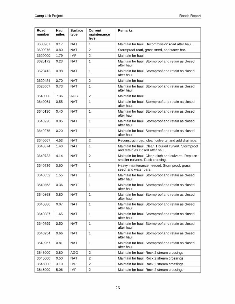
3600967 0.17 NAT 1 Maintain for haul. Decommission road after haul.
3600976 0.80 NAT 2 Stormproof road, grass seed, and water bar.
3620000 1.79 IMP 2 Maintain for haul.
3620172 0.23 NAT 1 Maintain for haul. Stormproof and retain as closed after haul.
3620413 0.98 NAT 1 Maintain for haul. Stormproof and retain as closed after haul.
3620484 0.70 NAT 2 Maintain for haul.
3620567 0.73 NAT 1 Maintain for haul. Stormproof and retain as closed after haul.
3640000 7.36 AGG 2 Maintain for haul.
3640064 0.55 NAT 1 Maintain for haul. Stormproof and retain as closed after haul.
3640130 0.40 NAT 1 Maintain for haul. Stormproof and retain as closed after haul.
3640220 0.05 NAT 1 Maintain for haul. Stormproof and retain as closed after haul.
3640275 0.20 NAT 1 Maintain for haul. Stormproof and retain as closed after haul.
3640667 4.53 NAT 2 Reconstruct road, clean culverts, and add drainage.
3640674 1.48 NAT 1 Maintain for haul. Clean 1 buried culvert. Stormproof and retain as closed after haul.
3640733 4.14 NAT 2 Maintain for haul. Clean ditch and culverts. Replace smaller culverts. Rock crossing.
3640836 0.60 NAT 1 Heavy maintenance needed. Stormproof, grass seed, and water bars.
3640852 1.55 NAT 1 Maintain for haul. Stormproof and retain as closed after haul.
3640853 0.36 NAT 1 Maintain for haul. Stormproof and retain as closed after haul.
3640868 0.80 NAT 1 Maintain for haul. Stormproof and retain as closed after haul.
3640886 0.07 NAT 1 Maintain for haul. Stormproof and retain as closed after haul.
3640887 1.65 NAT 1 Maintain for haul. Stormproof and retain as closed after haul.
3640899 0.50 NAT 1 Maintain for haul. Stormproof and retain as closed after haul.
3640954 0.66 NAT 1 Maintain for haul. Stormproof and retain as closed after haul.
3640967 0.81 NAT 1 Maintain for haul. Stormproof and retain as closed after haul.
3645000 0.80 AGG 2 Maintain for haul. Rock 2 stream crossings
3645000 0.50 NAT 2 Maintain for haul. Rock 2 stream crossings
3645000 3.10 IMP 2 Maintain for haul. Rock 2 stream crossings
3645000 5.06 IMP 2 Maintain for haul. Rock 2 stream crossings
Camp Lick Project Roads Report
27
Road number
Haul miles
Surface type
Current maintenance level
Remarks
3645158 0.42 NAT 2 Maintain for haul. Stormproof, grass seed, add water bars.
3645273 2.47 NAT 1 Maintain for haul. Stormproof and retain as closed after haul.
3645290 0.89 NAT 1 Maintain for haul. Stormproof and add large wood downstream of stream crossing. Decommission after haul.
3645324 0.52 NAT 1 Maintain for haul. Stormproof and retain as closed after haul.
3645457 0.69 NAT 2 Maintain for haul. Stormproof, grass seed, water bars, and reshape drainage dips.
3645601 1.05 NAT 2 Maintain for haul.
3645640 0.40 NAT 1 Maintain for haul. Stormproof and retain as closed after haul.
3645652 1.61 NAT 2 Maintain for haul. Clean culverts. Add drain dips and water bars in erosion sections.
3645652 1.10 IMP 2 Maintain for haul. Clean culverts. Add drain dips and water bars in erosion sections.
3645654 0.66 NAT 1 Maintain for haul. Stormproof and retain as closed after haul.
3645720 1.05 NAT 1 Maintain for haul. Add drainage at spring in road. Rock stream crossing. Stormproof, grass seed, water bar, and remove culvert at perennial stream crossing. Retain as closed after haul.
3650000 0.22 AGG 2 Maintain for haul. Rock 1 stream crossing. Clean ditches and culverts.
3650000 1.90 IMP 2 Maintain for haul. Rock 5 stream crossings. Clean ditches and culverts.
3650000 7.41 NAT 2 Maintain for haul. Rock 1 stream crossing if needed for haul. Clean ditches and culverts.
3650000 0.29 AGG 2 Heavy maintenance needed.
3650025 2.06 NAT 2 Maintain for haul. Reshape water bars, drain dips, and clean culverts. Spot blade sections of rill/gulley on road.
3650030 0.32 NAT 2 Maintain for haul. Stormproof, grass seed, and add/reshape water bars.
3650062 0.88 NAT 2 Maintain for haul.
3650106 0.93 NAT 2 Maintain for haul. Reshape water bars.
3650107 1.05 NAT 1 Maintain for haul. Stormproof and retain as closed after haul.
3650108 0.42 NAT 1 Maintain for haul. Stormproof and retain as closed after haul.
3650122 0.51 NAT 2 Maintain for haul. Stormproof, grass seed, and water bar.
3650123 2.68 NAT 2 Maintain for haul.
3650124 0.77 NAT 2 Maintain for haul.
3650125 0.45 NAT 1 Maintain for haul. Stormproof and retain as closed after haul.
Camp Lick Project Roads Report
28
Road number
Haul miles
Surface type
Current maintenance level
Remarks
3650127 0.30 NAT 2 Maintain for haul. Stormproof.
3650127 1.24 NAT 1 Maintain for haul. Add large woody debris to stream downstream of road stream crossing. Stormproof, water bar, grass seed, and remove perennial stream crossing culvert. Retain as closed after haul.
3650141 0.28 NAT 1 Maintain for haul. Stormproof and retain as closed after haul.
3650142 0.25 NAT 2 Maintain for haul.
3650190 1.33 NAT 1 Maintain for haul. Stormproof, grass seed, and water bar. Remove stream crossing culvert. Retain as closed after haul.
3650191 7.90 AGG 2 Maintain for haul. Reshape and clean ditch, water bars, drain dips, reshape road, add or reconstruct drainage dips, unbury and clean culverts, and spot rock.
3650193 1.06 NAT 1 Maintain for haul. Stormproof and retain as closed after haul.
3650195 0.88 NAT 1 Maintain for haul. Stormproof and retain as closed after haul.
3650210 0.36 NAT 1 Maintain for haul. Stormproof and retain as closed after haul.
3650210 0.15 NAT 2 Maintain for haul.
3650211 2.54 NAT 2 Maintain for haul. Repair culverts and clean catch basin.
3650225 0.27 NAT 2 Maintain for haul.
3650226 8.45 NAT 2 Maintain for haul. Clean and repair culverts. Replace fish bearing buried culvert on Charlie Creek. Add drainage.
3650227 0.38 NAT 1 Maintain for haul. Stormproof, grass seed, and water bar. Retain as closed after haul.
3650228 0.61 NAT 1 Maintain for haul. Stormproof, grass seed, and water bar. Retain as closed after haul.
3650276 1.36 NAT 1 Maintain for haul. Stormproof and retain as closed after haul.
3650283 1.37 NAT 1 Maintain for haul. Stormproof and retain as closed after haul.
3650292 0.20 NAT 2 Maintain for haul. Stormproof, grass seed, and water bar.
3650328 0.38 NAT 2 Maintain for haul. Stormproof, grass seed, and water bar.
3650358 0.60 NAT 1 Maintain for haul. Stormproof and retain as closed after haul.
3650358 0.20 NAT 2 Maintain for haul. Reconstruct water bars and drainage dips and blade eroded sections. Stormproof, grass seed, and water bar.
3650360 3.94 NAT 2 Maintain for haul. Stormproof, grass seed, and water bar. Clean culverts, repair drainage structures (24-inch culverts damaging road prism), and add drainage.
Camp Lick Project Roads Report
29
Road number
Haul miles
Surface type
Current maintenance level
Remarks
3650362 0.17 NAT 2 Maintain for haul. Stormproof, grass seed, and water bar.
3650377 0.80 NAT 2 Maintain for haul. Stormproof, grass seed, and water bar. Add drainage to springs in road prism.
3650394 2.92 NAT 2 Clean buried culverts and repair road prism around those. Add rock to category 2 stream-road crossing. Add rock to drain dips and wet sections of the road. Reconstruct water bars and drainage dips.
3650395 0.12 NAT 2 Maintain for haul. Stormproof, grass seed, and water bar. Remove 2 18-inch culverts with grade sags after haul.
3650397 0.39 NAT 2 Maintain for haul.
3650428 2.00 NAT 2 Maintain for haul. Stormproof, grass seed, and water bar. Safety issue with buried inlet of 34-inch stream-road crossing and road prism washed out. Remove culverts when storm proofing.
3650428 0.89 NAT 1 Maintain for haul. Stormproof, grass seed, and water bar. Safety issue with 24-inch stream-road crossing and road prism washed out. Remove culverts when storm proofing.
3650429 0.30 NAT 1 Maintain for haul. Stormproof, grass seed, and add water bars. Retain as closed after haul.
3650430 0.56 NAT 2 Maintain for haul.
3650478 4.70 NAT 2 Rock 4 road-stream crossings at perennial channels. Stormproof, grass seed, remove culverts on perennial channels, and add water bars. Clean culverts, blade ditch and road, and replace damaged culverts and drainage features.
3650478 3.58 IMP 1 Maintain for haul. Stormproof and retain as closed after haul.
3650481 1.37 NAT 1 Maintain for haul. Add culvert and rock for category 1 stream-road crossing (or) add coarse and large woody downstream of culvert. Stormproof, grass seed, and add water bars. Retain as closed after haul.
3650482 0.17 NAT 1 Maintain for haul. Stormproof, grass seed, and add water bars. Retain as closed after haul.
3650483 0.59 NAT 1 Maintain for haul. Stormproof, grass seed, and add water bars. Retain as closed after haul.
3650492 1.15 NAT 2 Maintain for haul. Clean and repair culverts and repair road prism.
3650495 0.85 NAT 2 Maintain for haul.
3650580 2.91 NAT 2 Maintain for haul.
3650613 0.19 NAT 2 Maintain for haul.
3650625 1.67 NAT 2 Maintain for haul. Stormproof, grass seed, water bar road, and remove culverts.
3650631 0.11 NAT 1 Maintain for haul. Stormproof and retain as closed after haul.
Camp Lick Project Roads Report
30
Road number
Haul miles
Surface type
Current maintenance level
Remarks
3650651 2.98 NAT 2 Maintain for haul. Add and reconstruct drain dips in eroded sections, and clean all culverts.
3650682 2.32 NAT 2 Maintain for haul. Reshape water bars and clean culverts.
3650690 0.52 NAT 2 Maintain for haul. Stormproof, grass seed, and water bar.
3650699 0.38 NAT 2 Maintain for haul.
3650712 0.33 NAT 2 Maintain for haul.
3650715 0.41 NAT 2 Maintain for haul. Stormproof, grass seed, and water bar.
3650716 0.09 NAT 2 Maintain for haul.
3650840 0.38 NAT 1 Maintain for haul. Stormproof, grass seed, and water bar. Retain as closed after haul.
3650845 0.28 NAT 2 Maintain for haul. Stormproof, grass seed, and water bar.
3650934 0.30 NAT 1 Maintain for haul. Stormproof and retain as closed after haul.
3660000 2.40 NAT 2 Maintain for haul. Rock 2 perennial stream-road crossings.
3660000 2.80 IMP 2 Maintain for haul. Rock 2 perennial stream-road crossings.
3660000 1.67 AGG 2 Maintain for haul. Rock 2 perennial stream-road crossings.
3660018 0.38 NAT 1 Maintain for haul. Stormproof, grass seed, and water bar. Retain as closed after haul.
3660019 0.19 NAT 1 Maintain for haul. Stormproof, grass seed, and water bar. Retain as closed after haul.
3660041 0.37 NAT 2 Maintain for haul. Reconstruct and add drainage dips, water bars, and spot rock in wet spots.
3660120 0.64 NAT 2 Maintain for haul. Add drainage dips, water bars, and clean culverts.
3660125 0.12 NAT 2 Maintain for haul.
3660130 0.67 NAT 1 Maintain for haul. Stormproof and retain as closed after haul.
3660151 0.54 NAT 1 Maintain for haul. Stormproof, grass seed, and water bar. Retain as closed after haul.
3660178 1.06 NAT 1 Maintain for haul. Stormproof and retain as closed after haul.
3660222 0.79 NAT 1 Maintain for haul. Stormproof, grass seed, and water bar. Retain as closed after haul.
3660240 0.23 NAT 2 Maintain for haul. Stormproof, grass seed, and water bar.
3660268 0.13 NAT 2 Maintain for haul.
3660321 0.50 NAT 2 Maintain for haul. Add drainage features and water bars.
3660447 0.57 NAT 1 Maintain for haul. Stormproof, grass seed, and water bar. Retain as closed after haul.
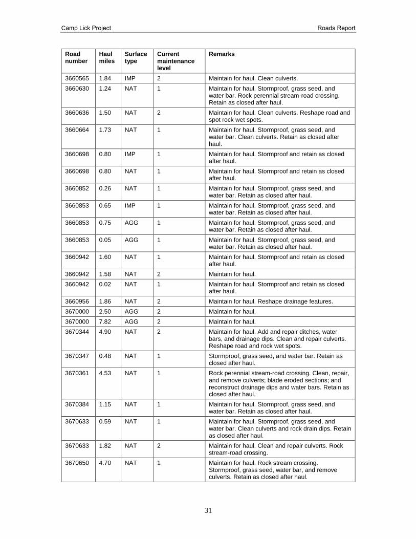
Camp Lick Project Roads Report
31
Road number
Haul miles
Surface type
Current maintenance level
Remarks
3660565 1.84 IMP 2 Maintain for haul. Clean culverts.
3660630 1.24 NAT 1 Maintain for haul. Stormproof, grass seed, and water bar. Rock perennial stream-road crossing. Retain as closed after haul.
3660636 1.50 NAT 2 Maintain for haul. Clean culverts. Reshape road and spot rock wet spots.
3660664 1.73 NAT 1 Maintain for haul. Stormproof, grass seed, and water bar. Clean culverts. Retain as closed after haul.
3660698 0.80 IMP 1 Maintain for haul. Stormproof and retain as closed after haul.
3660698 0.80 NAT 1 Maintain for haul. Stormproof and retain as closed after haul.
3660852 0.26 NAT 1 Maintain for haul. Stormproof, grass seed, and water bar. Retain as closed after haul.
3660853 0.65 IMP 1 Maintain for haul. Stormproof, grass seed, and water bar. Retain as closed after haul.
3660853 0.75 AGG 1 Maintain for haul. Stormproof, grass seed, and water bar. Retain as closed after haul.
3660853 0.05 AGG 1 Maintain for haul. Stormproof, grass seed, and water bar. Retain as closed after haul.
3660942 1.60 NAT 1 Maintain for haul. Stormproof and retain as closed after haul.
3660942 1.58 NAT 2 Maintain for haul.
3660942 0.02 NAT 1 Maintain for haul. Stormproof and retain as closed after haul.
3660956 1.86 NAT 2 Maintain for haul. Reshape drainage features.
3670000 2.50 AGG 2 Maintain for haul.
3670000 7.82 AGG 2 Maintain for haul.
3670344 4.90 NAT 2 Maintain for haul. Add and repair ditches, water bars, and drainage dips. Clean and repair culverts. Reshape road and rock wet spots.
3670347 0.48 NAT 1 Stormproof, grass seed, and water bar. Retain as closed after haul.
3670361 4.53 NAT 1 Rock perennial stream-road crossing. Clean, repair, and remove culverts; blade eroded sections; and reconstruct drainage dips and water bars. Retain as closed after haul.
3670384 1.15 NAT 1 Maintain for haul. Stormproof, grass seed, and water bar. Retain as closed after haul.
3670633 0.59 NAT 1 Maintain for haul. Stormproof, grass seed, and water bar. Clean culverts and rock drain dips. Retain as closed after haul.
3670633 1.82 NAT 2 Maintain for haul. Clean and repair culverts. Rock stream-road crossing.
3670650 4.70 NAT 1 Maintain for haul. Rock stream crossing. Stormproof, grass seed, water bar, and remove culverts. Retain as closed after haul.
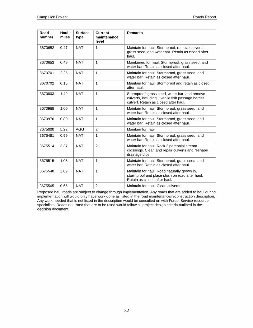
Camp Lick Project Roads Report
32
Road number
Haul miles
Surface type
Current maintenance level
Remarks
3670652 0.47 NAT 1 Maintain for haul. Stormproof, remove culverts, grass seed, and water bar. Retain as closed after haul.
3670653 0.49 NAT 1 Maintained for haul. Stormproof, grass seed, and water bar. Retain as closed after haul.
3670701 2.25 NAT 1 Maintain for haul. Stormproof, grass seed, and water bar. Retain as closed after haul.
3670702 0.15 NAT 1 Maintain for haul. Stormproof and retain as closed after haul.
3670803 1.49 NAT 1 Stormproof, grass seed, water bar, and remove culverts, including juvenile fish passage barrier culvert. Retain as closed after haul.
3670968 1.00 NAT 1 Maintain for haul. Stormproof, grass seed, and water bar. Retain as closed after haul.
3670976 0.80 NAT 1 Maintain for haul. Stormproof, grass seed, and water bar. Retain as closed after haul.
3675000 5.22 AGG 2 Maintain for haul.
3675481 0.99 NAT 1 Maintain for haul. Stormproof, grass seed, and water bar. Retain as closed after haul.
3675514 3.37 NAT 2 Maintain for haul. Rock 2 perennial stream crossings. Clean and repair culverts and reshape drainage dips.
3675515 1.03 NAT 1 Maintain for haul. Stormproof, grass seed, and water bar. Retain as closed after haul.
3675548 2.09 NAT 1 Maintain for haul. Road naturally grown in, stormproof and place slash on road after haul. Retain as closed after haul.
3675565 0.65 NAT 2 Maintain for haul. Clean culverts.
Proposed haul roads are subject to change through implementation. Any roads that are added to haul during implementation will would only have work done as listed in the road maintenance/reconstruction description. Any work needed that is not listed in the description would be consulted on with Forest Service resource specialists. Roads not listed that are to be used would follow all project design criteria outlined in the decision document.
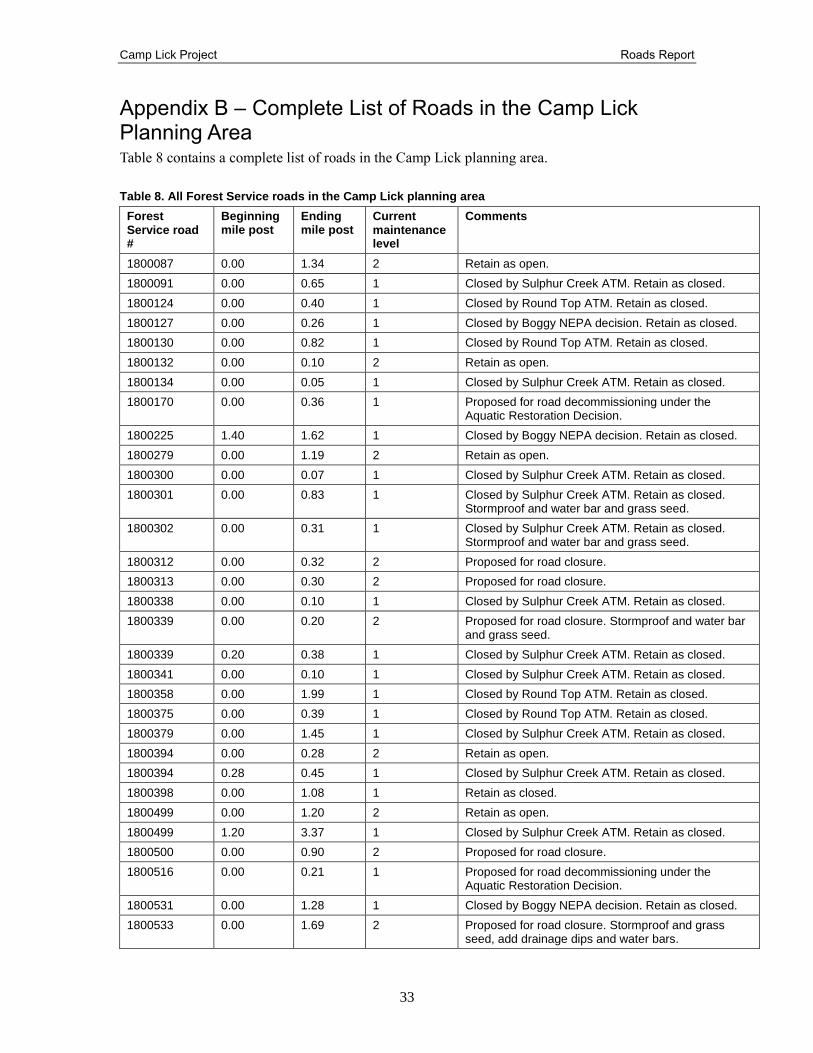
Camp Lick Project Roads Report
33
Appendix B – Complete List of Roads in the Camp Lick Planning Area Table 8 contains a complete list of roads in the Camp Lick planning area.
Table 8. All Forest Service roads in the Camp Lick planning area
Forest Service road #
Beginning mile post
Ending mile post
Current maintenance level
Comments
1800087 0.00 1.34 2 Retain as open.
1800091 0.00 0.65 1 Closed by Sulphur Creek ATM. Retain as closed.
1800124 0.00 0.40 1 Closed by Round Top ATM. Retain as closed.
1800127 0.00 0.26 1 Closed by Boggy NEPA decision. Retain as closed.
1800130 0.00 0.82 1 Closed by Round Top ATM. Retain as closed.
1800132 0.00 0.10 2 Retain as open.
1800134 0.00 0.05 1 Closed by Sulphur Creek ATM. Retain as closed.
1800170 0.00 0.36 1 Proposed for road decommissioning under the Aquatic Restoration Decision.
1800225 1.40 1.62 1 Closed by Boggy NEPA decision. Retain as closed.
1800279 0.00 1.19 2 Retain as open.
1800300 0.00 0.07 1 Closed by Sulphur Creek ATM. Retain as closed.
1800301 0.00 0.83 1 Closed by Sulphur Creek ATM. Retain as closed. Stormproof and water bar and grass seed.
1800302 0.00 0.31 1 Closed by Sulphur Creek ATM. Retain as closed. Stormproof and water bar and grass seed.
1800312 0.00 0.32 2 Proposed for road closure.
1800313 0.00 0.30 2 Proposed for road closure.
1800338 0.00 0.10 1 Closed by Sulphur Creek ATM. Retain as closed.
1800339 0.00 0.20 2 Proposed for road closure. Stormproof and water bar and grass seed.
1800339 0.20 0.38 1 Closed by Sulphur Creek ATM. Retain as closed.
1800341 0.00 0.10 1 Closed by Sulphur Creek ATM. Retain as closed.
1800358 0.00 1.99 1 Closed by Round Top ATM. Retain as closed.
1800375 0.00 0.39 1 Closed by Round Top ATM. Retain as closed.
1800379 0.00 1.45 1 Closed by Sulphur Creek ATM. Retain as closed.
1800394 0.00 0.28 2 Retain as open.
1800394 0.28 0.45 1 Closed by Sulphur Creek ATM. Retain as closed.
1800398 0.00 1.08 1 Retain as closed.
1800499 0.00 1.20 2 Retain as open.
1800499 1.20 3.37 1 Closed by Sulphur Creek ATM. Retain as closed.
1800500 0.00 0.90 2 Proposed for road closure.
1800516 0.00 0.21 1 Proposed for road decommissioning under the Aquatic Restoration Decision.
1800531 0.00 1.28 1 Closed by Boggy NEPA decision. Retain as closed.
1800533 0.00 1.69 2 Proposed for road closure. Stormproof and grass seed, add drainage dips and water bars.
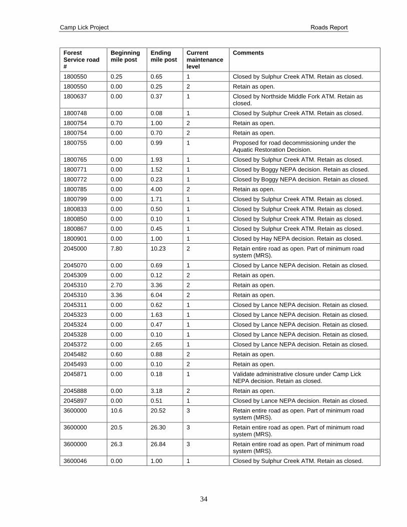
Camp Lick Project Roads Report
34
Forest Service road #
Beginning mile post
Ending mile post
Current maintenance level
Comments
1800550 0.25 0.65 1 Closed by Sulphur Creek ATM. Retain as closed.
1800550 0.00 0.25 2 Retain as open.
1800637 0.00 0.37 1 Closed by Northside Middle Fork ATM. Retain as closed.
1800748 0.00 0.08 1 Closed by Sulphur Creek ATM. Retain as closed.
1800754 0.70 1.00 2 Retain as open.
1800754 0.00 0.70 2 Retain as open.
1800755 0.00 0.99 1 Proposed for road decommissioning under the Aquatic Restoration Decision.
1800765 0.00 1.93 1 Closed by Sulphur Creek ATM. Retain as closed.
1800771 0.00 1.52 1 Closed by Boggy NEPA decision. Retain as closed.
1800772 0.00 0.23 1 Closed by Boggy NEPA decision. Retain as closed.
1800785 0.00 4.00 2 Retain as open.
1800799 0.00 1.71 1 Closed by Sulphur Creek ATM. Retain as closed.
1800833 0.00 0.50 1 Closed by Sulphur Creek ATM. Retain as closed.
1800850 0.00 0.10 1 Closed by Sulphur Creek ATM. Retain as closed.
1800867 0.00 0.45 1 Closed by Sulphur Creek ATM. Retain as closed.
1800901 0.00 1.00 1 Closed by Hay NEPA decision. Retain as closed.
2045000 7.80 10.23 2 Retain entire road as open. Part of minimum road system (MRS).
2045070 0.00 0.69 1 Closed by Lance NEPA decision. Retain as closed.
2045309 0.00 0.12 2 Retain as open.
2045310 2.70 3.36 2 Retain as open.
2045310 3.36 6.04 2 Retain as open.
2045311 0.00 0.62 1 Closed by Lance NEPA decision. Retain as closed.
2045323 0.00 1.63 1 Closed by Lance NEPA decision. Retain as closed.
2045324 0.00 0.47 1 Closed by Lance NEPA decision. Retain as closed.
2045328 0.00 0.10 1 Closed by Lance NEPA decision. Retain as closed.
2045372 0.00 2.65 1 Closed by Lance NEPA decision. Retain as closed.
2045482 0.60 0.88 2 Retain as open.
2045493 0.00 0.10 2 Retain as open.
2045871 0.00 0.18 1 Validate administrative closure under Camp Lick NEPA decision. Retain as closed.
2045888 0.00 3.18 2 Retain as open.
2045897 0.00 0.51 1 Closed by Lance NEPA decision. Retain as closed.
3600000 10.6 20.52 3 Retain entire road as open. Part of minimum road system (MRS).
3600000 20.5 26.30 3 Retain entire road as open. Part of minimum road system (MRS).
3600000 26.3 26.84 3 Retain entire road as open. Part of minimum road system (MRS).
3600046 0.00 1.00 1 Closed by Sulphur Creek ATM. Retain as closed.
Camp Lick Project Roads Report
35
Forest Service road #
Beginning mile post
Ending mile post
Current maintenance level
Comments
3600047 0.00 0.10 1 Proposed for road decommissioning under the Aquatic Restoration Decision.
3600060 0.00 0.20 2 Retain as open.
3600060 0.20 1.20 1 Closed by Northside Middle Fork ATM. Retain as closed.
3600085 0.00 0.06 1 Closed by Sulphur Creek ATM. Retain as closed.
3600104 0.00 0.40 1 Proposed for road decommissioning under the Aquatic Restoration Decision.
3600105 0.00 0.11 2 Proposed for road closure.
3600106 0.00 0.10 2 Proposed for road closure.
3600107 0.00 0.16 2 Retain as open.
3600138 0.00 2.87 1 Closed by Northside Middle Fork ATM. Retain as closed.
3600139 0.00 0.19 1 Closed by Northside Middle Fork ATM. Retain as closed.
3600140 0.00 0.89 1 Closed by Northside Middle Fork ATM. Retain as closed.
3600141 0.00 0.13 1 Proposed for road decommissioning under the Aquatic Restoration Decision.
3600142 0.00 1.05 1 Closed by Northside Middle Fork ATM. Retain as closed.
3600143 0.00 0.13 1 Proposed for road decommissioning under the Aquatic Restoration Decision.
3600145 0.00 0.22 2 Proposed for road decommissioning.
3600146 0.00 0.45 1 Proposed for road decommissioning under the Aquatic Restoration Decision.
3600148 0.00 0.21 1 Closed by Northside Middle Fork ATM. Retain as closed.
3600155 0.00 0.70 1 Proposed for road decommissioning under the Aquatic Restoration Decision.
3600172 0.00 1.92 1 Closed by Northside Middle Fork ATM. Retain as closed.
3600189 0.00 0.93 1 Proposed for road decommissioning. Fell large woody debris downstream of stream crossing culvert receiving haul.
3600208 0.00 0.15 1 Proposed for road decommissioning under the Aquatic Restoration Decision.
3600209 0.00 0.98 1 Proposed for road decommissioning under the Aquatic Restoration Decision.
3600210 0.00 0.05 1 Proposed for road decommissioning under the Aquatic Restoration Decision.
3600211 0.00 0.11 1 Proposed for road decommissioning under the Aquatic Restoration Decision.
3600239 0.00 0.38 2 Proposed for road closure.
3600268 0.00 0.70 1 Closed by Sulphur Creek ATM. Retain as closed. Stormproof and remove stream crossing culvert. Add water bars.
Camp Lick Project Roads Report
36
Forest Service road #
Beginning mile post
Ending mile post
Current maintenance level
Comments
3600269 0.00 0.40 1 Proposed for road decommissioning under the Aquatic Restoration Decision.
3600395 0.00 0.34 1 Closed by Northside Middle Fork ATM. Retain as closed.
3600396 0.00 0.24 2 Proposed for road decommissioning.
3600421 0.00 0.51 1 Proposed for road decommissioning under the Aquatic Restoration Decision.
3600448 0.00 1.10 1 Closed by Lance NEPA decision. Retain as closed.
3600449 0.00 1.12 1 Closed by Lance NEPA decision. Retain as closed.
3600461 0.00 0.57 1 Closed by Jungle NEPA decision. Retain as closed.
3600505 0.00 0.09 2 Retain as open.
3600506 0.00 0.19 1 Validate administrative closure under Camp Lick decision. Retain as closed.
3600517 0.00 3.08 2 Retain as open.
3600526 0.00 0.21 1 Proposed for road decommissioning under the Aquatic Restoration Decision.
3600534 0.00 1.25 2 Proposed for road closure.
3600546 0.00 0.34 1 Retain as closed
3600551 0.00 2.08 2 Retain as open.
3600551 2.08 2.95 2 Retain as open.
3600552 0.00 0.56 2 Retain as open.
3600553 0.00 0.51 2 Retain as open.
3600559 0.00 0.10 1 Validate administrative closure under Camp Lick decision. Retain as closed.
3600568 0.00 0.78 1 Validate administrative closure under Camp Lick decision. Retain as closed.
3600584 0.00 2.92 1 Closed by Sulphur Creek ATM. Retain as closed.
3600585 0.00 1.49 2 Retain as open. Add water bars or drain dips. Blade rills/gulley.
3600602 0.00 0.47 1 Validate administrative closure under Camp Lick decision. Retain as closed.
3600617 0.00 0.24 2 Proposed for road decommissioning.
3600619 0.00 0.13 2 Proposed for road decommissioning.
3600685 0.00 0.57 1 Closed by Sulphur Creek ATM. Retain as closed.
3600686 0.00 1.26 2 Retain as open.
3600686 4.61 5.40 2 Proposed for road closure.
3600686 1.26 4.61 1 Closed by Sulphur Creek ATM. Retain as closed.
3600686 5.40 5.90 2 Proposed for road closure.
3600703 0.00 3.82 1 Closed by Sulphur Creek ATM. Proposed for re-opening.
3600756 0.00 1.21 1 Closed by Bear Wallow NEPA decision. Retain as closed.
3600789 0.00 0.76 1 Proposed for road decommissioning under the Aquatic Restoration Decision.
Camp Lick Project Roads Report
37
Forest Service road #
Beginning mile post
Ending mile post
Current maintenance level
Comments
3600823 0.00 1.31 1 Closed by Bear Wallow NEPA decision. Retain as closed.
3600840 0.00 0.43 1 Proposed for road decommissioning under the Aquatic Restoration Decision.
3600856 0.00 0.73 2 Proposed for road closure.
3600856 0.73 4.24 1 Closed by Jungle NEPA decision. Retain as closed.
3600873 0.00 1.23 1 Closed by Jungle NEPA decision. Retain as closed.
3600890 0.00 1.57 1 Closed by Jungle NEPA decision. Retain as closed.
3600905 0.00 1.66 2 Proposed for road closure.
3600907 0.00 0.84 1 Closed by Jungle NEPA decision. Retain as closed.
3600918 0.00 0.86 1 Closed by Northside Middle Fork ATM. Retain as closed.
3600924 0.00 0.52 1 Closed by Jungle NEPA decision. Retain as closed.
3600930 0.00 0.71 2 Retain as open.
3600941 0.00 0.63 1 Proposed for road decommissioning under the Aquatic Restoration Decision.
3600967 0.00 0.17 1 Proposed for road decommissioning under the Aquatic Restoration Decision.
3600970 0.00 0.16 1 Closed by Sulphur Creek ATM. Retain as closed. Stormproof, construct few water bars, overgrown.
3600972 0.00 0.10 1 Closed by Sulphur Creek ATM. Retain as closed. Stormproof road.
3600976 0.00 0.80 2 Proposed for road closure.
3620000 3.17 4.96 2 Retain entire road as open. Part of minimum road system (MRS).
3620172 0.00 0.23 1 Closed by Sulphur Creek ATM. Retain as closed.
3620413 0.00 0.98 1 Closed by Sulphur Creek ATM. Retain as closed.
3620482 0.00 0.18 2 Proposed for road closure.
3620484 0.00 0.70 2 Proposed for road closure.
3620566 0.00 0.26 1 Closed by Sulphur Creek ATM. Retain as closed.
3620567 0.00 0.73 1 Closed by Sulphur Creek ATM. Retain as closed.
3640000 0.00 7.36 2 Retain entire road as open. Part of minimum road system (MRS)
3640064 0.00 0.55 1 Validate administrative closure under Camp Lick decision. Retain as closed.
3640067 0.00 0.20 1 Validate administrative closure under Camp Lick decision. Retain as closed.
3640130 0.00 0.40 1 Validate administrative closure under Camp Lick decision. Retain as closed.
3640203 0.00 1.32 1 Closed by Twin Bench NEPA decision. Retain as closed.
3640205 0.00 0.27 1 Closed by Twin Bench NEPA decision. Retain as closed.
3640220 0.00 0.05 1 Closed by Northside Middle Fork ATM. Retain as closed.
Camp Lick Project Roads Report
38
Forest Service road #
Beginning mile post
Ending mile post
Current maintenance level
Comments
3640237 0.00 1.50 1 Closed by Northside Middle Fork ATM. Retain as closed.
3640240 0.00 0.30 1 Closed by Northside Middle Fork ATM. Retain as closed.
3640243 0.00 0.20 1 Proposed for road decommissioning under the Aquatic Restoration Decision.
3640245 0.00 0.30 1 Proposed for road decommissioning under the Aquatic Restoration Decision.
3640247 0.00 0.20 1 Proposed for road decommissioning under the Aquatic Restoration Decision.
3640249 0.00 0.43 1 Closed by Twin Bench NEPA decision. Retain as closed.
3640275 0.00 0.20 1 Closed by Northside Middle Fork ATM. Retain as closed.
3640276 0.00 0.21 1 Proposed for road decommissioning under the Aquatic Restoration Decision.
3640461 0.00 0.09 1 Validate administrative closure under Camp Lick decision. Retain as closed.
3640667 0.00 4.53 2 Retain as open.
3640669 0.00 0.24 2 Retain as open.
3640674 0.00 1.48 1 Closed by Twin Bench NEPA decision. Retain as closed.
3640733 0.00 4.14 2 Retain as open.
3640835 0.00 0.10 1 Closed by Northside Middle Fork ATM. Retain as closed.
3640836 0.00 0.60 1 Closed by Northside Middle Fork ATM. Retain as closed.
3640852 0.00 1.55 1 Closed by Northside Middle Fork ATM. Retain as closed.
3640853 0.00 0.36 1 Closed by Northside Middle Fork ATM. Retain as closed.
3640868 0.00 0.80 1 Closed by Northside Middle Fork ATM. Retain as closed.
3640886 0.00 0.07 1 Closed by Northside Middle Fork ATM. Retain as closed.
3640887 0.00 1.65 1 Closed by Northside Middle Fork ATM. Retain as closed.
3640899 0.00 0.50 1 Closed by Northside Middle Fork ATM. Retain as closed.
3640920 0.00 0.43 1 Closed by Northside Middle Fork ATM. Retain as closed.
3640954 0.00 0.66 1 Closed by Northside Middle Fork ATM. Retain as closed.
3640961 0.00 3.70 2 Retain as open.
3640967 0.00 0.81 1 Closed by Twin Bench NEPA decision. Retain as closed.
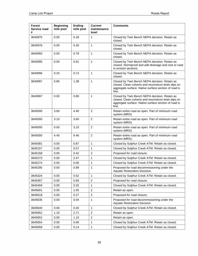
Camp Lick Project Roads Report
39
Forest Service road #
Beginning mile post
Ending mile post
Current maintenance level
Comments
3640975 0.00 0.18 1 Closed by Twin Bench NEPA decision. Retain as closed.
3640976 0.00 0.30 1 Closed by Twin Bench NEPA decision. Retain as closed.
3640993 0.00 0.79 1 Closed by Twin Bench NEPA decision. Retain as closed.
3640995 0.00 0.91 1 Closed by Twin Bench NEPA decision. Retain as closed. Stormproof and add drainage and rock to road in erosion sections.
3640996 0.20 0.72 1 Closed by Twin Bench NEPA decision. Retain as closed.
3640997 0.80 1.38 1 Closed by Twin Bench NEPA decision. Retain as closed. Clean culverts and reconstruct drain dips on aggregate surface. Native surface section of road is fine.
3640997 0.00 0.80 1 Closed by Twin Bench NEPA decision. Retain as closed. Clean culverts and reconstruct drain dips on aggregate surface. Native surface section of road is fine.
3645000 3.60 4.40 2 Retain entire road as open. Part of minimum road system (MRS).
3645000 3.10 3.60 2 Retain entire road as open. Part of minimum road system (MRS).
3645000 0.00 3.10 2 Retain entire road as open. Part of minimum road system (MRS).
3645000 4.40 9.46 2 Retain entire road as open. Part of minimum road system (MRS).
3645081 0.00 0.87 1 Closed by Sulphur Creek ATM. Retain as closed.
3645157 0.00 0.57 1 Closed by Sulphur Creek ATM. Retain as closed.
3645158 0.00 0.42 2 Proposed for road closure.
3645273 0.00 2.47 1 Closed by Sulphur Creek ATM. Retain as closed.
3645274 0.00 0.06 1 Closed by Sulphur Creek ATM. Retain as closed.
3645290 0.00 0.89 1 Proposed for road decommissioning under the Aquatic Restoration Decision.
3645324 0.00 0.52 1 Closed by Sulphur Creek ATM. Retain as closed.
3645457 0.00 0.69 2 Proposed for road closure.
3645459 0.00 0.25 1 Closed by Sulphur Creek ATM. Retain as closed.
3645601 0.00 1.05 2 Retain as open.
3645618 0.00 0.27 2 Proposed for road closure.
3645635 0.00 0.04 1 Proposed for road decommissioning under the Aquatic Restoration Decision.
3645640 0.00 0.40 1 Closed by Sulphur Creek ATM. Retain as closed.
3645652 1.10 2.71 2 Retain as open.
3645652 0.00 1.10 2 Retain as open.
3645654 0.00 0.66 1 Closed by Sulphur Creek ATM. Retain as closed.
3645659 0.00 0.14 1 Closed by Sulphur Creek ATM. Retain as closed.
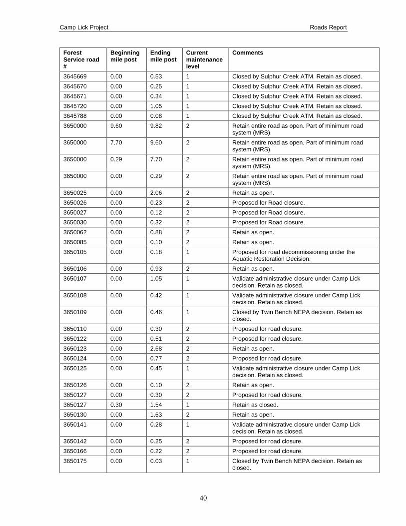
Camp Lick Project Roads Report
40
Forest Service road #
Beginning mile post
Ending mile post
Current maintenance level
Comments
3645669 0.00 0.53 1 Closed by Sulphur Creek ATM. Retain as closed.
3645670 0.00 0.25 1 Closed by Sulphur Creek ATM. Retain as closed.
3645671 0.00 0.34 1 Closed by Sulphur Creek ATM. Retain as closed.
3645720 0.00 1.05 1 Closed by Sulphur Creek ATM. Retain as closed.
3645788 0.00 0.08 1 Closed by Sulphur Creek ATM. Retain as closed.
3650000 9.60 9.82 2 Retain entire road as open. Part of minimum road system (MRS).
3650000 7.70 9.60 2 Retain entire road as open. Part of minimum road system (MRS).
3650000 0.29 7.70 2 Retain entire road as open. Part of minimum road system (MRS).
3650000 0.00 0.29 2 Retain entire road as open. Part of minimum road system (MRS).
3650025 0.00 2.06 2 Retain as open.
3650026 0.00 0.23 2 Proposed for Road closure.
3650027 0.00 0.12 2 Proposed for Road closure.
3650030 0.00 0.32 2 Proposed for Road closure.
3650062 0.00 0.88 2 Retain as open.
3650085 0.00 0.10 2 Retain as open.
3650105 0.00 0.18 1 Proposed for road decommissioning under the Aquatic Restoration Decision.
3650106 0.00 0.93 2 Retain as open.
3650107 0.00 1.05 1 Validate administrative closure under Camp Lick decision. Retain as closed.
3650108 0.00 0.42 1 Validate administrative closure under Camp Lick decision. Retain as closed.
3650109 0.00 0.46 1 Closed by Twin Bench NEPA decision. Retain as closed.
3650110 0.00 0.30 2 Proposed for road closure.
3650122 0.00 0.51 2 Proposed for road closure.
3650123 0.00 2.68 2 Retain as open.
3650124 0.00 0.77 2 Proposed for road closure.
3650125 0.00 0.45 1 Validate administrative closure under Camp Lick decision. Retain as closed.
3650126 0.00 0.10 2 Retain as open.
3650127 0.00 0.30 2 Proposed for road closure.
3650127 0.30 1.54 1 Retain as closed.
3650130 0.00 1.63 2 Retain as open.
3650141 0.00 0.28 1 Validate administrative closure under Camp Lick decision. Retain as closed.
3650142 0.00 0.25 2 Proposed for road closure.
3650166 0.00 0.22 2 Proposed for road closure.
3650175 0.00 0.03 1 Closed by Twin Bench NEPA decision. Retain as closed.
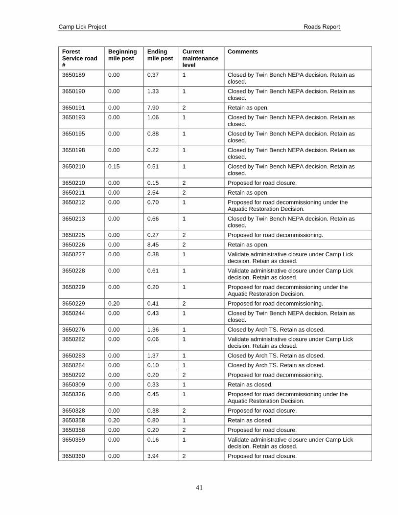
Camp Lick Project Roads Report
41
Forest Service road #
Beginning mile post
Ending mile post
Current maintenance level
Comments
3650189 0.00 0.37 1 Closed by Twin Bench NEPA decision. Retain as closed.
3650190 0.00 1.33 1 Closed by Twin Bench NEPA decision. Retain as closed.
3650191 0.00 7.90 2 Retain as open.
3650193 0.00 1.06 1 Closed by Twin Bench NEPA decision. Retain as closed.
3650195 0.00 0.88 1 Closed by Twin Bench NEPA decision. Retain as closed.
3650198 0.00 0.22 1 Closed by Twin Bench NEPA decision. Retain as closed.
3650210 0.15 0.51 1 Closed by Twin Bench NEPA decision. Retain as closed.
3650210 0.00 0.15 2 Proposed for road closure.
3650211 0.00 2.54 2 Retain as open.
3650212 0.00 0.70 1 Proposed for road decommissioning under the Aquatic Restoration Decision.
3650213 0.00 0.66 1 Closed by Twin Bench NEPA decision. Retain as closed.
3650225 0.00 0.27 2 Proposed for road decommissioning.
3650226 0.00 8.45 2 Retain as open.
3650227 0.00 0.38 1 Validate administrative closure under Camp Lick decision. Retain as closed.
3650228 0.00 0.61 1 Validate administrative closure under Camp Lick decision. Retain as closed.
3650229 0.00 0.20 1 Proposed for road decommissioning under the Aquatic Restoration Decision.
3650229 0.20 0.41 2 Proposed for road decommissioning.
3650244 0.00 0.43 1 Closed by Twin Bench NEPA decision. Retain as closed.
3650276 0.00 1.36 1 Closed by Arch TS. Retain as closed.
3650282 0.00 0.06 1 Validate administrative closure under Camp Lick decision. Retain as closed.
3650283 0.00 1.37 1 Closed by Arch TS. Retain as closed.
3650284 0.00 0.10 1 Closed by Arch TS. Retain as closed.
3650292 0.00 0.20 2 Proposed for road decommissioning.
3650309 0.00 0.33 1 Retain as closed.
3650326 0.00 0.45 1 Proposed for road decommissioning under the Aquatic Restoration Decision.
3650328 0.00 0.38 2 Proposed for road closure.
3650358 0.20 0.80 1 Retain as closed.
3650358 0.00 0.20 2 Proposed for road closure.
3650359 0.00 0.16 1 Validate administrative closure under Camp Lick decision. Retain as closed.
3650360 0.00 3.94 2 Proposed for road closure.
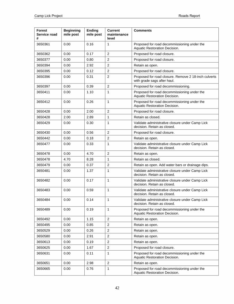
Camp Lick Project Roads Report
42
Forest Service road #
Beginning mile post
Ending mile post
Current maintenance level
Comments
3650361 0.00 0.16 1 Proposed for road decommissioning under the Aquatic Restoration Decision.
3650362 0.00 0.17 2 Proposed for road closure.
3650377 0.00 0.80 2 Proposed for road closure.
3650394 0.00 2.92 2 Retain as open.
3650395 0.00 0.12 2 Proposed for road closure.
3650396 0.00 0.31 2 Proposed for road closure. Remove 2 18-inch culverts with grade sags after haul.
3650397 0.00 0.39 2 Proposed for road decommissioning.
3650411 0.00 1.10 1 Proposed for road decommissioning under the Aquatic Restoration Decision.
3650412 0.00 0.26 1 Proposed for road decommissioning under the Aquatic Restoration Decision.
3650428 0.00 2.00 2 Proposed for road closure.
3650428 2.00 2.89 1 Retain as closed.
3650429 0.00 0.30 1 Validate administrative closure under Camp Lick decision. Retain as closed.
3650430 0.00 0.56 2 Proposed for road closure.
3650442 0.00 0.18 2 Retain as open.
3650477 0.00 0.33 1 Validate administrative closure under Camp Lick decision. Retain as closed.
3650478 0.00 4.70 2 Retain as open.
3650478 4.70 8.28 1 Retain as closed.
3650479 0.00 0.37 2 Retain as open. Add water bars or drainage dips.
3650481 0.00 1.37 1 Validate administrative closure under Camp Lick decision. Retain as closed.
3650482 0.00 0.17 1 Validate administrative closure under Camp Lick decision. Retain as closed.
3650483 0.00 0.59 1 Validate administrative closure under Camp Lick decision. Retain as closed.
3650484 0.00 0.14 1 Validate administrative closure under Camp Lick decision. Retain as closed.
3650489 0.00 0.19 1 Proposed for road decommissioning under the Aquatic Restoration Decision.
3650492 0.00 1.15 2 Retain as open.
3650495 0.00 0.85 2 Retain as open.
3650529 0.00 0.26 2 Retain as open.
3650580 0.00 2.91 2 Retain as open.
3650613 0.00 0.19 2 Retain as open.
3650625 0.00 1.67 2 Proposed for road closure.
3650631 0.00 0.11 1 Proposed for road decommissioning under the Aquatic Restoration Decision.
3650651 0.00 2.98 2 Retain as open.
3650665 0.00 0.76 1 Proposed for road decommissioning under the Aquatic Restoration Decision.
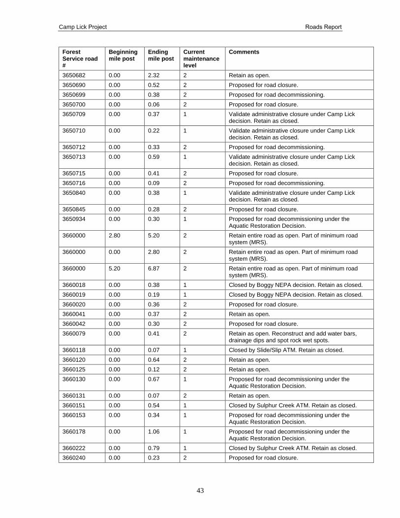
Camp Lick Project Roads Report
43
Forest Service road #
Beginning mile post
Ending mile post
Current maintenance level
Comments
3650682 0.00 2.32 2 Retain as open.
3650690 0.00 0.52 2 Proposed for road closure.
3650699 0.00 0.38 2 Proposed for road decommissioning.
3650700 0.00 0.06 2 Proposed for road closure.
3650709 0.00 0.37 1 Validate administrative closure under Camp Lick decision. Retain as closed.
3650710 0.00 0.22 1 Validate administrative closure under Camp Lick decision. Retain as closed.
3650712 0.00 0.33 2 Proposed for road decommissioning.
3650713 0.00 0.59 1 Validate administrative closure under Camp Lick decision. Retain as closed.
3650715 0.00 0.41 2 Proposed for road closure.
3650716 0.00 0.09 2 Proposed for road decommissioning.
3650840 0.00 0.38 1 Validate administrative closure under Camp Lick decision. Retain as closed.
3650845 0.00 0.28 2 Proposed for road closure.
3650934 0.00 0.30 1 Proposed for road decommissioning under the Aquatic Restoration Decision.
3660000 2.80 5.20 2 Retain entire road as open. Part of minimum road system (MRS).
3660000 0.00 2.80 2 Retain entire road as open. Part of minimum road system (MRS).
3660000 5.20 6.87 2 Retain entire road as open. Part of minimum road system (MRS).
3660018 0.00 0.38 1 Closed by Boggy NEPA decision. Retain as closed.
3660019 0.00 0.19 1 Closed by Boggy NEPA decision. Retain as closed.
3660020 0.00 0.36 2 Proposed for road closure.
3660041 0.00 0.37 2 Retain as open.
3660042 0.00 0.30 2 Proposed for road closure.
3660079 0.00 0.41 2 Retain as open. Reconstruct and add water bars, drainage dips and spot rock wet spots.
3660118 0.00 0.07 1 Closed by Slide/Slip ATM. Retain as closed.
3660120 0.00 0.64 2 Retain as open.
3660125 0.00 0.12 2 Retain as open.
3660130 0.00 0.67 1 Proposed for road decommissioning under the Aquatic Restoration Decision.
3660131 0.00 0.07 2 Retain as open.
3660151 0.00 0.54 1 Closed by Sulphur Creek ATM. Retain as closed.
3660153 0.00 0.34 1 Proposed for road decommissioning under the Aquatic Restoration Decision.
3660178 0.00 1.06 1 Proposed for road decommissioning under the Aquatic Restoration Decision.
3660222 0.00 0.79 1 Closed by Sulphur Creek ATM. Retain as closed.
3660240 0.00 0.23 2 Proposed for road closure.
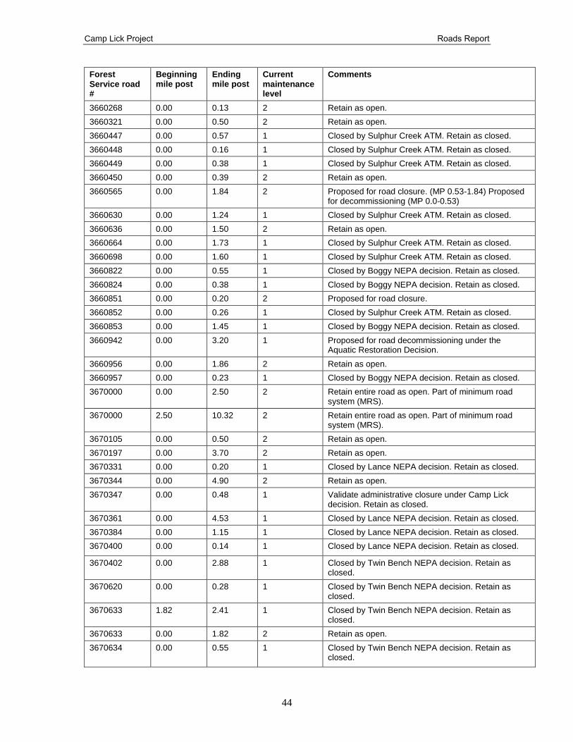
Camp Lick Project Roads Report
44
Forest Service road #
Beginning mile post
Ending mile post
Current maintenance level
Comments
3660268 0.00 0.13 2 Retain as open.
3660321 0.00 0.50 2 Retain as open.
3660447 0.00 0.57 1 Closed by Sulphur Creek ATM. Retain as closed.
3660448 0.00 0.16 1 Closed by Sulphur Creek ATM. Retain as closed.
3660449 0.00 0.38 1 Closed by Sulphur Creek ATM. Retain as closed.
3660450 0.00 0.39 2 Retain as open.
3660565 0.00 1.84 2 Proposed for road closure. (MP 0.53-1.84) Proposed for decommissioning (MP 0.0-0.53)
3660630 0.00 1.24 1 Closed by Sulphur Creek ATM. Retain as closed.
3660636 0.00 1.50 2 Retain as open.
3660664 0.00 1.73 1 Closed by Sulphur Creek ATM. Retain as closed.
3660698 0.00 1.60 1 Closed by Sulphur Creek ATM. Retain as closed.
3660822 0.00 0.55 1 Closed by Boggy NEPA decision. Retain as closed.
3660824 0.00 0.38 1 Closed by Boggy NEPA decision. Retain as closed.
3660851 0.00 0.20 2 Proposed for road closure.
3660852 0.00 0.26 1 Closed by Sulphur Creek ATM. Retain as closed.
3660853 0.00 1.45 1 Closed by Boggy NEPA decision. Retain as closed.
3660942 0.00 3.20 1 Proposed for road decommissioning under the Aquatic Restoration Decision.
3660956 0.00 1.86 2 Retain as open.
3660957 0.00 0.23 1 Closed by Boggy NEPA decision. Retain as closed.
3670000 0.00 2.50 2 Retain entire road as open. Part of minimum road system (MRS).
3670000 2.50 10.32 2 Retain entire road as open. Part of minimum road system (MRS).
3670105 0.00 0.50 2 Retain as open.
3670197 0.00 3.70 2 Retain as open.
3670331 0.00 0.20 1 Closed by Lance NEPA decision. Retain as closed.
3670344 0.00 4.90 2 Retain as open.
3670347 0.00 0.48 1 Validate administrative closure under Camp Lick decision. Retain as closed.
3670361 0.00 4.53 1 Closed by Lance NEPA decision. Retain as closed.
3670384 0.00 1.15 1 Closed by Lance NEPA decision. Retain as closed.
3670400 0.00 0.14 1 Closed by Lance NEPA decision. Retain as closed.
3670402 0.00 2.88 1 Closed by Twin Bench NEPA decision. Retain as closed.
3670620 0.00 0.28 1 Closed by Twin Bench NEPA decision. Retain as closed.
3670633 1.82 2.41 1 Closed by Twin Bench NEPA decision. Retain as closed.
3670633 0.00 1.82 2 Retain as open.
3670634 0.00 0.55 1 Closed by Twin Bench NEPA decision. Retain as closed.
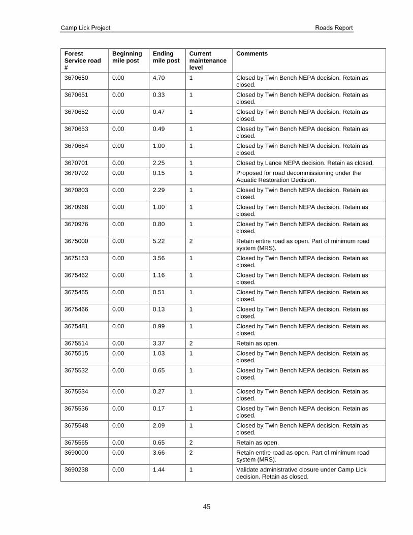
Camp Lick Project Roads Report
45
Forest Service road #
Beginning mile post
Ending mile post
Current maintenance level
Comments
3670650 0.00 4.70 1 Closed by Twin Bench NEPA decision. Retain as closed.
3670651 0.00 0.33 1 Closed by Twin Bench NEPA decision. Retain as closed.
3670652 0.00 0.47 1 Closed by Twin Bench NEPA decision. Retain as closed.
3670653 0.00 0.49 1 Closed by Twin Bench NEPA decision. Retain as closed.
3670684 0.00 1.00 1 Closed by Twin Bench NEPA decision. Retain as closed.
3670701 0.00 2.25 1 Closed by Lance NEPA decision. Retain as closed.
3670702 0.00 0.15 1 Proposed for road decommissioning under the Aquatic Restoration Decision.
3670803 0.00 2.29 1 Closed by Twin Bench NEPA decision. Retain as closed.
3670968 0.00 1.00 1 Closed by Twin Bench NEPA decision. Retain as closed.
3670976 0.00 0.80 1 Closed by Twin Bench NEPA decision. Retain as closed.
3675000 0.00 5.22 2 Retain entire road as open. Part of minimum road system (MRS).
3675163 0.00 3.56 1 Closed by Twin Bench NEPA decision. Retain as closed.
3675462 0.00 1.16 1 Closed by Twin Bench NEPA decision. Retain as closed.
3675465 0.00 0.51 1 Closed by Twin Bench NEPA decision. Retain as closed.
3675466 0.00 0.13 1 Closed by Twin Bench NEPA decision. Retain as closed.
3675481 0.00 0.99 1 Closed by Twin Bench NEPA decision. Retain as closed.
3675514 0.00 3.37 2 Retain as open.
3675515 0.00 1.03 1 Closed by Twin Bench NEPA decision. Retain as closed.
3675532 0.00 0.65 1 Closed by Twin Bench NEPA decision. Retain as closed.
3675534 0.00 0.27 1 Closed by Twin Bench NEPA decision. Retain as closed.
3675536 0.00 0.17 1 Closed by Twin Bench NEPA decision. Retain as closed.
3675548 0.00 2.09 1 Closed by Twin Bench NEPA decision. Retain as closed.
3675565 0.00 0.65 2 Retain as open.
3690000 0.00 3.66 2 Retain entire road as open. Part of minimum road system (MRS).
3690238 0.00 1.44 1 Validate administrative closure under Camp Lick decision. Retain as closed.

Camp Lick Project Roads Report
46
Forest Service road #
Beginning mile post
Ending mile post
Current maintenance level
Comments
3690995 0.00 0.66 1
3660450-Y 0.00 0.09 1 Validate administrative closure under Camp Lick decision. Retain as closed.
* Current Maintenance Level refers to the Roads Infrastructure Application (INFRA) database before the project started. Current maintenance level may not mean what is actually on the ground.