Embed Size (px)
Citation preview

Camp Lick Project
Range Report
Prepared by: Nick Stiner/Isaac Whitman
Rangeland Management Specialist
For:
Blue Mountain Ranger District
Malheur National Forest
June 12, 2017

In accordance with Federal civil rights law and U.S. Department of Agriculture (USDA) civil
rights regulations and policies, the USDA, its Agencies, offices, and employees, and institutions
participating in or administering USDA programs are prohibited from discriminating based on
race, color, national origin, religion, sex, gender identity (including gender expression), sexual
orientation, disability, age, marital status, family/parental status, income derived from a public
assistance program, political beliefs, or reprisal or retaliation for prior civil rights activity, in any
program or activity conducted or funded by USDA (not all bases apply to all programs).
Remedies and complaint filing deadlines vary by program or incident.
Persons with disabilities who require alternative means of communication for program
information (e.g., Braille, large print, audiotape, American Sign Language, etc.) should contact
the responsible Agency or USDA’s TARGET Center at (202) 720-2600 (voice and TTY) or contact
USDA through the Federal Relay Service at (800) 877-8339. Additionally, program information
may be made available in languages other than English.
To file a program discrimination complaint, complete the USDA Program Discrimination
Complaint Form, AD-3027, found online at http://www.ascr.usda.gov/complaint_filing_cust.html
and at any USDA office or write a letter addressed to USDA and provide in the letter all of the
information requested in the form. To request a copy of the complaint form, call (866) 632-9992.
Submit your completed form or letter to USDA by: (1) mail: U.S. Department of Agriculture,
Office of the Assistant Secretary for Civil Rights, 1400 Independence Avenue, SW, Washington,
D.C. 20250-9410; (2) fax: (202) 690-7442; or (3) email: [email protected].
USDA is an equal opportunity provider, employer, and lender..

Camp Lick Project Range Report
i
Table of Contents
Introduction ................................................................................................................................. 1 Regulatory Framework ............................................................................................................... 2 Resource Elements, Indicators and Measures ............................................................................. 2 Affected Environment ................................................................................................................. 2
Existing Condition ................................................................................................................... 2 Riparian Conditions within the Planning Area ................................................................... 4 Upland Conditions within the Planning Area ..................................................................... 4 Upland Water Developments ............................................................................................. 5
Desired Condition .................................................................................................................... 5 Environmental Consequences ..................................................................................................... 5
Methodology ........................................................................................................................... 5 Spatial and Temporal Context for Effect Analysis ............................................................. 6 Past, Present, and Reasonably Foreseeable Future Actions Relevant to Cumulative
Effects Analysis .................................................................................................................. 6 Design Criteria and Mitigation Measures ........................................................................... 6
Alternative 1 – No Action ....................................................................................................... 8 Direct and Indirect Effects ................................................................................................. 8 Cumulative Effects ............................................................................................................. 8
Alternative 2 – Proposed Action ............................................................................................. 9 Direct and Indirect Effects ................................................................................................. 9 Cumulative Effects ........................................................................................................... 12
Compliance with Forest Plan and Other Relevant Laws, Regulations, Policies and Plans ... 13 Other Relevant Mandatory Disclosures ................................................................................. 13
References ................................................................................................................................. 14
List of Tables
Table 1. Allotments in the Camp Lick planning area ...................................................................... 1 Table 2. Allotment livestock grazing numbers, animal unit months, and permitted dates of use ... 1 Table 3. Resource indicators and measures for assessing effects .................................................... 2 Table 4. Project design criteria to be applied during implementation ............................................. 6
List of Figures
Figure 1. Vegetation condition was “poor” in 1970 (left photo) compared to a “good-excellent”
vegetation condition in 2014 (right photo) (photos are representative of general trend
throughout the planning area) .................................................................................................. 4 Figure 2. Vegetation condition was “poor” in 1970 (left photo) compared to a “good-excellent”
vegetation condition in 2014 (right photo) (photos are representative of general trend
throughout planning area) ........................................................................................................ 5
Camp Lick Project Range Report
1
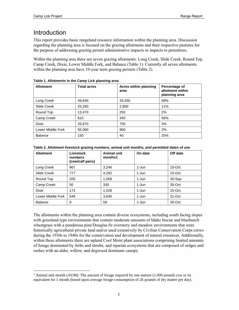
Introduction This report provides basic rangeland resource information within the planning area. Discussion
regarding the planning area is focused on the grazing allotments and their respective pastures for
the purpose of addressing grazing permit administrative impacts or impacts to permittees.
Within the planning area there are seven grazing allotments: Long Creek, Slide Creek, Round Top,
Camp Creek, Dixie, Lower Middle Fork, and Balance (Table 1). Currently all seven allotments
within the planning area have 10-year term grazing permits (Table 2).
Table 1. Allotments in the Camp Lick planning area
Allotment Total acres Acres within planning area
Percentage of allotment within planning area
Long Creek 49,640 33,450 68%
Slide Creek 25,260 2,850 11%
Round Top 13,470 250 2%
Camp Creek 610 340 56%
Dixie 26,870 750 3%
Lower Middle Fork 55,060 960 2%
Balance 150 40 25%
Table 2. Allotment livestock grazing numbers, animal unit months, and permitted dates of use
Allotment Livestock numbers (cow/calf pairs)
Animal unit months1
On date Off date
Long Creek 967 3,246 1-Jun 15-Oct
Slide Creek 777 4,282 1-Jun 15-Oct
Round Top 200 1,059 1-Jun 30-Sep
Camp Creek 50 330 1-Jun 30-Oct
Dixie 173 1,028 1-Jun 15-Oct
Lower Middle Fork 549 3,645 1-Jun 31-Oct
Balance 9 59 1-Jun 30-Oct
The allotments within the planning area contain diverse ecosystems, including south facing slopes
with grassland type environments that contain moderate amounts of Idaho fescue and bluebunch
wheatgrass with a ponderosa pine/Douglas-fir overstory and meadow environments that were
historically agricultural private land and/or used extensively by Civilian Conservation Corps crews
during the 1930s to 1940s for the conservation and development of natural resources. Additionally,
within these allotments there are upland Cool Moist plant associations comprising limited amounts
of forage dominated by forbs and shrubs, and riparian ecosystems that are composed of sedges and
rushes with an alder, willow, and dogwood dominant canopy.
1 Animal unit month (AUM): The amount of forage required by one mature (1,000 pound) cow or its
equivalent for 1 month (based upon average forage consumption of 26 pounds of dry matter per day).

Camp Lick Project Range Report
2
Regulatory Framework The authority to protect, manage, and administer National Forest System lands and other lands
under Forest Service administration for range management purposes is found in the following two
acts:
Multiple Use Sustained Yield Act (1960) established the policy and purpose of national
forests to provide for multiple uses and sustained yield of products and services.
Forest and Range Renewable Resources Planning Act (1974) established public land
policy and guidelines for management, protection, development, and enhancement of
public lands.
The Malheur Forest Plan, as amended, provides general direction, objectives, and goals for the
management of forest resources (USDA Forest Service 1990, page IV–2) including:
Provide a sustained production of palatable forage for grazing by livestock and dependent
wildlife species (Forest goal 20).
Manage rangelands to meet the needs of other resources and uses at a level that is
responsive to site-specific objectives (Forest goal 21).
Permit livestock use on suitable range when the permittee manages livestock using
prescribed practices (Forest goal 22).
The Malheur National Forest Post Fire Grazing Interim Guidelines (USDA Forest Service 2003) is
an interim guide providing direction that establishes minimum timeframes an area would be rested
from grazing following a wildfire or prescribed fire.
Resource Elements, Indicators and Measures The resource indicators detailed in Table 3, and described in the existing condition, are used for
assessing the effects to rangeland resources in the Camp Lick planning area.
Table 3. Resource indicators and measures for assessing effects
Indicator Resource Indicator Measure Justification
Upland water sources Availability of water developments to increase cattle distribution in the uplands
Number and maintenance level of water developments
USDA Forest Service 1990
Forage production Assess changes to forage production
Available forage USDA Forest Service 1990
Acres available for livestock grazing
Assess changes to acres available for livestock grazing
Available acres for livestock grazing
USDA Forest Service 1990
Affected Environment
Existing Condition
Livestock grazing within the planning area has been essential to meet European-American settlers’
needs since before the Forest Service was formed in 1905. In the early 1900s, individuals or
families living near Forest boundaries could obtain free use permits to graze up to 10 animals on
Forest Service land during a specified time of year. If they purchased a permit, they could graze
larger numbers of livestock, confined to a specific “allotment,” and if adhering to specific

Camp Lick Project Range Report
3
guidelines on where to place their salt blocks. In the early 1900s, the Forest Service limited the
number of livestock grazing on government land by instituting the current permit system. In
subsequent years it began fencing allotment boundaries and developing upland water sources to
keep permitted livestock in specified locations, and to keep non-permitted cattle off of government
land.
During the mid-1900s, priority was placed on rangeland restoration activities, including seeding,
erosion control, and the development of cross fencing. Cross-fencing was designed to control
where livestock were at certain times during the grazing season, which led to the development of
intensive grazing strategies. Intensive grazing strategies utilized on this forest include but are not
limited to: deferred rotation, rest rotation, rest-deferred rotation, and flash grazing. Each of these
are used on at a minimum of one of the allotments throughout the district. Throughout the early to
mid-1900s, permitted livestock numbers decreased. Permits temporarily increased during World
War I and World War II, but were reduced to pre-war numbers after World War II. Livestock
numbers have steadily decreased since World War II. During the late 1900s, active management
trends continued, with increased fencing and the development of deferred and rest rotations. “Best
available science” has been used to guide current and future allotment management decisions.
During the past 20 to 30 years, emphasis was placed on riparian habitat and stream health, largely
in response to the Endangered Species Act and the listing of key anadromous fish species. As a
result, management-intensive grazing strategies have been developed and are continually adapted
to maintain or improve riparian habitat. There has also been an increase in the amount of
monitoring conducted on riparian systems to foster a clearer understanding of grazing effects.
Habitat trends indicate that within managed sites significant positive trends were found in six of
the eight attributes. These attributes include: bank stability, D50 (median particle size), decrease in
percent fine sediment, increase in residual pool depth, increase in large woody debris frequency,
and increase in large woody debris volume. Although no significant change in the overhanging
banks was observed in the managed sites, no significant change in overhanging banks were
observed in the reference sites either. A significant decrease in percent of reaches as pools were
observed in both reference and managed sites throughout the survey (Archer et al. 2009). Although
there are still areas of concern, riparian habitat continues to improve with the continued presence
of livestock.
Forage availability within most of the planning area has decreased due to fire suppression and lack
of recent timber harvest. The result is an increase in canopy structure, which reduces the amount of
sunlight reaching the forest floor and thus the amount of available forage.
Prior to European-American settlement of the area, fire played a dominant role in shaping the
landscape. Forest Service fire suppression policies have altered the ecosystem. Many historically
open ponderosa pine stands have been encroached upon by other species and provide less in the
way of forage for grazing animals. Conifers have encroached upon areas that were once open
meadows and dry rangeland. Densely-populated stands are reduced in vigor because of
overcrowding, or have already succumbed to insects and disease. In areas with high tree mortality,
fallen trees restrict movement of wild ungulates and livestock, thereby further limiting the amount
of forage available.
Native grass and forb species are still predominant in many areas of the dry forest type; however,
in some areas, non-native species were introduced to stabilize soils along roads, skid trails, and
landing sites (i.e., intermediate wheatgrass, orchard grass, Timothy grass, yellow sweet clover,

Camp Lick Project Range Report
4
black medic, bird’s foot trefoil, and Kentucky bluegrass). Some of these same disturbed locations
now host populations of non-native invasive plant species.
Riparian Conditions within the Planning Area
Within the Camp Lick planning area, the Forest Service interdisciplinary team annually collects
riparian monitoring data on the amount of utilization by permitted livestock. At regular intervals,
the PACFISH/INFISH Biological Opinion (PIBO) Effectiveness Monitoring Program collects
stream condition data relating to livestock use levels. This data indicates that livestock use of
riparian areas has been within allowable levels for several years. As a result, the riparian areas
have been able to recover from their historically poor condition.
Upland Conditions within the Planning Area
In 1970, condition and trend monitoring of plant communities within the planning area was
completed. The results of this monitoring indicated that the condition of the vegetative community
was “poor.”
Throughout the planning area, upland utilization monitoring is collected annually using the
landscape appearance method. One plot is collected in each pasture of each allotment. As directed
by the current biological opinion, upland standards for these allotments are set at 45 percent
utilization threshold using the landscape appearance. Throughout the past 4 years, the Forest
Service has been successful in meeting the upland use standard.
Figure 1. Vegetation condition was “poor” in 1970 (left photo) compared to a “good-excellent” vegetation condition in 2014 (right photo) (photos are representative of general trend throughout the planning area)

Camp Lick Project Range Report
5
Figure 2. Vegetation condition was “poor” in 1970 (left photo) compared to a “good-excellent” vegetation condition in 2014 (right photo) (photos are representative of general trend throughout planning area)
Upland Water Developments
Throughout each allotment, a number of structural improvements are maintained by the
permittees. These improvements include allotment boundary and pasture fences, small enclosure
fences, watering troughs, and ponds. Fences on the allotments are maintained annually and troughs
and ponds are maintained on an as needed basis, typically once every 5 years.
There are currently 63 upland water developments within the planning area with varying levels of
functional life remaining, including: 31 ponds, 28 water troughs, and 4 trough/pond combinations.
Desired Condition
The lands within the planning area are managed to achieve desired conditions as described in the
Malheur Forest Plan and to maintain a healthy, diverse, resilient ecosystem. The Forest Plan
desired conditions include providing a sustained production of palatable forage for grazing by
livestock and dependent wildlife species, managing rangelands to meet the needs of other
resources and uses at a level that is responsible to site-specific objections, and permitting livestock
use on suitable range when the permittee manages livestock using prescribed practices (USDA
Forest Service 1990, page IV–2). The desired conditions include quality land management under
the sustainable multiple-use management concept to meet the diverse needs of people. Desired
conditions directly related to resource indicators include the development and maintenance of
upland water sources for use by wildlife and livestock. Vegetation management that yields
vigorous, diverse, sustainable ecosystems. Through the vegetation management practices our
resource indicator regarding acres available for grazing will be met.
Environmental Consequences
Methodology
Effects analysis in this report is focused on the grazing allotments and their respective pastures for
the purpose of addressing grazing permit administrative impacts or impacts to permittees.
Camp Lick Project Range Report
6
Annual range vegetation monitoring has been conducted on the grazing allotments located within
the planning area using the landscape appearance method. Range administration is conducted
yearly by both the Forest Service range program and the permittees to meet terms and conditions
of the grazing permit.
Other sources of information include:
Grazing permits
Malheur National Forest geographic information system (GIS) database
Malheur Forest Plan
On-the-ground knowledge of the planning area
Conversations and field visits with permittees
Spatial and Temporal Context for Effect Analysis
The spatial context for this analysis is the planning area which lies within and across, the
boundaries of seven grazing allotments within the Blue Mountain Ranger District of the Malheur
National Forest. Spatially, per allotment, the effects of the proposed action would exist at a scale of
the landscape that is 68 percent of the Long Creek allotment, 11 percent of the Slide Creek
allotment, 2 percent of the Lower Middle Fork allotment, 56 of the Camp Creek allotment, 3
percent of the Dixie allotment, 2 percent of the Roundtop allotment, 25 percent of the Balance
allotment. The allotments within the project planning area are spatially static and the effects from
the proposed actions are expected to occur solely within the boundaries.
The temporal context used for this analysis spans from immediately following the action to 2 years
(short-term effects) and from 2-10 years after the project is implemented (long-term effects).
Project disturbance is expected to span 2 years while the effects from the project will be analyzed
for the following 10 years. It is expected that the effects of the project would be greatest during
implementation. During the period following the project implementation it is expected that the
effects from the proposed action will increase over time in comparison to the areas not proposed
for treatment. These effects would be long-term and generally from the indirect effects, such as
changes in sunlight, hydrologic regimes, and changes in animal grazing patterns.
Past, Present, and Reasonably Foreseeable Future Actions Relevant to Cumulative Effects Analysis
Past actions in or near the planning area include, but are not limited to, timber management,
mining, wildland fuels management, fire suppression, grazing, recreation, firewood cutting, road
and facilities construction and maintenance, aquatic restoration, fencing, development of upland
water sources, and improving elk and mule deer habitat and forage. All actions listed in the Camp
Lick FEA Appendix E – Past, Ongoing, and Reasonably Foreseeable Activities were considered
for cumulative effects.
Design Criteria and Mitigation Measures
Table 4. Project design criteria to be applied during implementation
Criteria number
Objective Design criteria Areas, units, or activity type
Responsible Person
Range-1 Minimize impacts to allotment management
All existing structural range improvements (fences, gates, spring developments, etc.) and permanent ecological plots will be contractually
Silviculture treatments and prescribed burning
Timber sale administrator, burn boss

Camp Lick Project Range Report
7
Criteria number
Objective Design criteria Areas, units, or activity type
Responsible Person
protected. If these structural improvements are damaged during project operations they will be repaired to Forest Service standards prior to livestock scheduled use by the party responsible for causing the damage.
Range-2 Minimize impacts to allotment management
Fence right of ways (6 feet either side of fence), trails, other developments, and access to them will be cleared of slash produced by logging or post-sale activities.
Harvest activities
Timber sale administrator
Range-3 Minimize impacts to allotment management
Actions that result in roads being closed for any period of time, even if detours are present, need to be coordinated with the Blue Mountain Ranger District (BMRD) range program to ensure adequate passage for the purpose of livestock management and activities associated with FS-2200-10: term grazing permit.
Roads accessing rangeland management areas
Timber sale administrator, transportation planner
Range-4 Minimize impacts to allotment management
Construction of fencing for the purpose of protection of a resource will be coordinated with the BMRD range program and will not result in loss of grazing land in such a manner that the contractual obligations between the Forest Service and a term grazing permit holder require modification or are no longer achievable.
Fence construction
Resource specialist responsible for installing the fencing
Range-5 Minimize impacts to allotment management
All structural improvements will be constructed in accordance with guidance from General Technical Report PNW-GTR-250 (Sanderson et al.1990) and the expertise of a Rangeland Management Specialist.
Rangeland structural improvements
Resource specialist installing the structural improvements
Range-6 Minimize impacts to allotment management
Range, fire specialist, and permittees should coordinate activities, including the scheduling of burning activities in grazing units for prescribed fire.
Prescribed burning
Rangeland specialist, burn boss
Range-7 Minimize impacts to allotment management
Use the Malheur National Forest Post-Fire Interim Grazing Guidelines to aid in determining resumption of grazing after prescribed burning is complete.
Prescribed burning
Rangeland specialist
Range-8 Minimize impacts to allotment management
Whenever possible, burn units within pastures would be burned in the spring of the year the pasture is rested, or in the fall prior to the rest year.
Prescribed burning
Rangeland specialist, burn boss
Range-9 Minimize impacts to allotment management
The permittee has the option to exclude cattle grazing from portions of a pasture that were burned (through the use of fencing) and could continue to graze unburned areas of a pasture.
Prescribed burning
Rangeland specialist, burn boss

Camp Lick Project Range Report
8
Alternative 1 – No Action
Direct and Indirect Effects
With the no action alternative, current grazing practices would continue on all allotments within
the planning area. The no action alternative would have no overall direct or indirect impacts to
permittee operations.
Environmental consequences resulting from no action would include decreased forage availability
due to increased resource competition and overstory shading caused by ongoing conifer
encroachment. Decreases in forage availability would likely affect livestock distribution within the
allotments. It is also expected that increases in tree density over time would decrease the available
water in springs, thus increasing the difficulty of managing livestock.
Under this alternative, the existing forage base would decline in vigor, abundance, and diversity as
canopy cover continues to close. Tight canopies reduce available sunlight on the forest floor,
increase the duff layer, and reduce soil moisture and nutrients. Carrying capacity would decline as
grasses, forbs, and shrubs are crowded out by shade-tolerant species with less forage value to
livestock and wild ungulates, resulting in a reduction of available forage. If more suitable
rangeland is not created by future management projects or natural disturbance, the number of
livestock permitted to graze on this planning area may decrease in the future to avoid unacceptable
levels of damage to ecosystems by livestock.
With the no action alternative, no ground disturbance would occur, so grasses and grass-likes2 are
not as likely to be infested by non-native invasive plants. Aspen stands would continue to decline,
as increased competition from conifers outcompete them for nutrients, water, and sunlight.
Declining resource conditions and increased canopy cover would also favor larger, high-intensity
wildfires in the long-term. With more intense fire regimes, less palatable or non-native invasive
plant species would likely increase. Invasive plants readily establish in high-intensity burns and
prevent re-establishment of native forage.
Under the no action alternative, the existing spring developments and fence lines would require
slightly more maintenance. Fence maintenance costs would increase as snag densities increase and
fall into the fence right-of-way, thus needing to be removed. Increased tree density would decrease
access to spring developments by the permittee in order to keep them in proper functioning
condition.
With the no action alternative, no changes would be made in road densities that would impact
permittee operations or access to improvements.
Cumulative Effects
The past, present, and reasonably foreseeable future actions in the planning area include (but are
not limited to): use and maintenance of Forest roads, fire suppression, livestock grazing,
fence/water trough maintenance, firewood cutting, aquatic restoration activities, and year-round
recreational use.
2 Grasses are from the family Poaceae. Grass-likes are the variety of plants with long, narrow leaves that
sheath the stem, (like a grass). Some are hollow or have compartments with air spaces. They resemble
grasses or sedges, but do not have a perigynium (female part of the flower) like sedges, or flowers arranged
in spikelets as in true grasses.

Camp Lick Project Range Report
9
Permittees within the planning area utilize the road systems daily throughout the grazing season to
assist with management of their grazing allotments. As conifer encroachment continues, traversing
the landscape on horseback would continue to become more difficult and dangerous.
Fire suppression since the early 1900s has increased canopy density within the planning area,
consequently changing the forage composition and decreasing the acres available for grazing by
wildlife and cattle. This has decreased the overall productivity of the allotment in terms of
palatable herbaceous plant products. In addition, as tree density increases, springs and seeps would
have decreased flow as additional water is utilized to support the increased number of trees. Also,
maintenance of fencing and water troughs would increase in difficulty due to increased instances
of falling trees causing damage to livestock management structures.
Public firewood cutting would not have a measureable effect on the management of the grazing
allotments within the planning area because it would not negatively impact forage production.
Aquatic restoration in the short-term (1 to 2 years post-treatment) would have a negative effect on
the available forage for grazing. In the long-term it would limit cattle access to sensitive stream
banks and potentially increase the amount of time cattle can graze in a pasture without affecting
sensitive stream banks. Thus, long-term the aquatic restoration process would have a benefit to
grazing within the planning area.
Recreational use within the planning area creates challenges for livestock management as gates are
often left open throughout the grazing season, increasing the complexity of livestock management
actions.
Alternative 2 – Proposed Action
Direct and Indirect Effects
Silviculture Treatments
Silviculture treatments would positively affect range conditions by reducing conifer density in
stands, reducing ground fuel loads that restrict livestock movement, and decreasing overstory
cover, which would increase available forage and ease of access to water developments. Restoring
meadow systems is one of the facets of the silviculture treatments that would have a benefit to the
rangeland. The silviculture treatments would decrease the impacts of cattle grazing on riparian
zones by providing cattle more suitable upland rangeland to use.
Riparian and Upland Watershed Restoration Treatments
The amount of aspen enclosures and the area which would be excluded from livestock use due to
the enclosures is not expected to have a measurable effect on utilization rates throughout the rest
of the planning area.
The ecological riparian treatments and placement of woody debris within the riparian area in an
effort to collect sediment, reconnect the floodplain, increase hardwoods, and increase overall
ecological processes provided by the riparian systems are likely to decrease the amount of
available forage for livestock within the planning area in the short-term (1 to 2 years post-
treatment). Furthermore, riparian restoration treatments that decrease the amount of available acres
for livestock grazing would also have a detrimental effect to range management. These detrimental
effects are expected to be short-term and balanced by thinning activities within the planning area.
Thus, there is expected to be a positive effect from riparian restoration by decreasing livestock
Camp Lick Project Range Report
10
access to stream channels, and increasing the amount of time livestock could potentially stay in a
pasture without negatively impacting riparian systems. Although the potential for isolated impacts
is increased, aquatic restoration actions are expected to be beneficial overall to the riparian system
as well as the rangeland.
Prescribed Burning and Unplanned Ignitions
Prescribed burning that consumes light herbaceous material would have a positive effect on range
management. By burning decadent fuels, more plant material comes into contact with the soil
surface, which increases the rate of decay of the material. This increase in decay allows the
incorporation of organic matter into the soil which increases the nutrients available to the plant, as
well as increasing the water-holding capacity of the soil. All of these factors combine to increase
forage production of a site. Short-term impacts from prescribed burning may occur; however, the
effects are not expected to decrease the ability of permittees to effectively manage their allotments.
Fire was once an integral function of the majority of ecosystems in northeast Oregon and the
vegetation of the Blue Mountains is highly adapted to periodic fire in forest, shrubland, and
grassland ecosystems. Following implementation of the proposed actions, the predominant
vegetation would recover quickly after prescribed burning, and rest periods from grazing are not
anticipated in most pastures, therefore impacts to permittee operations are not anticipated.
Prescribed burning is proposed in areas predominately composed of elk sedge and pine grass.
These fire-tolerant herbaceous species are less desirable forage by livestock, thus the impacts of
prescribed burning are unlikely to affect the necessary forage base to manage these allotments for
livestock use.
Coordination with a district range specialist and permittees is required prior to prescribed burning
activities (see Camp Lick FEA Appendix C – Project Design Criteria). Grazing management
adjustments would be developed in coordination with the allotment permittee and incorporated
into the annual grazing strategies. After prescribed burning is initiated, grazing management
practices would be implemented to achieve desired use levels. These practices may include
deferment or electric fencing, adjustment of livestock placement in pastures, and use of salt blocks
or other management practices that would promote livestock use of pastures away from treatment
areas. The proposed actions are consistent with the Malheur National Forest Post-Fire Interim
Grazing Guidelines (USDA Forest Service 2003) which states that vegetation types such as elk
sedge and pine grass require little recovery time after a low intensity burn.
Generally, spring burns have the fewest undesirable effects to forage species, perhaps due to
higher soil moistures. However, bluebunch wheatgrass has a higher mortality if burned in the
spring, compared with fall burning. In the elk sedge/pinegrass communities, low to moderate
severity fire may result in rapid rhizome extension and greater palatability to livestock and wild
ungulates.
Burning impacts on plant species in this planning area would vary in response due to a variety of
conditions such as weather, season of burning, plant morphology, current plant condition and
vigor, accumulated litter, soil moisture, and fire intensity. Fire intensity likely has the most
influence on individual plants and forage production. The wide variation in burning intensity
across treatment units (unburned to light to moderate) would create wide variability in results and
recovery. Low-intensity fires would have low plant mortality and stimulate plant vigor. Plants with
increased vigor produce more leaf matter and set more seed, resulting in an increase in forage
production. Increased plant mortality is expected with heavier fuel loading. In these areas, re-
seeding with native plant seed mixes would be necessary.

Camp Lick Project Range Report
11
Low-intensity burning is expected where fuel loads are mostly herbaceous, and where there is little
woody material (less than 1 ton per acre), such as in open grassland with only light shrub cover.
When prescriptions call for broadcast burning of scattered fuels, the burning impacts would be
widespread over the unit, with severe burning intensity creating cover voids, but with surviving
plants interspersed throughout the unit. Bunched slash and piles burned at landings often kill
understory species in the immediate vicinity and re-seeding could be necessary.
Long-term impacts of prescribed burning are anticipated to be positive in terms of moving
treatment units towards historical conditions, improving watershed conditions, and increasing the
production of rangeland resources. Recovery of vigor and production in the herbaceous species is
quickest for pine grass and elk sedge. For low-intensity fires, dry site bluebunch wheatgrass and
Idaho fescue would be stimulated by the removal of decadent plant material and the flush of
nutrients from burning. However, long-term maintenance of historical conditions may require
follow-up treatments to ensure shrub cover does not reach pre-treatment levels or dominate the
understory in the future. Historically, these sites did not have a heavy shrub component, since fire-
return intervals thinned the shrub cover intermittently.
Prescribed burning has an indirect effect of promoting better livestock distribution due to
improved quality and distribution of forage. Indirect effects related to management of grazing
permits include loss of control of livestock if gates are left open or fences are rendered ineffective
due to fire activity. The loss of control of livestock due to these indirect effects increases the
complexity of the management strategies and could result in decreased management effectiveness.
Unplanned ignitions throughout the planning area would be managed with the involvement of the
range program as well as permittees.
Road Activities
During project implementation, the increase in road use associated with implementation of project
activities may detrimentally affect cattle distribution. The extent of this effect is unpredictable and
is based on several fluctuating factors, such as the timing of the road activities in correlation with
livestock management practices. Effects include, but are not limited to, potential fence damage or
removal during implementation, potential gates left open, increased traffic hindering the cattle
from traveling back and forth across roads. Detrimental impacts are expected to only last until the
project is complete.
Access too much of the planning area by permittees with livestock grazing permits is by
horseback. As such, decreasing road densities is unlikely to negatively affect livestock
management.
Permittees with term grazing permits are allowed limited off-road use in order to administer their
grazing permits pursuant to Title 36 Code of Federal Regulations 261.5. In addition, any existing
closed road that is needed for access for the administration of grazing permits within Malheur
National Forest lands are available for use even if closed for use by the general public. As such,
the decrease of open roads as proposed by the proposed action would likely not affect livestock
management activities, including access to and management of water developments, amount of
forage availability, and acreage available for livestock grazing. Road decommissioning and
relocation are expected to increase forage in the road bed but may decrease access by the
permittees for other management practices.

Camp Lick Project Range Report
12
Interpretive Sign Installation
No direct or indirect effects are expected to occur to the range resource as a result of interpretive
sign installation because it would not impact forage production or cattle distribution.
Range Fence Construction
Construction of the two proposed fences would improve allotment management in the affected
areas. Fences that are constructed and maintained on Forest land use the guidance of technical
reference PNW-GTR-250 Specifications for Structural Range Improvements as well as the
expertise of technical specialist to ensure that they have limited effects to the resources and the
wildlife that use it.
Cumulative Effects
The proposed action would move the planning area towards a healthier, resilient, diverse, and
sustainable ecosystem. The proposed action would increase the amount of available forage for
livestock as well as increase the amount of open area accessible by livestock. This increase in
forage, space, and functioning upland water developments would lead to an overall increase in the
distribution of livestock and decrease the concentrations of use by livestock and wildlife.
Combining more available forage with the current trend of increased conditions of vegetation in
the planning area may increase the options for forest land management to continue toward
increased multiple use, as described in the Forest Service’s mission.
Fire Suppression
Fire suppression increases canopy cover and thus decreases available forage on the forest floor,
creating a negative effect on range management. Alternatively, uncontrolled wildland fire would
have short-term negative effects to range management since the intensity can often decrease
microbial activity in the soil, harm the root structures of desired native plants, and offer increased
chances of non-native invasive plant infestations due to the increase of bare soil.
Grazing
Grazing has a beneficial effect to rangeland plant species. Grass has evolved with grazing and is
physiologically designed to respond positively to the effects of properly-managed grazing.
Adaptive management allows permittees to graze after seed production has been completed as a
way to increase the abundance of the species, since grazing helps incorporate seeds into the soil
through micro sites that are created by livestock hoofs. Grass can be grazed prior to seed
emergence and, through the natural process of nutrient cycling, can be fertilized prior to seed
production—the time in a plants maturity which take the most nutrients to complete.
Firewood Cutting
Firewood cutting is a common activity that has a negative impact on range management. Fences
are often cut, broken, or destroyed by people accessing trees. This allows livestock to access areas
that have already been grazed, are at a higher risk for impact, or are being protected for another
resource.
Aquatic Restoration
Potential upland water developments implemented under the Aquatic Restoration Decision would
increase the total number of upland water sources, which would positively affect cattle distribution
Camp Lick Project Range Report
13
and decrease the concentration of livestock in the riparian areas. Approximately 21 new water
developments throughout the planning area may be developed.
Compliance with Forest Plan and Other Relevant Laws, Regulations, Policies and Plans
Alternative 2 is consistent with the following Malheur Forest Plan Forest-wide standards:
Forest-wide standard 82: Manage residues to facilitate the use of forage by domestic
livestock (USDA Forest Service 1990, page IV-34). Alternative 2 would decrease canopy
cover and increase the number of acres available for grazing.
Forest-wide standard 85: Design improvements to protect tree regeneration and/or to
distribute livestock use (USDA Forest Service 1990, page IV-35). The proposed range
fence construction would help distribute livestock use.
Forest-wide standard 88: Design and implement structural and nonstructural range
improvements to maintain productivity and range condition in addition to benefiting both
wildlife and livestock. Locate range structural and nonstructural improvements to
encourage livestock movement away from riparian areas (USDA Forest Service 1990,
page IV-35). Alternative 2 would decrease the canopy cover, improving the forage base
and increasing the acres available for grazing. The proposed range fence construction
would encourage livestock movement away from riparian areas.
Range permittees were contacted during collaboration and the scoping period to solicit and
incorporate comments on project activities.
Other Relevant Mandatory Disclosures
There are no irreversible and irretrievable commitments of resources that may result from the
proposed action or other action alternatives with respect to rangeland management.

Camp Lick Project Range Report
14
References Archer, E, R. Al-Chokhachy, J. Heitke, P. Ebertowski, R. Leary, T. Romano, and B.B. Roper.
2009. PACFISH INFISH Biological Opinion Effectiveness Monitoring Program For
Streams and Riparian Areas, USDA Forest Service 2009 Annual Summary Report.
Available online:
https://www.fs.fed.us/biology/resources/pubs/feu/pibo/2009_pibo_em_annual_report_fina
l.pdf
Sanderson, H.R., T.M. Quigley, E.E. Swan, and L.R. Spink. 1990. Specifications for structural
range improvements. General Technical Report PNW-GTR-250. U.S. Department of
Agriculture, Forest Service, Pacific Northwest Research Station, Portland, Oregon.
Available online: http://www.fs.fed.us/pnw/publications/pnw_gtr250/
USDA Forest Service. 1990. Malheur National Forest Land and Resource Management Plan.
USDA Forest Service, Malheur National Forest, John Day, Oregon. Available online at:
http://www.fs.usda.gov/main/malheur/landmanagement/planning
USDA Forest Service. 2003. Post Fire Interim Grazing Guidelines, Malheur National Forest.
Unpublished Report. USDA Forest Service, Malheur National Forest, John Day, Oregon.
USDA Forest Service. 2014. Decision Notice for Aquatic Restoration Project. USDA Forest
Service, Malheur National Forest, John Day, Oregon. Available online at:
http://www.fs.usda.gov/Internet/FSE_DOCUMENTS/stelprd3820599.pdf