Embed Size (px)
Citation preview
CAMEROON
Under 500m , . . . . 500-1,ooom . . . . . . Over 1,ooom . . . . .
1. Physical environment and com m un i cati dn s
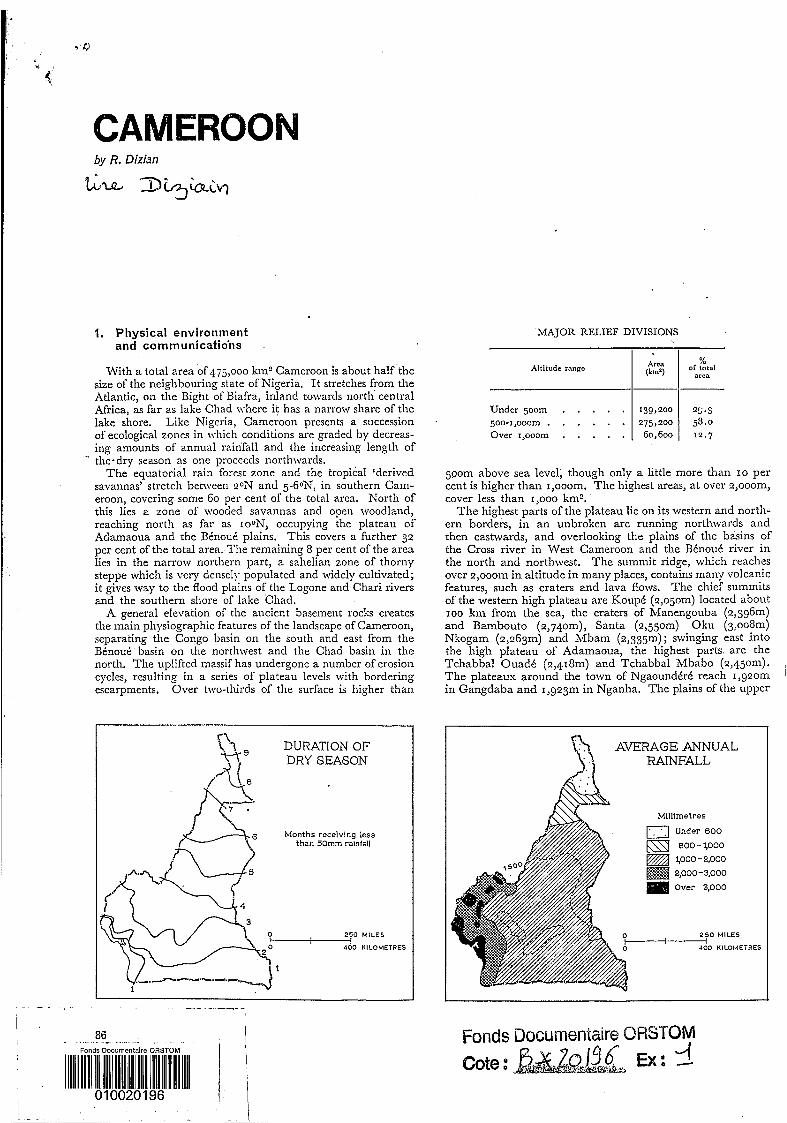
With a total area of 475,000 km2 Cameroon is about half the size of the neighbouring state of Nigeria. I t stretches from the Atlantic, on the Bight of Biafra, inland towards north central Africa, as far as lake Chad where it has a narrow share of the lake shore. Like Nigeria, Cameroon presents a succession of ecological zones in which conditions are graded by decreas- ing amounts of annual rainfall and the increasing length of
The equatorial rain forest zone and the tropical ‘derived savannas’ stretch between 20N and 5-60N, in southern Cam- eroon, covering some 60 per cent of the total area, North of this lies a zone of wooded savannas and open woodland, reaching north as far as IOON, occupying the plateau of Adamaoua and the Bénoué plains. This covers a further 32 per cent of the total area. The remaining 8 per cent of the area lies in the narrow northern part, a sahelian zone of thorny steppe which is very densely populated and widely cultivated; it gives way to the flood plains of the Logone and Chari rivers and the southern shore of lake Chad. A general elevation of the ancient basement rocks creates
the main physiographic features of the landscape of Cameroon, separating the Congo basin on the south and east from the Bénoué basin on the northwest and the Chad basin in the north. The uplifted massif has undergone a number of erosion cycles, resulting in a series of plateau levels with bordering escarpments. Over two-thirds of the surface is higher than
’. the-dry season as one proceeds northwards.
139,200 25.3 275,200 58.0 60,600 12.7
DURATION OF r\ ( 3 fl9 DRY SEASON
86 - - I l
hIAJOR RELIEF DIVISIONS
% Altitude range
area
500m above sea level, though only a little more than I O per cent is higher than 1,ooom. The highest areas, at over 2,ooom, cover less than 1,000 kmz.
Tlie highest parts of the plateau lie on its western and north- ern borders, in an unbroken arc running northwards and then eastwards, and overlooking the plains of the basins of the Cross river in West Cameroon and the Bénoué river in the north and northwest. The summit ridge, which reaches over 2,ooom in altitude in many places, contains many volcanic features, such as craters and lava flows. The chief summits of the western high plateau are Koupé (2,050m) located about IOO km from the sea, the craters of Manengouba (2,396111) and Bambouto (2,74om), Santa (2,550m) Oku (3,0081n) Nkogam (2,263m) and Mbam (2,335m); swinging east into the high plateau of Adamaoua, the highest parts are the Tchabbal Ouadi (2,418m) and Tchabbal Mbabo (2,450111). The plateaux around the town of Ngaoundéré reach 1,920m in Gangdaba and 1,923m in Nganha. The plains of the upper
I
I\ AVERAGE ANNUAL i; 1 RAINFALL
A\\ Mlllimetres
Under 800
O KILOMETRES
Fonds Documentaire ORSTOM 4 Cote f, Ex: --
CAMEROON
Under 1,ooomm . . . . . . . I,OOO-I, 400” . . . . . . . . 1,400-2,ooomm . . . . . . . : Over 2,000mm . . . . . . . .
Bénoué, below tlie bordering scarp in this area, are less than 500m in altitude.
This mountain arc constitutes. a physical barrier between western and central Africa. I t is reinforced by a further line of isolated steep-sided massifs, partly of volcanic origin, lying to the west. Tlie still-active Cameroon hiountain, close to tlie sea, reaches 4,070”; north of it Nont Rounipi reaches r,765m, and further north on the Xigerian border lie the Alan- tika mountains (1,885111) and Mandara mountains (1,442m).
The coastal lowland areas lie in the hot and humid south- west and south, around Cameroon hlountain, in the hlbam plain and in the valley of the middle Sanaga river. X coastal lowland estends south from Douala to the border with Equa- torial Guinea, The interior lowlands of tlie drier Bénoué basin are continuous, occupying about half of the total area below 500m. The remaining lowland area is that of tlie Cross river valley in the southwest.
The chief hydrographic division is that liet\vcen tlie drainage to north and west of tlie high plateau and that to the south and east. Of the latter the main river basins are those of the Sanaga and Xyong rivers both of which enter the Bight of Biafra south of Douala. A number of shorter rivers drain tlie southern plateaus directly to the sen, but the southeastern region is drained southeastwards to\vards the Congo river. The rivers of the southern plateaux are mostly incised Idow the plateau levels and their courses are frequently interrupted by gorges, waterfalls and rapids; Ixtween these, there are reaches which are often wide and marshy. Such streams are obstacles to, rather than links of communications and in general the settlements have favoured the interfluves, with their better drainage and lines of communication along tlic ridges. I n the Guinea savanna lands, however, shifting cul- tivators favour the soils of tlie cleared gallery forests rather than the impoverished soils of the interfluve areas.
Two major river systems rise and flow from the northern Adamaoua plateau, the Bénoué, which turns wcst to traverse eastern Nigeria to join the Niger; and the western Logone, which crosses into tlie Chad republic before turning north to follow the border lietween Cameroon and Chad and tlicn joining the Chari. The latter is therefore part of an intcrior drainage basin. Fed by the rains of the longer wet season of the high plateau, these rivers bring to the dry northern plains an annual flood, which has encouraged fairly dense settlement. Crops can be grown as tlie floods subside, water meadows can be used for stock grazing, and fishing resources are replen- ished. Tlie banks of the Logone carry many villages, some- times strung along tlie river course, sometimes nucleated on narrow levées and ridges as in tlie hlousgo!im and Kotoko areas.
I n the coastal lowlands tlie largcr rivers are navigable and form the major axes of communication, even in the thickly forested parts. The land bordering the lower Sanaga is less sparsely populated than the neighbouring plains. On the JYouri river, upstream from Douala to Yabassi, the settlement is concentrated on the levées, sharing with tlie crop lands the limited area that is above flood level.
Pre-Cambrian rocks cover 80 per cent of tlie total surface of Cameroon, chiefly granites, crystalline schists and dolerites. The chief areas of sedimentary rocks are the coastal lowlands, around Douala and northwest of Cameroon Mountain, where Tertiary marine sediments and a substantial thickness of fluviatile sandstones overlie Cretaceous rocks. Cretaceous deposits also occur in tlie valleys of the Cross river, near Mamfé, and of the Bénoué, around Garoua. The most wide- spread areas of Recent sedimentaries occur in the Chad basin, covering some 25,000 km2: these are chiefly Quaternary sands and superficial alluvium.
Young volcanic rocks and faulting are associated with the upwarping of the Cameroon dome, building the peaks and craters of the northwestern edge of the high plateau. A band of older basalts stretches along the Adamaoua plateau for
I O
20
50 ao
some 250 km, through Ngaoundéré and along the upper Djerem valley.
The two major soil types are more closely related to clilliatic conditions than to tlie underlying parent materials. The northern edge of the Adamaoua plateau forms a limit betiveen them. To the south in tlie more humid area, ferrallitic soils, largely kaolinite, cover roughly one-third of tlie area of Cam- eroon. These are generally well drained, of adequate depth for agricultural purposes and, only in high plateaus, with a good organic content. They tend to be shallower on the eastern forest-savanna mosaic and on the Adamaoua plateau, frequently with widespread lateritic crusts.
North of the Adamaoua plateau, fersiallitic (tropical fer- ruginous) soils are developed on the flat surfaces \vherE. lower rainfall and more intense evaporation prevent the total renioval of mineral bases and silica. Kaolinite is agnin dominant Ilut montmorillonite clays are formed under conditions of impeded drainage, producing gray soils that do not crack or shrink during the dry season.
In the sahelian zone of the north, the underlying parent material is more important, and soils are varied. Permeable and sandy soils predominate. They niay reach u p to too cm in thickness on the pediments around the Xlanclnra plnt- eau, but no more than 40-50 cm on the niossif itsclf. Lithosols are typical of the mountain slopes, requiring extreme care under terrace cultivation, in order to retain an adequate organic content. O n the plain such soils, while lacking cohesion and with little clay content, are very suitable for growing millet and cotton. They occur alongside pockets of very compact, uncultivated soils locally named /iuru’i, and they .are mainly associated with vertisols. The latter, with a high \vater- retention capacity, are particularly valuable in this dry zone, for tlie cultivation of late millets. These soils, locally named karul, with calcareous nodules at depth but little organic content near the surface, occur north of gON, as far as lake Chad. On tlie alluvial lowlands around the lakc, hydro- morphic soils are typical.
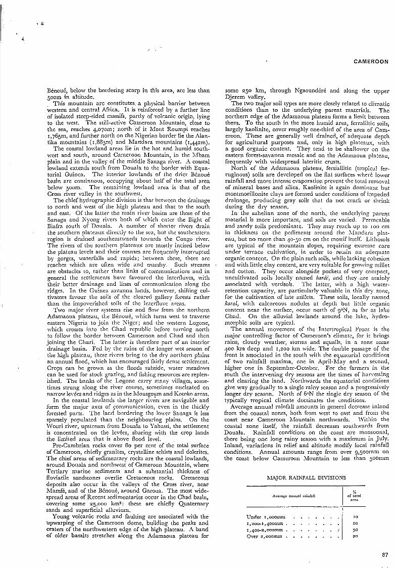
The annual movement of tlie Intertropical Front is tlie major controlling factor of Cameroon’s climate, for it brings rains, cloudy weather, storms and squalls, in a zone some 400 km deep and 1,200 kin wide. The double passage of the front is associated in the south with the equatorial conditions of two rainfall maxima, one in April-hiay and a second, higher one in September-October. For the farmers in the south the intervening dry seasons are the times of harvesting and clearing tlie land. Northwards the equatorial conditions give way gradually to a single rainy season and a progressively longer dry season. North of 6oN tlie single dry season of the typically tropical climate dominates the conditions.
Average annual rainfall amounts in general decrease inland from the coastal zones, both from west to east and froin the coast near Cameroon Mountain northwards. Within the coastal zone itself, the rainfall decreases southwards from Douala. Rainfall conditions on the coast are monsoonal, there being one long rainy season with a maximum in July. Inland, variations in relief and altitude modify local rainfall conditions, Annual amounts range from over g1500mm on the coast below Cameroon Mountain to less than joomm
MAJOR RAINFALL DIVISIONS
Average annual railifall %
of total
87
CAM E R O 0 N
around lake Chad - a reflection of the wide latitudinal ex- tent of the country.
On the high Bamenda plateau, 300 km inland, annual rainfalls over 2,000" are received. Beyond the edge of the plateau, however, in a distance of less than 50 km, it may be I,ooomm less. The 2,000" isohyet corresponds roughly with the 500m contour, from the Bamileke plateau south- wards to the border of Equatorial Guinea.
Station and zone
Northern coastal zone Ndian . . . . . . . Bota . . . . . . . Debundscba . . . . . Victoria. . . . . . . Douala . . , . . . . Kribi . . . . . . . Campo. . . . I . . Mamfi . . . . . . . Kumba . . . . . . Yabassi . . . . . . . Edéa # . . . . . . Lododorf . . . . . Bamenda . . . . . . Nkambd . . . . . Ndu . . . . . . . Jakiri . . . , . . . Banso . . . . . . . Ngaoundéré . . . . . Yaoundé . . . . . . Bertoua . . . . . .
Southern coastal zone
Coastal hinterland
Western high plateau
Adamaoua plateau
Southern moist forest zone
- Period o1 obrcma-
tions (years)
7 7
25
'9
18
36
21
33 30 50 32 24
6 E 7 9
24
31
26 24
Average annual rainfall b m )
Beyond the northern edge of the Adamaoua plateau, rainfall amounts drop steadily from 1,300" to 1,ooomm on the Bénoué river and thence into the dry sub-humid sahelian region with monthly rainfalls of ioomm or more only from June to September and for a n even shorter period around lake Chad.
Average annual temperatures in the southern part of the country are around 24-27"c, with a low annual range of only I-20C. They are modified on the high plateaux to 21- 230C but are higher on the northern plains, which lie in the hot thermal zone of 26-280C. Relative humidity is very high along the coast, the average annual humidity at Douala being 83 per cent. I n the southern moist forest zone it is around 70 per cent but in the sahelian north it is below 40 per cent. Evaporation amounts show a converse range, the average annual evaporation a t Douala being 593" and that at Maroua in the north 3,694".
Windspeeds are generally low, particularly in the equatorial zones, but the harmattan is dominant in the north during the dry season. Line squalls, with violent winds reaching 3om/sec, are liable to develop at the turn of the seasons and prior to crop sowing.
The natural vegetation zones grade from north to south, from dense rain forest through narrower zones of tropical forest-savanna mosaic (Guinea savanna), moist woodland- savanna, dry woodland-savanna, to the thorn steppe of the extreme north. Mangroves border the coast around Douala
and on the west coast. Cameroon Nountain and adjacent highlands carry vertically zoned tropical montane vegetation.
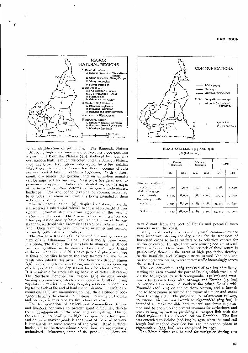
Five major regions can be determined on the basis mainly of physiographic differences, essentially of altitude. \Vithin these major regions, there are subdivisions in terms of diffe- rences of vegetation an*d climate. In order to be able to apply the available statistics, the subregions have been limited by administrative boundaries which largely correspond \vit11 various physical or natural divisions.
The Coastal Lowlands ( I ) are less than 200 kni \vide on thc plains to the north and east of Cameroon >Iountain and barely 100 km wide on the southern littoral. Thc slopes and steep scarps that mark the inner limit of the loivlands become progressively higher from south to north, rising froni about 2001-11 to over ~,ooom. The basins of the Cross river and the Nkam are dominated, therefore, by vcry high cscarp- ments. The lowlands and the bordering slopes are esposed to rain-bearing winds off the Gulf of Guinea and rcccive the heaviest rainfalls of the whole country - over 2,000111m a year, with niasimum falls of over 5,000" along the shores at the foot of Cameroon Mountain. \\'irli constant high teni- peratures and heavy rainfall, very dense evergreen forest covers those areas, esccpt for some places, as on the fertile volcanic soils along the Mungo river valley, which have been cleared and appear as savannas. The region is generally below 500m in altitude but it includes within it Cameroon hfountain and the moderately high plateau around Mount Roumpi. It may be subdivided into the Central Coastal region (IA), including the lower basins of the \Vouri, Nkam and Sanaga rivers and the city of Douala; the Soutliern Coastal region (IB), in the Nyong-Campo areas; the Northern Coastal region (IC), which includes the Xlungo basin and the Ndian river-Roumpi area; and the Cross River Basin ( ID) around Mamfé.
The Central region (2) is an area of moderate altitudes generally between 500m and goom, occupying the southern plateaux as far as the bórders with the Central African and Congo Brazzaville republics. Annual rainfall is I ,500- I ,6oomm, but i t is not distributed uniformly through the year over the whole region. Subdivisions are related largely to differences in natural vegetation. The most souther,ly zone (IA) with dense equatorial forest may be divided into the South-Central Atlantic western region (2Aw) and the Southeastern Congolese eastern region (2Xe), which have an equatorial climate with four alternating seasons, the dry winter season being short, no more than 2 months. TO the north of these, lies a zone (2B) of transitional semi-deciduous fqrest, much of which has been cleared: here thc dry winter season is a little longer, from December to January. It is divided into a western region, the Kyong-Sanaga region (2Bw) largely given over to cacao cultivation, and the hfaka- Kaka eastern region (2Be), where both robusta coffee and cacao are grown. The Mbam plains (2C) are actually a little lower than 6oom and lie in a rain shadow area, receivirig 1,400-1,50omm a year, Only remnants of the natural forest remain on the hills, sheltering the cacao trees. The soils of the grasslands are often very badly drained but they are sandy and suitable for growing yams. The remaining region, the Guinea Savannas (2D) are the most northerly zone of the southern plateaux. This area is one of f6ïest-savanna mosaic, with gallery forests along the river courses. The dry season lasts for 3-4 months, and the poverty of the soils in this sparsely inhabited area is worsened by fires started by game hunters.
The Western High Plateaux (3) comprise a large area at over 1,ooom altitude, surrounded by extensive lower plateaus at 700m or more. Flows of recent basalts and volcanic ash lead to a higher soil fertility than on the basement rocks, I n the tropical high-altitude climate, temperatures are mode- rate and a single long rainy season favours intensive food crop cultivation. Local differences in rainfall conditions lead
I
88
CAMEROON
MAJOR NATURAL REGIONS 1 CoastalLowland
A Central subregion: Wouri-N)tan
B South subregion: Nyong-campo C Mungo subregion D M a d e subregion
2 Central Region AW,Ae Equatorlal forest Bw,Be Transltlonal forest C Mbamplalns D Gm'nea savanna lands
3 Western High Plateaux A Bamenda highlands B Bamileke subregion C Bamoun and Tlkar subregion
4 Adamaoua High Plateau
Sanaga
O 2 5 0 M I L E S
'?- 0-30 KILOMETRES
to an identification of subregions. The Bamenda Plateau (3A), being higher and more exposed, receives 2,000-3,0001111n a year. The Bamileke Plateau (SB), sheltered by mountains over 2,ooom high, is much dissected, and the Bamoun Plateau (3C) has broad level plains interrupted by a few isolated hills; these two regions receive less than 2,000nin1 of rain per year and it falls in places to 1,500". IVith a three- month dry season, the grazing land on tsetse-free summits can be improved by burning. Vast areas 'are given over to permanent cropping. B L I S ~ C S are planted around the edges of the fields or in valley bottoms in this grassland-dominated landscape. Tea and coflee (arabica or robusta, according to altitude) plantations are gradually being extended in thcse well-populated regions.
The Adamaoua Plateau (4), despite its distance from the sea, receives a substantial rainfall because of its height of over 1,ooom. Rainfall declines from 1,700" in the west to 1,400min in the east. The absence of tsetse infestation and a low population density have resulted in the use of the vast savannas, scattered with fire-resistant trees or shrubs as grazing land. Crop farming, based on maize or millet and manioc, is usually confined to the valleys.
The Northern Region (5) lies beyond the northern escarp- ment of the Adamaoua Plateau, and is mostly below 5oom in altitude. The level of the plains falls to 180111 on the Bénoué river and to 280m on the shores of lake Chad. The largest of the occasional isolated hills have provided places of refuge at times of hostility between the crop farmers ana the pasto- ralists who inhabit this area. T h e Southern Bénoué region (5A) has open dry forest vegetation, and receives over 1,ooomm of rain per year. The dry season lasts for about 6 months. I t is unsuitable for stock raising because of tsetse infestation. The Northern Bénoué-Chad region (5B) includes widely varying environments, which are reflected in locally differing population densities. The very long dry season is the dominat- ing factor both of life and of land use in this area. The Mandara mountains (5C) are anomalous, in that their altitude of 600- 1,ooom benefits the climatic conditions. Farming on the hills and plateaux is restricted by limitations of space.
The transportation of agricultural commodities, timber and livestock continues to present great difficulties, despite recent developments of the road and rail systems. One of the chief factors leading to high transport costs for export and domestic market goods is that most of the road network is impassable a t some seasons of the year. Road surfaces, inadequate for the fierce climatic conditions, are not regularly maintained. Moreover, some of the producing regions are
ROAD SYSTEMS, 1964 rViD 1968 (lengths in km)
COMMUNICATIONS
- Malorroads - Railways _ _ _ _ Ra~lways(proposed)
'I. Navigable waterways
services) o Airports (scheduled
O 250 M I L E S
O 400 KILOMETRES
Enstrrn \\'cricm Camcroon Cameroon
Bitumen surfaced roads . . .
Main all-season earth roads .
Secondary earth roads . . .
Total . . .
920 1,230
4,115 6,000
7*435 8,770 ~- 12,470 16,000
340 340
962 1,100
1,965 2,060 AZ very distant from the port of Douala and markets near the coast.
Total
15,737 I 199500.
potential town
Many local tracks, maintained by local communities are very important during the dry season for the transport of harvested crops to local markets or to collection centres for cotton or cacao. I n 1964 there were some 17,000 km of such tracks in eastern Cameroon. The network of these routes is particularly dense in the areas of high population density, in the Bamileke and Mungo districts, around Yaoundé and on the northern plains, where motor traffic increasingly serves the settled areas.
The rail network in 1965 consisted of 532 km of railway, serving the area around the port of Douala, which was linked via the Mungo valley with Nkongsamba (172 km) and west- wards by branch lines with Mbanga and Kumba (15 km) in western Cameroon. A southern line joined Douala with Yaoundé (308 km) on the southern plateau, and a branch line to Mbalmayo permitted the export of timber and cacao from that district. The projected Trans-Cameroon railway, to extend this line northwards to Ngaoundéré (629 km) is intended to make possible both mineral and forest exploita- tion and to open up the central savannas for agriculture and stock raising, as well as providing a transport link with the Chad region and the Central African Republic. The line was extended to Belabo (296 km) by 1970, when the total rail length had reached over 800 km and the second phase to Ngaoundéré (333 km) was completed by 1974.
The Bénoué river can be used for navigation during two
89
CAMEROON
months in the wet season, alloiving the river port of Garoua to be used for the export of cotton via Nigeria in August and September. River transport is also used on the Wouri river, to supply foodstuffs to Douala from the riverside village farms.
Air transport is used for exporting livestock carcasses from the pastoral zones via, Ngaoundéré, despatching them to Yaoundé, Douala or to Libreville in Gabon, as well as fresh vegetables from the market-gardening areas of Ngaoundéré and Foumban to similar destinations.
2. Population
Among the states of equatorial Africa Cameroon had the second highest population (after Zaire) in 1965, when it was estimated to number sonie 5,150,ooo persons. This showed a growth in the preceding 30 years of some 60 per cent in East Cameroon and 130 per cent in IVest Cameroon.
The composition of the population is estremely diverse, for the country is located across the northern limit of the Bantu peoples, in a zone where several ethnic groups are intermised. Bantu peoples are predominant in the southern forest regions, where there are also small groups of pygmies in remote areas. Further north, groups classified as semi-Bantu include the Bamileke people of the western plateaus. North of these again the ethnic composition is even more comples, comprising Sudanese negroes, Hamitic Fulani or Foulbé and various Arab groups. In the south and west, where the effect of Euro- pean colonization has been greatest, Christianity lias some degree of influence, but in the north the pasioral and sedentary farmers are either Moslem or pagan, maintaining their tradi- tional customs more persistently.
A more recent social and cultural contrast in Cameroon derives from its colonial history during and since the 19th century. West Cameroon, occupying less than one-tenth of
+ 1 I\ 7 t I, DEPARTEMENTS
o 460 KILOMETRES
POPULATION m. DENSITY
Average number of persons per km2
MILES
K ! L O M E T R E S
the total area and carrying over one-fifth of the total popula- tion, was formerly under British administration. East Ca- meroon was formerly under French administration. Since the achievement of independence and the subsequent union of the two provinces in a Federal Republic in 1961, it has become a task of the government to overcome the disparities between the two provinces that originated in the contrasted policies of the European powers.
The annual growth rate in recent years has been estimated as 1.9 per cent, though there are wide regional variations: among the Bamileke for instance it is 2.3 to 2.4 per cent and in East Cameroon it ranges between 1.2 and 1.7 per cent. This reflects variations in the crude birth rate which averages 43 per thousand for the whole country. On the high plateaus of the west it reaches 50 per thousand but in parts of the South- Central region and on the Adamaoua plateau it is as low as 36 per thousand. These variations in turn are partly related to differences among ethnic groups in the rate of sterility.
The crude death rate of 24 per thousand is esaggcrated by the high infant mortality rate, particularly among ethnid groups which have a high birth rate, as in the overpopulatec northern mountain districts. Life expectancy in 1964 was. 37 years in rural areas, but as high as 50 years in urban centres.
Natural increase adds some IOO,OOO persons to the popula- tion each year, of whom 80 per cent are added to rural popula- tions and 20 per cent to the towns.
The age structure of the population shows a high ratio in the younger age groups, over 40 per cent being under 15 years of age in the early 1960s. In this demographic aspect again there are regional differences : the ratio of young people in the Bamileke country and on the high Bamenda plateau reached 48-49 per cent, as it did also in among certain other vigorous ethnic groups. The carrying of such a heavy youthful sector of the population has made necessary ari extension of the food producing areas and an increase of the domestic consumption. As these younger groups reach the age of joining the effectively active population, their numbers are likely to be reduced by migration from rural areas and also by the extension of education.
The data concerning the age and ses structure are derived from various demographic surveys: North Bénoué 1960; South Bénoué and Adamaoua, 1961; South coast, south- central and eastern districts, 1962; West Cameroon, 1964; West Mungo and Mungo Nkam, 1965; and census returns for Douala (1964) and Yaoundé (1965). They reveal also an excess of females to males.
90
CAMEROON
Males
'Persons 1 % Ase group
Females Total
Pcnons 1 % Persons I % _------ Under I O yrs. . 10-19 yrs. . . 20-29 y rs . . . 30-39 yrs . . . 40-49 yrs . . . 60 yrs and over . 50-59 y". . .
32.5 18.6 14.1 '3.3 9.9 6.6 5.0
100.0 Total . . I
793.6 424.4 479.7 375;s . 259.7 153.3 108.9
-~ 2,595.4
792.7 454.3 344.0 325.2 241. I
159.6 120.8
30.6 16.4 18.5 14.5 10.0
5.8 4.2
100.0 I-
1,586.3 878.7 823.7 701.0
500.8 312.9 229.7 --
5,033.1 12,437 * 7
42,372 46,594 6,029
465.073
107.0 940.0 350.0
59055.4
2.1
18.6 6.9 --
100.0
31.5 17.5 16.4 '3.9 9.9 6.2
4.6 - 100.0
2
20
54
II
The average population density is I I persons per km2, which is rather higher than that of neighbouring states in central Africa but much lower than that of Nigeria on the west. Large parts of Cameroon have densities lower than the national average and the most populous districts are grouped into three areas. A densely peopled zone runs inland from the coast at Cameroon Mountain and Douala for some 350 km towards the northeast, corresponding with the western high plateaux and mountains and the volcanic areas. Such a distribution shows the attraction of the highlands in an equatorial climate and also as places of refuge in times of hostility or local competition for land. T h e volcanic soils
in particular attract the crop farmers in a cotintry where the soil resources are otherwise mediocre. In the most favoured areas densities exceed 150 inhabitants per km2, as in the districts of Dschang, Bansoa, Bafoussam and Bamendjou in the Baniileke country. The average density for this subregion in 1964 was I O I per km2. A second area of higher densities lies on the southwestern
plateaux, in a curved zone between Bafia and Ebolowa and ,
centred on Yaoundé, the capital, In the more densely popu- lated districts, with 60-100 persons per km2, there is an acute shortage of the land available for the extension of cacao plantations or sometimes even for the necessary food crops. The establishment of dense populations in this area started during the 19th century with migrations from the northeast. The existence of an already established settlement zone on the coastal lands prevented further migration westwards, which was in any case prohibited by the European administra- tion. As a result, constrained within the limits allowed them, the occupants of these lands cleared in the southern forests have increased to high local densities.
The remaining areas of the south and east interior lands arc very sparsely populated and, northwards, even the Adamaoua plateau averages less than 3 persons per kms. There is thus a vast stretch of the country from south to north, with densities below the national average separating the populous south- west from the third zone of higher densities in the extreme north. The three départements of Diamaré, Margui Wandala, and Mayo Danay and the arrondissement of Guider together contain some g50,ooo persons, roughly 20 per cent of the total population with an average density of 41 per kmf. This zone largely lies between the lower Logone river and the Mandara
POPULATION DISTRIBUTION BY REGIONS, 1964
Region and subregion
Coastal Lowlands Central: IVouri-Nkam-Sanaga Southern: Nyong-Campo . . Northern: eastern Mungo .
western Mungo . Ndian-Roumpi .
Cross river basin . . . . Douala city . . . . . . .
Central Region \
South-Central Atlantic. . . Southeastern Congolese . . Nyong-Sanaga . . . . . hlaka-Kaka . . . . . . Mbam plains . . . . . Guinea savannas . . . . Bamenda plateau . . . . Bamileke plateau . . . . Bamoun plateau . . . . Adamaoua plateau. . . . Southern Bénoué . . . . Northern Bénoué-Chad . . Mandara mountains . . .
Western High Plateaux
Northern Region
. . . . . . . . . . . . .
. . . . . . . . . . . . .
. . . . . . . . . . . . .
. . . . . . . . . . . . .
. . . . . . . . . . . . .
. . . . . . . . . . . . .
. . . . . . . . . . . . . . . . . . . . . . . . . . . . . . . . . . . . . . . . . . . . . . . . . . . . . . . . . . . . . . . . . . . . . . . . . . . . . . . . . . . . . . . . . . . . . . . . . . . . . . . . . . . . . . . . . . . . . . . . . . . . . . . . . . . . . . . . . . . . . . . . . . . . . . . . . . . . . . . . . . . . . . . . . . . . . . . . . . . . . . . . . . . . . . . . . . . . . . . . . . . . . . . . . .
Cameroon . . . . . . . . . . . . . . . . . . . i Source: Institut de Géographie du Cameroun.
I Total population I
I I--- 163.1 '33.7 210.9 183.8 77.8
122.3 196.0
IO
a 55 22
12
11
169
4.2 6
10.0 17 2.7 5
1.1 I
1.9 13 1.1 I
11.4 32
2.8 '3 3.5 3
12.2 I01
Agricul turd population
135.0 120.4 127.0
169.8 72.3
114.6 15.0
154.2 54.0
418. I
90.0 53.0
527.0 536.5 113.0 130.2
107.0 893.0 334.0
41292.1
83 90 60 93 92 93 7
99 94 95
85
91
CAMEROON
Traditional sector . . . . . , Modern sector (plantations) . .
Total . . . . . . . . . I ,~
83.0 80.6 (12. j
2.5 4.2 2.8
85.5 84.8 85.3
mountains, with a diversity of environment that is matched by the diversity of the ethnic groups living there, with regard to their origins, languages, social organization and mental attitudes. Types of settlement and agriculture contrast greatly between the plateaux, the rocky slopes of the Mandara moun- tains, the isolated hills, the alluvial ridges close to the temporary streams or to the Logone river, the sandy plains and the sand dunes, the clay basins and the flood depressions. Nowadays, the pressure of population and of economic development is tending to wel¿ the many small specialized local &zys into a regional whole.
Administrative census surveys distinguish rural and urban populations only on the criterion of the place of residence. However, within the urban centres there reside a small number of farmers or market gardeners who produce foodstuffs for the urban population on all or part of their lands which lie on the edge of the towns. Also, wage labourers on the com- mercial plantations frequently live in the towns, which therefore include a certain percentage of persons engaged in agriculture. In the five large towns in southern West Cameroon, 13 per cent of the actively engaged adults of both sexes are engaged in traditional farming and 7 per cent are wage labourers in the modern farming sector. I n the northern regions of East Cameroon, the urban centre is an ancient social foundation, centred on the palace of a Fulani lamido or chief. Such towns have persisted up to modern times, though their urban func- tions have changed. The agricultural survey of 1962 showed that Garoua had 8,800 persons and Maroua 16,800 persons engaged in agriculture, some 40 per cent of their urban popula- tions. At Ngaoundéré the ratio was 30 per cent.
The western high plateaus have no urban tradition, except for the centre of Foumban, though there has been a very rapid growth of towns there since 1955, through immigrant set- tlement. Lack of employment in other sectors forces most of the active adult settlers to borrow or rent plots of land for cultivation in the neighbourhood of their towns.
The urbanization of town populations is therefore only partial. Only in the two major cities, Yaoundé and Douala, is there a small proportion (less than I O per cent) of cultivators among the city populations.
EMPLOYAIENT IN AGRICULTURAL SECTOR I N SELECTED TO\VNS OF MUNGO, BAMILEKE
AND BAhIOUN SUBREGIONS, 1965
Agricullural workers
yo of total adult I y!, of actively cm- population ployed population
Town and region
Foumban, Bamoun . . . . . . Bafoussam, Bamileke . . . . . . hlbouda, Bamileke . . . . . . Dschang, Bamileke . . . . . . Bafang, Bamileke . . . . . . . Pllongsamba, Mungo . . . . . Loum, Mungo . . . . . . . Mbanga, Mungo . . . . . . . .
49.2 43.5 61.8 46.2 46.2
62.2 38.5
59.6
72.3 72.2 81.6 70.6 70.6 66.7 80.9 77,6
Source: Capot-Rey, P., Mahdavi, G. and Audebert, D., Farming structures of western East Cameroon, Yaoundé, 1969.
The rural population in fact corresponds roughly with the agricultural population, for by far the large majority of the people live outside urban centres. For the country as a whole, this proportion is 80 per cent; in the littoral Province based on Douala, with large city populations and several towns,
92
it is as low as 46 per cent and in the Centre-South Province that comprises the southern coastal zone and adjacent plateaus it is 76 per cent. Elsewhere in the country the rural population, according to censuses of 1963-66, is well over 80 per cent of the total.
Of the total labour force in 1964-65 over 80 per cent, \cere actively engaged in the primary sector.
EMPLOYAIENT IN PRIAIARY SECTOR, 1964-Gj (percentage of total actively engaged population) .
I I I
Little is known of migrations to and from neighbouring states, for lack of statistics. As the states on the south and east are generally underpopulated, there is little movement from them into Cameroon. On the west, however, eastern Nigeria is a populous country and in 1964 the population of West Cameroon included 49,000 Ibos and 52,000 other Nige- rians, 9.8 per cent of the provincial population. Thcy were located mainly in the southern départements of Victoria, Ndian and Kumba, chiefly in districts concerned with sea or river traffic with Nigeria and on plantations in areas of low population density adjacent to the Nigerian border.
By 1965 the annual population growth rate of the three chief cities, Douala, Yaoundé and Victoria, was 8 per cent, largely owing to immigration from the countryside. Rural esodus may occur in densely peopled areas where the cultivable land is insufficient to support more inhabitants; this situation ap- plies to the Bamileke territory, the Bamenda and other western high plateaux and to the Mandara mountains. Some migra- tions from less densely populated zones result from the in- hibiting effects on young people of traditional socio-economic structures, as happens in the Yaoundé region. In the southern Bénoué area, the Adamaoua plateau and the southern littoral forest zone, the low level of the marketing and exchange facilities tends to encourage depopulation.
Not all of the migration is in the direction of the toicns. The European administrations established the attraction of the very fertile volcanic soils close to the western seaboard towards the close of the century, when from 1890 onwards cultivators from the Bainenda savannas Tvere encouraged to move to the foot slopes of Cameroon hlountain. Later, a similar trend drew Bamileke people and workers from the Yaoundé area to the Mungo area, between h4banga and Nkongsamba. ’The migrants gradually developed the character of spontaneous colonizers, outnumbering the original settlers of these areas. They ultimately secured individual rights to the land they developed, replacing the original communal ownership. Between the 1930s and the 1960s the populations of such areas as Victoria, Kumba, Ndian, Mungo, Nkam and Mamfé were doubled or trebled. I n hiungo, the original settlers represented only 30 per cent of the population by 1964.
I n the humid forest areas, migrations are restricted by the existence of ethnic or tribal boundaries, for established communities guard against encroachment by. neighbouring groups or individual incomers. Permission to clear the land
The drift from rural areas has grown since the 1950s.
CAMEROON
North: coffee zone . . . Centre: banana zone . . South: oil palm zone . .
implies the granting of land rights as soon as plantation trees are planted, a condition confirmed by an East Cameroon law of 1933, notably in connection with cacao plantations.
The Bamileke territory is the chief source of migrants, largely towards the fertile Mungo lands but also to the low Nkondjok plateau in the south and also to the Bamoun plateau, at- tracted by the volcanic ash soils around Foumbot.
Rural migrations in northern Cameroon have a more fluid character and cause less provocation to the original inhabitants. Amongst the shifts of population there, the descent of hill farmers from their limited terraces on the Mandara mountains since 1955 is noteworthy; they have been attracted to start growing cash crops on the Mora plain, north of the already populous Diamaré region. I n these northern regions, the expansion of the cultivated areas, through local migrations, is already encroaching on the sparsely populated areas formerly devoted to livestock grazing.
169 5 28 67 gg 16 24 58 19 42 10 47
3. Exploitation of resources, ownership and land tenure
Agriculture in Camcroon can be divided into two classes - a modern profit-making type of farming, and the tradi- tional family subsistence type. There is a less clear distinc- tion between the forms of tenure of the exploited land.
The land tenure laiv of 1963 defined four types of tenure: Lands held by communities or individuals according to
Public or private estates belonging to the state or local
Privately owned land; The national common heritage of unused and unoccupied
land. The whole of the cultivated land occurs under private
onnership and customary types of tenure. Under the laiv before independence, the acquisition of
private land ownership was governed by two articles. One concerned a grant of land for agricultural use after agreement with the customary holders. The transfer became definitive only on condition of effective esploitation of the land, establish- ed at the end of IO years, and it was ratificd by being recorded in a land register. The second concerned a procedure of certification of real rights of ownership, by :Ifrican holders or communities, known as Recoririaissarice de droits fonciers. This was completed by the ratification of the definitive title by adjudication which in turn led to registration of the title.
The first article applies compulsorily to land cultivated by modern enterprises, most of which originated as European colonial ventures,' either by individuals or by commercial or finance companies. Some of the estates created in this way since the beginning of this century are now managed by state agencies. Chief of these is the Cameroon Develop- ment Corporation which in )\'est Cameroon took the place of various German contractors after the second World TVar. The whole area registered is only a very small proportion of the total land area - a few tens of thousands of hectares. But their potential productivity in certain sectors is substantial, particularly in coffee, banana, palm oil, rubber and tea production. This article should be cited in connection with the case of land development of a co-operative kind, initiated by Cameroon nationals, like the Arabica coffee plantations of the Foumbot and Dschang regions.
U p to 1965 the areas of recognized real land titles involved in the procedures under the second article were limited i n extent; but they are destined to increase. The procedure was started in 1927 for individuals and extended to com- munities in 1932. It was defined in 1964 but in a restricted
the customary systcin;
communities ;
$
sense so far as communal claimants were concerned. Its advantages were proved only in very localized areas where there were serious tensions over the boundaries of developed land or in the absence of a respected traditional means of arbitration,
Such areas are those with mised ethnic populations, such as the département of Mungo, where the volcanic soils have attracted large numbers of immigrants, mostly Bamileke. I n the neighbourhood of modern coffee and banana planta- tions of European origin, the people native to the area deve- loped their own plantations, using the labour of incomers from other regions. After the trade slump of 1929, they \vere forced to make concessions. of land in payment for work, though this was regarded as merely a grant of space for planting crops and not an implication of property oivnership. The numerical preponderance of immigrants .has added to the demand from them for rights of ownership on lands \vhich they have brought into use by forest clearing, planting and the making of roads.
Statistics obtained during the 1965 agricultural survey in the département of hiungo have revealed the origin of the tenure of the small plots which were included in the sample survey, In the centre and north, the selling of land had occurrcd frequently but chiefly on plantation plots, while the fields reserved for growing food crops were generally the subject of loans. The southern region of Mungo has few immigrants. I n terins of area, a third of the cultivated land in Mungo has been alienated to immigrants.
LAND TENURE IN SAMPLE SUR\:EY OP RfUNGO DEPARTEMENT, 1965
Tcnure of land (yo or surveyed)
Plots surveyed
Inhcritcd I Purchased 1 Loancd
Total . . . . . . 1 287 I I I I 26 1 63 Percentage of area surveyed. 15.5 34.0 50.5
In 1936 there were three times as many original inhabitants (60,000) of Mungo département, including towns, as im- migrants (24,000); by 1965 the balance was reversed with 70,000 original inhabitants to 140,000 incomers.
The land tenure law of 1963, in its application to East Cameroon, made the provision that a person who is Cameroon by birth and who, before the promulgation of the law, was in effective occupation of urban or rural land granted with title subject to payment or free, would himself become the holder of that land, with customary rights, and could have those rights confirmed within a maximum period of five years. This article gave attention in particular to the situation as it existed in the specific conditions of Mungo.
I n the case of areas of homogeneous ethnic population, requests for recognition of land tenure rights are much less frequent. I t is only in places with rural densities higher than 60 persons per km2, such as the surroundings of Yaoundé and Saa, that disputes about land have been serious enough to be beyond local customary arbitration. In such forested regions, the extension of cacao plantations has given a degree of permanency to the enjoyment of land rights. In disputes about land development, the proof at law is attached to the trees, as opposed to the customary meaning of usufruct attached
93
CAMEROON
to land loaned for growing food crops or disputed between two families. Where the neighbourhood has agreed to its application, the procedure of “recognition” has the merit of clarifying the specification of the various rights, by demarca- tion or by guarantee. Under it, the conditions for farming are the same as those permitted under customary land tenure.
The well-known definition of customary possession is that it derives from the right of usufruct acquired through the labour of clearing land or through descent from the original clearer of the land. This is a fundamental basis of right in forest or humid savanna zones where the making of clearings in the dense vegetation demands a great deal of labour, continued over several years, and also the work of maintaining the clearing; this work benefits the community at large because it facilitates movement through the forest and therefore hunting. I n return, the community guarantees the right of usufruct to its individual members by perpetuating the evidence of seniority in the process of establishing fields or niaking clearings. At the same time, by establishing the identity of the land holder, it gives recognition to the link between the person and the tenure. .
Customary possession is thus inseparable from belonging to a community. This went without saying in former times, when the community’s capacity for defence was the only means of protecting its lands from each and every intrusive encroachment. An individual’s rights could neither be separat- ed from nor conflict with those of the community. There is still a kind of hierarchy of rights attaching to land, from the level of the whole community down to the individual, which limits fairly firmly those of the individual holder. I n Cameroon, the conditions of this interdependence vary according to the political system in which the customary land laws originated.
A fairly general constraint on customary possession is that which restricts the extent of the use of the soil to the capacity of the family unit to exploit it. Each family is guaranteed the enjoyment of the amount of land which it needs for its own sustenance, taking into account the farming methods in use. Buying up land beyond the limits justified within the social framework of the community, is liable to be prevented. There are some esceptions to this rule, associated with the status of chief of a large community, in compensation for the burdens implicit in fulfilling that function. However, since polygamy is usually an accompaniment of chiefhood, his large farmlands come within the definition of family holdings.
Family farms, under customary land tenure, are the most widespread form of agricultural unit. Agricultural surveys made between 1960 and 1965 showed that this kind ofenterprise is almost universal and that non-family labour plays a small part in the total agricultural work force. I n the small number of cases where non-family labour is used, it has to be seen against the background of socio-political systems and regional differences.
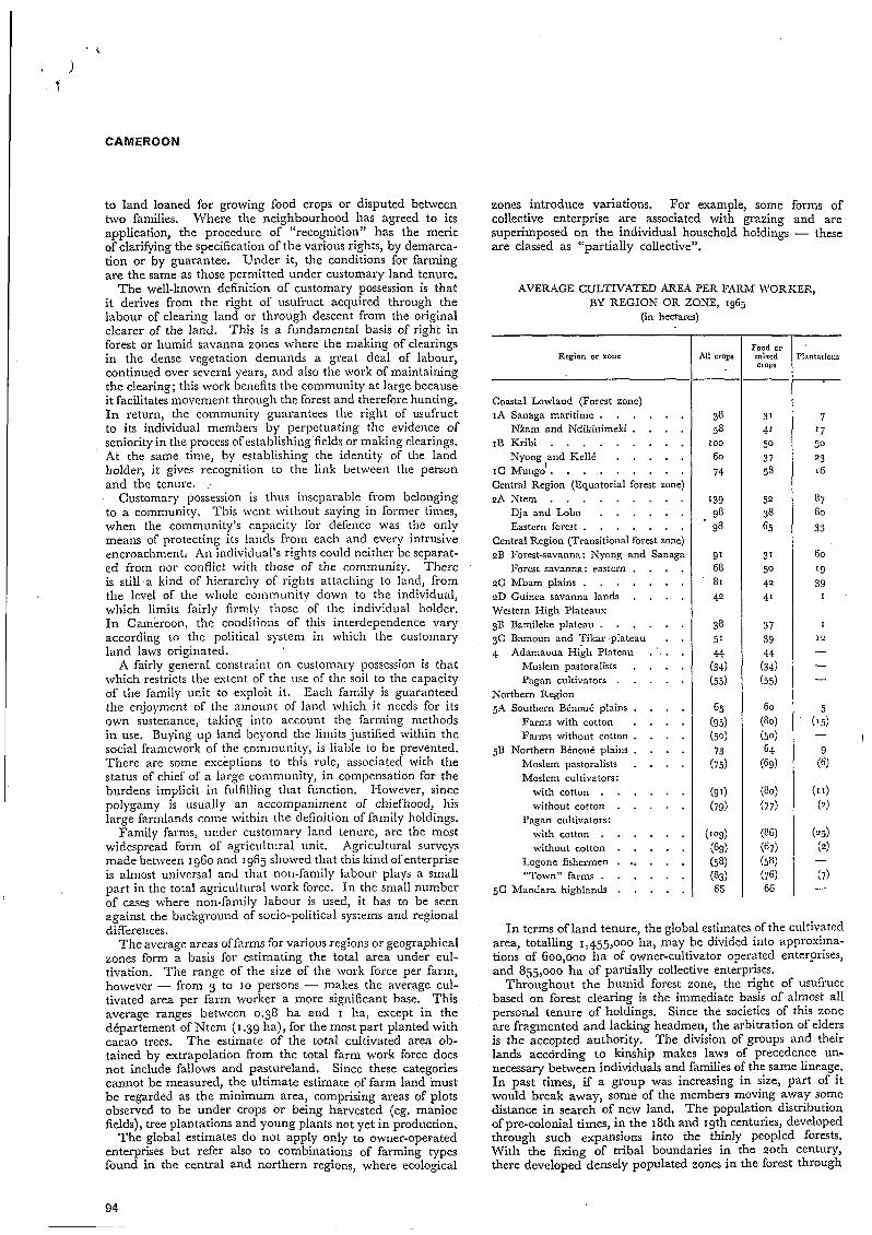
The average areas of farms for various regions or geographical zones form a basis for estimating the total area under cul- tivation. The range of the size of the work force per farm, however - from 3 to I O persons - makes the average cul- tivated area per farm worker a more significant base. This average ranges between 0.38 ha and I ha, escept in the département of Ntem (1.39 ha), for the most part planted with cacao trees. The estimate of the total cultivated area ob- tained by extrapolation from the total farm work force does not include fallows and pastureland. Since these categories cannot be measured, the ultimate estimate of farm land must be regarded as the minimum area, comprising areas of plots observed to be under crops or being harvested (eg. manioc fields), tree plantations and young plants not yet in production.
The global estimates do not apply only to owner-operated enterprises but refer also to combinations of farming types found in the central and northern regions, where ecological
zones introduce variations. For example, some forms of collective enterprise are associated with grazing and are superimposed on the individual household holdings - these are classed as “partially collective”.
AVERAGE CULTIVATED AREA PER FARM WORKER, BY REGION OR ZONE, 1965
(in h-res)
Region or zone
Coastal Lowland (Forest zone) IA Sanaga maritime . . . . . .
Nkam and Ndikinimeki . . . . IB Kribi . . . . . . . . .
Nyong and &Ilé . , . . . I C M u n g i . . . . . . . . . Central Region (Equatorial forest zone) 2A Ntem . . . . . . . . .
Dja and Lobo . . . . . . Eastern forest . . . . . . .
Central Region (Transitional forest zone) 2B Forest-savanna: Nyong and Sanaga
Forest savanna: eastern . . . . 2G Mbam plains . . . . . . . ID Guinea savanna lands . . . . Western High Plateaux 3B Bamileke plateau . . . . . . 3C Damoun and Tikar plateau . . 4 Adamaoua High Plateau . . . .
Moslem pastoralists . . . . Pagan cultivators . . . . .
Northern Region 5A Southern Bénoué plains . . . .
Farms with cotton . . . . Farms without cotton . . . .
5B Northern Bénoué plains . . . . Moslem pastoralists . . . . Moslem cultivators:
with cotton . . . . . . without cottori . . . . . with cotton . . . . . . without cotton . . . . .
Logone fishermen . .. . . . “Town” farms . . . . . .
5C Mandara highlands . . . . .
Pagan cultivators:
I n terms of land tenure, the global estimates of the cultivated area, totalling 1,455,000 ha, may be divided into approsima- tions of 600,000 ha of owner-cultivator operated enterprises, and 855,000 ha of partially collective enterprises.
Throughout the humid forest zone, the right of usufruct based on forest clearing is the immediate basis of almost all personal tenure of holdings. Since the societies of this zone are fragmented and lacking headmen, the arbitration of elders i s the accepted authority. The division of groups and their lands accòrding to kinship makes laws of precedence un- necessary between individuals and families of the same lineage. I n past times, if a group was increasing in size, part of it would break away, some of the members moving away some distance in search of new land, The population distribution of pre-colonial times, in the 18th and 19th centuries, developed through such expansions into the thinly peopled forests. With the fixing of tribal boundaries in the 20th century, there developed densely populated zones in the forest through
94
CAMEROON
natural demographic growth in the areas acquired by the
subdivision of family estates has led to a shortage of crop land, Some families, increasing faster than others, have felt this crisis more seriously.
The interdependent character of customary tenure favours the loaning of plots on a free and renewable basis, between individuals, for growing subsistence food crops. In the Eton area, since the 1960s, a number of land sales between in- dividuals of the same tribe have been noted. In contrast with this, the community is opposed to the alienation of land held by customary tenure to a n outsider, even though the change of holder is the subject of the procedure of “recogni- tion of rights”.
The introduction of cacao and coffee growing in the forest zone has brought with it the extension of forest clearing and the allocation of much larger areas than food crops would require, sometimes at cost of the space used for fallow rotations. Production of plantation crops accentuates the individual character of the tenure as opposed to communal or family tenure. The planting and development of a cacao plantation depends on the work of a household and all the children. Large planters soinctimes have to call upon the help of neigh- bours, mostly women and young men, at harvest time, with payment in kind from the harvest. The employment of paid workers for upkeep work, especially weeding, is not within the reach of all farmers, however. Such work is temporary and is only undertaken by people from outside the region, usually from regions to the east or north. Payment is normally fixed by contract. Some groups of tcinporary workers are able to keep themselves throughout the year in secondary urban centres.
Amongst all the Bantu peoples, wage labour is never recruited from local pcople. I n fact the equality of status between men, both in kinship and in land owning, outweighs inequality of resources, suficiently to uphold the dislike of becoming a paid worker for a relative. hloreover, eniployment in the timber industry, industrial plantations or in towns is much better paid.
On smalllioldings, the custom for work teams to travel round neighbours‘ farms is beginning to decline, because the system demands a lot of expenditure on food and drink in return for a low yield per participant.
Cacao plantations may often be inhcrited by people who are town dwellcrs, engagecl in non-agricultural work. In many cases, such holdings yield an income assigned to a guardian responsillle for the inheritance on behalf of minors. Sormally, their management is entrusted to a near relative living in the vil1ag.e. I f the inheritance is totally for the to\vn
’ dudler, there are various ways of running the holding: supervision by a young relative; permanent employment of an outsider as manager; or by wage labour. The implicit contracts of such supervision are not comparable with those of sharecropping.
The planters of the south and east have for a long time had the benefit of the residence in their villages of people of semi-domestic status : in past times the Maka in the Boulou country, more recently the pygmies in the eastern forests. Using these servants the Boulou in Ntem and in Dja and Lobo were able to develop plantations on a very large scale compared with other regions. Since the administration has protected the minority peoples, however, the situation has changed, and they are encouraged to plant their own trees on their own land.
Sharecropping is practised commonly in Mungo départe- ment. The large Afiican landowners - those with accounts were estimated to number 6,000 in 1964 - have used it for a long time. Lack of money prevents them from supporting regular wages for labour throughout the year, for work on
5 their banana and coffee plantations. They therefore make
I tribes u p to that time. I n the Yaoundé region the progressive grants of land to Bamileke immigrants in exchange for a share of the harvest, usually a half share of banana production. Disputes about land are known to result from this procedure. Another consequence is the failure to apply mineral fertilizers or any kind of plant hygiene by unreliable sharecroppers. The quality of the products intended for esport is therefore reduced.
Turning to the high western plateaux, in the Bamileke, Bamoun and Tikar societies, the politico-religious authority exercised in principle over the disposal of land amongst in- dividuals is that of the sovereign who continues the lineage of the founder of the chiefdom or kingdom. The population is a cultural amalgam formed around the house of the chief.
Each chiefdom is a defined agrarian unit, organized to be independent of others. The chief is the guarantor of the \\hole territory; the land belongs to him. For his personal benefit he works his own land, the &ala, and he controls the use of the communal property and natural grazing land. The remainder is granted to the inhabitants of the village, 011
precarious tenure to the dependents and servants of the chief, on firm title to the legitimate occupants, the heirs to ancient rights.
Lands ivhich are handed down in direct family line are never taken back except if the line becomes estinct. They constitute de facto ownership. They may even be sold but only to neighbours in the same district, never to strangers to the chiefdom. I n the conditions of high population densities, the smallness of the holdings capable of being transferred by purchase in practice precludes the building up of large in- heritances. I t is a longstanding practice that the whole of a single holding is transferred as a unit to only one son, who will continue the family line, his brothers having to emigrate.
Coffee plantations, both arabica and robusta, were for a very long time the privilege of the chiefs, shared only with leading citizens. Some other plantations were established as co-operatives on unoccupied land around Dschang and Foumbot. But since the upheavals of the 1960s individual enterprises have multiplied the plantation of plots for income. Since the agricultural survey of igGj there has been an ob- servable trend to\varcls the division of inheritances into small plots for profit.
The loaning of land also illustrates the scarcity of land for farming. In 1965, 34 per cent of the lands growing food crops and 14 per cent of the mixed plantation fields of the high western plateaux were on loan from their holders. I n the case of the mixed plantations, it is a question of the cul- tivators being authorized by the holders to plant crops bet- ween the rows of coffee trees, producing a “second” holding.
In the Bamoun département, 40 per cent of the plots planted with arabica coffee were on land that had been purchased, chiefly by Bamileke immigrants.
In the northern plains and plateaux there are two kinds of customary land tenure, depending on whether there is a central political power. I n the Fulani lands of the Adamaoua and the plains of the Garoua and Maroua regions, the lordship of the lamido originated in military conquest or, in some places, through alliance with the indigenous peoples. Under direct Fulani rule, all the land rights associated with the earth - pasture, crops, hunting, collecting - belong to the lamido, who is the legal depositary of the collective ownership which he must bequeath intact to his successor. The concession of land which he assigns to someone who requests it (in exchange for an offering if it is a n outsider), becomes a possession provided it is developed, but the land holder may not alienate his land without permission, for it is still included in the already agreed rights of the collective - those of grazing and hunting.
The real Fulani, the former nomads, only cultivate limited areas and secure their food needs by contributions from the villages of detribalized peoples, a custom established through several generations. On this kind of ancient personal depend-
.
95
CAMEROON
ence are based forms of rents in kind, which cannot be com- pared with the contractual arrangements between individuals as defined by sharecropping or leasing. The notion of dues paid by the Rimaïbé cultivators to the headman of the principal land collective is not to be confused with the tax or zakkat until recently collected by the emir of each Fulani state.
Currently, new forms of rent for 'land or for sharecropping are being worked out between cultivators arriving without restriction from autononious cantons and farmers or large landowners in Foulbé and JVandala cantons.
In Diamar6 and the l l o r a region, areas as yet unexploited on the plains are attracting more and more people from the overgrowded Mandara mountains. Others are drifting in from the border cantons of the south and from Logone, \\'here there is rapid population growth. Some of the landowning farmers of the esisting communities take advantage of the labour of these immigrants, by engaging them as farm ivorkers for their cotton or dry-season millet fields, sometimes on a permanent basis, but generally as seasonal workers.
The Mandara of the Mora region possess vcry good soils for these two crops, on alluvial ridges and grey clay basins, which they exploit for profit. They always adopt a contract basis with their labourers, either for tlie season or only for the hoeing work. Among the bigger farmers there are some with holdings of I O ha in crops, and one of 20 lia has been observed. They use ploughs for preparing the soil and engage day labourers to do the hoeing.
Other landowners offer the pagan cultivators plots of land for a rent fised in advance, controlled by the current market for cotton. For a ficld of sorghum planted out, tlie rent of 500 francs per half-hectare is supplemented by one out of every ten bags harvested.
The sahel and sudan savannas of the north are the territories of peoples wliosc social organization lacks central political power. These are open landscapes which have no perennial crops and where there are few cultural divisions to impose a definite character upon tlie settlements of incomers seeking land to cultivate. A notable esception to this is the terracing of mountainous sites in which some groups have sought refuge in the past.
Without a political head, the cohesion of tlie community is the essential thing to ensure the safety of its members and of their property and rights. One of these rights is that of cultivating crops in the same field. Tlie connection between the land and the cultivator is under the authority of tlie maftre de la terre, a n ofice held by a descendant of the oldest occupants of the territory. This ritual authority, which is separate from any social authority, resolves the conflicts about land between groups of different origin who make up tlie community, as is the case in several of the communities of the north.
In the mountain settlements tlie communities have establish- ed themselves on very limited areas; the land is divided into individual plots and holdings with very clearly marked boun- daries. With extremely high population densities, every possible corner is utilized, for every family is entitled to have land. Some exchanges or sales of plots take place, but ex- clusively between members of tlie sanie community. U1- timately emigration is forced upon the young men, who leave for the neighbouring plains. If there is enough room there, whole sections of villages may remove their homes and open u p new Gelds on the plains.
Among plains people of homogeneous culture and language, families retain the right of usufruct on the land belonging to their lineage, even until their return after emigration. This right is exercised often in connection with plots around the houses. which can be kept in permanent cultivation because of the application of domestic manures.
Besides these small plots, each bounded by a neighbour's, each household must add fields in the open- bush on the edge
of the settlement on land which is more or less communal. In the Massa country, among the groups known as the fishermen of Logone (Pêcheurs du Logone), the territorial unit is niade up of the houseliold plots of a single community founded both on patrilineal consanguinity and on long-term residence there of people of various ethnic origins. Tlie farming unit retains a patriarchal structure, in that the fields of tlie married sons are often inseparable from those of their father. Tlie own- ership of land is indicated only in so far as it is necessary to show the unit's boundaries. Among the temporary fields in tlie bush adjacent to the settlement, such boundaries are very ill defined, and tlie community allows the installation there of new family units who are strangers to it. Communal practices are preserved by the customs of pasturing in coin- mon the small herds of cattle which the Massa possess, and of collective fishing in the river or its annual flood channels. I n contrast with this, the creation of rice fields givcs rise to individual initiati\w.
Ethnically heterogeneous neighbourhoods are becoming more and more common as small groups of immigrants scttle on free land around existing villags. Local chiefs assist their integration, through censuses and taxation in kind or in labour, but the holding of grants of crop land remains precarious for such inconicrs.
The national administration has encouraged and organized the occupation of available empty areas by creating coloniza- tion settlements, notably in the neighbourhood of hlaroua. I t is observed that the colonists, coming from tlie mountainous areas, tend to regroup according to their original district and family affinities, re-establishing known communities of interest, The mising of ethnic groups has been accelerated through the development of cash crops of groundnuts and , since 1954, cotton, and with the gro\king of dry-season millct to meet the increasing food demands.
Among some groups, peoples of different ethnic origin liave lived side by side for a long time. The hiboum of Ngaiilia, in the Ngaoundéré region, have lived there for many centuries and are nominal vassals of the conquering Foulbé. They have granted crop land on their own lands to groups of Dourou, such as those of the village of Koubadjé. They renc\v these grants as needs be, since the low population density makes this possible. However, Dourou communities and individuals can claim no right to land ownership.
Among the Moslem peoples there are rural communities who originated in Nigeria - tlie Hausa and Kanouri - and who received from tlie Fulani chiefs of past times long- term concessions which make them the customary holders of crop lands. The numerous Arab pastoralists. around the shores of lake Chad are semi-nomads, divided into small communities who stay there for. a few months in order to cultivate millet, For the use of grazing land, for crop land and for fishing zones, they pay charges to the Kotoko sovereigns. Throughout the Kotoko principalities the latter exercise firm control over the very precise and time-honoured rights which are attached to the form and area of the extensive annual inundation that takes place.
4. Land utilization, crops and animal husbandry
Statistics for land utilization for the whole country, on a number of different bases, were established for the purposes of preparing the Development Plan ,of 1965.
A number of other sources have been consulted in connec- tion with the land use map for the World Atlas of Agriculture, in particular the final results of sample agricultural surveys of East Cameroon, made between 1957 and 1965. This in-
96
CAMEROON
formation yields a reasonable evaluation of the extent of land effectively cultivated and harvested, without taking account, however, of short fallows used in the various crop systems. The various figures for that time may be harmonized by extrapolation, using the average area cultivated per working adult, for each region or level of sample, and the total work force in 1965.
Similar data do not exist for West Cameroon. The demo- graphic sample survey of 1964 provided a close estimate of the agricultural work force, region by region. By making com- parisons between these regions and analogous adjacent regions in eastern Cameroon, it was possible to use the reipective calculations of average area cultivated per working adult in East Cameroon in conjunction withthe number of working farmers in \\‘est Cameroon. The resultant evaluation appears to be reasonable.
For ,other aspects of land use and farming, information from specialized government services has been related to in- formation drawn from maps for types of vegetation and non- agricultural land.
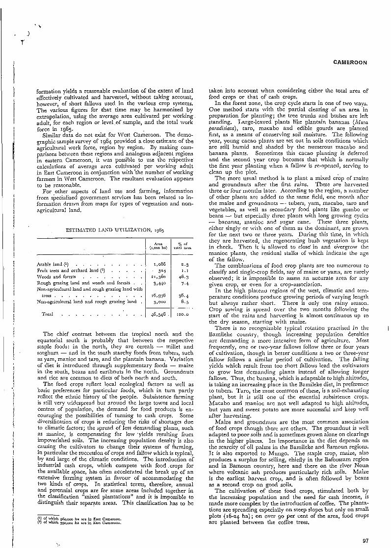
ESTIhIXTED LXKD UTILIZATION, 1965
Arable land (1) . . . . . . . . . . Fruit trees and orchard land (2) . . . . . IVoods and forests . . . . . . . . . Rough grazing land and woods and forests . . Non-agricultural land and rough grazing land with
trees . . , . . . . . . . . . . Non-agricultural land and rough grazing land .
Total . . . . . . . . . . . .
Aren (I,OQO ha)
46,546
2.3 1.1
46.3 7.4
36.4 6.5
100.0
The chief contrast between the tropical north and the equatorial south is probably that between the respective staple foods: in the north, they are cereals - millet and sorghum - and in the south starchy foods from tubers, such as yam, manioc and taro, and the plantain banana. Variation of diet is introduced through supplementary foods - maize in the south, beans and earthnuts in the north. Groundnuts and rice are common to diets of both north and south.
The food crops reflect local ecological factors as well as basic preferences for particular foods, which in turn partly reflect the ethnic history of the people. Subsistence farming is still very widespread but around the large towns and local centres of population, the demand for food products is en- couraging the possibilities of turning to cash crops. Some diversification of crops is reducing the risks of shortages due to climatic factors; the spread of less demanding plants, such as manioc, is compensating for low ‘yields resulting from impoverished soils. The increasing population density is also causing the cultivators to change their systems of farming, in particular the succession of crops and fallow which is typical, by and large of the climatic conditions. The introduction of industrial cash crops, which compete with food .crops for the available space, has often accelerated the break up of an extensive farming system in favour of accommodating the two kinds of crops. In statistical terms, therefore, annual and perennial crops are for some areas included together in the classification “mixed plantations” and it is impossible to distinguish their separate areas. This classification has to be
(I) of which g60,ooo ha are in East Cameroon. (’) Of which 390,- ha arc in East Cameroon.
taken into account when considering either the total area of food crops or that of cash crops.
I n the forest zone, the crop cycle starts in one of two ways. One method starts with the partial clearing of an area in preparation for planting; the tree trunks and bushes are left standing. Large-leaved plants like plantain bananas (Musa garudisiaca) , taro, macabo and edible gourds are planted first, as a means of conserving soil moisture. The following year, young cacao plants are set out in soils conditions which are still humid and shaded by the numerous macabo and banana plants. Sometimes this cacao planting is deferred and the second year crop becomes that which is normally the first year planting when a fallow is re-opened, serving to clean up the plot.
The more usual method is to plant a mixed crop of maize and groundnuts after the first rains. These are harvested three or four months later. According to the region, a number of other plants are added to the same field, one month after the maize and groundnuts - tubers, yam, macabo, taro and vegetables, as well as secondary food plants like gombo or beans - but especially three plants with long growing cycles - bananas, manioc and sugar cane. These three plants, either singly or with one of them as the dominant, arc grown for the next two or three years. During this time, in which they are harvested, the regenerating bush vegetation is kept in check. Then it is allowed to close’ in and overgrow the manioc plants, the residual stalks of which indicate the age of the fallow.
The combinations of food crop plants are too numerous to classify and single-crop fields, say of maize or yams, are rarely observed; it is impossible to assess an accurate area for any given crop, or even for a crop-association.
In the high plateau regions of the west, climatic and tem- perature conditions produce growing periods of varying length but always rather short. There is only one rainy season. Crop sowing is spread over the two months following the start of the rains and harvesting is almost continuous up to the dry season, starting with maize.
Bamileke country, though increasing population densities are demanding a more intensive form of agriculture. Most frequently, one or two-year fallows follow three or four years of cultivation, though in better conditions a two or three-year fallow follows a similar period of cultivation. The falling yields which result froin too short fallows lead the cultivators to grow less demanding plants instead of allowing longer fallows. Thus, the banaca, which is adaptable to high altitudes, is taking an increasing place in the Bamileke diet, in preference to tubers. Taro, the most common of these, is a soil-exhausting plant, but it is still one of the essential subsistence crops. Macabo and manioc are not well adapted to high altitudes, but yam and sweet potato are more successful and keep well after harvesting.
Maize and groundnuts are the most common association of food crops though there are others. The groundnut is well adapted to poor soils and is sometimes grown alone on clearings in the higher places. Its importance in the diet depends on the scarcity of oil palms in the Bamileke and Bamoun regions. I t is also exported to Mungo. The staple crop, maize, also produces a surplus for selling, chiefly in the Bafoussam region and in Bamoun country, here and there on the river Noun where volcanic ash produces particularly rich soils. Maize is the earliest harvest crop, and is often followed by beans as a second crop on good soils.
The cultivation of these food crops, stimulated both by the increasing population and the need for cash income, is made more complex by the introduction of coffee. The planta- tions are spreading especially on steep slopes but only on small plots (16-24 ha); on over go per cent of the area, food crops are planted between the coffee trees.
There is no recognizable typical rotation practised in the I
97
CAMEROON
l i
i
The land use is very similar on the highlands of Bamenda, in west Cameroon. Maize is the most important plant there, being planted year after year while the land is in production. This is for three or four years, followed by a two-or three- year fallow. Beans, potatoes, taro, yam, manioc and sweet potato usually accompany maize. Cabbage, tomatoes and sugar cane occupy small corners in the fields to a limited extent. The rapid spread of arabica coffee is also replacing land needed for food crops, and the spaces between tlie coffee trees, already too small, are used for yams, potatoes and manioc, often for longer than the two or three years which the soil can tolerate.
Towards the north of tlie plateau, around Nkambe, millet and sorghum join the range of plants cultivated. A diy season of almost four months indicates the transitional conditions towards the tropical climate.
On the high plateau of Adamaoua there is a definite transi- tion in the dominant staple food plants from maize in the southwest (Banyo, Tibati and Tignère districts) to millet and sorghum towards the north and east. I n this region, ivitli annual rainfalls of I ,600-1,7ooinni, maize is most frequently found in the alluvial valley bottoms, sheltered from the brush fires when tlie pastoralists bum the platcau savannas evcry year. The cultivable areas are limited and the use of these alluvial territories is more intense than the lo\v average popula- tion density of thc region \ \odd suggest.
Among the hlbouin and Dourou people, north of Xga- oundéré, millet is the basic crop. I t is replantecl on the same field until tlie soil is eshausted - sometimes for up to 25 years. Interplanted with it or grown as a complenicntary crop are beans and gourds, maize (which is highly valued but does badly on the infertile soils) , groundnuts, qnrthnuts and yams. Llanioc, introduced as a systematic crop since the 1950s~ is increasingly important in making productive use of soils approaching eshaustion. The farming system is, therefore, one of intensive cultivation until in t‘lie end the fields are abandoncd after complete eshaustion. Ultimately, this total exploitation of a village territory leads to the migra- tion of the inhabitants, either all together or in groups, to a new location some kilonietrcs distant. Tlie locations of villages are therefore changed every few decades. Individual land ownership has no significance under such conditions.
I n the plains and niounrains of the tropical north, with sudan and sahel conditions. the preoccupation of the farmers is to maintain food production from low-yielding plants in the limited rainy season. Thcy also have to contend \crith the variability of rainfall clistrilxition and the general poverty of the soil. They are spared \he ravagcs of locusts and tlie uncertainties of their environnielit, so that they are tempted to grow cash crops like cotton or groundnuts. Intense sub- division of the land in areas of higher population density often demands intercropping and rotations of suitable crops. Millets are the basis of all farm systems, supplying the most nourishing food value as well as the much prized beverage ’- millet beer. The highest yields are obtained from sorghums, of which there are numerous varieties, both early and Iate being valuable .for tiding over the out-of-season periods of shortage and for filling the granaries. Red-grained and white- grained sorghums are cultivated during tlie wet season, and dry-season varieties can be grown as a second crop in the clayey depressions which are barely usable during the rainy season. There areas were little used until their exploitation became necessary through pressure of population on resources and competition from cotton. Nowadays, they produce the most significant saleable surpluses; harvests are taken off them in January and February, the last operation of the farm- ing year. The stubble left in the hard clay is much prized for fodder. The pearl millets, though they have very low yields, are in demand especially amongst the Fulani for their texture and flavour.
98 -.
Under the wide range of physical conditions and the limita- tion of soil fertility and of space available for cultivation, there i s no dominant type of rotation. However, it seems to be the general rule that sorghum is the first crop sown an- nually, a t the beginning of the farming cycle. If the cul- tivation is intensive, it proves necessary to enrich the soil with organic matter, either animal manure or domcstic waste. At the end of a few years, it is always essential to change the crop. Fields which are under estensive esploitation are al- lowed to revert to brush.
The tuw chief plants alternating with millet are groundnuts and cotton. Tlie sorghum-cotton rotation is most common on the plains, where cotton as a cash crop dominates the agricultural economy. I n sonie villages located on river alluvium in the Afora region, the land is divided into two fields, on which cotton and millet are alternated annually. The sorghum-groundnut rotation is practised by the pagan farmers in the hlnndara massif piedmont zone.
The mountain pcople, densely concentrated on the cultiv- able areas of the massifs, devote the whole farm land to growing millet, usually on terraces. Some groups, in the hfora mountains, grow sorghum every year, intercropping it witli complenicntary crops. Others, in tlie frontier ranges north of hlokolo, use an annual rotation of sorghum and pearl millet in the one field. Interplanted crops also appear every second year.
A number of sccondary crops are grown either in association witli millet or separately on small plots. They are chiefly crops for food stockpiling or for sale, such as sesamum, earth- nuts, beans and cow peas. Sweet potatoes, manioc, yam and taro are grown to a limited estent and a number of garden vegetables are also cultivated, chiefly gombo, oscille (Hibiscus saDdariffa), gourds (Ci/u/lus zlulgnris and others) , maize, tobacco and onions.
The growing of ricc remains restricted to a small number of widely scattered and diverse districts. Rice is neither a traditional food nor a principal item in the cropping systems. Tlie crop has hac1 little success in tlie forest zones. I n TVest Cameroon, rain-fed rice is oftcn planted as the first crop after I clearing the land. North of hlount Cameroon and west of Kumba, its economic role is derived from foreign elements of tlie population, originating in eastern Sigeria, who cultivated it as a cash crop during the 1930s around plantations in Bay, Mbonge and Lobe. It is also found near the town of’ Mamfé, and on the high Bamenda plateau in the Koln and Bafut districts.
The enforced cultivation of rice was imposed in East Ca- meroon by the colonial administration, as the prime com- mercial crop, during the 1920s. This was intended to cnsure the food supply of the urban centres and public works sites. Cacao has replaced it successfully as a source of income in the forest zone. Oficial encouragement was given to rice cultivation towards 1950, in the savanna regions on the edge of the forest, through the establishment of two rice mills of moderate capacity, one at Nanga Eboko on the left bank of the river Sanaga, the other at Ntui on the right bank. These two factories subsequently went out ‘ of production because of shortage of supplies.
The problems of rice cultivation are reflected in the few remaining ricefields in valley bottoms between Nanga Eboko and Minta. These problems include the difficulties of protecting the ripe grain from marauding birds when the children are away a t school; the rapid regrowth of undergrowth and weeds after a single year’s cultivation; and the deficiencies of the marketing system. Very low yields have been noted near Nanga Eboko: between 2 and 7.2 quintals per ha, \vith an average of 4.5 quintals.
I n the north, the agricultural survey of 1961 revealed that upland rice, grown in small, scattered plots, occupied 3,000 ha, and flood rice some 2,500 ha in the chief valleys of Bénoue
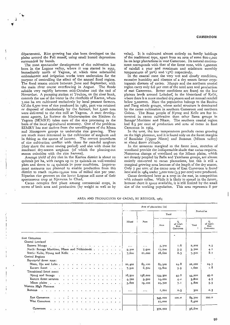
CAMEROON
5 9 700 17,200
28,1300
I
I .6 5.3 8.3 l
East Cameroon : M'est Cameroon . . . . . . . . . . . . . . . .
Cameroon . . . . . . . . . . . . . . . . . .
. . . . . . . . . . . . . . . i
3 4 5 , ~ ~ ~ Ioo.~ 89,700 100.0
27,000 8,900
372,000 98,600
département. Rice growing has also been developed on the plains around tlie Poli massif, using small humid depressions surrounded by bunds.
The most spectacular development of rice cultivation has been in the Logone valley, where it was started in 1952, immediately north of Yagoua, a t , which time substantial embankment and irrigation works were undertaken for the purpose of controlling the effect of the annual flood regime. Tlie flood season occurs between June and September, with the main river course overflowing in August. The floods subside very rapidly between mid-October and the end of November. A pumping station a t Toukou, on the river bank, controls the use of the water in the ricefields of Kartoa, where 7,000 ha are cultivated exclusively by local peasant farmers. Of tlie 6,500 tons of rice produced in 1967, part was retained or disposed of clandestinely by rhe farmers, but 5,000 tons were delivered to the rice mill a t Yagoua. A state develop- ment agency, Le Secteur de híodernisation des Rizibres de Yagoua (SEh4lZY) takes care of the rice processing as the basis of the local agricultural economy. One of the problems SEMRI' has met derives from the unwillingness of the Massa and Mousgouni groups to undertake rice growing. They are much niore interested in the cultivation of sorghum and in fishing as the source of income. The correct procedures of rice cultivation conflict with those for rain-fed sorghum (they share the same sowing period) and also with those for mouskwari dry-season sorghum (of which the planting-out season coincides with the rice harvest).
Average yield of dry rice in the Kartoa district is about 22 quintals per ha, with ranges up to 32 quintals on well-weeded plots and down to 14 quintals in poor conditions. Iniprove- ment measures are planned to enable production from this district to reach 12,000-13,000 tons of milled rice per year. Riparian rice growers on the lower Logone sell sonie of their spontaneous crop at Njamena in Chad.
Cacao occupies first place among commercial crops, in terms of both area and production (by weight as well as by
value). It is cultivated almost entirely on family holdings of the traditional type, apart from an area of some 800-1,000 ha on large plantations in west Cameroon. Its natural environ- ment corresponds with that of the forest zone, with 1,400" of rainfall a year and maximum and minimum nionthly temperatures of 320C and x50C respectively.
In the coastal zone the very wet and cloudy conditions, excessive humidity and absence of a dry season favour cryp- togamic diseases of cacao. h h n g o and the northern coastal region carry only 6.6 per cent of the total area and production of east Cameroon. Better conditions are found on the low plateau levels around Lolodorf, in the hinterland of Kribi, where there is a niore marked dry-season and an annual rainf'dl below 3,000mm. Here the population belongs to the Fioulou and Fang ethnic groups, whose social structure is dominated by the cacao cultivation in southern Cameroon and northern Gabon. Tlie Bassa people of Nyong and Kelle are less in- terested in cacao cultivation than other Bassa groups in Sanaga' híaritime and Nkam. The southern coastal region had 8.3 per cent of production and area of cacao in East Cameroon in 1964.
In the west, the low temperatures preclude cacao growing on the high plateaus, and it is found only on the forest margins of Bamileke (Upper Nkam) and Bamoun (híbam valley) at about 800m altitude.
In the savannas marginal to the forest zone, stretches of woodland provide the indispensable shade that cacao requires. Xumerous clumps of woodland on the Mbam plains, which are densely peopled by Bafia and Yambassa groups, are almost entirely converted to cacao plantations, but this is still a marginal growing area because of the length of the dry season. Only 7 per cent of the cacao area of East Cameroon is found here and in 1964 under 5,000 tons (5.3 per cent) were produced.
Cacao developed later as a crop in the east, in competition with robusla coKee. \$'hile it is likely to spread in the future, because there is spacc available, it is still limited by the small size of the working population. This area represents 8 per
I AREA AND PRODUCTION OF CACAO, BY REGIOSS, 1964
~~ ~
I Arca o f plantations (ha)
I 1 I'roduction I I Toial
hlixed
East Cameroon Coastal Lowland
Eastern Mungo . . . . . . . . . . North: Sanaga Maritime, Nkam and Sdikininieki South: Kribi, Nyong and Kelle
Equatorial forest zone:
. . . . . Central Regions
Ntem, Dja and Lobo . . . . . . . . Eastern forest . . . . . . . . . . Nyong and Sanaga . . . . . . . . Eastern forest savanna . . . . . . . Mbam plains . . . . . . . . . .
Bamoun . . . . . . . . . . . .
Transitional forest zone:
Western High Plateaux
. . . . . . .
. . . . . . .
. . . . . . .
. . . . . . .
. . . . . . .
. . . . . . .
. . . . . . .
. . . . . . .
. . . . . . .
10,400
79300
16,500 49700 5,600
...
... 79900
21,000
65,100 6,300
I 38,000 9,300
19, I O 0
...
of total: East
Cameroon Aren 1
I ' I
85,500 13,600
'549 500
14,000 249 700
1,200
24.8 3.9
0.3
Tons
2,200
3 t 700 7.300
22,000
1,600
300
o f total: East
Cztmeroon
2.5 4.1 8. I
24.5 .a
49.0 4.3 5.3
99
CAMEROON
cent of the total cacao area of East Cameroon, largely iu young plantations mingled with food crops. In 1964 it pro- duced 6 per cent of the total production.
Three-quarters of the total production and 70 per cent of the area of cacao in East Cameroon are found in the most densely populated zones. The Beti country around Yaoundé (Eton, Ewondo and Bane) and the Boulou country in Meni, and Dja and Lobo, have peasant economies dominated by the annual calendar of growing and selling cacao. There are few holdings without cacao trees but, in general, planta- tions are small. In 1958-59, throughout the départements of Ntem, Dja and Lobo, and Nyong and Sanaga, 6 per cent of all holdings grew no cacao (generally bachelors or savanna cultivators), 32 per cent liad less than I ha, 26 per cent grew 1-2 ha, and only 8 per cent grew over 4 ha.
Despite the work of the advisory and educational services, yields of cacao are still low - under 3 quintals per ha. The trees are usually grown from nibs planted in seed holes, rarely from selected cuttings, and they are poorly maintained and attended to, and inadequately treated for diseases. Harvesting from large numbers of bearing stems is favoured instead of using more expensive methods of cultivation and treatment on less dense plantations, hlore careful techniques may be adopted in areas where there is more pressuke on the available land because of high population density.
I n 1965 the income from cacao represented 50-70 per cent ofa planter’s budget. The controlled sale of the crop in markets, organized according to an administrative timetable, has led to an improvement of the marketed qualities of the product.
Production is expanding fairly rapidly as a result of increased area and of the good return it gives. The humid warmth of the forest zones is suitable for robusta coffee, and the lower temperatures of the upland climates for the arabica species. The two species are grown both on commercial plantations and on traditional holdings. Robusta coffee is planted between 400” and I ,2001111n, and arabica at altitudes above 1,ooom. There is therefore a narrow zone between 1,ooom and 1,200m where they both occur; this is found in the Bamileke country in the Upper Nkam and Ndé dPpartements.
The arabica zone covers the northern two-thirds -of the Bamileke country (Menoua, Bambouto and hfifi départe- ments), the black earth zones on the volcanic ash regions of Foumbot (northwest Bamoun département) and the basalt plateau of Bamenda in \Vest Cameroon. These are well populated regions, in which tree crops compete with food crops for the available space. On traditional holdings, mixed plantations have overcome this difficulty: arabica coffee was planted on 92 per cent of tlie cultivated area in 1965.
The spread of the area planted with arabica in tlie Bamileke and Bamoun country has been very rapid, increasing from 7,900 ha in 1952 to 25,000 ha in 1958 and 47,000 ha in 1965. Sample surveys in 1965 showed that many of the trees were immature: 95 per cent were under 15 years old, and 40 per cent were under 4 years old, indicating a future rapid increase of production. Replacement of old plantations can be done only on the same ground; but average density of trees is very high - 2,000 per ha instead of an optimum of 1,500-1,600. On these mixed plantations the careful cultivation devoted to the food crops, such as digging in green manure and frequent weeding, makes up for the impoverishment of the soils. Chem- ical fertilizers, though used increasingly from year to year, were applied on only half of the plots in 1965. Yields are still fairly low, though they vary according to the type of holding. O n family holdings, the yield is between I and 3 quintals per ha; on European or African co-operative planta- tions, under rational management, it is 3-5 quintals per ha. Increasing altitude of the plantation tends to favour a better yield of coffee. I n 1962, the European plantations, located mostly in the Bamoun country, covered a little over 3,000
Coffee is the second export crop, by value.
ha and they produced I O per cent of the total output. In West Cameroon, the area under arabica coffee in 1965
was 9,600 ha. However, tlie custom of associating the tree crops with subsistence crops and the excessively dense coffee trees contribute to the low average yield - about 2.25 quintals per ha. The production taken by the hlarketing Board in 1965 was of the order of 2,130 tons.
The distribution of robusta coffee is divided into tn’o areas, separated by the \cidth of the cacao zone. I n the \ v a t , it lies in a belt around the high plateaus. From l\’est Cameroon, it spreads from the départements of hlamfé and Kumba (with some 6,000 ha), through northern Nungo (with $5,ooo ha, of which 3,500 ha are in commercial plantations), the lower levels of the Baniilekc plateau (départements of Upper Kkam and Ndé, with 24,000 ha), and into the southern Bnmoun country, along the Mbam valley into the Tikar country (with a total of 16,000 ha). The total area in this western zone is 92,000 ha, representing 84 per cent of the total robusta area in Cameroon in 1965. Three-quarters of the area are in mixed plantations, combined with food crops. However, the robusla trees are taller than arabica, with spreading branches \rhich shade the soil and are therefore harmful to the groiving crops.
During the 1965 survey, tlie tree density was shown LO be high, reaching an average of 1,500 per ha in mixed planta- tions and 1,750 in pure stands on traditional holdings. The normal density should be 1,200. The trces are mostly young: go per cent are under 15 years old and 36 per cent. are not yet in production. With yields ranging between 2 and 5 quintals per lia, the average of 3.5 quintals esceeds that of arabica coffee. The average yield reaches 7 quintals per lia on coni- mercial plantations in Mungo (at Nohé, Baré and hielong), thanks to mechanized cultivation, regular pruning and at- tention, a vigorous campaign against disease and the use of fertilizers.
In the east, robusta coffee cultivation has developcd, in competition with cacao, around Abong hlbang in Upper h’yong, and secondarily around Batouri and Yokadouma. I n addition to these 15,000 ha, of which 1,000 ha are in com- mercial plantations, there are 3,000 ha in Mbam départe- ment. Yields are low because of tlie scanty cultivation tcch- niques that are applied: 2.1 quintals per ha around Batouri, 3.5 quintals per ha in Upper Nyong. The plantations are normally started on exhausted crop fields and are scattcred and inadequately attended to. Average density of trees is too high, reaching 1,800 trees per ha, though there is a wide range around that average. In 1963-64, production of robiufa coffee totalled 38,000 tons, of which 34,600 tons came from East Cameroon; arabica coffce production totalled 14,300 tolls, with 10,700 tons coming from East Cameroon. Since then production of robusta coffee has steadily increased to over 55,000 tons, while production of arabica coffee has fluctuated somewhat but has increased to over xg,ooo tons a year.
The cultivation of bananas for export (,\fusa sapierituni) is very localized, close to the ports. The “banana plain” of East Cameroon lies in Mungo département, between h,lbanga and Manengolé, an area of some 7 million ha. This is an area with soils of volcanic origin which are rich and permeable; rainfall ranges between 2,500mm and 3,000” a year, and there is constant heat. At altitudes above Goom, lower tem- peratures cause a fall in yield. I n West Cameroon bananas are grown in similar physical conditions between Victoria and Kumba, close to the Mungo river.
The fruit are produced in commercial and peasant planta- tions. The commercial plantations are specialized, growing only bananas under modern techniques, with mechanization, regular application of mineral fertilizers, cover crops and protection against diseases, There is a reduced need for paid labour outside the periods of harvesting and cultivation treat- ments. I n Mungo, these holdings belong to European conipa- nies as well as a few Cameroon companies; these are rarely
1 O0
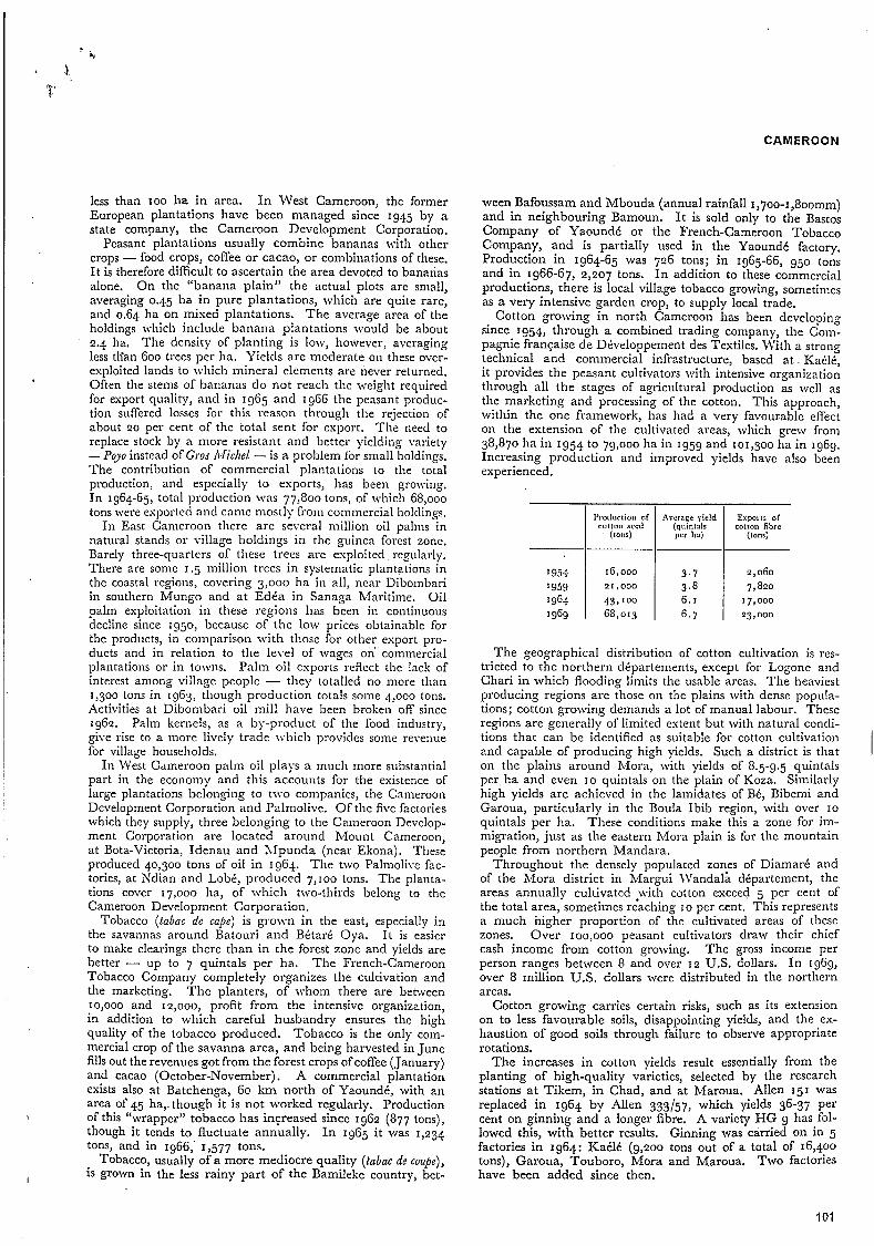
CAMEROON
I
less than 100 lia in area. In West Cameroon, the former European plantations have been managed since 1945 by a state company, tlie Cameroon Development Corporation.
Peasant plantations usually combine bananas with other crops - food crops, coffee or cacao, or coinbinations of these. I t is therefore difficult to ascertain the area devoted to bananas alone. On tlie “banana plain” the actual plots are small, averaging 0.45 ha in pure plantations, which are quite rare, and 0.64 ha on niised plantations. The average area of the holdings tvhicli include banana plantations would be about 2.4 ha. The density of planting is low, however, averaging less tlian 600 trees per ha. Yields are inoderate on these over- exploited lands to which mineral elements are never returned. Often the stems of bananas do not reach tlie weight required for export quality, and in 1965 and 1966 the peasant produc- tion suffered losses for this reason through the rejection of about 20 per cent of the total sent for export. The need to replace stock by a inore resistant and better yielding Lmiety - P g o instead of Gros Afirhel - is a problem for small holdings. The contribution of commercial plantations to the total production, and especially to exports, has been grolving. In 1964-65, total production was 77,800 tons, of which 68,000 tons were esportecl and came mostly from commercial holdings.
I n East Cameroon there are several million oil palms in natural stands or village holdings in the guinea forest zonc. Barely three-quartcrs of these trees arc exploited regularly. There are some 1.5 million trees in systematic plantations in the coastal regions, covering 3,000 ha in all, near Dibombari in southern Mungo and at Edéa in Sanagi Rfaritime. Oil palm exploitation in these regions has been in continuous decline since 1950, because of the low prices obtainable for the products, in Comparison with those for other esport pro- ducts and in relation to the level of wages 011’ commercial plantations or in towns. Palm oil esports reflcct the lack of interest among village people - they totalled no more than 1,300 tons in 1963, though production totals sonie 4,000 tons. Activities at Dibombari oil mill have been broken off since 1962. Palm kernels, as a by-product of tlie food industry, give rise to a more lively trade which provides some revenue for village households.
In West Cameroon palm oil plays a much more substantial part in the economy and this accounts for the esistcnce of large plantations belonging to t\\’o companies, the Cameroon Development Corporation and Palmolive. Of tlie five factories which they supply, three belonging to the Cameroon Develop- ment Corporation are located around Mount Cameroon, at Bota-Victoria, Idenau and Xfpunda (near Ekona). These produced 40,300 tons of oil in 1964. The two Palmolive fac- tories, at Kdian and Lobé, produced 7,100 tons. The planta- tions cover 17,000 ha, of which two-thirds belong to the Cameroon Development Corporation.
Tobacco (tabac de c a p ) is grown in tlie east, especially in the savannas around Batouri and Bétaré Oya. I t is easier to make clearings there than in tlie forest zone and yields are better - up to 7 quintals per ha. The French-Cameroon Tobacco Company completely organizes tlie cultivation and the marketing. T h e planters, of whom there are between 10,000 and I r,ooo,. profit from the intensive organization, in addition to which careful husbandry ensures the high quality of the tobacco produced. Tobacco is the only com- mercial crop of the savanna area, and being harvested in June fills out the revenues got from the forest crops of coffee (January) and cacao (October-November) . A commercial plantation exists also at Batchenga, 60 km north of Yaoundé, with an area of 45 ha,. though it is not worked regularly. Production of this “wrapper” tobacco has increased since 1962 (877 tons), though it tends to fluctuate annually. In 1965 it was 1,234 tons, and in 1966,’ 1,577 tons.
Tobacco, usually of a more mediocre quality (labac de coupe), is grown in the less rainy part of the Bamileke country, bet-
ween Bafoussam and Mbouda (annual rainfall 1,~00-1,8oomn1) and in neighbouring Bamoun. I t is sold only to the Bastos Company of Yaoundé or the French-Cameroon Tobacco Company, and is partially used in the Yaoundé factory. Production in 1964-65 was 726 tons; in 1965-66, 950 tons and in 1966-67, 2,207 tons. In addition to these commercial productions, there is local village tobacco growing, sometimes as a very intensive garden crop, to supply local trade.
Cotton growing in north Cameroon has been developing since 1954, through a combined trading company, the Com- pagnie française de Développement des Textiles, With a strong technical and commercial infrastructure, based a t Kaélé, it provides the peasant cultivators with intensive organization through all the stages of agricultural production as well as the marketing and processing of the cotton. This approach, within the one framework, has liad a very favourable effect on the extension of the cultivated areas, which grew from 38,870 ha in 1954 to 79,000 ha in 1959 and 101,300 ha in 1969. Increasing production and improved yields have also been experienced.
I954 ’959 19% 1969
1’rodtlrlion of ColIoII reed
(tons)
~G,ooo 21,000
43,”JO 68,013
Arerage yield (quin1nlr per ha)
3.7
6. I 3.8
6.7
Exports of cotton fibre
(l0,X)
2,060
7,820 17,000 23, o00
The geographical distribution of cotton cultivation is res- tricted to the northern départements, except for Logone and Chari in which flooding limits the usable areas. The heaviest producing regions are those on tlie plains with dense popula- tions; cotton growing demands a lot of manual labour. These regions are generally of limited estent but with natural concli- tions that can be identified as suitable for cotton cultivation and capable of producing high yields. Such a district is that on the plains around hlora, with yields of 8.5-9.5 quintals per ha and even IO quintals on the plain of Koza. Similarly high yields are achieved in the lamidates of Bé, Bibemi and Garoua, particularly in the Boula Ibib region, with over IO
quintals per ha. These conditions make this a zone for im- migration, just as the eastern Mora plain is for the mountain people from northern Mandara.
Throughout the densely populated zones of Diamaré and of the hlora district in Margui JVandala département, the areas annually cultivated with cotton exceed 5 per cent of the total area, sometimes reaching I O per cent. This represents a much higher proportion of the cultivated areas of these zones. Over IOO,OOO peasant cultivators draw their chief cash income from cotton growing. The gross income per person ranges between 8 and over 1 2 U.S. dollars. I n 1969, over 8 million US. dollars were distributed in the northern areas.
Cotton growing carries certain risks, such as its extension on to less favourable soils, disappointing yields, and the ex- haustion of good soils through failure to observe appropriate rotations.
The increases in cotton yields result essentially from the planting of high-quality varieties, selected by the research stations at Tikem, in Chad, and at Maroua. Allen 151 was replaced in 1964 by Allen 333157, which yields 36-37 per cent on ginning and a longer fibre. A variety HG 9 has fol- lowed this, with better results. Ginning was carried on in 5 factories in 1964: Kaélé (9,200 tons out of a total of 16,400 tons), Garoua, Touboro, Mora and Maroua. Two factories have been added since then.
I
1 O 1

CAMEROON
Dianiaré . . . . . . Bénoué . . . . . . Mnrgui \ v a n d n h . . . Mnyo Datiay . . . .
DISTRIBUTION OF COTTOS CULTIVATION AREAS AND PRODUCTION, 1964
% x DCpnrtcnicnt 1 of total I of total
cotton arca production
54 55 26 20
I 2 20
a 5
One cottonseed oil mill, a t KaClé, has a capacity of 1.5 million litres. The production of 1.3 niillion litres is partly sold in the locality. Oilseed cakes are partly used locally as manure, partly esported.
Only a limited amount of Cameroon's land offcrs natural conditions suitable for cattle raising: 8,000,000 ha in East Cameroon and 300,ooo ha in \\'est Cameroon. This area lies outside the humid forest ancl peripheral savannas, which are the zones where the wooded water courses are infested permanently by tsetse fly. It is located chicfly in northcrn Cameroon but also on lands above 1,oooin in height in the western mountains (the Dschang, Bainenda, \\'um and Kkambe regions) and the Adamaoua plateau.
In the western mountain areas, the only land which the populous farming commiinitics spare for the pnstoralists are the grasslands above I ,85om, which are beyond the cultiva- tion limit, or areas of mediocre quality. The lee slopes of mount Manengouba above the town of Nkongsamba and of mount Bambouto, above Dschang, carry pasture lands improverished by overgrazing. From the I 93Òs a commercial livestock company \vas raising cross-bred herds (zebus and European Montbtliards) there, for the purpose of supplying meat and dairy products to the town of Douala and the plantation areas in lfungo. This company ceased its ac- tivity about 1960. Fulani herdsmen keep a stock of cattle, totalling some 50,000 head, in the border area between \\'est and East Cameroon. In the Bamileke country there arc several hundred head of cattle, of a small-statured breed, in a number of small herds which represent, with some sacred significance, the wealth of the chieftaincies. Sheep and goats, of small breeds, are on the other hand very numerous, kept by peasant farmers who pasture them on hill-top fallow grassland. Pigs are raised for cash in some limited regions, for esample in Bafoussam.
The use of the Adamaoua plateau for pastoral purposes resulted from its 19th-century conquest by Islamic Fulani tribes who established themselves there, imposing their way of life over that of the agricultural societies already living there. The vast territories that lie between the sparse farni- lands offer adequate diversity of seasonal pastures. These range from the areas around the villages in the rainy season to the upland meadoivs of the northwest, in the Tchabbal Mbabo. Betu'een October and April, the stock are moved towards the valley bottoms where the grazing lasts longer on the marshy or periodically flooded grasslands. Salt springs are much frequented by the herds of nomadic Fulani and Mbororo and sedentarized Fulani; the total herd in 1965 numbered around I million head. The quality of the grazing lands is reflected in the intensity of their exploitation, and this can lead to a substantial degradation of the vegetal cover and the soil, with a consequent increase in woody species and herbaceous plants other than grasses.
There are three pastoral zones in the lowlands of northern Cameroon: the Bénoué region, the Diamaré plain and the Logone plain. Livestock raising in these climatic zones is extensive in character. The total cattle stock number some 800,000 head. The Bénoué region, more humid and scantily
populated, except in the Guider arrondissement, has enormous stretches of pastureland with sudan-type, chiefly shrubby vegetation. However, the esistence of tsetse fly infestation in the perennial water courses in some parts of these plains makes them unsuitable for cattle raising, particularly in the proximity of the Adamaoua escarpment.
The Diamaré plain lias a scantier vegetation with a sahel- type cover, poor in grass species. Facilities for grazing are restricted by the considerable extent of cultivated areas and the difficult conditions for watering stock. The water courses, which are torrents rising in the Mandara mountains, are absorbed in the sands of the plain but supply underground water resources available for consumption by men and livcstock from wells.
Large areas of the Logone plain are subject to annual flooding, but there are substantial parts of the estreme north and south which are higher and have sahel-type vegetation, with thorny species; these are often densely populated. Bet- ween Pouss and Logone Birni, there are vast areas which are only slightly depressed, known as p é r é , carrying natural grasslands called bourgou. \Vater stagnates in these, shrinking only during the dry season. Unfortunately, tsetse w a r m in these areas during the rainy season.
True nomadism is still practised by the nomadic Fulani, the Mbororo'en, between northern Diamaré (the Mora region) and the south of the Adamaoua plateau. They migrate readily across the frontiers of Nigeria, Chad and the Central African Republic, a practice which can lead to the spread of contagious stock diseases and makes systematic vaccination compulsory. Some groups may remain in one place for prolonged periods, depending on whether they are wclcomed locally, thc available space and possibilities for barter. The arrondisscrncnt of hleiganga, in Adamaoua, is almost entirely reserved for thcir use, between the villages of the sedentary Baya peoples. The Mbororo herds are almost entirely zebu cattle, accustomed to long distance migrations but are of mediocre quality for becf. These herds were estimated in 1963 to number about a third of the total cattle stock of Adamaoua, around some 300,000 head.
Transhumance is practised by the Arabs of the Logone and Chari area, whole families being involved in the move- ments. The yaéré of the Logone attract the largest number of Fulani owners' stock in the dry season, including some from Nigeria. The dispersal of herds spreads to the neighbourhood of Yagoua to the southeast, the valley of the Mayo Kebbi, into Chad territory, into other valleys to the south of the Mandara, and as far as Nigeria. I n Bénoué, the transhumance of the same season is less expansive, exploiting valley bottoms
LIVESTOCK IN EAST CAhIEROON, 1963
Region
North Logone and Chari . . Margui Wandala . . Diamaré . . . . . Mayo Danay . . . Bénoué . . . . .
Adamaoua . . . . . South Central . . . . East . . . . . . . \\'est . . . . . . . Coastal . . . . . .
East Cameroon . . .
Cattle
95,000 110,000 280,000 g0,ooo
160, o00 ~
735,000 1,000,000
I0,OOO
40, o00
-
-
Sheep
I 1,000
106,000 160,000 100,000
48,000
425 I 000
50(
Goats
35,000 207,000
151,000
107,000
055,000
30,000
5,000
15,000 10,000
I ~ 7 4 0 , O O O
P i p
15,000 15,000
120,000 20,000
75,000 45,000
2g0,ooo

CAMEROON
of the Bénoué and its tributaries. Rainy season migrations take place in order to avoid the tsetse flies around the villages close to water courses. They occur increasingly in the Diamaré region, to avoid the cultivation season.
Sedentary livestock raising is practised by farmers and fishermen (other than Fulani and Arabs) for whom the stock constitute an important item of social exchange. Esamples are the Massa and Toupouri of southeast Diamaré, who raise cattle and graze them close to their settlements. Sedentary Fulani who have the land to do so also raise cattle in this way, grazing them in the surrounding brush, depending on the distance from watering places during the dry season. After the crop harvest, the stubble supports the stock for many weeks.
I t is estimated that in northern Cameroon half the cattle and nine-tenths of the other livestock are not transhumant.
Some I 70,000 head of cattle are slaughtered annually, representing an average yield of 150 kg pcr head, or a total of about 30,000 tons of beef. Each region in which cattle raising is carried on has a fairly well-defined zone to supply for beef consumption.
Livestock herds in the north supply 70,000 head a year, almost all of which is consumed in that rcgion, the rcmainclt.r being exportcd to Kigeria. This exploitation rate, of the order of 8.75 per cent, reflects seasonal fluctuations of demand (related to harvests and ritual occasions) and supply (distance from transhumant herds). S a h and slaughtering of cattle
where the regular supply commands bcttcr prices. But there are many small markets where goats and sheep forin a sub- stantial part of the meat supply.
In 1963,. despatches reached 70,000 head, of which j2,ooo were taken on the hoof to Yaounclé and country markets for slaughter after journeys of .~OO-I,OOO km. Some 13,000 head were transported by road freight and 5,000 carcases \vere sent by air. The best estimates of local consumption suggest about 30,000 head. This exploitation rate is approaching II per cent, already a sign of overexploitation indicated by the sale of cows under IO years and of buil-calves. The airfreight despatches arc made by a livestock company Ivhich owns a fattening ranch and an abattoir-rcfrigeration plant and a herd of some 18,000 head.
The western region supplies some 5,000 head of cattle towards the region’s requirements; other supplies come from Adamaoua. Pigs and goats are also slaughtered for con-
l are concentrated chiefly upon a network of large markets,
Livestock in Adamaoua supply southern Cameroon.
sump tion. The rapid urban development in non-pastoral zones creates
a continuing growth in demand for nieat supplies, and it becomes questionable whether the traditional production methods of tlie Adamaoua region can meet the demand.
The Fulani breed excellent stock for meat supplies, cattle averaging 400 kg producing carcases of around zoo kg. The Mbororo zebu cattle are taller but with powerful frames, weighing some 370 kg but yielding a more mediocre meat. Systematic vaccination has protected the cattle stock against cattle pest and encouraged expansion of herds. A fairly dense network of veterinary dispensaries facilitates frequent vaccina- tions and health controls, which have been quite well accepted by the livestock breeders. However, the utilization of pastures is not carried out according to conservation methods, Over- grazing along the transhumant routes and around the places where stock gather seasonally, give rise to serious damage to the soil. Research a t the fodder station of Wakwa has led to more rational burning of pastures and to ranching tech- niques.
The extreme north of Cameroon already carries too many cattle. Three million ha of natural grazing should carry no more than about 450,000 head of cattle, which is only two-thirds of the actual livestock herd.
Cattle production in the Chad region is required to meet Cameroon’s meat deficits, which should, however, be reduced by technological improvements, in fattening stock, in transport and in marketing.
The potentialities for developing a meat canning industiy are very limited for various reasons. There is no surplus stock in Adamaoua because that region supplies the fresh meat market of the south. Only the north region can interest itself in the industry because of its distance from the southern markets, but supplies are irregular around slaughterhouse centres, because of transhumant practices. Moreover the market for canned meat is very small both in Cameroon and in this part of west Africa. A factory at Maroua consumes 2,500 head of cattle a year, with a production capacity of 200 tons. In 1963 1,030 tons of dried skins and 350 tons of sheep and goat skins were esported.
The area covered by forests or fairly dense woodland may be estimated to be 28 million ha, or some 59 per cent of the total area of Cameroon. Seven million ha may be classed as primary forest, 6 million ha as secondary forest, and over 3 million ha as forest fallows, mangrove swamp and natural palm groves. These 16 million ha coincide with the equatorial forest zone, while tlie remaining 1 2 million ha are savanna woodlands and dry tropical forest which are of value only in the domestic economy, for firewood and house construc- tion timber.
The area exploitable for commercial forestry is limited to 13 million ha, of which under 3.5 million ha were in use in 1967. Forestry has long been concentrated on less than 2
. million ha in a zone some 500 km wide, close to the only export routes. In east Cameroon these areas are located north of Douala in the direction of Nkongsamba and Yabassi; around Edéa, Kribi and Eseka; in the central zones, around the sta- tions of Yaoundé and Mbalmayo, towards Sangmelima, Akonolinga and Doumé. Because the forests of the coastal areas have been exhausted, there has been a recent expansion in stretches towards the zones of Abong X’lbang and Bertoua.
TYPES OF FARMLNG
u Subsistence or
lI17] Predominantly quast subsistence
subsistence ~~
Semi subsistence
Uninhabited or almost urilnhablted forests
If
0 4 0 0 KILOMETRES
103
CAMkKUUN
major regionalism in crop combinations, I n the southern, guinea region, two plants with a long growing cycle are always found: the plantain banana and taro or macabo - sometimes
‘i all three occur. These are food staples in the coastal forest’
IVith the completion of the first Trans-Cameroon railway link from Yaoundé to Belabo, near Bertoua; access is assured to an area of 5 million ha, out of the available 7 million ha in the east, The chief species extracted for export are doussié, azobé, obéché, ilomba, acajou, sapelli, sipo and iroko.
Forestry started fairly late in IVest Cameroon, in 1956, and is concerned chiefly with felling obéché, acajou, sipo and iroko. The exploited zone there covers some 550,000 ha of the total forest and savanna woodland area of 3 million ha.
In 1967, timber exports rose to 300,000 tons of logwood and 35,000 tons of sawn timber. In. 1962-63, 22 forestry enterprises were concerned in the production of sawn timber in East Cameroon totalling 70,300 m3.
Logs . . . . . . Sawn timber . . . .
Total exports . . . Domestic supply. . ,
East Cameroon Wut Camcmon Total
107.0 248.0 141 .o
15.7
107.0 273.7 166.7 55.0 7.0 62.0
25.7 -
SUBREGIONAL CROP
Systems of farming, which were in the past dominated by the demands of subsistence cultivation, have almost everywhere, in the country been modified as a result of two factors: govern- ment encouragement of cash crop production, supported by facilities provided for trading or, in the case of principal crops, by the organization of a marketing system; and the growing demand for foodstuffs generated by expanding urban markets, with, as a result, longer and longer supply routes.
Over forty subregions based on differences in the most characteristic crop associations can be identified. I n the accompanying table, the characteristic crops of the subregions are indicated, along with other crops which give the districts their local regional distinction. From this i t is possible to’discern cetain
The range of crop combinations has been widened,
CAMEROON
x Characteristic crop . 8 Crop of special significance locally
104 105 ~

CAMEROON
! I
I n the sudan and sahel zones, further north, the existence of humid clayey depressions (karak and land drained after the seasonal floods) makes it possible to extend the variety of crops by growing dry-season sorghum, thus intensifying the former farming system (30-33, 37, 39, 40 and 42).
The dividing line between the two staple food regimes (north and south) coincides with the northern edge of the Adamaoua plateau, which is the southern limit of sorghum as the dominant crop.
In general, crops of special local significance do not appear to reflect the distinction between the dry tropical north and the humid southern region. Their cultivation is adaPted to local conditions; they may be grown in fields, in kitchen gardens, or on flood lands, and theit selection depends on the length of the growing period locally, or on the availability of irrigation. Some are grown in connection with a rational rotation for intensive cropping, as in the case of beans, cowpeas and earthnuts. Thus they indicate regional variations rather than specialized farming systems. A number of subsidiary plants play a notable part at local level in the farmers' incomes, such as vegetables, condiments, kola nuts etc.
Livestock are important in the farming systems of the north, except in two zones: the plains of Poli and Rey, north of the Adamaoua (subregions 2 7 and 28) because endemic trypano- somiasis precludes cattle transhumance; and the Mandara mountains, where there is insufficient land for grazing (35, 36 and 38).
In the south, livestock are more exceptional in the farming systems. The cattle of the highlands of the west (20-22) are chiefly owned by ethnic minorities and graze on pastures between the heavily cultivated areas, such as the high grass- lands, savannas with poor soils, and marshlands.
Regional types of farming can be identified according to the economic destination of the various categories of crop production (food crops, cash crops, livestock, fishing). Broadly there are three major divisions: subsistence or quasi-sub- sistence farming; farming in which subsistence production is still predominant; and semi-subsistence farming, in which a substantial part of the farm income is derived from the marketing of cash crops, food crops, livestock and fishing products.
Among the subsistence farming areas, food crop production, typically extensive in nature and almost totally consumed directly, is characteristic only of regions which are thinly populated or are ill served by transport routes. These are the subregions 22, 23 and 28, which form a central zone where conditions are marginal for growing cash crops; the dry season is too accentuated for cacao, and the humidity is too high for cotton. Intensive subsistence farming is carried on in the mountains and small massifs of Mandara; it is necessary because of the high population densities and the exigencies of available land. Crops are grown on terraces, with a two-year rotation (35 and 38). Along the Logone, there is a quasi-subsistence farming, in which intensive use i s made of the local hydrological conditions: wet-season sorghum is grown on flood-free land, flooded valley bottoms are planted with rice, and maize and onions are produced on land after the floodwaters have receded. These find a market at Njamena. A similar kind of polyculture occupies the shores of lake Chad, with their many gardens on the humid valley floors; wheat, maize, pimentos, gombo and manioc are sold in Nigeria and Chad from these areas. Fishing, very important on the lake, is the chief complementary activity to this kind of market gardening.
Where subsistence farming is predominant, food crops do not produce much surplus for marketing but some cash crops are grown to produce a cash income. I n some enclosed regions with low populations in the south, these circumstances occur. The caih crops are oil palm around M a d é (subregion 3); some cacao and coffee in the Nkam département around
KEY MAP TO TABLE OF SUBREGIONAL CRCP COMBINATIONS
Uninhabited or almost unlnhablted fores t s
O ' 400 KILOMETRES
Yabassi and Nkondjok (8); copra as a speciality of the Kribi coast, and cacao in the southeast (12).
I n the north, on the Mokolo plateau (36) and the Poli plain (27) groundnuts are the only supplementary cash crop. They are combined with fishing or livestock raising in the farming of the very sandy lands close to the Logone (33, 39). Rice grown near Yagoua (40) produces regular incomes for Massa and Mousgoum peoples. The farming economy of the Kotoko country (42) is strongly influenced by the demands of markets in Nigeria and Chad. I t combines a very vigorous polyculture, similar to that of the region to the south, making use of the flood waters, with a substantial animal husbandry on the sand dunes and basins, raising cattle, Sheep and goats, and the use of dams to stock and maintain an abundant supply of fish. O n the high Adaniaoua plateau (24-26), animal husbandry and farming are practised side by side but rarely in association. Since cattle grazing is given priority in land use, only small alluvial valleys are left for the cultivators to grow maize, or patches of poor or thin soils for growing manioc. Sorghum is common only around Ngaoundéré (26). In these subregions, the livestock belong to sedentarized Fulani or semi-nomadic Bororo'en, and in the absence of any cash crop production, they provide the main part of the regional in- comes. For the cultivators, farming is quasi-subsistence in type, except that they may hold a few head of cattle.
In the region where semi-subsistence is the characteristic type of farming, the contribution of cash crops to farm revenues is equivalent to or exceeds the value of food crops, whether sold or consumed directly. This applies where the only org- anized market is the marketing system specifically for a single cash crop - cacao, coffee, palm oil or cotton. The average return for the particular product is influenced by climatic fluctuations, changes in the price, and the age of the plantation, but it is reflected in the total agricultural returns
I
106
CAMEROON
for the locality, A typical example is that of Ebolowa-Sang- mélima subregion ( I I). A survey of rural household budgets there in 1965 showed the income from the only cash crop (cacao) to be 86 per cent of all farm products marketed. This is the highest farm income in the whole country (48 U.S. dollars per head per year).
In the transition zones between forest and savanna, cacao (16) or cacao and coffee (15, 17), and on the west coastal zones, oil palm remain the major sources of income, even if it is by way of salaries paid on large commercial plantations (2 and 4). I n the cotton zone of the north, the incomes derived from cotton, and sometimes from groundnuts too, are as encouraging to farmers as the production of food crops for direct consumption and the keeping of livestock. Cereal production is basic to the economy of the Diamaré region (32) , which is also a major cotton producing area and well stocked with cattle. By the use of clay basins for growing " d a r i millet in the dry season, this region supplies a very active food market in the towns of Maroua, Garoua and Ngaoundéré, and even in Chad.
The marketing of food crops in the south, alongside cacao and coffee production, has developed through proximity to large urban markets or convenient supply routes. The railway from Douala to Nkongsamba and the main road as far a Foumban have stimulated, in the Mungo and high plateau regions (5, 19 and 20), the production of manioc, taro, macabo and, especially, maize. In the northern Bamileke country (20) and on the Bamenda plateau (21) alongside the intensive food crop production, arabica coffee or tobacco are grown. Part of the locally consumed meat is produced from local herds of pigs, sheep, goats or cattle. The central railway, between Douala and Yaoundé, carries daily supplies of fresh food, purchased at each station by travelling merchants and destined for Douala. In the same way, palm oil from the Bassa country is taken up to Yaoundé, which is also supplied from its suburbs or neighbouring savanna districts, with plantain, prepared manioc, yam and a variety of vegetables, and with maize from the Bamileke and Bamoun areas.
In these densely populated forest districts, there are classes of cultivators who are not planters - men and women who have no customary rights o n the land to create and maintain permanent tree crop plantations. These cultivators therefore plant annual crops for cash sale. Even cacao planters in the region of Yaoundé (13)~ according to the 1965 survey, derive 17-29 per cent of their farm incomes from food crop production.
5. Agricultural economy
The first economic accounts were formed in 1959, for East Cameroon, shortly before the formation of the federation (1961). Global accounts were made for 1962-63 and sub- sequently. In the accompanying table, showing 1959 and 1963-64, the available figures are shown gross, since the amount of depreciation for amortization is unknown.
The continuing progress of the Cameroon economy is shown by the constant growth of the gross domestic product, rate of growth being 6-7 per cent between '950 and 1958, and reaching IO per cent towards the late 1960s. While it has continued to grow (796 million U.S. dollars in 1967)~ monetary depreciation is reducing the degree of growth.
In 1964, the primary sector, which contained 85 per cent of the national work force, contributed only 46.5 per cent of the gross domestic product. The secondary sector provided 14.1 per cent and the tertiary sector 39.4 per cent. Between 1959 and 1964, growth in the value added by the agricultural
I
I sector was only 2.2 per cent per year, .compared with 7.2
per cent for the whole gross domestic production, a situation partly explained by the fall in world prices.
GROSS NATIONAL INCOME AT FACTOR COST, 1959 AXD 1963-64 (million U.S. dollars)
Value added at market prices Primary sector:
Agriculture . . . . . . . . . . Forestiy. . . . . . . . . . . .
Secondary sector . . . . , . . , . Tertiary sector . . . . . . . . . .
Gross domestic production at market prices . . Non-monetary sector . . . . . . , . Monetary sector . . . . . . . . .
of which:
Value added by Wages and salaries . . . . . . . , . Services . . . . . . . . . . . .
Gross domestic product at market prices . . . Subsidies . . . . . . . . . . . . less Local taxes . . . , . . . . . .
Gross national income a t factor cost . . . . Wages and salaries . . . . . . . . Gross farm incomes:
Company enterprises . , . . . . . Private farmers . . . . . . . . . ,
of which:
1959
197.5 22.9
220.4 46.2
'48.5
4'5.1
140.8 274.3
4'5. I
1 48.5
463.6
3 3 . 8
429 * 7
124.0
48.5
-
257.. 2
NATIONAL EXPENDITURE, 1963-64
Private consumers' expenditure Household expenditure . . . . . . . . Wages . . . . . . . . . . . .
Government expenditure Administration expenditure. . . . . . . Salaries . . . . . . . . . . . .
Capital formation Company investment . . . . . . . . Government investment . . . . . . .
Gross domestic expenditure . . . . . . . Export surplus
Exports . . . . . . . . . . . , Imports . . . . . . . . . . . .
Gross domestic product at market prices . . .
1963-64
242.8 20.8
263.6 80.0
223.2
566.9
149.8 417.1
566.9
10.6 61 .IL
638.7
-80.8 3.2
561.2
'75.9
68.2 317.1
million U.S. dollars
450.6 10.6
33.4 61 .I
45.3 24.9
144.8 132.1
461.2
94.6
70.2 ~
626.0
12.7
638.7
107
CAMEROON
Value added by production in the subsistence sector, outside the monetary economy, is high (149.8 million dollars in 1963- 64) in relation to that of the market sector production (417.1 million dollars). Out of the total of farm incomes, ’ 167.3 million dollars are commercialized.
The gross domestic product per head of population is low, averaging IZO U.S. dollars in 1964. There is a wide variation from region to region: 190 dollars in south Cameroon, 53 dollars in the north and 76 dollars in West Cameroon. Rural money incomes in the subsistence sector are even lower - 22 dollars per head in 1963.
INCOME PER HEAD OF POPULATION IN RURAL AREAS
Non-monetary : Food auto-consumption . . . . . . . Barter, gifts, housing . . . . . . . .
Monetary . , . . . . . . . . . . Total income . . . . . . . . . .
Percentage origin: . , . Food crops . . . . Cash crops . . . . Animal products . . Services and wages . . Artisan work and trade Local liquors . . . Gifts . I . . . . .
. . . . . . .
. . . . . . .
. . . . . . .
. . . . . . .
. . . . . . .
. . . . . . .
. . . . . . .
. . . . . . .
Cacao productioi
zone, 1964-65
US. dollai
29.6 19.6 49.4
98.5
%
48 ‘3
- ‘4 4 7
‘4
Adamaoua 1963-64
1I.S. dollorr
19.2
28.0 4.8
52.0
% 11.4
51.6 9.5
‘7.7 4.5 5.3
-
AGRICULTURAL PRODUCTION BY VALUE A h 4 UTILIZATION,
(million U.S. dollars) 1964
Export products: Coffee . . . . . . . . . . . . . Cacao . . . . . . . . . . . . . Cotton . . . . . . . . . . . . Rubber . . . . . . . . . . . .
Products both exported and consumed on domestic market: Palm products . . . . . . . . . . Bananas . . . . . . . . . . . . Groundnuts . . . . . . . . . . . Tobacco , . . . . . . . . . . .
Plantain bananas . . . . . . . . . Millet and sorghum . . . . . . . . Macabo and taro . . . . . . . , . Manioc , . . . . . . . . . . . Y a m . . . . . . . . . . . . . Sweet potatoes . . . . . . . . . . B e a n s . . . . . . . . . . . . . Kola nuts . . , . . . . . . . . R i c e . . . . . . . . . . . . , Gourd seeds . . . . . . . . . . . Sugar cane . . . . . . . . . . . Pineapples . . . . . . . . . . .
Products consumed on domestic market:
Source: Miniitke du Plan, Yaound6, 1965.
Cota1 value
24.27 22.28
5.48 2.47
19.16 12.61 7.44 0.84
17.93 13.90
5.90 5.52 3.04 2.64 I .o4 0.88 0.88 0.78 0.15
12.00
Value of auto-con- rumption
- - - -
13.20 0.80
1.37 a . .
16.50 11.30
10.93 5. ‘4 4.73 2.78 2.13 0.21
0.79 0.79 0.62 ...
Estimates are available for two contrasted agricultural regions, based on standard of living surveys: for 1963-64 by G. Winter, for the Adamaoua plateau; for 1964-65 by J. Gabaix for the greater part of the cacao production zone.
The total value of livestock in northern Cameroon was esti- mated to be in 1964 29.4 million US. dollars, cattle alone being valued a t 26.1 million dollars. Annual production from this source would be 5.7 million dollars, similar to that of cotton production. Sales of livestock and products are roughly valued at 10.2 million dollars.
Revenue from animal husbandry in Adamaoua has been evaluated a t 2.8 million dollars (2.6’ million dollars being from cattle), In this region, this income exceeds the rcturn got from agriculture, including auto-consuinption. The income from the sale of cattle can be as much as 85 per cent of the total income of Fulani pastoralists.
Agencies for the marketing of agricultural products are extremely diverse in character, depending on the class of production. In the food-crop production sector, where auto- consumption plays a very important part for 85 per cent of the rural population, there is typically a lack of true trading channels for marketing commodities. TVhen, the large towns were of more limited size than today, their food supply \ras assured from villages near to stations on the two railway lines, as in the case of Douala, and by family links between town dwellers and their native villages, as in the case of Yaoundé and secondary towns. The lack of adaptation of the foodstuff production to the demand of the large urban markets is also explained by the high cost of links between rural markets and the large centres of consumption, which links are subject to much speculation, to the initiative of car- riers and to variable road conditions.
There is a substantial interregional traffic in two products: maize, from the producing regions of the Baniileke and Bamouii lands to the southern urban centres; and millet, from Dianiaré to Garoua, southern Bénoué and Adamaoua.
There are three marketing systems in the cash crop sector: merchant buying; co-operative agencies; and state agencies or state concessions. The collection of such products as cacao or robusta coffee is made by local agents operating on their own account or for exporters. In its most elementary forni, this allows the farmer to sell at home, for ready money, though at a reduced price, later discharging advances against the harvest. The agents’ profits on such marketing are substantial, and are increased by those secured on the simultaneous sale to the producer, while he has disposable cash, of imported commodities. The robbing of peasant farmers and the lowering of product quality because of blending carried out by the exporters or their agents are subject to government interven- tion. The government attempts to impose, on the qne hpnd, quality controls, and on the other quantity and practical price controls. The concentration of sales at market centres according to an official schedule - “periodical markets” - allows the checking of qualities and the classification of goods prior to sales.
The co-operative movement has suffered a number of setbacks, for lack of an adequate organization and the failure of producers to adapt to its principles. Since 1957, it has made some advance through the reduction of the number of intermediaries. It is concerned almost exclusively with the marketing of export commodities though to varying es- tents. Cacao marketing through co-operatives in East Ca- meroon reached no more than 19 per cent of the total, and that of bananas was about 25 per cent. \l‘hile co-operatives are hardly concerned a t all with robusta coffee, they are of prime importance for arabica coffee.
The growers of arabica coffee are all affiliated to co-operatives who handle credit sales of farming equipment, fertilizers and insecticides and who, besides monitoring cultivation methods, undertake the collection and processing of the coffee. The
108
c
- Came- roon
1 1 0 . 5 124.3
134.6
150.2
130.5
144.8
CAMEROON
Balance
-~
-13.4 1 7 . 8
10.9
- 1.5
42.0
12.2
Union des Coopératives de Café Arabica de l'Ouest (UCCAO) has the monopoly right to market the whole production, granted in 1961, jointly with a co-operative of the large in- dustrial plantations. I t owns six decorticating factories; sorting is done by hand but partially since 1968 by an electrical sorting plant at Bafoussam. Carriage to Douala is done by private carriers.
The quality of the coffee keeps up the price for the Cameroon production on an overstocked foreign market and expanded plantations and increased outputs reflect the stimulus of the return which reaches the producers, through payments made thrice yearly. \Vith a distribution of around 12.24 million U.S. dollars to its 50,000 members, UCCAO might be regarded as the largest agricultural enterprise in Cameroon,
The state controls the marketing of certain farm products either directly or indirectly through semi-public agencies or specialized companies. In East Cameroon, cotton is bought and, after processing, exported by such an agency (CFDT). In the west, cut tobacco is bought by a collecting company which derives from the only tobacco industry in Cameroon; in the east a Franco-Cameroon company, which also sup- plies the agricultural organization, sells the wrapper tobacco, which is almost entirely exported. In West Cameroon, a purchasing and foreign sales monopoly
for cacao and palm kernels has been granted to the Southern Cameroon Marketing Board, which also determines the prices paid to producers. Bananas, coffee and rubber are sold and exported both by co-operatives and by farm development agencies : Cameroons Development Corporation and the Southern Cameroon Development Agency.
Credit banks have been established in East Cameroon to stabilize the prices of various major farm products: ground- nuts, cacao, coffee and cotton. These public organizations, managed by round-table committees of administrators, prp- ducers and exporters, regulate the fluctuations in prices paid to producers throughout the country, and build up reserves from the difference between world prices (when higher) and domestic prices. The reserves of the Cacao Credit Bank have been used to finance a campaign against insect infesta-
West :amcroon
MAJOR EXPORTS BY WEIGHT, 1963-64 AND 1964-65
Camc- roon
(in tons)
'957 1958 1959
1962-63 1963-64 1964-65
104.5 97.2 81.6 108.9 113.0
135.1
85.7 100.9 108.9 118.7 126.1 130.0
24.8 23.4 2 1 ~ 6 15.9 18.7 20.2
'9.4 9.3 6.9
19.6 14.8
16.6
123.9 106.5 88.5
132.6 123.7
151.7
Cacao . . . . . . . . Coffee . . . . . . . Cotton fibre . . . . . Bananas . . . . . . . Rubber . . . . . . . Palm kernels . . , . . Groundnuts. . . . . . Tobacco . . . . . . . Timber, sawn. . . . . . Timber, undressed . . . . Palm oil . . . . . . Cacao by-products . . . . Aluminium . . . . . .
BALANCE OF TRADE, 1957 T O 1959 AND 1962-63 T O 1964-65 (in million U.S. dollars)
Imports I Exports I East Camcroor zr Cameroon I
-I- -I-
PERCENTAGE CHANGE I N TONNAGE, VALUE AND PRICES OF MAJOR EXPORTS, 1963-64 T O 1964-65
Tonnage Value Average F. O. B. price VALUE OF EXPORTS, 1963-64 AND 1964-65
Cacao . . . . . . . . . Robusta coffee . . . . . . Arabica coffee . . . . . . . Cotton fibre . . . . . . . Bananas . . . . . . . . Rubber . . . . . . . . . Palm kernels . . . . . . . Groundnuts . . . . . . . Tobacco . . . . . . . . Timber, undressed . . . . . Hides and skins . . . . . .
-18.0 - 4.0 $15.5 + 8.0 + 7.0 + 7.0 + 7.5
+ 2.5 +13.5 +IO.O
+ 2.5
- 0.4 + 2.0
+ 8.5 + 7.0 s10.0
- 3.5 + 6.0 4.0 + 8.0
-11.0
3.0
-17.0 - 6.0 $31.0 - 1.5
- 3.5 S I 3 . 0 - 2.5
2.0
+ 5.0
...
-
...
- /o
- 22.5
21.5
6.5 5.5 3.5 I .8
0.4 2.0
0.2 - 63.9 6.5 I .5 1.7 4.3 0.3
0.4
'4.9 17.0
0.2
-
hfillion U.S. dollars
Million J.S. dollars
Coffee . . . . . . . Cacao . . . . . . . Cotton . . . . . . . Bananas . . . . . . . Rubber . . . . . . . Palm kernels . . . . . Groundnuts . . . . . . Tobacco . . . . . . . Tea . . . . . . . .
31.6 38.3 8.9
4.8 7.2
3.1 2.9 0.6 0.2
21.5 26.0 6.0
5.0 3.5 2.0
2.0
0.4 o. I
33.5 31.8 9.6 8.4 5.0 2.9 3.0 0.7 0.3 tion, but in 1965 they were exhausted supporting prices when
world prices were disastrous for Cameroon's economy, and they had to be replaced by loans.
Over the period of political independence and federation, between 1957 and 1964-65, foreign trade showed a net growth, both in volume and in value. From 1947 to 1957 the balance of trade in East Cameroon was negative, imports exceeding exports at rates of 70-90 per cent. This trend was reversed after the opening of the Alucam aluminium works a t Edéa, which stimulated imports of semi-finished products and ex- ports of aluminium, but apart from this item, the balance remains negative.
The situation is different in West Cameroon, which regularly
~
97.6 9.1 1.7 1.7 6.4 a.1 o. I
0.4
66.5 5.5 1.3 1.3 4.5 o. I O. I
0.3
95.2 " 9.4 2.2
2.0
6.4 0.4 0.3 0.5
21.1
25.6
Undressed timber and scantlings Sawn and worked wood . . . Palm oil . . . . . . . Cacao by-products. . . . . Palm kernel oil . . . . . Oil cakes . . . . . . . Hides and skins . . . . .
13.1 12.5
'9.5 18.4 Aluminium . . . . . . .
. . . ... .- .. .. . .. . .. . . . . . . . . . . - . .- ... I .. . , _ _ I. , , . . .. .. .,. ., .
CAMEROON
had a surplus of exports over imports, all of agricultural products. The level of imports of machinery and manufactured goods was very slight prior to federation, and has subsequently risen rapidly.
A comparison of foreign trade in 1963-64 and 1964-65 shows how the fall in prices for agricultural commodities has affected Cameroon’s essentially agricultural economy: exports increased in value by 2.5 per cent, but imports rose by 14 per cent. Despite increasing tonnages of exports of the prin- cipal agricultural products, the very severe fall in cacao prices in 1964 and to a less extent, the fall in prices for robusta coffee gave rise to a deficit in the balance of trade in 1964-65. Over this same two-year period, the value of unprocessed agricultural products declined from 66.5 per cent of total exports value to 63.9 per cent.
Processed agricultural products and forestry products in- creased their contribution to total exports slightly, from 13.1 per cent to 14.9 per cent by value, reflecting a higher demand combined with better prices. The worsening of the economic situation, as seen in prices for agricultural products, would
BIBLIOGRAPHY
MARTICOU, H., Les strucfures agricoles du Centre Camerouir (Farming sfrucfure in cenfral Cameroon), Yaoundé, 1963
ETIENNE, N., Les données essenfielles de ¿‘économie de la R+ublique fidérale du Cameroun (Basic facts on the economy of the Federal Republic o f Canieroon), Yaoundé, 1965
Etude géographique régionale (Regional geographical study of lhe Mandara Mountains norfh of dfokolo and the Mora plain), ORSTOM, Yaoundé, 1965
HAWKINS, P. and BRWT, bf., Report fo fhe Gouernment of Cameroon on lhe soils and ecology of W e s f Cameroon, FAO, Rome, 1965
CHAMPAUD, J., L’konomie cacao& du Cameroun ( T h e Cocoa economy o f Came- roon), Les Cahiers de I’ORSTOhf, Série Sciences Humaines, vol. 3, no. 3, 1966
FRECHOU, H., L’élevage et l e commerce du bétail daru le Nord du Cameroun, (Cattle raisirig and marketing in north Cameroon), ORSTOM, Paris, 1966
GABAIX, J., Le niceau de C i e des poprtlalioru de la ione cacaoyère du Cenlre Cameroun (Ihc standard o f liuing in the cacao zone of central Cameroon), S.E.D.E.S., Paris, 1966
MARTIN, D. and SEGALEN, P., Carle pédologique du Cameroun orienlal: notice explicative (Soil map of east Cameroon: explanatory note), ORSTOM, Paris, 1966
MIRIVEL, J. and CHAUMONT, J., L a population du Pays Bamiléké et des dP;barfe- mcnls limitrophes (The popdafion of flw Bamileke country and bordcring de‘parle- ments), S.E.D.E.S., Paris, 1966
VINT TER, G., Lc nii.eau de z i e des populafions de l’Adamaoua Yaoundé (Standard of liuing in fhe Yaoundé Adamaoua), Service de Statistique générale, INSEE Coopération, Paris, 1967
CAPOT-REY, P., Lcs sfruclares agricoles du .\íbum et de L’Ed du Cameroun oriental (Farming structitres o f Aíbam and eastern East Cameroon), Yaoun’dé, 1968
be reflected in this decline in their contribution to the country’s exports, .quite apart from the effect of the increasing importance of aluminium exports.
While imports have shown net growth in value and tonnage, this situation is favourable to. economic development, In- creasing quantities of finished goods and machinery parts have been demanded by the rail construction works for the Trans-Cameroon railway and the line from Mbanga in East Cameroon to Kumba in West Cameroon. I n this sense, increases of these kinds of imports are the cost of improving communications between the south - humid, forested and well-populated - and the north - region of cattle and cereal production, and now with increasing population ; and also of better links between the two federal states, East and West, serving their separate port installations and connecting their transport networks. These developments have been accompanied by the installation of numerous factories.
At the same time, there has been a decline in imports of food products and beverages, reflecting the attempts of Cameroon to be .sellrsupporting in this respect.
HUGON, P., Anabse du sous-déueloppement en Afrique Noirc. L’exemple de l’écotromie du Cameroun (Analysis o f underdeuelopment in Africa. The example of the econoin)’ of Cameroon), Paris, 1968
LETOUZEY, R., Elide phyfogéographiqul du Cameroun (Plylogeographic study of Cameroon), Paris, 1968
BARRAL, H. and FRANQUEVILLE, A., Atlas régional Sud-Est (Regional allas o f the southeast), ORSTOM, Yaoundé, 1969
CAPOT-REY, P., MAHDAVI, G. and AUDEBERT, D., Les sfructures agricoles de l’Ouest du Cameroun oriental (Farmine sfructures of wesfern Easf Cameroon), Yaoundé, 1969
CHAMPAUD, J., Coopérafiues et développemen/: 1’UCCAO (Co-operatives and deuelobment: the UCCAO), Les Cahiers d’Outre-Mer, 110.85, Bordeaux,
I.
1969-
I DUROPT, M. J., HOLIN, F. and TURLOT, F., Lapopdafion du Cameroun Occidenfal
(Population of western Cameroon), INSEE Coopfration, Paris, 1969 TISSANDIER, J., Zengoaga. Atlas des structures agraires au Sud du Sahara (.Sengoaga.
Atlas offarming slructures in the soufhern Sahara), vol. 3, ORSTOM, Paris, 1969 BOUTRAIS, J., L a colonisafion des plaines par les montagnards du Nord Cameroun:
Mods du Mandara (Colonization of theplains by mounfain dwellers of the Mandara mountains, north Cameroon), ORSTOM, Paris, 1970
CAPOT-REY, P., AUDEBERT, D. and OWONA, R., Les strucfures agricoles de la zone [ifforale (Farming structures in the littoral zone), Yaoundé, I970
MARTICOU, H. and AUDEBERT, D., Les structures agricoles du Nord Cameroun cf de l’Adamaoua (Farming strucfures in North Cameroon and Adamaoua), Yao- undé, 1970
PODLEWSKI, A., A p e r p général de lo démograjhie de la Re‘publique fidérale du Cameroun (General demographicsurW of Cameroon), in Population Council, I 970
under the aegis of the International Association of Agricultural Economists
Adonographs edited by the Committee for the World Atlas of A g r i c d t w e
Volume 4 AFRICA
Istituto Geografico De Agostini - Novara
. ..