Embed Size (px)
Citation preview
Bathymetric survey of the submarine platformsaround the island of Vaté (Vanuatu)
Cruise RN IRD Alis NEOTECT
Benwd PEll..El1EAGuyCASIOQl
Julen PERRIERJearHllchel BORÉ
~====:_lS:':'''':'''::_:'''''''-.-'''-$ ,-"e-ne-,--:==;
RAPPORTS OE MISSIONS
SCIENCES DE LA TERRE
GEOLOGIE GEOPHYSIQUE
N° 41
2000
Bathymetric survey of the submarine platformsaround the island of Vate (Vanuatu)
Cruise RN IRD Alis NEOTECT
Benwd PEll..El1EAGuyCASIOQl
Julen PERRlEflJearHllchel BORE
~====:_lS:':'''':'''::_:'''''''-.-'''-$ ,-"e-ne-.--:==;
RAPPORTS OE MISSIONS
SCIENCES DE LA TERRE
GEOlOGIE GEOPHYSICUE
N° 41
2000
RAPPORTS DE MISSIONS
SCIENCES DE LA TERRE
GEOLOGIE GEOPHYSIQUE
W 41
2000
Bathymetric survey of the submarine platforms a.roundtile island of Vate (Vanuatu)
Cruise RN IRD Alis NEOTECT
• Bernard PELLETIER• Guy CABIOCH• Julien PERRIER
.. Jean-Michel BORE
• Centre IRD de Noumea, Nouvelle-Caledonie•• Antenne IRD de Port-Vlla, Vanuatu
== ..~ ......_-== ..~-.. -.. ....Institut de recherchepour le developpement
© IRD, Nouméa, 2000
/Pelletier, B./Cabioch, G./Perrier, J./Boré, J.-M.
Bathymetric survey of the submarine platforms around the island of Vaté (Vanuatu)Cruise RN IRD Alis NEOTECT
Nouméa: IRD. Février 2000. 40 p.Missions; Sei. Terre; Géol-Géophys. 41
CAMPAGNE OCEANOGRAPHIQUE; PALEOENVIRONNEMENT ; NIVEAU MARIN; RELIEF SOUS
MARIN; BATHYMETRIE; RECIF CORALLIEN; HOLOCENE / VANUATU; EFATE
Imprimé par la service de ReprographieCentre IRD de Nouméa
Février 2000
Bathymetrie survey of the submarine platforms around the islandof Vaté (Vanuatu)
Cruise R1V IRD Alis NEüTECT
Bernard Pelletier*, Guy Cabioch*, Julien Perrier* & Jean-Michel Boré**
* Centre IRD de Nouméa, Nouvelle-Calédonie** Antenne IRD de Port-Vila, Vanuatu
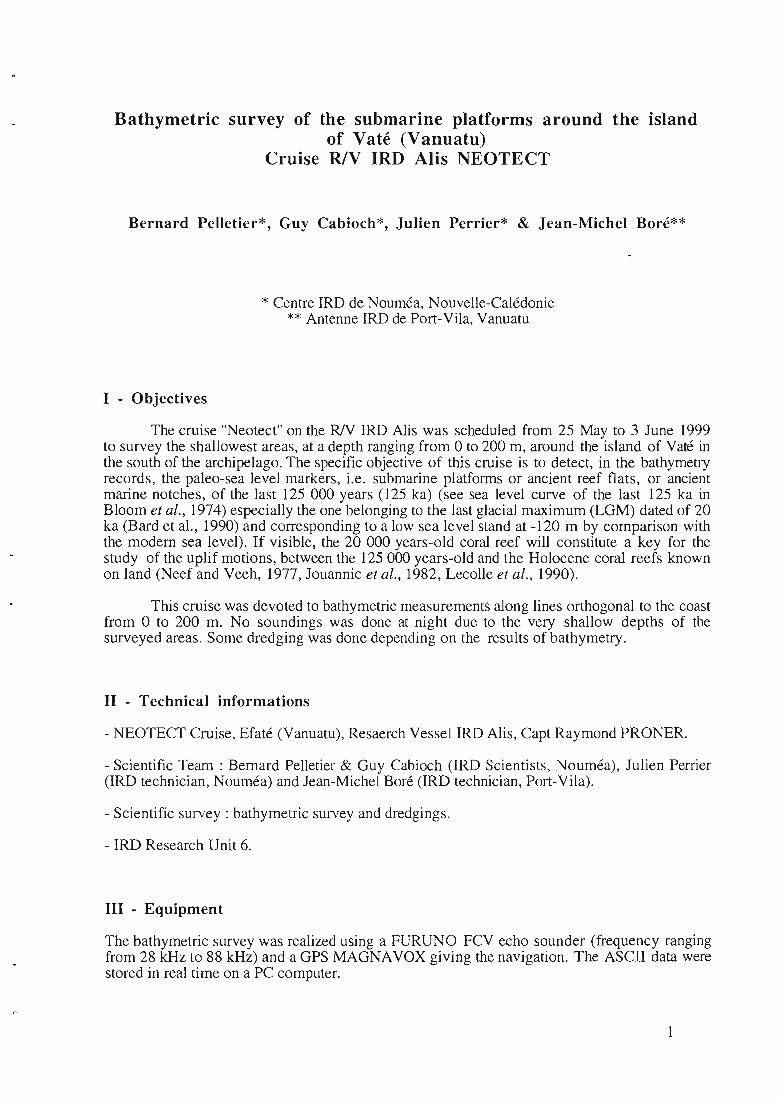
1 - Objectives
The cruise "Neotect" on the RJV IRD Alis was scheduled from 25 May to 3 June 1999to survey the shallowest areas, at a depth ranging from 0 ta 200 m, around the island of Vaté inthe south of the archipelago. The specifie objective of this cruise is to detect, in the bathymetryrecords, the paleo-sea level markers, i.e. submarine platforms or ancient reef flats, or ancientmarine notches, of the last 125 000 years (125 ka) (see sea level curve of the last 125 ka inBloom et al., 1974) especially the one belonging to the last glacial maximum (LGM) dated of 20ka (Bard et al., 1990) and corresponding to a low sea level stand at -120 m by comparison withthe modem sea level). If visible, the 20 000 years-old coral reef will constitute a key for thestudy of the uplif motions, between the 125 000 years-old and the Holocene coral reefs knownon land (Neef and Veeh, 1977, Jouannic et al., 1982, Lecolle et al., 1990).
This cruise was devoted to bathymetric measurements along lines orthogonal to the coastfrom 0 to 200 m. No soundings was done at night due ta the very shallow depths of thesurveyed areas. Sorne dredging was done depending on the results of bathymetry.
II - Technical informations
- NEOTECT Cruise, Efaté (Vanuatu), Resaerch Vessel IRD Alis, Capt Raymond PRONER.
- Scientific Team : Bernard Pelletier & Guy Cabioch (IRD Scientists, Nouméa), Julien Perrier(IRD technician, Nouméa) and Jean-Michel Boré (IRD technician, Port-Vila).
- Scientific survey : bathymetric survey and dredgings.
- IRD Research Unit 6.
III - Equipment
The bathymetric survey was realized using a FURUNO FCV echo sounder (frequency rangingfrom 28 kHz to 88 kHz) and a GPS MAGNAVOX giving the navigation. The ASCII data werestored in real time on a PC computer.

IV • Schedule of the cruise (see figure "schedule of the NEüTECT cruise" in "annexes")
25 May: departure: Nouméa
25-26 May: transit to Port-Vila
27 May: transit to Tukutuk Point and Devil Point
28 May : Tukutuk Point and transit to Port-Havannah
29 May: North-Moso and West-Moso
30 May : North N'Guna and East N'Guna
31 May: East and south coast of Vaté, Pango Point and arrivaI at Port-Vila
1 June: Devil Point
1-3 June: transit to Nouméa
3 June: arrivaI
V • Study areas &dredging operations
VI - 1 - Port-Vila to Devil Point and Tukutuk Point (see figures in "annexes")
TR 1 (from Port-Vila bay to Devil Point and Tukutuk Point) :from 17°45.1135, 168°10.455E to 17°41.0255, 168°10.313E
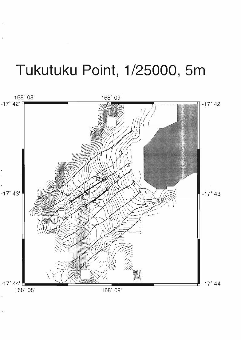
VI - 2 - Tukutuk Point (see figures in "annexes")
Box 1 (Tukutuk Point) : from 17°43.0115, 168°09.683E to 17°42.7895,168°08.897E
Dredging:D 1 (120 / 90 m)D 2 (130 / 150 m)D 3 (120 / 80 m)
TR 2 (from Tukutuk Point to Port-Havannah) : from 17°41.8165,168°08.897E to 17°36.2715. 168°14.584E
VI - 3 - Noth Moso and West Moso (see figures in "annexes")
TR 3 (from Port-Havannah to North Moso) : from 17°36.2495,168°14.578E to 17°32.0195, 168°12.948E
Box 2 (North Moso) : from 17°30.0075, 168°16.570E to 17°29.7225,168°16.476E
Box 3 (West Moso) : from 17°30.5945, 168°14.313E to 17°30.4175,168°13.957E
2
Dredging:D 4 (157 / 100 m)D 5 (123 / 90 m)D 6 (120 / 90 m)D 7 (117 / 90 m)
TR 4 (from West Moso to Port-Havannah) from 17°31.483S,168° 13.042E to 17°36. 162S, 168° 14.570E
VI - 4 - North N'Guna and East N'Guna (see figures in "annexes")
TR 5 (from Port-Havannah to North N'Guna) : from 17°36.162S,168° 14.570E to 17°25.002S, 168° 17.754E
Box 4 (North N'Guna) : from 17°25.002S, 168° 17.754E to 17°24.204S,168° 19.244E
Dredging:D 8 (125 / 102 m)D9(150/107m)
VI - 5 - Emao (see figures in "annexes")
TR 6 (from N'Guna to Emao) : from 17°24.204S, 168°19.244E to17°28.634S, 168°28.001E
Box 5 (West Emao) : from 17°28.634S, 168°28.001E to 1r28.926S,168°25.654E
Dredging:D 10 (125 / 102 m)D Il (150/ 107 m)
Box 6 (Mangea Reefs to North Emao)168°25.654E to 17°29.089S, 168°28.055E
from 17°28.926S,
VI - 6 - East and South coast of Efaté (see figures in "annexes")
TR 7 (from North Emao to Manuro Point): from 1r33.262S,168°3ü.436E to 17°42.514S. 168°36.420E
Box 7 (Manuro Point): from 17°42.512S, 168°36.24 lE to 1r43.260S,168°38.337E
TR 8 (from Manuro Point to Meslep Point) : from 1r43.260S,168°38.337E to 17°48.590S, 168°33.353E
TR 9 (vicinity of the Meslep Point) : from 17°48.590S, 168°33.353Eto 17°49.7üOS, 168°34.284E
TR 10 (from Meslep Point to Narpow Point) : from 1r49.700S,168°34.284E to 17°49.990S, 168°23.351E
TR 11 (vicinity of Narpow Point) : from 17°49.990S, 168°23.351E to17°51.448S, 168°23.282E
3

TR 12 (from Narpow Point to Pango Point) from 17°51.448S,168°23.282E to 1r46.845S, 168° 13.473E
VI . 7 - Pango Point (see figures in "annexes")
Box 8 (Pango Point) : from 17°46.845S, 168° 13.473E to 17°46.609S,168° 14.500E
TR 13 (from Pango Point to Port-Vila bay) : from lr46.609S,168°14.500E to 17°44.312S, 168°18.482E
VI . 8 - Devil Point (see figures in "annexes")
Box 9: from 17°44.252S, 168°18.504E to 17°45.082S, 168°1O.754E
Acknowledgments
We wish to thank the Vanuatu government and the "Service des Mines" for permits towork around Vaté and for their assistance. We would like also thank Michel Lardy (IRD,Port-Vila) for assistance in the cruise preparation and the crew of the RJV !RD Alis and itscaptain R. Proner
References
Bard E., Hamelin B., Fairbanks R.G. & Zindler A.(1990) Calibration of the 14C timescaleover the past 30,000 years using mass spectrometric U=Th ages from Barbados carals.Nature, 345 : 405-410.
Bloom AL, Broecker WS, Chappell JMA, Matthews RK, Mesolella KJ (1974) Quaternary sealevel fluctuations on a tectonic coast: new Th230 / U234 dates from the Huon Peninsula,New Guinea. Quatemary Research, 4: 185-205.
Jouannic c., Taylor F.W. & Bloom A.L. (1982) Sur la surrection et la défOlmation d'un arcjeune : l'arc des Nouvelles-Hébrides. In : Equipe de Géologie et de Géophysique:Contribution a l'étude géodynamique du Sud-Ouest Pacifique. Trav. Doc. ORSTOM, 147: 223-246.
Lecolle J., Bokilo J.E. & Bernat M. (1990) Soulèvement et tectonique de l'île d'Effaté(Vanuatu) arc insulaire des Nouvelles-Hébrides, au cours du Quaternaire récent. Datationsde terrasses soulevées par la méthode UlTh. Marine Ce%gy, 94 : 251-270.
Neef G. & Veeh H.H. (1977) Uranium series ages and late Quaternary uplift in the NewHebrides. Nature, 269 : 682-683.
4

ANNEXES
Schedule of the NEÛTECT crUIse

NEOTECT, R/V Alis, 1999
..
-17 0 30 1
1680
10'
1680
10' 1680
20 1
1680
30 1
1680
30'
1680 40 1
-17 0 30'
-170
401
_17 0 501
1680 40 1
Profiles of Tukutuk Point
Tukutuku Point, 1/25000, 5m
-170
43'
1680
09'-17 0 44'~__~~~~====- c::::========~_17 0 44'
1680
08'
-17" 43'
Profiles of North Moso
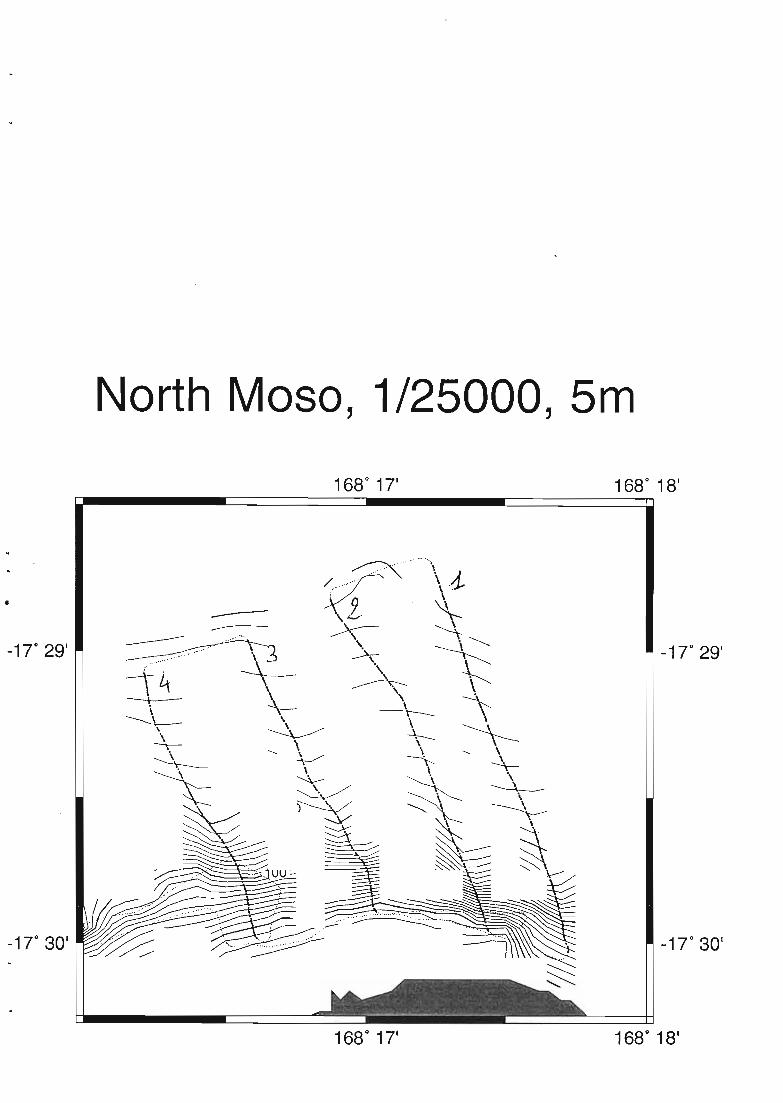
North Moso, 1/25000, 5m
-1T 29 1
---17" 29 1

· ..
Profils 1 ta 4 - North Maso
Cf} 0-17.495
Latitude
ID~ 20+-'
..................
Q) 40
.,
-17.500
E 60
.......
o Cf}
c... ....
20 ~
80
, .. ...
ID
3 2-
-
+-'
~ 100
-- 40 Q)
::J
60 E
Q) 120
1-....
-g 140
80 CQ)
o 160~
100 !oo.....
'+-
120 ::J
e 180
Q)
0... 200
140 "'0C
160 0
-17.495
'+-180 0
Latitude
!oo.....
-17.500200 0...

Profiles of West Moso
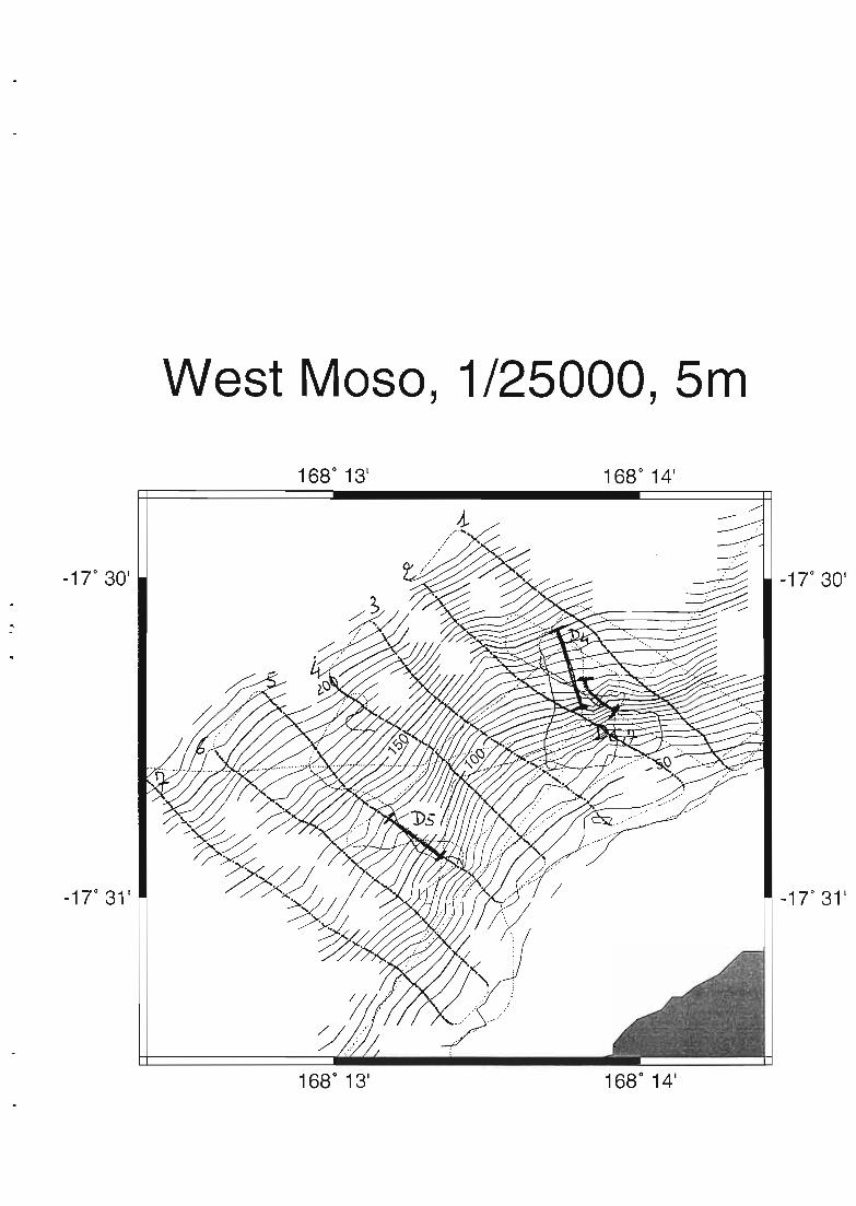
West Maso, 1/25000, 5m
1680
13'
-17 0 31'
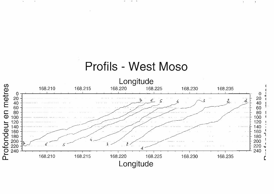
Profils - West MasoCI)
Longitude(
ID 168.210 168.215 168.220 168.225 168.230 168.235 (~ 0 o l
CD 20 ...... ... ....... ... ... .f+.. c ~ i, .:5 L 4 20 ~E 40 40 1
60 ............................................•..•...... 60C 80 80ID 100 100~ 120 120:::J 140 140 .ID 160 160 ~
"'C 180 180 l
C 200 4 200 1
E 220 c- s 3 l 220 ~d-o 240 240 l~
168.220 168.225 168.230 168.235:
0... 168.210 168.215 (
Longitude

Profiles of North N'Guna
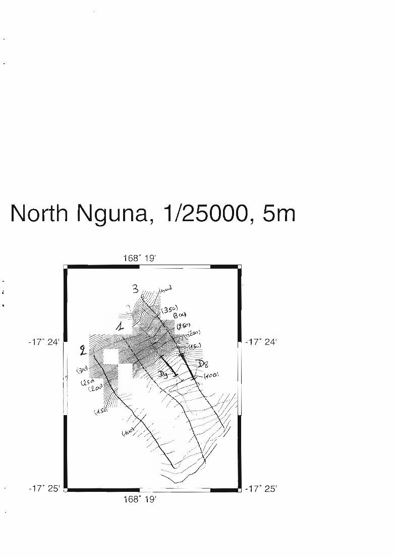
North Nguna, 1/25000, 5m
1680
19'
&
-170
24' -"1 T 24'
-1 T 25' L-. r:::===========.J_.-l -1 7 0 25'168
0
19'

Profiles of West Emao

_17 0 29'
_17 0 30'
West Emao, 1/25000, 5m
1680
26'
_17 0 29'
1680
26'

Profils 1 and 3 - West Emao
-17.475Latitude
-17.480 -17.485 -17.490o 0
20 ~~-~ 2040· .. -- . .. 40
Cf) 60 --------------.---------. -- --- ----------------- .. - ----------- - -............ . ----------------- - . . ------- --- - .. 60 Cf)(1.) 80 . - - -- --- . .. -- -.3 _____..1: 80 (1.)!...... _----00----- !......+J 100 100 +J(1.) 120-- . 120 (1.)E 140 -.,. ----- 140 E160------.-.-.... ..--- --- - - - - - -- -- -- 160
C C(1.) 180··.... 180 (1.)
200 .. . . 200!...... ...-!......$ ~~g . ..•..~........ .•••.••.••.•• ...•.. .. ~~g $
"'0 260 . 260 "'CC 280 280 Co 300 - -~ . . --- -- __ o. - ••• 300 0
*""' 320 320 *""'e 340 340 e0.. ~~g ~~. ..... ~~g 0..
400 ~ .~ . 400420 420
-17.475 -1 7.480 -17.485
Latitude-17.490

Profiles of South Emao

-17" 32'
-17" 3D'
-17" 31'
-17" 29'
168 0 29'1680
28'
. -'?i
~~t
i zn n-17" 33'168 0 3D'168
0
27'
, nil'.
/ /\., ,,: ~ \
/i :\ \~\./ ()
---~,{ \~. /i "'\'! .", \. ', .>'--... ""', / "-
~' ~~~~.,
...~,.
----x-
168 0 26'-17" 33 1
1680
25'
-17" 32'
-17" 3D'
-170
291
-17"31'
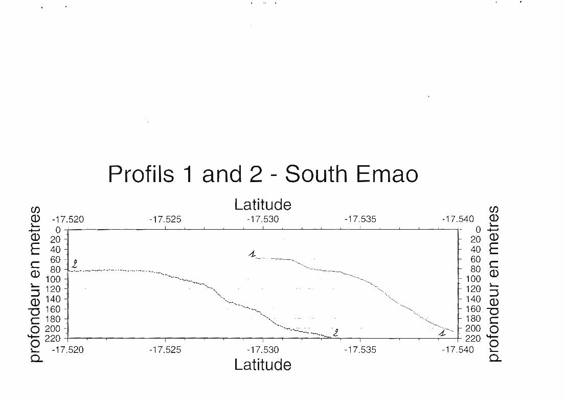
Profils 1 and 2 - South EmaoCf) Latitude Cf)
Q) -17.520 -17.525 -17.530 -17.535 -17.540 Q)~ ~
+-' 0 - O+-'Q) 20 20 Q)
E 40 -1.. 40 Ec 60 i 60 CQ) 80 ----'-'--"- ~. __. 80 Q)
100 100~ 120 120 ~:J 140 140 :J~ 160 160 {gC 180 180 Co2001, 4 200 0
'+- 220 220 '+-o 0~ -17.520 -17.525 -17.530 -17.535 -17.540 ~
Q. Latitude Q.

Profiles along East and South Vaté
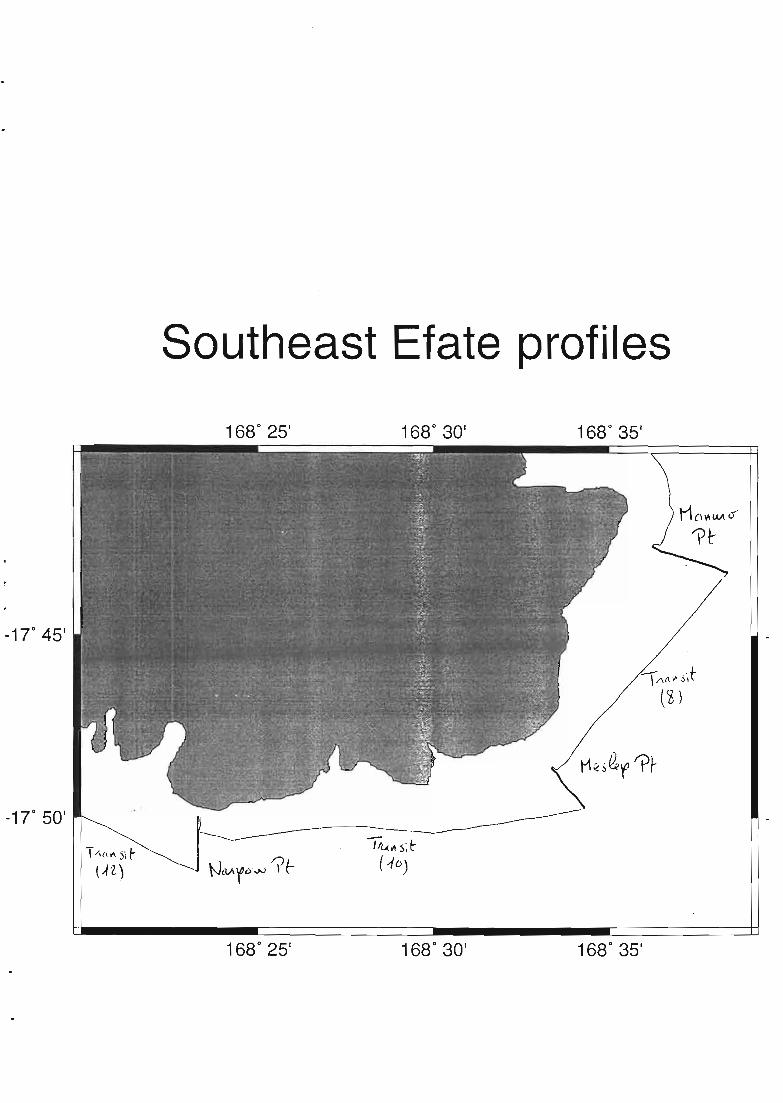
Southeast Efate profiles
-170
45 1
-170
50 1
T/\n"'s,r(A 2.)
1680
25'
1680
25'
1680
30 1
1680
3D'
1680
35 1
1680
35'

East Efate - Manuro PointCf) Longitude Cf)
~ 168.605 168.610 168.615 168.620 168.625 168.630 168.635 ~....... 0 0 +-'
Q) 20 20 Q)
E 40 40 Ec 60 60 CQ) 80 80 Q)~ 100 ·v w. __ •• 100 ~::J 120 ....~.._-~-- 120 ::JQ.) 140 140 Q)'0 160 ~- ~ .._ , 160 "'0C 180 _.- ~.. 180 C0200 ~ 2000of- 220 220 *-e 168.605 168.610 168.615 168.620 168.625 168.630 168.635 eCL Longitude 0...

Cf)
a ~........,<JL)
50 Ec
100 <JL)
SE Efate, Meslep Point ta Manuro PointLongitude
168.60, 1l , ,
Cf) 168.55 "<JL) l ' ,'"- a........,<JL)
E 50
'"-C ~(1) 100 150 (1)
~ ~~ 150 200 C(1) 0~ -C 200 250 2o ~'+-
o 250 168.60~ .~ 168.55 Longitude
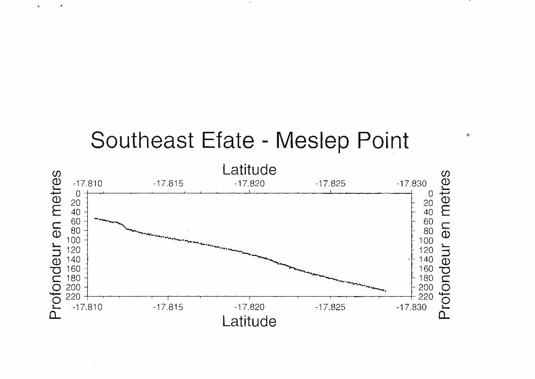
Southeast Efate - Meslep PointCf) Latitude Cf)
~ -17.810 -17.815 -17.820 -17.825 -17.830 ~~ 0 1 1 1 0 ~Q) 20 - f- 20 Q)E 40 - f- 40 Ec 60 - ----..... f- 60 CQ) 80 - --. . f- 80
100 - ------..-..... f- 100 Q)~ - ......- "'-::J 120 - .........~ f- 120 :::JQ) 140 - . ~_ 'f- 140 Q)"0 160 - ~__ f- 160 "0C 180 - --....._.-..., f- 180 Co 200 - ........"'--. f- 200 0o 220 1 1 1 220 0"'- -17.810 -17.815 -17.820 -17.825 -17.830 "'-
a.. Latitude 0..
..
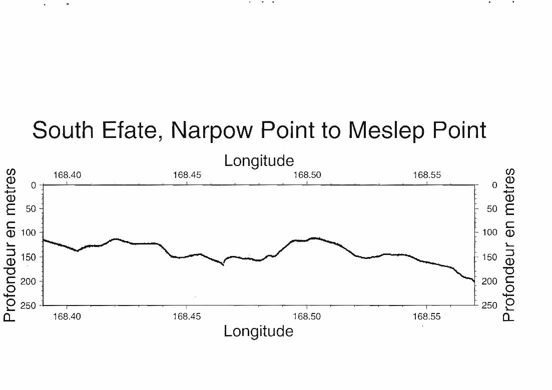
South Efate, Narpow Point to Meslep Point
enLongitude
Cf)168.40 168.45 168.50 168.55Q) a ~!.... a+-' +-'Q) Q)
E 50 50 Ec cQ) 100 100 Q)
!.... !....
:::J 150 150 ::JID. Q)
"0 "'0C 200 200 C0 0*- *-o 250 250 0!.... !....
a... 168.40 168.45 168.50 168.55 a...Longitude
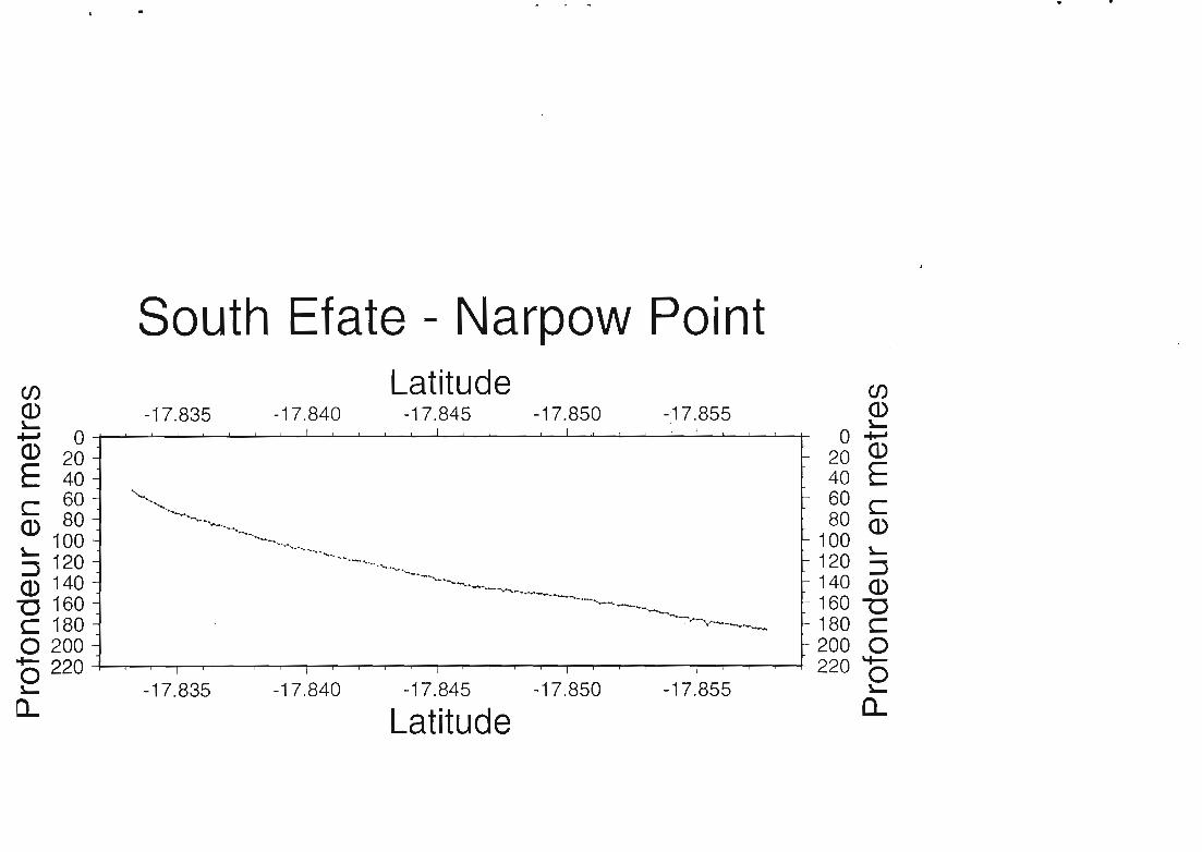
South Efate - Narpow PointCf) Latitude Cf)
~ -17.835 -17.840 -17.845 -17.850 -,17.855 ~of-' 0 0 -+-J
Q) 20 20 Q)
E 40 40 Ec 60 ~ 60 CQ) 80 ~~ 80 Q)~ 100 ..,.,....... 100 !o-
:::J 120 '--.._"......... 120 ::JQ) 140 '---..~ 140 Q)"'C 160 160 "0C 180 180 Co 200 200 0+- 220 220 '+-o 0!o- -17.835 -17.840 -17.845 -17.850 -17.855 !0-
n.. Latitude 0...

South Efate, Pango Point to Narpow PointCf) Longitude Cf)
Q) 168.25 168.30 168.35 Q)~ 50 50 ~Q) 100 100 Q)
E 150 150 EC 200 200 CQ) 250 250 Q)~ ~
~ 300 300 ~
Q) 350 350 Q)
"0 400 400 "0C Co 450 450 0
15 500 500 150= 168.25 168.30 168.35 0=Longitude

Profiles of Pango Point
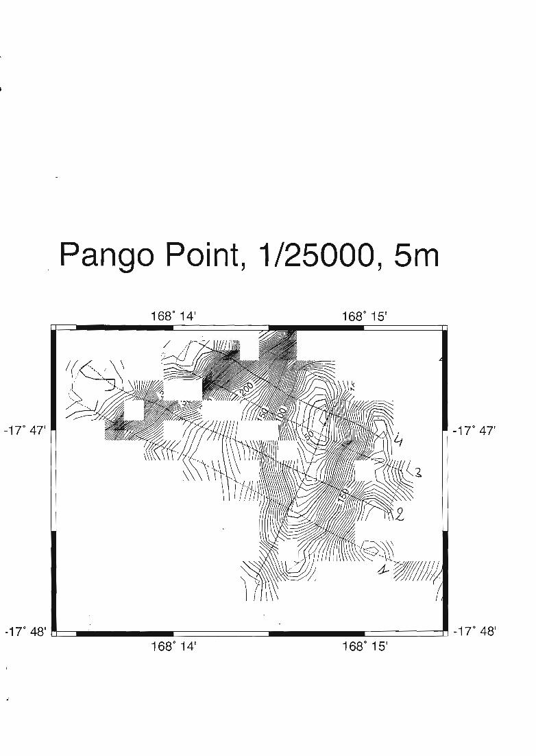
·Pango Point, 1/25000, 5m
1680
14 1 1680
15'
-17°4T -17°4T
_17 0 48\~__============-_-=========~_170
48 1
1680
14' 1680
15'

- . ,. "' "1["
•
Profils - Pango PointLongitude
168.225 168.230 168.235 168.240 168.245 168.2500 0
20 2040 4060 60
Cf) 80 ... ..... . 80 Cf)
Q) 100 100 Q)~ ~
......., 120 120 .......,ID 140 ..r 140 Q)
E 160 160 EC 180 ...... .... .. 180 CQ) 200 ................ 200 Q)~ 220 1.- 220 ~
::::J 240 240 -ID 260 260 ::::J
"'C 280 280 ~C 300 300 Co 320 ..... -... 320 0
'+- 340 - ............ 340 '+-e360 360 ea.. 380 .. " ....... ....." .. - ... ". ....... 380 a..
400 ....... - .............. 400420 420440 440460 460
168.225 168.230 168.235 168.240 168.245 168.250
Longitude
1
Profiles of Devil Point

5000 5m-1 Point 1/2 ,DevI ,
170
46' 1680 10'
•
1680
11'046'-17

, -
Profils - devil Point'tJQS+ ~s+
Longitudeen en168.160 168.165 168.170 168.175 168.180 168.185 168.190Q)
0 o ~~
+-' 20 -...... 20 +-'Q) 40 Q)E 40 .....
60 60 Ec 80 0 80 CQ) 100 100 Q)~ 120 120 ~
::J 140 ....... ..••.• ·.H···· 140 ::JQ) 160 160 Q)o 180 "........ 180 "'0C 200 2- 200 Co 220 220 0o240
0240 '0... . .....•..• ....
~ ~
1- 168.160 168.165 168.170 168.175 168.180 168.185 168.190 0..Longitude

, .,..-
" 1· •
Profil 5 Devil PointenID~ sJ Latitude tJoJR ~
ID -17.760 -17.755 0 EE 0 ··s ~g C20 ~ . IDc 40 ..... 60(J) - .• ' 80 ...60 ~... 80 100 ID~ 100 120 "'0ID 120 .. 140 C"'0 .C 140 .Eo ·17.760 -17.755 eë Latitude D...~
0...
Centre IRD de NouméaB.P, AS Nouméa Cédex, 98848. Nouvelle-Calédonie© IRD2000
---========:::=::==:==:======================~