Embed Size (px)
Citation preview
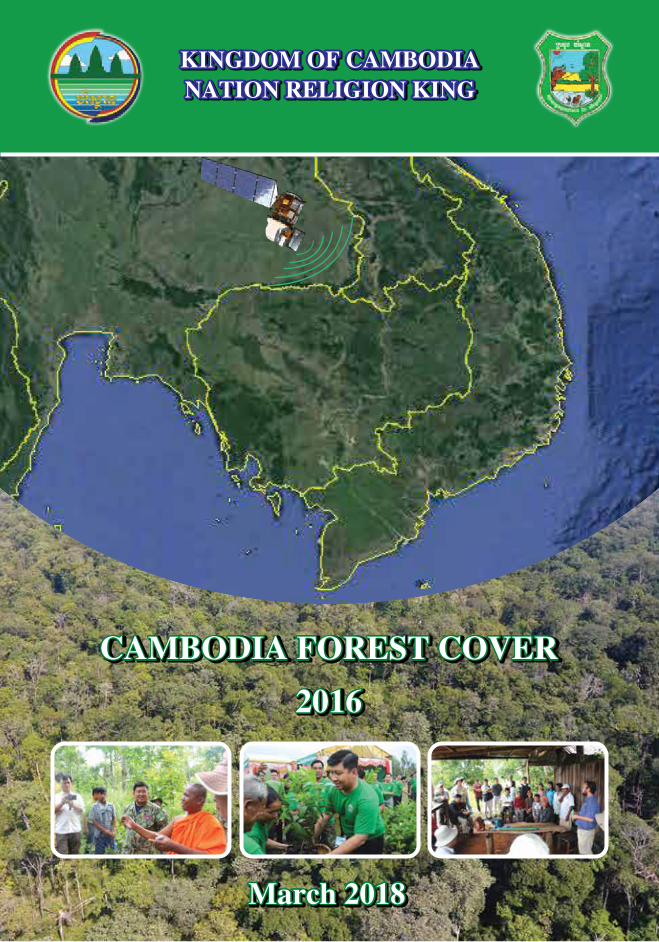
KINGDOM OF CAMBODIANATION RELIGION KING
CAMBODIA FOREST COVER
2016
CAMBODIA FOREST COVER
2016
CAMBODIA FOREST COVER
2016
March 2018March 2018March 2018
KINGDOM OF CAMBODIANATION RELIGION KINGKINGDOM OF CAMBODIANATION RELIGION KING
THE MINISTRY OF ENVIRONMENTGeneral Directorate of Administration for Nature Conservation and Protection
Morodok Techo building no. 503, Sangkat Tonle Bassac,
Khan Chamkarmon, Phnom Penh, Cambodia
For more information, please contact:
Tel: 012 488 339, Email: [email protected]
Tel: 017 955 811, Email: [email protected]
Produced by: Measurement, Reporting and Verification Technical Team
PREFACE Cambodia is rich of natural resources. Forest resources in particular, play important roles in ensuring environmental stability, mitigating climate change, contributing to national economic development and poverty alleviation. At the same time, some major challenges in forestry sector are seen as the concerns of the Royal Government of Cambodia (RGC) as such recent decreasing of forest cover due to higher demand of agricultural land along with gradual population growth, and the agro-economy development. In this context, RGC conducted an in-depth reform in natural resource and environment sector, in fact, exchange of protected forest, conservation areas, production forests, and economic land concessions between Ministry of Environment (MoE) and Ministry of Agriculture, Forestry and Fisheries (MAFF) to aim at strengthening management functions of the two ministries in field of conservation and development, improving effectiveness in environmental protection, biodiversity conservation, and sustainable livelihood. As a result of the above-mentioned reform in its 5th mandate of the RGC, current number of Protected Area (PAs) is increased up to 50 places and a new established biodiversity corridor conservation, together buildup in total area approximately 7.5 million ha, equivalent to 41% of the country territory. Therefore, updating data and information on the country’s forest cover is a need. The primary purpose of this booklet is to provide specific information on the forest cover 2016 of Cambodia, which can be used as a reference in developing plans, formulation of environmental policy, National Protected Area Strategic Management Plan and conservation forest resource, and to provide key activity data for implementation of REDD+ in Cambodia. Information and data represented in this booklet is followed the most recent IPCC’s guideline on transparent, completeness, consistency, and accuracy. This data and information is also an additional source to the 2006-2016 forest cover change dataset of PA system, which was published in last August 2017. On behalf of MoE, I would like to express my high appreciation and congratulations to all management levels of MoE, and particularly to the management of the General Directorate of Administration for Nature Conservation and Protection (GDANCP), the Technical Working Group (TWG) and Development Partners (DPs) for their leadership, efforts, and technical and financial contributions making this publication feasible and available for public. Finally, I would like to declare official launching the booklet for use now.
Phnom Penh, 01 March 2018
SAY Samal
Minister of Environment
i
ACKNOWLEDGEMENT We would like to express our profound thanks to H.E. Say Samal, Minister of Environment, and Excellency, Ladies and Gentlemen, the management of the MoE for their physical, moral and mental efforts to develop the Protected Area (PA) forest resources management, protection and conservation policy and strategic plan. In this sense, the “Cambodia Forest Cover 2016” will play important role in providing data and information to inform the development of sustainable management, protection and conservation plan.
We are the technical team, would like to express our particular thanks to General Directorate of Administration for Nature Conservation and Protection, Ministry of Environment (MoE), Forestry Administration, Ministry of Agriculture, Forestry and Fishery (MAFF) and Development Partners including FAO, Japan International Cooperation Agency (JICA), Forest Carbon Partnership Fund (FCPF) and Forest and Forest Products Research Institute (FFPRI) of Japan for their participation to support for the development of the publication.
We strongly hope that your support through this publication will benefit daily or eventual work of many and provides for a reference for future use. We also would like to express our pleasure and thankful for your meaningful and constructive feedback to mend our shortcomings and for improvement of our further publication in the future.
In conclusion, I wish His Excellency Minister, Excellency, ladies and gentlemen – all the management of the MoE and foreign friends a success and May the four gems of Buddhist blessings – longevity, health, security, and strength – be with you.
ii
1010
iii
1819
2122
iv
ABBREVIATIONS
ACRONYM FULL WORD RGC Royal Government of Cambodia MoE Ministry of Environment MAFF Ministry of Agriculture Forestry and Fishery GDANCP General Directorate of Administrative For Nature Conservation and
Protection FiA Fishery Administration FA Forestry Administration NFP National Forest Programme NFMS National Forest Monitoring System REDD Reducing Emission from Deforestation and Forest Degradation MRV Monitoring Reporting and Verification FRL Forest Reference Level SIS Safeguard Information System FAO Food and Agriculture Organization of the United Nations JICA Japan International Cooperation Agency FCPF Forest Carbon Partnership Facility FFPRI Forestry and Forest Products Research Institute, Japan ITTO International Tropical Tiber Organization MRC Mekong River Commission FRM Forest Resource Management GHG Green House Gas UNFCCC United Nations Framework Convention on Climate Change LU/LC Land Use/Land Cover
v
Cambodia Forest Cover 2016 1 Ministry of Environment
CHAPTER I
General Information
1.1 Introduction
Ministry of Environment (MoE) through technical collaboration with Food and Agriculture Organization of Unit Nation (FAO), Forest Carbon Partnership Facility (FCPF), Japan International Cooperation Agency (JICA) and Forestry and Forest Products Research Institute, Japan (FFPRI) conducted an assessment of Land use/cover using Geographic Information System (GIS) and Remote Sensing (RS) with satellite imageries for every two year assessment. As a result the assessment shows that for the last 2 years the rate of forest cover change would be further reduced depending on how effective of Royal Government of Cambodia (RGC) has made a reform by issuing necessary actions to strengthen sustainable natural resource management including:
1. A review of Economic Land Concessions (ELCs) with a decision to cancel the current development investment principle by some companies;
2. Establishment of a mechanism to prevent and suppression of natural resources offences;
3. Defining separate authority for conservation from development by having protection and conservation forests transferred to MoE and development projects in ELCs to Ministry of Agriculture, Forestry and Fisheries (MAFF);
4. A National Forum on Protection and Conservation of Natural Resources held on 22nd August 2016 and 2017 formed an important mechanism to strengthen partnership between government and relevant stakeholders in natural resource protection and conservation;
5. Circular #05 dated 22nd September 2016 on taking necessary actions on strengthening Natural Resource Management;
6. Strengthening capacity and expanding the number of park rangers to enhance effective patrol and law enforcement in Protected Area (Pas); and
7. Transfer of function and responsibility to sub-national levels to implement Natural Resource management, protection and conservation policy and strategy.
Moreover RGC had expanded the PAs coverage by designation of a number of new PAs making it to a total number of 51 areas covering 7.5 million ha. The assessment of Cambodia Forest Cover 2016 were produced by the National Technical Working group (GDANCP/MoE, FA/MAFF, FiA/MAFF) and technical assessment by an international expert FAO-UNREDD, JICA-CAMREDD and international academic institute.
1
Cambodia Forest Cover 2016 2 Ministry of Environment
1.2 Objectives
The main objectives of the assessment of the forest cover resources is to provide specific information on forest cover resources throughout Cambodia as a source of fundamental information to contribute to development planning and formulation of environmental policy, National Protected Area Strategic Management Plan and conservation forest resource, and to provide key activity data for implementation of Cambodia REDD+.
The assessment has three main objectives:
1. To be update and forest cover map 2016; 2. Assessment land use/cover change 2014-2016 and 2006-2016; and
3. To be use as baseline information for development of Cambodia’s forest resource management strategy and action plan and also for Cambodia REDD+ program implementation.
1.3 Forest Reference Level In accordance with decision 4/CP.15, 1/CP.16, 12/CP.17, 13/CP.19 Cambodia
is submitting on a voluntary basis for consideration by the United Nations Framework Convention on Climate Change (UNFCCC) its initial Forest Reference Level (FRL). The report will provide an overview of the data and methodologies to be transparent, complete, consistent, and accurate, and is guided by the most recent Intergovernmental Panel on Climate Change (IPCC) guidance and guidelines (IPCC, 2003a, 2003b, 2006a, 2006b). The submission of a FRL is exclusively for the purpose of obtaining and receiving result base payment (RBP) from Cambodia’s REDD+ program implementation. Cambodia covers a total area of 181,035 km2. Cambodia is categorized as a least developed, low-income country. Relative peace and stability over the past decade has brought steady economic growth, averaging between 7 and 10 percent since 1998, leading to substantial reductions in poverty, but also increased pressure on Cambodia’s natural resources. Cambodia was able to maintain a relatively high forest cover, with one of the highest levels of forest cover in Southeast Asia. While the current forest cover is still relatively high, Cambodia lost a considerable amount of forest over the last two decades, and the pace of land use and forest conversion has seen acceleration. Cambodia’s initial Forest Reference Level is assessed at 78.953.951 tCO2/year based on the historical average net emission level from 2006 to 2014 (Source: Cambodia Initial Emission Reference, 2016). 2
Cambodia Forest Cover 2016 3 Ministry of Environment
Chapter II
Land use/cover Assessment Methodology
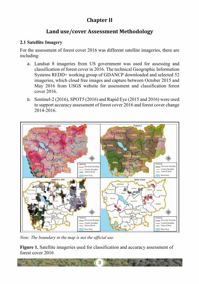
2.1 Satellite Imagery
For the assessment of forest cover 2016 was different satellite imageries, there are including:
a. Landsat 8 imageries from US government was used for assessing and classification of forest cover in 2016. The technical Geographic Information Systems REDD+ working group of GDANCP downloaded and selected 52 imageries, which cloud free images and capture between October 2015 and May 2016 from USGS website for assessment and classification forest cover 2016.
b. Sentinel-2 (2016), SPOT5 (2016) and Rapid Eye (2015 and 2016) were used to support accuracy assessment of forest cover 2016 and forest cover change 2014-2016.
Note: The boundary in the map is not the official use. Figure 1. Satellite imageries used for classification and accuracy assessment of forest cover 2016
3
Cambodia Forest Cover 2016 4 Ministry of Environment
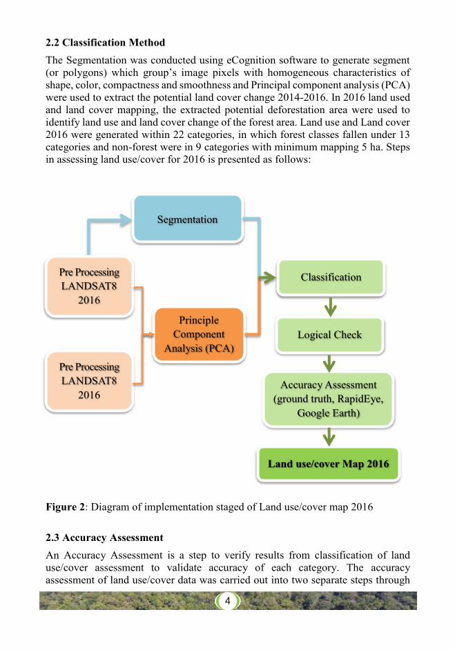
2.2 Classification Method
The Segmentation was conducted using eCognition software to generate segment (or polygons) which group’s image pixels with homogeneous characteristics of shape, color, compactness and smoothness and Principal component analysis (PCA) were used to extract the potential land cover change 2014-2016. In 2016 land used and land cover mapping, the extracted potential deforestation area were used to identify land use and land cover change of the forest area. Land use and Land cover 2016 were generated within 22 categories, in which forest classes fallen under 13 categories and non-forest were in 9 categories with minimum mapping 5 ha. Steps in assessing land use/cover for 2016 is presented as follows: Figure 2: Diagram of implementation staged of Land use/cover map 2016
2.3 Accuracy Assessment An Accuracy Assessment is a step to verify results from classification of land use/cover assessment to validate accuracy of each category. The accuracy assessment of land use/cover data was carried out into two separate steps through
Segmentation
Principle Component
Analysis (PCA)
Pre Processing LANDSAT8
2016
Classification
Land use/cover Map 2016
Logical Check
Accuracy Assessment (ground truth, RapidEye,
Google Earth)
Pre Processing LANDSAT8
2016
4
Cambodia Forest Cover 2016 5 Ministry of Environment
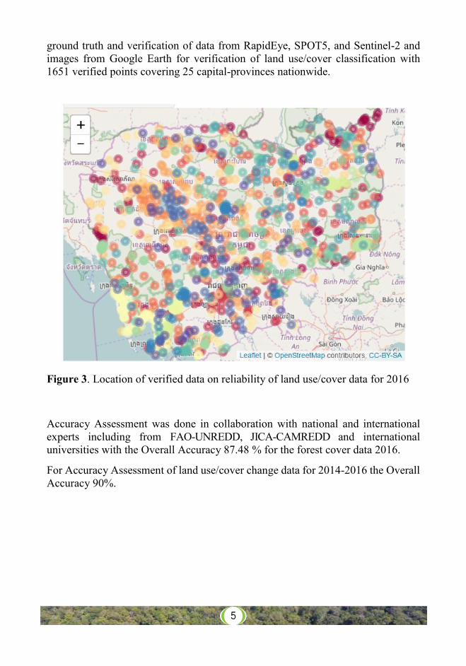
ground truth and verification of data from RapidEye, SPOT5, and Sentinel-2 and images from Google Earth for verification of land use/cover classification with 1651 verified points covering 25 capital-provinces nationwide.
Figure 3. Location of verified data on reliability of land use/cover data for 2016
Accuracy Assessment was done in collaboration with national and international experts including from FAO-UNREDD, JICA-CAMREDD and international universities with the Overall Accuracy 87.48 % for the forest cover data 2016.
For Accuracy Assessment of land use/cover change data for 2014-2016 the Overall Accuracy 90%.
5
Cambodia Forest Cover 2016 6 Ministry of Environment
Chapter III Results of Land use/cover Assessment
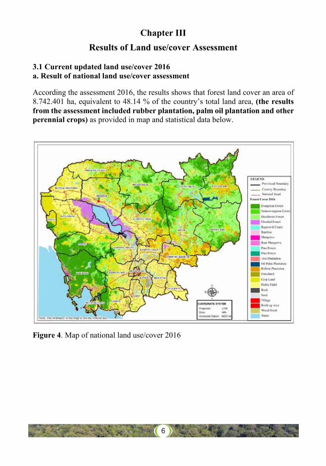
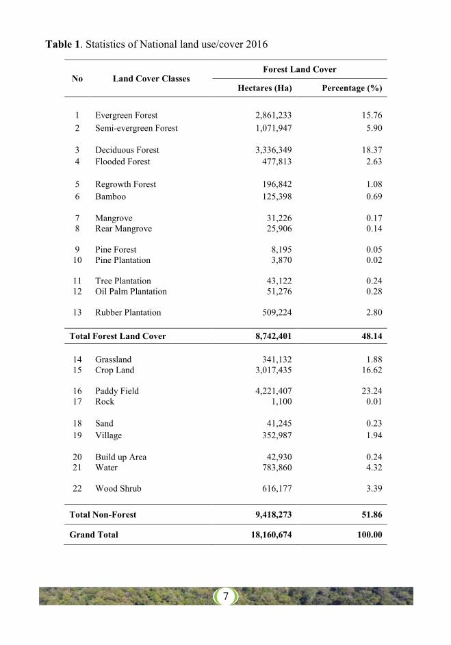
3.1 Current updated land use/cover 2016 a. Result of national land use/cover assessment According the assessment 2016, the results shows that forest land cover an area of 8.742.401 ha, equivalent to 48.14 % of the country’s total land area, (the results from the assessment included rubber plantation, palm oil plantation and other perennial crops) as provided in map and statistical data below.
Figure 4. Map of national land use/cover 2016
6
Cambodia Forest Cover 2016 7 Ministry of Environment
Table 1. Statistics of National land use/cover 2016
No Land Cover Classes Forest Land Cover
Hectares (Ha) Percentage (%)
1 Evergreen Forest 2,861,233 15.76 2 Semi-evergreen Forest 1,071,947 5.90
3 Deciduous Forest 3,336,349 18.37 4 Flooded Forest 477,813 2.63
5 Regrowth Forest 196,842 1.08 6 Bamboo 125,398 0.69
7 Mangrove 31,226 0.17 8 Rear Mangrove 25,906 0.14
9 Pine Forest 8,195 0.05 10 Pine Plantation 3,870 0.02
11 Tree Plantation 43,122 0.24 12 Oil Palm Plantation 51,276 0.28
13 Rubber Plantation 509,224 2.80
Total Forest Land Cover 8,742,401 48.14
14 Grassland 341,132 1.88 15 Crop Land 3,017,435 16.62
16 Paddy Field 4,221,407 23.24 17 Rock 1,100 0.01
18 Sand 41,245 0.23 19 Village 352,987 1.94
20 Build up Area 42,930 0.24 21 Water 783,860 4.32
22 Wood Shrub 616,177 3.39
Total Non-Forest 9,418,273 51.86
Grand Total 18,160,674 100.00
7
Cambodia Forest Cover 2016 8 Ministry of Environment
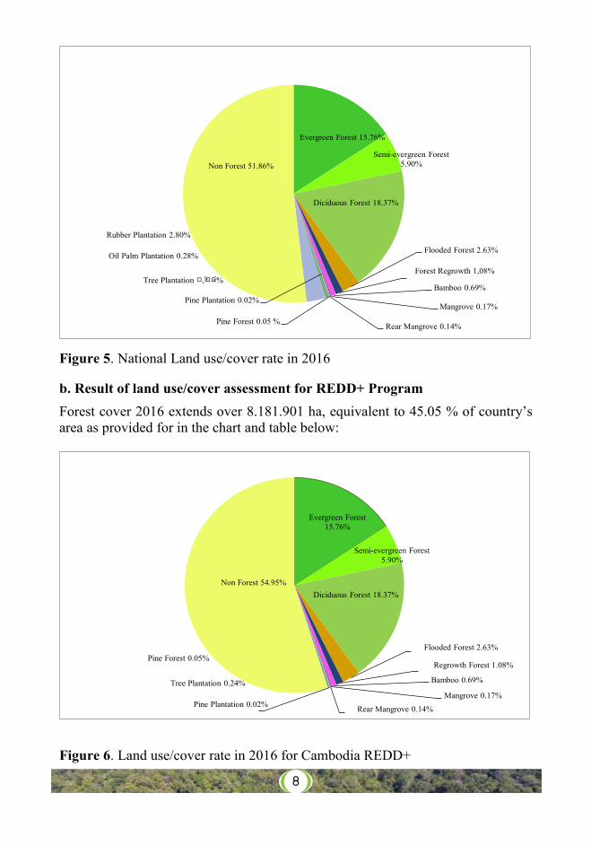
Figure 5. National Land use/cover rate in 2016 b. Result of land use/cover assessment for REDD+ Program Forest cover 2016 extends over 8.181.901 ha, equivalent to 45.05 % of country’s area as provided for in the chart and table below:
Figure 6. Land use/cover rate in 2016 for Cambodia REDD+
Evergreen Forest 15.76%
Semi-evergreen Forest 5.90%
Diciduous Forest 18.37%
Flooded Forest 2.63%
Forest Regrowth 1,08%
Bamboo 0.69%
Mangrove 0.17%
Rear Mangrove 0.14%Pine Forest 0.05 %
Pine Plantation 0.02%
Tree Plantation ០,២៤%
Oil Palm Plantation 0.28%
Rubber Plantation 2.80%
Non Forest 51.86%
Evergreen Forest 15.76%
Semi-evergreen Forest 5.90%
Diciduous Forest 18.37%
Flooded Forest 2.63%
Regrowth Forest 1.08%
Bamboo 0.69%
Mangrove 0.17%
Rear Mangrove 0.14%
Pine Forest 0.05%
Pine Plantation 0.02%
Tree Plantation 0.24%
Non Forest 54.95%
8
Cambodia Forest Cover 2016 1 Ministry of Environment
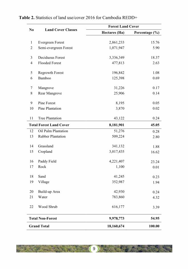
Table 2. Statistics of land use/cover 2016 for Cambodia REDD+
No Land Cover Classes Forest Land Cover
Hectares (Ha) Percentage (%)
1 Evergreen Forest 2,861,233 15.76 2 Semi-evergreen Forest 1,071,947 5.90
3 Deciduous Forest 3,336,349 18.37 4 Flooded Forest 477,813 2.63
5 Regrowth Forest 196,842 1.08 6 Bamboo 125,398 0.69
7 Mangrove 31,226 0.17 8 Rear Mangrove 25,906 0.14
9 Pine Forest 8,195 0.05 10 Pine Plantation 3,870 0.02
11 Tree Plantation 43,122 0.24
Total Forest Land Cover 8,181,901 45.05 12 Oil Palm Plantation 51,276 0.28 13 Rubber Plantation 509,224 2.80
14 Grassland 341,132 1.88 15 Cropland 3,017,435 16.62
16 Paddy Field 4,221,407 23.24 17 Rock 1,100 0.01
18 Sand 41,245 0.23 19 Village 352,987 1.94
20 Build-up Area 42,930 0.24 21 Water 783,860 4.32
22 Wood Shrub 616,177 3.39
Total Non-Forest 9,978,773 54.95
Grand Total 18,160,674 100.00
9
10Cambodia Forest Cover 2016 10 Ministry of Environment
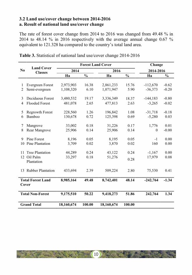
3.2 Land use/cover change between 2014-2016 a. Result of national land use/cover change The rate of forest cover change from 2014 to 2016 was changed from 49.48 % in 2014 to 48.14 % in 2016 respectively with the average annual change 0.67 % equivalent to 121.328 ha compared to the country’s total land area. Table 3. Statistical of national land use/cover change 2014-2016
No Land Cover Classes
Forest Land Cover Change 2014 2016 2014-2016
Ha % Ha % Ha %
1 Evergreen Forest 2,973,903 16.38 2,861,233 15.76 -112,670 -0.62 2 Semi-evergreen 1,108,320 6.10 1,071,947 5.90 -36,373 -0.20
3 Deciduous Forest 3,480,532 19.17 3,336,349 18.37 -144,183 -0.80 4 Flooded Forest 481,078 2.65 477,813 2.63 -3,265 -0.02
5 Regrowth Forest 228,560 1.26 196,842 1.08 -31,718 -0.18 6 Bamboo 130,678 0.72 125,398 0.69 -5,280 0.03
7 Mangrove 33,002 0.18 31,226 0.17 1,776 0.01 8 Rear Mangrove 25,906 0.14 25,906 0.14 0 -0.00
9 Pine Forest 8,196 0.05 8,195 0.05 -1 0.00 10 Pine Plantation 3,709 0.02 3,870 0.02 160 0.00
11 Tree Plantation 44,289 0.24 43,122 0.24 -1,167 0.00 12 Oil Palm
Plantation 33,297 0.18 51,276 0.28 17,979 0.08
13 Rubber Plantation 433,694 2.39 509,224 2.80 75,530 0.41
Total Forest Land Cover
8,985,164 49.48 8,742,401 48.14 -242,764 -1.34
Total Non-Forest 9,175,510 50.22 9,418,273 51.86 242,764 1.34
Grand Total 18,160,674 100.00 18,160,674 100.00
11Cambodia Forest Cover 2016 11 Ministry of Environment
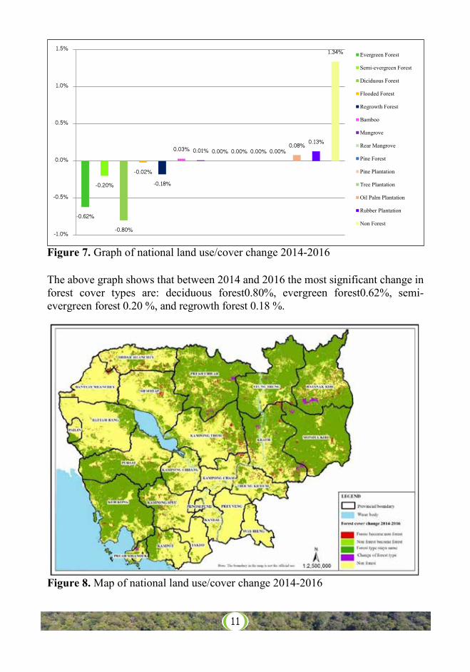
Figure 7. Graph of national land use/cover change 2014-2016
The above graph shows that between 2014 and 2016 the most significant change in forest cover types are: deciduous forest0.80%, evergreen forest0.62%, semi-evergreen forest 0.20 %, and regrowth forest 0.18 %.
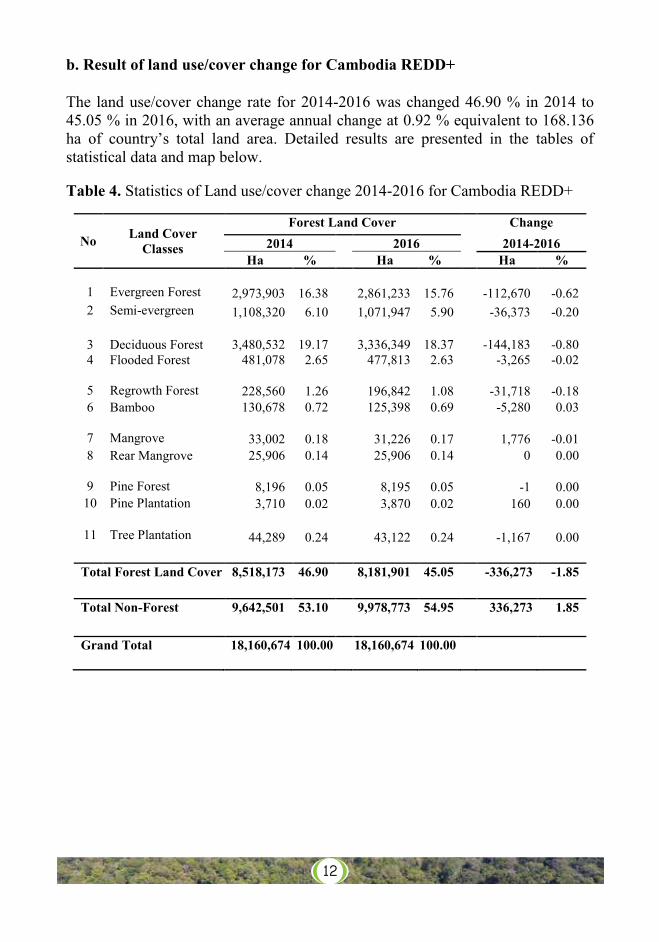
Figure 8. Map of national land use/cover change 2014-2016
-0.62%
-0.20%
-0.80%
-0.02%-0.18%
0.03% 0.01% 0.00% 0.00% 0.00% 0.00%0.08% 0.13%
1.34%
-1.0%
-0.5%
0.0%
0.5%
1.0%
1.5%Evergreen Forest
Semi-evergreen Forest
Diciduous Forest
Flooded Forest
Regrowth Forest
Bamboo
Mangrove
Rear Mangrove
Pine Forest
Pine Plantation
Tree Plantation
Oil Palm Plantation
Rubber Plantation
Non Forest
12Cambodia Forest Cover 2016 12 Ministry of Environment
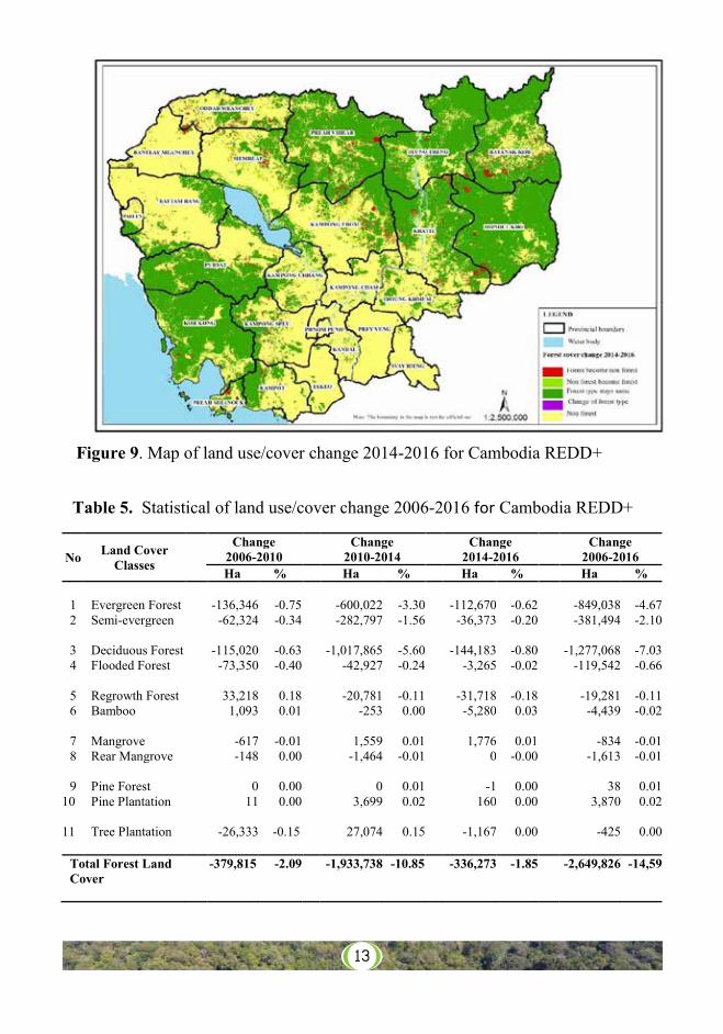
b. Result of land use/cover change for Cambodia REDD+ The land use/cover change rate for 2014-2016 was changed 46.90 % in 2014 to 45.05 % in 2016, with an average annual change at 0.92 % equivalent to 168.136 ha of country’s total land area. Detailed results are presented in the tables of statistical data and map below. Table 4. Statistics of Land use/cover change 2014-2016 for Cambodia REDD+
No Land Cover Classes
Forest Land Cover Change 2014 2016 2014-2016
Ha % Ha % Ha % 1 Evergreen Forest 2,973,903 16.38 2,861,233 15.76 -112,670 -0.62 2 Semi-evergreen 1,108,320 6.10 1,071,947 5.90 -36,373 -0.20
3 Deciduous Forest 3,480,532 19.17 3,336,349 18.37 -144,183 -0.80 4 Flooded Forest 481,078 2.65 477,813 2.63 -3,265 -0.02
5 Regrowth Forest 228,560 1.26 196,842 1.08 -31,718 -0.18 6 Bamboo 130,678 0.72 125,398 0.69 -5,280 0.03
7 Mangrove 33,002 0.18 31,226 0.17 1,776 -0.01 8 Rear Mangrove 25,906 0.14 25,906 0.14 0 0.00
9 Pine Forest 8,196 0.05 8,195 0.05 -1 0.00 10 Pine Plantation 3,710 0.02 3,870 0.02 160 0.00
11 Tree Plantation 44,289 0.24 43,122 0.24 -1,167 0.00
Total Forest Land Cover 8,518,173 46.90 8,181,901 45.05 -336,273 -1.85 Total Non-Forest 9,642,501 53.10 9,978,773 54.95 336,273 1.85 Grand Total 18,160,674 100.00 18,160,674 100.00
13Cambodia Forest Cover 2016 13 Ministry of Environment
Figure 9. Map of land use/cover change 2014-2016 for Cambodia REDD+ Table 5. Statistical of land use/cover change 2006-2016 for Cambodia REDD+
No Land Cover Classes
Change Change Change Change 2006-2010 2010-2014 2014-2016 2006-2016 Ha % Ha % Ha % Ha %
1 Evergreen Forest -136,346 -0.75 -600,022 -3.30 -112,670 -0.62 -849,038 -4.67 2 Semi-evergreen -62,324 -0.34 -282,797 -1.56 -36,373 -0.20 -381,494 -2.10 3 Deciduous Forest -115,020 -0.63 -1,017,865 -5.60 -144,183 -0.80 -1,277,068 -7.03 4 Flooded Forest -73,350 -0.40 -42,927 -0.24 -3,265 -0.02 -119,542 -0.66 5 Regrowth Forest 33,218 0.18 -20,781 -0.11 -31,718 -0.18 -19,281 -0.11 6 Bamboo 1,093 0.01 -253 0.00 -5,280 0.03 -4,439 -0.02 7 Mangrove -617 -0.01 1,559 0.01 1,776 0.01 -834 -0.01 8 Rear Mangrove -148 0.00 -1,464 -0.01 0 -0.00 -1,613 -0.01 9 Pine Forest 0 0.00 0 0.01 -1 0.00 38 0.01
10 Pine Plantation 11 0.00 3,699 0.02 160 0.00 3,870 0.02
11 Tree Plantation -26,333 -0.15 27,074 0.15 -1,167 0.00 -425 0.00 Total Forest Land Cover
-379,815 -2.09 -1,933,738 -10.85 -336,273 -1.85 -2,649,826 -14,59
Cambodia Forest Cover 2016 14 Ministry of Environment
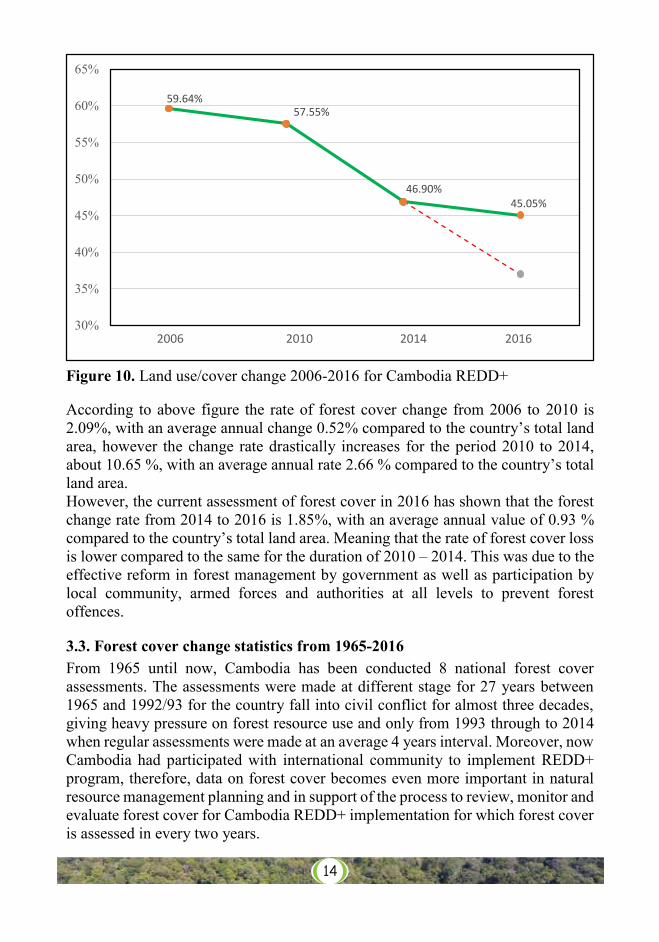
Figure 10. Land use/cover change 2006-2016 for Cambodia REDD+ According to above figure the rate of forest cover change from 2006 to 2010 is 2.09%, with an average annual change 0.52% compared to the country’s total land area, however the change rate drastically increases for the period 2010 to 2014, about 10.65 %, with an average annual rate 2.66 % compared to the country’s total land area. However, the current assessment of forest cover in 2016 has shown that the forest change rate from 2014 to 2016 is 1.85%, with an average annual value of 0.93 % compared to the country’s total land area. Meaning that the rate of forest cover loss is lower compared to the same for the duration of 2010 – 2014. This was due to the effective reform in forest management by government as well as participation by local community, armed forces and authorities at all levels to prevent forest offences.
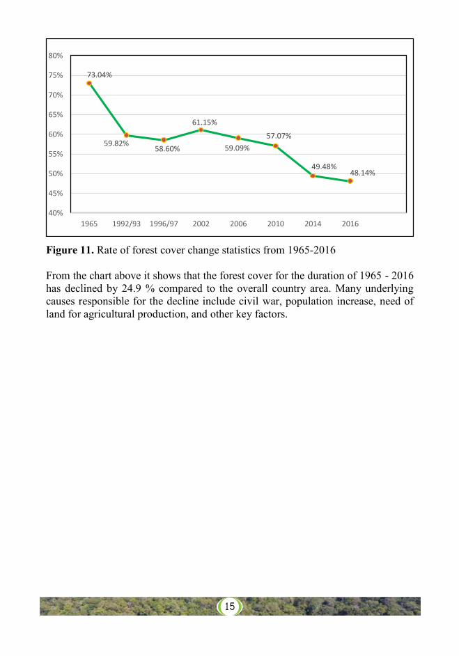
3.3. Forest cover change statistics from 1965-2016 From 1965 until now, Cambodia has been conducted 8 national forest cover assessments. The assessments were made at different stage for 27 years between 1965 and 1992/93 for the country fall into civil conflict for almost three decades, giving heavy pressure on forest resource use and only from 1993 through to 2014 when regular assessments were made at an average 4 years interval. Moreover, now Cambodia had participated with international community to implement REDD+ program, therefore, data on forest cover becomes even more important in natural resource management planning and in support of the process to review, monitor and evaluate forest cover for Cambodia REDD+ implementation for which forest cover is assessed in every two years.
59.64%57.55%
46.90%45.05%
30%
35%
40%
45%
50%
55%
60%
65%
2006 2010 2014 2016
14
Cambodia Forest Cover 2016 15 Ministry of Environment
Figure 11. Rate of forest cover change statistics from 1965-2016 From the chart above it shows that the forest cover for the duration of 1965 - 2016 has declined by 24.9 % compared to the overall country area. Many underlying causes responsible for the decline include civil war, population increase, need of land for agricultural production, and other key factors.
73.04%
59.82%58.60%
61.15%
59.09%57.07%
49.48%48.14%
40%
45%
50%
55%
60%
65%
70%
75%
80%
1965 1992/93 1996/97 2002 2006 2010 2014 2016
15
16
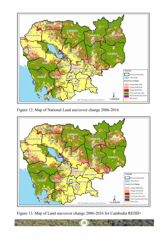
Figure 12: Map of National Land use/cover change 2006-2016
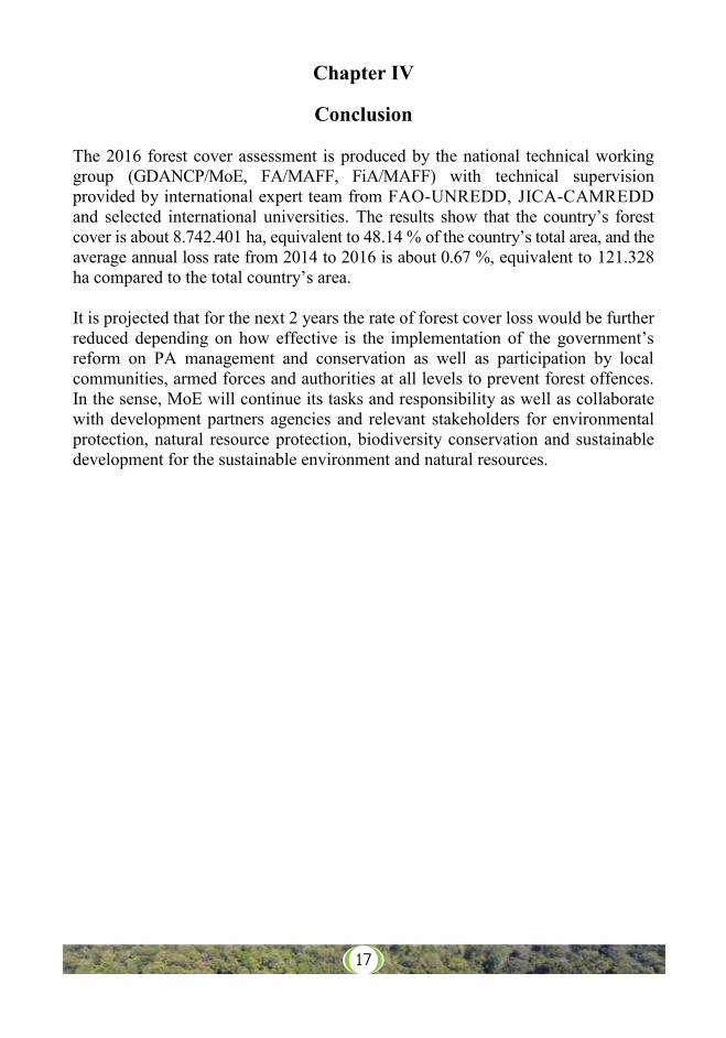
Figure 13. Map of Land use/cover change 2006-2016 for Cambodia REDD+
Cambodia Forest Cover 2016 17 Ministry of Environment
Chapter IV
Conclusion The 2016 forest cover assessment is produced by the national technical working group (GDANCP/MoE, FA/MAFF, FiA/MAFF) with technical supervision provided by international expert team from FAO-UNREDD, JICA-CAMREDD and selected international universities. The results show that the country’s forest cover is about 8.742.401 ha, equivalent to 48.14 % of the country’s total area, and the average annual loss rate from 2014 to 2016 is about 0.67 %, equivalent to 121.328 ha compared to the total country’s area. It is projected that for the next 2 years the rate of forest cover loss would be further reduced depending on how effective is the implementation of the government’s reform on PA management and conservation as well as participation by local communities, armed forces and authorities at all levels to prevent forest offences. In the sense, MoE will continue its tasks and responsibility as well as collaborate with development partners agencies and relevant stakeholders for environmental protection, natural resource protection, biodiversity conservation and sustainable development for the sustainable environment and natural resources.
17
Cambodia Forest Cover 2016 18 Ministry of Environment
Annexes
Annex 1. Definition of Forests National Forest: Forest is the unit of the natural ecosystem or plantation in the forms of wetland, lowland and dry land which covers by natural stands or plantation trees with a height from 5 meters on an area at least 0.5 hectares with a canopy of more than 10 percent. The plantations such as rubber, oil palm, teak, acacia and eucalyptus and other kinds of trees which fall under the above criteria will also be classified as forests. REDD+ Program:
Forest under the REDD+ programme refers to a unit of an ecosystem in the form of wetland and dry land, covered by natural or planted vegetation with height from 5 meters on an area of at least 0.5 hectares, and a canopy crown cover of more than 10%.
Areas also included in the REDD+ programme are forest regrowth and areas under afforestation or reforestation. Rubber, oil palm plantations and perennial crops are excluded from this definition.
18
19Cambodia Forest Cover 2016 19 Ministry of Environment
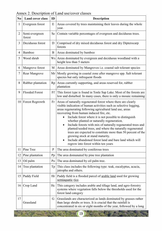
Annex 2. Description of Land use/cover classes No Land cover class ID Description
1 Evergreen forest E Areas covered by trees maintaining their leaves during the whole year.
2 Semi-evergreen forest
Se Contain variable percentages of evergreen and deciduous trees.
3 Deciduous forest D Comprised of dry mixed deciduous forest and dry Dipterocarp forests
4 Bamboo B Areas dominated by bamboo
5 Wood shrub Ws Areas dominated by evergreen and deciduous woodland with a height less than 5 meters
6 Mangrove forest M Areas dominated by Mangroves i.e. coastal salt tolerant species
7 Rear Mangrove Mr Mostly growing in coastal zone after mangrove spp. Salt tolerant species but only infrequent floods
8 Rubber plantation Rp Areas currently supporting, and areas reserved for, rubber plantation
9 Flooded Forest Ff This forest type is found in Tonle Sap Lake. Most of the forests are low and disturbed. In many cases, there is only a mosaic remaining
10 Forest Regrowth Fr Areas of naturally regenerated forest where there are clearly visible indication of human activities such as selective logging, areas regenerating following agricultural land use, areas recovering from human induced fire, etc.
Include forest where it is not possible to distinguish whether planted or naturally regeneration.
Include forests with mix of naturally regenerated trees and planted/seeded trees, and where the naturally regenerated trees are expected to constitute more than 50 percent of the growing stock at stand maturity.
Include abandoned forest land and bare land which will regrow into forest within ten years
11 Pine Tree P The area dominated by coniferous trees
12 Pine plantation Pp The area domunated by pine tree plantation
13 Oil palm Po The area dominated by oil palm tree.
14 Tree plantation Tp This class includes the following type: teak, eucalyptus, acacia, jatropha and others.
15 Paddy Field Hr Paddy field is a flooded parcel of arable land used for growing semiaquatic rice.
16 Crop Land Hc This category includes arable and tillage land, and agro-forestry systems where vegetation falls below the thresholds used for the forest land category
17 Grassland
G Grasslands are characterized as lands dominated by grasses rather than large shrubs or trees. It is crucial that the rainfall is concentrated in six or eight months of the year, followed by a long
20Cambodia Forest Cover 2016 20 Ministry of Environment
period of drought when fires can occur.
18 Built-up area Bu The patch of land with building and construction
19 Village Bt The patch of land with houses and garden surrounding house.
20 Rock R Land of naturally exposed rocks or strip mines, quarries and gravel pits.
21 Sand S In general, land of sand having thin soil or sand including deserts, dry salt flats, beaches, sand dunes.
22 Water W Area of fresh and sea water
21
Annex 3. Provincial Land use/cover statistic 2016
Province
Forest Types Total Non-Forest
(ha)
Grand Total (ha)
Evergreen Forest
Semi-Evergreen
Forest
Deciduous Forest
Other Forest
Total Forest (ha)
Banteay Meanchey 1,460 2,860 9,437 8,051 21,808 593,011 614,819
Battambang 59,483 16,382 20,075 171,573 267,513 919,697 1,187,210
Kampong Cham 658 59 641 50,923 52,281 402,893 455,174
Kampong Chhang 17,319 5,414 71,913 47,018 141,664 387,797 529,461
Kampong Speu 64,587 21,677 130,065 19,178 235,507 460,964 696,471
Kampong Thom 194,251 14,850 45,948 224,640 479,689 765,074 1,244,763
Kampot 125,764 3,924 27,758 4,970 162,416 309,399 471,815
Kandal 0 0 99 14,644 14,743 341,630 356,373
Kep 1,806 9 0 1,201 3,016 12,157 15,173
Koh Kong 839,938 11,632 24,404 95,247 971,221 240,374 1,211,595
Kratie 100,239 95,364 403,055 136,410 735,068 462,237 1,197,305
Mondul Kiri 131,439 212,341 803,665 67,975 1,215,420 151,472 1,366,892
Oddar Meanchey 50,051 18,639 104,912 16,361 189,963 473,202 663,165
Pailin 29,877 1,454 503 510 32,344 75,367 107,711
Phnom Penh 0 0 0 0 0 37,374 37,374
Preah Sihanouk 48,901 2,579 2 29,432 80,914 68,291 149,205
Preah Vihear 211,737 141,836 698,880 42,019 1,094,472 308,615 1,403,087
Prey Veng 19 0 92 1,613 1,724 474,436 476,160
Pursat 440,528 73,157 138,309 75,625 727,619 430,972 1,158,591
Ratanak Kiri 234,776 173,824 334,555 150,763 893,918 284,542 1,178,460
Siemreap 44,662 23,018 117,679 134,358 319,717 734,732 1,054,449
Stung Treng 261,240 252,779 395,117 62,181 971,317 230,344 1,201,661
Svay Rieng 28 0 0 5,189 5,217 281,608 286,825
Takeo 1,916 0 9,115 2,584 13,615 335,428 349,043
Thbang Khmom 554 149 125 108,844 109,672 383,450 493,122
Tonle Sap 0 0 0 1,563 1,563 253,207 254770
Total Area (ha) 2,861,233 1,071,947 3,336,349 1,472,872 8,742,401 9,418,273 18,160,674
Percent (%) 15.76 5.90 18.37 8.11 88.14 51.86 100.00
Cam
bodi
a Fo
rest
Cov
er 2
016
2
2
M
inis
try o
f Env
ironm
ent
Ann
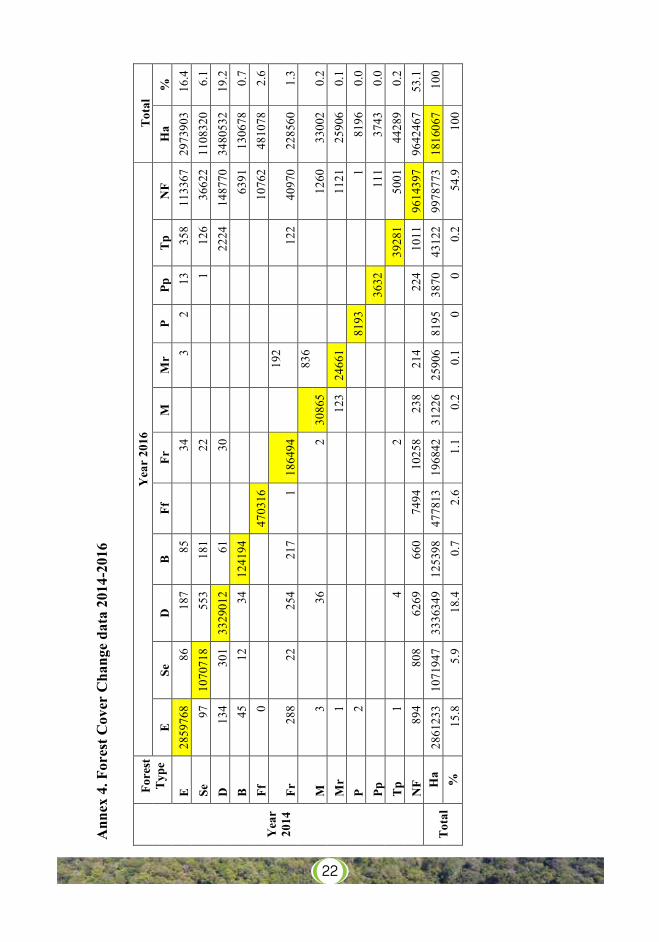
ex 4
. For
est C
over
Cha
nge
data
201
4-20
16
Yea
r 20
14
Fore
st
Typ
e Y
ear
2016
T
otal
E
Se
D
B
Ff
Fr
M
M
r P
Pp
Tp
NF
Ha
%
E
2859
768
86
187
85
34
3 2
13
358
1133
67
2973
903
16.4
Se
97
10
7071
8 55
3 18
1
22
1
126
3662
2 11
0832
0 6.
1 D
13
4 30
1 33
2901
2 61
30
2224
14
8770
34
8053
2 19
.2
B
45
12
34
1241
94
63
91
1306
78
0.7
Ff
0
4703
16
1076
2 48
1078
2.
6
Fr
288
22
254
217
1 18
6494
192
122
4097
0 22
8560
1.
3
M
3
36
2 30
865
836
12
60
3300
2 0.
2 M
r 1
12
3 24
661
11
21
2590
6 0.
1 P
2
8193
1
8196
0.
0 Pp
3632
111
3743
0.
0 T
p 1
4
2
39
281
5001
44
289
0.2
NF
894
808
6269
66
0 74
94
1025
8 23
8 21
4
224
1011
96
1439
7 96
4246
7 53
.1
Tot
al
Ha
2861
233
1071
947
3336
349
1253
98
4778
13
1968
42
3122
6 25
906
8195
38
70
4312
2 99
7877
3 18
1606
7 10
0 %
15
.8
5.9
18.4
0.
7 2.
6 1.
1 0.
2 0.
1 0
0 0.
2 54
.9
100
22
Cambodia Forest Cover 2016 23 Ministry of Environment
References - Ministry of Environment, Land use/cover change in Protected Area from
2006-2016 - Forestry Administration, Cambodia Forest Cover 2014 - Ministry of Environment, Lexicon of Climate Change-2017 - Ministry of Environment, Forest Referent Level 2016
23