Embed Size (px)
Citation preview
California Title 22 Metals
Lab #: 221628 Project#: 1966.001 Client: Fugro West Inc. Location: Breuner's Marsh Field ID: TP-7@5 Diln Fac: 1.000 Lab ID: 221628-011 Sampled: 08/02/10 Matrix: Soil Received: 08/03/10 Units: mg/Kg Prepared: 08/05/10 Basis: as received
Analyte Result RL Batch# Analyzed Prep Analysis Antimony ND 0.50 165623 08/06/10 EPA 3050B EPA 6010B Arsenic 5.4 0.25 165623 08/06/10 EPA 3050B EPA 6010B Barium 120 0.25 165623 08/06/10 EPA 3050B EPA 6010B Beryllium 0.45 0.10 165623 08/06/10 EPA 3050B EPA 6010B Cadmium 0.71 0.25 165623 08/06/10 EPA 3050B EPA 6010B Chromium 29 0.25 165623 08/06/10 EPA 3050B EPA 6010B Cobalt 8.6 0.25 165623 08/06/10 EPA 3050B EPA 6010B Copper 22 0.25 165623 08/09/10 EPA 3050B EPA 6010B Lead 18 0.25 165623 08/06/10 EPA 3050B EPA 6010B Mercury 0.025 0.020 165590 08/05/10 METHOD EPA 7471A Molybdenum 0.57 0.25 165623 08/06/10 EPA 3050B EPA 6010B Nickel 33 0.25 165623 08/06/10 EPA 3050B EPA 6010B Selenium ND 0.50 165623 08/09/10 EPA 3050B EPA 6010B Silver ND 0.25 165623 08/06/10 EPA 3050B EPA 6010B Thallium ND 0.50 165623 08/06/10 EPA 3050B EPA 6010B Vanadium 30 0.25 165623 08/06/10 EPA 3050B EPA 6010B Zinc 51 1.0 165623 08/06/10 EPA 3050B EPA 6010B
ND= Not DetectedRL= Reporting LimitPage 1 of 1 13.1
42 of 50
California Title 22 Metals
Lab #: 221628 Project#: 1966.001 Client: Fugro West Inc. Location: Breuner's Marsh Field ID: [email protected] Basis: as received Lab ID: 221628-012 Sampled: 08/02/10 Matrix: Soil Received: 08/03/10 Units: mg/Kg Prepared: 08/05/10
Analyte Result RL Diln Fac Batch# Analyzed Prep Analysis Antimony ND 0.50 1.000 165623 08/09/10 EPA 3050B EPA 6010B Arsenic 320 0.25 1.000 165623 08/06/10 EPA 3050B EPA 6010B Barium 540 2.3 10.00 165623 08/09/10 EPA 3050B EPA 6010B Beryllium 0.41 0.10 1.000 165623 08/06/10 EPA 3050B EPA 6010B Cadmium 0.93 0.25 1.000 165623 08/06/10 EPA 3050B EPA 6010B Chromium 38 0.25 1.000 165623 08/06/10 EPA 3050B EPA 6010B Cobalt 8.6 0.25 1.000 165623 08/06/10 EPA 3050B EPA 6010B Copper 76 0.25 1.000 165623 08/09/10 EPA 3050B EPA 6010B Lead 150 0.25 1.000 165623 08/06/10 EPA 3050B EPA 6010B Mercury 3.1 0.22 10.00 165590 08/05/10 METHOD EPA 7471A Molybdenum 1.4 0.25 1.000 165623 08/06/10 EPA 3050B EPA 6010B Nickel 41 0.25 1.000 165623 08/06/10 EPA 3050B EPA 6010B Selenium 1.1 0.50 1.000 165623 08/06/10 EPA 3050B EPA 6010B Silver ND 0.25 1.000 165623 08/06/10 EPA 3050B EPA 6010B Thallium ND 0.50 1.000 165623 08/06/10 EPA 3050B EPA 6010B Vanadium 37 0.25 1.000 165623 08/06/10 EPA 3050B EPA 6010B Zinc 210 1.0 1.000 165623 08/06/10 EPA 3050B EPA 6010B
ND= Not DetectedRL= Reporting LimitPage 1 of 1 14.1
43 of 50

California Title 22 Metals
Lab #: 221628 Project#: 1966.001 Client: Fugro West Inc. Location: Breuner's Marsh Field ID: TP-13@2 Basis: as received Lab ID: 221628-013 Sampled: 08/02/10 Matrix: Soil Received: 08/03/10 Units: mg/Kg Prepared: 08/05/10
Analyte Result RL Diln Fac Batch# Analyzed Prep Analysis Antimony 8.2 0.50 1.000 165623 08/06/10 EPA 3050B EPA 6010B Arsenic 1,600 2.4 10.00 165623 08/09/10 EPA 3050B EPA 6010B Barium 200 0.25 1.000 165623 08/06/10 EPA 3050B EPA 6010B Beryllium 0.53 0.10 1.000 165623 08/06/10 EPA 3050B EPA 6010B Cadmium 1.1 0.25 1.000 165623 08/06/10 EPA 3050B EPA 6010B Chromium 43 0.25 1.000 165623 08/06/10 EPA 3050B EPA 6010B Cobalt 10 0.25 1.000 165623 08/06/10 EPA 3050B EPA 6010B Copper 220 0.25 1.000 165623 08/09/10 EPA 3050B EPA 6010B Lead 430 0.25 1.000 165623 08/06/10 EPA 3050B EPA 6010B Mercury 7.8 0.22 10.00 165590 08/05/10 METHOD EPA 7471A Molybdenum 1.1 0.25 1.000 165623 08/06/10 EPA 3050B EPA 6010B Nickel 41 0.25 1.000 165623 08/06/10 EPA 3050B EPA 6010B Selenium 1.9 0.50 1.000 165623 08/06/10 EPA 3050B EPA 6010B Silver 0.34 0.25 1.000 165623 08/09/10 EPA 3050B EPA 6010B Thallium 1.2 0.50 1.000 165623 08/09/10 EPA 3050B EPA 6010B Vanadium 42 0.25 1.000 165623 08/06/10 EPA 3050B EPA 6010B Zinc 370 1.0 1.000 165623 08/06/10 EPA 3050B EPA 6010B
RL= Reporting LimitPage 1 of 1 15.1
44 of 50

Batch QC Report
California Title 22 Metals
Lab #: 221628 Location: Breuner's Marsh Client: Fugro West Inc. Prep: METHOD Project#: 1966.001 Analysis: EPA 7471A Analyte: Mercury Diln Fac: 1.000 Type: BLANK Batch#: 165590 Lab ID: QC554759 Prepared: 08/05/10 Matrix: Soil Analyzed: 08/05/10 Units: mg/Kg
Result RL ND 0.020
ND= Not DetectedRL= Reporting LimitPage 1 of 1 16.0
45 of 50

Batch QC Report
California Title 22 Metals
Lab #: 221628 Location: Breuner's Marsh Client: Fugro West Inc. Prep: METHOD Project#: 1966.001 Analysis: EPA 7471A Analyte: Mercury Batch#: 165590 Matrix: Soil Prepared: 08/05/10 Units: mg/Kg Analyzed: 08/05/10 Diln Fac: 1.000
Type Lab ID Spiked Result %REC Limits RPD LimBS QC554760 0.2500 0.2450 98 80-120 BSD QC554761 0.2500 0.2430 97 80-120 1 20
RPD= Relative Percent DifferencePage 1 of 1 17.0
46 of 50
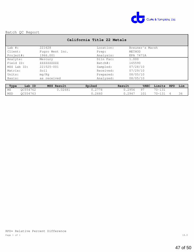
Batch QC Report
California Title 22 Metals
Lab #: 221628 Location: Breuner's Marsh Client: Fugro West Inc. Prep: METHOD Project#: 1966.001 Analysis: EPA 7471A Analyte: Mercury Diln Fac: 1.000 Field ID: ZZZZZZZZZZ Batch#: 165590 MSS Lab ID: 221525-001 Sampled: 07/28/10 Matrix: Soil Received: 07/29/10 Units: mg/Kg Prepared: 08/05/10 Basis: as received Analyzed: 08/05/10
Type Lab ID MSS Result Spiked Result %REC Limits RPD LimMS QC554762 0.02681 0.2778 0.2956 97 70-131 MSD QC554763 0.2660 0.2947 101 70-131 4 36
RPD= Relative Percent DifferencePage 1 of 1 18.0
47 of 50

Batch QC Report
California Title 22 Metals
Lab #: 221628 Location: Breuner's Marsh Client: Fugro West Inc. Prep: EPA 3050B Project#: 1966.001 Analysis: EPA 6010B Type: BLANK Diln Fac: 1.000 Lab ID: QC554890 Batch#: 165623 Matrix: Soil Prepared: 08/05/10 Units: mg/Kg
Analyte Result RL Analyzed Antimony ND 0.50 08/06/10 Arsenic ND 0.25 08/06/10 Barium ND 0.25 08/06/10 Beryllium ND 0.10 08/06/10 Cadmium ND 0.25 08/06/10 Chromium ND 0.25 08/06/10 Cobalt ND 0.25 08/06/10 Copper ND 0.26 08/09/10 Lead ND 0.25 08/06/10 Molybdenum ND 0.25 08/06/10 Nickel ND 0.25 08/06/10 Selenium ND 0.50 08/06/10 Silver ND 0.25 08/06/10 Thallium ND 0.50 08/06/10 Vanadium ND 0.25 08/06/10 Zinc ND 1.0 08/06/10
ND= Not DetectedRL= Reporting LimitPage 1 of 1 28.1
48 of 50

Batch QC Report
California Title 22 Metals
Lab #: 221628 Location: Breuner's Marsh Client: Fugro West Inc. Prep: EPA 3050B Project#: 1966.001 Analysis: EPA 6010B Matrix: Soil Batch#: 165623 Units: mg/Kg Prepared: 08/05/10 Diln Fac: 1.000 Analyzed: 08/06/10
Type: BS Lab ID: QC554891
Analyte Spiked Result %REC Limits Antimony 100.0 96.11 96 80-120 Arsenic 50.00 49.51 99 80-120 Barium 100.0 100.2 100 80-120 Beryllium 2.500 2.562 102 80-120 Cadmium 10.00 10.03 100 80-120 Chromium 100.0 98.29 98 80-120 Cobalt 25.00 24.12 96 80-120 Copper 12.50 12.47 100 80-120 Lead 100.0 96.37 96 80-120 Molybdenum 20.00 19.60 98 80-120 Nickel 25.00 24.14 97 80-120 Selenium 50.00 47.76 96 80-120 Silver 10.00 9.933 99 80-120 Thallium 50.00 49.17 98 80-120 Vanadium 25.00 24.86 99 80-120 Zinc 25.00 24.16 97 80-120
Type: BSD Lab ID: QC554892
Analyte Spiked Result %REC Limits RPD LimAntimony 100.0 98.23 98 80-120 2 20 Arsenic 50.00 50.39 101 80-120 2 20 Barium 100.0 101.1 101 80-120 1 20 Beryllium 2.500 2.603 104 80-120 2 20 Cadmium 10.00 10.22 102 80-120 2 20 Chromium 100.0 99.48 99 80-120 1 20 Cobalt 25.00 24.58 98 80-120 2 20 Copper 12.50 12.61 101 80-120 1 20 Lead 100.0 98.31 98 80-120 2 25 Molybdenum 20.00 19.98 100 80-120 2 20 Nickel 25.00 24.60 98 80-120 2 20 Selenium 50.00 48.97 98 80-120 2 20 Silver 10.00 9.959 100 80-120 0 20 Thallium 50.00 50.22 100 80-120 2 21 Vanadium 25.00 25.14 101 80-120 1 20 Zinc 25.00 24.50 98 80-120 1 20
RPD= Relative Percent DifferencePage 1 of 1 29.0
49 of 50
Batch QC Report
California Title 22 Metals
Lab #: 221628 Location: Breuner's Marsh Client: Fugro West Inc. Prep: EPA 3050B Project#: 1966.001 Analysis: EPA 6010B Field ID: [email protected] Batch#: 165623 MSS Lab ID: 221628-001 Sampled: 08/02/10 Matrix: Soil Received: 08/03/10 Units: mg/Kg Prepared: 08/05/10 Basis: as received Analyzed: 08/06/10 Diln Fac: 1.000
Type: MS Lab ID: QC554893
Analyte MSS Result Spiked Result %REC Limits Antimony ND 96.15 44.98 47 7-120 Arsenic 4.998 48.08 46.44 86 65-120 Barium 149.1 96.15 212.7 66 47-139 Beryllium 0.5429 2.404 2.779 93 68-122 Cadmium 0.2452 9.615 8.656 87 63-120 Chromium 36.45 96.15 123.5 91 54-125 Cobalt 8.963 24.04 29.40 85 50-124 Copper 30.62 12.02 43.78 110 36-154 Lead 42.87 96.15 125.9 86 51-125 Molybdenum 0.6865 19.23 16.37 82 62-120 Nickel 36.44 24.04 59.90 98 41-142 Selenium 1.082 48.08 42.41 86 63-120 Silver <0.03909 9.615 8.972 93 65-120 Thallium <0.1598 48.08 40.50 84 53-120 Vanadium 40.28 24.04 66.68 110 48-140 Zinc 76.06 24.04 102.5 110 30-154
Type: MSD Lab ID: QC554894
Analyte Spiked Result %REC Limits RPD LimAntimony 95.24 45.52 48 7-120 2 41 Arsenic 47.62 46.81 88 65-120 2 38 Barium 95.24 189.6 42 * 47-139 11 47 Beryllium 2.381 2.613 87 68-122 5 28 Cadmium 9.524 8.657 88 63-120 1 29 Chromium 95.24 113.4 81 54-125 8 40 Cobalt 23.81 28.78 83 50-124 1 41 Copper 11.90 38.43 66 36-154 13 46 Lead 95.24 120.5 82 51-125 4 52 Molybdenum 19.05 16.40 83 62-120 1 25 Nickel 23.81 52.27 66 41-142 13 44 Selenium 47.62 42.45 87 63-120 1 31 Silver 9.524 8.889 93 65-120 0 29 Thallium 47.62 40.29 85 53-120 0 28 Vanadium 23.81 55.51 64 48-140 18 39 Zinc 23.81 88.62 53 30-154 14 50
*= Value outside of QC limits; see narrativeND= Not DetectedRPD= Relative Percent DifferencePage 1 of 1 30.1
50 of 50


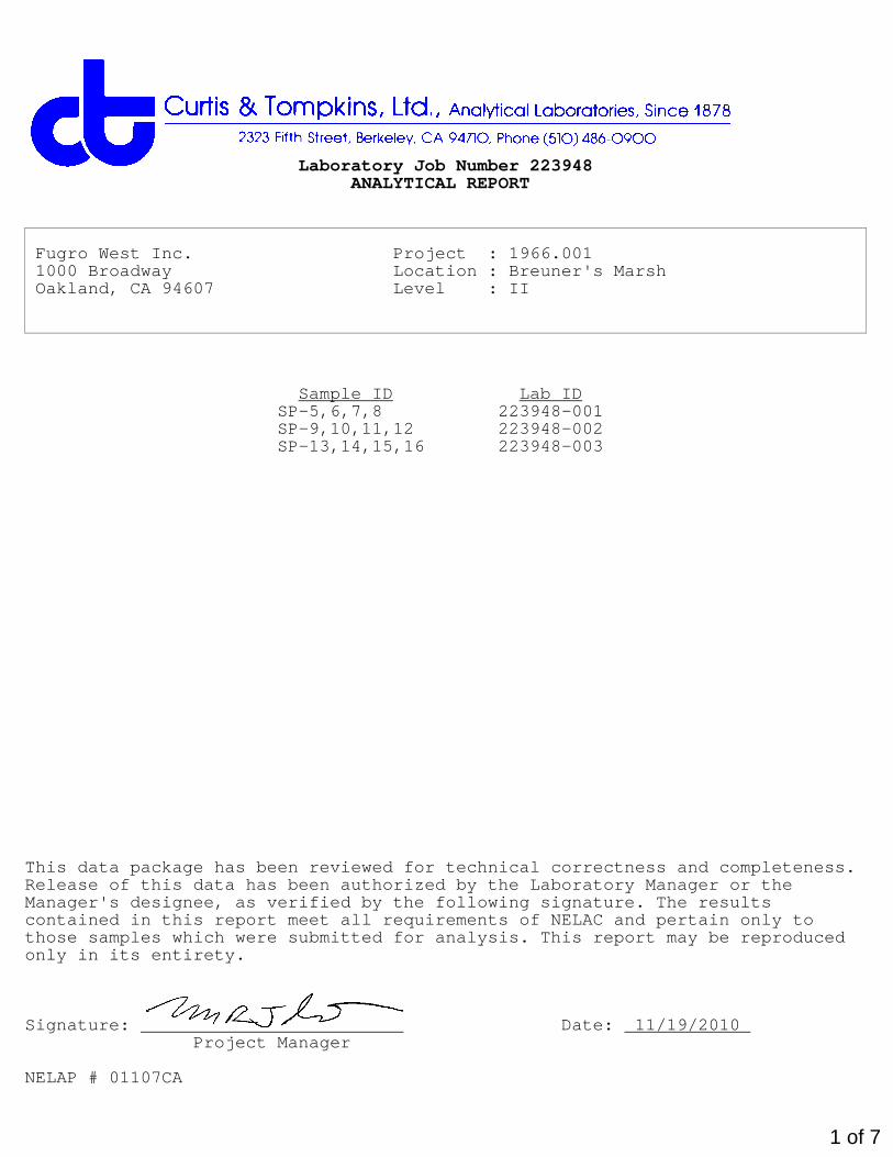
Laboratory Job Number 223761ANALYTICAL REPORT
Fugro West Inc. Project : 1966.001 1000 Broadway Location : Breuner's Marsh Oakland, CA 94607 Level : II
Sample ID Lab IDSP-5@2' 223761-001SP-6@1' 223761-002SP-7@4' [email protected]' [email protected]' [email protected]' 223761-006SP-11@1' [email protected]' 223761-008SP-13@2' [email protected]' 223761-010SP-15@1' [email protected]' 223761-012TP-14@2' 223761-013TP-15@1' [email protected]' [email protected]' 223761-016TP-18@1' [email protected]' 223761-018SP-5,6,7,8 223761-019SP-9,10,11,12 223761-020SP-13,14,15,16 223761-021
This data package has been reviewed for technical correctness and completeness.Release of this data has been authorized by the Laboratory Manager or theManager's designee, as verified by the following signature. The resultscontained in this report meet all requirements of NELAC and pertain only tothose samples which were submitted for analysis. This report may be reproducedonly in its entirety.
Signature: Date: 11/11/2010 Project Manager
NELAP # 01107CA
1 of 37
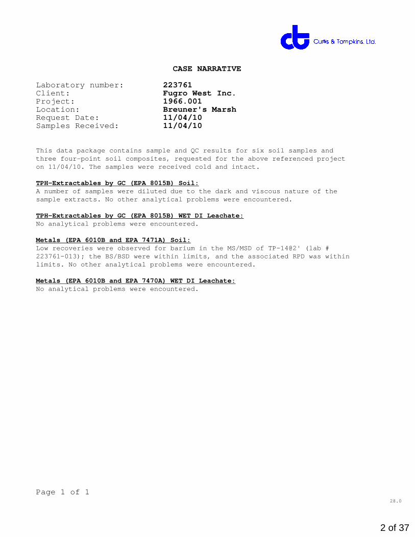
CASE NARRATIVE
Laboratory number: 223761Client: Fugro West Inc.Project: 1966.001Location: Breuner's MarshRequest Date: 11/04/10Samples Received: 11/04/10
This data package contains sample and QC results for six soil samples andthree four-point soil composites, requested for the above referenced projecton 11/04/10. The samples were received cold and intact.
TPH-Extractables by GC (EPA 8015B) Soil:A number of samples were diluted due to the dark and viscous nature of thesample extracts. No other analytical problems were encountered.
TPH-Extractables by GC (EPA 8015B) WET DI Leachate:No analytical problems were encountered.
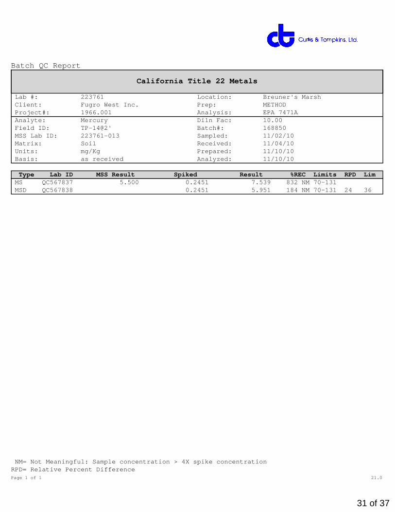
Metals (EPA 6010B and EPA 7471A) Soil:Low recoveries were observed for barium in the MS/MSD of TP-14@2' (lab #223761-013); the BS/BSD were within limits, and the associated RPD was withinlimits. No other analytical problems were encountered.
Metals (EPA 6010B and EPA 7470A) WET DI Leachate:No analytical problems were encountered.
Page 1 of 128.0
2 of 37
3 of 37
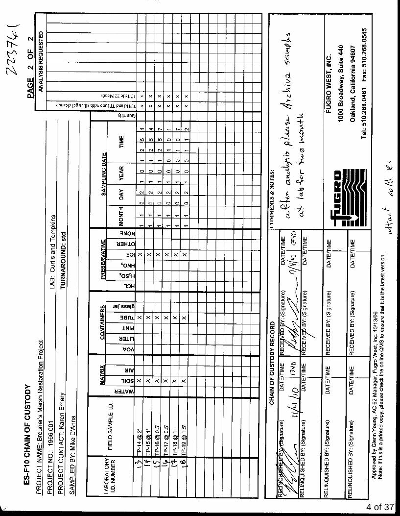
4 of 37

5 of 37

Total Extractable Hydrocarbons
Lab #: 223761 Location: Breuner's Marsh Client: Fugro West Inc. Prep: EPA 3550B Project#: 1966.001 Analysis: EPA 8015B Matrix: Soil Sampled: 11/02/10 Units: mg/Kg Received: 11/04/10 Basis: as received Prepared: 11/08/10 Batch#: 168767 Analyzed: 11/09/10
Field ID: TP-14@2' Diln Fac: 5.000 Type: SAMPLE Cleanup Method: EPA 3630C Lab ID: 223761-013
Analyte Result RL Diesel C10-C24 51 Y 5.0 Motor Oil C24-C36 230 25
Surrogate %REC Limits o-Terphenyl 84 45-130
Field ID: TP-15@1' Diln Fac: 5.000 Type: SAMPLE Cleanup Method: EPA 3630C Lab ID: 223761-014
Analyte Result RL Diesel C10-C24 38 5.0 Motor Oil C24-C36 250 25
Surrogate %REC Limits o-Terphenyl 95 45-130
Field ID: [email protected]' Diln Fac: 1.000 Type: SAMPLE Cleanup Method: EPA 3630C Lab ID: 223761-015
Analyte Result RL Diesel C10-C24 6.6 Y 1.0 Motor Oil C24-C36 34 5.0
Surrogate %REC Limits o-Terphenyl 91 45-130
Field ID: [email protected]' Diln Fac: 5.000 Type: SAMPLE Cleanup Method: EPA 3630C Lab ID: 223761-016
Analyte Result RL Diesel C10-C24 53 Y 5.0 Motor Oil C24-C36 360 25
Surrogate %REC Limits o-Terphenyl 105 45-130
Y= Sample exhibits chromatographic pattern which does not resemble standardND= Not DetectedRL= Reporting LimitPage 1 of 2 15.0
6 of 37
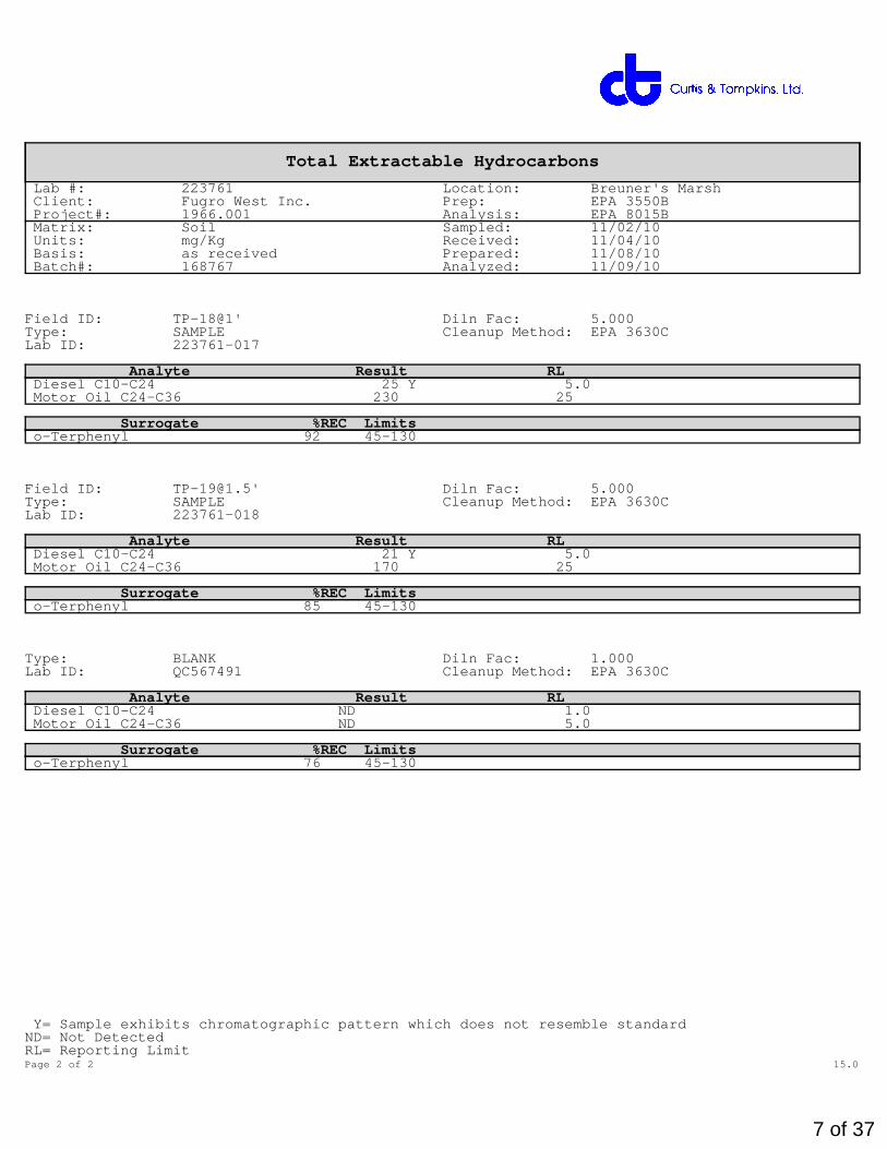
Total Extractable Hydrocarbons
Lab #: 223761 Location: Breuner's Marsh Client: Fugro West Inc. Prep: EPA 3550B Project#: 1966.001 Analysis: EPA 8015B Matrix: Soil Sampled: 11/02/10 Units: mg/Kg Received: 11/04/10 Basis: as received Prepared: 11/08/10 Batch#: 168767 Analyzed: 11/09/10
Field ID: TP-18@1' Diln Fac: 5.000 Type: SAMPLE Cleanup Method: EPA 3630C Lab ID: 223761-017
Analyte Result RL Diesel C10-C24 25 Y 5.0 Motor Oil C24-C36 230 25
Surrogate %REC Limits o-Terphenyl 92 45-130
Field ID: [email protected]' Diln Fac: 5.000 Type: SAMPLE Cleanup Method: EPA 3630C Lab ID: 223761-018
Analyte Result RL Diesel C10-C24 21 Y 5.0 Motor Oil C24-C36 170 25
Surrogate %REC Limits o-Terphenyl 85 45-130
Type: BLANK Diln Fac: 1.000 Lab ID: QC567491 Cleanup Method: EPA 3630C
Analyte Result RL Diesel C10-C24 ND 1.0 Motor Oil C24-C36 ND 5.0
Surrogate %REC Limits o-Terphenyl 76 45-130
Y= Sample exhibits chromatographic pattern which does not resemble standardND= Not DetectedRL= Reporting LimitPage 2 of 2 15.0
7 of 37
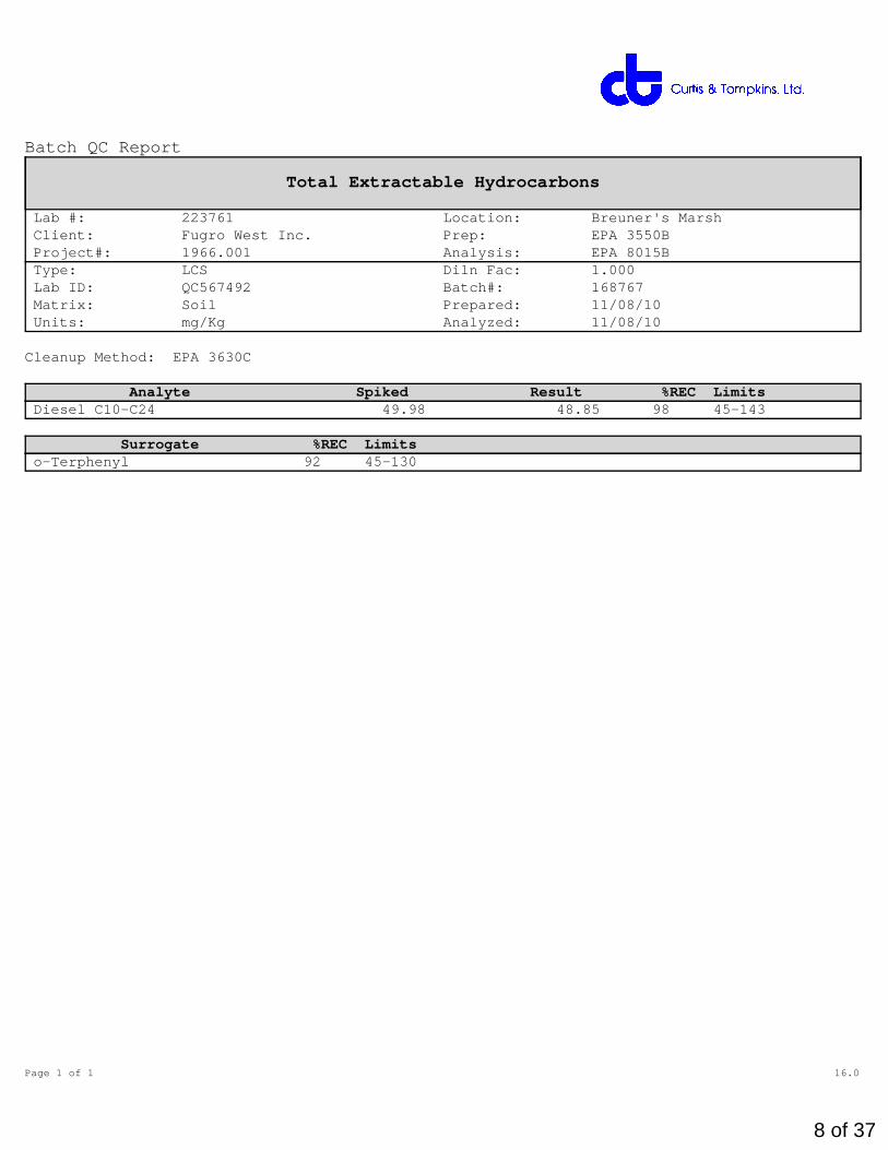
Batch QC Report
Total Extractable Hydrocarbons
Lab #: 223761 Location: Breuner's Marsh Client: Fugro West Inc. Prep: EPA 3550B Project#: 1966.001 Analysis: EPA 8015B Type: LCS Diln Fac: 1.000 Lab ID: QC567492 Batch#: 168767 Matrix: Soil Prepared: 11/08/10 Units: mg/Kg Analyzed: 11/08/10
Cleanup Method: EPA 3630C
Analyte Spiked Result %REC Limits Diesel C10-C24 49.98 48.85 98 45-143
Surrogate %REC Limits o-Terphenyl 92 45-130
Page 1 of 1 16.0
8 of 37

Batch QC Report
Total Extractable Hydrocarbons
Lab #: 223761 Location: Breuner's Marsh Client: Fugro West Inc. Prep: EPA 3550B Project#: 1966.001 Analysis: EPA 8015B Field ID: ZZZZZZZZZZ Diln Fac: 1.000 MSS Lab ID: 223757-002 Batch#: 168767 Matrix: Soil Sampled: 11/05/10 Units: mg/Kg Received: 11/05/10 Basis: as received Prepared: 11/08/10
Type: MS Analyzed: 11/08/10 Lab ID: QC567494 Cleanup Method: EPA 3630C
Analyte MSS Result Spiked Result %REC Limits Diesel C10-C24 23.88 49.82 80.66 114 32-142
Surrogate %REC Limits o-Terphenyl 83 45-130
Type: MSD Analyzed: 11/09/10 Lab ID: QC567495 Cleanup Method: EPA 3630C
Analyte Spiked Result %REC Limits RPD LimDiesel C10-C24 49.98 92.96 138 32-142 14 55
Surrogate %REC Limits o-Terphenyl 94 45-130
RPD= Relative Percent DifferencePage 1 of 1 17.0
9 of 37

Minutes0 1 2 3 4 5 6 7 8 9 10 11 12 13 14 15 16 17 18 19 20
0
100
200
0
100
200
300
400
500
600
700
800
900
1000
\\Lims\gdrive\ezchrom\Projects\GC17A\Data\313a008, A
10 of 37
Minutes0 1 2 3 4 5 6 7 8 9 10 11 12 13 14 15 16 17 18 19 20
0
100
200
0
100
200
300
400
500
600
700
800
900
1000
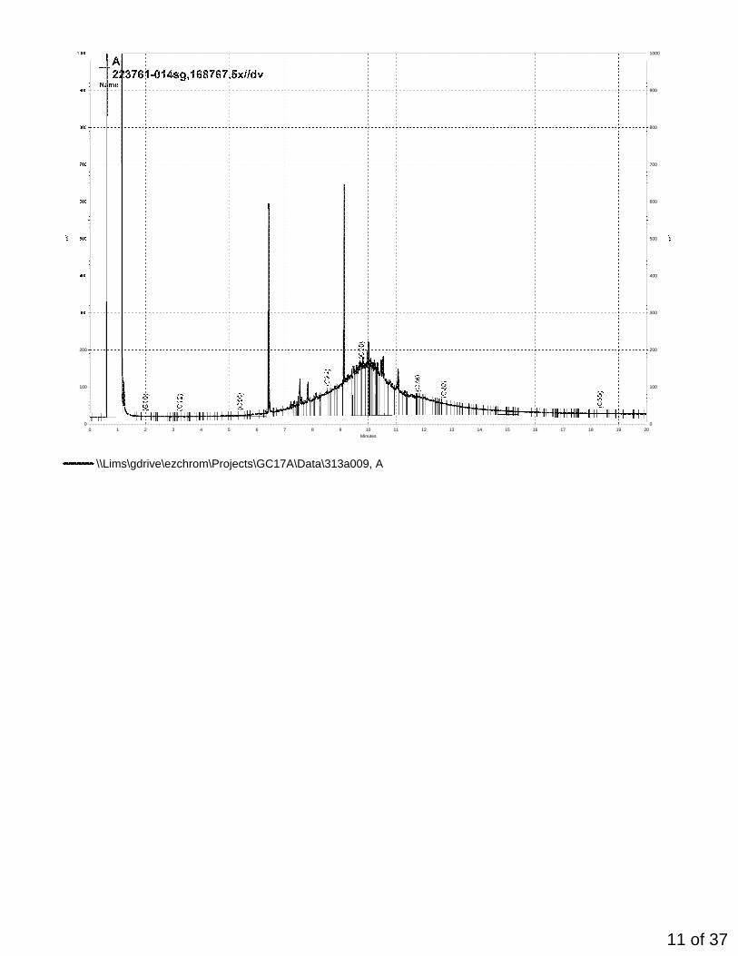
\\Lims\gdrive\ezchrom\Projects\GC17A\Data\313a009, A
11 of 37
Minutes0 1 2 3 4 5 6 7 8 9 10 11 12 13 14 15 16 17 18 19 20
0
50
100
150
0
50
100
150
200
250
300
350
400
450
500
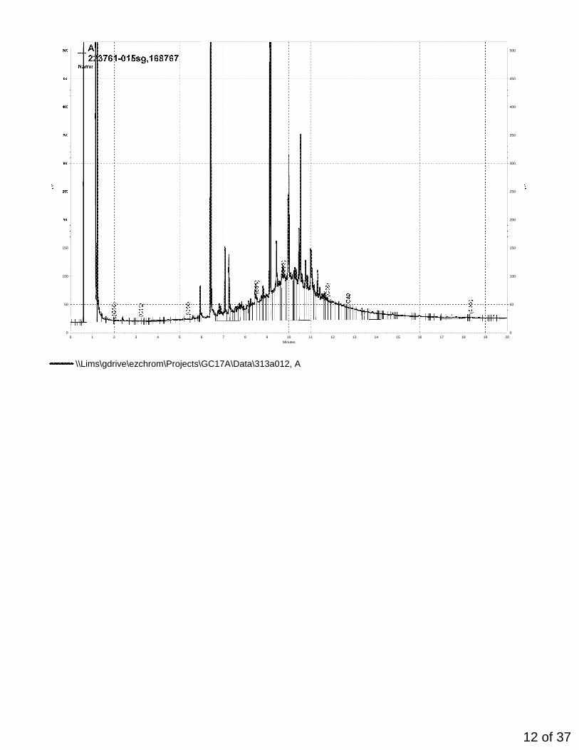
\\Lims\gdrive\ezchrom\Projects\GC17A\Data\313a012, A
12 of 37

Minutes0 1 2 3 4 5 6 7 8 9 10 11 12 13 14 15 16 17 18 19 20
0
100
200
0
100
200
300
400
500
600
700
800
900
1000
\\Lims\gdrive\ezchrom\Projects\GC17A\Data\313a013, A
13 of 37

Minutes0 1 2 3 4 5 6 7 8 9 10 11 12 13 14 15 16 17 18 19 20
0
100
200
0
100
200
300
400
500
600
700
800
900
1000
\\Lims\gdrive\ezchrom\Projects\GC17A\Data\313a014, A
14 of 37

Minutes0 1 2 3 4 5 6 7 8 9 10 11 12 13 14 15 16 17 18 19 20
0
50
100
150
0
50
100
150
200
250
300
350
400
450
\\Lims\gdrive\ezchrom\Projects\GC17A\Data\313a010, A
15 of 37

Minutes0 1 2 3 4 5 6 7 8 9 10 11 12 13 14 15 16 17 18 19 20
0
50
100
150
0
50
100
150
200
250
300
350
400
450
\\Lims\gdrive\ezchrom\Projects\GC17A\Data\312a017, A
16 of 37

Minutes0 1 2 3 4 5 6 7 8 9 10 11 12 13 14 15 16 17 18 19 20
0
100
200
0
100
200
300
400
500
600
700
800
900
1000
\\Lims\gdrive\ezchrom\Projects\GC17A\Data\313a005, A
17 of 37
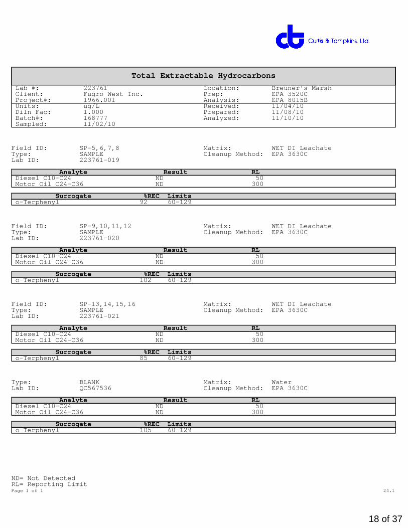
Total Extractable Hydrocarbons
Lab #: 223761 Location: Breuner's Marsh Client: Fugro West Inc. Prep: EPA 3520C Project#: 1966.001 Analysis: EPA 8015B Units: ug/L Received: 11/04/10 Diln Fac: 1.000 Prepared: 11/08/10 Batch#: 168777 Analyzed: 11/10/10 Sampled: 11/02/10
Field ID: SP-5,6,7,8 Matrix: WET DI Leachate Type: SAMPLE Cleanup Method: EPA 3630C Lab ID: 223761-019
Analyte Result RL Diesel C10-C24 ND 50 Motor Oil C24-C36 ND 300
Surrogate %REC Limits o-Terphenyl 92 60-129
Field ID: SP-9,10,11,12 Matrix: WET DI Leachate Type: SAMPLE Cleanup Method: EPA 3630C Lab ID: 223761-020
Analyte Result RL Diesel C10-C24 ND 50 Motor Oil C24-C36 ND 300
Surrogate %REC Limits o-Terphenyl 102 60-129
Field ID: SP-13,14,15,16 Matrix: WET DI Leachate Type: SAMPLE Cleanup Method: EPA 3630C Lab ID: 223761-021
Analyte Result RL Diesel C10-C24 ND 50 Motor Oil C24-C36 ND 300
Surrogate %REC Limits o-Terphenyl 85 60-129
Type: BLANK Matrix: Water Lab ID: QC567536 Cleanup Method: EPA 3630C
Analyte Result RL Diesel C10-C24 ND 50 Motor Oil C24-C36 ND 300
Surrogate %REC Limits o-Terphenyl 105 60-129
ND= Not DetectedRL= Reporting LimitPage 1 of 1 24.1
18 of 37

Batch QC Report
Total Extractable Hydrocarbons
Lab #: 223761 Location: Breuner's Marsh Client: Fugro West Inc. Prep: EPA 3520C Project#: 1966.001 Analysis: EPA 8015B Matrix: Water Batch#: 168777 Units: ug/L Prepared: 11/08/10 Diln Fac: 1.000 Analyzed: 11/09/10
Type: BS Cleanup Method: EPA 3630C Lab ID: QC567537
Analyte Spiked Result %REC Limits Diesel C10-C24 2,500 1,887 75 54-125
Surrogate %REC Limits o-Terphenyl 90 60-129
Type: BSD Cleanup Method: EPA 3630C Lab ID: QC567538
Analyte Spiked Result %REC Limits RPD LimDiesel C10-C24 2,500 2,185 87 54-125 15 53
Surrogate %REC Limits o-Terphenyl 105 60-129
RPD= Relative Percent DifferencePage 1 of 1 25.0
19 of 37

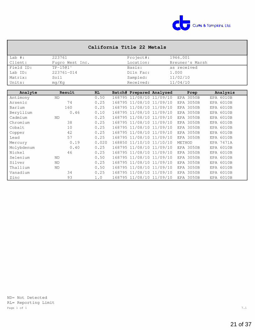
California Title 22 Metals
Lab #: 223761 Project#: 1966.001 Client: Fugro West Inc. Location: Breuner's Marsh Field ID: TP-14@2' Basis: as received Lab ID: 223761-013 Sampled: 11/02/10 Matrix: Soil Received: 11/04/10 Units: mg/Kg
Analyte Result RL Diln Fac Batch# Prepared Analyzed Prep Analysis Antimony 3.0 0.50 1.000 168795 11/08/10 11/09/10 EPA 3050B EPA 6010B Arsenic 770 2.5 10.00 168795 11/08/10 11/10/10 EPA 3050B EPA 6010B Barium 300 0.25 1.000 168795 11/08/10 11/09/10 EPA 3050B EPA 6010B Beryllium 0.42 0.10 1.000 168795 11/08/10 11/09/10 EPA 3050B EPA 6010B Cadmium 1.0 0.25 1.000 168795 11/08/10 11/09/10 EPA 3050B EPA 6010B Chromium 31 0.25 1.000 168795 11/08/10 11/09/10 EPA 3050B EPA 6010B Cobalt 8.7 0.25 1.000 168795 11/08/10 11/09/10 EPA 3050B EPA 6010B Copper 77 0.25 1.000 168795 11/08/10 11/09/10 EPA 3050B EPA 6010B Lead 210 0.25 1.000 168795 11/08/10 11/09/10 EPA 3050B EPA 6010B Mercury 5.5 0.19 10.00 168850 11/10/10 11/10/10 METHOD EPA 7471A Molybdenum 1.1 0.25 1.000 168795 11/08/10 11/09/10 EPA 3050B EPA 6010B Nickel 37 0.25 1.000 168795 11/08/10 11/09/10 EPA 3050B EPA 6010B Selenium ND 0.50 1.000 168795 11/08/10 11/09/10 EPA 3050B EPA 6010B Silver ND 0.25 1.000 168795 11/08/10 11/09/10 EPA 3050B EPA 6010B Thallium ND 0.50 1.000 168795 11/08/10 11/09/10 EPA 3050B EPA 6010B Vanadium 30 0.25 1.000 168795 11/08/10 11/09/10 EPA 3050B EPA 6010B Zinc 330 1.0 1.000 168795 11/08/10 11/09/10 EPA 3050B EPA 6010B
ND= Not DetectedRL= Reporting LimitPage 1 of 1 6.1
20 of 37
California Title 22 Metals
Lab #: 223761 Project#: 1966.001 Client: Fugro West Inc. Location: Breuner's Marsh Field ID: TP-15@1' Basis: as received Lab ID: 223761-014 Diln Fac: 1.000 Matrix: Soil Sampled: 11/02/10 Units: mg/Kg Received: 11/04/10
Analyte Result RL Batch# Prepared Analyzed Prep Analysis Antimony ND 0.50 168795 11/08/10 11/09/10 EPA 3050B EPA 6010B Arsenic 74 0.25 168795 11/08/10 11/09/10 EPA 3050B EPA 6010B Barium 160 0.25 168795 11/08/10 11/09/10 EPA 3050B EPA 6010B Beryllium 0.46 0.10 168795 11/08/10 11/09/10 EPA 3050B EPA 6010B Cadmium ND 0.25 168795 11/08/10 11/09/10 EPA 3050B EPA 6010B Chromium 38 0.25 168795 11/08/10 11/09/10 EPA 3050B EPA 6010B Cobalt 10 0.25 168795 11/08/10 11/09/10 EPA 3050B EPA 6010B Copper 42 0.25 168795 11/08/10 11/09/10 EPA 3050B EPA 6010B Lead 57 0.25 168795 11/08/10 11/09/10 EPA 3050B EPA 6010B Mercury 0.19 0.020 168850 11/10/10 11/10/10 METHOD EPA 7471A Molybdenum 0.40 0.25 168795 11/08/10 11/09/10 EPA 3050B EPA 6010B Nickel 46 0.25 168795 11/08/10 11/09/10 EPA 3050B EPA 6010B Selenium ND 0.50 168795 11/08/10 11/09/10 EPA 3050B EPA 6010B Silver ND 0.25 168795 11/08/10 11/09/10 EPA 3050B EPA 6010B Thallium ND 0.50 168795 11/08/10 11/09/10 EPA 3050B EPA 6010B Vanadium 34 0.25 168795 11/08/10 11/09/10 EPA 3050B EPA 6010B Zinc 93 1.0 168795 11/08/10 11/09/10 EPA 3050B EPA 6010B
ND= Not DetectedRL= Reporting LimitPage 1 of 1 7.1
21 of 37

California Title 22 Metals
Lab #: 223761 Project#: 1966.001 Client: Fugro West Inc. Location: Breuner's Marsh Field ID: [email protected]' Basis: as received Lab ID: 223761-015 Diln Fac: 1.000 Matrix: Soil Sampled: 11/02/10 Units: mg/Kg Received: 11/04/10
Analyte Result RL Batch# Prepared Analyzed Prep Analysis Antimony ND 0.50 168795 11/08/10 11/09/10 EPA 3050B EPA 6010B Arsenic 8.8 0.25 168795 11/08/10 11/09/10 EPA 3050B EPA 6010B Barium 120 0.25 168795 11/08/10 11/09/10 EPA 3050B EPA 6010B Beryllium 0.45 0.10 168795 11/08/10 11/09/10 EPA 3050B EPA 6010B Cadmium ND 0.25 168795 11/08/10 11/09/10 EPA 3050B EPA 6010B Chromium 34 0.25 168795 11/08/10 11/09/10 EPA 3050B EPA 6010B Cobalt 9.7 0.25 168795 11/08/10 11/09/10 EPA 3050B EPA 6010B Copper 27 0.25 168795 11/08/10 11/09/10 EPA 3050B EPA 6010B Lead 19 0.25 168795 11/08/10 11/09/10 EPA 3050B EPA 6010B Mercury 0.11 0.021 168850 11/10/10 11/10/10 METHOD EPA 7471A Molybdenum 0.48 0.25 168795 11/08/10 11/09/10 EPA 3050B EPA 6010B Nickel 49 0.25 168795 11/08/10 11/09/10 EPA 3050B EPA 6010B Selenium ND 0.50 168795 11/08/10 11/09/10 EPA 3050B EPA 6010B Silver ND 0.25 168795 11/08/10 11/09/10 EPA 3050B EPA 6010B Thallium ND 0.50 168795 11/08/10 11/09/10 EPA 3050B EPA 6010B Vanadium 33 0.25 168795 11/08/10 11/09/10 EPA 3050B EPA 6010B Zinc 71 1.0 168795 11/08/10 11/09/10 EPA 3050B EPA 6010B
ND= Not DetectedRL= Reporting LimitPage 1 of 1 8.1
22 of 37

California Title 22 Metals
Lab #: 223761 Project#: 1966.001 Client: Fugro West Inc. Location: Breuner's Marsh Field ID: [email protected]' Basis: as received Lab ID: 223761-016 Diln Fac: 1.000 Matrix: Soil Sampled: 11/02/10 Units: mg/Kg Received: 11/04/10
Analyte Result RL Batch# Prepared Analyzed Prep Analysis Antimony ND 0.50 168795 11/08/10 11/09/10 EPA 3050B EPA 6010B Arsenic 7.9 0.25 168795 11/08/10 11/09/10 EPA 3050B EPA 6010B Barium 140 0.25 168795 11/08/10 11/09/10 EPA 3050B EPA 6010B Beryllium 0.43 0.10 168795 11/08/10 11/09/10 EPA 3050B EPA 6010B Cadmium 0.68 0.25 168795 11/08/10 11/09/10 EPA 3050B EPA 6010B Chromium 34 0.25 168795 11/08/10 11/09/10 EPA 3050B EPA 6010B Cobalt 10 0.25 168795 11/08/10 11/09/10 EPA 3050B EPA 6010B Copper 24 0.25 168795 11/08/10 11/09/10 EPA 3050B EPA 6010B Lead 60 0.25 168795 11/08/10 11/09/10 EPA 3050B EPA 6010B Mercury 0.098 0.020 168850 11/10/10 11/10/10 METHOD EPA 7471A Molybdenum 0.61 0.25 168795 11/08/10 11/09/10 EPA 3050B EPA 6010B Nickel 46 0.25 168795 11/08/10 11/09/10 EPA 3050B EPA 6010B Selenium ND 0.50 168795 11/08/10 11/09/10 EPA 3050B EPA 6010B Silver ND 0.25 168795 11/08/10 11/09/10 EPA 3050B EPA 6010B Thallium ND 0.50 168795 11/08/10 11/09/10 EPA 3050B EPA 6010B Vanadium 29 0.25 168795 11/08/10 11/09/10 EPA 3050B EPA 6010B Zinc 130 1.0 168795 11/08/10 11/09/10 EPA 3050B EPA 6010B
ND= Not DetectedRL= Reporting LimitPage 1 of 1 9.1
23 of 37
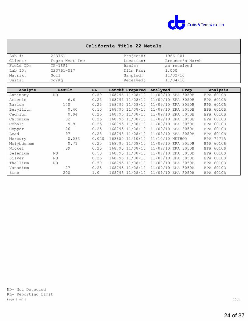
California Title 22 Metals
Lab #: 223761 Project#: 1966.001 Client: Fugro West Inc. Location: Breuner's Marsh Field ID: TP-18@1' Basis: as received Lab ID: 223761-017 Diln Fac: 1.000 Matrix: Soil Sampled: 11/02/10 Units: mg/Kg Received: 11/04/10
Analyte Result RL Batch# Prepared Analyzed Prep Analysis Antimony ND 0.50 168795 11/08/10 11/09/10 EPA 3050B EPA 6010B Arsenic 6.6 0.25 168795 11/08/10 11/09/10 EPA 3050B EPA 6010B Barium 140 0.25 168795 11/08/10 11/09/10 EPA 3050B EPA 6010B Beryllium 0.40 0.10 168795 11/08/10 11/09/10 EPA 3050B EPA 6010B Cadmium 0.94 0.25 168795 11/08/10 11/09/10 EPA 3050B EPA 6010B Chromium 32 0.25 168795 11/08/10 11/09/10 EPA 3050B EPA 6010B Cobalt 9.9 0.25 168795 11/08/10 11/09/10 EPA 3050B EPA 6010B Copper 26 0.25 168795 11/08/10 11/09/10 EPA 3050B EPA 6010B Lead 97 0.25 168795 11/08/10 11/09/10 EPA 3050B EPA 6010B Mercury 0.083 0.020 168850 11/10/10 11/10/10 METHOD EPA 7471A Molybdenum 0.71 0.25 168795 11/08/10 11/09/10 EPA 3050B EPA 6010B Nickel 39 0.25 168795 11/08/10 11/09/10 EPA 3050B EPA 6010B Selenium ND 0.50 168795 11/08/10 11/09/10 EPA 3050B EPA 6010B Silver ND 0.25 168795 11/08/10 11/09/10 EPA 3050B EPA 6010B Thallium ND 0.50 168795 11/08/10 11/09/10 EPA 3050B EPA 6010B Vanadium 27 0.25 168795 11/08/10 11/09/10 EPA 3050B EPA 6010B Zinc 200 1.0 168795 11/08/10 11/09/10 EPA 3050B EPA 6010B
ND= Not DetectedRL= Reporting LimitPage 1 of 1 10.1
24 of 37

California Title 22 Metals
Lab #: 223761 Project#: 1966.001 Client: Fugro West Inc. Location: Breuner's Marsh Field ID: [email protected]' Basis: as received Lab ID: 223761-018 Diln Fac: 1.000 Matrix: Soil Sampled: 11/02/10 Units: mg/Kg Received: 11/04/10
Analyte Result RL Batch# Prepared Analyzed Prep Analysis Antimony ND 0.50 168795 11/08/10 11/09/10 EPA 3050B EPA 6010B Arsenic 6.4 0.25 168795 11/08/10 11/09/10 EPA 3050B EPA 6010B Barium 120 0.25 168795 11/08/10 11/09/10 EPA 3050B EPA 6010B Beryllium 0.43 0.10 168795 11/08/10 11/09/10 EPA 3050B EPA 6010B Cadmium 1.0 0.25 168795 11/08/10 11/09/10 EPA 3050B EPA 6010B Chromium 30 0.25 168795 11/08/10 11/09/10 EPA 3050B EPA 6010B Cobalt 12 0.25 168795 11/08/10 11/09/10 EPA 3050B EPA 6010B Copper 31 0.25 168795 11/08/10 11/09/10 EPA 3050B EPA 6010B Lead 82 0.25 168795 11/08/10 11/09/10 EPA 3050B EPA 6010B Mercury 0.071 0.021 168850 11/10/10 11/10/10 METHOD EPA 7471A Molybdenum 0.77 0.25 168795 11/08/10 11/09/10 EPA 3050B EPA 6010B Nickel 39 0.25 168795 11/08/10 11/09/10 EPA 3050B EPA 6010B Selenium ND 0.50 168795 11/08/10 11/09/10 EPA 3050B EPA 6010B Silver ND 0.25 168795 11/08/10 11/09/10 EPA 3050B EPA 6010B Thallium ND 0.50 168795 11/08/10 11/09/10 EPA 3050B EPA 6010B Vanadium 28 0.25 168795 11/08/10 11/09/10 EPA 3050B EPA 6010B Zinc 210 1.0 168795 11/08/10 11/09/10 EPA 3050B EPA 6010B
ND= Not DetectedRL= Reporting LimitPage 1 of 1 11.1
25 of 37

Batch QC Report
California Title 22 Metals
Lab #: 223761 Location: Breuner's Marsh Client: Fugro West Inc. Prep: EPA 3050B Project#: 1966.001 Analysis: EPA 6010B Type: BLANK Diln Fac: 1.000 Lab ID: QC567599 Batch#: 168795 Matrix: Soil Prepared: 11/08/10 Units: mg/Kg Analyzed: 11/09/10
Analyte Result RL Antimony ND 0.50 Arsenic ND 0.25 Barium ND 0.25 Beryllium ND 0.10 Cadmium ND 0.25 Chromium ND 0.25 Cobalt ND 0.25 Copper ND 0.25 Lead ND 0.25 Molybdenum ND 0.25 Nickel ND 0.25 Selenium ND 0.50 Silver ND 0.25 Thallium ND 0.50 Vanadium ND 0.25 Zinc ND 1.0
ND= Not DetectedRL= Reporting LimitPage 1 of 1 12.0
26 of 37

Batch QC Report
California Title 22 Metals
Lab #: 223761 Location: Breuner's Marsh Client: Fugro West Inc. Prep: EPA 3050B Project#: 1966.001 Analysis: EPA 6010B Matrix: Soil Batch#: 168795 Units: mg/Kg Prepared: 11/08/10 Diln Fac: 1.000 Analyzed: 11/09/10
Type: BS Lab ID: QC567600
Analyte Spiked Result %REC Limits Antimony 100.0 91.77 92 80-120 Arsenic 50.00 50.02 100 80-120 Barium 100.0 94.60 95 80-120 Beryllium 2.500 2.597 104 80-120 Cadmium 10.00 9.757 98 80-120 Chromium 100.0 94.16 94 80-120 Cobalt 25.00 23.12 92 80-120 Copper 12.50 12.03 96 80-120 Lead 100.0 93.51 94 80-120 Molybdenum 20.00 19.13 96 80-120 Nickel 25.00 23.23 93 80-120 Selenium 50.00 46.84 94 80-120 Silver 10.00 9.420 94 80-120 Thallium 50.00 47.32 95 80-120 Vanadium 25.00 23.97 96 80-120 Zinc 25.00 23.97 96 80-120
Type: BSD Lab ID: QC567601
Analyte Spiked Result %REC Limits RPD LimAntimony 100.0 88.67 89 80-120 3 20 Arsenic 50.00 48.38 97 80-120 3 20 Barium 100.0 91.76 92 80-120 3 20 Beryllium 2.500 2.504 100 80-120 4 20 Cadmium 10.00 9.380 94 80-120 4 20 Chromium 100.0 91.52 92 80-120 3 20 Cobalt 25.00 22.19 89 80-120 4 20 Copper 12.50 11.63 93 80-120 3 20 Lead 100.0 89.76 90 80-120 4 25 Molybdenum 20.00 18.34 92 80-120 4 20 Nickel 25.00 22.38 90 80-120 4 20 Selenium 50.00 45.34 91 80-120 3 20 Silver 10.00 9.180 92 80-120 3 20 Thallium 50.00 45.39 91 80-120 4 21 Vanadium 25.00 23.25 93 80-120 3 20 Zinc 25.00 23.07 92 80-120 4 20
RPD= Relative Percent DifferencePage 1 of 1 13.0
27 of 37

Batch QC Report
California Title 22 Metals
Lab #: 223761 Location: Breuner's Marsh Client: Fugro West Inc. Prep: EPA 3050B Project#: 1966.001 Analysis: EPA 6010B Field ID: TP-14@2' Batch#: 168795 MSS Lab ID: 223761-013 Sampled: 11/02/10 Matrix: Soil Received: 11/04/10 Units: mg/Kg Prepared: 11/08/10 Basis: as received Analyzed: 11/09/10 Diln Fac: 1.000
Type: MS Lab ID: QC567602
Analyte MSS Result Spiked Result %REC LimitsAntimony 2.980 96.15 39.35 38 7-120 Arsenic 770.4 48.08 594.2 >LR -366 NM 65-120 Barium 295.5 96.15 256.1 -41 * 47-139 Beryllium 0.4213 2.404 2.588 90 68-122 Cadmium 0.9966 9.615 9.038 84 63-120 Chromium 31.18 96.15 107.5 79 54-125 Cobalt 8.736 24.04 28.81 84 50-124 Copper 77.03 12.02 95.51 154 NM 36-154 Lead 205.1 96.15 318.0 117 51-125 Molybdenum 1.121 19.23 15.29 74 62-120 Nickel 37.37 24.04 56.26 79 41-142 Selenium 0.3459 48.08 41.63 86 63-120 Silver 0.07577 9.615 8.648 89 65-120 Thallium <0.1377 48.08 40.33 84 53-120 Vanadium 30.11 24.04 49.37 80 48-140 Zinc 328.7 24.04 321.8 -29 NM 30-154
Type: MSD Lab ID: QC567603
Analyte Spiked Result %REC Limits RPD LimAntimony 96.15 38.05 36 7-120 3 41 Arsenic 48.08 479.0 -606 NM 65-120 NC 38 Barium 96.15 235.4 -62 * 47-139 8 47 Beryllium 2.404 2.689 94 68-122 4 28 Cadmium 9.615 9.260 86 63-120 2 29 Chromium 96.15 114.1 86 54-125 6 40 Cobalt 24.04 29.84 88 50-124 4 41 Copper 12.02 95.77 156 NM 36-154 0 46 Lead 96.15 307.4 106 51-125 3 52 Molybdenum 19.23 15.63 75 62-120 2 25 Nickel 24.04 61.15 99 41-142 8 44 Selenium 48.08 41.65 86 63-120 0 31 Silver 9.615 8.747 90 65-120 1 29 Thallium 48.08 41.51 86 53-120 3 28 Vanadium 24.04 52.19 92 48-140 6 39 Zinc 24.04 308.8 -83 NM 30-154 4 50
*= Value outside of QC limits; see narrativeNC= Not CalculatedNM= Not Meaningful: Sample concentration > 4X spike concentration>LR= Response exceeds instrument's linear rangeRPD= Relative Percent DifferencePage 1 of 1 14.0
28 of 37

Batch QC Report
California Title 22 Metals
Lab #: 223761 Location: Breuner's Marsh Client: Fugro West Inc. Prep: METHOD Project#: 1966.001 Analysis: EPA 7471A Analyte: Mercury Diln Fac: 1.000 Type: BLANK Batch#: 168850 Lab ID: QC567834 Prepared: 11/10/10 Matrix: Soil Analyzed: 11/10/10 Units: mg/Kg
Result RL ND 0.020
ND= Not DetectedRL= Reporting LimitPage 1 of 1 19.0
29 of 37

Batch QC Report
California Title 22 Metals
Lab #: 223761 Location: Breuner's Marsh Client: Fugro West Inc. Prep: METHOD Project#: 1966.001 Analysis: EPA 7471A Analyte: Mercury Batch#: 168850 Matrix: Soil Prepared: 11/10/10 Units: mg/Kg Analyzed: 11/10/10 Diln Fac: 1.000
Type Lab ID Spiked Result %REC Limits RPD LimBS QC567835 0.2500 0.2500 100 80-120 BSD QC567836 0.2500 0.2420 97 80-120 3 20
RPD= Relative Percent DifferencePage 1 of 1 20.0
30 of 37
Batch QC Report
California Title 22 Metals
Lab #: 223761 Location: Breuner's Marsh Client: Fugro West Inc. Prep: METHOD Project#: 1966.001 Analysis: EPA 7471A Analyte: Mercury Diln Fac: 10.00 Field ID: TP-14@2' Batch#: 168850 MSS Lab ID: 223761-013 Sampled: 11/02/10 Matrix: Soil Received: 11/04/10 Units: mg/Kg Prepared: 11/10/10 Basis: as received Analyzed: 11/10/10
Type Lab ID MSS Result Spiked Result %REC Limits RPD LimMS QC567837 5.500 0.2451 7.539 832 NM 70-131 MSD QC567838 0.2451 5.951 184 NM 70-131 24 36
NM= Not Meaningful: Sample concentration > 4X spike concentrationRPD= Relative Percent DifferencePage 1 of 1 21.0
31 of 37

Metals Analytical Report
Lab #: 223761 Project#: 1966.001 Client: Fugro West Inc. Location: Breuner's Marsh Matrix: WET DI Leachate Sampled: 11/02/10 Units: ug/L Received: 11/04/10 Diln Fac: 1.000
Field ID: SP-5,6,7,8 Lab ID: 223761-019 Type: SAMPLE
Analyte Result RL Batch# Prepared Analyzed Prep Analysis Arsenic 10 5.0 168854 11/10/10 11/11/10 WET DI EPA 6010B Lead ND 5.0 168854 11/10/10 11/11/10 WET DI EPA 6010B Mercury ND 1.0 168804 11/09/10 11/09/10 METHOD EPA 7470A Vanadium ND 5.0 168854 11/10/10 11/11/10 WET DI EPA 6010B
Field ID: SP-9,10,11,12 Lab ID: 223761-020 Type: SAMPLE
Analyte Result RL Batch# Prepared Analyzed Prep Analysis Arsenic 14 5.0 168854 11/10/10 11/11/10 WET DI EPA 6010B Lead ND 5.0 168854 11/10/10 11/11/10 WET DI EPA 6010B Mercury ND 1.0 168804 11/09/10 11/09/10 METHOD EPA 7470A Vanadium ND 5.0 168854 11/10/10 11/11/10 WET DI EPA 6010B
Field ID: SP-13,14,15,16 Lab ID: 223761-021 Type: SAMPLE
Analyte Result RL Batch# Prepared Analyzed Prep Analysis Arsenic 13 5.0 168854 11/10/10 11/11/10 WET DI EPA 6010B Lead ND 5.0 168854 11/10/10 11/11/10 WET DI EPA 6010B Mercury ND 1.0 168804 11/09/10 11/09/10 METHOD EPA 7470A Vanadium ND 5.0 168854 11/10/10 11/11/10 WET DI EPA 6010B
Type: BLANK Analyzed: 11/09/10 Lab ID: QC567645 Prep: METHOD Batch#: 168804 Analysis: EPA 7470A Prepared: 11/09/10
Analyte Result RL Mercury ND 1.0
Type: BLANK Analyzed: 11/11/10 Lab ID: QC567848 Prep: WET DI Batch#: 168854 Analysis: EPA 6010B Prepared: 11/10/10
Analyte Result RL Arsenic ND 5.0 Lead ND 5.0 Vanadium ND 5.0
ND= Not DetectedRL= Reporting LimitPage 1 of 1 2.1
32 of 37
Batch QC Report
Metals Analytical Report
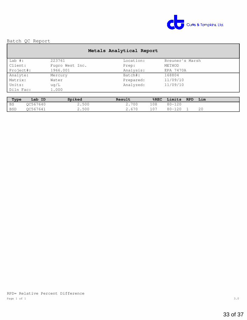
Lab #: 223761 Location: Breuner's Marsh Client: Fugro West Inc. Prep: METHOD Project#: 1966.001 Analysis: EPA 7470A Analyte: Mercury Batch#: 168804 Matrix: Water Prepared: 11/09/10 Units: ug/L Analyzed: 11/09/10 Diln Fac: 1.000
Type Lab ID Spiked Result %REC Limits RPD LimBS QC567640 2.500 2.700 108 80-120 BSD QC567641 2.500 2.670 107 80-120 1 20
RPD= Relative Percent DifferencePage 1 of 1 3.0
33 of 37
Batch QC Report
Metals Analytical Report
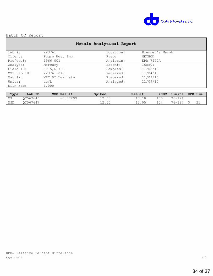
Lab #: 223761 Location: Breuner's Marsh Client: Fugro West Inc. Prep: METHOD Project#: 1966.001 Analysis: EPA 7470A Analyte: Mercury Batch#: 168804 Field ID: SP-5,6,7,8 Sampled: 11/02/10 MSS Lab ID: 223761-019 Received: 11/04/10 Matrix: WET DI Leachate Prepared: 11/09/10 Units: ug/L Analyzed: 11/09/10 Diln Fac: 1.000
Type Lab ID MSS Result Spiked Result %REC Limits RPD LimMS QC567646 <0.07299 12.50 13.10 105 76-124 MSD QC567647 12.50 13.05 104 76-124 0 21
RPD= Relative Percent DifferencePage 1 of 1 4.0
34 of 37
Batch QC Report
Metals Analytical Report
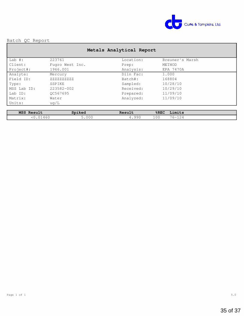
Lab #: 223761 Location: Breuner's Marsh Client: Fugro West Inc. Prep: METHOD Project#: 1966.001 Analysis: EPA 7470A Analyte: Mercury Diln Fac: 1.000 Field ID: ZZZZZZZZZZ Batch#: 168804 Type: SSPIKE Sampled: 10/28/10 MSS Lab ID: 223582-002 Received: 10/29/10 Lab ID: QC567695 Prepared: 11/09/10 Matrix: Water Analyzed: 11/09/10 Units: ug/L
MSS Result Spiked Result %REC Limits <0.01460 5.000 4.990 100 76-124
Page 1 of 1 5.0
35 of 37

Batch QC Report
Metals Analytical Report
Lab #: 223761 Location: Breuner's Marsh Client: Fugro West Inc. Prep: WET DI Project#: 1966.001 Analysis: EPA 6010B Matrix: WET DI Leachate Batch#: 168854 Units: ug/L Prepared: 11/10/10 Diln Fac: 1.000 Analyzed: 11/11/10
Type: BS Lab ID: QC567849
Analyte Spiked Result %REC Limits Arsenic 1,000 968.2 97 80-120 Lead 2,000 1,786 89 79-120 Vanadium 500.0 455.5 91 80-120
Type: BSD Lab ID: QC567850
Analyte Spiked Result %REC Limits RPD LimArsenic 1,000 966.7 97 80-120 0 20 Lead 2,000 1,776 89 79-120 1 20 Vanadium 500.0 452.0 90 80-120 1 20
RPD= Relative Percent DifferencePage 1 of 1 22.0
36 of 37

Batch QC Report
Metals Analytical Report
Lab #: 223761 Location: Breuner's Marsh Client: Fugro West Inc. Prep: WET DI Project#: 1966.001 Analysis: EPA 6010B Field ID: SP-9,10,11,12 Batch#: 168854 MSS Lab ID: 223761-020 Sampled: 11/02/10 Matrix: WET DI Leachate Received: 11/04/10 Units: ug/L Prepared: 11/10/10 Diln Fac: 1.000 Analyzed: 11/11/10
Type: MS Lab ID: QC567851
Analyte MSS Result Spiked Result %REC LimitsArsenic 14.03 1,000 867.4 85 74-126 Lead 4.672 2,000 1,822 91 66-120 Vanadium <1.000 500.0 458.8 92 78-120
Type: MSD Lab ID: QC567852
Analyte Spiked Result %REC Limits RPD LimArsenic 1,000 919.1 91 74-126 6 26 Lead 2,000 1,896 95 66-120 4 25 Vanadium 500.0 480.3 96 78-120 5 20
RPD= Relative Percent DifferencePage 1 of 1 23.0
37 of 37

Laboratory Job Number 223948ANALYTICAL REPORT
Fugro West Inc. Project : 1966.001 1000 Broadway Location : Breuner's Marsh Oakland, CA 94607 Level : II
Sample ID Lab IDSP-5,6,7,8 223948-001SP-9,10,11,12 223948-002SP-13,14,15,16 223948-003
This data package has been reviewed for technical correctness and completeness.Release of this data has been authorized by the Laboratory Manager or theManager's designee, as verified by the following signature. The resultscontained in this report meet all requirements of NELAC and pertain only tothose samples which were submitted for analysis. This report may be reproducedonly in its entirety.
Signature: Date: 11/19/2010 Project Manager
NELAP # 01107CA
1 of 7

CASE NARRATIVE
Laboratory number: 223948Client: Fugro West Inc.Project: 1966.001Location: Breuner's MarshRequest Date: 11/12/10Samples Received: 11/04/10
This data package contains sample and QC results for three soil samples,requested for the above referenced project on 11/12/10. The samples werereceived cold and intact.
Metals (EPA 6010B):No analytical problems were encountered.
Page 1 of 15.0
2 of 7

3 of 7
4 of 7

5 of 7

Arsenic
Lab #: 223948 Location: Breuner's Marsh Client: Fugro West Inc. Prep: EPA 3050B Project#: 1966.001 Analysis: EPA 6010B Analyte: Arsenic Batch#: 169120 Matrix: Soil Sampled: 11/02/10 Units: mg/Kg Received: 11/04/10 Basis: as received Prepared: 11/16/10 Diln Fac: 1.000 Analyzed: 11/18/10
Field ID Type Lab ID Result RL SP-5,6,7,8 SAMPLE 223948-001 22 0.25 SP-9,10,11,12 SAMPLE 223948-002 33 0.25 SP-13,14,15,16 SAMPLE 223948-003 40 0.25
BLANK QC568920 ND 0.25
ND= Not DetectedRL= Reporting LimitPage 1 of 1 2.0
6 of 7

Batch QC Report
Arsenic
Lab #: 223948 Location: Breuner's Marsh Client: Fugro West Inc. Prep: EPA 3050B Project#: 1966.001 Analysis: EPA 6010B Analyte: Arsenic Diln Fac: 1.000 Field ID: SP-5,6,7,8 Batch#: 169120 MSS Lab ID: 223948-001 Sampled: 11/02/10 Matrix: Soil Received: 11/04/10 Units: mg/Kg Prepared: 11/16/10 Basis: as received Analyzed: 11/18/10
Type Lab ID MSS Result Spiked Result %REC Limits RPD LimBS QC568921 50.00 51.26 103 80-120 BSD QC568922 50.00 51.22 102 80-120 0 20 MS QC568923 22.04 48.08 65.76 91 65-120 MSD QC568924 49.50 72.77 102 65-120 8 38
RPD= Relative Percent DifferencePage 1 of 1 3.0
7 of 7

........................................................................................................................
A P P E N D I X J
R E C R E A T I O N B A C K G R O U N D
R E P O R T

........................................................................................................................

RECREATION ASSESSMENT
Breuner Marsh Restoration and Public Access Project Point Pinole Regional Shoreline
Prepared for:
Questa Engineering
Prepared by:
2M Associates
Berkeley, California
Landscape Architect Lic. #1842
May, 2011

RECREATION ASSESSMENT
Breuner Marsh Restoration and Public Access Project i May, 2011
TABLE OF CONTENTS
page
1.0 Introduction ...................................................................................................................................... 2 2.0 Existing Recreation Conditions ....................................................................................................... 3 2.1 Project Site ........................................................................................................................................ 3 2.2 Adjacent Recreation Areas and Facilities ......................................................................................... 4 3.0 Existing Plans .................................................................................................................................. 5 3.1 Point Pinole Regional Shoreline Land Use Plan .............................................................................. 5 3.2 San Francisco Bay Trail (Bay Trail) ................................................................................................ 5 3.3 San Francisco Bay Area Water Trail (Water Trail) ......................................................................... 5 3.4 City of Richmond General Plan ....................................................................................................... 6 3.5 North Richmond Shoreline Specific Plan ........................................................................................ 8 4.0 Current Planning ............................................................................................................................. 9 4.1 Point Pinole Regional Shoreline ...................................................................................................... 9 4.2 City of Richmond ............................................................................................................................. 9
4.2.1 Bicycle Master Plan ................................................................................................................ 9 4.2.2 General Plan Update ............................................................................................................... 9
References ................................................................................................................................................ 13
Attachments
Attachment A: Point Pinole Regional Shoreline Facilities Map
Attachment B: Bay Trail Plan Route Map
Attachment C: North Richmond Shoreline Specific Plan Map
Attachment D: Point Pinole Regional Shoreline: Preliminary Plans for New Entrance
Attachment E: City of Richmond Draft Bicycle Master Plan Map
Attachment F: City of Richmond Draft General Plan: Parks, Trails, and Open Space Map

RECREATION ASSESSMENT
Breuner Marsh Restoration and Public Access Project 2 May, 2011
1.0 INTRODUCTION The purpose of this report is to describe the recreation context and existing conditions that will affect public access within the Breuner Marsh project area (Breuner Marsh). The Breuner Marsh will ultimately become part of the Point Pinole Regional Shoreline (personal communication: Brad Olsen) owned and operated by the East Bay Regional Park District (the Park District).
A basic goal of the Breuner Marsh Restoration and Public Access Project is to develop a link of the San Francisco Bay Trail (the Bay Trail) between Goodrick Avenue on the south side of Breuner Marsh with Point Pinole Road. Point Pinole Road is within the Point Pinole Regional Shoreline and is an existing segment of the Bay Trail. All public access and Bay Trail features with the Breuner Marsh project area would be fully ADA compliant. Other preliminary recreation goals include:
• Accommodate planned local trail connections.
• Site public access trails and features to not fragment habitats.
• Employ appropriate public access and wildlife compatibility design and management techniques to reduce use and habitat conflicts.
• Provide sustainable day use facilities in terms of design and material selection.
• Provide views to the San Francisco Bay.
• Provide access for fishing.
• Provide exhibits and/or programs to inform visitors about natural and cultural resources on the site.
A public workshop was conducted about the Breuner Marsh project on January 20, 2011 at Parchester Village. Specific project-related recreation program items that attendees expressed a keen interest about included:
• Create direct access to Breuner Marsh from Parchester Village.
• Assure that access is ADA compliantd specifically for seniors and individuals with disabilities
• Include an exercise course along the Bay Trail and possibly extending into Point Pinole
• Include benches along the entire trail, not just at limited viewpoint locations
• Include drinking fountains for people and dogs
• Include pooper-scooper dog stations
• Make new signage multi-lingual (English and Spanish) with pictograms
• Consider additional parking near the existing basketball courts north of Parchester Village
• Include a large picnic area (although some felt that there were enough existing facilities at Point Pinole)
• Consider trail lighting

RECREATION ASSESSMENT
Breuner Marsh Restoration and Public Access Project 3 May, 2011
2.0 EXISTING RECREATION CONDITIONS
2.1 PROJECT SITE The Breuner Marsh project area has never been formally open to general public use. The main vehicular access is from Goodrick Avenue and fenced and gated at the south property line. Other than signing, no perimeter controls exist on the east boundary along the Union Pacific railroad tracks, the north boundary with the existing trail system of Point Pinole Regional Shoreline, or from San Pablo Bay. However, the site is accessed and used by residents of Parchester Village and other nearby areas. This use principally involves walking, fishing, nature observation, and exploring. Along with the existing road system, a series of volunteer trails have developed. Use could be characterized as a few per day.
Bay Area Radio Control Society (BARCS) BARCS operates under a lease agreement with the East Bay Regional Park District that extends to June, 2012. The Park District has the right to terminate the lease at any time.
BARCS is chartered by the Academy of Model Aeronautics (AMA). Aircraft flown at the BARCS field is not to exceed 108 inches in wingspan, 62cc in motor size, and 98db of noise at 10 feet. Turbine powered airplanes are not permitted.
Facilities at the site were upgraded in 1996 and include:
• gravel pit area • frequency impound (a shed converted from a bus shelter) • shade structures • taxi area and runway
Using the guidelines of the AMA’s National Model Aircraft Safety Code the overflight area is generally east of the runway that includes the central portion of the Breuner Marsh project area and portions of the adjacent undeveloped private lands.
Aerial View of BARC facilities looking west Aerial View of BARC facilities looking south

RECREATION ASSESSMENT
Breuner Marsh Restoration and Public Access Project 4 May, 2011
2.2 ADJACENT RECREATION AREAS AND FACILITIES
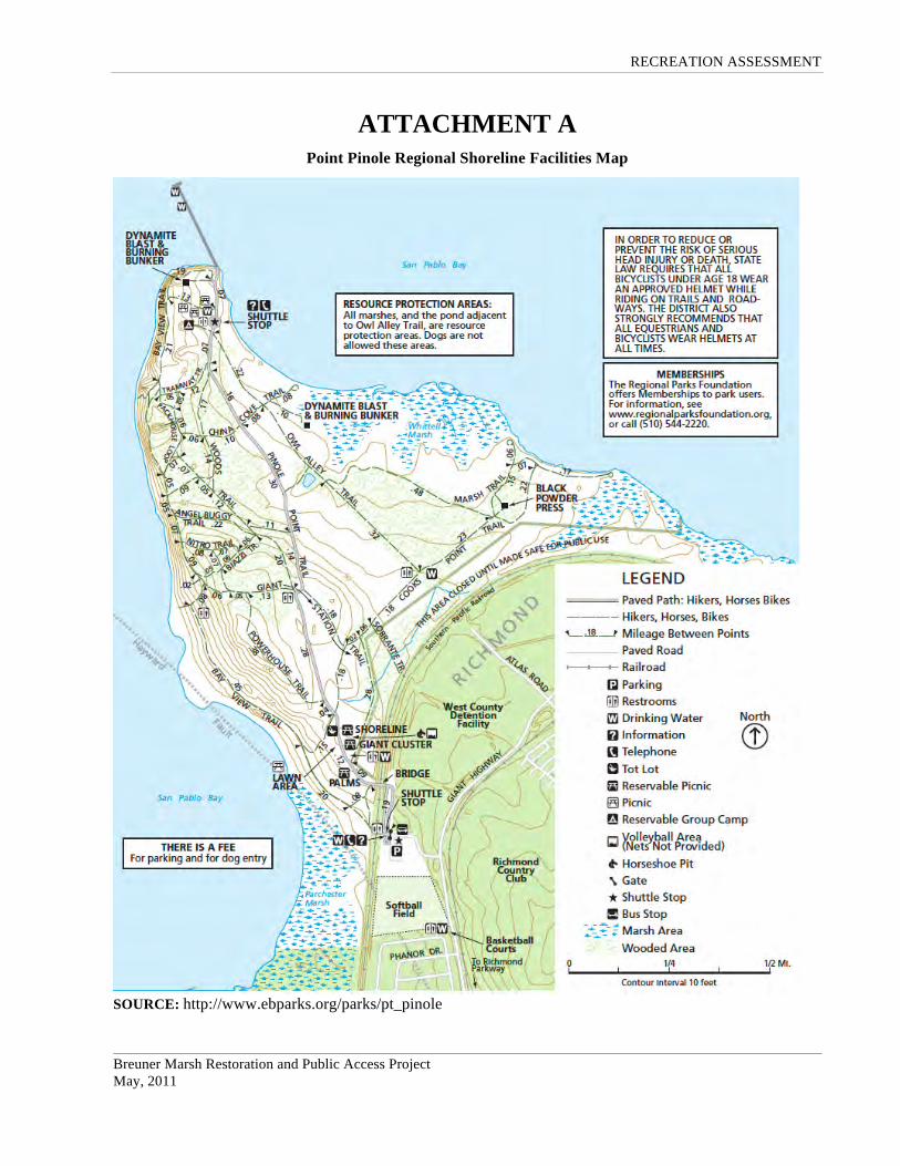
Point Pinole Regional Shoreline Point Pinole Regional Shoreline is a 2,315-acre parkland owned and operated by the Park District. Its main access point and staging area is located off of Giant Highway north of Parchester Village. It includes the following facilities:
• gated entrance • entrance kiosk • paved parking for 69 vehicles and 3 paved ADA parking spaces • gravel overflow parking area • potable water supply • restrooms • telephone • visitor information board.
Within the Pont Pinole Regional Shoreline there are over 12 miles of trails, family and group picnic areas, a group campsite, and a 1,250-foot-long fishing pier. On selected days, the Park District operates a shuttle bus system between the Giant Highway staging area and the pier, an approximately 1.5-mile distance. Point Pinole Regional Shoreline facilities are shown in Attachment A.
A small use area is also located off of Giant Highway immediately north of Parchester Village. Its use is principally from residents of Parchester Village and includes:
• 5 paved parking spaces • 1 paved ADA parking space • drinking water • restroooms • 2 basketball courts.
A meadow west of the basketball courts is includes a softball field. However, this consists of a backstop with no other facilities or improvements evident. A gravel trail connects the basketball courts with the main staging area.
Annual attendance estimates for Point Pinole Regional Shoreline is approximately 200,000 per year (source: East Bay Regional Park District)
The Richmond Rod and Gun Club The Richmond Rod and Gun Club is a multi-range facility for a wide variety of programs. Facilities include:
• 25 yard handgun range • 100 yard rifle range • 200 yard rifle range • trap and skeet range • action range
Hours of operation are from 9am to 4pm Wednesday, Friday, Saturday, and Sunday.
The effects of range activities on future public use of Breuner Marsh are related to noise and associated diminution of the marsh experience.

RECREATION ASSESSMENT
Breuner Marsh Restoration and Public Access Project 5 May, 2011
3.0 EXISTING PLANS
3.1 Point Pinole Regional Shoreline Land Use Plan The Land Use Plan (LUP) for the Point Pinole Regional Shoreline was first prepared in 1976 and then amended in 1998 and 1999 when additional lands were purchased and research discovered a rich history that resulted in naming all the trails after historic themes. Under the 1976 LUP, three areas were developed for recreation activities: the Parchester, Giant and Shoreline Clusters. The Laud Use Plan for the remainder of the Regional Shoreline are zoned as a Natural Units in keeping with the preservation and enhancement of natural habitat.
The section of the Regional Shoreline to which the Bay Trail through Breuner Marsh would connect is designated as the Giant recreation cluster. The area immediately north of Parchester Village is also designated a recreation cluster. These are defined in the LUP as follows:
Giant: The existing grass area, immediately west of the proposed bridge site, is sheltered on the bay side by eucalyptus. There are views of the Parchester marsh and to the bluffs of the western shoreline and the Marin shoreline across the bay. The cluster will offer the public a developed area within walking distance of the staging area. The area will be designed for family picnicking with access to the shore for fishermen and beachcombers. Drinking fountains and chemical toilets will be provided. This cluster is three acres.
Parchester: The existing facilities will be expanded to include family and group picnic sites. The grasslands will be irrigated and landscaped with trees to screen the adjacent parking area and portions of Giant Highway. Views of the bay from this cluster and from Giant Highway will be maintained. This unit total is twenty-four acres including the staging area.
3.2 San Francisco Bay Trail (Bay Trail) The Bay Trail is a planned recreational corridor that, when complete, will encircle San Francisco and San Pablo Bays with a continuous network of bicycling and hiking trails. It will connect the shoreline of all nine Bay Area counties, link 47 cities, and cross the major toll bridges in the region. To date, approximately 310 miles of the alignment—over 60 percent of the Bay Trail’s ultimate length—have been completed.
Senate Bill 100, authored by then-state Senator Bill Lockyer and passed into law in 1987, directed the Association of Bay Area Governments (ABAG) to develop a plan for this "ring around the Bay," including a specific alignment for the Bay Trail. The Bay Trail Plan, adopted by ABAG in July 1989, includes a proposed alignment; a set of policies to guide the future selection, design and implementation of routes; and strategies for implementation and financing. The route of the Bay Trail through the Breuner Marsh project area is found in Attachment B.
3.3 San Francisco Bay Area Water Trail (Water Trail) The Water Trail was authorized by the San Francisco Bay Area Water Trail Act signed into law in September 2005. The Act directed the San Francisco Bay Conservation and Development Commission, in coordination with other agencies and organizations, to conduct a public process to develop the San Francisco Bay Area Water Trail Plan, and assigned the California State Coastal Conservancy to be the lead agency for implementing the Plan.
The San Francisco Bay Area Water Trail Final Environmental Impact Report (FEIR) was certified by the California State Coastal Conservancy on March 17, 2011 at its scheduled public hearing. The Water Trail will be a network of access sites (or “trailheads”) that will enable people using non-motorized, small boats or other beachable sailcraft, such as kayaks, canoes, dragon boats, and windsurf boards, to safely enjoy single and multiple-day trips around San Francisco Bay. The Water Trail is to include educational, stewardship, and outreach components.
RECREATION ASSESSMENT
Breuner Marsh Restoration and Public Access Project 6 May, 2011
Point Pinole (Water Trail Site Key CC21) is a designated Water Trail Backbone Site and marked to be a destination site. Breuner Marsh is not identified as a component of the Water Trail system.
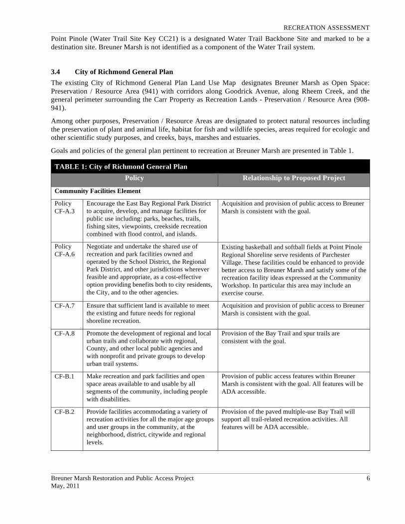
3.4 City of Richmond General Plan The existing City of Richmond General Plan Land Use Map designates Breuner Marsh as Open Space: Preservation / Resource Area (941) with corridors along Goodrick Avenue, along Rheem Creek, and the general perimeter surrounding the Carr Property as Recreation Lands - Preservation / Resource Area (908-941).
Among other purposes, Preservation / Resource Areas are designated to protect natural resources including the preservation of plant and animal life, habitat for fish and wildlife species, areas required for ecologic and other scientific study purposes, and creeks, bays, marshes and estuaries.
Goals and policies of the general plan pertinent to recreation at Breuner Marsh are presented in Table 1.
TABLE 1: City of Richmond General Plan Policy Relationship to Proposed Project
Community Facilities Element
Policy CF-A.3
Encourage the East Bay Regional Park District to acquire, develop, and manage facilities for public use including: parks, beaches, trails, fishing sites, viewpoints, creekside recreation combined with flood control, and islands.
Acquisition and provision of public access to Breuner Marsh is consistent with the goal.
Policy CF-A.6
Negotiate and undertake the shared use of recreation and park facilities owned and operated by the School District, the Regional Park District, and other jurisdictions wherever feasible and appropriate, as a cost-effective option providing benefits both to city residents, the City, and to the other agencies.
Existing basketball and softball fields at Point Pinole Regional Shoreline serve residents of Parchester Village. These facilities could be enhanced to provide better access to Breuner Marsh and satisfy some of the recreation facility ideas expressed at the Community Workshop. In particular this area may include an exercise course.
CF-A.7 Ensure that sufficient land is available to meet the existing and future needs for regional shoreline recreation.
Acquisition and provision of public access to Breuner Marsh is consistent with the goal.
CF-A.8 Promote the development of regional and local urban trails and collaborate with regional, County, and other local public agencies and with nonprofit and private groups to develop urban trail systems.
Provision of the Bay Trail and spur trails are consistent with the goal.
CF-B.1 Make recreation and park facilities and open space areas available to and usable by all segments of the community, including people with disabilities.
Provision of public access features within Breuner Marsh is consistent with the goal. All features will be ADA accessible.
CF-B.2 Provide facilities accommodating a variety of recreation activities for all the major age groups and user groups in the community, at the neighborhood, district, citywide and regional levels.
Provision of the paved multiple-use Bay Trail will support all trail-related recreation activities. All features will be ADA accessible.
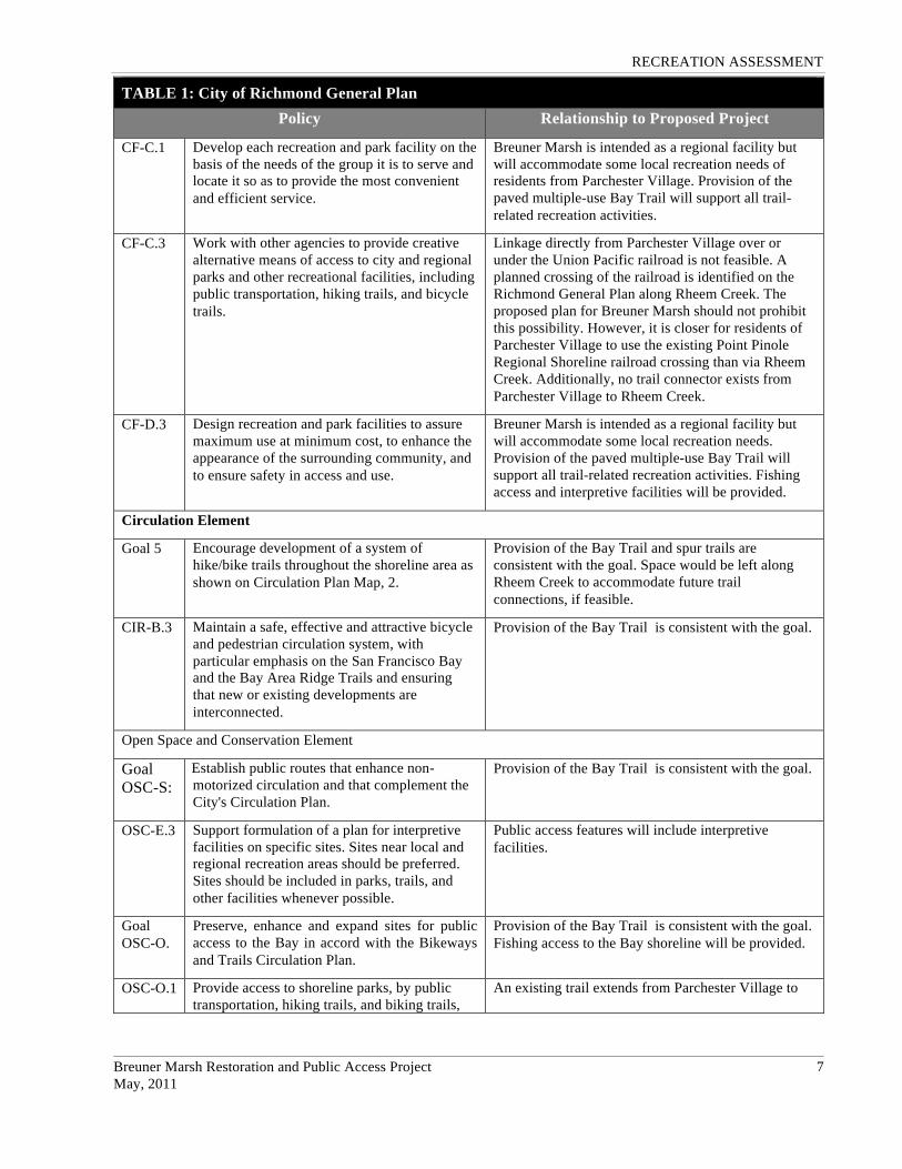
RECREATION ASSESSMENT
Breuner Marsh Restoration and Public Access Project 7 May, 2011
TABLE 1: City of Richmond General Plan Policy Relationship to Proposed Project
CF-C.1 Develop each recreation and park facility on the basis of the needs of the group it is to serve and locate it so as to provide the most convenient and efficient service.
Breuner Marsh is intended as a regional facility but will accommodate some local recreation needs of residents from Parchester Village. Provision of the paved multiple-use Bay Trail will support all trail-related recreation activities.
CF-C.3 Work with other agencies to provide creative alternative means of access to city and regional parks and other recreational facilities, including public transportation, hiking trails, and bicycle trails.
Linkage directly from Parchester Village over or under the Union Pacific railroad is not feasible. A planned crossing of the railroad is identified on the Richmond General Plan along Rheem Creek. The proposed plan for Breuner Marsh should not prohibit this possibility. However, it is closer for residents of Parchester Village to use the existing Point Pinole Regional Shoreline railroad crossing than via Rheem Creek. Additionally, no trail connector exists from Parchester Village to Rheem Creek.
CF-D.3 Design recreation and park facilities to assure maximum use at minimum cost, to enhance the appearance of the surrounding community, and to ensure safety in access and use.
Breuner Marsh is intended as a regional facility but will accommodate some local recreation needs. Provision of the paved multiple-use Bay Trail will support all trail-related recreation activities. Fishing access and interpretive facilities will be provided.
Circulation Element
Goal 5 Encourage development of a system of hike/bike trails throughout the shoreline area as shown on Circulation Plan Map, 2.
Provision of the Bay Trail and spur trails are consistent with the goal. Space would be left along Rheem Creek to accommodate future trail connections, if feasible.
CIR-B.3 Maintain a safe, effective and attractive bicycle and pedestrian circulation system, with particular emphasis on the San Francisco Bay and the Bay Area Ridge Trails and ensuring that new or existing developments are interconnected.
Provision of the Bay Trail is consistent with the goal.
Open Space and Conservation Element
Goal OSC-S:
Establish public routes that enhance non-motorized circulation and that complement the City's Circulation Plan.
Provision of the Bay Trail is consistent with the goal.
OSC-E.3 Support formulation of a plan for interpretive facilities on specific sites. Sites near local and regional recreation areas should be preferred. Sites should be included in parks, trails, and other facilities whenever possible.
Public access features will include interpretive facilities.
Goal OSC-O.
Preserve, enhance and expand sites for public access to the Bay in accord with the Bikeways and Trails Circulation Plan.
Provision of the Bay Trail is consistent with the goal. Fishing access to the Bay shoreline will be provided.
OSC-O.1 Provide access to shoreline parks, by public transportation, hiking trails, and biking trails,
An existing trail extends from Parchester Village to

RECREATION ASSESSMENT
Breuner Marsh Restoration and Public Access Project 8 May, 2011
TABLE 1: City of Richmond General Plan Policy Relationship to Proposed Project
for those who do not own automobiles, to ensure that all residents are able to utilize the shoreline parks.
Point Pinole Regional Shoreline.
OSC-O.2 Urge the development of public access points in order to make Richmond's open space visible to large numbers of people.
A vehicular access staging area and public non-vehicular access features along the regional Bay Trail system that travels through Richmond are consistent with the goal.
OSC-O.3 Encourage free public access in areas of proposed shoreline development.
The Goodrick Avenue staging area would not be a fee facility thus providing free public access.
OSC- O.5
Provide for maximum feasible access to the Richmond Shoreline.
Provision of the Bay Trail and fishing access are consistent with the goal.
OSC- O.7
Encourage and support the development of regional trails and scenic drives interconnecting the shoreline and hill areas.
Provision of the Bay Trail is consistent with the goal.
OSC- O.10
All developed open space features should incorporate design standards for the handicapped.
All public access features should be ADA accessible.
Goal OSC-S.
Establish public routes that enhance non-motorized circulation and that complement the City's Circulation Plan.
Provision of the Bay Trail is consistent with the goal.
OSC- S.2
Establish right-of-way for the Bay Trail in cooperation with the EBRPD and the respective trail councils.
Provision of the Bay Trail is consistent with the goal.
3.5 North Richmond Shoreline Specific Plan The Breuner Marsh is within the North Richmond Shoreline Specific Plan area. The Specific Plan was adopted in 1993. Public recreational trail features of the Specific Plan affecting the Breuner Marsh project are presented in Attachment C and include:
• San Francisco Bay Trail: At the time of plan adoption the Bay Trail was proposed to be included in the Richmond Parkway right-of-way and constructed as part of the Parkway. However the Bay Trail was not implemented at the time of the Parkway construction now rendering that route option obsolete.
• Rheem Creek Public Access Corridor and Pedestrian Trail: A corridor extending 100 feet northward from top of bank on the north side of the creek. The Rheem Creek pedestrian trail would provide local access from Parchester Village and other residential areas to the east, and would connect with the Bay Trail. This trail would pass under or over the railroad tracks along the Rheem Creek channel. It would be constructed as part of a flood improvement plan for the creek which would accommodate a pedestrian pathway in conjunction with a low flow channel, floodplain terrace, and riparian habitat zones. The flood control improvements would be required in conjunction with new development on adjacent Office/Industrial Flex designated properties. It is noted in the Specific Plan however that if a trail along Rheem Creek and over the railroad tracks is deemed infeasible because of limitations for channel improvements, this corridor shall be maintained solely as a riparian habitat.
RECREATION ASSESSMENT
Breuner Marsh Restoration and Public Access Project 9 May, 2011
• Shoreline Access: A pedestrian trail paralleling the shoreline is proposed along Goodrick Avenue from the Richmond Rod and Gun Club to the jetty within the Breuner Marsh project area that would serve as an observation point.
4.0 CURRENT PLANNING
4.1 Point Pinole Regional Shoreline In October 2010, the Park District began a multi–phase project to plan and build a second entrance area and other amenities at Point Pinole Regional Shoreline. The new entrance will be near the center of the Regional Shoreline at a new bridge at Atlas Road to extend over the train tracks. Proposed future facilities include an entrance kiosk, parking area, picnic areas, visitor interpretive center, shuttle bus stop, service yard and security residence. No schedule currently exists for constructing the facilities. Preliminary plans for the new entrance are provided in Attachment D.
4.2 City of Richmond
4.2.1 Bicycle Master Plan In February, 2011 the City of Richmond released its final draft of a proposed Bicycle Master Plan. Its existing and proposed routes are provided in Attachment E. These routes include a proposed Class 1 Bicycle Path through the Breuner Marsh project area with a spur trail leading to the end of the jetty.
The Draft Bicycle Master Plan provides an overall vision for the future of bicycling in Richmond, with specific policies and programs to achieve this vision. The vision is shaped by the values of the Richmond community, and is supported by policies already included in the City’s General Plan and the Contra Costa Countywide Bicycle and Pedestrian Plan, two plans that have or are in the process of being been updated.
4.2.2 General Plan Update The City of Richmond is in the final steps of updating its General Plan. The Draft General Plan and accompanying Draft Environmental Impact Report were released for public review on February 14, 2011. City Council adoption anticipated in June, 2011.
The Land Use Element of the Draft General Plan identifies the Breuner Marsh project area and immediately surrounding lands east to the Union Pacific railroad tracks as open space. The Parks, Trails, and Open Space Map is presented in Attachment F. It includes two planned bicycle and pedestrian trails through the Breuner Marsh project area that form a loop. Extensions from the loop would exist along the Union Pacific railroad tracks to Point Pinole Regional Shoreline, to the end of the jetty, and along the north side of Rheem Creek.
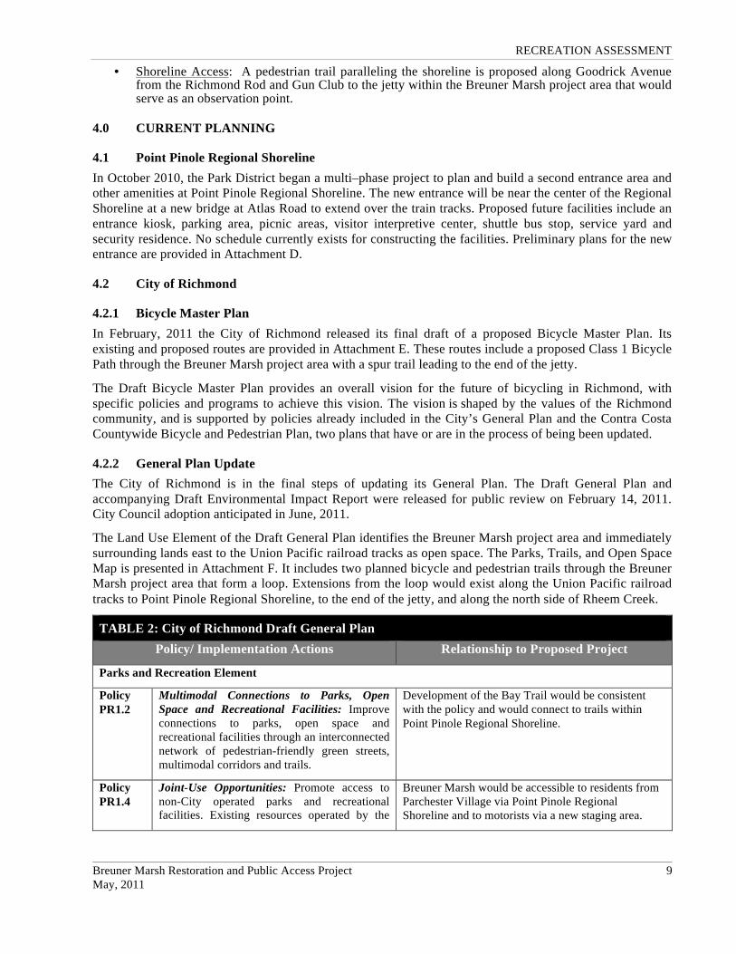
TABLE 2: City of Richmond Draft General Plan Policy/ Implementation Actions Relationship to Proposed Project
Parks and Recreation Element
Policy PR1.2
Multimodal Connections to Parks, Open Space and Recreational Facilities: Improve connections to parks, open space and recreational facilities through an interconnected network of pedestrian-friendly green streets, multimodal corridors and trails.
Development of the Bay Trail would be consistent with the policy and would connect to trails within Point Pinole Regional Shoreline.
Policy PR1.4
Joint-Use Opportunities: Promote access to non-City operated parks and recreational facilities. Existing resources operated by the
Breuner Marsh would be accessible to residents from Parchester Village via Point Pinole Regional Shoreline and to motorists via a new staging area.

RECREATION ASSESSMENT
Breuner Marsh Restoration and Public Access Project 10 May, 2011
TABLE 2: City of Richmond Draft General Plan Policy/ Implementation Actions Relationship to Proposed Project
East Bay Regional Parks District, school district, community groups or others may support residents’ interim needs for convenient access to parks and community centers. Joint-use opportunities serve to more efficiently utilize existing facilities and amenities, host programs in convenient neighborhood locations, better activate community areas so that they are in use during the day and in the evenings and enable the City and partners to share the cost of maintenance, upgrades and improvements for the benefit of the entire community.
Action PR1.E
Coordinate efforts with community groups, property owners, and the BCDC to analyze gaps and identify opportunity sites for completing the Bay Trail; identification of routes and improvements needed to connect the shoreline with core urban areas of the City; bicycle and pedestrian trails to provide local connections between the waterfront and surrounding neighborhoods; and provisions to complete planned regional trails including the San Francisco Bay Trail, Richmond Greenway and Wildcat Creek Regional Trail. The Shoreline Parks Plan will be developed in coordination with specific plans for the waterfront. The Plan will also consider state and federal security requirements for the Chevron refinery and other important industries.
Development of the Bay Trail would be consistent with the action and would complete a gap in the Bay Trail. The project design should allow for a future trail connection along the north side of Rheem Creek.
Policy PR4.1
Access to Large-Scale Natural Areas: Improve access to large-scale natural areas located in the City including regional parks along the shoreline and in the hills. These areas should be open for controlled access to improve public enjoyment and interpretation. Access should be limited where natural habitat is extremely sensitive. Work with transit agencies to improve connections and access to open space and recreation facilities from all Richmond neighborhoods.
Development of the Bay Trail and fishing access is consistent with the policy. Public access control mechanisms to protect habitat resources should be included in the project design.
Policy PR4.2
Shoreline Access and Development: Enhance public access to and encourage development of sports and recreation activities along the Richmond’s shoreline to encourage environmental awareness and improve public health and fitness. Encourage the development of sports and recreation activities along
Development of the Bay Trail and fishing access is consistent with the policy. Interpretive features should be included in the project design. The project is for passive use and not for active sports activities.

RECREATION ASSESSMENT
Breuner Marsh Restoration and Public Access Project 11 May, 2011
TABLE 2: City of Richmond Draft General Plan Policy/ Implementation Actions Relationship to Proposed Project
Richmond’s waterfront.
Conservation and Open Space Element
Action CN2.F
Community Access and Mobility: Develop access and mobility criteria for capital improvement projects and new development to enhance physical access to community facilities, schools, parks, shoreline open spaces, historical destinations, commercial and employment centers and transit hubs. The criteria should address access by walking, bicycling and public transit as well as vehicular access.
The community access and mobility criteria should:
• Ensure safe connections to large and small open spaces, community facilities such as schools, community centers, recreational facilities, cultural and enrichment centers, historical destinations, transit hubs and commercial and employment centers;
• Address travel routes, infrastructure improvement needs and barriers such as roads, railroad lines, highways, fences and natural features; and
• Provide bicycle and pedestrian-friendly routes including completion of major trails and pathways like the San Francisco Bay Trail and Richmond Greenway.
All public access features should be ADA accessible.
Crossing of the Union Pacific railroad tracks directly from Parchester Village is not feasible.
Safety fencing should be provided to discourage crossing of railroad tacks.
Development of the Bay Trail would be consistent with the Action. The project design should allow for a future trail connection along the north side of Rheem Creek.
Policy CN2.5
Access to Large-Scale Natural Areas: Improve access to large-scale natural areas located in the City including regional parks along the shoreline and in the hills. These areas should be open for controlled access to improve public enjoyment and interpretation. Access should be limited where natural habitat is extremely sensitive. Work w
The overall public access program for Breuner Marsh would be consistent with the policy.
Circulation Element
Policy CR1.7
Comprehensive Network of Multi-Use Trails: Develop a comprehensive network of multi-use trails including the Richmond Greenway and the San Francisco Bay Trail to enhance bicycle and pedestrian connectivity throughout the City and the region. Completion of the Bay Trail will enhance access to the Richmond shoreline and adjacent
Development of the Bay Trail would be consistent with the policy and would complete a gap in the Bay Trail. The project design should allow for a future trail connection along the north side of Rheem Creek.

RECREATION ASSESSMENT
Breuner Marsh Restoration and Public Access Project 12 May, 2011
TABLE 2: City of Richmond Draft General Plan Policy/ Implementation Actions Relationship to Proposed Project
open space. The proposed San Francisco Bay Water Trail will also provide enhanced access and recreational opportunities to the Bay.
Action CR1.C
Bicycle and Pedestrian Networks: Develop citywide bicycle and pedestrian routes to make Richmond a more pedestrian and bicycle-friendly City. Identify gaps in the network, major travel routes and priority safety improvements. Expand the network of multi-use trails and off-street paths. Include connections to open space amenities such as Stege Marsh, Point San Pablo, Point Pinole and the Richmond Greenway. Include strong connections to the Downtown, recreation destinations, commercial and mixed-use streets, transit stations and schools. Address pedestrian and bicycle connections in parking lots. Ensure links to the regional trail network including the San Francisco Bay Trail, and consistency with the County Bicycle and Pedestrian Plan. Coordinate efforts with ongoing bicycle and pedestrian community initiatives.
Development of the Bay Trail would be consistent with the action and would connect with Point Pinole Regionals Shoreline.
Action CR1.E
Trails and Greenway Program: Expand multi-use trails and greenways in the City. Provide connector trails and linkages to improve access from inner city neighborhoods to the regional open space in the hills and along the shoreline. Address barriers such as freeways, the Richmond Parkway and railroad tracks that limit shoreline access.
Development of the Bay Trail would be consistent with the policy and would complete a gap in the Bay Trail. The project design should allow for a future trail connection along the north side of Rheem Creek that would potentially bridge the Union Pacific railroad tracks.
RECREATION ASSESSMENT
Breuner Marsh Restoration and Public Access Project 13 May, 2011
REFERENCES Academy of Model Aeronautics. Academy of Model Aeronautics Membership Manual 2011.
Association of Bay Area Governments, Bay Trail Project. San Francisco Bay Trail – Carquinez Strait Map.
California State Coastal Conservancy. San Francisco Bay Water Trail and Revised Draft Environmental Impact Report. August, 2010.
City of Richmond, Planning Department. City of Richmond General Plan. August 1994 with revisions through May 1998.
City of Richmond, Planning Department. City of Richmond General Plan Land Use Map. August, 1994 as amended through November, 2006.
City of Richmond, Planning Department. Volume One of the Richmond General Plan - Goals, Policies, Guidelines, Standards, and Implementation Programs. August, 1994.
City of Richmond, Planning Division. Richmond General Plan Adoption Timeline. February 24, 2011
Brady and Associates. North Richmond Shoreline Specific Plan. Adopted by the Richmond City Council June, 1993.
Web Sites:
Bay Area Radio Control Society: http://www.barcs.org/ (date referenced 5/4/11)
City of Richmond General Plan Update: http://www.cityofrichmondgeneralplan.org/ (date referenced 5/4/11)
Point Pinole Regional Shoreline: http://www.ebparks.org/parks/pt_pinole (date referenced 5/4/11)
Richmond Rod and Gun Club: http://www.richmondrodandgun.com/ (date referenced 4/15/11)
San Francisco Bay Trail: http://www.baytrail.org/ (date referenced 5/4/11)
San Francisco Bay Water Trail: http://scc.ca.gov/2010/07/30/san-francisco-bay-area-water-trail/ (date referenced 5/27/11)
RECREATION ASSESSMENT
Breuner Marsh Restoration and Public Access Project May, 2011
ATTACHMENT A Point Pinole Regional Shoreline Facilities Map
SOURCE: http://www.ebparks.org/parks/pt_pinole

RECREATION ASSESSMENT
Breuner Marsh Restoration and Public Access Project May, 2011
ATTACHMENT B San Francisco Bay Trail Plan Route Map
SOURCE: http://www.baytrail.org/

RECREATION ASSESSMENT
Breuner Marsh Restoration and Public Access Project May, 2011
ATTACHMENT C North Richmond Shoreline Specific Plan Map
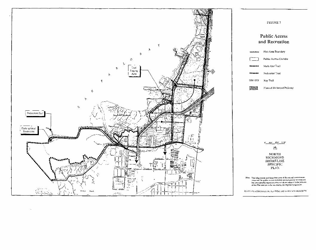
FIGURE 7
Public Accessand Recreation
RECREATION ASSESSMENT
Breuner Marsh Restoration and Public Access Project May, 2011
ATTACHMENT D Point Pinole Regional Shoreline: Preliminary Plans for New Entrance

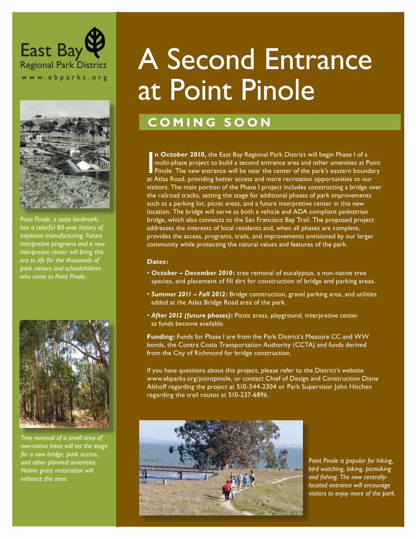
East Bay Regional Park Districtw w w . e b p a r k s . o r g
A Second Entrance at Point Pinole
C o m i n g S o o n
Phot
o: Jo
hn H
itche
n
Point Pinole, a state landmark, has a colorful 80-year history of explosive manufacturing. Future interpretive programs and a new interpretive center will bring this era to life for the thousands of park visitors and schoolchildren who come to Point Pinole.
Tree removal of a small area of non-native trees will set the stage for a new bridge, park access, and other planned amenities. Native grass restoration will enhance the area.
In october 2010, the East Bay Regional Park District will begin Phase I of a multi-phase project to build a second entrance area and other amenities at Point Pinole. The new entrance will be near the center of the park’s eastern boundary
at Atlas Road, providing better access and more recreation opportunities to our visitors. The main portion of the Phase I project includes constructing a bridge over the railroad tracks, setting the stage for additional phases of park improvements such as a parking lot, picnic areas, and a future interpretive center in this new location. The bridge will serve as both a vehicle and ADA compliant pedestrian bridge, which also connects to the San Francisco Bay Trail. The proposed project addresses the interests of local residents and, when all phases are complete, provides the access, programs, trails, and improvements envisioned by our larger community while protecting the natural values and features of the park.
Dates:
• �October�–�December�2010 : tree removal of eucalyptus, a non-native tree species, and placement of fill dirt for construction of bridge and parking areas.
• �Summer�2011�–�Fall�2012: Bridge construction, gravel parking area, and utilities added at the Atlas Bridge Road area of the park.
• After�2012�(future�phases): Picnic areas, playground, interpretive center as funds become available.
Funding: Funds for Phase I are from the Park District’s Measure CC and WW bonds, the Contra Costa Transportation Authority (CCTA) and funds derived from the City of Richmond for bridge construction.
If you have questions about this project, please refer to the District’s website www.ebparks.org/pointpinole, or contact Chief of Design and Construction Diane Althoff regarding the project at 510-544-2304 or Park Supervisor John Hitchen regarding the trail routes at 510-237-6896.
Point Pinole is popular for hiking, bird watching, biking, picnicking and fishing. The new centrally-located entrance will encourage visitors to enjoy more of the park.

Project overview: Tree removal on an 6.5-acre section of this 2,300-acre park will occur during 2010. Tree removal is during non-nesting season on an area of park purchased in 1996 specifically for this new access. The park and trails will remain open during this time. Once trees are removed this 6.5-acre section of park will be closed to visitors during construction of the bridge and parking area. All other park areas will remain open. Visitors may observe large trucks and equipment along Cooks Point and Pinole Point trails. When completed, this second entrance to the park will offer recreation opportunities while protecting the natural values and features of Point Pinole.
2950 Peralta Oaks Ct.Oakland, CA 946051-888-EBPARKSwww.ebparks.org
East Bay Regional Park District
ATLAS ROAD
GIA
NT H
IGHW
AY
RICHMOND PARKWAY
SAN
PA
BLO
AV.
PHANOR DR.
KAY RD.
SHAMROCK DR.
TARA HILLS DR.
WILDFLOWER WY.
OA
KMONT DR.
VISTA DR .
PARK
RID
GE
DR.
MEA
DO
W V
IEW
ROCK
RO
SE
WY.
LAKE
SIDE
DR.
MADEL
INE
RD.
RACH
AEL R
D.
CHRISTIN
E
DR.
HEATH
ER DR.
BONNIE DR.
LETTIA ROAD
GOLD
EN GATE
BRIAN ROAD
BRIA
N ROAD
KAVANAGH
RO
AD
SELMI GROVE
HO
RIZO
ND
R.
HILLTOP DR. RICH
MO
ND
P
ARK
WAY
ATLAS ROAD
BAY
VIEW TRAIL
POW
ERH
OUSE TRAIL
PINO
LEPO
INT TR
AIL
STATION
TRAIL
COOKS
POINT
TRAIL
MARSH TRAIL
OW
L ALLEY
TRAIL
TRAIL
COVE
CHIN A
TRAMWAY TR.
BAY
VIE
W T
RA
IL
WO
OD
S
TRAIL
GIANT
BIAZZ
I TR.NITRO TRAIL
TRAILANGEL BUGGY
PACKHO
USE LO
OP
SOBRA
NTE TR.
.19
.13
.07
.22
.08
.10
.07
.16.08
.21
.12.05
.05
.17
.10.06
.06
.14
.09
.07
.05
.07
.05.05
.07 .22
.12
.11
.08 .07
.07
.09
.05.06
.06
.02.06 .05 .13
.20.14
.08
.38
.45
.15
.04
.28
.20.08
.19
.12
.18
.18 .18
.23
.22
.07
.06
.17
.15
.48
.32
.30
.09
.28
.02
.06
50
50
100
5050
RichmondCountry
Club
West CountyDetention
Facility
Montara Bay Comm. Center
MontalvinPark
San Pablo Bay
San Pablo Bay
BasketballCourts
SoftballField
ParchesterMarsh
SHUTTLESTOP
SHUTTLESTOP
BRIDGELAWNAREA
SHORELINE
GIANT CLUSTER
PALMS
DYNAMITE BLAST& BURNING BUNKER
BLACKPOWDERPRESS
To Richmond Parkway
R I C H M O N D
WhittellMarsh
Hayward
Fault
Southern Pacific Railroad
DYNAMITE BLAST & BURNINGBUNKER
To Richmond Parkway
North
POINT PINOLE REGIONAL SHORELINE
THIS AREA CLOSED UNTIL MADE SAFE FOR PUBLIC USE
New AtlasRoad Bridge
Future Park Development Area
Tree Removal Project Area
Future Park Development Area
RECREATION ASSESSMENT
Breuner Marsh Restoration and Public Access Project May, 2011
ATTACHMENT E City of Richmond Draft Bicycle Master Plan Map
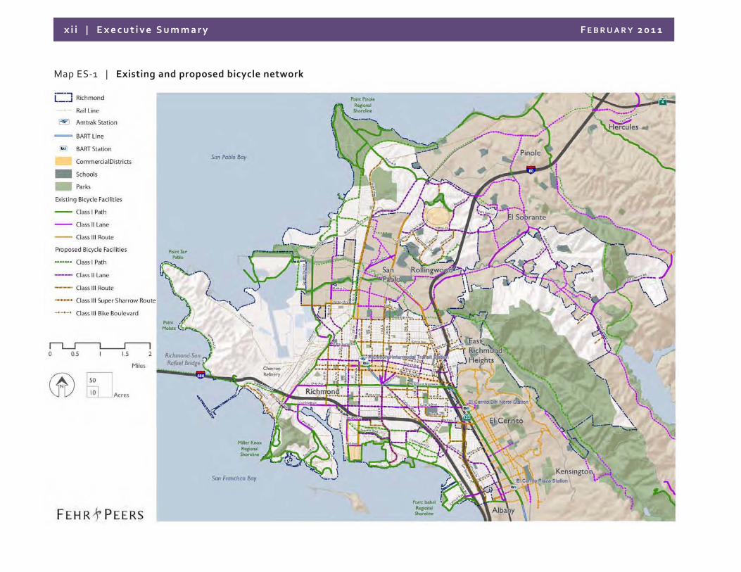
x i i | Execu t i ve Summary FEBRUARY 2011
Map ES‐1 | Existing and proposed bicycle network

RECREATION ASSESSMENT
Breuner Marsh Restoration and Public Access Project May, 2011
ATTACHMENT F City of Richmond Draft General Plan: Parks, Trails, and Open Space Map

S H A P I N G T H E N E W 1 0 0 Y E A R S | 10.55
10 Parks and Recreation
C O U N T Y C O U N T Y
C O U N T Y
C O U N T Y
C O N T R A C O S T AC O U N T Y
C O U N T Y
P I N O L E
H E R C U L E S
E L C E R R I T O
S A N P A B L O
C O U N T Y
K E N S I N G T O N
A L A M E D A C O U N T Y
SAN
PAB
LO AV
E
23
RD
ST
RIC
HM
ON
D P
KW
Y
CARLSON BLVDCUTTING BLVD
BARRETT AVEMACDONALD AVE
GIA
NT
RD
POTRERO AVE
MOESER LN
RUMRILL BLVD
CENTRAL AVE
GARRARD BLV
D
RD 20
AP
PIA
N W
Y
TENN
ENT AV
E
SOLANO AVE
WEST CUTTING BLVD
13T
H S
T
MCBRYDE AVE
HA
RB
OU
R W
Y
APPIAN W
Y
ARLINGTO
N B
LV D
CASTRO RANCH RD
ALHAMBRA VALLEY RD
PIN
OL
E V
ALLEY RD
VALLEY
VIEW
RD
BLU
ME
DR
HILLTOP DR
REFUGIO VALLEY RD
SYCAMORE AVE
SAN PABLO AVE
RICHM
ON
D P
KW
Y
BROOKSIDE DR SAN PABLO DAM RD
EL PORTAL DR
I-580
I-80
I-80
4
San Pablo Bay
San Francisco Bay
Richmond Inner Harbor
San Pablo Reservoir
Refugio Creek
Pinole Creek
Wildcat Creek
Rheem Creek
San Pablo Creek
Gar
rity Cre
ek
BART - Richmond Line
RichmondBART Station
El Cerrito Del Norte BART Station
El Cerrito Plaza BART Station
TildenRegional Park
Point Pinole Regional Shoreline
Wildcat CanyonRegional Park
Brooks Island
Sobrante RidgeRegional Preserve
Miller / KnoxRegional Shoreline
East Bay ShorelineState Park
Point IsabelRegional Shoreline
San Pablo Bay Regional Shoreline
Source: City of Richmond, Contra Costa County, Metropolitan Transportation Commission, Thomas Bros. Maps, US Census, State of California, MIG Inc.Thomas Bros. Map data reproduced with permission granted by THOMAS BROS. MAPS. THOMAS BROS. MAPS data is copyrighted by THOMAS BROS. MAPS. It is unlawful to copy or reproduce all or any part thereof, whether for personal use or resale, without the prior, written permission of THOMAS BROS. MAPS.
Current City and County Parks
Current Regional Parks and Open Space
Other Open Spaces (Cemetaries and Golf Courses)
City of Richmond
Existing Bicycle and Pedestrian Trail
Planned Bicycle and Pedestrian Trail
N
0 1 20.5 MILES
ACRES10
50
Parks, Trails and Open SpaceMap 10.1
* New areas for parks and open space are proposed as part of thisGeneral Plan. Please refer to the Map 3.2 of the General PlanLand Use and Urban Design Element
Pinole Park
Richmond Country Club
Kennedy Grove Regional Recreation
Area
Rolling HillsMemorial
Park(Cemetary)
Hillside Natural Area
Mira Vista Country Club & Golf Course
Sunset ViewCemetary
Saint JosephCemetary
Hilltop Lake Park
Hillside Natural Area
NichollPark
Hilltop Park
LamoinePark
Valley ViewSchool Field
Castro Park
Fairmede Park
Richmond City Hall Center
Vincent Park
Arlington Park
Ohlone Park
Booker T Anderson Jr Park
Refugio Valley Park
Olinda School Field
Point MolateBeach Park
Cerrito Vista Park
John HubertDavis Park
Hilltop Green Park
Canyon TrailPark
Rosie the Riveter Park
Sarah Drive Park
MontavinPark
Hugh Young Open Sapce
Huber Park
Nevin Park
Foxboro Park
John F Kennedy Park
Marina Park & Green
North Richmond Ball Park
Montara Bay Community Ctr
Woodfield Park
Fernandez Park
Shields-ReidPark
Casa Cerrito Rec Ctr
BayfrontPark
Atchison VillagePark
RichmondGreenway
Martin Luther King Memorial Park
Tiller Park
BoormanPark
TassajaraPark
Sheridan Point Park
Rain CloudPark
Amber Swartz Park
AlvaradoPark
MemorialPark
FairmontPark
Crecent Park
WashingtonPark
MeadowPark
Wendell Park
Mira VistaPark
ParchesterPark
Plaza One Park
Kennedy Swim Center
Burg Park
Belding-GarciaPark
Louis FrancisPark
CANYON DRIVE PARK
Humbolt Park
StewartPlaygroud
ElmPlaylot
Abraham Braxton Park
Monterey Playlot
Solano Playlot
KernPlaylot
Point RichmondCivic Triangle
Lucas ParkPlayground
Country ClubVista Park
Bay VistaPark
Note: Larger format maps are available for view or purchase at the Planning and Building Services Department.

........................................................................................................................
A P P E N D I X K
T R A F F I C B A C K G R O U N D R E P O R T

........................................................................................................................
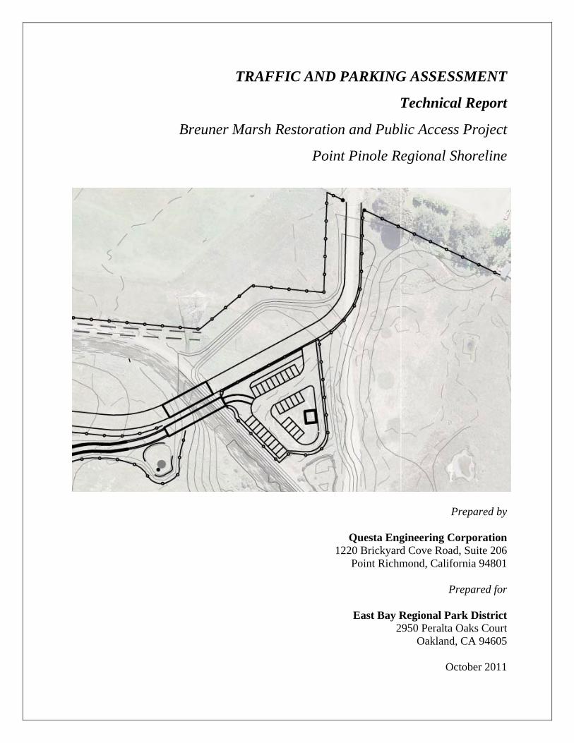
TRAFFIC AND PARKING ASSESSMENT
Technical Report
Breuner Marsh Restoration and Public Access Project
Point Pinole Regional Shoreline
Prepared by
Questa Engineering Corporation 1220 Brickyard Cove Road, Suite 206
Point Richmond, California 94801
Prepared for
East Bay Regional Park District 2950 Peralta Oaks Court
Oakland, CA 94605
October 2011

TRAFFIC AND PARKING ASSESSMENT TECHNICAL REPORT
Breuner Marsh Restoration and Public Access Project
Point Pinole Regional Shoreline
Prepared for:
East Bay Regional Park District 2950 Peralta Oaks Court
Oakland, CA 94605
Submitted by
Questa Engineering Corporation 1220 Brickyard Cove Road, Suite 206
Point Richmond, California 94801 Tel: (510) 236-6114 Fax: (510) 236-2423
Questa Project #1000008
October 2011
TRAFFIC AND PARKING ASSESSMENT
TABLE OF CONTENTS
1. INTRODUCTION .............................................................................................................................. 1
2. EXISITNG CONDITIONS ................................................................................................................ 2
Regional Access.................................................................................................................................... 2
Local Street System .............................................................................................................................. 2
Public Transit........................................................................................................................................ 3
Bicycle and Pedestrian Facilities .......................................................................................................... 3
3. PROJECTED DEMAND ................................................................................................................... 4
Bicycle Demand Methodology ............................................................................................................. 4
Results................................................................................................................................................... 6
Trip Generation and Parking Demand ................................................................................................ 6
4. REFERENCES ................................................................................................................................... 9
Personal Communication:..................................................................................................................... 9
Breuner Marsh Restoration and Public Access Project i October 2011
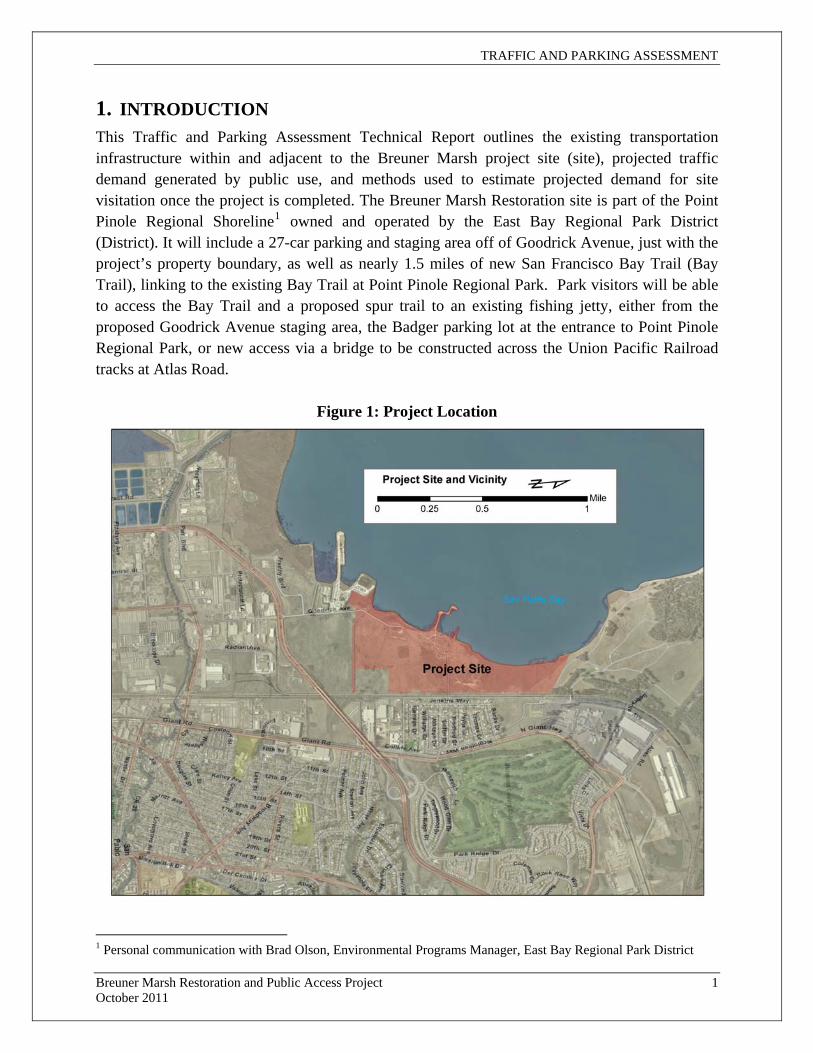
TRAFFIC AND PARKING ASSESSMENT
Breuner Marsh Restoration and Public Access Project 1 October 2011
1. INTRODUCTION This Traffic and Parking Assessment Technical Report outlines the existing transportation infrastructure within and adjacent to the Breuner Marsh project site (site), projected traffic demand generated by public use, and methods used to estimate projected demand for site visitation once the project is completed. The Breuner Marsh Restoration site is part of the Point Pinole Regional Shoreline1 owned and operated by the East Bay Regional Park District (District). It will include a 27-car parking and staging area off of Goodrick Avenue, just with the project’s property boundary, as well as nearly 1.5 miles of new San Francisco Bay Trail (Bay Trail), linking to the existing Bay Trail at Point Pinole Regional Park. Park visitors will be able to access the Bay Trail and a proposed spur trail to an existing fishing jetty, either from the proposed Goodrick Avenue staging area, the Badger parking lot at the entrance to Point Pinole Regional Park, or new access via a bridge to be constructed across the Union Pacific Railroad tracks at Atlas Road.
Figure 1: Project Location
1 Personal communication with Brad Olson, Environmental Programs Manager, East Bay Regional Park District

TRAFFIC AND PARKING ASSESSMENT
2. EXISITNG CONDITIONS Regional Access
The site can be accessed from major freeways from the north (I-80), the west (I-580 via the Richmond-San Rafael Bridge), and from the south (I-80 via the Bay Bridge, I-580, or I-880). Connecting roads from the east include State Route (SR) 24 and SR 4. Access to the site is via Richmond Parkway, a limited access facility with a mixture of at-grade signalized intersections and some grade-separated interchanges such as Garrard Boulevard to the south, and Richmond Parkway/I-580 to the east. The site is accessed from a signalized intersection at Richmond Parkway and Goodrick Avenue. Richmond Parkway has two to three lanes in each direction, depending upon the roadway segment. Other signalized intersections on Richmond Parkway north of the project site are located at Giant Road (interchange), Atlas Road, Hilltop Drive and at the intersection of Richmond Parkway and San Pablo Avenue. The closest Bay Area Rapid Transit (BART) station is the northern terminus of the Richmond line, located near the intersection of Barrett Avenue and 23rd Street approximately three miles east of the project area. The closest station adjacent to I-80 is El Cerrito del Norte, which is approximately four miles from the Project Site. Local Street System
In addition to Richmond Parkway, Giant Highway is the second closest major north-south street and is located approximately 0.25 to 0.5 miles to the east. Generally, it is a two-lane roadway that begins at Brookside Drive and extends north to Atlas Road. East-west roads that intersect with Richmond Parkway near the project area and to the south include Parr Boulevard, Pittsburg Avenue, and Gertrude Avenue. The Breuner Marsh site is not directly accessible from Giant Road due to the UP rail line that divides the area. Goodrick Avenue is a two-lane public street that provides vehicular access to the Breuner property near Rheem Creek, where it is gated. A partially paved and deteriorated section of road continues within the site, roughly following the Bay shoreline wetlands edge, and provides internal access to the site, including the model airplane facility operated by the Bay Area Radio Control Society (BARCS). There are also unpaved service roads on the south side of Rheem Creek, along with a number of now mostly overgrown internal dirt access roads. Currently Goodrick Avenue is primarily used by EBRPD and members and visitors of BARCS and the Richmond Rod and Gun Club, as well as personnel from the District, West County Wastewater District, Contra Costa County Flood Control and Water Conservation District, Pacific Gas and Electric Company, Chevron Oil, Shell Oil, and Union Pacific Railroad.
Breuner Marsh Restoration and Public Access Project 2 October 2011
TRAFFIC AND PARKING ASSESSMENT
Public Transit
The City of Richmond and site are served by AC Transit (bus service) and two regional rail services which include BART through Richmond, Berkeley, and Oakland, and AMTRAK's Capitol Route between Sacramento and San Jose, serving visitors at the multimodal facility in Richmond. Three AC Transit bus routes provide service to within 1.5 miles of the project area. This distance is too far for most persons to walk to or from a transit stop (as a general rule this distance is one-quarter mile or less). However, buses on these routes have outside bike racks, which can accommodate up to two bikes at one time. No bus service is currently provided on Richmond Parkway between Garrard Boulevard and Giant Highway. Routes 71 and 76 provide service to the vicinity of Giant Highway and Richmond Parkway via Rumrill Boulevard and Broadway Avenue. Route 71 continues on to I-80 via Giant Highway, Atlas Road, and Richmond Parkway. The two routes operate from approximately 7:00 AM to 8:30 PM on 30-minute headways during weekdays and 60-minute headways during weekends. They provide service to the following major trip generators to the south of the Project Site: Contra Costa College, the Richmond BART station and the El Cerrito del Norte BART station. The third bus route is Route 376, the North Richmond Shuttle, which takes the place of Routes 71 and 76 as well as several other routes from approximately 8:00 PM to 2:00 AM. It maintains approximately the same coverage as daytime routes with a more circuitous loop. Headways are 30 minutes for both clockwise and counterclockwise directions. Some limited route deviation is available on this line. Bicycle and Pedestrian Facilities
There are no bicycle facilities in the immediate project area. Likewise, most streets in the project vicinity do not have sidewalks, requiring pedestrians to walk on the shoulder of the streets. As an expressway facility, Richmond Parkway in the immediate project vicinity is not designed to accommodate pedestrians, and the Parkway overpass of the rail line east of the site precludes bicycles and pedestrians. Further south, portions of the Parkway contain discontinuous pedestrian facilities and have been designated as Bay Trail segments. For instance, trail sidewalks are continuous along the Richmond Parkway from I-580 to Wildcat Creek. Goodrick Avenue is a low-volume road with no curbs or sidewalks.
Breuner Marsh Restoration and Public Access Project 3 October 2011
The Bay Trail has been designed to provide a continuous trail around San Francisco Bay for use by both recreational and commuter bicyclists and pedestrians. Many segments have already been constructed but in other locations the trail is only conceptual at this time. The proposed plan for the Trail includes a segment adjacent to the shoreline north of Richmond Parkway, then east along Rheem Creek, and continuing north through the Project Site. The Bay Trail also includes a proposed east-west segment south of the Project Site that crosses Rumrill Boulevard near Davis Park where a connection to Route 71 could take place. The proposed Breuner Marsh Restoration and Public Access Project would make some changes to the currently designated alignment of the Bay Trail, but would implement or close this important gap in the Bay Trail in this area (see

TRAFFIC AND PARKING ASSESSMENT
Breuner Marsh Restoration and Public Access Project 4 October 2011
the project’s Recreation Assessment Report by 2M Associates, July 2011, for further information on the Bay Trail and public access trails in this area). 3. PROJECTED DEMAND Bicycle Demand Methodology
There is a lack of comparable methodology to accurately estimate anticipated bicycle facility demand for open space areas. Many bicycle and pedestrian facility demand models utilize bicycle and pedestrian count data from the field to compare against population and employment densities, the location of nearby attractors (retail stores, schools, parks, etc.), and demographics. Many of the models used for pedestrian and bicycle demand cannot be generalized between locations with widely different land-use, demographics, and even differing climate conditions, all of which influence multi-path seasonal use. For example, comparison models have discrepancies in estimated pathway use of 10 times or more for areas with similar demographics and land use.2 However, given the low traffic impact the Breuner Marsh project is expected to have, a sketch planning methodology was used to estimate bicycle demand.
The Bicycle Facility Demand Model based on the National Highway Cooperative Research Program (NCHRP) Report number 552 Guidelines for Analysis of Investments in Bicycle Facilities was chosen to estimate bicycle demand for the Project Site., including Bay Trail use. This study uses US Census information on travel to work and residential population estimates within 0.5 to 1.5 miles of the proposed bicycle facility to project bicycle travel demand. In addition to Census data, the model relies on inputs such as facility length and on/off-street designation. It should be noted that use demand for pedestrians and other groups such as recreational hikers and nature observers is not directly factored into the analysis.
Figure 2 shows the project site and census block group areas used for estimating population densities, which are used as model inputs. The model outputs (Table 1) present area population, existing and new bicycle facility users in modified3 low ranges for the area within three 0.5 mile intervals, comprising a 1.5 mile sphere of influence surrounding the project site.
2 Transportation Research Board, 2006 3 Research for the bicycle demand estimation presented in NCHRP 552 uses characteristics endemic to the St. Paul-Minneapolis metropolitan area. Therefore multipliers were modified to better suit the prevalent conditions of Richmond, CA. The mid and high range estimates were overestimated and excluded from the report. The overestimation, it is believed, resulted from distinct differences between the populations of Richmond, CA and the Twin Cities area.
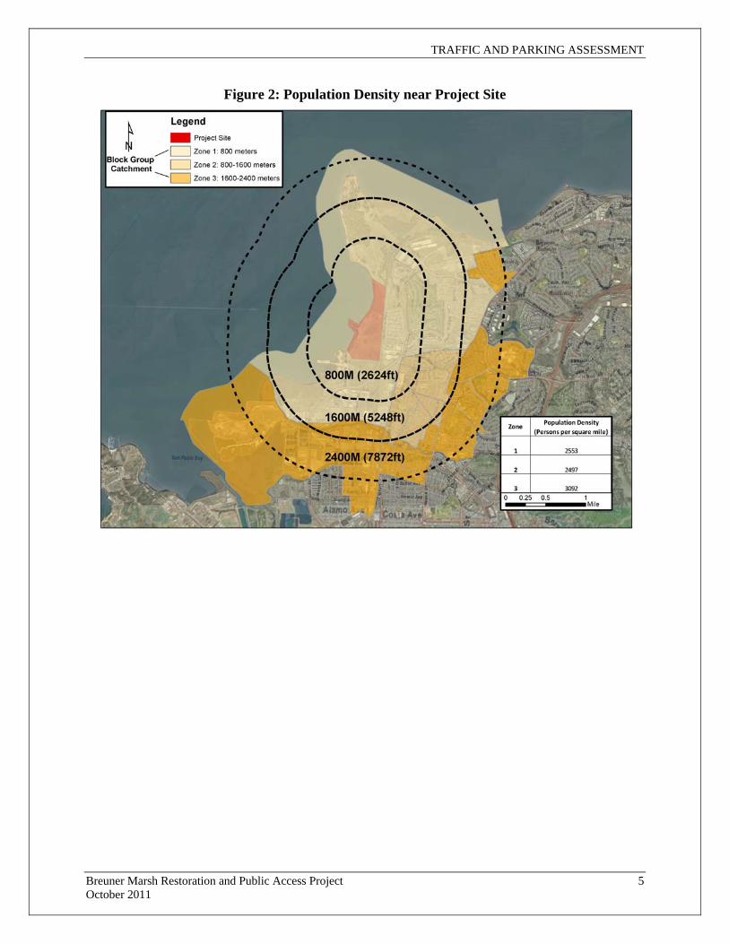
TRAFFIC AND PARKING ASSESSMENT
Figure 2: Population Density near Project Site
Breuner Marsh Restoration and Public Access Project 5 October 2011

TRAFFIC AND PARKING ASSESSMENT
Breuner Marsh Restoration and Public Access Project 6 October 2011
Table 1: Bicycle Demand Estimates
Inputs Outputs
Facility Length Zone Population
Density New Bicycle Commuters
New Daily Cyclists
5,000 ft 1 2,553 13 18
2 2,497 12 17
3 3,092 15 21
Total 8,142 40 57
Results
The Bicycle Facility Demand Model estimates that a total daily average of 57 new bicycle users per day will be generated by the proposed project. The total bicycle commuter estimates under existing and future build-out scenarios (156 and 196, respectively—not shown on table) will become more realistic once nearby gaps are filled in the Bay Trail network, and connectivity to destinations are improved. Therefore, day use for total cyclists may only reflect the number of new daily bicyclists until accessing the Bay Trail for commuting purposes becomes more feasible in the future. Trip Generation and Parking Demand
Estimates for parking demand were derived by employing trip generation rates appropriate for the project site’s designated land use, “open space.” The Institute of Transportation Engineers’ Trip Generation Handbook, eighth edition, designates a land use code 412-County Park, which includes open space owned by a County.4 The number of trips projected for the Project Site was calculated for weekday average daily trips, AM and PM peak hour trips (7am-9am and 4pm-6pm, respectively), Saturday and Sunday average daily trips, and Saturday and Sunday peak hour trips. The trip rates and estimates are given in Table 2.
4 ITE, 2008
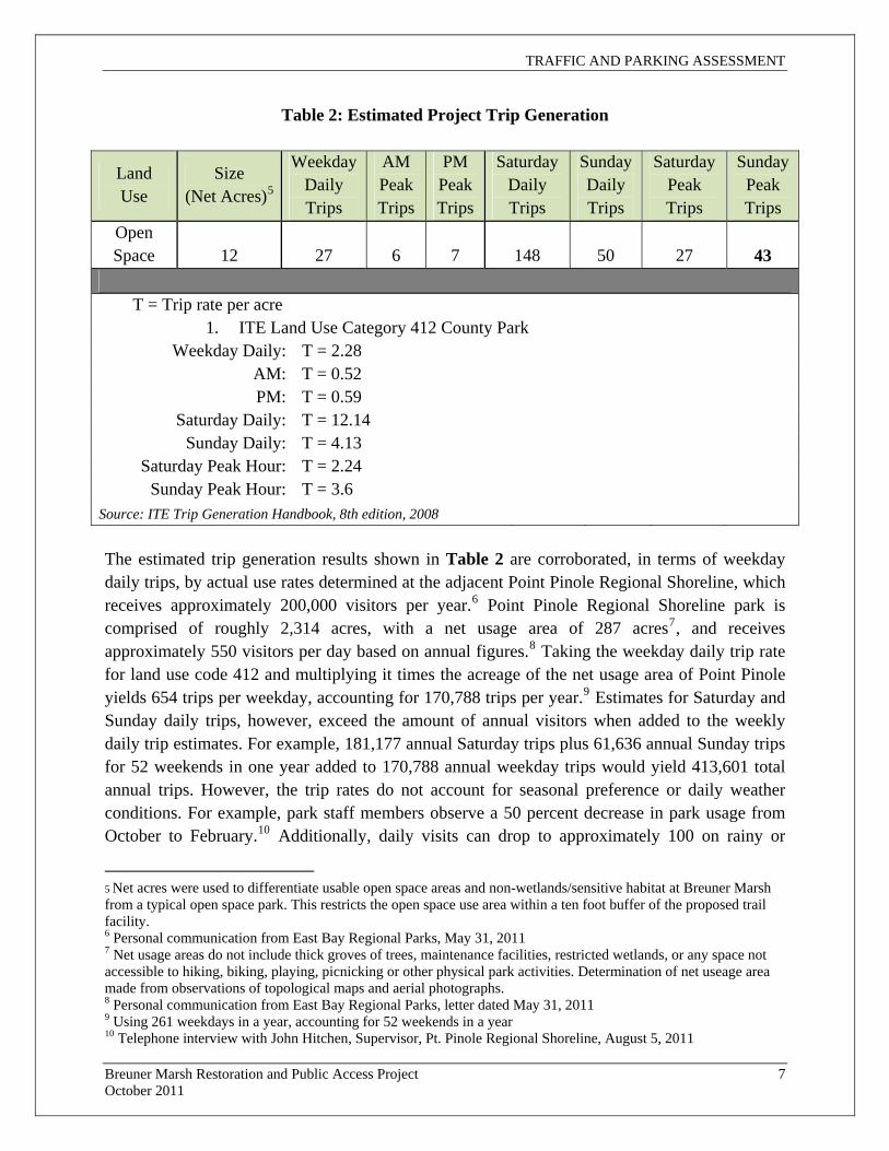
TRAFFIC AND PARKING ASSESSMENT
Breuner Marsh Restoration and Public Access Project 7 October 2011
Table 2: Estimated Project Trip Generation
Land Use
Size (Net Acres)5
Weekday Daily Trips
AM Peak Trips
PM Peak Trips
Saturday Daily Trips
Sunday Daily Trips
Saturday Peak Trips
Sunday Peak Trips
Open Space 12 27 6 7 148 50 27 43
T = Trip rate per acre
1. ITE Land Use Category 412 County Park Weekday Daily: T = 2.28
AM: T = 0.52 PM: T = 0.59
Saturday Daily: T = 12.14 Sunday Daily: T = 4.13
Saturday Peak Hour: T = 2.24 Sunday Peak Hour: T = 3.6
Source: ITE Trip Generation Handbook, 8th edition, 2008 The estimated trip generation results shown in Table 2 are corroborated, in terms of weekday daily trips, by actual use rates determined at the adjacent Point Pinole Regional Shoreline, which receives approximately 200,000 visitors per year.6 Point Pinole Regional Shoreline park is comprised of roughly 2,314 acres, with a net usage area of 287 acres7, and receives approximately 550 visitors per day based on annual figures.8 Taking the weekday daily trip rate for land use code 412 and multiplying it times the acreage of the net usage area of Point Pinole yields 654 trips per weekday, accounting for 170,788 trips per year.9 Estimates for Saturday and Sunday daily trips, however, exceed the amount of annual visitors when added to the weekly daily trip estimates. For example, 181,177 annual Saturday trips plus 61,636 annual Sunday trips for 52 weekends in one year added to 170,788 annual weekday trips would yield 413,601 total annual trips. However, the trip rates do not account for seasonal preference or daily weather conditions. For example, park staff members observe a 50 percent decrease in park usage from October to February.10 Additionally, daily visits can drop to approximately 100 on rainy or
5 Net acres were used to differentiate usable open space areas and non-wetlands/sensitive habitat at Breuner Marsh from a typical open space park. This restricts the open space use area within a ten foot buffer of the proposed trail facility. 6 Personal communication from East Bay Regional Parks, May 31, 2011 7 Net usage areas do not include thick groves of trees, maintenance facilities, restricted wetlands, or any space not accessible to hiking, biking, playing, picnicking or other physical park activities. Determination of net useage area made from observations of topological maps and aerial photographs. 8 Personal communication from East Bay Regional Parks, letter dated May 31, 2011 9 Using 261 weekdays in a year, accounting for 52 weekends in a year 10 Telephone interview with John Hitchen, Supervisor, Pt. Pinole Regional Shoreline, August 5, 2011
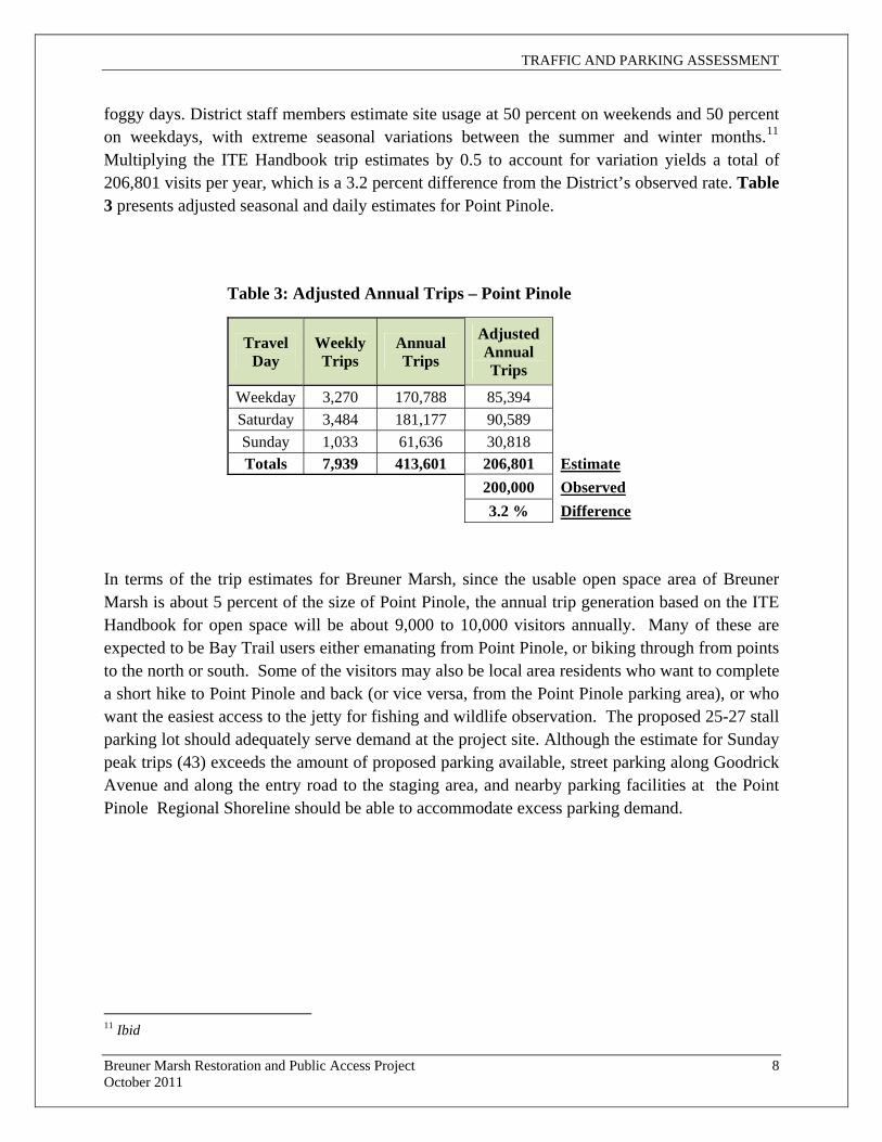
TRAFFIC AND PARKING ASSESSMENT
Breuner Marsh Restoration and Public Access Project 8 October 2011
foggy days. District staff members estimate site usage at 50 percent on weekends and 50 percent on weekdays, with extreme seasonal variations between the summer and winter months.11 Multiplying the ITE Handbook trip estimates by 0.5 to account for variation yields a total of 206,801 visits per year, which is a 3.2 percent difference from the District’s observed rate. Table 3 presents adjusted seasonal and daily estimates for Point Pinole.
Table 3: Adjusted Annual Trips – Point Pinole
Travel Day
Weekly Trips
Annual Trips
Adjusted Annual Trips
Weekday 3,270 170,788 85,394 Saturday 3,484 181,177 90,589 Sunday 1,033 61,636 30,818 Totals 7,939 413,601 206,801 Estimate
200,000 Observed 3.2 % Difference
In terms of the trip estimates for Breuner Marsh, since the usable open space area of Breuner Marsh is about 5 percent of the size of Point Pinole, the annual trip generation based on the ITE Handbook for open space will be about 9,000 to 10,000 visitors annually. Many of these are expected to be Bay Trail users either emanating from Point Pinole, or biking through from points to the north or south. Some of the visitors may also be local area residents who want to complete a short hike to Point Pinole and back (or vice versa, from the Point Pinole parking area), or who want the easiest access to the jetty for fishing and wildlife observation. The proposed 25-27 stall parking lot should adequately serve demand at the project site. Although the estimate for Sunday peak trips (43) exceeds the amount of proposed parking available, street parking along Goodrick Avenue and along the entry road to the staging area, and nearby parking facilities at the Point Pinole Regional Shoreline should be able to accommodate excess parking demand.
11 Ibid
TRAFFIC AND PARKING ASSESSMENT
Breuner Marsh Restoration and Public Access Project 9 October 2011
4. REFERENCES Institute of Transportation Engineers. Trip Generation Handbook, eigth edition. ITE 2008, Washington, DC
National Highway Cooperative Research Program. Guidelines for Analysis of Investments in Bicycle Facilities. Transportation Research Board 2006, Washington, DC
Personal Communication:
Letter regarding annual use figures at Pt. Pinole Regional Shoreline dated May 31, 2011 provided by Brad Olson, Environmental Programs Manager, East Bay Regional Park District
Personal communication with John Hitchen, Supervisor, Pt. Pinole Regional Shoreline, regarding seasonal and daily use rate fluctuations conducted on August 5, 2011

........................................................................................................................
A P P E N D I X L
A L T E R N A T I V E S R E P O R T

........................................................................................................................

CONC E P T R E S TO R A T I ON A L T E RN A T I V E S
BREUNER MARSH
RICHMOND, CONTRA COSTA COUNTY, CALIFORNIA
Submitted to:
East Bay Regional Park District
2950 Peralta Oaks Court
Oakland, CA 94605-0381
Prepared by:
LSA Associates, Inc.
157 Park Place
Point Richmond, CA 94801
(510) 236-6810
February 24, 2010
P:\EBR0901\Restoration Alternatives\Report.doc (02/17/10) i
TABLE OF CONTENTS
INTRODUCTION.................................................................................................................................. 1
APPROACH ................................................................................................................................ 1 OPPORTUNITIES EVALUATED.............................................................................................. 2 METHODS .................................................................................................................................. 2
EXISTING CONDITIONS .................................................................................................................... 3 LOCATION ................................................................................................................................. 3 COVER TYPES........................................................................................................................... 3 EXTANT HABITAT AND ASSOCIATED SPECIAL-STATUS SPECIES.............................. 3
CONCEPT RESTORATION ALTERNATIVES .................................................................................. 5 ALTERNATIVES CONSIDERED ............................................................................................. 5
Alternative 1. Minimal Plan .............................................................................................. 5 Alternative 2. Off-site Disposal Plan................................................................................. 5 Alternative 3. Reconstructed Tidal Slough........................................................................ 5
DISCUSSION OF PROBLEM FEATURES............................................................................... 6 “Duck's Neck” Peninsula................................................................................................... 6 Created Freshwater Seasonal Wetland .............................................................................. 6 Freshwater Pond ................................................................................................................ 7 Willow Riparian ................................................................................................................ 7 Parking Lot Placement....................................................................................................... 7
COST ESTIMATES, SCREENING MATRIX, AND DISCUSSION................................................... 8 COST ESTIMATES .................................................................................................................... 8 SCREENING MATRIX .............................................................................................................. 8 DISCUSSION .............................................................................................................................. 8
P:\EBR0901\Restoration Alternatives\Report.doc (02/17/10) ii
FIGURES AND TABLES
FIGURES
Figures are located at the end of the report.
Figure 1.0 Project Boundaries
Figure 2.0 Existing Conditions
Figure 3.1 Alternative 1 – Minimal Plan
Figure 3.2 Alternative 2 – Off-site Spoils Disposal Plan
Figure 3.3 Alternative 3 - Reconstructed Tidal Slough Plan
TABLES
Tables are located at the end of the report.
Table 1. Comparison of Features, Marsh Restoration Alternatives
Table 2. Acres of Cover Types, Marsh Restoration Alternatives
Table 3. Cost Estimates, Pre-implementation Phases
Table 4. Cost Estimates, Pre-implementation and Implementation Phases
Table 5. Screening Matrix, Marsh Restoration Alternatives
L S A A S S O C I A T E S , I N C .L S A A S S O C I A T E S , I N C .L S A A S S O C I A T E S , I N C .L S A A S S O C I A T E S , I N C . C O N C E P T R E S T O R A T I O N C O N C E P T R E S T O R A T I O N C O N C E P T R E S T O R A T I O N C O N C E P T R E S T O R A T I O N A L T E R N A T I V E SA L T E R N A T I V E SA L T E R N A T I V E SA L T E R N A T I V E S
F E B R U A R Y 2 0 1 0F E B R U A R Y 2 0 1 0F E B R U A R Y 2 0 1 0F E B R U A R Y 2 0 1 0 B R E U N E R M A R S HB R E U N E R M A R S HB R E U N E R M A R S HB R E U N E R M A R S H
C O N T R A C O S T A C O U N T Y ,C O N T R A C O S T A C O U N T Y ,C O N T R A C O S T A C O U N T Y ,C O N T R A C O S T A C O U N T Y , R I C HMO ND , C A L I F O R N I R I C HMO ND , C A L I F O R N I R I C HMO ND , C A L I F O R N I R I C HMO ND , C A L I F O R N I AAAA
P:\EBR0901\Restoration Alternatives\Report.doc (02/24/10) 1
INTRODUCTION
This presentation of concept restoration alternative scenarios for the East Bay Regional Park
District’s Breuner Marsh is an early phase in developing a more detailed implementation plan for the
restoration of environmental values and for the creation and enhancement of recreational values on
this site.
This report is written to be compatible with the Baylands Ecosystem Habitat Goals (San Francisco
Estuary Project 1999). The restoration plan is also be designed to be suitable for evaluation by the
trustee agencies (i.e., National Oceanic and Atmospheric Administration, US Fish and Wildlife
Service, and California Department of Fish and Game) for partial mitigation for environmental
damage to Castro Cove (Castro Cove/Chevron Richmond Refinery, Draft, Damage Assessment and
Restoration Plan/Environmental Assessment, 2008).
This report was prepared by LSA Associates, Inc. (LSA). Roger D. Harris, Certified Wildlife
Biologist, was the project manager. Malcolm J. Sproul was the principal-in-charge. Biologist Leslie
Allen and GIS specialists Greg Gallaugher and Lori Welch made major contributions with assistance
from other LSA staff. Civil engineer Glenn Dearth from LTD Engineering, Inc., assisted us with the
construction cost estimates. LSA planner Dennis Brown provided input on the CEQA process and
costing of permits.
APPROACH
The purpose of the restoration plan is to increase natural habitat values of the site for marine, inter-
tidal, and upland habitats. A range of restoration alternatives are presented. The alternatives are
designed to be compatible with constraints presented by adjacent properties (e.g., avoidance of
flooding neighbors). Compatible recreational uses are incorporated into the plan alternatives,
including provisions for closing the gap in the San Francisco Bay Trail, creating spur trails, public
access to the shoreline, fishing access, and public parking. Some of the trails may be placed on
boardwalks to minimize impacts to sensitive habitat.
Three alternative scenarios are presented, based primarily on cost considerations and on balancing
opportunities for creation of tidal habitat versus preservation of existing non-tidal habitat values.
Costs of alternatives are roughly calculated at this stage in the planning process based on a per-unit
cost for moving and disposing excavated material. Balancing cut and fill on-site would be desirable
from a cost savings point of view, but could result in covering and thus impacting existing coastal
prairie habitat. Our approach is to provide alternative scenarios of maximizing on-site cut and fill
balance versus maximizing upland habitat values and off-site disposal of excess excavated materials.
It may be possible to bury some if not all rubble from the model airplane port under excavated
material, or some or all rubble may need to be exported. If present, hazardous materials may need to
be disposed off the site.

L S A A S S O C I A T E S , I N C .L S A A S S O C I A T E S , I N C .L S A A S S O C I A T E S , I N C .L S A A S S O C I A T E S , I N C . C O N C E P T R E S T O R A T I O N C O N C E P T R E S T O R A T I O N C O N C E P T R E S T O R A T I O N C O N C E P T R E S T O R A T I O N A L T E R N A T I V E SA L T E R N A T I V E SA L T E R N A T I V E SA L T E R N A T I V E S
F E B R U A R Y 2 0 1 0F E B R U A R Y 2 0 1 0F E B R U A R Y 2 0 1 0F E B R U A R Y 2 0 1 0 B R E U N E R M A R S HB R E U N E R M A R S HB R E U N E R M A R S HB R E U N E R M A R S H
C O N T R A C O S T A C O U N T Y ,C O N T R A C O S T A C O U N T Y ,C O N T R A C O S T A C O U N T Y ,C O N T R A C O S T A C O U N T Y , R I C HMO ND , C A L I F O R N I R I C HMO ND , C A L I F O R N I R I C HMO ND , C A L I F O R N I R I C HMO ND , C A L I F O R N I AAAA
P:\EBR0901\Restoration Alternatives\Report.doc (02/24/10) 2
This report is at a conceptual level. At a subsequent design-level, professional civil engineer and
hydrologist expertise would be required. Subsequent investigations would be required to determine
the potential presence of hazardous materials.
OPPORTUNITIES EVALUATED
Opportunities exist on the Breuner Marsh to create and/or enhance tidal wetlands, seasonal wetlands,
and coastal prairie uplands. Opportunities that are presented for restoration at the Breuner Marsh
include laying back the north bank of Rheem Creek to create more of a tidal slough and flood plain
environment, excavation of channels delivering enhanced tidal flow into interior portions of the site,
removal of fill, removal of the model airplane facility, control of invasive exotic plants, enhancement
of salmon open water habitat, and native oyster restoration.
METHODS
Historic aerial photographs were examined to understand prior site conditions and to estimate the
locations of fill, past industrial use, and past agricultural use. The aerial photographs indicated that
the site is substantially altered from pristine conditions. Examination of the historic aerial
photographs showed that the location of Rheem Creek had been altered at least twice and that the site
did not support riparian (i.e., freshwater) vegetation. Originally Rheem Creek flowed through the
center of the Breuner Marsh and was a tidal slough at the location of the present property.

L S A A S S O C I A T E S , I N C .L S A A S S O C I A T E S , I N C .L S A A S S O C I A T E S , I N C .L S A A S S O C I A T E S , I N C . C O N C E P T R E S T O R A T I O N C O N C E P T R E S T O R A T I O N C O N C E P T R E S T O R A T I O N C O N C E P T R E S T O R A T I O N A L T E R N A T I V E SA L T E R N A T I V E SA L T E R N A T I V E SA L T E R N A T I V E S
F E B R U A R Y 2 0 1 0F E B R U A R Y 2 0 1 0F E B R U A R Y 2 0 1 0F E B R U A R Y 2 0 1 0 B R E U N E R M A R S HB R E U N E R M A R S HB R E U N E R M A R S HB R E U N E R M A R S H
C O N T R A C O S T A C O U N T Y ,C O N T R A C O S T A C O U N T Y ,C O N T R A C O S T A C O U N T Y ,C O N T R A C O S T A C O U N T Y , R I C HMO ND , C A L I F O R N I R I C HMO ND , C A L I F O R N I R I C HMO ND , C A L I F O R N I R I C HMO ND , C A L I F O R N I AAAA
P:\EBR0901\Restoration Alternatives\Report.doc (02/24/10) 3
EXISTING CONDITIONS
LOCATION
The Breuner property is located on San Pablo Bay, part of the San Francisco Bay estuary. The
property is in the City of Richmond, western Contra Costa County. The Point Pinole Regional
Shoreline is to the north.
See Figure 1 for the project boundaries. Also illustrated on Figure 1 are topographic lines at 2-foot
contour intervals derived from the Contra Costa County Light Detection and Ranging (LIDAR)
database.
COVER TYPES
Figure 2 illustrates existing conditions in a broad-brush fashion. More precision and detail will be
developed in later phases of this study. Cover types were delineated from interpretation of aerial
photographs and previous jurisdictional determinations of wetlands along with input from LSA’s
direct field experience with the property.
The wetland cover types include the existing stream channel, seasonal wetland, tidal wetlands, and
open water and mudflats. Seasonal and tidal wetlands are distinguished based on previous wetland
delineations, although precise boundaries have been reinterpreted to fit the most recent aerial
photographic base. The two upland cover type categories are developed and grassland. Developed
includes roads and the model airplane facilities. Grassland includes all other upland and does not
distinguish between ruderal, non-native grassland, and remnant coastal prairie.
Since the 1970s, the wetlands on the Breuner site have been subject to a substantial amount of fill
activities. Fewer than 3 acres have been restored, but the restoration has only been marginally
successful in re-establishing native salt marsh habitat. Despite the alteration of habitat on the site, the
site possesses important natural values and has a high potential for restoration.
EXTANT HABITAT AND ASSOCIATED SPECIAL-STATUS SPECIES
The site currently supports productive shallow-water habitat in the form of tidal channels, inter-tidal
mudflats, and sub-tidal water habitats. These habitats support phytoplankton and benthic micro-algae,
which in turn form the base of the food chain for vertebrates including fish and water birds. The
shallow-water portions of the site provide spawning and rearing habitat for marine, estuarine, and
anadromous fish along with marine invertebrates. Eelgrass (Zostera marina), a marine flowering
plant, may grow in the open shallow-water areas or has a potential to be established there.
Special-status animals that may be present in the shallow-water habitat include the federally and
State-listed endangered coho salmon (Oncorhynchus kisutch) and Chinook salmon (O. tshawytscha)
and the federally listed threatened green sturgeon (Acipenser medirostris) and steelhead (O. mykiss).

L S A A S S O C I A T E S , I N C .L S A A S S O C I A T E S , I N C .L S A A S S O C I A T E S , I N C .L S A A S S O C I A T E S , I N C . C O N C E P T R E S T O R A T I O N C O N C E P T R E S T O R A T I O N C O N C E P T R E S T O R A T I O N C O N C E P T R E S T O R A T I O N A L T E R N A T I V E SA L T E R N A T I V E SA L T E R N A T I V E SA L T E R N A T I V E S
F E B R U A R Y 2 0 1 0F E B R U A R Y 2 0 1 0F E B R U A R Y 2 0 1 0F E B R U A R Y 2 0 1 0 B R E U N E R M A R S HB R E U N E R M A R S HB R E U N E R M A R S HB R E U N E R M A R S H
C O N T R A C O S T A C O U N T Y ,C O N T R A C O S T A C O U N T Y ,C O N T R A C O S T A C O U N T Y ,C O N T R A C O S T A C O U N T Y , R I C HMO ND , C A L I F O R N I R I C HMO ND , C A L I F O R N I R I C HMO ND , C A L I F O R N I R I C HMO ND , C A L I F O R N I AAAA
P:\EBR0901\Restoration Alternatives\Report.doc (02/24/10) 4
The federally and State-listed endangered California least tern (Sternula antillarum browni) is known
to forage in San Pablo Bay and may use the Breuner Marsh off-shore areas.
Extensive stands of tidal salt marsh are present on the site, mainly vegetated by pickleweed
(Salicornia virginica). High marsh plants include native salt grass (Distichlis spicata). Salt pannes, a
limited habitat type, are found within the salt marsh.
Among the special-status species believed to be utilizing the tidal salt marsh at the Breuner Marsh are
the federally and State-listed endangered California clapper rail (Rallus longirostris obsoletus), the
State-listed threatened California black rail (Laterallus jamaicensis coturniculus), and the federally
and State-listed endangered salt marsh harvest mouse (Reithrodontomys raviventris).
The Breuner site also supports extensive non-native grasslands and limited areas of coastal prairie,
which provide foraging habitat for raptors such as the white-tailed kite (Elanus leucurus), a California
fully protected species, and short-eared owl (Asio flammeus), a California species of special concern.
The San Pablo vole (Microtus californicus), a California species of special concern, has been trapped
in the on-site grasslands along with the salt marsh harvest mouse, which utilizes the grassland cover
immediately adjacent to its preferred pickleweed habitat. The salt marsh wandering shrew (Sorex
vagrans) is a California species of special concern, which is found in the vicinity and may potentially
be present on site.

L S A A S S O C I A T E S , I N C .L S A A S S O C I A T E S , I N C .L S A A S S O C I A T E S , I N C .L S A A S S O C I A T E S , I N C . C O N C E P T R E S T O R A T I O N C O N C E P T R E S T O R A T I O N C O N C E P T R E S T O R A T I O N C O N C E P T R E S T O R A T I O N A L T E R N A T I V E SA L T E R N A T I V E SA L T E R N A T I V E SA L T E R N A T I V E S
F E B R U A R Y 2 0 1 0F E B R U A R Y 2 0 1 0F E B R U A R Y 2 0 1 0F E B R U A R Y 2 0 1 0 B R E U N E R M A R S HB R E U N E R M A R S HB R E U N E R M A R S HB R E U N E R M A R S H
C O N T R A C O S T A C O U N T Y ,C O N T R A C O S T A C O U N T Y ,C O N T R A C O S T A C O U N T Y ,C O N T R A C O S T A C O U N T Y , R I C HMO ND , C A L I F O R N I R I C HMO ND , C A L I F O R N I R I C HMO ND , C A L I F O R N I R I C HMO ND , C A L I F O R N I AAAA
P:\EBR0901\Restoration Alternatives\Report.doc (02/24/10) 5
CONCEPT RESTORATION ALTERNATIVES
ALTERNATIVES CONSIDERED
Figures 3.1-3.3 illustrate the three concept restoration alternatives considered. Table 1 summarizes the
features of each alternative.
Alternative 1. Minimal Plan
Alternative 1 presents the minimum of what it would take to open the property to the public and
complete the link of the Bay Trail through the facility. No new wetland areas would be created and
none would be directly impacted. This alternative would be installed in a single season.
The minimal plan involves establishment of a staging area at the base of Goodrick Avenue with a 40-
car parking lot and a toilet, extension of the Bay Trail across the property north to Giant Marsh and
along a spur to the “duck’s neck,” and demolition of the above ground buildings of the model airplane
port, but leaving the runway and building pads in place.
Alternative 2. Off-site Disposal Plan
The layout of the off-site disposal plan, alternative 2, is derived from an earlier drawing prepared by
the EBRPD, which has been subsequently modified to account for a more in-depth understanding of
existing conditions. It includes the built facilities in Alternative 1, although the parking lot has been
moved to the east to provide a setback from biologically valuable upland transition land adjacent to
tidal salt marsh. The intention for both alternatives 2 and 3 would be to enhance the existing
grasslands to improve the composition of native grass and forb species. This alternative would take
two or three seasons to install.
Alternative 2 would create 25.61 acres of tidal wetland and 10.27 acres of seasonal wetland for a total
of 35.88 acres of new wetland. A net gain of 33.96 acres of wetland would be achieved with some
wetland lost from installation of the parking lot.
Alternative 3. Reconstructed Tidal Slough
Alternative 3 calls for deposition of fill on-site to create a coastal scrub vegetation community on a
constructed hill. If contaminated material would be excavated on-site, that material would be hauled
off to a proper disposal facility. The main feature of Alternative 3 would be the recreation of the
historical slough that once traversed the property. This alternative would take two or three seasons to
install.
Alternative 3 would create 30.36 acres of tidal wetland and 2.16 acres of seasonal wetland for a total
of 32.52 acres of new wetland. A net gain of 22.32 acres of wetland would be achieved with some
wetland lost from installation of the parking lot. Also some of the existing seasonal wetland would be
restored to a presumably higher value tidal wetland.

L S A A S S O C I A T E S , I N C .L S A A S S O C I A T E S , I N C .L S A A S S O C I A T E S , I N C .L S A A S S O C I A T E S , I N C . C O N C E P T R E S T O R A T I O N C O N C E P T R E S T O R A T I O N C O N C E P T R E S T O R A T I O N C O N C E P T R E S T O R A T I O N A L T E R N A T I V E SA L T E R N A T I V E SA L T E R N A T I V E SA L T E R N A T I V E S
F E B R U A R Y 2 0 1 0F E B R U A R Y 2 0 1 0F E B R U A R Y 2 0 1 0F E B R U A R Y 2 0 1 0 B R E U N E R M A R S HB R E U N E R M A R S HB R E U N E R M A R S HB R E U N E R M A R S H
C O N T R A C O S T A C O U N T Y ,C O N T R A C O S T A C O U N T Y ,C O N T R A C O S T A C O U N T Y ,C O N T R A C O S T A C O U N T Y , R I C HMO ND , C A L I F O R N I R I C HMO ND , C A L I F O R N I R I C HMO ND , C A L I F O R N I R I C HMO ND , C A L I F O R N I AAAA
P:\EBR0901\Restoration Alternatives\Report.doc (02/24/10) 6
Alternative 3 calls for a hill to be created in the existing coastal plain, a topographic feature that was
not historically present. This hill, according to our cut/fill calculations, would have to be about 20 feet
high in order to accommodate the projected volume of excavated spoils. The resultant hill could be
used as a recreational overlook with a path to the top. The hill would also serve as a deposition area
for the demolished model airplane port building.
Creation of a native coastal scrub vegetation community is not assured. LSA’s past experience with
creating coastal scrub suggests that proper soils are critical. Further investigations would be required
to determine if suitable soils are available. As a fall-back option, the hill could be vegetated in
grassland. The intention for both alternatives 2 and 3 would be to enhance the existing grasslands to
improve the composition of native grass and forb species.
DISCUSSION OF PROBLEM FEATURES
“Duck's Neck” Peninsula
Consideration was given to the so-called “duck’s neck” peninsula into the bay, which could be in part
used to create a shorebird roost and a possible nesting island for California least terns (Sternula
antillarum browni) and shorebirds. After further investigation these improvements were rejected at
this stage on the basis of technical feasibility, environmental benefit, regulatory constraints,
recreational trade-offs, and cost. However, it is recommended that, at the subsequent planning phase
of this project, this potential improvement be more thoroughly investigated.
San Pablo Bay is extremely shallow at the location of the duck’s neck. In order to isolate the tip of the
peninsula from the adjacent mainland, it would be necessary to not only excavate some of the existing
peninsula but also a channel in the existing Bay. Such a Bay channel would have a high potential to
silt in again and thus require regular maintenance, which would have on-going financial and
environmental costs and regulatory concerns. Further, such a channel would destroy existing
cordgrass (Spartina sp.) tidal marsh, which is habitat for shorebirds.
Such an island, even if it were reduced in elevation, could become an attractant to nesting California
and more likely western gulls (Larus californicus and L. occidentalis), which may be considered pest
species under certain circumstances. Other negative considerations include the loss of recreational
opportunities by reducing human access to the Bay and the fact that even with an approximately 100-
foot break in the existing levee, the proposed bird-nesting island would still be subject to human
disturbance.
Created Freshwater Seasonal Wetland
Consideration was also given to creating additional freshwater seasonal wetland in the existing
grassland areas. Creation of such a vegetation community is technically feasible. The topography on-
site is fairly level, so that excavation of water collection areas can be done cost-effectively. The clay
soils are suitable for the retention of water, and the existing watershed plus wet season diversions
from Rheem Creek could provide the needed hydrology.
However, upon further consideration, this vegetation community was not targeted to be created at this
phase of the planning process. Historically, this vegetation community was not extensive on the site.
Creation of new freshwater seasonal wetlands would reduce grassland vegetation, which is also of

L S A A S S O C I A T E S , I N C .L S A A S S O C I A T E S , I N C .L S A A S S O C I A T E S , I N C .L S A A S S O C I A T E S , I N C . C O N C E P T R E S T O R A T I O N C O N C E P T R E S T O R A T I O N C O N C E P T R E S T O R A T I O N C O N C E P T R E S T O R A T I O N A L T E R N A T I V E SA L T E R N A T I V E SA L T E R N A T I V E SA L T E R N A T I V E S
F E B R U A R Y 2 0 1 0F E B R U A R Y 2 0 1 0F E B R U A R Y 2 0 1 0F E B R U A R Y 2 0 1 0 B R E U N E R M A R S HB R E U N E R M A R S HB R E U N E R M A R S HB R E U N E R M A R S H
C O N T R A C O S T A C O U N T Y ,C O N T R A C O S T A C O U N T Y ,C O N T R A C O S T A C O U N T Y ,C O N T R A C O S T A C O U N T Y , R I C HMO ND , C A L I F O R N I R I C HMO ND , C A L I F O R N I R I C HMO ND , C A L I F O R N I R I C HMO ND , C A L I F O R N I AAAA
P:\EBR0901\Restoration Alternatives\Report.doc (02/24/10) 7
value. There were no target special-status animals that would be especially attracted to these types of
wetlands. And, there was not a particular assemblage of native hydrophytic vegetation that was
identified that would be valuable to encourage. However, it is recommended that, at the subsequent
planning phase of this project, the potential for creation of this vegetation community be more
thoroughly investigated.
Freshwater Pond
A shallow seasonal pond feature could feasibly be created along the eastern boundary of the site in
the existing grassland. The clay soils would likely retain water, which could be drawn off the
drainage ditch that parallels the railroad right-of-way. Initially such an open water feature would
attract migratory waterfowl, although over time it may become colonized by dense wetland
vegetation and thus preclude waterfowl. After consideration, this feature was not included because it
was not part of the historical landscape.
Willow Riparian
A similar analysis was made for willow riparian vegetation as was made for freshwater seasonal
wetland (above). Some clusters of willows are extant on-site along the drainage ditch on the eastern
boundary and along the former constructed channel of Rheem Creek. However, more extensive
willow riparian communities were not historically present. The salt marsh native soils are not
especially conducive for supporting willows. Willows also are phreatophytic plants, which typically
have deep roots that tap a permanent source of underground water. Whether such water sources are
available on-site is not known at this time.
Alternative 2 does show the creation of an extensive riparian area along the north bank of the existing
Rheem Creek channel, near the mouth. This feature was retained from an earlier concept restoration
plan prepared by the EBRPD.
Parking Lot Placement
A parking lot is a necessary feature, but its placement raised some environmental concerns. The
parking lot would have to be at the entrance of the site for convenience and public safety
considerations. Usually a feature such as a parking lot would be placed entirely on uplands so as to
avoid filling jurisdictional wetlands. In this case, the parking lot was situated partly in wetlands even
though a no-fill alterative was technically feasible.
An upland placement would have placed the parking lot immediately adjacent to tidal wetland and
would have directly impacted high quality upland transition vegetation. The chosen placement of the
parking lot was dictated by environmental concerns, which sets it back from the tidal wetlands and
avoids directly impacting the upland transition vegetation. The trade-off is that it fills some seasonal
wetlands. These seasonal wetlands are jurisdictional, but are not natural features. These seasonal
wetlands were created by the berms built for Goodrick Avenue and the service road along the
reconstructed channel of Rheem Creek. These wetlands are vegetated almost entirely with non-native
species. Considering the project as a whole, there would be a net gain in wetland acreage even though
these low quality seasonal features would be filled.
L S A A S S O C I A T E S , I N C .L S A A S S O C I A T E S , I N C .L S A A S S O C I A T E S , I N C .L S A A S S O C I A T E S , I N C . C O N C E P T R E S T O R A T I O N C O N C E P T R E S T O R A T I O N C O N C E P T R E S T O R A T I O N C O N C E P T R E S T O R A T I O N A L T E R N A T I V E SA L T E R N A T I V E SA L T E R N A T I V E SA L T E R N A T I V E S
F E B R U A R Y 2 0 1 0F E B R U A R Y 2 0 1 0F E B R U A R Y 2 0 1 0F E B R U A R Y 2 0 1 0 B R E U N E R M A R S HB R E U N E R M A R S HB R E U N E R M A R S HB R E U N E R M A R S H
C O N T R A C O S T A C O U N T Y ,C O N T R A C O S T A C O U N T Y ,C O N T R A C O S T A C O U N T Y ,C O N T R A C O S T A C O U N T Y , R I C HMO ND , C A L I F O R N I R I C HMO ND , C A L I F O R N I R I C HMO ND , C A L I F O R N I R I C HMO ND , C A L I F O R N I AAAA
P:\EBR0901\Restoration Alternatives\Report.doc (02/24/10) 8
COST ESTIMATES, SCREENING MATRIX, AND DISCUSSION
COST ESTIMATES
See Table 4 for detailed estimation of costs for each of the three alternatives. The cost estimates cover
the following phases of plan development and implementation:
� Pre-implementation
o Concept Plan
o Preliminary Engineered Plans
o Environmental Review
o Permits, Entitlements, and Environmental Documentation
o Final Engineered Plans and Specifications
� Implementation
o Labor
o Materials and Fixed Fee Contractors
� Post Construction Monitoring and Maintenance
Major costs would be incurred for excavation and hauling of fill in alternatives 2 and 3. As illustrated
in Figures 3.2 and 3.3, the excavation areas in a broad sense may be divided into north and south
portions. On Table 4, the costs are correspondingly broken down into north and south sections.
As expected, Alternative 2 with off-site spoils disposal is almost twice as costly as Alternative 3 with
non-site spoils disposal. Alternative 1, with no excavation, is estimated to be about a third of the cost
of Alternative 3 and an sixth of the cost estimate of Alternative 2.
SCREENING MATRIX
See Table 5 for a matrix that compares the three alternatives based on the following factors:
� Technical feasibility
� Cost effectiveness
� Time to provide benefits
� Duration of benefits
� Compliance with applicable federal, State, and local laws and policies
� Multiple resource and service benefits
� Avoidance of adverse impacts
� Public health and safety
� Likelihood of success
DISCUSSION
This report is designed to provide a starting point for consideration of restoration alternatives.
Additional baseline resource studies would be advised to provide empirical data for choosing and

L S A A S S O C I A T E S , I N C .L S A A S S O C I A T E S , I N C .L S A A S S O C I A T E S , I N C .L S A A S S O C I A T E S , I N C . C O N C E P T R E S T O R A T I O N C O N C E P T R E S T O R A T I O N C O N C E P T R E S T O R A T I O N C O N C E P T R E S T O R A T I O N A L T E R N A T I V E SA L T E R N A T I V E SA L T E R N A T I V E SA L T E R N A T I V E S
F E B R U A R Y 2 0 1 0F E B R U A R Y 2 0 1 0F E B R U A R Y 2 0 1 0F E B R U A R Y 2 0 1 0 B R E U N E R M A R S HB R E U N E R M A R S HB R E U N E R M A R S HB R E U N E R M A R S H
C O N T R A C O S T A C O U N T Y ,C O N T R A C O S T A C O U N T Y ,C O N T R A C O S T A C O U N T Y ,C O N T R A C O S T A C O U N T Y , R I C HMO ND , C A L I F O R N I R I C HMO ND , C A L I F O R N I R I C HMO ND , C A L I F O R N I R I C HMO ND , C A L I F O R N I AAAA
P:\EBR0901\Restoration Alternatives\Report.doc (02/24/10) 9
refining a restoration alternative. We recommend more extensive baseline investigations at a future
point in the restoration process, including:
a. Detailed field mapping with GPS of all cover types;
b. Detailed field mapping stands of existing invasive, exotic weeds with GPS;
c. Creating a complete list of plants by habitat type;
d. Sample and map soils to better understand the distribution of native soils versus imported fill
and evaluate for restoration potential;
e. Possible small mammal trapping assessment. Small mammals are extremely accurate
indicators of habitat quality. However, live-trapping at this site is constrained by the
presence of the listed salt marsh harvest mouse;
f. Cultural resources studies to determine if there are any historical properties or archaeological
artifacts that should be avoided. For example, there may be sunken ships that would be more
efficiently (i.e., economically) preserved in place rather than removed and recorded;
g. Hazardous materials survey of potential excavation areas; and
h. Preliminary hydrologic and water quality analyses of each alternative.
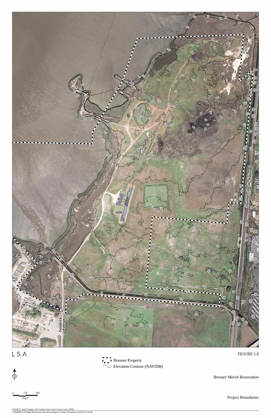
So
uth
ern
Pac
ific
Rail
ro
ad
Go
od
ric
kA
ven
ue
6
8
2
4
10
12
14
16
18
20
22
4
8
4
2
8
6
8
6
12
8
2
4
4
6
10
12
18
4
10
12
8
2
8
10
8
8
6
8
10
16
8
8
6
6
20
16
12
2
22
10
10
8
8
8
14
8
8
16
8
8
6
8
8
10
8
8
82
10
8
2
12
8
8
8
8
2
2
10
8
8
4
8
10
8
10
14
8
2
4
6
10
10
6
8
6
8
4
8
8
8
6
86
6
82
4
8
6
6
10
8
12
6
14
18
16
4
22
2
20
24
26
14
14
12
8
16
12
16
8 12
8
10
6
10
12
14
24
12
14
22
22
2
20
14
14
16
18
18
14
12
4
12
16
14
16
10
16
18
22
12
8
14
10
16
14
12
16
20
10
18
14
14
12
24
20
18
14
20
12
22
10
12
18
16
0 150 300
FEET
Breuner Marsh Restoration
Project Boundaries
I:\EBR0901\GIS\Maps\Restoration Alternatives\Figure1.0_Project Boundaries.mxd (02/22/2010)
SOURCE: Aerial Imagery and Contours from Contra Costa County (2008)
Breuner Property
Elevation Contour (NAVD88)
FIGURE 1.0

So
uth
ern
Pac
ific
Rail
ro
ad
Go
od
ric
kA
ven
ue
0 150 300
FEET
Breuner Marsh Restoration
Existing Conditions
I:\EBR0901\GIS\Maps\Restoration Alternatives\Figure2.0_Existing Conditions.mxd (02/22/2010)
SOURCE: Aerial Imagery from Contra Costa County (2008)
Existing Tidal Wetland
Existing Seasonal Wetland - Ruderal
Existing Seasonal Wetland - Pickleweed
Existing Salt Panne
Existing Grassland
Existing Ruderal Upland
Existing Stream Channel
Existing Open Water / Mudflat
Existing Developed
Breuner Property
FIGURE 2.0

So
uth
ern
Pac
ific
Rail
ro
ad
Go
od
ric
kA
ven
ue
0 150 300
FEET
Breuner Marsh Restoration
Alternative 1Minimal Plan
I:\EBR0901\GIS\Maps\Restoration Alternatives\Figure3.1_Minimal Plan.mxd (02/22/2010)
SOURCE: Aerial Imagery from Contra Costa County (2008)
Existing Tidal Wetland
Existing Seasonal Wetland - Ruderal
Existing Seasonal Wetland - Pickleweed
Existing Salt Panne
Existing Grassland
Existing Ruderal Upland
Existing Stream Channel
Existing Open Water / Mudflat
Existing Developed
Created Developed
Created Trail (30 feet wide)
Boardwalk (12 feet wide)
Breuner Property
FIGURE 3.1

So
uth
ern
Pac
ific
Rail
ro
ad
Go
od
ric
kA
ven
ue
0 150 300
FEET
Breuner Marsh Restoration
Alternative 2Off-site Spoils Disposal Plan
I:\EBR0901\GIS\Maps\Restoration Alternatives\Figure3.2_Off-site Spoils Disposal.mxd (02/22/2010)
SOURCE: Aerial Imagery from Contra Costa County (2008)
Existing Tidal Wetland
Existing Seasonal Wetland - Ruderal
Existing Seasonal Wetland - Pickleweed
Existing Salt Panne
Existing Grassland
Existing Stream Channel
Existing Open Water / Mudflat
Existing Developed
Breuner Property
Created Tidal Wetland
Created Seasonal Wetland
Created Grassland
Created Riparian
Created Developed
Created Trail (30 feet wide)
Boardwalk (12 feet wide)
Bay Trail Route and Spurs
Bridge (16 feet wide)
FIGURE 3.2
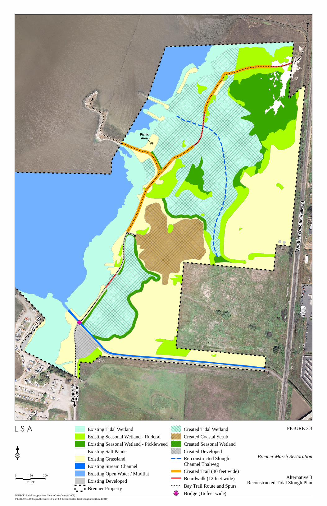
So
uth
ern
Pac
ific
Rail
ro
ad
Go
od
ric
kA
ven
ue
Picnic
Area
0 150 300
FEET
Breuner Marsh Restoration
Alternative 3Reconstructed Tidal Slough Plan
I:\EBR0901\GIS\Maps\Alternatives\Figure3.3_Reconstructed Tidal Slough.mxd (02/24/2010)
SOURCE: Aerial Imagery from Contra Costa County (2008)
Existing Tidal Wetland
Existing Seasonal Wetland - Ruderal
Existing Seasonal Wetland - Pickleweed
Existing Salt Panne
Existing Grassland
Existing Stream Channel
Existing Open Water / Mudflat
Existing Developed
Breuner Property
Created Tidal Wetland
Created Coastal Scrub
Created Seasonal Wetland
Created Developed
Re-constructed Slough
Channel Thalweg
Created Trail (30 feet wide)
Boardwalk (12 feet wide)
Bay Trail Route and Spurs
Bridge (16 feet wide)
FIGURE 3.3
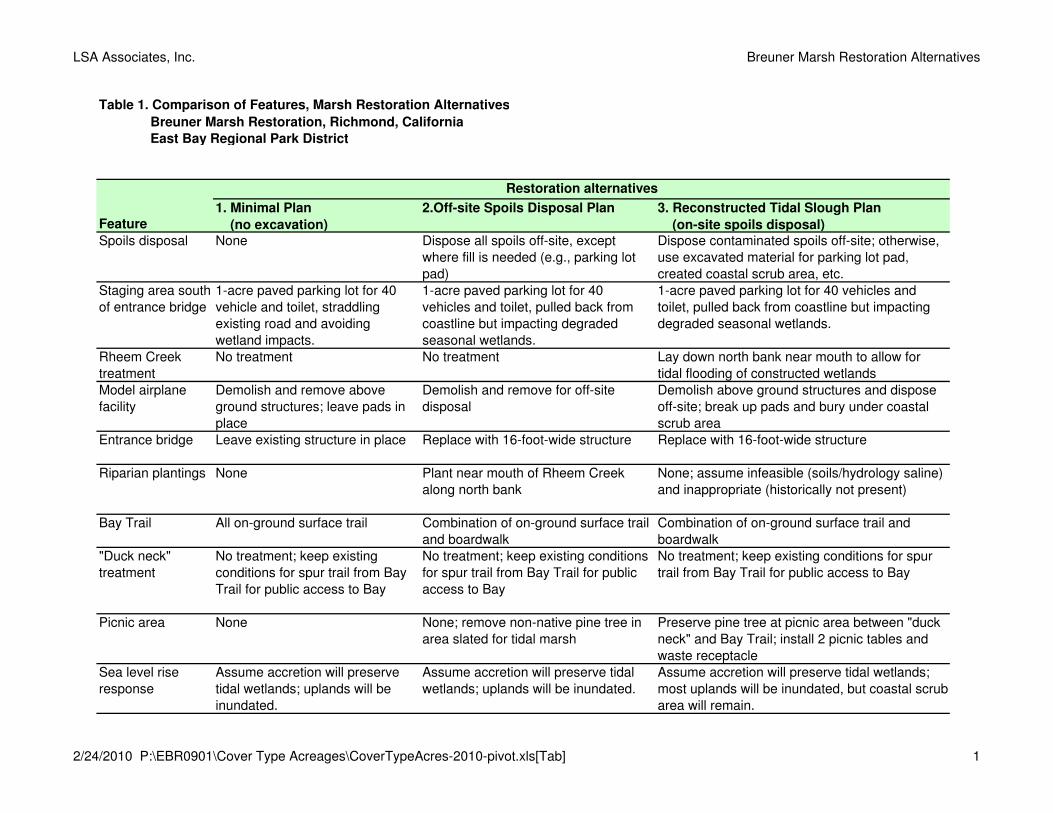
LSA Associates, Inc. Breuner Marsh Restoration Alternatives
Table 1. Comparison of Features, Marsh Restoration Alternatives
Breuner Marsh Restoration, Richmond, California
East Bay Regional Park District
1. Minimal Plan
(no excavation)
2.Off-site Spoils Disposal Plan 3. Reconstructed Tidal Slough Plan
(on-site spoils disposal)
Spoils disposal None Dispose all spoils off-site, except where fill is needed (e.g., parking lot pad)
Dispose contaminated spoils off-site; otherwise, use excavated material for parking lot pad, created coastal scrub area, etc.
Staging area south of entrance bridge
1-acre paved parking lot for 40 vehicle and toilet, straddling existing road and avoiding wetland impacts.
1-acre paved parking lot for 40 vehicles and toilet, pulled back from coastline but impacting degraded seasonal wetlands.
1-acre paved parking lot for 40 vehicles and toilet, pulled back from coastline but impacting degraded seasonal wetlands.
Rheem Creek treatment
No treatment No treatment Lay down north bank near mouth to allow for tidal flooding of constructed wetlands
Model airplane facility
Demolish and remove above ground structures; leave pads in place
Demolish and remove for off-site disposal
Demolish above ground structures and dispose off-site; break up pads and bury under coastal scrub area
Entrance bridge Leave existing structure in place Replace with 16-foot-wide structure Replace with 16-foot-wide structure
Riparian plantings None Plant near mouth of Rheem Creek along north bank
None; assume infeasible (soils/hydrology saline) and inappropriate (historically not present)
Bay Trail All on-ground surface trail Combination of on-ground surface trail and boardwalk
Combination of on-ground surface trail and boardwalk
"Duck neck" treatment
No treatment; keep existing conditions for spur trail from Bay Trail for public access to Bay
No treatment; keep existing conditions for spur trail from Bay Trail for public access to Bay
No treatment; keep existing conditions for spur trail from Bay Trail for public access to Bay
Picnic area None None; remove non-native pine tree in area slated for tidal marsh
Preserve pine tree at picnic area between "duck neck" and Bay Trail; install 2 picnic tables and waste receptacle
Sea level rise response
Assume accretion will preserve tidal wetlands; uplands will be inundated.
Assume accretion will preserve tidal wetlands; uplands will be inundated.
Assume accretion will preserve tidal wetlands; most uplands will be inundated, but coastal scrub area will remain.
Feature
Restoration alternatives
2/24/2010 P:\EBR0901\Cover Type Acreages\CoverTypeAcres-2010-pivot.xls[Tab] 1
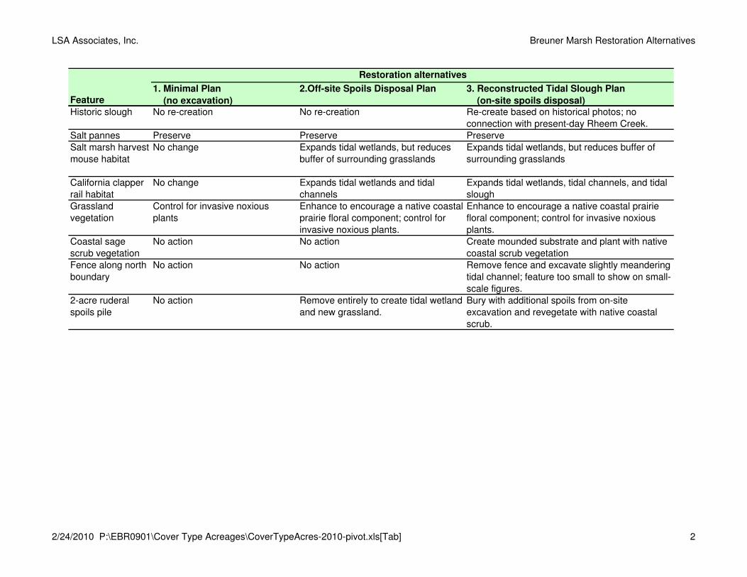
LSA Associates, Inc. Breuner Marsh Restoration Alternatives
1. Minimal Plan
(no excavation)
2.Off-site Spoils Disposal Plan 3. Reconstructed Tidal Slough Plan
(on-site spoils disposal)Feature
Restoration alternatives
Historic slough No re-creation No re-creation Re-create based on historical photos; no connection with present-day Rheem Creek.
Salt pannes Preserve Preserve PreserveSalt marsh harvest mouse habitat
No change Expands tidal wetlands, but reduces buffer of surrounding grasslands
Expands tidal wetlands, but reduces buffer of surrounding grasslands
California clapper rail habitat
No change Expands tidal wetlands and tidal channels
Expands tidal wetlands, tidal channels, and tidal slough
Grassland vegetation
Control for invasive noxious plants
Enhance to encourage a native coastal prairie floral component; control for invasive noxious plants.
Enhance to encourage a native coastal prairie floral component; control for invasive noxious plants.
Coastal sage scrub vegetation
No action No action Create mounded substrate and plant with native coastal scrub vegetation
Fence along north boundary
No action No action Remove fence and excavate slightly meandering tidal channel; feature too small to show on small-scale figures.
2-acre ruderal spoils pile
No action Remove entirely to create tidal wetland and new grassland.
Bury with additional spoils from on-site excavation and revegetate with native coastal scrub.
2/24/2010 P:\EBR0901\Cover Type Acreages\CoverTypeAcres-2010-pivot.xls[Tab] 2

LSA Associates, Inc. Breuner Marsh Restoration Alternatives
Table 2. Acres of Cover Types, Marsh Restoration Alternatives
Breuner Marsh Restoration, Richmond, California, East Bay Regional Park District
Exis-
ting
Crea-
ted
Total Exis-
ting
Crea-
ted
Total Exis-
ting
Crea-
ted
Total
Open water /mudflat
Includes off-shore bay lands to property line.
103.53 103.53 0.00 103.53 103.53 0.00 103.53 103.53 0.00 103.53
Stream channel The constructed Rheem Creek channel carries urban runoff and tidal waters.
0.78 0.78 0.00 0.78 0.78 0.00 0.78 0.78 0.00 0.78
Tidal wetland Includes tidal marsh, unvegetated beach, and shallow unvegetated channels.
16.76 16.75 0.00 16.75 16.76 25.61 42.37 16.74 30.36 47.10
Seasonal wetland - ruderal
Includes some muted tidal and fresh/ brackish/ saltwater seasonal wetlands with ruderal vegetation; may include some native salt grass.
15.01 15.01 0.00 15.01 13.12 0.00 13.12 11.30 0.00 11.30
Seasonal wetland - pickleweed
Includes some muted tidal and fresh/ brackish/ saltwater seasonal wetlands dominated with pickleweed
14.13 14.13 0.00 14.13 14.13 10.27 24.40 7.70 2.16 9.86
Salt panne Although delin-eated as seasonal wetland, receives muted high tidal influence.
1.01 1.01 0.00 1.01 0.97 0.00 0.97 0.95 0.00 0.95
Riparian Includes "riparian" designation on EBRPD plan.
0.00 0.00 0.00 0.00 0.00 2.59 2.59 0.00 0.00 0.00
Grassland Includes non-native and coastal prairie grassland.
61.30 59.28 0.00 59.28 25.05 0.52 25.57 32.23 0.00 32.23
Coastal scrub Create native cover of sage and other low-growing shrubs.
0.00 0.00 0.00 0.00 0.00 0.00 0.00 0.00 7.32 7.32
Ruderal upland Includes a large spoil pile vegetated with non-native mustard.
2.04 2.04 0.00 2.04 0.00 0.00 0.00 0.00 0.00 0.00
Developed Roads, Bay Trail (road and boardwalk), staging area, etc.
2.82 2.26 2.58 4.84 0.91 3.13 4.04 1.24 3.05 4.29
217.37 217.37 217.37 217.37
Description of cover type
Base-
line
con-
ditions
Acres of cover type
Total (acres)
Restoration alternatives
1. Minimal Plan
(no excavation)
2. Off-site Spoils
Disposal Plan
3. Reconstructed Tidal
Slough Plan
Cover types
2/24/2010 P:\EBR0901\Cover Type Acreages\CoverTypeAcres-2010-pivot.xlsAlternatives 1
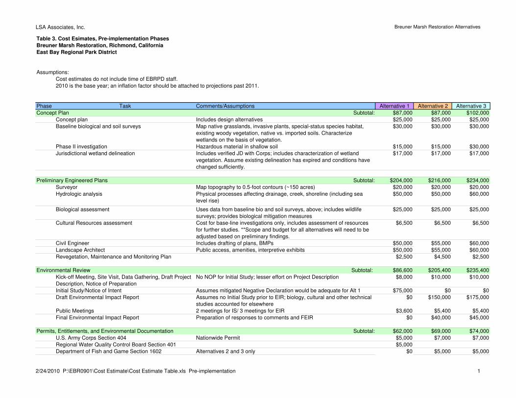
LSA Associates, Inc. Breuner Marsh Restoration Alternatives
Table 3. Cost Esimates, Pre-implementation Phases
Breuner Marsh Restoration, Richmond, California
East Bay Regional Park District
Assumptions:
Cost estimates do not include time of EBRPD staff.
2010 is the base year; an inflation factor should be attached to projections past 2011.
Phase Task Comments/Assumptions Alternative 1 Alternative 2 Alternative 3
Concept Plan Subtotal: $87,000 $87,000 $102,000
Concept plan Includes design alternatives $25,000 $25,000 $25,000
Baseline biological and soil surveys Map native grasslands, invasive plants, special-status species habitat,
existing woody vegetation, native vs. imported soils. Characterize
wetlands on the basis of vegetation.
$30,000 $30,000 $30,000
Phase II investigation Hazardous material in shallow soil $15,000 $15,000 $30,000
Jurisdictional wetland delineation Includes verified JD with Corps; includes characterization of wetland
vegetation. Assume existing delineation has expired and conditions have
changed sufficiently.
$17,000 $17,000 $17,000
Preliminary Engineered Plans Subtotal: $204,000 $216,000 $234,000
Surveyor Map topography to 0.5-foot contours (~150 acres) $20,000 $20,000 $20,000
Hydrologic analysis Physical processes affecting drainage, creek, shoreline (including sea
level rise)
$50,000 $50,000 $60,000
Biological assessment Uses data from baseline bio and soil surveys, above; includes wildlife
surveys; provides biological mitigation measures
$25,000 $25,000 $25,000
Cultural Resources assessment Cost for base-line investigations only, includes assessment of resources
for further studies. **Scope and budget for all alternatives will need to be
adjusted based on preliminary findings.
$6,500 $6,500 $6,500
Civil Engineer Includes drafting of plans, BMPs $50,000 $55,000 $60,000
Landscape Architect Public access, amenities, interpretive exhibits $50,000 $55,000 $60,000
Revegetation, Maintenance and Monitoring Plan $2,500 $4,500 $2,500
Environmental Review Subtotal: $86,600 $205,400 $235,400
Kick-off Meeting, Site Visit, Data Gathering, Draft Project
Description, Notice of Preparation
No NOP for Initial Study; lesser effort on Project Description $8,000 $10,000 $10,000
Initial Study/Notice of Intent Assumes mitigated Negative Declaration would be adequate for Alt 1 $75,000 $0 $0
Draft Environmental Impact Report Assumes no Initial Study prior to EIR; biology, cultural and other technical
studies accounted for elsewhere
$0 $150,000 $175,000
Public Meetings 2 meetings for IS/ 3 meetings for EIR $3,600 $5,400 $5,400
Final Environmental Impact Report Preparation of responses to comments and FEIR $0 $40,000 $45,000
Permits, Entitlements, and Environmental Documentation Subtotal: $62,000 $69,000 $74,000
U.S. Army Corps Section 404 Nationwide Permit $5,000 $7,000 $7,000
Regional Water Quality Control Board Section 401 $5,000
Department of Fish and Game Section 1602 Alternatives 2 and 3 only $0 $5,000 $5,000
2/24/2010 P:\EBR0901\Cost Estimate\Cost Estimate Table.xls Pre-implementation 1
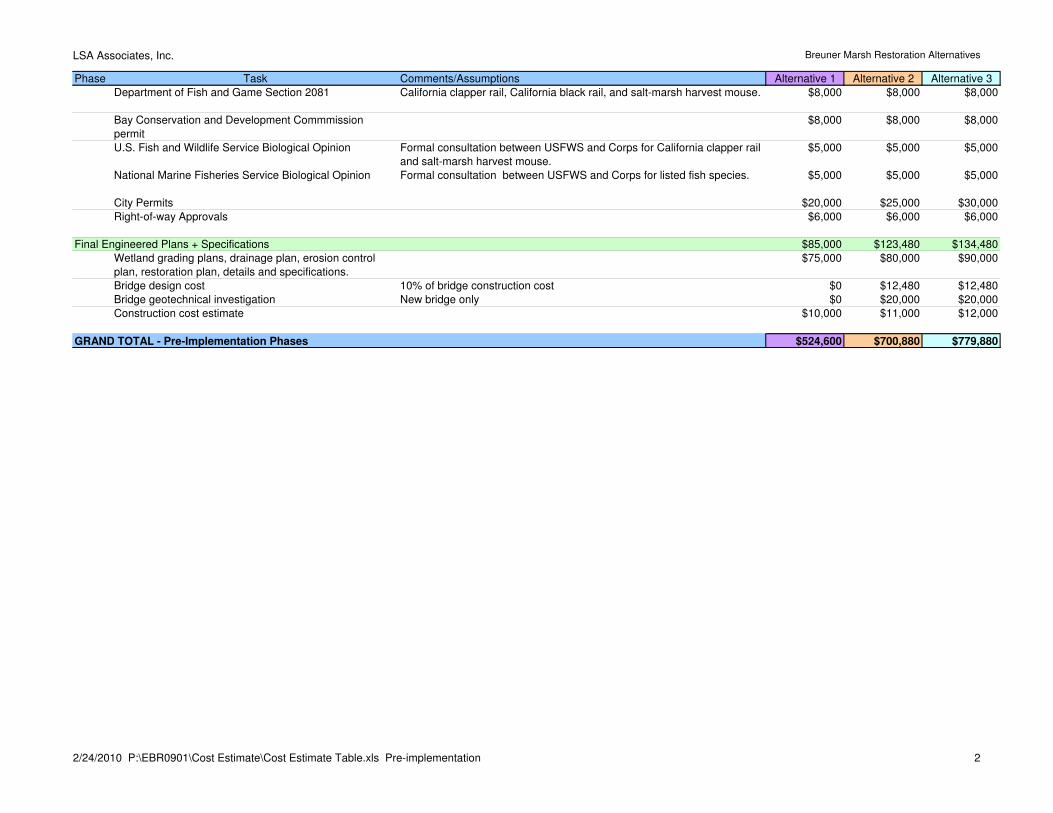
LSA Associates, Inc. Breuner Marsh Restoration Alternatives
Phase Task Comments/Assumptions Alternative 1 Alternative 2 Alternative 3
Department of Fish and Game Section 2081 California clapper rail, California black rail, and salt-marsh harvest mouse. $8,000 $8,000 $8,000
Bay Conservation and Development Commmission
permit
$8,000 $8,000 $8,000
U.S. Fish and Wildlife Service Biological Opinion Formal consultation between USFWS and Corps for California clapper rail
and salt-marsh harvest mouse.
$5,000 $5,000 $5,000
National Marine Fisheries Service Biological Opinion Formal consultation between USFWS and Corps for listed fish species. $5,000 $5,000 $5,000
City Permits $20,000 $25,000 $30,000
Right-of-way Approvals $6,000 $6,000 $6,000
Final Engineered Plans + Specifications $85,000 $123,480 $134,480
Wetland grading plans, drainage plan, erosion control
plan, restoration plan, details and specifications.
$75,000 $80,000 $90,000
Bridge design cost 10% of bridge construction cost $0 $12,480 $12,480
Bridge geotechnical investigation New bridge only $0 $20,000 $20,000
Construction cost estimate $10,000 $11,000 $12,000
GRAND TOTAL - Pre-Implementation Phases $524,600 $700,880 $779,880
2/24/2010 P:\EBR0901\Cost Estimate\Cost Estimate Table.xls Pre-implementation 2

LSA Associates, Inc. Breuner Marsh Restoration Alternatives
Table 4. Cost Esimates, Pre-implementation and Implementation Phases
Breuner Marsh Restoration, Richmond, California
East Bay Regional Park District
Assumptions:Cost estimates do not include time of EBRPD staff, with the exception of Construction Administration.2010 is the base year; an inflation factor should be attached to projections past 2011.Two construction seasons (limited to May 1 - October 15) required for completion; an estimated total of 216 work days.
Alternative 1 Alternative 2 Alternative 3Phase Task Comments/Assumptions Unit cost Metric Quantity Total Cost Quantity Total Cost Quantity Total CostConcept Plan $87,000 $87,000 $102,000
Preliminary Engineered Plans $204,000 $216,000 $234,000
Environmental Review $86,600 $205,400 $235,400
Permits, Entitlements, and Environmental Documentation $62,000 $69,000 $74,000
Final Engineered Plans + Specifications $85,000 $123,480 $134,480
Implementation - labor $160,240 $243,800 $250,000Biological construction monitoring Per permit conditions $620 day 72 $44,640 140 $86,800 150 $93,000Water quality/ BMP monitoring Per permit conditions; includes onsite
turbidity analysis$700 day 20 $14,000 30 $21,000 30 $21,000
Environmental reporting and coordination with agencies
Includes as-built report $900 day 24 $21,600 40 $36,000 40 $36,000
Construction Administration - in-house Bidding services, contract administration, inspection, submittal review, requests for information and contract close-out
$80,000 $100,000 $100,000
Implementation - materials and fixed fee contractors $1,340,596 $11,580,581 $5,326,054Bay trail elevated 12-foot concrete boardwalk $1,100 foot 600 $660,000 1,844 $2,028,400 740 $814,000Bay trail un-elevated, unpaved $4 foot 0 $0 $0 0 $0Bay trail un-elevated, paved 12-foot wide trail with 2" asphalt over 6"
aggregate base$51 foot 2,540 $129,540 2,355 $120,105 2,558 $130,458
Paved road New/raised or repaired $250 foot 0 $0 0 $0 0 $0Excavation, north tidal area Slow equipment on wet soil $12 cubic yard 0 $0 81,263 $975,156 200,975 $2,411,700Excavation, south tidal area Slow equipment on wet soil $12 cubic yard 0 $0 157,627 $1,891,524 68,945 $827,340Haul debris to off-site disposal Asphalt, rubble, lumber [load, haul 5 miles
round trip, $16/cy disposal fee]$40 cubic yard 733 $29,320 5,002 $200,080 733 $29,320
Haul fill to off-site diposal, north tidal excavation area
Clean fill [load, haul 5 miles round trip, dump, no disposal fee]
$22 cubic yard 0 $0 81,263 $1,787,786 0 $0
Haul fill to off-site diposal, south tidal excavation area
Clean fill [load, haul 5 miles round trip, dump, no disposal fee]
$22 cubic yard 0 $0 157,627 $3,467,794 0 $0
Import fill $20 cubic yard 0 $0 0 $0 0 $0Trailside fence 4-foot metal $7 foot 0 $0 0 $0 0 $0Security fence along eastern property line 6-foot vinyl coated chain link $16 foot 5,671 $90,736 5,671 $90,736 5,671 $90,736Vehicle gate 16 foot $2,000 each 1 $2,000 1 $2,000 1 $2,000Signage (safety and interpretation) Inclusive from inception to installation $200 sign 20 $4,000 35 $7,000 45 $9,000
2/24/2010 P:\EBR0901\Cost Estimate\Cost Estimate Table.xls Implementation 1

LSA Associates, Inc. Breuner Marsh Restoration Alternatives
Alternative 1 Alternative 2 Alternative 3Phase Task Comments/Assumptions Unit cost Metric Quantity Total Cost Quantity Total Cost Quantity Total Cost
New bridge over Rheem Creek H20 standard bridge, 20 ft wide x 50 ft long [NOTE: Construction cost is based on square foot area of bridge deck. Cost includes allowance for abutments. Assumes precast concrete construction]
$300 sq foot 0 $0 520 $156,000 520 $156,000
Parking lot/ staging area (1 acre) - paved Capacity for 40 cars [150 ft x 300 ft size; 4" asphalt over 6" aggregate base]
$500,000 lump sum 0 $0 1 $500,000 1 $500,000
Parking lot/ staging area (1 acre) - gravel Capacity for 40 cars [150 ft x 300 ft size; 6" aggregate base]
$175,000 lump sum 1 $175,000 0 $0 0 $0
Bathroom facilities/toilet at staging area Pre-fab, heavy duty, stainless steel fixtures $250,000 lump sum 1 $250,000 1 $250,000 1 $250,000
Picnic area Two tables and waste receptacle $3,000 lump sum 0 $0 0 $0 1 $3,000Non-native tree removal Including stump grinding $500 tree 0 $0 1 $500 0 $0Drill seeding Coastal Scrub $2,500 acre 0 $0 0 $0 8 $20,000Drill seeding Coastal Prairie $2,500 acre 0 $0 26 $65,000 33 $82,500Riparian planting (3.4 acres) Container stock trees and shrubs propagated
and installed w/ weed block, browse control and irrigation; 25-ft spacing for trees, 10-ft spacing for shrubs
$100 plant 0 $0 371 $37,100 0 $0
Riparian planting (700 linear feet) Live willow poles, harvested and installed at 10-ft spacing at water line
$20 pole 0 $0 70 $1,400 0 $0
Post Construction Monitoring and Maintenance (as required by permits) - 10 year period $165,000 $620,500 $525,000Wetland monitoring Vegetation and hydrology, Years 1-5, 7, 10 $7,000 year 7 $49,000 7 $49,000 7 $49,000
Riparian monitoring Vegetation, Years 1-5, 7, 10 $1,500 year 0 $0 7 $10,500 0 $0Upland vegetation monitoring Enhanced/created coastal scrub and prairie $7,000 year 0 $0 7 $49,000 7 $49,000
Endangered species/wildlife monitoring $10,000 year 7 $70,000 7 $70,000 7 $70,000Planting area maintenance Includes, weeding, replacement plants and
irrigation$30,000 year 0 $0 3 $90,000 0 $0
Weed management - Years 1-5 Approx. 90 acres of uplands and non-tidal wetlands
$50,000 year 0 $0 5 $250,000 5 $250,000
Weed management - Years 6, 8 and 10 Approx. 90 acres of uplands and non-tidal wetlands
$18,000 year 0 $0 3 $54,000 3 $54,000
Reporting Years 1-5, 7, 10 $4,000 year 7 $28,000 7 $28,000 7 $28,000Sign-off and documentation Includes Corps jurisdictional delineation one time 1 $18,000 1 $20,000 1 $25,000
GRAND TOTAL $2,190,436 $13,145,761 $6,880,934
2/24/2010 P:\EBR0901\Cost Estimate\Cost Estimate Table.xls Implementation 2

LSA Associates, Inc. Breuner Marsh Restoration Alternatives
Table 5. Screening Matrix, Marsh Restoration Alternatives
Breuner Marsh Restoration, Richmond, California
East Bay Regional Park District
Screening criteria
Alternative 1
Minimal Plan
Alternative 2
Off-site Spoils Disposal Plan
Alternative 3
Reconstructed Tidal Slough
a. Technical feasibility HIGHThis is a relatively simple plan, with the most challenging aspect being the board walk across existing salt marsh.
MODERATELY HIGHThis is a complex plan. The major technical challenge would be creating the proper elevations to achieve restoration objectives. The proposed riparian vegetation type may be technically problematic for this location, given soils and hydrology.
MODERATELY HIGHThis is a complex plan. The major technical challenge would be creating the proper elevations to achieve restoration objectives. The proposed coastal scrub vegetation type may be technically problematic for this location, given soils.
b. Cost effectiveness HIGHSmall and relatively not costly improvements would substantially enhance public recreational values.
MODERATE TO LOW Off-site disposal of excavated spoils would be a costly component.
HIGHSmall and relatively not costly improvements would substantially enhance public recreational values. Costly, but highly effective restoration improvements would result in enormous gains in natural values.
c. Time to provide benefits
One season for installation and then full public use.
Two to three seasons to install and then open to public use but another 5-10 years to full maturation of restored vegetation.
Two to three seasons to install and then open to public use but another 5-10 years to full maturation of restored vegetation.
d. Duration of benefits In perpetuity, absent sea level rise and with a low level of maintenance.
In perpetuity with provision for sea level rise and a moderate level of maintenance.
In perpetuity with provision for sea level rise and a moderate level of maintenance.
e. Compliance with applicable federal, State, and local laws and policies
IN COMPLIANCE IN COMPLIANCE IN COMPLIANCE
2/24/2010 P:\EBR0901\Restoration Alternatives\Screening Matrix.xls 1

LSA Associates, Inc. Breuner Marsh Restoration Alternatives
Screening criteria
Alternative 1
Minimal Plan
Alternative 2
Off-site Spoils Disposal Plan
Alternative 3
Reconstructed Tidal Slough
f. Multiple resource and service benefits
MODERATEThe public access component will be enhanced with installation of the Bay Trail but natural values would not be correspondingly enhanced.
VERY HIGHThe public access component will be enhanced with installation of the Bay Trail. Valuable wetland and adjacent upland vegetation types and special-status species habitat would be substantially created and enhanced.
VERY HIGHThe public access component will be enhanced with installation of the Bay Trail. Valuable wetland and adjacent upland vegetation types and special-status species habitat would be substantially created and enhanced.
g. Avoidance of adverse impacts
MODERATELY HIGHIncreased public access would have low impacts on natural resources.
HIGH AFTER RESTORATIONA very substantial increase of natural values after restoration would more than compensate for any adverse impacts.
HIGH AFTER RESTORATIONA very substantial increase of natural values after restoration would more than compensate for any adverse impacts.
h. Public health and safety
HIGHThe proposed improvements would pose no manifest risks to public health and safety and would have ancillary benefits in terms of outdoor recreational opportunities.
HIGHThe proposed improvements would pose no manifest risks to public health and safety and would have ancillary benefits in terms of outdoor recreational opportunities.
HIGHThe proposed improvements would pose no manifest risks to public health and safety and would have ancillary benefits in terms of outdoor recreational opportunities.
i. Likelihood of success HIGH MODERATELY HIGH See technical feasibility above.
MODERATELY HIGH See technical feasibility above.
2/24/2010 P:\EBR0901\Restoration Alternatives\Screening Matrix.xls 2