Embed Size (px)
Citation preview
SCA Proceedings, Volume 22 (2009) Mealey, p. 1
CALIFORNIA STATE PARKS ARCHAEOLOGY AT TORREY PINES STATE RESERVE:
PAST, PRESENT, AND FUTURE
MARLA M. MEALEY
Numerous archaeological studies have occurred throughout the years in and around the lands that are now known as Torrey Pines State Natural Reserve and Torrey Pines State Beach. This paper focuses on those studies that have taken place within California State Parks lands, namely those that have been conducted by California State Parks archaeologists, including the author’s most recent research at five erosion-damaged sites. All of these studies have led to a body of data that provides the basis for the creation of a fire-affected rock feature typology and other cross-site comparisons.
HISTORY OF RESEARCH
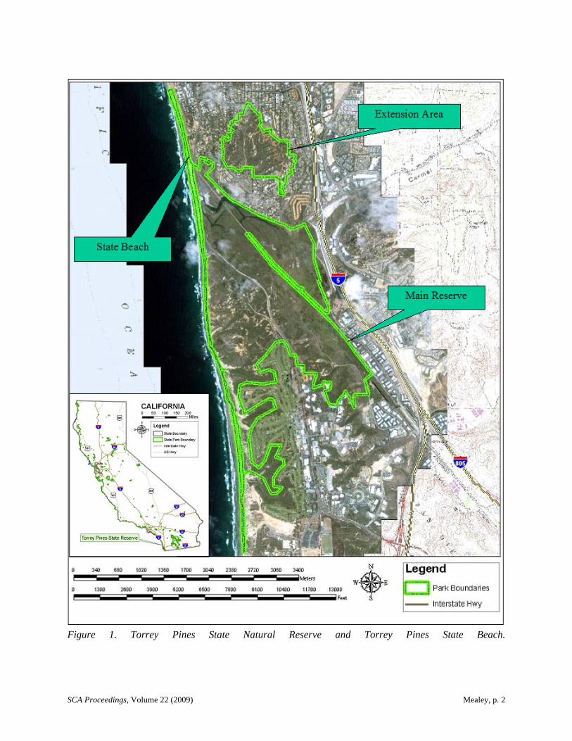
Torrey Pines State Natural Reserve (the Reserve) has long been a location of scientific investigation and research. Since the botanical investigations of Charles Parry in the mid 1800s that led to the identification of the Torrey pine (Pinus torreyana) as a unique species, scientists and researchers have been coming to this area to study and record its natural and cultural resources. Numerous archaeological studies have occurred throughout the years in and around the lands that are now known as Torrey Pines State Natural Reserve and Torrey Pines State Beach (Figure 1).
The story of previous archaeological research starts back before there was a Torrey Pines State Natural Reserve. The lands were first set aside as a park in 1899 and became the Torrey Pines Reserve in the 1920s. In the 1920s and 1930s, Malcolm Rogers, a researcher in association with the San Diego Museum of Man, was one of the first to scientifically record and excavate archaeological sites within San Diego County. A number of sites that he recorded and studied are located within the Reserve (Rogers 1930s).
Rogers (1930s) was also the first to identify and record “hearths” and “roasting platforms” as components of these sites. These features would later become an important focus of much of the archaeological research within the Reserve. Rogers’ notes on many of the sites within the Reserve mention such “hearths,” and he also noted the abundance of these features in the area. At SDM-W-7, a site recorded just to the south of the Reserve boundary on lands now occupied by business parks and research facilities, Rogers recorded what he called “an unusual number of cobble hearths.” At SDM-W-14, a site that used to be located on land now occupied by the Torrey Pines Golf Course, Rogers recorded “scattered hearths over five acres.”
The term “fire-affected rock feature” is used throughout this article as a generic term that encompasses hearths, roasting platforms, roasting pits, ovens, and other cultural features comprised of burned rocks. There are also other feature types and sites within the Reserve including shell middens, stone tool manufacturing sites, and sites with grinding stones and other artifacts and features. However, the fire-affected rock features seem to dominate the archaeological landscape.
In the years following Rogers’ research, there were a few other archaeological sites recorded in the Reserve, such as those recorded by Adan Treganza in the 1940s and several recorded in the 1970s by D. Colbern, Peter Ainsworth, and others (Ainsworth 1978; Colbern 1973; Treganza 1940s). There was also at least one archaeological test conducted by State Parks Archaeologist Francis Riddell in 1965, within the area where the North Beach Parking Lot was to be constructed. However, Riddell did not find any evidence of archaeological materials and only a small amount of shell, which he concluded was “not of Indian origin” (Woodward and Stammerjohan 1985).
The California Department of Parks and Recreation (State Parks) acquired the Reserve in 1959 and the nearby, discontinuous Extension Area in 1970 (Figure 1). A General Plan for these lands was
SCA Proceedings, Volume 22 (2009) Mealey, p. 2
Figure 1. Torrey Pines State Natural Reserve and Torrey Pines State Beach.
SCA Proceedings, Volume 22 (2009) Mealey, p. 3
developed in the early 1980s (California Department of Parks and Recreation 1984). As part of the planning process, a resources inventory was needed to identify what cultural and natural resources existed within the Reserve. In 1982 State Parks Archaeologist E. Breck Parkman led a team of archaeologists on a survey of the Reserve. They documented 29 archaeological sites, 11 of which were newly identified during this work (Nesbitt 1983). Also in 1982, State Parks Archaeologist Jim Woodward conducted a resources inventory survey along Torrey Pines State Beach and recorded two previously undocumented sites (Woodward and Stammerjohan 1985).
Researchers from outside California State Parks came to Torrey Pines State Reserve in the 1980s. B. K. O. Reeves, a researcher from the University of Calgary who was searching for Early Man sites, tested four locations within the Reserve. These studies resulted in radiocarbon dates between A.D. 600 and 800. It is likely these dates were a great disappointment to Reeves, but it is unclear if that was why he never wrote up a full report of this work. His brief letter report (Reeves 1982) leaves many questions regarding the methods that were used and the artifacts and other data that may have been recovered.
In 1985, archaeologist Linda Roth was hired to monitor utility trenching within the Reserve in the area of three previously recorded sites: CA-SDI-4625, SDI-9600, and SDI-9602. Roth was unable relocate two of the sites: SDI-9600 and SDI-9602. Surface collection was conducted along the park road and within the strip of land to be trenched. During monitoring, three definable midden areas were located in association with site SDI-4625 and a 1-by-1-m test unit was placed within each midden location. Based on the results of these investigations, Roth concluded that at one time SDI-4625 had been an extensive site, but it had lost “all scientific value” due to heavy disturbance (Roth 1985).
The 1980s continued to be busy with archaeological work in Torrey Pines State Reserve, including additional surveys and various monitoring and small testing projects carried out by State Parks archaeologists. In 1986, Eloise Barter and other State Parks archaeologists revisited some of the sites within the Reserve to check site conditions and update site forms. As a result of the 1986 survey, eight of the 28 known sites within the Reserve were rerecorded (SDI-196, SDI-198, SDI-199, SDI-200, SDI-4626, SDI-9588, SDI-9599, SDI-9605), five were located but not rerecorded (SDI-4625, SDI-7223, SDI-7224, SDI-7225, SDI-9602), two were located and newly recorded (SDI-10636 and SDI-10637), four could not be located, and a reevaluation of the remaining nine sites was not attempted. Barter concluded that the time frame represented by the sites ranged between the earliest California cultures through Spanish contact. Site density and the probability of locating more sites within the Reserve were found to be high, even though erosion was noted as causing a great deal of site destruction. Barter recommended excavation along the trail at SDI-9605 and of features at SDI-10636 and SDI-10637 in order to determine function and dates, before erosion destroyed the sites (Barter 1986).
Based on the results and recommendations of the 1986 survey work, Barter and other State Park archaeologists tested two fire-affected rock features at SDI-10636 in October 1986. But when radiocarbon dates obtained from these features came back as 90 60 years before present and “statistically indistinguishable from the modern standard,” further analysis of the artifacts and data was halted and never completed. The results of flotation studies could not establish the hearths as being prehistoric in origin, although four sherds of Tizon Brownware were discovered in one hearth. Barter concluded that both hearths may have been constructed by U.S. Army soldiers from nearby Camp Callan, who were training in the area during World War II (Barter 1987).
In 1987, State Parks archaeologists Carlys Gilbert and Gary Reinoehl excavated three test units within SDI-9588 along the edge of the lagoon. They found a shell midden deposit covered by approximately 50 cm of compact sterile sand. The sand was removed without screening, and the underlying shell midden was then excavated in 10-cm levels contoured to the top of the deposit. A moderate density of shell and flaked stone was recovered, along with ground and battered stones. There were also small amounts of fish and mammal bone. Samples of shell yielded radiocarbon dates between 2,920 and 6,560 years before present. Gilbert and Reinoehl (1987) theorized that shellfish were collected from the adjacent beach and lagoon, then processed at the site using simple cobble tools. Studies of the
SCA Proceedings, Volume 22 (2009) Mealey, p. 4
lithic materials recovered suggested an expedient technology, using locally available stone with little effort expended in manufacture (Gross 1987).
Following these mid- to late-1980s investigations, there was a brief hiatus of archaeological work within the Reserve. Then in 1995 State Parks archaeologist Mike Sampson proposed a project to recover data from three sites at Torrey Pines that were being damaged by erosion. Archaeological testing, mapping, and surface collections were conducted at SDI-9605, SDI-10636, and SDI-10637 (Mealey et al. 1996). The radiocarbon dates from test units at SDI-9605 were between 450 and 1,980 years before present. Flotation studies conducted by Paleo Research Labs on soil samples gathered from a fire-affected rock feature in one of the units revealed a charred sage seed and charcoal of the Asteraceae family, which includes many plants that grow within the Reserve (Scott Cummings et al. 1996). The sage seed was intriguing, but not enough to say for certain that the hearth had been used to toast or otherwise process seeds for consumption.
Two groundstone samples from site SDI-10637 were also sent to Paleo Research Labs for phytolith and protein residue analyses. The results indicate that both the mano and the metate fragment were used to process grass seeds, while the metate fragment also returned a positive protein residue result for deer, which could indicate processing of meat, bone, or hide (Scott Cummings et al. 1996).
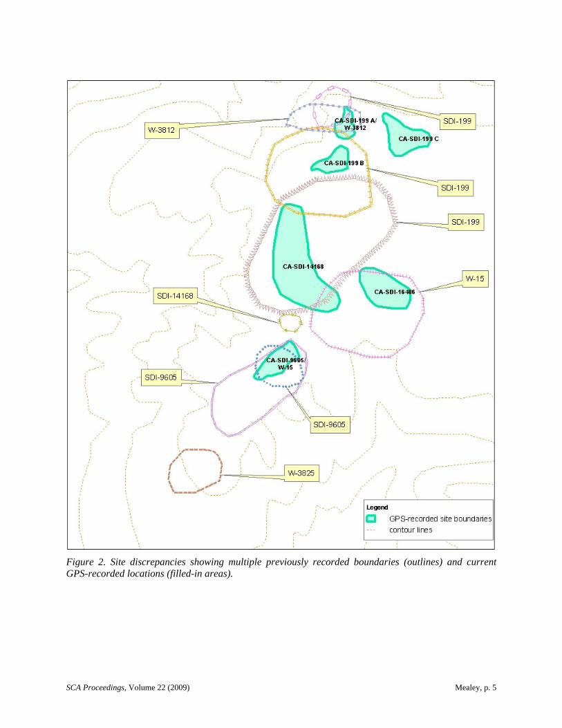
During the records and literature review for the 1995 fieldwork, many discrepancies had been noted in site location, size, and numbers (Mealey et al. 1996). In San Diego there are two site data repositories: the San Diego Museum of Man, using Malcolm Rogers’ site numbering system, and the South Coastal Information Center, using the state trinomial and primary numbering system. At the time, each facility had some records that the other did not. For record searches and assignment of site numbers, most researchers went to both facilities, but some only went to one or the other. Based on the analysis of the discrepancies at the Reserve, it seems that some of the sites had been recorded with one repository, and then subsequently recorded by someone else at the other repository without checking to see if the site had been recorded at the first repository. Then numbers were sometimes assigned by one repository to sites recorded at the other repository without a field check to make sure that the site was actually a new one. Due to differences in the way people defined and mapped site boundaries, many sites ended up with multiple locations and multiple numbers, leading to an enormous mess of overlapping sites and boundaries (Mealey et al. 1997).
Figure 2 shows one area of the Reserve and the multiple site boundaries and locations that were found during the research. In this instance, SDM-W-15 was originally recorded by Rogers (at the Museum of Man) in the 1930s. It was later assigned the state trinomial SDI-199 without a field check. But the mapped location of SDI-199 drifted to the north over the years, as it was recorded and rerecorded. It eventually lost its association with SDM-W-15 and was assigned another Museum of Man number, SDM-W-3812. Meanwhile, two other sites, SDI-9605 and SDI-14168, were recorded in the same general area and became associated with SDM-W-15, although SDI-9605 was later assigned another Museum of Man number, SDM-W-3825.
Photographs finally helped resolve the confusion over SDM-W-15. By comparing the photograph of the site that Rogers took in the 1930s with the current landscape, it was found that SDM-W-15 matched the currently mapped location of SDI-9605. Using global positioning system (GPS) data and careful comparison of site records, photographs, sketch maps, and field data, the inconsistencies and confusion for 27 sites within the Reserve were resolved (Mealey et al. 1997). The filled-in areas on Figure 2 depict the resolved site boundaries for SDI-199, SDI-9605, SDI-14168, SDM-W-15, SDM-W-3812, and a newly identified site, SDI-16406, as they were recorded with GPS. Only four sites within the Reserve could not be relocated during this project, but an additional 15 sites and two isolates that had not been previously documented, were identified and recorded.
During the late 1990s, smaller-scale site monitoring and examination work was undertaken by State Parks archaeologists throughout the Reserve. One such endeavor was a project area survey conducted in the Extension Area. During the fieldwork, a deeply buried fire-affected rock feature was
SCA Proceedings, Volume 22 (2009) Mealey, p. 5
Figure 2. Site discrepancies showing multiple previously recorded boundaries (outlines) and current GPS-recorded locations (filled-in areas).
SCA Proceedings, Volume 22 (2009) Mealey, p. 6
identified in the cut bank of a drainage and recorded as site SDI-15557 (Mealey and Pettus 1999). Students from San Diego State University under the guidance of Lynn Gamble were enlisted in early 2001 to excavate the buried feature (Gamble 2002). Flotation studies indicated that most of the charcoal was Ceanothus. Some of this charcoal was dated to between 1,500 and 1,710 years before present.
The year 2002 was a busy one for archaeology at the Reserve. In the spring an archaeological survey of the Extension Area was conducted (Mealey and Shabel 2002a). More than half of the total acreage of the Extension Area was examined, and five previously recorded sites, 21 previously unrecorded sites, and three isolates were identified and updated or recorded. Most of these sites consisted of fire-affected rock features and lithic processing and procurement areas. Three of the sites that were examined were historic in nature.
Also in 2002, salvage excavations of fire-affected rock features were carried out at three eroding sites in the Extension Area (Mealey et al. 2002). One of these was a nicely shaped fire-affected rock feature, akin to the one eroding out of the creek bank at SDI-15557. From these excavations, radiocarbon dates between 740 and 1,030 years before present at SDI-9595, and 6,990 and 7,230 years before present at SDI-14452 were obtained, making SDI-14452 the oldest dated site within the Reserve. Pollen, phytolith, and macrofloral analyses did not reveal any specific indication of plant processing. However, the recovery of various plant starches, and sand castings of what the floral analysts said might be pine nut shells, indicated the possible use of the fire-affected rock features for processing lupine, locoweed, and Torrey pine nuts (Puseman and Scott Cummings 2002).
In the autumn of 2002, additional funding was received to do survey work on the northern portion of the Main Reserve (Mealey and Shabel 2002b). Approximately 123 acres were surveyed during this project, and 14 previously unrecorded sites and nine previously unrecorded isolates were identified. Sixteen previously recorded sites were also examined and updated. Most of the sites were found to consist of fire-affected rock features and lithic materials from stone tool manufacture. This study also resulted in the completion of 33 Archaeological Site Condition Assessment Records (ASCARs), which State Parks uses to assess impacts and threats to archaeological resources. The assessment showed that 59 percent of the sites had only slight to light damages, 35 percent had moderate to heavy damages, and about 6 percent were in between. Most of the impacts came from road, trail, and facility development and use; bluff erosion; scientific studies; and off-trail use by park visitors and researchers.
RECENT RESEARCH
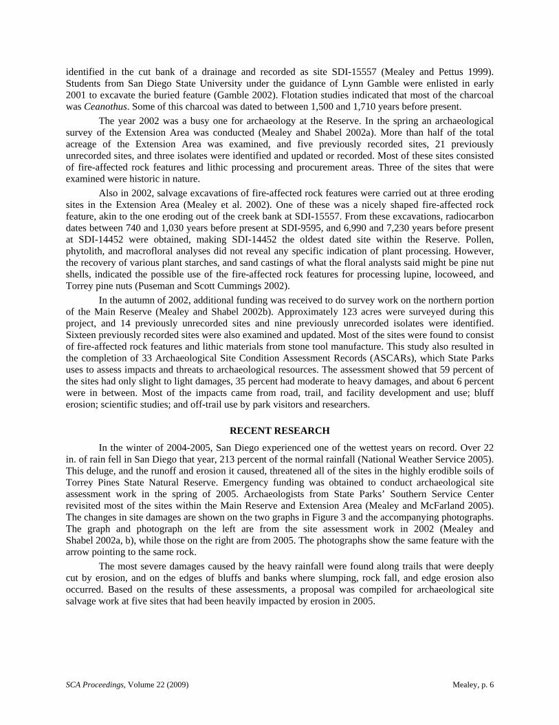
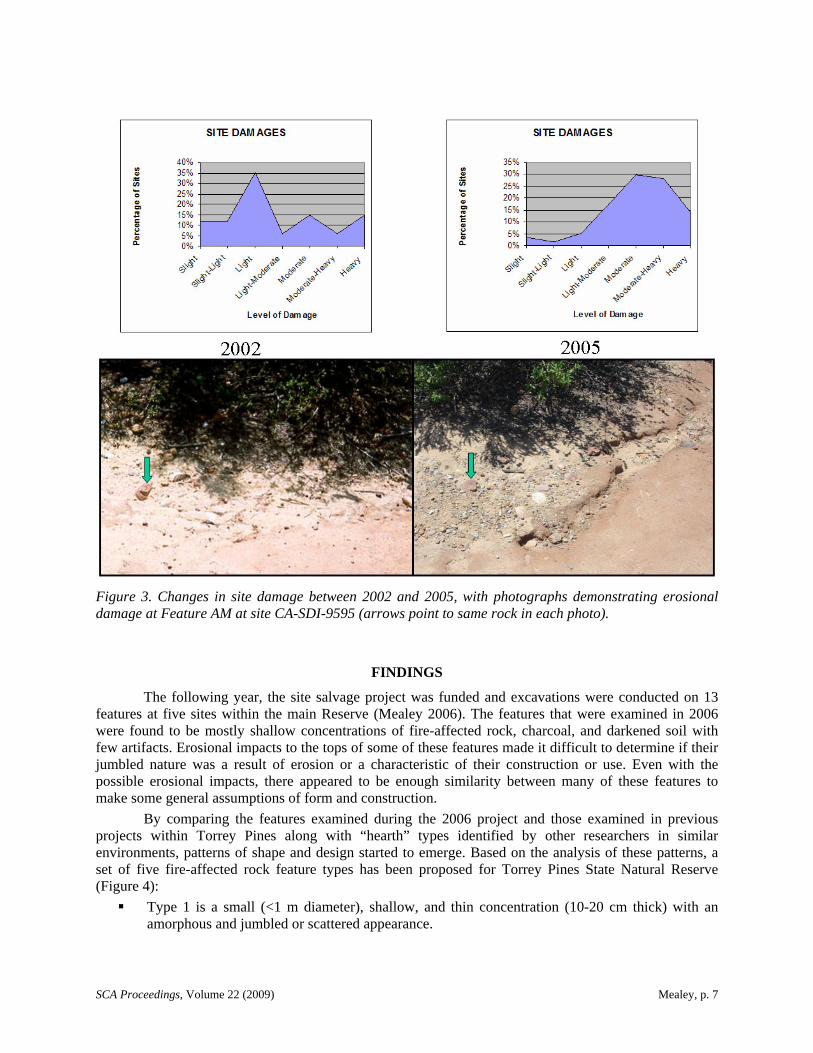
In the winter of 2004-2005, San Diego experienced one of the wettest years on record. Over 22 in. of rain fell in San Diego that year, 213 percent of the normal rainfall (National Weather Service 2005). This deluge, and the runoff and erosion it caused, threatened all of the sites in the highly erodible soils of Torrey Pines State Natural Reserve. Emergency funding was obtained to conduct archaeological site assessment work in the spring of 2005. Archaeologists from State Parks’ Southern Service Center revisited most of the sites within the Main Reserve and Extension Area (Mealey and McFarland 2005). The changes in site damages are shown on the two graphs in Figure 3 and the accompanying photographs. The graph and photograph on the left are from the site assessment work in 2002 (Mealey and Shabel 2002a, b), while those on the right are from 2005. The photographs show the same feature with the arrow pointing to the same rock.
The most severe damages caused by the heavy rainfall were found along trails that were deeply cut by erosion, and on the edges of bluffs and banks where slumping, rock fall, and edge erosion also occurred. Based on the results of these assessments, a proposal was compiled for archaeological site salvage work at five sites that had been heavily impacted by erosion in 2005.
SCA Proceedings, Volume 22 (2009) Mealey, p. 7
Figure 3. Changes in site damage between 2002 and 2005, with photographs demonstrating erosional damage at Feature AM at site CA-SDI-9595 (arrows point to same rock in each photo).
FINDINGS
The following year, the site salvage project was funded and excavations were conducted on 13 features at five sites within the main Reserve (Mealey 2006). The features that were examined in 2006 were found to be mostly shallow concentrations of fire-affected rock, charcoal, and darkened soil with few artifacts. Erosional impacts to the tops of some of these features made it difficult to determine if their jumbled nature was a result of erosion or a characteristic of their construction or use. Even with the possible erosional impacts, there appeared to be enough similarity between many of these features to make some general assumptions of form and construction.
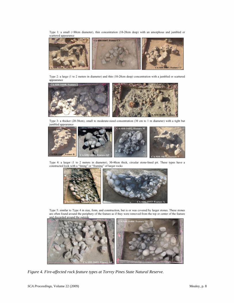
By comparing the features examined during the 2006 project and those examined in previous projects within Torrey Pines along with “hearth” types identified by other researchers in similar environments, patterns of shape and design started to emerge. Based on the analysis of these patterns, a set of five fire-affected rock feature types has been proposed for Torrey Pines State Natural Reserve (Figure 4):
Type 1 is a small (<1 m diameter), shallow, and thin concentration (10-20 cm thick) with an amorphous and jumbled or scattered appearance.
SCA Proceedings, Volume 22 (2009) Mealey, p. 8
Figure 4. Fire-affected rock feature types at Torrey Pines State Natural Reserve.
SCA Proceedings, Volume 22 (2009) Mealey, p. 9
Type 2 is similar to Type 1 in depth, thickness, and its jumbled and scattered appearance, but it is larger, averaging 1 to 2 m in diameter.
Type 3 is a small to moderate-sized concentration (30 cm to 1 m diameter) that is deeper and thicker (20-30 cm thick) than Types 1 and 2, with a tight but jumbled appearance.
Type 4 is a larger (1 to 2 m in diameter), deeper, and thicker (30-40 cm thick), circular stone-lined pit. Type 4 features have a constructed look with a “lining” or “framing” of larger rocks.
Type 5 is similar to Type 4 in size, form, and construction, but is or was covered by larger stones. These stones are often found around the periphery of the feature as if they were removed from the top or center of the feature and discarded around the outside.
All of these feature types have associated charcoal and darkened or burned soil. Ash is generally absent in these features, and artifacts are uncommon but do exist to attest to the cultural nature of these features. Bone and shell are usually absent or incidental. The rocks used to construct these features include volcanic (63 percent by weight), quartzite (19 percent), granitic (6 percent), and sandstone (8 percent) cobbles, plus a few other unidentified rocks (4 percent), all of which are readily available within the Reserve.
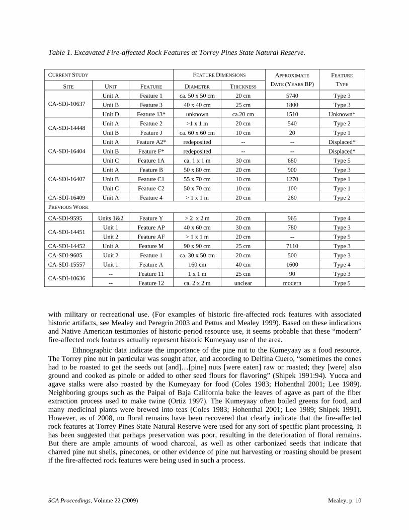
Of the 20 fire-affected rock features that have been examined within the Reserve, the largest set (35 percent) were identified as Type 3. Fifteen percent of the remaining features were identified as Type 1, 10 percent as Type 2, 10 percent as Type 4, and 15 percent as Type 5. The remaining features were either undetermined (5 percent) or displaced (10 percent). Table 1 lists the fire-affected rock features that have been excavated, their dimensions, radiocarbon dates, and type classifications.
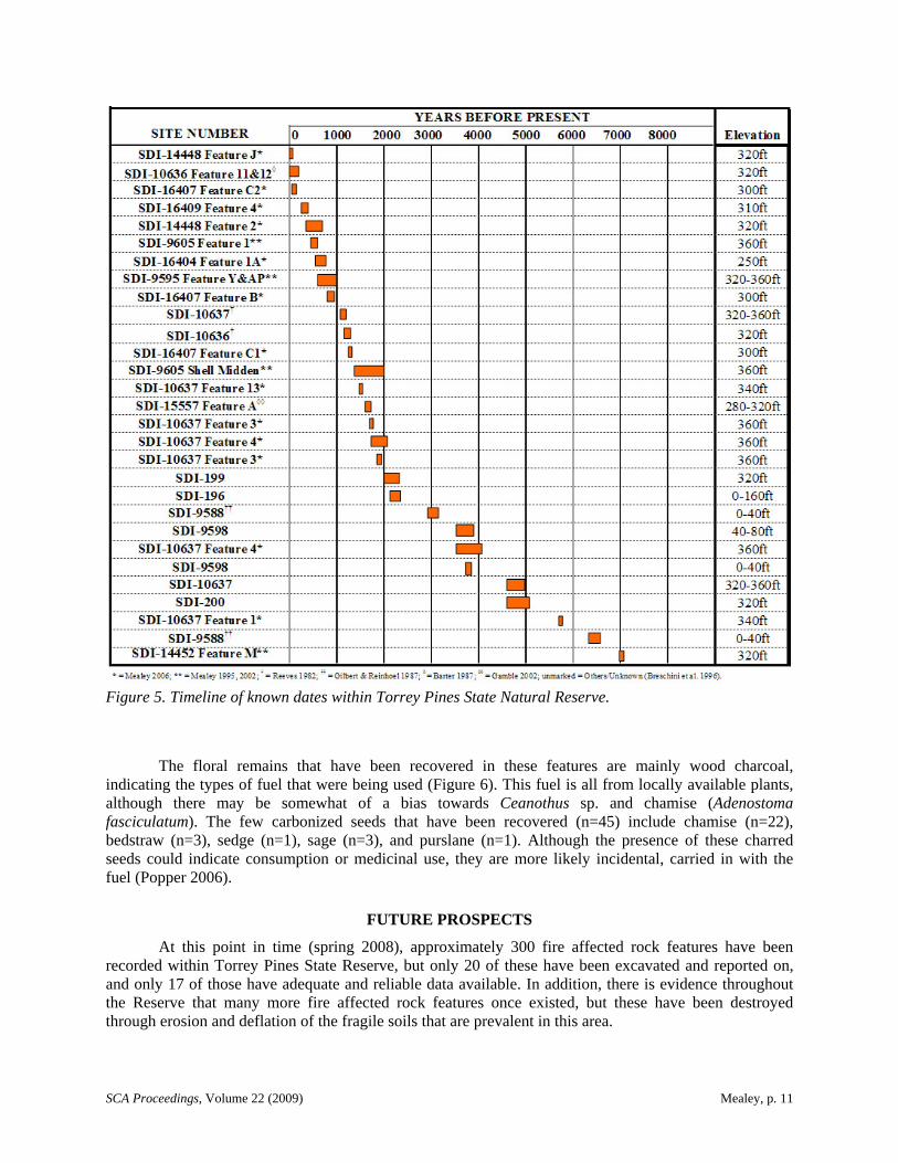
Most of the fire-affected rock features that have been studied were radiocarbon dated to between 0 to 2,000 years before present (n=14). Only two features, both identified as Type 3, returned earlier dates that were more than 5,500 years before present. The gap in dated fire-affected rock features between 2,000 to 5,500 years before present is most likely related to the smaller number of dated sites within the Reserve that fall within this time period (Figure 5). However, it is interesting to note that the shell midden features at SDI-9588 and SDI-10637 have returned dates that fall within this 2,000-to-5,500 years-before-present span. Perhaps this indicates a shift in activities within the area to shellfish collection and processing instead of those activities for which the fire-affected rock features were predominantly used.
The analysis of the shell midden at SDI-10637 showed that its composition was mainly Mytilus spp. (35 percent by count using minimum number of individuals [MNI] and 18.64 percent by weight) and Chione spp. (31 percent by count [MNI] and 44.72 percent by weight), with Ostrea lurida, Tegula spp., Astraea undosa, barnacle, Pectinidae, and Donax sp. together comprising 26 percent by count (MNI) and less than 20 percent by weight. The presence of these species indicates upper intertidal and lagoon/mudflat procurement areas. In comparison, at SDI-9605 (Mealey et al. 1996), 56 percent (by weight) of the shell was found to be Chione spp. and 22 percent was identified as Mytilus spp., with Saxidomus nuttalli at 11 percent, Pectinidae at 4 percent, and Ostrea lurida at 1 percent. However, at SDI-9588 there was a much larger percentage of Donax spp. (35 percent by count [MNI]), which Gilbert and Reinoehl (1987) speculated could be due to accessibility, availability, or simply preference for the species. It could also be a difference due to the elevation and placement of the site (note elevations on Figure 5). SDI-9588 is just above sea level on the edge of the lagoon, while both SDI-9605 and SDI-10637 are on the edges of eroding mesa tops.
Many of the fire-affected rock features that were examined during the 2006 study date to the Late period. Three features were dated to the Post-contact period including one that is essentially “modern.” This is similar to the results that Barter (1987) found at SDI-10636, when she concluded that the fire-affected rock features were created during military maneuvers connected to the Coast Artillery Corps’ Camp Callan in the 1940s. However, it is known from interviews with Delfina Cuero (Shipek 1970) that Kumeyaay Indians were going to the area of Torrey Pines to gather pine nuts and other resources well into the early twentieth century. Most of the fire-affected rock features at the Reserve contain prehistoric artifacts, not historic or modern “trash” such as cans, glass, foil, or metal that would indicate association
SCA Proceedings, Volume 22 (2009) Mealey, p. 10
Table 1. Excavated Fire-affected Rock Features at Torrey Pines State Natural Reserve.
CURRENT STUDY FEATURE DIMENSIONS
SITE UNIT FEATURE DIAMETER THICKNESS
APPROXIMATE
DATE (YEARS BP)
FEATURE
TYPE
Unit A Feature 1 ca. 50 x 50 cm 20 cm 5740 Type 3
Unit B Feature 3 40 x 40 cm 25 cm 1800 Type 3 CA-SDI-10637
Unit D Feature 13* unknown ca.20 cm 1510 Unknown*
Unit A Feature 2 >1 x 1 m 20 cm 540 Type 2 CA-SDI-14448
Unit B Feature J ca. 60 x 60 cm 10 cm 20 Type 1
Unit A Feature A2* redeposited -- -- Displaced*
Unit B Feature F* redeposited -- -- Displaced* CA-SDI-16404
Unit C Feature 1A ca. 1 x 1 m 30 cm 680 Type 5
Unit A Feature B 50 x 80 cm 20 cm 900 Type 3
Unit B Feature C1 55 x 70 cm 10 cm 1270 Type 1 CA-SDI-16407
Unit C Feature C2 50 x 70 cm 10 cm 100 Type 1
CA-SDI-16409 Unit A Feature 4 > 1 x 1 m 20 cm 260 Type 2
PREVIOUS WORK
CA-SDI-9595 Units 1&2 Feature Y > 2 x 2 m 20 cm 965 Type 4
Unit 1 Feature AP 40 x 60 cm 30 cm 780 Type 3 CA-SDI-14451
Unit 2 Feature AF > 1 x 1 m 20 cm -- Type 5
CA-SDI-14452 Unit A Feature M 90 x 90 cm 25 cm 7110 Type 3
CA-SDI-9605 Unit 2 Feature 1 ca. 30 x 50 cm 20 cm 500 Type 3
CA-SDI-15557 Unit 1 Feature A 160 cm 40 cm 1600 Type 4
-- Feature 11 1 x 1 m 25 cm 90 Type 3 CA-SDI-10636
-- Feature 12 ca. 2 x 2 m unclear modern Type 5
with military or recreational use. (For examples of historic fire-affected rock features with associated historic artifacts, see Mealey and Peregrin 2003 and Pettus and Mealey 1999). Based on these indications and Native American testimonies of historic-period resource use, it seems probable that these “modern” fire-affected rock features actually represent historic Kumeyaay use of the area.
Ethnographic data indicate the importance of the pine nut to the Kumeyaay as a food resource. The Torrey pine nut in particular was sought after, and according to Delfina Cuero, “sometimes the cones had to be roasted to get the seeds out [and]…[pine] nuts [were eaten] raw or roasted; they [were] also ground and cooked as pinole or added to other seed flours for flavoring” (Shipek 1991:94). Yucca and agave stalks were also roasted by the Kumeyaay for food (Coles 1983; Hohenthal 2001; Lee 1989). Neighboring groups such as the Paipai of Baja California bake the leaves of agave as part of the fiber extraction process used to make twine (Ortiz 1997). The Kumeyaay often boiled greens for food, and many medicinal plants were brewed into teas (Coles 1983; Hohenthal 2001; Lee 1989; Shipek 1991). However, as of 2008, no floral remains have been recovered that clearly indicate that the fire-affected rock features at Torrey Pines State Natural Reserve were used for any sort of specific plant processing. It has been suggested that perhaps preservation was poor, resulting in the deterioration of floral remains. But there are ample amounts of wood charcoal, as well as other carbonized seeds that indicate that charred pine nut shells, pinecones, or other evidence of pine nut harvesting or roasting should be present if the fire-affected rock features were being used in such a process.
SCA Proceedings, Volume 22 (2009) Mealey, p. 11
Figure 5. Timeline of known dates within Torrey Pines State Natural Reserve.
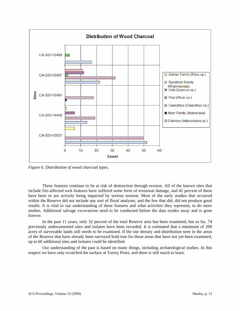
The floral remains that have been recovered in these features are mainly wood charcoal, indicating the types of fuel that were being used (Figure 6). This fuel is all from locally available plants, although there may be somewhat of a bias towards Ceanothus sp. and chamise (Adenostoma fasciculatum). The few carbonized seeds that have been recovered (n=45) include chamise (n=22), bedstraw (n=3), sedge (n=1), sage (n=3), and purslane (n=1). Although the presence of these charred seeds could indicate consumption or medicinal use, they are more likely incidental, carried in with the fuel (Popper 2006).
FUTURE PROSPECTS
At this point in time (spring 2008), approximately 300 fire affected rock features have been recorded within Torrey Pines State Reserve, but only 20 of these have been excavated and reported on, and only 17 of those have adequate and reliable data available. In addition, there is evidence throughout the Reserve that many more fire affected rock features once existed, but these have been destroyed through erosion and deflation of the fragile soils that are prevalent in this area.
SCA Proceedings, Volume 22 (2009) Mealey, p. 12
Figure 6. Distribution of wood charcoal types.
These features continue to be at risk of destruction through erosion. All of the known sites that include fire-affected rock features have suffered some form of erosional damage, and 42 percent of these have been or are actively being impacted by serious erosion. Most of the early studies that occurred within the Reserve did not include any sort of floral analyses, and the few that did, did not produce good results. It is vital to our understanding of these features and what activities they represent, to do more studies. Additional salvage excavations need to be conducted before the data erodes away and is gone forever.
In the past 11 years, only 32 percent of the total Reserve area has been examined, but so far, 74 previously undocumented sites and isolates have been recorded. It is estimated that a minimum of 200 acres of surveyable lands still needs to be examined. If the site density and distribution seen in the areas of the Reserve that have already been surveyed hold true for those areas that have not yet been examined, up to 60 additional sites and isolates could be identified.
Our understanding of the past is based on many things, including archaeological studies. In this respect we have only scratched the surface at Torrey Pines, and there is still much to learn.
SCA Proceedings, Volume 22 (2009) Mealey, p. 13
REFERENCES CITED
Ainsworth, P. 1978 Archaeological site records for CA-SDI-7223 and CA-SDI-7225. On file at South Coastal
Information Center, San Diego State University.
Barter, E. R. 1986 Torrey Pines State Reserve Resource Management Program. Report prepared for the
California Department of Parks and Recreation. On file at California Department of Parks and Recreation, Southern Service Center, San Diego.
1987 CA-SDI-10636, The Cache Site, Torrey Pines State Reserve: A Report of Work Conducted under Statewide Resource Management Program Project 403-630-3-2. Report prepared for the California Department of Parks and Recreation. On file at California Department of Parks and Recreation, Southern Service Center, San Diego.
Breschini, G. S., T. Haversat, and J. M. Erlandson 1996 California Radiocarbon Dates. 8th ed. Coyote Press, Salinas, California.
California Department of Parks and Recreation (DPR) 1984 San Diego Coastal State Park System General Plan Volume 8 - Torrey Pines State Beach and
State Reserve. California Department of Parks and Recreation. On file at California Department of Parks and Recreation, Southern Service Center, San Diego.
Colbern, D. 1973 Archaeological site record for CA-SDI-4612. On file at South Coastal Information Center,
San Diego State University.
Coles, D. S. 1983 The Ethnobotany of Torrey Pines State Reserve. Report prepared for the California
Department of Parks and Recreation. On file at California Department of Parks and Recreation, Southern Service Center, San Diego.
Gamble, L. 2002 Archaeological Investigations at CA-SDI-15557, Torrey Pines State Reserve. San Diego State
University. Report prepared for the California Department of Parks and Recreation. On file at California Department of Parks and Recreation, Southern Service Center, San Diego.
Gilbert, C., and G. Reinoehl 1987 Archaeological Investigations for Parking Lot Improvement at Torrey Pines State Beach and
Reserve. Report prepared for the California Department of Parks and Recreation. On file at California Department of Parks and Recreation, Southern Service Center, San Diego.
Gross, G. T. 1987 Lithic Analysis. In Archaeological Investigations for Parking Lot Improvement at Torrey
Pines State Beach and Reserve, by C. Gilbert and G. Reinoehl, Appendix B. California Department of Parks and Recreation. On file at California Department of Parks and Recreation, Southern Service Center, San Diego.
Hohenthal, W. D. 2001 Tipai Ethnographic Notes: A Baja California Indian Community at Mid-Century. Ballena
Press Anthropological Papers No. 48. Ballena Press, Novato, California.
Lee, M. 1989 Indians of the Oaks. San Diego Museum of Man, San Diego.
SCA Proceedings, Volume 22 (2009) Mealey, p. 14
Mealey, M. 2006 Cultural Stewardship Project Report: Data Recovery from Storm-Damaged Features at
Torrey Pines State Reserve. Report prepared for the California Department of Parks and Recreation. On file at California Department of Parks and Recreation, Southern Service Center, San Diego.
Mealey, M., B. Castro, and R. Heimgaertner 1996 Statewide Resource Management Program Project Status Report: Salvage of Eroding
Cultural Deposits at Three Archaeological Sites in Torrey Pines State Reserve. Report prepared for the California Department of Parks and Recreation. On file at California Department of Parks and Recreation, Southern Service Center, San Diego.
Mealey, M., S. Jenkins, K. Shabel, Beta Analytic, and Paleo Research Institute 2002 Cultural Resources Management Program Project Status Report: Testing and Data Recovery
at Three Sites in the Extension Area of Torrey Pines State Reserve. Report prepared for the California Department of Parks and Recreation. On file at California Department of Parks and Recreation, Southern Service Center, San Diego.
Mealey, M., and P. McFarland 2005 Cultural Resources Management Program Project Report: Archaeological Site Condition
Assessment within Torrey Pines State Reserve for Storm Damage following the 2004/2005 Rainfall Season. Report prepared for the California Department of Parks and Recreation. On file at California Department of Parks and Recreation, Southern Service Center, San Diego.
Mealey, M., T. Muranaka, and R. Heimgaertner 1997 Statewide Resource Management Program Project Status Report: Archaeological Site
Reevaluation and Mapping at Torrey Pines State Reserve. Report prepared for the California Department of Parks and Recreation. On file at California Department of Parks and Recreation, Southern Service Center, San Diego.
Mealey, M., and C. Peregrin 2003 Archaeological site record for CA-SDI-16806. On file at the South Coastal Information
Center, San Diego State University.
Mealey, M., and R. Pettus 1999 Archaeological site record for CA-SDI-15557 (Extension Hearths Site). On file at the South
Coastal Information Center, San Diego State University.
Mealey, M., and K. Shabel 2002a Cultural Resource Management Program Project Status Report Archaeological Survey of the
Extension Area of Torrey Pines State Reserve. Report prepared for the California Department of Parks and Recreation. On file at California Department of Parks and Recreation, Southern Service Center, San Diego.
2002b Statewide Cultural Resource Management Program Project Status Report Archaeological Survey of the Northern Portion of Torrey Pines State Reserve. Report prepared for the California Department of Parks and Recreation. On file at California Department of Parks and Recreation, Southern Service Center, San Diego.
National Weather Service 2005 Monthly and seasonal precipitation summaries for selected recording sites in the San Diego
Hydrologic Service Area. Electronic Document, http://www.wrh.noaa.gov/sgx/hydro/E5.pdf, accessed June 6, 2005.
SCA Proceedings, Volume 22 (2009) Mealey, p. 15
Nesbitt, P. E. 1983 The Cultural Resources of the Torrey Pines Units. Report prepared for the California
Department of Parks and Recreation. On file at California Department of Parks and Recreation, Southern Service Center, San Diego.
Ortiz, B. 1997 Manuela Aguiar’s Agave String and Nets. News from Native California 11(2):6-9.
Pettus, R., and M. Mealey 1999 Archaeological site record for CA-RIV-6416. On file at the South Coastal Information
Center, San Diego State University.
Popper, V. S. 2006 Macrobotanical Analysis of Soil Samples from the Torrey Pines State Reserve (CA-SDI-
10637, CA-SDI-14448, CA-SDI-16404, CA-SDI-16407, and CA-SDI-16409), San Diego County, California. Report prepared for the California Department of Parks and Recreation. On file at California Department of Parks and Recreation, Southern Service Center, San Diego.
Puseman, K. and L. Scott Cummings 2002 Pollen, Phytolith, and Macrofloral Analysis at Site CA-SDI-9595, Southern California.
Report prepared for the California Department of Parks and Recreation. On file at California Department of Parks and Recreation, Southern Service Center, San Diego.
Reeves, B. O. K. 1982 Torrey Pines Reserve, A Brief Report. University of Calgary, Alberta, Canada. Report
prepared for the California Department of Parks and Recreation. On file at California Department of Parks and Recreation, Southern Service Center, San Diego.
Rogers, M. J. 1930s Field notes and site records. On file at the San Diego Museum of Man.
Roth, L. 1985 Torrey Pines State Park utility line monitoring. Field notes on file at California Department of
Parks and Recreation, Southern Service Center, San Diego.
Scott Cummings, L., K. Puseman, and T. Moutoux 1996 Pollen, Phytolith, Macrofloral, and Protein Residue Analysis at Sites CA-SDI-10637, CA-
SDI-9605, and CA-LAN-92, Southern California. Paleo Research Laboratories. Report prepared for the California Department of Parks and Recreation. On file at California Department of Parks and Recreation, Southern Service Center, San Diego.
Shipek, F. C. 1970 The Autobiography of Delfina Cuero, a Diegueño Indian, as Told to Florence Shipek. Malki
Museum Press, Banning, California. 1991 Delfina Cuero: Her Autobiography, an Account of Her Last Years, and Ethnobotanic
Contributions. Ballena Press, Menlo Park, California.
Treganza, A. 1940s Archaeological site survey records for CA-SDI-199 and CA-SDI-200. On file at South
Coastal Information Center, San Diego State University.
Woodward, J., and G. Stammerjohan 1985 Resource Inventory Cultural Resources San Diego Coast State Beaches: Carlsbad, South
Carlsbad, Leucadia, Moonlight, San Elijo, Cardiff, Torrey Pines, Silver Strand. Report prepared for the California Department of Parks and Recreation. On file at California Department of Parks and Recreation, Southern Service Center, San Diego.