Embed Size (px)
Citation preview
Planning Phase for the Pilot Surfer’s Beach Restoration Project
CALIFORNIA OCEAN PROTECTION COUNCIL
Staff Recommendation October 17, 2016
Planning Phase for the Pilot Surfer’s Beach Restoration Project
Chris Potter, Project Manager
RECOMMENDED ACTION: Authorization to disburse up to $75,000 to San Mateo County Harbor District to conduct the planning phase of the Pilot Surfer’s Beach Restoration Project pursuant to the authority in Public Resources Code section 75702. LOCATION: Pillar Point Harbor/Surfer’s Beach, San Mateo County. STRATEGIC PLAN OBJECTIVES: • Objective 4.2: Encourage the development and adoption of sea-level-rise adaptation
strategies. • Objective 11.1: Improve policies and regulatory practices in ways that restore natural
sediment processes, while increasing opportunities for sediment reuse. • Objective 11.2: Increase the availability of data and tools that can influence sediment-
related planning decisions.
EXHIBITS
Exhibit A: Project Location and Site Map
Exhibit B: Site images
______________________________________________________________________________
FINDINGS AND RESOLUTION:
Staff recommends that the Ocean Protection Council (OPC) adopt the following findings: “Based on the accompanying staff report and attached exhibit(s), the Ocean Protection Council hereby finds that:
1) The proposed projects are consistent with the purposes of Division 26.5 of the Public Resources Code, the Ocean Protection Act.
Item 4i
1
Planning Phase for the Pilot Surfer’s Beach Restoration Project
2) The proposed projects are consistent with the Ocean Protection Council's grant program funding guidelines (Interim Standards and Protocols, August 2013).
3) The proposed project is not a ‘legal project’ that triggers the California Environmental Quality Act pursuant to Public Resources Code section 21068 and Title 14 of the California Code of Regulations, section 15378.”
Staff further recommends that the OPC adopt the following resolution pursuant to Sections 35500 et seq. of the Public Resources Code: “The California Ocean Protection Council hereby approves the disbursement of up to $75,000 to the San Mateo County Harbor District (District) to implement the planning phase of the Pilot Surfer’s Beach Restoration Project. This authorization is subject to the condition that prior to disbursement of funds, the District shall submit for the review and approval of the Executive Director of the OPC detailed work plans, schedules, staff requirements, budgets, and the names of any contractors intended to be used to complete the projects, as well as discrete deliverables that can be produced in intervals to ensure the projects are on target for successful completion. All projects will be developed under a shared understanding of process, management and delivery.
PROJECT SUMMARY: The grant funding would be used to fund a portion of the planning phase of the Pilot Surfer’s Beach Restoration Project (Project) being proposed by the San Mateo County Harbor District. The Project will address the significantly accelerated coastal erosion rates that have occurred on the bluffs and beaches adjacent to Pillar Point Harbor as a result of the construction of the East Breakwater approximately 55 years ago. The two primary issues that the proposed Project will address are impaired public beach access/recreational impacts and damages to infrastructure from coastal storms. Additionally, it will address the issues associated with accumulation of sediment within Pillar Point Harbor. The grant would fund the planning that is required in order to implement the Project. The Project itself is necessary to reduce the threat of structural damage and recreation loss along the coastal stretch in the Project area. As a background, the U.S. Army Corps of Engineers (USACE) recently completed a study1 that concluded that the shoreline in the Project area directly adjacent to the East Breakwater retreated at a rate of 1.64 feet per year between 1993 and 2012. This is approximately seven times greater than the background rate of erosion as measured at a geologically similar section of shoreline farther down the coast. The USACE
1 Lin, L., Li, H., Zoulas, J., Andes. L., and Wu, F. 2015. North Half Moon Bay Shoreline Improvement Project, Pillar Point Harbor, CA. Coastal Engineering Appendix. Final Report.
2

Planning Phase for the Pilot Surfer’s Beach Restoration Project
analysis also concluded that if no action were taken, an approximately 80-foot long section of Highway 1 would be undermined within the next 10 years and approximately 250 feet at risk over the next 50 years. The proposed Project involves the placement of an estimated 75,000 cubic yards of sand on the beach, acquired from the deposition of sediment that has been trapped inside the East breakwater of Pillar Point Harbor. It is important to note that the project site is located within the boundaries of the Monterey Bay National Marine Sanctuary (MBNMS). The Coastal Sediment Management Workgroup2 (CSMW), co-chaired by the U.S. Army Corps of Engineers (USACE) and the California Natural Resources Agency (CNRA), have been in discussions with MBNMS management over the last five years regarding opportunities to collaborate on a pilot project that addresses coastal erosion within sanctuary boundaries. For the reasons discussed above, this project represents the first best opportunity to collaborate with MBNMS on a project that addresses coastal erosion and the beneficial re-use of sand. The specific deliverables (categorized) include: Stakeholder Collaboration and Public Outreach: • Formation of a Technical Advisory Group to provide input on the Project design and
engineering decisions. • Conduct meetings with local municipalities to discuss opportunities for collaboration in
Project planning and implementation. • Coordination and facilitation of stakeholder and technical workshops. • Collaboration with permitting agencies and technical contractors to acquire all necessary
permits and consultations. • Collaboration with design and engineering contractors to develop detailed Project plans and
Best Management Practices. • Collaboration with biologists, geologists, regulatory agency staff and other experts to
develop a comprehensive ecological and physical monitoring program for the Project.
Project Design and Engineering: • Develop a comprehensive list of potential partners and stakeholders and identify their
potential roles in project planning and implementation. • Conduct individual meetings/interviews with technical experts to obtain initial design input
and Project guidance. • Identify initial Project design alternatives by working with technical experts and
stakeholders.
2 The CSMW is a statewide workgroup co-chaired by USACE and CNRA that is dedicated to protecting, enhancing and restoring California's coastal beaches and watersheds through federal, state and local cooperative efforts.
3
Planning Phase for the Pilot Surfer’s Beach Restoration Project
• Assemble a Technical Advisory Group and coordinate/facilitate a minimum of two design workshops.
• Determine acceptable Project parameters by working with permitting agencies • Prioritize process and determine preferred Project design alternative. • Pursue contracts for pre-construction engineering and design.
Permitting and Agency Consultation: • Extensive communication and coordination with all involved local, state and federal
agencies including: NOAA’s Monterey Bay and Greater Farallones National Marine Sanctuaries; U.S. Army Corps of Engineers; U.S. Environmental Protection Agency; National Marine Fisheries Service; U.S. Fish and Wildlife Service; California Coastal Commission; California State Lands Commission; California Department of Fish and Wildlife; San Francisco Regional Water Quality Control Board; County of San Mateo, and; City of Half Moon Bay.
• Meet individually with resource management and permitting agencies to discuss permitting considerations.
• Convene a permitting workshop and site visit with permitting agency staff to address permitting requirements, establish acceptable project parameters, and identify effective mitigation measures.
• Develop a detailed permitting roadmap that details all requirements, timelines, etc. • Apply for and obtain all necessary permits and consultations. • Coordination of the CEQA process to meet all requirements for Project permitting and
implementation.
Project Monitoring: • Work with permitting and natural resource agencies to determine requirements and
protocols for monitoring and to develop criteria for success. • Develop a draft and final post-construction monitoring plan. • Ensure contracts are in place for conducting physical and biological monitoring prior to
project construction to develop a baseline for comparison of potential effects, and during and after construction to quantify changes and identify potential issues.
Project Management: • Develop a detailed work plan, timeline and project schedule that lays out the specific tasks
and milestones of the planning phase through project construction and post-construction monitoring.
• Coordinate with San Mateo County Harbor District Board of Harbor Commissioners on all aspects of the project.
Overarching goal of project: Conduct the planning activities necessary to prepare for implementation of the Pilot Surfer’s Beach Restoration Project, which will address the issues of impaired public access/recreational
4
Planning Phase for the Pilot Surfer’s Beach Restoration Project
impacts and damages from coastal storms. Specific benefits of the project include preventing or mitigating beach erosion and sea cliff retreat; improving protection of State Highway 1 and other coast-side commercial and private structures; increasing the quality and quantity of public access and public recreation to that stretch of coast; reducing the need for hard structures (e.g. seawalls and revetments), and; improving beach and wildlife habitat in the project area. Site Description: The entirety of the property within the proposed Project area is publically owned. The easternmost portion of Pillar Point Harbor (including the East Breakwater) and the adjacent shoreline that includes Surfer’s Beach (officially named El Granada Beach), Vallejo Beach, and Miramar beach are within the boundaries of the City of Half Moon Bay. The project vicinity supports a variety of recreational activities including boating, swimming, surfing, fishing, kayaking, windsurfing, walking, bird watching, and beach going. The beach nourishment borrow area (sand source) is located within Pillar Point Harbor, under the jurisdiction of the San Mateo County Harbor District. Pillar Point Harbor is home port to a vital commercial fishing industry, to sport fishermen, and to pleasure boaters seeking the amenities this modern coastal harbor facility provides. The Harbor has 369 berths and an inner and outer breakwater, making it one of the safest harbors in the United States. Although there are numerous areas within the MBNMS and the California coast that suffer from beach erosion, this project was chosen, over other potential projects for the following reasons: 1) there is an easily accessible and convenient source of clean sand adjacent to the eroded beach, which can be used for nourishment; 2) the erosion problem at this particular beach is very severe and beach access is extremely difficult and hazardous in some areas 3) there has been significant amount of progress already in planning for such a project at this location, 4) there is substantial public support and no known opposition for this Project, and 5) jurisdictions and municipalities within the affected area are supportive of the Project. Project Timeline: The planning phase of the Project has been underway since early 2016 and will continue right up until the Project implementation date. Project implementation (construction) is anticipated to begin in summer of 2017. Physical and ecological monitoring for the District’s proposed Project would occur during construction and periodically following construction for up to two years. The construction phase of the proposed Project is anticipated to require approximately 4-6 weeks to complete. However this anticipated timeline is entirely dependent upon the completion of permitting and environmental review processes and it may be necessary to delay construction until the fall of 2017 or possibly spring of 2018.
5
Planning Phase for the Pilot Surfer’s Beach Restoration Project
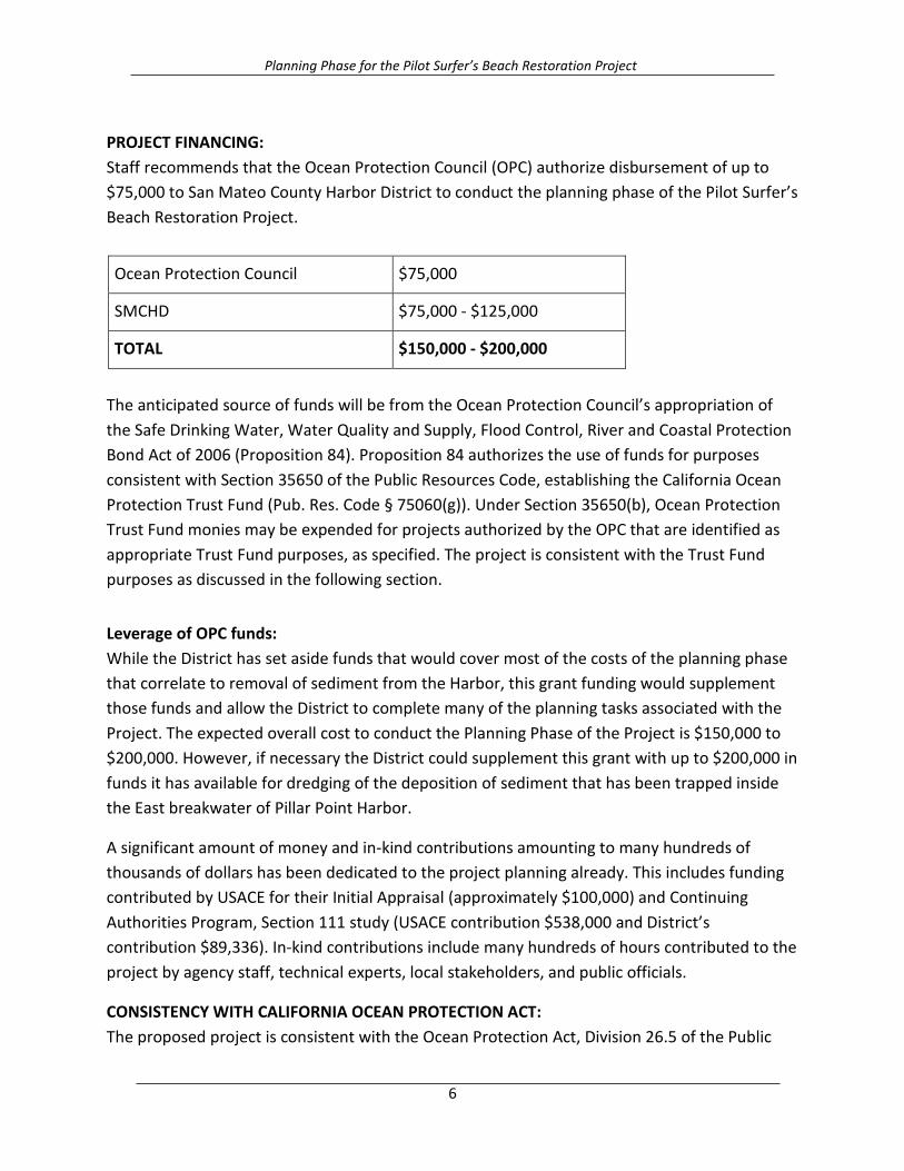
PROJECT FINANCING: Staff recommends that the Ocean Protection Council (OPC) authorize disbursement of up to $75,000 to San Mateo County Harbor District to conduct the planning phase of the Pilot Surfer’s Beach Restoration Project.
Ocean Protection Council $75,000
SMCHD $75,000 - $125,000
TOTAL $150,000 - $200,000
The anticipated source of funds will be from the Ocean Protection Council’s appropriation of the Safe Drinking Water, Water Quality and Supply, Flood Control, River and Coastal Protection Bond Act of 2006 (Proposition 84). Proposition 84 authorizes the use of funds for purposes consistent with Section 35650 of the Public Resources Code, establishing the California Ocean Protection Trust Fund (Pub. Res. Code § 75060(g)). Under Section 35650(b), Ocean Protection Trust Fund monies may be expended for projects authorized by the OPC that are identified as appropriate Trust Fund purposes, as specified. The project is consistent with the Trust Fund purposes as discussed in the following section. Leverage of OPC funds: While the District has set aside funds that would cover most of the costs of the planning phase that correlate to removal of sediment from the Harbor, this grant funding would supplement those funds and allow the District to complete many of the planning tasks associated with the Project. The expected overall cost to conduct the Planning Phase of the Project is $150,000 to $200,000. However, if necessary the District could supplement this grant with up to $200,000 in funds it has available for dredging of the deposition of sediment that has been trapped inside the East breakwater of Pillar Point Harbor.
A significant amount of money and in-kind contributions amounting to many hundreds of thousands of dollars has been dedicated to the project planning already. This includes funding contributed by USACE for their Initial Appraisal (approximately $100,000) and Continuing Authorities Program, Section 111 study (USACE contribution $538,000 and District’s contribution $89,336). In-kind contributions include many hundreds of hours contributed to the project by agency staff, technical experts, local stakeholders, and public officials.
CONSISTENCY WITH CALIFORNIA OCEAN PROTECTION ACT: The proposed project is consistent with the Ocean Protection Act, Division 26.5 of the Public
6

Planning Phase for the Pilot Surfer’s Beach Restoration Project
Resources Code, because it is consistent with trust-fund allowable projects, defined in Public Resources Code Section 35650(b)(2) as projects which:
1) Eliminate or reduce threats to coastal and ocean ecosystems, habitats, and species. 2) Allow for increased public access to, and enjoyment of, ocean and coastal resources, of
those resources. 3) Provide funding for adaptive management, planning coordination, monitoring, research,
and other necessary activities to minimize the adverse impacts of climate change on California's ocean ecosystem.
The planning phase of the project, which is now underway, includes a very comprehensive stakeholder collaboration process, including advisory working groups, regulatory and permitting meetings, and several public workshops and meetings. The extensive stakeholder collaboration that is required for the planning and implementation of this project would result in a beneficial coordination of state programs and activities. The proposed project will involve coordination with numerous local, state, and federal agencies and jurisdictions that will be involved in planning for the Pilot Surfer’s Beach Restoration Project. Some of these entities will be involved in permitting of the Project, some will be involved with consultation and review and others will provide technical expertise and planning support. The main state agencies and organizations include: the CSMW, California Department of Transportation (Caltrans), California Coastal Commission (CCC), California State Lands Commission (CSLC), California Department of Fish and Wildlife (CDFW), and San Francisco Regional Water Quality Control Board (RWQCB). By bringing together staff from these state organizations early and often, for example during workshops for permitting and design, it will be possible to identify and resolve potential conflicts, areas of concern, and opportunities for collaboration.
The project would benefit state programs and activities in several ways. As discussed above, the CSMW has been looking for opportunities to work with NOAA’s Office of National Marine Sanctuaries on conducting beach nourishment projects that will restore beach habitat. Monterey Bay and Greater Farallones Sanctuaries will play a key advisory and review roles in the planning of the Project. The Surfer’s Beach project also is a recommended activity in the Regional Sediment Management Plan for the Santa Cruz Littoral Cell, on which the CSMW partnered with local stakeholders to develop. Moreover, Surfer’s Beach (El Granada County Beach) has been identified as a Beach Erosion Concern Area within the CSMW’s California Beach Erosion Assessment Survey. Also, Caltrans is responsible for protecting Highway 1 and maintains a revetment along the bluffs at Surfer’s Beach near the root of the East Breakwater, and would benefit from a project that mitigates the coastal erosion that threatens its infrastructure. Finally, the California Coastal Trail, located on the bluffs behind Surfer’s Beach, is
7
Planning Phase for the Pilot Surfer’s Beach Restoration Project
now threatened in several locations and will gain protection from Project construction, which will benefit the pedestrians that use it as a walking and hiking trail. In addition to the state entities listed above, the Project would also involve collaborating with the following Federal and local agencies and jurisdictions: NOAA's Monterey Bay and Greater Farallones National Marine Sanctuaries (MBNMS and GFNMS) and National Marine Fisheries Service (NMFS), US Army Corps of Engineers (USACE), US Environmental Protection Agency (USEPA), County of San Mateo, City of Half Moon Bay and Caltrans. By bringing together the state, federal and local players this project will help to foster cooperation and enhance working relationships among the various agencies.
CONSISTENCY WITH THE OPC'S STRATEGIC PLAN: This project implements Focal Area “Coastal and Ocean Impact from Land,” the goal of which is to reduce the negative impacts of land-based activities on marine ecosystems and the state’s coastal and ocean economy.
CONSISTENCY WITH PROPOSITION 84 (The Safe Drinking Water, Water Quality and Supply, Flood Control, River and Coastal Protection Bond Act of 2006; Public Resources Code §75060(g) This project is consistent with the purposes of Proposition 84 because it provides data that allows the state to adaptively manage its marine resources, and enables planning that will lead to a capital project. (see Public Resources Code section 75702). For example, a significant amount of data that could be used for adaptive management of the coastal and marine ecosystems would be collected as part of this planning process. As a pilot effort that would be highly scrutinized by permitting agencies such as MBNMS, the proposed Surfer’s Beach project would be required to include a comprehensive studies and monitoring to determine whether or not it is effective and if there are any unacceptable environmental impacts. Moreover, it is a project that will be carried out within the boundaries of the Monterey Bay National Marine Sanctuary, which has strong protections and restrictions on certain activities involving discharge of materials within its boundaries. The proposed planning process would involve developing a comprehensive physical and ecological monitoring program before, during and after the construction phase, to meet requirements of permitting agencies and to gather additional data that could be used in designing an ongoing opportunistic beach nourishment program. CONSISTENCY WITH THE OPC'S GRANT PROGRAM FUNDING GUIDELINES: The proposed project is consistent with the OPC’s Grant Program Funding Guidelines for Proposition 84 funds, in the following respects:
8
Planning Phase for the Pilot Surfer’s Beach Restoration Project
Required Criteria 1. Directly relate to the ocean, coast, associated estuaries, or coastal-draining watersheds:
This project would involve the planning for a beach restoration project that would directly benefit the coastal ecosystem, local communities, recreational users and the agencies and jurisdictions that are responsible for protecting coastal infrastructure.
2. Support of the public: The need for a project to mitigate the coastal erosion issues has been identified for decades and is strongly supported by the community, Monterey Bay National Marine Sanctuary, Greater Farallones National Marine Sanctuary, San Mateo County, and others. There has been a long history of local support for this proposed beach restoration project within the local community and among natural resource agencies and local jurisdictions. We are not aware of any opposition to the Project.
Members of the local surfing community and other recreational beach users, in particular, have been very vocal in supporting the Project concept and have encouraged the District and pertinent regulatory agencies to take action to address the severe coastal erosion that has occurred over the past several decades as a result of the construction of the East Breakwater.
3. Greater-than-local interest: This project would have implications throughout the state and beyond. The planning and implementation of such a project is unprecedented in a National Marine Sanctuary and this will provide a replicable model of a planning process that is highly collaborative for future projects that conduct opportunistic nourishment in sensitive environments. Through a comprehensive monitoring program that will be developed as part of the planning phase, extensive data will be gathered to better assess impacts and develop effective mitigation measures and best management practices that could be used in other similar types of projects conducted elsewhere in the future. The monitoring will also help to gauge the effectiveness of the Project as a coastal resilience measure by studying its effect on physical and geological processes and coastal erosion. Therefore, this data can help to design future beach nourishment projects that are more effective in mitigating coastal erosion and storm damages.
Additional Criteria
4. Improvements to management approaches or techniques: This project will lead to improvements in coastal sediment management and beneficial re-use of sand in highly regulated marine managed areas such as National Marine Sanctuaries and in other waters throughout the state.
5. Resolution of more than one issue: This project will allow for the planning of a pilot opportunistic beach nourishment and dredging project that will a) address a significant
9
Planning Phase for the Pilot Surfer’s Beach Restoration Project
coastal erosion issue that threatens public infrastructure such as Highway 1, b) allow for enhanced beach access and reduce recreational hazards, and c) address impairments to navigation from shoaling inside Pillar Point harbor, due to the accumulation of sediment inside the East Breakwater.
6. Leverage: This project is being leveraged with funding from the San Mateo County Harbor District and prior contributions from the U.S. Army Corps of Engineers (See the “Project Financing” section above).
7. Timeliness or Urgency: The District has demonstrated its ability in other projects to complete and deliver projects as scheduled. There is an urgency to complete the project in the near future due to the severity of the existing coastal erosion at Surfer’s Beach. For example, as mentioned above, a recent USACE analysis concluded that if no action were taken an approximately 80-foot long section of Highway 1 would be undermined within the next 10 years and approximately 250 feet at risk over the next 50 years.
8. Coordination: Since the project would involve carrying out the planning phase of the
pilot Surfer’s Beach Restoration Project it would necessitate extensive stakeholder coordination and collaboration, including for example involvement by all relevant jurisdictions, municipalities, and regulatory agencies listed in the responses above.
COMPLIANCE WITH CEQA: The proposed project will involve coordinating the process that will result in completion of the CEQA requirements for implementation of the pilot Surfer’s Beach Restoration Project. Therefore the proposed project itself, to conduct planning activities for beach restoration activities, is categorically exempt from review under the California Environmental Quality Act (“CEQA”) pursuant to 14 Cal. Code of Regulations Section 15306 because the project involves only data collection, research and resource evaluation activities that will not result in a serious or major disturbance to an environmental resource. Staff will file a Notice of Exemption upon approval by the OPC.
10
Planning Phase for the Pilot Surfer’s Beach Restoration Project
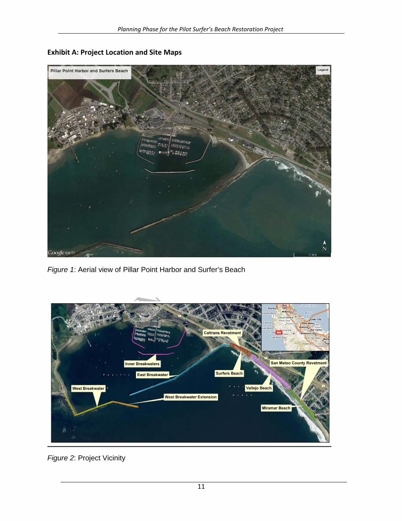
Exhibit A: Project Location and Site Maps
Figure 1: Aerial view of Pillar Point Harbor and Surfer’s Beach
Figure 2: Project Vicinity
11
Planning Phase for the Pilot Surfer’s Beach Restoration Project
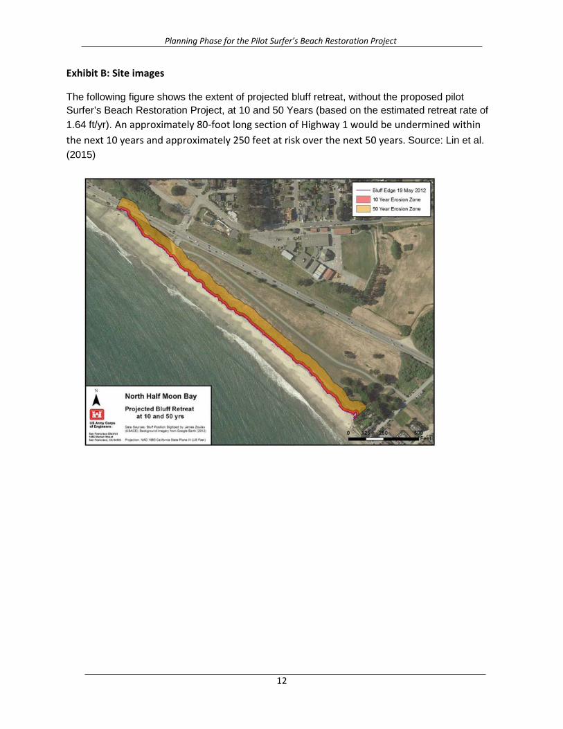
Exhibit B: Site images
The following figure shows the extent of projected bluff retreat, without the proposed pilot Surfer’s Beach Restoration Project, at 10 and 50 Years (based on the estimated retreat rate of 1.64 ft/yr). An approximately 80-foot long section of Highway 1 would be undermined within the next 10 years and approximately 250 feet at risk over the next 50 years. Source: Lin et al. (2015)
12
Planning Phase for the Pilot Surfer’s Beach Restoration Project
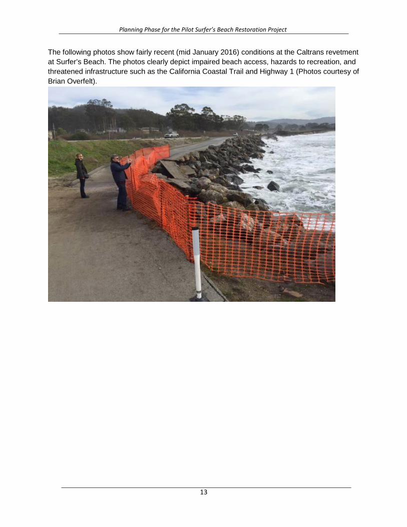
The following photos show fairly recent (mid January 2016) conditions at the Caltrans revetment at Surfer’s Beach. The photos clearly depict impaired beach access, hazards to recreation, and threatened infrastructure such as the California Coastal Trail and Highway 1 (Photos courtesy of Brian Overfelt).
13

Planning Phase for the Pilot Surfer’s Beach Restoration Project
14

Planning Phase for the Pilot Surfer’s Beach Restoration Project
15