Embed Size (px)
Citation preview

... - STATE OF CALIFORNIA-THE RESOURCES AGENCY PETE WILSON, Governor
" CALIFORNIA COASTAL COMMISSION RECORD Ptr~~ET COP~128197
..
UTH CENTRAl COAST AREA SOUTH CALIFORNIA ST., SUITE 200
ENTURA, CA 93001 49th Day: 12/16/97 (805) 641-0142 lBOth Day: 4/26/97 /«-
•
•
Staff: J Johnson · Staff Report: 11/13/97 Hearing Date: 12/9-12/97 Commission Action: 8202A
STAFF REPORT: REGULAR CALENDAR
APPLICATION NO.: 4-97-087
APPLICANT: Stevan Erlandson
PROJECT LOCATION: 1225 Latigo Canyon Road, Malibu, Los Angeles County
PROJECT DESCRIPTION: Construct a 2,336 square foot, one story, single family residence, with attached 960 square foot two car garage, septic system, two water storage tanks (6,000 and 5,500 gallons), and a 240 foot driveway on existing pad and driveway. Grade a total of 64 cubic yards of cut and export to location outside coastal zone. The applicant is also requesting "after the fact" approval of an unpermitted temporary mobile home during construction of new residence for a period not to exceed two years, a construction shed to be removed 90 days after receipt of certificate of occupancy, a tra i 1 er, woodshed, three trucks and two cars abandoned on-site to be removed 30 days after receipt of coastal permit, and a water well.
Lot Area Building Coverage Pavement Coverage Parking Spaces Plan Designation Zoning Project Density Ht abv fin grade
5.49 acres 3,197 sq. ft. none, gravel 2 Rural Land II and Mountain Land one du/ 5 and 20 acres 1 du/5 acres 20 feet
LOCAL APPROVALS RECEIVED: Approval in Concept, County of Los Angeles Department of Regional Planning, dated 3/26/97 and 6/26/97; Approval in Concept, Los Angeles County Department of Health Services, dated 10/9/97; Preliminary Approval, County of Los Angeles, Fire Department, dated 9/5/96 and 4/15/97.
SUMMARY OF STAFF RECOMMENDATION:
Staff recommends approval of the project with special conditions addressing landscape/erosion control, revegetation, and drainage plans; removal of temporary mobile home, construction shed, trailer, wood shed, and vehicles; future improvements; plans conforming to the geologic recommendations; wildfire waiver of liability; and condition compliance, to bring this project into compliance with the Coastal Act. The subject lot is bisected by the coastal zone boundary; the majority of the parcel is located within the coastal zone along north side of a saddle between a ridge of Castro Crest and the west flank of Castro Peak. The

Application No. 4-97-087 Erlandson
Page 2
proposed reside nee is 1 ocated within the Upper La Sierra Significant Watershed
•
and is located within 225 feet of a designated Environmentally Sensitive Habitat • Area <ESHA). However, the building site does not drain into the Upper La Sierra Canyon Significant Watershed or towards this ESHA but rather drains south into the Newton Canyon Significant Oak Woodland and Savannah about 1,800 feet from the project site which then drains to the Zuma Creek Significant Watershed. The Los Angeles County Environmental Review Board found the project consistent with the Land Use Plan and Table 1 policies.
The site is accessed from Latigo Canyon Road and a 4,800 foot length of the Castro Peak Motorway. The proposed residence is located on an existing building pad on the southern portion of the parce 1 near the Castro Peak Motorway. The subject parcel is located immediately east and to the north of the Pousette application (Coastal Permit 4-97-041) approved by the Commission at the November 5, 1997 meeting. As proposed in the Pousette project, the applicant also proposes to widen a portion, about 2,700 feet of Castro Peak Motorway, a private road, to 20 feet and pave a portion, about 1,045 feet. The road improvements are requirements of the Los Angeles County Fire Department to provide all weather emergency response access to the proposed residence. As a result of a detailed review of the Coastal Zone Boundary in this area all of these improvements to the Motorway are located outside the coastal zone. A small portion of the Motorway is located on the applicant's property; no improvements are proposed for this section. Therefore, the issue of potential prescriptive rights having been acquired on the Motorway and the potential effect of the road improvements on any such rights raised in the Pousette application are not determined in this report .
SUBSTANTIVE FILE DOCUMENTS: Update Engineering Geologic Report, dated January 13, 1997, by Mountain Geology, Inc.; Preliminary Geotechnical Investigation, dated 9-18-97. by Miller Geosciences, Inc.; Coastal Permit Number 4-97-041, Pousette; Coastal Permit Number 4-96-210, (Smith); Coastal Permit Number 4-96-162, (Jobbins); Coastal Permit Number 4-97-015, (Sayles>; Coastal Permit Number 5-87-956, Warren Erlandson; Coastal Permit Number 80-7443, (Carlson); Coastal Permit Waiver Number 5-91-215, (Carlson); Coastal Permit Number 5-82-359, (McCarthy and Frankel); Coastal Permit Number 4-96-084, (Von Hagen); Significant Ecological Areas, by England and Nelson, 1976.
STAFF RECOMMENDATION
The staff recommends that the Commission adopt the following resolution:
I. Approval with Conditions
The Commission hereby grants a permit for the proposed development, subject to the conditions below, on the grounds that, as conditioned, the development will be in conformity with the provisions of Chapter 3 of the California Coastal Act of 1976, will not prejudice the ability of the local government having jurisdiction over the area to prepare a Local Coastal program conforming to the provisions of Chapter 3 of the Coastal Act, and will not have any significant adverse impacts on the environment within the meaning of the California Environmental Quality Act.
•
•
•
•
•
•
Application No. 4-97-087 Erlandson
II. Standard Conditions
Page 3
1. Notice of Receipt and Acknowledgment. The permit is not valid and deve 1 opment sha 11 not commence unti 1 a copy of the permit, signed by the permittee or authorized agent, acknowledging receipt of the permit and acceptance of the terms and conditions, is returned to the Commission office.
2. Expiration. If development has not commenced, the permit will expire two years from the date on which the Commission voted on the app l i cation. Development shall be pursued in a diligent manner and completed in a reasonable period of time. Application for extension of the permit must be made prior to the expiration date.
3. Compliance. All development must occur in strict compliance with the proposal as set forth below. Any deviation from the approved plans must be reviewed and approved by the staff and may require Commission approval.
4. Interpretation. Any questions of intent or interpretation of any condition will be resolved by the Executive Director or the Commission.
5. Inspections. The Commission staff shall be allowed to inspect the site and the development during construction, subject to 24-hour advance notice.
6. Assignment. The permit may be assigned to any qualified person, provided assignee files with the Commission an affidavit accepting all terms and conditions of the permit .
7. Terms and Conditions Run with the Land. These terms and conditions shall be perpetual, and it is the intention of the Commission and the permittee to bind all future owners and possessors of the subject property to the terms and conditions.
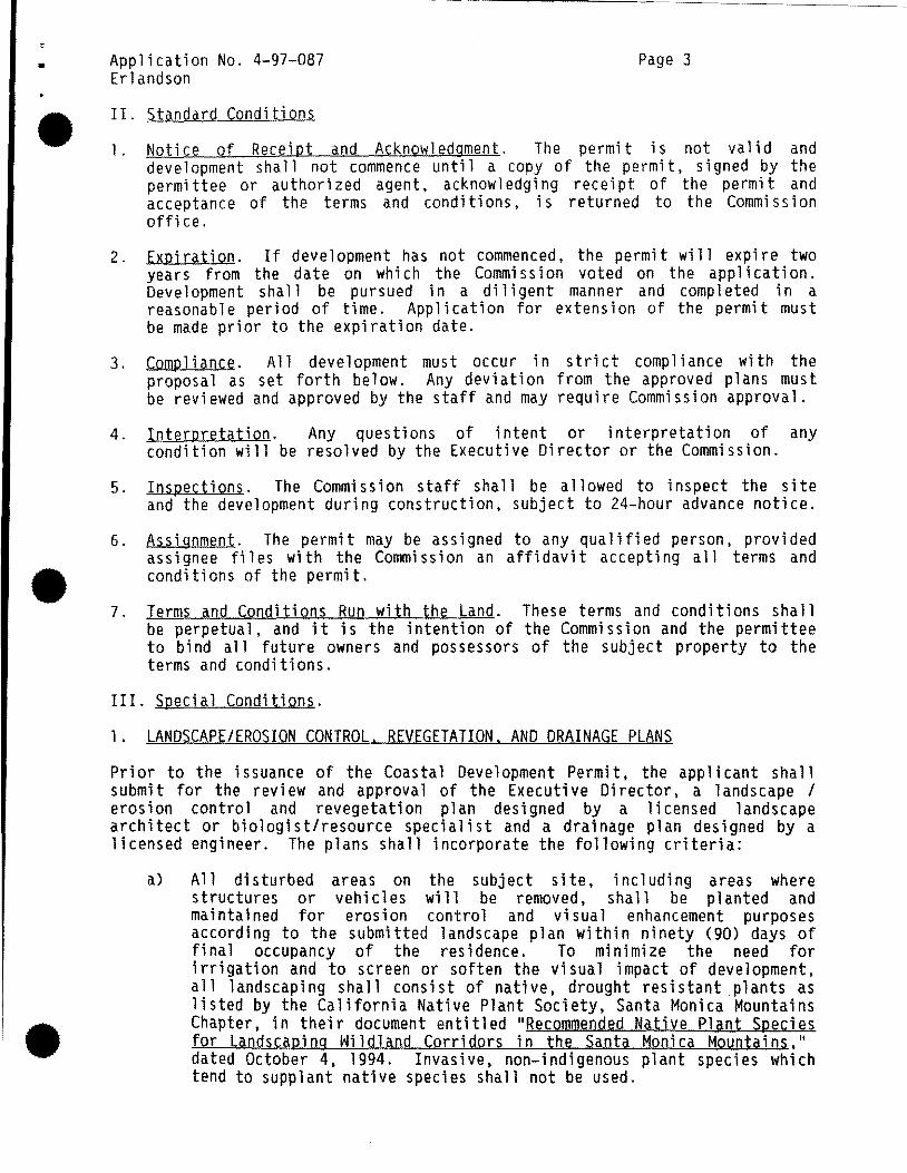
III. Special Conditions.
1. LANDSCAPE/EROSION CONTROL. REVEGETATION. AND DRAINAGE PLANS
Prior to the issuance of the Coastal Development Permit, the applicant shall submit for the review and approva 1 of the Executive Director, a 1 andscape I erosion control and revegetation plan designed by a licensed landscape architect or biologist/resource specialist and a drainage plan designed by a licensed engineer. The plans shall incorporate the following criteria:
a) All disturbed areas on the subject site, including areas where structures or vehicles will be removed, shall be planted and maintained for erosion control and visual enhancement purposes according to the submitted landscape plan within ninety (90) days of fi na 1 occupancy of the residence. To minimize the need for irrigation and to screen or soften the visual impact of development, all landscaping shall consist of native, drought resistant plants as listed by the California Native Plant Society, Santa Monica Mountains Chapter, in their document entitled 11 Recommended Native Plant Species for Landscaping Wildland Corridors in the Santa Monica Mountains, 11
dated October 4, 1994. Invasive, non-indigenous plant species which tend to supplant native species shall not be used.

Application No. 4-97-087 Erlandson
Page 4
b) Should grading take place during the rainy season <November 1 - March 31). sediment basins (including debris basins. desilting basins, or • silt traps) shall be required on the project site prior to or concurrent with the initial grading operations and maintained through the development process to minimize sediment from runoff waters during construction. All sediment should be retained on-site unless removed to an appropriate approved disposal location.
c) The drainage plan shall illustrate that run-off from the roof, patios, driveway and all other impervious surfaces on the subject parcel will be collected and discharged in a non-erosive manner which avoids ponding on the pad area. Site drainage shall not be accomplished by sheet-flow runoff. Should the residential project's drainage structures fail or result in erosion, the app 1 i cantil andowner or successor interests sha 11 be responsi b 1 e for any necessary repairs and restoration.
d) Vegetation within 50 feet of the proposed residence may be removed to mineral earth. Selective thinning, for purposes of fire hazard reduction,· shall be allowed in accordance with an approved long-term fuel modification plan submitted pursuant to this special condition. However, in no case should vegetation thinning occur in areas greater than a 300 foot radius of the residence, or as determined by the Los Angeles County Fire Department. The fuel modification plan shall include details regarding the types, sizes and locations of plant materials to be removed, and how often thinning is to occur. In addition, the applicant shall submit evidence that the final fuel • modification plan has been reviewed and approved by the Los Angeles County Fire Department, Fire Prevention Bureau.
2. REMQVAL OF MOBILE HOME. CONSTRUCTION SHED. TRAILER. WOQD SHED. AND VEHICLES
With the acceptance of this permit, the applicant agrees that the "temporary construction mobile home 11 and the "construction shed 11 on the site shall be removed within two years of the issuance of the coastal permit or within 90 days of applicant's receipt of the certificate of occupancy for the residence from Los Angeles County, whichever is less, to an appropriate disposal site located outside the coastal zone or a permitted site within the coastal zone. The applicant also agrees that the trailer, wood shed, abandoned three trucks, and two cars will be removed to an appropriate site outside the coastal zone or within a permitted site within the coastal zone within 30 days of the issuance of the coastal permit.
3. FUTURE IMPROVEMENTS RESTRICTION
Prior to the issuance of a coastal development permit. the applicant shall execute and record a document, in a form and content acceptable to the Executive Director. stating that the subject permit is only for the development described in the Coastal Development Permit No. 4-97-087; and that any future structures, additions or improvements to the property, including but not limited to clearing of vegetation, that might otherwise be exempt under Public Resource Code Section 30610(a), will require a permit from the Coastal Commission or its successor agency. However, fuel modification consistent with the requirements of the Los Angeles County Fire Department's fuel modification standards consistent with special condition number one (1) is permitted. The document shall run with the land, binding all successors and assigns, and shall be recorded free of prior liens and any other encumbrances which the Executive Director determines may affect the interest being conveyed.
•

•
•
•
Application No. 4-97-087 Erlandson
4. PLANS CONFORMING TO GEOLOGIC RECOMMENDATION
Page 5
All recommendations contained in the Update Engineering Geologic Report, dated January 13, 1997, by Mountain Geology, Inc. and the Preliminary Geotechnical Investigation, dated 9-18-97, by Miller Geosciences, Inc. shall be incorporated into all final design and construction plans including grading. foundations. floor slabs. sewage disposal. and drainage. All plans must be reviewed and approved by the consultants. Prior to the issuance of the coastal development permit, the applicant shall submit. for review and approval by the Executive Director. evidence of the consultant's review and approval of all project plans.
The final plans approved by the consultants shall be in substantial conformance with the plans approved by the Commission relative to construction, grading and drainage. Any substantial changes in the proposed development approved by the Commission which may be required by the consultants shall require an amendment to the permit or a new coastal permit.
5. WILDFIRE WAIVER OF LIABILITY
Prior to the issuance of the coastal development permit, the applicant shall submit a signed document which shall indemnify and hold harmless the California Coastal Commission, its officers, agents and employees against any and all claims, demands, damages, costs, expenses, of liability arising out of the acquisition, design, construction, operations, maintenance, existence, or failure of the permitted project in an area where an extraordinary potential for damage or destruction from wild fire exists as an inherent risk to life and property.
6. CONDITION COMPLIANCE
All requirements specified in the above conditions that the applicant is required to satisfy as a prerequisite to the issuance of this permit must be fulfilled within 120 days of Commission action. Failure to comply with such additional time as may be granted by the Executive Director for good cause. will nullify this permit approval.
IV. Findings and Declarations
The Commission hereby finds and declares as follows:
A. Project Description and Background
1. Project Location and Description
The project site is located within a partially developed subdivision nearly five miles inland along a saddle between a ridge of Castro Crest and the west flank of Castro Peak. The five and one half acre lot is accessed from Latigo Canyon Road along a 4,800 foot length of Castro Peak Motorway, a private drive that is a dirt roadway. The coastal zone boundary bisects the parce 1 a long the west central portion of the parcel. The majority of the parcel, including the proposed building site, is located within the coastal zone. The building site is located on the southern portion of the lot about sixty feet north of the Castro Peak Motorway. The Castro Peak Motorway crosses a small corner of the subject parcel. <Exhibits 1, 2, 3, and 4)

Application No. 4-97-087 Erlandson
Page 6
The lot has been substantially graded in the past to create several flat pads and access roads. According to the applicant, this grading had been done when the property was purchased in 1969 by his family. A review of historic aerial photographs confirmed that the pads and roads were in existence at least as early as 1977, when the Coasta 1 Act took effect in this area. The proposed residence is located on an existing pad at the southern portion of the property near the Castro Peak Motorway.
The applicant proposes to construct a 2,336 square foot, one story, single family residence, with attached 960 square foot two car garage, septic system, two water storage tanks (6,000 and 5,500 gallons), and a 240 foot driveway on existing pad and driveway. The applicant proposes to grade a total of 64 cubic yards of cut material and proposes to export it to a location outside coastal zone. The applicant is also requesting .. after the fact" approval of an unpermitted temporary mobile home during construction of the new residence for a period not to exceed two years, a construction shed to be removed 90 days after certificate of occupancy, a trailer, woodshed, three abandoned trucks and two cars disposed on-site to be removed 30 days after receipt of coastal permit, and a water well drilled in 1989. (Exhibits 5- 6)
•
Outside of the coastal zone, the applicant also proposes to widen about a 2,700 foot length of Castro Peak Motorway to 20 feet and pave 1,045 feet of the road (total length of road to site from Latigo Canyon Road is about 4,800 feet). (Exhibit 7) These road improvements are not part of this application since they are not located within the Coastal Zone. The road improvements are requirements of the Los Angeles County Fire Department to provide all weather emergency response access to the proposed residence. A small portion of the Motorway crosses the southwest corner of the subject parcel. <Exhibit 4) • This portion of the Motorway is about 200 sq. ft., and the parcel extends half way across a small portion of the Motorway. It's important to note that the applicant does not propose any improvements on this portion of the Motorway.
2. Background
A similar application was filed in 1988 and scheduled for the Commission's March 1988 meeting. Application number 5-87-956 was the request of Harren Erlandson for the approval of a 2,607 sq. ft. residence at the same building site. The staff report recommended approval with conditions addressing: geology; septic system approval by the County; applicant's assumption of risk; a conservation and open space easement; a restoration, landscape and fuel modification plan; and future improvements. The applicant withdrew the application from further consideration prior to the Commission meeting due the recommended open space easement over the majority of the property. No further applications were submitted on this property until now.
The subject property is surrounded by four residences on three sides of the parcel. There are two single family residences to the southwest (Pousette temporary construction trailer, coastal permit 4-97-041, and Mr. Caddell's residence now under development and located outside the coastal zone), to the south a residence (McCarthy, coastal permit 5-82-359), and a residential trailer to the east, and vacant lands to the north. The National Park Service (NPS) owns lands surrounding Castro Peak and along the southern slopes of the Castro Crest Area. NPS has identified this parcel as located within a • Cooperative Planning Area and !lQ.t for future acquisition in their Land Protection Plan. (Ex hi bit 7) To the northeast of the site are two property holdings of the NPS; the closest is about 1,200 feet from the building site. To the southwest, south and east are substantial land holdings of the NPS, through which the Backbone Trail traverses east to west below
•
•
•
Application No. 4-97-087 Erlandson
Page 7
Castro Crest. The proposed residence will not be visible from these lands due to the intervening topography. From the south, the project site will not be vis i b 1 e from the NPS 1 and, the Backbone Tra i 1 , and La ti go Canyon Road. The project site will be visible from portions of Kanan Dume Road and Mulholland Highway to the north which are located outside the coastal zone.
The designated Upper La Sierra Significant Watershed is located along the north facing slopes of the ridge west of Castro Peak. The majority of the subject parcel includes a portion of this Watershed identified on the Los Angeles County, Malibu, Sensitive Environmental Resources Map. (Exhibits 8 and 9) It is important to note that the majority of this watershed is located outside the coastal zone. A small portion of the land designated En vi ronmenta lly Sens Hive within the Upper La Sierra Significant Watershed, estimated to be about three quarters (3/4) of an acre, is located within the coastal zone along the northwest portion of the applicant's property. (Exhibit 9) The proposed residence is located about 225 feet to the south of the designated ESHA on the subject parcel. The residence, as proposed, is located on a flat existing pad and drains to the south, in the opposite direction from the La Sierra Significant Watershed. However, the building site does drain to the Newton Canyon Significant Oak Woodland and the Zuma Canyon Significant Watershed to the south. The Newton Canyon woodland is located about 1,800 feet south of the building site.
The certified Malibu/Santa Monica Mountains Land Use Plan (LUP) designates the sHe as Rura 1 Land II and Mountain land, allowing one dwe 11 i ng for five and twenty acres, respectively. The building site is located on land designated as Rura 1 Land II. Although this 1 at over a 11 is sma 11 er than the average of these designated land uses, this lot is legal non-conforming.
3. Coastal Zone Boundary Determinations
Staff requested a coastal zone boundary determination for the subject parcel. Although the majority of the parcel is located in the coastal zone, a small area about one acre in size is not located in the coastal zone. Existing development located in this area outside the coastal zone consists of an abandoned car disposed on the site. The coastal zone boundary on the subject parcel is identified in Exhibit 10 on an Assessor Parcel Map and on Exhibit 4 on the site plan. (The applicant also proposes to remove this car from the parcel) Exhibit 11 includes the paving plan for the improvements along the Castro Peak Motorway granted pre 1 i mi nary approva 1 by the Los Ange 1 es County Fire Department as an Access Plan; Exhibit 12 is an enlarged site plan of the proposed building site. A coastal zone boundary determination of the length of the Castro Peak Motorway was done for the adjacent Pousette project (Coastal Permit 4-97-041). As a result, this boundary determination was done along the thirteen parcels from Latigo Canyon west of the subject parcel where the Castro Peak Motorway traverses to access the applicant's property. This coastal zone boundary determination, Exhibit 13, concluded that all of the road improvements to the Motorway are located outside the coastal zone and, therefore, are not part of this application. Thus. because the road improvements are outside the Commission's jurisdiction, the issue of public prescriptive rights that was raised in the Pousette permit does not need to be addressed .
B. New Development and Environmentally Sensitive Resource Areas
Section 30250(a) of the Coastal Act provides that new development be located within or near existing developed areas able to accommodate it, with adequate

Application No. 4-97-087 Erlandson
Page 8
public services, where it will not have significant adverse effects, either individually or cumulatively, on coastal resources:
New residential, commercial, or industrial development, except as otherwise provided in this division, shall be located within, contiguous with, or in close proximity to, existing developed areas able to accommodate it or, where such areas are not able to accommodate it, in other areas with adequate pub 1 i c services and where it wi 11 not have significant adverse effects, either individually or cumulatively, on coastal resources.
Section 30105.5 of the Coastal Act defines the term ~~cumulatively", as it is used in Section 30250(a), to mean that:
the incremental effects of an individual project shall be reviewed in conjunction with the effects of past projects, the effects of other current projects, and the effects of probable future projects.
Section 30231 of the Coastal Act is designed to protect and enhance, or res tore where feas i b 1 e, marine resources and the bi o 1 ogi c productivity and quality of coastal waters, including streams.
•
The biological productivity and the quality of coastal waters, streams, wetlands, estuaries, and lakes appropriate to maintain optimum populations of marine organisms and for the protection of human health shall be maintained and, where feasible, restored through, among other means, minimizing adverse effects of waste water discharges and entrainment, controlling runoff, preventing depletion of ground water supplies and • substantial interference with surface water flow, encouraging waste water reclamation, maintaining natural vegetation buffer areas that protect riparian habitats, and minimizing alteration of natural streams.
In addition, Section 30240 of the Coastal Act states that environmentally sensitive habitat areas must be protected against disruption of habitat values:
(a) Environmentally sensitive habitat areas shall be protected against any significant disruption of habitat values, and only uses dependent on such resources shall be allowed within such areas.
(b) Development in areas adjacent to environmentally sensitive habitat areas and parks and recreation areas shall be sited and designed to prevent impacts which would significantly degrade such areas, and shall be compatible with the continuance of such habitat areas.
The Malibu/Santa Monica Mountains Land Use Plan policies addressing protection of Environmentally Sensitive Habitat Areas (ESHA's) are among the strictest and most comprehensive in addressing new development. In its findings regarding the LUP, the Commission has consistently emphasized the importance p 1 aced by the Coas ta 1 Act on protecting sensitive en vi ronmenta 1 resources. The LUP includes numerous policies addressing this issue which have been applied as guidance by the Commission in the review of development proposals in the Santa Monica Mountains.
Other applicable Land Use Plan policies address: the protection of ESHAs • against significant disruption of habitat values; locate new development close to existing roadways and services; existing development to minimize the effects on sensitive environmental resources; cluster structures; minimize

•
•
•
Application No. 4-97-087 Erlandson
Page 9
grading for access roads and driveways; m1n1m1ze the alterations of hillside and ravines; protect the water quality of groundwater basins, nearby streams, or wetlands as a result from development; and pollutants and other harmful waste shall not be discharged into coastal streams or wetlands. Land Use Plan policies also address stream protection and erosion control by: minimizing grading; landscape plans shall balance long-term stability and minimize fuel load, among other policies.
Past actions on coastal permits taken by the Commission generally reflect the goals and guidance provided in the certified LUP policies towards development in or near ESHA's. Where the Commission has found that single-family development would not cumulatively or individually create adverse impacts on habitat or other coastal resources, or that adequate mitigation could be provided, it has been permitted.
1. New Development
The Coastal Act provides that new development shall be located within, contiguous with, in close proximity to, existing developed areas able to accommodate development (test one). In the event the new development is in an area not able to accommodate the development, other areas must have adequate public services (test two), and the development must not create significant adverse effects, either individually or cumulatively, on coastal resources (test three). These three tests of Section 30250 <a> will be discussed below. The proposed project must meet tests one and three, or tests two and three to be found consistent with Section 30250 (a) .
The first test, whether or not the new development is located within, contiguous with, or in close proximity to, existing developed areas able to accommodate the proposed deve 1 opment, will be discussed. The subject parce 1 is split by two land use designations established by the Los Angeles County Land Use Plan. The parcel is designated as Rural Land II, and Mountain Land providing for one dwelling unit for five acres and one unit for about 20 acres, respectfully. The average density designation for the parcel is about one unit for 15 acres. As a result, this parcel is non-conforming at 5.49 acres in size. It is important to note that the proposed building site is located on the flattest portion of the parcel on an existing graded pad; the building site is designated Rural Land II, one dwelling unit for 5 acres.
The subject site is not located within an existing developed area, as commonly defined by the Commission in the past. The closest developed area is the Point Oume/Malibu terrace area located about three miles south. The subject parcel is located within a residential designated area accessed by the Castro Peak Motorway, an unpaved roadway. Castro Peak Motorway extends from Latigo Canyon Road on the west, to Castro Peak, and then to Corral Canyon Road on the east. <Exhibit 2) A review of the parcels between Latigo Canyon Road and Castro Peak was done. There are 31 parcels accessed by the Motorway between Latigo Canyon Road and Castro Peak; 11 parcels are developed with residential and commercial development. Of these, only about 26 parcels are located with a building site within the coastal zone. There are 5 parcels with residential development sites located outside the coastal zone. Therefore, about one third of the parcels in this area are developed .
A review of Commission permit records was done which indicated that four coastal permits were issued and two additional coastal permits were approved for residential or residential related development along this portion of the Castro Peak Motorway. The Commission approved a permit for a 3,111 sq. ft.

Application No. 4-97-087 Erlandson
Page 10
residence and a 550 sq. ft. garage for Lena Pousette at the November 5, 1997 meeting on a parcel adjacent to and southwest of the subject parcel. The same • improvements to the Castro Peak Motorway were required by the Los Angeles County Fire Department to meet their standards for an all weather access road for the Pousette residence as required for this subject application. (Exhibits 11 and 13) It is important to note that these improvements are located outside the coastal zone. At the same November 1997 meeting, the Commission also approved a permit for a horse barn and corral for Jim Nylund as an accessory to a residence located along the Motorway about 2,500 feet to the west of the subject parcel.
To the east, the Commission approved a 1,672 sq. ft. residence for McCarthy and Frankel (coastal permit # 5-82-359) in 1982 on a site accessed by the Motorway adjacent and to the south of the subject parcel. The Commission approval included a residence without an connection to the Southern California Edison electrical grid. The residence is powered by an electric generator and may also include a solar photovoltaic system. The Commission approved, in December 1996, a coastal permit for Mr. Von Hagen to construct a radio amateur structure/home and three antennae on a parcel located about one half mile east of the subject site (coastal permit number 4-96-084); electric power will be provided with an on-site generator. The parcel immediately east of the subject site also appears to be developed with a residential use, however no coastal permits were identified.
To the west, the Commission approved a 2,453 sq. ft. residence and attached two car garage through coastal permit 80-7443 for Sten Carlson located along Castro Peak Motorway about 2,500 feet west of the Pousette parcel. Since then, the new owner Jim Nylund, received a coastal permit waiver # 5-91-215, • for the construction of a 2,340 sq. ft. accessory structure for motor vehicles. Electric power is provided to this site from Latigo Canyon Road.
In addition, the Los Angeles County Department of Regional Planning approved a permit for a 5,000 sq. ft. two story residence on a parcel owned by Mr. Caddell west of the subject site. This residence, located outside the coastal zone, does not require Commission approval; the site is now under development. As a result of existing development on the adjacent parcels to the west and east of the subject parcel, the approval of a new residence on the subject site is considered a clustering of residential development.
Therefore, because about one third of the parcels in this geographic area are developed and four nearby parcels are developed or are permitted for residential land uses, the Commission finds that the area surrounding the subject parcel is a partially developed area. As a result, the Commission finds that the proposed project does not meet test number one as the project site is not located within an existing developed area able to accommodate it. Because the project is not located in a developed area able to accommodate it we need to move on to test number two of Section 30250 (a).
Regarding the second test, for areas located outside a developed area, the Commission reviews the adequacy of public services as an important criteria. The applicant has access along Castro Peak Motorway to the site and is required by the Los Angeles County Fire Department to improve portions of the Motorway to provide for all weather emergency vehicle access to meet current •. fire code standards. As noted above and on Exhibits 11 and 13, these improvements are located outside the coastal zone and, thus, are not subject to Commission action. Further, the applicant proposes to construct a driveway turnaround area, consistent with County Fire Code requirements. <Exhibit 12)
•
•
•
Application No. 4-97-087 Erlandson
Page 11
Therefore, because the Fire Department has determined that the proposed road improvements wi 11 be adequate to serve the proposed residence, and adequate road access to the subject parcel will be provided.
Water service is provided by an 'unpermitted' on-site water well and a proposed storage system located within the coastal zone on the subject parcel. The applicant proposes to install two water storage tanks, one 6,000 gallons the other 5,500 gallons. The well produces water at twenty (20} gallons per minute which will be stored in two proposed storage tanks totalling 11,500 gallons. Minimum County standards require water production at three ga 11 ons per minute. The app 1 i cant's we 11 produces more than six times the water required. This amount of water storage is nearly triple the County required 3,500 gallons necessary as determined by the los Angeles County Fire Department to be adequate for emergency fire fighting purposes. At the rate the well produces water, the 3,500 gallons of required water can be provided in a less than three hours. Therefore, total water storage will be up to 11,500 gallons on site, well beyond the 3,500 gallons required for fire suppression purposes. As proposed by the applicant, the project has received preliminary approval by the Los Angeles County Fire Department, and therefore, the Commission finds that adequate water service and fire emergency service is available to the site.
Electrical service from Southern California Edison could be provided from three nearby locations. The applicant proposes to provide service from existing overhead service lines located along the north side of Latigo Canyon Road, which is located about 1,300 feet south of the subject parcel. Until the electrical service is provided to the site in cooperation with intervening property owners and the applicant's available funding, the applicant proposes to use an on-site electrical generator. Electric service could also be provided by extending service from the Nylund property, which is about 2,500 feet to the west along Castro Peak Motorway. Lastly, electrical service could also be provided from existing lines serving the communication facilities at the top of Castro Peak to the east of the subject parcel; the service line is about 2,200 feet to the south-east of the site. Regardless. electrical utility connections to new residences are usually considered exempt from coastal permit requirements (California Code of Regulations Section 13252 (a) (3) (B)}. Therefore, the Commission finds that there is adequate electrical service available to the site.
Telephone service is provided by General Telephone Enterprises (GTE) directly to the subject parcel through land based wires. Cellular telephone service at the site may also be provided through the use of communication cell sites and earth orbiting communication satelites. Internet access to the World Wide Web could be provided by either land based wires, or orbiting satelites. Therefore, communication services are also available to the site. Sewage disposal is proposed to be provided by an on-site private septic system, as is common in the Santa Monica Mountains area. and is therefore adequate as described in section E. Septic Systems, below.
Therefore, the proposed project is located in an "other area with adequate public services" that are available and the Commission has previously approved development, and thus, meets the second test of Section 30250 of the Coastal Act.
The third test addressing project specific individual and cumulative impacts will be discussed in the section below.

Application No. 4-97-087 Erlandson
Page 12
2. Environmentally Sensitive Habitat Individual/Cumulative Impacts
The following discusses the third test. whether there are significant adverse ~ project impacts, either individual or cumulative. on coastal resources. Individual and cumulative impacts are addressed through the Chapter 3 Policies of the Coastal Act and the land use policies of the certified Los Angeles County Land Use Plan. The LUP is used as guidance by the Commission in carrying out Coastal Act policies. As noted above the land use policies allow for residential development at a density of about one unit for fifteen acres. The applicant proposes to construct one residence on a 5.49 acre parcel.
As noted in LUP po 1 i ci es P64 and P65, the County En vi ronmenta 1 Review Board (ERB) considers individual and cumulative impacts of each development within a designated significant watershed. The ERB provides recommendations to the Regional Planning Commission <or the decision makers for coastal permits) on the conformance or lack of conformance of the project to the policies of the LCP. Any recommendation of approval by the ERB will include mitigation measures designed to minimize adverse impacts on environmental resources. The ERB also considars individual and cumulative impacts of each development proposal within designated significant watersheds. This project was reviewed by the ERB and its findings on individual and cumulative impacts are disc~ssed in detail below.
The majority of the project site is located within the Upper La Sierra Significant Watershed. The majority of this inland Watershed is located outside the coastal zone on the inland side of Castro Peak. north of the subject parcel within a north facing canyon of Castro Peak.. A portion of the northwest corner of the subject parcel is an environmentally sensitive habitat .._. area. No development other than the removal of a woodshed, trailer and car is ~ proposed in this area. <Exhibit 4) As noted above. the property was extensively graded at least before the effective date of the Coastal Act. or around 1969 according to the applicant's family when the parcel was purchased. These habitat areas have been substantially altered in the past.
The Upper La Sierra Significant Watershed and the ESHA is designated on the Los Angeles County, Malibu Sensitive Environmental Resource Map certified by the Commission in 1986. A review to identify the Upper La Sierra Significant Watershed was done of the Malibu/Santa Monica Mountains land Use Plan, a Segment of the County of Los Angeles Local Coastal Program as certified by the Commission on 12/11/96. The Malibu Local Coastal Program Land Use Plan approved by the Los Angeles County Board of Supervisors on December 28, 1982 indicates that there are seven watershed areas designated as "Significant Watersheds" in accordance with Section 30240 of the Coastal Act. These seven relatively undisturbed watershed areas include exceptional undisturbed riparian and oak woodlands or savannahs and are depicted on the Sensitive Environmental Resources Map. These include: Arroyo Sequit, Zuma Canyon. Solis tic Canyon, Carra 1 Canyon, Ma 1 i bu Canyon, Co 1 d Creek. Canyon, and Tuna Canyon. During the Commission's review of the Land Use Plan, the Commission added an eighth Significant Watershed, Trancas Canyon, to the list in the certified Malibu/Santa Monica Mountains Land Use Plan on 12111/86. There is no record that the Upper La Sierra Significant Watershed was included in this listing. However, a study of Significant Ecological Areas was prepared for the County of Los Angeles by consultants England and Nelson in 1976, .._. describing this watershed, as follows: ~
•
•
•
Application No. 4-97-087 Erlandson
Page 13
Upper La Sierra Canyon contains an unusually rich and diverse stand of canyon flora inc 1 udi ng the Santa Monica Mountain Live-forever (Dudl eya cymosa marcesens), an officially endangered plant species. The Creek Dogwood (Cornus glabrata) which is only found at one other site in the county, is abundant. The Giant Chain Fern (Woodwardia fimbriata), which normally reaches heights of 5 1/2 to 6 l/2 feet, is 8 to 9 feet tall at this locality. This species is found at four other localities in the Santa Monica Mountains, but nowhere else is it as easily accessible. The Humbolt Lily (Lilium humboltii) also reaches heights of nine feet at this locality. Accompanying this unusual stand of canyon vegetation is a health woodland community. Big-leaf Maple (Acer macrophyllum) reach heights of 60 feet, surrounded by dense stands of Coast Live Oak (Quercus agrifolia) and California Laurel (Umbellaria californica). This dense aggregation of uncommon species makes the area generally unique.
However, because the Upper La Sierra Significant Watershed and its associated ESHA within the canyon is designated on the Malibu Sensitive Environmental Resources Map as certified by the Commission in 1986, the project needs to be consistent with these mapped resources and the ESHA policies of the County's Malibu/Santa Monica Mountains Land Use Plan.
The majority of the Upper La Sierra Significant Watershed and ESHA is located outside the coastal zone along the northern flank and canyons of Castro Peak. This Watershed drains to Malibu Lake, Malibu Creek, and ultimately, Malibu Lagoon. Since development located within this watershed has the potential to adversely affect Malibu Creek and Lagoon located in the coastal zone, it is important to review the guidance provided in the certified Malibu/Santa Monica Mountains Land Use Plan.
The Land Use Plan includes several policies designed to protect the Watersheds, and ESHA's contained within, from both the individual and cumulative impacts of development. Many of these policies, particularly those in Table 1 were developed as a result of the information developed at that time. These policies are used by the Commission as guidance during the review of applications for coastal development permits.
a. Protection of Environmental Resources
P63 Uses sha 11 be permitted in ESHAs, DSRs, Significant Watersheds, and Significant Oak Woodlands, and Wildlife Corridors in accordance with Table 1 and all other policies of the LCP.
Table 1 states that for "existing parcels smaller than 20 acres in proximity to existing development and/or services, and/or on the periphery of the significant watershed", residential uses are permitted: "at existing parcel cuts (build-out of parcels of legal record) in accordance with specified standards and policies ... " The Table 1 policies applicable to Significant Watersheds are as follows:
Allowable structures shall be located in proximity to existing roadways, services and other development to minimize the impacts on the habitat .
Structures shall be located as close to the periphery of the designated watershed as feasible, or in any other location for which it can be demonstrated that the effects of development will be less environmentally damaging.

Application No. 4-97-087 Erlandson
Page 14
Streambeds in designated ESHAs shall not be altered except where consistent with Section 30236 of the Coastal Act.
Grading and vegetation removal shall be limited to that necessary to accommodate the residential unit, garage, and one other structure, one access road and brush c 1 earance required by the Los Ange 1 es County Fire Department. The standard for a graded building pad shall be a maximum of 10,000 sq. ft.
New on-site access roads shall be limited to a maximum length of 300 feet or one third of the parce 1 depth, whichever is sma 11 er. Greater 1 engths may be allowed through conditional use, provided that the Environmental Review Board and County Engineer determine that there is no acceptable alternative.
Site grading shall be accomplished in accordance with the stream protection and erosion control policies.
Designated environmentally sensitive streambeds shall not be filled. Any crossings shall be accomplished by a bridge.
Other applicable Land Use Plan policies include:
P67 Any project or use which cannot mitigate significant adverse impacts as defined in the Ca 1 iforni a En vi ronmenta 1 Qua 1 ity Act on sensitive environmental resources (as depicted on Figure 6) shall be denied.
•
P6B Environmentally sensitive habitat areas (ESHAs) shall be protected • against significant disruption of habitat values, and only uses dependent on such resources shall be allowed within such areas. Residential use shall not be considered a resources dependent use.
P74 New development shall be located as close as feasible to existing roadways, services, and existing development to minimize the effects on sensitive environmental resources.
b. Stream Protection and ErosiQo CQntrol
PB2 Grading shall be minimized for all new development to ensure the potential negative effects of runoff and erosion on these resources are minimized.
P84 In disturbed areas, landscaping plans shall balance long-term stability and minimization of fuel load. For instance, a combination of taller, deep-rooted plants and low-growing covers to reduce heat output may be used. Within ESHAs and Significant Watersheds, native plant species shall be used, consistent with fire safety requirements.
PBB In ESHAs and Significant Watersheds and other areas of high potential erosion hazard, require site design to minimize grading activities and reduce vegetation removal based on the following guidelines:
Structures should be clustered.
Grading for access roads and driveways should be minimized; the standard new on-site access roads shall be a maximum of 300 feet or one-third the parcel depth, which ever is less. Longer roads
•
•
•
•
Application No. 4-97-087 Erlandson
Page 15
P91
P96
may be a 11 owed on approva 1 of the County Engineer and Envi ronmenta 1 Review Board and the determination that adverse environmental impacts will not be incurred. Such approval shall constitute a conditional use.
All new development shall be designed to minimize impacts and alterations of physical features, such as ravines and hillsides, and processes of the site (i.e., geological, soils, hydrologic, water percolation and runoff) to the maximum extent feasible.
Degradation of the water quality of groundwater basins, nearby streams, or wetlands shall not result from development of the site. Pollutants, such as chemicals, fuels, lubricants, raw sewage, and other harmful waste shall not be discharged into or alongside coastal streams or wetlands.
Past permit actions taken by the Commission generally reflect the goals contained in the certified LUP policies towards development in ESHAs and Significant Watersheds. Where the Commission has found that single-family development, including accessory structures, would not cumulatively or individually create adverse impacts on habitat or other coastal resources, or that adequate mitigation could be provided, it has been permitted. Although the certified LUP takes a different approach than some past permit decisions by allowing some residential development within SEAs and Significant Watersheds, subject to conformance with the policies stated above, the goal of the LUP remains the same; the protection of watersheds as viable units .
To address individual proposed project, the addressed.
and cumulative impacts potentially created by the above applicable policies and Table 1 will be
Regarding Land Use Plan Policy 63, uses shall be permitted in Significant Watersheds and ESHA's in accordance with Table 1 policies. Table 1 states that for "existing parcels smaller than 20 acres in proximity to existing development and/or services, and/or on the periphery of the significant watershed", residential uses are permitted, "at existing parcel cuts (build-out of parcels of legal record) in accordance with specified standards and policies .... 11 The subject parcel at 5.49 acres was created in 1932.
Table 1 states that allowable structures shall be located in proximity to existing roadways, services and other development to minimize impacts on habitat. The subject building site is located as close as 60 feet to the existing Castro Peak Motorway, is located with water on site and an electrical connection available nearby, and is surrounded by other residential development on three sides of the parcel.
Table 1 also states that structures shall be located as close to the periphery of the designated watershed as feasible. The proposed building site is located on an existing building pad that is the closest to the southern periphery of the Significant Watershed. All other "unpermitted 11 development located more deeply within the Watershed wi 11 be removed as proposed and the sites revegetated as conditioned by Special Condition one (1), with the exception of the water well. Table 1 also protects streambeds; the subject parcel does not include any streambeds within the designated ESHA.
The grading proposed to construct the residence is minimal, only 64 cubic yards of material which will be exported to an appropriate site outside the

Application No. 4-97-087 Erlandson
Page 16
coastal zone. The vegetation removal for a fuel modification plan is limited as only one structure is proposed as a residence and attached garage, thereby • minimizing vegetation clearance. The residential development is limited to one site and does not include other development normally associated with residential development, including tennis courts, or equestrian facilities.
Table 1 provides for a maximum graded building pad of 10,000 sq. ft.. The existing building pad is about 12,000 sq. ft. in size and has existed prior to the 1977 effective date of the Coastal Act. Although the building pad size does not conform with the Tab 1 e l po 1 icy, it wi 11 not be expanded and is considered non-conforming since it existed prior to 1977. Further, the building coverage and driveway within the building pad area wi 11 be about 6,500 sq. ft. fitting well within the 10,000 foot square maximum pad size. The remainder of the building pad will be landscaped as required by condition number one (1). Table 1 also addresses the access road or driveway. The applicant proposes to use an existing driveway to access the Castro Peak Motorway. The maximum length of the driveway will be 240 feet which is within the 300 foot maximum length allowed by Table l.
Further, LUP policies (P74, P82, P88, and P91) specify that grading activities be minimized and that development be designed to minimize landform alteration, and that said development is placed as close to existing services as possible. In the case of the proposed residence, no more than 64 cubic yards of grading is proposed, inc 1 udi ng the grading for the driveway. Therefore, grading and landform alteration will be minimized. Regarding services, the residence is located within 60 feet of the Castro Peak Motorway, water is available from a well on site, and electricity is available as close as 1,300 feet from the property. Lastly, P96 specifies that water quality be protected • from degradation resulting from deve 1 opment. The proposed building site wi 11 be 1 ocated about 225 feet from the designated ESHA. It 1 s important to note that the building site drains away to the south from the Upper La Sierra Watershed and this designated ESHA. Therefore, the proposed residence and garage will not adversely affect the Upper La Sierra Significant Watershed as it wi 11 not drain into it. However, there are a number of "unpermitted" developments on the subject parcel within the watershed area. The applicant proposes to remove all of these developments, the mobile home, trailer, construction shed, wood shed, and numerous vehicles, except for the water well which will remain to provide a water supply for the new residence.
Because the building site and driveway are located in an area that drains to the south as noted on the app 1 i cant 1 s proposed drainage p 1 an, the Newton Canyon Oak Woodland and Savannah which includes a blue line stream and significant oak woodlands and savannahs, has the potential to be impacted. These resources are designated in the LUP as a environmentally sensitive habitat area, which are as close as about 1,800 feet from the building site and road improvements. This stream leads into the Zuma Canyon Creek and Significant Watershed and Zuma Creek wetland which not only includes designated oak woodland and savannah, but also, a riparian habitat and wetland, all of which is designated as an environmentally sensitive habitat area (ESHA) in the LUP.
Because the building site and road improvements drain to the south, away from the Upper La Sierra Significant Watershed, no individual or cumulative impacts • are expected to this area. However, because the building site and road improvements drain to the south into the Newton Canyon Watershed there are potential individual and cumulative impacts to the ESHA in the Newton Canyon, and Zuma Creek, and wetland as discussed below.

•
•
•
Application No. 4-97-087 Erlandson
c. Environmental Review Board
Page 17
The project was reviewed by the Los Angeles County Department of Regional Planning and approved in concept based in part on the review and recommendation of the County Environmental Review Board <ERB). It is important to note that the ERB found the project consistent with the Los Angeles County Land Use Plan. The ERB review focused on the applicant's proposed residence and the revegetation of the mobile home pad area, once the construction is complete and the mobile home is removed. ERB review was required by the County because the project site is located within the Upper La Sierra Canyon Significant Watershed and is not within 200 feet of the Upper La Sierra Canyon ESHA (it is 1 ocated about 225 feet from the ESHA). Recommendations were made by the ERB to the County Department of Region a 1 Planning on December 16, 1996 which included the following recommendations or mitigation measures: the site is remote from existing services and may be a burden on the public to provide· services; runoff from the lot should be collected to prevent on- and off-site erosion (e.g., energy dissipator at bottom); remove a 11 eucalyptus from 1 ot; revegetate with native p 1 ants the trailer pad outside fuel modification zone; plant only indigenous native species in landscaping, use California Native Plant Society (CNPS) list for landscaping species; use earth tone colors of local area for house exterior, lighting to be directed downward and of low intensity. <Exhibit 14)
Due to the sma 11 sea 1 e of the proposed deve 1 opment for the residence, garage, and driveway and its proposed location, potential cumulative and individual impacts were addressed by conditions of approval by the Department of Regional Planning. These conditions included: revegetate the mobile home site after its removal as a temporary construction residence; all runoff shall be collected, retained, and dissipated on-site; all graded slopes shall be replanted with native, non-invasive species; a fuel modification plan is to be implemented approved by the Los Angeles County Fire Department; construction shall include the use of earth tones roof materials shall blend with natural landscape; and glass shall have a low reflectivity rating.
Therefore, the County's ERB review and the action of the Department of Regional Planning found the proposed project, as conditioned, consistent with the applicable LUP policies addressing significant adverse individual and cumulative impacts.
Regarding individual and cumulative impacts to coastal resources, the Land Use Plan also includes policies stating that in disturbed areas landscaping shall include native plants consistent with fire safety requirements by balancing the long-term stability while reducing the fire load. The Commission finds it necessary to require the applicant to submit a landscape/erosion control and revegetation plan providing for replanting of all disturbed areas with 90 percent coverage within two years of the applicant's receipt of certificate of occupancy for the new residence, and include provisions for sediment basins if grading is to occur during the rainy season. This plan will illustrate that existing vegetation will be "thinned" rather than "cleared" for fuel modification purposes, thus, allowing for the continued use of existing native plant materials for on-site erosion control. The thinning rather than complete removal of native vegetation helps to retain the natural erosion contra l properties. such as extensive deep root systems. provided by these species. This plan is required to be approved as a final fuel modification p 1 an by the Los Ange 1 es County Fire Department. as required by condition number one (1}.
' .
Application No. 4-97-087 Erlandson
Page 18
Minimizing erosion of the site is important to reduce geologic hazards and minimize sediment erosion in nearby drainages and creeks, including the Oak • Woodlands and Savannahs of Newton Canyon and the Significant Watershed and en vi ronmenta 11 y sensitive habitats within Zuma Canyon Creek and Zuma Creek Wetland. Although the building site is located within the Upper La Sierra Significant Watershed, the site drains south into the Zuma Canyon Significant Watershed as noted in the preliminary drainage plan. In addition, the recommendations of the consulting engineering geologist and geotechnical engineer emphasize the importance of proper drainage and erosion control measures to ensure the stability of the site. The Commission finds it necessary to require an accurate site plan with a drainage plan that will adequately direct drainage from the residential drainage pad an on-site drainage channel in an non-erosive manner as required by condition number one ( 1). Without such a p 1 an to reduce eros ion from storm water runoff, the building site could become unstable and will reduce erosion of soil from the site leading to the downstream Newton Canyon habitat and Zuma Canyon Significant Watershed.
Once construction is complete, the applicant proposes to remove the temporary mobile home, construction shed to an appropriate disposal site outside the coastal zone. The applicant also proposes to remove the trailer, wood shed, three trucks and two cars to an appropriate disposal site outside the coastal zone. Although the applicant initially has proposed to remove the "temporary construction mobile home" within one year during the construction of the residence, the applicant has subsequently requested to revise this time frame to two years after receipt of the coas ta 1 permit or within 90 days of the applicant•s receipt of the Los Angeles County Certificate of Occupancy. The Commission finds it necessary to require the removal of these structures to an • appropriate disposal site as follows as required by condition two (2): the 11 temporary construction mobile home" and the .. construction shed .. on the site sha 11 be removed within two years of the issuance of the coasta 1 permit or within 90 days of applicant•s receipt of the Certificate of Occupancy for the residence from Los Angeles County, whichever is less, to an appropriate disposal site located outside the coastal zone or a permitted site located within the coastal zone; the trailer, wood shed, abandoned three trucks, and two cars will be removed to an appropriate site outside the coastal zone or a permitted site located within the coastal zone within 30 days of the issuance of the coastal permit. One of the abandoned cars on the subject site is located outside the coastal zone. <Exhibit 4) The removal of these structures and trailer are necessary to avoid the potential conversion to a second dwelling unit and potential cumulative impacts on public services such as road capacity, sewage disposal, water, and electricity, as well as, erosional impacts to the N~wton Canyon habitat and Zuma Creek watersheds. In addition, the three trucks and two cars are located on the north side of the parcel, well within the designated significant watershed and, some of these abandoned vehi c 1 es, within the designated ESHA. The Commission finds that these discarded vehicles have the potential to add pollutants, including petroleum products, to the drainage courses as they deteriorate, thereby adversely affecting ESHA downstream within the Upper La Sierra Significant Watershed. Condition number two (2) requires the removal of these vehicles to an appropriate disposal site outside the coastal zone or to a permitted site located within the coastal zone to protect water quality of coastal streams draining into Malibu Creek and Wetland. The disturbed area where these • structures are located wf 11 be revegetated as required by condition one < 1). Therefore, the proposed project, as conditioned, meets the landscaping/erosion control, revegetation, and fuel modification guidance provided in the LUP for all projects located in the Santa Monica Mountains and Malibu area, and therefore, minimizes any impacts on coastal resources on an individual and cumulative basis.

•
•
•
Application No. 4-97-087 Erlandson
Page 19
Therefore, as conditioned, and determined by the ERB and Department of Regional Planning, the project generally meets the guidance provided in the LUP policies that pertain to locating development close to the periphery of designated ESHA's while protecting streams and ESHAs from alteration and disturbance to the greatest extent possible. This project was approved in concept by Los Angeles County on March 26, 1997 for the residence and June 26, 1997 for the residence and the "unpermitted" developments on site proposed by the applicant to be removed and the sites revegetated as noted above and as required by special conditions one (1) and two (2).
The Commission has emphasized the need to address the cumulative impacts of new development in the significant watersheds of the Malibu/Santa Monica Mountains region through past permit actions. This is due to the potential for future expansions of individual residential development which would be exempt from coastal development permit requirements. Specifically, the Commission notes concern about the potential for future impacts on coastal resources that may occur as a result of further development of the subject property. Specifically, the expansion of building site and developed area would require more vegetation removal as required for fuel modification by the Fire Department. Further, adding impervious surfaces to the site through future development or expansion could have adverse impacts on the existing drainage of the site, which in turn would have significant impacts on the Upper La Sierra Significant Watershed, Newton Canyon Oak Woodland and Savannah, and or the Zuma Canyon Significant Watershed and associated ESHA's due to increased erosion and sedimentation. Therefore, the Commission finds it is necessary to require the applicant to record a future improvements deed restriction to ensure that expanded development at this site that would otherwise be exempt from Commission permit requirements will be reviewed for consistency with the Coastal Act. Special condition number three (3) provides for a future improvements restriction.
d. Cumulative Impacts of Build Out
The cumulative impacts of build out for this area will be discussed based upon a staff review of potential development of this subject area. As noted previously, the area between Latigo Canyon and Castro Peak includes 26 parcels with potential building sites located within the coastal zone.. Five parcels with building sites located in this area are outside the coastal zone, one includes an existing residence. Of the 26 parcels, eleven are currently developed with residential or commercial {communication facilities on Castro Peak) development. These 26 parcels range in size from about one acre to 44 acres; most are between five and ten acres in size. Most of these parcels are also located along or near a long established fire break which has been graded and cleared of vegetation to reduce the fire hazard. Therefore, the fire break area is a heavily disturbed area due to these fire clearance activities. The geology of this area is relatively stable as it is underlain by sedimentary bedrock consisting of interbedded sandstone and siltstone capable of supporting residential development. Based on the large parcel size for most of these parcels and the geology. staff believes that percolation for septic systems will be found adequate for these parcels. Therefore. the geology and septic percolation capacity of this area appears to be adequate to support potential build-out .
Regarding road access, the Castro Peak Motorway traverses most of these parcels providing for direct or nearby access across a driveway to potential building sites. Only four parcels are located, one parcel length or less, removed from the Motorway. thereby requiring the crossing of an intervening

Application No. 4-97-087 Erlandson
Page 20
parcel to access the Motorway. Because the Motorway crosses most of these parcels, future build out of this area will be clustered near the roadway . Further, the western portion of the Motorway is being improved to meet County Fire Department access standards. It is anticipated that only minimal grading and landform alteration would be required to improve the Motorway to the east and beyond the subject parcel. Most of these parcels have an existing building pad and driveway leading to it from the Motorway, thereby minimizing the potential for landform alteration and grading impacts. Most of these parcels appear to have water available on the site or nearby. Staff has been informed by a property owner that the parce 1 s on the crest of the ridge leading to Castro Peak. and along the north facing flank. have found adequate water supplies. However, water may not be as readily available for parcels that are located on the south facing flank of the ridge leading to Castro Peak. Most of these parcels in this area include land on the ridge and along the north facing side of the ridge. Therefore, most of the remaining undeveloped parcels have the potential to be built out consistent with the densities allowed by the Malibu/Santa Monica Mountains Land Use Plan. It appears that only one parcel has the potential to be divided according to the LUP. Most of these parcels either conform or are non-conforming as to density.
The Commission has certified the Malibu/Santa Monica Mountains Land Use Plan which designated specific land uses, density, and mitigation measures to provide guidance to the Commission during the review of individual projects until the County of Los Angeles completes a Local Coastal Program. These LUP policies, as discussed above, address individual and cumulative impacts. These policies address the need to minimize landform alteration and grading, control drainage to minimize erosion and downstream sedimentation. provide for the landscaping with native plants of disturbed areas to minimize erosion and fire hazards, and provide for fuel modification plans to reduce the fire hazard. as an example. If future development projects, on the remaining 14 parcels are proposed, including the subject parcel, mitigation measures would be required as conditions of approval at that time. Because of the topography, it is expected that most property owners would design a project on existing building pads and use existing driveways to minimize landform alteration and grading. As a result, the individual impacts created by each of these potential projects, considered cumulatively for the additional 14 parcels, would not result in significant impacts to resources on and near each parcel and downstream from these parcels. These parcels will be developed under the guidance of the LUP coastal resource protection po 1 i ci es and the coas ta 1 resource protection po 1 i ci es required in Chapter 3 of the Coas ta 1 Act. Therefore, individual impacts on coastal resources created by each of these potential projects will be mitigated through conditions of approval and project design in a manner that will not create significant adverse impacts on coastal resources, on a cumulative basis, as required by Section 30250 of the Coastal Act.
Thus. although the project site, proposed residence, and driveway are located within the designated Upper La Sierra Significant Watershed, there will be no direct impacts to this watershed because the site drains to the south as proposed by the applicant in a preliminary drainage plan. However, the project site drains south to Newton Canyon which is at least 1.800 feet away which drains downstream to the Zuma Canyon Significant Watershed and Hetland . As designed by the applicant and conditioned. the project meets the guidance of the County LUP coastal resource protection policies, potential significant adverse impacts on an individual basis or considered all together on a cumulative basis are not expected, as a result of the proposed project.
•
•
•

•
•
•
Application No. 4-97-087 Erlandson
Page 21
Therefore the Commission finds that the proposed project, as conditioned, meets the third test of Section 30250 (a) of the Coastal Act.
In conclusion, although the certified Los Angeles County Land Use Plan provides guidance to the Commission to consider, the Commission's standard of review for this project are the policies of the Coastal Act. Therefore, Commission finds that although the proposed project is not located within an existing developed area able to accommodate it, it is located in an other area with adequate public services. Furthermore, the Commission finds that the project will not have significant adverse effects, either individually or cumulatively, on coastal resources. Thus, the Commission finds that the proposed project, as conditioned, meets tests two and three of Section 30250 (a). The Commission also finds that the biological productivity and quality of coastal waters and riparian habitat, ESHA, will be protected as a result of the proposed project as conditioned. Thus, the proposed project, as conditioned, is consistent with and conforms with Sections 30231, 30240, and 30250{a) of the Coastal Act.
C. Geologic Stability
Section 30253 of the Coastal Act states:
New development shall:
(l) Minimize risks to life and property in areas of high geologic, flood, and fire hazard .
(2) Assure stability and structural integrity, and neither create nor contribute significantly to erosion, instability, or destruction of the site or surrounding area or in any way require the construction of protective devices that would substantially alter natural landforms along bluffs and cliffs.
The proposed development is located in the Malibu area which is generally considered to be subject to an unusually high number of natural hazards. Geologic hazards common to the Malibu area include landslides, erosion, and flooding. In addition, fire is an inherent threat to the indigenous chaparral community of the coastal mountains. Wild fires often denude hillsides in the Santa Monica Mountains of all existing vegetation, thereby contributing to an increased potential for erosion and landslides on property.
The Commission reviews the proposed project's risks to life and property in areas where there are geologic, flood and fire hazards. Regarding the geo 1 ogi c hazard, the app 1 i cant submitted two reports, the first is tit 1 ed: "Update Engineering Geologic Report", dated January 13, 1997, by Mountain Geology, Inc., and "Preliminary Geotechnical Investigation" dated 9-18-97, by Miller Geosciences, Inc. These reports state:
Based upon our exploration and experience with similar projects, construction of the proposed single-family residence and installation of the private sewage disposal system is considered feasible from an engineering geologic standpoint provided the following recommendations are made part of the plans and are implemented during construction.
Based on the findings of our investigation, the site is considered to be suitable from a soils engineering standpoint for construction of a custom, single family residence provided the recommendations included herein are followed and integrated into the construction plans.
Application No. 4-97-087 Erlandson
Page 22
The recommendations in these reports address the following issues: grading, foundations floor slabs, sewage disposal, and drainage. Based on the findings and recommendations of the consulting engineering geologist and geotechni ca 1 engineer, the Commission finds that the development is consistent with Section 30253 of the Coastal Act so long as all recommendations regarding the proposed deve 1 opment are incorporated into the project p 1 ans. Therefore, the Commission finds it necessary to require the applicant to submit project plans that have been certified in writing by the consultants as conforming to their recommendations, as noted in condition number four (4) for the final project design and drainage plans for the proposed project.
Minimizing erosion of the site is important to reduce geological hazards on the site and minimize sediment deposition in the drainages leading to Newton Canyon Creek and Zuma Canyon Creek. Therefore. the Commission finds that it is necessary to require the applicant to submit landscape erosion control, revegetation, and fuel modification plan for the proposed development. This plan will incorporate native plant species and illustrate how these materials will be used to provide erosion control to those areas of the site disturbed by development activities. This plan will also illustrate that existing vegetation will be .. thinned .. rather than "cleared" for fuel modification purposes, thus allowing for the continued use of existing native plant materials for on site erosion control. The thinning, rather than complete removal, of native vegetation helps to retain the natural erosion control properties, such as extensive and deep root systems, provided by these species·. Special condition number one (1) provides for a landscape/erosion control, revegetation, and fuel modification plan prepared by a licensed landscape architect or biologist/resource specialist as noted in section IV. B. 2., New Development and Environmentally Sensitive Resource Areas, above .
The Commission finds it necessary for the applicant to submit an accurate site plan with a drainage plan that will adequately direct drainage from the residential building pad and driveway and convey water from this area downstream into the Newton Canyon Watershed, located about 1,800 feet to the south. in a non-erosive manner. Without such a p 1 an to reduce erosion from storm water runoff, the building site could become unstable and the road could become eroded and impassible. Special condition number one (1) will provide for such a drainage plan to reduce erosion.
The Coastal Act also requires that new development minimize the risk to life and property in areas of high fire hazard. The Coastal Act a 1 so recognizes that new development may involve the taking of some risk. Coastal Act policies require the Commission to establish the appropriate degree of risk acceptable for the proposed development and to establish who should assume the risK. Hhen development in areas of identified hazards is proposed, the Commission considers the hazard associated with the project site and the potential cost to the public, as well as the individual's right to use his property.
•
•
Vegetation in the coastal areas of the Santa Monica Mountains consists mostly of coastal sage scrub and chaparral. Many plant species common to these communities produce and store terpenes, which are highly flammable substances (Mooney in Barbour, Terrestrial Vegetation of California, 1988). Chaparral and sage scrub communities have evolved in concert with, and continue to • produce the potential for frequent wild fires. The typical warm, dry summer conditions of the Mediterranean climate combine with the natural characteristics of the native vegetation to pose a risk of wild fire damage to development that cannot be completely avoided or mitigated.

•
•
•
Application No. 4-97-087 Erlandson
Page 23
oue to the fact that the proposed project is located in an area subject to an extraordinary potential for damage or destruction from wild fire, the Commission can only approve the project if the applicant assumes the liability from these associated risks. The property has burned in the past 10 - 30 years according to a map by the Office of Emergency Services and Federal Management Agency <OES - FEMA), dated 9/21/94, and is located within a fire break area. Through the waiver of liability, the applicant acknowledges and appreciates the nature of the fire hazard which exists on the site and which may affect the safety of the proposed development, as incorporated by condition number five (5).
The Commission finds that only as conditioned is the proposed project consistent with Section 30253 of the Coastal Act.
D. Visual Impacts
Section 30251 of the Coastal Act states:
The scenic and visual qualities of coastal areas shall be considered and protected as a resource of public importance. Permitted development shall be sited and designed to protect views to and along the ocean and scenic coastal areas, to minimize the alteration of natural land forms, to be visually compatible with the character of surrounding areas, and where feasible, to restore and enhance visual quality in visually degraded areas. New development in highly scenic area such as those designated in the California Coastline Preservation and Recreation Plan prepared by the Department of Parks and Recreation and by local government shall be subordinate to the character of its setting.
In addition, the certified Malibu/Santa Monica Mountains Land Use Plan includes numerous policies which are applicable to the proposed development. These policies include: minimizing alterations of physical features, such as ravines and hillsides; site and design new development to protect public views from LCP-designated scenic highways to and along the shoreline and to scenic coastal areas, including public parklands; structures should be designed and located so as to create an attractive appearance and harmonious relationship with the surrounding environment; in highly scenic areas new development (including buildings, fences, paved areas, signs, and landscaping) shall be sited and designed to protect views to and along the ocean and to and a 1 ong other scenic features, as defined and identified in the Malibu LCP; minimize the alteration of natural landforms; be landscaped to conceal raw-cut slopes; be visually compatible with and subordinate to the character of its setting; be sited so as not to significantly intrude into the skyline as seen from public viewing places; and site structures to conform to the natural topography, as feasible.
As previously stated, this project involves the construction of a 20 foot high, one story, 2,336 sq. ft., single family residence and a 960 sq. ft. garage on a graded pad near a long a saddle between a ridge and a flank of Castro Peak. The site is located just below and on the north side of the significant ridgeline along Castro Peak. This ridgeline is designated as a significant ridge 1 i ne on the Scenic Resources map in the Ma 1 i bu/Santa Monica Mountains Land Use Plan.
In the review of this project, the Commission reviews the publicly accessible locations where the proposed development is visible to assess potential visual impacts to the public. The Malibu/Santa Monica Mountains Land Use Plan <LUP)
Application No. 4-97-087 Erlandson
Page 24
protects visual resources in the Santa Monica Mountains. Significant Ridgelines are given special treatment when evaluating potential visual • impacts caused by new development. The project site is located below and to the north of a s i gni fi cant vi sua 1 ridge 1 i ne. The Commission examines the building site, the proposed grading, and the size of the building pad and structures. The development of the residence and garage raises two issues regarding the siting and design: one, whether or not public views from public roadways will be adversely impacted, or two, whether or not public views from public parks and trails will be impacted. As noted above, the proposed grading is minimal and the building pad will not be expanded.
The proposed one story residence, totalling 3,196 sq. ft., will be visible from limited portions of upper Kanan Dume Road and Mulholland Highway to the north and northwest, these areas are located outside the coastal zone. The structure will not be visible from National Park Service lands or Latigo Canyon Road to the southwest, south, and east as an intervening ridgeline and portions of Castro Peak and Castro Flank provide a topographic screen.
Regarding public trails, an existing hiking trail, the Backbone Trail is located about one half to one miles south of the project site. This trail is also located near Newton Canyon. Due to the topography, public views from this trail of the proposed residence will not occur.
To conform with the policies of the Coastal Act and LUP regarding visual impacts. the Commission has in past permit actions required that structures not break ridgelines by siting them down the slope, in areas not visible, or when no other alternative is available, restricting the height of the structure. In this case, given the topography and size of the property, the • relatively flat site within a graded pad north of the saddle along a significant ridgeline, the site is suitable for the proposed project.
Regarding landform alteration, the residential site is a graded pad on a relatively flat portion of a saddle. The amount of final grading to prepare the building site for the residence is minima 1, comprising of a tot a 1 of 64 cubic yards of cut to be exported to an appropriate disposal site outside the coastal zone. The applicant's project will minimize grading and will not si gni fi cantly alter the existing 1 and form on the property; therefore, the proposed project is consistent with the Coastal Act and the guidance provided by the Malibu/Santa Monica Mountains land Use Plan (LUP) policies regarding landform alteration.
Furthermore, in order to ensure that future additions that might otherwise be exempt from coastal permit requirements, are reviewed for compliance with Section 30251 of the Coastal Act. the Commission finds it necessary to require that any future developments will require Commission review as provided by condition number three (3).
Therefore, the Commission finds that the project, as conditioned, minimizes impacts to public views to and along the coast. and thus, is consistent with Section 30251 of the Coastal Act.
E. Septic Systems
The proposed development includes the installation of an on-site septic system • to provide sewage disposal. The Commission recognizes that the potential bui 1 d-out of 1 ots in the Santa Monica Mountains, and the resultant installation of septic systems, may contribute to adverse health effects and geologic hazards in the local area. Section 30231 of the Coastal Act states that:

•
•
•
Application No. 4-97-087 Erlandson
Page 25
The biological productivity and the quality of coastal waters, streams, wetlands, estuaries, and lakes appropriate to maintain optimum populations of marine organisms and for the protection of human health shall be maintained and, where feasible, restored through, among other means, minimizing adverse effects of waste water discharges and entrainment, controlling runoff, preventing depletion of ground water supplies and substantia 1 interference with surface water flow. encouraging waste water reclamation, maintaining natural vegetation buffer areas that protect riparian habitats, and minimizing alteration of natural streams.
In addition. the Malibu Land Use Plan includes policies addressing sewage disposal: wastewater management operations within Malibu Coastal Zone shall not degrade streams or adjacent coastal waters; the construction of individual septic tank systems shall be permitted only in full compliance with building and plumbing codes; the County shall not issue a coastal permit for a development unless it can be determined that sewage disposal adequate to function without creating hazards to public health or coastal resources will be available for the life of the project beginning when occupancy commences.
The applicant proposes to install a 1,500 gal septic tank and seepage pit to accommodate the sewage of the proposed development. The applicant has submitted approval from the County of Los Angeles Department of Health Services, dated October 9, 1997, stating that the proposed septic system is in conformance with the minimum requirements of the County of Los Angeles Uniform Building Code. The County of Los Angeles' minimum health code standards for septic systems have been found protective of coastal resources and take into consideration the percolation capacity of soils along the coast, the depth of groundwater, etc.
The consulting engineer and geologist have reviewed the site and concluded that the construction of a septic system will not adversely affect the proposed site or the adjacent properties. provided the system is constructed in conformance with the requirements of Los Angeles County. The Commission therefore finds that the project is consistent with Section 30231 of the Coastal Act.
F. Violation
Although development has taken place prior to submission of this permit application, consideration of the application by the Commission has been based solely upon the Chapter 3 policies of the Coastal Act. Review of this permit does not constitute a waiver of any legal action with regard to any violation of the Coastal Act that may have occurred.
A portion of the proposed project includes after the fact development (temporary construction mobile home, construction shed, trailer, wood shed, two abandoned cars and three abandoned trucks disposed on the subject parcel. and a water well. all located within the coastal zone) and require a coastal permit in order to be in conformance with the Coas ta 1 Act. The Commission finds it necessary to require the applicant to fulfill all of the special conditions as a prerequisite to the issuance of this permit, as required by special condition number six (6) within a reasonable period of time, within 120 days of Commission action. Only as conditioned is the proposed development consistent Sections 30231, 30240, 30250, 30251 and 30253 of the Coastal Act.

Application No. 4-97-087 Erlandson
G. local Coastal Program.
Page 26
Section 30604(a) of the Coastal Act provides that the Commission shall issue a ~ Coastal Permit only if the project will not prejudice the ability of the local government having jurisdiction to prepare a Local Coastal Program which conforms with Chapter 3 policies of the Coastal Act. On December 11, 1986, the Commission certified the land Use Plan portion of the Malibu/Santa Monica Mountains Local Coastal Program. The certified lUP contains policies to guide the types, locations, and intensity of future development in the Malibu/Santa Monica Mountains area. Among these policies are those specified in the preceding sections regarding visual impacts, geologic impacts, septic systems, and the protection of ESHA. As conditioned, the proposed development will not create adverse impacts and is consistent with the policies contained in the lUP. Therefore, the Commission finds that approval of the proposed development, as conditioned, will not prejudice the County's ability to prepare a local Coastal Program implementation program for Malibu and the Santa Monica Mountains which is consistent with the policies of Chapter 3 of the Coastal Act as required by Section 30604(a).
H. California Environmental Quality Att <CEOA)
The Coastal Commission's permit process has been designated as the functional equivalent of CEQA. Section l3096(a) of the California Code of Regulations requires Commission approval of Coastal Development Permit applications to be supported by a finding showing the application, as conditioned by any conditions of approval, to be consistent with any applicable requirements of CEQA. Section 21080.5 (d)(2)(i) of CEQA prohibits a proposed development from being approved if there are feasible alternatives or feasible mitigation measures available that would substantially lessen any significant adverse impacts that the activity may have on the environment.
As discussed above, the proposed project has been mitigated to incorporate conditions addressing coasta 1 issues discussed above. The proposed project, as conditioned, will not have significant adverse effects on the environment within the meaning of the California Environmental Quality Act of 1970. Therefore, the proposed project has been determined to be consistent with CEQA and the policies of the Coastal Act.
8202A
~
~
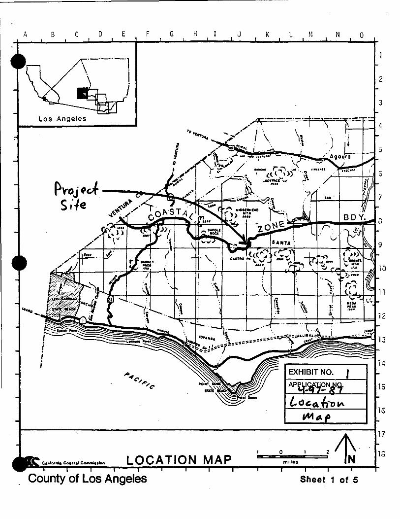
A B c D E F 0
Los Angeles
LOCATION MAP 18
County of Los Angeles Sheet 1 of 5

VICINITY MAP
CONSULTING ENGINEERING GEOLOGISTS
REFERENCE: THOMAS BROTHERS MAP GUIDE, PAGES 587 & 627
----+---~ -··- ... , )
.'
....... 18 ...... . REC
MONl
RECIIEAWJlf
NATIONAl ](/ .... 24.
EXHIBIT NO. Z. SCALE w
NORTH
OFT 2800 8400 5600 1120t - --- ---5158 COCHRAN ST. • SIMI VALLEY, CA. 93063 • (805) 522-5174 • FAX (805) 582-1228

__ .t.~- •r' · · '• ·• · -.-~-·•·· ·'· -~ ··.· 'c·. ,• ··'· · •·• , .. •• llj',__,~~~-~'rl Ill'' ·: ~::=~~:~~-. .~r;~ :/{-:~~!Y;~r~~ $;;: :£?:::-~ .. , . ..,~.!t~t?- .. , . ~~-~~~~~~A~ ..... tt ... ·~=-'1: .... ii~~ ~ .... , .. ~; .~~~ ';. • .;.,;;tl~"..:!. ~ :~-~~ ,.~~· .;·/'~:~ ;~:::: ~.:.:•!. i-t!:: ::r..:~Jt:~ ~ ..,..:·h ·~--~-:-.: \ ;;~~~-·: ;. .. ~-~-lM·'~W~~~-' ~5~~f .n,·~••t•n t. na....,......t 111 ttt.,t .... 'flu ·t~ --~ ~9!...-=iifri* ~tt ......... liJ·l.Mil.O.*'••, • ,.'·, ····-·• ~ .. ·ffW"ff\~teW't ~~Wl! trf -.....-· ... .....,.u~i~ ~ ttt.Jl ........ t..JM,:.. · r· _fi'PtlWQ•w.t•DOIVtiJIII ()It \tfTI.."'tNril.~f: '":'•· .. ·· • • ·- ·. --~ · .. ,. ,. ~::~ ~-:." ··> .'a,.'%M1W': NH.'IICH --.:.c~~'• ., .............. ~. .. ..!J.:.::::':l:.'lll"" .... '1J::.,::' -:~~~~~~~-..... ~f'~ ··>A{$ ~-~ ~~~ •, ~:·· .:·_· -~ . ;.: .......... -. "; ... t?:.,:: ··-· _., ... ~ .• :··· . ........ .t. .... ~.. .. ........ ~ .... 1, . •.•
,·-., ... •t~.tt'" .. ...,I__. t.1t th ~-?\Iii'~}' .... 1 ...... .. .,..u.~ ,_.~ ....... _,.an .... ·. '·:t ·.,., .•,":-
:!~:J":~~ •=::.~'~:rrP ·:·::~:1. ~~·-\:·::<: ~~ M•U " ot :l.•r.r Mt't:•• u.u ~.J.ett!f ... ·~ n4tb .,... Mptll ., •f • ,rJn•rn~ .. ~"':" • .·;.~ -.~ ' . ••
1 t." • I. •. ·,t_.• ,•'•' ~~-,·~lU4 s•l uu ... r~·~..., uu-..,.ftdM -~~ ~ :Uta ..... " fl•ri "'"' .. }l\_Ul ... ,...,., ........ ~-- ~. ' ... ·-u.,.- '.~ , ...... :. . , ~--- .:_; .·.:--:-· •..
•
ouR;t-K-:. :,H: ~·..t:·:·;:..-:..~::.: .. .:.•:./.!",t'.:r_:.< ~,?t1i"L&. J\Of<\6." TC.mpe:.n..A P..'f A E. S' i PeNC-6.
::L1.:·.::~ !:':,1:~~"·.~;.,..;. .... :~; \ c.cNSTRvc. T iC.>N Of. tlt.uJ RES io"E..tK.E:. f11tt . .. ---..&.-.. " ~· . 'f .•
A 1Ul!.:! :.. ... .!:;'~~" ... ll -·~·· ·~-~.,· f'~A.\CO T-------- --,---------- .,.. A""
.· - . -· . . . .• . '"~"'o >tC ~EO 0 ,:::. "«='"'''• 4ru• ,_-bnw t• " tt""lf., •• heM '41( Ul • ..-; \- l' - - I - I :a,:~:t~ ."~;:::.ttt!:!t.!!r.l:.~~::· --~ ·~ , ,
~;.~:~l~.- -D~y~:~;~~~:;. ~: t ~~~~;::;. ~,E~QQJ1.:..P.b~~-.S.EdJiON! I- -------- -----·-------
•; E_~E}f.ATJQN. ·· So..;;FlEOULES
.}"QI·V.:t~r-.-l'il\1: !±S/V'A'NG· -~-· ~0~-. ·_ ~-~ ~:'} ... L'} .. r:_~.u _.·· ., . ;pirn . - · , 1:\L :DETAILS;
TY!MAP
1f\!:l.r.·::~.\\-51', . --~] ;; .. :~ ---~·~w. ·. _ .. ;.~ -{·~
NS
._tlt.........
........-·~tttf~;'
~~~
1 ----------- -
lll.rh,:~ «aw o.vh••• r..l1'*~"1~
j1~" 1
( I
~-.//
Administrative Code, of California ft> . , \ ( I ~t:I,IS NOTA
\ . and
r .. -·--·--·"'0 '
. )l -)
; ~) "
§I·
,._.p--/ .
}J
) -~-------/
c.::>('JS rRv< T t'otJ / 0 SHe,_D/
_........-~
--
m·~·
\
--....
()
" •l
... l"«"l"."·'•" !•p"'"""W':
~"· ··"!"'' ¥: .<f\<·~W~:----~/~-r,;:t,l,·:.tf•/y ~-~) 'l ;:-.:· '1'~~· -~ ...... . ,._,11:1'',,·, ... . ........... ,.~·:"J .... ... .ttot ...... l ..... j, ... fl'1'"''
w ··-··· .... ~--!' f, !
\\(;\ ~i' ~ n ~H~\\ i(\ -~ "'- -... ~ . I.' I ; : S
~ <f>~·N&;.:
r ~~:§;--. 'v ' H H•,T::If1 -' (: - ' """'-""'· -~. • 1 • : \' t 1 'i • .._. l..o... '·, t:':t~ I ., ' ~ •'"' ""
.;ASE N U i\·10 ER --.. -~ -· ____ .:.. .. 'h .. ·.~- 'Bf'"' I /~ ' __..-' =; . OJ.! TOFfui -tlJ
=i z p
w
•..••.. '·-: ... ·. ;.;;:J.:
~u.· ~JUt.
CUI.
. ·.
(l!>1 H.ff qQ-0 H.ft
!o,lfll .fltll'f·
,, .• -:··::
;DOOE~a!~j ~his plot plan IS .',PPf'Wtftll Sllbtect to ihe r eq; ·~~· -lri...... h>•""'"'-"'"''.J"'~...... · ·'.;t Los Angele!':. Count~ Cc·<.Je anrJ tt; tile •:ondit1r.ms 11t"(~ ., • .,.
-~.$~·-·:;~. hefein. It IS appllcat>l<l unly ,~~:; sp~,;:lh•:,;,tlly_ n(ltet:.l ~H.ld mus"- ·~~~\'1§~~-l/'l'!!i!Mt:At ·-·:-;· ;'{f be USed j:..'f!Or 10 0C.y ;r.llalitr.t'' Ill /)I rJHi•lrlC(' r~~:. lU!Y•.:rn;,'!n~· :--:;-·r··"V· · ;·l'?_:._p .. 'orwithin two,ye.ar~, Sur:! i .<lPPr•.;v~:i :;ft,;H ~p! l~t' t.:iy!'~;l'liJe~ Srt"E'PLAN' •/><'•• o· APPUCIINrs COPY
.. ~~.:.:.··~~~--~-- ..... ;., . •• ~ .:.:4·1~. :~. ·.);~ .. ~t"J:~.:~·:.~-~·~~;;_~··.~ ') .• l>J'
/'' /,
I •
"\..tp;•
~tc
~ z w, . 0 -_,z. w.~; ~0
I ·I
~II
.-.... -' ,-------------
.i I i' ,. ¥ 11
·l 31 H
J. I I L ____________ ! ;
~l~!lli] .APfi:US ·
--=-II:Uoo~~.,.,
i !:
.. l s ...... . ..· :
• . , I . .. :
. . • . . ~ .. ·: ·-~'ij ·>-. ~--· ~·: ::;~ ;~ ! . . . '·;i
·Z1:·.~ .. J :::· ~:: ~j '\:t ~- -·· 'k
;a:: .t~·. : .: . ..?,~ ':'": ...... .;. ~:-;~:~ '· ~~
. . . . . . ·. :1ffl ~.
~ .. ~ . i
. l . ., -~ =~j
4 .; . ···~ .•·:;.
•
•
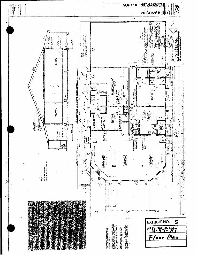
..... , ':,---l!====""""---..::z~9r- t'-i!r==lll:::i:=:;;:u::c:=:=C\"!'~_,_,_.,_~--·'
r--.... : __ "'
'
I 'l r

•
: .. ,;.."':""· .....
. '. :.i: . .... .;
..... ~:-~~= -~:-
.. ·.~ .; •
:. .. , .; : .. ' f .•. .. j
·.-;··
. · ..
,· .
•

VetJ;o,. 41 Ani< se.,v.·ce
tnd Protection Strategy Classification
Compatible Private Recreation Land
C, ~op:ratlve Planning Area
Developed Land
Military Land
- National Park Service Land
Other Parkland (State)
Other Public Land
Proposed National Park Service Easement Acquisition Area
Proposed National Park Service Fee Acquisition Area NRoads
Proposed State Acquisition Area
State Conservation Easement Land 0 Tract Boundaries

, . . •··.·· -. f'•
- ::. :~ .. .
l _:.·. •·.l
,.
·'
· .. , '·
··, ~ ..
,·
.. ~ ...
·. '. \
' I
.. _, .. :~ .:··! 1';:··
. '·
. , ,· ,. ... '.
... ' . ' ·· .. · .....
.. o:'
• ~ .. ·' &
' '
•• !, .. ,
. .. ·.· ..
. ,:;·
...
.-' _.
··• . .
....... u :' ·.:..\. ~· ·W.
•·...;,.. : .. ·\: _., .. . ~·?,~ ~ .. •' ·.~· -·. ., ·'
I . ~·: ~ ·' · ..

' .,! ____ _

JV BD 44-97
~ APN 4464-22-22
Coastal zone boundary
P.G 25
·I
I I I I _Parcel in Question I \
@ I @ j i ~ ' I Ul>'-'• I J,,,. I @ I @) I 9 I I I UIAo I Ud.ti. ,~ I
I I I I
I • __ l I \ \ I ---·L--- I I -~---+---L-------@ I I H~Ak 'I I
-------- I I
IN
9 11JfA4!
PG 19
0 T.fA ...
N41,.,1 1i'
I I I I I I I
~ I
r1~1.~,
,~ I i~~~~y~~~~~q~-----1
I I I I
Q- ---- ____ f?80 . ________ :;:;-..;:__ _"]
Feet
@ "'~Mf,,,.
r-------~ ® I ~ ' "" "" I I ~·--A . "" ~~ Q I R.:S.II.?·CT I UIU. I \(!)
,AU/.6. I lei . 0 I J.s,tU. I I 0.111~-'--------~- . I I ~- -_:;.0
.. .. ~ ll n-----+---L • 0 ·,1"" 1+-® I ---.... --,--- . ~ .. /<'P '8 I -r-- --- ,.. .... , 'i ~\
@ · 11.- 1 I I • _.::;;?...-;;...- '-.lf!'f~....-..--ii-"'~--1 111~.4 11--,u--1 f--1 I ~··" • -o:J'a!.l • 1 ---T-------
' _~ •. 1 Go 1-'11- ·I I I ··~· ••. e ~ ··<S.D r.. 2!147•111-GA 'I -
,... - I · r.> "" I ,..- - • • ... ' .. "" c>-l'>ll I "" I I <l- ~-~ ,..... - I I ~·w ,,.. . ., I \' il\-11 .1$~-~~~ , ••• -~;~r1 •'I I ! 1 •u ... n-,;:';>, I '
- • 11 •- l•j ~.--:,..•__. I I 1 ""·' I \ VSA uu• .. ~I \--<·:·~(:;..,.~~-. \@)~I I @) I@ . I I \
,_., •• ;.,~. •, _,.~ .. tfO t 1-- ;;t7ia; ~ I ,. " 1 I ••~ • < 1 ------~- I I j '" 'I I • • 1 UY-N 1 • 1 , 1 • e • 1
., · Ll:.Jj,j! @ I •·II •>f1l' ' -·~ >I @ ==:!=!b.--A~ ' ®!!>: .... _ 1 \ \ 1 1, 1 n ~ 711,,_,_, :~\ ,_,. \ .,.,,,.~ ...... ------+1 I I ;: ~~ I I I--~--~--: 'I I
\ @) I I I
@ ,J?I/..4.
REVISED 9~06Zb30Z ·14
<iPt1Nf.404·4S 9~o4Z4&tJ'i'·$<. IIUSZ4 ••
/IMllld?00£001 1.-~N.112r.tJr""l·llr .'~NV!"dn.J~/·&v.'
I'G ?.I
: 1 •""~ I @) I I ' "•" . I I _,:----------~L---~--1 ~,,.~~, 1 I - 'I •H• E. ,.,,,,, I
t'ilA->1 -:;;
-It~-. } ,,.__;,, &t"lfll,. :.~11i1ir!,l r T -,
S "~ ,,- ~ I ,, •. I ~~~-~~ 11 ~mil\f.\ DETAIL ~!\~~ .. .r;,;;n,. ... 1~t'-41.::: NO SCALE ·-~1 .:=. ~ -~ -~1 , .. '\I '"' s_, J~ \i-;.-;;•;i'ii•i ....... ,..,
TIS RI8W PG 24
[gcTION LIJo.l~~PER9 8-7~iJ
--~------·----·-----·"·--·----- .. -- ·- ••

• ¥. " p <J
:<?
,j
'
~ > .. . " ·• •O ~ ..
ll i z :5 0.. CJ)
• en w () () <(
• 1-a.. w 0 w a: -LL
•
~ ~ >
.. '·' ~
Cl .. j"
I I
I I I
I I. ''
.... t
<:1! ..... .. Cl
...... .s;
1 ~
EXHIBIT NO. J I
A-cces-s PI~ c(). s!Yo PDva. Pl-."'
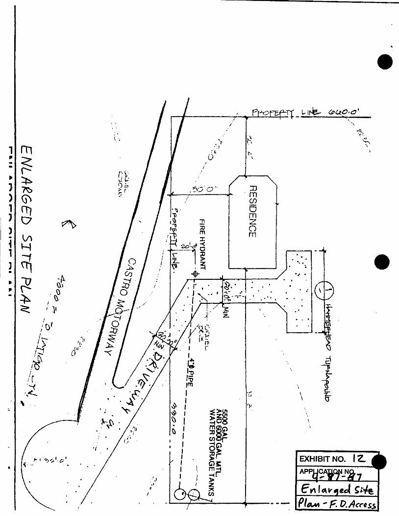
&
I
,. c' I I
;~ ,'j :l':\ !~ !r ·~
\.~
i
1 .. . .
'· \
·1rt\ . . \ .
/
: IJ t· 0
;
.~:.?.0" JJ ·m
(j)
0 m z 0 rn
•
•

••
SCOLC I' • 100' AUGUST 2. 1997
• • ·~
COASTAL ZONE BOUN>ARY MAP FOR THE NORTH EAST QUARTER OF SECTIO~ 18, TOWNSHIP 1 SOUTH, RANGE 18 WEST, SAN BERNIRDINO MERIDIAN PER BOUNDARY DETERJ;fiNATION 34-Sl. DATED Jl.!LY 29, 1997
C•s-bo ~ 7:-r~-~~:---
~~ I
114•tww• •\1:WIIIfrt ..,.
cz BD ;tJ z.
•• .\ ,er
<Q\.1,,~""
.... .. ........ .,.
~ !Vets ·l't.otiiM~
~~(--.-cJ
~ suu.., .. __ f.,.. •• t ........
-....,~~ . ....,
·ovseHe
PGt"ce I
'I'OII.U.G4,
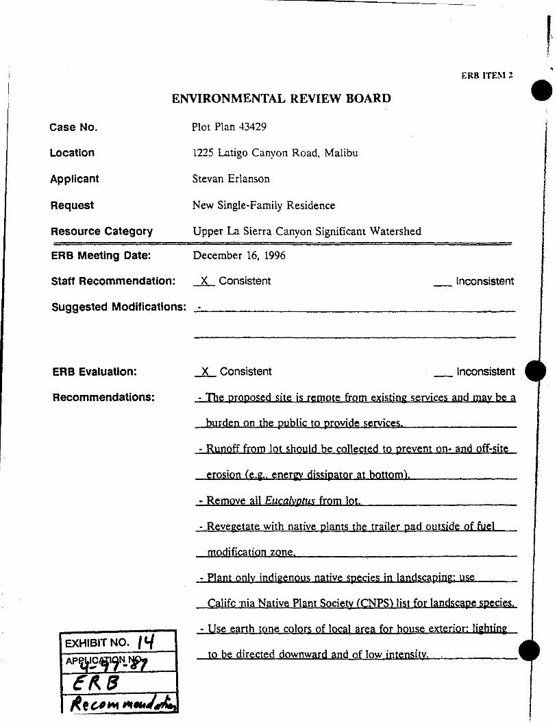
.. ERR ITEM 2
ENVIRONMENTAL REVIEW BOARD • Case No. Plot Plan 43429
Location 1225 Latigo Canyon Road, Malibu
Applicant Stevan Erlanson
Request New Single-Family Residence
Resource Category Upper La Sierra Canyon Significant Watershed
ERB Meeting Date: December 16, 1996
Staff Recommendation: _x_ Consistent _Inconsistent
Suggested Modifications: ------------------------
ERB Evaluation: .L Consistent _ Inconsistent
Recommendations: - The proposed site is remote from existing services and may be a
byrden on the public to provide services.
- Runoff from lot should be collected to prevent on• and off-site
erosion (e.g .. eneriJ dissipater at bottom).
- Remove all Euca[wtus from Jot.
- Revegetate with native plants the trailer pad outside of fuel
modification zone.
- Plant only indigenous native species in landscaping: use
Califc ·nia Native Plant Society (CNPS) list for langscape speci~s.
- Use earth tone colors of local area for hoyse exterior: lighting EXHIBIT NO.
to be directed downward and of low intensity. ,