Embed Size (px)
Citation preview
CAliFORNIA ·coASTAL COMMISSION Filed: 180th Day:
NA SOUTH CENTRAL COAST AREA
NA 88 SOUTH CALIFORNIA ST., SUITE 200
VENTURA, CA 83001 Staff: JLA 12/15/03 01/13-16/04
. (805) 585-1800 RECORD PACKET COPY Staff Report: Hearing Date: Commission Action:
STAFF REPORT: REGULAR CALENDAR
APPLICATION NO.: 4-01-108
APPLICANT: Jean Ross, LLC
AGENT: Schmitz & Associates
PROJECT LOCATION: North of Pacific Coast Highway Northeast of Sweetwater Mesa Road, APNs - 4453-005-018; 4453-005-002; 4453-005-037
PROJECT DESCRIPTION: Proposal to improve a 1 ,750-foot long portion of an existing access road/jeep trail to 1 0 feet in width with 465 cubic yards of grading (350 cu. yds. cut, 115 cu. yds. fill) to accommodate geologic testing equipment.
LOCAL APPROVALS RECEIVED: County of Los Angeles Department of Building and Safety, Approval in Concept, June 7, 2001.
SUBSTANTIVE FILE DOCUMENTS: Certified 1986 Malibu/Santa Monica Mountains Land Use Plan; Malibu Beach Quadrangle, California-Los Angeles County, 7.5 Minute Series Topographic, US Geologic Survey, 1950, Photo Revised 1967 & 1981; Department of County Forester and Fire Warden Map, Battalion 5, Santa Monica Mountains, County of Los Angeles, California, 1970 Edition; NASA Aerial Photography, January 1977.
Staff Note
The applicants' agent has provided notice (November 26, 2003) asserting that the Commission must act on this permit application within 60 days of the notice or it will be deemed approved, pursuant to the provisions of the Permit Streamlining Act. While staff does not agree that the information necessary to complete the file has been submitted, the application has been scheduled for hearing within 60 days of the applicant's notice so that the applicant may not assert that the project was deemed approved. Therefore staff recommends that the Commission act on this permit at the January 14-16,2004 Commission meeting.
:~1-,~os •.. (J~n·•'R~s~,J.icJ · p#lge2.
' .. ,
Summary of Staff Recommendation
Staff recommends approval of the proposed project with three. (3) special conditions . regarding: (1) Drainage and erosion control; (2) Lan~~capJng. ~Jajl; al1d (3) q~,,·~f/;
Malibu Coastal Development Permit. .:~~~Y ,; ~;' · ;:?;:< }>.·.;:.:· :l;·,~ \.il ... \.·<:·:~>(1;; l~d;f ..•. :.•·.~··.·.\ ... If .. • •. : ... !.i.l.•.·.::.'.:.
1: •.•. ~.; •. •·.·
,·;·:. :_::.}(~: ;, \\ ' .
I. Staff Recommendation
MOTION: I move that the Commission approve Coastal Development Permit No. 4-01-108 pursuant to the staff recommendation.
Staff Recommendation of Approval:
Staff recommends a YES vote. Passage of this motion will result in approval of the permit as conditioned and adoption of the following resolution and findings. The motion passes only by affirmative vote of a majority of the Commissioners present.
Resolution to Approve the Permit:
The Commission hereby approves a coastal development permit for the proposed development and adopts the findings set forth below on grounds that the development as conditioned will be in conformity with the policies of Chapter 3 of the Coastal Act and will not prejudice the ability of the local government having jurisdiction over the area to prepare a Local Coastal Program conforming to the provisions of Chapter 3. Approval of the permit complies with the California Environmental Quality Act because either 1) feasible mitigation measures and/or alternatives have been incorporated to substanti~lly lessen any significant adverse effects of the development on the environment, or 2) there are no further feasible mitigation measures or alternatives that would substantially lessen any significant adverse impacts of the development on the environment.
II. Standard Conditions
1. Notice of Receipt and Acknowledgment. The permit is not valid and development shall not commence until a copy of the permit, signed by the permittee or authorized agent, acknowledging receipt of the permit and acceptance of the terms and conditions, is returned to the Commission office.
2. Expiration. If development has not commenced, the permit will expire two years from the date on which the Commission voted on the application. Development shall
\lbi-1o~(J~n R~;~;ffcJ·•··•.· · ·· Page3 ··· · ·
be pursued in a diligent manner and completed .in a reasonable period. of time. Application for extension of the permit must be made prior to the expiration date.
3. Interpretation. Any questions of intent or interpretation of any term or .condition will be resolved by the Executive Director or the Commission.
4. Assignment. The permit may be assigned to any qualified person, }Pr9yig~d . assignee files with the Commission an affidavit accepting all terms and conditiqns of!he permit. · ·
5. Terms and Conditions Run with the Land. These terms and conditions shall be perpetual, and it is the intention of the Commission and the permittee to bind all future owners and possessors of the subject property to the terms and conditions.
Ill. Special Conditions
1. Drainage and Erosion Control Plans
Prior to the issuance of the coastal development permit, the applicant shall submit for the review and approval of the Executive Director, a final drainage and runoff control plan for the access road, including supporting calculations. The plan shall be prepared by a licensed engineer and shall be designed to control the volume and velocity of runoff off the access road in a non-erosive manner. The plan shall include the following:
(a) Detailed plan and cross sectional views of the roadway and drainage pathways, berms, water bars and other drainage system elements. Details of drainage structures and other erosion control measures. Energy dissipating measures shall be installed at the terminus of outflow drains.
(b) The plan shall include provisions for maintaining the drainage system in a functional condition throughout the life of the approved development. Such maintenance shall include the following: (1) drainage system shall be inspected, cleaned and repaired when necessary prior to the onset of the storm season, no later than September 30th each year and (2) should any of portion the project's drainage system fail or result in increased erosion, the applicant/landowner or successor-in-interest shall be responsible for any necessary repairs to the drainage system. Should repairs or restoration become necessary, prior to the commencement of such repair or restoration work, the applicant shall submit a repair and restoration plan to the Executive Director to determine if amendment(s) or new Coastal Development Permit(s) are required to authorize such work.
(c) The erosion control plan shall include a provision that ~rading shall not take place during the rainy season, which is from November 1 s - March 31st. Should
gradiQg Operations cease fora paridd Of moi:e,than thirty(30) days, the plan shall include temporary erosion control measures such as: stabilization of all stockpiled fill, disturbed soils, and cut and slopes with geotextiles and/or mats, sand bag barriers, silt fencing; temporary drains and swales and sediment bas.ins. The plans shall· also specify that all disturbed areas shall be seeded w.ith native grass species or another appropriate native ground coyer ,.a,s recommended by a qualified resource specialist or biologist. All ,,~~irt;a~~< ~pQuld be retain~d. on-site, unless removed to an appropriate, ;~ppap'tfd. dumping location either outside of the coastal zone or within the coastal 'zonelo a site permitted to receive fill. These temporary erosion control measures shall be monitored and maintained until grading or construction operations resume.
2. Revegetation Plans
Prior to issuance of a coastal development permit, the applicants shall submit two sets of revegetation plans, prepared by a licensed landscape architect or a qualified resource specialist, for review and approval by the Executive Director, for all graded and disturbed slopes. The plans shall identify the species, extent, and location of all plant materials and shall incorporate the following criteria:
A. Revegetation Plan
(1) All cut and fill slopes shall stabilized with plantings at the completion of final grading. Plantings should be of native plant species indigenous to the Santa Monica Mountains using accepted planting procedures. Such planting shall be adequate to provide 90 percent coverage within three (3) years. Invasive, nonindigenous plant species which tend to supplant native species shall not be used.
(2) Plantings will be maintained in good growing condition throughout the life of the project and, whenever necessary, shall be replaced with new plant materials to ensure continued compliance with applicable landscape requirements.
(3) The Permittee shall undertake development in accordance with the final approved plan. Any proposed changes to the approved final plan shall be reported to the Executive Director. No changes to the approved final plan shall occur without a Coastal Commission approved amendment to the coastal development permit, unless the Executive Director determines that no amendment is required.
B. Monitoring
Five (5) years from the date of completion of the proposed development, the applicant shall submit for the review and approval of the Executive Director a revegetation monitoring report, prepared by a licensed Landscape Architect or qualified Resource Specialist, that assesses the on-site revegetation and certifies whether it is in conformance with the revegetation plan approved pursuant to this special condition.
, 4-01-1os (J~an Ross,; i.LCJ · .• ... Page6'.
The monitoring report shall include photographic. documentation of planfspecies and plant coverage.
If the revegetation monitoring report indicates the revegetation is not in conformance with or has failed to meet the performance standards specified in the revegetation plan approved pursuant to these permits, the. applicant, or successors. in. interest,, s;lhall submit a revised or supplemental revegetation plan for the review and ~Rpr9y~1.9f;t1J~ ·. Executive Director. The supplemental landscaping plan· must be pr~pare~,;,by;c.~ licensed landscape architect or qualified resource specialist and shall specifYrne~~t:Jres··. to remediate those portions of the original plan that have failed or are not in conformance with the original approved plan. The permittee shall implement the remedial measures specified in the approved supplemental revegetation plan.
3. City of Malibu Coastal Development Permit for Access Road Improvements within the City of Malibu.
Prior to construction of the access road improvements within unincorporated Los Angeles County, approved pursuant to this permit, the applicant shall obtain a coastal development permit from the City of Malibu for the portion of the road improvements within the jurisdiction of the City of Malibu.
IV. Findings and Declarations
The Commission hereby finds and declares:
A. Project Description and Background
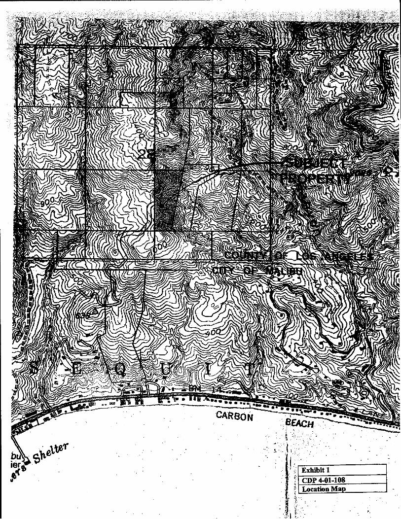
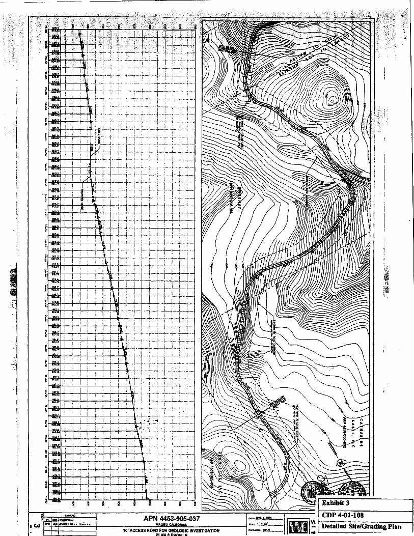
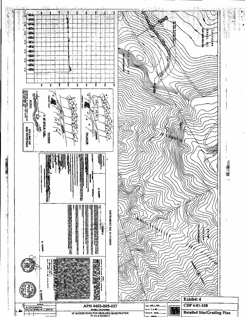
The applicant proposes to improve a 1,750 foot long portion of an existing access road in order to conduct geologic tests on an vacant parcel. (Exhibits1-4 ). The improvements involve 495 cubic yards of grading (350 cu. yds. cut, 115 cu. yds. fill) to provide for a 1 0-foot wide road bed and appropriate road grades to allow geologic test equipment to access a undeveloped parcel (4453-005-037). The project site is located north of Pacific Coast Highway at the end of Sweetwater Mesa Road. The proposed road improvements are within an existing 80-foot wide road easement through two adjacent offsite parcels.
Commission staff has reviewed aerial photography and various map resources and have confirmed the access road/jeep trail existed prior to the Coastal Act. The existing access road is a rough jeep trail that traverses five undeveloped parcels on steep hillside terrain. The existing road traverses three parcels within the jurisdiction of the City of Malibu and two within unincorporated Los Angeles County. The total length of proposed access road to be improved including the portion within the jurisdiction of the City of Malibu is 3,416 feet in length. The applicant has submitted evidence the parcel (4453-005-037) where the geologic test will be conducted on was created legally prior to the Coastal Act.
' ·,,>:::>,/. ·,;,:;,: ,, .. ,., "
,,, ,;,,.; ... •.!··; ' i> ;;; 1 ....... :t .. :: •.••... ·.,,··· .. ;;; .•. ~:. t;:t. ·:~;.\; {, .;\\' / ·:.:;' ;;·· ... Q.1+108'(~,8~i1J.;~'C)J. .;(: ··.~•. · .~t ;;;· :. Sf j•'' · • :} ~a~e ~ <ii; ~~; :~ \{ l
·• The 'area trav'er$e!J by~~e ~ro~Bd to~d is ~~ \1/iih 8 n11Xed cjha~rtal ~an! . community. While the existing road has disturbed this plant community the surrounding
area can be characterized as a relative undisturbed contiguous chaparral habitat that is considered to be environmentally sensitive habitat area (ESHA). The parcels the proposed road traverses to the south within thejurl~diction of the City of .Malibu ,were designated as ESHA in the adopted M~libu Local Coastal Program. The proposed roa<;:t improvements for the most part do n9t extend beyond tl'le existing [Pa~bec:t ~n:~ adjacent disturbed area and will not result the removal of any signffi~nf Cfiaparri!il vegetation. ' · • .~
The subject permit application was submitted to the Coastal Commission South Central District office on June 7, 2001. Commission staff determined the permit application was incomplete on July 3, 2001 and sent a letter to the applicant's agents indicating the file was incomplete and itemized what information was necessary to complete the file. On July 11, 2001 the applicant's agents submitted additional information in response to the July 3, 2003 incomplete notice. Commission staff responded in a letter to this submittal on August 25, 2001 indicating the file was still missing the following items: 1) Approval in Concept from the City and County Planning Departments; 2) Geologic Review Sheets or Geologic Referral Sheets from the City and County; 3) an alternatives analysis that addressed the use of tracked vehicles; 4) underlying evidence of lot legality.
On September 13, 2002 the Commission adopted a Local Coastal Program (LCP) for the City of Malibu which transferred coastal development permit authority to the City of Malibu. Commission staff notified the applicant's agents by letter on September 24, 2002 of the adoption of the LCP and that Commission no longer had permit authority for the portion for the project within the City of Malibu. Commission staff returned those materials of the file that related to the portion of the access road within the City of Malibu.
On June 23, 2003 the applicant's agents submitted additional information to complete the file including: 1) a "Approval in Concept" from the City of Malibu, 2) a Geologic Review Sheet from the City of Malibu; 3) a Certificate of Compliance from Los Angels Department of Regional Planning for the subject parcel as evidence the lot was legality. The applicant's agent's sent another letter on July 25, 2003 asserting that the file was complete because staff did not respond to their June 23, 2003 submittal within 30 days. However, the applicant's June 25, 2003 submittal did not include all of the required information previously requested by commission staff in previous correspondence. The applicant failed to provide: 1) the "Approval-in-Concept" for the project from the Los Angeles County Department of Regional Planning; and 2) the Geologic Referral Sheets from Los Angeles County. Unfortunately, the staff person assigned to this application left the Commission and the incomplete application was not reassigned. As such, staff did not respond to the applicant's letter.
On November 14, 2002, the applicant sent commission staff a letter indicating that, pursuant to the Section 65956 of the Government Code (Permit Streamlining Act), the
4-(11~'108 (Jean'Ros~. i..LCJ · lf'age. 7... ' ·
•·, '· "I
applicant is sending public notice of the "deemed appr:oved" status of the pemiit application (Exhibit 5). However, this section of the Government Code also provides that, if an applicant provides the required public notice of the application, ''the time limit for action by the permitting agency shall be extended to 60 days after the public notice is provided.'' Staff does not agree that the permit file has been completed given the applicant did not submit all the required items staff originally request~~ .qf th~ ~pplicant in written correspondence. However, the application he~s bee.n .s:ch~c:Jqled fof..h~adng within 60 days of the applicant's notice so that the applicant .f!lay n6V.~ss~~·th~t the project was deemed approved. · · · · · · ·· ·· · '
As previously mentioned, the Commission adopted a LCP for the City of Malibu on September 13, 2001. The permit application file was incomplete at the time the Malibu LCP was adopted. Commission staff returned those elements of the file that related to the portions of the road within the jurisdiction of the City of Malibu. One of the incomplete items was approval of the project from the City of Malibu. The applicant and the City of Malibu were in a legal dispute over the local approval for the portion of the road within the City. The applicant's agent asserts that the litigation between the City and the applicant over the local approval somehow extended or tolled the date that the application needed to be complete in order for the Commission to retain jurisdiction over this application. Commission staff are not aware of any authority for a lawsuit between the applicant and the City of Malibu to confer jurisdiction on the Commission over a project within the City after the date of approval of the Malibu LCP and transfer of permitting authority to the City, pursuant to Section 30166.5 of the Coastal Act. Therefore, the Commission does not have jurisdiction over the portion of the development with in the City of Malibu.
Finally, the two neighboring parcels that also take access off of the access road have unpermitted fencing and water tanks for a proposed future agricultural operation. However, this unpermitted development is not directly related to the proposed road improvements. The Commission's enforcement unit will address the unpermitted development on the adjacent properties
B. Geology and Water Quality
The proposed development is located in the Santa Monica Mountains area, an area that is generally considered to be subject to an unusually high amount of natural hazards. Geologic hazards common to the Santa Monica Mountains area include landslides, erosion, and flooding. In addition, fire is an inherent threat to the indigenous chaparral community of the coastal mountains. Wild fires often denude hillsides in the Santa Monica Mountains of all existing vegetation, thereby contributing to an increased potential for erosion and landslides on property. Grading of steep slopes with highly erodible soils can also result in sedimentation of drainages and streams adversely impacting water quality and degrading environmentally sensitive habitats.
Section 30253 of the Coastal Act states in pertinent part that new development shall:
(2) Assure stability and structural integrity, and neither create nor contributt slgnlficantl¥ to er:osion, instability, or destrur:t/Qn pf · the site or s~rrounding area or 'iiJ 'lfi'JY . WaY. ;requ}rfl ·· @
:':us:JZ:.t:fs'!,::::.:r!~·-7~tfl .. :{~>·····,\ .. ,. ' ::~;· ' ... o, ·', \._ -> .-,>·:··-·:>"-·'
Section 30231 of the Coastal Act states:
The biological productivity and the quality of coastal waters, streams, wetlands, estuaries, and lakes appropriate to maintain optimum populations of marine organisms and for the protection of human health shall be maintained and, where feasible, restored through, among other means, minimizing adverse effects of waste water discharges and entrainment, controlling runoff, preventing depletion of ground water supplies and substantial interference with surface water flow, encouraging waste water reclamation, maintaining natural vegetation buffer areas that protect riparian habitats, and minimizing alteration of natural streams.
Section 30253 of the Coastal Act mandates that new development be sited and designed to provide geologic stability and structural integrity, and minimize risks to life and property in areas of high geologic, flood, and fire hazard. As previously described, the proposed project includes improvement to a 1, 750-foot long section of an existing access road/jeep trail with 465 cubic yards of grading (350 cu. yds. cut, 115 cu. yds. fill). The proposed road improvements require only minimal grading over the length of the road and require very minimal cut and fill slopes.
The proposed road improvements are necessary to provide access for geologic test equipment to an undeveloped parcel. The geologic testing is required to determine the geologic stability of the parcel for future residential development. Commission staff asked the applicant to explore alternative methods to access the property such as tracked mounted drilling vehicles that could negotiate the existing unimproved jeep trail. The applicant's consulting geologist, Scott Hogrefe, addressed this issue in a letter dated September 1, 2001:
On August 22, I met at the property with two drilling subcontractors, Jay Cook of Roy Brothers Drilling and Dale Scheffler with Scheffler Drilling, and a water truck contractor, Gary Jensen of Jensen Water Trucks, to determine if it is feasible to access the planned testing locations within Sweetwater Highlands project site using track-mounted drilling rigs and water truck equipment. All of the subcontractors concluded with us that it is not feasible to access the planned testing sites to conduct all of the necessary geologic and geotechnical studies
"-o~-1oa (Je~~"R(#s~ il.c) · Page9 ·
;' ·, >· '.'" ··"· "" ·'
unless an access roadis first coflstruct~d that would allow vehicular access for all of the necessary equipment.
Based on the professional opinions of the consulting geologist, drill rig and water truck operators it does not appear that track mounted vehicles are a feasible option in this case. ···; .
. . · . :·.· i,\ I. : .'.··:.·· ·:. <• i, i,, . :;" .{.;,
The access road traverses very steep hillside terrain that is hi~hly.~uscept,~ltl't(> .. ~fP.~j()Q. if disturbed. Runoff from the proposed roadway if not properly controlled Wil.t result in· significant erosion of the steep slopes the road traverses.· Erosion of these slopes would result in geologic instability of the area and sedimentation of nearby drainages and streams. Controlling and diverting run-off in a non-erosive manner from the proposed road will add to the geologic stability of the proposed road. Therefore, in order to minimize erosion and ensure stability of the project site, and to ensure that adequate drainage and erosion control is included in the proposed development, the Commission requires the applicants to submit drainage and erosion control plans certified by the consulting civil engineer, as specified in Special Condition No. One {1 ). In addition, Special Condition 1 prohibits grading operations during the rainy season to ensure the proposed road improvements will not result erosion of neighboring slopes and sedimentation of nearby streams and drainages.
In addition, revegetation of the cut and fill slopes associated with road improvements with native vegetation will minimize the potential for erosion of these slopes. Therefore, the Commission finds Special Condition No. Two {2) is necessary to ensure these slopes are stabilized with native vegetation at the conclusion of grading operations.
Finally, in order to improve the portion of the road within unincorporated Los Angeles County the road segment within the jurisdiction of the City of Malibu must be improved. To ensure the applicant obtains a coastal development permit from the City of Malibu for the proposed road improvements prior to construction of the road improvements within the County of Los Angeles the Commission finds Special Condition 3 is necessary.
For the reasons set forth above, the Commission finds that, the proposed project, as conditioned, will serve to minimize potential geologic hazards of the project site and adjacent properties and is consistent with §30253 of the Coastal Act.
C. Visual Resources
Section 30251 of the Coastal Act states that:
The scenic and visual qualities of coastal areas shall be considered and protected as a resource of public importance. Permitted development shall be sited and designed to protect views to and along the ocean and scenic coastal areas, to minimize the alteration of natura/land forms, to be visually compatible with the character of surrounding areas, and,
.i•; '"' :.::: •• ;,,, ·r : . ~·. . ·l;.;.·:~l~~(:it~1r .• , . . . . .. . ·... ~r .. :_.,\., ·j_~]·.·_!l.;_;_ .. _r_ •.. ~,;·:··.·.·.· :.:·:·~-~-•.~.~.r :: .•. :!_.;.~.--~.;-•.·~ ..... '.:··.·.;·,·•·-N~·.:: .. ~.::·,···.·.~.;.-.· .. ·•.·•· .. •.'.'.·.:.-,~.,~.·.· •.. :.~_;_.. · ... \ __ .. ::_••••.·.;·:_~.::·'.~ .• f·_·_.::,_.: : .•. • .. _.··f,"_.·_,·· .•.• ~.:.:,:.~_-.~.~,· .• ~ .. -,·_:_._; :',:j ~ \ '·-~-•.1_·~.:_ ... _· ·.
··_:.:_·~·:··-;;·~~f·'··~-; ... ~.;~~-•-.:~_ .•...• ~.·~-· •. ~:r.·~···)·;;.)~-·-i. i.:.· .. ,'..... .... · · · · · ·. · : · ·· · · · • · · . · . · . " r ; 'IH ' ·· ... ·. · t \~ 1~~ wh111ir~ •fealiibl~, ··ro iesiare . and. ~n~anc~ Yl•ulil ;·quality ih vi$~"illt "'""'',..,!!J,,.,a,,., areas. New development iri highly scenic areas sui:h as· those designated in the California Coastline Preservation arid Recreation Plan prepared by the Department. of Parks and Recreation and by local governments shall be subordinate to the character .t:Jf setting.
To a~~~~s p()tenti~ll ~~;~al impacts of projects, the ··~~·< ln1tlilsi$rt:::liilrti'lE acces§i61e iocations from which the proposed '""""'""'····'-'·"'" Deal~I!IEf$ parks, trails, and roads. The Commission also examines the · proposed construction in relation to nearby scenic resources. The subject site is located % of a mile north of Pacific Coast Highway at the end of Sweetwater Mesa Road. Portions of the access road are visible at a distance from Pacific Coast Highway, a designated scenic highway. In addition, portions of the road are visible from the Saddle Peak Trail located to the west of the project site.
The proposed improvements to the existing roadway require only minimal grading and will result in very small shallow cut and fill slopes. These slopes will not result in significant landform alteration or adverse visual impacts as seen from public view areas. Revegetation of the cut and fill slopes with native vegetation will further mitigate any potential visual impacts and minimize erosion of these slopes. Therefore, the Commission finds the applicant must submit a revegetation plan for any graded and disturbed slopes as specified in Special Condition 2.
For the reasons cited above the Commission finds that the proposed project, as conditioned, is consistent with §30251 of the Coastal Act.
D. Local Coastal Program
Section 30604(a) of the Coastal Act states:
Prior to certification of the local coastal program, a coastal development permit shall be issued if the issuing agency, or the Commission on appeal, finds that the proposed development is in conformity with the provisions of Chapter 3 (commencing with §30200) of this division and that the permitted development will not prejudice the ability of the local government to prepare a local program that is in conformity with the provisions of Chapter 3 (commencing with §30200).
Section 30604(a) of the Coastal Act provides that the Commission shall issue a coastal permit only if the project will not prejudice the ability of the local government having jurisdiction to prepare a Local Coastal Program which conforms with Chapter 3 policies of the Coastal Act. The preceding sections provide findings that the proposed project will be in conformity with the provisions of Chapter 3 if certain conditions are incorporated into the project and accepted by the applicant. As conditioned, the proposed project will not create adverse impacts and is found to be consistent with the
·. · f.o~?;os (.Je~~~'Rdss, L~~J · · · · · .· . P~ge11 ··.·
applicable policies contained in Chapter 3 of · the · Coastal Act. Therefore, the Commission finds that approval of the proposed development, as conditioned, will not prejudice the County's ability to prepare a Local Coastal Program for the Santa Monica Mountains which is consistent with the policies of Chapter 3 of the Coastal Act as required by §30604(a).
E. California Environmental Quality AC:t
Section13.096(a) of the Commission's administrative regulations reqlliresCommis~i~n approval of a · · Coastal Development Permit application to be supported by a finding showing the application, as conditioned by any conditions of approval, to be consistent with any applicable requirements of the California Environmentally Quality Act (CEQA). Section 21 080.5(d)(2)(A) of CEQA prohibits a proposed development from being approved if there are feasible alternatives or feasible mitigation measures available which would substantially lessen any significant adverse effect that the activity may have on the environment.
The Commission finds that, the proposed project, as conditioned, will not have any significant adverse effects on the environment, within the meaning of the California Environmental Quality Act of 1970. Therefore, the proposed project, as conditioned, has been adequately mitigated and is determined to be consistent with CEQA and the policies of the Coastal Act.
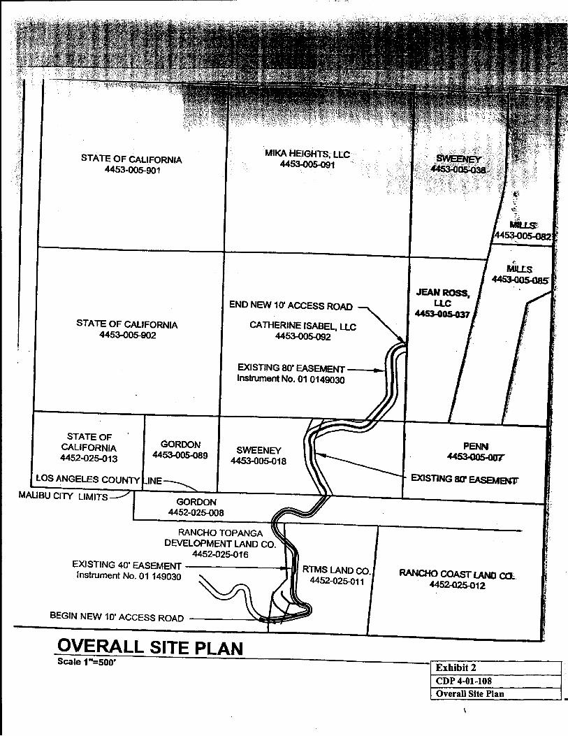
STATE OF CALIFORNIA 4453-005-901
STATE OF CALIFORNIA 4453-005-902
STATE OF CALIFORNIA 4452-Q25-013
MALIBU CllY LIMITS
GORDON 4453-DOS-089
MIKA HEIGHTS, LLC 4453-005-091
END NEW 10' ACCESS ROAD
CATHERINE ISABEL, LLC 4453-005-092
EXISTING 80' EASEMENT ---.a Instrument No. 01 0149030
SWEENEY 4453-005-018
RANCHO TOPANGA DEVELOPMENT LAND CO.
4452-Q25-016 EXISTING 40' EASEMENT ---------+-111 RTMS LAND CO. Instrument No. 01 149030 4452-025-011
OVERALL SITE PLAN Scale 1"=500'
PENN 4453-005-ooT
EXISTING 80" EASEMeN1r
RANCHo COAST LAND co;;. 4452-025-012
Exhibit 2 CDP 4-01-108 Overall Site Plan
'
I ! I
I t I
I· i
. I
·~~- ·- ~ ...
-·i- -·- ;-.~-;.:. ~~~t=r~ :t_ -!---}.
Hl'lftrt-'i--i--i1......,.-ir'---+-·----1i-_-_tt~-·t·-__ t·~···t·j:.--~t~~.J-~.t ' I . I ! I ;
10' ACCESS ROAD FOR GEOLOGIC INVESTIGATION PLAN & PRns:u o:
. , ..
CDP 4-ot-108
Detailed Site/Gradia& Plan
! I I • • I I I I I
li'!l. 11!'ll 'lll·fU (H l.!fM . lr • • J .,, n tfl • ln''l . ~,; 1·, ft·l ,,i .~.,., i ~
.• • I '1 tJ I 'I :~ :a . ,, Ia . 'rtJ ~~ illl' ~ i •r·J I' r 11 ••j •I $. m 'l't't !,• I ; I ·.f't ,u-., 3}: : .. ·.~ h r:~ ., n "'~· . '!•I Ill fjt! ~'Jtif-!- " ' ~ !111 Jlt ' t• '1 U!r ·. · · ·;, I I· ~lf ' P•tt (! .,!. ,.. .. i!,t
1 hi . b
1 ,p,.u ~
!tl J;, I J't :1 S[J o
I!!; 11 ! ·' ff '!•· · ~ l!t t'( I II tl iir' ••• • 4 l( l J J.l li l i, ~~ 1.:
l """"""' APN 4453-005-037 ..... ..., Q~=~~~·~~~~·--~~~~~~~~~~~· +-~--------~~~B~U~~ro~RN~~~----------~::.7.'•~•&--- ~~~~~r=~~~------------~
10' ACCESS ROAD FOR GEOLOGIC INVESTIGATION """"""' u• Detailed Site/Grading Plan PLAN & PR:OI=Ili; .,.,, •moz
•