Embed Size (px)
Citation preview

Cities, Vol. 18, No. 3, pp. 135–149, 2001 2001 Elsevier Science Ltd. All rights reservedPergamon
Printed in Great Britain0264-2751/01 $ - see front matter
www.elsevier.com/locate/cities
PII: S0264-2751(01)00006-3
Cairo’s urban growth and strategicmaster plans in the light of Egypt’s1996 population census results
Keith Sutton*a and Wael FahmibaDepartment of Geography, University of Manchester, Manchester M13 9PL, UK, bDepartment ofArchitecture University of Helwan, Cairo, Egypt
Cairo’s annual growth rate of 2.74%, 1976–86, concerned planners and politicians. The 1996census revealed a slowing down to 1.6% and a total population of 10.17 million. This regressionin Cairo’s primacy might suggest some success for the 1970 and 1983 master plans in theiraim to divert population growth away from the “green land” to the north and south of thecity and towards the desert fringes to the east and west, where new towns and new settlementswere located. 1996 census data for Greater Cairo shows strong inner city population declineand continued suburban growth including areas to both the north and south of the city. Onlylimited growth occurred in the new towns, however. Several factors are suggested as beingbehind the relative failure of Cairo’s master plans. These include much unplanned spontaneousurbanisation, the inability of the new towns to attract people, the IMF constraints on publicspending, and the boost to private housing development imparted by Cairo’s ring road. Sug-gested future scenarios include a Cairo–Alexandria urban corridor and a ruralisation of Cairobrought about by informal settlements and a proliferation of peripheral urban villages. Exclus-ive suburbs, eg New Cairo City, have contributed as private dynamism has replaced publicplanning. Greater Cairo has not been mastered or planned. 2001 Elsevier Science Ltd. Allrights reserved
Keywords: Cairo, Master plans, Population, New towns, New settlements, Inner city population decline, Ring road
Introduction – Cairo’s population growth
Cairo is often regarded as one of the world’s “mega-cities” (Richardson, 1989). As Egypt’s primate city,much larger than Alexandria, Cairo is seen to concen-trate within its extended limits the country’s economicand social problems. The Greater Cairo area is incon-veniently divided administratively between threeGovernorates: Cairo, Giza, and Qalyubiyya, alterna-tively known as the Northern City. As the latter twoadministrative units extend out into rural areas andincorporate many villages and other free-standingurban settlements, a definition of Greater Cairo cannotsimply aggregate the population totals for the threeGovernorates. A more sophisticated continuous built-up area definition is required. Hence, Greater Cairo’s
*Corresponding author; e-mail: [email protected]
135
population size varies according to definition anddelimitation.
Already a “million city” by the early years of thetwentieth century, Cairo has grown particularly rap-idly since the Second World War. (Table 1). In suc-cessive censuses Cairo’s population has increased,strongly concentrating an ever increasing proportionof Egypt’s population. From 2.23 million people in1947, Cairo’s population had more than doubled by1966 to 5.08 million. It then nearly doubled again inthe next 20 years threatening exponential growth. Forthe 1976 census a population figure of 7.96 millionpeople was given, growing quite rapidly at 2.5% ayear (El Kadi, 1987). However, a lower figure of 6.9million is given by Eric Denis (1998). Consequentlya decade later, by the mid-to-late 1980s estimates ofthe mega-city’s size varied from 9 million to 12million. The Governor of Cairo in 1985 estimated its

Cairo’s growth and strategic plans: K Sutton and W Fahmi
Table 1 Growth of Cairo’s population, 1947–96a
Date of census Population of Cairo % of population of Egypt Population living in 1986 area ofCairob
1947 2,233,000 11.9 2,597,0001960 3,807,000 14.7 4,156,0001966 5,080,000 16.9 5,385,0001976 6,805,000 18.5 7,067,0001986 9,312,000 19.3 9,312,0001996 10,171,874 17.3 –
aSource: 1947–86, Moriconi-Ebrard (1994, p 19); 1996, Denis (1999a).bArea defined in the 1986 census – would have included villages in earlier years, now absorbed into Cairo’s built-up area.
population to be 11.5 million (Raymond, 1993, p 337)and this brought calls for the city’s population growthto be controlled.
By the late 1980s the 1986 census result was avail-able. At a figure of 9.75 million for Greater Cairo(Raymond, 1993), or 9.06 million according to Denis(1999a), and 10.99 million for the widest regionaldefinition, including some new towns and villages,the total was lower than many had anticipated. How-ever, an annual growth rate, 1976–86, of 2.74% con-tinued to give cause for concern and “prophecies ofdoom” projected population totals of 15–20 millionfor the early years of the next century. Thus, in 1981Jenssen et al (1981, p. 209) could consider that “esti-mates under status quo conditions for the year 2000of around 20 million inhabitants seem not at allunrealistic”. Phrases like the “Mother of Mega-cities”(BBC, 1993) were coined and journalistic licencecould augment the population even more: “Cairo isalready home to 17 million people, and a new babyis born every 29 seconds…” (Bhatia, 1994).
The next and latest census was in 1996. Publicationof the basic results was delayed until early 1998 asthe Egyptian authorities could not accept the lowerthan expected figures. They were concerned aboutunder-counting, which is possible given the manyillegal buildings and squatters, but the apparent slow-down in population growth probably results fromreductions in fertility rates during the 1990s, and per-haps earlier, which were beginning to be appreciated.(Courbage, 1997) Eric Denis (1999a) gives a 1996population figure of 10.17 million for the agglomer-ation, and 13.47 million for the wider Cairo region.This suggests that the agglomeration’s populationgrowth rate has dropped from 2.7% per year to 1.6%(or 2.1% for the wider region). Also Greater Cairo’sproportion of the country’s total population appearsto have declined, probably for the first time duringthe twentieth century. In view of earlier comments onthe difficulties of defining the boundaries of Cairo andthe doubts about the accuracy of the 1996 Census, onehesitates to place too much reliance on this apparentdecline. However, Cairo’s population is now growingmore slowly than Egypt’s population, with both fer-tility decline and lower rural–urban migration con-tributing to this changed state of affairs (Denis, 1998).
136
It can be hypothesised that this slight regression inthe dominance of Cairo as a primate city representsthe first signs that the various restrictive master planssince 1956 were starting to have an impact. The mainmaster plan had been formulated in the period of highgrowth projections in 1970, with modifications in theearly 1980s and again in the early 1990s. It is perhapstime now, after the 1996 census results have emerged,to take stock of the attempts by planners to controland plan urban growth in this mega-city. This papertherefore aims to assess the overall strategies of themaster plans and then to try and explain their collec-tive failure in terms of several factors. Some futurescenarios are then suggested which take on board theconclusion that private dynamism has largely replacedpublic planning.
Master plans for CairoAn early 1956 master plan had predicted a populationof 4.5 million for Cairo by the year 2000. (Yousryand Aboul Atta, 1997) However, the city’s populationalready numbered 6 million by 1966. Consequentlythe 1970 master plan (Ministry of Housing, 1970)anticipated strong population growth, from bothrural–urban migration and from demographic growth,in its attempt to guide Cairo’s urban planning andexpansion through until 1990. To accommodate thispopulation growth Cairo was to become a “superagglomeration” with satellite towns. The 1970 plantried to contain the city within its then built-up areaand attempted to divert further growth to new townsbuilt essentially on desert land so as to preserve agri-cultural land, known as the “green land”. Certainmajor road constructions would support these objec-tives. Thus an essentially polynuclear approach wasfavoured with this series of new towns very much onthe London or Paris model.
Each new town was to have a sound economic baseso as to be free-standing and not depend on the oldmetropolis for jobs. In addition to the city’s southernindustrial extension of Helwan, the four new towns(see Fig. 1) were the 6th October, Al Badr, El Obour,and a West Bank project which was not proceededwith. The most successful were the 6th October newtown and the Helwan extension upstream on the Nile.

Cairo’s growth and strategic plans: K Sutton and W Fahmi
Figure 1 1970 and 1983 master plans for Cairo: new towns, new settlements, ring road, and east–west axes of development
Later additional more distant new towns were addedin the Delta towards Alexandria and in the easttowards the Suez Canal, namely Sadat City and the10th Ramadan new town. The building of each newtown was entrusted to a public development corpor-ation, again rather on the British model. However, thesubsequent scarcity of public investment funds meantthat the development of each new town had to rely onprivate capital, for which they were competing withprestigious suburban developments, as at Heliopolisin Cairo’s eastern suburbs.
Transport infrastructure was also favoured in the1970 master plan. This involved an outer ring roadand new bridges over the Nile to the north and southof the city centre. In time these developments prob-ably prompted spontaneous urbanisation west of theNile as Giza and Dokki were now more accessible.Similarly the plan’s projected Metro with its initialnorth–south line prompted Helwan’s developmentand that of the “Northern City”.
The 1983 master plan and infrastructuraldevelopmentAs a result of Cairo’s continuous urban problemswhich were evident in its overcrowded conditions, itsproliferation of small enterprises, its huge housingshortage, poor infrastructure and deteriorated environ-ment (Scheffler, 1990), the 1983 master plan waslaunched in 1981 and was approved by the Egyptianauthorities in 1983 (Belliot, 1993). The master plan,which superseded and revised the earlier plan, hadfour main objectives. Firstly, it aimed to meet theneeds of a growing population, which was expected,incorrectly as it turned out, to reach 16 million by the
137
year 2000. Secondly, it sought to protect farmland byestablishing 10 new settlements on desert land to theeast and west of the city. Thirdly, the plan aimed toreorganise and restructure the older built-up areasseeking to reduce the concentration of people and ser-vices in the existing central parts of Cairo(homogeneous sectors policy). Fourthly, it aspired toupgrade public infrastructure and facilities in partthrough a new metro and a ring road. A wider objec-tive in 1983 was to involve the private sector morein the process of urban development, with the newsettlements to be one focus of such investment.
The 1986 census results appeared to largely con-firm the short-term population and housing forecastsmade during the preparation of the master plan. Theyvalidated the planning strategy of redirecting growthtowards the city’s barren desert periphery and con-trolling urbanisation of the “green land”. However,Belliot (1993, p 170) claimed that an analysis ofremote sensing images revealed that between 1986and 1989 less than 200 ha of farmland a year werebeing converted to urban use, compared with theplan’s estimates of 1000 ha a year for the early 1980s.This 1986–89 urban extension was in the QalubiaPlain to the north of the city. Thus a slowdown inCairo’s urban growth was already revealed longbefore the 1996 census results. However, Yousry andAboul Atta (1997) claimed that such a decrease inurban growth, particularly on arable land, was attri-buted to a sharp increase in land prices, to a declinein purchasing power amongst households, and tostringent legal controls.
On the other hand the 1983 master plan’s ring roadproject, which had been partly open since the late

Cairo’s growth and strategic plans: K Sutton and W Fahmi
1980s in the eastern desert, threatened further urbansprawl. The early-to-mid 1990s ring road constructionof the Giza and Qalubia sections, while aiming toserve the new settlements and improve service pro-vision to the farmland fringe, also threatened tospread spontaneous urbanisation west of the Nile,depending on the number of intersections and accesspoints built. Seen as a key project to relieve trafficcongestion inside the city and to promote the urbanis-ation of the desert to the east and west through linkingin the new settlements to the rest of the metropolis,the ring road by its very completeness within a fewyears also favours urbanisation north and south ofCairo.
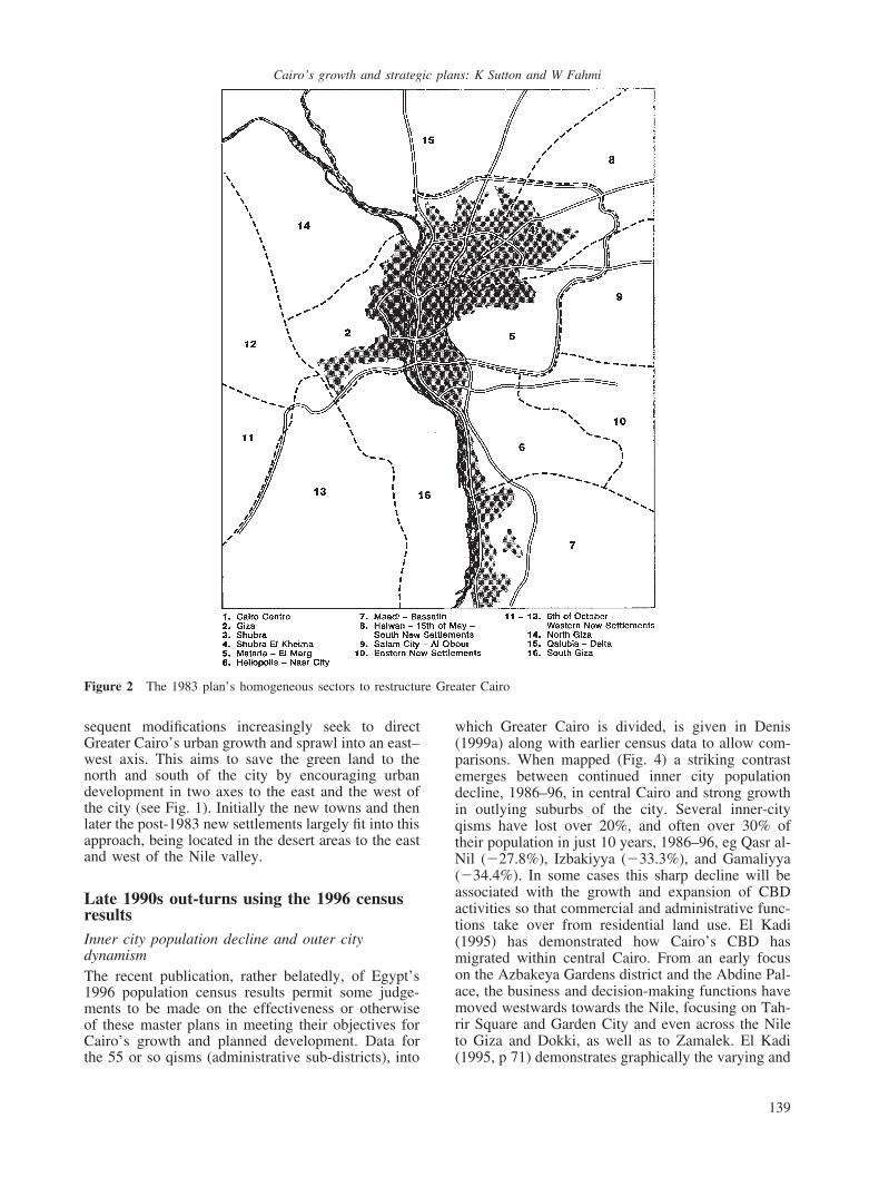
The 1983 master plan originally planned for 10new settlements ostensibly to house 2–3 millionpeople. These were organised into “development cor-ridors” to create urban poles to the east and west andaround the earlier new towns. In the event only nineout of the 10 new settlements were proceeded withand concern was expressed (Belliot, 1993) that as theywere sited in the “hostile” desert they would probablybe unpopular with people. The first phase waslaunched in 1987–88 with 10,000 housing units in sixof the new settlements. They received a populationboost following the 1992 earthquake when some ofthe resulting homeless families were relocated to thenew settlements. The plan’s attempt to restructure theexisting metropolitan area was promoted through ascheme of “homogeneous sectors”. This sought tobreak up the “mononuclear” arrangement of the cityby restructuring it into 16 homogeneous sectors (seeFig. 2). Each sector was to be an autonomous urbanunit of 500,000–2,000,000 people and to be relativelyself-sufficient in jobs and services. Several new sec-ondary centres were to be created in these homo-geneous sectors. Some progress has been madeincluding the rehabilitation of the old core of Cairoin Gamalaya-North. (Belliot, 1993; Madoeuf, 1995).Delay was nevertheless noted in the implementationof the concept of homogeneous sectors (HSs) becauseof financial constraints together with weak urbanplanning and land management processes at a locallevel, as well as poor linkages with planning auth-orities. More significantly, delay was attributed to theclose relation between the HS policy based on adecentralisation strategy and the new settlement pol-icy directly related to the deconcentration of popu-lation activities from the existing Greater CairoRegion (GCR) agglomeration.
In addition to the ring road, another large-scaleinfrastructural development promoted by the 1983master plan has been the north–south metro line of42 km length (El Marg-Helwan). A second NE–SWline of 18 km length was launched in 1992, from Shu-bra El Kheima in the north to Giza railway station,together with a third east–west line linking the CBDwith the West bank towards Dokki, so crossing theRiver Nile. A major urban motorway or “autostrada”has been added running from Helwan fringing the old
138
town and out eastwards to Heliopolis and the inter-national airport, and further to Ein Al Sukhna and newsettlements 1, 3, 5. Together with a related motorwayaxis in to Maidan Ramses, this forms a motorwaybackbone for Cairo’s right bank districts. Drinkingwater supply has been boosted on the right bank bya new pumping station at Fustat, which should alsoserve the new settlements in the Eastern Desert. Prob-lems of water supply remain in Giza and the left bank.Two enormous interceptor sewers, one on each bankof the Nile, have also been constructed. These meetan infrastructural gap which has festered for decades.Moreover, public facilities were introduced with thewholesale market being moved to Al Obour City andanother two markets to be located in the 6th Octoberand 15th May new towns.
1990s modifications to the master plansThe years 1991–92 saw some modifications to the1983 master plan. Population forecasts were increasedupwards to 16 million for the year 2000(GOPP/IAURIF, 1991). The ring road route was devi-ated 2 km to the east through the desert for militaryreasons. Also a western arc was introduced in thisroad on arable land on Giza’s outer fringes towards6th October and new settlements 6a and 6b. Suchmodifications affected the location of some newsettlements as well as contributing to the cancellationof the green belt project between Cairo and the East-ern new settlements. This gave way to the emergenceof “New Cairo City”, effectively merging new settle-ments 1, 3, and 5 (see Fig. 3). There was also moreconcern with the ecological protection of archaeolog-ical areas in the south and east, as well as withenvironmental improvements within the old city(relocation of polluting establishments from NorthGamalia to new settlement 3) and within Sayeda Zei-nab (removal of slaughterhouses and tanneries).Additionally, the protection of strategic areas wasadded within the existing agglomeration (such as Fus-tat Plateau, Zamalek Island, Shubra El Kheima, andMaadi Corniche) through the review of legal urbanplanning processes and specific action plans withstrict land control, land use regulations, approvedlocal guidelines and demonstrative urban studies (egSouth Giza and Old Cairo, the historical city). Themodified master plan stressed the need to strengtheninstitutional coordination as shown through the inte-gration of the policies of the local authorities (theGovernorates), the Ministry of Defence, and the Pol-ice housing development in new settlements 3 and 7.
These modifications were only approved in 1997.The Egyptian GOPP (General Organisation for Physi-cal Planning), in charge of Cairo’s master plan haslong been working in collaboration with a Frenchplanning organisation IAURIF (Institut d’Amenage-ment Urbain et Regional de l’Ile de France), so main-taining the link with Western Europe’s master plans,in this case with that for the Greater Paris region.
Together the 1970 and 1983 master plans and sub-
Cairo’s growth and strategic plans: K Sutton and W Fahmi
Figure 2 The 1983 plan’s homogeneous sectors to restructure Greater Cairo
sequent modifications increasingly seek to directGreater Cairo’s urban growth and sprawl into an east–west axis. This aims to save the green land to thenorth and south of the city by encouraging urbandevelopment in two axes to the east and the west ofthe city (see Fig. 1). Initially the new towns and thenlater the post-1983 new settlements largely fit into thisapproach, being located in the desert areas to the eastand west of the Nile valley.
Late 1990s out-turns using the 1996 censusresultsInner city population decline and outer citydynamismThe recent publication, rather belatedly, of Egypt’s1996 population census results permit some judge-ments to be made on the effectiveness or otherwiseof these master plans in meeting their objectives forCairo’s growth and planned development. Data forthe 55 or so qisms (administrative sub-districts), into
139
which Greater Cairo is divided, is given in Denis(1999a) along with earlier census data to allow com-parisons. When mapped (Fig. 4) a striking contrastemerges between continued inner city populationdecline, 1986–96, in central Cairo and strong growthin outlying suburbs of the city. Several inner-cityqisms have lost over 20%, and often over 30% oftheir population in just 10 years, 1986–96, eg Qasr al-Nil (�27.8%), Izbakiyya (�33.3%), and Gamaliyya(�34.4%). In some cases this sharp decline will beassociated with the growth and expansion of CBDactivities so that commercial and administrative func-tions take over from residential land use. El Kadi(1995) has demonstrated how Cairo’s CBD hasmigrated within central Cairo. From an early focuson the Azbakeya Gardens district and the Abdine Pal-ace, the business and decision-making functions havemoved westwards towards the Nile, focusing on Tah-rir Square and Garden City and even across the Nileto Giza and Dokki, as well as to Zamalek. El Kadi(1995, p 71) demonstrates graphically the varying and

Cairo’s growth and strategic plans: K Sutton and W Fahmi
Figure 3 New Cairo City incorporating new settlements 1, 3, and 5. Source: after Al-Ahram, 11 January 1998, p 19
widespread foci of financial services, embassies, min-istries and tourist enterprises in a fragmented andfluctuating CBD. Elsewhere, the effect of the serious1992 earthquake has been to relocate some of theinner city’s overcrowded and ill-housed population tothe edge of city housing and to the new settlements(Degg, 1992). More generally, lower urban fertilitylevels and increased predisposition towards thenuclear family rather than the extended family mayhave impacted on population change. Nevertheless,inner city population densities still remain high withover 250 people per hectare and even over 400 perhectare densities prevailing over much of centralCairo (Fig. 5). However, higher class qisms like Zam-alek and CBD qisms such as Qasr al-Nil have decid-edly lower population densities.
The 1986–96 decade saw “inner city” populationdecline spread west of the Nile to Aguza (�3.8%),Duqqi (�16.8%), and Giza (�7.7%) as well as toseveral qisms to the north and north-east (Fig. 6). Formost central Cairo qisms, however, populationdecline has been a regular feature for three decadesat least.
The transfer of population dynamism to outer areasof the city can be found literally in all directions. Tothe south from Baratin through Helwan to Markaz al-Saf strong population growth well in excess of 20%has occurred. To the north, most of the qisms of theQalyubiyya Governorate have displayed stronggrowth, sometimes in excess of 50% in more semi-rural areas. To the east, often very strong populationgrowth occurred in Minsha’at Nasir, Madinat Nasr,Nuzha and beyond to the airport. With evidence of
140
strong growth also west of Giza towards the pyramidsand the 6th October new town, there is an argumentto be made that one of the objectives of the masterplans is being partly achieved. However, the earliermentioned strong growth to both north and south ofthe city serves to negate this partial measure of suc-cess. A similar judgement emanates from Fig. 7showing population change over the longer time per-iod of 1966–96. Inner city decline dominates centralCairo, though over a less extensive area than in 1986–96 (Fig. 4). Giza and Duqqi display moderate popu-lation growth over this longer time period of threedecades. Fringe areas invariably display strong popu-lation growth since 1966, in some cases phenomenalgrowth, exceeding 300% and sometimes even higher,from very low population starting points in the 1960s.Therefore, population deconcentration was partiallyrealised through master plan strategy, though popu-lation growth affected rural areas (towards Giza),leading to encroachment on arable land and to thecreation of urban villages with demands for urban ser-vices as well as the planned urbanisation of desertland (new settlements). A further interpretation ofpopulation data can be made according to distancefrom city centre. Three concentric zones can be ident-ified: the core (HSs 1 and 3) experiencing negativegrowth rates, the first belt (HSs 2, 4, 5, 6, and 7)including half of the GCR population which is alsodeclining, and the second belt (HSs 8–16), displayingurban expansion on arable and desert lands with aslight increase in growth rates (see Fig. 2 for homo-geneous sectors)

Cairo’s growth and strategic plans: K Sutton and W Fahmi
Figure 4 Greater Cairo: population change, 1986–96 – byqisms. Source: Denis (1999a)
The new towns’ failure to achieve populationtargets
By 1996 the new towns, a major aspect of the masterplans, had achieved only modest population sizes(Table 2). The 6th October new town with only35,477 people and the 15th May new town with65,865 people were still well behind what now seemsto be their unattainable target populations of 250,000or more. The achievements of those new townsfurther out from Cairo, namely the 10th Ramadan andSadat new town, were equally unimpressive, thoughStewart (1996) and Denis (1999b) have reported moresuccess in attracting factories and job opportunities tothe new towns. Workers then commute out to thesejobs from Greater Cairo, which was not the originalself-sufficiency aim of the planners.
Jossifort (1995) reckons that the new settlementsare planned to contain 2 million people by the year2020, or 150,000–200,000 people each. She sees themas a hybrid mixture of new town, overspill estate andlow-cost rehousing scheme. In Jossifort’s opinion,without a revision of the rent control laws, the new
141
Figure 5 Greater Cairo: population density 1996 – by qisms.Source: Denis (1998)
settlements have little chance of becoming anythingother than “HLM-cites” which already flourish aroundthe metropolis and which are practically indis-tinguishable from the new settlements. Indeed, sherecords some luxury housing development at newsettlements 2 and 6 carried out by an Alexandriandeveloper, which rather clashes with the original con-cept. Low-cost dwellings to attract people from innerCairo plus a decent public transport infrastructure areseen by Jossifort as the key to success for the newsettlements.
While reporting in a 1994 conference that severaltens of thousands of dwellings have been constructedin five of the new settlements, where progress hasbeen made, El Kadi (1997) confirms that they are wellbehind their programme and that the dream of 2million people in the 10 new settlements by the year2020 would seem unattainable. By 1992 a govern-ment freeze on further development in the new settle-ments had been decided upon. However, subsequentlythe October 1992 earthquake forced the state to re-house thousands of victims for whom the new settle-ments provided an answer of sorts.

Cairo’s growth and strategic plans: K Sutton and W Fahmi
Figure 6 Greater Cairo: population trends, 1966–96 – byqisms. Source: (Denis, 1999a)
Inner–outer contrastsAs well as contrasts between inner districts and outerdistricts in terms of recent population trends, greatsocio-economic diversity between the inner and outerqisms of Cairo can also be demonstrated for 1996from selected localities (see Tables 3 and 4). Whilehigh population densities prevail in poorer inner ornorthern qisms such as Gamalia, Manshiet Nasser,and Shubra, outer and higher class districts such asHeliopolis and Zamalek, as well as the 15th May newtown have markedly lower densities. Youthfulnessand, more particularly illiteracy and educational levelattained also appear to correlate with the class spec-trum from Manshiet Nasser to Zamalek and Heli-opolis. In terms of the census of buildings the domi-nance of residential use prevails, except for innerCBD qisms such as Qasr el Nil and Zamalek, whileOld Cairo’s Gamalia district also has a fairly highproportion of non-residential buildings. Social classdisparities are also displayed in terms of the high pro-portion of flats and apartments in qisms such as Hel-wan and Shubra and the higher proportions of villas inZamalek, Maadi, and Heliopolis. The notorious highlevels of vacant buildings in Heliopolis, the 15th May
142
Figure 7 Greater Cairo: population change, 1966–96 – byqisms. Source: Denis (1999a)
new town, and Helwan contrast with remarkably lowlevels in Zamalek and Shubra. Variations in socio-economic indices thus parallel the marked spatial dis-parities in population trends from one part of Cairoto another over the last few decades.
Factors behind the relative failure of Cairo’smaster plansThe role of unplanned “spontaneous urbanisation”A major reason why the master plans failed to havea significant effect on Cairo’s urban development overthe last three decades, has been the dominance ofunplanned “spontaneous urbanisation”, to use GalilaEl Kadi’s (1994, 1997) terminology. She considersthat up to 84% of constructions over the last two dec-ades (probably referring to the 1970s and 1980s) havebeen illegal, such that at the end of the 20th centuryCairo appears to be “une megapole en grande partiespontanee”. The 23 ZUS (Zones d’urbanisationspontanees) built on the edge of the city on agricul-tural land or on desert fringes covered 24% of theurbanised area in 1993 and sheltered 6 million inhabi-tants, or 46.5% of Cairo’s population. (El Kadi, 1997,

Cairo’s growth and strategic plans: K Sutton and W Fahmi
Table 2 Lack of progress of Cairo’s new townsa
Target populations 1996 population Industrial jobs in 1996
10th Ramadhan 500,000 47,839 64,5916th October 500,000 35,477 27,80915th May 100,000 65,865 222Al-Badr 250,000 248 176Sadat City 500,000 16,312 8808El Obour 250,000 No data No data
aSources: Stewart (1996), CAPMAS (1996a,b) and Denis (1999b).
Table 3 Contrasts in population characteristics between selected qisms of the Governorate of Cairoa
Qisms Total population Population Average size of % of % of % ofdensity per ha household population population aged population aged1996 under 15 years 10+ illiterate 10+ educated to
of age university andintermediatelevel
Central CairoGamalia 58,839 301 3.9 20.1 30.6 43.6Manshiet Nasser 169,099 521 4.4 38.3 51.2 20.2Qasr el Nil 12,925 98 2.7 17.8 9.0 71.9Zamalek 15,498 58 2.0 13.1 5.0 79.5Outer districtsMaadi 70,415 125 3.5 21.7 9.8 75.6Shubra 83,084 594 3.8 23.8 24.0 60.6Heliopolis 151,027 174 3.4 22.9 6.5 76.9Helwan 518,823 140 4.2 29.0 33.9 52.9New towns15th May 65,865 52 4.4 32.3 8.0 60.7Badr City 248 n.d. 4.7 20.5 57.4 33.2Governorate of Cairo 6,789,479 218 4.0 27.4 23.3 52.4
aSources: CAPMAS (1996b) and Denis (1998).
p 1). It should be stressed that this immense amountof “spontaneous urbanisation” is, for the most part,not made up of conventional Third World shanty-town dwellings. Instead, by “spontaneous urbanis-ation” El Kadi is referring to illegal, unplanned, mod-ern formal housing. It can be a case of multi-storeyblocks of flats as well as individual houses built with-out any formal planning permission. Similarly, illegalextra floors are added to many buildings and this turnsconventional areas into partial spontaneous urbanis-ation areas. These cover large areas to the north, westand south of the metropolis. In part they are linkedto motorway development and to other infrastructuraldevelopments and pay no heed whatsoever to masterplans’ strategy.
As illegal and spontaneous these new urban areasare initially deprived of basic services like surfacedstreets, water supplies, sewers, schools, etc. Later,having become recognised and through force of cir-cumstances legalised, such services then start to beadded. Only rarely have spontaneous urban areas beenbulldozed and demolished. Developers know that theywill get away with their illegality as do those whoadd extra storeys to buildings.
143
The failure of new towns to attract residents
A second and major factor behind the relative failureof the master plans stems from the basic failure of thenew towns to attract population. Their contribution,relative to the size and growth of Greater Cairo, hasbeen minimal. Four satellite cities were originallyplanned for construction in the desert east and westof Cairo, but only three, namely 6th October, AlObour, and 15th May, have made any real progress.Situated within 40 km of Cairo, population targets forthese new towns range from 250,000 to 500,000.Further away from Cairo are another four new cities,designed to hold 500,000 to 1 million people. Two ofthem, 10th Ramadan and Al Badr are relatively nearGreater Cairo. Arguably Sadat City is also, whileNew Almeriya is located near Alexandria (Stewart,1996). Furthermore, the failure of the new settlementsto provide a further 500,000 housing units over 15years was aggravated by the inadequacy to providesmall, low-cost plots rather than ready made build-ings. Changes in housing financing procedures werenoted as part of restructuring the Egyptian economysince 1991 in accordance with the IMF agreement.

Cairo’s growth and strategic plans: K Sutton and W Fahmi
Tab
le4
Con
tras
tsin
build
ings
char
acte
rist
ics
betw
een
sele
cted
qism
sof
the
Gov
erno
rate
ofC
airo
,19
96a
Qis
ms
No
ofbu
ildin
gs%
resi
dent
ial
%m
ixed
%va
cant
%pr
ivat
ely
%go
vern
men
t%
inbl
ocks
of%
villa
sre
side
ntia
lan
dow
ned
and
publ
icly
flats
/apa
rtm
ents
wor
kow
ned
Cen
tral
Cai
roG
amal
ia62
2748
.312
.56.
489
.56.
563
.30.
0M
ansh
iet
Nas
ser
13,2
4680
.16.
52.
188
.810
.673
.50.
0Q
asr
elN
il91
724
.929
.44.
069
.426
.452
.52.
2Z
amal
ek11
2936
.926
.00.
786
.312
.858
.511
.7O
uter
dist
rict
sM
aadi
5388
79.5
1.5
3.8
94.6
3.7
70.8
13.5
Shub
ra46
1577
.712
.20.
795
.33.
990
.41.
2H
elio
polis
6368
61.1
11.4
13.2
80.7
17.1
73.2
13.2
Hel
wan
51,6
9581
.93.
08.
490
.57.
490
.41.
2N
ewto
wns
15th
May
2694
75.4
0.3
11.7
93.5
6.4
79.1
3.9
Bad
rC
ity53
100.
0–
–10
0.0
–10
0.0
0.0
Gov
erno
rate
ofC
airo
473,
788
76.0
5.6
7.4
91.6
7.1
83.7
1.4
a Sou
rce:
CA
PMA
S(1
996b
).
144

Cairo’s growth and strategic plans: K Sutton and W Fahmi
To create a more integrated urban network, thesenew towns/cities are incorporated in a series of devel-opment corridors (Fig. 1). These aim to promotetransportation linkages and to funnel growth awayfrom Cairo (Stewart, 1996, p 464). Stewart has stud-ied three of the new towns in detail: 6th October, 10thRamadan, and Sadat City. Focusing on their econ-omic development, only the 10th Ramadan has metmuch success in attracting industrial and other factor-ies. By 1993 it had 531 plants, with the 6th Octobernew town attracting 286 plants. Sadat City was failingto attract decentralised industrial units and so a June1993 government initiative was launched aiming toestablish 500 light industry projects there, with up to100,000 skilled jobs. However, research by Meyer(1989) suggests that a large proportion of the newindustrial workforce in these new towns commute outfrom Cairo. This is especially the case in the 6thOctober new town, a mere 32 km from Cairo.Employers have been forced to set up a bus and min-ibus system to pick up their workers from Cairo andits suburbs. Housing in the new towns has proved tobe too expensive for such workers and has attractedspeculators rather than residents (Stewart, 1996, p471). Poor basic services and the lack of social andeducational infrastructure have also discouraged fam-ilies from settling in the new towns. So, while Stewartconcludes that whereas the 10th Ramadan and 6thOctober new towns can be regarded as partial econ-omic successes they have not attracted large numbersof residents. The planners have failed to allow for thepossibility that people may prefer to remain in fam-iliar, if crowded, “lived-in environments” in GreaterCairo, rather than relocate to desert cities with unat-tractive modernistic architecture and which are“physically and psychologically distant” (Stewart,1996, p 475). Denis (1997) has observed that themajority of the “desert cities” remain empty, bereftof even the most meagre infrastructure: water, elec-tricity and transportation. By the early 1990s the statehas handed the future of these new cities over to priv-ate promoters and speculators. They constructed villacomplexes, enclosed elite compounds, often with inte-gral golf courses.
So, the new towns programme has failed to allevi-ate overcrowded conditions in Cairo through the relo-cation of small-scale and traditional firms from innercity areas and downtown locations (such as NorthGamalia) to these new settlements, thus implementinga deconcentration of activities policy. Yet it hasserved to divert government money and attentionwhich could have upgraded Greater Cairo’s degradingbuilt environment. A study by GOPP, however, sug-gested the short-term creation of small industrial areas(10–30 feddans) supplying small plots (200–1300 m2)within existing agglomerations such as Basatin, Hel-wan, Shubra El Kheima, followed by a middle rangeterm plan to extend such investment into the newsettlements (GOPP/IAURIF, 1990). This could
145
improve the balance of housing and jobs in thesesettlements as well improve inner city areas.
Financial constraints on government expenditure
A third general factor behind the lack of public invest-ment in the service infrastructure and in subsidisedreal estate housing in both new towns and new settle-ments has been the financial straight-jacket imposedon the Egyptian Government by its general economicproblems and by the IMF restructuring plan which issupposed to tackle those problems. With the IMF planreducing public spending, the political and economicclimate has favoured private capital investment andmarket economy approaches. This translates into yetmore spontaneous urban development, which by itsvery nature pays little heed to master plans or to legalprocedures. This gave way to more private involve-ment from the informal sector in the development ofthe new settlements. The savoir-faire and knowledgeof the market served to meet peoples’ housing needswithout state subsidies. Speculative private housebuilders are less inclined to take risks in untried desertlocations, preferring to build on green land in triedand tested urban fringe locations. With the newrequirement of reduced public expenditure and thetransparency imposed by the IMF, government invest-ment was directed to merely providing new expansionareas with basic infrastructure. This made plots ofdesert land attractive in comparison to similar agricul-tural land, given the apparent zero value of suchdesert land. Nonetheless, self-build squatters do nothave the means to travel from desert locations to citycentre jobs and likewise ignore planners’ strategies intheir self-focused spatial decision-making. Moreover,the development of new settlements within the frame-work of a market economy ought to consider chang-ing the rules of housing loans. Increases in the costof credit have been noticed recently.
The strengthening of Cairo’s polycentric CBD
A less specific factor has been the way that the CBDand related tertiary functions have moved around theinner city and have produced what El Kadi (1995)calls a “pluri-centre” situation. Earlier on, Meyer(1990) observed that the old city had experiencedchanges in the central bazaar area where an economicrevival was noted with new multi-storey manufactur-ing centres at the periphery providing workshops forgoldsmiths and artisans. In the residential quarters,the number of small-scale enterprises manufacturingconsumer goods has increased with densification ofthe old quarter, despite population decline since the1960s. While high-level functions have remained con-centrated in Cairo, spatially within the city they havemoved both eastwards towards Heliopolis and Madi-nat Nasr, following the social elite, and westwardson to the West Bank. In both cases densification offunctions and land use appear to have contributed topopulation loss, over the last three decades in the
Cairo’s growth and strategic plans: K Sutton and W Fahmi
inner city and more recently, over the 1986–96 decadein the case of Giza, Zamalek, and Aguza (see Fig. 4).
Planners’ and politicians’ aspirations to displacegovernment ministerial functions to Sadat City newtown and to an alternative new capital on the banksof the Suez Canal (El Kadi, 1995, p 38) have notmaterialised. Instead the nineteenth-century and earlytwentieth-century polycentrism continued as thediverse CBD functions expanded with new foci proli-ferating, in part because of the land use asphyxiationof the central districts around Tahrir Square, RamsesSquare and the Azbakeya and Abdine districts. Afterspreading to and then saturating the Garden City area,tertiary functions then spread westwards to the Zama-lek and Mohandessine quarters and to Dokki and Giza(El Kadi, 1995, pp 62–63). Following Mubarak’saccession to power in 1981, tertiarisation impulsesspread eastwards to Heliopolis and Madinat Nasr,with the airport and new international fair sites con-tributing to dynamism in eastern Cairo. In addition,there are future plans to promote both Maadi to thesouth as a business centre, and the Pyramid Avenueaxis to the west as a touristic service area. This trendhowever seems set to intensify with the unplannedemergence of “New Cairo” on the city’s eastern frin-ge.
El Kadi (1995, pp 68–69) demonstrates how thisprocess of “demolition–reconstruction–densification”has transformed the western district of Mohandessine.Between 1980 and 1992 a third of its villas andsmaller blocks have been demolished and replaced bytower blocks. Such a tertiary-focused transformationhas rendered Mohandessine much less attractive toresidents, especially amongst the elite classes. Manyhave moved out to more peripheral locations and theqism of Aguza has reversed previous populationgrowth trends, showing a 3.8% decline (1986–96).This was facilitated by the construction of 26th Julyaxis road, regarded as a ring road junction, whichlinks Giza with 6th October and new settlements 6a,6b and 7. So, over the last 30 years inner Cairo haswitnessed a contradictory movement, namely the con-solidation of its central place tertiary functions andthe fragmentation of those functions over a multi-centred CBD. This was all part of a spontaneousrather than a planned land use transformation.
The impact of the 1992 earthquakeAnother and quite specific factor affecting Cairo wasthe 1992 earthquake which caused the movement out-wards of 10,000s (perhaps 100,000s) of people fromcollapsed and damaged blocks of flats in some of themost densely populated inner districts to peripheralareas and to the new settlements. Degg (1992)observed two main types of construction changed bythe earthquake: firstly, old dilapidated adobe housesof the poor in rural areas and in Cairo’s inner cityslums; secondly, modern illegally constructed high-rise concrete constructions inhabited by the wealthy.Such a situation has led to the politicisation of the
146
earthquake event related to socio-economic reformand to the rise of Islamic fundamentalist activities.According to Florin (1997) the earthquake destroyed800 blocks of flats and damaged a further 9000 build-ings, leading to a deterioration of the existing housingstock. She studied the migration paths of families inthe new suburb of Hadaba El-Wusta, located on thedesert plateau of Muqattam, which has been re-namedMasaken El Zelzel (dwellings of the earthquake) byits inhabitants. Out of 16,000 families living there in1994–95, 10,000 had been relocated there followingthe 1992 earthquake. So, an unforeseen disaster hadin part fostered lower class movement out to a moreperipheral settlement, an aim of the master plan.However, once relocated earthquake victims foundthe services inadequate compared with more centralresidential areas and found that they had to pay forhouses and flats, supposedly replacing the dwellingsthat they had lost. So many moved back to their oldfamiliar inner city districts or to the City of the Deador other squatter settlements. Others had alwaysstayed put, continuing to live in unsafe buildings.
Vacant dwellings in a housing crisis situation
A background feature of housing in Cairo has longbeen the ironic contradiction of a crisis of dwellings,as well as a rapid decay of housing standards withinCairo’s central districts, alongside a large stock ofempty dwellings. The 1986 census revealed 467,000empty dwellings in Egypt, some 15% of the housingstock (Meyer, 1996); 250,000 or more of those emptyflats are in Cairo (Table 4). Several well-meaninglaws (1947–61) freezing rents and guaranteeing ten-ancy to the next generation have resulted in a whole-sale unwillingness on the part of owners to rent outproperty. For the same reason, owners were not ableto carry out essential maintenance to their rented flats,thus contributing to their decay, as well as to a changein real estate investment from flats for rent to apart-ments for sale to more well-off people. A new hous-ing law has been introduced recently to balance hous-ing demand and supply by making the rents of flatsmore flexible, with middle range leases of between 3and 6 years. These rents can float in level accordingto market demand and inflation rates. This encouragesowners to upgrade and maintain these units. The with-drawal of properties from the housing market hasserved to push up property values, so exacerbatingthe problem as property speculation keeps yet moredwellings empty. This vacancy rate is apparentlyhigher in middle class outer areas such as Heliopolisand Madinat Nasr. Inner city population decline hasprobably been increased by this social problem, whichhas spread to dwellings in the new towns and newsettlements as middle class property speculation hasin part taken the place of what were planned as lowerclass housing schemes.
Cairo’s growth and strategic plans: K Sutton and W Fahmi
The role of the ring roadThe ring road, which is now complete in its northern,eastern, and southern sections (Fig. 1), has proved tobe a significant factor in recent land use and popu-lation changes around Cairo. The concept of the ringroad was in the master plans from the beginning,being part of the 1956 and 1970 plans. Together witha spur to the west this improvement to road communi-cations has boosted development around the 6thOctober new town including new settlements 6A and6B, which threaten to be absorbed into the newtown’s built up area. One high-class suburban areahere even glories in the developer’s nomenclature of“Beverly Hills”. Such peripheral informal privatedevelopment combined with social exclusion hasaffected the new settlements and new towns in a waynot predicted by the master plan or by GOPP. Simi-larly to the east of the city “New Cairo” has emerged,including and extending the areas of new settlements1, 3, and 5 (see Fig. 3). However, much of this ring-road-associated housing development has been priv-ate rather than public and higher class rather thanlower. So development has gone ahead but despite asmuch as because of the master plan.
Conclusions and future scenariosThe first results of the 1996 population census havedemonstrated that the threat of exponential populationgrowth which prevailed during the 1970s and into the1980s has been lifted from Cairo. Between 1986 and1996 the city’s population has grown decidedly moreslowly than many planners and pundits anticipated.However, its spatial extent has continued to grow andthe realistic outer boundary of greater Cairo used forcalculating population size needs constantly to beredefined as peripheral transport provision and roadaccessibility improve. Hence some authorities stilloffer population estimates for Cairo greatly in excessof the 10.17–13.47 million range which emanatesfrom the 1996 census data.
As well as attempting to master the city’s growth,the 1970 and 1983 master plans especially attemptedto plan that growth in terms of infrastructural devel-opment and in terms of movement out to new townsand new settlements. Eastern and western extensionstowards desert land were favoured over further north–south extension as the latter orientations used up valu-able green land. However, only limited progress hasbeen made with developing the new towns and thenew settlements, all of which are well behind popu-lation and other targets. As often much more privatedevelopment rather than public building has occurredin the new towns, the social objectives of the masterplans have not been met either. Arguably, Cairo stillrepresents too attractive an urban environment interms of jobs, potential, hope, and familiar lived-inenvironments to allow much diversion of populationto the unattractive environments of the new towns andnew settlements. In contrast, the master plans’ infras-
147
tructural developments have been more successful,especially the construction of most of the ring road,the metro, the interceptor sewers, etc. Even the organ-isational changes represented by the HSs as part ofan administrative decentralising strategy have seensome success.
A major contributor to the “mastering” of Cairo’spopulation growth has been inner city populationdecline which has spread, 1986–96, to involve nearlyall the central districts. The associated movement outof people, especially of higher class families, hasoften been unplanned as in the case of those relocat-ing out to “New Cairo City” to the east of the agglom-eration.
Several factors can be suggested as being behindthe relative failure of the master plans, especially theunplanned, illegal nature of much “spontaneousurbanisation”, often ignoring the exhortations to pre-serve the precious green land. Also contributing hasbeen the failure of the new towns and new settlementsto attract people and of the state to provide adequatefunding for public housing for lower classes in thesenew towns and new settlements. Financial constraintsengendered by the IMF restructuring plan have nothelped the situation. Instead of planned movementout, centrality or polarisation of functions on centralCairo has continued, albeit with a more pluri-centrespatial pattern. Even the unforeseen impetus to relo-cation to the new settlements imparted by the 1992earthquake has proved inadequate. Many peoplestayed or returned to Inner Cairo and those whoagreed to move out were dissatisfied with poor ser-vices in their allocated new settlement. Then the ringroad, while representing the more successful infras-tructural side of the plans, has served to segregateinner Cairo from expanding outer fringe areas ofhigher class residences.
ScenariosFuture scenarios posed by Yousry and Aboul Atta(1997) imply a current pattern of GCR urban growthrapidly expanding along the traditional regionalnorth–south axis from Cairo to Alexandria withmedium and small-sized towns and villages beinginterrelated and affected by the influential zones ofthe two major urban poles (Cairo–Alexandria). A newmegalopolitan region housing nearly 50% of Egypt’spopulation could emerge along this urban corridorcreated by high rates of growth in population and inbuilt-up area in surrounding agglomerations, eitherbetween Cairo and Alexandria or between Cairo andTanta. According to Bayat and Denis (2000), whereasCentral Cairo lost population in the last decade, per-ipheral villages and towns grew rapidly. Indeed theydetected a double movement of population deconcen-tration at both metropolis and national levels, thusleading to diffusion of urbanisation throughout thecountry and less rural exodus (in 1986, 80% ofmigrants in cities came from other urban centres).This was characterised by a permanent population

Cairo’s growth and strategic plans: K Sutton and W Fahmi
movement between one urban settlement and anotherakin to a circular migration pattern. Cairo has shownsigns of population stabilisation as it ceased to attractmigrant population, a phenomenon noted by Bayatand Denis (2000). This was because of the city’s satu-ration with respect to the accommodation of low-income people as well as the tendency amongstaffluent groups to move to suburban areas. Quiteclearly, high land prices, increasing population den-sity, shortage of affordable housing and the decay ofexisting housing stock, together with the partial freemarket cost of housing, have all contributed to low-income migrants seeking peripheral districts and join-ing already marginalised groups in informal settle-ments around the metropolitan area of Cairo. This allcontributed to the ruralisation of the city. The mush-rooming of service microbuses (increasing from14,000 in 1990 to 60,000 in 1995) has generatedtime–space convergence, creating traffic congestionand environmental pollution. Consequently, in theseperipheral agglomerations on Cairo’s fringes, nearly91% of households are less than half an hour fromthe bazaar in the old city (Bayat and Denis, 2000).
Moreover, with the growing deregulation of agric-ulture, urban villages grew, characterised by a newaffluent class emerging out of investment in realestate, in construction activities and in cash cropping.Such urbanisation exhibits a pattern of polarization atthe level of large villages and small towns, signifyingthe prevalence of dynamic communities characterisedby increasing mobility and commodification exchangeand a new pattern of social stratification. Bayat andDenis (2000) argue that such diffused urbanisationhas shifted between ruralisation of the city and urban-isation of countryside, giving way to the emergenceof a “post metropolitization” of the city. This ischaracterised by population concentration whichposes a challenge to the political economy and stateauthority. Since the state refuses to recognise such“ruralised” and “urbanised” agglomerations andregards them as spontaneous settlements, it does nottherefore provide them with urban services and pub-lic facilities.
Consequently, a new spatial division has been cre-ated excluding citizens from urban participation. Inthe early 1990s Islamic activism has emerged as aresult of marginalisation. The “spontaneous settle-ments” have been stigmatised as “rural” as theyattract in-migrants. However, they also attract Cairo’surban youth from inner city areas.
The shift of emphasis from public to private urbandevelopment has contrasted with this process of mar-ginalisation and alienation. This is exemplified innewly emerging townships incorporating affluentprivate neighbourhoods, particularly in 6th Octobercity and the new settlements 6a and 6b in the westand new settlements 2 and 1, 3 and 5 in the east,especially in New Cairo City. As a result, Cairo’srecent urban extension stems from contrasting move-ments. Firstly, the poor and dispossessed were forced
148
to move out to spontaneous settlements in the urbanfringe, and, secondly, the rich affluent groups choseto leave the city with its pollution, traffic congestionand crowding and to move to new suburban resi-dences.
A model of Greater Cairo’s recent and projecteddevelopmentThis duality of peripheral informal and marginalsettlements on the one hand, and planned exclusivesuburbs on the other therefore demonstrates urbanpolarisation and social transformation (Bayat andDenis, 2000). Such polarisation partly characterisedby “closure” or the gated settlements approach hasdivided the city between six spatial patterns (Fig. 8):
� Ruralization of urban fringes and the emergence ofspontaneous informal settlements around the cityperipheries.
� Urbanization of rural villages on the outskirts ofGiza to the west and of Qalubia to the north, build-ing on arable land and emphasising the traditionalnorth–south axis.
� Densification of the west bank (Mohandessine andZamalek), of the south (Maadi), and of the nor-theast (Madinat Nasr).
Figure 8 Model of Greater Cairo’s recent and projecteddevelopment. Source: authors

Cairo’s growth and strategic plans: K Sutton and W Fahmi
� Saturation of the CBD and the decline of the innerold city as people seek to move out from core areasto the fringes.
� Inefficiency of new settlements in providing hous-ing for low-income population, except for emerg-ency shelter schemes for victims of the 1992 earth-quake.
� Exclusive private suburban districts emergingwithin the new settlements, in eastern Cairo (NewCairo City) and in the western desert (new settle-ments 6a and 6b and the 6th October city). Theseare inhabited by the new elite upper middle class.
In conclusion therefore, it can be suggested thatwhilst Cairo’s population growth has certainly sloweddown in recent years, and despite the positive effectof the ring road on eastern and western private sub-urban development, the present diversity of spatialpatterns has not particularly resulted from the GCRmaster plan strategy. The plan’s aims of controllingurban growth and east–west expansion, reducingpopulation concentration in the inner city, protectingarable land to the north and south of Cairo, andupgrading public facilities have in large part not beenachieved. This situation could result in grave socio-political consequences in the near future. Indeed, itcan be argued that, not only has Greater Cairo notbeen mastered or planned, but that the master plan of1983, as revised in 1991–92, no longer really existsin an effective way. As Denis (1997) has observed,Cairo has “a population that routinely resists officialdesigns for the organisation of the city”. Rather Cai-ro’s continued development has been carried out byprivate entrepreneurs and property speculators ratherthan by the city’s planners. Private dynamics prevailas increasingly the planners have been forced to leaveprivate developers to get on with things.
References
Bayat, A and Denis, E (2000) Who is afraid of Ashwaiyyat? Urbanchange and politics in Egypt. Environment and Urbanization12(2), 185–199.
BBC (1993) Programme: Cairo: mother of megacities.Belliot, M (1993) Le Grand Caire Dix Ans Apres. Cahiers de l’AU-
RIF, No. 104–105, 166–182.Bhatia, S (1994), Neighbours to the dead. The Observer: Life
Magazine, 12 June, 26–30.CAPMAS (Central Agency for Population Mobilisation and
Statistics) (1996a) Egypt: Statistical Yearbook. Cairo Giza andQalybia Governorates, Cairo.
CAPMAS (1996b) General Census of Population, Housing, andBuildings, 1996. Cairo.
Courbage, Y (1997) La demographie en rive sud de la Mediterraneeau XXIe siecle: changement de perspectives. Espaces, Popu-lations, Societes, 1997-1, 11–26.
149
Degg, M (1992) The 1992 Cairo earthquake: causes, effects, andresponse. Disasters 17(3), 226–238.
Denis, E (1997) Urban planning and growth in Cairo. Middle EastReport 27(1), 7–12.
Denis, E (1998) Le Caire et l’Egypte a l’oree du XXIe siecle. Unemetropole stabilisee dans une contexte de redeploiement de lacroissance. Lettre de l’Information de l’OUCC 48, 4–17.
Denis, E (1999) Erratum. Lettre de l’Information de lOUCC 49,71 (corrections to Denis, 1998).
Denis, E (1999) La face cachee des villes nouvelles. Dossier villesnouvelles de al-Gumhuriyya (sept–oct 1998). Lettre de l’In-formation de lOUCC 49, 38–46.
El Kadi, G (1987) L’Urbanisation spontanee au Caire. Fasciculede Recherches, No. 18, ORSTOM/URBAMA, Tours.
El Kadi, G (1994) Le Caire: la ville spontanee sous controle. Magh-reb-Machrek 143, 30–41.
El Kadi, G (1995) Le Caire a la recherche d’un centre. Annales deGeographie. Universite Saint-Joseph, Beyrouth 16, 37–72.
El Kadi, G (1997) Urbanisation spontanee et politiques d’amenage-ment, deux processus qui s’annullent: Le Caire. Citta e Societanel Mondo Arabo, Turin, Fondation Agnelli.
Florin, B (1997) Le Caire. Des quartiers centraux vers une cite dela peripherie: itineraires, pratiques d’appropriation et d’ajuste-ment a un nouveau modele urbain. Seminar paper, Montreal.
GOPP/IAURIF (General Organisation for Physical Planning)(1990) Activity relocation policy (in Arabic). Ministry ofDevelopment, New Communities, Housing, and Public Utilities.
GOPP/IAURIF (1991) Greater Cairo Region Master Scheme.Implementation Assessment. Updating Proposals. Ministry ofDevelopment, New Communities, Housing and Public Utilities,May 1991 (57 pp).
Jenssen, B, Kunzmann, K R and El-Din, S S (1981) Taming thegrowth of Cairo. Towards a deconcentration of the metropolitanregion of Cairo. Third World Planning Review 3, 201–233.
Jossifort, S (1995) Villes Nouvelles et New-Settlements: l’amen-agement du desert egyptien en question. Les Cahiers d’UR-BAMA 10, 29–43.
Madoeuf, A (1995) De la ville au secteur, du centre au site: unelecture des projets d’amenagement de la ville ancienne duCaire. Les Cahiers d’URBAMA 10, 44–58.
Meyer, G (1989) Bevolkerungsentwicklung und wohnraumversor-gung in der metropolitanen agglomeration von Kairo. Mitteil-ungen-Osterreichischen-Geographischen-Gesellschaft 131,145–170.
Meyer, G (1990) Wirtschaftlicher und Sozialer Struturwandel inder Altstadt von Kairo. Erdkunde 44(2), 93–110.
Meyer, G (1996) Kairo. Geographische Rundschau 48, 97–103.Ministry of Housing (1970) The Preliminary Master Plan. Cairo
(in Arabic).Moriconi-Ebrard, F (1994) Unite administrative et unite locale:
elements de reflexion pour une utilisation rationnelle de la stati-stique locale egyptienne. Lettre de l’Information de l’OUCC 37,17–23.
Raymond, A (1993) Le Caire. Paris, Fayard.Richardson, H (1989) The big bad city mega myth. Third World
Planning Review 11, 355–372.Scheffler, R (1990) Entwicklungsprobleme in der Region Gross-
Kairo. Geographische-berichte 35(4), 252–264.Stewart, D (1996) Cities in the desert: the Egyptian New-Town
Program. Annals of the Association of American Geographers86, 460–479.
Yousry, M and Aboul Atta, T A (1997) The challenge of urbangrowth in Cairo. In The urban challenge in Africa. Growth andmanagement of its large cities, ed. C Rakodi (pp 111–149). UNUniversity Press, Tokyo.