Embed Size (px)
Citation preview

Colchester Archaeological Group
BULLETIN Vol. 52 2012

Front cover:
The team excavating an earthen Neoliithic long barrow at Cowlins Farm, Mount Bures.

1
CAG 52
CONTENTS
Officers and Committee Members 2010-2011 2
Chairman’s Report Anna Moore 3
Editorial Pat Brown 3
CBA Report John Camp 4
Young Archaeologists’ Report Barbara Butler 4
Obituary - Rosemary Oliver Barbara Butler 5
Fieldwalking the “Onion Field” and Metlands, Wormingford
Howard Brooks 6
The Army Bicycle John Moore 11
Notes on the Excavation of the Longinus Site, Beverley Road 1996-1999
John Mallinson, Stephen Benfield, Denise Hardy and Michael J. Mathews
14
The Pink, Copford, Essex: a Medieval Thatched Cottage
Richard Shackle with Dave Stenning 15
REPORTS OF LECTURES 22
BOOK REVIEWS: The Secrets of the Mound Tin Glazed Tiles from London The Prehistoric and Medieval activity along the route of the Wormingford to Abberton Pipeline
Anna Moore Andrew White Andrew White
37 38 39
Visit to Mola Anna Moore 40
From Colonia to Capital: Roman Colchester at the British Museum
Louise Harrison 40
CAG Weekend Trip to Western Cumbria Gill Shrimpton 42
Visit to Burghley House and Longthorpe Tower Pat Brown 43
A Walk in the Constable Country Barbara Butler 44
Annual Summer Party Pat Brown 44
Visit to North Essex Churches
Pat Brown 44
Day School on Understanding Old Handwriting Jean Roberts 45
I went to see “Lucy” in Ethiopia Mary Coe 9
Charles Heath’s Weaving Loom Tokens of 1794 Francis Nicholls 21

2
CAG 52
COLCHESTER ARCHAEOLOGICAL GROUP
COMMITTEE 2011-12
Chair Mrs A. Moore Cob Cottage The Street Salcott Maldon CM9 8HL 01621-860217 [email protected] Vice-Chair P. Cunningham Essex Arms The Park Manningtree CO11 2AN 01206-393937 [email protected] Secretary Mrs G. Shrimpton 1 The Mount Colchester CO3 1JR 01206-545969 [email protected] Treasurer J. Mallinson 1 The Mount Colchester CO3 1JR 01206-545969 [email protected] Editor Mrs P. Brown 27 Alexandra Road Colchester CO3 3DF 01206-575081 [email protected] Members Mrs B. Butler, B. Colbron, G.M.R. Davies, D. Goodman, Mrs D. Hardy, D. Harrison, Ms L. Harrison, F.H. Nicholls, A. White Colchester Archaeological Group is a Registered Charity No. 1028434

3
CAG 52
CHAIRMAN’S REPORT Anna Moore Archaeology (and its near relative, history) is currently enjoying attention in the media perhaps un-precedented in the last hundred years. At the time of writing this report, there are daily newspaper articles on the search for the bones of Richard III under a carpark in Leicester; on television, Andrew Marr has just embarked on an ambitious series of programmes on the development of modern man, while on the same evening Neil Oliver presents his history of the Vikings; there are two national peri-odicals devoted to archaeology, British Archaeology and Current Archaeology, both of which con-tinue to attract a wide readership. Given these rival attractions, it is gratifying that members are still willing to turn out on a Monday eve-ning during the winter months to hear a real, live speaker and I’m glad to report that attendance at the lectures continues to be maintained. The Group’s membership remains at a very encouraging figure of around 200. Another successful and enjoyable summer programme has come and gone. Many members of the Group travelled to Cumbria for a weekend trip during the Spring, this time to the western end of Ha-drian’s Wall, thereby completing an exploration of the Wall started thirteen years before. We have also enjoyed an evening walk around Dedham, a day out to Burghley House and Longthorpe Tower, an evening at Mersea Museum and Barrow, a visit to four churches in North Essex and a Study Day on Reading Old Handwriting. Our thanks go to the organisers of those events, with thanks in particular going to Gill and Christopher Hamblin, who hosted our Summer Party in July. Little did they know earlier in the year when they offered their very attractive garden for the evening that the summer would turn out to be one of the coldest and wettest on record, and that we would colonise their house instead. They nevertheless made us extremely welcome and we had a very entertaining evening. During the last few months we have been occupied with arrangements for our Winter Lecture pro-gramme and for our library, due to the forthcoming closure of the Castle for a major refurbishment project. By the time you read this report, we will have been settled into our temporary lecture room at the Lion Walk United Reformed Church for some weeks, and plans for moving the library are well in hand. The books will be housed in a room at Roman Circus House, headquarters of the Colchester Archaeological Trust, who have kindly loaned us the space for as long as we need it. Many thanks to Philip Crummy of the Trust for this offer. Hopefully, the library will continue to be well used in its temporary premises. The weather also played havoc with our fieldwork, and the final weeks at the Wormingford kiln site were disrupted by the very wet conditions. However, the excavations were finally completed and the site closed down early in the summer. During the previous autumn, there was a brief opportunity to investigate a cropmark at Cowlins Farm, Mount Bures, which has long been recognised as an earthen longbarrow. A small excavation was carried out and the completion of the report is in hand. The team has now moved on to Marks Hall near Coggeshall, where the search for the footprint of a lost Jacobean mansion continues. ____________________________________________________________________________ EDITORIAL Pat Brown At the moment there are a number of reports in the pipeline, which we hope to publish either in next year’s Bulletin or in some other form. More and more is being published on line nowadays, and it is hoped that the Group’s new website will soon be available for members; as it develops we shall be publishing more online. But don’t worry—there are no plans to abolish the printed Bulletin yet! I would like to thank all the contributors, especially those who are willing to write up reports on the lectures. It is not easy to produce legible notes in the dark! _______________________________________________________________________________

4
CAG 52
COUNCIL FOR BRITISH ARCHAEOLOGY 2012 Report by John Camp The CBA year can best be described as one of retrenchment. After the cuts to its income from the British Academy the CBA has shed staff and is focussing on growing its membership, although the annual cost has risen from £29 to £34. It has allowed its re-gional groups to set their own fees and given them greater independence. The fee for the CBA East group is not published on their website and it is not clear whether there is an option to only belong to the regional group. One can only hope so as they have some good activities. Their AGM was held at St. Albans in the Verulamium Museum with tours of the ancient site. In July there was a visit to Bart-low Hills. The CBA has revised its website to make it more informative and the new address is www.archaeology.UK.org The CBA is exploring ways to fund the Young Archaeologists’ Club and keep it going, as this is clearly essential to the future of the organisation. The CBA has also secured a grant from the Heritage Lot-tery Fund to provide a further 24 placements in its Community Archaeology Training Programme, focusing on engaging young people in community archaeology. Unfortunately, the CBA‘s activities are taking place in a climate of continuing cuts in funding for local authorities, reflected in increasing reductions in archaeological and specialist planning staff . The Gov-ernment has completed its “reform” of planning legislation and it remains to be seen if the new sys-tem of favouring “sustainable development” will be at the expense of our historic heritage. In Essex, the County Council has reorganised its section dealing with historic buildings and has yet to determine the future of its Archaeology Unit. Is there to be a return to the crisis of the 1970’s with the ascen-dancy of local groups, such as ours, bridging the gaps left in the state system? Despite all this the CBA is concentrating on something it does well—publication. Its winter meeting focussed on a strategy for local society journals and examined the benefits of digitised format and on- line access. The latter is likely to be welcomed by libraries faced with funding cuts and a shortage of space. The CBA has published some new handbooks on Industrial Archaeology and Marine Archae-ology and also on the Archaeology of English Battlefields. The next few years will prove crucial for the direction and success of the CBA. ______________________________________________________________________________
YOUNG ARCHAEOLOGISTS’ CLUB Report by Barbara Butler The Colchester branch of the Young Archaeologists has been studying and making mosaics, enjoying games at a Christmas party in fancy dress; they have had a medieval medicine session, studied volca-noes and earthquakes, ancient art, enjoyed a trip to Sutton Hoo. The last meeting was a farewell party for Laura McLean and her team of leaders, who have left the Colchester and Ipswich Museum Ser-vices. This has resulted in the closure of the branch, which has also lost its meeting place as the Charles Grey room in the Castle now houses part of the Chinese exhibition. At the time of writing, with the help of Castle Ward councillor Jo Hayes, we have a found a temporary meeting place for the group at St Martin’s Church, in West Stockwell Street, subject to approval of the risk assessment by YAC headquarters in York. We still have one volunteer from the museum services, together with two museum assistants, a member of CAG who has just retired from teaching and a member of Oxford Archaeology who was formerly with CAT. When the space is clear and decorated we will have a per-manent meeting place for the Colchester branch of YAC at the former army education building which is now the new headquarters of CAT. It is hoped the meetings will start there in November. ______________________________________________________________________________

5
CAG 52
OBITUARY: ROSEMARY OLIVER Barbara Butler Many people in Colchester will miss Rosemary Oliver who died in Great Horkesley Manor on 22nd March at the age of 80. She was born Jean Rosemary Carrington in Osborne Street, Colchester on 1st March 1932. In the war years she and her parents were living in Rosebery Avenue, and she cheekily read her comic by the light of the fires caused by incendiaries in St Botolph's. Rosemary remembered the war years in Colchester well and would recount how she was almost evacuated to Canada on the ill-fated SS City of Benares in 1940. She was saved by her mother, who felt she would miss her too much if she went. Rosemary was educated at the Girls’ High School where she was nicknamed "carrots" for the colour of her hair. She loved history and particularly that of Colchester. Paul Sealey of Colchester and Ips-wich Museums remembers her stories of Castle curator Rex Hull and his family. In common with Rosemary's many tourist guide friends and colleagues, Mr Sealey feels her death marks an end of an era and a vital link with the past. She would also recount some lively memories of the archaeologist and broadcaster Mortimer Wheeler. Rosemary had a way of telling stories of Colchester and its local personalities which entertained and amused. She was a member of Colchester Tourist Guides Asso-ciation, Colchester Archaeological Group, Friends of Colchester Archaeological Trust, Friends of Colchester Museums, the Civic Society and Colchester Recalled. She rarely missed outings, trips and lectures. Members of all these groups will miss her and particularly her sense of humour and her vast store of local knowledge. Rosemary married Pat Oliver in 1964 and they lived in St Andrews Avenue for many years. Pat died in 1999. Rosemary was proud of being a Colcestrian and trained to become one of the town's first blue badge guides at the end of the 1970s. In later years, when she was well-known for guiding visi-tors around local sites, she would joke she was "Colchester's oldest recorded guide". __________________________________________________________________________

6
CAG 52
FIELDWALKING THE ONION FIELD AND METLANDS, WORMINGFORD November 2011 and May 2012 Howard Brooks Introduction This is a summary of the above field-walking projects, the first of which has been reported on more fully elsewhere (Brooks 2012), and on the second of which a fuller report, and more fieldwalking, are proposed. Thanks to landowners Mr and Mrs Tuffnell and to the farmer Mr John Rix for kindly grant-ing access to both fields. Both surveys were done to standard Essex methodology (ie, 10% surface collection based on 2-metre wide collection corridors spaced 20m apart: see Medlycott 2005). The collection corridors were aligned with the growing crops, rather than N/S-E/W. Onion Field (October 2011:TL 926 322) Introduction Following the discovery of Roman tile and sherds, CAG carried out a fieldwalking survey on the 2.44 hectare Onion Field, which lies 200m east of Sandy Hill and down-slope from Lodge Hills. Finds were collected from five corridors (A-E) and from 56 ‘stints’ (or, 20m boxes). The site archive (finds and paper record) is currently at the CAT offices at Roman Circus House, off Circular Road North, Col-chester CO2 7GZ, but will be permanently deposited with Colchester Museum under accession code COLEM 2011.83. Finds One hundred and seventy-eight finds were collected (total weight 3,916g). Most were post-medieval peg-tile and pottery, probably derived from manure scatter (51% of the group by weight). Significant finds included thirty-six struck flints (16% of the group by weight), and 26 pieces of Roman brick/tile (33% of group by weight). The flints dated from the Neolithic to the Bronze Age, with one piece possibly from the Mesolithic. There were very few Roman or medieval potsherds (3 and 1 respectively). There is a brief discussion of significant finds here, comparing the weights of finds with the Essex County Aver-age (CA), as described by Medlycott (2005). Worked flints The 36 struck flints (528g) are at a weight considerably above the CA (equivalent to 14.75g per hectare, as opposed to CA of 6 flints per ha). In that sense, they may be considered a ‘significant’ discovery. There was a slight grouping on the northern side of the field. Burnt flints The four burnt flints are at weight (0.63g per ha) which is only a fraction of the CA (4.82g per ha), and so they can not be considered as meaningful. However, they do support the idea that the site was in use, in some way, in the prehistoric period, as is indicated by the significant quantities of struck flints. Roman brick/tile The 26 pieces of Roman brick/tile (1306g) are at a weight considerably above the CA of 5.28g per ha, and may therefore be considered to be ‘significant’. The greater part of the group is on the northern half of the field (as with the struck flints) and along its eastern side (as with the Roman tile originally collected by Graham Brundell). There are two adjacent squares with significant weights (+2 standard deviations) which (in the Essex methodology) counts as a ‘site’. Onion Field conclusions Perhaps the most significant result is the above-County-average weight of worked prehistoric flints, and their concentration on the northern edge of the field. It is proposed to write a report to fully explore

7
CAG 52
the relationship between these flints and other local flints from Lodge Hills and Metlands, which cannot properly be done in this summary. The Roman brick/tile on the northern edge of the field confirms the earlier discovery of the same mate-rial which prompted this survey, and shows that there is a ‘site’ here. the question is – what kind of site? Is it a surface spread of tile which came to this field as manure scatter from Roman-period farms or vil-las, or is it buried Roman-period remains? Whilst this could only be answered by excavation, there are two factors which strongly indicate that it is surface material. First, an Anglian Water pipeline cut through the western side of this field in 2011 did not expose any obvious buried remains (of any period). Second, following the fieldwalking survey, a sample magnetometer survey was conducted by Tim Dennis and Patrick Spencer over an 80x40m area on the north-western end of the field, specifically to test for buried archaeological features under the Roman tile spread. No features of significance could be seen in the results. It therefore seems logical to accept that this tile is a surface ‘manure scatter’ from a local Ro-man farm or villa. As with the prehistoric flints, the local distribution of Roman sites, and the location of the Roman farm or villa deserves to be more fully argued elsewhere.
Metlands (May 2012: TL9235 3285 centre)
Introduction This fieldwalking survey was carried out by students of a Practical Archaeology course (part of the Cer-tificate in Local Historical Studies offered by the University of Essex Department of History, for which the writer was Course Tutor). The fieldwalked area was exactly 4 ha. Finds were collected from 10 collec-tion corridors (A-I), and from 100 stints (or 20m boxes). The site archive (finds and paper record) is currently at the CAT offices at Roman Circus House, off Circular Road North, Colchester CO2 7GZ, but will be permanently deposited with Colchester Museum under accession code COLEM 2012.52. Metlands has one of the most spectacular groups of cropmark sites in the Stour Valley, and deserves de-tailed study of the type which CAG has now initiated in its Stour Valley Cropmark Study Group. This sum-mary should feed into the results of that Study, as will future fieldwalking surveys at Metlands, and re-sults from other ongoing projects such as the Wormingford Historic Landscape Study. This is a summary of a fuller report, which can be consulted for further detail (Brooks forthcoming). Finds Three hundred and thirteen finds were collected (total weight 4,968g). Most were post-medieval peg-tile, brick, and pottery, probably derived from manure scatter (56.3% of all finds by weight). The only Roman finds were 4 pieces of possible brick/tile (2.7% of finds by weight). There was a single medieval sherd (0.10%). The most significant finds were prehistoric worked flints and burnt flints, which are discussed below. Worked flints Eighty-eight struck flints were collected (total weight 907g: average 9.07g per 20m box). This is consid-erably above the County Average (CA) of 6 flints per hectare (Medlycott 2005). Most of the flints were concentrated in the southern and eastern half of the survey area. A confident view about whether or not the flints correspond with the cropmarks must await further fieldwalking, as the sample is not yet big enough. A strict interpretation of the Essex fieldwalking methodology is that a ‘significant’ site is two adjacent 20-m squares from which finds at above +2 standard deviations are collected. There was only one such ‘site’, close to the SE corner of the survey area. One noticeable difference between the Metlands and Onion Field flints was the much higher proportion of tools and core fragments at Metlands. The ratio between waste flakes, and cores or tools (ie, blades, scrapers, denticulates, notched pieces) was 3:2 on the Onion Field, and 2:1 at Metlands. In this respect, it is interesting to note that the flints collected by CAG in 2005 from the footpath crossing Metlands are also in a similar ratio of 2 waste flakes to each tool (Skippins 2005). These differing flake/tool ratios pre-sumably bear some relation to what was happening on each site. It is proposed to explore this aspect of

8
CAG 52
the finds distribution at greater length when more of Metlands has been walked. Further, if the flints from Lodge Hills are also taken into account, we will have assemblages from plateau, hill-slope, and val-ley floor to compare and contrast. This will be useful data for the Stour Valley Cropmark Study Group to take forward into future exploration of this fascinating area. Burnt flints Fifty eight burnt flints were collected (total weight 1127g: average weight per 20m box, 11.27g. These burnt flints are at approximately three times the CA, and (like the worked flints) are an important discov-ery. The flints do not share the distribution of the worked flints, but are concentrated in a NW-SE band across the centre of the survey area. Further, there were far more burnt flints at Metlands than on the Onion Field. References Brooks, Howard, 2012, Archaeological fieldwalking on the Onion Field, Wormingford, Essex: October 2011. (for a PDF copy, send email to [email protected])
Brooks forthcoming Fieldwalking the Metlands cropmark site, Wormingford . Medlycott, Maria, 2005, ‘Archaeological fieldwalking in Essex 1986-2005’, Essex Archaeology & History, 36, 1-9 Skippins, P, 2005 Wormingford: field east of Staunch Farm, south of River Stour.
_
_______________________________________________________________________________________

9
CAG 52
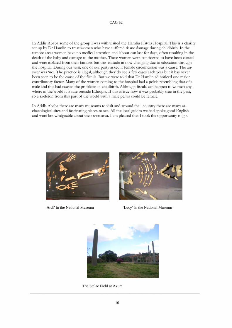
I WENT TO SEE ‘LUCY’ IN ETHIOPIA Mary Coe In November 2010, I took a holiday in Ethiopia, for 2½ weeks. This was after the rainy season, although we did have rain on some days. Ethiopia had not suffered the drought which had affected neighbouring Somalia, and the farmers were seeing good crops. The holiday began in Addis Ababa and after a few days there we left to see more of the country. We flew between towns as the roads are poor and journeys which we did on a one hour flight would have taken almost two days by road. Axum was our first stop, where there is the Stelae Field. These stelae are tall columns of granite which mark the site of tombs. Some are carved with false doors and windows so that they look like buildings and the tallest is over 20m high. One, of 33m, fell while it was being erected in the 3rd century and it now lies in pieces on the ground. It is possible to visit the tomb whose entrance is close to the base of this stela. It has a long corridor with small rooms off it. Near the field there is the complex centred on the 4th century Church of St Mary of Zion. Within this complex there is a chapel said to contain the Ark of the Covenant. According to the legend, the Ark was taken from Jerusalem by Menelik, the son of King Solomon and the Queen of Sheba, who was Ethiopian. In the hills above Axum there are the excavated tombs of King Kaleb and his son King Gebre Meskel. These tombs date to the 6th century and each contains several rooms, one of which contains an unopened sarcophagus. The following day we flew to Lalibela and spent two days visiting the eleven rock-hewn churches. These date to the 12th century and many are still in use. We also visited two monasteries outside the town both of which had been built into caves. One afternoon I joined a small group to go up a mountain to see a church. Most of the way up we were riding mules but in places we had to get off and walk. This was hard work as the church was at an altitude of about 4000m. Another flight took us to Bahir Dar, by Lake Tana. There were no archaeological sites to visit, but we did walk from a nearby village to a waterfall which is the source of the Blue Nile. This is the second highest waterfall in Africa and was worth seeing, although the water was brown with mud. We left Bahir Dar on a small boat which took us across the lake, stopping at two islands on the way. At the northern end of the lake we left the boat at Gorgora and our coach took us into Gondar. Here there is a Royal Enclosure, containing castles built in the 17th century by the Emperors, each one building him-self a new castle. Near Gondar is Kusquam where there are the ruins of a palace built in the 1730’s for the Empress Mentewab after she was widowed and was acting as regent for her son. Gondar, Lalibela and Axum were all featured in Current World Archaeology No. 47 and there are photo-graphs of the places I visited. After these visits we returned to Addis Ababa for one night before travel-ling south into the Rift Valley where there were no archaeological visits but we did take a boat out on Lake Awassa to see some hippos. The holiday then ended with more time in Addis Ababa. While in Addis Ababa, we visited the National Museum, and began our tour in the basement. Here there are exhibits from the Rift Valley dating back millennia to the time when the area was lush and stone tools have been recovered. In a small room there is a display case containing the skeletal remains of ‘Ardi’, who was a hominid of the species Ardipithecus Ramidus. She had lived in the Afar region of Ethiopia about 4·4 million years ago. The surviving bones had been laid in the correct position. In the next room there were the remains of the more famous ‘Lucy’. Her remains had also been laid for display and there was also a model showing how her complete skeleton would have looked and how she would have stood. Lucy was of the species Australopithecus Afarensis. The remains were found in the Afar region, where the bones had been buried in the sand. She lived about 3·4 million years ago. Her brain was very small, but the bones show that she walked upright and stood about 4ft tall. A further skeleton was found in 2000 in Ethiopia but it was not on display as the bones are still being researched although they have been dated to around 3·3 million years ago. This was a baby and has been given the name ‘Salem’. And now, something for archaeologists to think about if they have to determine the sex of a skeleton from Abyssinia or the surrounding countries.
10
CAG 52
In Addis Ababa some of the group I was with visited the Hamlin Fistula Hospital. This is a charity set up by Dr Hamlin to treat women who have suffered tissue damage during childbirth. In the remote areas women have no medical attention and labour can last for days, often resulting in the death of the baby and damage to the mother. These women were considered to have been cursed and were isolated from their families but this attitude in now changing due to education through the hospital. During our visit, one of our party asked if female circumcision was a cause. The an-swer was ‘no’. The practice is illegal, although they do see a few cases each year but it has never been seen to be the cause of the fistula. But we were told that Dr Hamlin ad noticed one major contributory factor. Many of the women coming to the hospital had a pelvis resembling that of a male and this had caused the problems in childbirth. Although fistula can happen to women any-where in the world it is rare outside Ethiopia. If this is true now it was probably true in the past, so a skeleton from this part of the world with a male pelvis could be female. In Addis Ababa there are many museums to visit and around the. country there are many ar-chaeological sites and fascinating places to see. All the local guides we had spoke good English and were knowledgeable about their own area. I am pleased that I took the opportunity to go.
‘Ardi’ in the National Museum ‘Lucy’ in the National Museum
The Stelae Field at Axum
_______________________________________________________________________________________

11
CAG 52
THE ARMY BICYCLE John Moore
Whilst enjoying a lunchtime sandwich in the porch of St. Peter’s Church, Great Totham, my eye was caught by the Roll of Honour displayed on the wall. Intrigued by the entry relating to the Essex Cyclist Battalion, I decided to investigate this unusual, and little-known, branch of the armed services. (N.B. The cross prefacing the entry for Pte. G.W. Dickerson denotes ‘killed in action’.) The first recorded use of bicycles in a military context was during the Franco-Prussian War of 1870. In 1885 the British Army began using cyclists as scouts during manoeuvres and during the next few years some Volun-teer Battalions set up cyclist sections whose brief was to defend England should an invasion occur. The first complete bicycle unit (the 26th Middlesex Rifle Volunteers) was formed in 1888. In 1896 a Frenchman, Cap-tain Gerard, invented a folding bicycle that could be carried on a soldier’s back.
The folding Army bicycle of 1896 The British Army bicycle of 1901 However, the role of the military bicycle was to change significantly during the Boer Wars when cyclists were used effectively for reconnaissance and by couriers, cycles being lighter, quieter, and logistically much easier to maintain than horses. By the start of the 20th century there were some 8000 cyclists in various Companies and Volunteer sections. Following the Boer Wars, Sir Richard Haldane (the Secretary of State for War) made a number of reforms to the British Army. One result of this was the creation of the Territorial Force (the fore-runner of the Territorial Army) by combining the Volunteer units with the Yeomanry. In 1908, nine Battalions of cyclists were formed – one from the 26th Middlesex, five from volunteer Infantry Battalions, and three newly raised, including the Essex and Suffolk Cyclist Battalion. The British Army bicycle was designed to enable the rider to travel as a self-contained one-man fighting unit. Everything he needed could be stowed away on the machine, from his rifle to his cape and ground sheet. A small kitbag carried behind the seat held rations and personal items, and an emergency toolkit hung from the crossbar. Some members of each Battalion, known as ‘Cycle Artificers’, were specially trained as mechanics to maintain the machines. The bikes had some obvious military advantages – they were cheap to manufacture and cycling troops could move far more quickly than those on foot. Unlike motorized troops, they were quiet and weren’t dependent on fuel supplies. Among their disadvantages were their limited cargo capacity, their need for smooth terrain and the vulnerability of their riders. In 1910, the Essex and Suffolk Cyclist Battalion split into two separate Battalions – the ‘8th (Cyclist) Battalion (Territorial Force), The Essex Regiment’ and the ‘6th (Cyclist) Battalion (Territorial Force), The Suffolk Regi- ment’. The Essex Battalion had its headquarters at Wivenhoe, moving to Southminster in 1917, whilst the Suf-folk Battalion was based in Ipswich. On the eve of the First World War the Territorial Force stood at a strength of fourteen cyclist Battalions, ten being Territorial Battalions of regular infantry regiments, whilst four – the Huntingdonshire, Highland, Northern and Kent Cyclists – were independent battalions without regimen-tal affiliation. In late 1914, the Army Cyclist Corps was founded to encompass these battalions; it was

12
CAG 52
later extended to cover around 15 more battalions, raised from yeomanry regiments which had been converted to cyclists. The following year there was an intensive recruitment campaign. Examples of the recruitment campaign of 1915
The British Army Bicycle of 1915 The Army Cycling Corps badge
As a result of this campaign, two more Essex Cyclist Battalions were formed in Colchester, the first being based initially at Clacton before moving briefly to Manningtree and then returning to Clacton, and the second staying in Colchester before being disbanded a year later. Although Private Dickerson was listed as ‘killed in action’ I have not yet found any record of an Essex Cyclist Battalion serving overseas, their main roles being to patrol the coastline and man lookout posts.
During the First World War, cycle-mounted infantry, scouts, messengers and ambulance carriers were widely used by the British, French, German and Italian armies. In the British army, cyclists were attached to various regiments to survey the roads ahead of foot soldiers, with cavalry surveying the open ground, and the first units were posted to France, Flanders and Gallipoli in 1915.
13
CAG 52
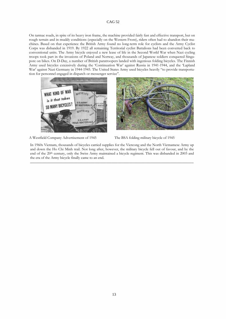
On tarmac roads, in spite of its heavy iron frame, the machine provided fairly fast and effective transport, but on rough terrain and in muddy conditions (especially on the Western Front), riders often had to abandon their ma-chines. Based on that experience the British Army found no long-term role for cyclists and the Army Cyclist Corps was disbanded in 1919. By 1922 all remaining Territorial cyclist Battalions had been converted back to conventional units. The Army bicycle enjoyed a new lease of life in the Second World War when Nazi cycling troops took part in the invasions of Poland and Norway, and thousands of Japanese soldiers conquered Singa-pore on bikes. On D-Day, a number of British paratroopers landed with ingenious folding bicycles. The Finnish Army used bicycles extensively during the ‘Continuation War’ against Russia in 1941-1944, and the ‘Lapland War’ against Nazi Germany in 1944-1945. The United States Army used bicycles heavily “to provide transporta-tion for personnel engaged in dispatch or messenger service”. A Westfield Company Advertisement of 1945 The BSA folding military bicycle of 1945
In 1960s Vietnam, thousands of bicycles carried supplies for the Vietcong and the North Vietnamese Army up and down the Ho Chi Minh trail. Not long after, however, the military bicycle fell out of favour, and by the end of the 20th century, only the Swiss Army maintained a bicycle regiment. This was disbanded in 2003 and the era of the Army bicycle finally came to an end. ______________________________________________________________________________________

14
CAG 52
NOTES ON THE RE-EXCAVATION OF THE LONGINUS SITE, BEVERLEY ROAD COLCHESTER 1996-1999 John Mallinson, Stephen Benfield, Denise Hardy and Michael J Matthews Abstract In 1996, CAG, led by James Fawn, were given the opportunity to re-examine the site off Beverley Road, Colchester where, in 1928, the tombstone of Longinus had been found. As a result of the ex-cavation work carried out, several pieces missing from the tombstone, including most importantly the head of Longinus himself, were recovered and have now been restored to the monument in Col-chester Castle Museum. Unfortunately James Fawn died before he was able to complete a full archaeological report on the excavations. The surviving archive from the excavation, comprising plans, drawings, photographs and finds, but crucially not personal notebooks, were passed to CAG on James’ death. This archive has now been re-examined by surviving members of the excavation team, and these notes report their recollections and findings. Most importantly, the archive provides convincing evidence that, contrary to the currently widely held view, the missing pieces from the tombstone were not removed as a result of defacement during the Boudiccan revolt. Their relative positions in the ground strongly support the view that they only became detached after the monument had fallen to the ground where it was found in 1928. The notes also include observations on the alignment of the main London to Colchester Roman road, on two inhumation and two cremation burials found within it, and on a strange monumental plinth found alongside it. A representative selection of some of the more interesting items of pottery found on the site were examined by Stephen Benfield of CAT, and his report is included in the notes. The full notes are available in the digital version of this bulletin, and on the CAG website at caguk.net. ______________________________________________________________________________

15
CAG 52
THE PINK, COPFORD, ESSEX: A MEDIEVAL THATCHED COTTAGE Richard Shackle with Dave Stenning The Pink is a timber framed house with an oak frame, wattle and daub and a thatched roof. It is close studded with external tension braces on all four elevations (Figs 2, 3, 6 and 7). It is one of the few large medieval houses in Essex which is unjettied. It has a standard medieval house plan, hall, parlour and service end (Fig 1) with some unusual fea-tures. During the day the hall was the place where everybody ate and public business was conducted. At night everybody slept in the hall except the householder and his family who slept in the parlour. The open hall would have been a large smoky room with central hearth and smoke would have es-caped through the thatch of the roof. There may have been gablets in the roof to let the smoke out as seen in the reconstruction drawing by Dave Stenning. The open hall is separated from the cross passage by a spere truss (Fig 4). Between the spere posts and the side walls, slots suggest that these openings were boarded. Note that the cross passage undershoots the upper chamber of the low end. The hall windows are fragmentary but there is enough evidence to show that both the top and bot-tom halves of the hall windows had sliding shutters (Figs 2 and 3). The hall windows are much more central to the hall than is usual, they are normally nearer to the high end bench and table. This cen-tral position may have made it easier to control the smoke of the fire using three shutters of the hall windows. The top plate of the hall bay has a halved and bridled scarf joint. At the high end (north) the parlour wall would have had a bench and draughts screen attached to it; however there is no evi-dence of peg holes to support the bench or draught screens. This wall (Fig 5) had two doors entering the parlour, the one to the west of the bench probably was the entrance to stairs to the solar above, the door to the east probably led from the hall into the parlour. The parlour was the private family room of the householder. The parlour had four windows, a single diamond mullion window in the east and west elevations and a pair of two diamond mullion win-dows, one on each side of the central post in the north elevation. In each window the two mullions are offset to the west leaving a bigger gap to the east. These gaps enabled people sitting in the east side of the parlour to see people approaching the front of the house. The upper room of the high end probably had a stair trap coming up from the hall in the south west corner. There were three windows, the ones on the east and west elevations each had a single diamond mullion, while the one on the north elevation (Fig 6) had two diamond mullions. The mullions themselves had disappeared but the shutter runner showed that there was room for two mullions.
The north elevation (Fig 7) had a pair of two mullion windows on either side of the central post. This means that the room above the service end had more light than the room above the parlour end. In the medieval period there would have been an outside detached kitchen but no evidence of this survives.
The service end, which was usually used for storing food, has a much more complicated plan than usual. The original joists in the service end have been replaced, so it is not possible to say where the two service doors would have been. It is suspected that the service end was divided in two by a par-tition giving a larger and smaller service room. Figure 1 shows where the two service doors may have been. On the west elevation, near the corner, there is a door entering the service room. This door was either a second entrance into the smaller service room, or more likely (as it opened out-wards), a door to stairs leading to the room over the service end. This upper room could either have been used as a store room with outside access or as a room which could be used separately from the rest of the house, perhaps as a meeting room etc. As all the joists in the low end have been re-placed we cannot tell if there were any stair traps from the two service rooms to the room above. The room(s) above the service end had three windows. In the east and west elevations (Figs 2 and 3) there are small windows each with a single diamond mullion.

16
CAG 52
The house has had several later alterations. In the 17th century a brick chimney stack was built in the hall against the hall/parlour wall. This may have blocked the door to the stairs to the room over the parlour. Perhaps at the same time, an inserted floor was put in the open hall. This inserted floor seems to have been in two parts, divided by an east/west beam two foot six from the parlour wall. This beam, which was chamfered on its soffit except in the north west corner, may have supported a smoke bay. At some stage, perhaps in the 18th century, an addition was built along the middle of the west elevation blocking the hall window. This addition was mainly to provide room for a new less steep staircase and a new kitchen/scullery. In the 19th century a single storied addition was added to the north elevation. This addition was built of very flimsy timbers some of which still had their bark on them. I should like to thank Dave Stenning for his help and advice and for providing the reconstruction drawing of the house as it may have looked when first built _____________________________________________________________________________.

17
CAG 52
Fig. 1 The Pink, Copford: plan of ground floor with joists
Fig. 2: The Pink, Copford: front elevation from outside

18
CAG 52
Fig, 3 The Pink, Copford: rear elevation from outside
Fig. 4: The Pink, Copford: low end, spere truss

19
CAG 52
Fig. 5: The Pink, Copfotd: truss between hall and parlour
Fig. 6: The Pink, Copford: high end, end truss from inside

20
CAG 52
Fig. 7: The Pink, Copford: low end, end truss from outside
Fig. 8: The Pink, Copford: reconstruction of rear by Dave Stenning

21
CAG 52
CHARLES HEATH’S WEAVING LOOM TOKENS OF 1794 Francis Nicholls
Like many late 18th century cloth manufacturers, the Colchester baymaker Charles Heath was finding trading extremely tough due mainly to the decreasing demand for his particular cloth. However this problem was exacerbated by a national shortage of small denomination coinage. This resulted in many traders, particularly in the provinces, having real difficulties conducting their day-by-day retail transac-tions and also giving rise to problems like paying wages and bills. How had this situation come about? In 1775 the British government decided to discontinue the mint-ing of low-value copper coins.. The reason for this was the huge amount of counterfeit coinage in cir-culation. New coins were being quickly melted down by counterfeiters to produce lightweight pennies and half pennies which quickly lost the trust of the public. (This shortage of small change has much similarity with the period around the Civil War in the mid 17th century when traders also took to issu-ing their own money tokens). Shortages however often bring business opportunities and in this case the opportunist was the Parys Mining Company in Anglesey. The company had a good supply of copper and also access to coin presses. In 1787 they began minting penny and halfpenny tokens. The weights of their tokens were meticulously in line with the former national coinage and the quality of their designs was of a very high order and very hard to replicate. In addition, many of them had edge inscriptions, often with trading or even political slogans. The new tokens quickly gained public confidence and were readily accepted as a reliable source of small change which could be trusted and for ten years (1787 to 1797) these were the only small ‘coins’ in circulation. However by 1795 new tokens were being over-produced and the quality of the minting had deterio-rated to an unacceptable level. The government again stepped in and in 1797 issued new heavyweight penny and two penny coins. At this point the production of copper tokens came to an official end. Clearly by 1794 Charles Heath must have realised that to alleviate at least one of his business problems he simply had to have small denomination coins to facilitate day-by-day trade. His very finely designed halfpenny token on one side shows Colchester Castle with the date 1794; on the other, a weaving loom with the legend ‘SUCCESS TO THE BAY TRADE’ . Along the edge was the inscription ‘Payable at Charles Heaths Bay Maker Colchester X’. ________________________________________________________________________________

22
CAG 52
REPORTS OF LECTURES BETWEEN ROMAN AND SAXON LONDON Alison Telfer, Project Officer, Museum of London Archaeology 17th October 2011 Report by Sylvia Skinner A detailed account of the finds and subsequent interpretation from archaeological fieldwork un-dertaken between 2005 and 2007, during the £36 million redevelopment of St. Martin-in-the-Fields church in Trafalgar Square, City of Westminster. It was already known that a church had existed on this site since 1222, at least until late medieval times literally isolated ‘in the fields’, on a hill, on a bend in the River Thames, and well outside the known limits of Roman London. The renewal project encompassed the crypt, a row of buildings and the provision of significant new underground spaces, thus allowing considerable excavation in what must surely have been one of the most challenging, inspiring and cramped digs to afford a glimpse of Roman and Saxon London. A summary of finds from the 1st – 8th centuries included: the earliest building recorded from the time of the Roman conquest (possibly a Roman look-out point, although traces of loomweight and grain suggest domestic /Iron Age farm); a C3 road; several late Roman burials (latest rc dated 410 AD, making the deceased the latest securely dated Roman to be found in London); two C5 Roman kilns (last firing dated between 400 and 450 AD, making it the latest known Roman struc-ture in London); other C5 burials; a C6 oven with C6 and C7 buildings (rooms, possible smithy); C7 burial with grave goods, and C8 domestic rubbish pits and wells. Interpretation leans towards the possibility of burials and settlement forming around the graves of saints and martyrs (evidence elsewhere for this practice). Finds evidence suggests temporary visit-ing, as at a shrine, not domestic habitation. Furthermore the prominent site is along a known Ro-man road (the Strand) leading to Silchester. Evidence for C4 remains in Westminster is rare; conti-nuity into C5 anywhere in London is rare; C7 reverence for a site is a definite possibility, acknowl-edging a known history of high status Roman burials. The recovery of fragments of glass from all periods suggests that further Roman, C5 and C7 graves did exist. The evidence for C6 construc-tion at the Northern edge of the site ties in with development found on other sites to the immedi-ate North. This sequence of finds forms a transition from Roman to Saxon which is very rare in London: traditional thought has separated Londinium from Lundenwic by 200 years and 2 kilometres. The evidence from St. Martin’s suggests some continuity, at least in this part of Westminster. ________________________________________________________________

23
CAG 52
DECORATIVE BRICKWORK Peter Minter, Bulmer Brick and Tile Co. 24th October 2011 Report by Barbara Butler The Bulmer Brickworks is located on Rhine estuarine mud which yields a clay seam. The Minter fam-ily started the business in 1936. Flints, spearheads, axe heads and arrowheads had been found on the site. In the 1950s, 160 acres were ploughed up for sugar beet and broken and damaged urns were dis-covered. A 3,000 year-old Belgic hand-thrown burial urn was identified by Rex Hull. A new kiln for the brickworks was constructed about 10 years ago, before which an excavation yielded quern stones, loom weights and a medieval tile kiln, which was dated by Cambridge University to 1450. It was an up-draught kiln with clods of earth round the outside, which would have been pulled apart and reloaded. It had been built from unfired tiles and the firing made it permanent. Excavations also revealed traces of a Roman villa site, on which vines and hops had been cultivated. In the 1940s, Peter Minter's father had been keen to make pots on the site and set up a small pottery in 1943, which attracted skilled potters who had studied under David Leach and Michael Cardew. The site at Bulmer is 260 ft above sea level, yielding 30 ft of clay, which is dug out in September. The site has 3 ft of top soil and the clay is underneath a sandy clay loam and there are few impurities. This is due to the estuary drying out. The waste material at Bulmer is crushed and sold as a lime mortar which sets in water. 1,000 tons of clay is dug in a year, enough for three brick makers to have a supply left soaking. This is then put into a machine and extruded for the brick makers. All bricks are hand made to imperial sizes. The standard Bulmer brick is 9 inches with a three inch rise. Sand is used to stop the damp clay sticking to the bench or to the mould. The works produces 3,000 bricks a day. The finished bricks are taken by bar-row from the maker to the drying ground, where there will be about 80,000 bricks drying at any one time. Each brick is turned for drying. The bricks are made 12 per cent oversize to allow for shrinkage in drying. Peter Minter explained how the Bulmer brickworks achieves an exact replacement for repairs to his-toric buildings, for instance the firm can replicate 16th century terracotta, which was first commis-sioned by Cardinal Wolsey, and Henry Vlll continued to use it. After the Reformation, these bricks were no longer in demand, and the Italian craftsmen who were skilled in making them returned home. They were later replicated by English craftsmen in the 19th century Gothic revival. The brickworks often has to create special moulds for specific jobs, for instance gate piers on historic estates. There were some fancy brick moulds from the 19th century stored in the Second World War in a gas mask testing shed in Castle Hedingham. Although the shed burned down, about 70 of the moulds were saved. The works now stores about 7,000 special moulds, many made for a specific repair or renova-tion. In 1936, the works used updraught kilns and this was the main kiln up until the Second World War. The same firing techniques were used from 1450 until 1939 until the Bulmer kilns were modern-ised by Peter Minter's father to be better insulated and have a better draught control. Bulmer bricks can be seen in renovations of Roman brick in the Balkerne gate in Colchester. There is possible Saxon-made brick in Trinity church in Colchester, which has also been repaired by Bulmer. There are Cister-cian moulded bricks at Bradwell juxta Coggeshall from circa 1130. The Cistercian monks brought the skills of brick making back into the British Isles. St Gregory's church at Sudbury has been repaired by Bulmer brickworks and also the gateway to Simon of Sudbury's college, which is all that remains of the original college buildings. The "diaper" pattern of brick, for instance found in Wormingford, and Hadleigh (1490/92) and the chimneys at Layer Marney have all been repaired by Minters of Bulmer, which also provided bricks to the toilet blocks, which won an award. Peter Minter then explained how potash glazes can give a huge range of colours. Seaweed, he told us,

24
CAG 52
was a good source of potash. Dark bricks were required by Bruisyard in Suffolk and Hampton Court. These days, weathered bricks are cleaned rather than replaced. He explained that it was only part of a renovation project to make the bricks. A skilled brick layer was needed to lay them and one particular project he mentioned in this connection was Queen Anne's summer house at Shuttleworth, which is owned by the Landmark Trust. This had a fine pattern of bricks all repaired and relayed by a skilled woman, Emma Simpson. Bulmer Brickworks can boast repair, renovation, refurbishment and exten-sion projects which are seen by many hundreds of people daily. A local example is the repair of Bury railway station Perhaps the most spectacular example is St Pancras railway station and station hotel. The gothic architecture was famously saved by John Betjeman. Now, with the combined expertise of architects, English Heritage and Bulmer Brickworks, St Pancras has been renovated and extended to be a fine example of spectacular railway architecture. It is also an important international transport hub, through which thousands of passengers pass every day. _______________________________________________________________________________
THE STOCKWELL ARMS: AN ANCIENT BUILDING REVEALED Richard Shackle, Buildings Recorder 31st October 2011 Report by Mary Coe Richard began by ensuring that we all knew where the building was. He then gave us a brief history of the building and how he came to record it. The Stockwell Arms had been a popular pub but went into decline and finally closed six years ago. After a couple of years of neglect the building was bought by a developer who intended renovating the building. Richard was asked to analyse and record the struc-ture. Richard then ensured that we all knew the basic plan of a medieval house. The Stockwell Arms con-sisted of one house and the attached cross-wing of a second house, the rest of which had been demol-ished. The two houses were built in the late 14th century or early 15th century. In both of them the cross passage is under-shot, in that it is part of the service wing, under the upper storey and not part of the hall. In the southern house, the front room of the service wing was a shop, with a service room behind it. The cross-wing at the parlour end of the northern house is jettied on two sides. Richard then went through the Stockwell Arms area by area. The hall of the southern building was demolished in about 1800 and gates were placed across the gap. The parlour wing was demolished in about 1890. At some point in the 1600’s a floor was added to the hall, making it two storeys. The northern house was more elaborate and probably of a higher status. At the service end, the ceiling had been lowered at some time, giving less headroom to the ground floor rooms. The earliest deeds date to the 18th century and during that time and the next century the building was mortgaged to bay and say merchants. The 1871 census lists the building as a pub. The parlour wing had moulded windows. The upper jetty beam is elaborately carved. The crown post in the roof has four solid braces. Until the 19th century the upper room was open to the roof. At the front of this floor there was an oriel window. The rear of the cross wing was unframed, probably be-cause it was up against another building. The hall has a 14th century type roof and before the 15th cen-tury it may have been an in-line hall. The service cross wing also had an oriel window and a beam shows where the original beams for the floor were cut at the time the floor was lowered. In the roof there is a crown post. Between the hall and the cross passage there is a spere truss which is a screen to exclude draughts. The valley between the service cross wings of the two houses is a weak point in which rain can penetrate. Evidence for this happening is shown by the replacement of sections of the roof timbers. The service wing of the southern house had a shop at the front and there was a spere truss between the cross passage and the hall. Behind some plaster, the wall was found to be covered in wall paper

25
CAG 52
with a Chinese pattern. In the roof there is a 14th century style joint above the crown post. The raf-ters all have carpenters marks on them. Above the spere truss there is evidence for the roof line of the hall. The upper beam had rotted in what was a weak point. In the early 20th century a ceiling was put in under the roof and part of a 16th century door was used for the trapdoor. Richard finished his talk here and then answered a number of questions. The service wing of the northern house is raised from road level, as the road slopes past the building. There is a small cellar under the wing which uses this space but it may be a later addition. Beams had been coated in red ochre which could be decorative and/or an insect repellent. On the exterior of the buildings, beams were coated in a lime wash as an insect repellent. Green timber was used in the building because it is easier to work then seasoned wood. Also, it is flexible and the joints tighten as the wood dries. Ur-ban houses are smaller than rural houses. The cross passages in the two buildings were undershot to give more space in the hall. There was no evidence for the kitchen, which would have been detached. Carpenters tools changed very little from Roman times to the 18th century. During the Middle Ages an axe was used for most of the work. Throughout his talk Richard illustrated his points with pictures of beams, joints and other features. He also showed drawings he had done of the framework of each of the walls. ________________________________________________________________________
THE FRIENDS OF FRIENDLESS CHURCHES, FIFTY YEARS ON Matthew Saunders, Director of Friends of Friendless Churches 7th November 2011 Report by Christine Gorringe
The Friends of Friendless Churches was set up in 1957 by Ivor Bulmer-Thomas, who had been an MP and was a wealthy man by means of his wife’s family, the Bulmer cider company, whose name he incorporated into his own. The Historic Churches PreservationTrust was set up in 1952 to preserve redundant churches. Ivor felt with passion that the decision of the Historic Churches Preservation Trust of which he was Chairman, to grant-aid only churches which were ‘in use’ would increase the number of demolitions and unseemly conversions. After a very public row with the Archbishop of Canterbury, he cut his ties with the HCPT and resolved to set up “The Friends”. They met in his house in London for the first 40 years, until his death in 1993, aged 88. The Friends now own 46 churches and maintain 340, a number of which are in Suffolk and Essex. They also look after Private Chapels, Catholic Chapels and a number of Welsh chapels and churches, because the Churches Conservation Trust only looks after Anglican Churches and stops at the Welsh border. After Ivor’s death Matthew took over as Director of the Friends and their base is now in St Ann’s Vestry Hall in Blackfriars, in the City of London. Funding is predominantly from church and state, plus English Heritage. Two thirds of the churches looked after by the Friends are never locked. Matthew showed a series of slides, showing some of the churches and the repairs and renovations undertaken to them. We saw Papworth St Agnes, Cambs, a flint church now in a good state of repair, moving on to St Mary’s Church in Mundon, near Maldon, a timber-framed, double storey tower, with a significant C18 Trompe L’Oeil wall painting, which cost £370K to restore thanks to a grant from English Heritage. The other church in Essex which the Friends maintain is Old St Peter’s church at Wickham Bishops. Originally built in conjunction with the Bishop of London to serve the Manorial Estates, it was mainly built of pudding stone, septaria, brick and salvaged Roman tiles. It fell into disrepair and dis-use mainly because it was cut off from the settlement by the closed Witham & Maldon rail line. Thanks to the Friends and the fact that it is now used as a stained glass workshop, it has been well restored. Robert Billio was rector here from 1658-60 and celebrated Essex historian Phillip Morant

26
CAG 52
was incumbent from 1742-5. The Friends have maintained churches in conjunction with their rela-tionships with local people, who help with maintenance and restoration of many buildings. A Strict and Peculiar Baptist chapel in Waddesdon, built by the agricultural labourers who worked on the Rothschild Estate, is now restored, as is a private Catholic chapel set up by two spinster sisters in 1937 to give spiritual repose to those traumatised by WWI, located in Gloucester, which contains some outstanding modern stained glass and was restored at a cost of £16K. Many other lovely slides of restored and preserved churches in England and Wales were shown, those with unusual sedilias, rare full-height Rood screens painted in ox blood, tomb railings, class- structured pews, tempting us to go and visit all over the country where these wonderful buildings are located. There are Arts and Crafts churches of Henry Wilson, a C14 funeral bier in a church in An-glesey, a convent chapel near Windsor, which the Friends hope to take over to stop it from being demolished in a modern housing development and a beautifully painted altar by John Coates-Carter, who helped with the 1928 rebuilding of a Medieval church in Pembrokeshire. The Friends also sponsor and purchase rare monuments and stained glass and support the Stained Glass Museum at Ely Cathedral, as well as encouraging works by modern stained glass artists. Anglican churches alone are closing down at the rate of 25 per year. A lovely book is obtainable through Friends detailing many of the churches featured in the slides. A most enjoyable and illuminating talk, particularly for those interested in church preservation. _____________________________________________________________________________
THE ANGLO-SAXON MEAD HALL Stephen Pollington, Lecturer and Author 14th November 2011 Report by pat Brown Stephen Pollington illustrated his talk with photographs taken in a reconstructed Anglo-Saxon hall near Canterbury, where enactments of feasting and entertainments were taking place. He ex-plained that, particularly before the Conversion, the mead hall was the centre not only for convivi-ality but for business and law-giving. It was a very hierarchical society and this was reflected in the seating arrangements. He then looked in detail at items in the Sutton Hoo Mound 1 burial which might have been seen in the mead hall. The drinking horns, which each held four and a half pints, would have been passed round, and every man would have had to drink and make a speech, creating bonds of solidarity. Alcohol was seen as possessing the special power to release speech. Rings were given to successful warriors and such distribution of treasure ensured the circulation of wealth. The lord also distrib-uted food from the mead hall, giving rise to the name hlaford (loaf-giver), hence “lord”. Oaths were sworn on weapons (if broken, the sword could turn against the oath-breaker). The wearer of a helmet was thought to take on the personality of a god. The richness and intricate decoration of these objects demonstrated status in a very visible way, and this was apparent at high-status funerals, when the grave may well have been left open for some tine, with the rich grave goods on display. Anglo-Saxon art of this period was deeply ambiguous: examples could be the dragon or wyrm, and the bird, probably a raven, on the Sutton Hoo shield, symbolising the lower world and the upper, paralleled by the burial rites of cremation and inhumation. Boys started to be trained as warriors at 7, they could go raiding at 15, and by the time they were 25 could settle down with land to raise a family and become lords in their turn. The gradual elimina-tion of small kingdoms in the 7th and 8th centuries could have been due to the introduction of book land, whereby land could be given in perpetuity, so that the availability of estates shrank.

27
CAG 52
Stephen Pollington attributed the end of the mead hall to Danes, the threat they posed leading to the concentration of the population in larger defended settlements. However the idea of the mead hall persisted, constantly recurring in Old English poetry. Stephen Pollington ended with a recitation of “The Ruin”, where the ruins of, probably, Bath, were seen as representing the Roman equivalent of the mead hall. _______________________________________________________________________________
NON-CONFORMIST CHAPELS IN ESSEX Rosalind Kaye 21st November 2011 Report by John Spears In her introduction Rosalind explained that the loss of chapels in Essex and interior modernisation had created a need for study and that only in the last 30 years have books been written on the sub-ject. But why were they built? Following the Restoration, Parliament debated religious issues which finally resulted in the Act of Toleration 1689. This provided freedom of worship for dissenters and permit-ted the building of chapels such as the early chapels at Little Baddow and Wethersfield, but many people continued to worship on farms and in barns and private houses. Emphasis in the chapel was on the pulpit; Rosalind defined the difference between church and chapel as the church is the house of God whereas the chapel is for the people of God. Under the Act preachers and places of worship were registered. Dissenters could not attend Univer-sity yet still had to pay church rates. This resulted in the setting up of Dissenting Academies. Chapels usually had two entrances. In the late 18th to early 19th century John Wesley was keen on chapel building, he adopted the octagonal plan but expansion could only be upwards so the square chapel evolved which could be extended as congregations grew. Examples illustrated were of Man-ningtree (1823) and Thorpe-le-Soken. The Evangelical Revival in the 19th century led to a change in building design. Following the creation of Dissenting Academies, which led to an educated clergy, building in the classical style evolved. Examples illustrated were Braintree chapel and Chelmsford London Road chapel which could accommodate a thousand worshippers. Earlier chapels were re-built, such as Castle Hedingham (1842) and Wivenhoe. Later, new chapels were built in the Gothic style which paralleled Church of England building practice. Examples shown were Colchester Lion Walk and Hatfield Heath. Village chapels were discussed, such as the Peculiar chapel at Tillingham (1897) and Coggeshall Li-brary (formerly the Quaker Meeting House), St. Osyth’s and Cooks Mill, near Chelmsford. Rosalind described further chapel characteristics, such as how pews were rented out, how non-alcoholic wine was used at communion and served in small individual cups to avoid infection. Um-brella stands were common, pews were often numbered and Baptists practised total immersion in baptism. An example of a bath at Clacton was shown. Foundation stones were often laid by impor-tant people who often gave large donations towards the chapel. Non-conformist numbers peaked between 1900 and 1910. There was then a gradual decline in wor-ship and many chapels closed. After building restrictions were lifted, following World War II, many surviving chapels were rebuilt or updated. The single aisle format was generally adopted. It was more convenient for weddings and funerals. As congregations declined, many sects had to share chapels. However, Lion Walk in Colchester let out buildings to commercial outlets, thus providing an income and ensuring survival. ______________________________________________________________________________

28
CAG 52
WHERE HAVE ALL THE PEOPLE GONE? A PUZZLE FROM LATE IRON AGE ESSEX Paul R. Sealey, Curator of Archaeology, Colchester and Ipswich Museums 28th November 2011 Report by Jean Roberts At the beginning of his talk Paul Sealey told us that several of his friends had called his theory “crackers”, but we could make up our own minds. Something happened in Essex between the Middle and Late Iron Age, as the number of houses that are found from that period drop dramatically, by 50% - 75% in some cases. Usually the houses from this time are round houses, surrounded by drip gullies. However, at some sites traces of rec-tangular buildings built on sleeper beams have been seen, leaving hardly any traces except for some artifacts to date them. Does this mean that in Essex, round houses went out of fashion, to be replaced by rectangular ones, which haven’t been recognised? Several local sites had thriving Middle Iron Age settlements, which seem to either disappear or have fewer inhabitants in the Late Iron Age. Sites such as Little Waltham, St Osyth, Slough House Farm, Heybridge and Uphall Camp in East London bear this out. Excavations in Colchester over the years have produced little signs of Late Iron Age activity. All these facts point to a big drop in population, county wide, but no specific reason can be found. Was it disease, mass exodus, climate change, slave trade, or warfare? Frustratingly, no one knows. _____________________________________________________________________________
RECENT ARCHAEOLOGICAL EXCAVATIONS ALONG THE ABBERTON PIPELINE Nick Finch, Archaeological Consultant for the Abberton Pipeline 5th December 2011 Report by Keith Amery On Monday 5th December the Colchester Archaeological Group welcomed Jim Jenkins from Essex and Suffolk Water and Nick Finch, archaeological consultant, to talk about recent finds along the Ab-berton pipeline. Jim Jenkins set the background for the recent archaeological intervention, explaining how Essex and Suffolk Water had commissioned the archaeological survey to coincide with the Cley Ouse to Essex Transfer Scheme. He explained how Abberton is one of two main reservoirs serving the area (the other being Hanningfield) and how 16 kilometres of transfer enhancement had been planned and executed between Wormingford and Abberton. After this short introduction, Nick Finch, the archaeological consultant was introduced to talk about the finds made along the route of the proposed pipeline. He thanked the contractors and explained how the large scale team of field workers had been provided by Oxford Archaeology Cambridge unit following successful tender for the contract. He then went on to introduce the four main stages of the process: Desk based assessment; Geophysical survey; Fieldwalking and Trial trenches. He explained there were two routes for the pipeline, a northern (Suffolk) and a southern (Essex) route, apologising that the most interesting finds had occurred in exploring the northern route through Suffolk. Out of 37 areas of archaeological interest discovered in the course of exploration, only 8 were located in Essex covering all historical ages from the Bronze Age to Victorian. The Fieldwork season lasted from January to July 2011 and uncovered evidence of Iron Age settlements at Stanway and Staunch Farm and Bronze Age remains at Wormingford. The northern route revealed hitherto unknown flint

29
CAG 52
mining south of Kedington and a Bronze Age cremation cemetery at Great Wratting. The main fo-cus of the lecture was however, on the Roman town of Wixoe, one of only eight town sites known. The villa had been discovered in World War II but the five months of investigative archaeology re-vealed significant finds, identifying the town’s outer ditch, Roman roads and structures parallel to the roads. Amongst half a ton of pottery found in rubbish pits were a number of complete vessels, leading to lively and speculative debate amongst the presenter and members of the CAG group as to the identi-fication of these sites as rubbish pits. Nick Finch pointed out the amount and range of pottery will be important for the ongoing study of trade and local industries . A unique bone pin bearing the im-age of a dog or horse was held up as a significant find amongst the small objects recovered, including c. 100 Roman coins important to the dating of the site occupation. 2 Roman inhumations found in-side the town walls were also the focus of lively debate. Nick went on to discuss the geoarchaeology of sites dating from the 8th to the 13th centuries focus-sing on the landscape of the river Stour, highlighting a lack of archaeological data from rural Essex. He explained how the pipeline had helped to locate settlements showing the landscape was widely used from the Bronze Age onwards. The talk ended with reassurance that the first assessment report of the archaeology of the Abberton pipeline will be published in the Spring of 2012 as well as other information booklets which will be made available for both children and adults. It was also suggested a detailed academic publication of the archaeology of the pipeline would be forthcoming in due course. Lively discussion and several questions followed the main presentation which raised further ques-tions and points of interest, not least of which was the presence of Samian ware from Gaul amongst local wares which should help with the dating of locally produced pottery. 2000 Flints recovered from the stream bed were also mentioned as a major contribution to the further study of the Neo-lithic occupation. Of course most questions raised involved people’s private concerns regarding the impact of the pipeline on their homes and environment. Jim Jenkins stepped in to explain that the Abberton pipeline project is subject to an Environmental Impact Assessment and just part of a 25 year plan to ensure the provision of water supplies to Essex and Suffolk. It was agreed the £1,000,000 investment in archaeology out of the £150,000,000 budget had been a worthwhile invest-ment. ______________________________________________________________________________
HADRIAN'S WALL SOUVENIRS AND OTHER ROMANO-BRITISH ENAMELLED PANS Ralph Jackson, Senior Curator, British Museum 16th January 2012 Report by Richard Shackle There are four enamelled pans which definitely seem to represent Hadrian's wall. They are all bronze with a diameter of 90mm and a capacity of 160ml. The Rudge cup was found in Wiltshire in 1725. At the base are two rows of squares, above which are alternating squares and crescents The large squares are divided into four small squares with crenella-tions on top. The pan is enamelled in red, blue and green. Just below the rim is an inscription in moulded relief. .A. MAIS ABALLAVA VXELODUM CAMBOGLANS BANNA This is a list of Roman forts at the west end of the wall. They are Bowness on Solway, Burgh by

30
CAG 52
Sands, Stanwix, Castlesteads and Birdoswald. The Hildenburgh fragment was found in Spain in 1935. It is decorated in a similar manner to the Rudge cup with squares and triangles but the inscription does not survive. The Amiens cup was found in France in 1949 in the ruins of a Roman house. It has similar elements of squares and crescents to the Rudge cup and is enamelled in red, blue and green. The handle was found separately from the bowl. The inscription names the same forts as the Rudge cup plus an extra fort called ESICA, which is thought to be Great Chesterford. The Ilam pan was found in Staffordshire in 2003. The decoration is quite different from the other cups and consists of evenly spaced roundels enamelled in red, blue, green and yellow. The inscription is as follows: RIGORE VALI AELI DRACONIS MAIS COGGABATA VXELODUNUM CAMMOGIANNA The named forts are the same as before with the addition of COGGABATA which is Drumburgh. The first few words before MAIS may mean “from the line of the frontier” and Draconis may be the person for whom the cup was made or presented to. Several other pans related to the above have been found at the sacred spring at Bath, Braughing, Malt-bec in Denmark and Winterton in Lincolnshire. Other Roman souvenirs celebrate the Circus Maxi-mus and famous charioteers. ______________________________________________________________________________
b
MEMBERS’ ACTIVITIES – THE WORMINGFORD HISTORIC LANDSCAPE PROJECT 23rd January 2012 Report by Rosemary Joseland Howard Brooks began the evening, which took the form of a series of seven mini talks, taking in all aspects of the Wormingford Historic Landscape Project, by summarising what evidence had been found of the pre-historic to Roman periods. He referred to evidence of crop marks and mentioned that much of the field work had been done, with reports coming out soon. There had been, he said, finds in the form of pottery, barrows, flint and coin, as well as the Bures Cursus, a ritual monument, which dated from the New Stone Age, 3,000 BC. There were also crop marks, showing the existence of the great mound of Wormingford and further crop marks at Wormingford Mere, with a third set in the area of Smallbridge and Bowdens. All the important and interesting landscape material, Howard said, pointed to a large population of people living in the area now occupied by the Church, which has Roman brick and tile evident, and he concluded his introduction by saying that he hoped that he had given a glimpse of the landscape and evidence of activity in Wormingford, up to the Roman period. The second mini talk was given by Pat Brown and was entitled ‘Anglo Saxon to Domesday’. Pat said that, in fact, there was virtually no evidence to be found, but a Viking axe head had, at one time, been discovered but subsequently lost! It is hard, Pat acknowledged, to find Saxon pottery, or Saxon structures, being made of wood. At least one person is known to have lived in the area, that person being Withermond, from whom the name of Wormingford derives. The settlement would have been around where the church is and along the main north-south and east-west lines of communication, the river also being an extremely important means of communication. Nearby, of course, are Nayland, and Bures where King Edmund is thought to have been crowned. There might well have been a Saxon church on or near the site of the present one. The Domesday survey of 1086 would have been compiled by Norman clerks and possibly not completely accurate. There was mention of villeins,

31
CAG 52
bordars and slaves, on the demesne, and the presence of all sorts of animals, as well as a beehive and fishery. Use of the word ‘butt’ could indicate the presence of open fields and it will be seen later how the study of hedgerows helps to identify field systems. Woodland, which had been cleared for sheep, would have resulted in the value of the manor increasing significantly. John Moore than took the floor to introduce the study of Domesday to the present day, as revealed in documents. In 1377 Richard II had levied the first Poll Tax, which included everyone from the age of 14, and in the 14th C the population numbered 146. At this time there were 3 deer parks. There are still a number of properties dating from the 16th C and, as time went by, the parks belonging to Ger-nons and Wood Hall were turned over to agriculture, with a new park at Lodge Hills. The Tithe Act came in to force in the 19th C and, in 1838, the population numbered 524, in 101 households, with an average of 5 persons per household. Three of the landowners were not resident in the village, which then had 328 fields. At the end of the 19th C the population dropped, probably as a result of the agri-cultural depression. Today it is 459, with 182 households, and 2.5 people per household, with the main focus of the village having moved north/south to the main Bures Road. Next we heard from Mary Coe, who reported on the Housing Survey, which had included 57 proper-ties, including 5 which have been demolished, all having been indexed. The properties visited ranged from the church, two pubs, a large number of houses, cart lodges (one of which had a king post), farm labourers’ cottages and a ‘lobby’ house. Mary thanked Richard Shackle and the other members of the team who had been involved in this survey. John Camp then traced the history of the airfield, from 1916 when night fighters were stationed there. The airfield closed in 1919 and it then reverted to farming until the 2nd World War when it was loaned to the 9th Air Force in 1943. At this time there were a large number of buildings, including a cinema. The B51s then stationed there were involved in bombing Berlin and, in 1945, were responsible for smashing up the infrastructure. Once again, after the War, the land reverted to agriculture and now there are only a few buildings remaining, one of which is the parachute store. John showed a slide of the memorial, which remembers the 127 aircraft destroyed in the war and the loss of 97 pilots. Our next speaker was Neil Catchpole, who took us through the hedgerow survey and referred to in-formation gathered from the Tithe map and Google Earth. He mentioned how tenancy changes led to changes in boundaries and fields, with hedgerows giving shelter to livestock, which were likely to lose weight during winter. The hedges, Neil said, had a large variety of species, including ash, oak, holly, field maple, etc. He showed us slides of coppicing and pollarding, some of which examples were as much as 1000 years old and had contributed to providing food for livestock, with the timber gained from these processes being used for building purposes. Neil pointed out that hedges only survive if they are managed properly, and would survive as long as they were needed. He said that it is possible to gauge the age of the hedgerows by studying the species over a 30 m length – Hooper’s Hedgerow Hypothesis. Banks and ditches and green lanes (very ancient trackways) had also been studied and it had been noted that hedges were often planted north/south. Neil summed up by pointing out that we should now look again at determining the age of banks and other features of the landscape. The last mini talk was presented by Mark Brewster and was a way of summarising the research, bring-ing it all together using GIS mapping (Geographic Information Systems - software programmes deal-ing with map co-ordinates). Within GIS are Raster Data – grid map imaging, elevation and resistivity, and Vector Data – road, boundary recognition. The software can locate and scan the original map, show locations and define boundaries. Questions such as ‘where is the arable land?’ and ‘where is the pasture?’ are able to be pinpointed. Mark went on to refer to the website, which enables accessing landscape views by means of Google Earth and the European Space Agency, incorporating the Tithe Map. _______________________________________________________________________________

32
CAG 52
THE ARISTOCRACY OF LATE ANGLO-SAXON ENGLAND Anne Williams, Independent Researcher 30th January 2012 Report by Marc Brewster
… the English at that time, wore short garments reaching to the mid-knee; they had their hair cropped; their beards shaven; their arms laden with golden bracelets; their skin adorned with punctured designs. They were accustomed to eat till they became surfeited, and to drink till they were sick.
William of Malmesbury (c1095 - 1143)
The Anglo Saxon aristocracy are a shadowy group of people, all but wiped out following the Norman conquest of 1066. Much of the information we have about them comes from documents, such as the Anglo-Saxon Chronicle, Domesday, Land Charters and Wills. The later texts are written by the vic-tors, such as William of Malmesbury quoted above, so their view on the decadence that led to the loss of the English crown must be considered in this light. The aristocratic social structure, before 1066, was organised in a pyramid with 5 layers; at the top was the King, followed by his Earls, who administered large parts of the kingdom on his behalf. Next were the Thegns, men with land holdings in excess of 5 hides (approximately 600 acres), who also owed their allegiance directly to the King. Beneath the Thegns were a class of lesser Thegn; having similar landholdings to the former, they owed their allegiance to someone other than the King. Fi-nally, at the bottom, were the freemen or Ceorls. Children were afforded the status of their father but a title was not automatically passed down from father to son; a young man might become a Thegn, through gifts of land or inheritance of an estate; however, an Earl’s son could only gain the title by appointment from the King. A Thegn’s daughter retained the rank of Lady, independently of anyone she might marry. Abbot Wulfstan wrote much of the law codes for King Aethelred, his son Edmund, up to Cnut. In them, he attempted to define the attributes of people in these different classes and how they might move between them; in effect, a set of rules for social climbing! A Ceorl might become a Thegn by increasing his land holdings and a Thegn become an Earl by appointment of the King. At all levels, advancement was obtained through service to your overlord. Lordship and service entailed definite rights and responsibilities, for both parties. A lord was ex-pected to have a hall, provide armour for his warriors and Loan Land from which his retainers could make a living, for the duration of their service; in some cases, a widow or child might be allowed to keep this land for their lifetime. In return, a warrior was expected to provide military service, fighting in his lord’s war band, or act as bodyguard; other retainers would be expected to carry messages and possibly act as witnesses in court proceedings. The hierarchy of lordship was enshrined in the oath of fidelity, where a retainer knelt or curtsied before their Lord, with hands clasped and raised; the Lord would take their hands in his and the oath would be spoken. ______________________________________________________________________________

33
CAG 52
16 YEARS OF ARCHAEOLOGICAL EXCAVATION AT FLIXTON PARK QUARRY, SUFFOLK Sstuart Boulter, Senior Project Officer with Suffolk C.C. Archaeological Service 6th February 2012 Report by Francis Nicholls The Suffolk Archaeological Service have been working at Flixton Quarry over the past 16 years. The 40 hectare quarry site is located on the Suffolk/Norfolk borders about 4 miles SW of Bungay. The dig has produced finds ranging from 250,000 year old flints to the remains of WW1 training trenches. Commercial quarrying began at Flixton in the 1950’s and until 1996 no archaeological records had been kept. However, with the advent of PPG16 (Government advisory note re land development) archaeologists have been working on the site. The main finds have been: an early Neolithic long barrow with a central pit. There were no traces of human remains due
to the acidity of the soil. In the pit was a complete Mildenhall ware bowl together with a bead. Nearby was a rectangular Neolithic structure with an incorporated circular feature, the use of which remains unknown. The immediate area revealed a circular posthole containing cre-mated material. A pottery beaker and a good cross-section of flint tools were also excavated nearby.
14 ring ditches, most with central pits and some with human remains deep down. The largest circle had an external bank and an internal raised mound, together with a central burial. The main artifacts found were beads, amber toggles, a Beaker wrist-guard, loom weights and the most recent find has been a necklace bead.
11 Anglo-Saxon burials have been located. About 600 metres from the burial sites a two-post sunken feature building was located with greater dimensions than any of the SFB’s at West Stow.
medieval beads have been found close to the site of some other buildings with large post-holes. some of the later dated excavations remain a mystery, with suggestions such as a hunting lodge
and a windmill. the final feature mentioned by Stuart Boulter was a Bronze Age ring ditch intersected by a
WW1 training trench. Flixton Park quarry is very much an on-going site and Stuart reckoned that there is still sufficient work to keep him buy for years. Lucky man! _____________________________________________________________________________
LIFE, DEATH AND REVOLUTION: THE STORY OF A SUFFOLK VILLAGE IN THE FOURTEENTH CENTURY Jonathan Belsey, Researcher in Evidence-based Medicine 13th February 2012 Report by Beverley Smith Little Cornard is a small parish with about 400 inhabitants near Sudbury, in Suffolk, to which Jonathan (whose passion is local history) moved about 15 years ago. He showed us some helpful colour-coded slides which demonstrated its past and layouts. There were 2 medieval manors in the parish, which lies on rich farming land near the River Stour. The parish church is not located on a road, and one of the (fallacious) theories about the village is that it was abandoned after the Black Death. There is evidence of strip farming, and also of old housing in what are now fields.

34
CAG 52
Jonathan stated that pre 1250, there was little documentation about ordinary people. At this time, the feudal system was still in place; he pointed out that the simplistic model of this system (King at the top of the pyramid, followed by nobles, knights, and peasants) was invalid, and that in fact this hierarchical society also encompassed the church, and a line of command from senior to junior nobles, then to ten-ants, and thence to villeins, whom he considers to have been 'the engine of the economy' in the 14th century. The villeins were not freemen; they gave labour to the lords in return for land and food. In 1320 the second wealthiest person in Suffolk was a villein in Bury St. Edmunds. We know all this be-cause of the records kept in the manorial court rolls, which Jonathan has been able to access in both their original and transcribed forms for about 80 years of the 14th century. The originals are kept in the Norwich Record Office as Lt. Cornard was owned by Lord Walsingham of Norfolk. In the middle ages, the average land-holding in Lt. Cornard was 2 to 3 acres; the manorial court (which was not a criminal court) met every 2 to 3 months in order to deal with local disputes relating to land, rentals, taxation, heriots (inheritance matters), disputes and minor infringements. Jonathan likened the story-lines evident from perusal of the court rolls (which were recorded by a scribe brought by the lord to the court, first of all in Latin, then in French, latterly in English) to events in Ambridge. In 1328 the total population of the parish, as now, was less than 400. Villeins accounted for a large proportion of this group. Jonathan read off a rental record extracted from the court rolls; of the 19 householders then paying rent, 6 were women. There was evidence of regular local transactions such as payments to the lord at Christmas of one hen, and at Easter of one egg; of fines for trespass, of local anecdotal history encompassing small day-to-day incidents. Jonathan also spoke at length of the fascination of local names, and their derivations from places or occupations. Jonathan has also been able to trace the devastating effect of the Black Death, which arrived in England in 1347/8, on the parish. Deaths began to increase from early 1349; no manorial court was held from April to November of that year. About 45 householders in the parish died (plus, presumably, many of their relatives). One land-holding was passed on 6 times in 8 months as the family was decimated by the plague. He estimates that about 50% of the population perished. During 1350-51, lands were re-assigned, and by 1353 the court was back to its normal run of business. The feudal system fell apart as the phenomenon of social mobility exploded - suddenly the villeins had power, as the lords offered good wages to retain them, as their labour was desperately needed to farm the produce on the lords' lands.. This was a fascinating account, containing much detailed specific knowledge, of what can be learned through the rigorous study of original documents. ________________________________________________________________________________
CONQUERING THE NORTH: THE FIRST COLONISATION OF NORTHERN EUROPE 800,000 YEARS AGO Nick Ashton, Curator of Palaeolithic Collections, British Museum 20th February 2012 Report by John Mallinson Nick Ashton described the work that had been carried out over the last 12 years along the Norfolk Coast as part of the Ancient Human Occupation of Britain Project (AHOB). He stressed the world-wide importance of this project, which was giving insights not only into the earliest occupation of Britain, but also in the way early man entered and adapted to colder climates world-wide.

35
CAG 52
He began by describing the work at Pakefield, completed in 2003. Here man-made flint artefacts were found in organic rich soil at the base of the cliff, which could be dated from stratigraphic and environmental evidence to about 0.7Ma. He then went on to describe the work which continues at Happisburgh. Five sites have been exam-ined, of which the most significant has to date been Site 3, where stone tools in dark soils from an estuarine river environment have been dated by stratigraphy, palaeomagnetism, biostratigraphy and palaeogeography to either c. 0.85Ma or c. 0.95Ma. The details of this work, and all the charts and photographs used to illustrate it in the lecture, can be found on http://www.britishmuseum.org/research/research_projects/featured_project_happisburgh.aspx In summarising the findings to date, the speaker offered a tentative hypothesis contrasting the two sites. He suggested that at Happisburgh the earlier finds, dating to at least 0.85Ma, might be associ-ated with Homo antecessor, and represented a relatively primitive degree of adaptation to cold con-ditions, characterised by few and crude artefacts, substantial body hair but no clothing, no shelter or fire, and relatively few tools consisting only of crude flakes and cores. At Pakefield, by 0.5Ma, he suggested, we might be seeing Homo heidelbergensis, and a culture characterised by sustained occu-pation, a hunting lifestyle, clothing, shelter and fire, and more sophisticated tools including hand axes. Work continues at Happisburgh, in particular at Sites 3 and 5. This latter is actually out to sea, and will prove particularly challenging to the divers and specialists involved, though not, the speaker stressed, to himself. He intends to stay very firmly shore-bound. ___________________________________________________________________________
ARCHAEOLOGICAL CONSERVATION Bob Entwhistle: Senior Conservation Officer for Colchester and Ipswich Museums 27th February 2012 Report by Ellie Mead Bob Entwhistle gave us a most entertaining talk, which he introduced by defining conservation as ‘sticking things back together or making sure they don’t fall apart’. With regards repair work, every-thing has to be reversible and documented and a happy medium has to be found in knowing just how much conserving to do. The rule of thumb he uses is ‘would the object have looked like this when people used it’. Ipswich Museum is lucky enough to retain the ‘Receipt’ book of one George Nathan Maynard, a conservator who died in 1885. His receipt for a glue to mend broken china contained ‘powder of Suffolk cheese’ with the comment “the more cheese, the stronger it is”. At both Ipswich and Col-chester the collection involves a fair amount of conserving – we were treated to photos of, amongst other things, the sewing up of a zebra’s backside, Roman timbers that had been to Norway for freeze drying and Banksy’s fish fingers in a fish bowl of glycerine (impossible to conserve?)! Artefacts are moved around: celestial globes on improvised wheels trundle down the road; cut open: a 1955 can of tinned pork sausages has its contents fed to seagulls; or spat upon: the enzymes in spit are good for breaking down dirt on the surface of paper.
The 5 agents of decay were listed as damage by 1) insects, 2) water, 3) fire, 4) light and 5) curatorial ne-glect /vandalism. We were shown examples of each, from grain weevils to a painting that was left un-covered whilst the ceiling above it was painted!

36
CAG 52
The conservation team wage war on insects with sticky traps; moths are a particular problem in muse-ums at present. Infested artefacts may also be placed in the walk-in freezer, which is supposed to kill all pests, but is not always effective. UV light has to be cut out – we saw a polecat whose fur had needed re-colouring – and relative humidity is also carefully monitored. Bronze is particularly suscepti-ble to damp – a bronze key will fall apart in 5 years in damp conditions. Photos of many examples of artefacts before and after conservation were shown and admired. Museum staff clean wooden furniture with a sparing amount of beeswax polish once or twice a year, hoovers are used on low power through muslin nets to prevent parts of artefacts disappearing up the tube! A goat-hair brush or micro-fibre cloths are also used to minimise abrasion. Textiles pose particu-lar problems. They should be stored without folds as they will dry out on the fold, so clothing is pad-ded out and placed on padded hangers to stop it becoming misshapen. Large textiles may be rolled inside out and shoes are padded in acid free paper; fans should always be stored open. The speaker concluded his talk by discussing the rights and wrongs of replacement parts in an artefact. The 3ft rule was cited: ‘If you are closer than 3 ft to the object you should be able to see any replace-ments’. _______________________________________________________________________________
THE GLASS WORKERS OF ROMAN LONDON Angela Wardle, Roman Finds Specialist, Museum of London Archaeology 5th March 2012 Report by Pam Pudney The speaker stated that glass-making appears so have been a flourishing industry in Roman London. But some early glass c43 AD, dug up aat the Upper Walbrook excavation (approximately 5 years ago) has, however, given us a false impression as those pieces originated from workshops in Italy and Gaul. An attractive ribbed bowl excavated here was made by a casting method which was an expensive proc-ess. Eventually the Romans did start glass-blowing, and by using this system they mass-produced glass vessels, even in Britain. The Romans also recycled glass, as it was a valuable commodity. The Bas-inghall archaeologists found a collection of broken sherds, stacked in heaps, ready to be melted down and re-used. Less molten glass is used if it is blown rather than cast. The earliest glass-making in the city of London took place close to the northern end of the river crossing over the Thames (near mod-ern London Bridge). More glass-making locations grew up on the western side of the city in the Fleet valley and the Upper Walbrook valley. At least nine more sites have been discovered so far. Waste glass has been found near the Tower of London, but was it only ballast from ships, rather than from a manufacturing site? Glass workshops were gradually moved westwards as it was preferable that the pollution from their hot fumes was directed away from the timber-framed Roman houses lin-ing the city's residential streets. In Gresham Street some round houses have been excavated and in them were several glass-ended beads with central clay cores made to a pre-Roman (i.e. Iron Age) style. Was this a collection of Romano-British dwellings where the beads were discovered? Warehouses are known to have stood in King William Street (Regis House site) and fragments of glass-stirring rods and everyday vessels were found near to the St. Paul’s/through to Watling Street sites. After the Second World War there was a great rush to replace the commercial buildings destroyed by bomb damage. In the 1950’s some archaeological work had to be undertaken quickly near the Old Bailey. Eight furnaces were found there. At the time they were believed to have been pottery kilns, but now it is thought that they may have been glass kilns, but the evidence has been swept away. This area appears to have been an industrial zone for pottery manufacture and bone and leather working as well as for glass working which was gradually abandoned c100 AD. Did the city authorities and its residents encourage this to avoid the industrial pollution being near them? 50 kilos of glass waste, of mid to late 2nd century date, were excavated at the Guildhall Yard in the early 1990’s, but there was no trace of a workshop. Was this just a glass collection point and a place

37
CAG 52
for its storage? The glass appears to have been sorted into heaps of different colours. Was the army used to collect the glass from further afield, to store it here? 70 kilos of later waste glass was found at No. 35 Basinghall Street, but no trace was discovered here either. Experts Mark Taylor and David Hill have made experimental kilns at Andover, Hampshire—replicas of Roman ones— to see how they work. Ir seems that itinerant craftsmen came here from continental Europe and, with reference to Basinghall Street, set up in a marginal area close to a marshy site. It was also not far from the amphitheatre and the Roman fort on the north-west corner of the city of London. There appears to have been a malfunctioning of the kiln at Basinghall Street. Of the 70 kilos of waste glass excavated here, 30 kilos of it comprised one big lump, produced because a faulty furnace had caused the glass to leak and, pouring out, had solidified into a greenish-tinged mass. The fur-nace was not rebuilt and the workers moved on and were probably encouraged to leave by reason of the city wall being built. The structure would have blocked their freedom of movement and their easy access to fuel for the kiln. However, the afore-mentioned industrial disaster did give an ar-chaeological team the chance to see the workings of an elusive industry in the city of London and has given present-day Roman historians a great deal of food for thought. _____________________________________________________________________________________
BOOK REVIEWS The Secrets of the Mound by Sue Howlett Review by Anna Moore The Mersea Barrow, or Mersea Mount, is well known to this Group, whose members have visited it on a number of occasions, most recently in June of this year. The date of our visit was timed to coin-cide with the centenary of the excavation of the monument, and in fact, exactly a hundred years be-fore CAG’s arrival on 18th June, the daughter of the farmer on whose land the Barrow stood was kept very busy (as she recorded in her notebook) looking after the visitors who flocked to see North-East Essex’s latest tourist attraction. This is one of the facts that can be gleaned from a new and comprehensive booklet on the history of the Barrow, from excavation to the present day, written by CAG member and Mersea resident Sue Howlett. For six weeks, starting in April 1912, Samuel Hazzledine Warren led the excavations, funded by the Morant Club, which were to find the tile-lined chamber and the lead cist burial containing a glass cremation urn. It was only then that the monument could be dated to the Roman period, putting paid to the highly speculative and often very lurid tales of the Mount’s origins. Part One of the book-let deals with the excavation and the publication of the report, which (amazingly) appeared only nine months later, in the Transactions of the Essex Archaeological Society, Vol. 13, 1913. Part Two is an account of the history of the Barrow from 1912 to the present day. Fortunately, the mound was scheduled as an Ancient Monument as early as 1923, saving it from destruction, but not, as one of the photographs from the 1960s shows, from being overgrown with trees and grazed by chickens. Part Three deals with the interpretation of the Barrow. The dating of the monument by Arthur Wright, Curator of Colchester Castle Museum at the time of the excavation, is considered and re-assessed. The type of burial is compared to other local burials of a similar age and style, and the monument is discussed in its geographical context, only eight miles from the colonia and even closer to a known villa site on Mersea Island itself. There is also a discussion of the type of burial ritual which may have accompanied the creation of the mound. Much of this last part of the booklet is based on recent research by Dr Ernest Black.

38
CAG 52
This is a thoughtful and comprehensive account, very well written, of one the area’s few upstanding earthworks. There will be a copy held in this Group’s library for any member to borrow, but many will want to purchase a copy for themselves. They area available from Mersea Island Museum, or via their website www.merseamuseum.org.uk with proceeds from sales going to the Museum. ________________________________________________________________________________
Tin Glazed Tiles from London by Ian Betts and Rosemary Weinstein Museum of London Archaeology Review by Andrew White CAG Library Book No V1059 This beautifully illustrated book was acquired as a result of a visit to the Museum of London's ar-chive. It looks at the rich diversity of decorative tile designs used in the capital over 400 years start-ing with Moorish and Renaissance designs from Spain. The book traces the importation of decora-tive tiles from Spain and the Low Countries through to their eventual manufacture in London itself. These later tiles have the blue on white design associated with the town of Delft. Production started in London in 1571 and by the late 17th century fourteen tin glazed pot houses are known to have manufactured tiles alongside tin glazed pottery. Of particular interest is the reference to Colchester. Antwerp was predominant in tile manufacture in northern Europe but the industry suffered with the Spanish destruction of the city in November 1576 during which thousands of its inhabitants were murdered and its buildings left in ruins. Ant-werp was never again to be northern Europe's most important centre for tin glazed tile manufacture. Amongst the refugees from the Spanish persecution of protestants was Jasper Andries who first set-tled in Norwich in 1567 but who then moved to Colchester; he appears to have produced tiles in Colchester until 1576 when he moved to Lambeth. The polychromatic tile found at Lodge Hills, Worrningford is a complete match with a tile illustrated in the book (fig 113) dated 1571-1615 or c1620, probably from the pot-house at Aldgate.
Tile fragment from the Lodge

39
CAG 52
The Prehistoric and Medieval activity along the route of the Wormingford to Abber-ton Pipeline by Helen Stocks Morgan Review by Andrew White This report was commissioned by Essex and Suffolk Water from Oxford Archaeology East and pub-lished in July 2012. It covers the section from Worrningford to Abberton and is divided into a num-ber of segments. Of particular interest to the CAG cropmark working party is the work carried out at Staunch Farm, Wormingford in the Dedham Vale. Late Mesolithic/early Neolithic occupation was established by the presence of residual flints. Evidence of Bronze Age activity is provided by enclo-sure ditches; they are 3.2m wide and 1.06m deep and are spaced 700m apart and aligned North East/ South West. Five sherds of Beaker pottery were discovered; these were likely to be related to the monumental enclosures at Metlands, Wormingford. Referring to the significance of the site the re-port states that “the area around Wormingford is a known prehistoric landscape with several ring-ditch complexes recorded in aerial photographs and excavations. This excavation has further defined this, but has also shown that the landscape may have been agricultural as well as monumental with the discovery of a possible Early Bronze Age field system to the south of the cursus monument. The presence of Beaker pottery within the ditch fills is relatively infrequent as little domestic occupation has been conclusively shown for the early Bronze Age in this area. It is suggested that the domestic occupation may have been located near to the known monumental evidence." There is little evidence of Iron Age and no direct evidence of Roman occupation. My main criticism of the report is the confusion caused by the existence of two cursuses in the vicin-ity. Wormingford cursus is to the East of Staunch Farm on a field known as Metlands . The remains of another cursus lie to the North of the river in Bures St Mary parish and is to the west of Staunch Farm . The section examined is extremely narrow and raises fascinating questions about the archae-ology either side of it. The Essex and Suffolk pipeline construction has provided the opportunity for a fascinating insight into a section of’ archaeology West of Colchester. The excavation has highlighted the importance of the area in the pre-Roman period, in particular the Bronze Age.
Staunch Farm Ex-cavation

40
CAG 52
FROM COLONIA TO CAPITAL: ROMAN COLCHESTER AT THE BRITISH MU-SEUM Dr V..Ralph Jackson, Curator of Roman Britain at the British Museum. 25th February 2012 Report by Louise Harrison A historic talk, in aid of the Roman Circus, was given to a combined audience comprising mem-bers of Colchester Archaeological Group, Friends of Colchester Archaeological Trust, and Friends of Colchester Museums. It was given in the auditorium at First Site, Colchester’s stunning new art gallery. Dr Jackson began his talk with describing the collection of Roman artefacts in the British Museum which originated in Colchester. The collection is not well known, but the provenance of the ob-jects on display is provided alongside. He continued with biographies of the two men largely re-sponsible for the British Museum’s Colchester collection, the Rev. John Hutton Pollexfen and Au-gustus Wollaston Franks KCB. Slides followed of important objects in the BM’s collection: complete glass vessels, probably from graves because of their unbroken state; a jet pendant from the C3rd – C4th, depicting cupids; a C1st glazed ceramic flask from Central Gaul; a bronze mirror, minus handle, sold to the BM by a William Edwards in 1854. The mirror has a high tin content for polishing, and is one of a number
VISIT TO MOLA 4th February 2012 Report by Anna Moore 30 CAG members took a Kings coach to Mortimer Wheeler House and the Museum of London. Mortimer Wheeler house is the headquarters of the Museum of London (MOLA) and the London Archaeological Archive and Research Centre (LAARC). MOLA is responsible for almost all of the archaeological investigations carried out in the London area, and their records and finds are stored in this building. We were taken on a tour and learned how sites are recorded, as well as how finds are processed, recorded and stored. Comprehensive re-cords are kept so that anything can be retrieved for research purposes. Almost nothing is discarded, so that there are an awful lot of cardboard boxes! A highlight of the tour was a large room full of display cases containing items from non-excavation sources, mostly prior to PPG16. These come from collections that have been donated to LAARC as well as accidental finds handed in from builders, gardeners, walkers etc. It was a joy to walk among cases containing rows of almost identical objects, very like an old-fashioned museum, and very un-like a modern museum experience. That is exactly what we had in the afternoon, when we moved on to the Museum of London itself, which many of the party had not visited since a major refurbishment a few years ago. New galleries take the visitor from the Regency period, through Victorian London and two World Wars, right up to the modern, twenty-first century metropolis. A special exhibition had recently started, dedicated to the bi-centenary of the birth of Charles Dickens. We all agreed that the modern Museum is a great success and manages that very difficult feat, in that it appeals to all age groups. Thanks go to Barbara Butler for organising an excellent day out. _______________________________________________________________________

41
CAG 52
of mirrors from Colchester; a lamp also sold by William Edwards, showing the eagle symbol, represent-ing the empire and the army; a bronze eagle head donated in 1884; a glass cremation urn sold by Eliza Plowright in 1881; 2 gold finger rings, 1 showing the goddess Roma; a marble bust from Blackheath, probably imported – possibly in modern times; but little militaria in the collection with the exception of a few scales of armour from Pollexfen’s collection, and a degraded iron dagger, possibly from 1930s exca-vations in Sheepen. Rev. John Hutton Pollexfen. Born 1813 in Orkney, he became an MD in Edinburgh and then went up to Cambridge in 1840. He be-came a deacon in Ripon, then a curate. After marriage, he was ordained and in 1851 he came to St Run-walds, Colchester. He was mentioned in Hansard as being on a committee of vicars representing soldiers’ families. In 1863, Pollexfen exhibited his collection of antiquities found in Colchester. The exhibition was written up in Archaeologia* by Augustus Franks. Among the exhibits were a very fine boar figurine, and a rare blue glass disc. The disc, found in 1863 in an urn in the Beverley Road area, was of the type given to sol-diers as a reward. In 1869, Pollexfen offered his collection for sale to the BM. Franks made an inventory and valued the collection. He thought it very important and in 1870 the BM paid £200 for the collection, on the basis of Franks’ recommendation. In 1870, after the death of his wife, Pollexfen left Colchester and moved to Yorkshire. He died in 1899 at the age of 86. Among the collection were a number of face pots, urns and beakers. It has been possible to regroup some of the finds into individual burials. There were many lamps; innumerable unguentaria; surgical in-struments used for treating piles; a cased mirror with polished inner faces; a lot of brooches, and many beads. A complete blown glass cup, depicting a circus (though not Colchester’s circus) is an important find. The top band on the cup bears an inscription “Cresces was a winner, others lost”; the middle band reveals the architecture of the circus including the turning post and dolphin lap counters; the lowest band dramatically records a 4-horse chariot race. The cup can be compared to the Colchester vase (acquired by the BM in 1848) which shows events in an arena; gladiatorial combat, and men fighting ani-mals. In all there were 800 pieces in Pollexfen’s collection. Augustus Franks Augustus Franks worked hard to get the money for Pollexfen’s collection, and oversaw the transporta-tion of the collection to the BM. He himself was an obsessive collector. Known as the second founder of the British Museum, he transformed its collections into a wide range of areas. He was born in Geneva in 1826, and in 1845 he went up to Trinity College, Cambridge. There, he devoted himself to church archi-tecture and antiquary. Having independent means he was able to pursue a career in archaeological work, beginning at the Royal Archaeological Institute. In 1851 he was appointed to the BM as an assistant to Edward Hawkins, the Keeper of the Department of Antiquities, at a time when Hawkins was under pressure to exhibit British antiquities. As there were very few of these, Franks’ job was to expand the collection. He was a passionate collector and in 1846 he acquired Roche-Smith’s collection of 6000 objects - a great coup. In 1867, Franks organised a loan of objects to the Paris Exhibition, to showcase British history. In the same year he gave the BM the Franks Casket. In 1870 he helped to acquire the Pollexfen collection. Later he acquired Octavius Morgan’s clock collection. He acquired a statuette of Venus from Colchester. In 1892, he used some of his own money to help the BM to acquire the ‘Royal Gold Cup of the Kings of France & England’ priced at £8000. He regarded this as his finest achievement. After his death in 1897, the BM continued to benefit when Franks’ considerable personal collections were bequeathed to the Mu-seum. During his time at the BM, Franks purchased over 20,000 important objects for its collections. Dr Jackson gave a fascinating talk on two collectors of Roman antiquities very important to the British Museum. His slides reminded us of the considerable variety and quality of objects in the BM which came from Colchester. We have good reason to be proud of the contribution Colchester has made to the

42
CAG 52
nation’s awareness of British history. An appreciative vote of thanks was given by Mark Davies. This first joint lecture was a great success and we hope it will not be the last. *Published by the Society of Antiquaries of London _____________________________________________________________________________
CAG WEEKEND TRIP TO WESTERN CUMBRIA: 20-23 APRIL 2012 Report by Gill Shrimpton
Friday 20 Once the party was complete we left Colchester and arrived at our first stop, Lyme Park in Derby-shire. The house, which has featured in films, dates from 16C through to 19C and has an early printed book “The Caxton Missal” (1487) housed in the library. The mansion is set in a large deer park and has beautiful gardens. Having refreshed ourselves and stretched our legs, we continued on to the Crown Hotel at Wetheral – our base for the weekend. Lyme Park Saturday 21 We left the hotel and headed west following the line of Hadrian`s Wall. We passed the sites of some forts along the route; Stanwix (Petriana); Burgh on Sands (Aballava); various sightings of the turf wall and vallum and reached Bowness – the western end of the wall. It was later extended south-wards to Maryport where we visited the site of the fort and the small Senhouse museum which has a fine collection of military altars from the fort. It was interesting to see how those who had erected these altars were from all corners of the empire. In the early afternoon we arrived in Keswick where about 12 walkers set off round the lake, climbed over the shoulder of Walla Crag and reached Castle Rigg Stone Circle (Neolithic). We met up with the rest of the group who had enjoyed various activities in the lakeside town. In spite of our worst fears and the dire weather predictions we all stayed dry!
Castle Rigg Birdoswald Sunday 22 This morning we went to Carlisle where we could visit the Castle, Cathedral and Abbey gate before meeting up for a group visit to the Tullie House museum which has a new Roman Frontier Gallery with several interactive exhibits. It also has other Roman material, a Border Reivers display, History of Carlisle and a fine Art Gallery. We then went on to Birdoswald Roman fort, passing stretches of wall and the northern ditch en route. A small part of the fort has been excavated showing that it con-tinued in use late in the Roman period and after. There is a display museum which we were glad to visit during the showers! A fine stretch of stone wall exists at this point, although the fort was origi-nally built across the turf wall.

43
CAG 52
Monday 23 On our last morning we made our way across the Pennines on the A66 passing Brough and Bowes Castles – both sites of forts - and Rey Cross, where there was a large marching camp. Must have been fairly bleak up there under canvas (goatskin)! Barnard Castle We arrived at Barnard Castle for our “official” break. It is a pleasant historic market town on the Tees with a lovely 12C castle. We set off on the final leg of our homeward journey when, in the pouring rain and just north of Cambridge, the coach blew a puncture. This was skilfully dealt with by our driver, Robin, who steered into a lay-by. A breakdown truck arrived and a replacement coach to rescue us. We arrived back in Colchester only an hour later than scheduled - good service by Kings Coaches. Thanks, of course, to Barbara Butler who organized it all (not the puncture!) and Mark Davies for his commentary during our travels. _____________________________________________________________________________
VISIT TO BURGHLEY HOUSE AND LONGTHORPE TOWER 9th June 2012 Report by Pat Brown A coachload of CAG members and friends set off for Burghley House near Stamford, described as “England’s greatest Elizabethan house”. Only a small part of this huge house is open to the public, but this is the most spectacular, containing hundreds of paintings and some magnificent beds, as well as exquisite furniture, mainly 18th century. The house had been greatly altered in the 17th century by the 5th Earl, whose portrait by Kneller hangs in his State Dining Room. Our tour took us first to the high vaulted Kitchen with its great copper pans, through the Chapel (altered in the 18th cen-tury to give it more light), the Billiard Room, several bedrooms decorated in a variety of lavish styles, the State Rooms, the Heaven Room and Hell Staircase (appropriately depicted on walls and ceilings), and, finally, the Great Hall with original Tudor fireplace and double hammerbeam roof. Some then found time to visit the Garden of Surprises, the nature of which I will not reveal. After lunch we went on to Castor church, with its fine Norman tower and rare dedication stone of 1124. It contained carved stones from the earlier Anglo-Saxon church. Nearby was the striking Longthorpe Tower. This had been added to a medieval manor house by its upwardly mobile own-ers in about 1300; the walls are covered with paintings, the finest in a domestic setting in Western Europe, showing the Wheel of Five Senses, local rural scenes, musicians, heraldry and religious themes such as the twelve apostles. Flawless planning by John Moore ensured a day moving easily from one cultural feast to another, leaving us with much to remember. _____________________________________________________________________________

44
CAG 52
VISIT TO NORTH ESSEX CHURCHES 18th August 2012 Report by Pat Brown On one of the hottest afternoons in the year 19 CAG members set off in their cars on a tour of four of the most interesting churches in this part of Essex. We met at the parish church of St Mary the Virgin, Little Dunmow, formerly the Lady Chapel of the Augustinian priory founded in 1104. It is all that remains after the Dissolution of a large cruciform church and monastic buildings. The north wall arcade, which would have separated the Lady Chapel from the chancel, has transitional Norman carvings: the south wall windows are Decorated, and below them runs a blind arcade with delightful animal and human figures. Kept in the east end is the Dunmow Flitch Chair, probably a C13 stall. Next to Stebbing, a fine example of C14 Decorated, chiefly notable for its stone tripartite rood screen, one of only three surviving in Eureope. It has a rare example of a pulley block used to carry the Lenten veil. Finally to the two Bardfields: Little Bardfield with an unusual dedication to St Katherine of Alexan-dria, and, rare for Essex, a square west Anglo-Saxon tower and nave, aand a double-splayed Anglo-Saxon window visible in the south wall. It has a later north aisle. Great Bardfield possesses the only other English stone rood screen, similar to Stebbing but later. The nave is C14, the tower and chan-cel earlier. Of much more renent date are the glass doors to the tower, on which are etched figures of St Luke and St Cedd by Richard Bawden, in memory of his artist parents, Edward and Charlotte Bawden.. Interestingly three of the churches are dedicated to St Mary the Virgin, and all were more or less heav-ily restored in C19. We must thank John Moore for organising the trip so efficiently and providing clear information and directions. ———————————————————————————————————————-
A WALK IN CONSTABLE COUNTRY Report by Barbara Butler On 28th May a select group of CAG members took an evening's walk in the Dedham Vale. We met in the car park at Dedham for a riverside walk to Flatford, where we looked at the historic mill, which had once belonged to the Constable family and also at the locations of some of the artist's well known canvases. We then followed John Constable's footsteps to school, along Fen Lane in our walk back to Dedham as the sun became lower in the sky. Some members of the group took refreshment in one of the local pubs before returning home. Whilst some of us took the bus to Dedham, it is possible to walk to Dedham and Flatford from Manningtree railway station. In the day time, refreshments are available at Flatford and there are pubs open in East Bergholt and Dedham in the evenings. _______________________________________________________________________________ ANNUAL SUMMER PARTY Report by Pat Brown We were fortunate in our new venue at Gill Hamblin’s lovely spacious house in Ardleigh—though less fortunate in the weather—for our summer feast on July 16th. Gourmet food from members’ kitch-ens combined with Dave Harrison’s expertise as sommelier to ensure that about 40 of the Group spent a thoroughly congenial evening. Our thanks go to Gill for going to a great deal of trouble to make sure that we were all comfortable indoors and that serving and clearing up went without a hitch. _______________________________________________________________________________

45
CAG 52
DAY SCHOOL ON UNDERSTANDING OLD HANDWRITING Report by Jean Roberts Twenty- four keen members and non-members attended CAG's annual Study Day, on 21st September 2012, held this year at the Hythe Community Centre.The subject was "Understanding Old Handwriting" given by Patrick Denney, which mostly covered documents from the 1500's and 1600's. After some ex-planations of the way different letters could be written and how abbreviations were used, the day started with trying to figure out single words. However, as the day wore on Patrick's handouts of "exercises" became more complicated, involving Parish Records, Property Sales and Wills. It was fully participatory , with Patrick encouraging everyone to have a say, after struggling to make sense of the words. The time went very quickly and the general consensus was that it had been a fascinating, informative, frustrating, but very enjoyable day. ________________________________________________________________________________________ ________________________________________________________________________________
No part of this publication may be reproduced, stored or transmitted without the prior permission of CAG.
Please apply in writing to the Honorary Secretary
________________________________________________________________________________

Back cover:
Visiting day at the Marks Hall excavation.