Embed Size (px)
Citation preview
Colchester Archaeological GroupRegistered Charity No. 1028434
ANNUAL BULLETIN VOL. 21 1978
Programme 1 (1)Combretovium R. H. Farrands 2 (2-3)Line of Possible Roman Road South of
Abberton Church A.A. Doorne 3 (3-4)A Red Hill at Tollesbury, Essex Kay de Brisay 4-8 (5-10)Flint Core Found at Hall Farm, Mount Bures Ida McMaster 8 (11-12)Obituary: Mr E.S. May 9 (12)A 17 th Century Kiln at West Bergholt P.R. Holbert 9-12 (13-17)Historical Notes on Garlands Farm
and Kiln, West Bergholt Ida McMaster 12-16 (18-23)1977 Cropmarks 17-18 (24-27)A Living Link with a Distant Past D.M. Chesterfield 18-19 (28)Book Reviews 19-20 (28-29)Winter Meetings 1977-78 20 (30)
This copy has been scanned from the original, which was first published in A5 size, and has beenreformatted to A4 size. Page numbers in brackets refer to the original edition, and should correspond to
pagination given in the Bulletin Index.
No part of this publication may be reproduced, stored or transmittedwithout the prior permission of CAG.
Please apply in writing to the Honorary Secretary at the following address:
Honorary SecretaryColchester Archaeological Groupc/o 27 Alexandra RoadColchesterEssex C03 3DF
Colchester Archaeological Group Bulletin Vol. 21 1978
1
Programme - Summer 1978
Saturday 29th April Annual General Meeting Essex Archaeological and Historical Congress at Thaxted.(Details from the Secretary).
Monday 8th May Evening outing by car to Wivenhoe led by Mr. D. T. D. Clarke. Meet Wivenhoe 7 p.m. atthe car park, opposite The Greyhound.
Saturday 17th June Day outing to Sutton Hoo and Royston Caves. Please book well in advance, see enclosedleaflet.
Monday 3rd July Cheese and Wine Party at Threshelfords, Feering, Kelvedon by kind invitation of Mr. &Mrs. B. A. Bonner. The party begins 8 p.m., tickets 50p at the door.
Monday 17th July Evening outing by car to the Belchamps. Meet at "Eight Bells" Sudbury 6.45 p.m.
Saturday 12th August Day outing to Fengate, Peterborough; an extensive and important mufti-period site. Pleasebook well in advance, see enclosed leaflet.
Monday 9th October Annual General Meeting and beginning of the Winter season of lectures.
Saturday 18th November Archaeological Symposium at Passmore Edwards Museum, Newham.
Group Officers and Committee Members
G. M. R. Davies, M.A., A.M.A. ChairmanKathleen Evans Vice ChairmanKay de Brisay, F.S.A. Hon. SecretaryAnne Hampton Hon. Treasurer. B. A. BonnerA. A. DoorneA. J. Fawn B.Sc.R. H. FarrandsNan GibsonP. R. HolbertIda McMasterG. R. Pytches
Colchester Archaeological Group Bulletin Vol. 21 1978
2
Combretovium
R. H. Farrands
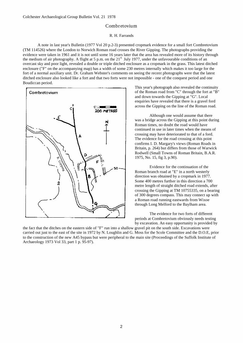
A note in last year's Bulletin (1977 Vol 20 p.2-3) presented cropmark evidence for a small fort Combretovium(TM 114526) where the London to Norwich Roman road crosses the River Gipping. The photographs providing theevidence were taken in 1961 and it is not until some 16 years later that the area has revealed more of its history throughthe medium of air photography. A flight at 5 p.m. on the 21st July 1977, under the unfavourable conditions of anovercast sky and poor light, revealed a double or triple ditched enclosure as a cropmark in the grass. This latest ditchedenclosure ("F" on the accompanying map) has a width of some 230 metres internally which makes it too large for thefort of a normal auxiliary unit. Dr. Graham Webster's comments on seeing the recent photographs were that the latestditched enclosure also looked like a fort and that two forts were not impossible - one of the conquest period and oneBoudiccan period.
This year's photograph also revealed the continuityof the Roman road from "C" through the fort at "B"and down towards the Gipping at "G". Localenquiries have revealed that there is a gravel fordacross the Gipping on the line of the Roman road.
Although one would assume that therewas a bridge across the Gipping at this point duringRoman times, no doubt the road would havecontinued in use in later times when the means ofcrossing may have deteriorated to that of a ford.The evidence for the road crossing at this pointconfirms I. D. Margary's views (Roman Roads inBritain, p. 264) but differs from those of WarwickRodwell (Small Towns of Roman Britain, B.A.R.1975, No. 15, fig 3, p.90).
Evidence for the continuation of theRoman branch road at "E" in a north westerlydirection was obtained by a cropmark in 1977.Some 400 metres further in this direction a 700metre length of straight ditched road extends, aftercrossing the Gipping at TM 10755335, on a bearingof 300 degrees compass. This may connect up witha Roman road running eastwards from Wixoethrough Long Melford to the Baylham area.
The evidence for two forts of differentperiods at Combretovium obviously needs testingby excavation. An easy opportunity is provided by
the fact that the ditches on the eastern side of "F" run into a shallow gravel pit on the south side. Excavations werecarried out just to the east of the site in 1972 by N. Loughlin and G. Moss for the Scole Committee and the D.O.E, priorto the construction of the new A45 bypass but were peripheral to the main site (Proceedings of the Suffolk Institute ofArchaeology 1973 Vol 33, part 1 p. 95-97).
Colchester Archaeological Group Bulletin Vol. 21 1978
3
Line of Possible Roman Road South of Abberton Church
A. A. Doorne
The historical significance of this road or track is not known. Preliminary documentary research seemed toindicate that it might be the route of the Roman road to Mersea Island. The land is in private ownership and so it wasdecided to photograph and examine the evidence on the surface and most of the work has been by observation from adistance.
The visible section of the road commences at a field gate approximately 50 yards east-south-east of AbbertonChurch. It is clearly defined on both its boundaries, its route being south-south-westerly and disappearing beneath thewaters of the reservoir. However, on the southern side of the reservoir some old field edges are straight which mayindicate its further passage southwards. These will be examined at a later date. The boundaries of the visible section areclearly defined by lines of small trees, all that remains of what must have been hedgerows. The ditches are only faintlydiscernible and have either silted up or have been filled back because they had ceased to be of any practical use. Its totalwidth, including the ditches, appears to be approximately 20 feet while the agger is about 17 feet. There is someevidence that the road continues northwards to Church Lane, as the eastern hedge line continues to join Church Lane.There is considerable weed growth on this section and the western boundary has disappeared.
The Abberton Tithe Map (1838) shows the road and it is described by the Tithe Surveyor as "Road to Barn",while other byways are described as "Drift Ways". Church Lane apparently did not exist as a road at that date, althoughthe field edges may have been used as an unofficial short-cut to the Church. The road is marked on the ReproductionOrdnance Survey Map (David and Charles Edition) and so seems to have become a recognised road between 1860 and1890. No doubt when the new rectory was built around the year 1902 some effort was made to bring the road up tostandard. It is still denoted as part of a footpath on modern maps.
Older maps indicate this road to the barn, but by the 1930’s it seems to have become not only a barn, but a barnand buildings (Bartholomew's Map of Essex - half inch 1936); in fact, I am told that it was known as Lower Barn Farm,and that an undefined footpath beyond it became two paths, one heading towards Peldon and the other towards PeteTye, possibly crossing it and leading to Pete Hall.
The route northwards to Colchester, according to Arthur Mee (1966) was from the foot of Abberton ChurchTower and this is a reasonable assumption. However, on the Abberton Tithe Map (1838) it appears that the old footpathfrom the Layer Road to the Church left the road at a point slightly further west and continued in a straight line to the oldfield edge north west of the Church. This suggests that part of the road has been lost at this point. Personally, I feel thatwhat is more likely is that the route of the road was from the field gate, through the site of Abberton Hall and moat tothe Layer Road, then northwards through the grounds of the Manor, following the old field edge along the side of FenHall to join the present footpath east of the Manor. It should be remembered that the moat and the hall would not havebeen in existence in ancient times and by the time the hall and its moat were constructed this road had probably ceasedto be an important route. Thus no inconvenience would have been caused to travellers when the builder of the halldecided to guard it with a moat.
The junction of this path and at least four other paths is at the confluence of the Layer Brook and the RomanRiver. Perhaps it should be pointed out here that the "Roman" river has no connection with the Roman occupation, butaccording to the Essex English Place Name Society takes its name from a John Romayn who appears to have hadconsiderable property in the area in 1377.
William White (History and Gazeteer and Directory to the County of Essex 1863) suggested that the route toColchester was along what is known as the Berechurch Dyke. We now know that these dykes were probably originallypart of a pre-Roman defence system, but I would submit that the early writers may be correct insofar as the dykes, longafter their original construction, may have been used as convenient path. The southern end of the dyke appears to reachthe Roman River opposite the *"four went way".
Finally, some of the field names along the line of the road in Abberton seem to suggest the existence of asettlement much earlier than the present village. As for the road, was its route merely to Mersea? There is evidence thatit could well have been an arterial road, with smaller roads running off it to serve several coastal or river ports, betweenSalcott and West Mersea.
* For comparison Four Wantz Corner, Oxlow Lane, Dagenham and P. J. Fowler's Landscape Archaeology p.133.
Colchester Archaeological Group Bulletin Vol. 21 1978
4
A Red Hill at Tollesbury, Essex : Its Background & ExcavationReport on the First Year
Kay de Brisay
Tollesbury is a pleasant little town situated on a small plateau about 75 feet above sea level, close to the northernshore of the mouth of the Blackwater. Colchester is approximately 12 miles to the north and Maldon 9 miles to the west.On every side but the west, the town is surrounded by salt-marsh which is confined by a well maintained sea-wall. Thesaltings on the north-west side are invaded by exceptionally large tidal creeks; of these Woodrolfe Creek, nearest to thetown, is a thriving yachting centre while Tollesbury Creek leads into Old Hall Creek. Old Hall itself has long sincedisappeared as have the wharves, granary, lime-burning kilns, brick kilns and coal yard which once made up a busycommercial centre; but the building known as "Ship Ahoy" still stands at the head of the creek; this was once an Inn,previously known as "The Crooked Billet". The extensive Old Hall marshes separate Tollesbury Fleet from SalcottChannel. These are deserted now except for sea birds and wild flowers but, some years ago, a brick building stood on thenorth shore of Pennyhole Fleet; known as the "Salt House" it is said that church services were held there in the time ofCromwell. Further to the north the Mersea Fleet and Pyefleet Channel divide Mersea Island and the Ray from the mainlandwith Abbot's Hall and Copt Hall saltings bordering the villages of Great and Little Wigborough, Peldon and Langenhoe.
Tollesbury appears in the Domesday Book of 1086 as "Tolesberia" and as "Towlseburye" according to Nordenback in 1594 (1) Ekwall (2) suggests that the name derives from "Toll's burh"; "Toll" being an unrecorded personal nameand "burh" Old English for a settlement or stronghold. The same name appears in the names of the nearby villages ofTolleshunt Darcy, Tolleshunt Knights and Tolleshunt Major.
Undoubtedly there was a settlement here in Roman times attested by the presence of Roman tiles and bricks in themake-up of the church and there is said to have been a Roman villa and other buildings near Mill Creek on the Blackwater.But the geographical position and the traces of many Red Hills or salt-making sites suggest an active commercial centre asfar back as the early Iron Age. From existing records one can trace the prosperity of Tollesbury from Medieval toVictorian times when there were many rich manors and country houses. Then water transport was cheap and efficient andthere was extensive trading in fish, oysters, water fowl from the duck decoys and hay from the land. However, the comingof the railway destroyed this, Colchester became the main trading centre and Tollesbury was virtually isolated. TheLondon and North Eastern Railway tried to remedy the situation in 1904 by building a light railway, known as the "Craband Winkle", which ran from Kelvedon to the pier at Mill Creek but this was abandoned in the 1950's and Tollesburybecame the peaceful haven it is today. The line of the "Crab and Winkle" can still be traced; notably at Kelvedon wherethe present A12 trunk road crosses the old embankment.
It has been stated that traces of many Red Hills can be found in the saltings which nearly surround the town; infact these can be found in great numbers along the whole of the Essex coast from the Thames to the Stour. Havingexcavated a site on the Peldon marsh and another near the causeway to Osea Island it was decided to examine a similarsite at Tollesbury in order to compare any differences in make-up, methods and artefacts.
Location
A survey of the marsh lying between the Tollesbury Sewage Works and the Old Hall marsh was made in the latesummer of 1976. A site on the seaward side of the sea-wall in the south-west corner was selected. With red-lined creeks allround and a slight rise crowned with the familiar long grass made it an obvious choice, though rather difficult of access. Itwas enclosed by the modern sea-wall on the south and west sides; a deep ditch separated this from what appeared to be anolder sea-wall on which were five scrub oak trees, said to be salt tolerant. Permission to dig was obtained from the ownersand work began early in April 1977. A trench 15 metres long and 2 metres wide was put down with the Al peg at thesouth east corner (N.G.R. TL. 96411282). The shallow top soil came away easily and red earth was found immediatelybeneath.
In the eastern end of the trench a soft red infill predominated, interspersed with isolated patches of clay; in thecentre a thick band of briquetage lay diagonally across the trench and this continued in a downward slope to the west.From this central patch the nearly complete head and stem of a pedestal was found together with several pieces of fire-bar.In an effort to find the depth, the red infill to the east of the central briquetage mass was taken down to a depth of 1.5metres where a hard red floor was found. There was much clay on the north side but it did not appear to constitute anydefinitive feature. The briquetage slope at the western end was excavated to a depth of nearly half a metre. Several hearthsin a more or less fragmentary state were found with much burning and carbonised wood; one in particular was flooredentirely with broken body sherds covered with a thick layer of black ash; beneath this was a solid layer of clay mixed withmore ash. Many interesting pieces of briquetage were found with some large fragments of heavy hearth walling.
A darker diagonal strip was found crossing the trench at the eastern end at a lower level of the red infill. This wascarefully excavated and the sloping clay walls of a gulley emerged. Lying across the centre of the gulley was a structure
Colchester Archaeological Group Bulletin Vol. 21 1978
5
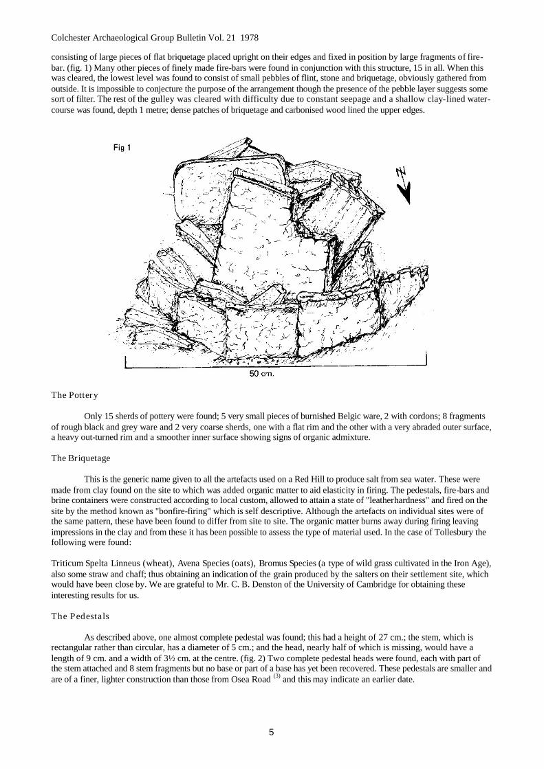
consisting of large pieces of flat briquetage placed upright on their edges and fixed in position by large fragments of fire-bar. (fig. 1) Many other pieces of finely made fire-bars were found in conjunction with this structure, 15 in all. When thiswas cleared, the lowest level was found to consist of small pebbles of flint, stone and briquetage, obviously gathered fromoutside. It is impossible to conjecture the purpose of the arrangement though the presence of the pebble layer suggests somesort of filter. The rest of the gulley was cleared with difficulty due to constant seepage and a shallow clay-lined water-course was found, depth 1 metre; dense patches of briquetage and carbonised wood lined the upper edges.
The Pottery
Only 15 sherds of pottery were found; 5 very small pieces of burnished Belgic ware, 2 with cordons; 8 fragmentsof rough black and grey ware and 2 very coarse sherds, one with a flat rim and the other with a very abraded outer surface,a heavy out-turned rim and a smoother inner surface showing signs of organic admixture.
The Briquetage
This is the generic name given to all the artefacts used on a Red Hill to produce salt from sea water. These weremade from clay found on the site to which was added organic matter to aid elasticity in firing. The pedestals, fire-bars andbrine containers were constructed according to local custom, allowed to attain a state of "leatherhardness" and fired on thesite by the method known as "bonfire-firing" which is self descriptive. Although the artefacts on individual sites were ofthe same pattern, these have been found to differ from site to site. The organic matter burns away during firing leavingimpressions in the clay and from these it has been possible to assess the type of material used. In the case of Tollesbury thefollowing were found:
Triticum Spelta Linneus (wheat), Avena Species (oats), Bromus Species (a type of wild grass cultivated in the Iron Age),also some straw and chaff; thus obtaining an indication of the grain produced by the salters on their settlement site, whichwould have been close by. We are grateful to Mr. C. B. Denston of the University of Cambridge for obtaining theseinteresting results for us.
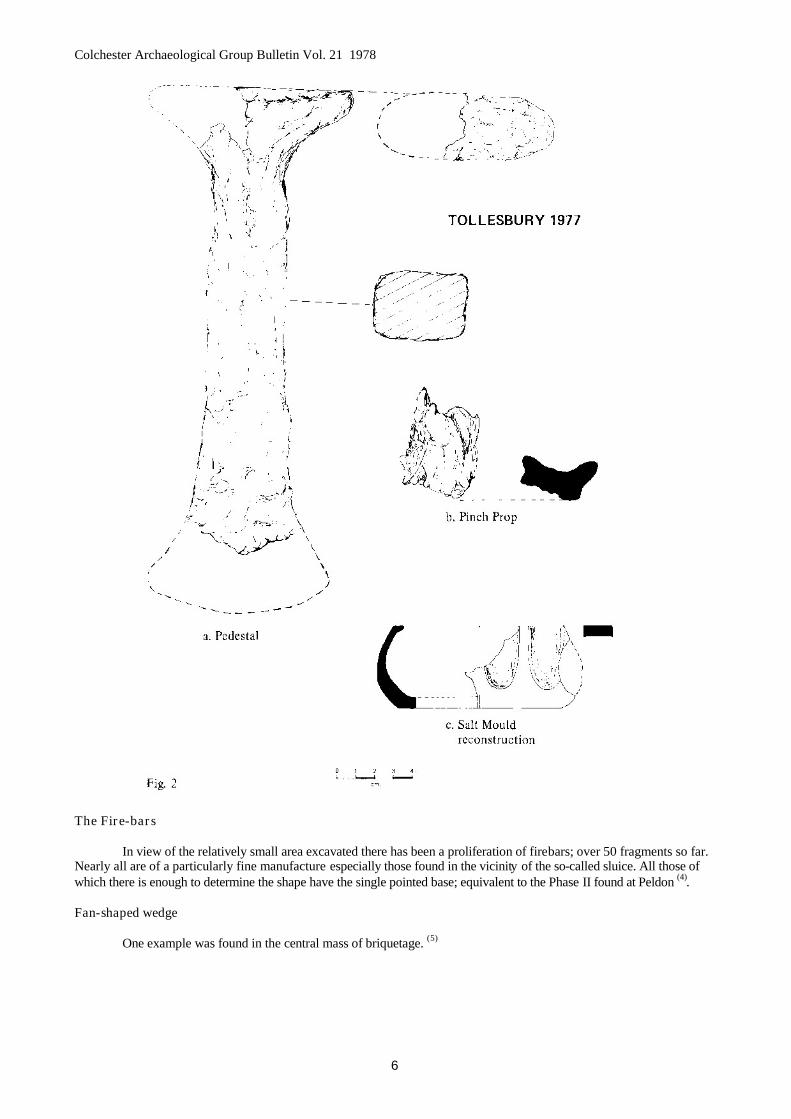
The Pedestals
As described above, one almost complete pedestal was found; this had a height of 27 cm.; the stem, which isrectangular rather than circular, has a diameter of 5 cm.; and the head, nearly half of which is missing, would have alength of 9 cm. and a width of 3½ cm. at the centre. (fig. 2) Two complete pedestal heads were found, each with part ofthe stem attached and 8 stem fragments but no base or part of a base has yet been recovered. These pedestals are smaller andare of a finer, lighter construction than those from Osea Road (3) and this may indicate an earlier date.
Colchester Archaeological Group Bulletin Vol. 21 1978
6
The Fire-bars
In view of the relatively small area excavated there has been a proliferation of firebars; over 50 fragments so far.Nearly all are of a particularly fine manufacture especially those found in the vicinity of the so-called sluice. All those ofwhich there is enough to determine the shape have the single pointed base; equivalent to the Phase II found at Peldon (4).
Fan-shaped wedge
One example was found in the central mass of briquetage. (5)
Colchester Archaeological Group Bulletin Vol. 21 1978
7
Pinch-props
Several of these objects were found at Peldon (6) and it is interesting to note that already 13 have been recoveredfrom the site under discussion. Clearly they are an integral part of the process and demonstrate the efficiency and attentionto detail displayed by the salters. The finest example is illustrated above. (Fig.2b)
Hearth Walls
Only 4 recognisable pieces of hearth wall have been found this year. These are quite unlike those from Peldonbeing of much heavier construction and containing an intensive organic admixture. The rims vary in width from 3 - 6 cm.In every case there is a thick grey deposit on one side. A rim fragment of a thin walled vessel had adhered to the inner sideof one much-burnt fragment.
Fire-bar Slots
None has been found on the hearth walls but single lumps of fired clay containing deep depressions of fire-barpoints were found among the briquetage scatter around areas of intense burning.
Wattling
Two small fragments with very deep furrowing were found but it is impossible to determine from what sort ofvessel they came. (7)
Brine Containers
A large number of plain rims were recovered at various levels throughout the site together with a few decoratedones but none is large enough to assess the diameter. However, there were several heavy bases exhibiting similar trimmingto those thought to be of the 'pig-trough' shape found at Peldon (8).
The most interesting finds were a few sherds of fine red clay rims with hardly any organic admixture; the surfaceof these are smooth and noticeably refined; three of them have a series of large flutings on the body. The largest fragmenthas a flat rim under 1 cm. in width, but the base, only part of which was found, is very heavy. The diameter would beapproximately 5 cm. and the height nearly 6 cm. (fig. 2c) It has not been possible to trace a similar example but it isreminiscent of the salt moulds found in Lincolnshire.
Skeletal Remains
On Sunday, 16 th October 1977, Mr. J. J. C. Cairns of 8 North Road, Tollesbury was out in a boat with afriend, moving up the North Channel of Tollesbury Fleet, when they noticed what appeared to be the dome of askull protruding from the mud between them and the shore. This was extricated with some difficulty and,though the lower jaw was missing, the skull was undeniably human. The find spot was noted: TL91. 98251142. Asit was not possible to know the age of the skull, Mr. Cairns took it to the local Police Station from whence itfinally reached the Department of Forensic Medicine. The London Hospital Medical College. The opinion there isthat the skull is Romano-British.
Plan of the Site and its Immediate Vicinity
Early in September Mr. Paul Brown, Chairman of the Maldon Archaeological Group, with six memberssurveyed a grid of five metre squares to cover the whole area surrounding the actual excavation, including the sea-walls, and using the extended south baulk of the trench as a base line. The grid measures 40 metres east - west and60 metres north - south. From this a detailed plan is being made showing the creeks and basins and indicating theincidence of red earth and briquetage in the walls thereof. This will be published in our next issue. It is, ofcourse, not possible to know whether these markings will show the remains of one and the same Red Hill or ofseveral small ones but we feel it will be a valuable contribution towards our knowledge of the Essex saltings.
Acknowledgements
Our thanks are due to the owners of the land, Mr. Drake and Mr. Frost, of the Tollesbury Yacht BerthingCo., for permission to excavate, to Mr. Paul Brown and members of the Maldon Archaeological Group, Mr. andMrs. Dark, Liam Dark, Miss Christina Tracey, Mr. Ramus and the following members of the ColchesterArchaeological Group:- Mrs. K. A. Evans, Mrs. M. Dunn, Mrs. A. Hampton and Mr. and Mrs. Ginger.
Colchester Archaeological Group Bulletin Vol. 21 1978
8
References
1. Norden. Historical Description of Essex 1594.2. Ekwall E. The Concise Oxford Dictionary of English Place Names. 4th Edn. (1960)3-8. All to be found in "Salt" Proceedings of Conference. (Eds. de Brisay and Evans) Colchester
Archaeological Group (1975).
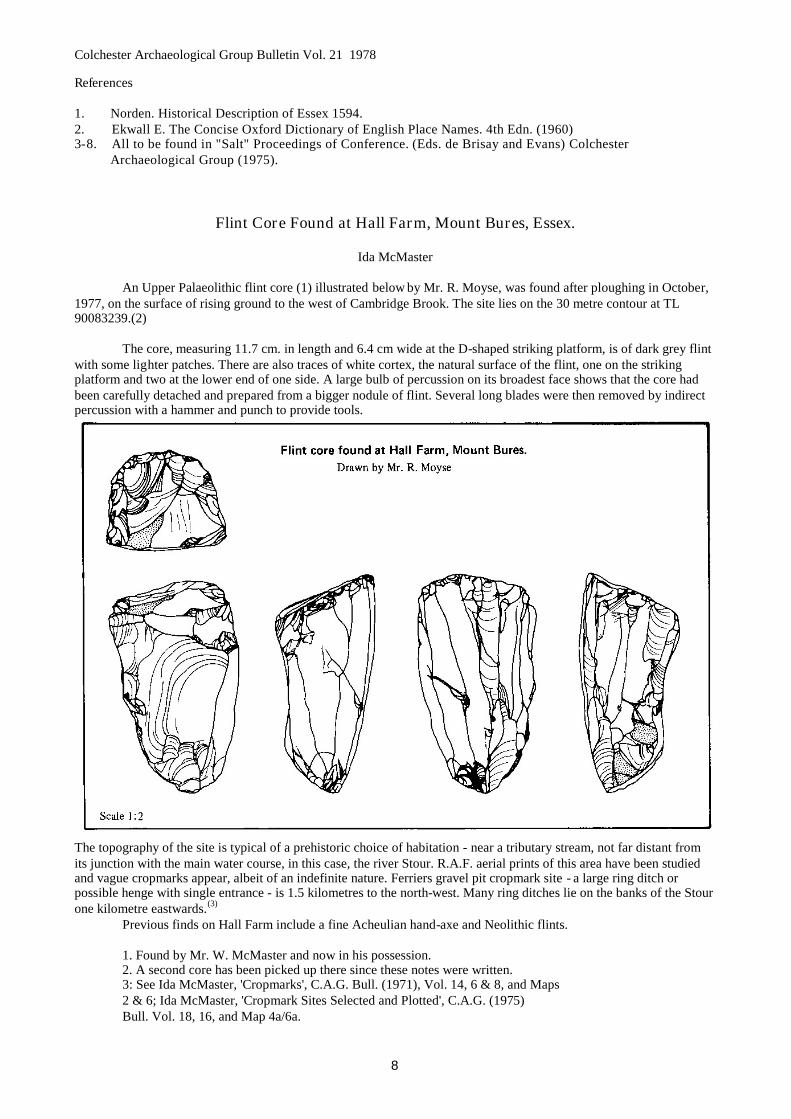
Flint Core Found at Hall Farm, Mount Bures, Essex.
Ida McMaster
An Upper Palaeolithic flint core (1) illustrated below by Mr. R. Moyse, was found after ploughing in October,1977, on the surface of rising ground to the west of Cambridge Brook. The site lies on the 30 metre contour at TL90083239.(2)
The core, measuring 11.7 cm. in length and 6.4 cm wide at the D-shaped striking platform, is of dark grey flintwith some lighter patches. There are also traces of white cortex, the natural surface of the flint, one on the strikingplatform and two at the lower end of one side. A large bulb of percussion on its broadest face shows that the core hadbeen carefully detached and prepared from a bigger nodule of flint. Several long blades were then removed by indirectpercussion with a hammer and punch to provide tools.
The topography of the site is typical of a prehistoric choice of habitation - near a tributary stream, not far distant fromits junction with the main water course, in this case, the river Stour. R.A.F. aerial prints of this area have been studiedand vague cropmarks appear, albeit of an indefinite nature. Ferriers gravel pit cropmark site - a large ring ditch orpossible henge with single entrance - is 1.5 kilometres to the north-west. Many ring ditches lie on the banks of the Stourone kilometre eastwards.(3)
Previous finds on Hall Farm include a fine Acheulian hand-axe and Neolithic flints.
1. Found by Mr. W. McMaster and now in his possession.2. A second core has been picked up there since these notes were written.3: See Ida McMaster, 'Cropmarks', C.A.G. Bull. (1971), Vol. 14, 6 & 8, and Maps2 & 6; Ida McMaster, 'Cropmark Sites Selected and Plotted', C.A.G. (1975)Bull. Vol. 18, 16, and Map 4a/6a.
Colchester Archaeological Group Bulletin Vol. 21 1978
9
Obituary
Mr. E. S. May, Croix de Guerre
Edward May died on 10th December 1977 at the age of 85. He first became interested in archaeology whenwork began on the corner of Balkerne Lane, Colchester; prior to the building of the Embassy Suite. He had been afaithful member of the Group for over fifteen years. In his early days he took part in Group excavations and regularlyattended the weekly meetings at the Castle almost to the end. Those of us who know him well enjoyed his gentlehumour and he will be sadly missed.
K. de B.
Essex County Council Amenities Award Scheme 1976
Members will be glad to hear that the Group has again been awarded first prize under the Scheme. This yearthe entry was an album of aerial photographs taken by Mrs. I. McMaster and Mr. R. H. Farrands and submitted in theResearch Category. The award is a certificate and a prize of £30 and we congratulate Mrs. McMaster and Mr. Farrandson their success.
A 17th Century Kiln at West BergholtFirst Report - 1977 Excavations
P. R. Holbert
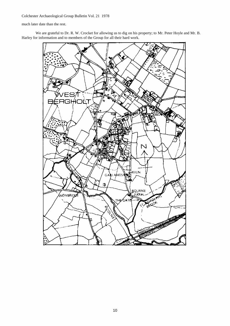
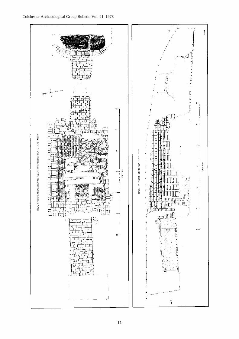
The site of this excavation, Map reference TL 963269, is at "Garlands", Bourne Road, in the village of WestBergholt which is situated to the north-west of Colchester just outside the old Borough boundary.
The kiln was originally discovered when, during the construction of an access track to a cottage at the rear of"Garlands", the bulldozer uncovered a brick structure. On examination this proved to be the flues and oven floor of abrick or tile kiln.
SummaryThe kiln is of the rectangular updraught type with sloping, lateral flues. Built entirely of brick the body of the
kiln measures 4 metres by 3 metres approximately. There are nine transverse flue arch walls and two firing tunnels.Evidence for dating is entirely documentary, exhaustive research into the history of the kiln and its owners over theperiod 1650 to 1830 having been carried out by Mrs. Ida McMaster. Her findings follow the excavation report.
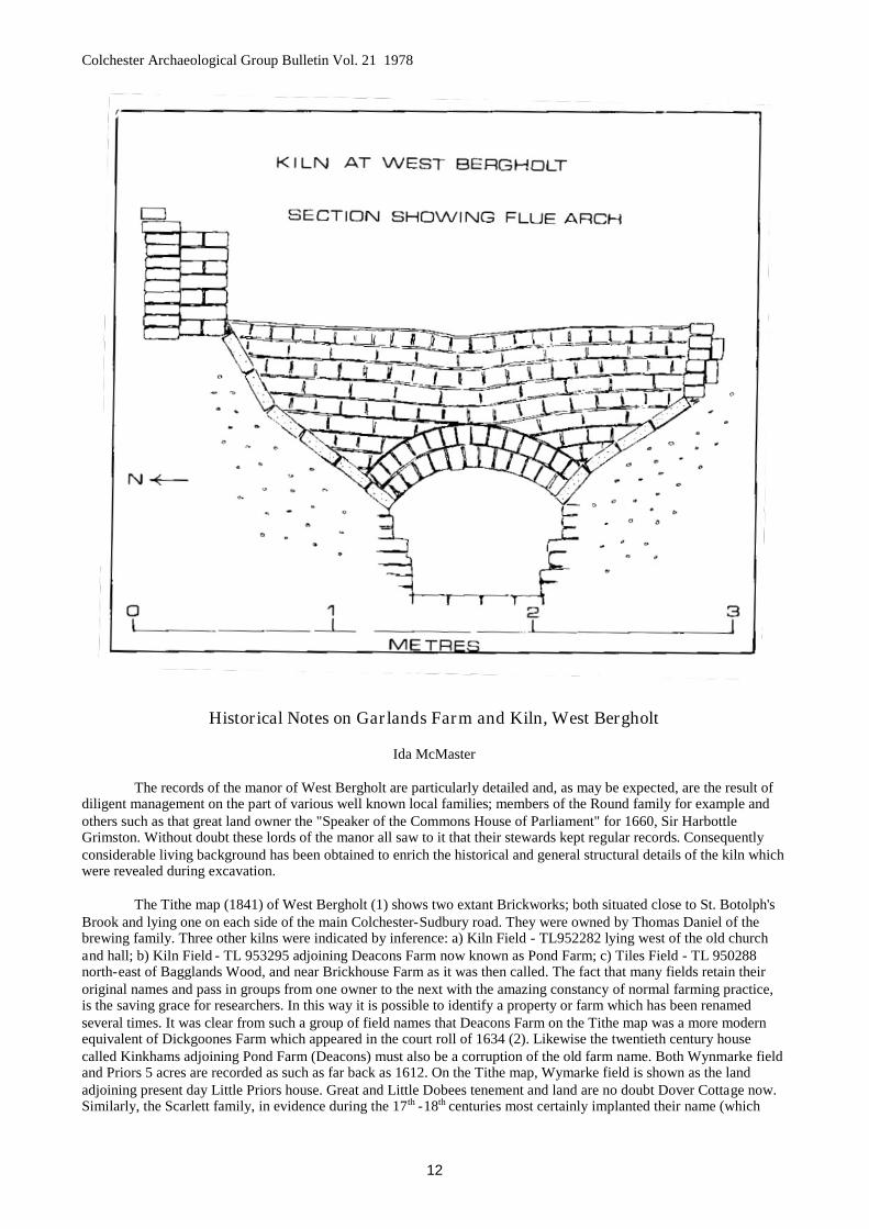
Structural detailsThe main body of the kiln consists of nine transverse walls with flue arches and the two end walls which were
built into a V shaped trench. These nine arches, in line along the length of the kiln, formed the main flue and the gapsbetween the walls formed the transverse flues. These were floored with bricks laid flat on the sloping sides of thetrench, the purpose being to give an even spread of heat to the oven floor above (see section across kiln). The main flueis also brick floored.
The horizontal tops of the nine transverse walls formed the floor of the oven, the gaps were bridged at everyother brick, the intervening holes allowing the heat to pass through into the oven. The floor thus formed was thencovered with a layer of clay, the holes, of course, being left clear.
The oven proper was represented by some six layers of bricks that had survived on the north side of the kilnbody.
There are two firing tunnels; the one to the west being earlier, and for reasons unknown, was found to beunsatisfactory being sealed off from the kiln by a blocking wall. This tunnel is contemporary with the earliest phase ofthe kiln. A second firing tunnel was then built at the eastern end of the kiln and this appears to have been successful. Atthe same time the main flue was deepened by trenching some 60cms deep along its length and a new brick floor laid.The stoke hole for this tunnel appears to have been well constructed with buttress walls at either side of the tunnelmouth and a decent non-slip floor consisting of bricks laid at an angle and a drainage channel. Both firing tunnels werebrick floored.
A kiln of this type, especially as it appears to have been in use continuously over a long period, would needfairly regular repairs and this would seem to be the case as the present internal structure of the kiln obviously is of a
Colchester Archaeological Group Bulletin Vol. 21 1978
10
much later date than the rest.
We are grateful to Dr. R. W. Crocket for allowing us to dig on his property; to Mr. Peter Hoyle and Mr. B.Harley for information and to members of the Group for all their hard work.
Colchester Archaeological Group Bulletin Vol. 21 1978
11
Colchester Archaeological Group Bulletin Vol. 21 1978
12
Historical Notes on Garlands Farm and Kiln, West Bergholt
Ida McMaster
The records of the manor of West Bergholt are particularly detailed and, as may be expected, are the result ofdiligent management on the part of various well known local families; members of the Round family for example andothers such as that great land owner the "Speaker of the Commons House of Parliament" for 1660, Sir HarbottleGrimston. Without doubt these lords of the manor all saw to it that their stewards kept regular records. Consequentlyconsiderable living background has been obtained to enrich the historical and general structural details of the kiln whichwere revealed during excavation.
The Tithe map (1841) of West Bergholt (1) shows two extant Brickworks; both situated close to St. Botolph'sBrook and lying one on each side of the main Colchester-Sudbury road. They were owned by Thomas Daniel of thebrewing family. Three other kilns were indicated by inference: a) Kiln Field - TL952282 lying west of the old churchand hall; b) Kiln Field - TL 953295 adjoining Deacons Farm now known as Pond Farm; c) Tiles Field - TL 950288north-east of Bagglands Wood, and near Brickhouse Farm as it was then called. The fact that many fields retain theiroriginal names and pass in groups from one owner to the next with the amazing constancy of normal farming practice,is the saving grace for researchers. In this way it is possible to identify a property or farm which has been renamedseveral times. It was clear from such a group of field names that Deacons Farm on the Tithe map was a more modernequivalent of Dickgoones Farm which appeared in the court roll of 1634 (2). Likewise the twentieth century housecalled Kinkhams adjoining Pond Farm (Deacons) must also be a corruption of the old farm name. Both Wynmarke fieldand Priors 5 acres are recorded as such as far back as 1612. On the Tithe map, Wymarke field is shown as the landadjoining present day Little Priors house. Great and Little Dobees tenement and land are no doubt Dover Cottage now.Similarly, the Scarlett family, in evidence during the 17th -18th centuries most certainly implanted their name (which

Colchester Archaeological Group Bulletin Vol. 21 1978
13
persists to this day) on a farm.
A three acre meadow and tile kiln called Whipps (3) is the only specific record (1639) of such a structureneeded for our purpose. It was faithfully recorded through two centuries but, inconveniently never again included thekiln! Tyalls, Tyalls hoppet; Tyalls fen and Tyalls meadow (4) another group is equally suggestive in 1649, but fromsuccessive descriptions appears to be the site of c) Tile Field above on the Tithe map, or at least, its immediate environs.None of these kilns tied in with our excavation site.
The most promising entry is a presentment in the Quarter Sessions Roll for Epiphany 1665 (5). Under WestBergholt appears ...."Samuel Bigesby for erecting a cottage there and for digging pits for brick earth and tile earth andnot filling up or covering of those pits where the same were so digged whereby the cattle of the neighbouringinhabitants of the same parish who have right of commoning on West Bergholt common have been drowned orotherwise prejudiced!" Nathaniel Mascall was also in trouble for keeping an unlicensed ale house there and sufferingtippling and for erecting a cottage without laying four acres of land to it. Subsequent evidence (6) shows that Nathanieloccupied a cottage used with Bourne Farm (see map above) which adjoins the site of our excavation. An interestingreflection for nearby owners of old cottages!
There had been two earlier complaints in the manor court against Samuel Bigesby. Both were encroachmentsfor pit and earth digging, one in 1651 with Howard Sweetinge and the other in 1663 with one Garrad (7). Here it mustbe remembered that plague and civil war no doubt took their toll during the following decades for no more is enteredagainst the Bigesby family for over half a century. The lord of the manor had greater problems to contend with and thisis clearly reflected in the sub-standard entries made by the then incumbent in the parish registers.
As far back as 1609 the waste of the common had been at risk from other such trespassers. That year the manorsteward and Homage (assembled tenants of the manor) decreed ...."all men that take furze off the heath and burn thesame in the kilns from this day to pay 4d. a load to the next Court"(8). Again in 1621 four men were amerced fordigging clay for brick and tile. A rider was added that .... "two oaks near their brick places were felled and carried awaybut by whom the Homage knew not" (9)
On the Tithe map Garlands farmhouse and its cottage are situated as today but lying completely isolated on along strip of open heath land. Both were owned by a Thomas Drawbridge, the house with 3 roods 35 perches of landoccupied by Benjamin Howard, and the cottage with 1 rood 2 perches occupied by Amy Osborne. There is nothing toindicate a kiln of course! However, the 1827 manor rental (10) is fortunately of assistance; it reads as follows:
Thomas Hurrell for a cottage and 1h acre of land ............. 1s.0d.Thomas Hurrell for a cottage and 1h acre of landlate a brick kiln ... late Nathaniel Hurrell's ......................... ls.6d.
Both the manor rolls (11) and Thomas Hurrell's will (12) (proved 1832) make it clear that Sarah Drawbridgewas his sister and one of his beneficiaries. She and Mary Drawbridge made a deed of gift of the property to theirkinsman Thomas Drawbridge (see above). So here is our kiln and the approximate date of its going out of use. Thedescription of the property contains a significant and useful phrase "near the Brook gate." Such a gate is shown on theaccompanying map as it is described on the 1801 perambulation of Colchester (13) ..."from Chitts Hill proceed alongthe road to Newbridge on which bridge is cut a cross. From thence go into the meadows on the right hand and proceedeastwards along the river bank to an ashen tree standing on Westfields by the side of the river where a footbridge latelywas and which was formerly called Motts bridge. From this tree proceed across the river to a place where a brook fallsinto the river and then go along up the course of the same brook to a Gate in a lane leading onto Bergholt heath. Crossthe lane and enter the fields following the course of the brook. Proceed along its bank leaving the brook on the left handto the place where it crosses the road leading from Colchester to Bergholt at which place it is called Botolphs Brook,but more anciently Godulnes Brook. ..."
Other evidence, an appraisal of the common waste bounds of 1734 (14) places Brook Gate contiguous with aMr. Sadler's land, thereby confirming the above position since Bourne Farm (described above and adjoining theexcavation) was owned by the Sadler family (15) for two centuries, ownership terminating finally in 1877. One propertyonly is recorded continuously in conjunction with the Brook Gate during the period 1736-1832; indeed the descriptionis included in no other property from the early 17th century onwards. In these circumstances it was possible to pursuevarious entries relating to the Bigesby family whilst simultaneously tracing back over the Hurrell transactions. By thegreatest good fortune the searches met in the middle and this would have been most unlikely had there been gaps in thesequence of the documents available.
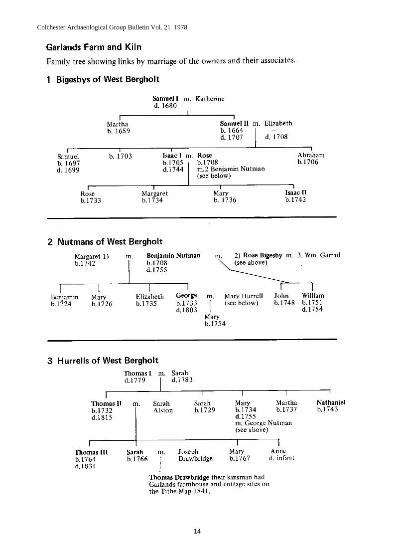
Information concerning members of the three families connected with the kiln is listed below and theindividuals can be identified on the pedigrees which follow.
Colchester Archaeological Group Bulletin Vol. 21 1978
14
Colchester Archaeological Group Bulletin Vol. 21 1978
15
Samuel Bigesby I and Katherine his wife had a daughter baptized 1659 and a son Samuel in 1664 being theyear preceding the Quarter Sessions presentment for building the illegal cottage (16).
Samuel Bigesby II married in 1697, his wife's name unfortunately being omitted from the register. Thebaptisms, more accurately entered however, reveal it and Samuel and Elizabeth are shown having sons Isaac andAbraham baptized 1705 and 1706 respectively. There was also a son of Samuel Bigesby born in 1697 and "a child" ofthe same in 1703 who were not named, such omissions from the register are possibly due to the exigencies of thatperiod which are apparent from other nameless block burial entries. The former is almost certainly the "Samuel Bigesbya child buried 1699" otherwise as eldest son one would expect to find him in possession of the following property.
Isaac Bigesby I married Rose. Three daughters were born to them between 1733 - 1736 and then a son Isaac in1742. During that period, after a lapse of seventy years, the family again figures in the fines threatened by the manorcourt. This was in 1734 and once more for building a cottage and kiln without licence (17). They were ordered to pull itdown before Ladyday. Two years later came the portentous entry .... "Isaac Bigesby on the Lords Grant to one cottageand brick kiln and half an acre of land lying upon Bergholt heath near the Brook Gate heretofore parcel of the waste ofthis manor .... 6d Quitrent .... Fine respited."(18)
When Isaac died eight years later the manor officials made three separate proclamations (19) for his heir tocome forward as is the usual procedure. By that action they provided the first evidence of the legality of his property,something never before accorded the Bigesby family, even though they had lived within the parish all those years. Afull rental (20) of the manor for 1716 gives all the freehold and copyhold tenants but no Bigesby appears on it neither isthere a cottage-by the Brook Gate, nor are they listed as occupants. It seems likely that up to this point they had beensquatters and as such ignored in the proper proceedings. Of course the cottage built by Samuel I may well have beenforcibly demolished but all through these preceding years other people were also stealing waste on which to build.There is the possibility that Isaac and Rose were, in fact, granted the present Garlands Cottage although from thegeneral evidence the principal house there seems the more likely, with the cottage construction coming later. The familytree shows that Isaac I and his brother were orphaned as infants; there is also record of a possible uncle of the samechristian name within the village who perhaps raised them with his own children of about the same age and hence theneed for a second cottage for Isaac and Rose.
Four years after Isaac's death his widow Rose Bigesby married Benjamin Nutman a widower. (21) Her sixyear old son Isaac II was that year admitted as heir to his father Isaac I to all the above property near the Brook Gate,"and Benjamin Nutman is named as his guardian. (22) Rose and Benjamin were both forty years of age in 1748 at theirmarriage in East Donyland church, which appears to make Benjamin only sixteen when his eldest son was born to hisfirst wife. Rose, an outstanding lady, married for the third time in 1756 (23) following which no more is heard of herfourteen year old son Isaac II who probably moved away with his mother. Benjamin Nutman, Brickmaker of WestBergholt, in his will of 1755 (24) bequeathed the Brickhouse at Bottle End, Stanway to his eldest son; to second sonGeorge he left his freehold Brick house in West Bergholt together with the kiln and sheads and all that belong to theBrickhouse. To third daughter Elizabeth went two freehold tenements in West Bergholt in the occupation of JosephCoveny and Robert Crooks. (These are more likely to be Garlands Cottage). His wife to have "the buttre, 2 parlours, 2closets, 1 tub of pork, 12 bushels of wheat and 8 rods of land." Small wonder that Rose was soon off to better things!After bequests to the others he directed that all the estate was to be let for two years (except George's house and one atAldham for John his son by Rose), then they were to balance accounts and share out equally.
George Nutman married Mary Hurrell the year before his father's death. Sadly for George Mary died onlyfive months after his father and soon after the birth of a daughter. It is not absolutely certain that George's house at WestBergholt with the kiln is the one described as near the Brook Gate. When he died he had only two surviving daughtersfrom three wives and his will of 1803 makes no mention of a kiln (25) . Nevertheless the Brook Gate kiln is clearlyassociated within his family circle. Probably he lived on one or other of the two Garlands establishments.
Thomas Hurrell I and Sarah his wife, the parents of Mary (above), appear in the parish soon after her death asmight be expected with a small motherless grandchild. One could hazard a guess that they came to a businessarrangement with their son-in-law for when Thomas died George Nutman was one of the executors, with Sarah thewidow as the other. Sarah is admitted for life to her husband's house, yards and buildings etc. and on her death theyounger son Nathaniel is to inherit. (26) When that happens in 1783 the manor court admits Nathaniel Hurrell to thecottage and kiln near the Brook Gate; he conveys the same property to his brother Thomas Hurrell in 1791. (27) BothGeorge Nutman and Thomas Hurrell together committed the time honoured pit digging nuisance on the heath accordingto the 1797 manor roll. {28) One wonders how any heath survived at all to be shown on the Tithe map! Also whethereither of the newer brickworks shown on the Tithe map to the east of Garlands Farm was commenced by one of theabove families shortly after this time; possibly with help from James Howe (see below).
Thomas Hurrell II in his will proved 1815 (29) is still designated brickmaker of West Bergholt. His words
Colchester Archaeological Group Bulletin Vol. 21 1978
16
show clearly that two houses stood upon his property there. To son Thomas III he gives his copyhold house andtenement with the yards gardens orchards and other appurtenances thereto belonging; to daughters Sarah Drawbridgeand Mary Coveny, "all his freehold house containing two tenements with the lower yard and other appurtenances situateand adjoining my own house where I now dwell and the which I have devised unto my son Thomas above"
Thomas Hurrell III yeoman of West Bergholt died in 1831. His will directs that his copyhold and freeholdtenures are to be sold. the money derived to be shared equally between his two sisters Sarah Drawbridge and MaryCoveny. Friend James Howe, mentioned above, brickmaker of West Bergholt is an executor. (30) The sale transactionsrecord that Thomas lived in one cottage until three years before his death. After that the cottage was divided into twotenements and occupied by his executor James Howe and a Thomas Fairclough. The other cottage was divided intothree tenements occupied by Joseph Woodway, widow Deeks and Amos Tracy. The former being "the cottage near theBrook Gate with the kiln some years since pulled down". (31)
Sarah, with Mary Drawbridge spinster, (presumably a daughter), purchased both cottages and the land for£200; immediately passing it to Thomas Drawbridge of Newfoundland, gentleman, by a virtual deed of gift. This lastpiece of information brings these historical notes up to the Tithe map identification; they have spanned almost twohundred years from that dim period when in 1683 . . . "a poor maid Mary Bigesby was certified by the Parson andchurch wardens of West Bergholt as having been examined and found to have the disease called Kings Evil and that shehad not at any time been touched by his sacred Majesty to the intent to be healed" (32)
References
Unless otherwise indicated all references are to documents in the Essex Record Office.1. D/CT 332. D/DMa M 153. ibid4. ibid5. E.R.O. Calendar of Quarter Sessions Rolls Q/SR 403/16 (Epiphany Session 1665)6. D/DE1 T259 (Bourne Farm Deeds 1636 - 1877)7. D/DMa M7 and D/DMa M88. Op. cit. 2 above9. Op. cit. 2 above10. D/DMa M2111. D/DMa M1112. D/ABR 33/48513. T/A 465/11214. Op. cit. 2 above15. Op. cit. 6 above16. Most references to baptisms, marriages and burials are from the Parish Records of West Bergholt held by the
incumbent the Reverend C. K. Douglas.17. Op. cit. 2 above18. Op. cit. 2 above19. Op. cit. 2 above20. D/DMa M 1921. D/ACL 174822. Op. cit. 2 above23. Op. cit. 16 above24. D/ABR 24/24025. D/ABR 29/55226. D/ABR 27/12727. D/DMa M1028. ibid29. D/ABR 31/19730. Op. cit. 12 above31. Op. cit. 11 above32. Op. cit. 16 above.
We were greatly assisted in this research by Mr. Paul Coverley of the Essex Record Office and his help is muchappreciated.
Colchester Archaeological Group Bulletin Vol. 21 1978
17
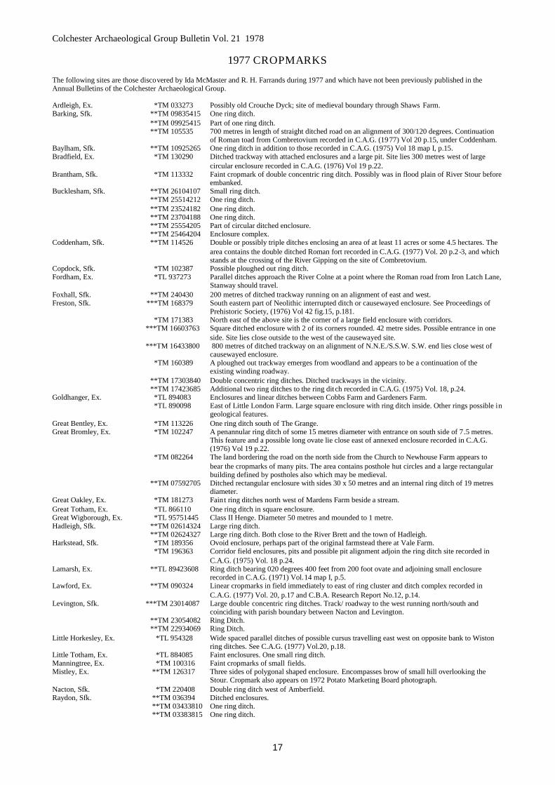
1977 CROPMARKS
The following sites are those discovered by Ida McMaster and R. H. Farrands during 1977 and which have not been previously published in theAnnual Bulletins of the Colchester Archaeological Group.
Ardleigh, Ex. *TM 033273 Possibly old Crouche Dyck; site of medieval boundary through Shaws Farm.Barking, Sfk. **TM 09835415 One ring ditch.
**TM 09925415 Part of one ring ditch.**TM 105535 700 metres in length of straight ditched road on an alignment of 300/120 degrees. Continuation
of Roman toad from Combretovium recorded in C.A.G. (1977) Vol 20 p.15, under Coddenham.Baylham, Sfk. **TM 10925265 One ring ditch in addition to those recorded in C.A.G. (1975) Vol 18 map I, p.15.Bradfield, Ex. *TM 130290 Ditched trackway with attached enclosures and a large pit. Site lies 300 metres west of large
circular enclosure recorded in C.A.G. (1976) Vol 19 p.22.Brantham, Sfk. *TM 113332 Faint cropmark of double concentric ring ditch. Possibly was in flood plain of River Stour before
embanked.Bucklesham, Sfk. **TM 26104107 Small ring ditch.
**TM 25514212 One ring ditch.**TM 23524182 One ring ditch.**TM 23704188 One ring ditch.**TM 25554205 Part of circular ditched enclosure.**TM 25464204 Enclosure complex.
Coddenham, Sfk. **TM 114526 Double or possibly triple ditches enclosing an area of at least 11 acres or some 4.5 hectares. Thearea contains the double ditched Roman fort recorded in C.A.G. (1977) Vol. 20 p.2 -3, and whichstands at the crossing of the River Gipping on the site of Combretovium.
Copdock, Sfk. *TM 102387 Possible ploughed out ring ditch.Fordham, Ex. *TL 937273 Parallel ditches approach the River Colne at a point where the Roman road from Iron Latch Lane,
Stanway should travel.Foxhall, Sfk. **TM 240430 200 metres of ditched trackway running on an alignment of east and west.Freston, Sfk. ***TM 168379 South eastern part of Neolithic interrupted ditch or causewayed enclosure. See Proceedings of
Prehistoric Society, (1976) Vol 42 fig.15, p.181.*TM 171383 North east of the above site is the corner of a large field enclosure with corridors.
***TM 16603763 Square ditched enclosure with 2 of its corners rounded. 42 metre sides. Possible entrance in oneside. Site lies close outside to the west of the causewayed site.
***TM 16433800 800 metres of ditched trackway on an alignment of N.N.E./S.S.W. S.W. end lies close west ofcausewayed enclosure.
*TM 160389 A ploughed out trackway emerges from woodland and appears to be a continuation of theexisting winding roadway.
**TM 17303840 Double concentric ring ditches. Ditched trackways in the vicinity.**TM 17423685 Additional two ring ditches to the ring ditch recorded in C.A.G. (1975) Vol. 18, p.24.
Goldhanger, Ex. *TL 894083 Enclosures and linear ditches between Cobbs Farm and Gardeners Farm.*TL 890098 East of Little London Farm. Large square enclosure with ring ditch inside. Other rings possible in
geological features.Great Bentley, Ex. *TM 113226 One ring ditch south of The Grange.Great Bromley, Ex. *TM 102247 A penannular ring ditch of some 15 metres diameter with entrance on south side of 7.5 metres.
This feature and a possible long ovate lie close east of annexed enclosure recorded in C.A.G.(1976) Vol 19 p.22.
*TM 082264 The land bordering the road on the north side from the Church to Newhouse Farm appears tobear the cropmarks of many pits. The area contains posthole hut circles and a large rectangularbuilding defined by postholes also which may be medieval.
**TM 07592705 Ditched rectangular enclosure with sides 30 x 50 metres and an internal ring ditch of 19 metresdiameter.
Great Oakley, Ex. *TM 181273 Faint ring ditches north west of Mardens Farm beside a stream.Great Totham, Ex. *TL 866110 One ring ditch in square enclosure.Great Wigborough, Ex. *TL 95751445 Class II Henge. Diameter 50 metres and mounded to 1 metre.Hadleigh, Sfk. **TM 02614324 Large ring ditch.
**TM 02624327 Large ring ditch. Both close to the River Brett and the town of Hadleigh.Harkstead, Sfk. *TM 189356 Ovoid enclosure, perhaps part of the original farmstead there at Vale Farm.
*TM 196363 Corridor field enclosures, pits and possible pit alignment adjoin the ring ditch site recorded inC.A.G. (1975) Vol. 18 p.24.
Lamarsh, Ex. **TL 89423608 Ring ditch bearing 020 degrees 400 feet from 200 foot ovate and adjoining small enclosurerecorded in C.A.G. (1971) Vol.14 map I, p.5.
Lawford, Ex. **TM 090324 Linear cropmarks in field immediately to east of ring cluster and ditch complex recorded inC.A.G. (1977) Vol. 20, p.17 and C.B.A. Research Report No.12, p.14.
Levington, Sfk. ***TM 23014087 Large double concentric ring ditches. Track/ roadway to the west running north/south andcoinciding with parish boundary between Nacton and Levington.
**TM 23054082 Ring Ditch.**TM 22934069 Ring Ditch.
Little Horkesley, Ex. *TL 954328 Wide spaced parallel ditches of possible cursus travelling east west on opposite bank to Wistonring ditches. See C.A.G. (1977) Vol.20, p.18.
Little Totham, Ex. *TL 884085 Faint enclosures. One small ring ditch.Manningtree, Ex. *TM 100316 Faint cropmarks of small fields.Mistley, Ex. **TM 126317 Three sides of polygonal shaped enclosure. Encompasses brow of small hill overlooking the
Stour. Cropmark also appears on 1972 Potato Marketing Board photograph.Nacton, Sfk. *TM 220408 Double ring ditch west of Amberfield.Raydon, Sfk. **TM 036394 Ditched enclosures.
**TM 03433810 One ring ditch.**TM 03383815 One ring ditch.
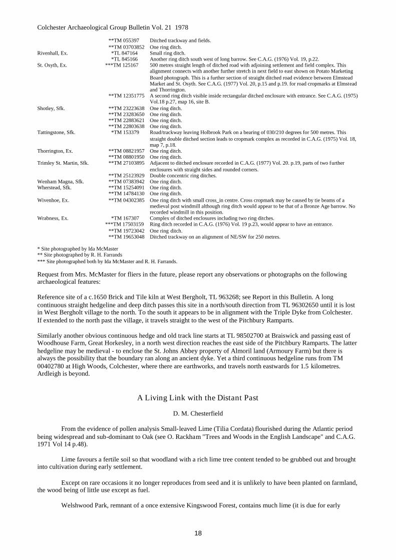
Colchester Archaeological Group Bulletin Vol. 21 1978
18
**TM 055397 Ditched trackway and fields.**TM 03703852 One ring ditch.
Rivenhall, Ex. *TL 847164 Small ring ditch.*TL 845166 Another ring ditch south west of long barrow. See C.A.G. (1976) Vol. 19, p.22.
St. Osyth, Ex. ***TM 125167 500 metres straight length of ditched road with adjoining settlement and field complex. Thisalignment connects with another further stretch in next field to east shown on Potato MarketingBoard photograph. This is a further section of straight ditched road evidence between ElmsteadMarket and St. Osyth. See C.A.G. (1977) Vol. 20, p.15 and p.19. for road cropmarks at Elmsteadand Thorrington.
**TM 12351775 A second ring ditch visible inside rectangular ditched enclosure with entrance. See C.A.G. (1975)Vol.18 p.27, map 16, site B.
Shotley, Sfk. **TM 23223638 One ring ditch.**TM 23283650 One ring ditch.**TM 22883621 One ring ditch.**TM 22803638 One ring ditch.
Tattingstone, Sfk. *TM 153379 Road/trackway leaving Holbrook Park on a bearing of 030/210 degrees for 500 metres. Thisstraight double ditched section leads to cropmark complex as recorded in C.A.G. (1975) Vol. 18,map 7, p.18.
Thorrington, Ex. **TM 08821957 One ring ditch.**TM 08801950 One ring ditch.
Trimley St. Martin, Sfk. **TM 27103895 Adjacent to ditched enclosure recorded in C.A.G. (1977) Vol. 20. p.19, parts of two furtherenclosures with straight sides and rounded corners.
**TM 25123929 Double concentric ring ditches.Wenham Magna, Sfk. **TM 07383942 One ring ditch.Wherstead, Sfk. **TM 15254091 One ring ditch.
**TM 14784130 One ring ditch.Wivenhoe, Ex. **TM 04302385 One ring ditch with small cross_in centre. Cross cropmark may be caused by tie beams of a
medieval post windmill although ring ditch would appear to be that of a Bronze Age barrow. Norecorded windmill in this position.
Wrabness, Ex. *TM 167307 Complex of ditched enclosures including two ring ditches.***TM 17503159 Ring ditch recorded in C.A.G. (1976) Vol. 19 p.23, would appear to have an entrance.
**TM 19723042 One ring ditch.**TM 19653048 Ditched trackway on an alignment of NE/SW for 250 metres.
* Site photographed by Ida McMaster** Site photographed by R. H. Farrands*** Site photographed both by Ida McMaster and R. H. Farrands.
Request from Mrs. McMaster for fliers in the future, please report any observations or photographs on the followingarchaeological features:
Reference site of a c.1650 Brick and Tile kiln at West Bergholt, TL 963268; see Report in this Bulletin. A longcontinuous straight hedgeline and deep ditch passes this site in a north/south direction from TL 96302650 until it is lostin West Bergholt village to the north. To the south it appears to be in alignment with the Triple Dyke from Colchester.If extended to the north past the village, it travels straight to the west of the Pitchbury Ramparts.
Similarly another obvious continuous hedge and old track line starts at TL 98502700 at Braiswick and passing east ofWoodhouse Farm, Great Horkesley, in a north west direction reaches the east side of the Pitchbury Ramparts. The latterhedgeline may be medieval - to enclose the St. Johns Abbey property of Almoril land (Armoury Farm) but there isalways the possibility that the boundary ran along an ancient dyke. Yet a third continuous hedgeline runs from TM00402780 at High Woods, Colchester, where there are earthworks, and travels north eastwards for 1.5 kilometres.Ardleigh is beyond.
A Living Link with the Distant Past
D. M. Chesterfield
From the evidence of pollen analysis Small-leaved Lime (Tilia Cordata) flourished during the Atlantic periodbeing widespread and sub-dominant to Oak (see O. Rackham "Trees and Woods in the English Landscape" and C.A.G.1971 Vol 14 p.48).
Lime favours a fertile soil so that woodland with a rich lime tree content tended to be grubbed out and broughtinto cultivation during early settlement.
Except on rare occasions it no longer reproduces from seed and it is unlikely to have been planted on farmland,the wood being of little use except as fuel.
Welshwood Park, remnant of a once extensive Kingswood Forest, contains much lime (it is due for early
Colchester Archaeological Group Bulletin Vol. 21 1978
19
development). There are also small amounts of lime in Churnwood, Ardleigh and Birchwood, Dedham. Small-leavedLime has recently been recorded in these parishes surviving, in what are presumably ancient hedges, in the form ofextensive coppice. These are "relic" hedges from woodland, following uneven lines and species rich. In Ardleigh theyoccur at TM 035269, 034273, 029274, 025292, 025293, 026292 and 028292 denoting a "ghost" of the formerKingswood Forest. In Dedham parish they occur at TM 062311, 064310, 063319, 056322 and 050324 and at Langhamat TM 026304 denoting the extent of Dedham Birchwood
Oliver Rackham in a report to the Suffolk Naturalists Trust described the Small leaved Lime coppice in GrotonWood and stated "it is a living link with the prehistoric forest." By the same token owners of ancient hedges, especiallythose containing Small-leaved Lime, should be encouraged to preserve them as they are no less an artifact of man thanis a medieval pot.
Book Reviews
Ardleigh in 1796: Its farms, families and local government, by F. H. Erith. Published early 1978 by Hugh TempestRadford about 100 pages with three illustrations and a map - £5.00
The Author, who has won a well-deserved Fellowship of the Society of Antiquaries for his work on the pre-history of his own lands at Ardleigh (which he farms with great competence and understanding), has for some yearsnow brought to bear his powers of acute observation and knowledge of local farming on to the strange chance that aconscientious parson of Ardleigh in the war-threatened England of 1796, decided to make a census in great detail of allhis parishioners in the Autumn of that year, and the still more unusual chance of survival of these records.
Of course, Mr. Erith has sought widely indeed for supporting information, scouring the Essex Record Officeand the Parish Records. The result is a fascinating account in microscopic detail of one generation of a then remoteEssex village at the end of the 18th century.
For a specialist in 18th century local history, or for one whose family had roots in Ardleigh two centuries ago, Ican imagine no more fascinating account; indeed, I myself, could not put it down unfinished, but for the non-specialistwho finds such detail rather heavy going, I wonder whether £5 is not a high price to pay. L. S. Harley
Review from 'The Antiquaries Journal' 1977 Vol. LVII part 1. p. 100/1Reprinted by permission of Society of Antiquaries of London.
Salt: The Study of an Ancient Industry. Edited by K. W. de Brisay and K. A. Evans. Pp. 94-51 illus. Colchester:Colchester Archaeological Group, 1975. -£4.
In September 1974 a Salt Weekend was held at the University of Essex. The inspiring force behind thisconference was Mrs. K. de Brisay, and F. H. Thompson was chairman of the meeting. The volume under review is theoutcome of the weekend's discussions, and all who are associated with it are to be congratulated.
The volume consists of twenty-five short papers which naturally are mostly concerned with Britain, but thereare ten which range through the continents of Europe, Africa, Asia and America. This conscious effort to include aswide a coverage as possible is worth while in terms of bibliography alone. Salt sources, salt-making, the discovery ofsalt-making sites, and their archaeological examination, are all considered here in various forms of reports orcommentaries. One of the interesting points to emerge from this volume is the high proportion of amateurarchaeologists represented; the archaeology of salt-making sites tends to involve `loners', people who carry on field-work in spare moments or free days, and who may not have much contact with other workers in the subject. As theeditors say, one of the reasons for the conference was to encourage contact and communication. From the conferencephotograph which appears on the title-page, it would seem that the conference succeeded in this regard.
Of the papers published here, that by Mrs. de Brisay herself on the Red Hills of Essex is an excellent example,combining a survey of literature, field-work, and excavation, the whole well illustrated and presented in an orderlymanner. There are other useful surveys, from Dorset, Hampshire and Sussex, Kent, Lincoln, Cumbria, and East Anglia,and there is an attempt to relate some of this archaeological evidence to the well-documented ethnographic records fromAfrica. The index is full, and the bibliography contains almost 400 items. The only subject omitted was perhaps salt-licks, and their attraction for animals including humans, but this was marginal to the study as an industry. Although thisconference and its proceedings are clearly not the whole story of salt-making, the stimulus they will give to studentswill doubtless lead on to a greater understanding of salt and its role in ancient societies.
J. M. COLES.
Colchester Archaeological Group Bulletin Vol. 21 1978
20
Excavations
Excavations at the Red Hill at Tollesbury will begin after Easter - details from the Secretary. Excavations at the Kiln atWest Bergholt will continue - details from Mr. P. R. Holbert.
Subscriptions
These are now due 15th September 1978 and the Hon. Treasurer will appreciate prompt payment.
Hon. Secretary Mrs. K. de Brisay Hon. Treasurer Mrs. A. HamptonCorner Cottage, Oxley House,Layer de le Haye, Tolleshunt Darcy,Colchester C02 OLE. TN 815339TN274
Winter Meetings 1977/78In the Lecture Room, Colchester Castle, at 7.30 p.m.
1977October 10th Annual General Meeting.
17th J. H. Williams, M.A., Northampton Development Corporation: Origins and Growth of MedievalNorthampton.
24th J. May, M.A., F.S.A., University of Nottingham: Prehistoric Lincolnshire.31st T. Tatton-Brown, Canterbury Archaeological Trust: Recent Excavations in the Canterbury
District.November 7th H. L. Sheldon, B.Sc., F.S.A., F.R.S.A., Southwark Archaeological Unit: Recent Excavations.
14th H. F. Cleere, F.S.A., Council for British Archaeology: The Roman Iron Industry.21st H. R. Hurst, M.A., F.S.A.: Excavations at Carthage.28th J. J. Wymer, M.A., F.S.A., F.G.S., Research Associate, University of Chicago:
Mammoth Hunting In Ipswich.December 5th Miss Jennifer Price, University of Cardiff: The Trade in Roman Glass.
1978January 16th Group Excavations.
23rd J. H. C. Sunnucks: Land Tenure30th J. Pickering, A.F.C., F.S.A., Committee for Archaeological Photography for East Anglia and
Lincolnshire: Aerial Archaeology.February 6th Dr. J. P. Wild, M.A., F.S.A., University of Manchester: Roman Textiles and the East Anglian
Connection.13th C. Saunders, B.A., Verulamium Museum: Verulamium and St. Albans.20th Dr. D. D. A. Simpson, M.A., F.S.A., University of Leicester: The Skendlebury Long Barrow.27th Miss Christina Colyer, B.A., Lincoln Archaeological Trust: Recent Archaeological Work in
Lincoln.March 6th A. J. Clark, F.S.A., Ancient Monuments Research Laboratory: Science in Archaeology.
13th F. H. Thompson, M.C., M.A., Assistant Secretary, Society of Antiquaries: RomanAmphitheatres.
20th D. Miles, Oxford Archaeological Unit: Recent Work in the Upper Thames Valley.