Embed Size (px)
Citation preview
.J \ ..
~'-. - .. j'
CADDO LAKEWATER CONTROL PLAN-
NEW ORLEANS DISTRICT
SEPTHmER 1982
,.
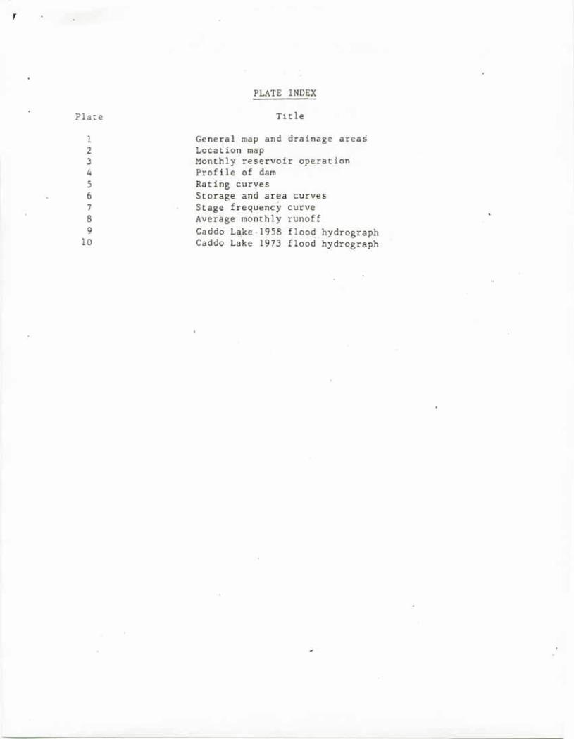
Plate
123456789
10
PLATE INDEX
Ti tle
General map and drainage areasLocation mapMonthly reservoir operationProB Ie of damRating curvesStorage and area curvesStage frequency curveAverage monthly runoffCaddo L~ke·1958 floodhydrographCaddo Lake 1973 flood hydrograph
,
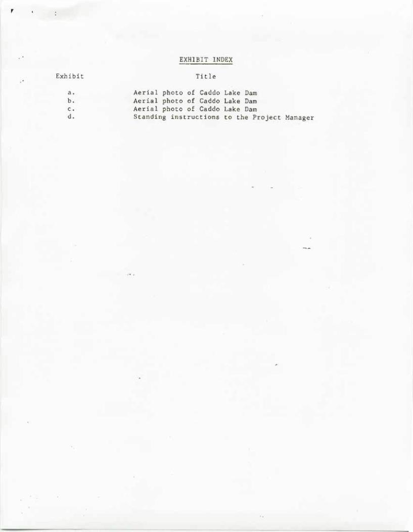
Exhibit
a.b.c.d.
EXHIBIT INDEX
Title
Aerial photo of Caddo Lake DamAerial photo of Caddo Lake DamAerial photo of Caddo Lake DamStanding instructions to the Project Manager
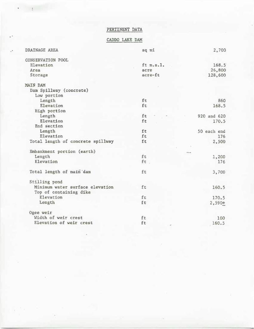
PERTINENT DATA
CADDO LAKE DAM
DRAINAGE AREA
CONSERVATION POOLElevationAreaStorage
sq mi
ft m.s.l.acreacre-ft
2,700
168. S"26,800
128,600
MAIN DAMDam Spillway (concrete)
Low portionLengthElevation
High portionLengthElevat.ion
End sectionLengthElevation
Total length of concrete spillway
Embankment portion (earth)LengthElevation
Total length of main·dam
Stilling pond "Minimum water surface elevationTop of containing dike
ElevationLength
Ogee weirWidth of weir crestElevation of weir crest
it 860ft 168.S
ft 920 and 620ft 170.5
it 50 each endit 176it 2,500
ft 1,200ft 176
it 3,700
ft 160.5
ft 170.5ft 2,59o.±
ft 100ft 160.5
September 1982
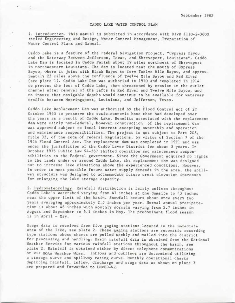
CADDO LAKE WATER CONTROL PLAN
1. Introduction. This manual is submitted in accordance with DIVR 1110-2-3600titled Engineering and Design, Water Control Management, Preparation ofWater Control Plans and Manual.
Caddo Lake is a feature of the Federal. Navigation Project, "Cypress Bayouand the Waterway Between Jefferson, Texas, and Shreveport, Louisiana". CaddoLake Dam is located in Caddo Parish about 19 miles northwest of Shreveportin northwestern Louisiana. The dam is located near the mouth of CypressBayou, where it joins with Black Bayou to form Twelve Mile Bayou, and approx-imately 23 miles above the confluence of Twelve Mile Bayou and Red River(see plate 1). Caddo Lake Dam was authorizd in 1910 and completed in 1914to prevent the loss of Caddo Lake, then threatened by erosion in the outletchannel after removal of the rafts in Red River and Twelve Mile Bayou, andto insure that navigable depths would continue to be available for waterwaytraffic between Mooringsport, Louisiana, and Jefferson, Texas.
Caddo Lake Replacement Dam was authorized by the Flood Control Act of 27October 1965 to preserve the socio-economic base that had developed overthe years as a result of Caddo Lake. Benefits associated with the replacementdam were mainly non-Federal, however construction. of the replacement damwas approved subject to local interest accepting ownership and operationand maintenance responsibilities. The project is ~ot subject to Part 208,Title 33, of the code of Federal Regulations, by virtue of Section 7 of the1944 Flood Control Act. The replacement dam was completed in l~il and wasunder the jurisdiction of the Cadpo' Levee District for about 5 years. InOctober 1976 Public Law 94-587 shifted operation and maintenance respon-sibilities to the F~deral government. Since the Government acquired no rightsto the lands under or around Caddo Lake, the replacement dam was designednot to increase lake elevations above the experienced conditions. However,in order to meet possible future water supply demands in the area, the spill-way structure was designed to accommodate future crest elevation increasesfor enlarging the lake storage capacity.
2. Hydrometeorology. Rainfall distribution is fairly uniform throughoutCaddo Lake's watershed varying from 47 inches at the damsite to 43 inchesnear the upper limit of the basin. Snowfall occurs about once every twoyears averaging approximately 2.5 inches per year. Normal annual precipita-tion is about 46 inches with monthly normals varying from 2.7 inches inAugust and September to 5.1 inches fnMay. The predominant flood seasonis in April - May.
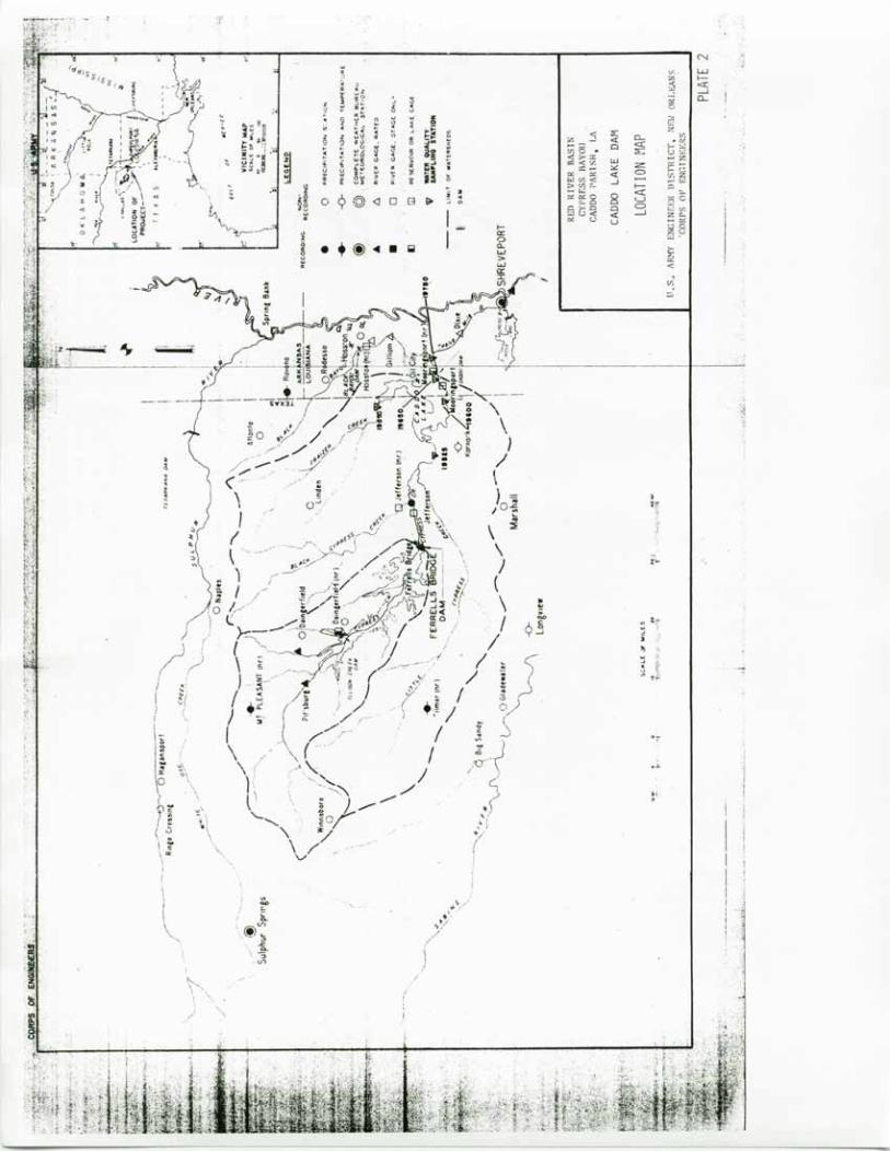
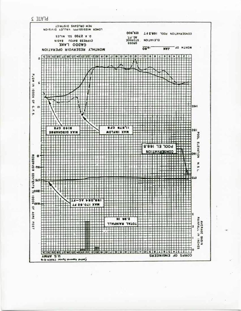
Stage data is received from five gaging stations located in the immediatearea of the lake, see plate 2. These gaging stations are automatic recordingtype stations whose charts are pulled weekly and mailed into the districtfor processing and handling. Basin rainfall data is obtained from the NationalWeather Service for various rainfall stations throughout the basin, seeplate 2. Rainfall is obtained either by direct telephone communicationsor via NOAA Weather Wire. Inflows and outflows are determined utilizinga storage ~urve and spillway rating curve. Monthly operational chartsdepicting rainfall, inflow, discharge and stage data as shown on plate 3are prepared and forwarded to LMVED-WR.

Caddo Dam passes flows from a drainage area of approximately 2700 squaremiles of the Cypress Bayou drainage basin. The runoff from about 850 squaremiles is controlled by Ferrells Bridge Dam which is located about 50 milesupstream from Caddo Dam. High flows are generally experienced during theperiod from March through May, while low flows normally occur from Augustthrough November. Average monthly runoff in cfs for the period 1958 through1981 is shown in Plate 8.
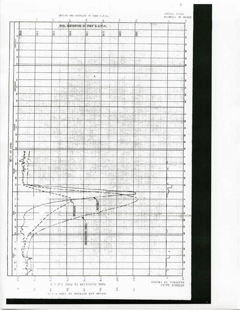
Eight major floods have occurred at Caddo Dam since 1930. The greatest floodon record occurred during April - June 1958. The flood was produced by thestorm of 25 April - 4 May, centered at Daingerfield, Texas. During the perioda maximum of 20.7 inches of rainfall was recorded at Daingerfield with over10 inches falling in a 48-hour period from 26 - 28 April. The watershedabove Caddo Dam experienced an average rainfall of 15.7 inches. With FerrellsBridge Dam in operation, the stage at Caddo Lake went to 182.6 ft on 5 May,which is the maximum stage of record at Caddo Lake Dam, producing a peakdischarge of 36,000 cfs. The peak inflows to the reservoir was 71,500 cfswith a total runoff of 9.9 inches from 24 April to 15 June. During moderateto large floods Caddo Lake's uncontrolled outlet becomes completely submergedand reverts to an open river condition. Consequently, the backwater effect"of the dam on upst~eamstages during these floods are minimal. Because thereis no flood control storage and the dam becomes completely submerged duringlarge floods, a hypothetical design flood has not been routed through theproject. (See plates 9 and 10 for typical flood hydrographs), '
The New Orleans District does not make stage forecast for Caddo Lake. TheNational Weather Service makes stage forecast for. th~ Mooringsport gage duringflood' periods. These forecast are distributed via NOAA -tieatherWire' circui t.The Mooringsport gage is located several miles above the damsite.
3. Project Management. Caddo Lake Dam is completely uncontrolled. Waterlevel~ within Caddo Lake d~pend' primarily on rainfall - runoff above thedamsite. During large floods Caddo Dam becomes completely submerged andTwelve Mile Bayou governs discharge frcmCaddo Lake. The role of the projectmanager is to periodically visit the structure when lake levels exceed 168.5feet NGVD. His principal duties consists of inspecting the dam and appurtenantstructurs to determine if there exists any adverse conditions which mayendanger the structure and to report such conditions to the district officefor action. Also, during storm seasons, the manager shall keep himself
______,.. ~~~?rmed on inclement weather conditions affec,ting the project •
4. Water Control Plan. The replacement of Caddo Dam has provided improvementsfor the benefit of navigation as well as various recreational projects. TheCaddo Levee District is presently the owner of Caddo Lake Dam consisting ofthose areas necessary for the embankment, spillway and outlet channel. All
,other lands associated with Caddo Lake are either privately or state ownedlands.
2

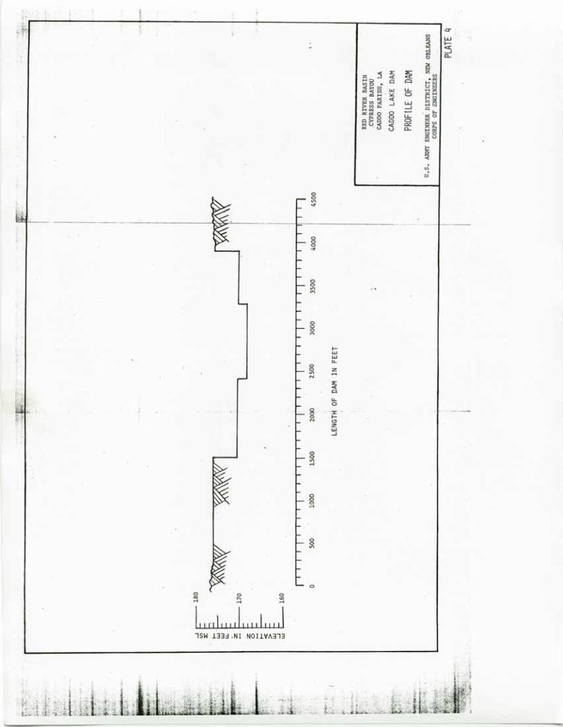
Caddo Lake Dam is a combination earth embankment and concrete spillway havingabout the same overall length as the original dam, but with the spillwaysection located at the left side of the dam. A stilling pool is formed down-stream from the spillway bya 100-foot long ogee weir flanked by earth embank-ments. A stilling basin downstream from the ogee weir provides the desiredenergy dissipation during periods of low flow. An outlet channel connectsthe ogee weir to Twelve Mile Bayou. Photographic illustriations are shownon Exhibits. a., .b, and c.
The various features of Caddo Dam are described below: (see plate 4)
a. Earth Embankment. The earth embankment extends from the south bankabout 1200 feet where it meets the concrete spillway. The embankment hasa 1 on 3 side slope on the upstream face and a 1 on 4 side slope on thedownstream face. Erosion protection consists of rip rap for the upstreamface and sad on the downstream face. The crest width is 30 feet at elevation176 feet NGVD. During large floods the entire embankment becomes submergedwith several feet of water.
b. Concrete Spillway. The spillway is a bi-level broad-crested weir.The lower portion is 860 feet long at elevation 168.5 feet NGVD. The lowerweir is flanked by 920 feet of weir on the south side and 620 feet of weiron the north side both at elevation 170.5 NGVD. Low flows up to about8,000 cfs from Caddo Lake are discharged over the concrete spiTtway. Thefoundation of the concrete structure was designed for raising to an elevationof up to 172.5 feet should it become desirable to raise stages in CaddoLake for navigation ...ar water supply storage at some future date.
c. Stilling Pond. The stilling pond is located just downstream ofthe concrete spillway. A low earth embankment at elevation 170.5 with1:3 upstream slope, a 30 foot crest width, and 1:10 downstream slope containsthe pond. A system of ditches downstream from the low portion of the spillwaycollects and directs flow over to a concrete ogee-type weir. The ogee weirwas constructed such that a sufficient water level is retained in the pondto provide the necessary stilling of water flowing over the dam.
d. Ogee Weir. The uncontrolled ogee weir and stilling basin immediatelydownstream form the outlet works for the stilling pond. ~The weir i~ 100feet wide with a crest elevation of 160.5 feet between concrete training'~alls that extend to elevation 173.5 feet. The weir is tied in to high groundon the north and the earth section of the main dam by an earth dike toelevation 170.5 feet. The weir discharges into a concrete stilling basinand thence into a reinforced concrete apron. The stilling basin, 30.67 feetlong, has one row of baffle blocks and an end sill to dissipate the energyin Caddo Lake discharges through the formation of a hydraulic jump. Theoutlet channel starts at the edge of the concrete apron. A 75-foot longriprap blanket is located downstream from the stilling basin to protectthe weir and training walls from discharge scouring and undermining tendencies.
3
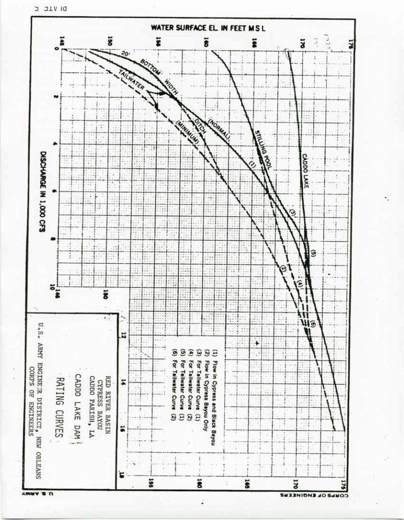
e. Outlet Channel. A trapezoidal channel with a 20-foot bottom widthand 1:3 side slope connects the ogee weir stilling basin with Black Bayou.Considerate erosion has occurred along the outlet channel such that designdimensions are no longer present. A tailwater rating curve is shown onplate 5.
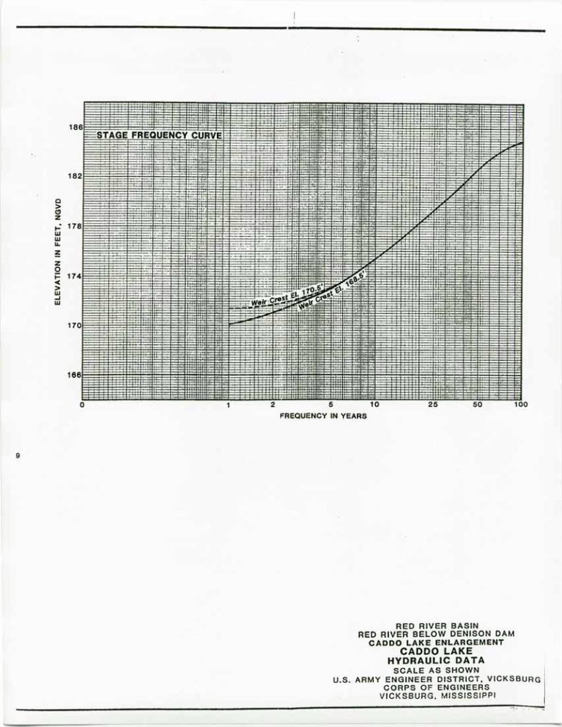
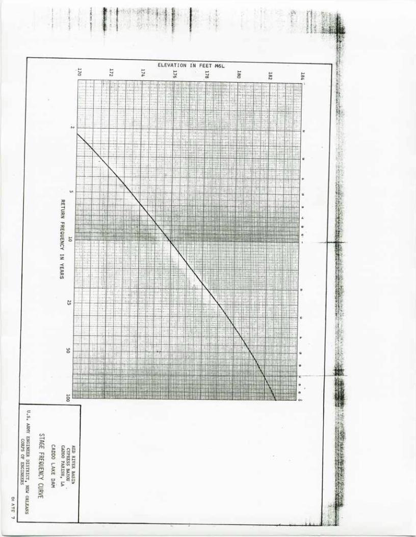
f. Water Levels. High flows are generally experienced during theperiod from March through May and low flows occur from August through November.The maximum flood of record occurred in April - May 1958. The elevation ofCaddo Lake reached 182.6 and the peak discharge was 36,000 cfs. The minim~melevation observed in Caddo Lake was 166.0 in 1934. This is 2.5 feet lowerthan the weir crest. A stage frequency curve is shown on plate 7.
Navigation: Caddo Lake Dam is a feature of the navigation project, "CypressBayou and Waterway from Jefferson, Texas, to Shreveport, Louisiana", Itspurpose was to prevent loss of navigable depths in Caddo Lake threatenedby erosion of Twelve Mile Bayou and Red River as _a res_ult of .the removalof rafts. Anticipated navigation benefits never fully materialized andauthorized studies for the replacement dam recognized that sufficient Federalinterest no longer existed to support the project. Existing commercial naviga-tion on Caddo Lake is that associated with development and production fromoil wells in the lake. However; since most of the oil from the wells ismoved by pipelines, commercial traffic on the lake consists pre~ominate1yof that associated with servicing the wells during production and drillingto deeper producing sands.
Water Supply: Due to the detention time provided by water storage capacity,good water has been~available in Caddo Lake for many years. Therefore, nearbytowns and cities turned to Caddo Lake as a source of municipal water supplyas ·their water requirements expanded. Industries requiring large quantitiesof water for both consumptive and non-consumptive use also have locatednear the lake. The known principal users of water from Caddo Lake are asfollows: (1) Marshall, Texas, (2) Mooringsport, Louisiana, (3) WaterworksDistrict No.1, Oil City, Louisiana, (4) Longhorn Ordinance Works, Karnack,Texas, (5) Southwestern Electric Power Company, (6) Universal PolychemCorporation and (7) Gulf Oil Company. Water supply was not a project purposeand no specific storage has been allocated for water supply. Regulation ofthis project is not required for this feature.
Water Quality: In Louisiana, there are three water quality stations (19550,19600, 19650) within Caddo Lake and one station (19750) downstream of CaddoLake Dam on Twelve Mile Bayou. There is one station (19525) upstream ofthe dam in Texas. Location of these stations are shown on Plate 2. Measurementstaken include four parameters: (1) temperature, (2) PH, (3) dissolved oxygen,and (4) conductance. Water quality sampling also includes surface sampling
.for analysis of physical parameters such as turbidity, total dissolved solidsand total suspended solids, as well as biological and chemical parameters.Data collected with the exception of dissolved oxygen and PH, are withinacceptable limits of the Louisiana Stream Control Commission (LSCC) criteria.Water quality data is entered into NOD's HEIS data system and EPA's STORE!
4
system. ,This provides easy access to Caddo Lake water quality data. Releasesfrom Caddo Lake are of good quality. The water quality downstream meets allLSCC criteria except for PH. The PH readings occasionally exceed the state1scriteria. Since the spillway and outlet structure are uncontrolled, thereis no means to regulate the quality of the releases. However, since thequality of the releases is good, no regulation is necessary.
Recreation: Caddo Lake has long been a favorite recreational area formany residents of Shreveport, Bossier City, Marshall, Jefferson, Longview,Texarkana and other nearby areas. The lake affords an excellent opportunityfor recreational boating and fishing, hunting and commercial fishing. Alarge number of permanent and summer-type homes, private and commercialcamps, boathouses, and boat launching facilities are located on or near theshoreline of the lake. Public access is available at the dam and via LouisianaState Highway No. 1 right-of-way. Although significant recreational benefitsare derived from Caddo Lake, recreation was not a project purpose and regula-tion of the project is not required for this feature.
'..
5

~ .. f.
~It E <;<; )? !~. ~
¢O~
•....•UJ
~
>-"'" .:5UJ 0-0::«:UJ
.~""::'i ~ ex: .::lz .. :::... '" c ga~ 0 - ~.. '" wfQ:i~ '" Q ~...gj",!;! ..
Q ~~~~~ -' :z "' ...8 <:r:: gj0.. '" 0-at~ c !:!'".. ~ •.• Clu
~8...Jex:0:: §UJ:zUJ
"" '",;
I
v..:z~~
iI,o
•• Ii.
••.;:""I g
Y-'
\,/,:0 /, ...
>/-,//
i,
'.
.~-,
,ii\~
';,'
--~
.l:i S:~891 'OOd NOll~"il3SNO:>
NOI.1'" 3'3
£ 31\fld.1:>I~J.SIO SNVi'alO Ao\.3N
NOt'>I •••IO •••:n'~.•.IddISSISSIf\l ij;3/AO'
S3',W 'OS OOL~ 'f '0
NIS~B nOA'B SS3aldAO3>1V1 oaavo
NOI.l\1Y3dO YIOAY3S3Y A'Hl.NON
OO,"ZI'.1" 'OY
3!)~il0.1S _SSOij~
Olel NYI' .:10 H.1NOW
1£0£6aaal a N ~2 ••3 £3 33 13 03 61 81 II 81 SI "I £1 al II 01 6 a l 9 ; •• £ 3 I
-
•••I
,\
,
\.1 "\ ~I
•.&0 olo.a •••0 IL"II3811YHOlIa XYIII . M.O'••N' XY,.
g'991 13 100d.NO U.Y
;fit- N
~ -
'-: ~.-OY 10.0 •••i••Z.8·OLI XYIII
- NI "'Z,'Y .••NIYII 'Y~OJ. !
-' ,
1_.1£~6283L3 N ;a to3 £3 33 13103161 al II 91 lil to, £1 21 II 01 6 a L 9 Ii to £ 2 1 I
o
ooo••o"
~ 0ell••JD
~Ofl:atooz;:w:z-1Vt
zO"ooo"'00'o"J>a=-'""'"'"-1
ANHY "S-n9-!I-M:)91013 ~ •• l$ \tI,,-V •••,••,
0'"
001•••oor1'1r1'1<J>
091:!oz
OlJ
SH33NI9N3 ~O SdHu~..
ooo""
~(.,. .:r
'" UJ
~ I-;;j :50 a..
j ~ :E: ~Z .0: ex: .lQH;;l 0 ·Cl'"0 •
H<.:I
pg ~ ijlw u.... U<.:I
o:l H· ~ a E~~"'~ .0: UJ "'z
'" ll.o -l -' HI,,!H<.:I Arx:rx: 0 8 . ~~~.~
u.... rx:o0 a <.:I.0: e::: lil'"u a.. Hl:!
<:>0zu<.:I
§'"~
00.,.,""
o.0.,.,M
000M
I-wWlL
00 z.,., -N
~.0:0
lL0
8- ..::J: - .. ..-".-"- •...-0 l-N Cl
Zw..J
00.,.,....•
000....•
o<Xl....•
o•........•o'"....•
ooU'I
o
lSW 133~.NI NOIIVA313
:J .:ll. v 10
WATER SURfACE EL IN FEET M S L
c:oeno

0;o
en-lo:tJl>
'C>'1T1
::;jo
>;0IT1l>
ELEVATION IN FEET M.S.L.
T.
t
r
t-h-r
--I r.0,o
TrR=
a>oo
en-l0:tJl>C>IT1
Z.r
(3 Ul IT. T-,
0 00 0
l>n:tJ hIT1
I." a>IT1 0IT1 0
,-l
,.
l T' :
(30c:: 0
CIl
,.~ (/)
-I'" Cl 0n z· = 0oc;-,
:J:>"' .... n n '"."z G> l> ~n",CIl", ITl 0 -<'"'" 8 "'."0'" :J:> 0"''''.., "' ....'" :z '"t:IJ)<"' .... t:::I r- >VJpj
ZCll l> '" '" Nc;-,..., :z:> .~ '".... '" 7< :.r.>ttl 0"' .... = m "'-<,. 0"'n ITl w CCIl"'..., :z:> 0 :::: ...."'. l> &: zCIl n :;:z c:'"~ =-<° ITl
'"'" if)0r-
~ 0.-i Z, CIl
L
9
186
182
Q>CJZ..: 178wwII.
~Zo~ 174-<>w...•w
170
166
o
STAGE FREQUENCY CURVE·-
1 2 5 10FREQUENCYIN YEARS
25 50 100
RED RIVER BASINRED RIVER BELOW DENISON DAM
CADDO LAKE ENLARGEMENTCADDO LAKE
HYDRAULIC DATASCALE AS SHOWN I
U.S. ARMY ENGINEER DISTRICT, VICKSBURG I
CORPS OF ENGINEERSVICKSBURG. MISSISSIPPI-----------------------------------------=-~. -~
VI
;0m-ic:;0:z"Tl;0m.lDc: •...m 0:zn-<
:z
-<m);0;0en
~I
•...00
;='".~ c.n'" 4nz J>on en1:11-< nl ~. SQg"'~ 0'" -n 0 t:1'tJo~ :;0 o~~'oj 0t:1 !'TI
~ 00 <."'I-< 10 r ~"'!:Jz'" c:: );0n>-l nl ;><: ~~~I-<~ :z m~~ ('""") 0=><!;l.>-l -< 0 • g I-<
'" );0 s: :z
~('""") ~.c::;0<:
!:! 0 nl::>
~-l.,'"..J
ElEVATION r"N FEET .f+SL

Month
JanuaryFebruaryMarchApri 1 .MayJuneJulyAugustSeptemberOctoberNovemberDecember
Caddo Lake
Average Monthly Runoff(1958 - 1981)
Runoff (cfs)
2,9803,3803,7984,1053,6691,976
765290520475
1,0932,404
Plate 8
i'~F!.ml AND Ol'TFLllW IN 1000 e.F.S
;-
. ;;
..
.. '"! L_.
" . -c
\VERAc;r D.'IlLY
RA I NF,\!.!. IN J NCHES
.
.
. :
: .
','::>
·
··
:. ,
~.
.
.
.'.::>
o.I rt, •~~!'~~~tt~lt~
. .1.:; ••• ,, •.• ;:, •••• h
"'.
~l NOIIVA313 100J
",
wC
. #:- ". :
.
. .
I ..
, '
~o
wo
-cIn:>-"o"

tNFL.lW .\NIl Ol'TF'LOW iN 100' C F S
Wi-RACE !J;\]] ,
RAINFALL IN INCHES
"o
",.
•...C
"f ~
.l..
'-'''1' _.: ~
---
: .
I ~ .,1_ I
-" ,"
: -
.!
a
If,----- 0
SJHJNl NT 'l'lV.:IN~VM
,nlVG J:J\~3I1V
"
'"
. .
. .
.
.
.'
. :
, ; 1+'- . ~-. I·:, ,~'
-
..
..
,
. ,"
.:~,
,--
. .
, .
wC
I .'
, .
-- '
.
..
l ,_
7:; t:-
'::.:, '
. : i.. :_, .•.
___. _:.n.. :,
, .
.
--. _.~ t l-
; .,'~'.
.'l",
~.-
.. ":.....~."
-- -
, ,
•...-,•...
"
-noll°:>"N ~:;r:;rd NI NOILVII::!1::!10Ud•..•• N I...•
'" C '"'5-.:I°J DOOr NI I'\O'1.:1~no((NY I'\O'l.:l~C
rfpt.~: '," :~#'rtJttfiq~r~11;' c
I. ~_ .
.;r.-!- ..
•...C
:
.
.
I 'n::=f1::-~J~ '~:;-::tr~-',"
, : .
--, .. ,
;t ." l'~ " "
,
wo
"o
o ~.'.=-' - ...
.
Standing Instructions to the Project Manager
1. General Information and Responsibilities.
a. General Information. Caddo Lake Dam is located in Caddo Parishabout 19 miles northwest of Shreveport in northwestern Louisiana (see plate 1).The replacement dam was completed in 1971 and the Caddo Levee District hadoperation and maintenance responsibilities for about 5 years. In October1976 Public Law 94-587 shifted operation and maintenance responsibilitiesto the Federal government. The main water control objective of this projectwas to prevent the loss of navigable depths in Caddo Lake threatened byerosion of Twelve Mile Bayou and Red River as a result of the removal ofrafts. Caddo Lake is also a source of water supply for several nearby citiesand industries which have located near the lake. However., water supply wasnot a project purpose and regulation of this project is not required forthis feature. The darn consists of an earth embankment, a concrete bi-levelspillway, a stilling pond, an uncontrolled ogee weir and an outlet channel,and is a completely uncontrolled structure. Therefore. there are no constraintson it's physical operation and it is not a local protection project.
b. Role of the Project Manager. The project manager of Caddo Lake needsno day to day instructions from the District Office since the dam is a com-pletely uncontrolled structure.
2. Data Collection and Reporting. Stage data is received from :rive gagingstations located in the immediate area of the lake, see plate 2. These gagingstations are automatic recording type stations wnose charts are pulled weeklyand mailed into the .eistrict for processing and handling. Basin rainfalldata is obtained from the National Weather Service for various rainfall stationsthroughout the basin, see plate 2. Rainfall is obtained either by directtelephone communications or via' NOAA Weather Wire.
In Louisiana, there are three water quality stations (19550, 19600, 19650)within Caddo Lake and one station (19750) downstream of Caddo Lake Dam onTwelve Mile Bayou. There is one station (19525) upstream of the darn in Texas.The location of these stations are shown on plate 2. Measurements taken include
four parameters: (1) temperature. (2) PH, (3) dissolved oxygen, and(4)s conductance. Water quality sampling also includes surface sampling foranalysis of physical parameters such as turbidity. total-dissolved solidsand total suspended solids, as well as biological and chemical parameters.Water quality data is ehtered into NOD's HEIS data system and EPA~s STORETsystem. This provides easy access to Caddo Lake water quality data.
3. Water Control Action and Reporting. Caddo Lake Dam is completely uncontrolled.Water levels within Caddo Lake depend primarily on rainfall - runoff above the
'damsite. During large floods Caddo Dam becomes completely submerged and TwelveMile Bayou governs discharge from Caddo Lake. The role of the project manageris to periodically visit the structure when lake levels exceed 168.5 feet NGVD.His principal duties consists 'of inspecting the dam and appurtenant structuresto determine if there exists any adverse conditions which may endanger thestructure and to report such conditions to the district office for action.
F)(HIRJT llrill
,< ,.
Also, during storm seasons, the manager shall keep himself informed on inclementweather conditions affecting the damsite, and shall initiate whatever emergencyoperations are applicable. He is responsible for reporting deficiencies thatdevelop in the embankments, spillway, outlet channels and appurtenant works.