Embed Size (px)
Citation preview
Caddo Archeology
Journal
Volume 18 2008
Caddo Archeology
Journal
CADDO ARCHEOLOGY JOURNAL
344 CR 4154Pittsburg, TX 75686
EDITORIAL BOARD
TIMOTHY K. PERTTULA
10101 Woodhaven Dr.Austin, TX 78753
e-mail: [email protected]
CHESTER P. WALKER
8316 HANBRIDGE
AUSTIN, TX 78736e-mail: [email protected]
LIASON WITH THE CADDO NATION OF OKLAHOMA
ROBERT CAST
Tribal Historic Preservation Offi cerCaddo Nation of Oklahoma
P.O. Box 487Binger, OK 73009
e-mail: [email protected]
ISSN 1522-0427
Printed in the United States of Americaat Morgan Printing in Austin, Texas
2008
CADDO ARCHEOLOGY JOURNAL ◆ iii
Table of Contents
A Decade of Straight Talk and Trust . . . . . . . . . . . . . . . . . . . . . . . . . . . . . . . . . . . . . . . . . . . . . . . . . . . . . . 1 Cecile Elkins Carter
Caddo Archaeology in Texas and the Caddo Nation of Oklahoma: Prospects and Challenges. . . . . . . . . . 5 Timothy K. Perttula, Robert Cast, and Bobby Gonzalez
Was Timber Hill the Last Caddo Village in the Caddo Homeland?. . . . . . . . . . . . . . . . . . . . . . . . . . . . . . 11 Jim Tiller
A Foster Trailed-Incised Vessel from the Sister Grove Creek Site (41COL36), Collin County, Texas . . . 22 Wilson W. Crook, III and Timothy K. Perttula
Tuinier Borrow Pit Biface Cache, Hopkins County, Texas . . . . . . . . . . . . . . . . . . . . . . . . . . . . . . . . . . . . 26 Harry J. Shafer and Lee Green
Book Review of “Looting Spiro Mounds: An American King Tut’s Tomb,” by David La Vere. 2007, University of Oklahoma Press . . . . . . . . . . . . . . . . . . . . . . . . . . . . . . . . . . . . . . 40 Robert Cast
Index to the First Eighteen Volumes of the Caddoan Archeology Newsletter, Caddoan Archeology, and Caddo Archeology Journal . . . . . . . . . . . . . . . . . . . . . . . . . . . . . . . . . . . . . . 45 Timothy K. Perttula and Chester P. Walker
50th Caddo Conference (March 2008) Abstracts . . . . . . . . . . . . . . . . . . . . . . . . . . . . . . . . . . . . . . . . . . . . 53

CADDO ARCHEOLOGY JOURNAL ◆ 1
A Decade of Straight Talk and Trust
Cecile Elkins Carter
Prepared for Opening Session entitled “Borders, Boundaries, and Bridges in Texas Archaeology,” Society of American Archaeology Annual Meeting, Austin, April 2007
The motives that bring tribal representatives and archeologists together for a discussion of Indian perspectives call for straight talk and trust. With that goal in mind, I will tell you how it is that I came to be here, state some opinions, raise a few questions, and ask each of you to examine your own perspective with consideration for the thoughts and ideas expressed tonight and the days that follow.
I fi rst talked about straight talk and trust at an Annual Meeting of the Society for American Archaeology (SAA) in New Orleans in 1996. I am a Caddo, a writer and historian, and I suspected then, as I do now, that the reason I was invited was because 32 years ago my research created a need for me to understand how archeologists reach their conclusions. So I stuck a centimeter tape in my pocket, picked up a trowel, and scraped my fi ngers screening dirt during an Arkansas Archeological Survey/Society Training Program at a Caddo site. There, I studied fundamentals in a classroom and under strict tutelage learned basic techniques and the discipline of excavation under Dr. Ann Early, who is now Arkansas State Archeologist.
That same summer, in Shreveport, I became acquainted with the late Dr. Clarence Webb, who is often referred to as the father of Caddo archeology. It was then, too, that I began a long term friendship with Dr. Hiram F. “Pete” Gregory at Northwestern State University of Louisiana in Natchitoches. He impressed me with his strong belief that archeology cannot and should not be isolated from connection with living descendants of a defi ned culture. This was not a widely accepted theory in the early 1970s.
Since the summer of my archeological initiation I’ve participated in other fi eld schools, inspected, and joined the crew on many sites in the four state region that encompasses the ancient Caddo homeland. Along the way I’ve enjoyed meeting, forming friendships, and working with perhaps a hundred or more professional and avo-cational archeologists in Arkansas, Louisiana, Oklahoma, and of course in Texas. I respect the work of most, rely on the expertise of some, and implicitly trust the advice of a few. As my Caddo elders and documentary research have taught me our history, archeologists have taught me Caddo prehistory.
During a Caddo membership meeting in January 1993, our Chairman read aloud a bewildering letter asking for consultation on excavations. Members were aghast to learn for the fi rst time that people “dug up” the graves of ancestors. Who is it that does that? Why do they do it? Afterward I gave the Chairman a brief explanation of the Native American Graves Protection and Repatriation Act (NAGPRA) and he immediately asked if I would volunteer to serve as cultural liaison for outside contacts. A few months later, I also became the voluntary Caddo NAGPRA representative. When a 1995 National Park Service grant made it possible for us to staff a NAGPRA offi ce, I withdrew from active participation but continued to serve as Caddo liaison when called upon. I am currently a member of the Caddo Heritage Museum Board of Trustees.
2 ◆ Volume 18 2008
My experiences in fulfi lling these duties, together with NAGPRA workshops and various conferences where tribal representatives shared experiences, confi rm for me that the Indian view of the relationship between Indian Nations and archeologists is greatly affected by whether or not their people remain within aboriginal territory. Aboriginal Territory? Homeland. A homeland without federal or state-drawn borders; with boundaries marked by natural landscape—rivers, prairies, mountains, Cross Timbers; and with bridges built by alliances, trade, and kinship.
The people of Indian Nations still occupying the land of their ancestors have an unbroken link with their past. The youngest may live on the site of an ancient village. Their parents and grandparents are familiar with sacred grounds and can locate the graves of their ancestors. They know when outsiders come to investigate, survey the surface of the land, or dig into it. They also are well aware that lines drawn on maps restrict their former borders and boundaries and that outside those lines, the land is now owned by others. There, with or without their agreement, excavations may been conducted and items carried away along with pieces of the People’s pride. There should be no wonder that archeologists sometimes fi nd it diffi cult to win their trust.
For the people of tribes who, like the Caddo, were coerced into leaving their original homelands, either by treaty or threat of violence, the experience is different. Generations have been born in another place and the youngest have scant knowledge of the homeland occupied by their ancestors. Few have visited the old homeland, even though most do know where their People came from and the feeling of attachment to that place is strong. Removed from the lands of their ancestors, it was many years before they knew that old home sites and sacred places were desecrated; that the bones of the ancient ones and objects reverently buried beside them were dug from the earth, examined, analyzed, discarded, sold for profi t, exhibited in a glass case, or stored on a museum shelf. Incensed, shocked, saddened that ANYONE would violate a grave, they fi nd little consolation in being told that archeologi-cal evidence documents their cultural history and dates the old one’s long occupation of the land they lost. Having preserved important aspects of their ancient culture, they know where they came from, and they can discern no real benefi t coming to them from archeology. Is there any wonder that it takes a long time to gain their trust? I assume that SAA members are familiar with the Principle of Archaeological Ethics endorsed by the SAA Executive Board and that all of you who are actively engaged in archeological activities know Section 106 of the National Historic Preservation Act, the Archaeological Resources Protection Act (ARPA), and the NAGPRA by heart. If you don’t, you should, and your assignment for next week is to fi nd copies and study them until they are fi rmly planted in your brain.
ARPA’s stated purpose is: “to secure, for the present and future benefi ts of the American people the protec-tion of archaeological resources and sites which are on public lands and Indian lands, and to foster increased cooperation and exchange of information between governmental authorities, the professional archaeological community, and private individuals,” but its main focus is on regulation of legitimate archeological investigation on public lands and the enforcement of penalties against those who loot or vandalize archeological resources. I remind you, though, that protection and preservation or special treatment of burial sites and cultural resources found on private and state owned public land is left to legislation enacted by the State.
NAGPRA described for the fi rst time in any preservation law, the rights of Native American lineal descendants, Indian tribes, and Native Hawaiian organizations with respect to the treatment, repatriation, and disposition of human remains and cultural items. State agencies held responsible for overseeing archeological resources were initially disturbed by some of the Act’s descriptions and requirements, notably inventory and provision of summaries to tribes, and consultation. Museum Directors had visions of Indians carrying off truckloads of prized collections. Indian leaders had little faith but much hope that the law would actually be implemented.
CADDO ARCHEOLOGY JOURNAL ◆ 3
The consultation mandated by the Act opened a bridge to cover the void between tribal communities and the community of archeologists. Straight talk garnered trust on both sides of the gap and the initial doubts and fears have almost faded.
The Indian view of repatriation and reburial remains problematic for some. It is often diffi cult for non-Indians to understand the deeply held spiritual beliefs and traditional practices of Indian people. Those unable to understand considered the Indian point-of-view on reburial and repatriation unrealistic, unreasonable, and impracticable. Less troublesome cases arise when there is a lack of familiarity with the laws, or a deliberately narrow interpretation given in an attempt to avoid or exempt a state agency, private contractor, or individual from protecting or preserving a site. Budget and time constraints, personal bias, or career outlook may blind an otherwise perceptive person from seeing the intent behind the laws. The effectiveness of NAGPRA depends upon how strictly the rules, regulations, interpretation, and INTENT are enforced by decision makers, both federal and state.
State legislators must struggle to enact NAGPRA type laws. Lobbyists for certain agencies, institutions, land owners, and politically infl uential artifact collectors weaken the language or block unmarked burial laws be-fore they are enacted. If these pressures prevail, tribal effort to infl uence the preservation of a site or to protect graves from disturbance is discredited; tribal sovereignty is disparaged; religious and spiritual practices are dishonored; request for responsible action is denied; looters have no fear of penalty; and both preservation law and archeology lose relevance. The last time I checked 38 state laws specifi cally addressed reburial of human skeletal remains, repatriation of human remains and grave goods, and/or unmarked grave protection statutes. In the four state area encompassing Caddo sites, Arkansas, Louisiana, and Oklahoma have an unmarked burial law. Texas does not. Under both federal and state law State Historic Preservation Offi cers (SHPO) administer historic preservation programs at the State level. In 1992 the U.S. Congress adopted amendments to the National Historic Preserva-tion Act that allow federally recognized Indian tribes to assume any or all the functions of a SHPO with respect to tribal land. Both State and tribal offi ces may approve Memoranda of Agreements. It must be remembered, though, that designated State agencies have authority to issue permits for excavations, but tribes do not. I do not imply that the majority of decision makers involved with archeology are unwilling to support both the word and the intent of legislation. Aside from an occasional dismal experience, I am encouraged by the extent of sensitivity and responsible actions I’ve observed during the past decade. Mutual respect has emerged to bridge the gap between the Caddo Nation and the archeologists whose fi eld of study is in the land of their ancestors. You have heard evidence tonight. The Caddo Nation’s Tribal Historic Preservation Offi cer is a trusted non-Indian archeologist, Robert Cast, who protects our interests with the fervor of a Caddo. Bobby Gonzalez, one of our own taught the Caddo way by his elders, is our NAGPRA representative. Several years before he was appointed to that position, Bobby was introduced to archeology by our implicitly trusted, straight talking friend, and voluntary advisor, Dr. Tim Perttula. Tim took Bobby as an untried Caddo recruit and taught him how to be a crew member on a Caddo site in East Texas. Now, with an understanding of what archeology is all about, Bobby is a capable NAGPRA representative and, as chair of the Repatriation Committee, he is able to explain things in a way that elders serving on the Committee need to understand in order to assess the value of archeological work; how it provides new information about tribal history; establishes defi nitions for homeland territory; and even may provide insight into contemporary health issues.
Here in Texas, the state that takes its name from the Caddo word “Taysha,” meaning friend or ally, professional archeologists and a strong corps of archeological stewards have earned the trust of Caddo people. Together
4 ◆ Volume 18 2008
with the Arkansas Archaeological Survey and Arkansas Archeological Society, archeologists in Louisiana, and in Oklahoma, alliances have crossed borders, redefi ned boundaries, and built bridges that span differences between the Caddo Nation and archeological communities. There are still more steps to be taken; private and semi-private arguments and disagreements will arise on certain issues, but both parties now know that straight talk leads to trust.
That’s our experience. For the rest of you, in whatever region your work takes you, I suggest that there are positive steps that each of you involved with archeology can take to promote trust and demonstrate that your work has relevancy for Indian tribes. You can make sure that the tribe is not the last to learn that you have made a discovery (despite regulations to the contrary, failure to immediately notify the tribe, or a delay in doing so, happens too often). Most importantly, you can question yourself. Ask, “does this excavation add anything we don’t already know about the cultural history of people or is it just a collection of scientifi c data?” Ask yourself, “will analysis of human remains actually contribute to the well being of living descendants, substantiate their territorial claim, identify genetic traits that aid diagnosis and current treatment of disease, or will my analysis primarily be of benefi t to the advancement of my professional standing or the satisfaction of my curiosity?” Ask yourself, “is the protection of sites from vandalism part of my job and am I willing to argue strongly with anyone who thinks it isn’t?” Remaining shadows of doubt that cloud the Indian perception of the relevance of archeology can be dispelled when each person whose position infl uences the direction of American archeology can justify his or her work with honest answers to questions like these. Accept responsibility for the protection of cultural resources, ac-knowledge tribal sovereignty, respect traditional religious and spiritual beliefs—these are the touchstones of trust for building bridges that span the space separating our communities.
_______________________Time limitations prevented the full presentation of this paper on the date for which it was written—Cecile Elkins Carter.
CADDO ARCHEOLOGY JOURNAL ◆ 5
Caddo Archaeology in Texas and the Caddo Nation of Oklahoma: Prospects and Challenges*
Timothy K. Perttula, Robert Cast, and Bobby Gonzalez
This is a tri-partite presentation on Caddo archaeology in Texas and the prospects and challenges existing today for the Caddo Nation of Oklahoma in insuring that they are involved in framing the direction and conduct of Caddo archaeological work in Texas. As we hope to make clear, present and future prospects range from bleak to exciting. Perttula will introduce the paper, then yield the text to Robert Cast and Bobby Gonzalez of the Historic Preservation Program at the Caddo Nation.
To provide a thumbnail archaeological context, the ancestors of the Caddo Nation of Oklahoma lived in the eastern part of Texas from at least as early as 2500-3000 years ago. The Caddo Indian people were forcibly removed from Texas in 1859 and were settled in Oklahoma, then Indian Territory. The Caddo left behind an extensive archaeological record of their life in Texas: thousands of farmsteads, hamlets, villages, small and large mound centers, and the bones and funerary offerings of their ancestors in many family and community cemeteries.
Caddo archaeology is an endlessly fascinating and challenging exploration of the lives and times—the deep history, if you will—of a special people, a people that have left their mark on the state of Tejas. Caddo archae-ology is also sometimes a maddeningly elusive subject. After more than 100 years spent pursuing it by a wide variety of folks, we realize that what is thought to be known about Caddo archaeology is so much less than what still remains to be learned.
Before the Caddo Nation of Oklahoma representatives have their say, there are several issues and concerns that warrant mention in any discussion of Caddo archaeology in Texas:
• A poor, if not abysmal, record of protection of unmarked Caddo Indian burials in Texas;
• The active and sustained looting of Caddo Indian burials on private, state, and federal lands in our state; over the last 70 years or more documentation exists that thousands of Caddo Indian burials have been looted;
• The interstate traffi cking of Caddo funerary offerings by for-profi t groups such as the Caddo Trading Co. and eBay. This traffi cking is well known to be going on in violation of state burial laws (but not in Texas, since this state has no unmarked burial law protecting Indian burials), the Archaeological Resources Pro-tection Act (ARPA) and the Native American Graves Protection and Repatriation Act (NAGPRA);
• The perfunctory history of consultation and government-to-government relationships between the Caddo Nation and representatives of state and Federal agencies working in Texas; much of that consultation is without regards to the interests of the Caddo Nation, and is often little more than pro forma and paternal-istic, if consultation takes place at all;
6 ◆ Volume 18 2008
• The status of NAGPRA consultation between the Caddo Nation and some museum facilities in Texas that hold Caddo human remains and funerary offerings has often been slow to involve the Caddo Nation of Oklahoma and often rocky in all its aspects;
• Archaeologists in Texas have only begun to learn how to communicate with the Caddo Nation of Okla-homa; it’s debatable whether they’ve earned the trust of the Caddo people. Personally, I do not believe most archaeologists in our state have learned or earned anything. Those few Texas archaeologists that have learned some things about the modern state of archaeological practice in North America (cf. Atalay 2006; Kerber 2006; Silliman 2008; Smith 2007) are actively collaborating with the Caddo Nation on archaeologi-cal projects of mutual interest and concern.
In the remaining sections of this article, Robert Cast and Bobby Gonzalez give their views on the present and future prospects and challenges facing the Caddo Nation of Oklahoma in regards to Caddo archaeology.
For those readers that do not know me, my name is Robert Cast and I am the Tribal Historic Preservation Of-fi cer with the Caddo Nation of Oklahoma. Let’s start at the beginning, with the record of Caddo Indian burial protection in the state of Texas. In my view, there are still a few archaeologists, particularly in Texas, that view Caddo human remains and their funerary items not so much as a cultural resource (with the inference that a “culture” actually has a connection to the resource) but more like a natural or archaeological resource of the state of Texas. Such resources can then be bargained with and bartered for when it comes to the interests of the state and the Caddo, and to each group’s dealings with other outside agencies and the public.
When mining operations are pending that will destroy signifi cant parts of important Caddo archaeological sites, for example, knowing that Caddo Indian burials will be disturbed and not all of them can possibly be avoided, sure, some of the burials will be professionally excavated, but still the interests of the mining companies (and their pocket books) always take precedence, the unidentifi ed burials are destroyed, ground away into the landscape.
When U.S. Army Corps of Engineers, Fort Worth District, lake levels in East Texas drop to record lows and archaeological sites with human remains and complete pottery vessels are exposed to looters looking only to make a quick buck, the federal agency simply states they don’t have the money or the man-power to monitor or stop the looting or to excavate the remains. But, they say that they will build the Caddo a reburial area so they can bury the ones they help put in the museums and universities.
When new lakes are proposed in the homelands of the Caddo, and research designs and archaeological surveys are proposed, it is usually with the idea that a sample survey is suffi cient enough; we hear that not all the sites or burials can be identifi ed or protected. That is left to Mother Nature for the next drought or the next fl ood to expose these burials at some later date. And when they are eventually exposed, nothing is done to protect them, not even to remove them from the elements. This cycle of archaeological sampling, avoiding archaeological assessments and evaluations, and leaving burials to be exposed by both the natural and the unnatural forces of looting is one of the major problems and challenges we (both archaeologists and Caddo tribal members) are faced with every day. On the one hand, we say that these villages, cemeteries, and burial sites are irreplaceable resources, “archaeological resources,” but we do not really believe it, because our actions would show otherwise. Perhaps “the resource” is not as irreplaceable as we thought. Perhaps it is the mindset that Caddo Indian burials only serve a purpose for researchers in so far as to what information they contain can be extracted from these remains, and maybe it
CADDO ARCHEOLOGY JOURNAL ◆ 7
is believed enough has already been extracted, so their importance is diminished? If this is indeed the case, then these human remains become only a product used by archaeologists, looters, the state, and the Caddo, like corn or cotton to a farmer, or coal to a mining company, something harvested to be used, bartered with, or sold. There needs to be some form of humanity brought back to the profession. Even though the ARPA defi nes these burials as “archaeological resources” these “resources” were living, breathing, human beings. Each one has a story to tell.
Why is the concern with the desecration of burials so important to the Caddo people? You will hear Bobby say over and over “We treat the discovery of each burial as though it were a crime scene.” Why is this? The discoveries of these burials are proof of the Caddo presence in these areas. Each time we abandon or ignore our responsibilities to manage and preserve these places, we are the ones that should be held accountable for helping to rip another page out of the history books of the Caddo people.
Next, I would like to discuss the illegal traffi cking of funerary objects and the Caddo Trading Company. Ironi-cally, an article in The Oklahoman, dated August 20, 2006, with the title “Market for artifacts isn’t too black” came out shortly after 26 Caddo pottery vessels from the Cedar Grove site were stolen from Southern Arkansas University at Magnolia. The article begins: “The so-called market for ancient Indian artifacts might actually be best described as gray.” The writer of the article, Ron Jackson, interviewed Sam Johnson as an expert source on the market for Indian artifacts; this is a guy that has made a living off of selling Indian artifacts for over 30 years and the owner of the Caddo Trading Company. Yet, according to the article, Sam says that there is simply no market. How has he made a living all these years? Why does he own a Caddo burial mound and have fi eld schools there? How can he continue to dig up Caddo burials and funerary offerings, selling what he can, when there is a burial law in the state he operates in (Arkansas) that has a burial law that prohibits a lot of this activ-ity? It boggles the mind.
Why then would someone walk into a university curatorial facility and walk out with 26 Caddo pottery vessels? Why did this same thing happen several years before with pottery vessels from the Sanders site at the Texas Archeological Research Laboratory in Austin, Texas? To put it plainly, there is a market for Caddo funerary objects or these things would not happen. Part of our job is to also try to educate the public on what is really happening with regard to the illicit trading, buying, and selling of Caddo funerary objects.
There are only three people in our Historic Preservation Offi ce that works with the above-mentioned issues on a daily basis; so, we do need all the help we can get. We do have a mostly unpaid archeological consultant who helps with Section 106 and NAGPRA, and all those issues in between. We have partnered up with several Texas Caddo archaeologists to complete a number of projects of importance to the Caddo people, including documenting NAGPRA collections in various museums and curation facilities across the country (Gonzalez et al. 2005; Cast et al. 2006; Perttula et al. 2007). With each of these projects a professional quality report was produced and all of these signifi cant projects were associated with Caddo archaeologists in the state of Texas working directly with the Caddo Nation of Oklahoma. We will be doing more of this kind of important Caddo research in the years ahead.
Keep in mind, while working on these projects, we are also constantly being bombarded with requests for meetings, to attend trainings or workshops, or to respond to human remains eroding out from some other state shoreline or to intervene in some development project that a local community is fi ghting against. We have learned to curb the Section 106 workload by streamlining the consultation process when it makes sense by forming agreements with federal and state agencies and by developing certain protocols for consultation, for inadvertent discoveries, and for the intentional excavations of human remains.
8 ◆ Volume 18 2008
A Programmatic Agreement that we thought was important was initiated over six years ago with the Fort Worth District of the U.S. Army Corps of Engineers. It has yet to be formalized. For all I know, it was tossed in some-one’s circular fi le at the Advisory Council on Historic Preservation in Washington, D. C. Perttula was there at the outset of these consultation meetings and was largely responsible for bringing the Caddo into this process. We met with the Colonel of the Fort Worth District, several staff members, the Texas Historical Commission, the State Historic Preservation Offi cer, and other interested parties to discuss the development of this agreement. We formed a smaller “working group” that was organized from those in attendance to put together the content of the agreement. At one of these working group meetings, our trust in the Corps, and the consultation process, was broken, and as yet, has never been fully restored. This scenario has been hashed and rehashed publicly in various places (to read more about it, see Austin et al. 2002; Cast and Perttula 2003a, 2003b). But, and this is an important point: Do what you say you are going to do. When trying to develop any type of trusting relation-ship with the tribe, do not make promises you are not prepared to keep. And it does work both ways. As with any other relationship, we need to get to know each other better. If one group feels like they are being lied to, well, the relationship is doomed.
To summarize our relationship with the Fort Worth District of the U.S. Army Corps of Engineers, our main antagonist, I have now personally advised the Chairman of the Caddo Nation, LaRue Parker, to disregard any agreement that comes out of the Advisory Council on Historic Preservation and request instead that the Fort Worth District of the U.S. Army Corps of Engineers simply comply with existing Federal law and regulations concerning cultural resources. I would say that falls under a “challenge” both for the Corps and the Caddo Nation.
But, I believe there are many prospects and possibilities. We do want to be a part in framing where Caddo archaeology goes from here, and not just in Texas. Our schedules sometimes do not permit us to do a lot of things that we would like to do, much like anybody else’s, but this does not mean that we don’t care about every particular Caddo archaeological project, because we do. We seek to develop a relationship based on mutual trust and respect. But, that trust and respect has to be earned. If you are involved in Caddo archaeology, we want to hear from you. If you are involved in Caddo archaeology, see this as an invitation to come to the tribal complex in Binger, Oklahoma, and meet some living Caddo people. We do want to directly participate when we can. When discussing legislation that may directly or indirectly effect archaeological sites of importance to the Caddo, we would like a spot open at the table. Who knows, we might even partner up with you on a project in the future. All we are asking for is the opportunity to discuss issues and be involved.
We now turn this paper over to Bobby Gonzalez:
In a perfect world, the Caddo would have become as powerful as the United States of America. In a perfect world, the Caddo would have continued negotiations with the French, Spanish, and Mexican governments. In a perfect world, the Caddo would be truly a Sovereign Nation. But, the reality is, that the French left us with trade, the Spanish left us with disease, and Mexico became Tejas. We were then forced and driven away like a disease, quarantined, and held captive against our wills to be moved to a place known as “Oklahoma.”
With the passage of the Native American Graves Protection and Repatriation Act (NAGPRA) the Caddo have been able to reconstruct our time in history associated with the landscapes of our ancestral homelands in northwest Louisiana, southwest Arkansas, eastern Oklahoma, and northeast Texas. Currently, Caddo NAGPRA collections are being held in institutions across the United States, which include places like Harvard Univer-sity, the American Museum of Natural History, the Sam Noble Oklahoma Museum of Natural History, and the Texas Archeological Research Laboratory at the University of Texas (just to name four out of over one hundred museums). With the passage of the National Historic Preservation Act, and its amendments to include Indian
CADDO ARCHEOLOGY JOURNAL ◆ 9
tribes in the Section 106 consultation process, it has given the Caddo an opportunity to learn why some of these NAGPRA collections exist in these museums, libraries, repositories, and federal agencies in the fi rst place.
Executive Order 13007 regarding Sacred Sites has also allowed the Caddo an opportunity through tribal resolu-tions to deem sites that the Caddo people consider sacred. Many of these places are in the state of Texas. With Executive Orders and Presidential memorandums issued by the President of the United States, it has given the Caddo an opportunity to become more involved in the government-to-government consultation process with federal agencies.
We also understand our cultural importance as a nation within a nation and to be able to govern our tribal affairs accordingly. We understand the importance of Traditional Cultural Properties and Intellectual Property rights. We know that we are the victims of political compromise and are continually faced with laws challenging our sover-eignty, our cultural traditions, and those very things that make us Caddo. We will, however, continue to strive for justice and equality for all the Caddo people when it comes to the protection and repatriation of their human remains and funerary objects, this being a comfort that is not so readily afforded to everyone in the state of Texas.
The Caddo believe in property rights and do understand the real meaning of having a place you call home: a place to live and raise your family and to be buried with the dignity and pride given to you at the time of death, with family, friends, and a community of people at your family’s side.
You must ask yourself as archaeologists and people of science why there is such continued looting on lands not protected by any state unmarked burial law, a state where an individual can loot an unmarked grave regardless of ethnicity. This is the same state where the appointed Chairman of the Advisory Council on Historic Preservation prides himself on being from a state where our nation’s president was once governor.
The Caddo have been impacted more than any other tribe in the state of Texas with the looting of our ances-tor’s graves from private, state, and federal lands. Such a situation has occurred over time on lands owned and controlled by the Fort Worth District Corps of Engineers. Archaeologists have documented over 800 looted graves from federal property over the last 10-20 years in this small area of northeast Texas (Cast and Perttula 2002; Perttula and Nelson 1999). Many of the looted graves are open to this day.
The Texas Historical Commission, “the state agency for historic preservation,” continues its efforts to take control of 21 state parks such as “Caddoan Mounds” state park at the George C. Davis site (41CE19), yet has never con-sulted with the Caddo Nation on any of these plans (or probably with any other group or agency for that matter). This is the same state agency that chooses to allow landowners within the state to pick and choose burial items from Caddo graves—in a sense helping them amass collections—before any repatriation effort can be attempted by a federally recognized tribal government such at the Caddo Nation of Oklahoma. Under federal law, the Caddo Nation would be considered “culturally affi liated” to such human remains and funerary objects.
In all the years of looting in Texas, the Texas Historical Commission has never once called the Caddo Nation to inform them about the desecration of these burial sites or graves being looted for their funerary objects. We learned about these things by going and visiting some of these places, fi rst hand, or from someone outside of this state agency for historic preservation.
Archaeologists and anthropologists, as stewards of the past, should be attempting to protect these sites and locations, not providing landowners with collections. It has been our experience that archaeologists have also forgotten about the collections held in museums and repositories across the country. Many of these have never
10 ◆ Volume 18 2008
been documented or written about even though they were excavated well over 30-50 years ago. What information is being lost here as well?
We would truly like to form better working relationships and true partnerships with the archaeological com-munity in Texas, the Fort Worth District Corps of Engineers, and the Texas Historical Commission. We simply ask to be respected as equals and partners in this process and as Caddo people with concerns for the care and treatment of our ancestors.
REFERENCES CITED
Atalay, S. (editor)2006 Decolonizing Archaeology. Special issue. American Indian Quarterly 40(3).
Austin, S. P., D. E. McGregor, and R. Scott2002 Resource Protection and Management in the Fort Worth District. Council of Texas Archeologists Newsletter
26(3):23-28.
Cast, R. and T. K. Perttula2002 The Long-Term Looting of Caddo Indian Sites on Federal Property in Northeastern Texas. CRM 25(2):26-28.
National Park Service.
2003a Response to CTA Article on “Resource Protection and Management in the Fort Worth District.” Council of Texas Archeologists Newsletter 27(1):19-23.
2003b Who’s Wastin’ Time: A Somewhat Warped Record, A Response to Martin’s Time’s a Wastin’: Setting the Record Straight. Council of Texas Archeologists Newsletter 27(2):9-10.
Cast, R., T. K. Perttula, B. Gonzalez, and B. Nelson2006 Documentation of Caddo Ceramic Vessels from 41WD60, Wood County, Texas. Caddo Nation of Oklahoma, Historic
Preservation Program, Binger, Oklahoma.
Gonzalez, B., R. Cast, T. K. Perttula, and B. Nelson2005 A Rediscovering of Caddo Heritage: The W. T. Scott Collection at the American Museum of Natural History and
Other Caddo Collections from Arkansas and Louisiana. Caddo Nation of Oklahoma, Historic Preservation Program, Binger, Oklahoma.
Kerber, J. E. (editor)2006 Cross-Cultural Collaboration: Native Peoples and Archaeology in the Northeastern United States. University of
Nebraska Press, Lincoln.
Perttula, T. K. and B. Nelson1999 The Looting of Prehistoric Caddo Indian Cemeteries in Northeast Texas. Texas Forum on Civil Liberties and Civil
Rights 4(1):77-86.
Perttula, T. K., M. Walters, R. Cast, B. Gonzalez, and B. Nelson2007 Documentation of Funerary Offerings from a Prehistoric Caddo Burial at Site 41WD244, Wood County, Texas. Caddo
Nation of Oklahoma and Archeological & Environmental Consultants, LLC, Binger, Oklahoma, and Austin.
Silliman, S. W.2008 Collaborative Indigenous Archaeology: Troweling at the Edges, Eyeing the Center. In Collaborative Indigenous
Archaeology at the Trowel’s Edge: Exploring Methodology and Education in North American Archaeology, edited by S. W. Silliman. University of Arizona Press, Tucson, in press.
Smith, C.2007 The Indigenous Transformation of Archaeological Practice. The SAA Archaeological Record 7(2):35-39.
____________________*This paper was originally presented at the 72nd Annual Meeting of the Society for American Archaeology, April 25, 2007.
CADDO ARCHEOLOGY JOURNAL ◆ 11
Was Timber Hill the Last Caddo Village in the Caddo Homeland?
Jim Tiller
ABSTRACT
Literature suggests that the last Caddo village in the Caddo homeland, Timber Hill in Marion County, Texas, was abandoned in 1842 when the tribe relocated to the Oklahoma Territory. Using primarily archival materials, this paper will present a geographically-based circumstantial case that Timber Hill was probably abandoned during the late 1820s or very early 1830s.
INTRODUCTION
In 2002, the Texas Historical Commission published Finding Sha’chahdinnih (Timber Hill): The Last Village of the Kadohadacho in the Caddo Homeland.1 As the subtitle indicates, the authors were confi dent enough in their fi ndings to declare the Caddo village north of Caddo Lake in Marion County to be the last village in the tribe’s traditional northwestern Louisiana-eastern Texas homeland.
In this article I will examine the archival record as it relates to the abandonment of Timber Hill. Period documents used will include the letters of Caddo Agents George Gray and Jehiel Brooks as well as plat maps and related fi eld notes from the 1837-1838 United States surveys of Range 16 and 17 West. Based on these materials, a geographically-based circumstantial case will be offered suggesting that Timber Hill was probably abandoned by the late 1820s, and almost surely was abandoned by the very early 1830s.
THE LETTERS OF THE CADDO AGENTS
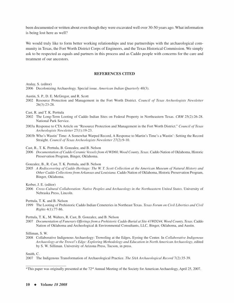
From the letters of George Gray and Jehiel Brooks, it is clear that there were at least two substantial Caddo vil-lages within the jurisdiction of the Caddo Prairie Agency (Figure 1)—one was Timber Hill located north of the Caddo or Sodo Lake complex on Jim’s Bayou,2 and a second, whose specifi c location has yet to be confi rmed, was somewhere south of Caddo Lake.3
During the mid-to-late 1820s, Gray provided a government subsidy to James Shenick to operate a ferry across Caddo Lake.4 This ferry appears to have provided benefi ts to both Caddo groups: (1) giving the Caddo living south of the lake relatively easy access to the Caddo Prairie Agency; and (2) giving the Timber Hill village and Caddo Prairie Agency north of the Sodo Lake complex access to Bayou Pierre—an important communication and trade link with Natchitoches.
Throughout much of the late 1820s, Gray’s Caddo Prairie Agency was subjected to periodic inundation caused by the ever-northward moving Great Raft of the Red River.5 Faced with the likelihood of continued fl ooding and
12 ◆ Volume 18 2008
an ongoing problem with outsiders intruding upon Indian lands, Gray, on August 11, 1828, suggested moving the Agency south of the Sodo Lake complex nearer to Fort Jesup in Louisiana. In addition to giving him better access to military assistance, Gray noted that such a relocation “would be more convenient to the Indians of this Agency.”6 At the very least, this statement indicates an increasing number of Agency Indians south of the lake complex by 1828.
Gray died in late 1828 and was replaced in early 1829 by Thomas Griffi th, who died shortly after he moved the Agency back to Natchitoches. Jehiel Brooks was appointed Caddo Agent in 1830.7 In August of that year, Brooks toured the Caddo lands with an eye to determining sentiment for moving the Agency to a point south of Lake Sodo on the Red River. In an October 23, 1830 letter to Washington, he indicated he had “consulted with all the Indians about a removal, and it being their wish to have the Agency established, at all events, below Lake Sodo.”8 In a later letter recounting this same event, Brooks noted that, “the Caddo, Quapaw and Cochatta [Coushatta] Indians, to a man [were] in favor of a removal below Lake Sodo.”9
As a result of this trip and his consultations with the Indians, Brooks suggested to Washington that the Agency be moved to a higher and more healthful location south of the lake complex. The place he selected for the new Caddo Agency was Peach Orchard Bluff just south of modern-day Shreveport.10
The fact that both Gray in 1828 and Brooks in 1830 recommended, and the Indians consented, to a reloca-tion south of the lakes suggest that in all likelihood Timber Hill was already abandoned. With regard to Gray, and access to the military notwithstanding, had Timber Hill been inhabited to any substantial degree in 1828, and the area north of the lakes still been inhabited by large numbers of Indians as had been the case when he relocated the Agency to the Caddo Prairie from Sulphur Fork in early 1825, it seems likely Gray would have simply recommended moving the Agency west a mile or so to higher ground.
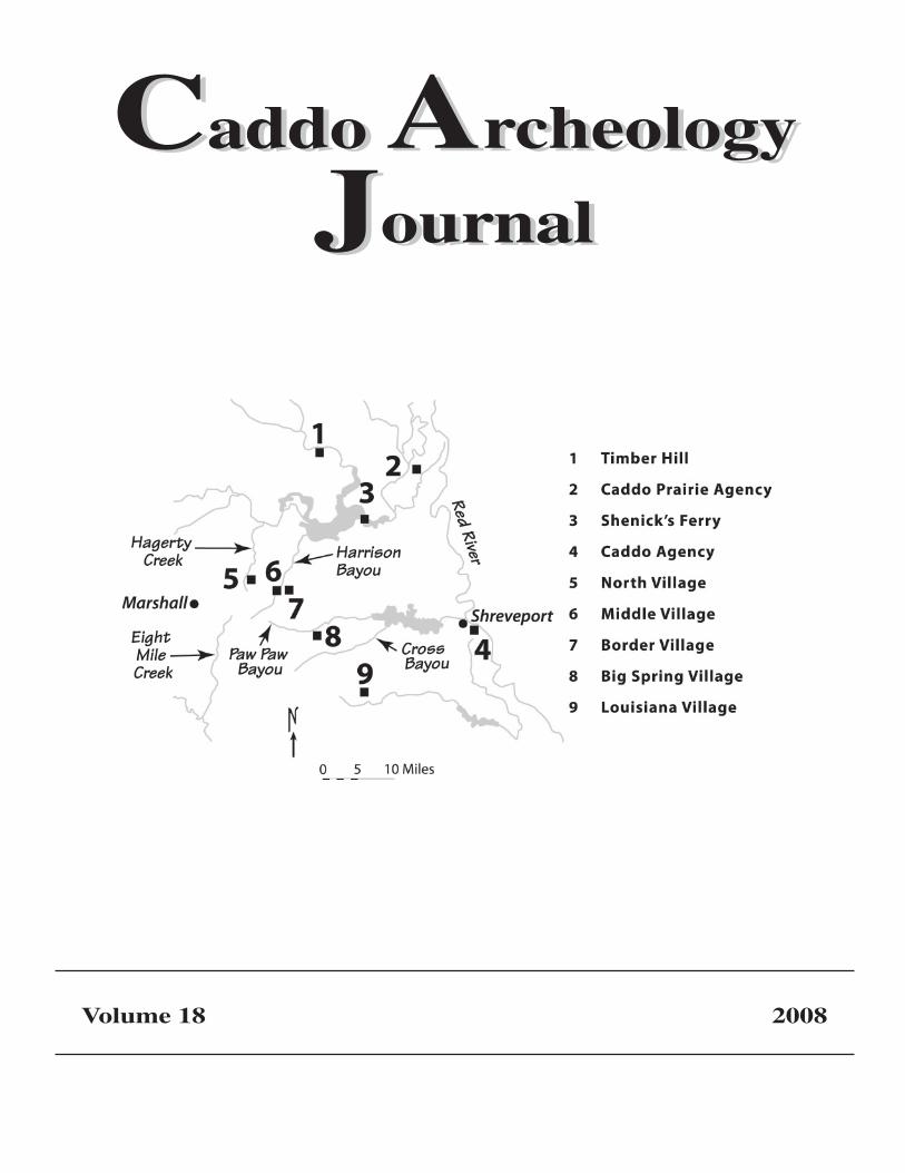
Figure 1. Known Historic-Era Caddo Village Sites, 2007. As of 2007, a number of historic-era Caddo village sites had been located in the Caddo Lake area. Except for Timber Hill, which was found in the early 1990s, the locations of the balance of the villages have only become known since 2000. It is very likely that either the Big Spring or Middle Caddo village is the site mentioned by Gray as being the second Caddo village.
CADDO ARCHEOLOGY JOURNAL ◆ 13
Brooks’ motives do not appear to have included a military component—he seemingly wanted the Agency moved to a more convenient (for the Indians) and healthful (for himself) location. In a January 17, 1831 letter, Brooks expanded upon his reasoning for having moved the Agency down river noting that, “the Indians will meet with no obstruction at any time in their visits thereto, their distance to travel from their villages shortened very considerably, with a free Boat navigation at any season of the year and the expense of transportation ma-terially diminished.”11
On February 13, 1832, Brooks addressed a new Secretary of War about his reasons for having moved the Agency below the lakes.12 He made at least three points in this letter that, taken together, confi rm without question that by 1830 the Caddo villages were located south of the Lake Sodo complex. Brooks noted that by moving the Agency from its location north of the lakes, he had:
• “[saved the government] one hundred dollars a year for ferrying Indians across Lake Sodo which lay be-tween their villages and the prairie.”
In 1830, Brooks eliminated the supplement paid by the government of the United States to James Shenick to ferry Indians across Caddo Lake. As is clear from this statement, by 1830 there was no need for this expenditure because most, if not all, Agency Indian villages lay south of the Lake Sodo complex. It is not likely Brooks would have made this statement had Timber Hill, the oldest, and long one of the largest Caddo villages in the area, still been inhabited.
• “[shortened] the distance from the Caddo villages [to the Agency] nearly one half.”
It seems clear by this statement that once the Agency had been re-located to Peach Orchard Bluff, the Caddo as a group experienced a signifi cant reduction in the distance needed to travel to the Agency. While true for Caddo living south of the lakes, clearly, such would not have been the case for any inhabitants of Timber Hill. In fact, the distance to the Agency for the residents of Timber Hill would have increased appreciably. This is a point Brooks would have been well aware of had that site been inhabited.
• “[given] the Indians free ingress and egress [to the Agency] at all seasons of the year.”
South of the lakes, the topography is typical of most of East Texas; the land tends to be gently rolling and dissected by numerous small creeks and occasionally larger streams. Indians traveling the 25 to 30 miles between their villages and the Agency at Peach Orchard Bluff could have made the trip at any time of the year, only occasionally hampered by stream fl oods caused by locally heavy rain. Brooks would not likely have made such a statement had any villages remained north or east of the Lake Sodo complex as such villages would have experienced diffi culties associated with both the northward-advancing Great Raft and spring fl ooding along the Red River and around the lakes.
Considering the fact the Indians had agreed with the idea of moving the Agency below the lakes, and that there would be no signifi cant obstructions encountered by Indians on trips to the Agency, taken together suggests that by 1830 all of the Indian villages were probably located south of the lakes. A reduction in both distance traveled (to the Indians) by half, and Agency expense for transportation (much of it the free-to-the-Indians Shenick’s ferry), further suggests there were few if any Indians north of the Sodo Lake complex by 1830.
14 ◆ Volume 18 2008
THE 1837-1838 UNITED STATES SURVEYS
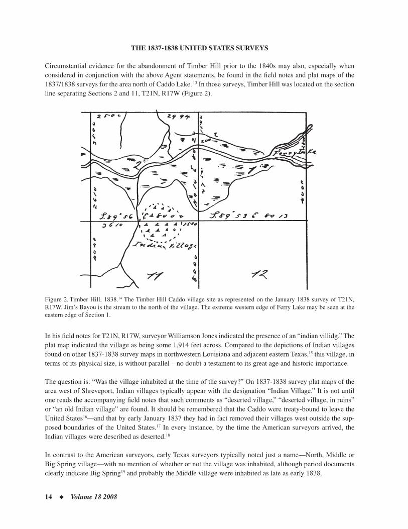
Circumstantial evidence for the abandonment of Timber Hill prior to the 1840s may also, especially when considered in conjunction with the above Agent statements, be found in the fi eld notes and plat maps of the 1837/1838 surveys for the area north of Caddo Lake. 13 In those surveys, Timber Hill was located on the section line separating Sections 2 and 11, T21N, R17W (Figure 2).
Figure 2. Timber Hill, 1838.14 The Timber Hill Caddo village site as represented on the January 1838 survey of T21N, R17W. Jim’s Bayou is the stream to the north of the village. The extreme western edge of Ferry Lake may be seen at the eastern edge of Section 1.
In his fi eld notes for T21N, R17W, surveyor Williamson Jones indicated the presence of an “indian villidg.” The plat map indicated the village as being some 1,914 feet across. Compared to the depictions of Indian villages found on other 1837-1838 survey maps in northwestern Louisiana and adjacent eastern Texas,15 this village, in terms of its physical size, is without parallel—no doubt a testament to its great age and historic importance.
The question is: “Was the village inhabited at the time of the survey?” On 1837-1838 survey plat maps of the area west of Shreveport, Indian villages typically appear with the designation “Indian Village.” It is not until one reads the accompanying fi eld notes that such comments as “deserted village,” “deserted village, in ruins” or “an old Indian village” are found. It should be remembered that the Caddo were treaty-bound to leave the United States16—and that by early January 1837 they had in fact removed their villages west outside the sup-posed boundaries of the United States.17 In every instance, by the time the American surveyors arrived, the Indian villages were described as deserted.18
In contrast to the American surveyors, early Texas surveyors typically noted just a name—North, Middle or Big Spring village—with no mention of whether or not the village was inhabited, although period documents clearly indicate Big Spring19 and probably the Middle village were inhabited as late as early 1838.
CADDO ARCHEOLOGY JOURNAL ◆ 15
In Jones’ fi eld notes regarding Timber Hill, the only description provided is of an “indian villidg.” Such might at fi rst lead one to believe the village was inhabited. In fact, a number of pieces of circumstantial evidence, in addition to the comments of Gray and Brooks, seem to point to the village being deserted.
Most obvious is the lack of any improvements, roads, trails, or paths leading to, or even in the immediate vicinity of, Timber Hill. In fact, the only road visible in the 1837-1838 surveys in the surrounding area is the “Road from Shreveport to Caddo Prairie” leading north from Shenick’s Ferry along the western shore of Clear Lake in Section 36, T21N, R16W. At its closest point, this road is some eight miles southeast of Timber Hill. Interestingly, the surveyor of the township containing the Shreveport to Caddo Prairie Road was Williamson Jones. Jones seemingly surveyed cultural features when he found them.
As the name of the road indicates, the orientation of traffi c in the area north of Caddo Lake in the late 1830s was south toward Shreveport. Except for the lake-area improvements of Colonel Robert Potter (T20N, R16W) and James Shenick (20N, 17W), there was not a single improvement noted by surveyors across the approximately 100 square miles encompassed by the townships surrounding Timber Hill. This is not to say that the area was deserted in the absolute sense. While there were no doubt cabins and improvements scattered throughout the area, it should be remembered that surveyors typically only made note of those they actually saw. One of the primary reasons the area was so thinly populated was the impediment posed by the lakes to those seeking access to Shreveport.
Interestingly, in February 1839, the American surveyors correctly noted on their plat map of T20N, R17W the presence of a “Coshatta village” (their fi eld notes only reference “an old Indian clearing”). We know from the Harriett Ames manuscript that this village had been inhabited at least as late as the spring of 1837.20 One has to wonder, assuming Timber Hill was inhabited, why the surveyors knew this to be a Coushatta village, yet were unaware of the makeup of the much older, larger, and presumably more prominent Timber Hill.
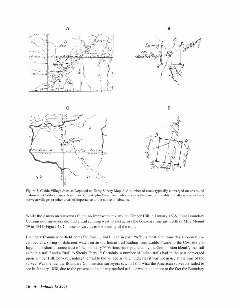
Except for the apparently abandoned Coushatta village north of Colonel Potter on the common boundary of Sections 1 and 12, T20N, R17W and Timber Hill, every other Indian village found on the 1837-1838 survey maps west of Shreveport tended to serve as a transportation hub for the surrounding area. Roads converged from four different directions upon the Louisiana site (Figure 3) and from three different directions at both the Middle Caddo and Big Spring sites. The North Caddo village was located on the relatively heavily traveled north-south Trammel Trace that extended from the Red River to Nacogdoches.
Finally it should be noted that when the Texas General Land Offi ce reopened in January 1838, the earliest sur-veyors into eastern Harrison County typically referenced their work to such features as large streams, Caddo Lake, roads, or Indian villages. In this manner, the North Caddo village was referenced at least two times,22 the Middle Caddo village two times23 and Big Spring village six times.24 In contrast, not a single reference to the presence of Timber Hill was made by early Texas surveyors. It would appear that by 1838 there was no trace of the village to be seen, and thus the site was not a legitimate feature to be referenced.
While the North, Middle, Big Spring, and Louisiana villages were noted in some manner as deserted by survey-ors, they had doubtless been inhabited in the relatively recent past since traces of roads leading to them were still visible to surveyors. With Timber Hill, no sign of any road or trail was noted by early surveyors, leading one to suspect that the village had been abandoned for at least 5 to 10 years. The basis for such a time-frame is found in the statements of multiple individuals, including an academic botanist,25 surveyors,26 and on-the-ground-landowners,27 who indicate such to be the period one might reasonably expect it would take in this humid East Texas environment for vegetation to reclaim the area, and, more importantly, for erosion, freezing/thawing, roots, and litter to obliterate paths and trails to all but those specifi cally looking for such cultural features.
16 ◆ Volume 18 2008
Figure 3. Caddo Village Sites as Depicted on Early Survey Maps.21 A number of roads typically converged on or around historic-era Caddo villages. A number of the Anglo-American roads shown on these maps probably initially served as trails between villages or other areas of importance to the native inhabitants.
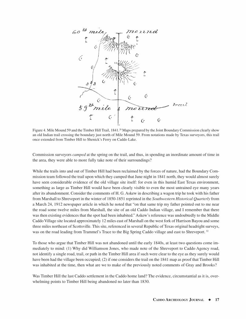
While the American surveyors found no improvements around Timber Hill in January 1838, Joint Boundary Commission surveyors did fi nd a trail running west to east across the boundary line just north of Mile Mound 59 in 1841 (Figure 4). Comments vary as to the identity of the trail.
Boundary Commission fi eld notes for June 1, 1841, read in part: “After a most circuitous day’s journey, en-camped at a spring of delicious water, on an old Indian trail leading from Caddo Prairie to the Coshatta vil-lage, and a short distance west of the boundary.”29 Various maps prepared by the Commission identify the trail as both a trail30 and a “trail to Shenix Ferry.”31 Certainly, a number of Indian trails had in the past converged upon Timber Hill; however, noting the trail to the village as “old” indicates it was not in use at the time of the survey. Was the fact the Boundary Commission surveyors saw in 1841 what the American surveyors failed to see in January 1838, due to the presence of a clearly marked trail, or was it due more to the fact the Boundary
CADDO ARCHEOLOGY JOURNAL ◆ 17
Commission surveyors camped at the spring on the trail, and thus, in spending an inordinate amount of time in the area, they were able to more fully take note of their surroundings?
While the trails into and out of Timber Hill had been reclaimed by the forces of nature, had the Boundary Com-mission team followed the trail upon which they camped that June night in 1841 north, they would almost surely have seen considerable evidence of the old village site itself: for even in this humid East Texas environment, something as large as Timber Hill would have been clearly visible to even the most untrained eye many years after its abandonment. Consider the comments of H. G. Askew in describing a wagon trip he took with his father from Marshall to Shreveport in the winter of 1850-1851 reprinted in the Southwestern Historical Quarterly from a March 24, 1912 newspaper article in which he noted that “on that same trip my father pointed out to me near the road some twelve miles from Marshall, the site of an old Caddo Indian village, and I remember that there was then existing evidences that the spot had been inhabited.” Askew’s reference was undoubtedly to the Middle Caddo Village site located approximately 12 miles east of Marshall on the west fork of Harrison Bayou and some three miles northeast of Scottsville. This site, referenced in several Republic of Texas original headright surveys, was on the road leading from Trammel’s Trace to the Big Spring Caddo village and east to Shreveport. 32
To those who argue that Timber Hill was not abandoned until the early 1840s, at least two questions come im-mediately to mind: (1) Why did Williamson Jones, who made note of the Shreveport to Caddo Agency road, not identify a single road, trail, or path in the Timber Hill area if such were clear to the eye as they surely would have been had the village been occupied; (2) if one considers the trail on the 1841 map as proof that Timber Hill was inhabited at the time, then what are we to make of the previously noted comments of Gray and Brooks?
Was Timber Hill the last Caddo settlement in the Caddo home land? The evidence, circumstantial as it is, over-whelming points to Timber Hill being abandoned no later than 1830.
Figure 4. Mile Mound 59 and the Timber Hill Trail, 1841.28 Maps prepared by the Joint Boundary Commission clearly show an old Indian trail crossing the boundary just north of Mile Mound 59. From notations made by Texas surveyors, this trail once extended from Timber Hill to Shenick’s Ferry on Caddo Lake.
18 ◆ Volume 18 2008
THE LAST CADDO VILLAGE
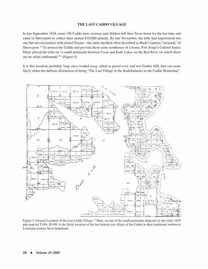
In late September 1838, some 156 Caddo men, women, and children left their Texas home for the last time and came to Shreveport to collect their annual $10,000 annuity. By late November, the tribe had experienced not one but two encounters with armed Texans—the latter incident often described as Rusk’s famous “invasion” of Shreveport. 33 To protect the Caddo and provide them some semblance of a home, Fort Jesup’s Colonel James Many placed the tribe on “a small peninsula between Cross and Sodo Lakes on the Red River on which there are no white settlements”34 (Figure 5).
It is this location, probably long since eroded away, silted or paved over, and not Timber Hill, that can more likely claim the dubious distinction of being “The Last Village of the Kadohadacho in the Caddo Homeland.”
Figure 5. General Location of the Last Caddo Village. 35 Here, on one of the small peninsulas depicted on this early 1838 plat map for T18N, R14W, is the likely location of the last historic-era village of the Caddo in their traditional northwest Louisiana-eastern Texas homeland.
CADDO ARCHEOLOGY JOURNAL ◆ 19
NOTES
1 Parsons, Mark L., James E. Bruseth, Jacques Bagur, S. Eileen Goldborer, and Claude McCrocklin. Finding Sha’chahdinnih (Timber Hill): The Last Village of the Kadohadacho in the Caddo Homeland. Austin: Texas Historical Commission, Ar-cheological Reports Series, No. 3, 2002.
2 Parsons, Mark L., James E. Bruseth, Jacques Bagur, S. Eileen Goldborer, and Claude McCrocklin. Finding Sha’chahdinnih (Timber Hill): The Last Village of the Kadohadacho in the Caddo Homeland. Austin: Texas Historical Commission, Ar-cheological Reports Series, No. 3, 2002. pp. 8-9.
3 National Archives and Records Administration. Letters Received by the Offi ce of Indian Affairs, 1824-1881. Roll 31, Caddo Agency, 1824-1842. Letters, Red River Agency. Table entitled: “A List of Indian Tribes Belonging to the Red River Indian Agency, Sulphur Fork, 1824” contained in a letter from Gray to McKenney, October 1, 1824.
4 National Archives and Records Administration. Letters Received by the Offi ce of Indian Affairs, 1824-1881. Roll 31, Caddo Agency, 1824-1842. Letters, Red River Agency. Letter, Gray to McKenney, October 1, 1824; National Archives and Records Administration. Letters Received by the Offi ce of Indian Affairs, 1824-1881. Roll 31, Caddo Agency, 1824-1842. Letters, Red River Agency. Letter, Gray to Barbour, December 31, 1826; National Archives and Records Administration. Letters Received by the Offi ce of Indian Affairs, 1824-1881. Roll 31, Caddo Agency, 1824-1842. Letters, Red River Agency. Letter, Gray to Barbour, February 4, 1828.
5 National Archives and Records Administration. Letters Received by the Offi ce of Indian Affairs, 1824-1881. Roll 31, Caddo Agency, 1824-1842. Letters, Caddo Agency. Letter, Brooks to Case, February 28, 1832.
6 National Archives and Records Administration. Letters Received by the Offi ce of Indian Affairs, 1824-1881. Roll 31, Caddo Agency, 1824-1842. Letters, Red River Agency. Letter, Gray to Porter, August 11, 1828.
7 National Archives and Records Administration. Letters Received by the Offi ce of Indian Affairs, 1824-1881. Roll 31, Caddo Agency, 1824-1842. Letters, Caddo Agency. Letter, Brooks to Herring, February 13, 1832.
8 National Archives and Records Administration. Letters Received by the Offi ce of Indian Affairs, 1824-1881. Roll 31, Caddo Agency, 1824-1842. Letters, Caddo Agency. Letter, Brooks to Eaton, October 23, 1830.
9 National Archives and Records Administration. Letters Received by the Offi ce of Indian Affairs, 1824-1881. Roll 31, Caddo Agency, 1824-1842. Letters, Caddo Agency. Letter, Brooks to Case, February 28, 1832.
10 National Archives and Records Administration. Letters Received by the Offi ce of Indian Affairs, 1824-1881. Roll 31, Caddo Agency, 1824-1842. Letters, Caddo Agency. Letter, Brooks to Eaton, January 17, 1831.
11 National Archives and Records Administration. Letters Received by the Offi ce of Indian Affairs, 1824-1881. Roll 31, Caddo Agency, 1824-1842. Letters, Caddo Agency. Letter, Brooks to Eaton, January 17, 1831.
12 National Archives and Records Administration. Letters Received by the Offi ce of Indian Affairs, 1824-1881. Roll 31, Caddo Agency, 1824-1842. Letters, Caddo Agency. Letter, Brooks to Herring, February 13, 1832.
13 All of the material in the following pages regarding the fi eld notes and plat maps of the American surveys may be found in the archives of the Department of the Interior, Bureau of Land Management for the North West District of Louisiana in Springfi eld, Virginia. Both the plat maps and fi eld notes are also available online at: http://1webfn.doa.la.gov/slodocs/SLO/ First time users will need to download and install the document viewer. Future references to these materials will cite the appropriate range and township only.
14 T21N, R17W (plat map).
15 See the common boundary of Sections 2 and 11, T21N, R17W (plat map); the common boundary of Sections 1 and 12, T20N, R17W (plat map); Section 6, T18N, R17W (plat map); Section 35, T16N, R16W (plat map). For sketch maps of Indian villages on Texas GLO surveys, see for example Texas General Land Offi ce. Shelby County. First Class, File
20 ◆ Volume 18 2008
000108, Josiah Prewitt. Original Land Grant Collection, Archives and Records Division, Austin, Texas; Texas General Land Offi ce. Shelby County. First Class, File 000185, Seaborn J. Robinson. Original Land Grant Collection, Archives and Records Division, Austin, Texas.
16 Kappler, Charles J. (editor and compiler). Indian Affairs: Laws and Treaties, Volume II, Treaties. Washington: Govern-ment Printing Offi ce, 1904. pp. 432-434.
17 National Archives and Records Administration. Letters Received by the Offi ce of Indian Affairs, 1824-1881. Roll 31, Caddo Agency, 1824-1842. Letters, Caddo Agency. Petition, Caddo Chiefs to Joel Poinsett, January 9, 1837.
18 Surveyor fi eld notes indicated the Louisiana village (Section 35, T16N, R16W) to have been a “deserted village” in March 1837; the Big Spring village (Sections 2 and 3, 17N, 17W) “an old Indian Village (now in ruins)” on April 27, 1838; the Border village (Section 6, T18N, R17W) “an old Indian village” on May 3, 1838; and the Coushatta village north of Caddo Lake (the common boundary of Sections 1 and 12, T20N, R17W, plat map), which is clearly identifi ed as the site of an inhabited Indian village in Harriett Ames’ manuscript [Ames, Harriett. During the Early Days of Texas. Typescript. Collection 288, Box 1, Folder 1. Noel Memorial Library, Archives and Special Collections, Louisiana State University in Shreveport.] but described as an “old Indian clearing” on February 9, 1839.
19 Ford, John Salmon. Edited by Stephen B. Oates, with introduction and commentary. Rip Ford’s Texas. Austin: The Uni-versity of Texas Press, 1963. p. 25.
20 Ames, Harriet A. During the Early Days of Texas: A True Story of Harriet A. Ames. Typescript. Collection 288, Harriet Pot-ter Ames Memoirs. Noel Memorial Library, Archives and Special Collections, Louisiana State University in Shreveport.
21 Inset A, T16N, R16W (plat map); Inset B, Texas General Land Offi ce. Shelby County. First Class, File 000185, Seaborn J. Robinson. Original Land Grant Collection, Archives and Records Division, Austin, Texas; Inset C, T17N, R17W (plat map); Inset D, Texas General Land Offi ce. Shelby County. First Class, File 000108, Josiah Prewitt. Original Land Grant Collection, Archives and Records Division, Austin, Texas.
22 Texas General Land Offi ce. Shelby County. First Class, File 000090, R. O. Watkins. Original Land Grant Collection, Archives and Records Division, Austin, Texas; Texas General Land Offi ce. Shelby County. First Class, File 000108, Josiah Prewitt. Original Land Grant Collection, Archives and Records Division, Austin, Texas.
23 Texas General Land Offi ce. Shelby County. First Class, File 000152, Holland Anderson. Original Land Grant Collec-tion, Archives and Records Division, Austin, Texas; Texas General Land Offi ce. Shelby County. First Class, File 000185, Seaborn J. Robinson. Original Land Grant Collection, Archives and Records Division, Austin, Texas.
24 Texas General Land Offi ce. Shelby County. First Class, File 000156, Lucinda Wallace. Original Land Grant Collection, Archives and Records Division, Austin, Texas; Texas General Land Offi ce. Shelby County. First Class, File 000361, Sebas-tian C. Garner. Original Land Grant Collection, Archives and Records Division, Austin, Texas; Texas General Land Offi ce. Harrison County. Third Class, File 000094, Simeon Dickerson. Original Land Grant Collection, Archives and Records Divi-sion, Austin, Texas; Texas General Land Offi ce. Harrison County. Third Class, File 000160, Jonathan Stephenson. Original Land Grant Collection, Archives and Records Division, Austin, Texas; Texas General Land Offi ce. Harrison County. Third Class, File 000184, Josiah Barrentine. Original Land Grant Collection, Archives and Records Division, Austin, Texas; Texas General Land Offi ce. Harrison County. Third Class, File 000272, James Adams. Original Land Grant Collection, Archives and Records Division, Austin, Texas.
25 Williams, Justin K. Assistant Professor of Biology, Sam Houston State University, Huntsville, Texas. Personal interview, February 16, 2007.
26 Ben Thomson, Senior Land Surveyor, LSLS, RPLS, PE. Texas General Land Offi ce, Austin, Texas. Personal interview, April 10, 2007; David Pyle, Land Surveyor III, LSLS, RPLS. Texas General Land Offi ce, Austin, Texas. April 10, 2007.
27 Mouzon R. Tiller, Landowner, Harrison and Panola County, Texas. March 18, 2007; James W. Tiller, Sr., Landowner, Harrison and Panola County, Texas. March 18, 2007.
CADDO ARCHEOLOGY JOURNAL ◆ 21
28 Texas, General Land Offi ce. Texas/United States Boundary Collection, Map, Boundary Between Republic of Texas and United States, Plan B, Part 3rd. GLO Map 65413. Texas General Land Offi ce, Austin, Texas.
29 Texas, General Land Offi ce. Texas/United States Boundary Collection, Journal of the Joint Commission. GLO Map Im-age 65523. Texas General Land Offi ce, Austin, Texas.
30 Texas, General Land Offi ce. Texas/United States Boundary Collection, Journal of the Joint Commission. GLO Map Im-age 65413. Texas General Land Offi ce, Austin, Texas.
31 Texas, General Land Offi ce. Texas/United States Boundary Collection, Map, Boundary Between Republic of Texas and United States, Plan B, Part 3rd. GLO Map Image 3132. Texas General Land Offi ce, Austin, Texas.
32 Webb, Walter Prescott. “Texas Collection.” Southwestern Historical Quarterly 42 (January 1939): 268-269; Texas General Land Offi ce. Shelby County. First Class, File 000152, Holland Anderson. Original Land Grant Collection, Archives and Records Division, Austin, Texas; Texas General Land Offi ce. Shelby County. First Class, File 000185, Seaborn J. Robin-son. Original Land Grant Collection, Archives and Records Division, Austin, Texas; 17N, 17W (plat map), 18N, 17W (plat map), 17N, 16W (plat map), 17N, 15W (plat map), 17N, 14W (plat map), 18N, 14W (plat map).
33 National Archives and Records Administration. Letters Received by the Offi ce of Indian Affairs, 1824-1881. Roll 31, Caddo Agency, 1824-1842. Letters, Caddo Agency. Statement, W. Jenkins, January 1, 1839.
34 National Archives and Records Administration. Letters Received by the Offi ce of Indian Affairs, 1824-1881. Roll 31, Caddo Agency, 1824-1842. Letters, Caddo Agency. Letter, Many to Poinsett, April 19, 1839.
35 T18N, R14W (plat map).
22 ◆ Volume 18 2008
A Foster Trailed-Incised Vessel from the Sister Grove Creek Site (41COL36), Collin County, Texas
Wilson W. Crook, III and Timothy K. Perttula
INTRODUCTION
A near-complete and reconstructed Foster Trailed-Incised jar, a common Late Caddo (ca. A.D. 1500-1700) ceramic type along certain parts of the Red River in southwestern Arkansas, northwestern Louisiana, and northeastern Texas, has been recovered by the senior author from the Sister Grove Creek site (41COL36) in Collin County, in North central Texas (Crook 2007). This is the fi rst known occurrence of Foster Trailed-Incised pottery in any of the Late Prehistoric sites along the East Fork of the Trinity River. We discuss the fi nd and the character of the reconstructed vessel in this article, and put on record this evidence of contact between the Caddo and Late Prehistoric populations living in the upper Trinity River basin.
SISTER GROVE CREEK SITE (41COL36)
During the early 1970s, Mark Lynott (1975a, 1975b) led a major excavation of the rim-and-pit structure at the Sister Grove Creek site (41COL36) on the East Fork. Following completion of Lynott’s work at the site, and the publication of the final report, Crook returned several times to the site in order to photograph and study the major features found there, including the rim-and-pit structure. On one such occasion fol-lowing a strong rain, a number of large, freshly broken pottery sherds were discovered in a 1 x 1 m area immediately north of the central pit structure. Visual inspection showed all the sherds to be of the same type and thus likely from a single ceramic vessel. The presence of weathered animal footprints all around the vessel coupled with obvious fresh breaks on the sherds indicated that it had likely only recently been broken. With the chance of recovering a near-complete pottery vessel from an East Fork site, Crook laid out a 5 x 5 m area around the sherds and carefully excavated the area to a depth of 10 cm below the sur-face. A total of 21 sherds were recovered in the immediate area of the initial surface discovery. Subsequent reconstruction of the vessel showed it to be about 85% complete, and of the Foster Trailed-Incised type (Suhm and Jelks 1962: Plate 22).
FOSTER TRAILED-INCISED JAR
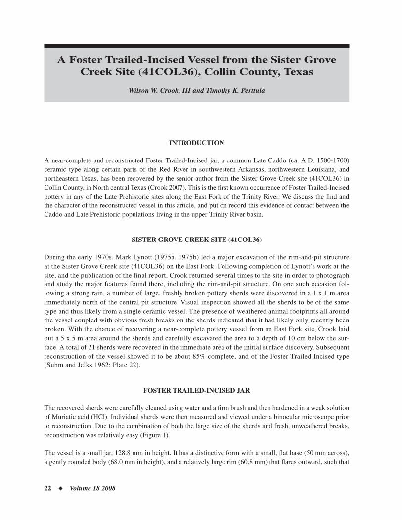
The recovered sherds were carefully cleaned using water and a fi rm brush and then hardened in a weak solution of Muriatic acid (HCl). Individual sherds were then measured and viewed under a binocular microscope prior to reconstruction. Due to the combination of both the large size of the sherds and fresh, unweathered breaks, reconstruction was relatively easy (Figure 1).
The vessel is a small jar, 128.8 mm in height. It has a distinctive form with a small, fl at base (50 mm across), a gently rounded body (68.0 mm in height), and a relatively large rim (60.8 mm) that fl ares outward, such that
CADDO ARCHEOLOGY JOURNAL ◆ 23
the diameter of the mouth of the vessel is greater than that of the body (see Figure 1). This is a pre-A.D. 1600 Foster Trailed-Incised form (Schambach and Miller 1984:Figure 11-10).
Wall thickness of the vessel varies from 4.3 mm near the rim to 8.1 mm in the main part of the body to 9.3 mm at the base. These thickness data suggest that the vessel appears to have been built from the base upwards to the rim (cf. Krause 2007). It is tempered with fi nely-crushed grog and has a compact clay paste. The color of the vessel is light to dark olive-brown with the cores darker than the surfaces, suggesting it had been fi red in a low oxygen or reducing environment, and then pulled from the fi re to cool, leaving lighter-colored interior and/or exterior surfaces. Some fi re mottling is present over the sides of the vessel. The interior of the jar is highly smoothed, almost polished in surface treatment.
The vessel has a distinctive decoration that consists of incising and trailing, the latter made with a broad, round tipped tool (see Figure 1). The high rim is separated from the body by a broad horizontal incised line. The rim is further sub-divided into four horizontal panels with lines running downward or diagonally to the left. These lines may have been made with either with a bone or wood tool or by fi ngerprint impressions. The body of the vessel contains four distinct sets of concentric trailed semi-circles (see Figure 1).
Analysis of Red River Caddo pottery by Schambach and Miller (1984:121) indicate that the Sister Grove Creek fi nd is a Foster Trailed-Incised, var. Foster vessel, although it lacks the nipple-like nodes that are one element of the described decorative elements of this variety (see below). Schambach and Miller (1984:121) describes this variety, which is the earliest of seven known Late Caddo and Historic Caddo varieties of the type, as follows:
Figure 1. Foster Trailed-Incised vessel from the Sister Grove Creek site (41COL36).
24 ◆ Volume 18 2008
The Foster variety… consists of high rimmed, globular bodied, jars with concentric circle designs (our Baker pattern) on the bodies and multiple bands of zoned diagonal lines on the rims (our Alfred pattern). The concentric circle motif on the body is usually repeated three or four times and there are either single or multiple nipple-like nodes at the center of each set of circles. The diagonal line designs on the rim are composed of narrow incised lines while the concentric circle designs on the bodies are composed of broad trailed lines.
The seriation of Late Caddo pottery types from burial features on sites in the Red River valley indicates that Foster Trailed-Incised, var. Foster vessels were made by the Caddo between ca. A.D. 1500-1600 (Perttula 1992:Table 9; Schambach and Miller 1984:164-168 and Table 11-12). Other kinds of resident pottery made by these Caddo groups includes Belcher Engraved, Karnack Brushed-Incised, and Simms Engraved. While sherds and a few vessels from a number of different Caddo pottery types have been described from Late Prehistoric sites along the East Fork (Crook 2007), none of the above Late Caddo ceramic types have ever been noted in this region.
CONCLUSIONS
Foster Trailed-Incised is a relatively common Caddo pottery type made primarily by Belcher and Texarkana phase Caddo peoples living in the Great Bend area of the Red River valley in southwestern Arkansas, northwest-ern Louisiana, and a small part of northeastern Texas (Perttula 2005; Schambach and Miller 1984:121; Webb 1959). This includes several counties in the southwestern part of Arkansas (Little River, Hempstead, Miller, and Lafayette counties) to Bowie County, Texas, and downstream to various sites near Shreveport, Louisiana in Bossier and Caddo Parishes (Webb 1959; Kelley 1997). Ceramic analyses by Schambach and Miller (1984) indicate that different varieties of Foster Trailed-Incised were made and used by the Caddo between ca. A.D. 1500 and ca. A.D. 1700.
The presence of a Foster Trailed Incised, var. Foster vessel in a Late Prehistoric site on the East Fork of the Trinity clearly indicates trade between an East Fork aboriginal group and one of the Red River Caddo groups, probably the prehistoric ancestors of the Kadohadacho. Caddo pottery was widely traded across Texas and surrounding states (Perttula 2002:Figure 5.1) in prehistoric and historic times, especially after about A.D. 1400, when there were apparently periodic contacts and interaction between several different and non-Caddo aboriginal groups and southern Caddo groups. This contact and interaction must have been intermittent because this Foster Trailed-Incised jar is the fi rst occurrence of Belcher and Texarkana phase pottery from an East Fork of the Trinity River site.
In his excavation of Sister Grove Creek, Lynott (1975a) obtained seven radiocarbon dates on charcoal and two dates from collagen and apatite from human bone. Charcoal from Feature 5, a hearth from near the center of the central rim-and-pit structure, yielded an uncorrected radiocarbon date of 360 ± 70 B.P. (A.D. 1590 ± 70); its calibrated age range is AD 1469-1614 (CAL PAL Online Radiocarbon Calibration, accessed October 19, 2007). The discovery of a pre-A.D. 1600 variety of Foster Trailed Incised vessel at the Sister Grove Creek site corroborates this calibrated radiocarbon date and further establishes that the Late Prehistoric inhabitants of the East Fork were present in the region up to the beginning of the post-A.D. 1550 Historic period in Texas.
CADDO ARCHEOLOGY JOURNAL ◆ 25
REFERENCES CITED
Crook, Wilson W., III2007 An Unusual Ceramic Vessel from the Sister Grove Creek Site, Collin County, Texas. The Record, Dallas Archeo-
logical Society, in press.
Kelley, David B. (editor)1997 Two Caddoan Farmsteads in the Red River Valley: The Archeology of the McLelland and Joe Clark Sites. Research
Series No. 51. Arkansas Archeological Survey, Fayetteville.
Krause, Richard A.2007 A Potter’s Tale. In Plains Village Archaeology: Bison-hunting Farmers in the Central and Northern Plains, edited
by Stanley A. Ahler and Marvin Kay, pp. 32-40. University of Utah Press, Salt Lake City.
Lynott, Mark J.1975 Archeological Investigations at Lake Lavon, 1974. Contributions in Anthropology 16. Archaeology Research
Program, Southern Methodist University, Dallas.
1975b Wylie Focus Pits in Light of Recent Investigations. The Record, Dallas Archeological Society, Vol. 31, No. 2, pp. 1-4.
Perttula, Timothy K.1992 “The Caddo Nation”: Archaeological & Ethnohistoric Perspectives. University of Texas Press, Austin.
2002 Archaeological Evidence for the Long-Distance Exchange of Caddo Indian Ceramics in the Southern Plains, Mid-west, and Southeastern United States. In Geochemical Evidence for Long-Distance Exchange, edited by Michael D. Glascock, pp. 89-107. Bergin and Garvey, Westport, Connecticut.
2005 1938-1939 WPA Excavations at the Hatchel Site (41BW3) on the Red River in Bowie County, Texas. Southeastern Archaeology 24(2):180-198.
Schambach, Frank F. and John E. Miller III1984 A Description and Analysis of the Ceramics. In Cedar Grove: An Interdisciplinary Investigation of a Late Caddo
Farmstead in the Red River Valley, edited by Neal L. Trubowitz, pp. 109-170. Research Series No. 23. Arkansas Archeological Survey, Fayetteville.
Suhm, Dee Ann and Edward B. Jelks (editors)1962 Handbook of Texas Archeology: Type Descriptions. Texas Archeological Society, Special Publications, No. 1, and
the Texas Memorial Museum, Bulletin No. 4.
Webb, Clarence H.1959 The Belcher Mound: A Stratifi ed Caddoan Site in Caddo Parish, Louisiana. Memoirs No. 16. Society for American
Archaeology, Salt Lake City.
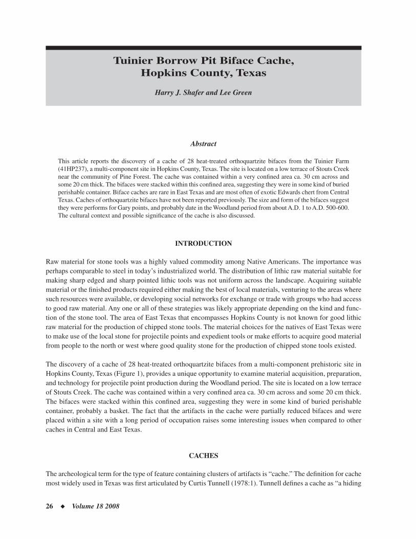
26 ◆ Volume 18 2008
Tuinier Borrow Pit Biface Cache, Hopkins County, Texas
Harry J. Shafer and Lee Green
Abstract
This article reports the discovery of a cache of 28 heat-treated orthoquartzite bifaces from the Tuinier Farm (41HP237), a multi-component site in Hopkins County, Texas. The site is located on a low terrace of Stouts Creek near the community of Pine Forest. The cache was contained within a very confi ned area ca. 30 cm across and some 20 cm thick. The bifaces were stacked within this confi ned area, suggesting they were in some kind of buried perishable container. Biface caches are rare in East Texas and are most often of exotic Edwards chert from Central Texas. Caches of orthoquartzite bifaces have not been reported previously. The size and form of the bifaces suggest they were performs for Gary points, and probably date in the Woodland period from about A.D. 1 to A.D. 500-600. The cultural context and possible signifi cance of the cache is also discussed.
INTRODUCTION
Raw material for stone tools was a highly valued commodity among Native Americans. The importance was perhaps comparable to steel in today’s industrialized world. The distribution of lithic raw material suitable for making sharp edged and sharp pointed lithic tools was not uniform across the landscape. Acquiring suitable material or the fi nished products required either making the best of local materials, venturing to the areas where such resources were available, or developing social networks for exchange or trade with groups who had access to good raw material. Any one or all of these strategies was likely appropriate depending on the kind and func-tion of the stone tool. The area of East Texas that encompasses Hopkins County is not known for good lithic raw material for the production of chipped stone tools. The material choices for the natives of East Texas were to make use of the local stone for projectile points and expedient tools or make efforts to acquire good material from people to the north or west where good quality stone for the production of chipped stone tools existed.
The discovery of a cache of 28 heat-treated orthoquartzite bifaces from a multi-component prehistoric site in Hopkins County, Texas (Figure 1), provides a unique opportunity to examine material acquisition, preparation, and technology for projectile point production during the Woodland period. The site is located on a low terrace of Stouts Creek. The cache was contained within a very confi ned area ca. 30 cm across and some 20 cm thick. The bifaces were stacked within this confi ned area, suggesting they were in some kind of buried perishable container, probably a basket. The fact that the artifacts in the cache were partially reduced bifaces and were placed within a site with a long period of occupation raises some interesting issues when compared to other caches in Central and East Texas.
CACHES
The archeological term for the type of feature containing clusters of artifacts is “cache.” The defi nition for cache most widely used in Texas was fi rst articulated by Curtis Tunnell (1978:1). Tunnell defi nes a cache as “a hiding
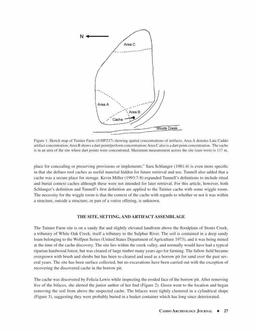
CADDO ARCHEOLOGY JOURNAL ◆ 27
place for concealing or preserving provisions or implements.” Sara Schlanger (1981:4) is even more specifi c in that she defi nes tool caches as useful material hidden for future retrieval and use. Tunnell also added that a cache was a secure place for storage. Kevin Miller (1993:7-8) expanded Tunnell’s defi nitions to include ritual and burial context caches although these were not intended for later retrieval. For this article, however, both Schlanger’s defi nition and Tunnell’s fi rst defi nition are applied to the Tuinier cache with some wiggle room. The necessity for the wiggle room is that the context of the cache with regards to whether or not it was within a structure, outside a structure, or part of a votive offering, is unknown.
THE SITE, SETTING, AND ARTIFACT ASSEMBLAGE
The Tuinier Farm site is on a sandy fl at and slightly elevated landform above the fl oodplain of Stouts Creek, a tributary of White Oak Creek, itself a tributary to the Sulphur River. The soil is contained in a deep sandy loam belonging to the Wolfpen Series (United States Department of Agriculture 1973), and it was being mined at the time of the cache discovery. The site lies within the creek valley, and normally would have had a typical riparian hardwood forest, but was cleared of large timber many years ago for farming. The fallow fi eld became overgrown with brush and shrubs but has been re-cleared and used as a borrow pit for sand over the past sev-eral years. The site has been surface collected, but no excavations have been carried out with the exception of recovering the discovered cache in the borrow pit.
The cache was discovered by Felicia Lewis while inspecting the eroded face of the borrow pit. After removing fi ve of the bifaces, she alerted the junior author of her fi nd (Figure 2). Green went to the location and began removing the soil from above the suspected cache. The bifaces were tightly clustered in a cylindrical shape (Figure 3), suggesting they were probably buried in a basket container which has long since deteriorated.
Figure 1. Sketch map of Tuinier Farm (41HP237) showing spatial concentrations of artifacts. Area A denotes Late Caddo artifact concentration; Area B shows a dart point/perform concentration; Area C also is a dart point concentration. The cache is in an area of the site where dart points were concentrated. Maximum measurement across the site (east-west) is 117 m.
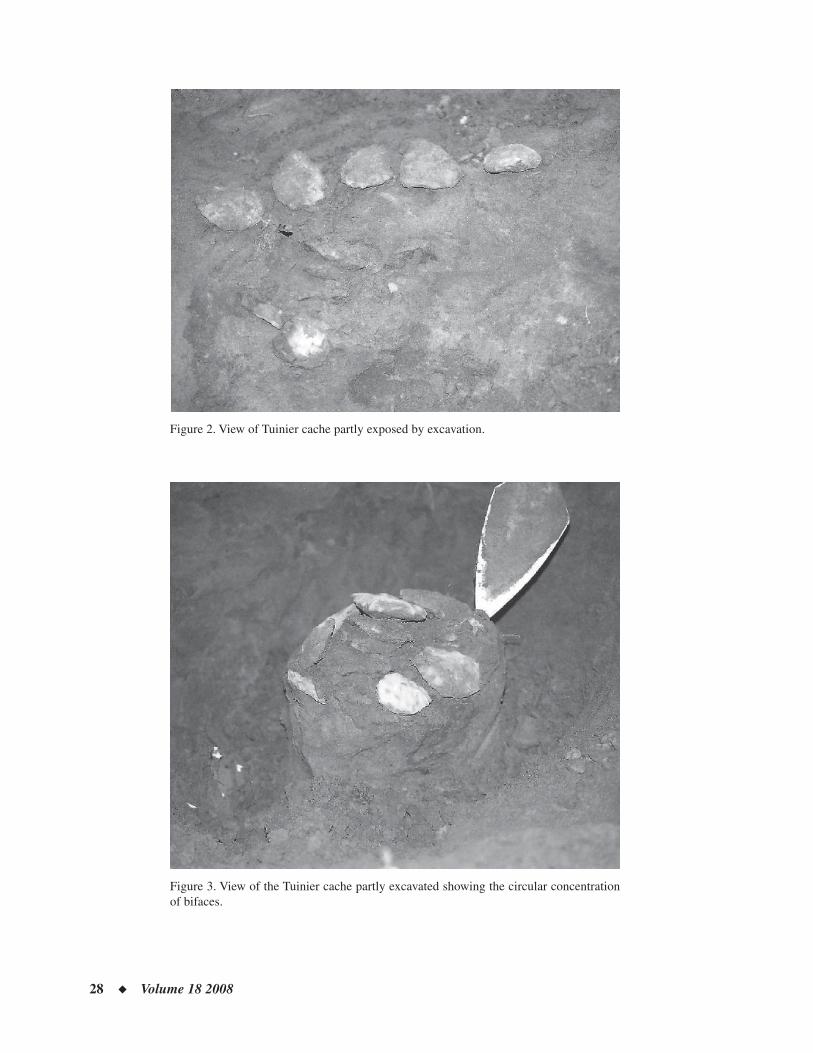
28 ◆ Volume 18 2008
Figure 2. View of Tuinier cache partly exposed by excavation.
Figure 3. View of the Tuinier cache partly excavated showing the circular concentration of bifaces.
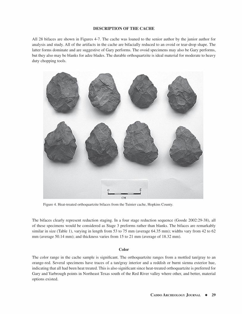
CADDO ARCHEOLOGY JOURNAL ◆ 29
DESCRIPTION OF THE CACHE
All 28 bifaces are shown in Figures 4-7. The cache was loaned to the senior author by the junior author for analysis and study. All of the artifacts in the cache are bifacially reduced to an ovoid or tear-drop shape. The latter forms dominate and are suggestive of Gary performs. The ovoid specimens may also be Gary performs, but they also may be blanks for adze blades. The durable orthoquartzite is ideal material for moderate to heavy duty chopping tools.
The bifaces clearly represent reduction staging. In a four stage reduction sequence (Goode 2002:29-38), all of these specimens would be considered as Stage 3 preforms rather than blanks. The bifaces are remarkably similar in size (Table 1), varying in length from 53 to 75 mm (average 64.35 mm); widths vary from 42 to 62 mm (average 50.14 mm); and thickness varies from 15 to 21 mm (average of 18.32 mm).
Color
The color range in the cache sample is signifi cant. The orthoquartzite ranges from a mottled tan/gray to an orange-red. Several specimens have traces of a tan/gray interior and a reddish or burnt sienna exterior hue, indicating that all had been heat treated. This is also signifi cant since heat-treated orthoquartzite is preferred for Gary and Yarbrough points in Northeast Texas south of the Red River valley where other, and better, material options existed.
Figure 4. Heat-treated orthoquartzite bifaces from the Tuinier cache, Hopkins County.
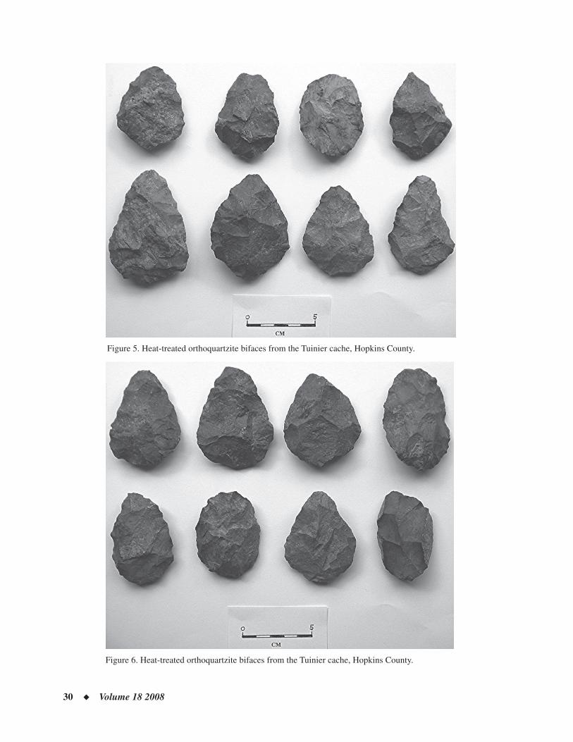
30 ◆ Volume 18 2008
Figure 6. Heat-treated orthoquartzite bifaces from the Tuinier cache, Hopkins County.
Figure 5. Heat-treated orthoquartzite bifaces from the Tuinier cache, Hopkins County.
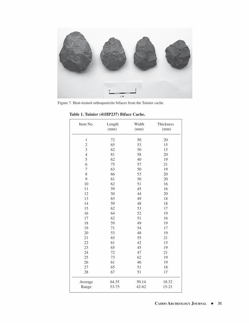
CADDO ARCHEOLOGY JOURNAL ◆ 31
Figure 7. Heat-treated orthoquartzite bifaces from the Tuinier cache.
Table 1. Tuinier (41HP237) Biface Cache.
Item No. Length (mm)
Width (mm)
Thickness (mm)
1 72 50 202 65 53 153 62 50 154 81 58 205 62 40 196 75 57 217 63 50 198 66 53 209 61 50 2010 62 51 1611 59 45 1612 50 44 2013 65 49 1814 59 48 1815 62 53 1716 64 52 1917 62 51 1618 59 49 1919 71 54 1720 53 48 1921 65 55 2122 61 42 1523 65 45 1924 72 47 2125 73 62 1926 61 46 1927 65 51 1828 67 51 17
Average 64.35 50.14 18.32Range 53-75 42-62 15-21
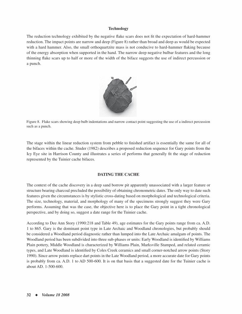
32 ◆ Volume 18 2008
Technology
The reduction technology exhibited by the negative fl ake scars does not fi t the expectation of hard-hammer reduction. The impact points are narrow and deep (Figure 8) rather than broad and deep as would be expected with a hard hammer. Also, the small orthoquartzite mass is not conducive to hard-hammer fl aking because of the energy absorption when supported in the hand. The narrow deep negative bulbar features and the long thinning fl ake scars up to half or more of the width of the biface suggests the use of indirect percussion or a punch.
Figure 8. Flake scars showing deep bulb indentations and narrow contact point suggesting the use of a indirect percussion such as a punch.
The stage within the linear reduction system from pebble to fi nished artifact is essentially the same for all of the bifaces within the cache. Studer (1982) describes a proposed reduction sequence for Gary points from the Icy Eye site in Harrison County and illustrates a series of performs that generally fi t the stage of reduction represented by the Tuinier cache bifaces.
DATING THE CACHE
The context of the cache discovery in a deep sand borrow pit apparently unassociated with a larger feature or structure bearing charcoal precluded the possibility of obtaining chronometric dates. The only way to date such features given the circumstances is by stylistic cross-dating based on morphological and technological criteria. The size, technology, material, and morphology of many of the specimens strongly suggest they were Gary performs. Assuming that was the case, the objective here is to place the Gary point in a tight chronological perspective, and by doing so, suggest a date range for the Tuinier cache.
According to Dee Ann Story (1990:218 and Table 49), age estimates for the Gary points range from ca. A.D. 1 to 865. Gary is the dominant point type in Late Archaic and Woodland chronologies, but probably should be considered a Woodland period diagnostic rather than lumped into the Late Archaic amalgam of points. The Woodland period has been subdivided into three sub-phases or units: Early Woodland is identifi ed by Williams Plain pottery, Middle Woodland is characterized by Williams Plain, Marksville Stamped, and related ceramic types, and Late Woodland is identifi ed by Coles Creek ceramics and small corner-notched arrow points (Story 1990). Since arrow points replace dart points in the Late Woodland period, a more accurate date for Gary points is probably from ca. A.D. 1 to AD 500-600. It is on that basis that a suggested date for the Tuinier cache is about AD. 1-500-600.
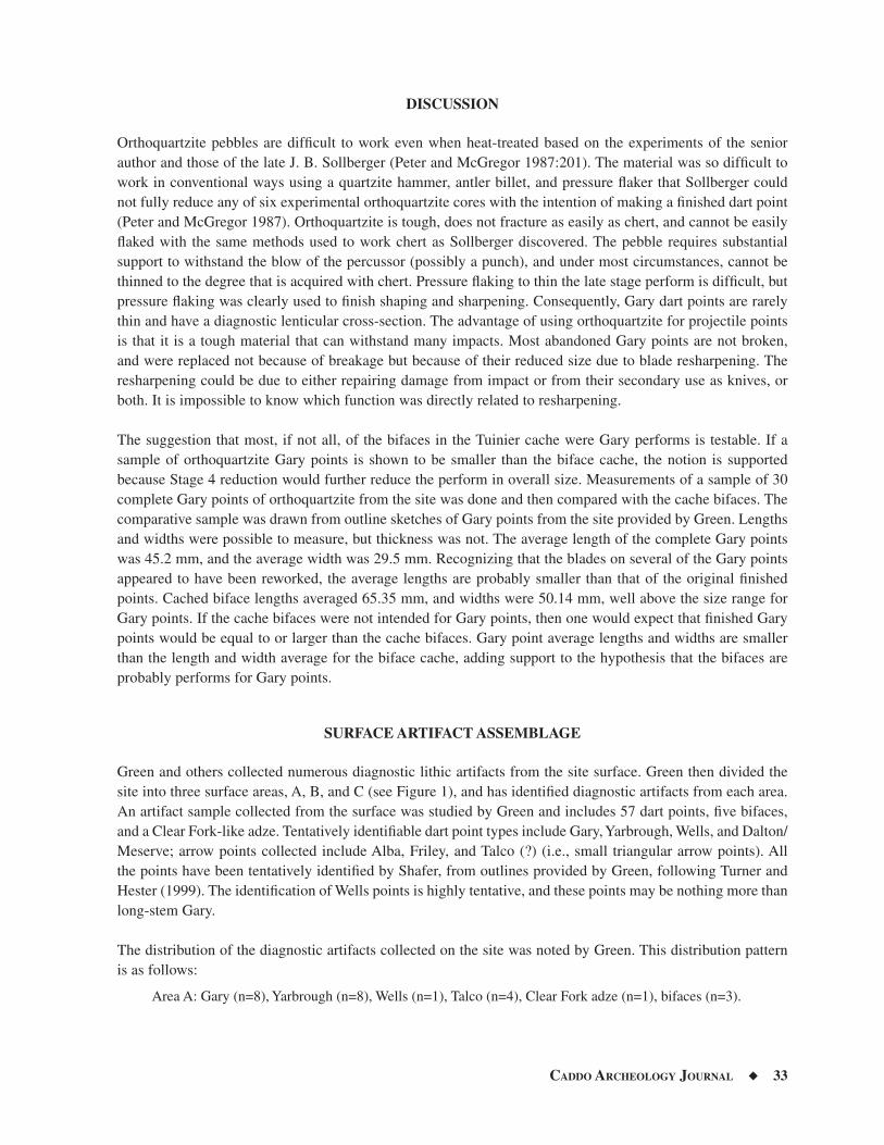
CADDO ARCHEOLOGY JOURNAL ◆ 33
DISCUSSION
Orthoquartzite pebbles are diffi cult to work even when heat-treated based on the experiments of the senior author and those of the late J. B. Sollberger (Peter and McGregor 1987:201). The material was so diffi cult to work in conventional ways using a quartzite hammer, antler billet, and pressure fl aker that Sollberger could not fully reduce any of six experimental orthoquartzite cores with the intention of making a fi nished dart point (Peter and McGregor 1987). Orthoquartzite is tough, does not fracture as easily as chert, and cannot be easily fl aked with the same methods used to work chert as Sollberger discovered. The pebble requires substantial support to withstand the blow of the percussor (possibly a punch), and under most circumstances, cannot be thinned to the degree that is acquired with chert. Pressure fl aking to thin the late stage perform is diffi cult, but pressure fl aking was clearly used to fi nish shaping and sharpening. Consequently, Gary dart points are rarely thin and have a diagnostic lenticular cross-section. The advantage of using orthoquartzite for projectile points is that it is a tough material that can withstand many impacts. Most abandoned Gary points are not broken, and were replaced not because of breakage but because of their reduced size due to blade resharpening. The resharpening could be due to either repairing damage from impact or from their secondary use as knives, or both. It is impossible to know which function was directly related to resharpening.
The suggestion that most, if not all, of the bifaces in the Tuinier cache were Gary performs is testable. If a sample of orthoquartzite Gary points is shown to be smaller than the biface cache, the notion is supported because Stage 4 reduction would further reduce the perform in overall size. Measurements of a sample of 30 complete Gary points of orthoquartzite from the site was done and then compared with the cache bifaces. The comparative sample was drawn from outline sketches of Gary points from the site provided by Green. Lengths and widths were possible to measure, but thickness was not. The average length of the complete Gary points was 45.2 mm, and the average width was 29.5 mm. Recognizing that the blades on several of the Gary points appeared to have been reworked, the average lengths are probably smaller than that of the original fi nished points. Cached biface lengths averaged 65.35 mm, and widths were 50.14 mm, well above the size range for Gary points. If the cache bifaces were not intended for Gary points, then one would expect that fi nished Gary points would be equal to or larger than the cache bifaces. Gary point average lengths and widths are smaller than the length and width average for the biface cache, adding support to the hypothesis that the bifaces are probably performs for Gary points.
SURFACE ARTIFACT ASSEMBLAGE
Green and others collected numerous diagnostic lithic artifacts from the site surface. Green then divided the site into three surface areas, A, B, and C (see Figure 1), and has identifi ed diagnostic artifacts from each area. An artifact sample collected from the surface was studied by Green and includes 57 dart points, fi ve bifaces, and a Clear Fork-like adze. Tentatively identifi able dart point types include Gary, Yarbrough, Wells, and Dalton/Meserve; arrow points collected include Alba, Friley, and Talco (?) (i.e., small triangular arrow points). All the points have been tentatively identifi ed by Shafer, from outlines provided by Green, following Turner and Hester (1999). The identifi cation of Wells points is highly tentative, and these points may be nothing more than long-stem Gary.
The distribution of the diagnostic artifacts collected on the site was noted by Green. This distribution pattern is as follows:
Area A: Gary (n=8), Yarbrough (n=8), Wells (n=1), Talco (n=4), Clear Fork adze (n=1), bifaces (n=3).
34 ◆ Volume 18 2008
Area B: Gary (n=7), Yarbrough (n=1), Dalton/Meserve (n=2), unidentifi ed dart point (n=1), Alba (n=1), Friley (n=1), and non-cache bifaces (n=5). The cache of 28 bifaces came from Area B.
Area C: Wells (n=2), Gary (n=5), unidentifi ed dart points (n=4).
Unknown provenience within the site: Wells (n=5), Gary (n=9), other dart points (n=1), Talco (n=3), and corner notched arrow point (n=1).
The chronological time span represented by the collection indicates that Tuinier Farm (41HP237) was used as a campsite from the Late Archaic through the Middle-Late Caddo periods, with a Late Paleoindian-Early Archaic specimen also included. This chronologically mixed assemblage is consistent with other deep sandy sites along Stouts Creek (Scurlock 1962). The horizontal distribution of the diagnostic lithic artifacts within areas A-C hints that spatial clustering of the Early Archaic Wells points and the Late Prehistoric Talco points might be present. Wells points were recovered from areas A and C, while Talco arrow points were found only in Area A. The distribution of ceramics (not tallied here) would likely provide more defi nitive evidence of the spatial clustering of artifacts.
Surface Collection Raw Materials
Raw materials represented in the diagnostic artifact collection were identifi ed by Green and are represented in the surface collection as follows:
Orthoquartzite/quartzite: Wells (n=6), Gary (n=28), Yarbrough (n=11), other dart points (n=2), Talco arrow points (n=3), unidentifi ed corner-notched arrow point (n=1), unidentifi ed contracting stem arrow point (n=1), bifaces (n=5).
Chert: Gary (n=5), Dalton/Meserve (n=2), other dart points (n=5), Talco arrow points (n=4), Alba arrow point (n=1), beveled biface (n=1).
Silicifi ed wood: Friley arrow point (n=1), bifaces (n=2).
Ferruginous sandstone: Clear Fork-like adze (n=1).
Orthoquartzites were the preferred material for many artifacts left at the site, including Wells, Gary, Yarbrough, and Talco points (Figure 9). The heat-treated orthoquartzite cache bifaces are not out of character for mate-rial preferences at the site. Non-local cherts are represented among the unclassifi ed points and the Dalton/Meserve points. Silicifi ed wood was identifi ed for three artifacts, including a Friley point. The ferruginous sandstone adze is a local material and was probably selected because it occurs in larger masses suitable for large biface tools.
LITHIC RAW MATERIAL DISTRIBUTION
All of the Tuinier cache bifaces are made of heat-treated orthoquartzite, a metamorphic quartzite. Orthoquartz-ite pebbles and small cobbles are common in the Uvalde Gravels across Northeast Texas and the central part of East Texas. These ancient Pliocene gravels occur in outwash fans from the Rocky Mountains (Banks 1990; Byrd 1971), were picked up and reworked in Pleistocene and Holocene streams, and were obtained in the stream beds and gravel outcrops by Archaic, Woodland, and Caddo groups as raw material for chipped stone tools. The orthoquartzite commonly occurs in gray hues with yellow or tan streaks. The quality of the material varies from coarse granular to fi ne-grained. Flaking quality of the material also varies, but can be improved when heat-treated. Heat-treated orthoquartzite assumes burnt sienna, pinkish, or brownish-yellow hues due to
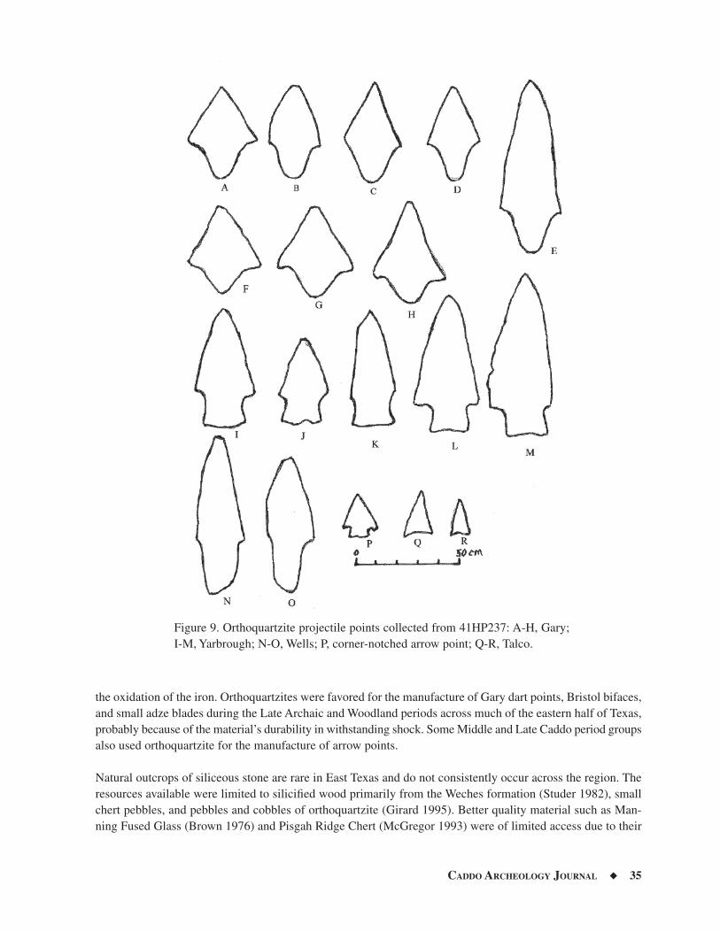
CADDO ARCHEOLOGY JOURNAL ◆ 35
Figure 9. Orthoquartzite projectile points collected from 41HP237: A-H, Gary; I-M, Yarbrough; N-O, Wells; P, corner-notched arrow point; Q-R, Talco.
the oxidation of the iron. Orthoquartzites were favored for the manufacture of Gary dart points, Bristol bifaces, and small adze blades during the Late Archaic and Woodland periods across much of the eastern half of Texas, probably because of the material’s durability in withstanding shock. Some Middle and Late Caddo period groups also used orthoquartzite for the manufacture of arrow points.
Natural outcrops of siliceous stone are rare in East Texas and do not consistently occur across the region. The resources available were limited to silicifi ed wood primarily from the Weches formation (Studer 1982), small chert pebbles, and pebbles and cobbles of orthoquartzite (Girard 1995). Better quality material such as Man-ning Fused Glass (Brown 1976) and Pisgah Ridge Chert (McGregor 1993) were of limited access due to their
36 ◆ Volume 18 2008
geologically isolated occurrence. Excellent chert occurs on the Edwards Plateau (Banks 1990) and in gravels in stream systems draining from portions of the Edwards Plateau, such as the Brazos River and its western tributaries, including the Leon, Little, and San Gabriel rivers (Gadus et al. 2006:42). Eastern tributaries of the Brazos River and tributaries of the Trinity River contain mostly local sandstones, quartzites, petrifi ed wood, and reworked Uvalde gravels in their stream systems. The Red River gravels contain excellent lithic raw material mostly derived from the western Ouachita Mountains of Oklahoma.
Lithic artifact caches are now being widely reported across the United States and Texas, but are rare in East Texas (Miller 1993). Caches have been discovered that date from the Clovis period (Collins 1999; Frison and Bradley 1999), through the Archaic and Late Prehistoric periods in Texas (Miller 1993; Tunnell 1978). Most lithic caches reported in the eastern half of the state were in the prairies of Central and east-central Texas (Miller 1993). The prairie caches are almost all of Edwards chert from Central Texas (Shafer 1973:235-237; Tomka and Fields 1990). Perhaps the best reported cache from East Texas is the 63 bifaces from the George C. Davis site (Shafer 1973:235-237). These bifaces were made of heat-treated chert from the Leona Park ledge in western Bell County (J. B. Sollberger, personal communication 1983; Glenn Goode, personal com-munication 2006).
The most economical way of transporting chert from the Balcones Edge to East Texas was to reduce the mass into biface performs that could be shaped into a variety of tool forms. The bifaces apparently were transported in carrying baskets and, at times, were cached for later retrieval. The unusual aspect about the Tuinier Cache is that it is not Edwards chert, but is the locally available orthoquartzite. The nature of the cache and the fact that the cache performs fi t the expected reduction trajectory of Gary points, may indicate that the cache was buried in a seasonal campsite for later retrieval, although other possible reasons for the cache cannot be ruled out because the precise context (i.e., inside a structure or associated with some event) is unknown.
The purposes of caching are variable, and includes resource hoarding, votive offerings, and mortuary as-sociations. The most common lithic caches are most likely the result of resource hoarding for later retrieval based on the reduction stages, cache concentrations, and placement of caches within a campsite or permanent settlement (e.g., George C. Davis site cache [Shafer 1973:235-237], Tuinier cache, and the Jewett Mine caches [Tomka and Fields 1990]). Caches do occur in graves and tombs as mortuary offerings (Shafer 1973:194-196, 224-233; Story 1997).
Votive caches are either not recorded or are probably misinterpreted in East Texas. Votive caches would most likely have included fi nished artifacts recovered complete or smashed in contexts that would otherwise sug-gest ritual placement such as in, or in proximity to, structures, mounds, and burials. Possible votive caches are reported from both Jonas Short Mound (Jelks 1965) and Coral Snake Mound (Jensen 1968; McClurkan et al. 1966). In both of these cases, however, it is also very possible that the “caches” were in fact mortuary items and that traces of human skeletal material had long since deteriorated as interpreted by Jensen (1968). McClurkan et al. (1966) certainly misinterpreted human remains preserved by associated copper as “caches” at Coral Snake Mound. A possible example of a votive cache was the dense concentration of pottery sherds in Feature 9 at the George C. Davis site (Newell and Krieger 1949:78-79), which might be interpreted as a termination event marked by many smashed vessels. Termination events marked by caches, sacrifi ces, and smashed pottery, and followed by rebuilding episodes, were common and cyclical among the Maya and other complex cultures of Mesoamerica. Cyclical mound additions with associated burials are also well documented among the early Caddo (Story 1997), but no evidence has been reported where these events were directly associated with artifact caches.
CADDO ARCHEOLOGY JOURNAL ◆ 37
SUMMARY AND CONCLUSIONS
The cached heat-treated orthoquartzite bifaces from the Tuinier Farm site (41HP237) were tightly clustered and horizontally stacked in a circular concentration. While the context of discovery in a deep sand borrow pit appar-ently unassociated with a larger feature or structure precluded the possibility of obtaining chronometric dates, it is possible to provide a stylistic cross-date based on morphological and technological criteria. No pit feature was recognized by the excavators, but the cluster suggests the cache was probably in a basket placed in a pit. This is not an isolated cache unassociated with occupation. The site has a Woodland period component dating from about A.D. 1 to 500-600, and was probably a major Woodland period village with structures. Given the kinds of material refuse left at the site, we can assume that structures were once present during the Woodland period. Caching resources would be a common behavior among seasonally mobile populations who expected to return to the same encampment. For reasons unexplainable, this cache was never retrieved.
ACKNOWLEDGMENTS
The authors thank the Tuinier family for allowing access to the property, Felicia Lewis, the discoverer of the cache, and Jenny Green and Newman Bradford for their assistance in excavation and documentation. We also thank Laura Nightengale at the Texas Archeological Research Laboratory for her assistance in providing access to various caches from East Texas, and Ross Fields for sharing information on caches from the Jewett Mine and other locations in East. Texas.
REFERENCES CITED
Banks, L. D.1990 From Mountain Peaks to Alligator Stomachs: A Review of Lithic Sources in the Trans-Mississippi south, the South-
ern Plains, and Adjacent Southwest. Memoir No. 4. Oklahoma Anthropological Society, Norman.
Brown, K. M.1976 Fused Volcanic Glass from the Manning Formation. Bulletin of the Texas Archeological Society 47:189-208.
Byrd, C. L.1971 Origin and History of the Uvalde Gravels of Central Texas. Bulletin 20. Baylor Geological Studies, Waco.
Collins, M. B.1999 Clovis Blade Technology. The University of Texas Press, Austin.
Frison, G. and B. Bradley1999 The Fenn Cache: Clovis Weapons & Tools. One Horse Land and Cattle Company, Santa Fe, New Mexico.
Gadus, E. F., R. C. Fields, and K. W. Kibler2006 Data Recovery Excavations at the J. B. White Site (41MM341), Milam County, Texas. Reports of Investigations No.
145, Prewitt and Associates, Inc., Austin, and Archeological Studies Program, Report No. 87, Texas Department of Transportation, Environmental Affairs Division, Austin.
Girard, J. S.1995 The Chipped Stone Collection: Technological, Functional, and Typological Analyses. In The Deshazo Site, Na-
cogdoches County, Texas, Vol. 2: Artifacts of Native Manufacture, edited by D. A. Story, pp. 33-156. Studies in Archeology 21. Texas Archeological Research Laboratory, The University of Texas at Austin.
Goode, G. T.2002 The Anthon Site: A Prehistoric Encampment in Southern Uvalde County, Texas. Archeological Studies Report 38.
Texas Department of Transportation, Environmental Affairs Division, Austin.
38 ◆ Volume 18 2008
Jelks, E. B.
1965 The Archeology of McGee Bend Reservoir, Texas. Ph.D. dissertation, Department of Anthropology, The University of Texas at Austin.
Jensen, H. P., Jr.1968 Coral Snake Mound (X16SA48). Bulletin of the Texas Archeological Society 39:9-44.
Miller, K. A.1993 A Study of Prehistoric Biface Caches from Texas. Master’s Thesis, Department of Anthropology, The University
of Texas at Austin.
McClurkan, B. B., W. T. Field, and J. N. Woodall1966 Excavations in Toledo Bend Reservoir, 1964-65. Papers of the Texas Archeological Salvage Project, No. 8. Texas
Archeological Salvage Project, Austin.
McGregor, D. E.1993 Pisgah Ridge Chert Distributions: Evidence for Changing Territorial Size in North Central Texas. Bulletin of the
Texas Archeological Society 64:247-267.
Newell, H. P. and A. D. Krieger1949 The George C. Davis Site, Cherokee County, Texas. Memoirs, No. 5. Society for American Archaeology, Menasha,
Wisconsin.
Peter, D. E. and D. E. McGregor1987 Lithic Reduction Systems and Inter-assemblage Variability: Problems of Recognition. In Hunter-Gatherer Ad-
aptations along the Prairie Margin: Site Excavations and Synthesis of Prehistoric Archaeology, edited by D. E. McGregor and J. E. Bruseth, pp. 197-228. Richland Creek Technical Series, Volume III. Archaeology Research Program, Institute for the Study of Earth and Man, Southern Methodist University, Dallas.
Schlanger, S. H.1981 Tool Caching Behavior and the Archaeological Record. Paper Presented at the 46th Annual Meeting of the Society
for American Archaeology, San Diego.
Scurlock, J. D.1962 The Culpepper Site, A Late Fulton Aspect site in Northeastern Texas. Bulletin of the Texas Archeological Society
32:285-316.
Shafer, H. J.1973 Lithic Technology at the George C. Davis Site, Cherokee County, Texas. Ph.D. dissertation, Department of An-
thropology, The University of Texas at Austin.
United States Department of Agriculture1973 Soil Surveys of Hopkins and Rains Counties. United States Department of Agriculture, Natural Resource Conserva-
tion Service, Washington, D.C.
Story, D. A.1990 Cultural History of the Native Americans. In The Archeology and Bioarcheology of the Gulf Coastal Plain, Vol. 1,
by D. A. Story, J. A. Guy, B. A. Burnett, M. D. Freeman, J. C. Rose, D. G. Steele, B. W. Olive, and K. J. Reinhard, pp. 163-366. Research Series No. 38. Arkansas Archeological Survey, Fayetteville.
1997 1968-1970 Archeological Investigations at the George C. Davis Site, Cherokee County, Texas. Bulletin of the Texas Archeological Society 68:1-103.
Studer, J. M.1982 Archaic Pebble Core Reduction Technology in East Texas: The Icy Eye Example. Papers in Anthropology No. 3.
Stephen F. Austin State University, Nacogdoches.
CADDO ARCHEOLOGY JOURNAL ◆ 39
Tomka, S. A. and R. C. Fields1990 Chipped Stone Artifacts, 41LN29A and 41LN106. In Excavations at the Charles Cox, Lambs Creek Knoll, and
Buffalo Branch Sites, Jewett Mine Project, Leon and Freestone Counties, Texas, Vol. 1, edited by R. C. Fields, pp. 141-288. Reports of Investigations No. 70. Prewitt & Associates, Inc, Austin.
Tunnell, C. 1978 The Gibson Lithic Cache from West Texas. Report No. 30. Offi ce of the State Archeologist, Texas Historical Com-
mission, Austin.
Turner, E. S., and T. R. Hester1999 A Guide to the Stone Artifacts of Texas Indians. Gulf Publishing Co., Houston.
40 ◆ Volume 18 2008
Book Review of “Looting Spiro Mounds: An American King Tut’s Tomb,” by David La Vere. 2007,
University of Oklahoma Press
Robert Cast
Looting of Spiro Mounds: An American King Tut’s Tomb, with its rubbernecking, eye-catching title, is a book that should be read and studied, if for no other reason than to add its small part to the history of the looting and destruction of probably one of the most well known mound sites in American history west of the Mississippi River. This is a mound group that to this day stands as somewhat of an archeological anomaly for the entire Southeastern United States, and especially among the mounds found in Oklahoma. First of all, let me say that there are probably many more people much more qualifi ed to be writing this book review than I am, so with that in mind, let me apologize to all of you forthrightly. Selfi sh interests motivate this review along with the need to explore what David La Vere left unexplored in his book, especially with regard to what he presents in Chapter 10. The book can be separated into basically fi ve related sections, with the 10 chapters in it intertwined and fl uctuat-ing back and forth in time with a smattering of archeological interpretations throughout. Section One begins in 1934 and moves through time from the looting of the site to La Vere’s interpretations and descriptive narrative of the life ways of the people living at the mounds.
Sections Two and Three describe the Works Progress Administration (WPA) excavations at the mounds and the publicity surrounding the place and the objects coming from the site. A Kansas City Star newspaper of the time actually referred to the Craig Mound at Spiro as “A ‘King Tut’ Tomb;” hence, La Vere’s title for the book (p. 143). Section Four gives a brief accounting of where many of the artifacts from the Spiro site looting actually ended up and where some are thought to have ended up. The fi nal part of this section (Chapter 10) is a disjointed discourse on some of the present archeological interpretations of the site, along with the Native American Graves Protection and Repatriation Act (NAGPRA) implications as to which present-day Indian tribes may be culturally affi liated to the place.
Although only 10 chapters and 255 pages in length, including bibliography and chapter notes, La Vere paints an interesting picture of the Depression-era past in Oklahoma, with the players in this history represented by the poor, uneducated southern men who worked in the hot, steamy, humid basin of the Arkansas River valley, simply looting for their own survival. La Vere, as he recreates his image of the past, seems to sympathize with the plight of the looters. His depiction of the interaction between the looters, mid-level buyers and sellers, and collectors of antiquities of the day, and the interactions of each of these groups with the archeological “suits” of the time from the University of Oklahoma who wanted nothing more but to preserve the mounds for study (and their own excavations), is reason enough for every archeologist to read this book.
CADDO ARCHEOLOGY JOURNAL ◆ 41
As the story unfolds, and the reader is transported back and forth in time, La Vere steps outside his historian’s comfort zone to loosely and desperately try to recreate what the histories and life ways of the people called “Spiroans” (p. 18) were like. Any archeologist who reads the book will be aware of the misnomers and slight misrepresentations spattered throughout the work. For example, in describing the people of the Archaic period in eastern Oklahoma, La Vere states, “These Archaic Indians, as archeologists call them, lived well, and a population increase is proof of it” (p. 21). I personally do not recall ever hearing any archeologists that I work with on a regular basis (within a four state area) make reference to “Archaic Indians” (and I would venture to say most are aware of the “Indian” misnomer as well).
Another example of a misnomer—if not fl at out misrepresentation—is found in the book when La Vere begins trying to explain the debate on the cultural affi liations of the Spiro sites (p. 187) and relies on the use of the word “Caddoan.” In my opinion, the hackneyed term “Caddoan” continues to be a misnomer and a misrepresentation of the archeology its use connotes. First employed many years ago as a linguistic term to refer to the related Caddoan languages spoken by the Caddo, the Wichita, the Pawnee, and the Arikara, it then spread like a virus through the archeological literature of the Southeastern U.S. to be used to describe a myriad of things: the people, the archeology, and now even the archeological record in specifi c geographical areas (e.g., Northern Caddoan, Southern Caddoan, Arkansas River valley Caddoan) with little basis in archeological or scientifi c terminology. Moreover, the term is often used interchangeably with “Caddo,” making it yet more confusing. In archeology, scientifi c terms should represent discrete scientifi c observations untethered by linguistic presumptions. La Vere only briefl y touches upon this, but it is an important aspect to keep in mind while reading the book and trying to decipher the cultural affi liations of the Spiroans.
With a dash of summarized explanations from the writings of the late Kenneth Orr, and interviews and sum-mations of the archeological ideas of Don Wyckoff and Frank Schambach, La Vere tries to describe the on-going debate of who actually lived at Spiro in the prehistoric past. Wyckoff and others believe in a Wichita/Kichai cultural affi liation for the Spiroans, even though the Wichita never practiced cranial modeling (a point not mentioned in the book). Schambach vies for the Tunican cultural affi liation using the Nagle Site (34Ok4) as his westernmost “entrepot” and connection with the trade between Spiro and the Southern Plains (p. 191). This local Tunican contention is given play despite the fact that Oklahoma state archeologist Robert L. Brooks (1996:22-23) has pointed out that: “First and foremost: there is no evidence of a settlement at this location or in the immediate vicinity.” He further states: “In fact, 50% of the Nagle population is under 15 years of age, highly suspect for a group of traders. It is also unlikely that surrounding people, if on good terms with the traders, would permit them to reach the extent of malnutrition described by Brues (1957) and confi rmed by Owsley.” I guess a burial site does not an “entrepot” make. This type of information is also not mentioned by La Vere. He concedes, however, that “most scholars go with either the Caddo or Wichita interpretation” (p. 189). But blatantly missing from this list of archeological experts is any interviews with a present-day Caddo archeologist who could have given La Vere good reasons why they believe the Caddo are culturally affi liated to the archeological remains at the Spiro site.
La Vere also makes leaps of faith when describing the Tunica connection with Spiro and the Tunica connec-tions embedded in Frank Schambach’s theories. “Now called the Tunica, which sounds rather similar to Tula, their Spiro history made them avid traders in the area” (p. 191). Please, Tula sounds nothing like Tunica. This is like saying the “Carden” Bottoms sounds like the “Caddo” Bottoms. Furthermore, as an attempt to sensa-tionalize the cultural affi liation claims by the Caddo, Wichita, and Tunica, he also goes so far to say that the Choctaw may have a claim to Spiro: “It would not be surprising for the Choctaws to demand some type of say on the disposition of artifacts found on land they claim as their own” (p. 193). I do wonder if La Vere actually contacted the Choctaw about this statement before coming to this preposterous conclusion. I have worked for
42 ◆ Volume 18 2008
the Caddo Nation of Oklahoma for almost 10 years and have personally had many meetings with Choctaw representatives, including their NAGPRA representative, and I have never heard the Choctaw voice any claim to the Spiro site or its funerary objects.
The irony of all this is that La Vere bases his histories and descriptions of this Spiro story, along with its hy-pothesized multiple cultural affi liations, on the years of research done by archeologists who have diligently tried to piece this puzzle together. When it comes to giving due credit, however, La Vere misses the point in a dramatic fashion by comparing archeologists with looters (p. 206).
La Vere obviously does not understand that in terms of the NAGPRA, archeologists have been given a two-edged sword. On the one edge is the scientifi c curiosity to keep and preserve all things for future study; on the other edge is the ethical responsibility to help federally recognized tribes determine cultural affi liations when pos-sible and usually by doing so, consequently losing all control of what happens to human remains and funerary objects that fall under the purview of NAGPRA.
The history La Vere weaves is a complex and sordid one drawing many comparisons to an age-old juxta-position and an argument still used by many looters today regarding the “rights” that exist among profes-sional archeologists and looters when it comes to exploration of newly discovered archeological sites. For example, when describing the motivations of Forrest E. Clements, then Chair of the Anthropology Department at the University of Oklahoma (p. 12) to preserve the mounds at Spiro, La Vere states, “For him, the pot hunters were looters, destroyers of knowledge for the sake of a quick buck, and they should be prevented from taking what he felt rightly belonged to him and the members of his profession” (p. 87, emphasis mine). The use of this type of language in a supposedly “historical” accounting of Spiro only fans the fl ame between those who know how important in situ context is in interpreting history (based on the archeological evidence left behind) and those that see archeological evidence as mere “treasure troves” to be sold to the highest bidder.
When referring to whatever became of Dr. Clements (a physical anthropologist and not an archeologist), La Vere insinuates, “Even the University of Oklahoma archives cannot seem to locate a picture of him” (p. 187), suggesting that Clements just somehow disappeared from the face of the earth after the shame of Spiro with no further explanation. However, within two minutes of beginning the research for this book review, I found a nice photograph in the first edition of the Oklahoma Anthropological Society Handbook (Albert and Gifford 1995:13), showing Clements using a camera, probably the one mentioned by La Vere (p. 176).
Another dilemma woven throughout this book, but only slightly addressed (even though it is extremely signifi -cant for the present state of archeology in this country), is the rights of landowners (and lessees) versus those of the state or federal government when it came to legally defi ning “property” and who owns what is beneath the ground within a particular piece of property. In the early formulation of the antiquities laws protecting archeo-logical sites, human remains, and funerary objects in the state of Oklahoma, Clements in some ways should be applauded and looked upon as a hero, for without the looting of Spiro (only one of many sites being looted across the United States during this time), we would not have the state preservation laws (including those protecting unmarked graves) that exist in some form from state to state, or those laws developed and passed on a national level, such as the National Historic Preservation Act of 1966, the Archaeological Resources Protection Act of 1979, and I dare say, the NAGPRA of 1990. Although these were hard lessons learned and much information was lost during these looting episodes, history shows that some people like Clements actually answered the call to try to preserve a part of history in its varied palimpsest forms.
CADDO ARCHEOLOGY JOURNAL ◆ 43
History has also shown that no matter how many laws are put in place to protect archeological sites, human remains, and funerary objects, there are still those that will plunder these places to make a buck. Right now, there is a push in the state of Texas (a state without an unmarked burial law; all states surrounding Texas have one) by the Surface Hunters of Texas (SHOT 2006) to amend the Antiquities Code so collectors can receive “Artifact Collectors Licenses” from the Texas Historical Commission to be able to collect on all public waterways in Texas, except for state parks and lands administered by the Federal government. Of course their argument is that most of the artifacts that are found along the shorelines of these lakes are in “disturbed” contexts. As many archeologists are aware and can testify, “disturbed” contexts are sometimes in the eye of the beholder, and we know that much information can be obtained even from disturbed contexts, or that a site can be only partially disturbed with large portions remaining intact. The kicker of their proposal is that if a collector fi nds something really signifi cant and of archeological interest, SHOT has made a provision in the amendments to the Antiquities Code for them to be able to sell the artifacts back to the state!
When raising questions as to Craig Mound’s later literal reconstruction for tourism purposes by the state of Oklahoma (pp. 196-197), with the insistence and participation of the archeological community (who had also been reconstructing the archeology of the mounds and the physical evidence they contained), La Vere seems to insinuate that the absence of then State Archeologist Don Wyckoff was somehow to blame for the near loss of the reconstruction of the mounds and preservation of the place as Oklahoma’s only state archeological park. The most interesting part of the book for me was La Vere’s last chapter discussing the cultural affi liations and NAGPRA implications of Spiro and the artifacts and human remains it contains, two important subjects that La Vere knows very little about. He states (p. 190), using the Sunday Oklahoman as his source: “If archaeologists or government offi cials cannot determine whether they [referring to the NAGPRA-affi liated human remains and objects from Spiro] should go to the Caddos or Wichitas, then the artifacts remain with the museum.” However, and this is a most important point, in the NAGPRA, cultural affi liation is determined by a “preponderance of the evidence.” The defi nition for this is given at 43CFR10.2(e) of the Code of Federal Regulations and states: “What is cultural affi liation? Cultural affi liation means that there is a relationship of shared group identity which can reasonably be traced historically or prehistorically between members of a present-day Indian tribe or Native Hawaiian organization and an identifi able earlier group. Cultural affi liation is established when the preponderance of the evidence—based on geographical, kinship, biological, archeological, linguistic, folklore, oral tradition, historical evidence, or other information or expert opinion—reasonably leads to such a conclu-sion.” The point is that the evidence is not just archeological, but is based on a number of factors combined and used in tandem to meet the “preponderance of the evidence” language in the NAGPRA regulations.
La Vere believes that there would be a large windfall for the tribe that makes the claim to Spiro and receives the artifacts through repatriation under NAGPRA (p. 189). The Wichita and the Caddo both have said that the items that are considered “associated funerary objects” under the NAGPRA would be reburied with the human remains. This does not sound like tribes that are concerned with “millions of dollars worth of artifacts at stake?” These tribes are more concerned with showing respect to the dead, and maintaining cultural traditions in this regard. And, by the way, the “Smithsonian’s Museum of the American Indian” (p. 190) does not comply with NAGPRA but with the National Museum of the American Indian Act of 1989.
There are many more things wrong with this book than I care to discuss in this review. But all in all, La Vere’s book is worth reading if for no other reason than to get a historian’s somewhat skewed take on the subject of the Spiro site based mostly on the archeological research of others.
44 ◆ Volume 18 2008
REFERENCES CITED
Brooks, R. L. 1996 The Arkansas River Valley: A New Paradigm, Revisionist Perspectives and the Archaeological Record. Caddoan
Archeology Newsletter 7 (1):17-27.
Brues, A. M. 1957 Skeletal Material From the Nagle Site. Bulletin of the Oklahoma Anthropological Society 5:93-99.
Albert, L. E. and C. Gifford (editors)1995 Oklahoma Anthropological Society Handbook. First Edition. Oklahoma Anthropological Society, Norman.
Surface Hunters of Texas (SHOT) 2006 Newsletter, Vol. 16, No. 5. November–December 2006.
CADDO ARCHEOLOGY JOURNAL ◆ 45
Index to the First Eighteen Volumes of the Caddoan Archeology Newsletter, Caddoan Archeology,
and Caddo Archeology Journal
Timothy K. Perttula and Chester P. Walker
This index presents a listing of articles, book reviews, reprints from The Oklahoma Prehistorian, and abstracts from past Caddo Conferences that have been published in the Caddoan Archeology Newsletter (CAN, 1989-1996), Caddoan Archeology (CA, 1996-2001) and the Caddo Archeology Journal (CAJ, 2003-2008). It expands and supplements the index prepared in January 1996 for the fi rst six volumes of this publication and the second index prepared in April 2001 for the fi rst 11 volumes. Since then, Caddoan Archeology has once again changed its name to the Caddo Archeology Journal, but it still provides important information on Caddo archeological research, and can rightly be considered a preeminent Caddo archeological publication.
Like the previous indexes, other newsworthy items can be found in various CAN’s and CA’s, but are not included here for space reasons. These include editor’s corner and editor’s page; recent publications; recent and ongoing projects and regional news; upcoming meetings, conferences, and events; as well as reburial/repatriation and vandalism issues.
ARTICLES
Albert, Lois E.1991 Recent Excavations at the Tall Cane Site (34SQ294). CAN II(4):2-10.
1992a Excavations to Continue at the Tall Cane Site (34SQ294). CAN III(1):13.
1992b Oklahoma Archeological Survey Works with GLO Survey Maps. CAN III(1):14.
1992c Archeological Survey in Northeastern Oklahoma. CAN III(1):14.
2000 The Norman Site: Descriptions. CA 11(1-2):23-59.
Amick, Clyde, Ed Furman, Timothy K. Perttula, James E. Bruseth, and Bonnie C. Yates1991 ALCOA #1 (41AN87): A Frankston Phase Settlement along Mound Prairie Creek, Anderson County, Texas. CAN
II(2):11-15.
Bagur, Jacques1992 The Caddo Indian Village. CAN III(3):15-16.
Barnes, Mark R. and Timothy K. Perttula1999 Caddoan Ceremonial Sites of the Caddoan Cultural Area of Arkansas, Louisiana, Oklahoma, and Texas: Draft
Caddo National Historic Landmark Nomination. CA 10(1):5-29.
Bartlett, Robert1998 Archaeological Investigations at 34WG220: A Prehistoric Occupation in the Arkansas River Valley of Eastern
Oklahoma. CA 9(2):13-25.
Bergstrom, Velicia R., John Ippolito, and Kent Schneider2008 Ground Penetrating Radar Investigations at the Leaning Rock Site (41SM325). CAJ 17:115-117.
46 ◆ Volume 18 2008
Bousman, C. Britt and Michael B. Collins1989 Quaternary Environmental Change in Northeast Texas. CAN I(1):20.
Bowker Lee, Dayna 2001 Regional Variation and Protohistoric Identity: A Round Table Discussion from the 43rd Caddo Conference, March
17 2001. CA 12 (2&3):10-35.
Boyd, Bryan E. and Timothy K. Perttula2001 Initial Findings from the Archaeological Investigations of the Hardin A Site (41GG69), Greg County, Texas. CA
12(1):5-10.
Brooks, Robert L.1996 The Arkansas River Valley: A New Paradigm, Revisionist Perspectives and the Archaeological Record. CA 7(1):17-
27.
2006 From Mounds to Monasteries: A Look at Spiro and Other Centers Through the use of Metaphor. CAJ 15:41-58.
Bruseth, James E.1991 Hudnall-Pirtle Site: An Early Caddoan Mound Complex in Northeast Texas. CAN II(3):9-15.
Bruseth, James, E., and Timothy K. Perttula with contributions from Gayle J. Fritz and Bonnie C. Yates.2006 Archaeological Investigations at the Hudnall-Pirtle Site (41RK4): An Early Caddo Mound Center in Northeast
Texas. CAJ 15:57-158.
Cast, Robert, Timothy K. Perttula, Bobby Gonzalez, and Bo Nelson2005 A Rediscovery of Caddo Heritage: The W. T. Scott Collection at the American Museum of Natural History. CAJ
14:5-16.
Carter, Cecile Elkins2008 A Decade of Straight Talk and Trust. CAJ 18:1-4.
Crook, Wilson W. III and Timothy K. Perttula2008 A Foster Trailed-Incised Vessel from the Sister Grove Creek Site (41COL36), Collin County, Texas. CAJ 18:22-25.
Cruse, J. Brett and Timothy K. Perttula1996 The Caddoan Oak Hill Village. CAN 6(4):23-25.
Davis, Hester A.1993 Flash!!!!! We’re Back from Shady Lake!!! CAN IV(2):5.
Dickson, Don R.1995a Prehistoric Lithic Procurement Sites: A Vanishing Resource. CAN V(4):12-13.
1995b Recent Work at 34PS341 in the Brushy-Peaceable Watershed. CAN V(4):14.
1997 Extractive Strategies at Peoria Quarry, Ottawa County, Oklahoma. CA 8(1):17-27.
1998 Obsidian Artifacts from the Ozark Area. CA 8(4):7-10.
Early, Ann M.1991 An Example of Rock Art from the Arkansas Ouachitas. CAN II(4):16-18.
1995 June 1995 Fieldwork in the Ouachita Mountains. CAN 6(2):5-6.
Early, Ann M. and Mary Beth Trubitt2003 The Caddo Indian Burial Ground (3MN386), Norman, Arkansas. CA 13(2):11-23.
Etchieson, Meeks1997 Ouachita National Forest/Weyerhauser Company Land Exchange. CA 8(2):17-27.
2000 Archeological Investigations on the Weyerhauser Land Exchange Sites, McCurtain County, Oklahoma: An Update. CA 11(4):7-20.
Ewen, Charles1993 The 1993 Arkansas Archeological Survey/Society Training Program at Shady Lake. CAN IV(2):4-5.
CADDO ARCHEOLOGY JOURNAL ◆ 47
Fields, Ross C.1989 Recent Archeological Investigations at the Jewett Mine, East-Central Texas. CAN I(1):14-15.
1990 Recent Archeological Investigations at the Louisiana Army Ammunition Plant, Webster Parish, Louisiana. CAN I(2):3-7.
Finkelstein, J. Joe2000 The Norman Site Excavations near Wagoner, Oklahoma. CA 11(1-2):6-22. (Reprinted from The Oklahoma Pre-
historian, Volume 3, No. 3, 1940).
Gaither, Steve, Timothy K. Perttula, and Gary Cheatwood1991 The Cheatwood Place (41RR181), a Midden Mound along Little Mustang Creek, Red River County, Texas. CAN
II(1):21-28.
Gibson, Jon L.2005 Bossier Tribes, Caddo in North Louisiana’s Pineywoods. CAJ 14:93-118.
Girard, Jeffrey S.1991 Notes from the Northwest Louisiana Regional Archaeology Program. CAN II(1):1-5.
1994 Investigations at the James Pace Site (16DS268), DeSoto Parish, Louisiana. CAN V(1):8-16.
1995 An Early Ceramic Period Pit Feature at the Swan Lake Site (16BO11), Bossier Parish, Louisiana. CAN V(4):6-11.
1997 Historic Caddoan Occupation in the Natchitoches Area: Recent Attempts to Locate Residential Sites. CA 8(3):19-31.
1999 Late Caddoan Occupation along Cowhide Bayou: An Update on the Belcher Mound and Village Sites. CA 10(3):13-27.
2007 Bryam Ferry (16BO17): A Middle to Late Caddo Period Mound Site in the Red River Floodplain, Northwest Louisiana. CAJ 16:9-25.
Gregory, Hiram F.1990 Individual’s Generous Gifts are Signifi cant to Caddoan Archeology. CAN I(2):22.
Hardey, Jim and Claude McCrocklin1991 Preliminary Report on an Archeological Survey of Stormy Point. CAN II(3):16-21.
Hickerson, Daniel A.1992 Early Historic Hasinai Leadership: Toward a Coalition Theory. CAN III(2):1-11.
1995 Historical Processes and the Political Organization of the Hasinai Caddo Indians. CAN 6(3):5-15.
Howard, Lynn E.2001 Preliminary Report on Cherokee County, Oklahoma Archaeology. CA 12(1):37-47. (Reprinted from The Oklahoma
Prehistorian, Volume 3, Number 1, 1940).
Jackson, A.T.2003 Hatchel Site and Paul Mitchell Cemetery. CA 13(2):25-28.
2004 Excavation of an Earth Mound, Bowie County, Texas. CAJ 13(3&4):57-64.
Jobson, Robert W., Jr. and Frank R. Winchell1994 First ARPA Conviction in Oklahoma. CAN V(2):2-3.
Jobson, Robert W., Jr., Frank Winchell, A. E. Picarella, and Kevin C. Hill1995 Preliminary Report on a Stratifi ed Late Archaic-Woodland Era Rockshelter in Rogers County, Oklahoma. CAN
6(3):16-22.
Jurney, David H.1994 The Original Distribution of Bois d’arc, Part I: Texas. CAN V(2):6-13.
Jurney, David H. and William Young1995 Southwestern Pottery and Turquoise in Northeastern Texas. CAN 6(2):15-28.
48 ◆ Volume 18 2008
Keller, John E.1993 Excavations at the Gray’s Pasture Site (41HS524). CAN III(4):26-28.
Kenmotsu, Nancy Adele and Timothy K. Perttula1996 “Historical Processes and the Political Organization of the Hasinai Caddo Indians”: A Reply. CA 7(2):9-24.
Limp, W. Fred1990 New Report Series of Interest to Caddoanists. CAN I(2):18-20.
Lintz, Christopher and Floyd Largent2005 Note on a Possible Chipped Stone Grubbing Tool from Upshur County, Texas. CAJ 14:71-74.
Mallouf, Robert J.1990 The “Battle of the Bill” in Texas. CAN I(2):7-10.
Marceaux, Paul Shawn2005 Caddo Archives and Economies. CAJ 14:79-92.
Martin, William A.1989 Northeast Texas Bibliography. CAN I(1):26-27.
McCrocklin, Claude1992a Report on Test Excavations by the Adais Caddo at a Caddoan Mound in Caddo Parish. CAN III(2):12-13.
1992b An Intermediate Report on the James Bayou Survey, Marion County, Texas: A Search for Caddo Village. CAN III(3):17-20.
1998 Preliminary Report on the James Bayou Survey: A Search for Sha-Childni-Ni (1795-1840). CA 9(1):11-19.
McKee, Bonnie C.1990a Texas Archeology Preservation Award for Boy Scouts of Texas. CAN I(2):11-13.
1990b The Archaeological Conservancy: Ten Years of Preservation Success and the New Landowner’s Preservation Partnership Program. CAN I(4):22-23.
Middlebrook, Tom A.1993 Radiocarbon Dates from the Tyson Site (41SY92). CAN III(4):2-8.
Middlebrook, Tom and Ryan Middlebrook1996 Of Hearths and Houses. CAN 6(4):11-22.
Nelson, Bo and Timothy K. Perttula1993 Site 41UR136, a Titus Phase Site in the Little Cypress Creek Basin. CAN III(4):11-16.
Nelson, Bo, Timothy K. Perttula, and Mike Turner1994 Caddoan Archaeology in the Little Cypress Creek Valley: Recent Investigations at the Griffi n Mound Site
(41UR142), Upshur County, Texas. CAN V(3):6-17.
Orr, Kenneth G.
2001 Field Report on the Excavation of Indian Villages in the Vicinity of the Spiro Mounds, LeFlore County, Oklahoma. CA 11(3):5-13. (Reprinted from The Oklahoma Prehistorian, Volume 2, Number 2, 1939).
2001 The Eufaula Mound: Contributions to the Spiro Focus. CA 12(2&3):38-53. (Reprinted from The Oklahoma Pre-historian, Volume 4, Number 1, 1941.
Perttula, Timothy K.
1989 Historic Contexts. CAN I(1):19-21.
1990 Northeast Texas Historic Contexts. CAN I(4):6.
1993 The Caddo Lake Scholars Program Seminar and What it Means for the Protection of Caddoan Archeological Resources. CAN IV(2):2-4.
1994a Caddoan Mound Sites in the Sabine River Basin of Northeast Texas. CAN IV(4):4-19.
1994b Additional Information on “Caddoan Mound Sites in the Sabine River Basin of Northeast Texas.” CAN V(1):1-2.
CADDO ARCHEOLOGY JOURNAL ◆ 49
1995 Caddoan Archeological and Historical Workshop for the Caddo Tribe of Oklahoma in Support of their Native American Graves Protection and Repatriation Act Grant. CAN V(4):15-18.
1996 Index to the First Six Volumes of the Caddoan Archeology Newsletter. CAN 6(4):37-43.
1997 Sabine River and Middle Red River Ceramics: Musings on the Ceramic Data Used in Schambach’s “Continuing the Discussion of the Spiroans and Their Entrepots.” CA 8(3):9-18.
1998 Caddo Ceramics from the Middle Caddoan Period Knight’s Bluff Site (41CS14), Cass County, Texas. CA 8(4):11-19.
1999 Current Archeological Investigations at the Pilgrim’s Pride Site (41CP304) in Camp County, Texas. CA 10(2):7-18.
2001 Chemical Analysis of Caddo Pottery: A Request for Assistance in the Study of Prehistoric Caddo Trade and Ex-change with their Neighbors, both Near and Far. CA 11(4):21-24.
2001 Index to the First Eleven Volumes of Caddoan Archaeology Newsletter and Caddoan Archaeology. CA 12(1):24-34.
2007 Proposal for a 2007 Caddo Archaeology Summit Meeting. CAJ 16:5-7.
2007 The History of Archaeological Investigations at the Jamestown Mound Site (41SM54), An Archaeological Con-servancy Preserve in Smith County, Texas. CAJ 16:45-56.
Perttula, Timothy K. and Bo Nelson2001 Archeological Investigations at the Harrison Bayou Site (41HS240) in Harrison County, Texas. CA 11(3):14-32.
2003 Temporal and Spatial Patterns in the Prehistoric Settlement of the Lake Bob Sandlin Area, Big Cypress Creek Basin, Northeastern Texas. CA 13(2):29-36.
2004 Certain Caddo Sites in the Ouachita Mountains of Southwestern Arkansas. CAJ 13(3&4):21-40.
2005 The Pine Saddle Site (3PL1080) in the Ouachita Mountains, Polk County, Arkansas. CAJ 14:65-70.
Perttula, Timothy K. and Kathryn Reese-Taylor1995 The Caddoan Ceramics Working Group. CAN 6(1):5-6.
Perttula, Timothy K. and Chester P. Walker2008 Index to the First Eighteen Volumes of the Caddoan Archeology Newsletter, Caddoan Archeology, and Caddo
Archeology Journal. CAJ 18:45-52.
Perttula, Timothy K., Robert Cast, and Bobby Gonzalez2008 Caddo Archaeology in Texas and the Caddo Nation of Oklahoma: Prospects and Challenges. CAJ 18:5-10.
Perttula, Timothy K., Mike Turner, and Bo Nelson1997 Radiocarbon and Oxidizable Carbon Ratio Dates from the Camp Joy Mound (41UR144) in Northeast Texas. CA
7(4):10-16.
1997 Corrections to Perttula et al. CA 8(1):8-10.
Perttula, Timothy K., Bo Nelson, Mark Walters, and LeeAnna Schniebs2003 Titus Phase Archaeology at the S. Stockade Site (41TT865) on Tankersley Creek, Titus County, Texas. CAJ 13(1):7-
15.
2007 Archaeological Investigations of the Lang Pasture (41AN38) Midden Deposits on private property west of the SH 155 Right-of-Way, Anderson County, Texas. CAJ 16:27-36.
Perttula, Timothy K., Daniel J. Prikryl, Bo Nelson, and Sergio A. Iruegas1998 Caddo Lake Archaeology: Phase I of Archaeological Investigations along Harrison Bayou, Harrison County, Texas.
CA 9(1):5-10.
Rogers, J. Daniel1989 Ozarks/Arkansas Basin Research Group. CAN I(1):17-18.
1991 A Perspective on Arkansas Basin and Ozark Highland Prehistory. CAN II(1):9-16.
Rogers, J. Daniel, Lois E. Albert, and Frank Winchell2000 Chronometrics at the Norman Site. CA 11(1-2):61-68.

50 ◆ Volume 18 2008
Schambach, Frank1990 The “Northern Caddoan Area” was not Caddoan. CAN I(4):2-6.
1991 Coles Creek Culture and the Trans-Mississippi South. CAN II(3):2-8.
1993 Spiroan Entrepots at and Beyond the Western Border of the Trans-Mississippi South. CAN IV(2):11-26.
1995 A Probable Spiroan Entrepot in the Red River Valley of Northeast Texas. CAN 6(1):9-25.
1996 The Womack, Gilbert, and Pearson Sites: Early Eighteenth Century Tunican Entrepots in Northeast Texas? CA 7(3):9-31.
1997 Continuing the Discussion of the Spiroans and Their Entrepots: A Reply to Brooks’s Critique of My New Paradigm for the Archeology of the Arkansas Valley. CA 7(4):17-46.
1999 Deconstructing the “Sanders Focus” and the “Sanders Phase”: A Reply to Perttula Regarding the Taxonomy and Signifi cance of the So-called Sanders Focus, or Sanders Phase, Pottery of Northeast Texas and Southeast Oklahoma. CA 9(3/4):3-55.
Shafer, Harry J.2007 Leaning Rock Site (41SM325) Lithics. CAJ 16:57-70.
Shafer, Harry J. and Lee Green2008 Tuinier Borrow Pit Biface Cache, Hopkins County, Texas. CAJ 18:26-39.
Sollberger, J. B.1990 Greetings, Caddoan Archeology. CAN I(2):1-2.
Speir, Thomas E.1993 Caddoan Reburial. CAN IV(2):9-10.
Speir, Thomas E. and David H. Jurney1995 Archaeological Investigations at the Marshall Powdermill and Arsenal (41HS17), Confederate States of America
1864-1865, Harrison County, Texas. CAN 6(1):7-8.
Thurmond, J. Peter1990 Was the Cypress Cluster One of the (Many) Victims of the 1539-1543 De Soto Expedition? CAN I(3):6-13.
Tiller, Jim2008 Was Timber Hill the Last Caddo Village in the Caddo Homeland? CAJ 18:11-21.
Todd, Jesse1998 Conch Shell Cups and Black Drink. CA 9(2):26-27.
2001 Notes on the Mollusca from Site 41DT59, Cooper Lake, Delta County, Texas. CA 11(3):33-37.
2001 Insect Effi gy Pendants. CA 11(4):25-28.
Trubitt, Mary Beth2005 Mapping a Novaculite Quarry in Hot Springs National Park. CAJ 14:17-34.
2007 The Organization of Novaculite Tool Production: Quarry-Workshop Debitage Comparisons. CAJ 16:71-89.
Vogel, Gregory 2004 A Spatial Analysis Approach to Understanding Caddoan Mounds in the Arkansas River Drainage. CAJ 13(3&4):5-
18.
2005 Cavanaugh: A Late Prehistoric Platform Mound in Western Arkansas. CAJ 14:35-64.
Vogele, Louis E., Jr.2000 Current Status of the Norman Site, 34WG2. CA 11(1-2):69-71.
Wade, Mariah F.2005 Casanas, Hidalgo, and Espinosa: a Spanish Learning Curve. CAJ 14:75-78.
Walker, Chester P. and Timothy K. Perttula2007 Remote Sensing at the Horace Cabe Site (41BW14). CAJ 16:37-44.
CADDO ARCHEOLOGY JOURNAL ◆ 51
Walters, Mark 2004 The Browning Site (41SM195A). CAJ 13(3&4):19-21.
2006 The Lake Clear (41SM243) Site and Crotalus horridus atricaudatus. CAJ 15:5-40.
Walters, Mark, with contributions from Leslie G. Cecil, Linda Scott Cummings, J. Phil Dering, Jeffrey R. Ferguson, Michael D. Glascock, Timothy K. Perttula, LeeAnna Schniebs, Harry J. Shafer, Jesse Todd, and Chester P. Walker
2008 Life on Jackson Creek, Smith County, Texas: Archeological Investigations of a 14th Century Caddo Domicile at the Leaning Rock Site (41SM325). CAJ 17:1-114.
Walters, Mark, Bryan Boyd, Bo Nelson, LeeAnna Schniebs, and Timothy K. Perttula2003 The James Owens Site (41TT769) in the Sulphur River Basin of Northeast Texas. CAJ 13(1):16-34.
White, Sarah2001 Human Effi gy Pipes from Spiro Mound, LeFlore County , Oklahoma. CA 12(1):48-50. (Reprinted from The
Oklahoma Prehistorian, Volume 3, Number 1, 1940).
Wilson, Diane1993 The Sexual Division of Labor at the Sanders Site (41LR2), Lamar County, Texas. CAN IV(3):6-13.
Wilson, Diane and Diane Cargill1993 Stable Isotope Analysis from the Sanders Site (41LR2). CAN IV(3):3.
Winchell, Frank1989 Comments on Caddo Settlement Patterns and Culture Identity. CAN I(1):7-13.
1990 An Assessment of the Fourche Maline Culture and its Place in the Prehistory of Northeast Texas. CAN I(4):7-19.
1993 A Look at the Relationship between the Spiro and Toltec Centers on the Arkansas River: A View from the Ancient Nile Valley. CAN IV(1):6-11.
Winchell, Frank and David H. Jurney1992 Native American Integration in 19th Century Anglo-American Society: An Archaeological Perspective from
Northeastern Texas. CAN III(3):1-8.
Wyckoff, Don G. and Larry Neal1994 Some Notes on “Rose Quartz” Artifacts in the Caddoan Area. CAN V(1):17-22.
BOOK REVIEWS
Cameron, Catherine M. and Steve A. Tomka (editors), Abandonment of Settlements and Regions: Ethnoarchaeological and Archaeological Approaches. Reviewed by Ann M. Early, CAN V(3):18-20.
Fiedel, Stuart J., Prehistory of the Americas. Reviewed by Timothy K. Perttula, CAN IV(4):20-21.
King, Thomas F., Thinking About Cultural Resource Management: Essays from the Edge. Reviewed by Robert Cast, CAJ 13(1):35-36.
Kenmotsu, Nancy A. and Timothy K. Perttula (editors), Archeology in the Eastern Planning Region, Texas: A Planning Document. Reviewed by Robert L. Brooks, CAN 6(4):44-46.
La Vere, David, Looting Spiro Mounds: An American King Tut’s Tomb. Reviewed by Robert Cast, CAJ 18:40-44.
Massey, Ellen Gray (editor), Bittersweet Earth. Reviewed by Francie Sisson, CAN IV(4):19-20.
Nies, Judith, Native American History: A Chronology of a Culture’s Vast Achievements and Their Links to World Events. Reviewed by Timothy K. Perttula, CA 8(1):28-29.
Perttula, Timothy K., “The Caddo Nation”: Archaeological and Ethnohistoric Perspectives. Reviewed by Timothy R. Pauketat, CAN IV(4):20.
Peterson, Dennis A., J. Daniel Rogers, Don G. Wyckoff, and Karen Dohm, An Archeological Survey of the Spiro Vicinity, LeFlore County, Oklahoma. Reviewed by Ann M. Early, CAN IV(3):13-14.
Rafferty, Milton D. and John C. Catau, The Ouachita Mountains: A Guide for Fishermen, Hunters, and Travelers. Re-viewed by Heidi Vaughn, CAN V(3):20.

52 ◆ Volume 18 2008
Rogers, J. Daniel and Samuel M. Wilson (editors), Ethnohistory and Archaeology: Approaches to Postcontact Change in the Americas. Reviewed by Richard R. Drass, CAN IV(2):27-28.
Stapp, Darby C. and Michael S. Burney, Tribal Cultural Resource Management: The Full Circle to Stewardship. Reviewed by Robert Cast. CAJ 13(3&4):65-67.
Stein, Howard F. and Robert F. Hill (editors), The Culture of Oklahoma. Reviewed by Timothy K. Perttula, CAN IV(3):14-15.
Tomer, John S. and Michael J. Broadhead (editors), A Naturalist in Indian Territory: The Journals of S. W. Woodhouse, 1849-1850. Reviewed by Barbara Keener, CAN V(2):14.
CADDO CONFERENCE ABSTRACTS
Abstracts of the 24th Caddo Conference, University of Arkansas, Fayetteville, March 19-20, 1981. CA 10(4):28-41.
Abstracts of 1984 Caddo Conference (26th), Stephen F. Austin State University, Nacogdoches, TX. CA 10(3):29-34.
Abstracts of the 27th Caddo Conference (1985), Norman, OK. CA 10(2):27-33.
Abstracts of the 28th Caddo Conference (1986), Little Rock, AR. CA 10(1):41-45.
Abstracts of Papers from the 29th Caddo Conference, Bossier City, Louisiana, March, 1987. CA 9(2):28-34.
Abstracts of Papers from the 30th Caddo Conference, Dallas, Texas, March 1988. CA 9(1):20-28.
Abstracts of Papers from the 31st Caddo Conference, Norman, Oklahoma, March 3-5, 1989. CA 8(4):29-33.
Abstracts from the 1990 Caddo Conference. CAN I(3):14-18.
Abstracts of Papers--33rd Annual Caddo Conference. CAN II(2):4-6.
Abstracts of Papers presented at the 34th Caddo Conference. CAN III(1):2-7.
35th Caddo Conference (1993) Abstracts. CAN IV(1):11-15.
36th Caddo Conference Abstracts (1994). CAN 6(4):27-31.
37th Caddo Conference Abstracts (1995). CAN 6(4):31-36.
38th Caddo Conference (1996) Abstracts. CA 7(1):9-10.
Abstracts From the 39th Caddo Conference. CA 8(1):12-16.
Abstracts of Papers from the 40th Caddo Conference, Arkadelphia, Arkansas, March 13-14, 1998. CA 8(4):20-28.
Abstracts: Papers, Symposia, and Workshops, 41st Caddo Conference (1999). CA 10(1):34-40.
Abstracts of Papers from the 42nd Caddo Conference, Natchitoches LA, February 24-26, 2000. CA 12(1):11-15.
Abstracts from the Abstracts of the 43rd Caddo Conference/23rd Flint Hills Conference. Norman, Oklahoma March 15-18, 2001. CA 12 (2&3)54-62.
Abstracts of the 45th Caddo Conference, Arkadelphia, Arkansas, February 21-23, 2003. CA 13(2):4-7.
50th Caddo Conference (March 2008) Abstracts. CAJ 18:53-57.
REPRINTS FROM THE OKLAHOMA PREHISTORIAN
Volume I, No. 1 (June 1938). CA 10(2):19-26.
Volume II(1) (March 1939). CA 10(4):13-27.
Volume 2(2). CA 11(3):4-13.
Volume 3, No. 3 (1940). CA 11(1-2):5.
Volume 3, No. 1 (1940). CA 12(1):35-50.
Volume 4, No.1 (1941). CA 12(2&3):36-53.
CADDO ARCHEOLOGY JOURNAL ◆ 53
50th Caddo Conference (March 2008) Abstracts
Seed Bead Color Patterns from Colonial Period Sites in Texas and LouisianaGeorge Avery, Stephen F. Austin State University
This presentation focuses on the seed beads recovered from the Spradley Site (41NA206), a possible Nacogdoche village site located south of Nacogdoches, Texas, and compares their color pattern to seed bead color patterns from other colonial period sites in the region, including Deshazo (41NA27), Stephens (41NA202), Pearson (41RA5), Gilbert (41RA13), Roseborough Lake (41BW5), Vinson (41LT1), Womack (41LR1), 41HO64, and Atlanta State Park (41CS5) in Texas; and Los Adaes (16NA16) and Colfax Ferry (16NA15) in Louisiana. Dif-ferent seed bead color patterns may be associated with different social groupings.
Landscape Selection of the Prehistoric Caddo: Southeastern OklahomaRobert L. Brooks, Oklahoma Archeological Survey
Archaeological research on the prehistoric Caddo in southeastern Oklahoma has been conducted since the WPA era with most of the excavated data coming from the Oklahoma River Basin Survey era. These investigations along with more recent surveys and testing programs have resulted in a database of some 280 prehistoric Caddo sites or sites with Caddo components in Choctaw and McCurtain counties. Through the use of GIS as well as statistical applications, we have the opportunity to examine the landscape settings of these sites and gain some insights of the prehistoric Caddo’s decision-making about their natural surroundings. This presentation repre-sents an initial and somewhat preliminary introduction to the results of this research.
Reconnecting the Present to the Past: The Caddo Return to the Red River ValleyRobert Cast and Bobby Gonzalez, Caddo Nation Cultural Preservation Offi ce; Dayna Bowker Lee and H. F. Pete Gregory, Northwestern State University of Louisiana.
Although forced to cede ancestral territory in the Red River valley to the United States in 1835, Caddo people have never lost sight of their Red River homelands and have remained connected to those places that their an-cestors were forced to leave behind. The Caddo Nation Cultural Preservation Offi ce has worked in recent years to build partnerships that enable Caddo people to reconnect with their ancestral past. Working with the Caddo Repatriation Committee, Cultural Preservation offi cers have visited ancestral sites, identifi ed and documented traditional cultural properties, addressed preservation and interpretation of sites and collections, and returned that information to Caddo people. This discussion presents three projects conducted between 2004 and 2006.
The Bois d’arc Archery Bow of the Caddo: Style and Construction with Uses in Historical and Modern TimesPhil Cross, Enrolled member Caddo Nation of Oklahoma
The paper discusses the style of the bois d’arc bow of the Caddo Indians in historical times and in modern times. Construction of the bow is set forth with aspects of design in terms of performance and use. Use of the bow in historical and modern times by Caddo Indians is discussed.
54 ◆ Volume 18 2008
Defi ning Variation: Caddo Ceramics from Southeastern OklahomaElsbeth Dowd, University of Oklahoma
Archaeologists in the Caddo region have developed various systems for analyzing and comparing pottery as-semblages to answer many anthropological questions. An effective method for studying stylistic variation must be rooted in an understanding of the design process. In this presentation, I illustrate this method of analysis through a study of whole vessels from the McDonald site in McCurtain County, Oklahoma. I suggest that an analysis of individual variable and attribute modes and a hierarchical classifi cation system based on both form and decoration are both useful for studying inter-assemblage variation.
Pioneer Era Caddo Archeology in the Northern Ouachita Mountains: Aikman SiteAnn Early, Arkansas Archeological Survey
More than two decades before the Caddo Conference began to set the agenda for Caddoan Research, when Same Dellinger was just beginning his explorations, the University of Arkansas Museum undertook one of its fi rst excavations at a mound site in the northern Ouachita Mountains. The northern Ouachitas were a hotbed of antiquarian interest since the plunder of Indian cemeteries at Carden Bottoms just to the north. The 1933 excavations revealed the existence of a substantial Caddo mound site, although the digging was inexpert by modern standards and of short duration. The plunder of the Craig Mound at the Spiro site taking place at the same time was soon to draw away the attention of archeologists and collectors who have never returned their interests to this region.
Radiocarbon Chronology of Caddo in Arkansas: Status Report and Recommendations for Future PrioritiesAnn M. Early, Arkansas Archeological Survey
The Caddo Conference was born into an era when Radiocarbon Dating was in its infancy and the chronology of landmark events and places in the Caddo Region was of great interest and speculation. Fifty years later, what has this tool provided for us, and where have we failed to take advantage of it? A review of the Arkansas Radiocarbon database offers some insights into where our efforts have focused so far and where our priorities ought to be directed for future research.
A Survey of Ceramics from the Wister Area, Lefl ore County, OklahomaRachel Fauchier, University of Oklahoma
Ceramics from published and unpublished sites in the Wister area will be reviewed and compared with those from Akers, 34Lf32. Vessel form, type of temper, and type of decoration will be discussed. Attention will be focused on sites located close to Akers and to the Fourche Maline Creek, as well as on sites that are similar in nature to Akers.
Cultural Vestiges: The Greenhouse Site, A Pre-contact Ceremonial Mound Complex in Spring Bayou, LouisianaDustin Fuqua, Cane River Creole National Historical Park and Northwestern State University
The Greenhouse Site is a pre-contact ceremonial mound complex in Avoyelles Parish, Louisiana. As a result of proactive protection and preservation efforts by the Greenhouse Family, the site is remarkably well-preserved and stands as a testament to the resiliency of the ancient mound builders’ cultural beliefs and construction methods. Through collaborative efforts between the site owners and Northwestern State University, the author was able to coordinate a visit by the Caddo Cultural Preservation Offi ce and Repatriation Committee to the
CADDO ARCHEOLOGY JOURNAL ◆ 55
Greenhouse Site (16-AV-02) and the nearby Marksville Site (16-AV-01). These site visits allowed the Caddo to examine traditional cultural properties that may be linked to the Caddo occupation of the Red River valley. This presentation will correlate the context of Avoyelles Parish mound sites, prior archaeological investigations, research and documentation efforts by the author, parallels with Caddoan archaeology, and the Caddo Nation’s visit to the Greenhouse Site.
The Early Development of Caddo Archaeology in Northwest LouisianaJeffrey S. Girard, Northwestern State University of Louisiana
This paper is a brief survey of the beginnings of Caddo archaeology in northwest Louisiana from the early 19th century visit by Montroville Dickeson to Mounds Plantation, through the early Caddo Conferences held in Shreveport at the home of Clarence H. Webb. I focus on the formation of the concept of a Caddo culture area, early thoughts on relationships to cultures of the Lower Mississippi Valley, and the recognition of time-depth in the Caddo archaeological record prior to the application of radiocarbon dating.
A River Runs Through, Around, Over It: The Old Allen’s Ferry Site (3LR58), Little River County, ArkansasDavid Jeane, Arkansas Archeological Survey
In 1982, John Miller of the Arkansas Archeological Survey’s Magnolia Station, accompanied by David Jeane, investigated a report of cultural material falling into the Red River at its junction with Little River. We found what remained of a possible human burial and pieces of historic china. Subsequent fi eld work with Dr. Frank Schambach enabled the recording of site 3LR58 with the remains of at least 3 different occupations before it was totally destroyed by river action. This is a report of that investigation.
Thirty-Odd Years of Observing the Caddoan Scene from the Mysterious EastMarvin D. Jeter
This is a trip down Memory Lane, more or less in chronological order, beginning with second-hand impressions of the then-distant Caddoan scene in the earlier 1970s, followed by the real thing, beginning 30 years ago in 1978. Subjects touched upon will include my fi rst Caddo Conference in 1979; my fi rst actual digs at Caddoan sites in 1981-83; the Fish Lake site dig in 1988; the Arkansas-Louisiana comparative “Overview” project in 1989 while investigating Edward Palmer’s 1880s Caddoan forays; observing Frank Schambach’s trimmings of the “Caddoan culture area” through the ’80s and ’90s; more Caddo Conferences, increasingly involving Caddo Indians; the Saline River Valley (central to SE Arkansas) overview; and gradually growing awareness of Plains Caddoans.
Pre-Caddoan Connections Between the Lower Red and Lower Mississippi River ValleysAubra L. Butch Lee, Earth Search, Inc.
This paper explores pre-Caddoan connections between the Lower Red and Lower Mississippi River valley between ca. A.D. 400-800. Recent research indicates that prehistoric Native American living in both river val-leys share common site plans, material cultural assemblages, and similar types of architecture. This paper also presents data from excavations at the Troyville Mound Site (16CT7) during 2005 and 2006 as well as those from the McGuffee Site (16CT17).
A View Beneath the Surface: Archaeogeophysical Research at Battle Mound (3LA1)Duncan P. McKinnon, University of Arkansas
Archaeogeophysical methods are increasingly being utilized as a non-invasive approach to delineate sub-surface patterning. Using this approach, a large-scale magnetometer survey at Battle Mound has resulted in the cov-

56 ◆ Volume 18 2008
erage of 8 hectares. The results reveal an informative mix of archaeological and geological features. Several concentrations of activity are visible including numerous Caddo circular structures. The outline of a historic tenant house can be identifi ed east of the mound. A sequence of Red River meander scars can clearly be seen. This project reaffi rms the utility of archaeogeophysical survey methods as a critical tool for the exploration and mapping of sub-surface features.
Spanish Colonial Archaeology at the Pocket Park Site (41NA303), Nacogdoches Plaza PrincipalTom Middlebrook, Texas Archeological Stewardship Network
During 2008, the author, Drs. Morris K. Jackson and George Avery and numerous volunteers excavated a portion of the Pocket Park site (41NA303) in downtown Nacogdoches, the earliest chartered European town in Texas (established 1779). Excavations of three large pits suggest activities associated with the backyard of a residence on Plaza Principal of a prosperous early Spanish inhabitant. This paper will present a review of Pocket Park’s cultural features and signifi cant artifacts. Preliminary speculations regarding architecture, subsistence and trade with aboriginal groups will be discussed.
Constructing Identity at the Caddo Heritage MuseumGeorge Sabo III, University of ArkansasKim Penrod, Caddo Heritage Museum
The Caddo Heritage Museum was established by administrative resolution in May, 2000. Located on the Caddo Nation complex and run by a small staff assisted by a Board of Trustees, the Caddo Heritage Museum hosts exhibits on community culture and history and sponsors an annual dance to honor individuals who have made signifi cant contributions to heritage preservation. This paper shows how exhibits of ancient and contemporary artworks, historic photographs, traditional clothing, and veterans’ service in the U.S. armed forces employ material objects in a community dialog to construct cultural identities that include connections with ancestral communities and the wider American society.
Geophysics at the Crenshaw SiteJohn Samuelson, University of Arkansas
The Crenshaw Site (3MI6) is known to have been occupied by the Fourche Maline and the early Caddo cultures. The information gathered so far has been limited to the results of excavations of the mounds and some off mound salvage excavation. To reveal more about the off mound areas of the site, a geophysical survey using a gradiometer was performed in October of 2007. This is the fi rst phase of this study as Ground Penetrating Radar (GPR) will also be used on Crenshaw in the near future. The results show possible features in a large area.
Archaic Arkansas: Preliminary Results from 2007 ExcavationsMary Beth Trubitt, Arkansas Archeological Survey
Excavations in west-central Arkansas as part of the 2007 Arkansas Archeological Society/Survey Training Program uncovered new data on Archaic period hunter-fi sher-gatherers living along the Ouachita River. Cultural deposits and features were uncovered at two sites that can shed light on regional settlement, site seasonality and activity patterns. This research project is intended to better understand stone tool making and use and the exchange novaculite and other kinds of rock from the Hot Springs vicinity during the Middle and Late Archaic periods.
CADDO ARCHEOLOGY JOURNAL ◆ 57
Use of Original Survey and Land Claims Data in Identifying Early Historic Sites: Examples from Northwestern LouisianaRobert C. Vogel, Pathfi nder CRM, LLC
Although most of the Caddo were already gone from northwestern Louisiana by the time the surveyors employed by the U.S. General Land Offi ce laid out the rectangular survey, the information recorded in the fi eld notes and plats can be used to identify sites associated with colonial period occupation. In addition to topography, soils, and vegetation, the government surveyors also recorded and mapped trails, salt licks, settlers’ cabins, old fi elds, and other cultural landscape features, as well as place names. Using these records, it is possible to make informed predictions of the general location of archaeological sites dating from the contact period, since such sites are often linked to natural and cultural landforms which may no longer be readily discernable. For Caddo archaeologists working in northwestern Louisiana, the government surveyor data is augmented by the records generated by the General Land Offi ce in relation to the examination of private claims for lands granted prior to the Louisiana Purchase. These so-called Arroyo Hondo claims include testimony taken from actual settlers as well as reproductions of archival material, including records of land transactions between Indians and Europe-ans, descriptions of settlement patterns and land use practices, and actual surveys of eighteenth-century land holdings. Analysis of the land claims data can provide valuable details about the locations of villages as well as information on trade routes and natural resources used by the Caddo and other native groups.
Anthropology Program Update at Stephen F. Austin State UniversityJerry Williams, Stephen F. Austin State University
Activity related to the anthropology program at SFASU will be discussed, including the following: NAGPRA documentation, Texas Historical Commission Preservation Fund Grant, the hiring of two archaeologists, the formation of the new Center for Regional Heritage Research, the SFASU Archaeology Field School this sum-mer at the Acosta Durst Taylor Site (41NA182), recent activity at Washington Square (41NA49), and upcoming archaeological investigations at Mission Dolores (41SA25). Finally, a proposal to the National Science Founda-tion for a multi-disciplinary study of the effects of historical population decline in the area will be discussed.
The Crase Cache and Site 34HS81: Fourche Maline in the Arkansas River ValleyDon G. Wyckoff, Sam Noble Oklahoma Museum of Natural History, University of Oklahoma
Site 34HS81 lies along the north margin of a ridge overlooking the Arkansas River fl oodplain and the east fl ow-ing Little San Bois Creek. Inspected and posthole tested in 1977, the site was deemed worthy of preservation and nomination to the National Register, but the Tulsa District Corps of Engineers never followed up on this recommendation. Today the site has been badly eroded by shoreline erosion due to R.S. Kerr Lock and Dam. Avocational archaeologists report recovering many Gary points, double-bitted axes, stemmed hoes, and some grinding stones from the eroding shore. By far the majority of the projectile points are of Ozark chert, some showing cortex from being stream rolled, probably along the Arkansas River some 2 miles to the north. In May of 2007, avocationalist Dean Crase walked the shoreline and found a 10 x10 inch area holding red water. Upon scraping the silt away he began fi nding a cache of 31 large spear points (Gary style), a boatstone, several bannerstones, and a cone, the latter two kinds of objects of hematite. With one exception, one of Ouachita Mountains Quartzite, the spear points are of Ozark chert. The site appears to be a notable camp occupied some 1500 to perhaps 1800 years ago. As such, it seems contemporaneous with Fourche Maline sites in the Fourche Maline Valley some 30 miles to the south. The material assemblage bears similarities to the Gober Complex which was identifi ed along the Arkansas River downstream in Arkansas.


Renewal Notice for 2009
Please renew my subscription for Volume 19/2009 of the Caddo Archeology Journal. I have enclosed a check or money order in the amount of $20.00, made out to the Dept. of Sociology, SFA.
Name: __________________________________________________________________
Address: __________________________________________________________________
__________________________________________________________________
__________________________________________________________________
Telephone: __________________________________________________________________
E-mail: __________________________________________________________________
Please send this form and payment to:
George AveryDepartment of Sociology
Stephen F. Austin State UniversityP.O. Box 13047, SFA Station
Nacogdoches, TX 75962-3047