Embed Size (px)
Citation preview

10/27/2011
1
Building Linear CommunitiesThe promise of Enhanced Bus Transit
John Owen: Overview of BRT: What it is, how it can be used, potential benefits.
Thera Black: Getting started: Preliminary urban corridor planning in Thurston County.p g y
Allan Giffen: Implementation: Linear community planning in Snohomish County
Joe Tovar: The results: Recent work in Shoreline WA.
October 2011 Washington Oregon APA Conference
The reality is that our land use systems are primarily linear
Challenge 1: Urban corridor redevelopment Challenge 2: More flexible, lower cost transit
We understand fixed rail transit oriented development, but what about BRT oriented redevelopment?
Older models
Ciudad Lineal
Streetcar suburbs

10/27/2011
2
But this is often a tougher contextEnhanced Transit
+Corridor Redevelopment
Linear Community(With livability, efficiency and ridership)
Vision: A Linear CommunityWhat is Bus Rapid Transit - BRT?
High quality rapid transit system with the appeal of rail, but with a number of potential advantages:• Flexibility• Connect activity centers quickly, and costConnect activity centers quickly, and cost
effectively • Provide multiple services on a single running
way• Does not require special tracks, electrical
systems, etc.• Can eliminate the need for many transfers
Source: Breakthrough Technologies Institute
Source: Breakthrough Technologies Institute
Hence, the term “enhanced transit” is appropriate

10/27/2011
3
King County Metro Rapid Ride system
Some Lessons• BRT is not a one-size-fits-all solution• Successful systems generally require
extensive planning and public consultation• Major challenges tend to be political, not
technicalBRT often viewed as “just a bus” or a second-BRT often viewed as just a bus or a second-class solutionImage critical (design elements, landscaping, branding, etc.)
• Capital costs often not as challenging as operating costs
Source: Breakthrough Technologies Institute
An Example: Cleveland’s Health Line Redevelopment along Cleveland’s Health Line
Source: Greater Cleveland RTA
Revitalizing Urban Transit Corridors A Cornerstone of Sustainable Regional Development
Aligning Vision and Reality – Phase 1Thera Black, Thurston Regional Planning Council
[email protected] 360.741.25451993 RTP Defined Corridor Concept for Local Plans

10/27/2011
4
Where is the change that was envisioned?
40%
50%
60%
70%
80%
90%
100%
Share of N Urban Residential by Type
Mixed Use
Master Planned Community
Residential Multi-family
Residential Mixed to Medium
67%66% 73%
28%15%
12%1%
8%
6%18%
7%
0%
10%
20%
30%
1991-1995 1996-2000 2001-2005
Density
Distribution of Growth to Infill Areas, Strategy CorridorsArea Type 1991-1995 1996-2000 2001-2005
Infill Areas 8% 14% 6%
Strategy Corridors 8% 9% 5%
Evolution of a Suburban Arterial
Existing conditions
Denver
Evolution of a Suburban Arterial, Phase 1
Private Investment: For example, mixed-use buildings on one block that triggers start of a transformation.
Evolution of a Suburban Arterial, Phase 2
Public investment supports private investment: Street improvementstransform the public realm and help establish a sense of place.
Evolution of a Suburban Arterial, Phase 3
Public investment stimulates more private investment: In walkable, transit-oriented places, growth is an asset. More development leads to better communities.

10/27/2011
5
Urban Corridors Task ForceTask Force = Elected officials from Lacey, Olympia,
Tumwater, Intercity Transit, North Thurston school district, plus citizen and business representatives
Fundamental question:
What will it take for this region’s urban corridors and activity centers to better support urban transit services, and how will we get there?
Stimulate the evolution of select auto-oriented suburban corridors to people-oriented urban
corridors.
Translating Vision into Reality
Define priority corridor
Identify priority districts
Explore the toolboxExplore the toolbox
Reach across the counter
Understand the market
Identify local and regional action steps
Evaluate priority corridor
characteristics
1. Define Priority Corridor
Identify significant metro
corridors
• Transit headways• Jobs & housing• Mixed-use capacity• Future growth• Redevelopment
potentialConsensus on
regional priority corridor
Consensus on Priority Regional Corridor
Martin WayWestside CapitolWay
Pacific
CapitolBlvd
Way
Capitol Blvd / Capitol Way / 4th / State / Martin Way
Objecti es
Redevelopment considerations • Efforts currently
underway to ID
2. Identify Priority Districts
Key activity centers
• Objectives• Opportunities• Realities
underway to ID one or two for regional focus
Identify priority districts
Redevelopment Considerations – Realities• Focus efforts.
• Some areas are more attractive for redevelopment than others. Start there.
• Economics matter.If it d ’t il t it ’t b b ilt K th• If it doesn’t pencil out, it won’t be built. Know the
market and work with it.
• Change takes time.• Transformation occurs in baby steps. Develop a strategy and stick to it.
Growth is a finite resource. Use it wisely.

10/27/2011
6
Identify Priority Districts
Narrowing the focus strategically
Know the Development Players3. Explore the Toolbox
Cities, County
Transit Agency
GovernmentGovernment
Finance
Real Estate
Private SectorPrivate Sector
Agency
GA, State Capitol
School Districts
Port of Olympia
Builders
Investors
Consumers
Know the Development Tools
Explore the Toolbox
Zoning
St d d
Regulatory Tools
Regulatory Tools
Incentives
I t t
Financial Tools
Financial Tools
Standards
Codes
Fees
Process
Investments
Land Aggregation
Public Private Partnership
4. Reach Across the CounterWhat drives community investment decisions?
5. Understand the Market
Commercial and Housing Market Analyses
• Demographic changes
Cons mer preferences• Consumer preferences
• Absorption capacity
• Financial markets
• Puget Sound influences
6. Identify Local & Regional Action Steps
Augment the status quoModest Measures• Property Inventory• Education Process
Work within existing the frameworkModerate Measures• Infrastructure Investments• Planned Action EIS• Revamp Impact Fees• Land Acquisition Strategy
Redefine the frameworkMighty Measures• Legislative Agenda• Community Lending Pool• Corridor Development Commission

10/27/2011
7
Linear Community Planning in Snohomish County WACounty WA
Evergreen Way –Highway 99
A work in Progress
Swift BRT Line• 17 miles – 15 stops• Bus every 10 minutes at
peak• Fast ticketing & boarding• Bicyclists walk their bikes
t th bonto the bus• 45 min travel time vs. 71
min regular transit• $28.5 M & 4 years to build• Ridership exceeds
projections and rising
Multi-Jurisdiction Corridor Plan• Did not start as a
coordinated effort• BRT line located in or
near 6 jurisdictionsBRT f d t l k t• BRT forced us to look at our own land use plans
• Lynnwood adopted plan this year
• Everett will adopt plan in early 2012
Everett’s 1978 Evergreen Way Plan• Widen from 5 to 7 lanes• 6.5 foot wide sidewalks each side • New traffic signals• Did not address land use or streetscape• Built in 1980–90’s
Before After
Everett’s Existing Policies• Designated “Mixed-Use
Commercial-Multi-Family”• Redevelop - mix of commercial
and multi-family residential• Provide high level of transit
service to support land usesservice to support land uses• Promote high density around
transit stations • Adopt pedestrian oriented design
standards• Improve overall aesthetic
character of corridor
Redevelopment Strategy = Linear Community1. Pedestrian friendly mixed-use
nodes around BRT stations
2. Plan the station areas to accommodate local services
3. Easy ped access to shops and services
4. Convenient transit access to services within the corridor

10/27/2011
8
Pedestrian & bicycle access
Remove Impediments and Improve
Connections to Neighborhoods
Public improvements: Local streets
Streetscape Standards Site and Building Design Standards
Attractions and amenities
Connection to Schools Existing ResourcesNew parks
New Standards - Rezone of Entire Corridor within Everett
• 2 new zone districts• Underlying E-1 zone• Mixed Use Overlay
around BRT stationsaround BRT stations for Transit Oriented Development
• Improved design standards (site, building, signs, landscaping)
10/27/2011
9
Economic Feasibility Analysis on Opportunity Sites
Multi-Family Development Incentives
• Density increases• Parking reductions• Impact fee• Impact fee
reductions• Multi-family
property tax exemption
Example: 4th
Ave Node fromAve Node from Concept to Implementation
Oregon APA/Washington APA Joint Annual ConferencePortland, Oregon October 21, 2011
Building a Linear Community – the Shoreline Town Center Experience
Joseph W. Tovar, FAICP
Planning Director, City of Shoreline, [email protected] (425) 263-2792
Snohomish County
Future Light rail station
City of Shoreline – focusing growth in regional transportation corridors
TownCenterSubarea
City Hall Lake Forest
Interurban Trail
Seattle
SR 99/Aurora Boulevard and BRT I-5 route for Light Rail
Future Light rail station
Shorewood High School Park
Aurora Avenue Corridor Project Goals
• Improve safety for traffic and pedestrians• Provide efficient movement of people and goods• Support increased use of transitpp• Balance local and regional movements• Support economic development along the corridor• Improve aesthetics in the corridor

10/27/2011
10
Interurban Trail System• 3.25 miles, part of a 25 mile regional trail system
• Mostly within Seattle City Light right of wayright of way
• Signs and minor structures evoke old Interurban Electric Railway
• Iconic bike/pedestrian bridge crosses Aurora Avenue
SR 99/Aurora from auto dominated commercial strip monoculture
SR 99/Aurora from auto dominated commercial strip monocultureTo a new reality of multi-modal, mixed use “centers” and nodes
BEFORE: Mile 2 of Aurora through the “Town Center” area

10/27/2011
11
AFTER: Mile 2 of the Aurora project through Town Center: undergrounded utilities, new light standards, landscaped medians, BRT lanes
Aurora project’s green infrastructureAurora project’s green infrastructure
The Business Access/Transit lanes in Aurora will accommodate The Business Access/Transit lanes in Aurora will accommodate Bus Rapid Transit service with 10 minute headways at peak hourBus Rapid Transit service with 10 minute headways at peak hour
Town Center Organizing concepts: four sub-districs and three street types
LINDEN AVE
AURORA AVENUE NORTH N
. 185T
HS
T.
STONE AVE
N. 175
TH
ST.
Greenlink Street Storefront StreetBoulevard Street
Retro-fitting suburbia – growing a land use pattern of mixed use, mid-rise urban form served by multiple modes of transportation
10/27/2011
12
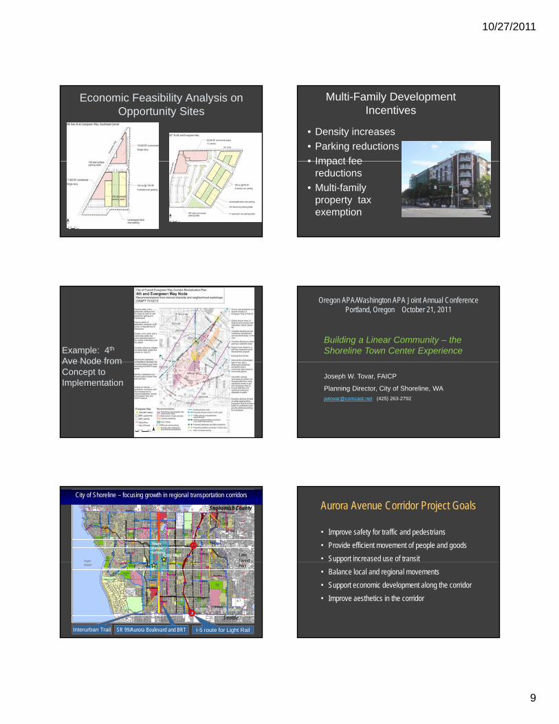
LEED Gold City Hall
Will it work?
??It has worked where…
Public improvements have changed the area’s character
Before
After
It has worked where ….There is an amenity

10/27/2011
13
Lessons• Think regionally • Collaboration between local governments,
stakeholders and transit agencies• Transit options that fit the context and that
can grow• Special regulations and guidelines are
necessary• Try for at least 1,000 du in ¼ mi around
key nodes
Lessons• Focus on cross streets and address
corridor edge conditions• If possible, transform the context
through street and open space i timprovements.
• Making it happen will take time• Though examples are still emerging,
the notion of a “linear community” holds a lot of promise
Contacts
• Thera Black: [email protected]
• Allan Giffen: [email protected](425) 257 8731(425) 257-8731
• John Owen: [email protected](206) 652-5080
• Joe Tovar: [email protected](425) 263-2792