Embed Size (px)
Citation preview

Building Better Agents: Geo-Temporal Tracking and Analysis Of Tourist Behavior
aO’Connor, A., bA. Zerger and cB. Itami
aCentre for Geographic Information Systems and Modelling, The University of Melbourne, Melbourne, Australia.
bCSIRO Sustainable Ecosystems, Canberra, Australia cGeodimensions Pty. Ltd., Brunswick, Melbourne Australia.
Abstract: Agent-based simulation is a technology which is being used as a decision support tool for recreation managers to better plan the development of tourist destinations in the face of increasing tourist numbers. Agent-based simulation for national park management is a developing field of research. A number of projects have been undertaken, applying the technology to a range of park scenarios. These projects have reported successful preliminary progress but acknowledge the need for more 'realistic' agents. It has been suggested that the next step in this research is to verify agent-based modelling at a particular tourism site. The aim of this research was to develop a typology of tourists via the geo-statistical analysis and visualisation of individual human movement data within a day-use recreational facility. The research aimed to determine whether tourist typologies can be developed by tracking individual people moving around at a tourist destination. Spatial tracking devices were used to obtain detailed geo-temporal data of tourist movement at the Twelve Apostles, Port Campbell National Park. Valid micro-scale tourist typologies will help to improve agent-based simulations of tourism scenarios and assessment of management decisions at the site where they are generated, and possibly at other similar sites.
Keywords: Recreation; Tourist Behavior; Agent-based; Simulation
1. INTRODUCTION
Agent-based simulation is a technology which is increasingly being used as a tool to improve recreation resource management. Agent-based simulations allow managers to develop spatially explicit simulations of current tourist movement patterns, and to develop predictive scenarios for analysing future demands and impacts. This paper describes the results of a study that has attempted to develop tourist typologies for the recreation behaviour simulator, RBSim (Itami et al. 2002, Itami 2002, this conference). The research involved physically tracking tourists at the Twelve Apostles, Port Campbell National Park Victoria, using innovative tracking, spatial data analysis and visualisation techniques. The outcome was a time series of continuous movement patterns over three days which can be used to better understand recreation behaviour, and to calibrate RBSim.
The paper examines the hardware components used for tracking tourists, it presents the results of the statistical and spatial analysis for the Twelve Apostles site, and examines the implications for recreation behaviour simulators. The research raises a number of important research questions pertaining to the analysis of human behaviour in
recreation areas, and specifically, movement over constrained networks. More importantly, the tracking technology allows researchers to uniquely identify tourists, hence providing a suite of new analysis opportunities, and challenges when integrated with demographic data. The study is the first of its type that has captured, mapped, and analysed, uniquely tagged geo-temporal human movement.
2. RECREATION PLANNING & TOURIST BEHAVIOR
2.1. Introduction
National park management is becoming an increasingly multifaceted problem. As with many tourist activities, there are a growing number of national park visitors, and more diverse park uses have arisen. These factors have created a need for effective and efficient decision support tools to assist park managers to administer resources, assess planning decisions, cater for an increased range of recreators, avoid user conflicts and minimise negative impacts on the environment.
Traditionally, user surveys, simple traffic count methods and manager expertise have been the
main sources of information for assessing park user experiences, crowding, movement patterns and impacts. As park demands increase, management decisions become more complex, and the diversity of user types create management scenarios that are increasingly difficult to manage (Itami & Gimblett 2000). As one way of dealing with the increasing complexity of the problem, agent-based simulation models are being used to model the human use of parks, to assist managers to model current situations, and to predict the effect of management decisions (Bishop and Gimblett, 1998, Gimblett et al. 1996, Gimblett et al. 2000, Itami & Gimblett 2000, Itami et al. 2002.)
While there is potential for agent-based simulation to become an integral part of park management decision making, a particular concern is the lack of sufficient tests to confirm the veracity of trip projections provided by simulation models (Gimblett et al. 2000). The ongoing development and implementation of agent-based simulation requires 'realistic' agents and typical trips to ensure simulations are correctly calibrated. This research attempts to overcome limitations of incomplete, subjective data by building agent typologies using detailed, real, tourist movement data.
2.2. Tourist Typologies
Tourist typologies developed to date have described tourist behaviour such as spending habits, and psychological motivations for tourism. Factors such as the speed of tourist travel, wayfinding decisions, crowd avoidance, and other spatial behaviour, are not yet well understood. Ryan (1991) acknowledges that while existing categorizations of tourists create easily recognised types, it is not know if they actually reflect the complexities of tourist behavior. What is required for recreation planning, is verification of how tourists act spatially at recreation sites.
3. THE TWELVE APOSTLES SITE
The Twelve Apostles site is nested within the Port Campbell National Park, which is located on the Great Ocean Road, in Western Victoria. The site has almost iconic significance to most Australians, and remains one of the nations most popular tourist destinations. The Twelve Apostles are a series of high cliff stacks resulting from the weathering of the soft limestone coastline. The site is surrounded by other similarly spectacular geology such as Lochard George. The park attracts an increasing number of visitors each year. Around 2.1 million visitors were recorded in 2001-2 and 2.8 million are predicted in 2006-7 (Parks Victoria, 1998).
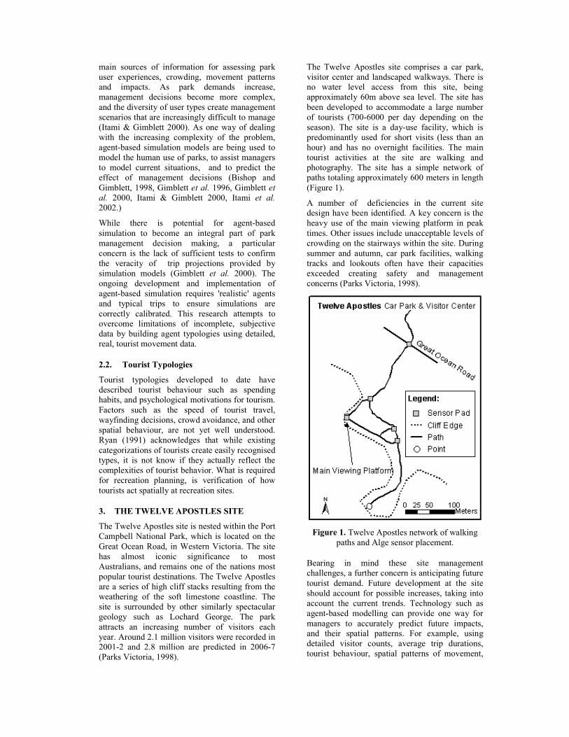
The Twelve Apostles site comprises a car park, visitor center and landscaped walkways. There is no water level access from this site, being approximately 60m above sea level. The site has been developed to accommodate a large number of tourists (700-6000 per day depending on the season). The site is a day-use facility, which is predominantly used for short visits (less than an hour) and has no overnight facilities. The main tourist activities at the site are walking and photography. The site has a simple network of paths totaling approximately 600 meters in length (Figure 1).
A number of deficiencies in the current site design have been identified. A key concern is the heavy use of the main viewing platform in peak times. Other issues include unacceptable levels of crowding on the stairways within the site. During summer and autumn, car park facilities, walking tracks and lookouts often have their capacities exceeded creating safety and management concerns (Parks Victoria, 1998).
Figure 1. Twelve Apostles network of walking
paths and Alge sensor placement.
Bearing in mind these site management challenges, a further concern is anticipating future tourist demand. Future development at the site should account for possible increases, taking into account the current trends. Technology such as agent-based modelling can provide one way for managers to accurately predict future impacts, and their spatial patterns. For example, using detailed visitor counts, average trip durations, tourist behaviour, spatial patterns of movement,
and demand forecasting can assist in planning future infrastructure development. Although the research focuses on the Twelve Apostles, the methodologies and results may be transferable to other sites nationally, and internationally. Owing to its high usage statistics, and its national prominence, the Twelve Apostles act as an exemplar for other, less prominent locations, that can nevertheless experience future growth.
4. DATA CAPTURE
4.1. ALGE Timing System
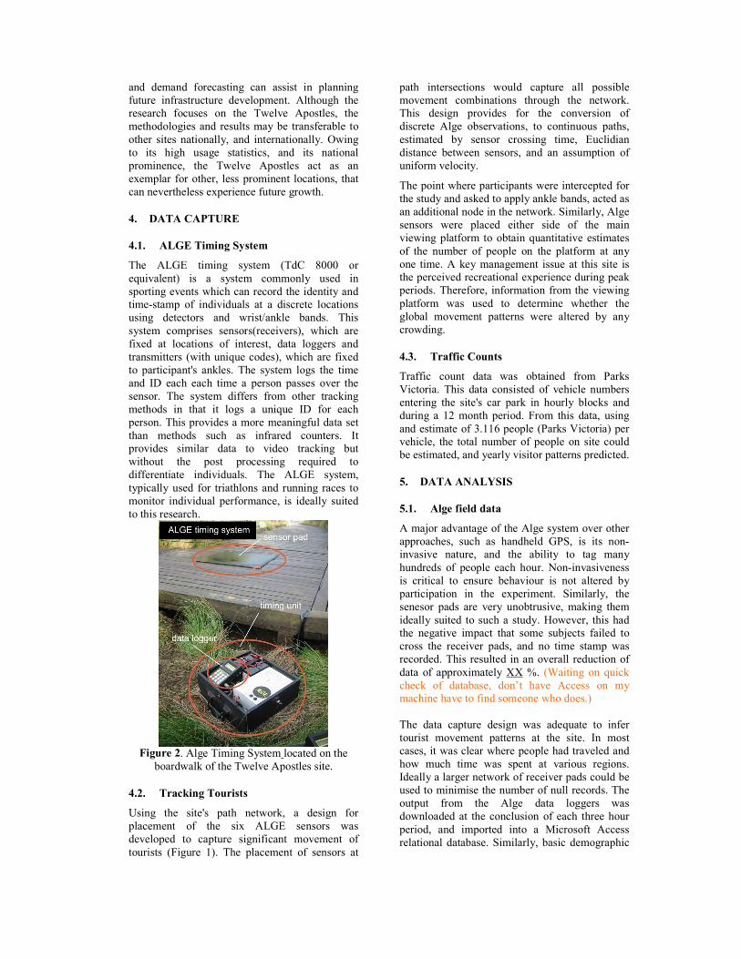
The ALGE timing system (TdC 8000 or equivalent) is a system commonly used in sporting events which can record the identity and time-stamp of individuals at a discrete locations using detectors and wrist/ankle bands. This system comprises sensors(receivers), which are fixed at locations of interest, data loggers and transmitters (with unique codes), which are fixed to participant's ankles. The system logs the time and ID each each time a person passes over the sensor. The system differs from other tracking methods in that it logs a unique ID for each person. This provides a more meaningful data set than methods such as infrared counters. It provides similar data to video tracking but without the post processing required to differentiate individuals. The ALGE system, typically used for triathlons and running races to monitor individual performance, is ideally suited to this research.
Figure 2. Alge Timing System located on the
boardwalk of the Twelve Apostles site.
4.2. Tracking Tourists
Using the site's path network, a design for placement of the six ALGE sensors was developed to capture significant movement of tourists (Figure 1). The placement of sensors at
path intersections would capture all possible movement combinations through the network. This design provides for the conversion of discrete Alge observations, to continuous paths, estimated by sensor crossing time, Euclidian distance between sensors, and an assumption of uniform velocity.
The point where participants were intercepted for the study and asked to apply ankle bands, acted as an additional node in the network. Similarly, Alge sensors were placed either side of the main viewing platform to obtain quantitative estimates of the number of people on the platform at any one time. A key management issue at this site is the perceived recreational experience during peak periods. Therefore, information from the viewing platform was used to determine whether the global movement patterns were altered by any crowding.
4.3. Traffic Counts
Traffic count data was obtained from Parks Victoria. This data consisted of vehicle numbers entering the site's car park in hourly blocks and during a 12 month period. From this data, using and estimate of 3.116 people (Parks Victoria) per vehicle, the total number of people on site could be estimated, and yearly visitor patterns predicted.
5. DATA ANALYSIS
5.1. Alge field data
A major advantage of the Alge system over other approaches, such as handheld GPS, is its non-invasive nature, and the ability to tag many hundreds of people each hour. Non-invasiveness is critical to ensure behaviour is not altered by participation in the experiment. Similarly, the senesor pads are very unobtrusive, making them ideally suited to such a study. However, this had the negative impact that some subjects failed to cross the receiver pads, and no time stamp was recorded. This resulted in an overall reduction of data of approximately XX %. (Waiting on quick check of database, don’t have Access on my machine have to find someone who does.) The data capture design was adequate to infer tourist movement patterns at the site. In most cases, it was clear where people had traveled and how much time was spent at various regions. Ideally a larger network of receiver pads could be used to minimise the number of null records. The output from the Alge data loggers was downloaded at the conclusion of each three hour period, and imported into a Microsoft Access relational database. Similarly, basic demographic
data was captured at the participant interception point and included in the database.
6. RESULTS
6.1. Crowding
The tourist numbers inferred from traffic count estimates provide a range of additional information. The visitor estimates derived from traffic counts relied on the assumption of 3.116 people per vehicle, derived from Parks Victoria estimates. Assessment of crowding effects included plotting the estimated total number of people on site (in hourly increments) against average time spent on site, or in specific regions, for that hour. This analysis sought to determine whether people were spending less time, for example, on the viewing platform, during more crowded times of the day. There was no significant correlation between total number of people on site, and time spent at key viewing areas (Figure 3). However, these findings must take into account the fact that sampling was conducted over only three days, and during the winter period, when visitor numbers a lower. Similarly, traffic count data was aggregated to hourly increments, when Alge data was available at much finer temporal resolutions (seconds). Further work should examine the behaviour during peak periods as crowding thresholds may exist, which result in impacts on the duration spent in particular regions of the site.
Figure 3 . Effect of crowding.
6.2. Graphing the data
Graphing tourist behaviour data provided a range of insights into tourist movement at the site (Figure 4). The shape of these graphs provided detailed information about times and sequences of travel for individuals and groups, where each shape represents a ‘type’ of movement. People traveling together could be seen to follow similar paths. This was a further point of interest for programming way-finding logic as little information had been generated on whether
groups that arrive together, stay together while exploring the site. While such techniques provide insights into the motions of small groups of people (< 10 individuals), the utility of such techniques for the entire cohort of some 800 individuals, was limited.
Figure 4. Graphical representation of tourist
behaviour
6.3. Travel Time
A key issue for computer-based recreation behaviour simulators is the frequency distribution of the time spent on site. This is commonly achieved by establishing a probability distribution. Results from this study have indicated that the duration of time spent on site is relatively uniform between individuals (Figure 5). Initially, the research had hypothesised that particular individuals such as the young, elderly, or those traveling in large groups, would vary in the amount of time the spent at the site.
Figure 5. Frequency distribution of time spent on
site for all individuals in the study
Although global estimates of duration spent on site is important, local estimates at various regions of the site proved more valuable. The Alge timing system allowed time frequency distributions to be analysed for specific regions at the site, and uncovered some local trends. For example, some regions were shown to have two distinct travel durations. Namely, some people
actually spent time viewing scenery along some paths, while others use the interconnecting paths as simple connections between significant nodes in the network. Significant nodes are generally viewing platforms.
Although an analysis of the global and local time durations at the site was interesting, it did not utilize the unique ID’s of each individual, inherent the Alge system. The time that individuals were spending on each path section was analysed to identify behavior specific to people, rather than the behavior of all tourists.
Analysis of the travel time data for individuals revealed little correlation between how individuals were acting on the various path segments (Figure 6). This was unexpected as it suggests that people were behaving randomly, rather than being influenced by personality or physical traits (age, gender, group size etc). There was however a significant correlation between time spent on site, and the time spent on the most distant point at the Twelve Apostles (Figure 1). Experimental design may play some role in influencing these findings. For example, the location of Alge sensors may have divided the site into regions that held no significance in terms of human wayfinding and trip decision making. Hence, aggregation effects may be masking behaviour patterns, or typologies.
Travel times alone did not divide the tourists at the Twelve Apostles into distinguishable types. This may have been due to the placement of the sensors, or the inherent topological design of the walkways at the site. From a management perspective, these results are interesting, as behaviour follows similar spatial and temporal patterns, regardless of externalities, such as path design as one example.
Figure 6. Correlation between time spent in various area of the study site.
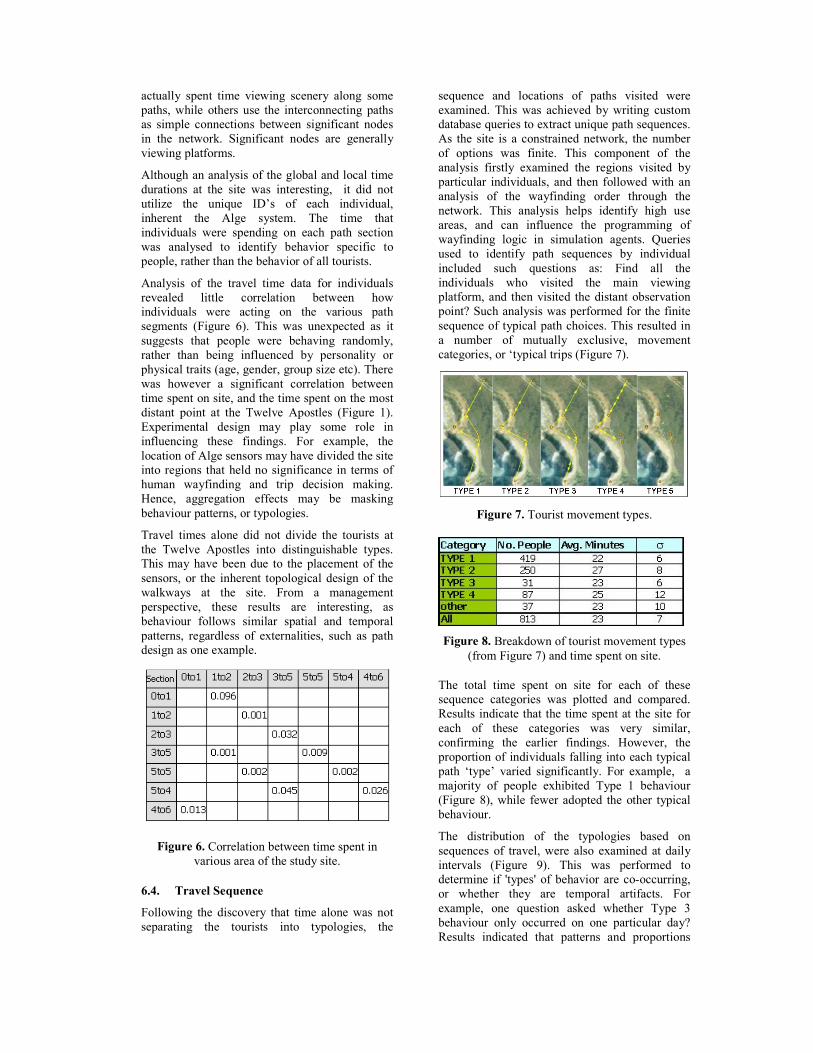
6.4. Travel Sequence
Following the discovery that time alone was not separating the tourists into typologies, the
sequence and locations of paths visited were examined. This was achieved by writing custom database queries to extract unique path sequences. As the site is a constrained network, the number of options was finite. This component of the analysis firstly examined the regions visited by particular individuals, and then followed with an analysis of the wayfinding order through the network. This analysis helps identify high use areas, and can influence the programming of wayfinding logic in simulation agents. Queries used to identify path sequences by individual included such questions as: Find all the individuals who visited the main viewing platform, and then visited the distant observation point? Such analysis was performed for the finite sequence of typical path choices. This resulted in a number of mutually exclusive, movement categories, or ‘typical trips (Figure 7).
Figure 7. Tourist movement types.
Figure 8. Breakdown of tourist movement types
(from Figure 7) and time spent on site.
The total time spent on site for each of these sequence categories was plotted and compared. Results indicate that the time spent at the site for each of these categories was very similar, confirming the earlier findings. However, the proportion of individuals falling into each typical path ‘type’ varied significantly. For example, a majority of people exhibited Type 1 behaviour (Figure 8), while fewer adopted the other typical behaviour.
The distribution of the typologies based on sequences of travel, were also examined at daily intervals (Figure 9). This was performed to determine if 'types' of behavior are co-occurring, or whether they are temporal artifacts. For example, one question asked whether Type 3 behaviour only occurred on one particular day? Results indicated that patterns and proportions
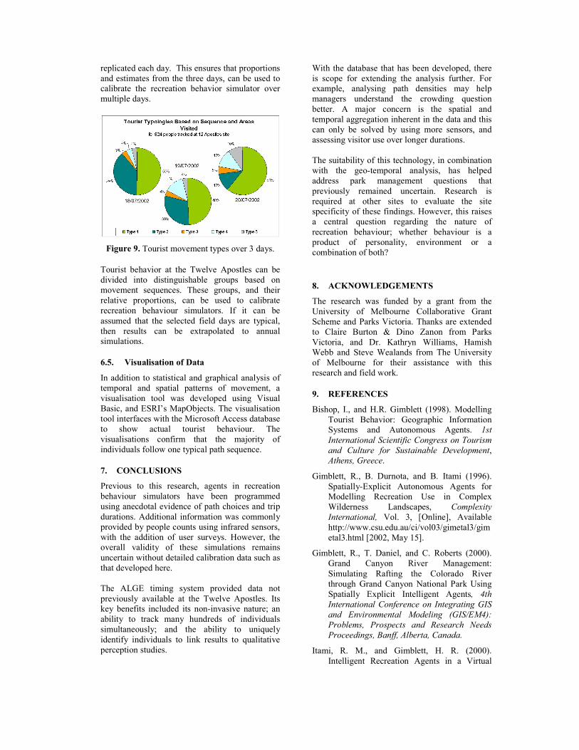
replicated each day. This ensures that proportions and estimates from the three days, can be used to calibrate the recreation behavior simulator over multiple days.
Figure 9. Tourist movement types over 3 days.
Tourist behavior at the Twelve Apostles can be divided into distinguishable groups based on movement sequences. These groups, and their relative proportions, can be used to calibrate recreation behaviour simulators. If it can be assumed that the selected field days are typical, then results can be extrapolated to annual simulations.
6.5. Visualisation of Data
In addition to statistical and graphical analysis of temporal and spatial patterns of movement, a visualisation tool was developed using Visual Basic, and ESRI’s MapObjects. The visualisation tool interfaces with the Microsoft Access database to show actual tourist behaviour. The visualisations confirm that the majority of individuals follow one typical path sequence.
7. CONCLUSIONS
Previous to this research, agents in recreation behaviour simulators have been programmed using anecdotal evidence of path choices and trip durations. Additional information was commonly provided by people counts using infrared sensors, with the addition of user surveys. However, the overall validity of these simulations remains uncertain without detailed calibration data such as that developed here. The ALGE timing system provided data not previously available at the Twelve Apostles. Its key benefits included its non-invasive nature; an ability to track many hundreds of individuals simultaneously; and the ability to uniquely identify individuals to link results to qualitative perception studies.
With the database that has been developed, there is scope for extending the analysis further. For example, analysing path densities may help managers understand the crowding question better. A major concern is the spatial and temporal aggregation inherent in the data and this can only be solved by using more sensors, and assessing visitor use over longer durations. The suitability of this technology, in combination with the geo-temporal analysis, has helped address park management questions that previously remained uncertain. Research is required at other sites to evaluate the site specificity of these findings. However, this raises a central question regarding the nature of recreation behaviour; whether behaviour is a product of personality, environment or a combination of both?
8. ACKNOWLEDGEMENTS
The research was funded by a grant from the University of Melbourne Collaborative Grant Scheme and Parks Victoria. Thanks are extended to Claire Burton & Dino Zanon from Parks Victoria, and Dr. Kathryn Williams, Hamish Webb and Steve Wealands from The University of Melbourne for their assistance with this research and field work.
9. REFERENCES
Bishop, I., and H.R. Gimblett (1998). Modelling Tourist Behavior: Geographic Information Systems and Autonomous Agents. 1st International Scientific Congress on Tourism and Culture for Sustainable Development, Athens, Greece.
Gimblett, R., B. Durnota, and B. Itami (1996). Spatially-Explicit Autonomous Agents for Modelling Recreation Use in Complex Wilderness Landscapes, Complexity International, Vol. 3, [Online], Available http://www.csu.edu.au/ci/vol03/gimetal3/gimetal3.html [2002, May 15].
Gimblett, R., T. Daniel, and C. Roberts (2000). Grand Canyon River Management: Simulating Rafting the Colorado River through Grand Canyon National Park Using Spatially Explicit Intelligent Agents, 4th International Conference on Integrating GIS and Environmental Modeling (GIS/EM4): Problems, Prospects and Research Needs Proceedings, Banff, Alberta, Canada.
Itami, R. M., and Gimblett, H. R. (2000). Intelligent Recreation Agents in a Virtual

GIS World, Complex Systems 2000 Conference Proceedings, University of Otago, Dunedin, New Zealand.
Itami, R., R., Raulings, G. MacLaren, K. Hirst, R. Gimblett, D. Zanon, and P. Chladek (2002). RBSim 2: Simulating the complex interactions between human movement and the outdoor recreation environment, Monitoring and Management of Visitor Flows in Recreational and Protected Areas, Institute for Landscape Architecture and Landscape Management Proceedings, University of Agricultural Sciences, Vienna, Austria.
Parks Victoria (1998). National Park and Bay of Islands Management Plan, National Library of Australia, Cataloguing-in-Publication entry. Parks Victoria, Kew, Victoria
Ryan, C. (1991). Recreational Tourism, Routledge, London


![Geo-Temporal Visual Analysis of Customer Feedback Data ... · PDF filecluding long, multivatiate, unevenly spaced or categorical time series [17]. ... system for cluster-based analysis](https://img.pdfslide.us/doc/110x75/5a7886227f8b9a8c428cbb3a/geo-temporal-visual-analysis-of-customer-feedback-data-long-multivatiate-unevenly.jpg)