Embed Size (px)
Citation preview
590
Building an Integrated Land InformationManagement System Infrastructure for the
Government
José Elias Mucombo1
Abstract
The present paper has been prepared to provide a presentation at 18th InternationalConference Informatics for Environmental Protection, the EnviroInfo 2004, organ-ized by CERN, Geneva, Switzerland, October 21-23, 2004, on how an integratedand cross-sectorial Land Information Management Infra-structure System, is beingdesigned, built, used and benefiting central and local Government Institutions, mu-nicipalities, utilities, non-profit organizations, universities, companies and donors inthe Republic of Mozambique.
A brief description of the National Directorate of Geography and Cadastre man-date within the framework of the Government is given. It describes, in an introduc-tory country background, the Mozambican geographical location and the adminis-trative division. Briefly outline the current policies and legal framework prevailingon the land in Mozambique. It focus on the program of Government of Mozambiquethat influence the setting up of the land information management system as well ason the integrated and cross-sectorial aspects concerning the geo-referencing of themaps and the IT-solutions, shows how to access to the land information and mapsfrom the system via web-services. It describes the means for reaching the objectives,i.e. designing and building the Land Information Management System Infra-structure, the conversion of the existing data from paper into digital format, themethodologies to be used, the organizational aspects of the system, etc.
Finally, it concludes with remarks of how a such system could be adopted as anexample in Africa for building an integrated Land Information Management Infra-structure for the Government.
1 National Director of dinageca, Republic of Mozambique, Ministry of Agriculture and RuralDevelopment, National Directorate of Geography and Cadastre (dinageca), [email protected], http://www.dinageca.gov.mz
EnviroInfo 2004 (Geneva)Sh@ring – EnviroInfo 2004
Copyright © Editions du Tricorne 2004. ISBN: 28 29 30 275-3
591
1. IntroductionThe National Directorate of Geography and Cadastre, abbreviated to Dinageca fromthe Portuguese: Direcção Nacional de Geografia e Cadastro, under the aegis of theMinistry of Agriculture and Rural Development, is an executive and governmentinstitution in Mozambique, responsible for national mapping (topographic and the-matic), land administration and land management (national land cadastre and ar-chive). It is responsible for establishing, providing and maintaining the nationalgeodetic network, national map series, national cadastral atlas, administration andmanagement of all land rights concessions process, information and data on land useand land cover for better planning and decision making, definition of policies, stan-dards, norms and procedures on geo-referenced data and information.
Topographic national mapping activities offer basic maps at scale of 1:50 000which covers the country with a total of 1207 sheets and at scale of 1:250 000 with102 Sheets. It has also maps at different scales including the administrative bounda-ries, touristic, city and thematic maps at various scales and at graphical and digitalformats.
Land administration and land management activities are directed to promote theland use for social welfare and economic development, security of tenure and toguarantee the access on land for Mozambican people as well as national and foreigninvestors.
The Government Programme 2000-2004 has defined the Land as one of the in-dispensable resource for production of agro-cattle breeding, for forestry and faunalexploitation, for the conservation and maintenance of the biodiversity, of ecologicalequity and for the construction of economical, social and habitation infra-structures.
In addition, it refers that the land management policy must guaranty the use ofland rights to all singular and collective entities, nationals and foreign, those haveeconomical and social initiatives for the benefit of the Mozambican People.
One of the ascribed role for Dinageca, as the main institution responsible for theestablishment, maintenance and updating of the national land cadastre in Mozam-bique, has driven the Government of Mozambique to strengthen the capacity of theinstitution to deliver its cross-sectorial mandate on administration and managementof the country’s most important and precious natural resources.
Thus, the ultimate mandate for Dinageca is to design and build a modern, effi-cient, reliable cross-sectorial and transparent Land Information Management SystemInfrastructure for:1. Internal land administration and land management responsibilities within the na-
tional directorate and its provincial offices by cross-checking and validating allland rights registration applications;
2. Inter- and intra-governmental land and other natural resources administration andmanagement through cross-checking and validating all concessions (land, for-estry and wildlife, water resources, mineral resources, etc.);
Copyright © Editions du Tricorne 2004. ISBN: 28 29 30 275-3
592
3. Inter- and intra-governmental natural resources planning and management ac-tivities;
4. Provision of a consistent database of land and other natural resources utilizationfor all users.
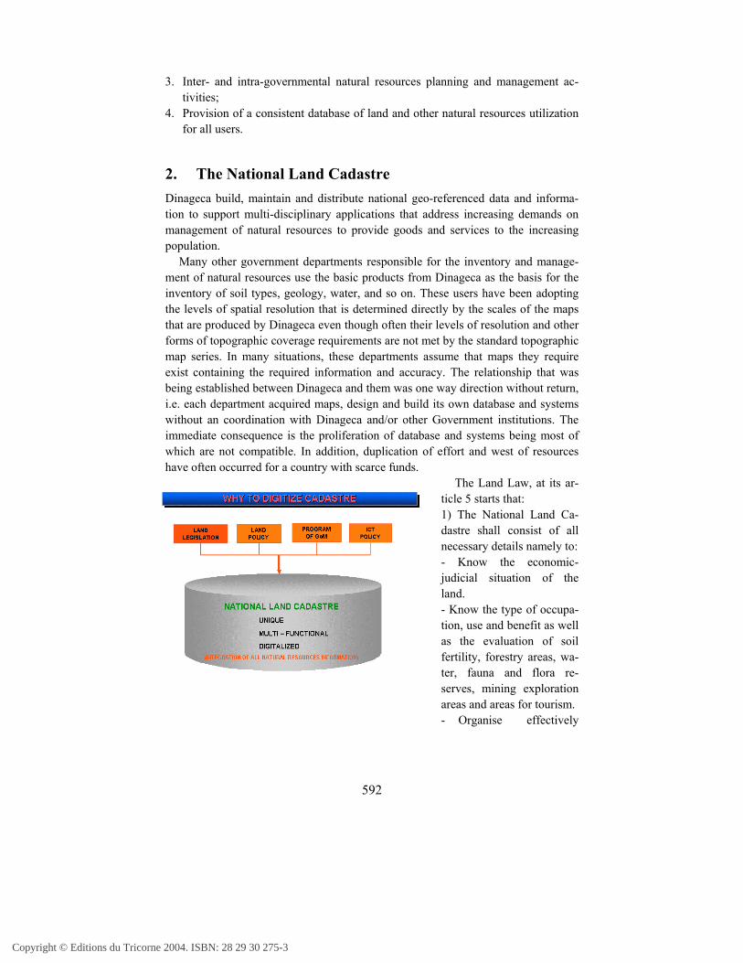
2. The National Land CadastreDinageca build, maintain and distribute national geo-referenced data and informa-tion to support multi-disciplinary applications that address increasing demands onmanagement of natural resources to provide goods and services to the increasingpopulation.
Many other government departments responsible for the inventory and manage-ment of natural resources use the basic products from Dinageca as the basis for theinventory of soil types, geology, water, and so on. These users have been adoptingthe levels of spatial resolution that is determined directly by the scales of the mapsthat are produced by Dinageca even though often their levels of resolution and otherforms of topographic coverage requirements are not met by the standard topographicmap series. In many situations, these departments assume that maps they requireexist containing the required information and accuracy. The relationship that wasbeing established between Dinageca and them was one way direction without return,i.e. each department acquired maps, design and build its own database and systemswithout an coordination with Dinageca and/or other Government institutions. Theimmediate consequence is the proliferation of database and systems being most ofwhich are not compatible. In addition, duplication of effort and west of resourceshave often occurred for a country with scarce funds.
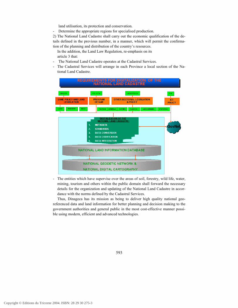
The Land Law, at its ar-ticle 5 starts that:1) The National Land Ca-dastre shall consist of allnecessary details namely to:- Know the economic-judicial situation of theland.- Know the type of occupa-tion, use and benefit as wellas the evaluation of soilfertility, forestry areas, wa-ter, fauna and flora re-serves, mining explorationareas and areas for tourism.- Organise effectively
Copyright © Editions du Tricorne 2004. ISBN: 28 29 30 275-3
593
land utilisation, its protection and conservation.- Determine the appropriate regions for specialised production.2) The National Land Cadastre shall carry out the economic qualification of the de-tails defined in the previous number, in a manner, which will permit the confirma-tion of the planning and distribution of the country’s resources.
In the addition, the Land Law Regulation, re-emphasis on itsarticle 3 that:
- The National Land Cadastre operates at the Cadastral Services.- The Cadastral Services will arrange in each Province a local section of the Na-
tional Land Cadastre.
- The entities which have supervise over the areas of soil, forestry, wild life, water,mining, tourism and others within the public domain shall forward the necessarydetails for the organization and updating of the National Land Cadastre in accor-dance with the norms defined by the Cadastral Services.Thus, Dinageca has its mission as being to deliver high quality national geo-
referenced data and land information for better planning and decision making to thegovernment authorities and general public in the most cost-effective manner possi-ble using modern, efficient and advanced technologies.
Copyright © Editions du Tricorne 2004. ISBN: 28 29 30 275-3
594
3. The National Land Information Management SystemInfrastructure
The initial steps toward rational use of natural resources requires an inventory whichis accomplished with the aid of land information taking into account that much ofMozambique’s resources have not been adequately inventoried because the capaci-ties are beyond the budgets of many governmental institutions involved.
Unfortunately, land and other natural resources information have become pro-gressively more expensive for the Government of Mozambique who can hardly fundsmall-scale mapping and land information management systems programmes. Withthe advent of modern and efficient technologies and systems a great opportunity tothe Government of Mozambique has arisen to obtain adequate funding and technicalassistance to design and build a National Land Information Management System In-fra-structure for natural resources inventory, administration and management. In thelight of these circumstances, Dinageca has decided to design and build a nationalland information management system
Dinageca early understood that designing and building a modern, efficient, cross-sectorial and transparent Land Information Management System Infra-structureneeded better and sought extensive partnerships with all institutions within the Min-istry and across government wherever land and other natural resources administra-tion and management are factors in the identification and delivery of economicallyand environmentally sustainable and socially acceptable development.
3.1 The management system infrastructure objectiveWe have seen that the Government of Mozambique has recognized that land, as akey source of wealth, lies at the heart of good governance and effective public ad-ministration. In adopting its agricultural development program, the Government hasassigned a priority to land registration and improving the capacity for land informa-tion management. The various institutional, technical and process changes and de-velopments that have taken place to date constitute concrete steps in this direction.
The importance of a digital land registry system is further underscored in the Na-tional Information and Communications Technology Policy Implementation Strat-egy where Mozambique requested an high priority assistance from the e-governmentfor development program of the Government of Itly and the Development GatewayFoundation to fund the building of a modern, efficient, reliable cross-sectorial andtransparent land information management system infra-structure for the Govern-ment.
It was recognised that land information management system is a means whichshould be used to produce a good land use and development, a system of land hold-ing through registration which provide an administrative aid for the new generation
Copyright © Editions du Tricorne 2004. ISBN: 28 29 30 275-3
595
of users who are more concerned with the problems of establishing a comprehensiveland information management systems with a wide range of benefits rather thankeeping a fragmentary or limited system that has fewer benefits to offer.
The current advancement in technology combined with limitations in the amountof usable land and increasing demand for more information related to land, have re-fined land management to an extent where systematic land information system of thecountry appear to be an ideal as well as a practical solution to land and other naturalresources management problems.
A modern, efficient and reliable cross-sectorial land information managementsystem infra-structure offers so many advantages and opens so many more possi-bilities that it is generally preferable in the long run, however it will be possible withthe funding and if when there is co-operation of a large number of diverse institu-tions and experts.
The overall mission of national land information management system infra-structure is to satisfy the national interest and customer need for accurate, up-to-dateand readily available land information data of the whole country. All data have to berepresented in the basis of a national geodetic reference framework under whichvirtually all other data collected by government is referenced.
The ultimate objective for the program is to design and build a modern, efficient,reliable cross-sectorial and transparent Land Information Management System Infra-structure in order to:
Facilitate land rights application handling within the cadastral services, the Na-tional Directorate and its Provincial Services (offices) and the Municipal Direc-torate of Construction and Urbanisation by cross-checking and validating all le-gal requirements for land rights registration, land administration and land man-agement responsibilities.
Facilitate the administration and management of land and other natural resourceswithin the Government institutions, i.e. lands, forestry and wildlife, waters,mining, tourism, physical planning, statistics, etc., through cross-checking andvalidating all legal requirements and restrictions and planning.
Facilitate input, consultation, verification, updating and use of land and othernatural resources information.
Facilitate the exercise of inter- and intra-governmental activities of planning,distribution and management of natural resources within the Government insti-tutions.
Facilitate the provision of a consistent database on utilization of lands and othernatural resources.
Copyright © Editions du Tricorne 2004. ISBN: 28 29 30 275-3
596
3.2 Designing and building the management systeminfrastructure
Increasingly, nowadays, there is a major concern about access to and security ofland as mankind’s primary asset from which people are fed, clothed and housed, andwhich is used to generate their wealth and recreation specially in the case of Mo-zambique where 71% of the total population live in rural areas and depend on land,i.e. agricultural activities for their subsistence. Many policy-makers and scientistshave emphasised that decisions concerning the allocation and use of land evenshaped by political, economic and social values, depend on the quality, accuracy andappropriateness of the land information, data available to the participants for effec-tive and efficient decision-making.
Systematic information of land has great importance for natural resource man-agement, i.e. public administration, land planning and development, and privatetransactions in land. The management of land and other natural resources is set bythe land rights vested in landowners and/or land managers who administrate the landrights units. Thus, the first stage of managing natural resources is the identificationof the units as the areas of decision-making through identification of boundaries onthe ground.
Different steps have been taken in order to accomplish the identification of theunits and boundaries through detailed survey, using Differencial GPS, has been fin-ished in four District, Manica, Angónia, Gúruè and Mandimba using outsourcing ofprivate land surveyors. In addition to that, a preparatory work is underway to certifyindividual land rights ownership for small and medium agricultural producers for themarket using smart card technologies. All digital data resulting from these under-takings will be incorporated into LIM-SI. The Government of Mozambique has con-cluded that land information management system is an essential part under whichproper management of natural resources are undertaken.
3.2.1 Designing the LIM-SI
Since 1990, Dinageca has been attempting to establish an electronic land applicationhandling system (LAHS). Initially, the system was in house development under thefunding of Swedish International Development Agency through technical assistanceand consultancy from Swede Survey AB. The major problems accounted with thesystem early developed were following:1. Complete dependency on foreign designer and developer of the system;2. Lack of local support of the system;3. Finishing of the project that funded the development of the system;4. Unsolved Year 2000 bugs;5. Runs on SQL Base Server;
Copyright © Editions du Tricorne 2004. ISBN: 28 29 30 275-3
597
6. Database not spatially aware;7. No tracking and management of changes taking place opening possibilities for
vulnerability;8. Duplication of information on the forms;9. Lack of some of desired functionalities.
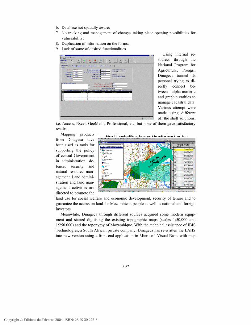
Using internal re-sources through theNational Program forAgriculture, Proagri,Dinageca trained itspersonal trying to di-rectly connect be-tween alpha-numericand graphic entities tomanage cadastral data.Various attempt weremade using differentoff the shelf solutions,
i.e. Access, Excel, GeoMedia Professional, etc. but none of them gave satisfactoryresults.
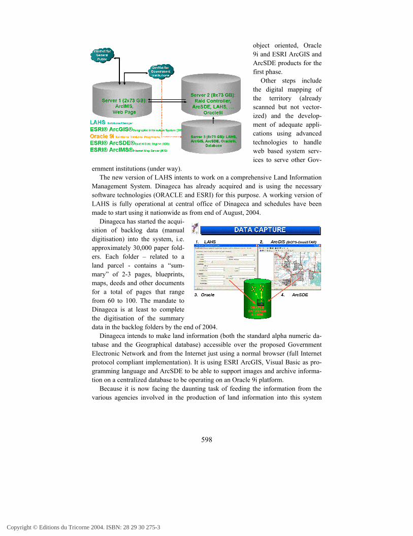
Mapping productsfrom Dinageca havebeen used as tools forsupporting the policyof central Governmentin administration, de-fence, security andnatural resource man-agement. Land admini-stration and land man-agement activities aredirected to promote theland use for social welfare and economic development, security of tenure and toguarantee the access on land for Mozambican people as well as national and foreigninvestors.
Meanwhile, Dinageca through different sources acquired some modern equip-ment and started digitising the existing topographic maps (scales 1:50,000 and1:250.000) and the toponymy of Mozambique. With the technical assistance of IBISTechnologies, a South African private company, Dinageca has re-written the LAHSinto new version using a front-end application in Microsoft Visual Basic with map
Copyright © Editions du Tricorne 2004. ISBN: 28 29 30 275-3
598
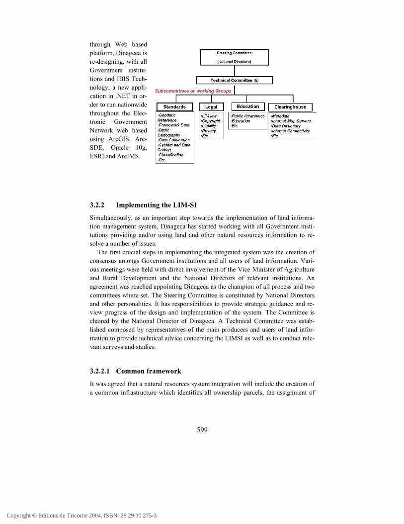
object oriented, Oracle9i and ESRI ArcGIS andArcSDE products for thefirst phase.
Other steps includethe digital mapping ofthe territory (alreadyscanned but not vector-ized) and the develop-ment of adequate appli-cations using advancedtechnologies to handleweb based system serv-ices to serve other Gov-
ernment institutions (under way).The new version of LAHS intents to work on a comprehensive Land Information
Management System. Dinageca has already acquired and is using the necessarysoftware technologies (ORACLE and ESRI) for this purpose. A working version ofLAHS is fully operational at central office of Dinageca and schedules have beenmade to start using it nationwide as from end of August, 2004.
Dinageca has started the acqui-sition of backlog data (manualdigitisation) into the system, i.e.approximately 30,000 paper fold-ers. Each folder – related to aland parcel - contains a “sum-mary” of 2-3 pages, blueprints,maps, deeds and other documentsfor a total of pages that rangefrom 60 to 100. The mandate toDinageca is at least to completethe digitisation of the summarydata in the backlog folders by the end of 2004.
Dinageca intends to make land information (both the standard alpha numeric da-tabase and the Geographical database) accessible over the proposed GovernmentElectronic Network and from the Internet just using a normal browser (full Internetprotocol compliant implementation). It is using ESRI ArcGIS, Visual Basic as pro-gramming language and ArcSDE to be able to support images and archive informa-tion on a centralized database to be operating on an Oracle 9i platform.
Because it is now facing the daunting task of feeding the information from thevarious agencies involved in the production of land information into this system
Copyright © Editions du Tricorne 2004. ISBN: 28 29 30 275-3
599
through Web basedplatform, Dinageca isre-designing, with allGovernment institu-tions and IBIS Tech-nology, a new appli-cation in .NET in or-der to run nationwidethroughout the Elec-tronic GovernmentNetwork web basedusing ArcGIS, Arc-SDE, Oracle 10g,ESRI and ArcIMS.
3.2.2 Implementing the LIM-SI
Simultaneously, as an important step towards the implementation of land informa-tion management system, Dinageca has started working with all Government insti-tutions providing and/or using land and other natural resources information to re-solve a number of issues:
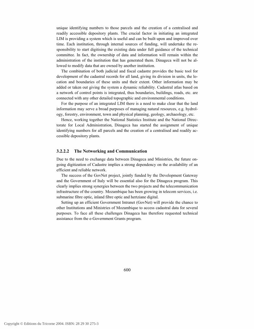
The first crucial steps in implementing the integrated system was the creation ofconsensus amongs Government institutions and all users of land information. Vari-ous meetings were held with direct involvement of the Vice-Minister of Agricultureand Rural Development and the National Directors of relevant institutions. Anagreement was reached appointing Dinageca as the champion of all process and twocommittees where set. The Steering Committee is constituted by National Directorsand other personalities. It has responsibilities to provide strategic guidance and re-view progress of the design and implementation of the system. The Committee ischaired by the National Director of Dinageca. A Technical Committee was estab-lished composed by representatives of the main producers and users of land infor-mation to provide technical advice concerning the LIMSI as well as to conduct rele-vant surveys and studies.
3.2.2.1 Common framework
It was agreed that a natural resources system integration will include the creation ofa common infrastructure which identifies all ownership parcels, the assignment of
Copyright © Editions du Tricorne 2004. ISBN: 28 29 30 275-3
600
unique identifying numbers to those parcels and the creation of a centralised andreadily accessible depository plants. The crucial factor in initiating an integratedLIM is providing a system which is useful and can be built upon and improved overtime. Each institution, through internal sources of funding, will undertake the re-sponsibility to start digitising the existing data under full guidance of the technicalcommittee. In fact, the ownership of data and information will remain within theadministration of the institution that has generated them. Dinageca will not be al-lowed to modify data that are owned by another institution.
The combination of both judicial and fiscal cadastre provides the basic tool fordevelopment of the cadastral records for all land, giving its division in units, the lo-cation and boundaries of these units and their extent. Other information may beadded or taken out giving the system a dynamic reliability. Cadastral atlas based ona network of control points is integrated, thus boundaries, buildings, roads, etc. areconnected with any other detailed topographic and environmental conditions.
For the purpose of an integrated LIM there is a need to make clear that the landinformation may serve a broad purposes of managing natural resources, e.g. hydrol-ogy, forestry, environment, town and physical planning, geology, archaeology, etc.
Hence, working together the National Statistics Institute and the National Direc-torate for Local Administration, Dinageca has started the assignment of uniqueidentifying numbers for all parcels and the creation of a centralised and readily ac-cessible depository plants.
3.2.2.2 The Networking and Communication
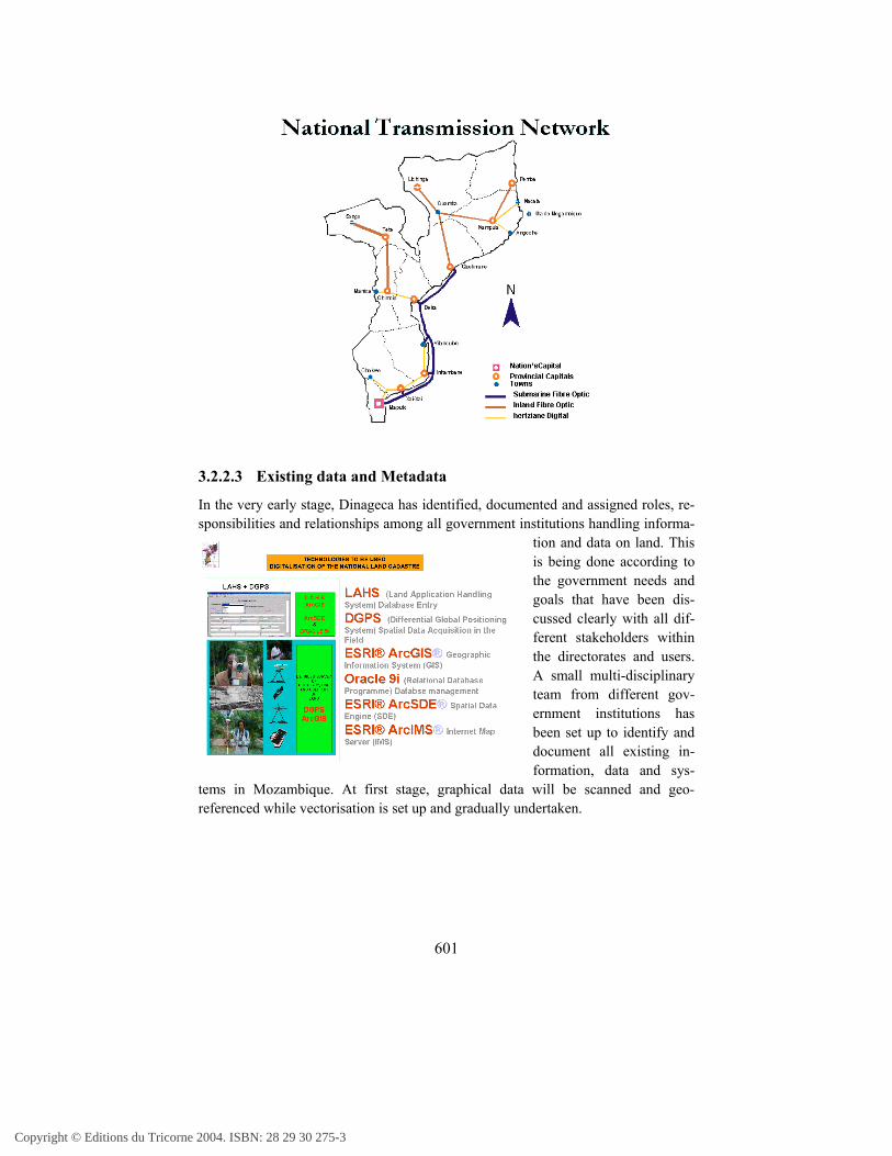
Due to the need to exchange data between Dinageca and Ministries, the future on-going digitization of Cadastre implies a strong dependency on the availability of anefficient and reliable network.
The success of the GovNet project, jointly funded by the Development Gatewayand the Government of Italy will be essential also for the Dinageca program. Thisclearly implies strong synergies between the two projects and the telecommunicationinfrastructure of the country. Mozambique has been growing in telecom services, i.e.submarine fibre optic, inland fibre optic and hertziane digital.
Setting up an efficient Government Intranet (GovNet) will provide the chance toother Institutions and Ministries of Mozambique to access cadastral data for severalpurposes. To face all these challenges Dinageca has therefore requested technicalassistance from the e-Government Grants program.
Copyright © Editions du Tricorne 2004. ISBN: 28 29 30 275-3
601
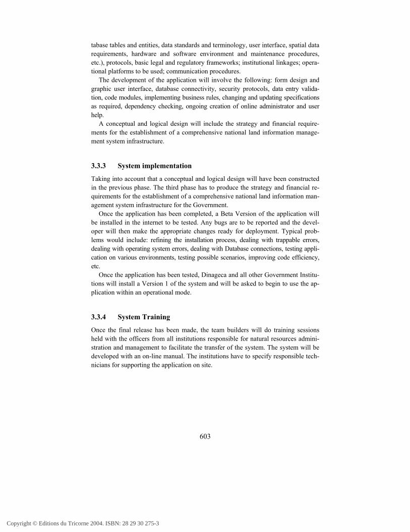
3.2.2.3 Existing data and Metadata
In the very early stage, Dinageca has identified, documented and assigned roles, re-sponsibilities and relationships among all government institutions handling informa-
tion and data on land. Thisis being done according tothe government needs andgoals that have been dis-cussed clearly with all dif-ferent stakeholders withinthe directorates and users.A small multi-disciplinaryteam from different gov-ernment institutions hasbeen set up to identify anddocument all existing in-formation, data and sys-
tems in Mozambique. At first stage, graphical data will be scanned and geo-referenced while vectorisation is set up and gradually undertaken.
Copyright © Editions du Tricorne 2004. ISBN: 28 29 30 275-3

602
3.3 The phases of the LIM-SIIn order to build a common basic framework of Land Information ManagementSystem Infrastructure, different phases have been identified.
3.3.1 Feasibility study
The feasibility study phase will have to deliver a document describing land informa-tion needs based upon the present data collection, processing and retrieval proce-dures and systems among the various agencies producing land information, indicat-ing possible stumbling blocks that could hamper the transformation from any iso-lated and individual systems to a more efficient and transparent systems.
3.3.2 System Design and Development
The design phase is regarded as the cornerstone of the total program. The systemdesign and developmentphase has to extend the ex-isting database and LAHSat Dinageca constructing anew conceptual and logicaldesign with its differentcomponents, which in-cludes: analysing the func-tionality, data requirements,flow of the processes, vali-dation and business rules,task sequences, graphicalinterfaces and the layout ofthe forms and data integra-tion.
The design of the deliv-erables will be the design ofa comprehensive nationalland information manage-ment system infrastructureof Mozambique, including:database structures; type ofinformation (geo-attributes); technical re-quirements (workflow, da-
Copyright © Editions du Tricorne 2004. ISBN: 28 29 30 275-3
603
tabase tables and entities, data standards and terminology, user interface, spatial datarequirements, hardware and software environment and maintenance procedures,etc.), protocols, basic legal and regulatory frameworks; institutional linkages; opera-tional platforms to be used; communication procedures.
The development of the application will involve the following: form design andgraphic user interface, database connectivity, security protocols, data entry valida-tion, code modules, implementing business rules, changing and updating specificationsas required, dependency checking, ongoing creation of online administrator and userhelp.
A conceptual and logical design will include the strategy and financial require-ments for the establishment of a comprehensive national land information manage-ment system infrastructure.
3.3.3 System implementation
Taking into account that a conceptual and logical design will have been constructedin the previous phase. The third phase has to produce the strategy and financial re-quirements for the establishment of a comprehensive national land information man-agement system infrastructure for the Government.
Once the application has been completed, a Beta Version of the application willbe installed in the internet to be tested. Any bugs are to be reported and the devel-oper will then make the appropriate changes ready for deployment. Typical prob-lems would include: refining the installation process, dealing with trappable errors,dealing with operating system errors, dealing with Database connections, testing appli-cation on various environments, testing possible scenarios, improving code efficiency,etc.
Once the application has been tested, Dinageca and all other Government Institu-tions will install a Version 1 of the system and will be asked to begin to use the ap-plication within an operational mode.
3.3.4 System Training
Once the final release has been made, the team builders will do training sessionsheld with the officers from all institutions responsible for natural resources admini-stration and management to facilitate the transfer of the system. The system will bedeveloped with an on-line manual. The institutions have to specify responsible tech-nicians for supporting the application on site.
Copyright © Editions du Tricorne 2004. ISBN: 28 29 30 275-3