Embed Size (px)
Citation preview
BROAD SCENIC RIVERMANAGEMENT PLAN
2003 Update
Report 32
Broad Scenic River Advisory Council ReportIn partnership with
Duke Power, a Division of Duke EnergySouth Carolina Department of Natural Resources
South Carolina Department of Health and Environmental Control
Mary CrockettBroad Scenic River Project Manager
South Carolina Department of Natural Resources2221 Devine St. Suite 222
Columbia, SC [email protected]
803-734-9111
Funding for publishing this plan was provided by The Duke Energy Foundation
with the help ofThe Harry Hampton Memorial Wildlife Fund

i
i
Summary
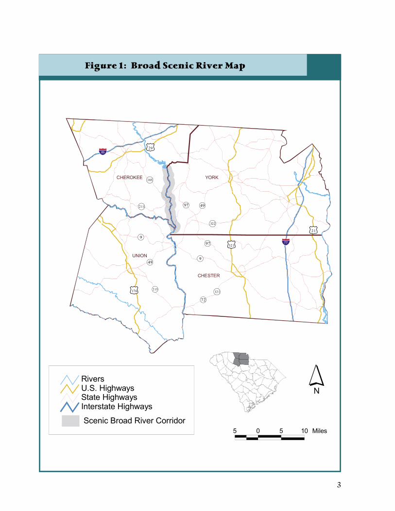
In 1991, a 15.3-mile section of the Broad River was designated a State Scenic River by the South Carolina General Assembly (see Figure 1). The scenic designation originates at the Ninety-Nine Islands Dam near the Town of Hickory Grove and ends at the Broad’s confluence with
the Pacolet River. With this designation, the Broad River became part of a program established by the South Carolina Scenic Rivers Act of 1989 (Scenic Rivers Act), the purpose of which is to protect unique and outstanding river resources throughout South Carolina. To accomplish this purpose, the Scenic Rivers Act provides for a voluntary, cooperative river management program to be administered by the South Carolina Department of Natural Resources (SCDNR), which enables landowners, community interests, and the SCDNR to work together toward common river conservation goals.
Following the procedures set forth in the Scenic Rivers Act, an advisory council for the Broad Scenic River was formed in 1991 with members representing river-bordering landowners, river users, and community interests. The purpose of the Broad Scenic River Advisory Council is to assist and advise the SCDNR in the protection and management of the scenic river corridor. Creating a management plan for the river corridor is the first major task of any advisory council.
The Broad Scenic River Advisory Council, in partnership with the SCDNR, published a Broad Scenic River Management Plan in 1993. This plan served as the guide for ongoing program activities of the advisory council and the SCDNR for the past ten years. This Broad Scenic River Management Plan Update (Management Plan) was created after studying, identifying, and exploring potential impacts to the river. The information gained in this process was discussed by the advisory council and management plan committee members to determine management goals for the river corridor while considering regional community needs. This Management Plan reflects public values, concerns, and desires for the river; it defines problems and opportunities and advocates goals and recommendations. The ideas of the management plan come from the local community, from landowners, river users, and community leaders who wish to promote excellent stewardship of the Broad Scenic River. The plan’s goals are to protect and enhance the highly valued natural, cultural, and scenic qualities of the river for the benefit and enjoyment of present and future generations. This updated management plan acknowledges the legacy of superior stewardship among many generations of landowners along the Broad, and it offers ideas to support the continuation of careful and responsible management of this resource.
The first two sections of this plan provide an introduction to and history of the Broad Scenic River Project. The remaining sections form the core of the management plan and each section provides detailed information about the various resources, uses, and concerns within the river corridor. The resource management issues, a resource management goal, and recommendations and opportunities for the Broad Scenic River are presented at the end of each of these sections. The Implementation section provides a plan of action that incorporates the resource recommendations.
The management plan specifies seven river management subject areas for which issues and recommendations are addressed.
• Land Use management area has seven recommendations concerning the conservation of the scenic view while providing for certain development practices.
• Natural Resources management area has eight recommendations concerning the conservation of the scenic river ecosystems.
• Water Quality management area has two main recommendations emphasizing the reduction of nonpoint source pollution.
• Recreation management area has nine recommendations concerning the various recreation uses of the river.
• Public Safety management area has six recommendations concerning the safety of visitors to the scenic river corridor.
• Cultural and Historical Resources management area has three recommendations concerning the cultural history and historic sites associated with the scenic river corridor.
ii iii
• Education and Community Stewardship management area has six recommendations for information and outreach opportunities.
The recommendations are numbered consecutively (not in order of priority) so that the advisory council may refer to the work being accomplished in the future to a number only instead of a number and chapter. The appendices supplement the management plan and provide information and graphics that support recommendations and public input.
This plan had a public review and comment period from March 10 to April 11, 2003, and was approved by the Broad Scenic River Advisory Council on April 24, 2003. The South Carolina Department of Natural Resources’ Land, Water and Conservation Advisory Committee approved this plan on July 16, 2003, and the South Carolina Department of Natural Resources Board approved this plan on August 15, 2003.

ii iii
Table of Contents
SUMMARY.......................................................................................................iTABLE OF CONTENTS ................................................................................ iiiLIST OF TABLES............................................................................................ vLIST OF FIGURES ......................................................................................... vACKNOWLEDGEMENTS............................................................................ viiINTRODUCTION....................................................................................... viiiPROJECT HISTORY ..................................................................................... ixBROAD SCENIC RIVER MANAGEMENT PLAN.........................................1
LAND MANAGEMENT Overview of Land Management ......................................................5 Issues .........................................................................................8 ManagementGoal ........................................................................8 Recommendations and Opportunities.............................................8
NATURAL RESOURCES Overview of Natural Resources .....................................................15 Issues .......................................................................................24 Management Goal .....................................................................24 Recommendations and Opportunities...........................................24
WATER QUALITY
Overview of Water Quality............................................................26 Issues .......................................................................................31 Management Goal .....................................................................31 Recommendations and Opportunities...........................................31
RECREATION AND PUBLIC ACCESS Overview of Recreation...............……………………………………33 Issues .....................................……………………………………34 Management Goal ...................……………………………………34 Recommendations and Opportunities..................…………………35
LAW ENFORCEMENT AND PUBLIC SAFETY Overview of Public Safety .............................................................37 Issues .......................................................................................37 Management Goal .....................................................................37 Recommendations and Opportunities...........................................37
CULTURAL AND HISTORICAL RESOURCES Overview of Historical Resources ..................................................41 Issues .......................................................................................46 Management Goal .....................................................................46 Recommendations and Opportunities...........................................46

iv v
EDUCATION AND COMMUNITY STEWARDSHIP Overview of Education and Community Stewardship .................... 49 Issues ....................................................................................... 49 Management Goal ..................................................................... 49 Recommendations and Opportunities........................................... 49
IMPLEMENTATION.................................................................................... 53GLOSSARY.................................................................................................... 56REFERENCES............................................................................................... 57APPENDICES ............................................................................................... 59
iv v
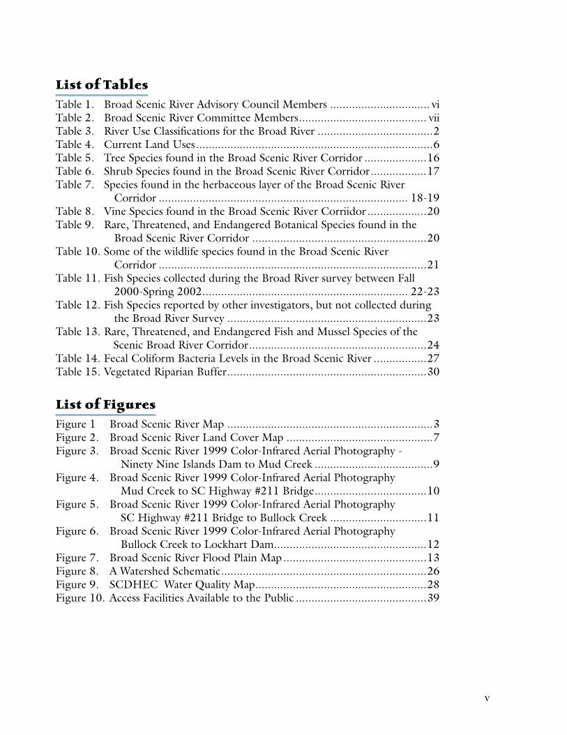
List of TablesTable 1. Broad Scenic River Advisory Council Members ................................ viTable 2. Broad Scenic River Committee Members......................................... viiTable 3. River Use Classifications for the Broad River .....................................2Table 4. Current Land Uses............................................................................6Table 5. Tree Species found in the Broad Scenic River Corridor ....................16Table 6. Shrub Species found in the Broad Scenic River Corridor..................17Table 7. Species found in the herbaceous layer of the Broad Scenic River Corridor ................................................................................ 18-19Table 8. Vine Species found in the Broad Scenic River Corriidor ...................20Table 9. Rare, Threatened, and Endangered Botanical Species found in the Broad Scenic River Corridor ........................................................20Table 10. Some of the wildlife species found in the Broad Scenic River Corridor ......................................................................................21Table 11. Fish Species collected during the Broad River survey between Fall 2000-Spring 2002.................................................................. 22-23Table 12. Fish Species reported by other investigators, but not collected during the Broad River Survey ................................................................23Table 13. Rare, Threatened, and Endangered Fish and Mussel Species of the Scenic Broad River Corridor.........................................................24Table 14. Fecal Coliform Bacteria Levels in the Broad Scenic River .................27Table 15. Vegetated Riparian Buffer................................................................30
List of FiguresFigure 1 Broad Scenic River Map ..................................................................3Figure 2. Broad Scenic River Land Cover Map ...............................................7Figure 3. Broad Scenic River 1999 Color-Infrared Aerial Photography - Ninety Nine Islands Dam to Mud Creek ......................................9Figure 4. Broad Scenic River 1999 Color-Infrared Aerial Photography Mud Creek to SC Highway #211 Bridge....................................10Figure 5. Broad Scenic River 1999 Color-Infrared Aerial Photography SC Highway #211 Bridge to Bullock Creek ...............................11Figure 6. Broad Scenic River 1999 Color-Infrared Aerial Photography Bullock Creek to Lockhart Dam.................................................12Figure 7. Broad Scenic River Flood Plain Map..............................................13Figure 8. A Watershed Schematic..................................................................26Figure 9. SCDHEC Water Quality Map.......................................................28 Figure 10. Access Facilities Available to the Public ..........................................39
vi vii
Acknowledgements
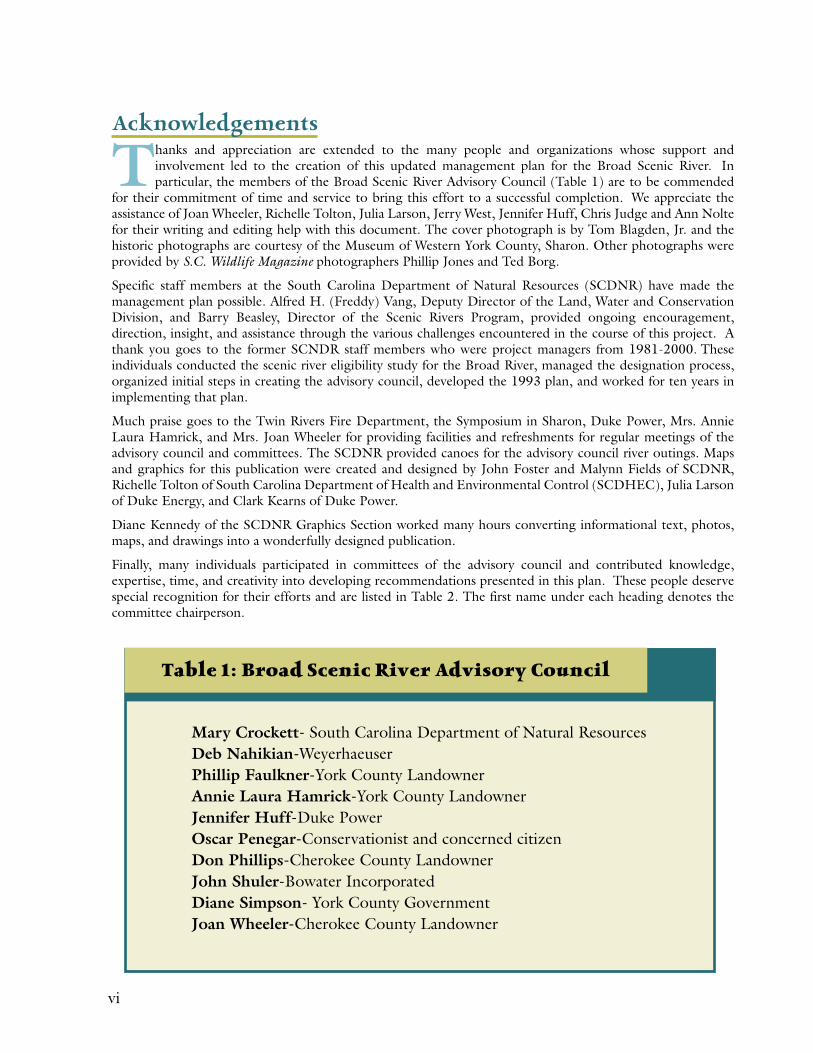
Thanks and appreciation are extended to the many people and organizations whose support and involvement led to the creation of this updated management plan for the Broad Scenic River. In particular, the members of the Broad Scenic River Advisory Council (Table 1) are to be commended
for their commitment of time and service to bring this effort to a successful completion. We appreciate the assistance of Joan Wheeler, Richelle Tolton, Julia Larson, Jerry West, Jennifer Huff, Chris Judge and Ann Nolte for their writing and editing help with this document. The cover photograph is by Tom Blagden, Jr. and the historic photographs are courtesy of the Museum of Western York County, Sharon. Other photographs were provided by S.C. Wildlife Magazine photographers Phillip Jones and Ted Borg.
Specific staff members at the South Carolina Department of Natural Resources (SCDNR) have made the management plan possible. Alfred H. (Freddy) Vang, Deputy Director of the Land, Water and Conservation Division, and Barry Beasley, Director of the Scenic Rivers Program, provided ongoing encouragement, direction, insight, and assistance through the various challenges encountered in the course of this project. A thank you goes to the former SCNDR staff members who were project managers from 1981-2000. These individuals conducted the scenic river eligibility study for the Broad River, managed the designation process, organized initial steps in creating the advisory council, developed the 1993 plan, and worked for ten years in implementing that plan.
Much praise goes to the Twin Rivers Fire Department, the Symposium in Sharon, Duke Power, Mrs. Annie Laura Hamrick, and Mrs. Joan Wheeler for providing facilities and refreshments for regular meetings of the advisory council and committees. The SCDNR provided canoes for the advisory council river outings. Maps and graphics for this publication were created and designed by John Foster and Malynn Fields of SCDNR, Richelle Tolton of South Carolina Department of Health and Environmental Control (SCDHEC), Julia Larson of Duke Energy, and Clark Kearns of Duke Power.
Diane Kennedy of the SCDNR Graphics Section worked many hours converting informational text, photos, maps, and drawings into a wonderfully designed publication.
Finally, many individuals participated in committees of the advisory council and contributed knowledge, expertise, time, and creativity into developing recommendations presented in this plan. These people deserve special recognition for their efforts and are listed in Table 2. The first name under each heading denotes the committee chairperson.
Table 1: Broad Scenic River Advisory Council
Mary Crockett- South Carolina Department of Natural ResourcesDeb Nahikian-WeyerhaeuserPhillip Faulkner-York County LandownerAnnie Laura Hamrick-York County LandownerJennifer Huff-Duke PowerOscar Penegar-Conservationist and concerned citizenDon Phillips-Cherokee County LandownerJohn Shuler-Bowater IncorporatedDiane Simpson- York County GovernmentJoan Wheeler-Cherokee County Landowner

vi vii
Table 2: Broad Scenic River Committee Members
NATURAL RESOURCES• Jennifer Huff, Duke Power• Jason Bettinger, South Carolina Department of Natural Resources• Dick Christie, South Carolina Department of Natural Resources • Todd Huntley, FM Outfitters Unlimited• Oscar Penegar, Concerned Citizen and Conservationist • Ric Rhyne, FM Outfitters Unlimited• Robert Stroud, South Carolina Department of Natural Resources
LAND USE• Julia Larson, Duke Energy• Phil Cooley, Cooley and Associates, LLC Resource Consultants • Phillip Faulkner, Broad River Landowner• John Shuler, Bowater Incorporated
WATER QUALITY• Richelle Tolton, South Carolina Department of Health and Environmental Control• David Hughes, York County Public Works• Elmer Huskey, Cherokee County Public Works• Chuck Zimmerman, Duke Engineering & Services
RECREATIONAL USE AND ACCESS• Jeff Tallman, Paddler• Randy Horton, Duke Power• Don Phillips, Cherokee County Landowner• Diane Simpson, York County Government• Eddie Wilson, Recreation Enthusiast
HISTORIC AND CULTURAL RESOURCES • Annie Laura Hamrick, Broad River Landowner• John Hiott, Hiott Forestry Consultants, Incorporated• Dean Ross, Cherokee County Historic Society• Jerry West, York County Historian
LAW ENFORCEMENT• Mary Crockett, South Carolina Department of Natural Resources• Bobby Duncan, Gaffney Police Department• Steve Morrow, South Carolina Department of Natural Resources Law Enforcement• Mike Reeves, South Carolina Department of Natural Resources Law Enforcement
EDUCATION/STEWARDSHIP AND COMMUNITY INVOLVEMENT• Joan Wheeler, Cherokee County Landowner• Mary Crockett, South Carolina Department of Natural Resources• Bobby Duncan, Overmountain Victory Trail Association
viii ix
Introduction
The Broad River begins its journey along the eastern slope of the Blue Ridge Mountains near Hickory Nut Gap, North Carolina. The river flows in a southeastern direction for 166 miles to its junction with the Saluda River to form the Congaree River near Columbia, South Carolina. Along its course,
the Broad has been tapped for the production of electricity by the construction of at least six hydroelectric stations in South Carolina. One of these dams, the Ninety-Nine Islands Hydroelectric Station, is located at the beginning of the Broad Scenic River segment. This dam, constructed in 1910, impounds a 388-acre reservoir and is operated as a run-of-river facility for power production.
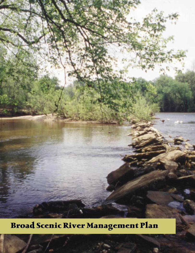
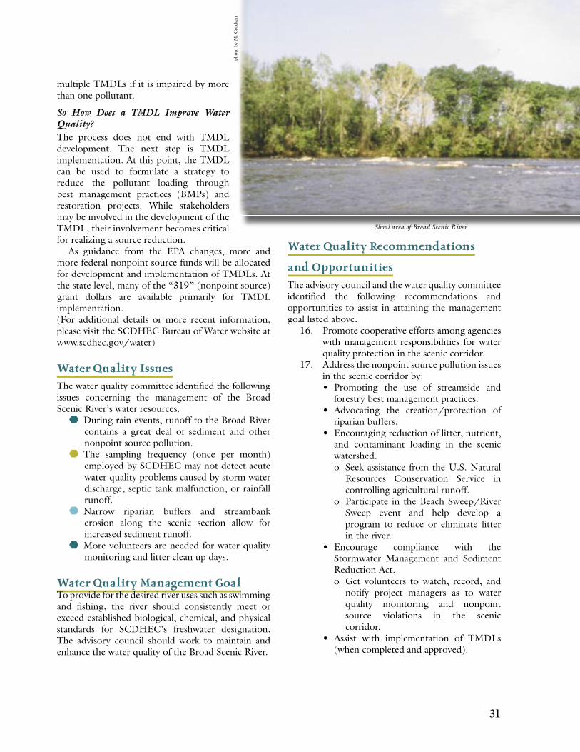
Below the Ninety-Nine Islands Hydroelectric Station, the Broad Scenic River flows through the Piedmont region of South Carolina forming a portion of the boundary between Cherokee and York Counties. The designated 15.3-mile scenic stretch of river is navigable and consists of a sandy bottom interspersed with rock outcrops and shoals. Land surrounding the river is devoted to traditional rural uses such as raising livestock, hunting, and managing timber. The terminus of the scenic section is recognized as the place where the Pacolet River enters the Broad River. Just downstream from the confluence of these rivers is the picturesque and historic town of Lockhart overlooking the Lockhart Hydroelectric Station, the Lockhart Canal, and the Broad River.
Rivers and communities are dynamic; thus, this current Broad Scenic River Management Plan is a community-based update to the existing, but out of print, 1993 Broad Scenic River Management Plan (1993 plan). In part, the Broad Scenic River has been protected in the past by its isolation from development and use pressures due to lack of road access and distance from major metropolitan areas. However, as the Interstate-85 corridor and the cities of Charlotte, Spartanburg, York, and Gaffney expand, the Broad Scenic River corridor has seen increasing recreational activities such as picnicking, hiking, hunting, fishing, and boating, as well as increasing residential development pressures. This community-based, voluntarily implemented, land and water management stewardship plan will help to conserve the Broad Scenic River’s fragile natural resources for future generations.
viii ix
Project History
In the summer of 1989 the threat of a dam, resulting in a 22,000-acre lake, caused many landowners and concerned citizens from York, Union, Cherokee, and Spartanburg Counties to form the Broad River Basin Coalition.
The purpose of this group was to convince the legislators and county officials that this project would create undue hardships for many people. Highways, utilities, farming activities, cemeteries, and historic areas would all be adversely affected. The dam was deemed not feasible so the Broad River Landowners Coalition requested that the South Carolina Water Resources Commission (Commission)* conduct an investigation to determine if a portion of the Broad River along the border of Cherokee and York Counties would be eligible for inclusion into the State Scenic Rivers Program.
An eligibility study of the proposed section was completed in October of 1990. The study’s major components included an assessment of the natural, scenic, and cultural resources of the river along with an evaluation of landowner and community support. As part of the eligibility process, both the Cherokee and the York County Councils approved the proposed designation. The study recommended that the Broad River from the Ninety-Nine Islands Dam to the confluence of the Pacolet River be designated as a Type-II State Scenic River. The classification as a Type-I, II or III depends on the level of development in the river corridor. The Broad River received the Type-II classification because activities such as recreation, raising livestock, and timber management are common on Type-II Rivers.
The next step in the process was to gain the approval of the South Carolina General Assembly. On May 31, 1991, Governor Carroll Campbell signed the Broad Scenic River Bill, which officially designated the 15.3-mile stretch of the Broad River as a state scenic river. After designation, the Executive Director of the Commission appointed the Broad’s advisory council. The advisory council, chaired by a Commission (now SCDNR) staff person, is composed of ten voting members, many of whom were, and continue to be, riparian landowners. In August 1993, the first Broad Scenic River Management Plan (1993 plan) was published, providing a vision for the conservation and enhancement of this scenic river corridor. The 1993 plans focus included development of recreational access, voluntary use of stream best management practices, a habitat survey of the scenic corridor, a historic sites inventory, and study and encouragement of an effective law enforcement presence. Over the last ten years, the advisory council has worked diligently to fulfill the recommendations presented in the 1993 plan and to address other issues and opportunities as they arose involving the river corridor.
In 2000, the advisory council determined that updating and developing a new management plan was necessary based on recent issues, opportunities, and development pressures. At this point, the ten-member advisory council was augmented to include ex-officio and committee members, who were asked to serve by virtue of technical expertise or by a position held in the surrounding river community. These additional members represent local and state government, business interests, environmental interests, river users, recreational interests, and landowner interests. This larger advisory committee met monthly for approximately two years at locations throughout the project area. Their focus was to analyze and define the current river corridor based on identified issues and opportunities and to propose a recommended course of action for dealing with each of the issues and opportunities. Field trips within the corridor and canoeing trips on the Broad River allowed advisory council and committee members to note current land uses, evaluate public access, and observe wildlife. The outcome of this process is the management plan you now hold in your hands. This plan outlines the community’s vision for the Broad Scenic River. The plan’s recommendations will be implemented both in a voluntary, non-regulatory framework and within the regulatory framework provided by York and Cherokee Counties. Implementation will depend on decisions reached and actions taken by local and state governments, corporations, environmental organizations, river users, residents of the Broad River Watershed, and, most importantly, the riparian landowners. The property owners within the Broad Scenic River Watershed are the REAL managers of this resource. The advisory council, supported by South Carolina’s natural resource agencies, will provide information and resource guidance in the decision-making process with each of the above-named groups.
It is hoped that implementing the management plan will continue to unite the Broad River community in an effort to keep the river a viable, valuable, and rural natural resource for the enjoyment of present and future generations.
*On July 1, 1994, the South Carolina Water Resources Commission, the Land Resources Conservation Commission, the S.C. Geological Survey, and the South Carolina Wildlife and Marine Resources Department combined to form the South Carolina Department of Natural Resources.
x 1
Broad Scenic River Management Plan
x 1
Broad Scenic River Management Plan
It is appropriate that we give credit to the legacy of past generations and a thank you to the present generation of riparian landowners for their stewardship and conservation efforts on behalf of the Broad Scenic River corridor. This section of the river is rich in natural and
pastoral beauty with historic treasures interspersed along its banks. Several factors that currently threaten to spoil the special character of this rural and significant natural resource include: urban sprawl, reckless boating practices, nonpoint source pollution, and agricultural or forestry practices that do not follow best management guidelines. This management plan offers ideas and suggestions to support ongoing and new stewardship efforts for the conservation of the Broad Scenic River corridor.
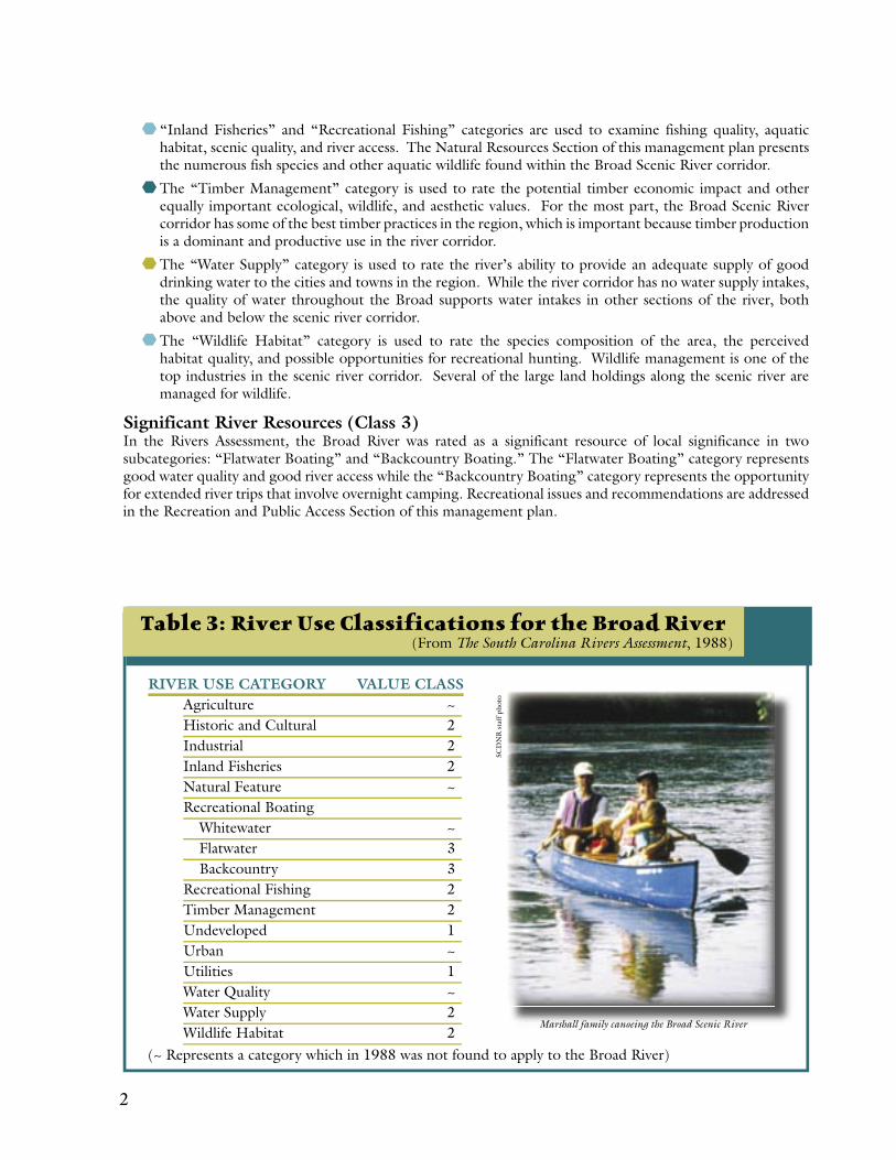
South Carolina Rivers Assessment FindingsAn important source of information for understanding the rivers of South Carolina is The South Carolina Rivers Assessment (Rivers Assessment), prepared by the S.C. Water Resources Commission in 1988. The Rivers Assessment provides an analysis of each river in South Carolina as it relates to river uses and was designed to aid in planning and decision making for the rivers of South Carolina. It provides some of the best available comparative information about South Carolina’s river resources. Over 70 individuals with expertise in evaluation of the state’s rivers developed the Rivers Assessment. Using river data, personal knowledge, and professional opinion, the experts formed 16 sub-committees and evaluated over 1,400 rivers and river segments, classifying the rivers according to their significance within 16 different identified resource categories. The results of the resource categories that were assigned to the Broad River are presented in Table 3.
Superior River Resources (Class 1)The Rivers Assessment rates the Broad River as a superior resource of statewide or greater significance for two categories: “Undeveloped” and “Utility.” The “Undeveloped” river category represents the natural character and occurrence of man-made structures along the scenic river corridor. The perceived scenic and natural qualities of the river are also considered. The Broad River had a Class 1 ranking because there were a very small number of structures visible from the water. The “Utility” category represents the ability of the river to be used as a source of energy. The Broad River has a Class 1 “Utility” ranking because the Ninety-Nine Islands Hydroelectric Station is located at the northern end of the scenic river corridor and the Lockhart Hydroelectric Station is located a few miles below the southern end of the scenic corridor. Both hydroelectric stations provide power for the region.
Outstanding River Resources (Class 2)The Rivers Assessment rates the Broad River as an outstanding river of regional significance in seven categories: 1) Historic and Cultural, 2) Industrial, 3) Inland Fisheries, 4) Recreational Fishing, 5) Timber Management, 6) Water Supply, and 7) Wildlife Habitat.
The “Historic and Cultural” category represents the known historically significant sites associated with the river. Several of the sites associated with the Broad are discussed in the Cultural and Historic Chapter of this plan.
The “Industrial” category is based on a river’s assimilative capacity for wastewater. There are currently no wastewater dischargers on this section of the Broad River. Based on the shallow waters and the distance of communities with the need for wastewater treatment facilities, no wastewater facilities are anticipated on this section of the Broad River.
2 3
“Inland Fisheries” and “Recreational Fishing” categories are used to examine fishing quality, aquatic habitat, scenic quality, and river access. The Natural Resources Section of this management plan presents the numerous fish species and other aquatic wildlife found within the Broad Scenic River corridor.
The “Timber Management” category is used to rate the potential timber economic impact and other equally important ecological, wildlife, and aesthetic values. For the most part, the Broad Scenic River corridor has some of the best timber practices in the region, which is important because timber production is a dominant and productive use in the river corridor.
The “Water Supply” category is used to rate the river’s ability to provide an adequate supply of good drinking water to the cities and towns in the region. While the river corridor has no water supply intakes, the quality of water throughout the Broad supports water intakes in other sections of the river, both above and below the scenic river corridor.
The “Wildlife Habitat” category is used to rate the species composition of the area, the perceived habitat quality, and possible opportunities for recreational hunting. Wildlife management is one of the top industries in the scenic river corridor. Several of the large land holdings along the scenic river are managed for wildlife.
Significant River Resources (Class 3)In the Rivers Assessment, the Broad River was rated as a significant resource of local significance in two subcategories: “Flatwater Boating” and “Backcountry Boating.” The “Flatwater Boating” category represents good water quality and good river access while the “Backcountry Boating” category represents the opportunity for extended river trips that involve overnight camping. Recreational issues and recommendations are addressed in the Recreation and Public Access Section of this management plan.
Table 3: River Use Classifications for the Broad River(From The South Carolina Rivers Assessment, 1988)
RIVER USE CATEGORY VALUE CLASSAgriculture ~Historic and Cultural 2Industrial 2Inland Fisheries 2Natural Feature ~Recreational Boating
Whitewater ~Flatwater 3Backcountry 3
Recreational Fishing 2Timber Management 2Undeveloped 1Urban ~Utilities 1Water Quality ~Water Supply 2Wildlife Habitat 2
(~ Represents a category which in 1988 was not found to apply to the Broad River)
SCD
NR
sta
ff p
hoto
Marshall family canoeing the Broad Scenic River
2 3
Figure 1: Broad Scenic River Map
5
Land Management
5
Overview of Land Management /Physical Description
Rivers have drawn humans to their shorelines and waters since man first walked the Earth. Over the centuries, rivers have provided a transportation network, irrigation for crops, water
for drinking and domestic chores such as cooking, washing clothes, and bathing, and, in more recent years, for recreation. Rivers support an abundance of life within their waters from fish, reptiles, and amphibians to numerous types of vegetation including grasses, reeds, and trees. Rivers can be wide and slow or narrow and swift. They occasionally drift gently through wetland areas.
A river’s character can often undergo dramatic changes both seasonally and daily. The flow will change from rapid during the rainy season to meandering during the dry season. The color and clarity of a river can vary significantly, especially here in the Southeast, depending upon the amount and type of silt, sand, and clay the river carries. After heavy rains, especially in the upper reaches of a watershed, a river will rise rapidly, tearing at and often overflowing its banks, moving anything in its path downstream. Rivers are in a constant state of change: eroding banks, building islands, and cutting new paths through soil and rock.
The Broad River is no exception. Over the centuries as the river has cut its path, people have taken advantage of its resources in many ways: by drinking and fishing its waters; by traveling its waters; by irrigating crops; by raising livestock; by living along its shores; and by harnessing its power.
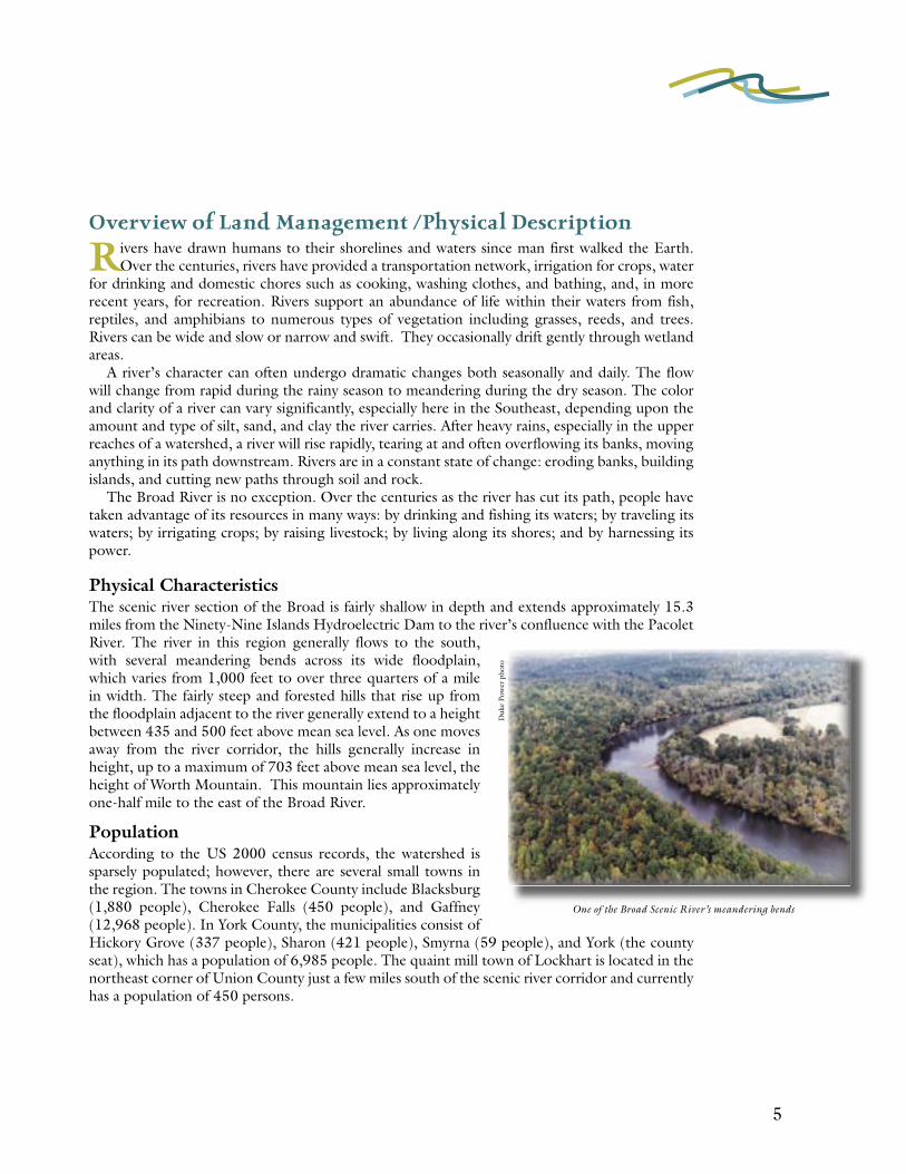
Physical CharacteristicsThe scenic river section of the Broad is fairly shallow in depth and extends approximately 15.3 miles from the Ninety-Nine Islands Hydroelectric Dam to the river’s confluence with the Pacolet River. The river in this region generally flows to the south, with several meandering bends across its wide floodplain, which varies from 1,000 feet to over three quarters of a mile in width. The fairly steep and forested hills that rise up from the floodplain adjacent to the river generally extend to a height between 435 and 500 feet above mean sea level. As one moves away from the river corridor, the hills generally increase in height, up to a maximum of 703 feet above mean sea level, the height of Worth Mountain. This mountain lies approximately one-half mile to the east of the Broad River.
PopulationAccording to the US 2000 census records, the watershed is sparsely populated; however, there are several small towns in the region. The towns in Cherokee County include Blacksburg (1,880 people), Cherokee Falls (450 people), and Gaffney (12,968 people). In York County, the municipalities consist of Hickory Grove (337 people), Sharon (421 people), Smyrna (59 people), and York (the county seat), which has a population of 6,985 people. The quaint mill town of Lockhart is located in the northeast corner of Union County just a few miles south of the scenic river corridor and currently has a population of 450 persons.
Duk
e Po
wer
pho
to
One of the Broad Scenic River’s meandering bends
6 7
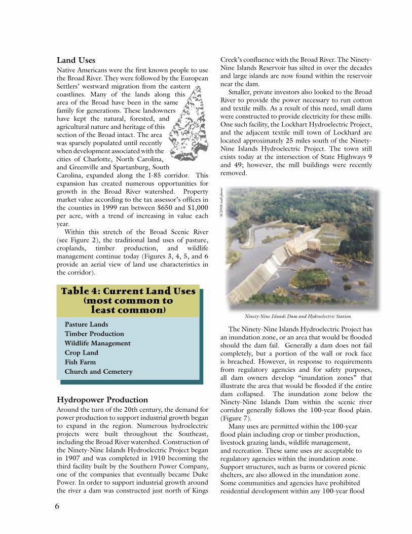
Creek’s confluence with the Broad River. The Ninety-Nine Islands Reservoir has silted in over the decades and large islands are now found within the reservoir near the dam.
Smaller, private investors also looked to the Broad River to provide the power necessary to run cotton and textile mills. As a result of this need, small dams were constructed to provide electricity for these mills. One such facility, the Lockhart Hydroelectric Project, and the adjacent textile mill town of Lockhard are located approximately 25 miles south of the Ninety-Nine Islands Hydroelectric Project. The town still exists today at the intersection of State Highways 9 and 49; however, the mill buildings were recently removed.
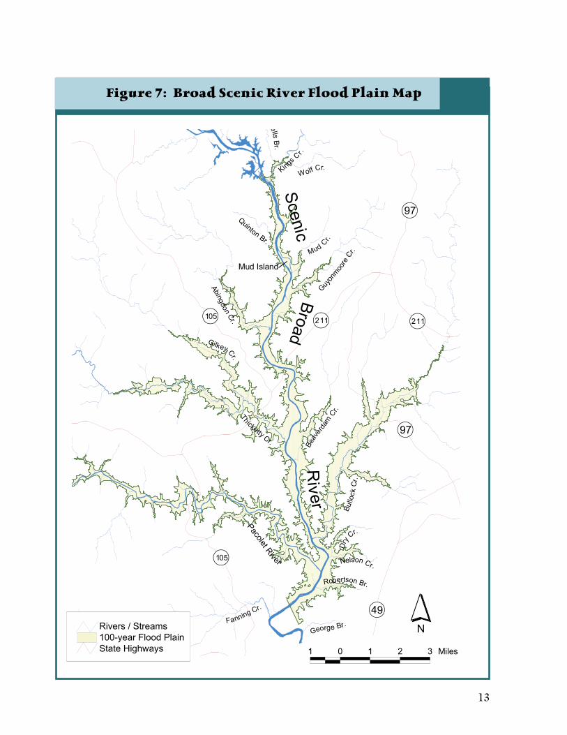
The Ninety-Nine Islands Hydroelectric Project has an inundation zone, or an area that would be flooded should the dam fail. Generally a dam does not fail completely, but a portion of the wall or rock face is breached. However, in response to requirements from regulatory agencies and for safety purposes, all dam owners develop “inundation zones” that illustrate the area that would be flooded if the entire dam collapsed. The inundation zone below the Ninety-Nine Islands Dam within the scenic river corridor generally follows the 100-year flood plain. (Figure 7).
Many uses are permitted within the 100-year flood plain including crop or timber production, livestock grazing lands, wildlife management, and recreation. These same uses are acceptable to regulatory agencies within the inundation zone. Support structures, such as barns or covered picnic shelters, are also allowed in the inundation zone. Some communities and agencies have prohibited residential development within any 100-year flood
Land UsesNative Americans were the first known people to use the Broad River. They were followed by the European Settlers’ westward migration from the eastern coastlines. Many of the lands along this area of the Broad have been in the same family for generations. These landowners have kept the natural, forested, and agricultural nature and heritage of this section of the Broad intact. The area was sparsely populated until recently when development associated with the cities of Charlotte, North Carolina, and Greenville and Spartanburg, South Carolina, expanded along the I-85 corridor. This expansion has created numerous opportunities for growth in the Broad River watershed. Property market value according to the tax assessor’s offices in the counties in 1999 ran between $650 and $1,000 per acre, with a trend of increasing in value each year.
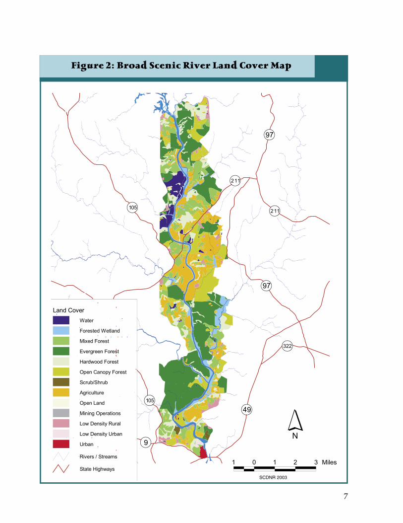
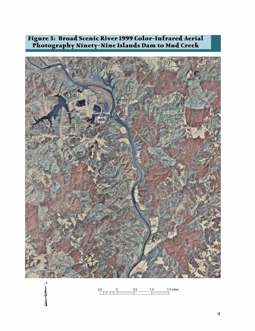
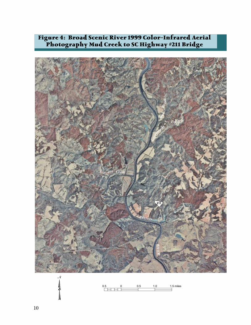
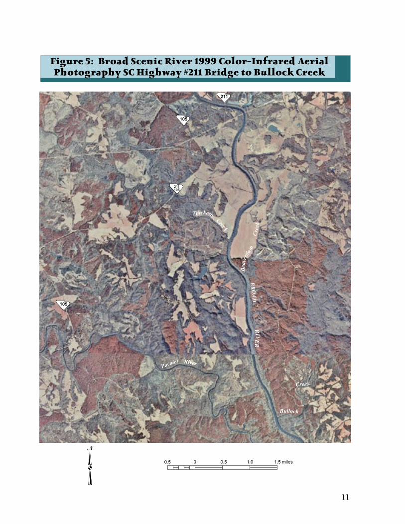
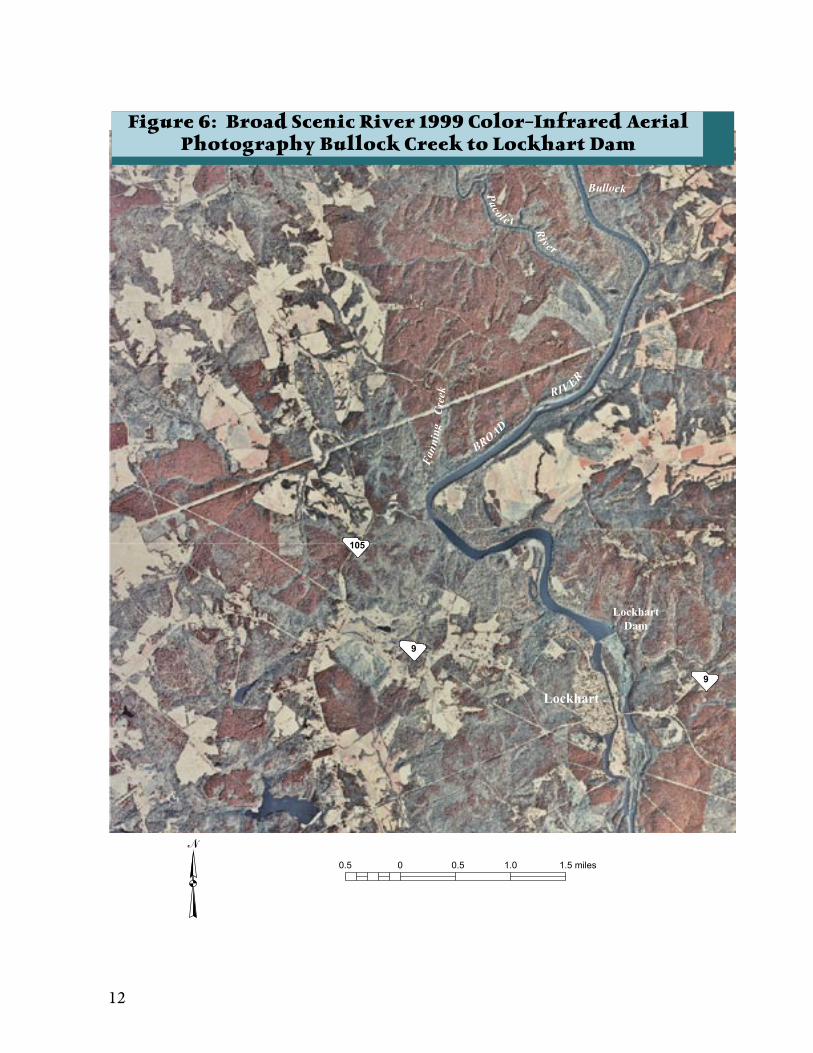
Within this stretch of the Broad Scenic River (see Figure 2), the traditional land uses of pasture, croplands, timber production, and wildlife management continue today (Figures 3, 4, 5, and 6 provide an aerial view of land use characteristics in the corridor).
Table 4: Current Land Uses (most common to
least common) Pasture LandsTimber ProductionWildlife ManagementCrop LandFish Farm Church and Cemetery
Hydropower ProductionAround the turn of the 20th century, the demand for power production to support industrial growth began to expand in the region. Numerous hydroelectric projects were built throughout the Southeast, including the Broad River watershed. Construction of the Ninety-Nine Islands Hydroelectric Project began in 1907 and was completed in 1910 becoming the third facility built by the Southern Power Company, one of the companies that eventually became Duke Power. In order to support industrial growth around the river a dam was constructed just north of Kings
Ninety-Nine Islands Dam and Hydroelectric Station
SCD
NR
sta
ff p
hoto
6 7
Figure 2: Broad Scenic River Land Cover Map

8 9
plain or inundation zone due to the potential for loss of life in any flood situation.
Land Management Issues
The land use committee identified the following issues pertaining to the Broad Scenic River corridor.
Concern that the growth of Charlotte, North Carolina, and Rock Hill, Gaffney, York, and Blacksburg, South Carolina, along with the I-85 corridor, and a proposed state highway near the Broad Scenic River will change the rural characteristics of the scenic river corridor. Concern that the traditional primary land uses of agriculture, timber, and wildlife management within the river corridor will disappear over time. Concern that the development of the Worth Mountain York County property, which lies within the scenic river corridor, will change the natural and aesthetic aspects of that large parcel.
Land Management Goal
To protect, maintain, and enhance the rural character of the region, both within the Broad Scenic River corridor and along its tributaries.
Land Management Recommendations and Opportunities
The land use committee developed and the advisory council approved several recommendations that are detailed below.
1. Encourage, promote, and conduct land stewardship and conservation easement workshops that inform the property owners of alternative land use planning opportunities, illustrate good design, and identify financial incentives for alternatives. (See Appendix C for
information on conservation easements.)2. Support comprehensive plans developed at
the state, regional, county, or local level that address options that preserve existing land uses and maintain or enhance the natural resources within the scenic river corridor and region by limiting residential growth options.
3. Support the use of conservation easements and land trusts within the river corridor to protect scenic, natural, and cultural resources.
4. Encourage landowners to maintain a riparian buffer zone of natural vegetation adjacent to the river that is 50 feet or more wide. Seek funding or find programs that provide incentives for improving or planting vegetative buffers along the river. (See Glossary for buffer zone definitions.)
5. Encourage landowners to landscape, re-vegetate, and restore areas of the riparian zone with native vegetation.
6. Residential Development recommendations:• Recommend that residential developments
are limited to areas outside of the 100-year flood zone.
• New developments in the corridor above the 100-year flood zone should implement the following:i. Homes should be designed so that
buildings will have minimal visual impact on surrounding lands. Height limitations should be placed on structures.
ii. Homes should be constructed of natural materials. Home color and roofing material should blend with the surrounding land cover.
• If property is developed as a subdivision, that development should hold a riparian zone in common to maintain a scenic vista from the water and provide habitat for wildlife.
7. The following should apply to development of the Worth Mountain York County property located within the scenic river corridor:• The advisory council recommends that a
representative of the Broad Scenic River Advisory Council be invited to all planning meetings concerning the property.
•The advisory council would like to see limited impervious surface development and more nature-based development with controlled entrances.
View of Worth Mountain Park.
SCD
NR
sta
ff p
hoto
8 9
Figure 3: Broad Scenic River 1999 Color-Infrared AerialPhotography Ninety-Nine Islands Dam to Mud Creek
10 11
Figure 4: Broad Scenic River 1999 Color-Infrared AerialPhotography Mud Creek to SC Highway #211 Bridge
10 11
Figure 5: Broad Scenic River 1999 Color-Infrared AerialPhotography SC Highway #211 Bridge to Bullock Creek
12 13
Figure 6: Broad Scenic River 1999 Color-Infrared AerialPhotography Bullock Creek to Lockhart Dam
12 13
Figure 7: Broad Scenic River Flood Plain Map
14 15
Natural Resources
14 15
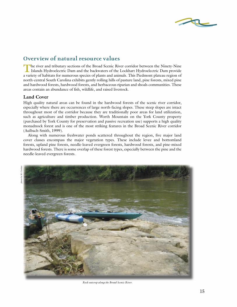
Overview of natural resource values
The river and tributary sections of the Broad Scenic River corridor between the Ninety-Nine Islands Hydroelectric Dam and the backwaters of the Lockhart Hydroelectric Dam provide
a variety of habitats for numerous species of plants and animals. This Piedmont plateau region of north-central South Carolina exhibits gently rolling hills of pasture land, pine forests, mixed pine and hardwood forests, hardwood forests, and herbaceous riparian and shoals communities. These areas contain an abundance of fish, wildlife, and raised livestock.
Land CoverHigh quality natural areas can be found in the hardwood forests of the scenic river corridor, especially where there are occurrences of large north-facing slopes. These steep slopes are intact throughout most of the corridor because they are traditionally poor areas for land utilization, such as agriculture and timber production. Worth Mountain on the York County property (purchased by York County for preservation and passive recreation use) supports a high quality monadnock forest and is one of the most striking features in the Broad Scenic River corridor (Aulbach-Smith, 1999).
Along with numerous freshwater ponds scattered throughout the region, five major land cover classes encompass the major vegetation types. These include levee and bottomland forests, upland pine forests, needle-leaved evergreen forests, hardwood forests, and pine-mixed hardwood forests. There is some overlap of these forest types, especially between the pine and the needle-leaved evergreen forests.
phot
o by
M. C
rock
et
Rock outcrop along the Broad Scenic River.
16 17
Tab
le 5
: Tre
e Sp
ecie
s fo
un
d i
n t
he
Bro
ad S
cen
ic R
iver
Co
rrid
or
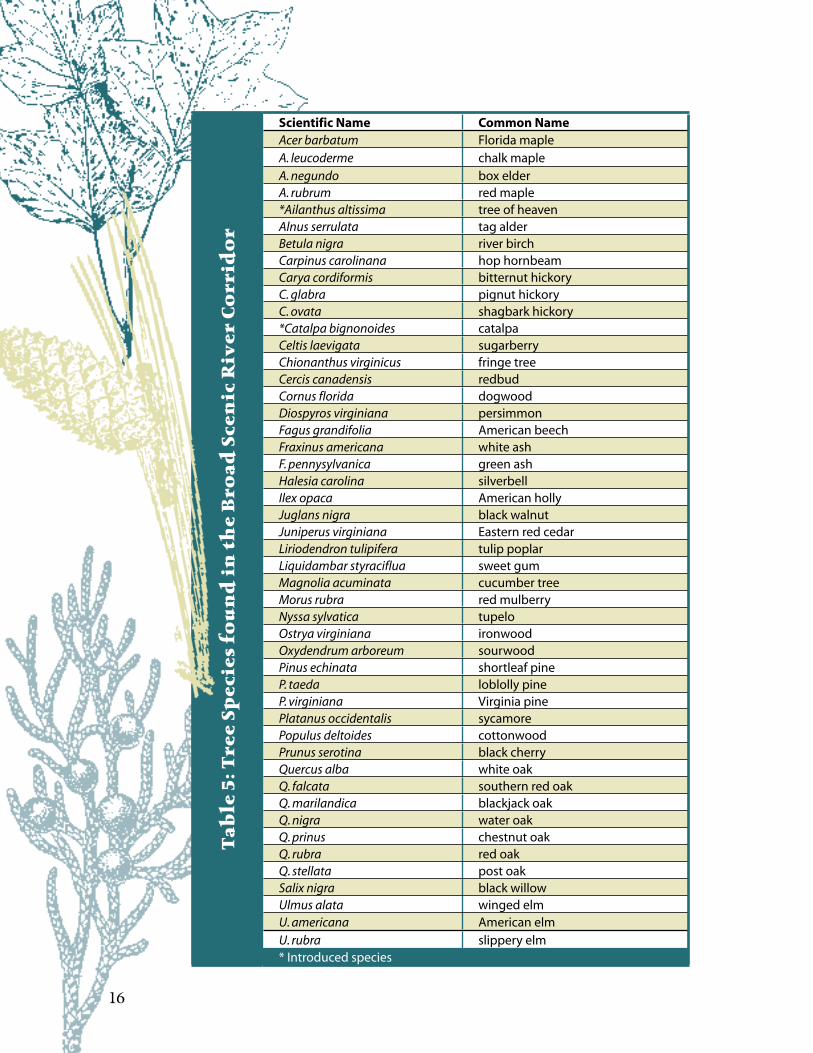
Scientific Name Common NameAcer barbatum Florida mapleA. leucoderme chalk mapleA. negundo box elderA. rubrum red maple*Ailanthus altissima tree of heavenAlnus serrulata tag alderBetula nigra river birchCarpinus carolinana hop hornbeamCarya cordiformis bitternut hickoryC. glabra pignut hickoryC. ovata shagbark hickory*Catalpa bignonoides catalpaCeltis laevigata sugarberryChionanthus virginicus fringe treeCercis canadensis redbudCornus florida dogwoodDiospyros virginiana persimmonFagus grandifolia American beechFraxinus americana white ashF. pennysylvanica green ashHalesia carolina silverbellIlex opaca American hollyJuglans nigra black walnutJuniperus virginiana Eastern red cedarLiriodendron tulipifera tulip poplarLiquidambar styraciflua sweet gumMagnolia acuminata cucumber treeMorus rubra red mulberryNyssa sylvatica tupeloOstrya virginiana ironwoodOxydendrum arboreum sourwoodPinus echinata shortleaf pineP. taeda loblolly pineP. virginiana Virginia pinePlatanus occidentalis sycamorePopulus deltoides cottonwoodPrunus serotina black cherryQuercus alba white oakQ. falcata southern red oakQ. marilandica blackjack oakQ. nigra water oakQ. prinus chestnut oakQ. rubra red oakQ. stellata post oakSalix nigra black willowUlmus alata winged elmU. americana American elmU. rubra slippery elm* Introduced species

16 17
Levee and Bottomland ForestsThis classification consists primarily of riverfront forests, particularly those occurring in the floodplain and along the levees, in areas that are often flooded. The dominant vegetation in these areas includes river birch, sycamore, and sweetgum. In the flats and terraces along the river other species such as green ash, American elm, black walnut, and slippery elm can be found (Table 5).
Upland Pine Forests and Needle-leaved Evergreen Forests/WoodlandsThe pine-dominated forests located in the scenic river corridor include areas of successional forests as well as large tracts of planted loblolly pine. Successional forests have resulted primarily from re-vegetation in abandoned agricultural lands. These generally consist of loblolly pine, shortleaf pine, and Eastern red cedar. There is some overlap of the two forest types, as the needle-leaved evergreen class includes more of the mixed pine stands in addition to those containing red cedar. Most of the upland pine class is planted. The majority of these woodland areas are former pastures and agricultural fields or the result of past logging or clear-cutting.
Hardwood Forests and Pine-Mixed Hardwood ForestsDue to past and present land uses, most of the remaining hardwood forests are restricted to areas of steep slopes, especially north-facing slopes, and along small streams. One of the largest areas of hardwoods can be found on the York County property. American beech is the dominant cover type found in the hardwood forests of the north-facing slopes and small streams. Additional dominant cover species associated with the pine-mixed hardwood forests of the river are the white oak, loblolly pine, and hickories. Maples, sourwood, and other species occur in the subcanopy. The Eastern red cedar is also found in most of the pine-mixed hardwood areas of the Broad River.
Tab
le 6
: Sh
rub
Sp
ecie
s fo
un
d i
n t
he
Bro
ad S
cen
ic R
iver
Co
rrid
or
Scientific Name Common NameAesculus sylvatica dwarf painted buckeyeAmorpha sp. lead-plantArundinaria gigantea switchcaneAsimina triloba pawpawCalycanthus floridus sweetshrubCephalanthus occidentalis buttonbushCornus stricta swamp dogwoodHamamelis virginiana witchhazelIlex decidua var. longipes upland possumhawKalmia latifolia mountain laurelLeucothoe fontesiana dog-hobbleLindera benzoin spicebush or allspice*Ligustrum sinensis Chinese privetPhiladelphus inodoratus mock-orangeRhododendron minus Carolina laurelRosa palustris swamp roseSambucus canadensis elderberryStyrax americana least storaxVaccinium arboreum sparkleberryV. vacillans blueberry* Introduced species
Aesculus sylvatica
SC W
ildlif
e M
agaz
ine
phot
o
18 19
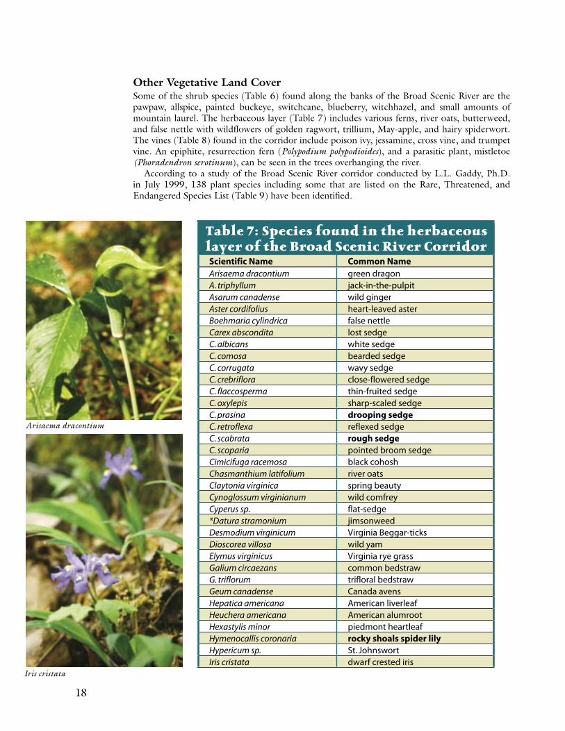
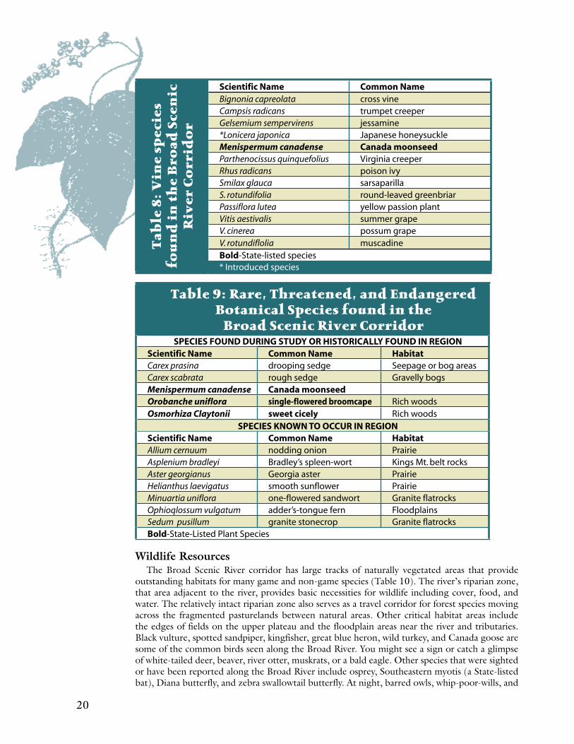
Other Vegetative Land CoverSome of the shrub species (Table 6) found along the banks of the Broad Scenic River are the pawpaw, allspice, painted buckeye, switchcane, blueberry, witchhazel, and small amounts of mountain laurel. The herbaceous layer (Table 7) includes various ferns, river oats, butterweed, and false nettle with wildflowers of golden ragwort, trillium, May-apple, and hairy spiderwort. The vines (Table 8) found in the corridor include poison ivy, jessamine, cross vine, and trumpet vine. An epiphite, resurrection fern (Polypodium polypodioides), and a parasitic plant, mistletoe (Phoradendron serotinum), can be seen in the trees overhanging the river.
According to a study of the Broad Scenic River corridor conducted by L.L. Gaddy, Ph.D. in July 1999, 138 plant species including some that are listed on the Rare, Threatened, and Endangered Species List (Table 9) have been identified.
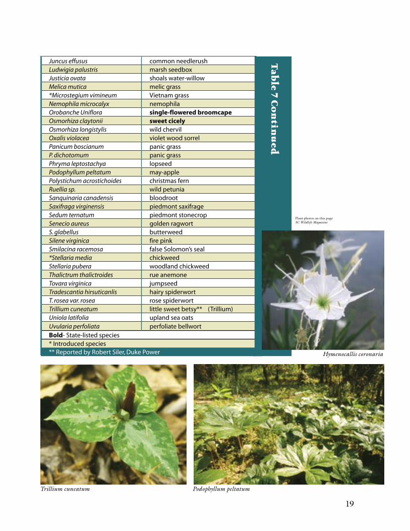
Table 7: Species found in the herbaceous layer of the Broad Scenic River CorridorScientific Name Common NameArisaema dracontium green dragonA. triphyllum jack-in-the-pulpitAsarum canadense wild gingerAster cordifolius heart-leaved asterBoehmaria cylindrica false nettleCarex abscondita lost sedgeC. albicans white sedgeC. comosa bearded sedgeC. corrugata wavy sedgeC. crebriflora close-flowered sedgeC. flaccosperma thin-fruited sedgeC. oxylepis sharp-scaled sedgeC. prasina drooping sedgeC. retroflexa reflexed sedgeC. scabrata rough sedgeC. scoparia pointed broom sedgeCimicifuga racemosa black cohoshChasmanthium latifolium river oatsClaytonia virginica spring beautyCynoglossum virginianum wild comfreyCyperus sp. flat-sedge*Datura stramonium jimsonweedDesmodium virginicum Virginia Beggar-ticksDioscorea villosa wild yamElymus virginicus Virginia rye grassGalium circaezans common bedstrawG. triflorum trifloral bedstrawGeum canadense Canada avensHepatica americana American liverleafHeuchera americana American alumrootHexastylis minor piedmont heartleafHymenocallis coronaria rocky shoals spider lilyHypericum sp. St. JohnswortIris cristata dwarf crested iris
Iris cristata
Arisaema dracontium
18 19
Juncus effusus common needlerushLudwigia palustris marsh seedboxJusticia ovata shoals water-willowMelica mutica melic grass*Microstegium vimineum Vietnam grassNemophila microcalyx nemophilaOrobanche Uniflora single-flowered broomcapeOsmorhiza claytonii sweet cicelyOsmorhiza longistylis wild chervilOxalis violacea violet wood sorrelPanicum boscianum panic grassP. dichotomum panic grassPhryma leptostachya lopseedPodophyllum peltatum may-applePolystichum acrostichoides christmas fernRuellia sp. wild petuniaSanquinaria canadensis bloodrootSaxifraga virginensis piedmont saxifrageSedum ternatum piedmont stonecropSenecio aureus golden ragwortS. glabellus butterweedSilene virginica fire pinkSmilacina racemosa false Solomon’s seal*Stellaria media chickweedStellaria pubera woodland chickweedThalictrum thalictroides rue anemoneTovara virginica jumpseedTradescantia hirsuticanlis hairy spiderwortT. rosea var. rosea rose spiderwortTrillium cuneatum little sweet betsy** (Trillium)Uniola latifolia upland sea oatsUvularia perfoliata perfoliate bellwortBold- State-listed species* Introduced species** Reported by Robert Siler, Duke Power Hymenocallis coronaria
Trillium cuneatum Podophyllum peltatum
Plant photos on this page SC Wildlife Magazine
Tab
le 7 Co
ntin
ued
20 21
Wildlife ResourcesThe Broad Scenic River corridor has large tracks of naturally vegetated areas that provide
outstanding habitats for many game and non-game species (Table 10). The river’s riparian zone, that area adjacent to the river, provides basic necessities for wildlife including cover, food, and water. The relatively intact riparian zone also serves as a travel corridor for forest species moving across the fragmented pasturelands between natural areas. Other critical habitat areas include the edges of fields on the upper plateau and the floodplain areas near the river and tributaries. Black vulture, spotted sandpiper, kingfisher, great blue heron, wild turkey, and Canada goose are some of the common birds seen along the Broad River. You might see a sign or catch a glimpse of white-tailed deer, beaver, river otter, muskrats, or a bald eagle. Other species that were sighted or have been reported along the Broad River include osprey, Southeastern myotis (a State-listed bat), Diana butterfly, and zebra swallowtail butterfly. At night, barred owls, whip-poor-wills, and
Tab
le 8
: Vin
e sp
ecie
s fo
un
d i
n t
he
Bro
ad S
cen
ic
Riv
er C
orr
ido
r
Scientific Name Common NameBignonia capreolata cross vineCampsis radicans trumpet creeperGelsemium sempervirens jessamine*Lonicera japonica Japanese honeysuckleMenispermum canadense Canada moonseedParthenocissus quinquefolius Virginia creeperRhus radicans poison ivySmilax glauca sarsaparillaS. rotundifolia round-leaved greenbriarPassiflora lutea yellow passion plantVitis aestivalis summer grapeV. cinerea possum grapeV. rotundiflolia muscadineBold-State-listed species* Introduced species
Table 9: Rare, Threatened, and Endangered Botanical Species found in the
Broad Scenic River CorridorSPECIES FOUND DURING STUDY OR HISTORICALLY FOUND IN REGION
Scientific Name Common Name HabitatCarex prasina drooping sedge Seepage or bog areasCarex scabrata rough sedge Gravelly bogsMenispermum canadense Canada moonseed Orobanche uniflora single-flowered broomcape Rich woodsOsmorhiza Claytonii sweet cicely Rich woods
SPECIES KNOWN TO OCCUR IN REGIONScientific Name Common Name HabitatAllium cernuum nodding onion PrairieAsplenium bradleyi Bradley’s spleen-wort Kings Mt. belt rocksAster georgianus Georgia aster PrairieHelianthus laevigatus smooth sunflower PrairieMinuartia uniflora one-flowered sandwort Granite flatrocksOphioqlossum vulgatum adder’s-tongue fern FloodplainsSedum pusillum granite stonecrop Granite flatrocksBold-State-Listed Plant Species

20 21
Tab
le 1
0: S
om
e o
f th
e w
ild
life
sp
ecie
s fo
un
d i
n t
he
Bro
ad S
cen
ic R
iver
Co
rrid
or
Scientific Name Common Name
Actitis macularia spotted sandpiper
Agkistrodon contortrix copperhead snake
Ambystoma maculatum spotted salamander
A. opacum marbled salamander
Ardea herodias great blue heron
Bonasa umbellus ruffed grouse
Branta Canadensis Canada goose
Bufo americanus American toad
Canis latrins coyotes
Caprimulgus carolinensis chuck-will’s widow
C. vociferus whip-poor-will
Castor canadensis beaver
Ceryle alcyon kingfisher
Colinus virginianus bobwhite quail
Coragyps atratus black vulture
Didelphis marsupialis opossum
Elaphe obsoleta common rat snake
Haliacetus leucocephalus bald eagle
Lutra Canadensis river otter
Lynx rufus bobcat
Marmota monax ground hog
Meleagris gallopavo wild turkey
Mephitus mephitus striped skunk
Myotis austroriparius southeastern myotis bat
Odatra zibethica muskrats
Odocoileus virginianus white-tailed deer
Pandion haliaetus osprey
Papilio Marcellus zebra swallowtail butterfly
Philohela minor woodcock
Procyon lotor raccoon
Rana catesbiana bullfrog
Sciurus carolinensis gray squirrel
Speyeria diana Diana butterfly
Spilogale putorius skunk
Strix varia barred owl
Sylvilagus floridanus rabbit
S. transitionalis rabbit
Tamiasciurus hudsonicus red squirrel
Urocyon cinereoargenteus gray fox
Vulpes vulpes red fox
Zenaida macroura mourning dove
Bold-State listed species
22 23
chuck-will’s widow can be heard along the river. Turtles, poisonous and nonpoisonous snakes, spotted and marbled salamanders, crickets, bullfrogs, and the American toad are also found in the scenic corridor. There is a need for continued research in this area.
FisheriesCritical elements of fisheries habitat include shoals, riffles, pools, undercut streambanks, downed trees, and shading provided by the forest canopy. Forested areas adjacent to streams and rivers are particularly important because they furnish cover and nutrients. Woody debris from forests
provides critical spawning and nursery areas for fish. The major nutrient input to the river is the autumn leaf fall, which provides food for macroinvertebrates; these
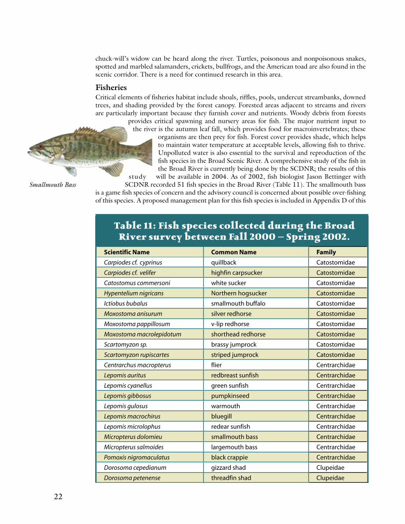
organisms are then prey for fish. Forest cover provides shade, which helps to maintain water temperature at acceptable levels, allowing fish to thrive. Unpolluted water is also essential to the survival and reproduction of the fish species in the Broad Scenic River. A comprehensive study of the fish in the Broad River is currently being done by the SCDNR; the results of this
study will be available in 2004. As of 2002, fish biologist Jason Bettinger with SCDNR recorded 51 fish species in the Broad River (Table 11). The smallmouth bass
is a game fish species of concern and the advisory council is concerned about possible over-fishing of this species. A proposed management plan for this fish species is included in Appendix D of this
Table 11: Fish species collected during the Broad River survey between Fall 2000 – Spring 2002.
Scientific Name Common Name Family
Carpiodes cf. cyprinus quillback Catostomidae
Carpiodes cf. velifer highfin carpsucker Catostomidae
Catostomus commersoni white sucker Catostomidae
Hypentelium nigricans Northern hogsucker Catostomidae
Ictiobus bubalus smallmouth buffalo Catostomidae
Moxostoma anisurum silver redhorse Catostomidae
Moxostoma pappillosum v-lip redhorse Catostomidae
Moxostoma macrolepidotum shorthead redhorse Catostomidae
Scartomyzon sp. brassy jumprock Catostomidae
Scartomyzon rupiscartes striped jumprock Catostomidae
Centrarchus macropterus flier Centrarchidae
Lepomis auritus redbreast sunfish Centrarchidae
Lepomis cyanellus green sunfish Centrarchidae
Lepomis gibbosus pumpkinseed Centrarchidae
Lepomis gulosus warmouth Centrarchidae
Lepomis macrochirus bluegill Centrarchidae
Lepomis microlophus redear sunfish Centrarchidae
Micropterus dolomieu smallmouth bass Centrarchidae
Micropterus salmoides largemouth bass Centrarchidae
Pomoxis nigromaculatus black crappie Centrarchidae
Dorosoma cepedianum gizzard shad Clupeidae
Dorosoma petenense threadfin shad Clupeidae
Smallmouth Bass
22 23
Clinostomus funduloides rosyside dace Cyprinidae
Ctenopharyngodon idella grass carp Cyprinidae
Cyprinella chloristia greenfin shiner Cyprinidae
Cyprinella nivea whitefin shiner Cyprinidae
Cyprinella pyrrhomelas fieryblack shiner Cyprinidae
Cyprinus carpio common carp Cyprinidae
Hybognathus regius Eastern silvery minnow Cyprinidae
Hybopsis labrosa thicklip chub Cyprinidae
Hybopsis zanema santee chub Cyprinidae
Nocomis leptocephalus bluehead chub Cyprinidae
Notemigonus crysoleucas golden shiner Cyprinidae
Notropis hudsonius spottail shiner Cyprinidae
Notropis lutipinnis yellowfin shiner Cyprinidae
Notropis scepticus sandbar shiner Cyprinidae
Ameiurus brunneus snail bullhead Ictaluridae
Ameiurus catus white catfish Ictaluridae
Ameiurus platycephalus flat bullhead Ictaluridae
Ictalurus punctatus channel catfish Ictaluridae
Noturus insignis margined madtom Ictaluridae
Lepisoteus osseus longnose gar Lepisosteidae
Morone Americana white perch Moronidae
Morone chrysops white bass Moronidae
Morone saxatilis x M. chrysops hybrid striped bass Moronidae
Etheostoma flabellare fantail darter Percidae
Etheostoma olmstedi tessellated darter Percidae
Etheostoma thalassinum seagreen darter Percidae
Perca flavescens yellow perch Percidae
Percina crassa piedmont darter Percidae
Gambusia holbrooki Eastern mosquito fish Poeciliidae
Tab
le 11 Co
ntin
ued
Table 12: Fish species reported by other investigators,but not collected during the Broad River survey.
Scientific Name Common Name Family
Campostoma anomalum Central stoneroller Cyprinidae
Notropis petersoni coastal shiner Cyprinidae
Pteronotropis hypselopterus sailfin shiner Cyprinidae
Esox masquinongy muskellunge Esocidae
Ameiurus melas black bullhead Ictaluridae
Noturus gyrinus tadpole madtom Ictaluridae
Noturus leptacanthus speckled madtom Ictaluridae
Etheostoma fusiforme swamp darter Percidae
24 25
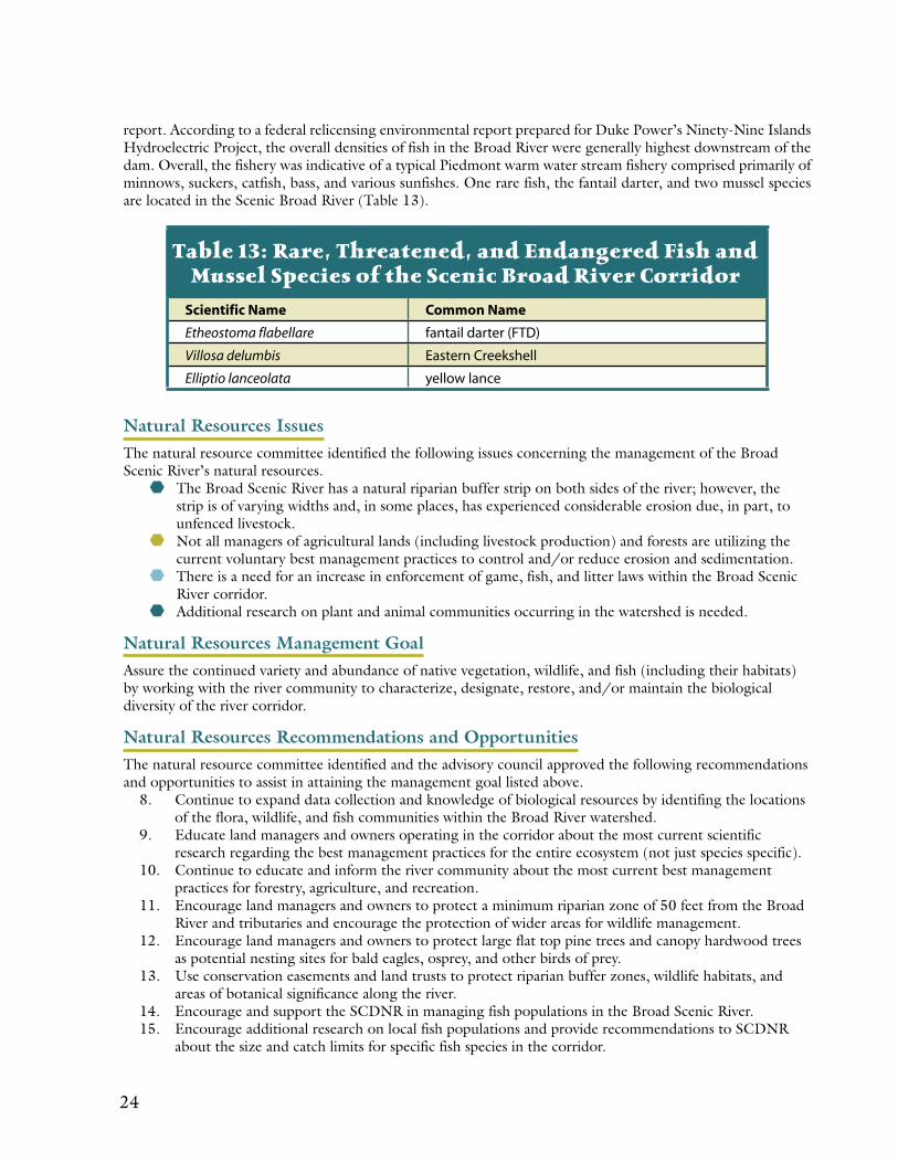
report. According to a federal relicensing environmental report prepared for Duke Power’s Ninety-Nine Islands Hydroelectric Project, the overall densities of fish in the Broad River were generally highest downstream of the dam. Overall, the fishery was indicative of a typical Piedmont warm water stream fishery comprised primarily of minnows, suckers, catfish, bass, and various sunfishes. One rare fish, the fantail darter, and two mussel species are located in the Scenic Broad River (Table 13).
Natural Resources IssuesThe natural resource committee identified the following issues concerning the management of the Broad Scenic River’s natural resources.
The Broad Scenic River has a natural riparian buffer strip on both sides of the river; however, the strip is of varying widths and, in some places, has experienced considerable erosion due, in part, to unfenced livestock.
Not all managers of agricultural lands (including livestock production) and forests are utilizing the current voluntary best management practices to control and/or reduce erosion and sedimentation.
There is a need for an increase in enforcement of game, fish, and litter laws within the Broad Scenic River corridor.
Additional research on plant and animal communities occurring in the watershed is needed.
Natural Resources Management GoalAssure the continued variety and abundance of native vegetation, wildlife, and fish (including their habitats) by working with the river community to characterize, designate, restore, and/or maintain the biological diversity of the river corridor.
Natural Resources Recommendations and OpportunitiesThe natural resource committee identified and the advisory council approved the following recommendations and opportunities to assist in attaining the management goal listed above.
8. Continue to expand data collection and knowledge of biological resources by identifing the locations of the flora, wildlife, and fish communities within the Broad River watershed.
9. Educate land managers and owners operating in the corridor about the most current scientific research regarding the best management practices for the entire ecosystem (not just species specific).
10. Continue to educate and inform the river community about the most current best management practices for forestry, agriculture, and recreation.
11. Encourage land managers and owners to protect a minimum riparian zone of 50 feet from the Broad River and tributaries and encourage the protection of wider areas for wildlife management.
12. Encourage land managers and owners to protect large flat top pine trees and canopy hardwood trees as potential nesting sites for bald eagles, osprey, and other birds of prey.
13. Use conservation easements and land trusts to protect riparian buffer zones, wildlife habitats, and areas of botanical significance along the river.
14. Encourage and support the SCDNR in managing fish populations in the Broad Scenic River. 15. Encourage additional research on local fish populations and provide recommendations to SCDNR
about the size and catch limits for specific fish species in the corridor.
Table 13: Rare, Threatened, and Endangered Fish and Mussel Species of the Scenic Broad River Corridor
Scientific Name Common Name
Etheostoma flabellare fantail darter (FTD)
Villosa delumbis Eastern Creekshell
Elliptio lanceolata yellow lance
24 25
Water Quality
26 27
Overview of Water Quality
The South Carolina Department of Health and Environmental Control (SCDHEC) initiated its first watershed planning activities as a result of a U.S. Environmental Protection Agency
(USEPA) grant in June of 1972. These activities were soon extended by Section 303(e), “Federal Water Pollution Control Act Amendments of 1972,” U.S. Public Law 92-500. In 1975, the SCDHEC published watershed-planning reports for the four major basins in South Carolina. The next major planning activity resulted from Section 208 of the Federal Water Pollution Control Act, which required states to prepare planning documents on an areawide basis. Areawide plans were completed in the late 1970’s for the five designated areas of the State and for the nondesignated remainder of the State. To date, these plans or their updated versions have served as information sources and guides for water quality management.
In the past twenty years, special water quality initiatives and Congressional mandates have diverted attention and resources from comprehensive water quality assessment and protection. SCDHEC’s Bureau of Water now emphasizes watershed planning to better coordinate river basin planning and water quality management. Watershed-based management allows SCDHEC to address Congressional and legislative mandates in a coordinated manner and to better utilize current resources. The watershed approach also improves communication between SCDHEC, the regulated community, and the public on existing and future water quality issues.
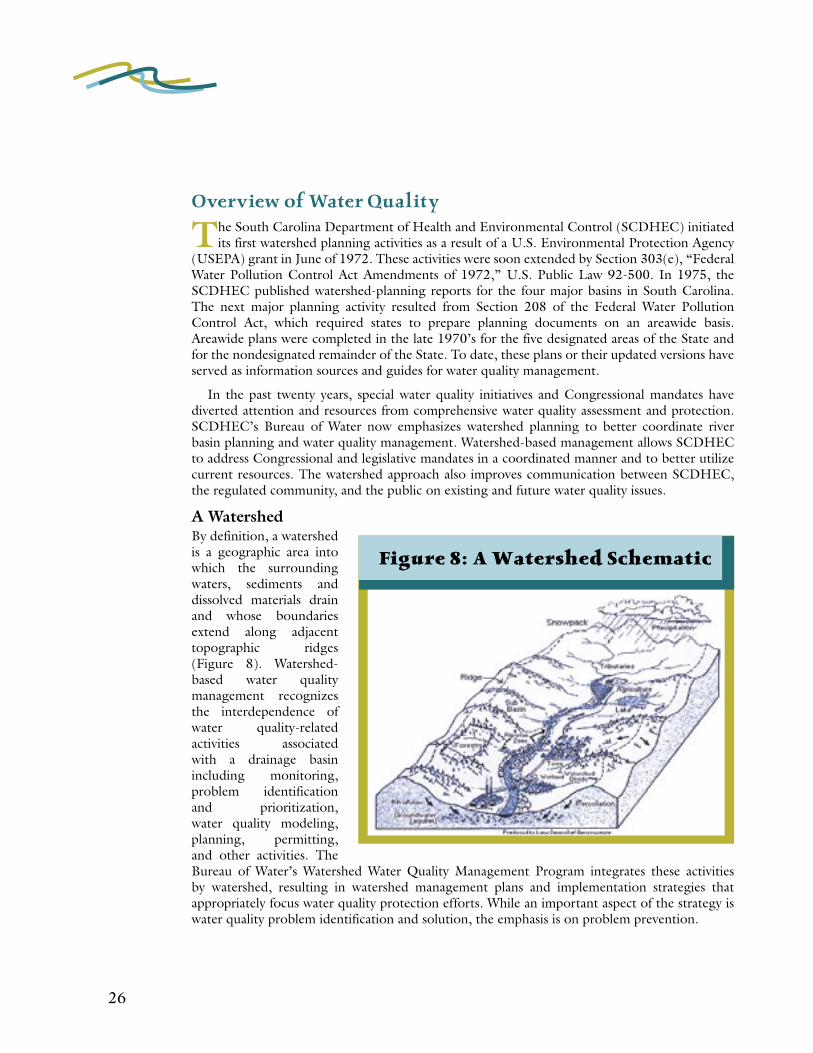
A Watershed By definition, a watershed is a geographic area into which the surrounding waters, sediments and dissolved materials drain and whose boundaries extend along adjacent topographic ridges (Figure 8). Watershed-based water quality management recognizes the interdependence of water quality-related activities associated with a drainage basin including monitoring, problem identification and prioritization, water quality modeling, planning, permitting, and other activities. The Bureau of Water’s Watershed Water Quality Management Program integrates these activities by watershed, resulting in watershed management plans and implementation strategies that appropriately focus water quality protection efforts. While an important aspect of the strategy is water quality problem identification and solution, the emphasis is on problem prevention.
Figure 8: A Watershed Schematic
26 27
Monitoring and ReportingThe scenic section of the Broad River is classified as “freshwaters” (FW), which are defined as suitable for primary and secondary contact recreation and as a source for drinking water supply after conventional treatment, in accordance with the requirements of SCDHEC. These waters are suitable for fishing and the survival and propagation of a balanced indigenous aquatic community of fauna and flora. This class is also suitable for industrial and agricultural uses. In order to decide how well this classification is being met, the river is investigated to determine whether it supports aquatic life and recreation. SCDHEC regularly collects and analyzes water samples from the Broad River and publishes The Watershed Water Quality Assessment: Broad River Basin (Water Quality Assessment). The most recent Water Quality Assessment illustrates the condition of the water quality within the scenic section of the Broad River (Figure 9). Aquatic life use support is assessed by comparing important water quality characteristics and the concentrations of potentially toxic pollutants with standards set by SCDHEC. Parameters that assist in determining whether aquatic life is supported include dissolved oxygen (DO), pH, heavy metals, priority pollutants, chlorine, and ammonia. Biological data are the ultimate deciding factor used to determine whether aquatic life uses are supported regardless of chemical conditions because the ultimate goal of set standards is “the protection of a balanced indigenous aquatic community.” Recreational use support is based on the frequency with which water samples exceed the fecal coliform bacteria standards.
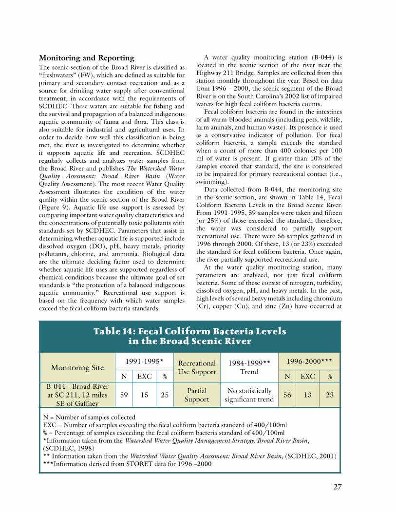
A water quality monitoring station (B-044) is located in the scenic section of the river near the Highway 211 Bridge. Samples are collected from this station monthly throughout the year. Based on data from 1996 – 2000, the scenic segment of the Broad River is on the South Carolina’s 2002 list of impaired waters for high fecal coliform bacteria counts.
Fecal coliform bacteria are found in the intestines of all warm-blooded animals (including pets, wildlife, farm animals, and human waste). Its presence is used as a conservative indicator of pollution. For fecal coliform bacteria, a sample exceeds the standard when a count of more than 400 colonies per 100 ml of water is present. If greater than 10% of the samples exceed that standard, the site is considered to be impaired for primary recreational contact (i.e., swimming).
Data collected from B-044, the monitoring site in the scenic section, are shown in Table 14, Fecal Coliform Bacteria Levels in the Broad Scenic River. From 1991-1995, 59 samples were taken and fifteen (or 25%) of those exceeded the standard; therefore, the water was considered to partially support recreational use. There were 56 samples gathered in 1996 through 2000. Of these, 13 (or 23%) exceeded the standard for fecal coliform bacteria. Once again, the river partially supported recreational use.
At the water quality monitoring station, many parameters are analyzed, not just fecal coliform bacteria. Some of these consist of nitrogen, turbidity, dissolved oxygen, pH, and heavy metals. In the past, high levels of several heavy metals including chromium (Cr), copper (Cu), and zinc (Zn) have occurred at
Table 14: Fecal Coliform Bacteria Levels in the Broad Scenic River
Monitoring Site1991-1995* Recreational
Use Support1984-1999**
Trend1996-2000***
N EXC % N EXC %B-044 - Broad River at SC 211, 12 miles
SE of Gaffney59 15 25 Partial
SupportNo statistically
significant trend 56 13 23
N = Number of samples collectedEXC = Number of samples exceeding the fecal coliform bacteria standard of 400/100ml% = Percentage of samples exceeding the fecal coliform bacteria standard of 400/100ml*Information taken from the Watershed Water Quality Management Strategy: Broad River Basin, (SCDHEC, 1998)** Information taken from the Watershed Water Quality Assessment: Broad River Basin, (SCDHEC, 2001)***Information derived from STORET data for 1996 –2000

28 29
Figure 9: SCDHEC Water Quality Map
28 29
this site. However, more recent assessments indicate an improvement (decrease in metals) and this site now meets water quality standards for these metals.
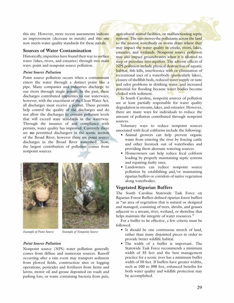
Sources of Water ContaminationHistorically, impurities have found their way to surface water (lakes, rivers, and estuaries) through two main ways: point and nonpoint source pollution.
Point Source PollutionPoint source pollution occurs when a contaminant enters the water through a distinct point like a pipe. Many companies and industries discharge to our rivers through single points. In the past, these discharges contributed impurities to our waterways; however, with the enactment of the Clean Water Act, all discharges must receive a permit. These permits help control the quality of the discharges and do not allow the discharges to contain pollutant levels that will exceed state standards in the waterway. Through the issuance of and compliance with permits, water quality has improved. Currently there are no permitted dischargers in the scenic section of the Broad River, however there are point source discharges in the Broad River watershed. Now, the largest contribution of pollution comes from nonpoint sources.
Point Source PollutionNonpoint source (NPS) water pollution generally comes from diffuse and numerous sources. Runoff occurring after a rain event may transport sediment from plowed fields, construction sites or logging operations; pesticides and fertilizers from farms and lawns; motor oil and grease deposited on roads and parking lots; or waste containing bacteria from pets,
agricultural animal facilities, or malfunctioning septic systems. The rain moves the pollutants across the land to the nearest waterbody or storm drain where they may impact the water quality in creeks, rivers, lakes, estuaries, and wetlands. Nonpoint source pollution may also impact groundwaters when it is allowed to seep or percolate into aquifers. The adverse effects of NPS pollution include physical destruction of aquatic habitat, fish kills, interference with or elimination of recreational uses of a waterbody (particularly lakes), closure of shellfish beds, reduced water supply or taste and odor problems in drinking water, and increased potential for flooding because water bodies become choked with sediment.
In South Carolina, nonpoint sources of pollution are at least partially responsible for water quality degradation in streams, lakes, and estuaries. However, there are many ways for individuals to reduce the amount of pollution contributed through nonpoint sources.
Voluntary ways to reduce nonpoint sources associated with fecal coliforms include the following:
• Animal growers can help prevent organic waste from entering the river by fencing cattle and other livestock out of waterbodies and providing them alternate watering sources.
• Homeowners can help reduce fecal coliform loading by properly maintaining septic systems and repairing faulty ones.
• Landowners can reduce nonpoint source pollution by establishing and/or maintaining riparian buffers or corridors of native vegetation along waterbodies.
Vegetated Riparian BuffersThe South Carolina Statewide Task Force on Riparian Forest Buffers defined riparian forest buffers as “an area of vegetation that is natural or designed and managed, consisting of trees, shrubs, and grasses adjacent to a stream, river, wetland, or shoreline that helps maintain the integrity of water resources.”
For a buffer to be effective, a few criteria must be followed.
• It should be one continuous stretch of land, rather than many disjointed pieces in order to provide better wildlife habitat.
• The width of a buffer is important. The Statewide Task Force recommends a minimum width of 35 feet and the best management practice for a scenic river has a minimum buffer width of 50 feet. If buffers have greater widths, such as 100 to 300 feet, enhanced benefits for both water quality and wildlife protection may be accomplished.
Example of Point Source Example of Nonpoint Source
phot
os b
y M
. Cro
cket
30 31
• The type of vegetation in the buffer is also significant. A mix of native vegetation, including trees, bushes, shrubs, and grasses should be included in the buffer. A strictly lawn/grass buffer will not provide the same benefits.
• Other factors that contribute to the effectiveness of a riparian buffer include buffer slope, soil type and characteristics, and site design.
Currently the majority of the Broad Scenic River has some type of vegetated buffer. However, as development along the river occurs, care must be taken to ensure that an adequate buffer remains in place.
Total Maximum Daily Load (TMDL)Since the data from the monitoring station in the scenic section indicate that the water quality is not meeting the standard for fecal coliform, that station is listed on the State’s 303(d) list of impaired waters. There are three ways a waterbody can be removed from the list:
(1) The listing was made in error (i.e., faulty data) (2) The waterbody has been cleaned up since the previous listing (3) There is an approved TMDL for the waterbody.
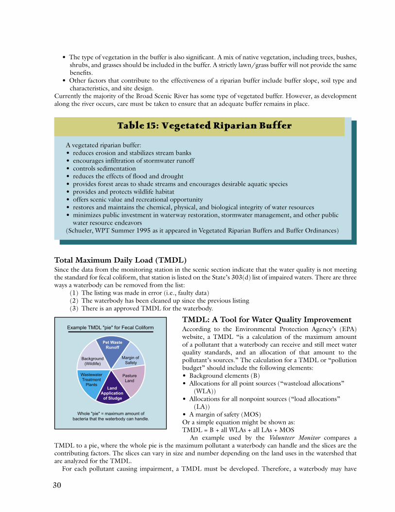
TMDL: A Tool for Water Quality Improvement According to the Environmental Protection Agency’s (EPA) website, a TMDL “is a calculation of the maximum amount of a pollutant that a waterbody can receive and still meet water quality standards, and an allocation of that amount to the pollutant’s sources.” The calculation for a TMDL or “pollution budget” should include the following elements:• Background elements (B)• Allocations for all point sources (“wasteload allocations” (WLA))• Allocations for all nonpoint sources (“load allocations” (LA))• A margin of safety (MOS)Or a simple equation might be shown as: TMDL = B + all WLAs + all LAs + MOS
An example used by the Volunteer Monitor compares a TMDL to a pie, where the whole pie is the maximum pollutant a waterbody can handle and the slices are the contributing factors. The slices can vary in size and number depending on the land uses in the watershed that are analyzed for the TMDL.
For each pollutant causing impairment, a TMDL must be developed. Therefore, a waterbody may have
Table 15: Vegetated Riparian Buffer
A vegetated riparian buffer:• reduces erosion and stabilizes stream banks• encourages infiltration of stormwater runoff• controls sedimentation• reduces the effects of flood and drought• provides forest areas to shade streams and encourages desirable aquatic species• provides and protects wildlife habitat • offers scenic value and recreational opportunity• restores and maintains the chemical, physical, and biological integrity of water resources• minimizes public investment in waterway restoration, stormwater management, and other public
water resource endeavors (Schueler, WPT Summer 1995 as it appeared in Vegetated Riparian Buffers and Buffer Ordinances)
30 31
multiple TMDLs if it is impaired by more than one pollutant.
So How Does a TMDL Improve Water Quality?The process does not end with TMDL development. The next step is TMDL implementation. At this point, the TMDL can be used to formulate a strategy to reduce the pollutant loading through best management practices (BMPs) and restoration projects. While stakeholders may be involved in the development of the TMDL, their involvement becomes critical for realizing a source reduction.
As guidance from the EPA changes, more and more federal nonpoint source funds will be allocated for development and implementation of TMDLs. At the state level, many of the “319” (nonpoint source) grant dollars are available primarily for TMDL implementation. (For additional details or more recent information, please visit the SCDHEC Bureau of Water website at www.scdhec.gov/water)
Water Quality Issues
The water quality committee identified the following issues concerning the management of the Broad Scenic River’s water resources.
During rain events, runoff to the Broad River contains a great deal of sediment and other nonpoint source pollution.
The sampling frequency (once per month) employed by SCDHEC may not detect acute water quality problems caused by storm water discharge, septic tank malfunction, or rainfall runoff.
Narrow riparian buffers and streambank erosion along the scenic section allow for increased sediment runoff.
More volunteers are needed for water quality monitoring and litter clean up days.
Water Quality Management Goal To provide for the desired river uses such as swimming and fishing, the river should consistently meet or exceed established biological, chemical, and physical standards for SCDHEC’s freshwater designation. The advisory council should work to maintain and enhance the water quality of the Broad Scenic River.
Water Quality Recommendations
and Opportunities
The advisory council and the water quality committee identified the following recommendations and opportunities to assist in attaining the management goal listed above.
16. Promote cooperative efforts among agencies with management responsibilities for water quality protection in the scenic corridor.
17. Address the nonpoint source pollution issues in the scenic corridor by:• Promoting the use of streamside and
forestry best management practices.• Advocating the creation/protection of
riparian buffers.• Encouraging reduction of litter, nutrient,
and contaminant loading in the scenic watershed.o Seek assistance from the U.S. Natural
Resources Conservation Service in controlling agricultural runoff.
o Participate in the Beach Sweep/River Sweep event and help develop a program to reduce or eliminate litter in the river.
• Encourage compliance with the Stormwater Management and Sediment Reduction Act.o Get volunteers to watch, record, and
notify project managers as to water quality monitoring and nonpoint source violations in the scenic corridor.
• Assist with implementation of TMDLs (when completed and approved).
Shoal area of Broad Scenic Riverph
oto
by M
. Cro
cket
t

32 33
Recreation and Public Access

32 33
Overview of Recreational Values
The current recreational uses of the Broad Scenic River include fishing, boating, rafting, tubing, swimming, nature study, photography, and bird watching. Hunting and trapping
are also common outdoor activities along the river. The entire length of the scenic corridor from the Ninety-Nine Islands Hydroelectric Station to the confluence with the Pacolet River is considered navigable waters under Regulation 19-450 of the South Carolina Code of Laws 1976, as amended, and under Section 10 of the National Rivers and Harbors Act of 1899 (33 U.S.C. 403). As previously discussed (Table 3), the Rivers Assessment reports the Broad River as locally significant in the “Backcountry Boating” and the “Flatwater Boating” categories.
This river is also popular with paddlers and tubers who are able to use the shallow river, even during low water flows. When the water depth is high and over the tops of the shoals, the use of small-motorized boats increases. However, the upper half of the scenic section does have a number of rocky shoals that can become dangerous when the water increases in volume and velocity due to flash floods or the sudden release of water from the Ninety-Nine Islands Hydroelectric Station. In the lower portion of the scenic segment (a mile or so below Highway 211), the river flow decreases and the width of the river increases. This very picturesque flatwater section deepens as the hydroelectric station at Lockhart backs up the water.
There are only two public access points within the Broad Scenic River Corridor; both of which are at the beginning of the scenic section. Because there is currently a long distance between access points (21 miles), the river user who wants a shorter trip must ask permission to ingress or egress on private property. When such permission is not requested, the riparian landowners are forced to deal with trespassers.
Due to the lack of public access points along the course of the river, there are currently very few fishing and canoeing outfitters or guides operating trips on the Broad Scenic River. Fortunately, one can often view wildlife from either of the two public access landings or the Highway 211 Bridge.
The two public access points within the scenic segment and two others outside the scenic segment are described below:
The Ninety-Nine Islands Boat Landing The Ninety-Nine Islands Boat Landing is a public boat access area operated by Duke Power in the scenic river corridor. It is located in Cherokee County at the end of State Secondary Road 43, between the towns of Cherokee Falls in Cherokee County and Hickory Grove in York County. This landing is located at the beginning of the scenic section. The landing has a concrete paved double boat ramp, large paved parking area, and a wooden wildlife viewing/fishing dock.
The Cherokee LandingThe Cherokee Landing is located at the end of State Secondary Road 13 (off of Highway 105) within the scenic corridor. This landing, located across the river from the Ninety-Nine Islands Landing, is very steep and is paved in asphalt with a very small paved parking area.
SCD
NR
sta
ff p
hoto
Hiking a creek which flows into the Scenic Broad River
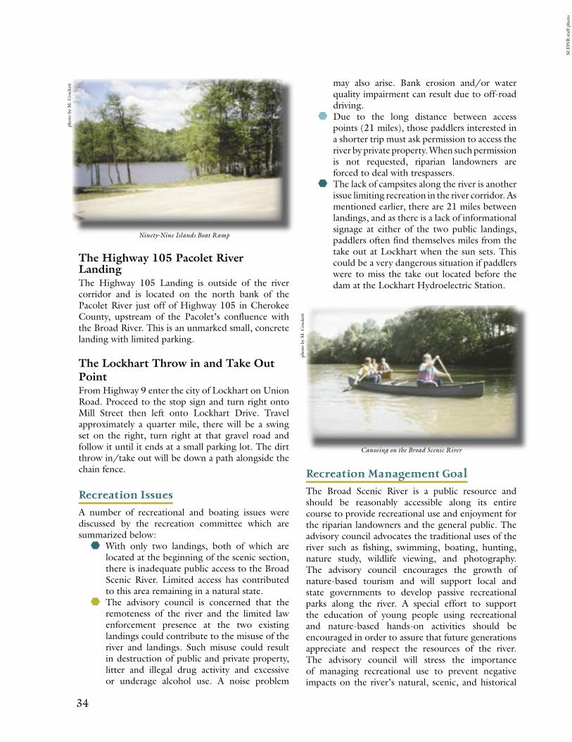
34 35
The Highway 105 Pacolet River LandingThe Highway 105 Landing is outside of the river corridor and is located on the north bank of the Pacolet River just off of Highway 105 in Cherokee County, upstream of the Pacolet’s confluence with the Broad River. This is an unmarked small, concrete landing with limited parking.
The Lockhart Throw in and Take Out Point From Highway 9 enter the city of Lockhart on Union Road. Proceed to the stop sign and turn right onto Mill Street then left onto Lockhart Drive. Travel approximately a quarter mile, there will be a swing set on the right, turn right at that gravel road and follow it until it ends at a small parking lot. The dirt throw in/take out will be down a path alongside the chain fence.
Recreation Issues
A number of recreational and boating issues were discussed by the recreation committee which are summarized below:
With only two landings, both of which are located at the beginning of the scenic section, there is inadequate public access to the Broad Scenic River. Limited access has contributed to this area remaining in a natural state.
The advisory council is concerned that the remoteness of the river and the limited law enforcement presence at the two existing landings could contribute to the misuse of the river and landings. Such misuse could result in destruction of public and private property, litter and illegal drug activity and excessive or underage alcohol use. A noise problem
may also arise. Bank erosion and/or water quality impairment can result due to off-road driving.
Due to the long distance between access points (21 miles), those paddlers interested in a shorter trip must ask permission to access the river by private property. When such permission is not requested, riparian landowners are forced to deal with trespassers.
The lack of campsites along the river is another issue limiting recreation in the river corridor. As mentioned earlier, there are 21 miles between landings, and as there is a lack of informational signage at either of the two public landings, paddlers often find themselves miles from the take out at Lockhart when the sun sets. This could be a very dangerous situation if paddlers were to miss the take out located before the dam at the Lockhart Hydroelectric Station.
Recreation Management Goal
The Broad Scenic River is a public resource and should be reasonably accessible along its entire course to provide recreational use and enjoyment for the riparian landowners and the general public. The advisory council advocates the traditional uses of the river such as fishing, swimming, boating, hunting, nature study, wildlife viewing, and photography. The advisory council encourages the growth of nature-based tourism and will support local and state governments to develop passive recreational parks along the river. A special effort to support the education of young people using recreational and nature-based hands-on activities should be encouraged in order to assure that future generations appreciate and respect the resources of the river. The advisory council will stress the importance of managing recreational use to prevent negative impacts on the river’s natural, scenic, and historical
phot
o by
M. C
rock
ett
phot
o by
M. C
rock
ett
Ninety-Nine Islands Boat Ramp
Canoeing on the Broad Scenic River
SCD
NR
sta
ff p
hoto
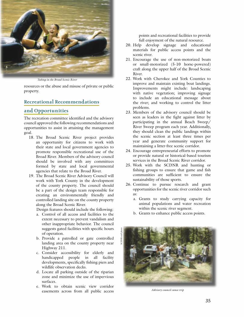
34 35
resources or the abuse and misuse of private or public property.
Recreational Recommendations
and Opportunities
The recreation committee identified and the advisory council approved the following recommendations and opportunities to assist in attaining the management goal.
18. The Broad Scenic River project provides an opportunity for citizens to work with their state and local government agencies to promote responsible recreational use of the Broad River. Members of the advisory council should be involved with any committees formed by state and local governmental agencies that relate to the Broad River.
19. The Broad Scenic River Advisory Council will work with York County in the development of the county property. The council should be a part of the design team responsible for creating an environmentally friendly and controlled landing site on the county property along the Broad Scenic River.Design features should include the following:a. Control of all access and facilities to the
extent necessary to prevent vandalism and other inappropriate behavior. The council suggests gated facilities with specific hours of operation.
b. Provide a patrolled or gate controlled landing area on the county property near Highway 211.
c. Consider accessibility for elderly and handicapped people in all facility developments, specifically fishing piers and wildlife observation decks.
d. Locate all parking outside of the riparian zone and minimize the use of impervious surfaces.
e. Work to obtain scenic view corridor easements across from all public access
points and recreational facilities to provide full enjoyment of the natural resource.
20. Help develop signage and educational materials for public access points and the scenic river.
21. Encourage the use of non-motorized boats or small-motorized (5-10 horse-powered) craft along the upper half of the Broad Scenic River.
22. Work with Cherokee and York Counties to improve and maintain existing boat landings. Improvements might include: landscaping with native vegetation; improving signage to include an educational message about the river; and working to control the litter problems.
23. Members of the advisory council should be seen as leaders in the fight against litter by participating in the annual Beach Sweep/River Sweep program each year. Additionally, they should clean the public landings within the scenic section at least three times per year and generate community support for maintaining a litter-free scenic corridor.
24. Encourage entrepreneurial efforts to promote or provide natural or historical-based tourism services in the Broad Scenic River corridor.
25. Work with the SCDNR and hunting or fishing groups to ensure that game and fish communities are sufficient to ensure the sustainability of those sports.
26. Continue to pursue research and grant opportunities for the scenic river corridor such as:a. Grants to study carrying capacity for
animal populations and water recreation within the scenic river segment.
b. Grants to enhance public access points.
Tubing in the Broad Scenic River
Advisory council canoe trip
SCD
NR
sta
ff p
hoto
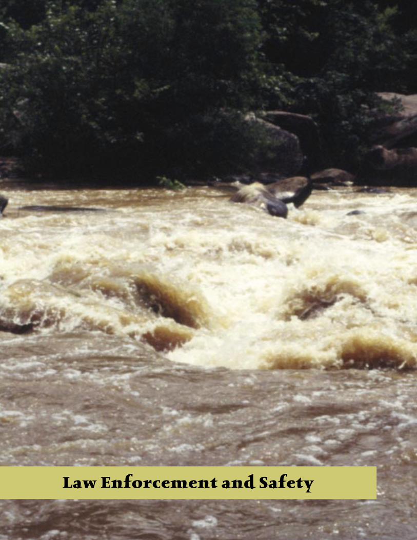
36 37
Law Enforcement and Safety
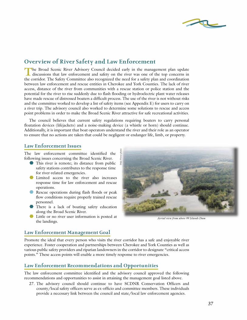
36 37
Overview of River Safety and Law Enforcement
The Broad Scenic River Advisory Council decided early in the management plan update discussions that law enforcement and safety on the river was one of the top concerns in
the corridor. The Safety Committee also recognized the need for a safety plan and coordination between law enforcement and rescue entities in Cherokee and York Counties. The lack of river access, distance of the river from communities with a rescue station or police station and the potential for the river to rise suddenly due to flash flooding or hydroelectric plant water releases have made rescue of distressed boaters a difficult process. The use of the river is not without risks and the committee worked to develop a list of safety items (see Appendix E) for users to carry on a river trip. The advisory council also worked to determine some solutions to rescue and access point problems in order to make the Broad Scenic River attractive for safe recreational activities.
The council believes that current safety regulations requiring boaters to carry personal floatation devices (lifejackets) and a noise-making device (a whistle or horn) should continue. Additionally, it is important that boat operators understand the river and their role as an operator to ensure that no actions are taken that could be negligent or endanger life, limb, or property.
Law Enforcement Issues
The law enforcement committee identified the following issues concerning the Broad Scenic River.
This river is remote; its distance from public safety stations contributes to the response time for river-related emergencies.
Limited access to the river also increases response time for law enforcement and rescue operations.
Rescue operations during flash floods or peak flow conditions require properly trained rescue personnel.
There is a lack of boating safety education along the Broad Scenic River.
Little or no river user information is posted at the landings.
Law Enforcement Management Goal
Promote the ideal that every person who visits the river corridor has a safe and enjoyable river experience. Foster cooperation and partnerships between Cherokee and York Counties as well as various public safety providers and riparian landowners in the corridor to designate “critical access points.” These access points will enable a more timely response to river emergencies.
Law Enforcement Recommendations and Opportunities
The law enforcement committee identified and the advisory council approved the following recommendations and opportunities to assist in attaining the management goal listed above.
27. The advisory council should continue to have SCDNR Conservation Officers and county/local safety officers serve as ex-officio and committee members. These individuals provide a necessary link between the council and state/local law enforcement agencies.
Aerial view from above 99 Islands Dam
Duk
e Po
wer
pho
to
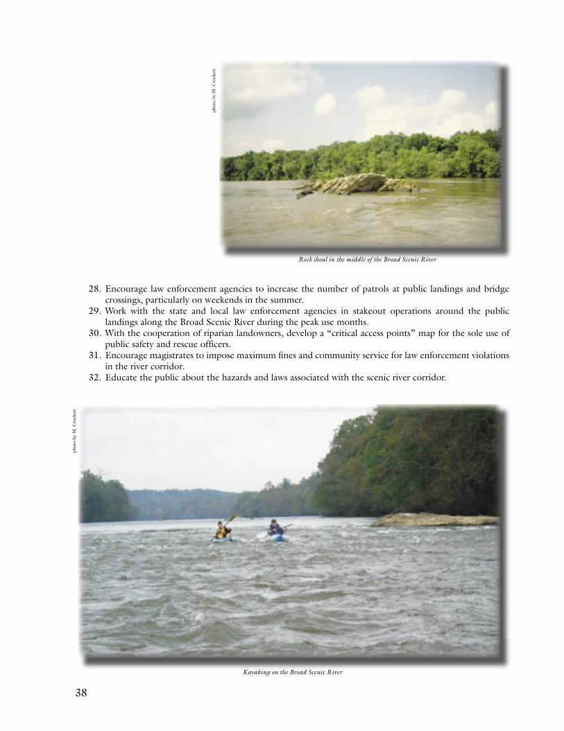
38 39
28. Encourage law enforcement agencies to increase the number of patrols at public landings and bridge crossings, particularly on weekends in the summer.
29. Work with the state and local law enforcement agencies in stakeout operations around the public landings along the Broad Scenic River during the peak use months.
30. With the cooperation of riparian landowners, develop a “critical access points” map for the sole use of public safety and rescue officers.
31. Encourage magistrates to impose maximum fines and community service for law enforcement violations in the river corridor.
32. Educate the public about the hazards and laws associated with the scenic river corridor.
Kayaking on the Broad Scenic River
Rock shoal in the middle of the Broad Scenic River
phot
o by
M. C
rock
ett
phot
o by
M. C
rock
ett
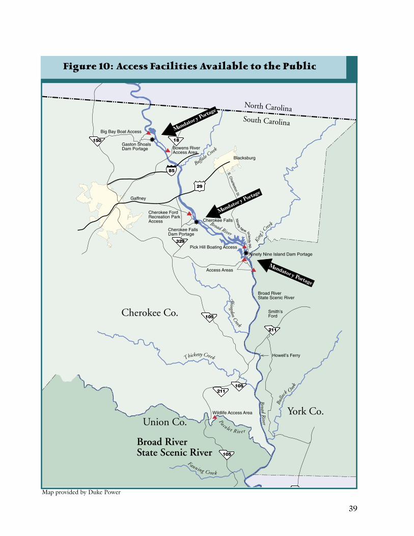
38 39
Figure 10: Access Facilities Available to the Public
Map provided by Duke Power

40 41
Cultural and Historical Resources

40 41
Overview of Historical Resources
Approximately twenty-eight prehistoric and historic sites are currently known in the Broad River Corridor. According to the South Carolina Institute of Archeology and Anthropology
(SCIAA), human activity has occurred in the corridor since about 10,000 B.C. During the Woodland era (circa 1,000 B.C. to 1,500 A.D.), Native Americans began to settle in small groups in the area and were dependent upon agriculture and hunting for their livelihood. These small villages were usually located on bluffs overlooking a river or stream. The Iroquoian people, known as the Cherokee Nation, occupied the western third of South Carolina, including the Broad Scenic River Corridor. The river served as the line of demarcation between the Cherokees and their neighbors, the Catawbas, a Siouan Nation. These tribes used the river for drinking, traveling, fishing (remains of fishing weirs can still be seen in the river today), and food gathering. About 1150 A.D. the Mississippians entered South Carolina and built ceremonial mounds on the banks of many rivers in South Carolina. A mound, believed to be a burial mound, is located near Lockhart Shoals.
In 1514, Lucas Vasques de Ayllon of Spain made an expedition to the coast somewhere between present day Georgia and North Carolina; he is credited with making the first contact with the Native American people of South Carolina. Ayllon ordered a second expedition near Beaufort in 1521, where his men kidnapped a number of Indians as slaves. Later, in 1526, the Spanish founded, and then abandoned, the town of San Miguel de Guadalupe near present day Beaufort. This was one of four failed attempts to colonize the area.
The English founded Charles Towne in 1670 and the town grew in population and importance by trading with the Native American populations. In 1685, the upper Broad River became a part of Craven County in the province of Carolina, one of three counties ordered by the Lords’ Proprietors to be used as election districts for the Assembly. However, much of Craven County was yet unsettled and was largely ignored.
Parishes were established in 1706 as the principal election divisions of local government. The Broad River watershed fell into the St. Mark’s Parish, by far the largest in land area of any in the state at that time. Due to the low number of settlers, the parish was not actually established until 1757.
In 1719, the Proprietary Government was overthrown by self-government and the Carolina Charter was surrendered to the British Crown in 1729. Thus, land obtained after 1729 was done so by Crown patents. Bounties to encourage settling of the backcountry attracted settlers to the lower Piedmont of South Carolina.
The French and Indian War in Virginia and Pennsylvania began in 1754. Just prior to this date North Carolina was issuing land patents in the Broad River area. However the French and Indian War did not affect the settlement of the scenic river corridor until after 1758.
In 1763, a treaty was signed by the southeastern Indian tribes which defined the Cherokee boundary lines. This Augusta Treaty also established a 225-square mile reservation for the Catawba Nation along the Catawba River. The Cherokee lands were located in the most western corner of the colony just east of the Blue Ridge Mountains.
Charles Woodmason wrote a petition for backcountry courts, jails, schools, and courthouses in 1767 asking for regulators to be organized in the backcountry Parishes. Barnaby Pope, one of the backcountry regulators worked to restore law and order. In 1769, the Parish divisions were replaced with Districts, which continued until counties were formed in 1785.
Bethel Presbyterian Church
Phot
o co
urte
sy o
f Jer
ry L
. Wes
t

42 43
In 1776, the American Revolution began and many places in South Carolina played host to that war. In the Broad River Watershed, the Tories or British loyalists made their headquarters in Fort Thicketty (located in present day Cherokee County). This stronghold alternately exchanged hands, finally being taken by American Patriots.
On the east side of the Broad River in York County, Colonel Edward Lacey ordered a redoubt to be constructed about 1778 on the Charleston Road above Turkey Creek. Lacey’s Fort, sometimes known as “Liberty Hill,” was constructed to deter the British in their push into the backcountry. The Americans held this fort until January 1781 when they voluntarily abandoned it and British Lord Cornwallis and his army occupied it for three days. The Culture and Heritage Commission of York County marked this site with a historical marker in June of 2002.
Smith’s Ford was an ancient natural crossing connecting what are now York and Cherokee Counties. In the summer of 1775, Reverend Tennent and a commission from the South Carolina Council of Safety arrived there to enlist the help of the area settlers with the war. While Colonel Joseph McDowell was camped at Smith’s Ford in August of 1780, he dispatched a company of men to seek out a company of Tories on the Enoree River, resulting in the Battle of Musgrove Mill.
A few miles to the north, another natural ford, known as Cherokee Ford, was a popular camping site of American Patriots. This ford lies in the heart of the Old Iron Ore District.
In 1791, the state created an intermediate court system. The Town of Pinckneyville was also created at this time. This courthouse town was located in present day Union County at the confluence of the Pacolet and Broad Rivers. By 1820, the state moved the court system to Union and although the town continued into the twentieth century it never prospered. Eventually the town was abandoned and fell into ruins.
Howell’s Ferry, located 500 yards below the Salem-Irene Bridge (Highway 211), was an important crossing between York and Union Counties from the late eighteenth century to the early part of the twentieth century. In 1766, the Provincial Congress of South Carolina passed an act to establish a road leading to Howell’s Ferry and required the proprietor of the ferry to keep “a good and sufficient ferry-boat and canoe, and that it shall be lawful to ask, demand, and receive fixed rates and prices per cargo.” In 1813, William Howell took over the operation of the ferry from his father, Joseph Howell. At that time the ferry was reported to be part of the shortest route to Tennessee via Mill’s Gap and the back parts of Georgia. The ferry was being used by mail carriers as a return from Spartanburg to Columbia by way of Yorkville. The ferry continued to be used until 1913 when the Salem-Irene Bridge (Highway 211) was constructed.
In 1818, the General Assembly authorized the building of eight canals in order to make travel around the shoals easier in the backcountry river systems. All eight were built, one of which was located at Lockhart Shoals, below the scenic corridor. In 1825, Robert Mills produced an atlas map of the York and Union Districts which illustrates features found in the Broad River corridor
The ruins of a Pinckneyville store cr1792 — sometimes misidentified as the town’s courthouse
Phot
o co
urte
sy o
f Jer
ry L
. Wes
t
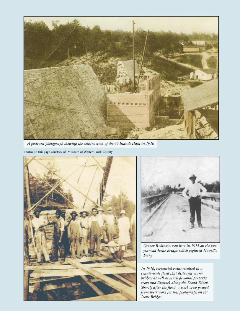
42 43
In 1916, torrential rains resulted in a county-wide flood that destroyed many bridges as well as much personal property, crops and livestock along the Broad River. Shortly after the flood, a work crew paused from their work for this photograph on the Irene Bridge.
A postcard photograph showing the construction of the 99 Islands Dam in 1910
Grover Robinson seen here in 1915 on the two-year-old Irene Bridge which replaced Howell’s Ferry
Photos on this page courtsey of Museum of Western York County

44 45
at that time. Twenty years after the authorization of the canal system, it was obsolete due to the statewide construction of the railroad. The Lockhart Mill was constructed during the first quarter of the twentieth century on the ancient shoals. To power the mill, a canal was constructed along the route of the old canal. Today the canal is used to produce electricity for the Lockhart Power Company.
In 1870, Stooping Pines Church was established. This African-American church, cemetery and school was once the center of activity for African-Americans on both sides of the river. Within its cemetery, which can only be reached by foot, are buried members of the Garrett, Hardin, and Smith families.
The Charleston, Cincinnati, and Chicago Railroad Company (often called the 3 C’s) was formed in 1885. This company started construction
on a railroad that would link Newberry to Union and then continue up the Broad River to Blacksburg. The 3 C’s built a railroad bed along the western side of the Broad River in what is now Union and Cherokee Counties, but the company suffered financially and never completed the track. Later in 1907 another railroad company surveyed routes along both sides of the Broad River. This company established a base camp at Pine Grove (believed to be near Wilkinsville) in Cherokee County and later moved their base to Beaver Dam Creek in York County. Like the 3 C’s, this survey did not produce a completed rail line.
Finally in 1889, the 3 C’s Railroad completed a trunkline across York County from Blacksburg to York. This rail line produced three towns - Smyrna, Hickory Grove, and Sharon. The greatest effect on the Broad River and its tributaries since the construction of the 3 C’s occurred from 1922-1923 when the “West Road” was constructed from York to Gaffney. Bridges were built over Bullocks Creek and Kings Creek connecting the towns of Sharon, Hickory Grove, and Smyrna.
Iron Production While some iron ore was being smelted in western York County before the Revolution, Jacob Stroup and his partner, Edmund Fewell, built the first real furnace in the Broad River basin in 1809 on Kings Creek. A flood destroyed the Kings Creek Furnace in 1822. In 1825, the operation was sold to William McGill and John B. Darwin who moved the operation near the present day Cherokee Falls Mill. Stroup built his third furnace near Doolittle Creek, but sold out in 1826. Meanwhile, McGill and Darwin sold their furnace to E. Graham & Company, which consisted of Emmorl Graham, Governor David Johnson, Jacob M. Deal, James A. Black, Robert Peter, and John Byrce. These men built the first rolling mill in the south. About 1837, they sold the rolling mill to the Kings Mountain Iron Company. This company continued through 1865 and produced shot for six and nine pound cannons, as well as round, grape, and canister shot for the Confederate artillery. Abner Benson, Andrew B. Moore, and Wilson Nesbitt incorporated the South Carolina Manufacturing Company in 1826. Part of this company’s operation was built at Hurricane Shoals and another part on Thicketty Mountain. In 1834, the company rebuilt several pre-Revolutionary furnaces on Cherokee Creek and purchased 25,000 acres of ore-bearing land. They built a rolling mill at Hurricane Shoals and attracted large investors. In 1841, the South Carolina legislature authorized the company to increase its capital stock to $301,000. In 1835, the newly formed Nesbitt Manufacturing Company became the third largest iron producer in the area; it subsequently built an industry and village on Broad River. They purchased 8,000 acres, including Limestone Springs, where they built the Limestone Spring Hotel and developed a resort village. The village, Coopersville, was named in honor of its major stockholder, Dr. Thomas Cooper.
A tombstone found in one of the many family and church cemeteries in the area.
Phot
o co
urte
sy o
f Jer
ry L
. Wes
t
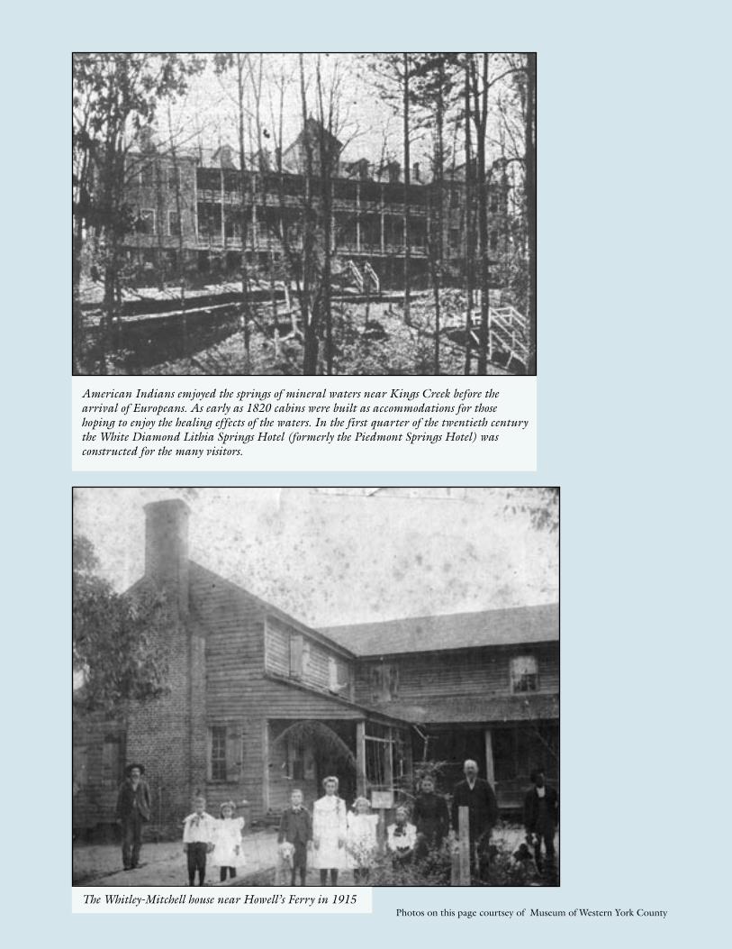
44 45
American Indians emjoyed the springs of mineral waters near Kings Creek before the arrival of Europeans. As early as 1820 cabins were built as accommodations for those hoping to enjoy the healing effects of the waters. In the first quarter of the twentieth century the White Diamond Lithia Springs Hotel (formerly the Piedmont Springs Hotel) was constructed for the many visitors.
The Whitley-Mitchell house near Howell’s Ferry in 1915Photos on this page courtsey of Museum of Western York County
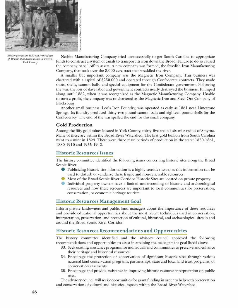
46 47
Nesbitt Manufacturing Company tried unsuccessfully to get South Carolina to appropriate funds to construct a system of canals to transport its iron down the Broad. Failure to do so caused the company to sell off its assets. A new company was formed, the Swedish Iron Manufacturing Company, that took over the 8,000 acre tract that straddled the river.
A smaller but important company was the Magnetic Iron Company. This business was chartered with a capital of $250,000 and operated through Confederate contracts. They made shots, shells, cannon balls, and special equipment for the Confederate government. Following the war, the loss of slave labor and government contracts nearly destroyed the business. It limped along until 1882, when it was reorganized as the Magnetic Manufacturing Company. Unable to turn a profit, the company was re-chartered as the Magnetic Iron and Steel Ore Company of Blacksburg.
Another small business, Leo’s Iron Foundry, was operated as early as 1861 near Limestone Springs. Its foundry produced thirty-two pound cannon balls and eighteen pound shells for the Confederacy. The end of the war spelled the end for this small company.
Gold ProductionAmong the fifty gold mines located in York County, thirty-five are in a six-mile radius of Smyrna. Many of these are within the Broad River Watershed. The first gold bullion from South Carolina went to a mint in 1829. There were three main periods of production in the state: 1830-1861, 1880-1910 and 1935-1942.
Historic Resources Issues
The history committee identified the following issues concerning historic sites along the Broad Scenic River.
Publicizing historic site information is a highly sensitive issue, as this information can be used to disturb or vandalize these fragile and non-renewable resources.
Most of the Broad Scenic River Corridor Historic Sites are located on private property. Individual property owners have a limited understanding of historic and archaeological
resources and how these resources are important to local communities for preservation, conservation, or economic heritage tourism.
Historic Resources Management Goal Inform private landowners and public land managers about the importance of these resources and provide educational opportunities about the most recent techniques used in conservation, interpretation, preservation, and protection of cultural, historical, and archaeological sites in and around the Broad Scenic River Corridor.
Historic Resources Recommendations and Opportunities
The history committee identified and the advisory council approved the following recommendations and opportunities to assist in attaining the management goal listed above.
33. Seek existing assistance programs for individuals and communities to preserve and enhance their heritage and historical resources.
34. Encourage the protection or conservation of significant historic sites through various national land conservation programs, partnerships, state and local land trust programs, or conservation easements.
35. Encourage and provide assistance in improving historic resource interpretation on public sites.
The advisory council will seek opportunities for grant funding in order to help with preservation and conservation of cultural and historical aspects within the Broad River Watershed.
Miners pose in the 1950’s in front of one of 40 now abandoned mines in western
York County
Phot
o co
urts
ey o
f Mus
eum
of W
este
rnYo
rk C
ount
y
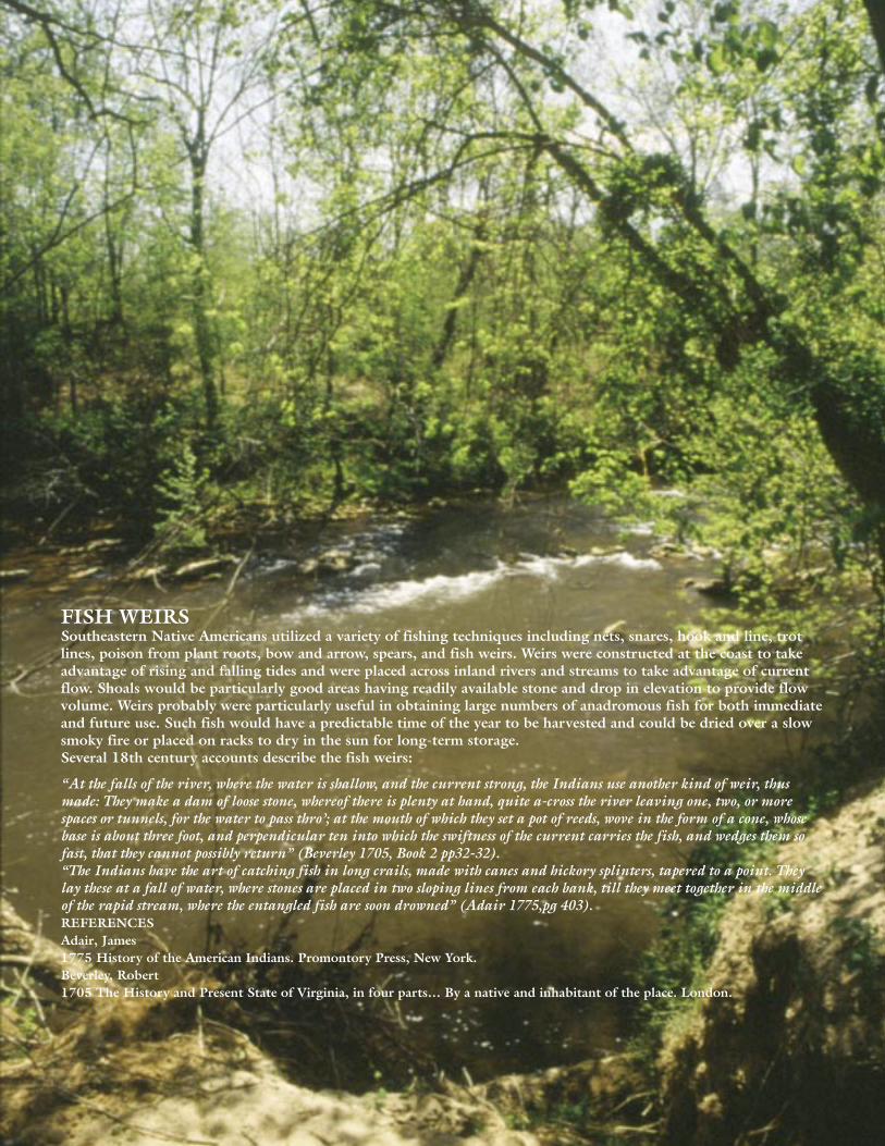
46 47
FISH WEIRSSoutheastern Native Americans utilized a variety of fishing techniques including nets, snares, hook and line, trot lines, poison from plant roots, bow and arrow, spears, and fish weirs. Weirs were constructed at the coast to take advantage of rising and falling tides and were placed across inland rivers and streams to take advantage of current flow. Shoals would be particularly good areas having readily available stone and drop in elevation to provide flow volume. Weirs probably were particularly useful in obtaining large numbers of anadromous fish for both immediate and future use. Such fish would have a predictable time of the year to be harvested and could be dried over a slow smoky fire or placed on racks to dry in the sun for long-term storage. Several 18th century accounts describe the fish weirs:
“At the falls of the river, where the water is shallow, and the current strong, the Indians use another kind of weir, thus made: They make a dam of loose stone, whereof there is plenty at hand, quite a-cross the river leaving one, two, or more spaces or tunnels, for the water to pass thro’; at the mouth of which they set a pot of reeds, wove in the form of a cone, whose base is about three foot, and perpendicular ten into which the swiftness of the current carries the fish, and wedges them so fast, that they cannot possibly return” (Beverley 1705, Book 2 pp32-32).“The Indians have the art of catching fish in long crails, made with canes and hickory splinters, tapered to a point. They lay these at a fall of water, where stones are placed in two sloping lines from each bank, till they meet together in the middle of the rapid stream, where the entangled fish are soon drowned” (Adair 1775,pg 403). REFERENCESAdair, James1775 History of the American Indians. Promontory Press, New York.Beverley, Robert 1705 The History and Present State of Virginia, in four parts… By a native and inhabitant of the place. London.
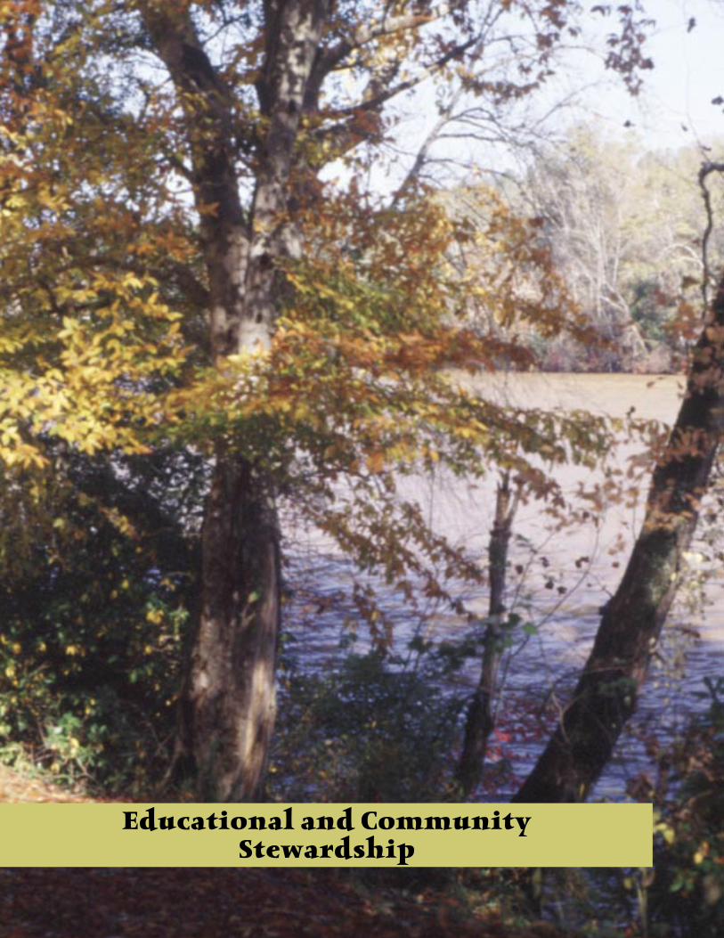
48 49
Educational and CommunityStewardship

48 49
Overview of educational and community stewardship
This chapter is of particular importance because it will outline the way knowledge is passed on to the community. Who will be responsible for deciding how best to use the information
given? For important management recommendations found in this plan to be meaningful, we must rely on the riparian landowners and the local community to embrace and implement them.
During the last ten years, members of the Broad Scenic River Advisory Council have actively worked to educate themselves about stewardship, easements, and natural and historic resources located in the corridor. Council members have worked with the local school systems when asked. The advisory council now believes that the time has come to be more active in promoting the wise use of all lands within the watershed in order to protect and conserve the natural, cultural, and scenic values of the Broad Scenic River.
Education Issues
The education committee identified the following issues pertaining to the Broad Scenic River corridor.
The best methods to educate the Cherokee and York County communities about the Broad Scenic River and the advisory council’s conservation efforts need to be determined.
Determine how to involve the local river corridor communities in a conservation effort along the Broad Scenic River.
Foster research efforts using local high schools and colleges.
Inform all watershed landowners, especially those who border the river or its tributaries, about best management practices and stewardship using the most up-to-date, scientific information possible.
Support Cherokee and York Counties in development of natural/historical/cultural-based sites along the Broad Scenic River.
Education Management Goal
Promote public awareness and community stewardship of the resources of the Broad Scenic River Corridor to benefit residents and visitors of the watershed and for the enjoyment of future generations.
Education Recommendations and OpportunitiesThe education committee identified and the advisory council approved the following recommendations and opportunities to assist in attaining the management goal listed above.
36. The council should partner with interested parties such as citizen groups, educational institutions, and local governments to gather data about the river corridor and to host educational workshops.
37. Regularly update the local media through press releases or by inviting them to volunteer outings or work days.
38. Where feasible, participate in outreach opportunities such as career day, or other local
Advisory Council meeting
phot
o by
M. C
rock
ett
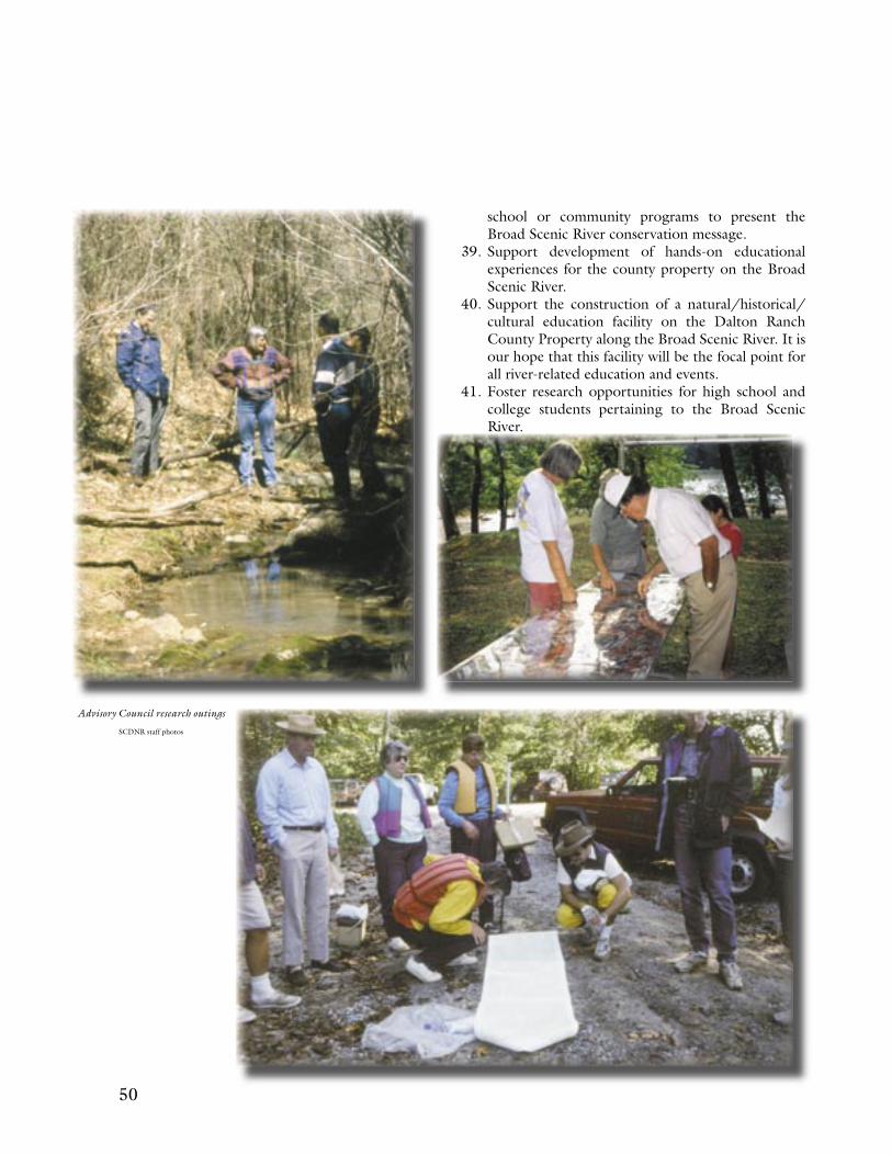
50 51
school or community programs to present the Broad Scenic River conservation message.
39. Support development of hands-on educational experiences for the county property on the Broad Scenic River.
40. Support the construction of a natural/historical/cultural education facility on the Dalton Ranch County Property along the Broad Scenic River. It is our hope that this facility will be the focal point for all river-related education and events.
41. Foster research opportunities for high school and college students pertaining to the Broad Scenic River.
Advisory Council research outings
SCDNR staff photos
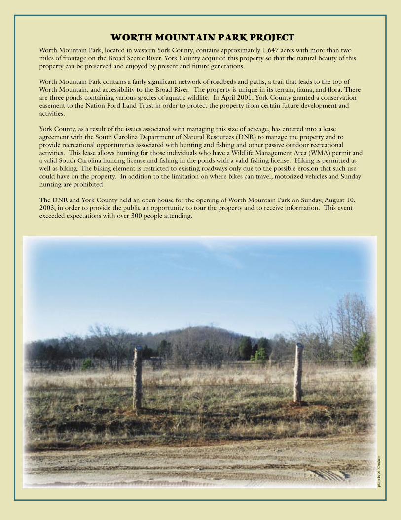
50 51
WORTH MOUNTAIN PARK PROJECT Worth Mountain Park, located in western York County, contains approximately 1,647 acres with more than two miles of frontage on the Broad Scenic River. York County acquired this property so that the natural beauty of this property can be preserved and enjoyed by present and future generations.
Worth Mountain Park contains a fairly significant network of roadbeds and paths, a trail that leads to the top of Worth Mountain, and accessibility to the Broad River. The property is unique in its terrain, fauna, and flora. There are three ponds containing various species of aquatic wildlife. In April 2001, York County granted a conservation easement to the Nation Ford Land Trust in order to protect the property from certain future development and activities.
York County, as a result of the issues associated with managing this size of acreage, has entered into a lease agreement with the South Carolina Department of Natural Resources (DNR) to manage the property and to provide recreational opportunities associated with hunting and fishing and other passive outdoor recreational activities. This lease allows hunting for those individuals who have a Wildlife Management Area (WMA) permit and a valid South Carolina hunting license and fishing in the ponds with a valid fishing license. Hiking is permitted as well as biking. The biking element is restricted to existing roadways only due to the possible erosion that such use could have on the property. In addition to the limitation on where bikes can travel, motorized vehicles and Sunday hunting are prohibited.
The DNR and York County held an open house for the opening of Worth Mountain Park on Sunday, August 10, 2003, in order to provide the public an opportunity to tour the property and to receive information. This event exceeded expectations with over 300 people attending.
phot
o by
M. C
rock
ett

52 53
Implementation

52 53
Implementation
This management plan contains seven management goals and 41 recommendations that address issues, concerns, and opportunities regarding the river corridor. The creation of this
plan with its many objectives is an important accomplishment because it represents a consensus among a diversity of local citizens and landowners and reflects community values, concerns, and desires for the river. The management plan serves as a guide for promoting good stewardship of the Broad Scenic River. The challenge will be to put the plan into action and produce tangible results. Through implementation, the local community can take steps to achieve litter-free landings and river corridor; beautiful trees and shrubs along the shoreline enhancing natural views; exemplary development designs that conserve the natural character of the Broad River; cleaner water in the river; and a natural conservation-inspired property and boat landing at the York County property.
The Broad Scenic River Advisory Council will advocate this management plan to the broader community and take actions to implement specific recommendations. Not all of the recommendations can be implemented at once. Some recommendations will require a short-term effort, while others will be ongoing. Still others will require much time and effort including organizing and building partnerships and obtaining funding. People and organizations such as landowners, river users, community interest groups, developers, or governmental entities that decide that this management plan presents an appropriate way to manage the river can aid in the implementation of many of the recommendations.
Local citizens and organizations are encouraged to become involved with the advisory council to pursue the goals and implementation strategies of this management plan. The advisory council will continue to meet regularly in the Broad River area and invites interested citizens to be informed of and involved in the projects and plans concerning the Broad Scenic River.
Recommendations for implementation are presented below to serve as guidelines for moving forward with advocacy, governmental coordination, funding, and educational efforts to accomplish the objectives of this management plan.
Implementation Recommendations: 1) The advisory council will pursue the goals and
recommendations of the management plan and will use the plan to inform and encourage other citizens, landowners, developers, and leaders of the community to take specific action for better stewardship of the natural and cultural resources of the scenic river corridor.
2) The advisory council will seek to understand existing and proposed regulations, ordinances, codes, master plans, comprehensive plans, and transportation plans and promote the goals of this management plan to the counties and local planning agencies. a) The advisory council will be in a more effective position to consult and work with the local,
state, and federal agencies for river conservation.b) The advisory council will seek to review and provide comments on plans and permit
applications for development projects that have potential impacts on the natural and cultural
Broad Scenic River canoe trip
SCD
NR
sta
ff p
hoto
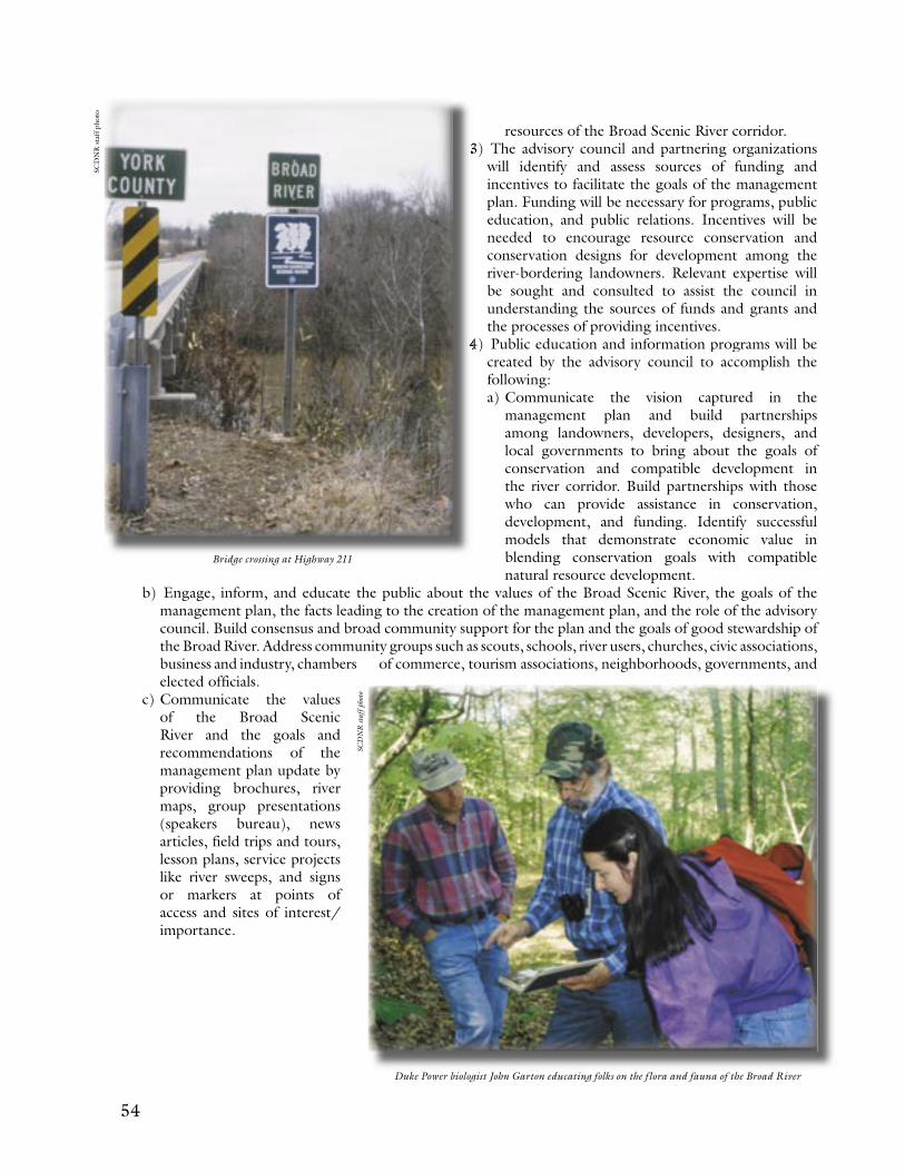
54 55
resources of the Broad Scenic River corridor. 3) The advisory council and partnering organizations
will identify and assess sources of funding and incentives to facilitate the goals of the management plan. Funding will be necessary for programs, public education, and public relations. Incentives will be needed to encourage resource conservation and conservation designs for development among the river-bordering landowners. Relevant expertise will be sought and consulted to assist the council in understanding the sources of funds and grants and the processes of providing incentives.
4) Public education and information programs will be created by the advisory council to accomplish the following: a) Communicate the vision captured in the
management plan and build partnerships among landowners, developers, designers, and local governments to bring about the goals of conservation and compatible development in the river corridor. Build partnerships with those who can provide assistance in conservation, development, and funding. Identify successful models that demonstrate economic value in blending conservation goals with compatible natural resource development.
3) The advisory council and partnering organizations
4) Public education and information programs will be
b) Engage, inform, and educate the public about the values of the Broad Scenic River, the goals of the management plan, the facts leading to the creation of the management plan, and the role of the advisory council. Build consensus and broad community support for the plan and the goals of good stewardship of the Broad River. Address community groups such as scouts, schools, river users, churches, civic associations, business and industry, chambers of commerce, tourism associations, neighborhoods, governments, and elected officials.
c) Communicate the values of the Broad Scenic River and the goals and recommendations of the management plan update by providing brochures, river maps, group presentations (speakers bureau), news articles, field trips and tours, lesson plans, service projects like river sweeps, and signs or markers at points of access and sites of interest/importance.
Bridge crossing at Highway 211
Duke Power biologist John Garton educating folks on the flora and fauna of the Broad River
SCD
NR
sta
ff p
hoto
SCD
NR
staf
f pho
to
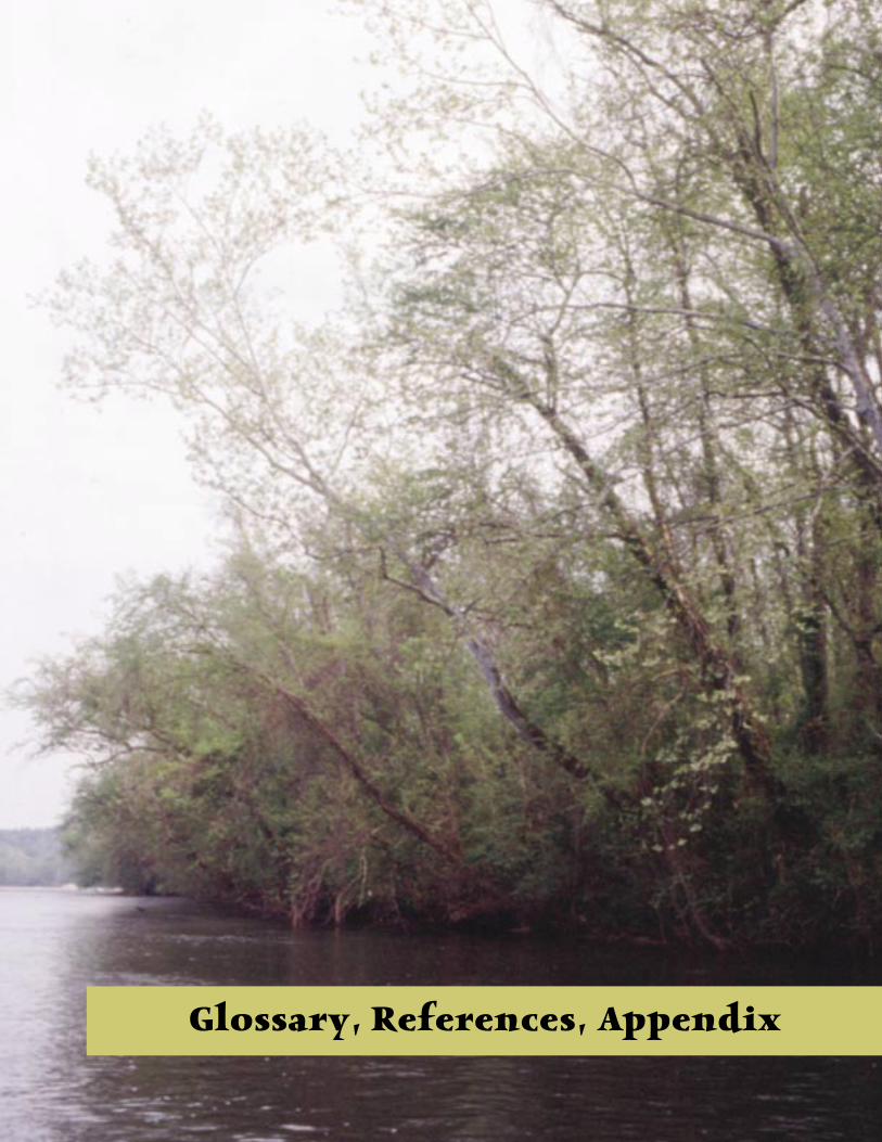
54 55
Glossary, References, Appendix

56 57
GLOSSARYBest management practice (BMP) – a method, activity, maintenance procedure, or other management practice for reducing the amount of pollution entering a water body.
Bluff – a steep riverbank.
Ecosystem – a community of different species interacting with one another and with chemical and physical factors making up their environment.
Erosion – the wearing away of rock or soil by water, wind, ice, and/or other mechanical or chemical forces.
Ford – a place where a river is shallow and can be crossed by wading.
Habitat – the specific area or environment in which a particular type of plant or animal lives (elements of habitat include food, water, and cover).
Impervious surface – a surface area that does not allow water to penetrate into the soil below.
Inundation zone – an area of land that would be flooded should a dam fail.
Monadnock – a single hill or mountain rising conspicuously above the general level of the land.
Nonpoint source pollution- contamination that comes from diffuse, numerous sources, rather than from a specific point such as a pipe.
Redoubt – a breastwork outside a fortification to defend an approach.
Riparian buffer – a strip of natural vegetation along a stream or river. Riparian buffers fulfill three basic roles: maintenance of the hydrologic, hydraulic, and ecological integrity of the stream channel; removal of pollution from runoff; and protection of fish and wildlife.
Riparian zone – at the smallest scale, the riparian zone would be the immediate water’s edge where specialized plants and animals form a distinct community. At a larger scale, it would be the area periodically inundated by high water, i.e., the banks and floodplain of the river. Finally, on the largest scale, it would be the band of forest that has a significant influence on the river ecosystem or conversely is significantly influenced by the river (Hunter, 1990).
Rolling mill –a factory in which metal bars, sheets, etc. are rolled out.
Watershed – an area surrounding and “shedding” water into a stream, river, lake, or wetland.
56 57
REFERENCESAulbach-Smith, Cynthia A., 1999. Land Cover and Vegetation of the Broad River Scenic Corridor South Carolina, submitted to Duke Engineering & Services, Botanical Services of South Carolina.
Bureau of Land Management, 1986. Visual Resource Inventory, BLM Manual Handbook 8410-1, United States Department of the Interior, Bureau of Land Management, Denver, Colorado.
Center for Environmental Policy, 2000. Final Report of the Statewide Task Force on Riparian Forest Buffers, Institute of Public Affairs, University of South Carolina, Columbia, South Carolina.
Cherokee County Citizens Planning Commission and the Appalachian Council of Governments, 1999. 1998 Cherokee County Comprehensive Plan, Gaffney, South Carolina.
Duke Engineering & Services, 1999. Broad River Fish & Habitat Study, conducted by Duke Power Laboratory Services.
Edgar, Walter, 1998. South Carolina A History, University of South Carolina Press, Columbia, South Carolina.
Fabel, Doug and Lisa Hajjar, 1999. 1999 Update, South Carolina Nonpoint Source Management Program, South Carolina Department of Health and Environmental Control, Columbia, South Carolina.
Gaddy, L.L., 1999. Inventory of Rare, Threatened, and Endangered Species and Significant Natural Areas of the Upper Broad River Corridor from Ninety-Nine Islands Lake to Lockhart, South Carolina, submitted to Duke Engineering & Services.
Harvey, Bruce, 2001. An Intensive Architectural Survey of the Gaston Shoals Plant and the Ninety-Nine Islands Plant, Cherokee County, South Carolina.
Hernandez, D., W. Reynolds and L. Hajjar, 1999. Vegetated Riparian Buffers and Buffer Ordinances, South Carolina Department of Health and Environmental Control, Columbia, South Carolina.
Hunter, M. L., Jr. 1990. Wildlife, Forests, and For-estry: Principiles of Managing Forests for Biological Diversity. Englewood Cliffs, New Jersey.
Lee, Edward J. and Jerald L. West, 2001. York and Western York County, The Story of Southern Eden, York, South Carolina.
Lossing, Benson J., 1850. Pictorial Field Book of the Revolution, vol. 2.
Murphy, Carolyn Hanna, 1995. Carolina Rocks! The Geology of South Carolina, Sandlapper Publishing Co., Inc., Orangeburg, South Carolina.
Porcher, Richard D. and Douglas A. Rayner, 2001. A Guide to the Wildflowers of South Carolina, University of South Carolina Press, Columbia, South Carolina.
Rideout, R., 1997. Lynches Scenic River Management Plan, South Carolina Department of Natural Resources, Report No. 15, Columbia, South Carolina.
Scheuler, T.R., 1995. Site Planning for Urban Stream Protection, Center for Watershed Protection, Metropolitan Washington Council of Governments, Silver Spring, Maryland.
Smith, Karen, 1993. Broad River Scenic River Management Plan, South Carolina Water Resources Commission, Report No. 176, Columbia, South Carolina.
South Carolina Department of Health and Environmental Control, 2001. Water Classifications and Standards (Regulation 61-68) / Classified Waters (Regulation 61-69), Bureau of Water, Columbia, South Carolina.
South Carolina Department of Health and Environmental Control, 2001. Watershed Water Quality Assessment: Broad Basin, Bureau of Water Technical Report No. 001-01, Columbia, South Carolina.
South Carolina Department of Health and Environmental Control, 1991. Watershed Water Quality Management Strategy in South Carolina: Program Description, Bureau of Water Pollution Control, Columbia, South Carolina.
South Carolina Department of Health and Environmental Control, 1998. Watershed Water Quality Management Strategy: Broad Basin, Bureau of Water Technical Report No. 001-98,Columbia, South Carolina.
South Carolina Department of Natural Resources, Wildlife Diversity Division, 2001. Personal conversation, internet information, and email correspondence with Julie Holling.
South Carolina Department of Natural Resources, Wildlife Diversity Division, 2002. Personal conversation, internet information, and email correspondence with Jim Sorrow.
58 59
South Carolina Department of Natural Resources, Wildlife and Freshwater Fisheries Division, 2001, 2002 personal conversation, research information, and email correspondence with fish biologists Jason Bettinger and Dick Christie.
South Carolina Forestry Commission, 1998. South Carolina’s Best Management Practices for Forestry, Columbia, South Carolina.
South Carolina Institute of Archaeology and Anthropology, 2001. Information obtained from archaeological site files, Columbia, South Carolina.
South Carolina Water Resources Commission, 1988. South Carolina Rivers Assessment, Report No. 164, Columbia, South Carolina.
South Carolina Water Resources Commission, 1991. South Carolina Scenic Rivers Program Administrative Handbook, Report No. 172, Columbia, South Carolina.
South Carolina Water Resources Commission, 1983. South Carolina State Water Assessment, Report No. 140, Columbia, South Carolina.
United States Census, internet site, 2000 census figures for South Carolina.
The Volunteer Monitor: The National Newsletter of Volunteer Watershed Monitoring. Spring 2001 (www.epa.gov/owow/volunteer/vm_index.html)
Webster’s New World Dictionary, 1974, William Collins and World Publishing Co, Inc.
West, Jerald L. 1996. The Broad River Notebook, York, South Carolina. p. 68-75.
York County Council, 1990. York County Forecast 2010 /The Next Twenty Years, The Final Report, York, South Carolina.
S uc t trr t Broa Rvr lt t Or stry, s f th r t Rvr’s egngs. B ety, ts egngs g ay, ay fr s. T Broa s uc k l grt r. I hs r r s n tce t chng, nre t ts n stremts, n trly ci th cm. W r igte t r th t Broa ci . Lk t l grt r, r igte t gur t vr r ts w sk.
Cry Frn
58 59
APPENDIX
A: The Scenic River Act and Process
(b) is restricted to the area defined in the easement deed;
(c) grants a privilege to those charged with the administration or enforcement of the provisions of this chapter to go upon the land for the purpose of compliance inspection.
(7) ‘River’ means a flowing body of water or a section, portion, or tributary of it including rivers, streams, creeks, branches, or small natural lakes.
(8) ‘Road’ means a highway or any hard-surface road.
Section 49-29-30. Findings and policy.The General Assembly finds that certain selected rivers and river segments of this State possess unique or outstanding scenic, recreational, geologic, botanical, fish, wildlife, historic, or cultural values. It is the policy of the General Assembly to provide for the protection of these selected diminishing values and to preserve the state’s natural heritage for the benefit and enjoyment of present and future generations. The provisions of this chapter complement and are considered part of the State Water Resources Plan as formulated by the department.
Section 49-29-40. Types of rivers eligible for inclusion in scenic rivers program.The following types of rivers are eligible for inclusion in the State Scenic Rivers Program:Natural rivers: those free-flowing rivers or river segments generally inaccessible except by trail or river, with adjacent lands and shorelines essentially undeveloped and its water essentially unpolluted.Scenic rivers: those rivers or river segments which are essentially free flowing and possess shoreline largely undeveloped and with limited road access. Adjacent lands are partially or predominantly used for agriculture, silviculture, or other dispersed human activity which does not disturb substantially the natural character of the river corridor.Recreational rivers: those rivers or river segments accessible by road and that possess development along shorelines and adjacent lands. Included are rivers with developed or partially developed shorelines and adjacent lands for residential, commercial, or industrial purposes, rivers with parallel roads or railroads, and rivers with some impoundments. These
South Carolina Scenic Rivers ActSection 49-29-10. Short title.This chapter may be cited as the ‘South Carolina Scenic Rivers Act of 1989’.
Section 49-29-20. Definitions.Except as otherwise required by the context:(1) ‘Department’ means the Department of Natural
Resources.(2) ‘Free flowing’ means existing or flowing in natural
condition without impoundment, (diversion) straightening, riprapping, or other modification of the waterway. The existence of low dams, diversion works, and other minor structures at the time a river is proposed for inclusion of the State Scenic Rivers Program does not automatically bar its consideration for inclusion, but this may not be construed to authorize, intend, or encourage future construction of those structures within components of the State Scenic Rivers Program.
(3) ‘Management agency’ means the Department of Natural Resources.
(4) ‘Mean highwater line’ means that line which intersects with the shore in tidal waters representing the average height of high waters over an eighteen and one-half year tidal cycle. Benchmarks purporting to have established mean high or low water values must be verified by the department as meeting state and national ocean survey standards.
(5) ‘Ordinary highwater mark’ means the natural or clear line impressed on the shore or bank in nontidal waters representing the ordinary height of water. It may be determined by bank shelving, changes in the character of the soil, destruction or absence of terrestrial vegetation, the presence of litter or debris, or a combination of the above or other appropriate criteria that consider the characteristics of the surrounding area. Ordinary highwater mark is not the line reached by floods, but it is the line to which ordinary high water usually reaches.
(6) ‘Perpetual easement’ means a perpetual right in land of less than fee simple which:(a) obligates the grantor and his heirs and assigns
to certain restrictions constituted to maintain the scenic qualities of those lands bordering the river as determined by the State under this chapter;
60 61
rivers or river segments provide outstanding river-related recreational opportunities.
Section 49-29-50. Inventory and study of rivers; designation of river a eligible state scenic river; proposals for inclusion of additional rivers.(A) The department shall inventory and study all
South Carolina rivers and identify the rivers or river segments which possess unique or outstanding scenic, recreational, geological, botanical, fish, wildlife, historic, or cultural values in accordance with Section 49-29-70.
(B) Rivers or river segments identified in the inventory as possessing unique or outstanding scenic, recreational, geologic, botanical, fish, wildlife, historic, or cultural values are eligible for the State Scenic Rivers Program and may be designated as an eligible state scenic river by the department. Rivers or river segments so designated are subject to the completion of a management plan and the acquisition of management rights on adjacent riparian lands.
(C) Proposals for including additional rivers or river segments may be made by state agencies, local governments, and other governmental or citizen’s groups and submitted to the department for evaluation and study.
Section 49-29-60. Public meeting on proposed designation of river as scenic river. The department shall hold a public meeting in the vicinity of the river or river segment proposed for addition to the State Scenic Rivers Program. This public meeting must be conducted before any action by the department to designate the river or river segment as an eligible state scenic river. The purpose of this meeting is to solicit comments from the public concerning the proposed designation of a river or river segment. Notice of this meeting must be published at least thirty days before the meeting in the State Register and in a newspaper having general circulation in each county containing or bordering the river or river segment under study and in a newspaper having general circulation in the State. Landowners along the proposed river or river segment also must be notified by letter.
Section 49-29-70. Minimum criteria for assessing the river’s eligibility for designation as scenic river. The department shall establish and publish minimum criteria for assessing a river’s eligibility and classification under the State Scenic Rivers Program.
To qualify as eligible, the river or river segment must possess unique or outstanding scenic, recreational, geological, botanical, fish, wildlife, historic or cultural values. The level of pollution of a river’s waters must be considered in determining eligibility for qualification as a scenic river. A river with relatively polluted waters may qualify as eligible as a scenic river if other values are considered outstanding. The river or river segment must be managed permanently for the preservation or enhancement of its values.
Section 49-29-80. Advisory council for designated scenic river. After eligibility procedures for a river or river segment are completed by the department , and the General Assembly ratifies such designation, the department, through the executive director, shall establish an advisory council for that scenic river. The advisory council must be appointed as early as possible to assist the work of the department. Each advisory council must consist of not less than six nor more than ten members who must be selected from local government, riparian landowners, community interests, and the department, whose staff member must serve as chairman. The riparian landowners must constitute a majority of the membership on each council. The duties of the advisory councils are to assist and advise the department concerning protection and management of each scenic river.
Section 49-29-90. Formal action by department required for designation; notice of proposed designation; approval of designation by General Assembly. No river or river segment may be eligible as a state scenic river and accorded the protection of this chapter, except upon formal action by the department. Following action by the department declaring a river or river segment eligible as state scenic river, the department shall publish a notice of the eligibility in the State Register and provide written notice to the State Budget and Control Board, the Department of Revenue and Taxation, and the affected units of local government. Notice of eligibility also must be published in a newspaper of general circulation in the State to apprise interested parties of the opportunities under Section 49-29-100. The notice must describe the boundaries of the river or river segment. Following notice of eligibility, the department shall submit the same to the General Assembly for review. No river or river segment may be designated a state scenic river until the General Assembly has duly enacted legislation ratifying such designation.
60 61
Section 49-29-100. Acquisition of lands adjacent to scenic rivers; donations; requirements; tax treatment of donations; reports; liability of title holders. After ratification by the General Assembly of the designation of a river or river segment as a scenic river under the State Scenic Rivers Program, the State, through the Budget and Control Board, and with the consent of the governing body of the county in which the land is located, may purchase with donated or appropriated funds, exchange lands for, or otherwise accept donations of certain lands adjacent to the eligible river or section of a river either in fee simple or perpetual easement from an owner. Unless unusual circumstances warrant, purchases of land adjacent to scenic and recreational rivers may not be less than one hundred feet in width from the ordinary highwater mark or mean highwater line of the river in normal conditions. Purchases of land for natural rivers may not be less than three hundred feet in width from the ordinary highwater mark or mean highwater line of the river.
For landowners donating perpetual easements to the State under the Scenic Rivers deduction from state income tax may be taken equal to the fair market value of the easement granted. The value of a perpetual easement is determined as the difference between the fair market value of the total property before the land is burdened with the easement and the fair market value of the property after the easement is granted. After the grant of a perpetual easement, land subject to a permanent easement is exempt from all property taxes. Donors of land in fee simple may elect to take a deduction from state income tax equal to the value of the fee donated. For both donations in fee simple or easement, the donor may elect to take the deduction during a five-year period following the donation. The total deduction may be taken during any one year of the five-year period or the deduction may be taken in proportionate amounts during the five-year period. The value of the fee or easement must be assessed at the time of the donation.
Land placed in the Scenic Rivers Program which is owned by the State may be restricted in conformance with this chapter by executed easement or deed restriction executed by the donating agency and approved by the Budget and Control Board.
The Budget and Control Board shall submit annually a report of the property included in the Scenic Rivers Program to the Department of Revenue and Taxation and the auditor of each county in which the property is situated.
The limitations of the liability of titleholders, as
provided under Section 29-3-50, apply to all land purchased or donated in easement under the Scenic Rivers Program.
Section 49-29-110. Scenic Rivers Trust Fund. There is created the Scenic Rivers Trust Fund which must be kept separate from other funds of the State. The fund must be administered by the department for the purpose of acquiring fee simple or lesser interest in land adjacent to scenic river segments, legal fees, appraisals, surveys, or other costs involved in the acquisition of those interests.
Unexpended balances, including interest derived from the fund, must be carried forward each year and used for the purposes provided in this chapter.
No fund money may be expended to acquire an interest in land by eminent domain nor may the funds be expended to acquire interest in land without a recommendation from the board and the approval of the Budget and Control Board.
The department shall report by letter to the presiding officers of the General Assembly and chairmen of the House and Senate Agriculture and National Resources Committees each year all funds expended pursuant to this chapter for the previous year, including the amount of funds expended and the uses to which the expenditures were applied.
The fund is eligible to receive appropriations of the state general funds, federal funds, donations, gifts, bond issue receipts, securities, and other monetary instruments of value. A reimbursement for monies expended from this fund must be deposited in this fund. A fund received through sale, exchange, or otherwise of land acquired under this chapter accrues to the fund.
Section 49-29-120. Acquisition of land by eminent domain prohibited. The lands to be placed in the Scenic Rivers Program may be obtained only from private or corporate owners voluntarily in the manner specified in Section 49-29-100. Neither the State nor an agency or department of it may obtain by eminent domain land for the Scenic Rivers Program either in fee simple or in perpetual easement.
Section 49-29-130. Title of donated land to revert back to donor. Whenever land or a portion of it donated pursuant to this chapter ceases to be used for the purpose for which it was donated, the title to the land reverts to the donor.
62 63
Section 49-29-140. Applicable policies for managing scenic rivers. Management of scenic river areas may differ in degree within a given class of rivers based on the special attributes of the river but must adhere to the following management policies:(1) Natural rivers must be managed in a manner
which:(a) would best maintain and enhance those
conditions which are attributed to wilderness type areas;
(b) would allow camping and river access only at designated public access areas; and
(c) would allow certain public uses only within prescribed public access areas.
(2) Scenic rivers must be managed in a manner which best maintains and enhances the scenic values of the river and the adjacent land while at the same time preserving the right of riparian landowners to use the river for customary agricultural, silvicultural, or other similar purposes.
(3) Recreational rivers must be managed in a manner which would best maintain and enhance the scenic values of the river while at the same time preserving the right of riparian landowners to use the river for customary agricultural, silvicultural, residential, recreational, commercial, and industrial purposes.
To the extent practicable and consistent with the objectives of this chapter to preserve and maintain scenic rivers, public access and use must be open in all classes of scenic rivers. The level and nature of public use must not interfere with the rights retained by the titleholders or detract from the natural scenic qualities of the land, but the State may purchase lands or accept donations of easements, in accordance with Section 49-29-100, which restricts public access and use when necessary to implement this chapter.
Section 49-29-150. Application of provisions regarding restrictive use or zoning of lands. The provisions of this chapter regarding restrictive use or zoning of lands apply only to those lands which have been accepted into the State Scenic Rivers Program by donation, perpetual easement, or purchase.
Section 49-29-160. Comprehensive water and related land use plans. The department shall formulate comprehensive water and related land use plans for the three classes of scenic rivers. Each plan must address access of
electricity, natural gas, and communication lines or other facilities for permitted uses for each class of river facilities. Each plan must also address criteria for permitting the crossing of each class of scenic river by sellers of electric energy, natural gas, or communication services. In developing these criteria, the department must consider the state of available technology, the economics of the various alternatives, and that electric, natural gas, and communication suppliers are required to deliver their services. The department must recognize that emergency situations will arise that require immediate action and must make provision in the management plan to allow this action.
In the comprehensive plan for the river classes, the following general land and water use practices are permitted or prohibited depending on the class:(1) In natural river areas, no new roads or buildings
may be constructed and there may be no mining and no commercial timber harvesting.
(2) In scenic and recreational river areas, the continuation of present agricultural practices such as grazing the propagation of crops, including timer, is permitted. The construction of farm-use buildings is permitted if it is found to be compatible with the maintenance of scenic qualities of the stream and its banks. There may be no construction of roads paralleling the river within the limits of a scenic easement or public access area. The harvesting of timber is permitted provided the landowner follows the best management practices for forested wetlands as approved by the South Carolina Forestry Commission. Mining activities are permitted pursuant to a mining permit issued under the provisions of Chapter 19 of the South Carolina Mining Act. Construction for public access related to recreational use of these scenic river areas is allowed in accordance with Section 49-29140.
Section 49-29-170. Access on, over or under designated rivers by sellers of electric energy, natural gas, or communication services; certificate of consistency.Sellers of electric energy, natural gas, or communication services may cross on, over, or under lands designated as part of the Scenic River System provided that the department certifies that such crossing is consistent with the management plan for those lands. A certificate of consistency shall be issued by the department upon a finding:(1) the crossing is necessary to provide electric,
62 63
natural gas, or communication service and either(a) that the crossing is consistent with the
management plan; or(b) that the extent of deviation from the
management plan for the construction, operation, and maintenance of the facility across the scenic river is justified, considering the state of available technology and the nature and economics of the various alternatives, and that the entity responsible for the encroachment will make reasonable mitigation for the impacts caused by the construction, operation, and maintenance of the facility. The department shall issue a certification of consistency or nonconsistency within thirty days from the receipt of an application. A time extension may be granted upon a mutual agreement of both parties. Certification does not preclude the necessity to obtain other required state and federal authorizations. All administrative proceedings are subject to Article 1, Chapter 23 of Title 1 (the Administrative Procedures Act), as amended.
Section 49-29-180. Administration of chapter; regulations; restrictions on management of scenic rivers.The department shall administer the provisions of this chapter. The department may promulgate regulations to carry out the provisions of this chapter. In addition to general regulations, the department may promulgate further regulations based on the individual attributes of each designated scenic river area if regulations do not defeat, conflict with, or minimize the provisions of the general regulations for each class of scenic river. No scenic river may be managed in a manner that would result in the river corridor falling into a less restrictive class. Nothing in this chapter or its implementation may restrict reasonable utilization of the rivers in the program for fishing from the banks of the rivers or river segments.
Section 49-29-190. Agreements for mutual management of scenic rivers; certain agencies to assist department. The department may enter into agreements with local, state, and federal agencies, and private landowners, for the mutual management of a scenic river. An agency which has administrative jurisdiction over lands or interests in land along a state scenic river must assist the department to implement the policies and practices of this chapter.
Section 49-29-200. Enforcement of provisions of chapter.The Natural Resources Enforcement Division of the Department of Natural Resources and the State Forestry Commission, as well as local sheriffs, constables, and special officers, shall cooperate in the inspection and enforcement of the provisions of this chapter.
Section 49-29-210. Penalties for violations of chapter. A person who violates a provision of this chapter, the regulations promulgated by the management agency under it, or the conditions of the perpetual easements granted to the State under this chapter is guilty of a misdemeanor and may be compelled to comply with or obey the provisions of this chapter by injunction or other appropriate remedy and, upon conviction, must be punished by a fine of not more than five hundred dollars or imprisonment for not more than thirty days for each day of a violation. The provisions of this section do not preclude any applicable action by the Department of Revenue and Taxation to remove or recover property or income tax due it under Section 49-29-100.
Section 49-29-220. Camping activities encouraged at scenic rivers.To the extent practicable and consistent with the objectives of this chapters to preserve and maintain scenic rivers, camping activities are encouraged to be included in the comprehensive management plans of all classes of scenic rivers when that activity does not interfere with the rights retained by the titleholders or detract from the natural scenic qualities of the land.
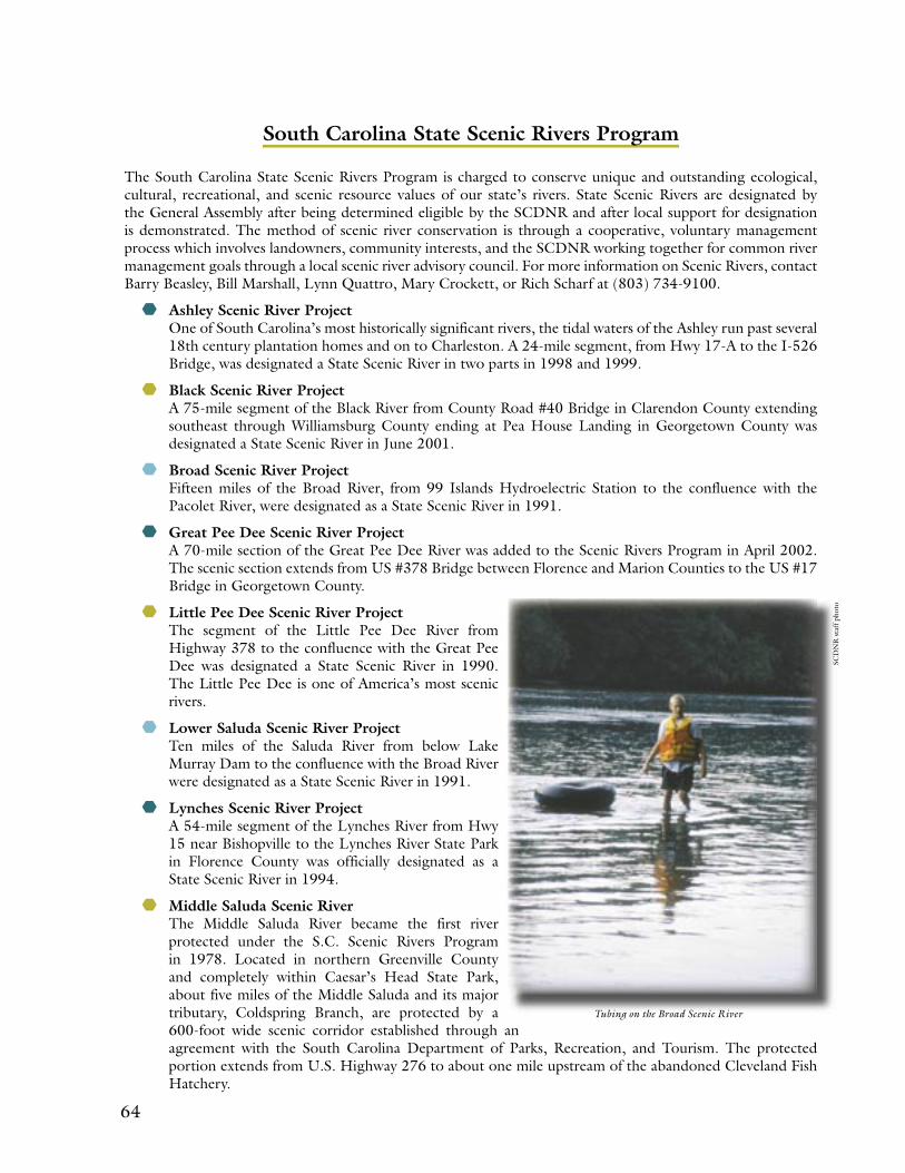
64 65
South Carolina State Scenic Rivers Program
The South Carolina State Scenic Rivers Program is charged to conserve unique and outstanding ecological, cultural, recreational, and scenic resource values of our state’s rivers. State Scenic Rivers are designated by the General Assembly after being determined eligible by the SCDNR and after local support for designation is demonstrated. The method of scenic river conservation is through a cooperative, voluntary management process which involves landowners, community interests, and the SCDNR working together for common river management goals through a local scenic river advisory council. For more information on Scenic Rivers, contact Barry Beasley, Bill Marshall, Lynn Quattro, Mary Crockett, or Rich Scharf at (803) 734-9100.
Ashley Scenic River ProjectOne of South Carolina’s most historically significant rivers, the tidal waters of the Ashley run past several 18th century plantation homes and on to Charleston. A 24-mile segment, from Hwy 17-A to the I-526 Bridge, was designated a State Scenic River in two parts in 1998 and 1999.
Black Scenic River ProjectA 75-mile segment of the Black River from County Road #40 Bridge in Clarendon County extending southeast through Williamsburg County ending at Pea House Landing in Georgetown County was designated a State Scenic River in June 2001.
Broad Scenic River ProjectFifteen miles of the Broad River, from 99 Islands Hydroelectric Station to the confluence with the Pacolet River, were designated as a State Scenic River in 1991.
Great Pee Dee Scenic River ProjectA 70-mile section of the Great Pee Dee River was added to the Scenic Rivers Program in April 2002. The scenic section extends from US #378 Bridge between Florence and Marion Counties to the US #17 Bridge in Georgetown County.
Little Pee Dee Scenic River ProjectThe segment of the Little Pee Dee River from Highway 378 to the confluence with the Great Pee Dee was designated a State Scenic River in 1990. The Little Pee Dee is one of America’s most scenic rivers.
Lower Saluda Scenic River ProjectTen miles of the Saluda River from below Lake Murray Dam to the confluence with the Broad River were designated as a State Scenic River in 1991.
Lynches Scenic River ProjectA 54-mile segment of the Lynches River from Hwy 15 near Bishopville to the Lynches River State Park in Florence County was officially designated as a State Scenic River in 1994.
Middle Saluda Scenic RiverThe Middle Saluda River became the first river protected under the S.C. Scenic Rivers Program in 1978. Located in northern Greenville County and completely within Caesar’s Head State Park, about five miles of the Middle Saluda and its major tributary, Coldspring Branch, are protected by a 600-foot wide scenic corridor established through an agreement with the South Carolina Department of Parks, Recreation, and Tourism. The protected portion extends from U.S. Highway 276 to about one mile upstream of the abandoned Cleveland Fish Hatchery.
Tubing on the Broad Scenic River
SCD
NR
sta
ff p
hoto
64 65
B: Scenic River Best Management Practices
S.C. Department of Natural Resources Scenic Rivers ProgramRecommended Best Management Practices for River-bordering Lands
October 1998
Recognizing that activities on river-bordering land can have a direct and immediate impact on river resources, the S.C. Scenic Rivers Program encourages river-bordering (riparian) landowners to practice wise land and water management to conserve the natural and scenic qualities of the river for themselves and their community.
Riparian landowners are invited to show their support for river conservation by participating in the Scenic Rivers Stewardship Program and adopting best management practices (BMPs) suited to their particular land use. The recommended BMPs listed on the following pages are designed to serve as land management guidelines (they are not regulations) for conserving and enhancing the water quality, wildlife habitats, and scenic character of state-designated scenic river corridors.
To protect and improve water quality, scenic quality, and wildlife habitat, the Scenic Rivers Program has developed BMPs to address several land uses including timber management, various types of agricultural production, and residential and commercial developments. Based on his/her land use objectives, the landowner may adopt the appropriate land management practices to protect and enhance water quality, scenic values, wildlife, or a combination of resource values.
The BMPs serve as the foundation for land management agreements between riparian landowners and the S.C. Scenic Rivers Program. (Land management agreements are an option for landowners who participate in the Scenic Rivers Stewardship Program.) By signing a land management agreement, the landowner agrees to manage his/her river-bordering land for the protection of water quality at a minimum and he/she may choose to implement additional and more conservative BMPs for the protection of scenic values and/or wildlife.
Different sections of a land parcel may be managed for different purposes. For example, a landowner may choose to manage one area for timber, one area for pasture, and another for wildlife. When a landowner has questions or reservations about a particular BMP, the program staff will work with the landowner to determine a mutually satisfactory agreement.
The single-most important BMP for protection of river resources is establishment and/or maintenance of a riparian buffer. A riparian buffer is a strip of land along the banks of a river which is characterized by a growing cover of naturally occurring vegetation. The recommended width of the buffer depends on the management goal.
For protection of water quality, a minimum riparian buffer width of 40 to 80 feet (dependent on slope) on both sides of the stream is recommended (see pages 2 and 3).
To protect aesthetic/scenic values, it is recommended that the riparian buffer be extended to a minimum of 100 feet on both sides of the stream with the first 50 feet remaining undisturbed (see page 4).
To conserve and enhance wildlife diversity, it is recommended that a vegetated riparian buffer measuring at least 100 to 300 feet be established and/or maintained. The wider the buffer, the greater the benefits for wildlife. Ideally, the riparian buffer should include the natural floodplain and adjacent bluff.
The S.C. Scenic Rivers Program advocates a minimum riparian buffer of at least 100 feet on both sides of the river to protect water quality, scenic values, and wildlife habitat.
66 67
Water Quality: Best Management Practices
Resources (DNR) and the Natural Resources Conservation Service (NRCS) in their book entitled Farming for Clean Water in South Carolina: A Handbook of Conservation Practices.
The following BMPs are recommended as essential to the protection of water quality:
Row Crop Production:
• There should be a naturally vegetated riparian buffer of at least 40 feet in width on both sides of all perennial and intermittent streams. Farm fields should never extend to the bank of a stream or drainage ditch.
Where possible, the Scenic Rivers Program advocates a more extensive buffer, a minimum of 100 feet, to allow for additional protection of water quality and preservation of other important values such as aesthetics and wildlife habitat.
• To help keep agricultural chemicals such as fertilizers and pesticides out of the river, a no-till filter strip of at least 15 feet in width is encouraged along both sides of all drainage ditches.
• New drainage ditches should not be constructed in the riparian corridor of State Scenic Rivers. The width of the riparian corridor is defined by the respective scenic river advisory council dependent on the river’s classification (natural, scenic, or recreational). Landowners should be aware that new ditches require a Section 404 permit from the Army Corps of Engineers. In maintaining existing ditches, care should be taken to minimize sediment loading to the river.
• The application of pesticides to farm fields should be according to the principles of integrated pest management:– Apply pesticides only when the economic
benefit of spraying exceeds the cost of spraying.
– Apply pesticides as efficiently as possible and at times when runoff losses are unlikely.
– Triple rinse and dispose of pesticide containers properly. They should never be discarded on a ditch bank, along a stream, or in a wetland.
• When pesticide applications are necessary and a choice of registered materials exists, the landowner should consider the toxicity, runoff potential, and
The following best management practices are grouped by the general land use categories of forest management, agriculture, and urban development. These BMPs are critical to the protection of water quality and are recommended for voluntary implementation by river-bordering landowners:
Forest Management and Water Quality:Forest management activities along State Scenic Rivers should be conducted according to guidelines published by the S.C. Forestry Commission in their book entitled South Carolina’s Best Management Practices for Forestry.
The following BMPs are emphasized as essential to the protection of water quality:
• Land adjacent to perennial, intermittent, and ephemeral streams requires special attention during forestry operations. A riparian buffer, what foresters refer to as a streamside management zone (SMZ), should be identified and protected. At a minimum, the SMZ should be 40 to 80 feet in width on both sides of the stream, dependent on slope.
Where possible, the Scenic Rivers Program advocates a more extensive SMZ, a minimum of 100 feet, to allow for additional protection of water quality and preservation of other important values such as aesthetics and wildlife habitat.
• Forestry operations should be limited in the SMZ. Clear-cuts should never extend to the bank of perennial or intermittent streams.
• Forestry operations should be timed to avoid wet weather and wet soil conditions.
• Forest roads should be designed to minimize the amount of sediment leaving the site and entering stream channels. Road construction in sensitive sites such as the SMZ should be avoided.
• There should be no broadcast application of fertilizer or pesticides in the SMZ.
• River-bordering landowners are encouraged to consult a registered forester for help in long-term forest management planning.
Agriculture and Water Quality:Agricultural activities along State Scenic Rivers
should be conducted according to guidelines published by the S.C. Department of Natural
66 67
leaching potential of the products in making the selection.
• Due to the potential for drift, aerial spraying of pesticides should not be allowed within 100 feet of a scenic river or its tributaries.
• All steps necessary should be taken to control erosion/sedimentation including establishment of perennial vegetative cover to protect the soil; establishment of cover crops that generate nutrients; practicing conservation tillage; and construction of sediment control structures.
• Highly erodible soils should be removed from production.
• With the aid of NRCS and/or extension personnel, farmers should develop and implement nutrient management plans. It is very important to test soil annually and apply nutrients/lime based on the results of the testing.
Livestock/Poultry Production:
• As required by law, any new or expanded animal waste treatment lagoons should not be located within 1/4 mile of waters of the State including perennial streams, major tributaries, and adjacent wetlands. All waste treatment lagoons should have a synthetic liner.
• Animal waste treatment lagoons should not be located within 200 feet of drainage ditches.
• Care should be taken to dispose of waste from confined animal facilities in such a manner as to prevent contamination of surface or ground water. Animal waste sprayfields should not be located within 200 feet of perennial streams, major tributaries, adjacent wetlands, or drainage ditches.
• Pastured or free-roaming animals should not be allowed uncontrolled access to the river, tributaries, or adjacent wetlands. The animals should be fenced out to prevent destruction of the streambank/riparian zone and to prevent contamination of the water from pollutants associated with fecal waste. Where it is necessary to allow access for drinking water, the access should be limited to one location.
Residential/Commercial Development and Water Quality:The Scenic Rivers Program recommends that all residential/commercial development activities in scenic river corridors be conducted according to best
management practices developed by the Environ-mental Protection Agency and the South Carolina Department of Health and Environmental Control (DHEC). Residential/commercial development ac-tivities also include those associated with industrial and municipal development.
The following BMPs are emphasized as essential to the protection of water quality:
• A minimum 40 to 80 foot riparian buffer should be established and maintained along both sides of the river. The buffer should be characterized by native vegetation. Development should be limited in this buffer area. Where possible, the Scenic Rivers Program advocates a more extensive buffer, a minimum of 100 feet, to allow for additional protection of water quality and preservation of other important values such as aesthetics and wildlife habitat.
• New homes (permanent or vacation) should be set back at least 100 feet and lawns should be set back at least 40 feet from the river.
• Septic systems should be set back at least 50 feet from the river as required by existing DHEC guidelines.
• The following practices are encouraged along roads and their right-of-ways:– Adequate culverts should be installed to
manage drainage/runoff.– The area around culverts should be stabilized.– Proper erosion and sediment control measures
should be implemented at all times.– Paved parking areas should not be allowed
within 40 feet of the river when a natural, vegetated buffer is present. In the absence of a buffer, paved parking areas should not be allowed within 100 feet of the river.
– New roads should be set back 100 feet or more from the river.
– Runoff from parking lots and roads should be filtered before entering the river.
– Mowing along roads is preferable to the use of herbicides.
• The handling and disposal of chemicals such as pesticides should be avoided within 100 feet of the river and its tributaries.
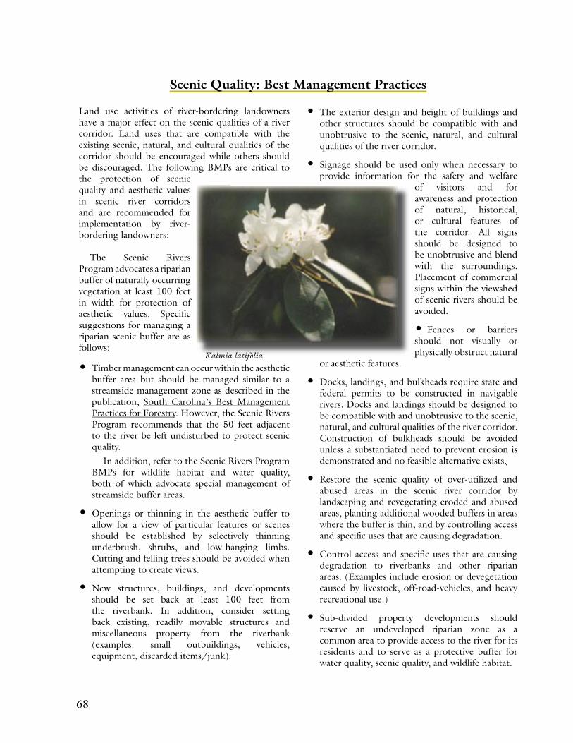
68 69
• The exterior design and height of buildings and other structures should be compatible with and unobtrusive to the scenic, natural, and cultural qualities of the river corridor.
• Signage should be used only when necessary to provide information for the safety and welfare
of visitors and for awareness and protection of natural, historical, or cultural features of the corridor. All signs should be designed to be unobtrusive and blend with the surroundings. Placement of commercial signs within the viewshed of scenic rivers should be avoided.
• Fences or barriers should not visually or physically obstruct natural
or aesthetic features.
• Docks, landings, and bulkheads require state and federal permits to be constructed in navigable rivers. Docks and landings should be designed to be compatible with and unobtrusive to the scenic, natural, and cultural qualities of the river corridor. Construction of bulkheads should be avoided unless a substantiated need to prevent erosion is demonstrated and no feasible alternative exists.
• Restore the scenic quality of over-utilized and abused areas in the scenic river corridor by landscaping and revegetating eroded and abused areas, planting additional wooded buffers in areas where the buffer is thin, and by controlling access and specific uses that are causing degradation.
• Control access and specific uses that are causing degradation to riverbanks and other riparian areas. (Examples include erosion or devegetation caused by livestock, off-road-vehicles, and heavy recreational use.)
• Sub-divided property developments should reserve an undeveloped riparian zone as a common area to provide access to the river for its residents and to serve as a protective buffer for water quality, scenic quality, and wildlife habitat.
Scenic Quality: Best Management Practices
Land use activities of river-bordering landowners have a major effect on the scenic qualities of a river corridor. Land uses that are compatible with the existing scenic, natural, and cultural qualities of the corridor should be encouraged while others should be discouraged. The following BMPs are critical to the protection of scenic quality and aesthetic values in scenic river corridors and are recommended for implementation by river-bordering landowners:
The Scenic Rivers Program advocates a riparian buffer of naturally occurring vegetation at least 100 feet in width for protection of aesthetic values. Specific suggestions for managing a riparian scenic buffer are as follows:
• Timber management can occur within the aesthetic buffer area but should be managed similar to a streamside management zone as described in the publication, South Carolina’s Best Management Practices for Forestry. However, the Scenic Rivers Program recommends that the 50 feet adjacent to the river be left undisturbed to protect scenic quality.
In addition, refer to the Scenic Rivers Program BMPs for wildlife habitat and water quality, both of which advocate special management of streamside buffer areas.
• Openings or thinning in the aesthetic buffer to allow for a view of particular features or scenes should be established by selectively thinning underbrush, shrubs, and low-hanging limbs. Cutting and felling trees should be avoided when attempting to create views.
• New structures, buildings, and developments should be set back at least 100 feet from the riverbank. In addition, consider setting back existing, readily movable structures and miscellaneous property from the riverbank (examples: small outbuildings, vehicles, equipment, discarded items/junk).
Kalmia latifolia

68 69
Wildlife Habitat: Best Management Practices
which advocate special management of streamside buffer areas.
• Uplands adjacent to riparian habitats should be managed in a manner that sustains riparian habitat values.
• Landowners with forested or woodland lots in the river corridor can enhance wildlife diversity on their property by maintaining an understory of native herbaceous and shrub plants, a multi-layered tree canopy, diverse tree sizes, and some standing dead snags and fallen trees.
• Riparian areas that have been devegetated and degraded should be restored by reestablishing the naturally occurring vegetation, particularly where restoration can enhance connectivity between adjacent riparian habitats. Vegetated riparian buffers play an important role in providing natural strips to aid in the movement of wildlife along the river corridor. In addition, vegetated buffers help control water quality problems and fisheries habitat degradation associated with erosion and stormwater runoff, and they maintain the scenic character of the river corridor.
• Maintain large, contiguous blocks of natural habitats and avoid habitat fragmentation that can be caused by permanent land clearing. Enhance the connections between existing natural habitat blocks, particularly to those that are isolated, by establishing forest stands or habitat corridors.
• Landowners should reforest idle/marginal agricultural lands and harvested timberlands. Reforestation may be accomplished through natural regeneration or planting a variety of native species.
• Fences or barriers which create a hindrance to the movement of wildlife should not be constructed in the riparian corridor.
• The use of recreational vehicles in scenic river corridors should be controlled and managed to avoid degradation caused by the destruction of vegetation, erosion of soil, and disturbance of wildlife.
Riparian habitats, or river-bordering habitats, are ecologically diverse and productive places. When managed to conserve natural conditions, riparian habitats can support many wildlife species. The following BMPs are recommended to river-bordering landowners for the protection of wildlife diversity in scenic river corridors:
• To conserve and enhance wildlife diversity, landowners are encouraged to maintain riparian habitat corridors of naturally occurring vegetation along scenic rivers. For the protection of wildlife values, a vegetated buffer measuring at least 100 to 300 feet from the ordinary high water mark is recommended. The wider the buffer, the greater the benefits for wildlife.
(Note: The ordinary high water mark is defined as the natural or clear line impressed on the shore or bank representing the ordinary height of the water. It may be determined by bank shelving, changes in the character of the soil, destruction or absence of vegetation, the presence of litter or debris, or a combination of the above.)
• Timber management can occur within the riparian habitat corridor but should be designed to promote wildlife habitat and diversity. For example:– Maintain the mixed or hardwood forest stands
and other naturally occurring habitats of the river corridor and avoid converting to short rotation monoculture forest stands.
– Leave some groups of mature mast-producing trees such as oak, hickory, and dogwood.
– Maintain stands of trees in a variety of size classes and ages.
– Leave snags and old trees that provide hollow dens and cavities.
– Use prescribed burning to remove thick undergrowth, promote growth of valuable wildlife food such as legumes and hardwood sprouts, and perpetuate fire-dependent species.
– Provide wildlife travel corridors to connect tree stands that are separated by clearings.
– Provide for the special habitat needs of sensitive species located in the area.In addition, refer to the Scenic Rivers Program
BMPs for scenic quality and water quality, both of
70 71
C: Landowner Options for Conservation and Financial Incentives
IntroductionMany landowners along the Broad Scenic River own land that is largely undeveloped and has special natural, pastoral, ecological, and historic resources. These special resources remain intact, thanks to many generations of good stewards. Today’s landowners, interested in continuing the legacy of good stewardship, have a number of options, some of which contain financial incentives, to encourage and ensure ongoing protection of the Broad Scenic River’s natural resources.
All of the options presented below are entirely voluntary for the landowner. Private, voluntary action has proven over time to be the surest protection method against all threats. Note that this Management Plan proposes to preserve and improve the current scenic, historic, and ecological resources of the Broad Scenic River Corridor, and the alternatives listed below are merely presented for information and consideration. Further information may be obtained from attorneys, land trusts, or other entities specializing in conservation.
Options presented include the following:
1. Deed Restrictions2. Conservation Easements3. Purchase of Development Rights4. Fee Simple Donation5. Bargain Sale6. Life Estate or Donation by Will7. Setback and Buffer Guidelines and
Easements8. Limited Development or Conservation
Design
Deed RestrictionsThis is the simplest alternative to enact. The landowner, in conjunction with heirs or assigns, lists the conservation covenants that he or she expects to be fulfilled by all future owners of the property. This is included as a codicil (supplement or appendix) on the deed and recorded. It then has the force of law; however, it begs the question of who will enforce the covenants. It may be advisable to appoint a trustee, usually a corporation that has an extended life, to monitor the property in the future and be ready to enforce the terms of the codicil. There are no tax or financial incentives involved in this option and a fund may need to be set aside to aid in enforcement.
Conservation EasementsThe conservation easement provides a voluntary and flexible means of protecting private property, while designating someone to provide stewardship and enforcement, when necessary. It also usually offers tax incentives. In a conservation easement, the owner and subsequent owners maintain title to the land, but enter into a legally binding contract with a land trust that permanently removes some of the rights to fully develop a property. The landowner promises to preserve the conservation values of the property as outlined in the terms of the agreement, and the land trust is granted the right (and responsibility) to monitor the property and enforce the terms. The owner and heirs may continue to live on the land, use the land for traditional uses (such as farming, hunting, and forest management) and transfer ownership, if desired. The IRS usually considers this a charitable donation and is willing to allow a deduction for the difference in value of the property between its worth if development were allowed and its worth with the restrictions.
The terms of an easement usually include both restrictions and reserved rights. Restrictions generally prohibit industrial and most commercial uses, restrict the number of subdivisions, limit the number and size or nature of structures, docks, roads, etc., and specify that most vegetation, wetlands, topography, hydrology, and significant habitat remain undisturbed. Reserved rights are exceptions to the restrictions and may include the right to farm, manage timber, build a homestead, run home-based businesses, hunt, fish, have stables, and manage the wildlife and ecology. The restrictions are designed to maintain residential and recreational uses, while not limiting the income-producing prospects of the property so severely that it becomes a financial burden on present and future owners.
The landowner is generally responsible for obtaining and paying for attorneys, appraiser, surveyor, and appropriate consultants, as required. However, the tax advantages can offset most if not all of these costs and will carry forward for up to six years (the year of donation, plus five) on federal and state income taxes, should there be insufficient income to carry the entire deduction in one year. There is generally also a reduction in estate taxes and property taxes due to the documented loss in value of the property. Change in value for tax purposes means little in comparison to the worth of ecological

70 71
and scenic values maintained. Some properties with conservation easements have been shown to appreciate in value because of the easement.
Purchase of Development RightsThis alternative involves the outright purchase of the right to develop the property, usually by a conservation-minded second party, who is not interested in developing the land at all. It could be a non-profit corporation or it could be a state or federal agency. Recently passed state legislation known as the Conservation Land Bank Act provides for funds to be used for this purpose, beginning in 2004. The agreement for the purchase of development rights will generally specify the nature and extent of development intended. There are no tax incentives associated with this option, and it is not necessarily permanent, as development rights can be resold at a later date.
Fee Simple DonationOf course, the landowner may donate land to a conservation interest. Under this strategy, all interest in the property or portion of the property is gifted to a land trust or other agency and the charitable contribution reflects the full value of the property. One caveat with this strategy is that title must be clear.
Bargain SaleThis strategy is similar to donation, except it is an actual sale but at or below market value. The difference between the sale price and market value would be a charitable contribution (provided it is made to a qualifying charity or agency) and treated as such for tax purposes.
Life Estate or Donation by WillThere are many options available in estate planning. Either property or easements may be donated at the time of the landowner’s death, both of which will reduce estate taxes. Provisions may be made for a number of options for the landowner’s survivors and heirs. A specific example of this is the Life Estate, where a remainder interest in the property is donated to a land trust, for instance, but a designated family member is given the right to live on and use the property until their death, at which time the land trust acquires full ownership.
Setback and Buffer Guidelines and EasementsShould a landowner decide to develop part of his or her property, it is important to at least comply with the Standards for Voluntary Buffers on a State
Scenic River presented in Appendix B. The essential function of buffers and open space is to reduce the negative effects of development on scenery, water quality, and wildlife habitat; however, these features also enhance the market value of the lots or home sites. Placing setbacks or buffers in conservation easements before selling or developing property can result in some tax offsets to the income derived from the sale or development. As this Management Plan seeks to minimize development impacts to the river corridor, meeting setback and buffer guidelines is recommended as an essential practice for all development.
Limited Development or Conservation DesignLandowners who need to consider selling all or part of their property should be aware of a development technique known as conservation design or limited development. This process allows development in only a limited portion of the property, dedicating the major portion to conservation, usually through the vehicle of an easement. The combination of tax advantages accruing from a conservation easement, the sale of higher-valued, more prestigious lots, and lower development costs can make the financial returns of a limited development option comparable to selling the land outright to a developer. This approach is particularly beneficial to a landowner who may wish for him/herself and his/her family the opportunity to continue living on t he property and enjoying its special resources.
Several conditions are required for the limited development technique to be successful.
The land has significant conservation value (i.e., water edges, wetlands, scenic views, archeological sites, and/or wildlife habitat).
There is little or no debt on the land (easements require subordination).
The land has a high interest for development, causing property values to rise significantly.
When these conditions are met, this form of development can make sense economically as well as preserve much of the property’s conservation values. It can allow someone who is “land-rich” but “cash-poor,” who values their land and wishes to remain on it, to conserve it, obtain some return, and still be able to pass the use and legacy on to his or her heirs.
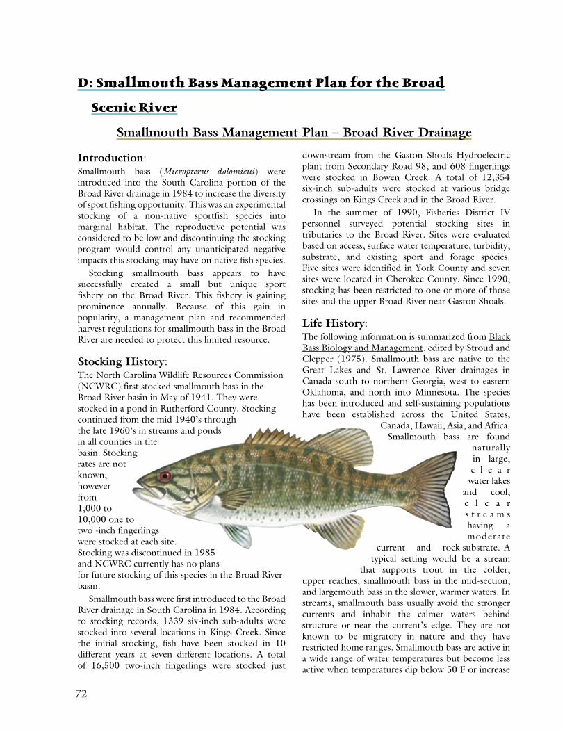
72 73
D: Smallmouth Bass Management Plan for the Broad
Scenic River
Smallmouth Bass Management Plan – Broad River Drainage
Introduction: Smallmouth bass (Micropterus dolomieui) were introduced into the South Carolina portion of the Broad River drainage in 1984 to increase the diversity of sport fishing opportunity. This was an experimental stocking of a non-native sportfish species into marginal habitat. The reproductive potential was considered to be low and discontinuing the stocking program would control any unanticipated negative impacts this stocking may have on native fish species.
Stocking smallmouth bass appears to have successfully created a small but unique sport fishery on the Broad River. This fishery is gaining prominence annually. Because of this gain in popularity, a management plan and recommended harvest regulations for smallmouth bass in the Broad River are needed to protect this limited resource.
Stocking History: The North Carolina Wildlife Resources Commission (NCWRC) first stocked smallmouth bass in the Broad River basin in May of 1941. They were stocked in a pond in Rutherford County. Stocking continued from the mid 1940’s through the late 1960’s in streams and ponds in all counties in the basin. Stocking rates are not known, however from 1,000 to 10,000 one to two -inch fingerlings were stocked at each site. Stocking was discontinued in 1985 and NCWRC currently has no plans for future stocking of this species in the Broad River basin.
Smallmouth bass were first introduced to the Broad River drainage in South Carolina in 1984. According to stocking records, 1339 six-inch sub-adults were stocked into several locations in Kings Creek. Since the initial stocking, fish have been stocked in 10 different years at seven different locations. A total of 16,500 two-inch fingerlings were stocked just
downstream from the Gaston Shoals Hydroelectric plant from Secondary Road 98, and 608 fingerlings were stocked in Bowen Creek. A total of 12,354 six-inch sub-adults were stocked at various bridge crossings on Kings Creek and in the Broad River.
In the summer of 1990, Fisheries District IV personnel surveyed potential stocking sites in tributaries to the Broad River. Sites were evaluated based on access, surface water temperature, turbidity, substrate, and existing sport and forage species. Five sites were identified in York County and seven sites were located in Cherokee County. Since 1990, stocking has been restricted to one or more of those sites and the upper Broad River near Gaston Shoals.
Life History: The following information is summarized from Black Bass Biology and Management, edited by Stroud and Clepper (1975). Smallmouth bass are native to the Great Lakes and St. Lawrence River drainages in Canada south to northern Georgia, west to eastern Oklahoma, and north into Minnesota. The species has been introduced and self-sustaining populations have been established across the United States,
Canada, Hawaii, Asia, and Africa. Smallmouth bass are found
naturally in large, c l e a r
water lakes and cool, c l e a r s t r e a m s having a moderate
current and rock substrate. A typical setting would be a stream
that supports trout in the colder, upper reaches, smallmouth bass in the mid-section, and largemouth bass in the slower, warmer waters. In streams, smallmouth bass usually avoid the stronger currents and inhabit the calmer waters behind structure or near the current’s edge. They are not known to be migratory in nature and they have restricted home ranges. Smallmouth bass are active in a wide range of water temperatures but become less active when temperatures dip below 50 F or increase

72 73
above 85 F. They may lose weight above 95 F. They are spring spawners and move into the spawning grounds when the water temperatures reach 60 F. Soon after they lose their yolksac, bass feed on insect larvae such as midges and mayflies. They are sight feeders, and water clarity is probably an important factor in the success of natural reproduction. Larger fish feed on insects, fish, and crayfish. Smallmouth bass exhibit a wide range of growth rates. Smallmouth grow slower than largemouth bass, and age I, II, and III fish average 3.7, 6.7, and 9.2 inches in total length. One-year old fish grown at the Cheraw Fish Hatchery in South Carolina range from 3 to 7 inches (X=5 inches) and average about 0.1 pounds.
Management: Smallmouth bass were introduced into the Broad River drainage to increase the diversity of sport fishing opportunity. Although habitat is considered to be good in the Kings Creek tributary and satisfactory to marginal in the main river channel, habitat is limited by increased sediment and the resulting impact on turbidity and water temperature. Turbidity is thought to hinder the survival of the eggs by reducing their ability to respire, and to decrease survival of the post sac fry by reducing their ability to see and capture prey. In some years, high water temperature may also impact physiology. Based on limited aquatic surveys, food items do not appear to be a limiting factor in the success of this species. Insects (mayflies and midges), shiners (Notropis sp.), and crayfish are abundant in King’s Creek but less numerous in the Broad River. Growth rates similar to those reported in the literature are expected. A 12–14 inch smallmouth (age V-VI) would be a quality fish and a 16-inch smallmouth would be a memorable fish.
Very little information is currently available regarding the distribution of smallmouth bass to judge the extent at which they will contribute to the sport fishery. A study to evaluate fish species abundance and distribution is ongoing in the Broad River system. Ancedotal information from anglers indicates that the species is concentrated in Kings Creek and above the Lockhart Hydroelectric facility, confined pretty much to where they were stocked. Some anglers have expressed an interest in “protecting” this species before it becomes exploited. The SCDNR has no estimates of angling effort, harvest, growth rates, or mortality from the Broad River population. While the success of this introduction is evaluated, smallmouth bass need to be protected from over harvest. Thus, this proactive recommendation is offered.
Harvest Recommendation: This recommendation is based on the following set of assumptions. 1) The management objective of stocking smallmouth bass in the Broad River is to increase the number of sport species available for recreational fishing. 2) Smallmouth bass are often sought by angling “purists” who use ultra-light tackle or fly rods and practice catch and release. A successful trip for most anglers will be determined by numbers of fish caught rather than the quality of the fish. 3) Production of memorable fish (> 16 in) is limited by habitat. 4) Some smallmouth bass anglers think that the existing regulation of ten black bass per day with no size limit is too liberal. 5) Smallmouth bass handle well and non-harvest fishing mortality is less than 10%. 6) Broad River anglers and enforcement officers can differentiate between largemouth and smallmouth bass. Based on the assumptions listed and the current management philosophy, it is recommended that the SCDNR impose a two fish per day creel limit for smallmouth bass on the Broad River drainage.
Other management recommendations: The following additional recommendations are suggested:
1. Conduct a sport fish creel survey on the Broad River to estimate fishing pressure, harvest, success, and system specific angler information including the quality of fishing for smallmouth bass.
2. Collect life history data to include food habits, age and growth, and reproduction.
3. Continue to stock smallmouth bass annually. Stocking rates are dependant on availability. Historically, 600-800 sub-adult fish have been stocked in the Fall at several locations in Kings Creek. Up to 5,000 fingerlings have been stocked annually in the Spring in the Gaston Shoals vicinity of the Broad River. All stocked fish should be marked.
4. Consider establishing a Broad River Smallmouth Bass Advisory Council or use the Broad Scenic River Advisory Council to solicit public input.

74 75
E: River Safety Plan and Trip List for the Broad Scenic River
Broad Scenic River Emergency and Safety Response Plan
Purpose: To establish guidelines for standards toward the efficient response to emergencies in and adjacent to the Broad Scenic River from the Ninety-Nine Islands Hydroelectric Station to the town of Lockhart, S.C., known as the Broad Scenic River Corridor.
Scope: The Broad Scenic River Corridor may be the location of numerous emergencies. The remote nature of the river corridor, the outdoor activities conducted, and the ever changing river conditions complicate all emergency responses.
The Broad Scenic River from the Ninety-Nine Islands Hydroelectric Station to Lockhart S.C. is a 21-mile section of the river with limited access. The characteristics of the river change from flatwater to Class II whitewater in some locations, depending on the water flow.
Be aware that the river can rise unexpectedly during a heavy rainstorm or when Duke Power releases water through the dam. The upper section of the river is studded with rocks, ledges, and shoals. Large releases can produce strong currents and dangerous conditions around the rocks.
Corridor: Ninety-Nine Islands Hydroelectric Station to Lockhart S.C.
Length: 21 miles
Topographic Maps: Kings Creek, Hickory Grove, and Lockhart
County Maps: Cherokee, Union, and York
Discharge: Gates closed: run of river about 80 cubic feet per second; Gates open: 11,340 cubic feet per second; Flood Stage: Not established
Gradient: 80 feet or 2.5 feet per mile
Difficulty: Fast flatwater; class I, II
Hazards: Swift currents, turbulence created by releases from the dam, shoals along the upper section of the river.
Definitions: Law Enforcement Activities -Situations that arise which require the intervention of a police agency to
mitigate the situation. Law enforcement activities are those that could result in criminal charges and/or investigations or information concerning emergency situations.
Emergency Preparedness -The county agency with the responsibility of coordinating all emergency planning, response and recovery operations (ie. Regulation 58-1 S.C. Code of Law, York County Code of Law Section 6).
Rescue Squad -Civil emergency forces or volunteer departments organized in each county to respond to emergencies, free trapped persons, search for missing persons, and perform activities not assigned to other county departments.
The Emergency Preparedness Agency with jurisdiction or their designee will be responsible for the coordination of response activities (depending on the County Emergency Operations Plan and Standard Operating Procedures). If the emergency, search, etc., expands to another county, all counties will coordinate the response units from their counties. The overall responsibility will rest with the county where the majority of the activity is taking place. The coordinator has the responsibility of keeping the responders, other counties, and law enforcement abreast of all activities associated with the situation.
Upon receiving a call, the receiving agency will obtain as much information as possible. A law enforcement officer will be dispatched and the appropriate Emergency Preparedness office notified. The situation will dictate the nature of the response, number of persons and equipment needed to respond, and the area. Adjoining counties should be notified as soon as possible if they could be involved in the emergency.
Communications: Radio communications will be conducted on the frequencies assigned to the counties for these purposes. Close coordination is essential to the passing of information to responders on various radio systems and channels. The ideal situation is a common radio frequency shared by all response groups.
Missing Persons: In all situations involving missing persons the law
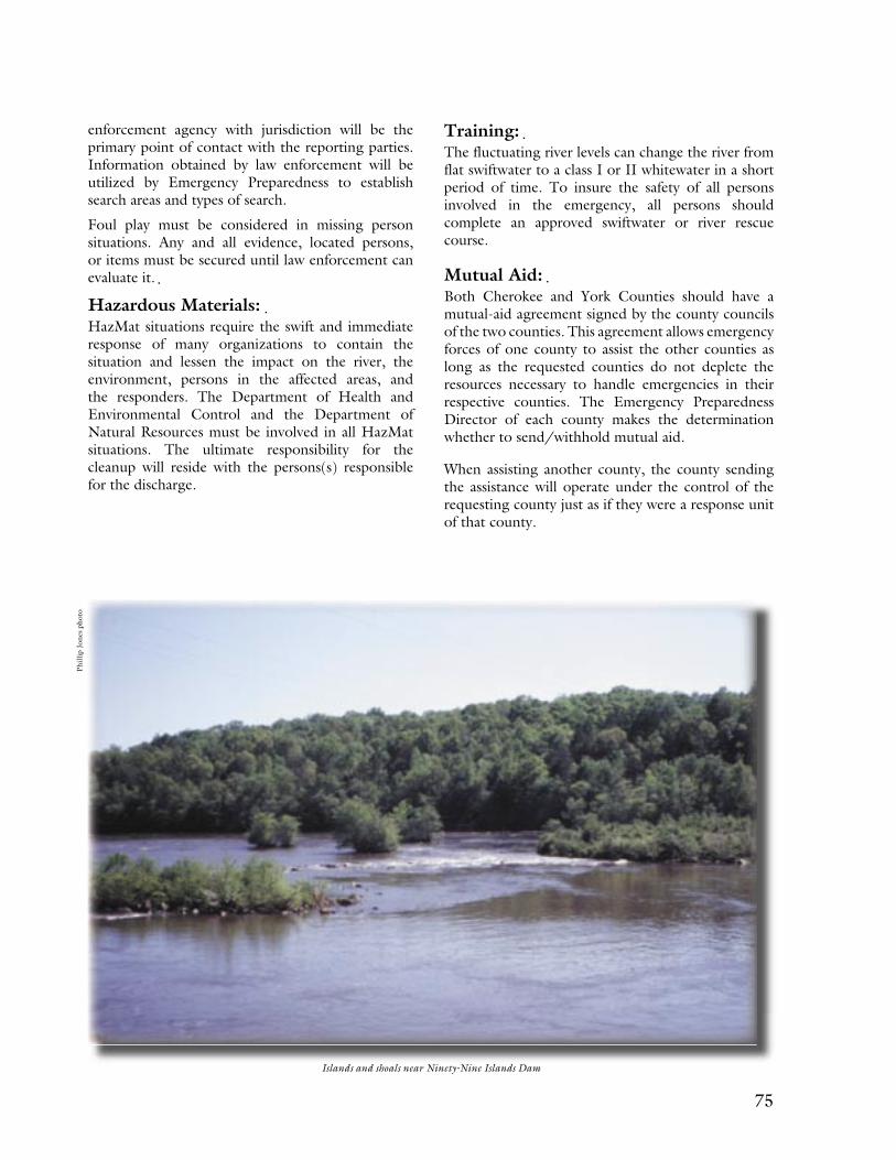
74 75
enforcement agency with jurisdiction will be the primary point of contact with the reporting parties. Information obtained by law enforcement will be utilized by Emergency Preparedness to establish search areas and types of search.
Foul play must be considered in missing person situations. Any and all evidence, located persons, or items must be secured until law enforcement can evaluate it.
Hazardous Materials: HazMat situations require the swift and immediate response of many organizations to contain the situation and lessen the impact on the river, the environment, persons in the affected areas, and the responders. The Department of Health and Environmental Control and the Department of Natural Resources must be involved in all HazMat situations. The ultimate responsibility for the cleanup will reside with the persons(s) responsible for the discharge.
Training: The fluctuating river levels can change the river from flat swiftwater to a class I or II whitewater in a short period of time. To insure the safety of all persons involved in the emergency, all persons should complete an approved swiftwater or river rescue course.
Mutual Aid: Both Cherokee and York Counties should have a mutual-aid agreement signed by the county councils of the two counties. This agreement allows emergency forces of one county to assist the other counties as long as the requested counties do not deplete the resources necessary to handle emergencies in their respective counties. The Emergency Preparedness Director of each county makes the determination whether to send/withhold mutual aid.
When assisting another county, the county sending the assistance will operate under the control of the requesting county just as if they were a response unit of that county.
Islands and shoals near Ninety-Nine Islands Dam
Phill
ip J
ones
pho
to
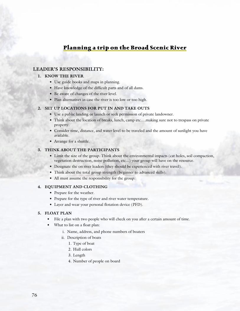
76 7776
Planning a trip on the Broad Scenic River
LEADER’S RESPONSIBILITY:1. KNOW THE RIVER
• Use guide books and maps in planning.• Have knowledge of the difficult parts and of all dams.• Be aware of changes of the river level.• Plan alternatives in case the river is too low or too high.
2. SET UP LOCATIONS FOR PUT IN AND TAKE OUTS• Use a public landing or launch or seek permission of private landowner.• Think about the location of breaks, lunch, camp etc….making sure not to trespass on private
property. • Consider time, distance, and water level to be traveled and the amount of sunlight you have
available.• Arrange for a shuttle.
3. THINK ABOUT THE PARTICIPANTS• Limit the size of the group. Think about the environmental impacts (cat holes, soil compaction,
vegetation destruction, noise pollution, etc...) your group will have on the resource.• Designate the on river leaders (they should be experienced with river travel).• Think about the total group strength (beginner to advanced skills).• All must assume the responsibility for the group.
4. EQUIPMENT AND CLOTHING• Prepare for the weather.• Prepare for the type of river and river water temperature.• Layer and wear your personal flotation device (PFD).
5. FLOAT PLAN• File a plan with two people who will check on you after a certain amount of time.• What to list on a float plan:
i. Name, address, and phone numbers of boaters ii. Description of boats
1. Type of boat2. Hull colors3. Length 4. Number of people on board
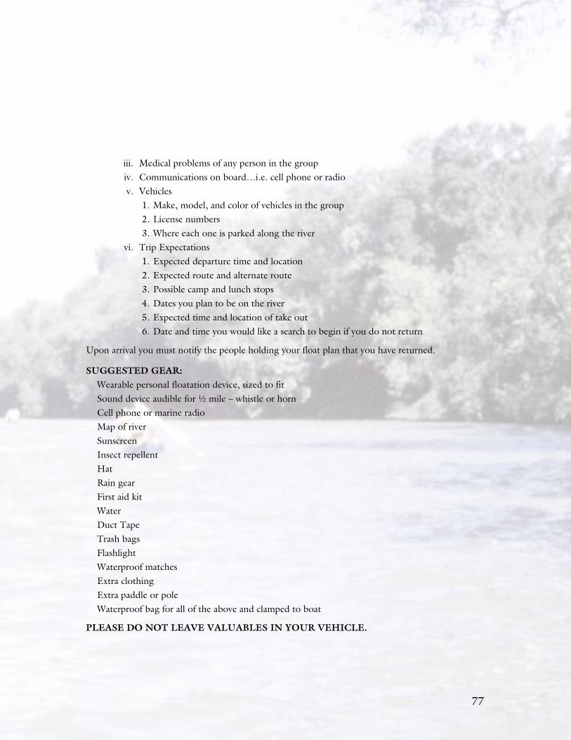
76 7777
iii. Medical problems of any person in the group iv. Communications on board…i.e. cell phone or radio v. Vehicles
1. Make, model, and color of vehicles in the group2. License numbers 3. Where each one is parked along the river
vi. Trip Expectations1. Expected departure time and location2. Expected route and alternate route3. Possible camp and lunch stops4. Dates you plan to be on the river5. Expected time and location of take out6. Date and time you would like a search to begin if you do not return
Upon arrival you must notify the people holding your float plan that you have returned.
SUGGESTED GEAR:Wearable personal floatation device, sized to fitSound device audible for 1⁄2 mile – whistle or hornCell phone or marine radioMap of riverSunscreenInsect repellentHatRain gearFirst aid kitWaterDuct TapeTrash bagsFlashlightWaterproof matches Extra clothing Extra paddle or poleWaterproof bag for all of the above and clamped to boat
PLEASE DO NOT LEAVE VALUABLES IN YOUR VEHICLE.

78 79
Ts vr es gre de t ts strc u. I c ir t t s tey cre t Broa Rvr t g t Bl Kngs Mt Octr t 7t 1780. An I hv joe lerng t rouci r lng ts vr. Ts vr hs rvide ny hrs rein acvv r y ly n ins r ny ers. Bby D. Dnc

78 79

80