Embed Size (px)
Citation preview
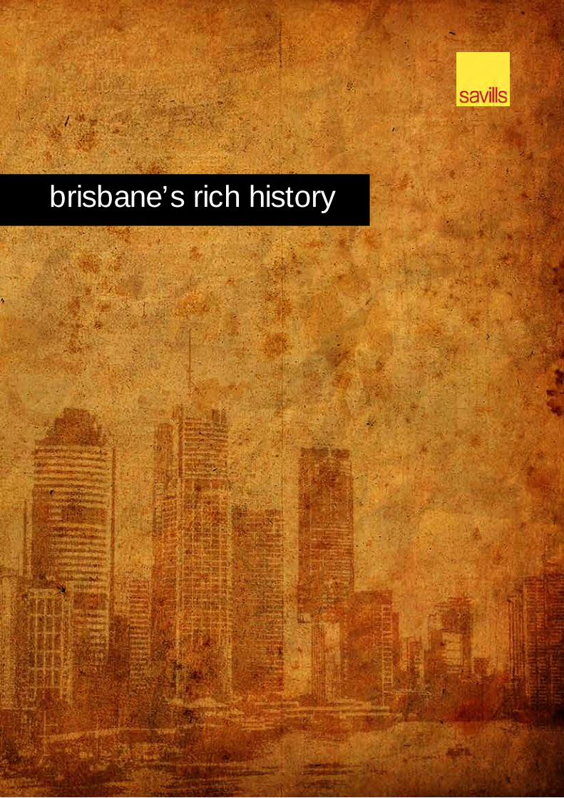
brisbane’s rich history

® Copyright Savills 3
introduction Welcome to this special Savills publication on Brisbane’s Rich History. Honouring the people and places that have developed Brisbane into the thriving modern city that it is today, is important to us. For more than two decades, Savills has taken great care and pride in the responsibility that is bestowed on us to sensitively handle the sale of many historical Brisbane properties and estates. Every historic Brisbane property in every corner of the city has a story to tell and has played an important role in the development of that area and the greater Brisbane region as a whole.
Those who have gone before us continue to live on. They provide a valuable guide and greater depth and understanding to our busy modern-day lives. The generations that stretch back through time are the foundations of our current prosperity and future potential. Honouring our ancestors, the stories of their time and the vital contribution that they made to the Brisbane that we love and enjoy today enriches all of our lives. By remembering and recognising the efforts and achievements of our past, we gain a greater appreciation of what has gone before and the contribution that we can now make.
Savills is committed to ensuring the founding character and colourful stories of the people, places and events of Brisbane’s past are keep alive now and into the future. What we do today, and will strive for in the future, is aligned with the values forged in our past. The more that we learn from history, the greater our connection with these values and pride in our city’s shared successes. We hope you enjoy and are inspired by Brisbane’s Rich History.
This Publication If you would like to recognise your family’s connection with Brisbane or include your property in future publications of Brisbane’s Rich History, please forward the details to [email protected] or contact us at Level 2, Central Plaza II, 66 Eagle Street, Brisbane, QLD 4000 (07) 3221 8355.
Savills Services If we can assist you with ensuring an historic Brisbane property or deceased estate is handled sensitively and appropriately, please contact Robert Dunne at [email protected] or 0418 888 84.
® Copyright Savills 4
Family Index Agnew 15 Albert 37 Bailey 17 Baker 11 Baxter 7 Beirne 39 Bernays 10 Bishop 19 Blakeney 10 Bligh 38 Bliss 12 Bond 14 Bowen 6, 7 Box 9 Bradfield 17 Bruce 6 Campbell-Wilson 11 Chermside 8 Clarke 19 Coombe 36 Corbett 34 Cribb 10 Darragh 18 Dart 34 Davis 17 Denison 22 Diggles 17 Dixon 37 Duhig 12, 21 Duramboi 17 Dutton 10 Ellis 39 Fancutt 20 Fettes 34 Finlayson 12 Fletcher 32 Galloway 35 Gibb 30 Gibbon 12 Graham 6 Gramenz 6 Grant 20 Green 27 Griffith 30 Groom 19 Hamilton 8 Heinecke 10 Hinze 26 Hubbard 38 Hughes 11, 35 Jones 21 Klumpp 33 Landsborough 29 Lavarack 17 Lawson 25 Logan 14, 27 Lutwyche 20, 38
Macansh 10 MacArthur 19 Magee 11 Marchant 9 Mayne 23 McLennan 20 Mein 29 Miller 28 Mitchell 22 Mitchell 35 Murdoch 7 Murphy 29 Nathan 6 Neilson 34 Nicholson 12 Nicklin 32 O’Connell 38 O’Connor 33 O’Neill 20 O’Sullivan 35 Opperman 33 Oxenford 26 Oxley 9, 14 Palmer 9 Pashen 24 Patterson 35 Pegg 23 Peters 27 Piggot 39 Pixley 15 Pugh 25 Robertson 10 Rogers 33 Russell 18 Scanlan 39 Shelley 26 Smith 19 Snow 16, 18 Somerset 38 Stone 33 Tang 37 Thompson 18, 39 Towson 9 Vasey 28 Weedon 11 Wienholt 31 Wight 38 Wilson 34
Contents
® Copyright Savills 5
Suburb Index ashgrove ................................................................ 6
bowen hills ............................................................. 7
chermside .............................................................. 8
corinda ................................................................... 9
dutton park ........................................................... 10
eight mile plains .................................................... 11
enoggera .............................................................. 12
kangaroo point ...................................................... 14
kenmore ............................................................... 19
lutwyche ............................................................... 20
manly ................................................................... 21
mitchelton ............................................................. 22
moorooka ............................................................. 23
morningside .......................................................... 24
oxenford ............................................................... 26
park ridge ............................................................. 27
redcliffe ................................................................ 28
scarborough ......................................................... 29
sherwood ............................................................. 31
stones corners...................................................... 33
st lucia.................................................................. 34
toowong ............................................................... 35
west end .............................................................. 36
windsor ................................................................ 38
woolloongabba ..................................................... 39
® Copyright Savills 6
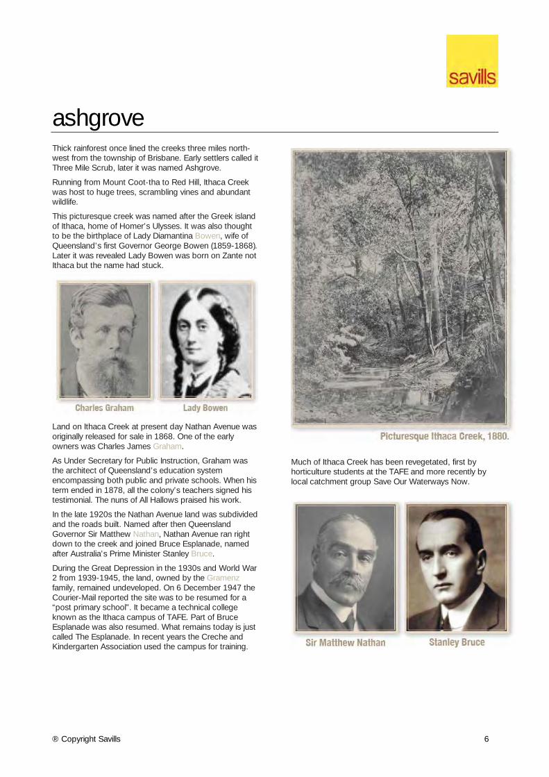
ashgrove Thick rainforest once lined the creeks three miles north-west from the township of Brisbane. Early settlers called it Three Mile Scrub, later it was named Ashgrove.
Running from Mount Coot-tha to Red Hill, Ithaca Creek was host to huge trees, scrambling vines and abundant wildlife.
This picturesque creek was named after the Greek island of Ithaca, home of Homer’s Ulysses. It was also thought to be the birthplace of Lady Diamantina Bowen, wife of Queensland’s first Governor George Bowen (1859-1868). Later it was revealed Lady Bowen was born on Zante not Ithaca but the name had stuck.
Land on Ithaca Creek at present day Nathan Avenue was originally released for sale in 1868. One of the early owners was Charles James Graham.
As Under Secretary for Public Instruction, Graham was the architect of Queensland’s education system encompassing both public and private schools. When his term ended in 1878, all the colony’s teachers signed his testimonial. The nuns of All Hallows praised his work.
In the late 1920s the Nathan Avenue land was subdivided and the roads built. Named after then Queensland Governor Sir Matthew Nathan, Nathan Avenue ran right down to the creek and joined Bruce Esplanade, named after Australia’s Prime Minister Stanley Bruce.
During the Great Depression in the 1930s and World War 2 from 1939-1945, the land, owned by the Gramenz family, remained undeveloped. On 6 December 1947 the Courier-Mail reported the site was to be resumed for a “post primary school”. It became a technical college known as the Ithaca campus of TAFE. Part of Bruce Esplanade was also resumed. What remains today is just called The Esplanade. In recent years the Creche and Kindergarten Association used the campus for training.
Much of Ithaca Creek has been revegetated, first by horticulture students at the TAFE and more recently by local catchment group Save Our Waterways Now.
® Copyright Savills 7
bowen hills Bowen Hills holds an important place in Brisbane’s rich cultural history due to its close links to the city’s industrial and media development, along with exhibition events. The suburb was named after Sir George Bowen, the first Governor of Queensland (1859-68).
As with most cities during the Industrial era, areas close to the central business district were a hub for industry. Bowen Hills was no exception and, with abundant transport facilities, was a popular location for a wide range of industries, including timber yards, soap factories, oil depots and the Mayne locomotive yards.
The Queensland Acclimatisation Society obtained occupancy of Bowen Park in 1862. The area later came under the Royal Queensland National Agricultural and Industrial Society, now known as the RNA Exhibition Grounds and home to the Brisbane cultural icon ‘The Ekka’. In 1866 Bowen Hills was defined as a postal district and settlement generally spread there in the 1870s. A post office was opened in 1878, and the train station in 1882.
The title for 39 Mayne Road, Bowen Hills was first issued to John Baxter in 1859. The Brisbane family known for old money bought the property for eighteen shillings.
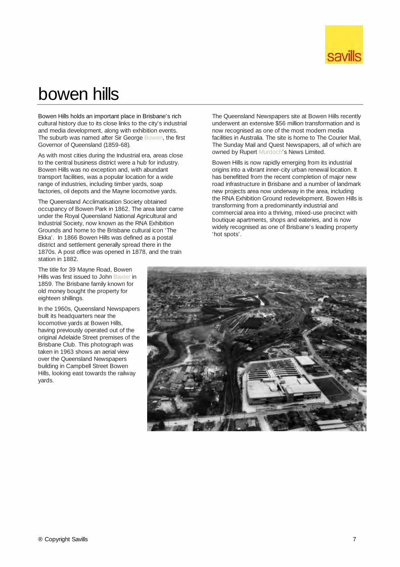
In the 1960s, Queensland Newspapers built its headquarters near the locomotive yards at Bowen Hills, having previously operated out of the original Adelaide Street premises of the Brisbane Club. This photograph was taken in 1963 shows an aerial view over the Queensland Newspapers building in Campbell Street Bowen Hills, looking east towards the railway yards.
The Queensland Newspapers site at Bowen Hills recently underwent an extensive $56 million transformation and is now recognised as one of the most modern media facilities in Australia. The site is home to The Courier Mail, The Sunday Mail and Quest Newspapers, all of which are owned by Rupert Murdoch’s News Limited.
Bowen Hills is now rapidly emerging from its industrial origins into a vibrant inner-city urban renewal location. It has benefitted from the recent completion of major new road infrastructure in Brisbane and a number of landmark new projects area now underway in the area, including the RNA Exhibition Ground redevelopment. Bowen Hills is transforming from a predominantly industrial and commercial area into a thriving, mixed-use precinct with boutique apartments, shops and eateries, and is now widely recognised as one of Brisbane’s leading property ‘hot spots’.
® Copyright Savills 8
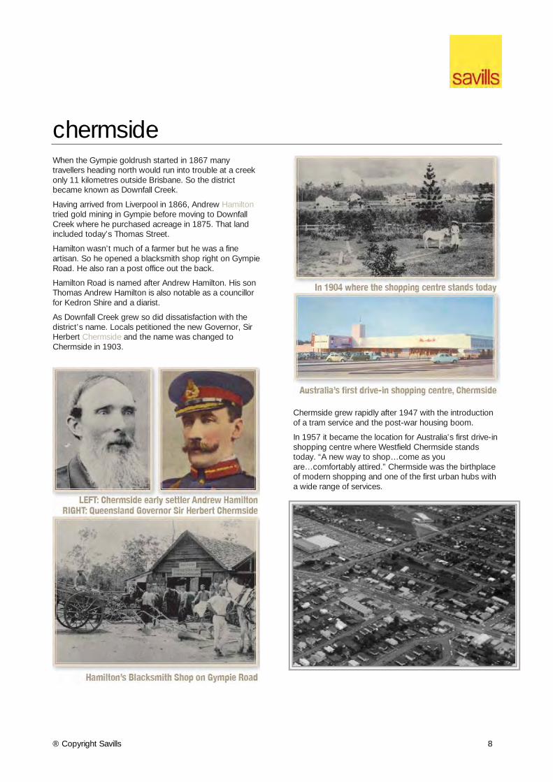
chermside When the Gympie goldrush started in 1867 many travellers heading north would run into trouble at a creek only 11 kilometres outside Brisbane. So the district became known as Downfall Creek.
Having arrived from Liverpool in 1866, Andrew Hamilton tried gold mining in Gympie before moving to Downfall Creek where he purchased acreage in 1875. That land included today’s Thomas Street.
Hamilton wasn’t much of a farmer but he was a fine artisan. So he opened a blacksmith shop right on Gympie Road. He also ran a post office out the back.
Hamilton Road is named after Andrew Hamilton. His son Thomas Andrew Hamilton is also notable as a councillor for Kedron Shire and a diarist.
As Downfall Creek grew so did dissatisfaction with the district’s name. Locals petitioned the new Governor, Sir Herbert Chermside and the name was changed to Chermside in 1903.
Chermside grew rapidly after 1947 with the introduction of a tram service and the post-war housing boom.
In 1957 it became the location for Australia’s first drive-in shopping centre where Westfield Chermside stands today. “A new way to shop…come as you are…comfortably attired.” Chermside was the birthplace of modern shopping and one of the first urban hubs with a wide range of services.
® Copyright Savills 9
corinda Corinda is a part of Brisbane’s rich history. The suburb was reportedly named after a local property owned by Sir Arthur Palmer which he named after his Corinda pastoral station near Aramac. He became Queensland’s fifth premier in 1881 and was buried in Toowong Cemetery in 1898.
Corinda rises up sharply from the Brisbane River as its western boundary and Oxley Creek to the east, a stream originally named by John Oxley in 1824 as Canoe Creek. The stream was renamed Oxley Creek in honour of John Oxley. The area was an early farming locality when land sales began in the 1860s.
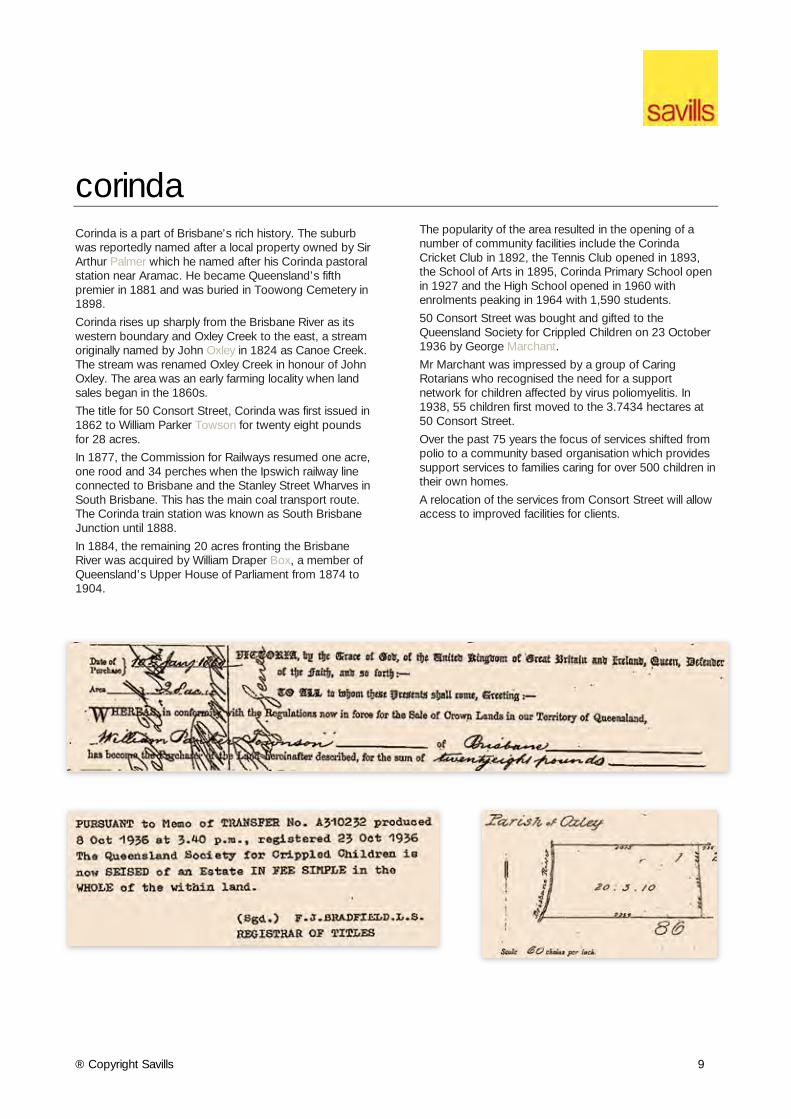
The title for 50 Consort Street, Corinda was first issued in 1862 to William Parker Towson for twenty eight pounds for 28 acres.
In 1877, the Commission for Railways resumed one acre, one rood and 34 perches when the Ipswich railway line connected to Brisbane and the Stanley Street Wharves in South Brisbane. This has the main coal transport route. The Corinda train station was known as South Brisbane Junction until 1888.
In 1884, the remaining 20 acres fronting the Brisbane River was acquired by William Draper Box, a member of Queensland’s Upper House of Parliament from 1874 to 1904.
The popularity of the area resulted in the opening of a number of community facilities include the Corinda Cricket Club in 1892, the Tennis Club opened in 1893, the School of Arts in 1895, Corinda Primary School open in 1927 and the High School opened in 1960 with enrolments peaking in 1964 with 1,590 students.
50 Consort Street was bought and gifted to the Queensland Society for Crippled Children on 23 October 1936 by George Marchant.
Mr Marchant was impressed by a group of Caring Rotarians who recognised the need for a support network for children affected by virus poliomyelitis. In 1938, 55 children first moved to the 3.7434 hectares at 50 Consort Street.
Over the past 75 years the focus of services shifted from polio to a community based organisation which provides support services to families caring for over 500 children in their own homes.
A relocation of the services from Consort Street will allow access to improved facilities for clients.
® Copyright Savills 10
dutton park When Brisbane was still part of New South Wales, the colony’s most prominent and influential citizens were acquiring land and building grand homes along what it is now known as Gladstone Road Dutton Park.
In December 1858 Robert Cribb acquired more than 17 acres of prime land in South Brisbane between the Brisbane River and Ipswich Road, later renamed Gladstone Road after the British Prime Minister.
Born in England in 1805, Cribb migrated to Brisbane in 1849, set up a bakery in Queen Street and began acquiring land. He was a councillor, a member of NSW Parliament and a keen advocate of Queensland becoming a separate colony. Following separation in 1859 Cribb was elected a member of Queensland Parliament.
Cribb would have known Lewis Bernays who was appointed first clerk of the Queensland Parliament in 1860. Privately, Bernays was a keen advocate of introducing “useful plants” to Queensland.
With business partner, William Blakeney, Bernays purchased the Gladstone Road land from Cribb in 1863. Blakeney would go on to become Registrar- General overseeing registration of births, deaths and marriages in Queensland. Bernays and Blakeney set about subdividing their land.
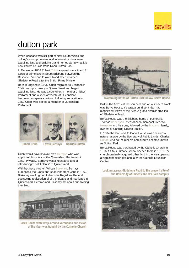
Built in the 1870s at the southern end on a six-acre block was Borva House. It’s wraparound verandah had magnificent views of the river. A grand circular drive led off Gladstone Road.
Borva House was the Brisbane home of pastoralist Thomas Robertson, later tobacco merchant Frederick Heinecke and his sons, followed by the Macansh family, owners of Canning Downs Station.
In 1884 the land next to Borva House was declared a nature reserve by the Secretary of Public Lands, Charles Dutton. And so the reserve and suburb became known as Dutton Park.
Borva House was purchased by the Catholic Church in 1916. St Ita’s Primary School opened there in 1919. The church gradually acquired other land in the area opening a high school for girls and later the Catholic Education Centre.
® Copyright Savills 11
eight mile plains Eight Mile Plains was on of Brisbane’s suburbs first to be settled.
In 1857 Charles Baker bought land from a sheep herder named Wilson. Fox hunting developed on the Baker property and he also turned his land to construction, building a hotel. In 1868 he became postmaster at Eight Mile Plains. His services were called upon when the Cobb and Co. services started a regular run through Eight Mile Plains to the Logan and Nerang River Settlements.
Fred Hughes was a horse-dealer and livery stables keeper, resident in Brisbane from at least 1871, when he purchased land in Charlotte Street. He had established a livery stables on this site by 1874. In the mid-1880s, Hughes and his family moved to Upper Mt Gravatt, where they owned a property at the corner of Kessels and Logan Roads.
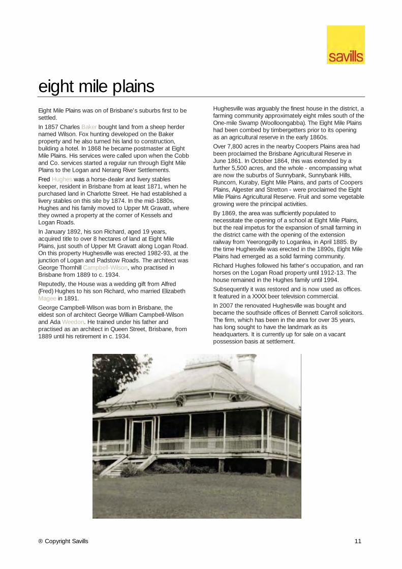
In January 1892, his son Richard, aged 19 years, acquired title to over 8 hectares of land at Eight Mile Plains, just south of Upper Mt Gravatt along Logan Road. On this property Hughesville was erected 1982-93, at the junction of Logan and Padstow Roads. The architect was George Thornhill Campbell-Wilson, who practised in Brisbane from 1889 to c. 1934.
Reputedly, the House was a wedding gift from Alfred (Fred) Hughes to his son Richard, who married Elizabeth Magee in 1891. George Campbell-Wilson was born in Brisbane, the eldest son of architect George William Campbell-Wilson and Ada Weedon. He trained under his father and practised as an architect in Queen Street, Brisbane, from 1889 until his retirement in c. 1934.
Hughesville was arguably the finest house in the district, a farming community approximately eight miles south of the One-mile Swamp (Woolloongabba). The Eight Mile Plains had been combed by timbergetters prior to its opening as an agricultural reserve in the early 1860s.
Over 7,800 acres in the nearby Coopers Plains area had been proclaimed the Brisbane Agricultural Reserve in June 1861. In October 1864, this was extended by a further 5,500 acres, and the whole - encompassing what are now the suburbs of Sunnybank, Sunnybank Hills, Runcorn, Kuraby, Eight Mile Plains, and parts of Coopers Plains, Algester and Stretton - were proclaimed the Eight Mile Plains Agricultural Reserve. Fruit and some vegetable growing were the principal activities.
By 1869, the area was sufficiently populated to necessitate the opening of a school at Eight Mile Plains, but the real impetus for the expansion of small farming in the district came with the opening of the extension railway from Yeerongpilly to Loganlea, in April 1885. By the time Hughesville was erected in the 1890s, Eight Mile Plains had emerged as a solid farming community.
Richard Hughes followed his father's occupation, and ran horses on the Logan Road property until 1912-13. The house remained in the Hughes family until 1994.
Subsequently it was restored and is now used as offices. It featured in a XXXX beer television commercial.
In 2007 the renovated Hughesville was bought and became the southside offices of Bennett Carroll solicitors. The firm, which has been in the area for over 35 years, has long sought to have the landmark as its headquarters. It is currently up for sale on a vacant possession basis at settlement.
® Copyright Savills 12
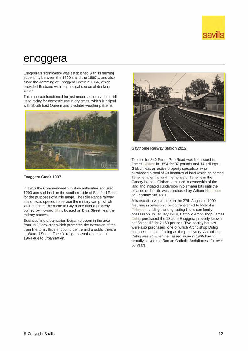
enoggera Enoggera’s significance was established with its farming superiority between the 1850’s and the 1860’s, and also since the damming of Enoggera Creek in 1866, which provided Brisbane with its principal source of drinking water.
This reservoir functioned for just under a century but it still used today for domestic use in dry times, which is helpful with South East Queensland’s volatile weather patterns.
Enoggera Creek 1907
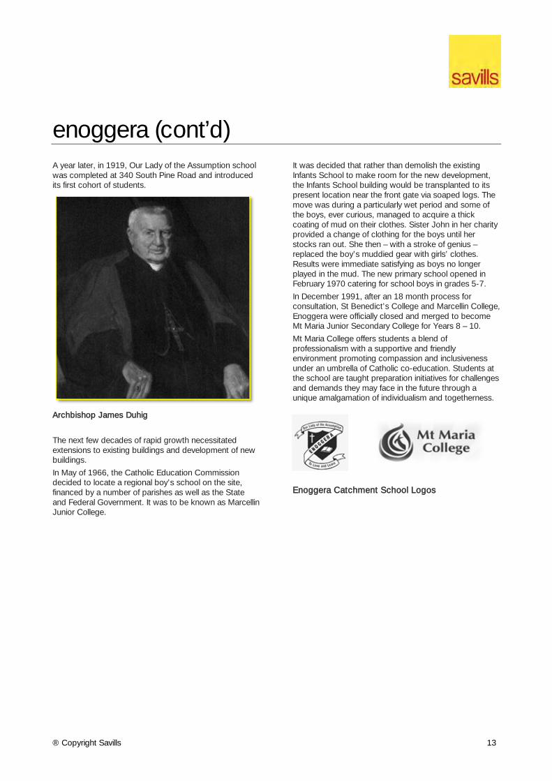
In 1916 the Commonwealth military authorities acquired 1200 acres of land on the southern side of Samford Road for the purposes of a rifle range. The Rifle Range railway station was opened to service the military camp, which later changed the name to Gaythorne after a property owned by Howard Bliss, located on Bliss Street near the military reserve.
Business and urbanisation began to boom in the area from 1925 onwards which prompted the extension of the tram line to a village shopping centre and a public theatre at Wardell Street. The rifle range ceased operation in 1964 due to urbanisation.
Gaythorne Railway Station 2012
The title for 340 South Pine Road was first issued to James Gibbon in 1854 for 37 pounds and 14 shillings. Gibbon was an active property speculator who purchased a total of 48 hectares of land which he named Tenerife, after his fond memories of Tenerife in the Canary Islands. Gibbon remained in ownership of the land and initiated subdivision into smaller lots until the balance of the site was purchased by William Nicholson on February 5th 1881.
A transaction was made on the 27th August in 1909 resulting in ownership being transferred to Malcolm Finlayson, ending the long lasting Nicholson family possession. In January 1918, Catholic Archbishop James Duhig purchased the 13 acre Enoggera property known as ‘Shine Hill’ for 2,150 pounds. Two nearby houses were also purchased, one of which Archbishop Duhig had the intention of using as the presbytery. Archbishop Duhig was 94 when he passed away in 1965 having proudly served the Roman Catholic Archdiocese for over 68 years.
® Copyright Savills 13
enoggera (cont’d) A year later, in 1919, Our Lady of the Assumption school was completed at 340 South Pine Road and introduced its first cohort of students.
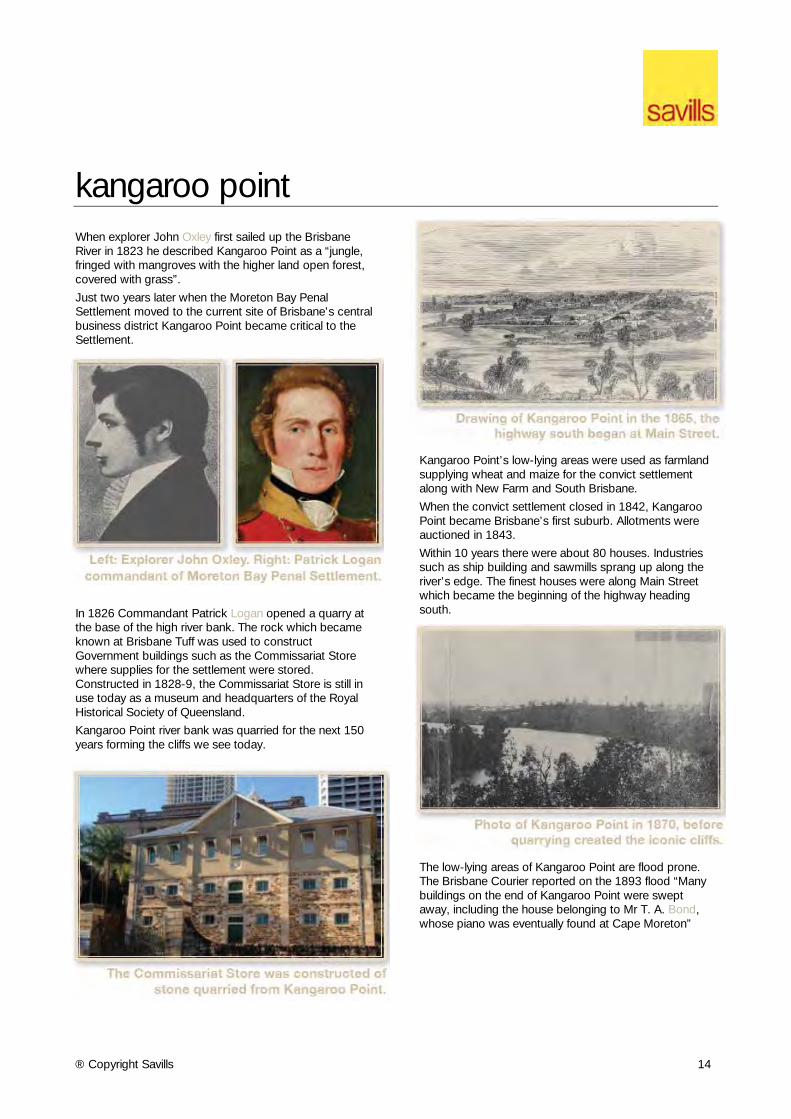
Archbishop James Duhig
The next few decades of rapid growth necessitated extensions to existing buildings and development of new buildings.
In May of 1966, the Catholic Education Commission decided to locate a regional boy’s school on the site, financed by a number of parishes as well as the State and Federal Government. It was to be known as Marcellin Junior College.
It was decided that rather than demolish the existing Infants School to make room for the new development, the Infants School building would be transplanted to its present location near the front gate via soaped logs. The move was during a particularly wet period and some of the boys, ever curious, managed to acquire a thick coating of mud on their clothes. Sister John in her charity provided a change of clothing for the boys until her stocks ran out. She then – with a stroke of genius – replaced the boy’s muddied gear with girls’ clothes. Results were immediate satisfying as boys no longer played in the mud. The new primary school opened in February 1970 catering for school boys in grades 5-7.
In December 1991, after an 18 month process for consultation, St Benedict’s College and Marcellin College, Enoggera were officially closed and merged to become Mt Maria Junior Secondary College for Years 8 – 10.
Mt Maria College offers students a blend of professionalism with a supportive and friendly environment promoting compassion and inclusiveness under an umbrella of Catholic co-education. Students at the school are taught preparation initiatives for challenges and demands they may face in the future through a unique amalgamation of individualism and togetherness.
Enoggera Catchment School Logos
® Copyright Savills 14
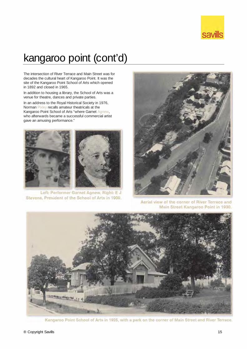
kangaroo point When explorer John Oxley first sailed up the Brisbane River in 1823 he described Kangaroo Point as a “jungle, fringed with mangroves with the higher land open forest, covered with grass”.
Just two years later when the Moreton Bay Penal Settlement moved to the current site of Brisbane’s central business district Kangaroo Point became critical to the Settlement.
In 1826 Commandant Patrick Logan opened a quarry at the base of the high river bank. The rock which became known at Brisbane Tuff was used to construct Government buildings such as the Commissariat Store where supplies for the settlement were stored. Constructed in 1828-9, the Commissariat Store is still in use today as a museum and headquarters of the Royal Historical Society of Queensland.
Kangaroo Point river bank was quarried for the next 150 years forming the cliffs we see today.
Kangaroo Point’s low-lying areas were used as farmland supplying wheat and maize for the convict settlement along with New Farm and South Brisbane.
When the convict settlement closed in 1842, Kangaroo Point became Brisbane’s first suburb. Allotments were auctioned in 1843.
Within 10 years there were about 80 houses. Industries such as ship building and sawmills sprang up along the river’s edge. The finest houses were along Main Street which became the beginning of the highway heading south.
The low-lying areas of Kangaroo Point are flood prone. The Brisbane Courier reported on the 1893 flood “Many buildings on the end of Kangaroo Point were swept away, including the house belonging to Mr T. A. Bond, whose piano was eventually found at Cape Moreton”
® Copyright Savills 15
kangaroo point (cont’d) The intersection of River Terrace and Main Street was for decades the cultural heart of Kangaroo Point. It was the site of the Kangaroo Point School of Arts which opened in 1892 and closed in 1965.
In addition to housing a library, the School of Arts was a venue for theatre, dances and private parties.
In an address to the Royal Historical Society in 1976, Norman Pixley recalls amateur theatricals at the Kangaroo Point School of Arts “where Garnet Agnew, who afterwards became a successful commercial artist gave an amusing performance.”
® Copyright Savills 16
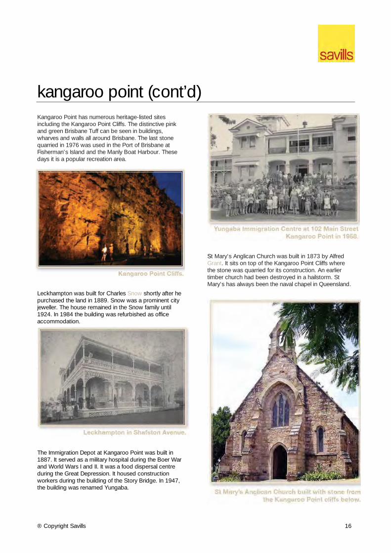
kangaroo point (cont’d) Kangaroo Point has numerous heritage-listed sites including the Kangaroo Point Cliffs. The distinctive pink and green Brisbane Tuff can be seen in buildings, wharves and walls all around Brisbane. The last stone quarried in 1976 was used in the Port of Brisbane at Fisherman’s Island and the Manly Boat Harbour. These days it is a popular recreation area.
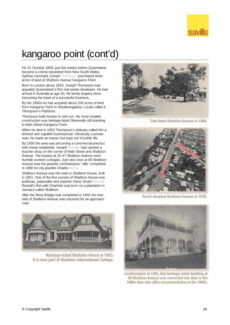
Leckhampton was built for Charles Snow shortly after he purchased the land in 1889. Snow was a prominent city jeweller. The house remained in the Snow family until 1924. In 1984 the building was refurbished as office accommodation.
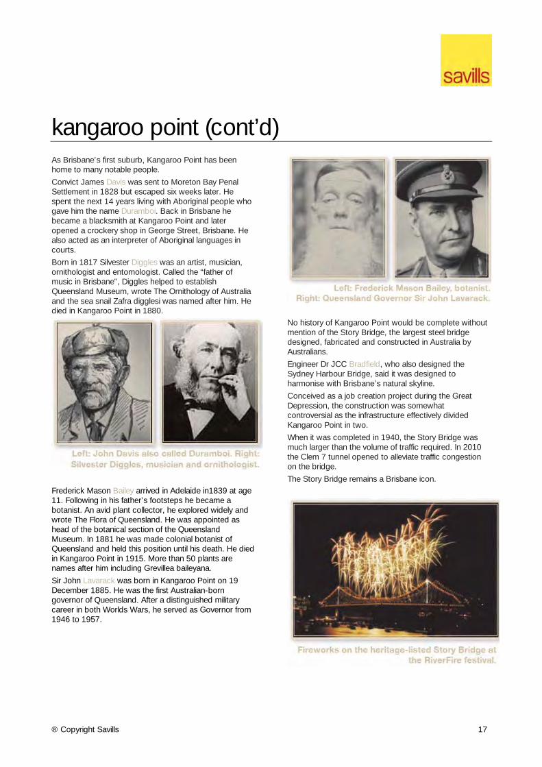
The Immigration Depot at Kangaroo Point was built in 1887. It served as a military hospital during the Boer War and World Wars I and II. It was a food dispersal centre during the Great Depression. It housed construction workers during the building of the Story Bridge. In 1947, the building was renamed Yungaba.
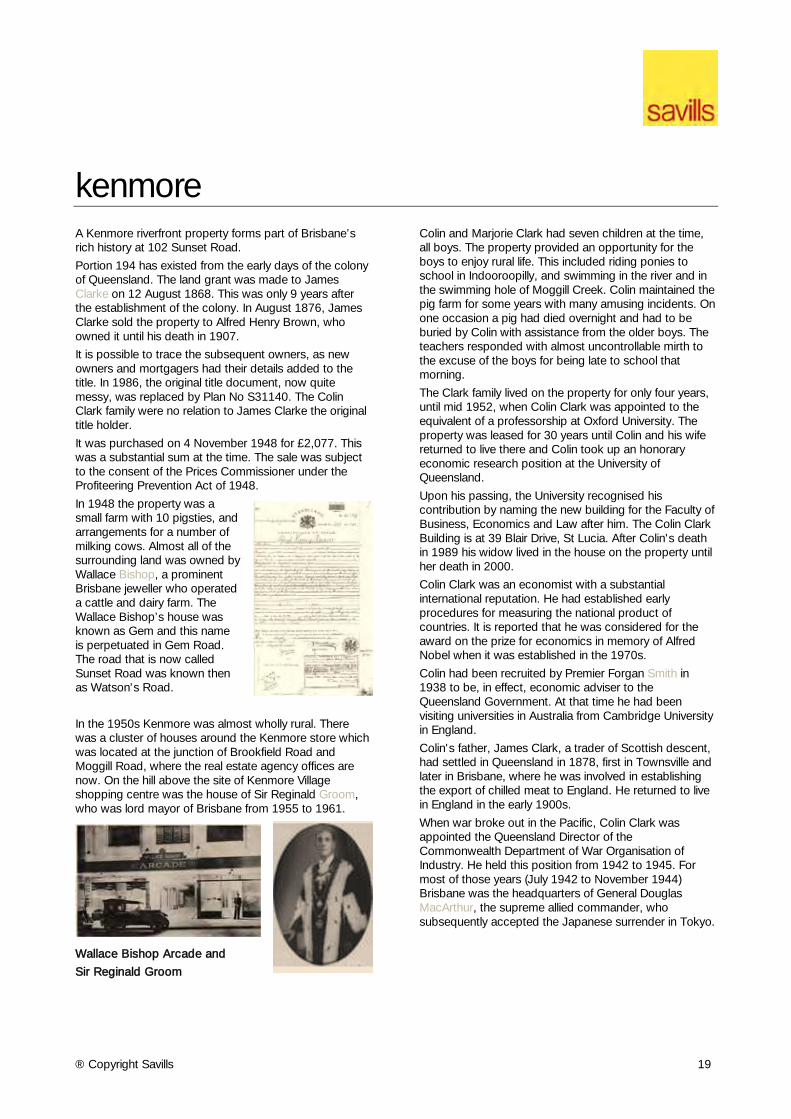
St Mary’s Anglican Church was built in 1873 by Alfred Grant. It sits on top of the Kangaroo Point Cliffs where the stone was quarried for its construction. An earlier timber church had been destroyed in a hailstorm. St Mary’s has always been the naval chapel in Queensland.
® Copyright Savills 17
kangaroo point (cont’d) As Brisbane’s first suburb, Kangaroo Point has been home to many notable people.
Convict James Davis was sent to Moreton Bay Penal Settlement in 1828 but escaped six weeks later. He spent the next 14 years living with Aboriginal people who gave him the name Duramboi. Back in Brisbane he became a blacksmith at Kangaroo Point and later opened a crockery shop in George Street, Brisbane. He also acted as an interpreter of Aboriginal languages in courts.
Born in 1817 Silvester Diggles was an artist, musician, ornithologist and entomologist. Called the “father of music in Brisbane”, Diggles helped to establish Queensland Museum, wrote The Ornithology of Australia and the sea snail Zafra digglesi was named after him. He died in Kangaroo Point in 1880.
Frederick Mason Bailey arrived in Adelaide in1839 at age 11. Following in his father’s footsteps he became a botanist. An avid plant collector, he explored widely and wrote The Flora of Queensland. He was appointed as head of the botanical section of the Queensland Museum. In 1881 he was made colonial botanist of Queensland and held this position until his death. He died in Kangaroo Point in 1915. More than 50 plants are names after him including Grevillea baileyana.
Sir John Lavarack was born in Kangaroo Point on 19 December 1885. He was the first Australian-born governor of Queensland. After a distinguished military career in both Worlds Wars, he served as Governor from 1946 to 1957.
No history of Kangaroo Point would be complete without mention of the Story Bridge, the largest steel bridge designed, fabricated and constructed in Australia by Australians.
Engineer Dr JCC Bradfield, who also designed the Sydney Harbour Bridge, said it was designed to harmonise with Brisbane’s natural skyline.
Conceived as a job creation project during the Great Depression, the construction was somewhat controversial as the infrastructure effectively divided Kangaroo Point in two.
When it was completed in 1940, the Story Bridge was much larger than the volume of traffic required. In 2010 the Clem 7 tunnel opened to alleviate traffic congestion on the bridge.
The Story Bridge remains a Brisbane icon.
® Copyright Savills 18
kangaroo point (cont’d) On 31 October 1859, just five weeks before Queensland became a colony separated from New South Wales, Sydney merchant Joseph Thompson purchased three acres of land at Shafston Avenue Kangaroo Point.
Born in London about 1819, Joseph Thompson was arguably Queensland’s first real-estate developer. He had arrived in Australia at age 20, his family drapery store becoming the basis of a successful business.
By the 1860s he had acquired about 200 acres of land from Kangaroo Point to Woolloongabba. Locals called it Thompson’s Paddock.
Thompson built houses to rent out. His most notable construction was heritage-listed Silverwells still standing in Main Street Kangaroo Point.
When he died in 1902 Thompson’s obituary called him a shrewd and capable businessman. Obviously a private man, he made an impact but kept out of public life.
By 1900 the area was becoming a commercial precinct with mixed residential. Joseph Darragh had opened a butcher shop on the corner of Main Street and Shafston Avenue. The houses at 25-47 Shafston Avenue were humble workers cottages. Just next door at 69 Shafston Avenue was the grander Leckhampton “villa” completed in 1890 for city jeweller Charles Snow.
Shafston Avenue was the road to Shafston House, built in 1851. One of the first owners of Shafston House was politician, pastoralist and explorer Henry Stuart Russell. Russell’s first wife Charlotte was born on a plantation in Jamaica called Shafston.
After the Story Bridge was completed in 1940 the river side of Shafston Avenue was resumed for an approach road.
.
® Copyright Savills 19
kenmore A Kenmore riverfront property forms part of Brisbane’s rich history at 102 Sunset Road.
Portion 194 has existed from the early days of the colony of Queensland. The land grant was made to James Clarke on 12 August 1868. This was only 9 years after the establishment of the colony. In August 1876, James Clarke sold the property to Alfred Henry Brown, who owned it until his death in 1907.
It is possible to trace the subsequent owners, as new owners and mortgagers had their details added to the title. In 1986, the original title document, now quite messy, was replaced by Plan No S31140. The Colin Clark family were no relation to James Clarke the original title holder.
It was purchased on 4 November 1948 for £2,077. This was a substantial sum at the time. The sale was subject to the consent of the Prices Commissioner under the Profiteering Prevention Act of 1948.
In 1948 the property was a small farm with 10 pigsties, and arrangements for a number of milking cows. Almost all of the surrounding land was owned by Wallace Bishop, a prominent Brisbane jeweller who operated a cattle and dairy farm. The Wallace Bishop’s house was known as Gem and this name is perpetuated in Gem Road. The road that is now called Sunset Road was known then as Watson's Road.
In the 1950s Kenmore was almost wholly rural. There was a cluster of houses around the Kenmore store which was located at the junction of Brookfield Road and Moggill Road, where the real estate agency offices are now. On the hill above the site of Kenmore Village shopping centre was the house of Sir Reginald Groom, who was lord mayor of Brisbane from 1955 to 1961.
Wallace Bishop Arcade and
Sir Reginald Groom
Colin and Marjorie Clark had seven children at the time, all boys. The property provided an opportunity for the boys to enjoy rural life. This included riding ponies to school in Indooroopilly, and swimming in the river and in the swimming hole of Moggill Creek. Colin maintained the pig farm for some years with many amusing incidents. On one occasion a pig had died overnight and had to be buried by Colin with assistance from the older boys. The teachers responded with almost uncontrollable mirth to the excuse of the boys for being late to school that morning.
The Clark family lived on the property for only four years, until mid 1952, when Colin Clark was appointed to the equivalent of a professorship at Oxford University. The property was leased for 30 years until Colin and his wife returned to live there and Colin took up an honorary economic research position at the University of Queensland.
Upon his passing, the University recognised his contribution by naming the new building for the Faculty of Business, Economics and Law after him. The Colin Clark Building is at 39 Blair Drive, St Lucia. After Colin's death in 1989 his widow lived in the house on the property until her death in 2000.
Colin Clark was an economist with a substantial international reputation. He had established early procedures for measuring the national product of countries. It is reported that he was considered for the award on the prize for economics in memory of Alfred Nobel when it was established in the 1970s.
Colin had been recruited by Premier Forgan Smith in 1938 to be, in effect, economic adviser to the Queensland Government. At that time he had been visiting universities in Australia from Cambridge University in England.
Colin's father, James Clark, a trader of Scottish descent, had settled in Queensland in 1878, first in Townsville and later in Brisbane, where he was involved in establishing the export of chilled meat to England. He returned to live in England in the early 1900s.
When war broke out in the Pacific, Colin Clark was appointed the Queensland Director of the Commonwealth Department of War Organisation of Industry. He held this position from 1942 to 1945. For most of those years (July 1942 to November 1944) Brisbane was the headquarters of General Douglas MacArthur, the supreme allied commander, who subsequently accepted the Japanese surrender in Tokyo.
® Copyright Savills 20
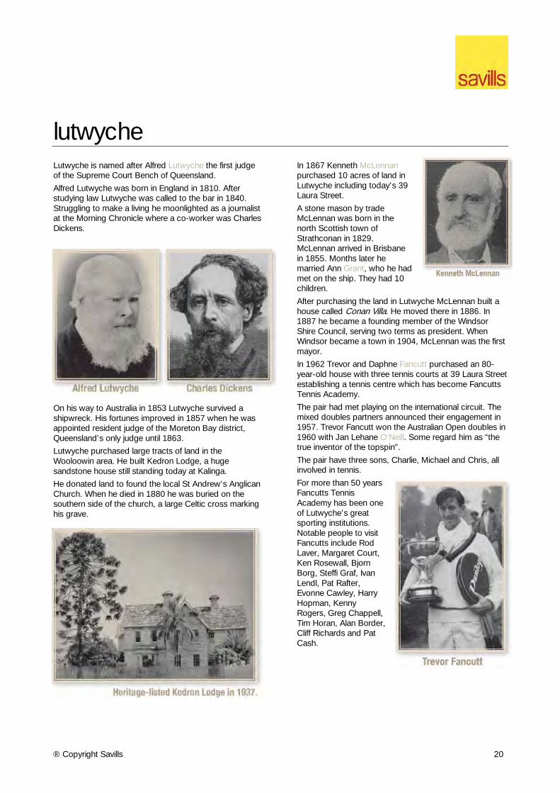
lutwyche Lutwyche is named after Alfred Lutwyche the first judge of the Supreme Court Bench of Queensland.
Alfred Lutwyche was born in England in 1810. After studying law Lutwyche was called to the bar in 1840. Struggling to make a living he moonlighted as a journalist at the Morning Chronicle where a co-worker was Charles Dickens.
On his way to Australia in 1853 Lutwyche survived a shipwreck. His fortunes improved in 1857 when he was appointed resident judge of the Moreton Bay district, Queensland’s only judge until 1863.
Lutwyche purchased large tracts of land in the Wooloowin area. He built Kedron Lodge, a huge sandstone house still standing today at Kalinga.
He donated land to found the local St Andrew’s Anglican Church. When he died in 1880 he was buried on the southern side of the church, a large Celtic cross marking his grave.
In 1867 Kenneth McLennan purchased 10 acres of land in Lutwyche including today’s 39 Laura Street.
A stone mason by trade McLennan was born in the north Scottish town of Strathconan in 1829. McLennan arrived in Brisbane in 1855. Months later he married Ann Grant, who he had met on the ship. They had 10 children.
After purchasing the land in Lutwyche McLennan built a house called Conan Villa. He moved there in 1886. In 1887 he became a founding member of the Windsor Shire Council, serving two terms as president. When Windsor became a town in 1904, McLennan was the first mayor.
In 1962 Trevor and Daphne Fancutt purchased an 80-year-old house with three tennis courts at 39 Laura Street establishing a tennis centre which has become Fancutts Tennis Academy.
The pair had met playing on the international circuit. The mixed doubles partners announced their engagement in 1957. Trevor Fancutt won the Australian Open doubles in 1960 with Jan Lehane O’Neill. Some regard him as “the true inventor of the topspin”.
The pair have three sons, Charlie, Michael and Chris, all involved in tennis.
For more than 50 years Fancutts Tennis Academy has been one of Lutwyche’s great sporting institutions. Notable people to visit Fancutts include Rod Laver, Margaret Court, Ken Rosewall, Bjorn Borg, Steffi Graf, Ivan Lendl, Pat Rafter, Evonne Cawley, Harry Hopman, Kenny Rogers, Greg Chappell, Tim Horan, Alan Border, Cliff Richards and Pat Cash.
® Copyright Savills 21
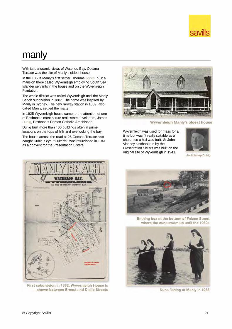
manly With its panoramic views of Waterloo Bay, Oceana Terrace was the site of Manly’s oldest house.
In the 1860s Manly’s first settler, Thomas Jones, built a mansion there called Wyvernleigh employing South Sea Islander servants in the house and on the Wyvernleigh Plantation.
The whole district was called Wyvernleigh until the Manly Beach subdivision in 1882. The name was inspired by Manly in Sydney. The new railway station in 1889, also called Manly, settled the matter.
In 1925 Wyvernleigh house came to the attention of one of Brisbane’s most astute real estate developers, James Duhig, Brisbane’s Roman Catholic Archbishop.
Duhig built more than 400 buildings often in prime locations on the tops of hills and overlooking the bay.
The house across the road at 26 Oceana Terrace also caught Duhig’s eye. “Culterfel” was refurbished in 1941 as a convent for the Presentation Sisters.
Wyvernleigh was used for mass for a time but wasn’t really suitable as a church so a hall was built. St John Vianney’s school run by the Presentation Sisters was built on the original site of Wyvernleigh in 1941.
® Copyright Savills 22
mitchelton
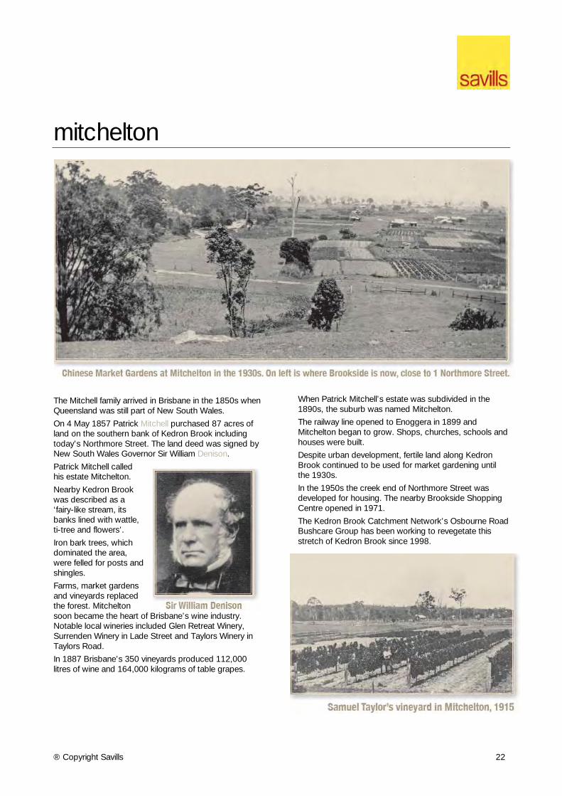
The Mitchell family arrived in Brisbane in the 1850s when Queensland was still part of New South Wales.
On 4 May 1857 Patrick Mitchell purchased 87 acres of land on the southern bank of Kedron Brook including today’s Northmore Street. The land deed was signed by New South Wales Governor Sir William Denison.
Patrick Mitchell called his estate Mitchelton.
Nearby Kedron Brook was described as a ‘fairy-like stream, its banks lined with wattle, ti-tree and flowers’.
Iron bark trees, which dominated the area, were felled for posts and shingles.
Farms, market gardens and vineyards replaced the forest. Mitchelton soon became the heart of Brisbane’s wine industry. Notable local wineries included Glen Retreat Winery, Surrenden Winery in Lade Street and Taylors Winery in Taylors Road.
In 1887 Brisbane’s 350 vineyards produced 112,000 litres of wine and 164,000 kilograms of table grapes.
When Patrick Mitchell’s estate was subdivided in the 1890s, the suburb was named Mitchelton.
The railway line opened to Enoggera in 1899 and Mitchelton began to grow. Shops, churches, schools and houses were built.
Despite urban development, fertile land along Kedron Brook continued to be used for market gardening until the 1930s.
In the 1950s the creek end of Northmore Street was developed for housing. The nearby Brookside Shopping Centre opened in 1971.
The Kedron Brook Catchment Network’s Osbourne Road Bushcare Group has been working to revegetate this stretch of Kedron Brook since 1998.
® Copyright Savills 23
moorooka
The original owner of 51 Mayfield Road Moorooka was Patrick Mayne, one of Brisbane’s most notorious early citizens.
At the time the district was called Rocky Water Holes. The name Moorooka was first used for the railway station which opened in 1887. Moorooka being a local Aboriginal word for Iron Bark or possibly like a nose.
Mayne had bought the Mayfield Road land in 1864 when land in the district was first released for sale. On the southern side of the road was the Mayne property and on the northern side was Mayfield Farm.
Hailing from Mayfield in Staffordshire, England, George Pegg purchased the land to establish a dairy farm. Three generations of George Pegg ran dairy cattle on Mayfield Farm until 1927.
Patrick Mayne had bought the land across the road as an investment.
Mayne was a butcher, businessman and one of the original councillors on the Brisbane Municipal Council. He is best remembered today as the subject of the book The Mayne Inheritance which suggests he murdered a man for money to establish his business.
Following Patrick Mayne’s death in 1865, the property in Mayfield Road was inherited by his son Isaac Mayne remaining in the Mayne family until 1939.
Although the land was not developed by the Maynes it was used during the Depression as an informal settlement for people unable to afford housing.
During World War II, the southern side of Mayfield Road was used as a staging camp by the U.S. Army. With Brisbane the headquarters of the war in the south-west Pacific, about 1 million U.S. personnel were stationed in Brisbane at some time between 1942 and 1945. Many were flown into Amberley Airfield and sent to Camp Moorooka at first before being deployed elsewhere.
The sleepy farming district suddenly became a lively city. Traffic and traffic accidents increased, the Recreation Hall hosted international acts and the local Grey’s Cafe had to open 24 hours a day.
Following World War II, Moorooka experienced the post-war housing boom with farms redeveloped for new estates.
51 Mayfield Road was purchased by the Presbyterian Church in 1953. Knox Presbyterian Church opened in 1955. Later renamed Knox Uniting Church it closed on 9 March 2014. The church hall was used for some years as a centre for Scottish dancing.
® Copyright Savills 24
morningside The inspiration for the suburb name of Morningside was apparently the sight of nearby hills catching the rising sun – it was the “morning side” of Brisbane. It may also have been named after a suburb in Edinburgh.
The first records in the area date back to 1876 when a tannery was opened. It was positioned beside some waterholes south of the railway line and continued there until 1900.
A brick Methodist church in Thynne Road was opened in 1902.
The area remained beyond the limits of metropolitan Brisbane until the years after World War I.
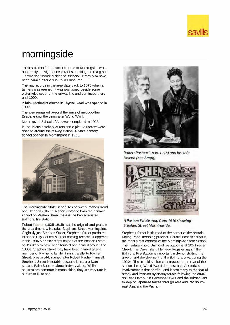
Morningside School of Arts was completed in 1926.
In the 1920s a school of arts and a picture theatre were opened around the railway station. A State primary school opened in Morningside in 1923.
The Morningside State School lies between Pashen Road and Stephens Street. A short distance from the primary school on Pashen Street there is the heritage-listed Balmoral fire station.
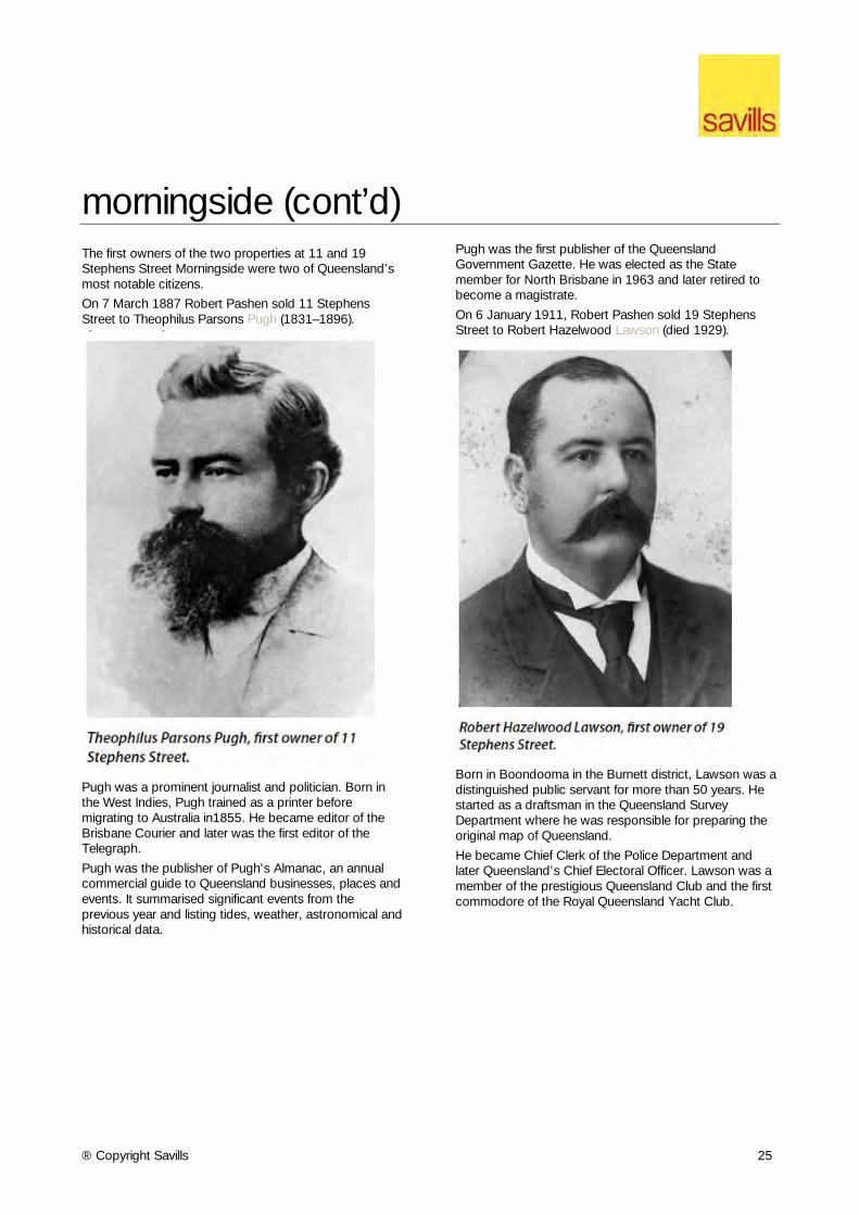
Robert Pashen (1838-1918) had the original land grant in the area that now includes Stephens Street Morningside. Originally just Stephen Street, Stephens Street predates Brisbane City Council’s street naming records. It appears in the 1886 McKellar maps as part of the Pashen Estate so it’s likely to have been formed and named around the 1880s. Stephen Street may have been named after a member of Pashen’s family. It runs parallel to Pashen Street, presumably named after Robert Pashen himself. Stephens Street is notable because it has a private square, Palm Square, about halfway along. Whilst squares are common in some cities, they are very rare in suburban Brisbane.
Stephens Street is situated at the corner of the historic Riding Road shopping precinct. Parallel Pashen Street is the main street address of the Morningside State School. The heritage-listed Balmoral fire station is at 105 Pashen Street. The Queensland Heritage Register says: “The Balmoral Fire Station is important in demonstrating the growth and development of the Balmoral area during the 1920s. The air raid shelter constructed to the rear of the station during World War II demonstrates Australia’s involvement in that conflict, and is testimony to the fear of attack and invasion by enemy forces following the attack on Pearl Harbour in December 1941 and the subsequent sweep of Japanese forces through Asia and into south-east Asia and the Pacific
® Copyright Savills 25
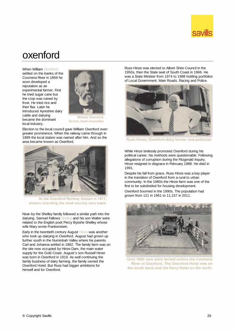
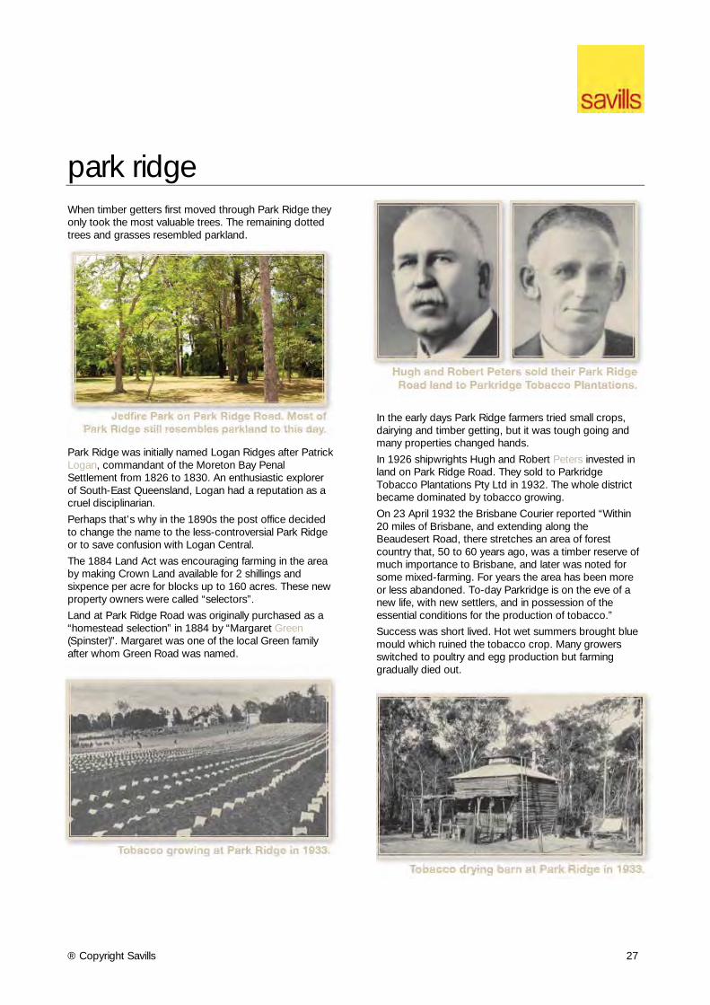
morningside (cont’d) The first owners of the two properties at 11 and 19 Stephens Street Morningside were two of Queensland’s most notable citizens.
On 7 March 1887 Robert Pashen sold 11 Stephens Street to Theophilus Parsons Pugh (1831–1896).
Pugh was a prominent journalist and politician. Born in the West Indies, Pugh trained as a printer before migrating to Australia in1855. He became editor of the Brisbane Courier and later was the first editor of the Telegraph.
Pugh was the publisher of Pugh’s Almanac, an annual commercial guide to Queensland businesses, places and events. It summarised significant events from the previous year and listing tides, weather, astronomical and historical data.
Pugh was the first publisher of the Queensland Government Gazette. He was elected as the State member for North Brisbane in 1963 and later retired to become a magistrate.
On 6 January 1911, Robert Pashen sold 19 Stephens Street to Robert Hazelwood Lawson (died 1929).
Born in Boondooma in the Burnett district, Lawson was a distinguished public servant for more than 50 years. He started as a draftsman in the Queensland Survey Department where he was responsible for preparing the original map of Queensland.
He became Chief Clerk of the Police Department and later Queensland’s Chief Electoral Officer. Lawson was a member of the prestigious Queensland Club and the first commodore of the Royal Queensland Yacht Club.
® Copyright Savills 26
oxenford When William Oxenford settled on the banks of the Coomera River in 1869 he soon developed a reputation as an experimental farmer. First he tried sugar cane but the crop was ruined by frost. He tried rice and then flax. Later he introduced Ayreshire dairy cattle and dairying became the dominant local industry.
Election to the local council gave William Oxenford even greater prominence. When the railway came through in 1889 the local station was named after him. And so the area became known as Oxenford.
Near-by the Shelley family followed a similar path into the dairying. Samuel Fallows Shelley and his son Walter were related to the English poet Percy Bysshe Shelley whose wife Mary wrote Frankenstein.
Early in the twentieth century August Hinze was another who took up dairying in Oxenford. August had grown up further south in the Numinbah Valley where his parents Carl and Johanna settled in 1882. The family farm was on the site now occupied by Hinze Dam, the main water supply for the Gold Coast. August’s son Russell Hinze was born in Oxenford in 1919. As well continuing the family business of dairy farming, the family owned the Oxenford Hotel. But Russ had bigger ambitions for himself and for Oxenford.
Russ Hinze was elected to Albert Shire Council in the 1950s, then the State seat of South Coast in 1966. He was a State Minister from 1974 to 1988 holding portfolios of Local Government, Main Roads, Racing and Police.
While Hinze tirelessly promoted Oxenford during his political career, his methods were questionable. Following allegations of corruption during the Fitzgerald Inquiry, Hinze resigned in disgrace in February 1988. He died in 1991.
Despite his fall from grace, Russ Hinze was a key player in the transition of Oxenford from a rural to urban community. In the 1980s the Hinze farm was one of the first to be subdivided for housing development.
Oxenford boomed in the 1990s. The population had grown from 121 in 1961 to 11,157 in 2011.
® Copyright Savills 27
park ridge When timber getters first moved through Park Ridge they only took the most valuable trees. The remaining dotted trees and grasses resembled parkland.
Park Ridge was initially named Logan Ridges after Patrick Logan, commandant of the Moreton Bay Penal Settlement from 1826 to 1830. An enthusiastic explorer of South-East Queensland, Logan had a reputation as a cruel disciplinarian.
Perhaps that’s why in the 1890s the post office decided to change the name to the less-controversial Park Ridge or to save confusion with Logan Central.
The 1884 Land Act was encouraging farming in the area by making Crown Land available for 2 shillings and sixpence per acre for blocks up to 160 acres. These new property owners were called “selectors”.
Land at Park Ridge Road was originally purchased as a “homestead selection” in 1884 by “Margaret Green (Spinster)”. Margaret was one of the local Green family after whom Green Road was named.
In the early days Park Ridge farmers tried small crops, dairying and timber getting, but it was tough going and many properties changed hands.
In 1926 shipwrights Hugh and Robert Peters invested in land on Park Ridge Road. They sold to Parkridge Tobacco Plantations Pty Ltd in 1932. The whole district became dominated by tobacco growing.
On 23 April 1932 the Brisbane Courier reported “Within 20 miles of Brisbane, and extending along the Beaudesert Road, there stretches an area of forest country that, 50 to 60 years ago, was a timber reserve of much importance to Brisbane, and later was noted for some mixed-farming. For years the area has been more or less abandoned. To-day Parkridge is on the eve of a new life, with new settlers, and in possession of the essential conditions for the production of tobacco.”
Success was short lived. Hot wet summers brought blue mould which ruined the tobacco crop. Many growers switched to poultry and egg production but farming gradually died out.
® Copyright Savills 28
redcliffe When the Moreton Bay Penal Settlement was established in 1824, it was first set up by the creek, a stone’s throw from what is now Downs Street Redcliffe.
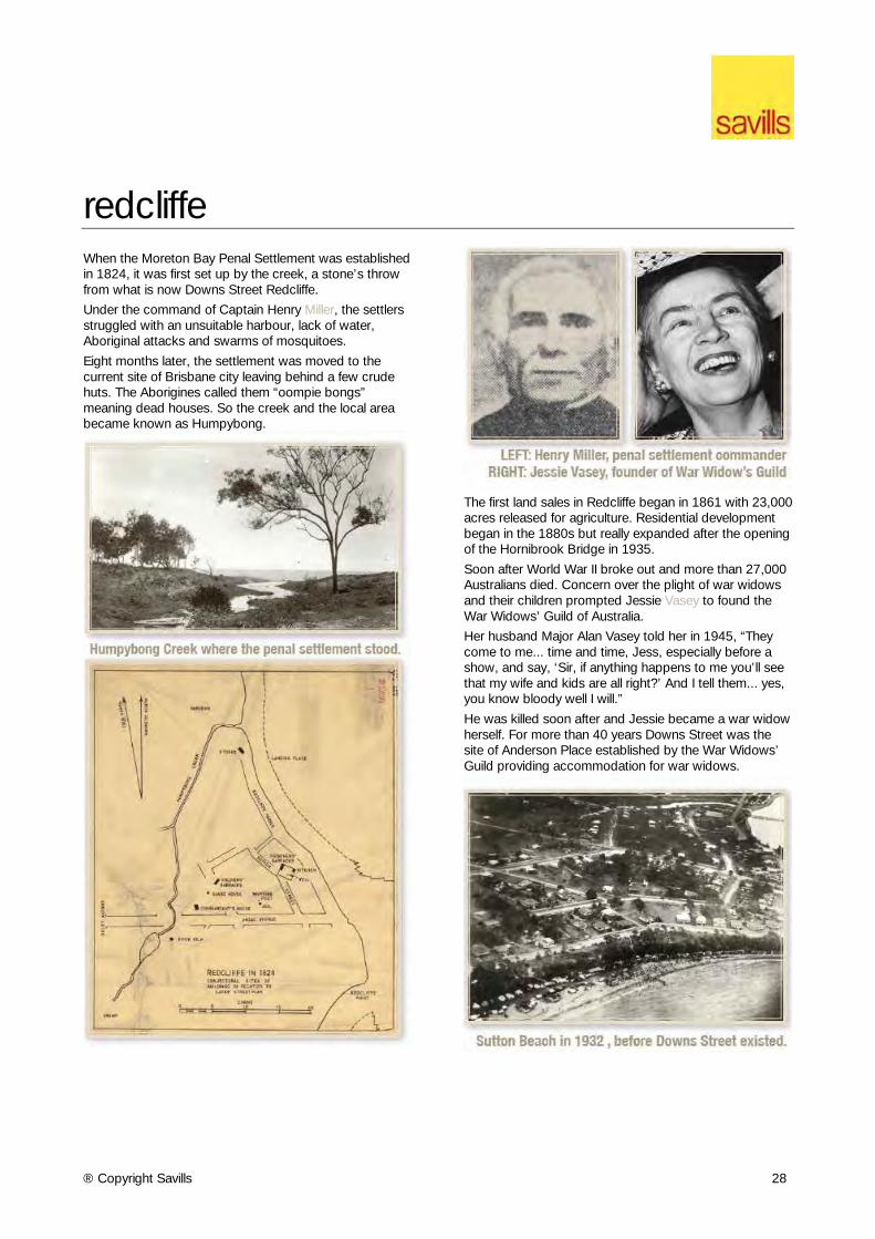
Under the command of Captain Henry Miller, the settlers struggled with an unsuitable harbour, lack of water, Aboriginal attacks and swarms of mosquitoes.
Eight months later, the settlement was moved to the current site of Brisbane city leaving behind a few crude huts. The Aborigines called them “oompie bongs” meaning dead houses. So the creek and the local area became known as Humpybong.
The first land sales in Redcliffe began in 1861 with 23,000 acres released for agriculture. Residential development began in the 1880s but really expanded after the opening of the Hornibrook Bridge in 1935.
Soon after World War II broke out and more than 27,000 Australians died. Concern over the plight of war widows and their children prompted Jessie Vasey to found the War Widows’ Guild of Australia.
Her husband Major Alan Vasey told her in 1945, “They come to me... time and time, Jess, especially before a show, and say, ‘Sir, if anything happens to me you’ll see that my wife and kids are all right?’ And I tell them... yes, you know bloody well I will.”
He was killed soon after and Jessie became a war widow herself. For more than 40 years Downs Street was the site of Anderson Place established by the War Widows’ Guild providing accommodation for war widows.
® Copyright Savills 29
scarborough
Scarborough Beach Queensland with its Norfolk Island Pines When the Scarborough Hotel opened on Landsborough Avenue in 1879 it was the first building on a wild, windswept, uninhabited coast.
Located at the northern end of the Redcliffe Peninsula, Scarborough was probably named after the Yorkshire seaside resort.
Scarborough Beach Yorkshire
The Redcliffe Peninsula was first subdivided into small farming blocks in the 1870s. Scarborough boomed in the 1880s on rumours the railway was coming and as Brisbane residents yearned for sandy beaches and holiday shacks.
After 1935 when the Hornibrook Highway was built, Scarborough became a residential area.
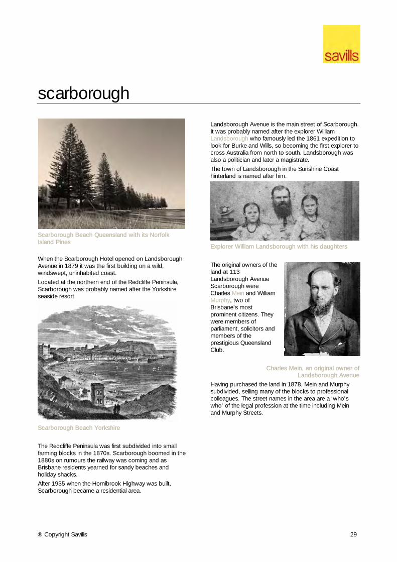
Landsborough Avenue is the main street of Scarborough. It was probably named after the explorer William Landsborough who famously led the 1861 expedition to look for Burke and Wills, so becoming the first explorer to cross Australia from north to south. Landsborough was also a politician and later a magistrate.
The town of Landsborough in the Sunshine Coast hinterland is named after him.
Explorer William Landsborough with his daughters
The original owners of the land at 113 Landsborough Avenue Scarborough were Charles Mein and William Murphy, two of Brisbane’s most prominent citizens. They were members of parliament, solicitors and members of the prestigious Queensland Club.
Charles Mein, an original owner of Landsborough Avenue
Having purchased the land in 1878, Mein and Murphy subdivided, selling many of the blocks to professional colleagues. The street names in the area are a ‘who’s who’ of the legal profession at the time including Mein and Murphy Streets.
® Copyright Savills 30
scarborough (cont’d) While a student at the University of Sydney, Charles Mein began a lifelong friendship with Samuel Griffith. Sir Samuel Walker Griffith (1845-1920) was the finest legal mind of his generation. He was twice Premier of Queensland and the first Chief Justice of the Australian High Court. Griffith was also a land developer, railway enthusiast and one of the original partners in the Scarborough Hotel. Griffith was a key supporter of the Federation of Australia. He is remembered by the naming of Griffith University, the suburb of Griffith in Canberra and the federal electorate of Griffith, which was used to be held by Kevin Rudd. Sir Samuel Griffith Drive on Mount Coot-tha in Brisbane is named after him, as is the Mathematics Building of Brisbane Grammar School.
An early photo of Scarborough Hotel
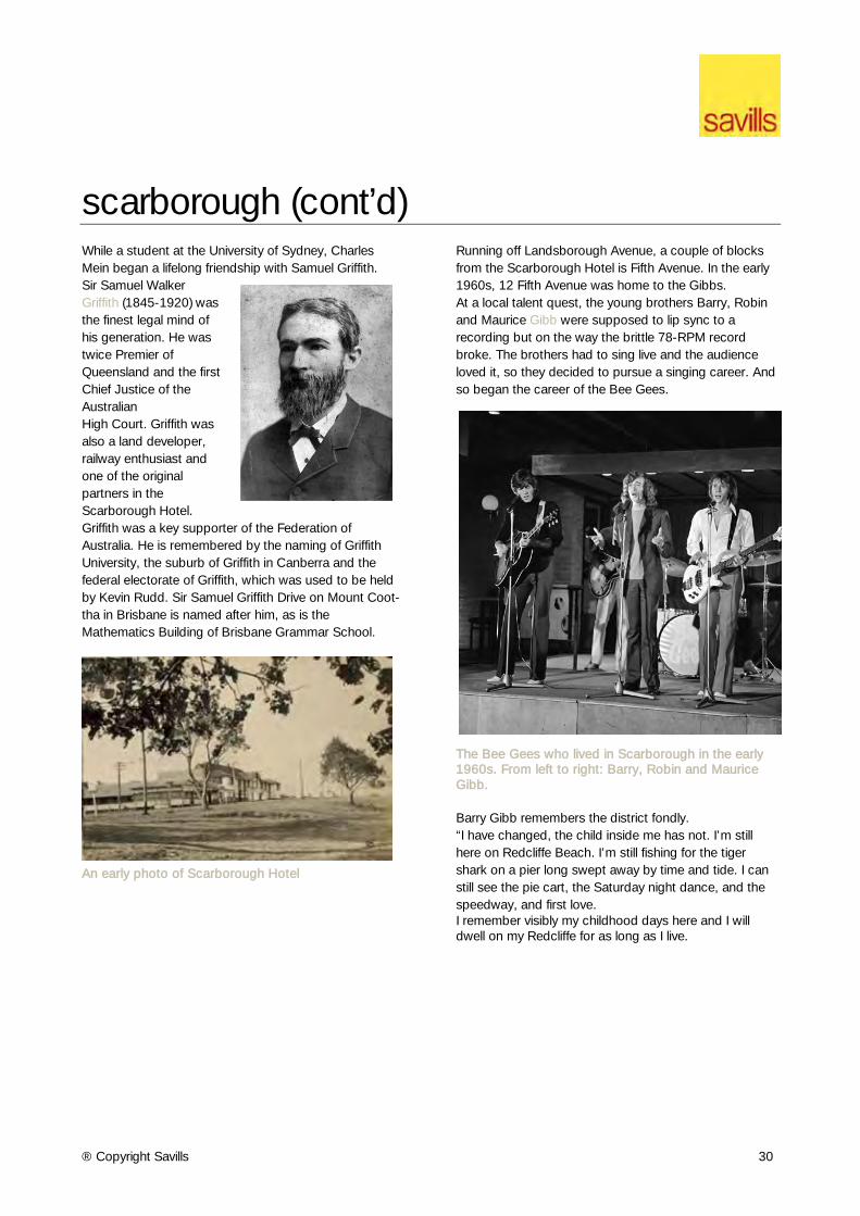
Running off Landsborough Avenue, a couple of blocks from the Scarborough Hotel is Fifth Avenue. In the early 1960s, 12 Fifth Avenue was home to the Gibbs. At a local talent quest, the young brothers Barry, Robin and Maurice Gibb were supposed to lip sync to a recording but on the way the brittle 78-RPM record broke. The brothers had to sing live and the audience loved it, so they decided to pursue a singing career. And so began the career of the Bee Gees.
The Bee Gees who lived in Scarborough in the early 1960s. From left to right: Barry, Robin and Maurice Gibb. Barry Gibb remembers the district fondly. “I have changed, the child inside me has not. I’m still here on Redcliffe Beach. I’m still fishing for the tiger shark on a pier long swept away by time and tide. I can still see the pie cart, the Saturday night dance, and the speedway, and first love. I remember visibly my childhood days here and I will dwell on my Redcliffe for as long as I live.
® Copyright Savills 31
sherwood Sherwood is an integral part of the rich history of Brisbane. The title for 27 Magazine Street Sherwood was first issued in 1860 to pastoralist and politician Arnold Wienholt. The 82 acre parcel was purchased for around 1 pound per acre.
Arnold Wienholt (1826-1895) was the son of John Birkett Wienholt (1775-1852), merchant, and his second wife Sarah, née Hill. Arnold was born on 22 January 1826 at Laugharne, Carmarthenshire, Wales, the setting for Dylan Thomas's poem Under Milk Wood. His brothers, Daniel (1822-1865), Edward (1833-1904) and Arthur (1835-1892), were also prominent Queensland pioneers.
The family, originally Winholt, originated at Wiemsdorf, Oldenburg, Germany, in the sixteenth century.
Educated privately, Arnold arrived at Sydney about 1847. He purchased Maryvale in 1849 and Gladfield in 1852, both on the Darling Downs, Queensland; they became two of the finest Clydesdale studs in Australia.
Arnold held the seat of Warwick 1863-67. He died in the Grand Hotel, Locarno, Switzerland on 16 January 1895.
In the 1860s farming spread along the Brisbane River, sugar cane being planted in 1869 and actively grown until frost spoiled crops in the 1870s. Cotton was also grown and processed at a gin at Corinda.
The name Sherwood originally referred to a local farm and came to the fore when Sherwood primary school was opened in 1867. The Sherwood Presbyterian church and Orange Lodge Hall were opened in 1875, coinciding with the Ipswich to Brisbane Railway line running northwards to the Albert Bridge river crossing at Chelmer (then Oxley Point).
There was a scattering of settlements around the railway stations, including a school (1870) and a court house (1874) at Oxley, further south. The Yeerongpilly division brought local government to Sherwood and Oxley in 1878.
The advent of the railway led to some farms being subdivided, but in 1890 Sherwood was still described as a farming community. In addition to the school and the railway station there were also Presbyterian and Episcopal churches, a post office (1875) and Bright's store (1879).
In 1890 the Sherwood Progress Association was formed and in the following year the Sherwood local government division was detached from Yeerongpilly. Its area of 20 square miles extended westwards from the Oxley Creek along the south and east banks of the Brisbane River at Wacol, and generally north–west of Ipswich Road.
Population was concentrated along the railway line from Oxley to the Albert Bridge; Darra was heavily timbered with little settlement.
In 1903 Sherwood was described in the Australian Handbook:
® Copyright Savills 32
sherwood (cont’d) Sherwood's population was nearly 1,300 in 1921 and the Shire's was over 6,600. Advancing urbanisation unexpectedly ran beside the formation of the Sherwood Agricultural, Horticultural and Industrial Society (1921), from which show spectators could repair to Barney Cook's open–air picture show (also 1921) or to the river baths.
The Sherwood Forest Park (later an arboretum) running down to Brisbane River was laid out in 1925, uniquely containing over 300 species of almost entirely native flora the year when Sherwood Shire was incorporated into the Greater Brisbane Council.
The arboretum is listed on the Queensland heritage register, along with a Boer War memorial further east along Sherwood Road near the entry to a Church of England.
The land at 27 Magazine Street was vested to the Commonwealth of Australia for defence purposes before being transferred to the current registered owner, the State of Queensland.
The Alan Fletcher Research Station (AFRS) began life as the headquarters for the Commonwealth Prickly Pear Board in 1921. It was from this location that the famously successful prickly pear campaign was directed. Following the disbandment of the board, staff, resources and responsibilities were assumed by the Biological Section, Queensland Department of Lands in 1939. Research activity ceased at AFRS in May 2010.
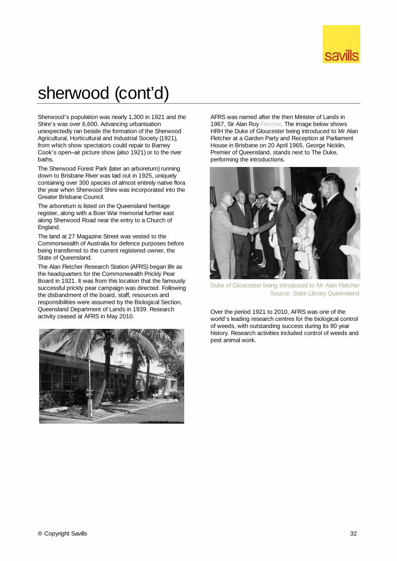
AFRS was named after the then Minister of Lands in 1967, Sir Alan Roy Fletcher. The image below shows HRH the Duke of Gloucester being introduced to Mr Alan Fletcher at a Garden Party and Reception at Parliament House in Brisbane on 20 April 1965. George Nicklin, Premier of Queensland, stands next to The Duke, performing the introductions.
Duke of Gloucester being introduced to Mr Alan Fletcher
Source: State Library Queensland
Over the period 1921 to 2010, AFRS was one of the world's leading research centres for the biological control of weeds, with outstanding success during its 90 year history. Research activities included control of weeds and pest animal work.
® Copyright Savills 33
stones corners Stones Corner is an inner suburb at the junction of Logan and Old Cleveland Roads just five kilometres from the heart of Brisbane.
It is named Stones Corner after James Stone, who arrived in Australia in August 1857 as a child with his parents and family as early settlers from Somerset, England aboard the ship Mary Pleasants.
The land now known as Stones Corner had previously been owned by early resident Henry Opperman, who purchased it in 1857 for the sum of 59 Pounds. Opperman sold his land to Frederika Klumpp, whose sons notably went on to establish farms at Mt Gravatt, giving name to Klumpp Road.
Klumpp sold her land, subdivided to include a small triangular 0.4 hectares at the corner of the two main roads, to James Stone in 1875.
Stone erected a slab hut to sell refreshments to travellers, however was unable to get a liquor license. Since selling regular beer was out, Stone started selling his own brand of ginger beer. James Stone Ginger Beer has recently been resurrected commercially as a boutique soft drink.
Stone sold the site in 1887, at a 25-fold profit, and the new owner Denis O’Connor erected the two-storey (licensed) Junction Hotel around 1890. The building subsequently adopted the name Stones Corner Hotel.
The Stones Corner area has long been a thriving retail district. A post office was opened in 1893. The tram service that operated from Woolloongabba and along Logan Road, was extended to Stones Corner in 1899.
Tram services along Old Cleveland Road to Coorparoo and along Logan Road to Greenslopes began in 1914, making the corner a busy location for passing trade.
Early businesses included butcheries such as H Narst, Cash Butcher (1906), Watson & Son, Butcher (1911), and J.F. Rogers Family Butcher. J.F. Rogers later became the owner of the Alhambra Theatre.
Stewarts Department Store was established in Stones Corner in 1914. Other businesses in the area by the 1950s included Charles Henderson Motor Repair Shop, Johnston’s Store (crockery, hardware, kitchenware, paint), Regency Home Furnishers, Beard’s Shoes, Scientific Hobby Shop Pty Ltd, Drouyn’s Music Store, Tacey’s Drapers, Gardiners Millinery, Holt’s Electrical Store, Finlayson’s Menswear, and Handasydes (Holden).
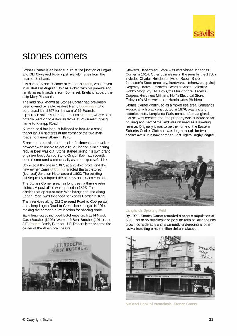
Stones Corner continued as a mixed use area. Langlands House, which was constructed in 1876, was a site of historical note. Langlands Park, named after Langlands House, was created after the property was subdivided for housing and part of the land was retained as a sporting reserve. Originally it was to be the home of the Eastern Suburbs Cricket Club and was large enough for two cricket ovals. It is now home to East Tigers Rugby league.
Langlands Sporting Field
By 1921, Stones Corner recorded a census population of 531. This richly historical and popular area of Brisbane has grown considerably and is currently undergoing another revival including a multi-million dollar makeover.
National Bank of Australasia, Stones Corner
® Copyright Savills 34
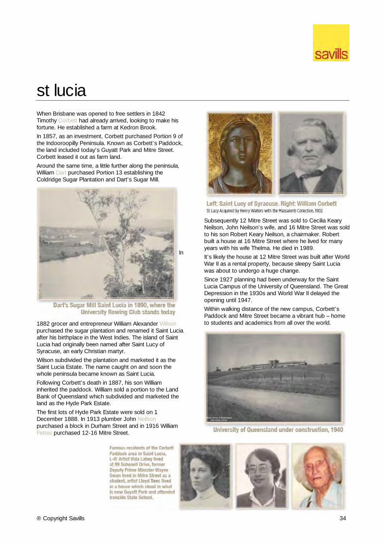
st lucia When Brisbane was opened to free settlers in 1842 Timothy Corbett had already arrived, looking to make his fortune. He established a farm at Kedron Brook.
In 1857, as an investment, Corbett purchased Portion 9 of the Indooroopilly Peninsula. Known as Corbett’s Paddock, the land included today’s Guyatt Park and Mitre Street. Corbett leased it out as farm land.
Around the same time, a little further along the peninsula, William Dart purchased Portion 13 establishing the Coldridge Sugar Plantation and Dart’s Sugar Mill.
In
1882 grocer and entrepreneur William Alexander Wilson purchased the sugar plantation and renamed it Saint Lucia after his birthplace in the West Indies. The island of Saint Lucia had originally been named after Saint Lucy of Syracuse, an early Christian martyr.
Wilson subdivided the plantation and marketed it as the Saint Lucia Estate. The name caught on and soon the whole peninsula became known as Saint Lucia.
Following Corbett’s death in 1887, his son William inherited the paddock. William sold a portion to the Land Bank of Queensland which subdivided and marketed the land as the Hyde Park Estate.
The first lots of Hyde Park Estate were sold on 1 December 1888. In 1913 plumber John Neilson purchased a block in Durham Street and in 1916 William Fettes purchased 12-16 Mitre Street.
Subsequently 12 Mitre Street was sold to Cecilia Keary Neilson, John Neilson’s wife, and 16 Mitre Street was sold to his son Robert Keary Neilson, a chairmaker. Robert built a house at 16 Mitre Street where he lived for many years with his wife Thelma. He died in 1989.
It’s likely the house at 12 Mitre Street was built after World War II as a rental property, because sleepy Saint Lucia was about to undergo a huge change.
Since 1927 planning had been underway for the Saint Lucia Campus of the University of Queensland. The Great Depression in the 1930s and World War II delayed the opening until 1947.
Within walking distance of the new campus, Corbett’s Paddock and Mitre Street became a vibrant hub – home to students and academics from all over the world.
® Copyright Savills 35
toowong Toowong is the Aboriginal word for the Eastern Koel, a type of cuckoo. Its loud mournful and rising toowong call is still common in the summer months.
At auction in 1871 Jane Galloway purchased 55 acres of land in northern Toowong on the city side of Toowong Cemetery.
In 1884 Jane sold the parcel to Thomas O’Sullivan. Born in Ipswich in 1856 O’Sullivan proceeded to subdivide the land into more than 100 house-size blocks which he sold progressively over the following decades.
O’Sullivan entered politics in 1903. He was Queensland Attorney-General from 1908 to 1915. After leaving politics he entered the law eventually become a Supreme Court judge.
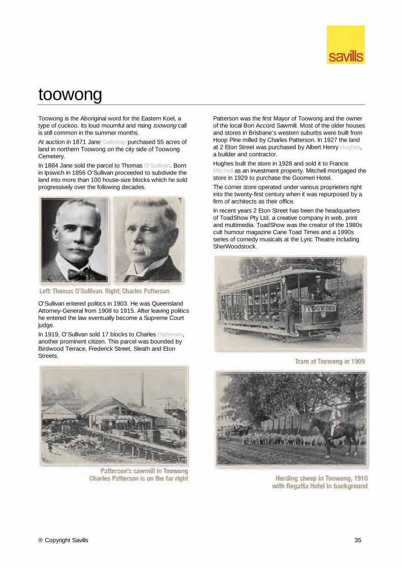
In 1919, O’Sullivan sold 17 blocks to Charles Patterson, another prominent citizen. This parcel was bounded by Birdwood Terrace, Frederick Street, Sleath and Eton Streets.
Patterson was the first Mayor of Toowong and the owner of the local Bon Accord Sawmill. Most of the older houses and stores in Brisbane’s western suburbs were built from Hoop Pine milled by Charles Patterson. In 1927 the land at 2 Eton Street was purchased by Albert Henry Hughes, a builder and contractor.
Hughes built the store in 1928 and sold it to Francis Mitchell as an investment property. Mitchell mortgaged the store in 1929 to purchase the Goomeri Hotel.
The corner store operated under various proprieters right into the twenty-first century when it was repurposed by a firm of architects as their office.
In recent years 2 Eton Street has been the headquarters of ToadShow Pty Ltd, a creative company in web, print and multimedia. ToadShow was the creator of the 1980s cult humour magazine Cane Toad Times and a 1990s series of comedy musicals at the Lyric Theatre including SherWoodstock.
® Copyright Savills 36
west end The banks of the Brisbane River from South Brisbane to Hill End were once covered in dense subtropical rainforest. The Aboriginal people called it Kurilpa meaning the place for rats, probably referring to the antechinus, a small marsupial.
South Brisbane was a corn farm in the days of the Moreton Bay Penal Settlement after 1824. Private land ownership was allowed when it shut in 1842.
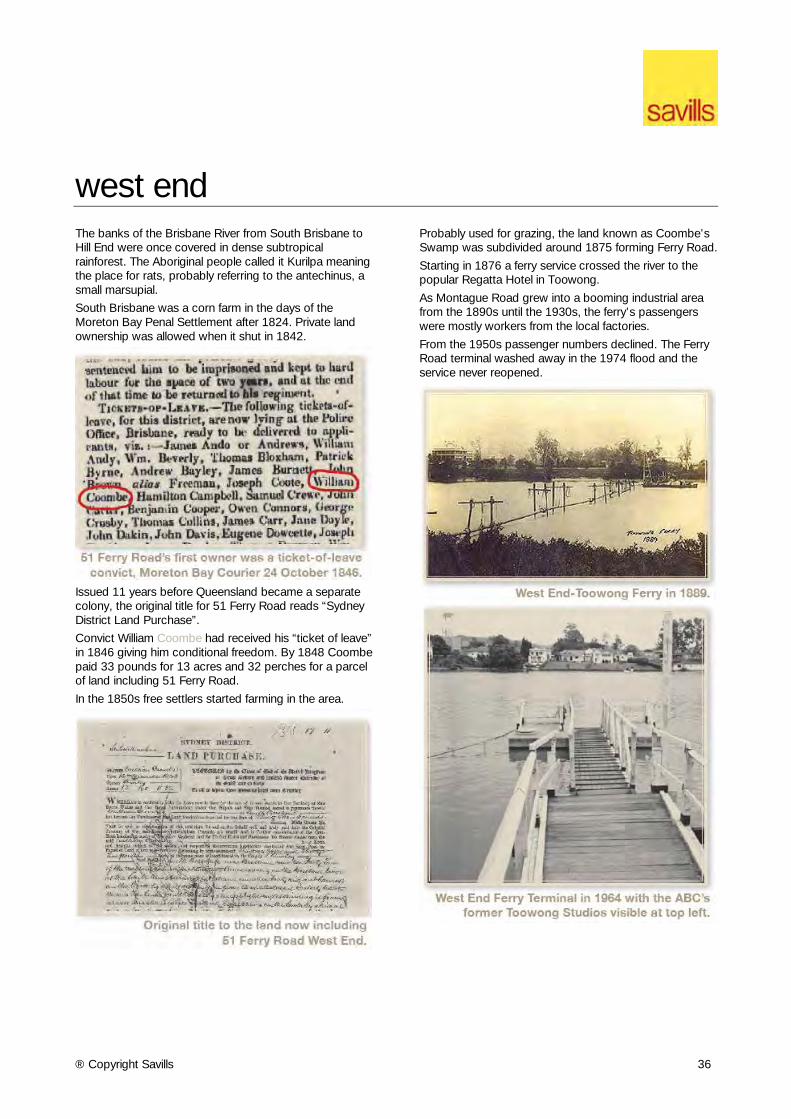
Issued 11 years before Queensland became a separate colony, the original title for 51 Ferry Road reads “Sydney District Land Purchase”.
Convict William Coombe had received his “ticket of leave” in 1846 giving him conditional freedom. By 1848 Coombe paid 33 pounds for 13 acres and 32 perches for a parcel of land including 51 Ferry Road.
In the 1850s free settlers started farming in the area.
Probably used for grazing, the land known as Coombe’s Swamp was subdivided around 1875 forming Ferry Road.
Starting in 1876 a ferry service crossed the river to the popular Regatta Hotel in Toowong.
As Montague Road grew into a booming industrial area from the 1890s until the 1930s, the ferry’s passengers were mostly workers from the local factories.
From the 1950s passenger numbers declined. The Ferry Road terminal washed away in the 1974 flood and the service never reopened.
® Copyright Savills 37
west end (cont’d) In 1873 a 26-year-old Quaker named Thomas Dixon started a tannery between Montague Road and the Brisbane River, in the area that is now Ferry Road. Dixon soon started making boots on the site.
Fire destroyed his premises in 1885 and the 1893 flood was another setback but Dixon regrouped to open a new shoe factory in 1908 on the other side of Montague Road at the corner of Drake Street.
The Dixon Centre was refurbished in the 1990s by the Queensland Government as offices and rehearsal studios for Queensland Ballet.
Early in the twentieth century, Ferry Road was divided into small residential lots. The site at 51 Ferry Road was largely undeveloped. A house was built in the north-west corner in 1925 which remained there until 1976.
In 1977 the area was revitalized as a cultural hub when the ABC constructed a purpose-built home for the Queensland Symphony Orchestra (QSO) at 51 Ferry Road.
Formed in 1947, the QSO is Australia’s the third largest orchestra with 88 members. The QSO began to receive international acclaim in the 1980s with Chief Conductor, Werner Andreas Albert, involving the Orchestra in international recording projects.
The QSO’s reputation was enhanced in the 1990s with the appointment of Maestro Muhai Tang as Chief Conductor and the orchestra’s first tour abroad to China. The QSO farewelled Ferry Road in 2012 moving to the ABC’s new South Bank studios.
Aerial view of West End in 1932
® Copyright Savills 38
windsor In August 1855, Daniel Rowntree Somerset, Registrar of Pensions, purchased 77 acres of land stretching from Enoggera Creek at Bowen Bridge northwards along what is now Lutwyche Road.
Somerset built a grand stone house called Rosemount with four bedrooms, a separate kitchen, coach house and an acre of gardens with fruit trees, flowers and shrubs. Today this is the site of Rosemount Hospital.
Arriving in Brisbane in 1860 after a stint in Gladstone as a government official, Maurice Charles O’Connell leased Rosemount for his family residence.
The grandson of colonial Governor William Bligh, O’Connell had been appointed one of the original members of the Legislative Council when Queensland became a separate colony in 1859.
In May 1865, he purchased Rosemount along with 53 acres. Within months, O’Connell set about subdividing his land. The locals called the area O’Connell Town.
The main road was named Lutwyche Road after Alfred Lutwyche, Queensland’s first judge, who had purchased 50 acres further north at Kedron in 1862.
One of O’Connell’s blocks, just near Rosemount at 217 Lutwyche Road, was sold to Alfred Hubbard in July 1870.
Hubbard was a storekeeper in Queen Street, later elected to the Brisbane Municipal Council. He was Brisbane Mayor from 1877 to 1878.
Meanwhile O’Connell Town was becoming a community with houses, shops, schools and churches.
In 1880, Hubbard sold his land to the Queensland Congregational Union as the site for a church.
Congregational Minister Reverend George Wight’s small, wooden Sunday School at nearby Eildon Hill was moved to the Lutwyche Road site. The growing congregation soon needed a bigger church which was completed in 1887.
Also in 1887 the area was named Windsor Shire, after Windsor Castle in England, commemorating 50 years’ reign of Queen Victoria. O’Connell Town fell out of use.
In November 1915 the church burned to the ground. Another was built to replace it and a large church hall was added in 1935. The Congregational Church became part of the Uniting Church in 1977.
In more recent years the site has been used by various advocacy groups including the Multicultural Development Association, the Cerebral Palsy League of Queensland and Youth Advocacy.
® Copyright Savills 39
woolloongabba The suburb name ‘Woolloongabba’ was derived from an Aboriginal expression ‘wooloon-capemm’ which means ‘whirling waters’ or ‘a fighting place’.
The first record of activity in the area was in 1855 and constituted of the establishment of the rail depot near the present Gabba Cricket Ground, known as One Mile Swamp.
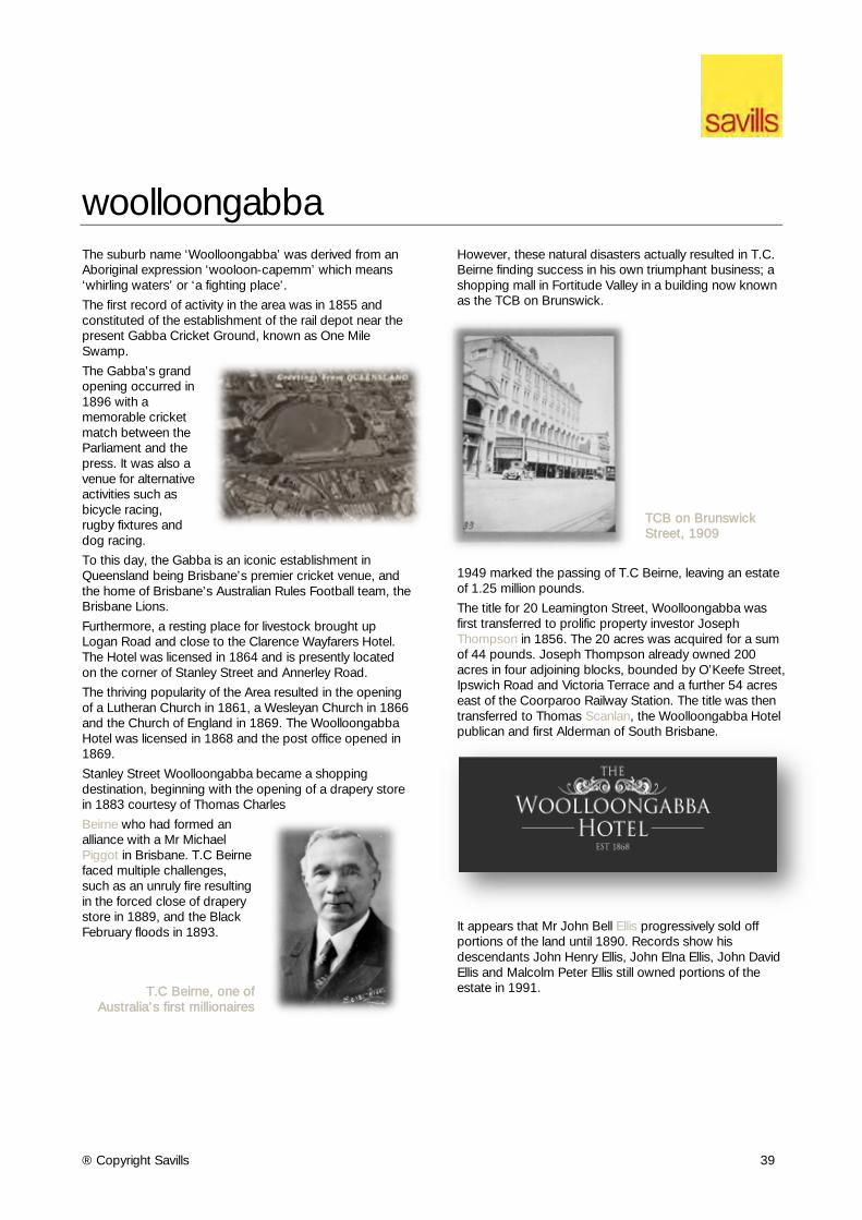
The Gabba’s grand opening occurred in 1896 with a memorable cricket match between the Parliament and the press. It was also a venue for alternative activities such as bicycle racing, rugby fixtures and dog racing.
To this day, the Gabba is an iconic establishment in Queensland being Brisbane’s premier cricket venue, and the home of Brisbane’s Australian Rules Football team, the Brisbane Lions.
Furthermore, a resting place for livestock brought up Logan Road and close to the Clarence Wayfarers Hotel. The Hotel was licensed in 1864 and is presently located on the corner of Stanley Street and Annerley Road.
The thriving popularity of the Area resulted in the opening of a Lutheran Church in 1861, a Wesleyan Church in 1866 and the Church of England in 1869. The Woolloongabba Hotel was licensed in 1868 and the post office opened in 1869.
Stanley Street Woolloongabba became a shopping destination, beginning with the opening of a drapery store in 1883 courtesy of Thomas Charles
Beirne who had formed an alliance with a Mr Michael Piggot in Brisbane. T.C Beirne faced multiple challenges, such as an unruly fire resulting in the forced close of drapery store in 1889, and the Black February floods in 1893.
T.C Beirne, one of Australia's first millionaires
However, these natural disasters actually resulted in T.C. Beirne finding success in his own triumphant business; a shopping mall in Fortitude Valley in a building now known as the TCB on Brunswick.
TCB on Brunswick Street, 1909
1949 marked the passing of T.C Beirne, leaving an estate of 1.25 million pounds.
The title for 20 Leamington Street, Woolloongabba was first transferred to prolific property investor Joseph Thompson in 1856. The 20 acres was acquired for a sum of 44 pounds. Joseph Thompson already owned 200 acres in four adjoining blocks, bounded by O’Keefe Street, Ipswich Road and Victoria Terrace and a further 54 acres east of the Coorparoo Railway Station. The title was then transferred to Thomas Scanlan, the Woolloongabba Hotel publican and first Alderman of South Brisbane.
It appears that Mr John Bell Ellis progressively sold off portions of the land until 1890. Records show his descendants John Henry Ellis, John Elna Ellis, John David Ellis and Malcolm Peter Ellis still owned portions of the estate in 1991.
® Copyright Savills 40
disclaimer Savills Research Whilst this information has been prepared in good faith and with due care, Savills makes no representations or warranties (express or implied) in relation to the accuracy, currency, completeness or suitability of the information. This information is intended as a guide only and does not constitute advice nor does it constitute any offer or part of any contract. Any specific measurements, values or quantities contained in this information are approximate and have not been independently verified. Any user of this information should not rely on it but should make their own enquiries to verify and satisfy themselves of all aspects of the information. Savills, its officers, employees, subcontractors, agents and clients shall not be liable (to the extent permitted by law) to any person for any loss, liability, damage or expense arising from or connected in any way with any use of, or reliance on, this information.
® Copyright Savills 41