Embed Size (px)
Citation preview
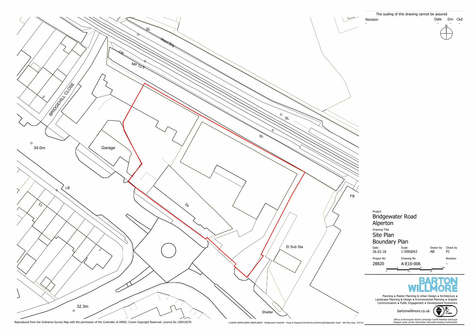
Bridgewater Road, Alperton
Environmental Impact Assessment Screening Report
April 2019
Bridgewater Road, Alperton
Environmental Impact Assessment Screening Report
Prepared on behalf of Peabody Group
Job Number: 28820/A5/EIA Screening Report
Status: Draft Draft Final
Issue/Rev: 01 02 03
Date: 23rd July 2018 24th July 2018 4th April 2019
Prepared by: JO JO NP
Checked by: NP NP MM
Barton Willmore LLP
7 Soho Square
London W1D 3QB
COPYRIGHT
The contents of this document must not be copied or reproduced in whole or in part without the written consent of Barton Willmore LLP.
All Barton Willmore stationery is produced using recycled or FSC paper and vegetable oil based inks.
Bridgewater Road, Alperton Contents
28820/A5/EIA Screening Report i April 2019
CONTENTS
1 INTRODUCTION ................................................................................................................ 1
2 SITE AND PROPOSED DEVELOPMENT................................................................................. 3
3 SCREENING ASSESSMENT ................................................................................................. 5
4 CONCLUSION .................................................................................................................. 18
APPENDICES
APPENDIX 1: SITE LOCATION PLAN
Bridgewater Road, Alperton Introduction
28820/A5/EIA Screening Report 1 April 2019
1 INTRODUCTION
1.1 This report has been prepared by Barton Willmore, Institute of Environmental Management
and Assessment (IEMA) qualified assessors and Environmental Impact Assessment (EIA)
Quality Mark registrants, on behalf of Peabody Group (the ‘Applicant’). The report
accompanies a request to London Borough of Brent (LBB) to adopt a screening opinion to
determine whether the proposed development of a residential-led, mixed use scheme of up
to 145 residential dwellings and up to 850 square metres (sqm) of commercial floorspace on
land at Bridgewater Road, Alperton constitutes EIA development.
1.2 This report reflects the requirements of the Town and Country Planning (Environmental
Impact Assessment) Regulations 20171 (the “EIA Regulations”) and in accordance with
Regulation 6 of the EIA Regulations, this report contains:
• A plan sufficient to identify the land;
• a description of the development, including in particular:
(i) a description of the physical characteristics of the development and, where relevant,
of demolition works;
(ii) a description of the location of the development, with particular regard to the
environmental sensitivity of geographical areas likely to be affected;
• a description of the aspects of the environment likely to be significantly affected by the
development;
• to the extent the information is available, a description of any likely significant effects of
the proposed development on the environment resulting from—
(i) the expected residues and emissions and the production of waste, where relevant;
and
(ii) the use of natural resources, in particular soil, land, water and biodiversity; and
• such other information or representations as the person making the request may wish to
provide or make, including any features of the proposed development or any measures
envisaged to avoid or prevent what might otherwise have been significant adverse effects
on the environment.
Requirement for EIA
1.3 In order to determine whether the proposed development is ‘EIA development’, regard must
be had for the EIA Regulations and supporting Planning Practice Guidance2 (PPG).
1 SI 2017/571 2 http://planningguidance.planningportal.gov.uk/blog/guidance/environmental -impact-assessment/
Bridgewater Road, Alperton Introduction
28820/A5/EIA Screening Report 2 April 2019
1.4 EIA development is defined by the EIA Regulations as development:
“likely to have significant effects on the environment by virtue of factors such as its nature, size or location”.
1.5 EIA development falls into two Schedules of the EIA Regulations. EIA is mandatory for
developments listed within Schedule 1. Schedule 2 developments require EIA if they would
lead to likely significant effects on the environment.
1.6 In deciding whether a Schedule 2 development is EIA development, Regulation 5(4) states:
“Where a relevant planning authority … has to decide under these Regulations whether Schedule 2 development is EIA development, the relevant planning authority … must take into account in making that decision- (a) Any information provided by the applicant; (b) The results of any relevant EU environmental assessment
which are reasonably available to relevant planning authority…; and
(c) such of the selection criteria set out in Schedule 3 as are relevant to the development.”
1.7 In order to allow LBB to determine the need for EIA this report provides a description of the
site and proposed development, a review of the EIA Screening Criteria based on the EIA
Regulations and PPG, a completed EIA Screening Checklist, and a site location plan at
Appendix 1.
Bridgewater Road, Alperton Screening Assessment
28820/A5/EIA Screening Report 3 April 2019
2 SITE AND PROPOSED DEVELOPMENT
Site Context
2.1 The site is located in Alperton in the administrative London Borough of Brent. The north of
the site is bound by the Piccadilly Line of the London Underground, with Alperton Community
School and One Tree Hill Recreation Ground located beyond. One Tree Hill Recreation Ground
includes a series of paths and a public right of way (PRoW).
2.2 Transport related infrastructure is located to the south-east of the site including two large
buildings: Alperton Bus Depot and Garage. Alperton Underground station is located
approximately 80m east of the site boundary, beyond which is the A4089 (Ealing Road) .
2.3 The south west of the site is bound by Bridgewater Road (A4005). To the south of the site
are a number of industrial and office units. The Grand Union Canal is located approximately
150m to the south of the site. Residential use is located to the west of the site, beyond the
A4005. Immediately to the north-west of the site boundary is a car wash and a two-storey
building, with the ground floor in commercial use. Further to the northwest is Bridgehill Close,
beyond which is residential use.
2.4 The surrounding area to the south of the site is currently undergoing significant change, with
a number of major developments that include high-rise buildings as described further in Table
1.
Site Description
2.5 The site (see site location plan at Appendix 1) extends to approximately 0.35 hectares (ha).
and currently comprises a vacant car showroom of approximately 320sqm and a single storey
row of industrial units, of approximately 300sqm.
2.6 The majority of the site is hardstanding with scrubby vegetation that surrounds the built
development on the site.
2.7 The primary vehicular access to the site is directly off Bridgewater Road , to the southwest of
the site.
Bridgewater Road, Alperton Screening Assessment
28820/A5/EIA Screening Report 4 April 2019
Proposed Development
2.8 The proposed development comprises the demolition of all the existing buildings on site, and
the erection three blocks comprising up to 145 residential dwellings and up to 850sqm of
commercial floorspace.
2.9 The proposed development will also include up to eight disabled car parking spaces and cycle
storage. Vehicular access will be provided via a one-way access road entered from the south-
eastern corner of the site, off Bridgewater Road and circulates the site wi th the egress point
located to the west.
2.10 The proposed maximum height of the buildings will be up to 19 storeys (104.310m AOD).
Mitigation
2.11 A number of mitigation measures will be considered to be part of the proposed development.
This includes adherence to best practice measures during the construction phase, such as
through a Construction Environmental Management Plan (CEMP).
Bridgewater Road, Alperton Screening Assessment
28820/A5/EIA Screening Report 5 April 2019
3 SCREENING ASSESSMENT
Introduction
3.1 In determining whether the proposed development constitutes EIA development,
consideration should be had to the following:
• If the proposed development is of a type listed in Schedule 1;
• If not, whether it is listed in Schedule 2;
• Is it located within a sensitive area;
• It meets any of the relevant thresholds and criteria set out in Schedule 2; and/or
• Would it lead to likely significant effects on the environment.
3.2 These points are explored further in this section with reference to the EIA Regulations and
supporting PPG.
Schedule 1 Projects
3.3 EIA is mandatory for projects listed in Schedule 1 of the EIA Regulations. Schedule 1
developments are large scale projects for which significant effects would be expected and
comprise developments such as new airports and power stations. The proposed development
is not of a type listed in Schedule 1.
Schedule 2 Projects
3.4 EIA is discretionary for projects listed in Schedule 2. If the development proposed is of a type
listed in Schedule 2 then it may be classified as EIA development depending on the location
of the development (i.e. if it is within a sensitive area) and/or whether it meets any of the
relevant thresholds or criteria in Column 2.
3.5 Sensitive Areas are defined in the EIA Regulations as:
• Sites of Special Scientific Interest and European Sites;
• National Parks, the Broads, and Areas of Outstanding Natural Beauty;
• World Heritage Sites and Scheduled Monuments.
3.6 In certain cases, local designations which are not included in the definition of sensitive areas,
but which are nonetheless environmentally sensitive, may also be relevant in determining
Bridgewater Road, Alperton Screening Assessment
28820/A5/EIA Screening Report 6 April 2019
whether an assessment is required. Furthermore, in considering the sensitivity of a particular
location, regard should also be had to whether any national or internationally agreed
environmental standards (e.g. air quality) are already being approached or exceeded.
3.7 The proposed development falls within category 10 of Schedule 2, ‘Infrastructure Projects’,
sub-section (b) ‘Urban Development Projects’. The site is not located in a sensitive area and
therefore the thresholds should be applied. The thresholds for residential developments as
set out in Schedule 2 relate to developments that “includes more than 1 hectare of urban
development which is not dwellinghouse development, more than 150 dwellings or the overall
area of the development exceeds 5 hectares”. The proposed development is for up to 145
dwellings and the area of development is approximately 0.35ha, which both fall below the
thresholds. However, due to the number of developments coming forward in the surrounding
area, and the proposed height of the development, this screening assessment has been
prepared to determine whether the proposals would be likely to result in significant cumulative
effects. To achieve this, Schedule 3 of the EIA Regulations and the PPG need to be considered.
Information on these are set out below.
Schedule 3
3.8 Schedule 3 of the EIA Regulations sets out selection criteria which relate to specific matters
including: the characteristics of the development; the location of the development; and the
characteristics of the potential impact. These factors should be taken into account as part of
the screening process and are set out below:
Characteristics:
• the size and design of the whole development;
• cumulation with other existing development and/or approved development;
• the use of natural resources, in particular land, soil, water and biodiversity;
• the production of waste;
• pollution and nuisances;
• the risk of major accidents and/or disasters relevant to the development concerned,
including those caused by climate change, in accordance with scientific knowledge; and
• the risks to human health (for example, due to water contamination or air pollution).
Location:
• The existing and approved land use;
• the relative abundance, availability, quality and regenerative capacity of natural resources
Bridgewater Road, Alperton Screening Assessment
28820/A5/EIA Screening Report 7 April 2019
(including soil, land, water and biodiversity) in the area and its underground ; and
• The absorption capacity of the natural environment.
Potential Impact:
• the magnitude and spatial extent of the impact (for example geographical area and size
of the population likely to be affected);
• the nature of the impact;
• the transboundary nature of the impact;
• the intensity and complexity of the impact;
• the probability of the impact;
• the expected onset, duration, frequency and reversibility of the impact;
• the cumulation of the impact with the impact of other existing and/or approved
development; and
• the possibility of effectively reducing the impact.
Consideration of Cumulative Effects
3.9 Schedule 4 of the EIA Regulations requires consideration of a proposed development
cumulatively with other existing and/or approved development. Guidance on the consideration
of cumulative effects in the EIA screening process is set out in the PPG, which echoes the
requirements of the EIA Regulations:
“each application (or request for a screening opinion) should be considered on its own merits. There are occasions where other existing or approved development may be relevant in determining whether significant effects are likely as a consequence of a proposed development. The local planning authorities should always have regard to the possible cumula tive effects arising from any existing or approved development.”
3.10 Table 1 below, sets out those ‘existing and approved’ schemes identified in the surrounding
area. The five applications in Table 1 have been approved and due to proximity to the site,
or relationship to approved development, warrant consideration.
Table 1: Approved Applications
Application Description Distance
Approved Applications
Minavil House, Rosemont Road, Wembley
(ref. 16/2629)
Demolition of existing two storey commercial buildings
and erection of a mixed used development ranging from
ten to 26 storeys in height, comprising 251 residential flats
(83 x 1bed, 136 x 2bed and 32 x 3bed), 1,942 sqm retail
foodstore (Use class A1) on the ground floor, 622sqm of
office space (Use Class B1) on the first floor, 634sqm retail
Approximately 95m to the south-east of the site.
Bridgewater Road, Alperton Screening Assessment
28820/A5/EIA Screening Report 8 April 2019
Application Description Distance
floorspace for flexible use as cafe, bar or restaurant (Use
class A1, A4 or A3) at lower ground floor and ground floor
level; together with associated vehicular access, car and
cycle parking spaces, bin stores, plant room, landscaping
and private and communal amenity space.
243 Ealing Road, Wembley (ref. 13/0653)
Details pursuant to condition 11 (risk assessment and
method statement), 12 (construction method statement),
16 (construction and management statement), 17 (site
investigation report), 23 (cycle parking) and 28 (phasing
plan) of full planning permission reference 09/2116 dated
30/03/2012 for erection of 7 blocks (1 x 14 storeys, 3 x
11 storeys, 1 x 10 storeys & 2 x 6 storeys) comprising 440
flats and commercial and community space at ground-floor
level, the erection of a three-storey detached
dwellinghouse, the provision of 219 parking spaces
including 30 disabled parking spaces at basement and
ground-floor level, associated landscaping and provision
of private and public amenity space.
Approximately 180m to the south-east of the site.
245-249 and 253 Ealing Road, Wembley (ref. 16/3606)
Redevelopment of the site to provide two new buildings of
part 9 and part 10 storeys high to accommodate 92 flats
(10 x studios, 42 x 1 bed, 25 x 2 bed and 15 x 3 bed units),
ground floor commercial use within Use class A4 (drinking
establishment) or Use class D1 (community centre) with
associated basement for car and cycle parking spaces and
storage, vehicular crossover, bin stores, amenity space,
landscaping and associated works (Revised plans
submitted changing the floorplans and elevations of Block
B and Daylight/Sunlight Report addendum).
Approximately 330m to the south of the site.
Land at 255 Ealing Road, Wembley (ref. 14/2276)
Construction of 3- to 9-storey building comprising 125
residential units and 277 sqms of affordable workspace
(Use Class B1) and/or community floorspace (Use Class
D1) and associated parking, access, landscaping and
related ancillary works, subject to a Deed of Agreement
dated 10 December 2014 under Section 106 of the Town
and Country Planning Act 1990, as amended.
Approximately 340m to the south of the site.
2 Atlip Road, Wembley (ref. 15/2061)
Proposed demolition of existing former retail warehouse
building and erection of development comprising a part 3
storey to part 10 storey building of 99 residential units (4
x studio, 31 x one-bedroom, 51 x two-bedroom and 13 x
three-bedroom units) with associated cycle parking, x13
no. disabled only parking spaces at basement level with,
x2 car club only spaces and new vehicle accesses off Atlip
Road and associated landscaping (as amended).
Approximately 300m south-east of the site.
3.11 The Applicant is also aware of the submitted planning application for the proposed
development at Alperton House (ref: 18/4199), located approximately 50m to the south of
the Site. The proposed development comprises: Demolition of the existing buildings and
construction of 4 buildings ranging in height from 14 to 23 storeys, comprising 474 residential
units at 1st to 23rd floors (140 x 1-bed, 263 x 2-bed and 71 x 3-bed), mixed commercial use
at ground and part 1st floor including a new public house (Use Class A4) retail floorspace
(Use Classes A1, A2, and/or A3), workspace (B1b/c), and an office (B1a), together with
Bridgewater Road, Alperton Screening Assessment
28820/A5/EIA Screening Report 9 April 2019
associated public realm improvements; soft/hard landscaping; creation of a canal side
walkway, new access arrangements, car and cycle parking; servicing, refuse and recycling
facilities.
3.12 The planning application does not fall within the definition of the PPG, however because of
the close proximity to the site and the likelihood of the development coming fo rward, the
scheme warrants consideration.
Planning Practice Guidance
3.13 Paragraphs 057 and 058 of PPG provide guidance to help determine whether significant effects
are likely. In general, the more environmentally sensitive the location, the lower the threshold
will be at which significant effects are likely. Table 2 below sets out indicative criteria and
thresholds identified in the PPG along with some of the issues that are most likely to need to
be considered in determining the whether a development is likely to be EIA development.
Table 2: Planning Practice Guidance Indicative Screening Criteria
Development type
Indicative criteria and threshold Key issues to consider
(b) Urban development projects, including the construction of shopping centres and car parks, sports stadiums, leisure centres and multiplex cinemas;
Environmental Impact Assessment is unlikely to be required for the redevelopment of land unless the new development is on a significantly greater scale than the previous use, or the types of impact are of a markedly different nature or there is a high level of contamination. Sites which have not previously been intensively developed: (i) area of the scheme is more than 5 hectares; or (ii) it would provide a total of more than 10,000 m2 of new commercial floorspace; or (iii) the development would have significant urbanising effects in a previously non-urbanised area (e.g. a new development of more than 1,000 dwellings).
Physical scale of such developments, potential increase in traffic, emissions and noise.
3.14 Table 3 sets out a review of all of the above criteria and requirements and specifically
addresses the proposed development at the site.
Table 3: Screening Assessment for Development on Land at Bridgewater Road,
Alperton.
SCREENING CRITERIA PROPOSED DEVELOPMENT
1. CHARACTERISTICS OF THE DEVELOPMENT
(a) Size of the development
Will the development as a whole be out of scale with the existing environment?
The site is currently developed and comprises a
vacant car showroom and a single storey row of industrial units. The proposed development would provide a new building that will consist of up to 145 new residential units and up to 850sqm of commercial floorspace. The surrounding environment comprises a mixture of uses including residential, light industrial,
Bridgewater Road, Alperton Screening Assessment
28820/A5/EIA Screening Report 10 April 2019
SCREENING CRITERIA PROPOSED DEVELOPMENT
commercial, leisure and community use. In light of this, the development would not be out of context with existing development in the area.
Will the design of the development as a whole fit in with the existing environment?
The height of the proposed development would be up to a maximum of 19 storeys. The current surrounding buildings already comprise high-rise buildings for example, Grand Union Heights, Peppermint Heights, Atlip Road and 185 Ealing Road and a number of planning applications for future high-rise developments in the surrounding area are currently being considered as detailed in Table 2. The future development of Minavil House has a maximum height of 26 storeys, located 95m to the south-east of the site. The proposals are considered to fit in with the existing environment.
Will it lead to further consequential development or works?
No. The proposed development is a discrete proposal and includes all necessary works, including access.
(b) Accumulation with other development
Are there potential cumulative impacts with other existing development or development not yet begun but for which planning permission exists?
As identified in Table 1, the Applicant is aware of the following ‘existing and approved development’ within the meaning of PPG and the EIA Regulations: • Minavil House (ref.16/2629); • 245-249 and 253 Ealing Road (ref. 16/3606); • 255 Ealing Road (ref. 14/2276); • 243 Ealing Road (ref. 13/0653); and • 2 Atlip Road (ref. 15/2061).
As mentioned in paragraph 3.11, the Applicant is aware of a planning application for Alperton House (ref: 18/4199). Even though this application does not
fall within the definition of PPG, the close proximity to the site and the likelihood of the scheme coming forward, the scheme warrants consideration.
Should the application for this development be regarded as an integral part of a more substantial project? If so, can related developments which are subject to separate applications proceed independently?
No. As noted above, the proposed development is a discrete project and could proceed independently.
(c) Use of natural resources
Will construction or operation of the development use natural resources such as land, water, material or energy, especially any resources which are non-renewable or in short supply?
The proposed construction and operational phases of the proposed development will use resources in terms of land, water and energy as would be expected for a primarily residential development.
(d) Production of waste
Will the development produce wastes during construction or operation or decommissioning?
Construction waste would be reused and recycled where possible. Operational waste would be disposed of in line with LBB requirements and managed in accordance with all applicable legislation.
(e) Pollution and nuisances
Will the development release any pollutants or any hazardous, toxic or noxious substances to air?
During the construction phase of the proposed development, dust would be generated. Dust generation would be managed in accordance with standard best practice measures, enforced through a CEMP and is not anticipated to generate significant adverse effects. There would be emissions associated with plant and
vehicles during the construction phase and from vehicles during the operation of the proposed
Bridgewater Road, Alperton Screening Assessment
28820/A5/EIA Screening Report 11 April 2019
SCREENING CRITERIA PROPOSED DEVELOPMENT
development. The number of vehicles travelling to and from the site during the operational phase would be associated with the residential dwellings and the future employees that will work within the non-residential element of the site. However, with the limited parking spaces proposed on the site, there would be very little impact from operational traffic. An Air Quality Assessment will also be submitted with the planning application.
The proposed development is primarily of residential use which is not associated with hazardous substances or toxic emissions to air. There is not anticipated to be a requirement to store large volumes of hazardous materials. Any such materials would be stored and handled in accordance with relevant legislation.
Is there a potential risk from leachates or escape of wastes of other products/by-products that may constitute a contaminant in the environment?
Appropriate measures, in accordance with all relevant legislation, would be used to prevent accidental spillages of contaminants during the construction or operational phases of the proposed development. The land uses proposed are not highly contaminative and it is not expected that there is a high risk of contaminants being released into the environment.
Will the development cause noise and vibration or release of light, heat, energy or electromagnetic radiation?
The potential exists for noise effects to result from the construction processes associated with the proposed development. These effects will be managed in accordance with best practice measures, implemented through the CEMP and are not anticipated to generate significant adverse effects.
Lighting would be designed carefully in accordance with relevant British Standards and Institute of Lighting Professionals (ILP) (2011) Guidance Notes for the Reduction of Obtrusive Light.
No electromagnetic radiation, heat or energy releases are expected other than those associated with normal residential development.
Will the development lead to risks of contamination of land or water from releases of pollutants onto the ground or into surface waters, groundwater, coastal waters or the sea?
Hydrocarbons will be used as part of the construction phases of the development. This would involve plant and vehicle fuel and lubricants.
Surface water run-off and foul water drainage will be managed on-site during the construction and operational phases. Sustainable drainage would be
considered, and appropriate drainage design would be included within the planning application documents including the Flood Risk Assessment (FRA) and Drainage Strategy.
(f) Risk of major accidents and/or disasters, including those caused by climate change and also having regard in particular to substances or technologies used
Will there be a risk of accidents during construction or operation of the development which would have effects on people or the environment?
During the construction phase, the contractor(s) would implement measures in accordance with Health and Safety legislation/requirements, and best practice to minimise the risks of accidents that would have effects on people or the environment. All such measures would form part of the CEMP. There are no anticipated significant risks of accidents during operation as the proposed development does not involve users dealing with hazardous substances.
Will the development involve use, storage, transport, handling or production of
During the construction phase, certain materials may be present on the site which may be harmful to the
Bridgewater Road, Alperton Screening Assessment
28820/A5/EIA Screening Report 12 April 2019
SCREENING CRITERIA PROPOSED DEVELOPMENT
substances or materials which could be harmful to people or the environment (flora, fauna, water supplies)?
environment. However, it is considered that through the implementation of appropriate environmental control measures in line with the relevant legislation there will be no significant environmental effects. The operational development is not expected to involve the use, transport or production of substances or materials which could be harmful to the environment.
(g) Risks to human health
What are the risks to human health such as from water contamination or air pollution?
During the construction phase of the proposed development, dust would be generated. However, dust generation would be managed in accordance with standard best practice measures, enforced through a CEMP and is not anticipated to generate adverse effects to human health.
Surface water run-off and foul water drainage will be managed on-site during the construction and operational phases, as detailed further in the FRA and Drainage Strategy that will be submitted with the planning application.
Other characteristics
Potential physical changes (topography, land use, changes in water bodies etc) from construction, operation or decommissioning of the development?
The principal land use will change from light industrial/commercial use to land used for primarily residential purposes and retail and workspace use. There would be changes to the site during the construction phase however these are not expected to involve significant changes in topography etc.
2. LOCATION OF THE DEVELOPMENT
(a) Existing and approved land use
Are there existing land uses on or around the location which could be affected by the
development, e.g. residential, industry, commerce, recreation, public open space, community facilities, agriculture, forestry, tourism, mining or quarrying?
Currently the site is used for light industry and commercial use. To the south of the site is a further
area of predominantly light industrial and commercial use. Further to the south of the site is a mixture of industrial and high density residential development, including Peppermint Heights, Grand Union Heights, 185 Ealing Road and Atlip Road. The proposed residential-led development is not considered likely to affect the surrounding areas, as these comprise similar land uses.
Is the development located in a previously undeveloped area where there will be loss of greenfield land?
The site is brownfield that has been previously developed. There will be no loss of greenfield land.
(b) Relative abundance, availability, quality and regenerative capacity of natural resources in the area and its underground*
Are there any areas on or around the location which contain important, high quality or
scarce resources which could be affected by the development? • soil• land• groundwater resources• surface waters• biodiversity• forestry• agriculture• fisheries• tourism• minerals
The Grand Union Canal is located approximately 150m south of the site. The canal is included in the Blue
Ribbon Network which seeks to protect and promote the River Thames and its adjoining tributaries, canal and drainage systems.
None of the other features are present in or adjacent to the site.
(c) Absorption capacity of the natural environment**
Are there any areas on or around the location which are protected under international or national or local legislation for their
The site is not located within any sensitive area, within the meaning of the EIA regulations. There are no statutory designations within the site either i.e. there are no Scheduled Monuments, Areas of
Bridgewater Road, Alperton Screening Assessment
28820/A5/EIA Screening Report 13 April 2019
SCREENING CRITERIA PROPOSED DEVELOPMENT
ecological, landscape, cultural or other value, which could be affected by the development?
Outstanding Natural Beauty (AONBs), Sites of Special Scientific Interest (SSSIs), National Parks, World Heritage Sites, Special Areas of Conservation, Special Protection Areas (SPAs), or Ramsar Sites.
The nearest ‘Sensitive Area’, as defined by the EIA Regulations is the Scheduled Monument of the medieval moated site, 454m south-west of Sudbury Golf Club House which is located approximately 1km north-west of the site. The Iron Age settlement on Horsenden Hill, Greenford is a Scheduled Monument located approximately 1.6km north-west of the site.
Fox Wood Local Nature Reserve (LNR) is located approximately 1.5km south of the site. Perivale Wood LNR is located approximately 1.8km west of the site.
Walpole Park (Grade II) is the closest Registered Park and Garden to the site, located approximately 3.3km south of the site.
The closest Listed Building is the Sudbury Stone located approximately 1.1km north-west of the site. There are a further 13 Grade II Listed Buildings within 1.5km of the site.
It is considered that the above features would not be directly or indirectly affected by the proposed development due to their separation from the site by distance from the proposals and by existing built form and topography.
Are there any other areas on or around the location which are important or sensitive for reasons of: • Wetlands, riparian areas, river mouths;• coastal zones and the marine
environment;• mountains and forest areas;• nature reserves and parks;• European sites and other areas classified
or protected under national legislation;• Areas in which there has already been a
failure to meet the environmental qualitystandards laid down in Union legislationand relevant to the project, or in which itis considered that there is such a failure;
• Densely populated areas;• Landscapes and sites of historical, cultural
or archaeological significance.
The Grand Union Canal is located approximately 150m south of the site. The canal is included in the Blue Ribbon Network which seeks to protect and promote the River Thames and its adjoining tributaries, canal and drainage systems. The proposals will not physically alter the Grand Union Canal. A FRA and Drainage Strategy will be submitted with the planning application.
The site is located within the Brent Air Quality Management Area (AQMA). The pollutants declared are Particulate Matter (PM10) and Nitrogen Dioxide (NO2). A Transport Assessment which will include a Travel Plan will be submitted with the planning application. An Air Quality Assessment will also be submitted in support of the planning application.
The site is located in LBB and forms part of Greater London. Being an urban area, Alperton is already densely populated and is therefore not sensitive to a new primarily residential development.
Are there any areas on or around the location which are used by protected, important or sensitive species of fauna or flora e.g. for breeding, nesting, foraging, resting, overwintering, migration, which could be affected?
As a previously developed site that is currently in commercial and light industrial use, it is anticipated that the site has low ecological value. A Biodiversity Survey and Report will be submitted with the planning application.
Are there any inland, coastal, marine or underground waters on or around the location which could be affected?
According to the Gov.UK website, the site is located within Flood zone 1 (low probability of flooding). The Grand Union Canal is located approximately 150m
south of the site. However, the development will not alter this water body. A FRA and Drainage Strategy
Bridgewater Road, Alperton Screening Assessment
28820/A5/EIA Screening Report 14 April 2019
SCREENING CRITERIA PROPOSED DEVELOPMENT
will be submitted in support of the planning application.
The site is not located within or close to a groundwater Source Protection Zone.
No other water bodies would be expected to be significantly affected by the proposed development.
Are there any groundwater source protection zones or areas that contribute to the recharge of groundwater resources?
As stated above, the site is not located within or adjacent to a groundwater Source Protection Zone.
Are there any areas or features of high landscape or scenic value on or around the location which could be affected?
The site is not located within an AONB. The closest AONB is located at significant distance from the site: the Chilterns AONB is located approximately 19km north-west of the site. This distance is such that the proposed development would not directly affect the AONB.
There are no other areas or features of high landscape or scenic value, which would be affected by the proposed development.
Are there any routes or facilities on or around the location which are used by the public for access to recreation or other facilities, which could be affected?
Bridgewater Road (A4005) is located adjacent to the south-western boundary of the site.
Ealing Road (A4089) is located approximately 100m to the south-east of the site.
Are there any transport routes on or around the location which are susceptible to congestion or which cause environmental problems, which could be affected?
The construction phases of the proposed development would involve changes to traffic movements (e.g. use of HGVs). There is likely to be an increased number of vehicles using the local road network once the proposed development is operational. Alperton Station is located approximately 80m east of the site, which provides good connections and will help facilitate the traffic movements associated with the proposed development. A Transport Assessment which will include a Travel Plan will be submitted in support of the planning application.
Is the development in a location where it is likely to be highly visible to many people?
The proposed development is located approximately 50-100m north of an area with other established and proposed high-rise buildings as detailed in Table 1. The future development of Minavil House will comprise a building of 26 storeys in height, while a planning application has been submitted for Alperton House for development up to 23 storeys. These are higher than the proposed development of up to 19 storeys. The potential for local views of the site exists from adjacent and nearby roads and public rights of way to the north, and, on completion, will be visible to residents and employers of the consented development immediately surrounding the site. However, the proposed development will not be out of context with the present and future development that will be coming forward in this area. A Townscape and Visual Impact Assessment will be submitted with the planning application which will address local and, where appropriate, long distance views.
Are there any areas or features of historic or cultural importance on or around the location which could be affected?
No features are present within the site.
The closest Scheduled Monument is the medieval moated site, 454m south-west of Sudbury Golf Club House which is located approximately 1km north-west of the site. The Iron Age settlement on Horsenden
Bridgewater Road, Alperton Screening Assessment
28820/A5/EIA Screening Report 15 April 2019
SCREENING CRITERIA PROPOSED DEVELOPMENT
Hill, Greenford is a Scheduled Monument is located approximately 1.6km north-west of the site. The closest Listed Building is the Sudbury Stone located approximately 1.1km north-west of the site. There are a further 13 Grade II Listed Buildings located within 1.5km of the site. The site is not located within a conservation area. It is expected therefore that no features of historic importance will be significantly affected by the proposed development due to the distance and existing development that separates the features from the site.
Are there any areas on or around the location
which are densely populated or built up, which could be affected?
According to the 2011 Census, the LBB has a
population of 311,215. Noise from the development is likely to arise during the construction stage from construction plant however this would be managed in accordance with standard procedures. On completion of the proposed development, the main source of noise would be from traffic from residents and users of the proposed development however this will be small scale and where necessary will be addressed at the detailed design stage to mitigate any potential effects. A Noise & Vibration Assessment will accompany the planning application. At a maximum height of up to 19 storeys, the
development has potential to affect the wind microclimate of the area. The height of these buildings has the potential to obstruct regular wind patterns and may have an effect on increasing local wind gusts in the area and hence impact the dense population in the area. However, Alperton is an existing urban and residential area that is already subject to high-rise buildings, thus significant effects are not anticipated. A Microclimate Assessment will be submitted with the planning application.
Are there any areas on or around the location which are already subject to pollution or environmental damage e.g. where existing legal environmental standards are exceeded, which could be affected?
The site is located within the Brent AQMA. The Pollutants declared are Particulate Matter (PM10) and Nitrogen Dioxide (NO2). A Transport Assessment which will include a Travel Plan will be submitted with the planning application. An Air Quality Assessment
will also be submitted in support of the planning application. According to the data.gov.uk maps, the site does not record any historic landfill within the site. However, the site has been previously developed and it currently comprises light industrial use. A Land Contamination Assessment will be submit ted with the planning application.
Is the location of the development susceptible to earthquakes, subsidence, landslides, erosion, flooding or extreme or adverse climatic conditions e.g. temperature inversions, fogs, severe winds, which could cause the development to present
environmental problems?
The site is located within Flood zone 1 (low probability of flooding). The southern boundary of the site is adjacent to the Grand Union Canal which is included in the Blue Ribbon Network. A FRA and Drainage Strategy will be submitted with the planning application.
The site is not located within a groundwater SPZ.
Bridgewater Road, Alperton Screening Assessment
28820/A5/EIA Screening Report 16 April 2019
SCREENING CRITERIA PROPOSED DEVELOPMENT
The site is located within the Brent AQMA. The Pollutants declared are Particulate Matter (PM10) and Nitrogen Dioxide (NO2). A Transport Assessment which will include a Travel Plan and an Air Quality Assessment will be submitted with the planning application.
The site is not considered susceptible to any other hazards.
CHARACTERISTICS OF THE POTENTIAL IMPACT
(a) Extent and nature of the impact
Will the effect extend over a large area? No. This is confined to the site (approximately 0.35ha) and the land immediately adjacent.
Will many people be affected? The residents and employees adjacent to the site will
be affected by the proposed development during the construction phase. However, this would not be significant following implementation of best working practices through the CEMP.
It is considered that people will not be affected significantly once the proposed development is operational.
What will be the nature of the impact? Long-term visual impact in the immediate surrounding area; increase in HGV traffic movements during and noise during site construction; minor impact upon air quality from additional traffic movements.
(b) Transboundary nature of the impact
Will there be any potential for transboundary impact? (n.b. Development which has a significant effect on the environment in
another Member State is likely to be very rare. It is for the Secretary of State to check Environmental Statements to decide whether there is likely to be such an effect in each case).
No.
(c) Magnitude and complexity of the impact
Will there be a large change in environmental conditions?
No.
Will the effect be unusual in the area or particularly complex?
No.
Will many receptors other than people (fauna and flora, businesses, facilities) be affected?
As a previously developed site, this is considered to be unlikely.
Will valuable or scarce features or resources be affected?
No.
Is there a risk that environmental standards will be breached?
No.
Is there a risk that protected sites, areas, and features will be affected?
No.
(d) Probability of the impact
Is there a high probability of the effect occurring?
The effects of the proposed development can be clearly established and the probability of any effects determined with reasonably confidence.
Is there a low probability of a potentially highly significant effect?
As above.
(e) Expected onset, Duration, frequency and reversibility of the impact
What will result in the onset of the impact? Development will commence following the discharge of pre-commencement conditions attached to the planning permission and the issue of any environmental permitting. Works will be suitably limited during sensitive times.
Bridgewater Road, Alperton Screening Assessment
28820/A5/EIA Screening Report 17 April 2019
SCREENING CRITERIA PROPOSED DEVELOPMENT
Will the effect continue for a long time? Construction effects would be short term in duration and the operational effects would be long term.
Will the effect be permanent rather than temporary?
Construction effects would be temporary and the operational effects would be permanent.
Will the impact be continuous rather than intermittent?
Construction – intermittent Operation – continuous
If intermittent, will it be frequent rather than rare?
Frequent.
Will the impact be irreversible? Construction – Yes Operation - No
Will it be difficult to avoid or reduce or repair or compensate for the effect?
No.
(f) Possibility of effectively reducing the impact
What is the possibility of the likely impacts arising from the Proposed Development being effectively reduced?
Whilst it is not considered that significant effects would be likely, mitigation measures would be considered to ensure that any impacts arising from the proposed development would be reduced. This includes best practice measures during the construction phase, such as through a CEMP.
Bridgewater Road, Alperton Conclusion
28820/A5/EIA Screening Report 18 April 2019
4 CONCLUSION
4.1 The screening assessment has considered whether the proposed development of up to 145
residential units and up to 850sqm of commercial floorspace on land at Bridgewater Road,
Alperton would result in likely significant effects on the environment .
4.2 The proposed development falls within Schedule 2, 10 (b) of the EIA Regulations, as an urban
development project. The site is not located within a sensitive area as defined by the EIA
Regulations, and falls below the indicative criteria and screening thresholds at less than 5
hectares in area and less than 150 dwellings. However, due to the number of developments
coming forward in the surrounding area (see Table 1), this screening assessment has been
prepared to determine whether the proposed development would be likely to result in
significant cumulative effects.
4.3 With regard to the indicative criteria and thresholds identified in the PPG (set out in Table 2
above) it is considered that the proposals when considered cumulatively with other proposed
and permitted development would exceed the 1,000 dwelling threshold but falls under the
10,000 sqm of commercial floorspace threshold. However, the proposed development would
be in keeping with the current nature and scale of the surrounding development and would
not result in significant effects in an already heavily urbanised area and with permitted and
proposed tall buildings in the surrounding area.
4.4 It is considered that the principal environmental effects will relate to the height of the
proposed buildings, construction and operational increases in traffic movements and
associated noise and air quality emissions, although as set out in Table 3 above, these effects
could be managed in accordance with standard methods, including the implementation of a
CEMP.
4.5 In summary, the screening assessment has identified that significant effects on the
environment are not considered likely. Even though the proposals would be tall when
considered cumulatively with other future developments, the location of the Site has good
access and is within a densely populated area with other high-rise buildings. The effects that
may arise could be appropriately managed in accordance with standard methods. The
proposed development is therefore not considered to be formal EIA development as defined
by the EIA Regulations.
4.6 The planning application will be supported by a suite of environmental reports, including:
• Transport Assessment and Framework Travel Plan;
Bridgewater Road, Alperton Conclusion
28820/A5/EIA Screening Report 19 April 2019
• Sustainability Statement;
• Landscape Strategy;
• Townscape and Visual Impact Assessment;
• Flood Risk Assessment;
• Drainage Strategy;
• Air Quality Assessment (inc Air Quality Neutral Assessment);
• Noise and Vibration Assessment;
• Land Contamination Assessment;
• Tree Survey and Arboricultural Impact Assessment;
• Biodiversity Survey and Report;
• Daylight and Sunlight Assessment;
• Draft Construction Management Plan; and
• Wind Assessment.

APPENDIX 1
SITE LOCATION PLAN
FB
M
P
1
2
.
5
SL
SL
SL
El Sub Sta
LB
W
a
r
d
B
d
y
C
R
34.0m
2
32.3m
1
3
2
a
Shelter
1
B
R
I
D
G
E
H
I
L
L
C
L
O
S
E
Garage
Reproduced from the Ordnance Survey Map with the permission of the Controller of HMSO. Crown Copyright Reserved. Licence No 100019279.
The scaling of this drawing cannot be assured
Revision
Date Drn Ckd
- - - -
ScaleDate
RevisionProject No Drawing No
Drawing Title
Project
Planning ● Master Planning & Urban Design ● Architecture ●
Landscape Planning & Design ● Environmental Planning ● Graphic
Communication ● Public Engagement ● Development Economics
J:\28000-28999\28800-28899\28820 - Bridgewater Road\A4 - Dwgs & Registers\Architecture\Working\Bridgewater Road - Site Plan.dwg - E10-01
Check byDrawn by
bartonwillmore.co.uk
Certificate FS 29637
Offices at Birmingham Bristol Cambridge Cardiff Ebbsfleet Edinburgh
Glasgow Leeds London Manchester Newcastle Reading Southampton
28820
Bridgewater Road
Alperton
A-E10-006
Site Plan
Boundary Plan
26.03.181:500@A3
-
AB PJ
N
0 10 20
5 1525m