Embed Size (px)
Citation preview
Brent
Alperton masterplanSupplementary planning document
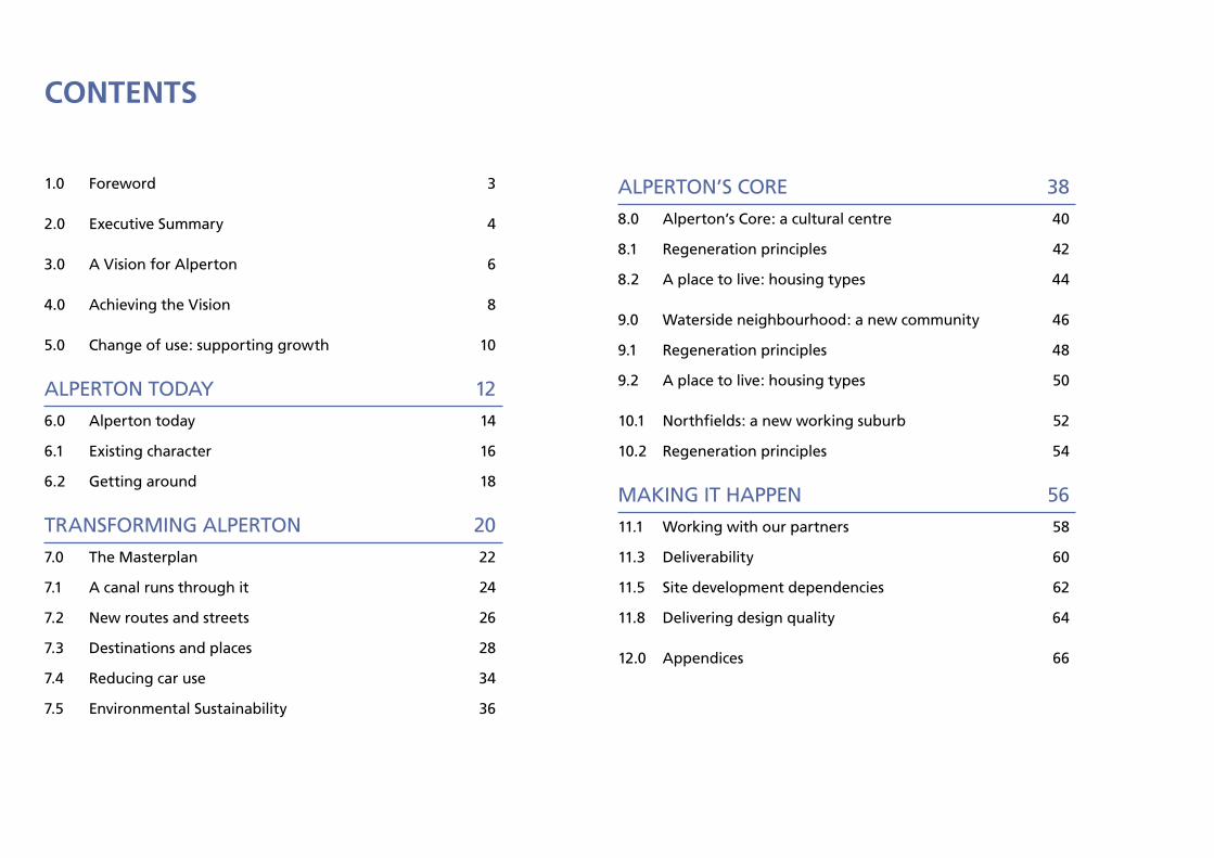
Contents
1.0 Foreword 3
2.0 Executive Summary 4
3.0 A Vision for Alperton 6
4.0 Achieving the Vision 8
5.0 Change of use: supporting growth 10
ALPERTON TODAY 12
6.0 Alperton today 14
6.1 Existing character 16
6.2 Getting around 18
TRANSFORMING ALPERTON 20
7.0 The Masterplan 22
7.1 A canal runs through it 24
7.2 New routes and streets 26
7.3 Destinations and places 28
7.4 Reducing car use 34
7.5 Environmental Sustainability 36
ALPERTON’S CORE 38
8.0 Alperton’s Core: a cultural centre 40
8.1 Regeneration principles 42
8.2 A place to live: housing types 44
9.0 Waterside neighbourhood: a new community 46
9.1 Regeneration principles 48
9.2 A place to live: housing types 50
10.1 Northfields: a new working suburb 52
10.2 Regeneration principles 54
MAKING IT HAPPEN 56
11.1 Working with our partners 58
11.3 Deliverability 60
11.5 Site development dependencies 62
11.8 Delivering design quality 64
12.0 Appendices 66
3
Foreword
alperton was originally identified as a growth area through the preparation of the core strategy in 2008, at this time the area was attracting a lot of developer interest and there was no specific planning policy in place to ensure that proposals met the council’s regeneration objectives for the area.
the economic downturn has meant that developments have taken longer to come forward in recent years and this has given the council the opportunity to reflect on what kind of development they would like to see in the growth area.
this document has been developed over two years from visions to adoption in close collaboration with many stakeholders including residents, businesses, landowners and council officers. the aim of this document is to transform alperton in a way which benefits existing as well as new communities and which is environmentally and socially sustainable as well as being economically viable.
4
2.0 exeCutive summAry
Brent Council has identified the land adjoining the canal in Alperton as a growth area suitable for the construction of new homes to meet the UK wide demands of population growth and the shortage of housing.
This Supplementary Planning Document (SPD) is part of the Brent Local Development Framework and is supple-mentary to the Brent Core Strategy 2010 and the Site Specific Allocations 2011. The Alperton SPD was adopted by Executive in July 2011. The purpose of the masterplan is to set out in detail how the council will bring about the transformation of this industrial area into a new, mostly residential neighbour-hood. It will provide clear guidance for developers, landowners and residents about the scale of change which the council would like to see happen.
As a growth area Alperton’s transfor-mation sits within the council’s overall approach to growth: the delivery of physical, social and economic regeneration by enabling new development in a defined location. This transformation is considered within the context of the diverse population of Alperton and how it can support existing arts and cultural activities.
The ‘Vision for Alperton’ developed with council partners, residents, businesses and landowners, forms the basis for this masterplan. The vision describes a transformed Alperton as having three distinct character areas by virtue of use, scale and appearance, linked together by a lively stretch of the Grand Union Canal. Each character area is described in terms of its overall feel and character, land use, building height, street hierarchy, public realm, open space improvements and housing density, types and tenure.
Alperton’s Core will be a lively centre for cultural activities, community facilities and local shopping. Development will be mixed use with a supply of modern business space for economic growth.
The Waterside Residential Neighbour-hood will predominantly be a place to live for families within a compact environment defined by a network of connected streets and public spaces. Access to the canal for existing and new residents will be introduced.
The Industrial Transition Zone will provide modern business space for large and small operations. A road bridge link across the River Brent will connect Northfields Industrial Estate with the North Circular Road and onwards to Park Royal.
A new urban structure is established which suggests new streets and connections, improving connectivity between the new and existing communities, and access to and across the canal. Destinations are identified as a series of new public realm and open space improvements.
A sustainable approach to transport is set out which proposes fewer cars and improved connections to public transport. Energy efficient design and renewable energy are encouraged.
Viability studies have been carried out to test which housing types and densities are feasible and deliverable considering current and emerging market conditions.
Whilst much of the industrial land in Alperton is of poor quality, there are businesses which are doing well and employing local people. The council intends to encourage proposals where affected businesses have been offered an acceptable solution.
Although the council’s property interests in the area are very limited, its role in delivery is to facilitate development and prioritise the physical and social infrastructure needed to support new homes and adapt to changing economic circumstances.
The aim of this document is to demonstrate how Alperton can be transformed through growth to deliver homes, business space, jobs, services and infrastructure to support a sustainable community.
The Alperton Masterplan SPD was adopted as a Supplementary Planning Document to the Councils Local Development Framework (LDF) Core Strategy at Executive on 18 July 2011.
5
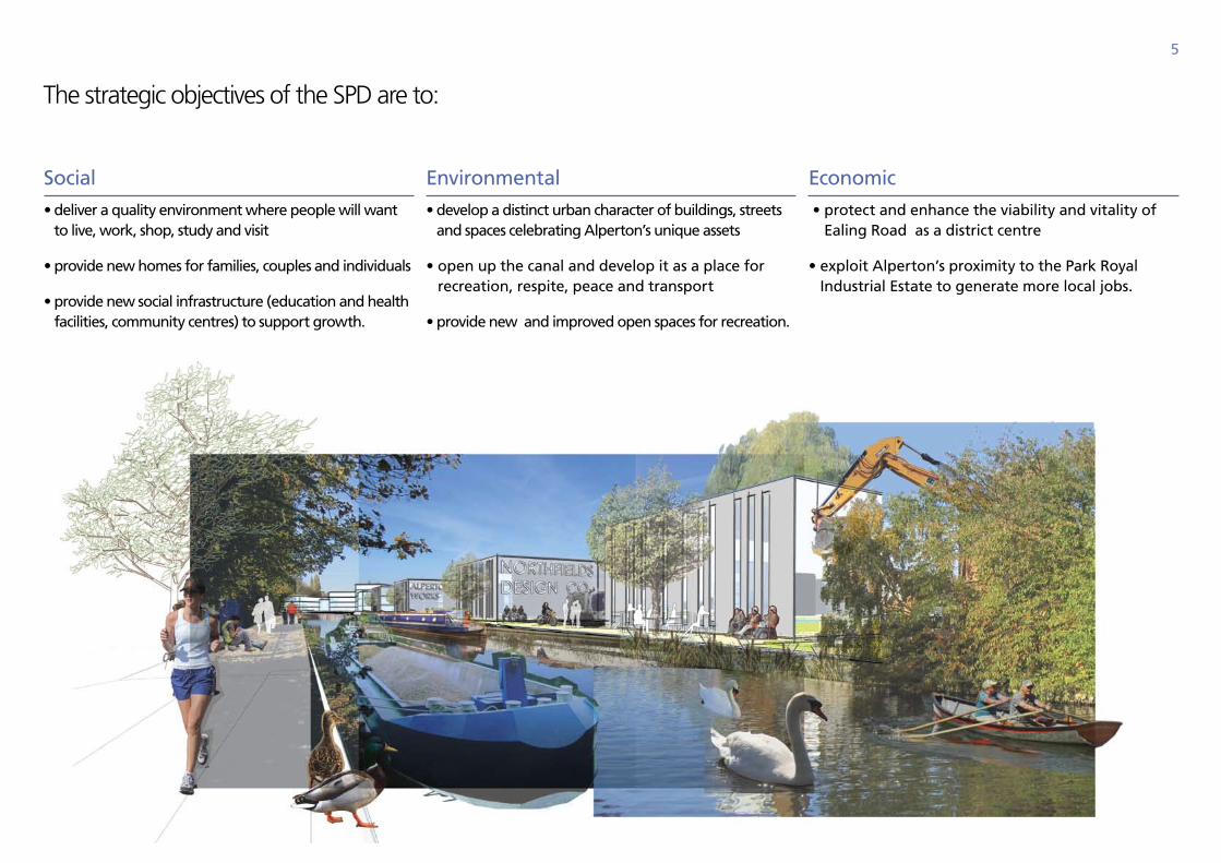
the strategic objectives of the Spd are to:
Social
• deliver a quality environment where people will want to live, work, shop, study and visit
• provide new homes for families, couples and individuals
• provide new social infrastructure (education and health facilities, community centres) to support growth.
Environmental
• develop a distinct urban character of buildings, streets and spaces celebrating Alperton’s unique assets
• open up the canal and develop it as a place for recreation, respite, peace and transport
• provide new and improved open spaces for recreation.
Economic
• protect and enhance the viability and vitality of Ealing Road as a district centre
• exploit Alperton’s proximity to the Park Royal Industrial Estate to generate more local jobs.
6
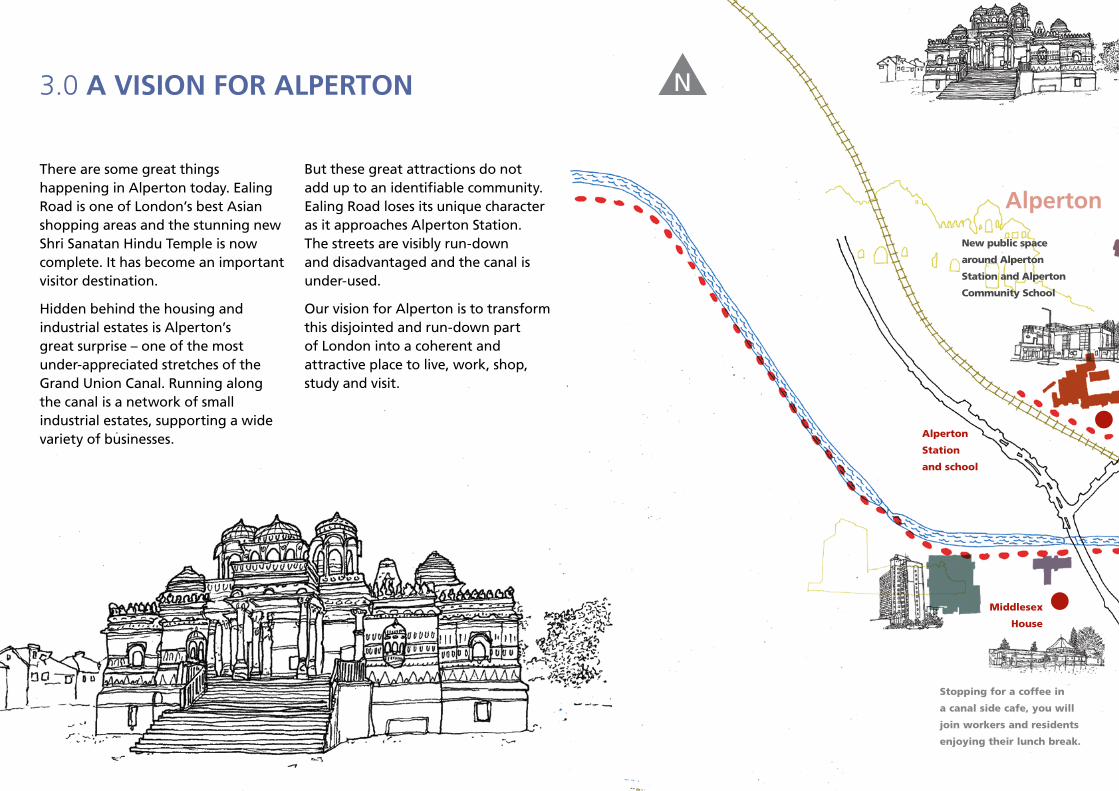
3.0 A vision For Alperton
There are some great things happening in Alperton today. Ealing Road is one of London’s best Asian shopping areas and the stunning new Shri Sanatan Hindu Temple is now complete. It has become an important visitor destination.
Hidden behind the housing and industrial estates is Alperton’s great surprise – one of the most under-appreciated stretches of the Grand Union Canal. Running along the canal is a network of small industrial estates, supporting a wide variety of businesses.
But these great attractions do not add up to an identifiable community. Ealing Road loses its unique character as it approaches Alperton Station. The streets are visibly run-down and disadvantaged and the canal is under-used.
Our vision for Alperton is to transform this disjointed and run-down part of London into a coherent and attractive place to live, work, shop, study and visit.
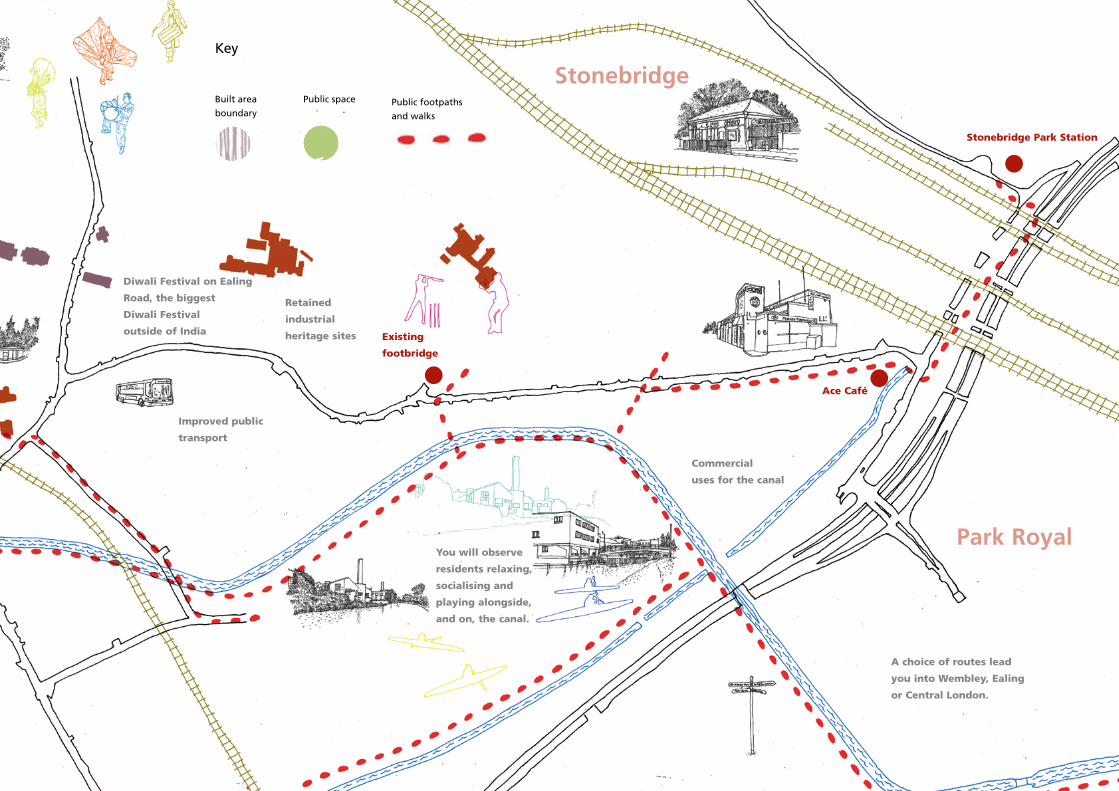
Stopping for a coffee in
a canal side cafe, you will
join workers and residents
enjoying their lunch break.
New public space
around Alperton
Station and Alperton
Community School
Middlesex
House
Alperton
Alperton
Station
and school
N
7
You will observe
residents relaxing,
socialising and
playing alongside,
and on, the canal.
Retained
industrial
heritage sites Existing
footbridge
Improved public
transport
A choice of routes lead
you into Wembley, Ealing
or Central London.
Commercial
uses for the canal
Stonebridge Park Station
park royal
stonebridge
Ace Café
Key
Built area
boundary
Public space Public footpaths
and walks
Diwali Festival on Ealing
Road, the biggest
Diwali Festival
outside of India
8
4.0 AChieving the vision
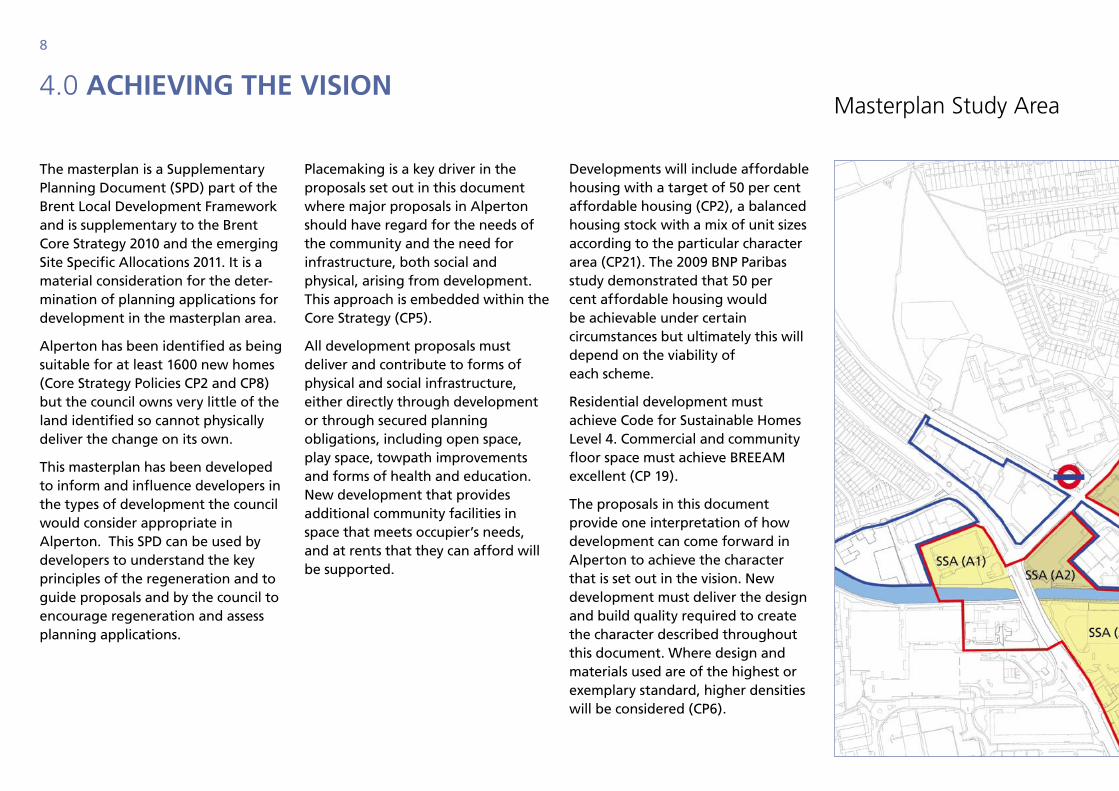
The masterplan is a Supplementary Planning Document (SPD) part of the Brent Local Development Framework and is supplementary to the Brent Core Strategy 2010 and the emerging Site Specific Allocations 2011. It is a material consideration for the deter-mination of planning applications for development in the masterplan area.
Alperton has been identified as being suitable for at least 1600 new homes (Core Strategy Policies CP2 and CP8) but the council owns very little of the land identified so cannot physically deliver the change on its own.
This masterplan has been developed to inform and influence developers in the types of development the council would consider appropriate in Alperton. This SPD can be used by developers to understand the key principles of the regeneration and to guide proposals and by the council to encourage regeneration and assess planning applications.
Placemaking is a key driver in the proposals set out in this document where major proposals in Alperton should have regard for the needs of the community and the need for infrastructure, both social and physical, arising from development. This approach is embedded within the Core Strategy (CP5).
All development proposals must deliver and contribute to forms of physical and social infrastructure, either directly through development or through secured planning obligations, including open space, play space, towpath improvements and forms of health and education. New development that provides additional community facilities in space that meets occupier’s needs, and at rents that they can afford will be supported.
Developments will include affordable housing with a target of 50 per cent affordable housing (CP2), a balanced housing stock with a mix of unit sizes according to the particular character area (CP21). The 2009 BNP Paribas study demonstrated that 50 per cent affordable housing would be achievable under certain circumstances but ultimately this will depend on the viability of each scheme.
Residential development must achieve Code for Sustainable Homes Level 4. Commercial and community floor space must achieve BREEAM excellent (CP 19).
The proposals in this document provide one interpretation of how development can come forward in Alperton to achieve the character that is set out in the vision. New development must deliver the design and build quality required to create the character described throughout this document. Where design and materials used are of the highest or exemplary standard, higher densities will be considered (CP6).
masterplan Study area
9
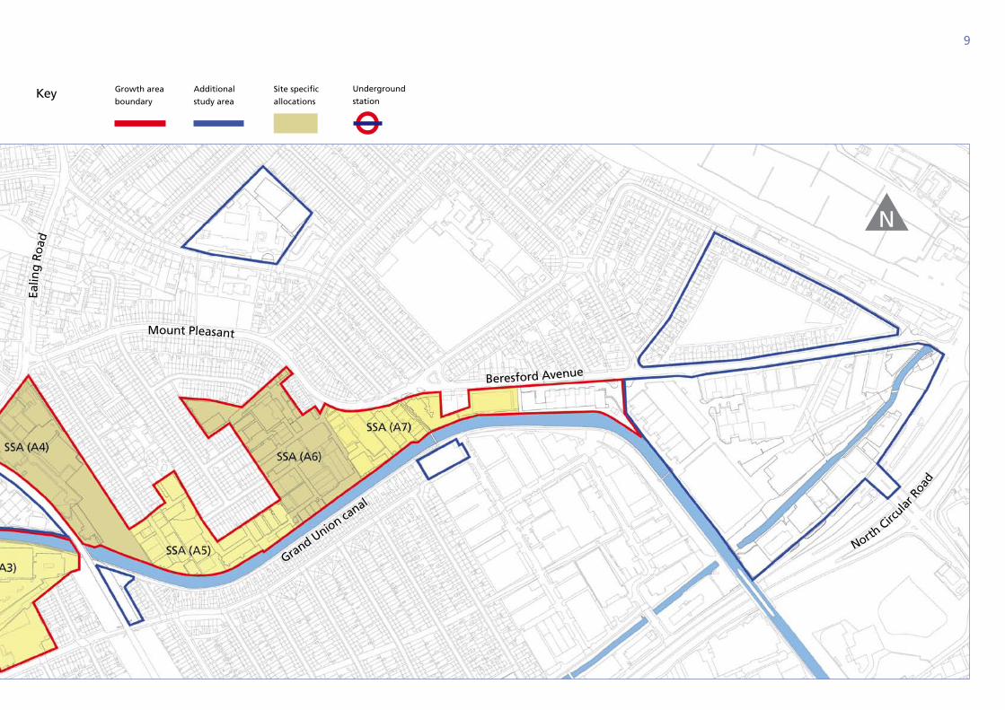
Key Growth area
boundary
Additional
study area
Site specific
allocations
Underground
station
N
Ealin
g R
oad
Grand Union canal
North Circ
ular R
oad
Mount Pleasant
Beresford Avenue
10
5.0 ChAnge oF use: supporting growth
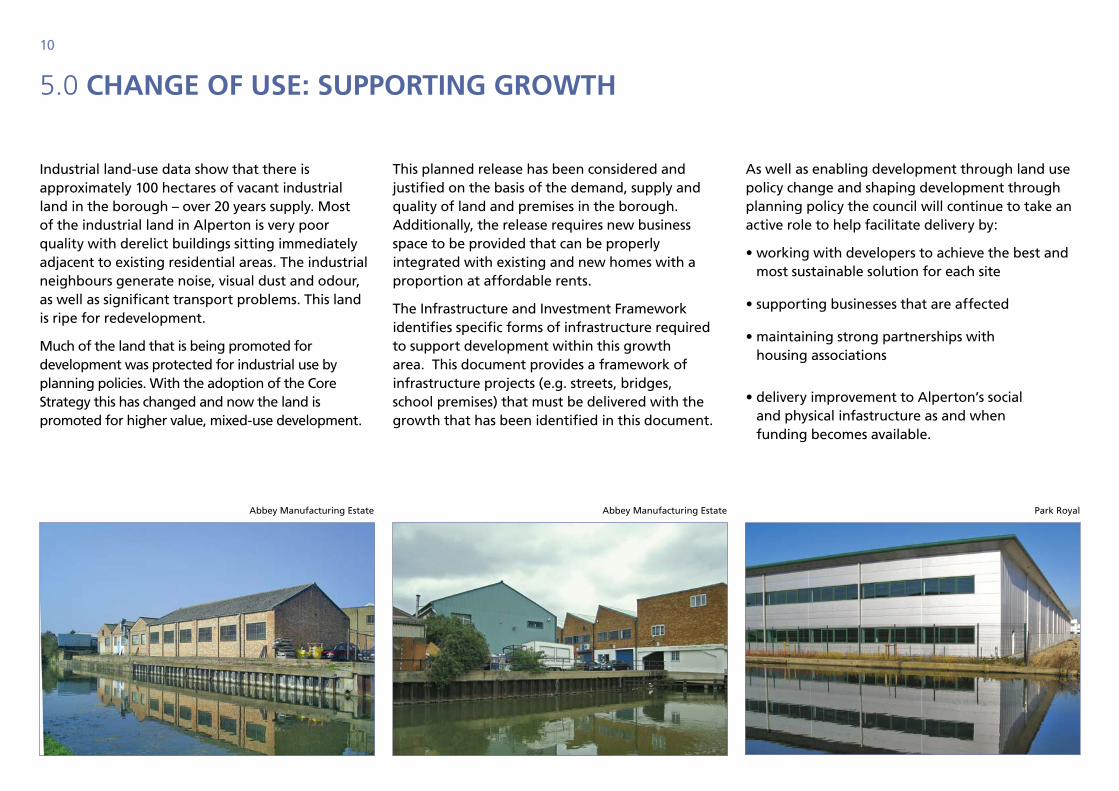
Industrial land-use data show that there is approximately 100 hectares of vacant industrial land in the borough – over 20 years supply. Most of the industrial land in Alperton is very poor quality with derelict buildings sitting immediately adjacent to existing residential areas. The industrial neighbours generate noise, visual dust and odour, as well as significant transport problems. This land is ripe for redevelopment.
Much of the land that is being promoted for development was protected for industrial use by planning policies. With the adoption of the Core Strategy this has changed and now the land is promoted for higher value, mixed-use development.
This planned release has been considered and justified on the basis of the demand, supply and quality of land and premises in the borough. Additionally, the release requires new business space to be provided that can be properly integrated with existing and new homes with a proportion at affordable rents.
The Infrastructure and Investment Framework identifies specific forms of infrastructure required to support development within this growth area. This document provides a framework of infrastructure projects (e.g. streets, bridges, school premises) that must be delivered with the growth that has been identified in this document.
As well as enabling development through land use policy change and shaping development through planning policy the council will continue to take an active role to help facilitate delivery by:
• working with developers to achieve the best and most sustainable solution for each site
• supporting businesses that are affected
• maintaining strong partnerships with housing associations
• delivery improvement to Alperton’s social and physical infastructure as and when funding becomes available.
Abbey Manufacturing Estate Abbey Manufacturing Estate Park Royal
11
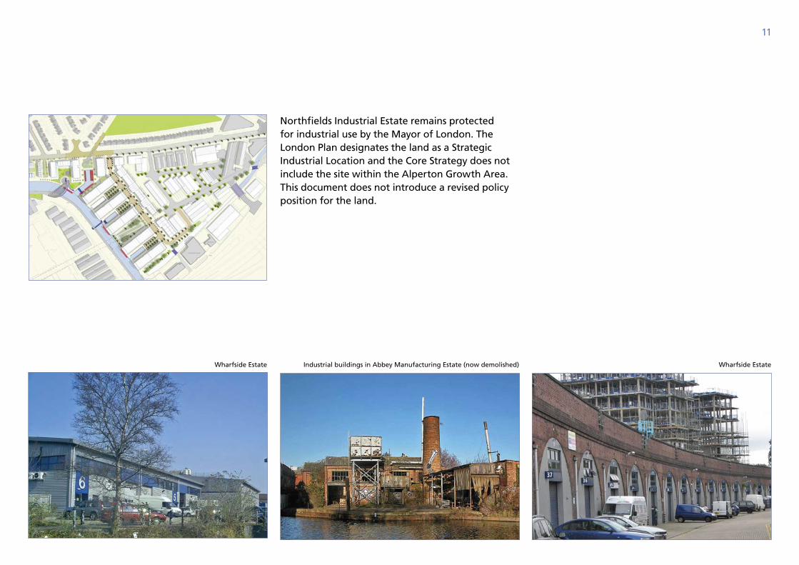
Northfields Industrial Estate remains protected for industrial use by the Mayor of London. The London Plan designates the land as a Strategic Industrial Location and the Core Strategy does not include the site within the Alperton Growth Area. This document does not introduce a revised policy position for the land.
Industrial buildings in Abbey Manufacturing Estate (now demolished)Wharfside Estate Wharfside Estate

12
Alperton today

13
14
6.0 Alperton todAy
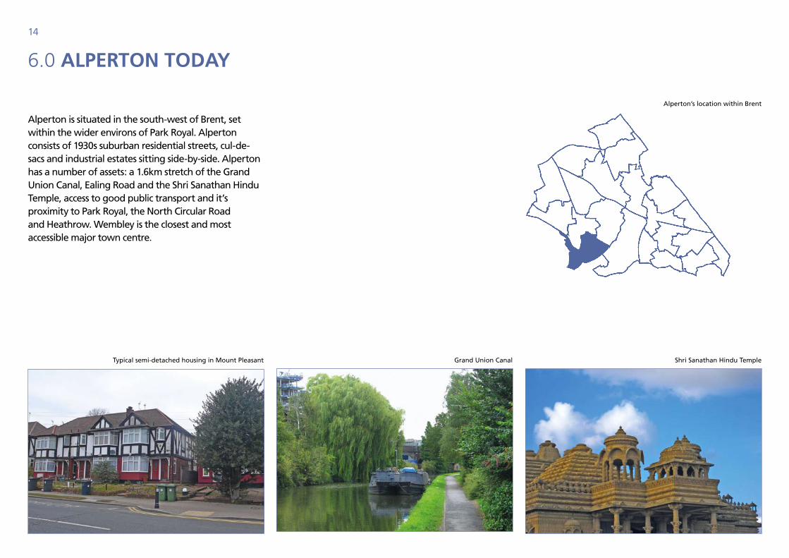
Alperton is situated in the south-west of Brent, set within the wider environs of Park Royal. Alperton consists of 1930s suburban residential streets, cul-de-sacs and industrial estates sitting side-by-side. Alperton has a number of assets: a 1.6km stretch of the Grand Union Canal, Ealing Road and the Shri Sanathan Hindu Temple, access to good public transport and it’s proximity to Park Royal, the North Circular Road and Heathrow. Wembley is the closest and most accessible major town centre.
Typical semi-detached housing in Mount Pleasant Grand Union Canal Shri Sanathan Hindu Temple
Alperton’s location within Brent
15
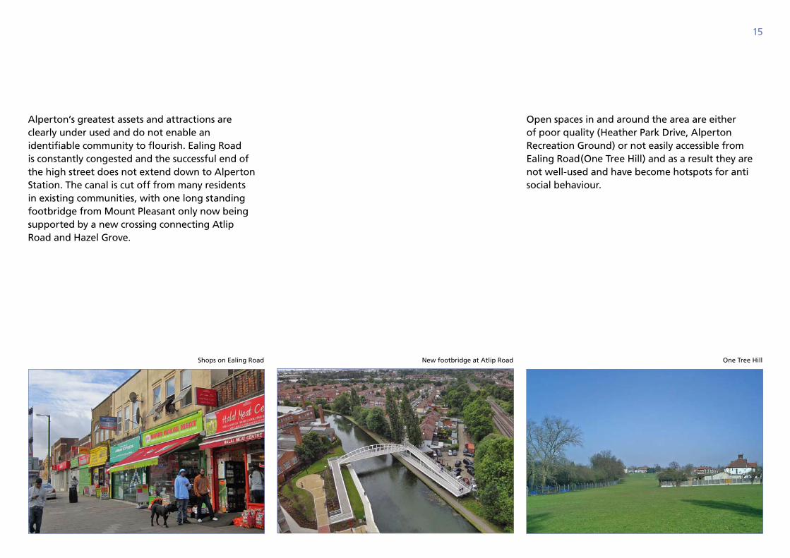
Alperton’s greatest assets and attractions are clearly under used and do not enable an identifiable community to flourish. Ealing Road is constantly congested and the successful end of the high street does not extend down to Alperton Station. The canal is cut off from many residents in existing communities, with one long standing footbridge from Mount Pleasant only now being supported by a new crossing connecting Atlip Road and Hazel Grove.
Open spaces in and around the area are either of poor quality (Heather Park Drive, Alperton Recreation Ground) or not easily accessible from Ealing Road(One Tree Hill) and as a result they are not well-used and have become hotspots for anti social behaviour.
New footbridge at Atlip RoadShops on Ealing Road One Tree Hill
16
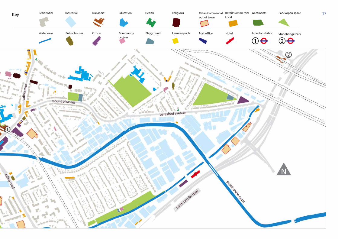
6.1 existing ChArACter
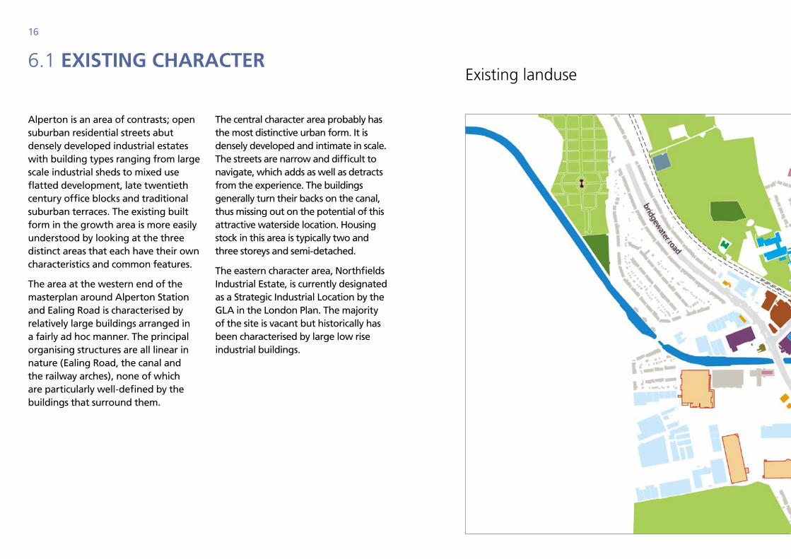
Alperton is an area of contrasts; open suburban residential streets abut densely developed industrial estates with building types ranging from large scale industrial sheds to mixed use flatted development, late twentieth century office blocks and traditional suburban terraces. The existing built form in the growth area is more easily understood by looking at the three distinct areas that each have their own characteristics and common features.
The area at the western end of the masterplan around Alperton Station and Ealing Road is characterised by relatively large buildings arranged in a fairly ad hoc manner. The principal organising structures are all linear in nature (Ealing Road, the canal and the railway arches), none of which are particularly well-defined by the buildings that surround them.
The central character area probably has the most distinctive urban form. It is densely developed and intimate in scale. The streets are narrow and difficult to navigate, which adds as well as detracts from the experience. The buildings generally turn their backs on the canal, thus missing out on the potential of this attractive waterside location. Housing stock in this area is typically two and three storeys and semi-detached.
The eastern character area, Northfields Industrial Estate, is currently designated as a Strategic Industrial Location by the GLA in the London Plan. The majority of the site is vacant but historically has been characterised by large low rise industrial buildings.
existing landuse
17
Alperton station
Residential
Waterways
Industrial
Public houses
Transport
Offices
Education Health
Playground
Religious
Leisure/sports
AllotmentsRetail/Commercial
out of town
Post office
Retail/Commercial
Local
Hotel
Parks/open space
Community
centres
N
Key
Stonebridge Park
18
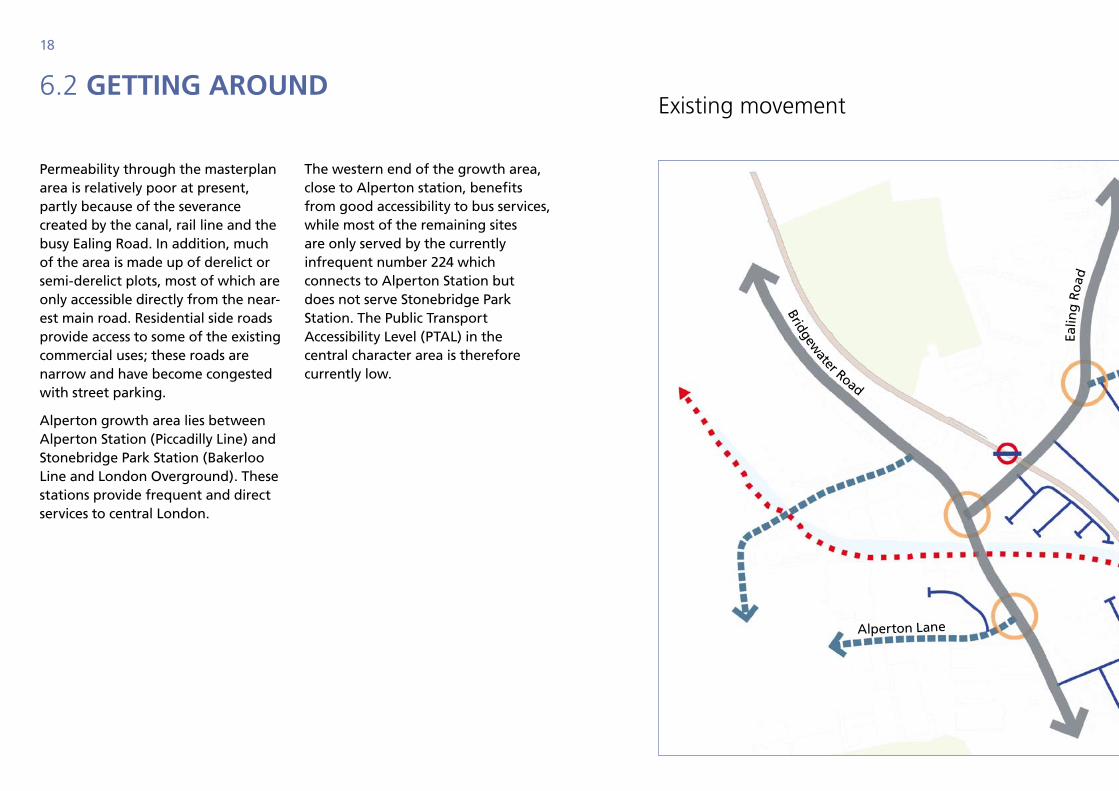
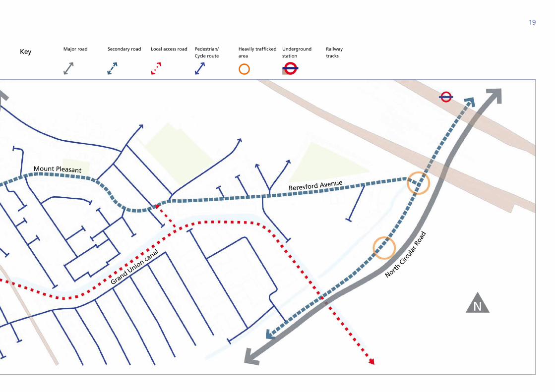
6.2 getting Around
Permeability through the masterplan area is relatively poor at present, partly because of the severance created by the canal, rail line and the busy Ealing Road. In addition, much of the area is made up of derelict or semi-derelict plots, most of which are only accessible directly from the near-est main road. Residential side roads provide access to some of the existing commercial uses; these roads are narrow and have become congested with street parking.
Alperton growth area lies between Alperton Station (Piccadilly Line) and Stonebridge Park Station (Bakerloo Line and London Overground). These stations provide frequent and direct services to central London.
The western end of the growth area, close to Alperton station, benefits from good accessibility to bus services, while most of the remaining sites are only served by the currently infrequent number 224 which connects to Alperton Station but does not serve Stonebridge Park Station. The Public Transport Accessibility Level (PTAL) in the central character area is therefore currently low.
existing movement
Ealin
g R
oad
Bridgewater Road
Alperton Lane
19
Key Major road Secondary road Local access road Pedestrian/
Cycle route
Heavily trafficked
area
Underground
station
Railway
tracks
N
Ealin
g R
oad
Grand Union canal
North
Circ
ular
Roa
d
Mount Pleasant
Beresford Avenue
20
transforming Alperton

21
22
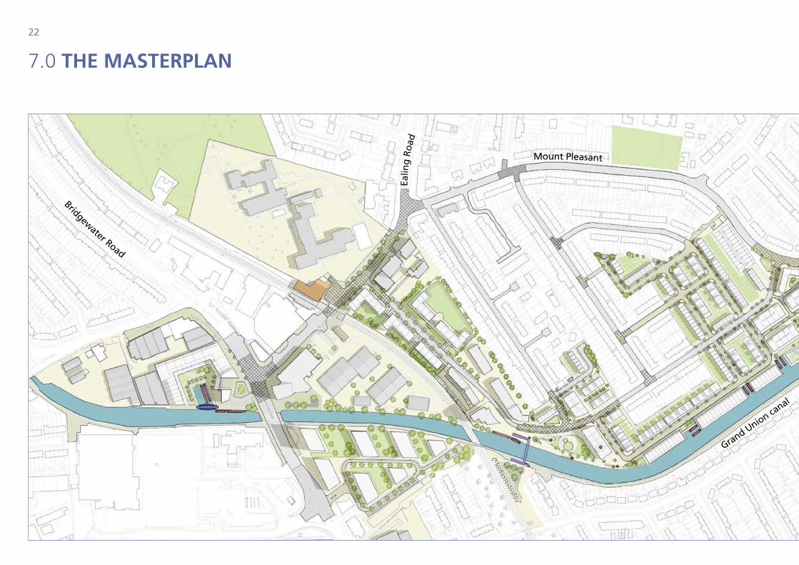
7.0 the mAsterplAn
Ealin
g R
oad
Grand Union canal
Mount Pleasant
Bridgewater Road
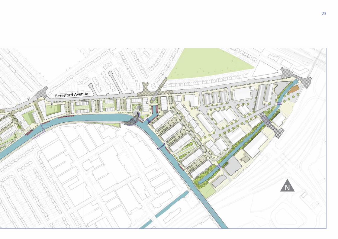
23
NGrand Union canal
Beresford Avenue
24
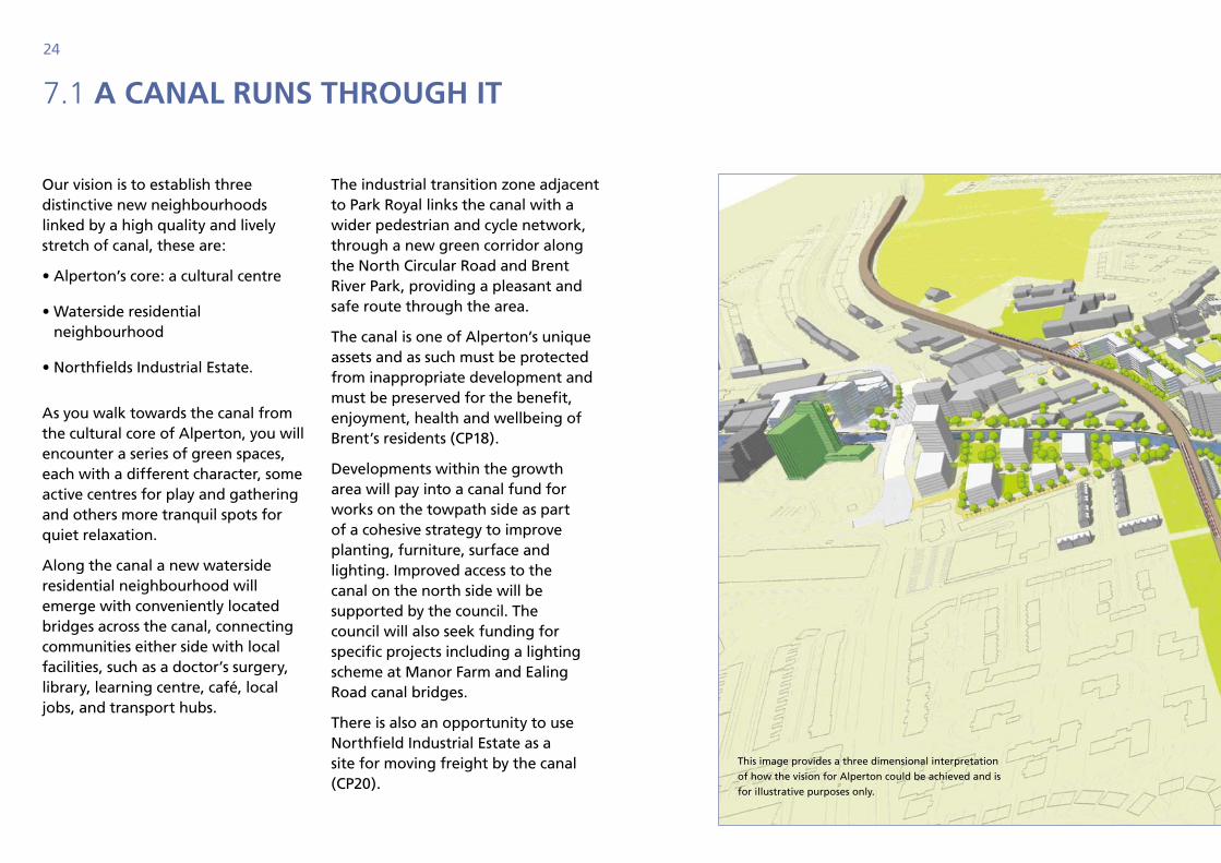
7.1 A CAnAl runs through it
Our vision is to establish three distinctive new neighbourhoods linked by a high quality and lively stretch of canal, these are:
• Alperton’s core: a cultural centre
• Waterside residential neighbourhood
• Northfields Industrial Estate.
As you walk towards the canal from the cultural core of Alperton, you will encounter a series of green spaces, each with a different character, some active centres for play and gathering and others more tranquil spots for quiet relaxation.
Along the canal a new waterside residential neighbourhood will emerge with conveniently located bridges across the canal, connecting communities either side with local facilities, such as a doctor’s surgery, library, learning centre, café, local jobs, and transport hubs.
The industrial transition zone adjacent to Park Royal links the canal with a wider pedestrian and cycle network, through a new green corridor along the North Circular Road and Brent River Park, providing a pleasant and safe route through the area.
The canal is one of Alperton’s unique assets and as such must be protected from inappropriate development and must be preserved for the benefit, enjoyment, health and wellbeing of Brent’s residents (CP18).
Developments within the growth area will pay into a canal fund for works on the towpath side as part of a cohesive strategy to improve planting, furniture, surface and lighting. Improved access to the canal on the north side will be supported by the council. The council will also seek funding for specific projects including a lighting scheme at Manor Farm and Ealing Road canal bridges.
There is also an opportunity to use Northfield Industrial Estate as a site for moving freight by the canal (CP20).
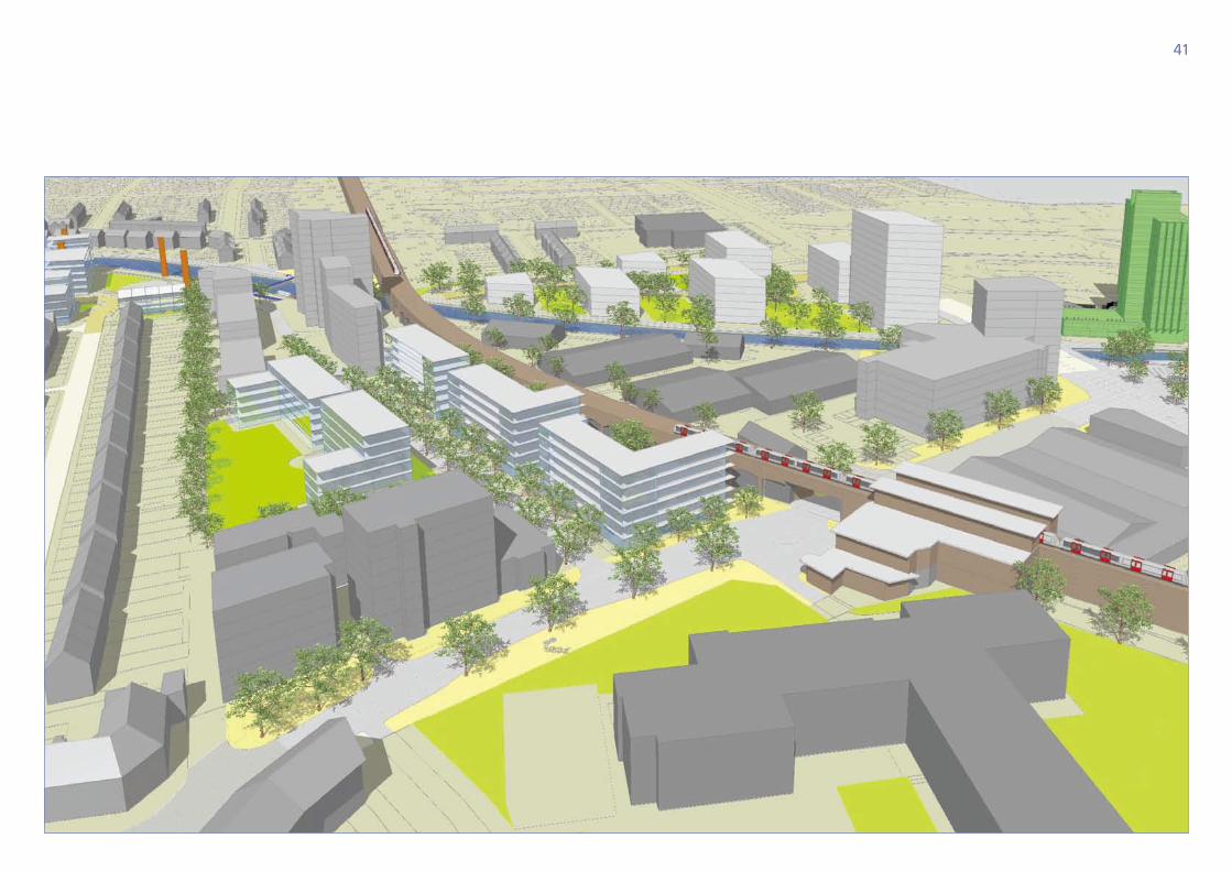
This image provides a three dimensional interpretation
of how the vision for Alperton could be achieved and is
for illustrative purposes only.
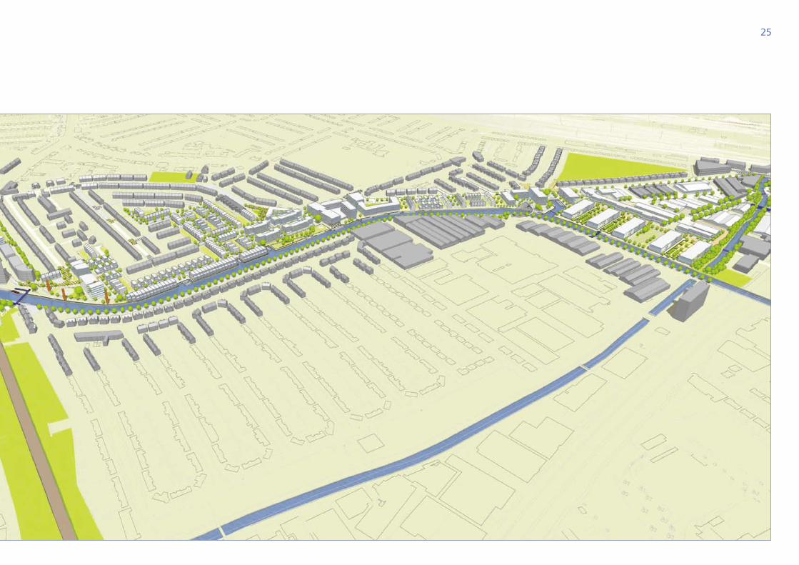
25
26
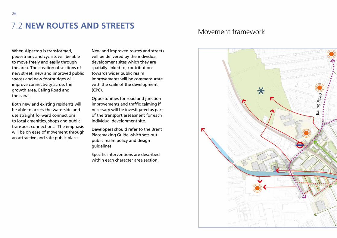
7.2 new routes And streets
When Alperton is transformed, pedestrians and cyclists will be able to move freely and easily through the area. The creation of sections of new street, new and improved public spaces and new footbridges will improve connectivity across the growth area, Ealing Road and the canal.
Both new and existing residents will be able to access the waterside and use straight forward connections to local amenities, shops and public transport connections. The emphasis will be on ease of movement through an attractive and safe public place.
New and improved routes and streets will be delivered by the individual development sites which they are spatially linked to; contributions towards wider public realm improvements will be commensurate with the scale of the development (CP6).
Opportunities for road and junction improvements and traffic calming if necessary will be investigated as part of the transport assessment for each individual development site.
Developers should refer to the Brent Placemaking Guide which sets out public realm policy and design guidelines.
Specific interventions are described within each character area section.
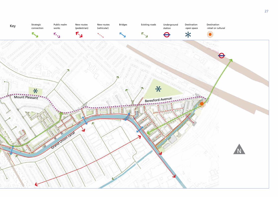
movement framework
Ealin
g R
oad
27
Key Strategic
connection
Public realm
works
New routes
(pedestrian)
New routes
(vehicular)
Bridges Existing roads Underground
station
Destination
-open space
Destination
-retail or cultural
N
Ealin
g R
oad
Grand Union canal
Mount PleasantBeresford Avenue
28
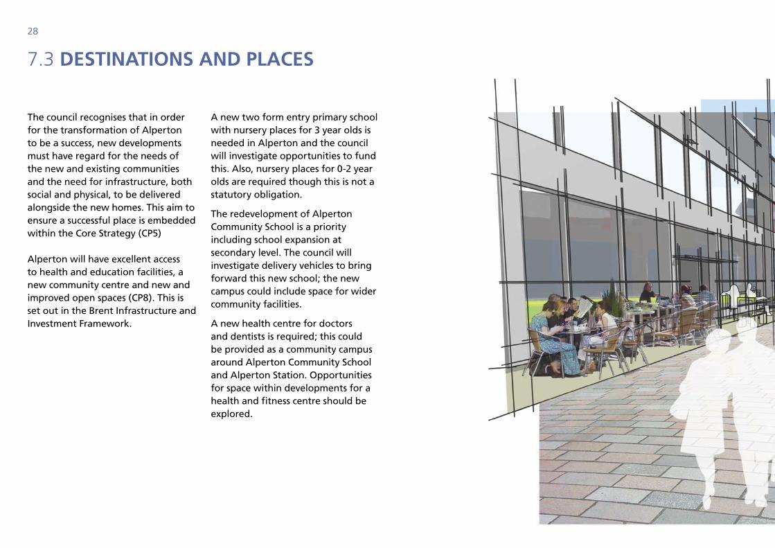
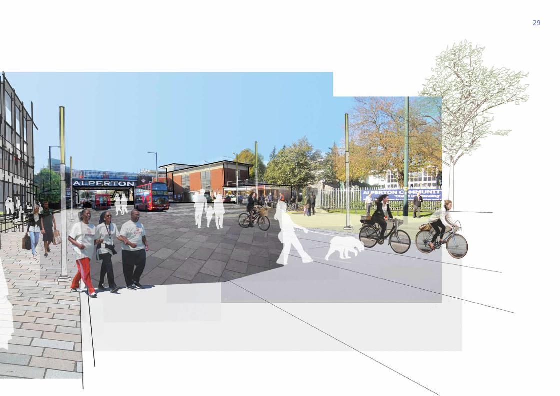
The council recognises that in order for the transformation of Alperton to be a success, new developments must have regard for the needs of the new and existing communities and the need for infrastructure, both social and physical, to be delivered alongside the new homes. This aim to ensure a successful place is embedded within the Core Strategy (CP5)
Alperton will have excellent access to health and education facilities, a new community centre and new and improved open spaces (CP8). This is set out in the Brent Infrastructure and Investment Framework.
A new two form entry primary school with nursery places for 3 year olds is needed in Alperton and the council will investigate opportunities to fund this. Also, nursery places for 0-2 year olds are required though this is not a statutory obligation.
The redevelopment of Alperton Community School is a priority including school expansion at secondary level. The council will investigate delivery vehicles to bring forward this new school; the new campus could include space for wider community facilities.
A new health centre for doctors and dentists is required; this could be provided as a community campus around Alperton Community School and Alperton Station. Opportunities for space within developments for a health and fitness centre should be explored.
7.3 destinAtions And plACes
29
30
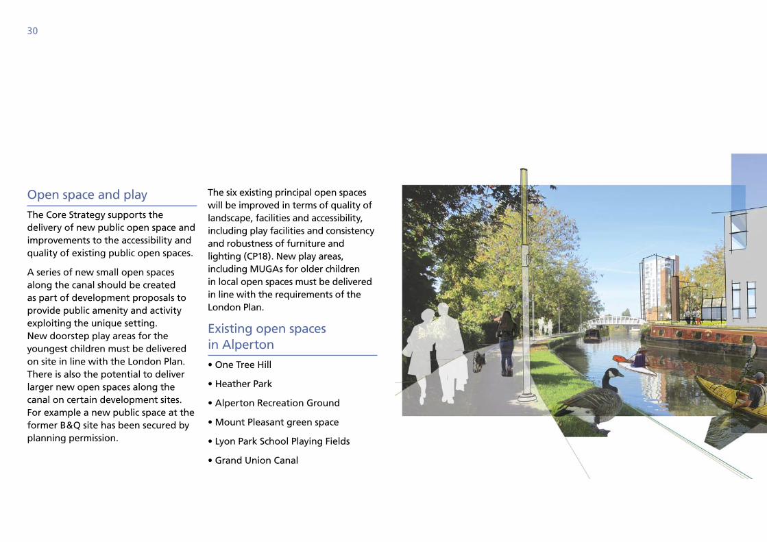
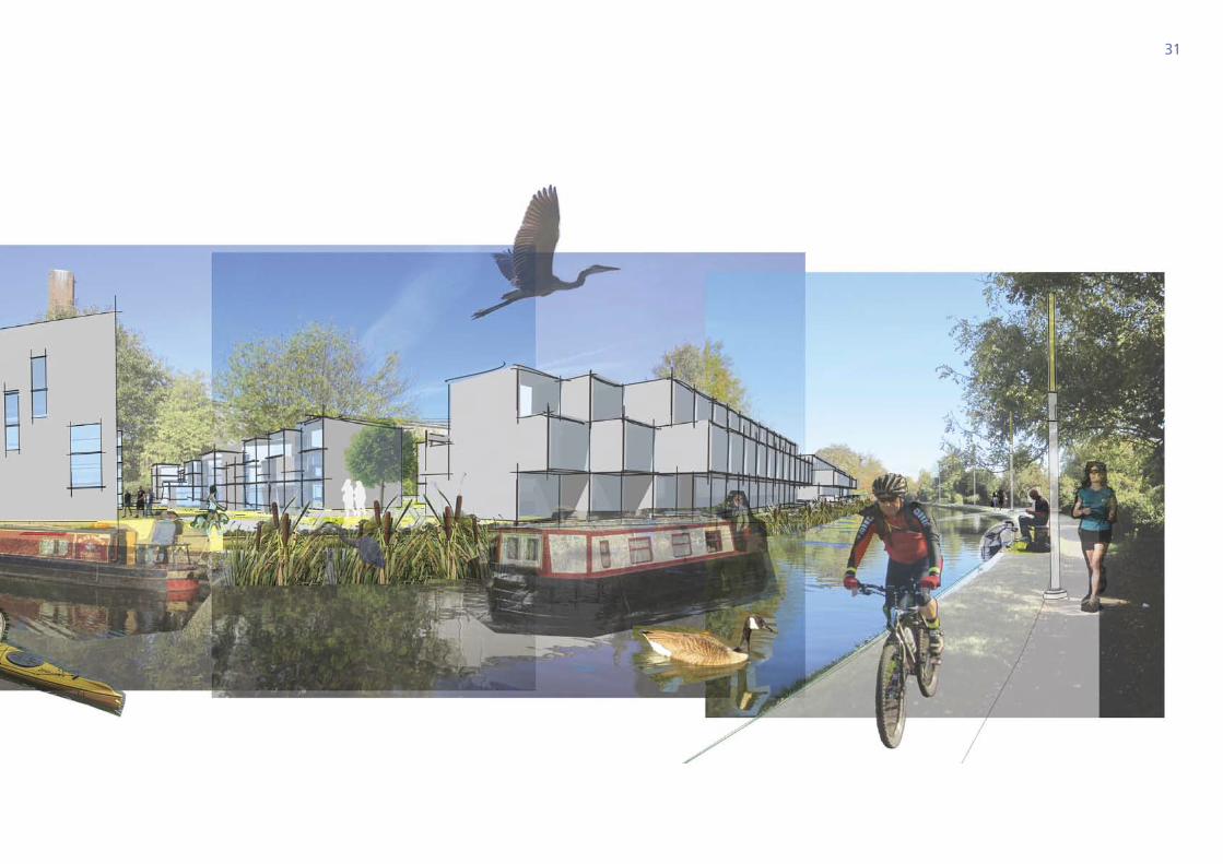
Open space and play
The Core Strategy supports the delivery of new public open space and improvements to the accessibility and quality of existing public open spaces.
A series of new small open spaces along the canal should be created as part of development proposals to provide public amenity and activity exploiting the unique setting. New doorstep play areas for the youngest children must be delivered on site in line with the London Plan. There is also the potential to deliver larger new open spaces along the canal on certain development sites. For example a new public space at the former B&Q site has been secured by planning permission.
The six existing principal open spaces will be improved in terms of quality of landscape, facilities and accessibility, including play facilities and consistency and robustness of furniture and lighting (CP18). New play areas, including MUGAs for older children in local open spaces must be delivered in line with the requirements of the London Plan.
Existing open spaces in Alperton
• One Tree Hill
• Heather Park
• Alperton Recreation Ground
• Mount Pleasant green space
• Lyon Park School Playing Fields
• Grand Union Canal
31
32
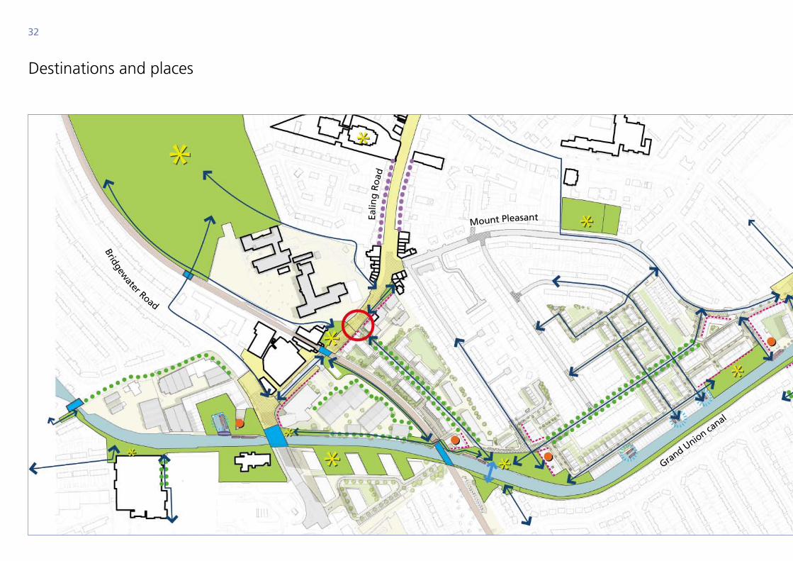
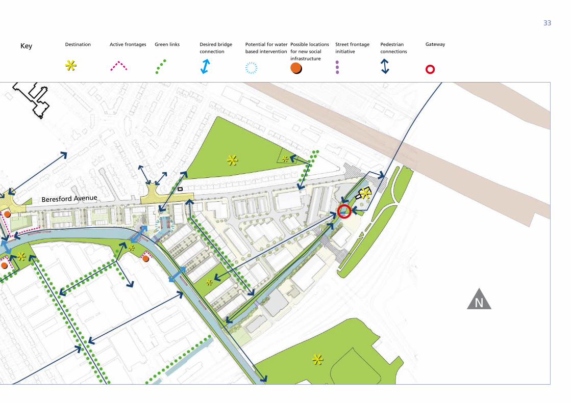
destinations and places
Ealin
g R
oad
Grand Union ca
nal
Mount Pleasant
Bridgewater Road
33
Key Destination Active frontages Green links Desired bridge
connection
Potential for water
based intervention
Possible locations
for new social
infrastructure
Street frontage
initiative
Pedestrian
connections
Gateway
N
Beresford Avenue
34
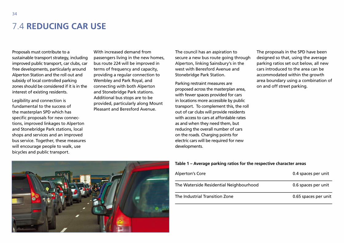
7.4 reduCing CAr use
Proposals must contribute to a sustainable transport strategy, including improved public transport, car clubs, car free developments, particularly around Alperton Station and the roll out and subsidy of local controlled parking zones should be considered if it is in the interest of existing residents.
Legibility and connection is fundamental to the success of the masterplan SPD which has specific proposals for new connec-tions, improved linkages to Alperton and Stonebridge Park stations, local shops and services and an improved bus service. Together, these measures will encourage people to walk, use bicycles and public transport.
With increased demand from passengers living in the new homes, bus route 224 will be improved in terms of frequency and capacity, providing a regular connection to Wembley and Park Royal, and connecting with both Alperton and Stonebridge Park stations. Additional bus stops are to be provided, particularly along Mount Pleasant and Beresford Avenue.
The council has an aspiration to secure a new bus route going through Alperton, linking Sainsbury’s in the west with Beresford Avenue and Stonebridge Park Station.
Parking restraint measures are proposed across the masterplan area, with fewer spaces provided for cars in locations more accessible by public transport. To complement this, the roll out of car clubs will provide residents with access to cars at affordable rates as and when they need them, but reducing the overall number of cars on the roads. Charging points for electric cars will be required for new developments.
The proposals in the SPD have been designed so that, using the average parking ratios set out below, all new cars introduced to the area can be accommodated within the growth area boundary using a combination of on and off street parking.
table 1 – Average parking ratios for the respective character areas
Alperton’s Core 0.4 spaces per unit
The Waterside Residential Neighbourhood 0.6 spaces per unit
The Industrial Transition Zone 0.65 spaces per unit
35
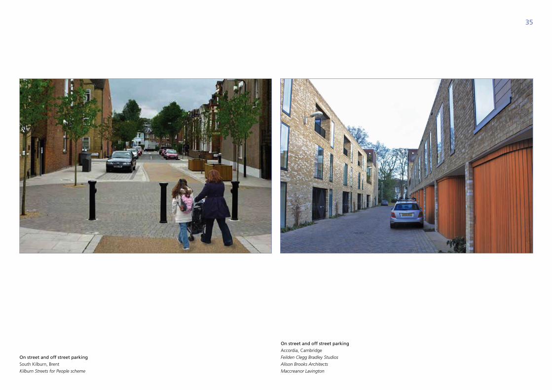
On street and off street parking
South Kilburn, Brent
Kilburn Streets for People scheme
On street and off street parking
accordia, cambridge
Feilden Clegg Bradley Studios
Alison Brooks Architects
Maccreanor Lavington
36
7.5 environmentAl sustAinAbility
The core strategy requires that all major housing proposals in Alperton are built to Code for Sustainable Homes Level 4, and non-residential development to BREEAM “Excellent”. Proposals will be expected to comply with Supplementary Planning Guidance (SPPG19) Sustainable Design and Construction and score a minimum of 50 percent on the Brent sustainability checklist. The extensive southern aspect of development sites offers potential for passive solar design, while a tight urban grain, particularly within the Waterside Residential Neighbourhood will provide opportunities for shading through orientation of buildings.
All proposals will be expected to incorporate the following principles of sustainable development:
• use landform, layout, orientation, massing and landscaping to reduce energy demand
• connect to, or provide for future connection to decentralised energy if feasible
• provide multi-functional green spaces and green networks
• prioritise sustainable drainage systems
• provide space for recycling and composting
• promote active travel with suitable cycle parking, implement travel plans and provide a safe and attractive cycling and walking environment.
New development in Alperton will need to be built to cope with the adverse effects of climate change, including higher summer temperature, increased risk of flooding, and reduced water availability and quality. Proposals should incorporate the following adaptation measures:
Preventing overheating:
• shading and orientation of buildings
• thermal mass to regulate temperature naturally
• use of cool (light-coloured) or reflective materials
• natural ventilation and active cooling
• provide cool and attractive outdoor areas, green roofs, street trees and living walls
Flood protection:
• limit surface water run off to green field run off rate so flood risk is not increased off-site
• evaluate the use of sustainable urban drainage methods in the following order of preference: living roofs, basins and ponds, filter strips and swales, infiltration devices, permeable surfaces and tanked systems.
• all flat roof space should be utilised for living roofs (or solar panels) where feasible
Conserve water:
• use of water efficient fixtures and fittings
• rainwater harvesting for reuse in buildings and for irrigation
• grey water recycling
• sustainable drainage systems to collect and store water.
37
New development will place pressure on existing utilities infrastructure such as water and wastewater. The above measures will help to minimise this impact, in addition developers should demonstrate that adequate capacity exists or upgrades to utilities infrastructure will be required prior to occupation of the development.
Reducing the carbon footprint of new development in Alperton should first be addressed by ensuring energy efficient design and proposals will be encouraged to adopt best practice building fabric performance standards.
The proximity of the development sites and the mix of uses within the SPD facilitate the introduction of a decentralised network of Combined Cooling, Heat and Power (CCHP) systems, with the potential to connect adjacent sites as development proceeds. The presence of both commercial and residential floor space allows for heating and cooling to occur within respective buildings and neighbouring uses at different times of the day, maximising the potential of heat recovery. PV panels are a renewable technology compatible with CCHP. The feasibility and delivery of such a system would be contingent on the scale of development coming forward.
Contaminated land
Land contamination is likely to be an issue on many development sites in the Alperton growth area. Appropriate site investigation and remediation measures will be required, with a preference for bio-remediation, soil vapour extraction and soil washing methods, which are preferable to less sustainable dig and dump practices.
Canal wildlife protection and enhancement
The Grand Union Canal is an important resource for wildlife, and is designated Metropolitan Importance for Nature Conservation. Proposals affecting the canal should protect and enhance the canal habitat and improve public access. Water quality should be protected by preventing rainwater run-off entering the canal by using Sustainable Urban Drainage systems (SUDs).
Protection measures include:
• protecting canal side trees
• removing invasive plants including Japanese Knotweed
• bats roost under many canal bridges and canal side structures – avoid artificial lighting on bat roosts, entrance points and flight paths
• ensure development include measures to manage run-off and water quality.
Enhancement measures include:
• marginal vegetation planting
• nesting rafts
• install bird and bat bricks/boxes
• create reedbeds and ponds
• opportunities to provide soft planting along the towpath
• aquatic planting within the canal
• green roofs and living walls
• tree and hedgerow planting
• plant bare walls with climbers
• wildflower planting
• new public access to canal and opening up public footpaths.

38
Alperton’s core

39
40
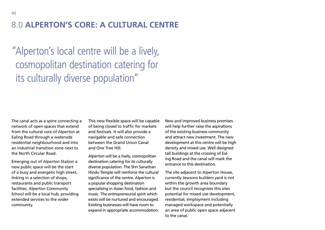
8.0 Alperton’s Core: A CulturAl Centre
The canal acts as a spine connecting a network of open spaces that extend from the cultural core of Alperton at Ealing Road through a waterside residential neighbourhood and into an industrial transition zone next to the North Circular Road.
Emerging out of Alperton Station a new public space will be the start of a busy and energetic high street, linking in a selection of shops, restaurants and public transport facilities. Alperton Community School will be a local hub, providing extended services to the wider community.
This new flexible space will be capable of being closed to traffic for markets and festivals. It will also provide a navigable and safe connection between the Grand Union Canal and One Tree Hill.
Alperton will be a lively, cosmopolitan destination catering for its culturally diverse population. The Shri Sanathan Hindu Temple will reinforce the cultural significance of the centre. Alperton is a popular shopping destination specialising in Asian food, fashion and music. The entrepreneurial spirit which exists will be nurtured and encouraged. Existing businesses will have room to expand in appropriate accommodation.
New and improved business premises will help further raise the aspirations of the existing business community and attract new investment. The new development at this centre will be high density and mixed use. Well designed tall buildings at the crossing of Eal-ing Road and the canal will mark the entrance to this destination.
The site adjacent to Alperton House, currently Jewsons builders yard is not within the growth area boundary but the council recognises this sites potential for mixed use development, residential, employment including managed workspace and potentially an area of public open space adjacent to the canal.
“ Alperton’s local centre will be a lively, cosmopolitan destination catering for its culturally diverse population”
41
42
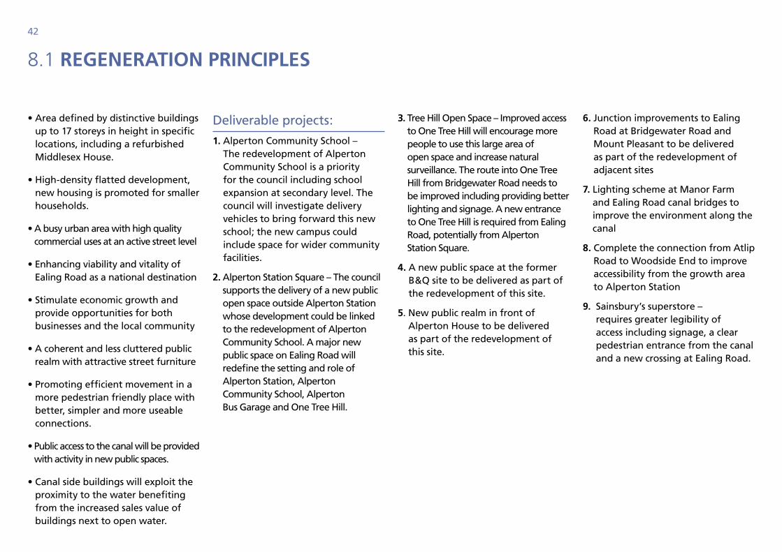
8.1 regenerAtion prinCiples
• Area defined by distinctive buildings up to 17 storeys in height in specific locations, including a refurbished Middlesex House.
• High-density flatted development, new housing is promoted for smaller households.
• A busy urban area with high quality commercial uses at an active street level
• Enhancing viability and vitality of Ealing Road as a national destination
• Stimulate economic growth and provide opportunities for both businesses and the local community
• A coherent and less cluttered public realm with attractive street furniture
• Promoting efficient movement in a more pedestrian friendly place with better, simpler and more useable connections.
• Public access to the canal will be provided with activity in new public spaces.
• Canal side buildings will exploit the proximity to the water benefiting from the increased sales value of buildings next to open water.
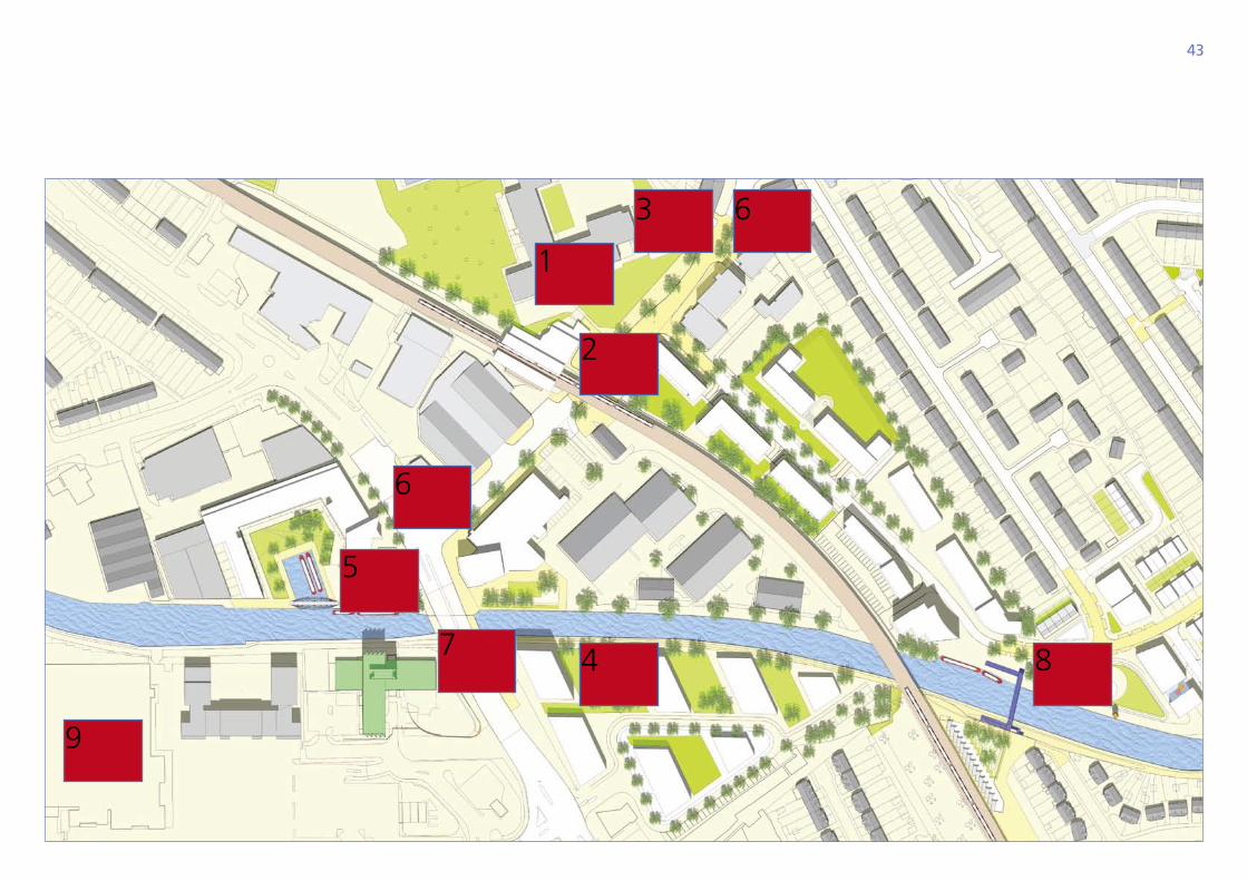
Deliverable projects:
1. Alperton Community School – The redevelopment of Alperton Community School is a priority for the council including school expansion at secondary level. The council will investigate delivery vehicles to bring forward this new school; the new campus could include space for wider community facilities.
2. Alperton Station Square – The council supports the delivery of a new public open space outside Alperton Station whose development could be linked to the redevelopment of Alperton Community School. A major new public space on Ealing Road will redefine the setting and role of Alperton Station, Alperton Community School, Alperton Bus Garage and One Tree Hill.
3. Tree Hill Open Space – Improved access to One Tree Hill will encourage more people to use this large area of open space and increase natural surveillance. The route into One Tree Hill from Bridgewater Road needs to be improved including providing better lighting and signage. A new entrance to One Tree Hill is required from Ealing Road, potentially from Alperton Station Square.
4. A new public space at the former B&Q site to be delivered as part of the redevelopment of this site.
5. New public realm in front of Alperton House to be delivered as part of the redevelopment of this site.
6. Junction improvements to Ealing Road at Bridgewater Road and Mount Pleasant to be delivered as part of the redevelopment of adjacent sites
7. Lighting scheme at Manor Farm and Ealing Road canal bridges to improve the environment along the canal
8. Complete the connection from Atlip Road to Woodside End to improve accessibility from the growth area to Alperton Station
9. Sainsbury’s superstore – requires greater legibility of access including signage, a clear pedestrian entrance from the canal and a new crossing at Ealing Road.
43
1
2
4 8
5
6
7
9
3 6
44
8.2 A plACe to live: housing types
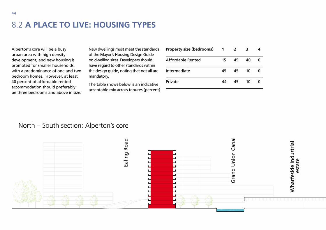
Alperton’s core will be a busy urban area with high density development, and new housing is promoted for smaller households, with a predominance of one and two bedroom homes. However, at least 40 percent of affordable rented accommodation should preferably be three bedrooms and above in size.
New dwellings must meet the standards of the Mayor’s Housing Design Guide on dwelling sizes. Developers should have regard to other standards within the design guide, noting that not all are mandatory.
The table shows below is an indicative acceptable mix across tenures (percent)
Gra
nd
Un
ion
Can
al
Atl
ip R
oad
Ealin
g R
oad
Picc
adill
y Li
ne
Sun
leig
h R
oad
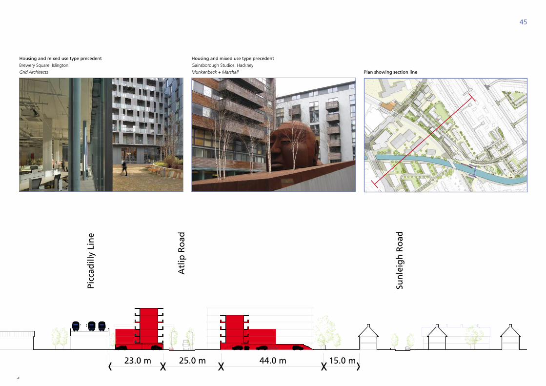
25.0 m 44.0 m 15.0 m23.0 m
Wh
arfe
sid
e In
du
stri
al
esta
te
north – South section: alperton’s core
property size (bedrooms) 1 2 3 4
Affordable Rented 15 45 40 0
Intermediate 45 45 10 0
Private 44 45 10 0
45
Housing and mixed use type precedent
Brewery Square, islington
Grid Architects
Housing and mixed use type precedent
gainsborough Studios, Hackney
Munkenbeck + Marshall Plan showing section line
Gra
nd
Un
ion
Can
al
Atl
ip R
oad
Ealin
g R
oad
Picc
adill
y Li
ne
Sun
leig
h R
oad
25.0 m 44.0 m 15.0 m23.0 m
Wh
arfe
sid
e In
du
stri
al
esta
te
46
9.0 wAterside neighbourhood: A new Community
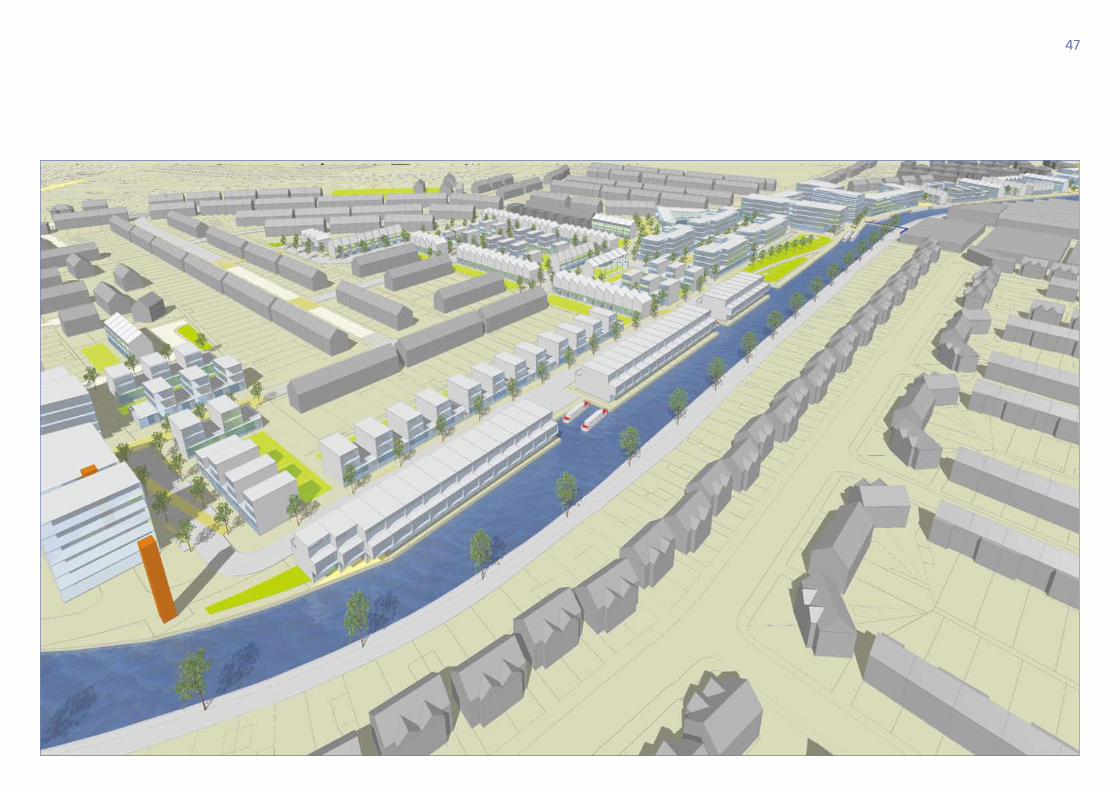
Moving east along the canal a different neighbourhood emerges, quieter and more residential; a new type of community which provides family homes in a compact modern environment. New housing will activate the canal, taking advantage of the views and special character that is generated.
The scale of the new development will relate to the adjacent existing neighbourhoods to the north and south, with taller buildings making the transition into a different scale in the Northfield Estate. The homes will set high standards of environmentally sensitive design.
A series of public and private open spaces emerge with the new developments. Open spaces along the canal will be the location for new community facilities. Existing open spaces will be improved to provide new recreation and sports facilities.
The new residential neighbourhood will be made accessible by improvements to public transport. Initiatives could include a more frequent local bus route joining Alperton and Stonebridge stations and a fast bus link to Wembley. Car clubs will be introduced to provide residents with an alternative to private car use.
The existing built form and physical location of this district offers the greatest opportunities to apply innovative design to create a neighbourhood with a very special and clearly distinguishable character. It is envisaged that mews and courtyard type of developments will be introduced, and other similar forms that entail relatively small front to front distances.
The concept for this area is to create a new canal side community, whilst retaining and reinforcing that which currently makes up the character of Alperton today. The proposed development seeks to achieve a unique identity for this new residential neighbourhood where streets and spaces are compact, urban and enclosed allowing housing targets to be achieved whilst maintaining a massing appropriate to the existing context.
Standards in existing planning policy such as physical separation have been challenged and it is suggested that good quality residential amenity can still be achieved through the careful design, placement and orientation of windows to prevent overlooking. The council will only be persuaded of this approach where designs and materials are of the highest quality.
Where new development interfaces with existing residential areas great care will be taken to protect the privacy outlook and amenity of the existing residents of Alperton.
“ A new type of community which provides family homes in a compact modern environment”
47
48
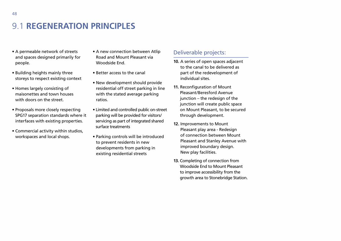
9.1 regenerAtion prinCiples
• A permeable network of streets and spaces designed primarily for people.
• Building heights mainly three storeys to respect existing context
• Homes largely consisting of maisonettes and town houses with doors on the street.
• Proposals more closely respecting SPG17 separation standards where it interfaces with existing properties.
• Commercial activity within studios, workspaces and local shops.
• A new connection between Atlip Road and Mount Pleasant via Woodside End.
• Better access to the canal
• New development should provide residential off street parking in line with the stated average parking ratios.
• Limited and controlled public on-street parking will be provided for visitors/servicing as part of integrated shared surface treatments
• Parking controls will be introduced to prevent residents in new developments from parking in existing residential streets
Deliverable projects:
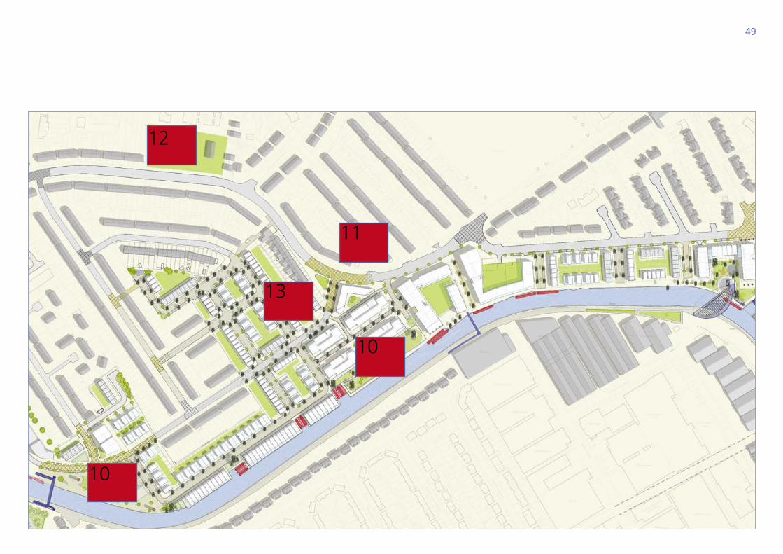
10. A series of open spaces adjacent to the canal to be delivered as part of the redevelopment of individual sites.
11. Reconfiguration of Mount Pleasant/Beresford Avenue junction – the redesign of the junction will create public space on Mount Pleasant, to be secured through development.
12. Improvements to Mount Pleasant play area - Redesign of connection between Mount Pleasant and Stanley Avenue with improved boundary design. New play facilities.
13. Completing of connection from Woodside End to Mount Pleasant to improve accessibility from the growth area to Stonebridge Station.
49
12
11
13
10
10
50
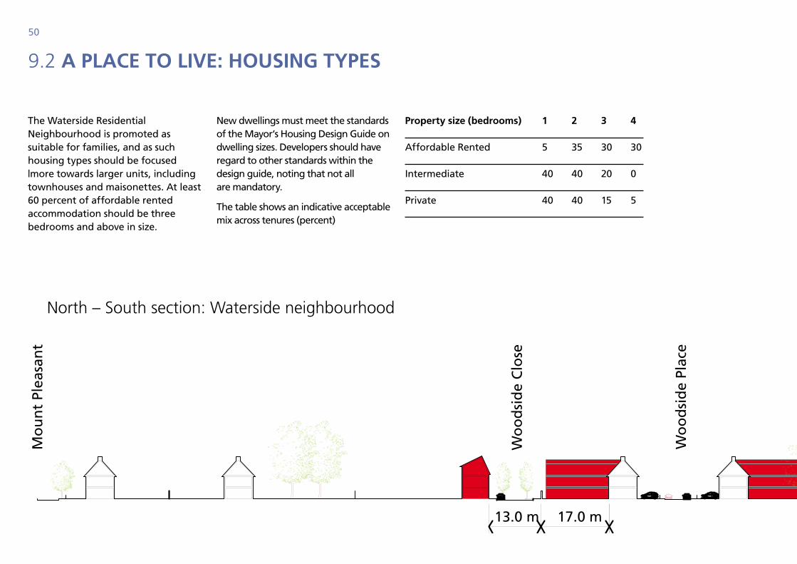
9.2 A plACe to live: housing types
The Waterside Residential Neighbourhood is promoted as suitable for families, and as such housing types should be focused |more towards larger units, including townhouses and maisonettes. At least 60 percent of affordable rented accommodation should be three bedrooms and above in size.
New dwellings must meet the standards of the Mayor’s Housing Design Guide on dwelling sizes. Developers should have regard to other standards within the design guide, noting that not all are mandatory.
The table shows an indicative acceptable mix across tenures (percent)
property size (bedrooms) 1 2 3 4
Affordable Rented 5 35 30 30
Intermediate 40 40 20 0
Private 40 40 15 5
Gra
nd
Un
ion
Can
al
New
Mew
s
Wo
od
sid
e En
d
Car
lyo
n R
oad
Wo
od
sid
e Pl
ace
Wo
od
sid
e C
lose
25.0 m 15.0 m17.0 m 14.0 m10.010.013.0 m
Mo
un
t Pl
easa
nt
north – South section: Waterside neighbourhood
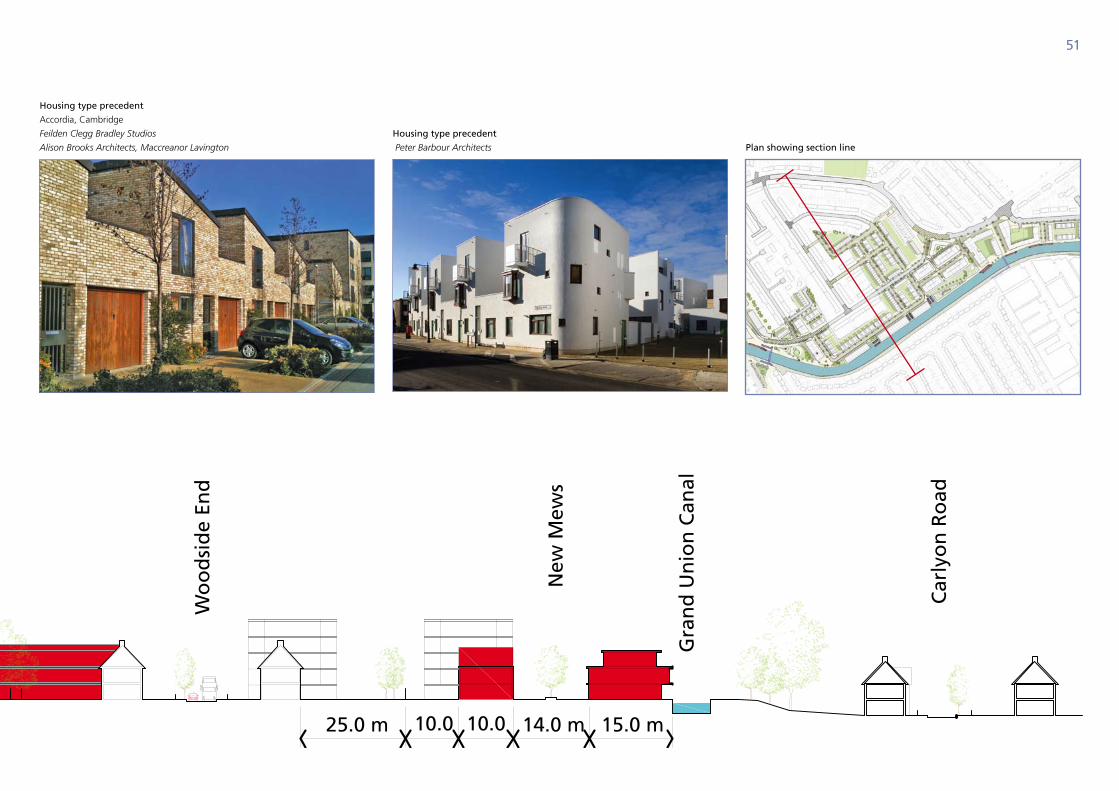
51
Housing type precedent
accordia, cambridge
Feilden Clegg Bradley Studios
Alison Brooks Architects, Maccreanor Lavington
Housing type precedent
Peter Barbour Architects Plan showing section line
Gra
nd
Un
ion
Can
al
New
Mew
s
Wo
od
sid
e En
d
Car
lyo
n R
oad
Wo
od
sid
e Pl
ace
Wo
od
sid
e C
lose
25.0 m 15.0 m17.0 m 14.0 m10.010.013.0 m
Mo
un
t Pl
easa
nt
52
10.1 northFields: A new working suburb
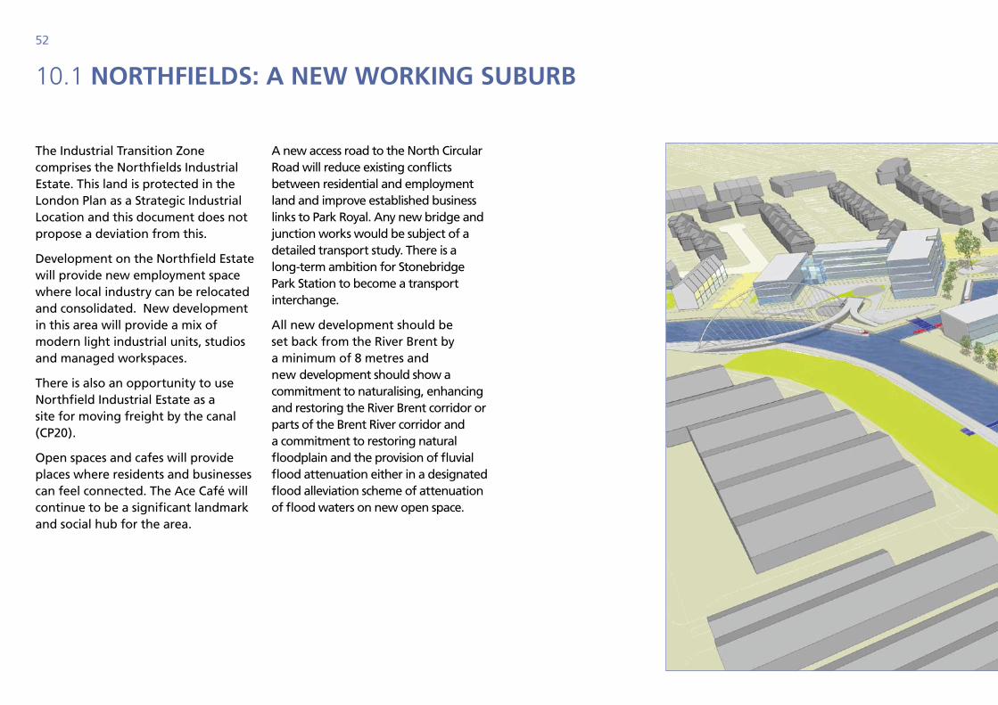
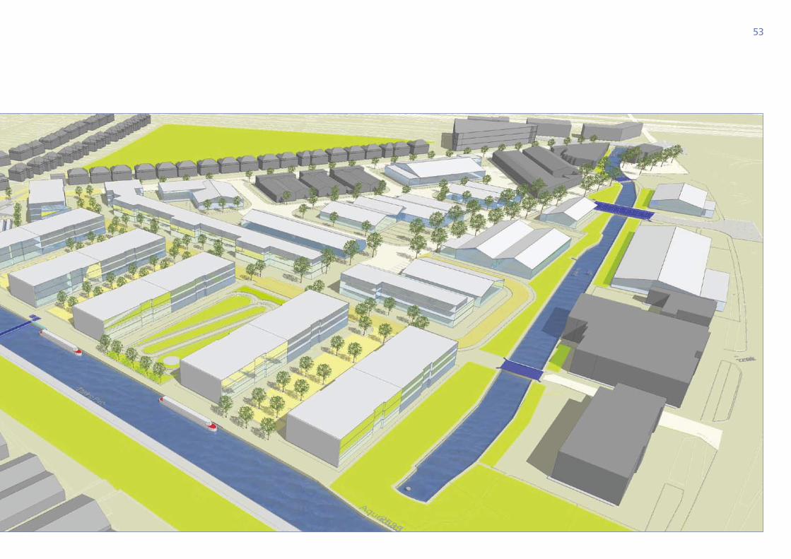
The Industrial Transition Zone comprises the Northfields Industrial Estate. This land is protected in the London Plan as a Strategic Industrial Location and this document does not propose a deviation from this.
Development on the Northfield Estate will provide new employment space where local industry can be relocated and consolidated. New development in this area will provide a mix of modern light industrial units, studios and managed workspaces.
There is also an opportunity to use Northfield Industrial Estate as a site for moving freight by the canal (CP20).
Open spaces and cafes will provide places where residents and businesses can feel connected. The Ace Café will continue to be a significant landmark and social hub for the area.
A new access road to the North Circular Road will reduce existing conflicts between residential and employment land and improve established business links to Park Royal. Any new bridge and junction works would be subject of a detailed transport study. There is a long-term ambition for Stonebridge Park Station to become a transport interchange.
All new development should be set back from the River Brent by a minimum of 8 metres and new development should show a commitment to naturalising, enhancing and restoring the River Brent corridor or parts of the Brent River corridor and a commitment to restoring natural floodplain and the provision of fluvial flood attenuation either in a designated flood alleviation scheme of attenuation of flood waters on new open space.
53
54
10.2 regenerAtion prinCiples
• An industrial character in the designs for new workspace.
• Providing business relocation space to enable redevelopment of the adjacent growth area
• Major pedestrian route connecting the waterside with the Ace Cafe and Stonebridge Park Station beyond.
• Improved physical links to Park Royal with a road bridge across the River Brent to the North Circular Road.
• New public space at the ‘knuckle’ of the canal, with a crossing across the water.
• Support for naturalising, enhancing and restoring the Brent river corridor.
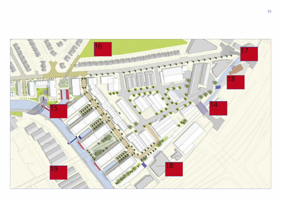
Projects
14. Vehicular Crossing to North Circular Road – To relieve Heather Park Drive of industrial traffic. Will help to integrate Northfields with the fabric of Park Royal.
15. Footbridge at Beresford Avenue – Connecting the towpath with Northfields Industrial Estate with a direct link to Heather Park open space.
16. Heather Park Drive open space – Increased accessibility from Beresford Avenue, new furniture and play space.
17. Route to Stonebridge Park Station - significant public realm and security improvements are required to the space beneath the viaduct including lighting and de-cluttering.
18. New pedestrian crossings across Brent River - Will connect the growth area with North Circular Road bus routes.
19. Public realm improvements to Queensbury Road Strategic Industrial Location including signage, planting, lighting and landscaping to support the continuing function of the industrial estate and improve the local environment.
55
16
15
19
17
18
14
18

56
making it happen

57
58
11.1 working with our pArtners
Much of the land in Alperton is within private ownership, either by existing businesses, property developers and investors or housing associations, who will deliver the new homes, commercial and community space. Discussions with landowners and developers have been held in relation to almost all of the land within the growth area, reflecting a high degree of interest from the development market. Indeed, some sites now benefit from planning permissions.
The council’s role in implementation is one of leading, enabling and facilitating change. The LDF Core Strategy has released planning protection upon employment land in Alperton, therefore establishing the principle of mixed use development. The preparation of the Vision for Alperton and this SPD has set a direction for what Alperton can become.
To facilitate change in Alperton, the council will negotiate development proposals through the planning system and secure benefits such as affordable housing, community facilities and public realm intervention. It will also continue to develop partnerships between delivery agencies to ensure local and regional players can collectively use their influence and obligations to shape Alperton.
The council will seek to maintain the links to the local community which have been established during the development of this SPD and will work with existing Alperton residents and businesses during delivery stage to eliminate concerns. Developers are encouraged to closely engage with existing communities including local faith groups, Neighbourhood Watch Groups and Resident Associations on the emerging proposals.
The council does have compulsory purchase powers and will consider using them to remove blockages to the transformation of Alperton to deliver the vision.
59
11.2 business reloCAtion
There is a clear message within this document, the run down dislocated industrial estates of Alperton will be transformed into a coherent sustainable mixed-use community. Alperton has some of the worst quality industrial land in Brent. There are almost 100 hectares of vacant land and buildings elsewhere in the borough, including approximately, 60 hectares in Park Royal – this is over 25 years’ supply of vacant land.
Although there are a small number of successful and sustainable businesses in the masterplan area, the vast majority of the units accommodate car repair operations. Car repair, spaying and scrapping can be better located away from established and growing residential areas. This situation requires a radical transformation and will not be possible to achieve the objectives of the masterplan while keeping some businesses in situ and redeveloping land around them, while there is such a large supply of suitable land elsewhere in the borough.
Part of the offer to release industrial land is for new mixed-use development to include business space at affordable rents – some space has already been secured at the former B&Q superstore and the Minavil House proposals and is a policy requirement elsewhere in the masterplan area. Developers are encouraged to negotiate with occupiers to include businesses within new space that can sit comfortably and sensitively alongside residential development.
A supply of space could be delivered that includes a number of units at a range of sizes. Rents could be ‘stair-cased’ or ‘pump primed’ so that early years were more affordable but could then increase as businesses grow. Units could be located around shared business administrative hubs (such as meeting venues, reception, copying).
Alternatively, the council will work with business to explore opportunities to relocate elsewhere in the wider Alperton or Park Royal area.
Interviews with existing businesses in the area indicate that there is an appetite for businesses to come together to purchase land and build units at Northfields as part of the comprehensive redevelopment. It is likely that this will require subsidy as part of the development.
60
11.3 deliverAbility
An understanding of the deliverability and feasibility of the masterplan has informed and tested the formation of the design and commentary text. This has been a process of testing and refining.
To understand the viability of future developments, an analysis of land ownership and exchange has been completed across the area to form an appreciation of existing use values, exchange of land and prices paid and any premiums to assemble land from fractured ownerships.
This analysis suggests that the highest value existing commercial uses appear to be in Alperton’s Core with a combination of office and retail uses. However, the land is not fragmented and can be delivered as developable sites. Further east in the Waterside Residential Neighbourhood, existing use values are very low, but the ownership is more fractured which may lead to costs relating to assembly. At the Industrial Transition Zone, values are considered to be low, and the land is already assembled, but there may be costs related to addressing physical, utilities and access constraints.
Using a development appraisal tool, the council understands development costs and sales values of what the SPD proposes. The conclusions are that high density flatted development c ost significantly more to build than houses and maisonettes. Because they are denser, they often require physically more car parking spaces, often in basements. They also take longer to build and therefore longer to sell. Clearly, approximately 1,600 homes will not be built simultaneously or even within the same development cycle. It may be that some sites may not come forward without appreciation within the housing market.
The core strategy requires 50 percent affordable housing across the borough, supported by a 2009 Affordable Housing delivery study prepared by BNP Paribas. The appraisal of the SPD has tested proportions of affordable housing to understand the impact on scheme viability.
Development sites and proposals within Alperton to date have a track record of producing a high proportion of affordable housing. The definition of affordable housing has now changed to be up to 80 percent of the local rental market, but housing benefit has now been capped.
Additionally, the level of grant funding available to deliver affordable housing is now lower than it was. The council will continue to expect affordable housing to be delivered and the policy requirement of the Core Strategy stands. Proposals will continue to be considered on a case by case basis using the GLA Affordable Housing Toolkit, Three Dragons or other appropriate tools.
61
11.4 Funding sourCes
It is envisaged that the majority of development will come forward through private developers in a co-ordinated approach in line with the core objectives of this document. The council will have to achieve its wider economic, social, community and sustainability objectives mainly from that development and to use such funding creatively to attract other sources of funding.
Main sources of funding could include:
• S106 / CIL contributions or direct developer provision;
• Growth Area Funding or other Government programmes;
• Brent Council’s Capital Programme;
• Greater London Authority including Transport for London;
• Other Agencies, e.g. Lottery;
• Direct government funding through education and other programmes;
• New Homes Bonus.
Section 106 (S106) and CIL Strategy
Section 106 contribution is determined by the nature of proposed development. Development quanta have been suggested for the masterplan as a whole but the council will take into account viability and the achievement of other planning objectives in determining permissible levels of development. A range of infrastructure requirements is envisaged as a result of comprehensive redevelopment of the area.
The main infrastructure requirements required as a result of new housing and other development is set out in the council’s core strategy (CP8). The SPD sets out in more detail where requirements such as open space may be located. It is the council’s intention to replace S106 planning obligations largely by implementation of the Community Infrastructure Levy (CIL) although the local infrastructure requirements such as bus contributions would still be sought in S106 planning obligations.
Utilities
All new development must fully consider water and wastewater infrastructure capacity both on and off the site in order to avoid any potential problems for existing or new users. In some circumstances it may be necessary for developers to fund studies to ascertain whether the proposed development will lead to overloading of existing water and sewerage infrastructure. Where there is a capacity problem and no improvements are programmed by the statutory agency, then the developer needs to contact the undertaker to agree what improvements are required and how they will be funded prior to any occupation of the development
62
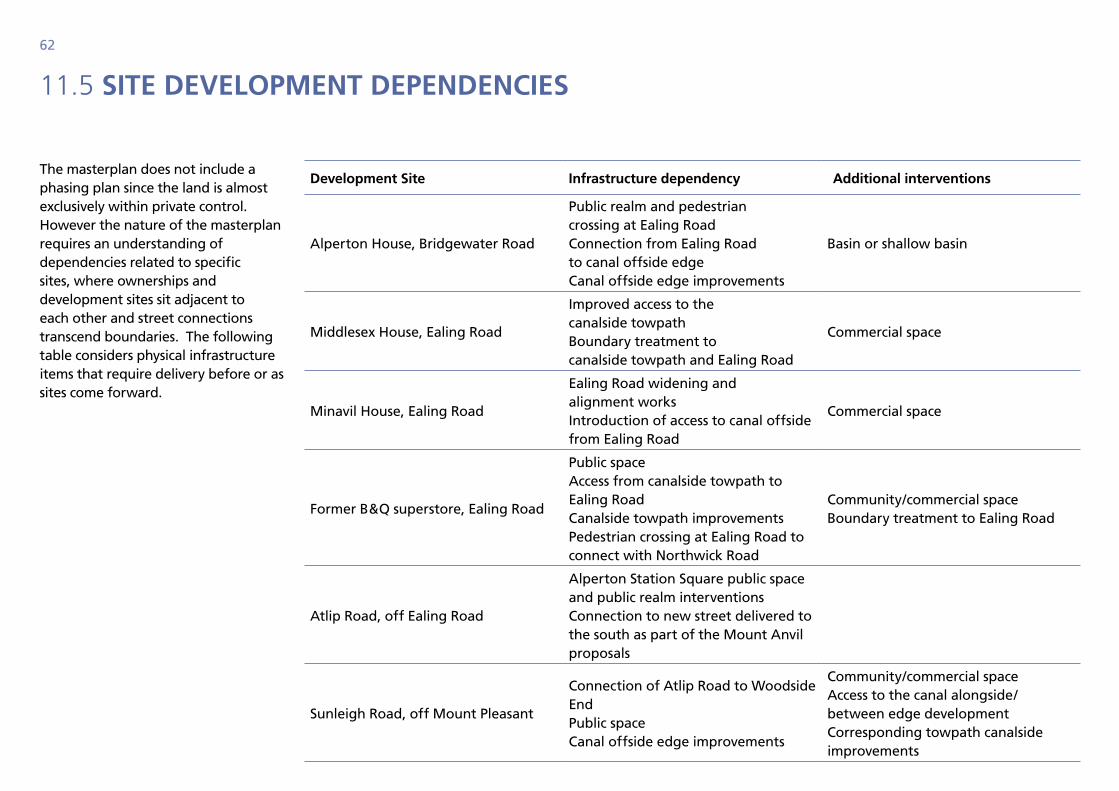
11.5 site development dependenCies
The masterplan does not include a phasing plan since the land is almost exclusively within private control. However the nature of the masterplan requires an understanding of dependencies related to specific sites, where ownerships and development sites sit adjacent to each other and street connections transcend boundaries. The following table considers physical infrastructure items that require delivery before or as sites come forward.
development site infrastructure dependency Additional interventions
Alperton House, Bridgewater Road
Public realm and pedestrian crossing at Ealing Road Connection from Ealing Road to canal offside edge Canal offside edge improvements
Basin or shallow basin
Middlesex House, Ealing Road
Improved access to the canalside towpath Boundary treatment to canalside towpath and Ealing Road
Commercial space
Minavil House, Ealing Road
Ealing Road widening and alignment works Introduction of access to canal offside from Ealing Road
Commercial space
Former B&Q superstore, Ealing Road
Public space Access from canalside towpath to Ealing Road Canalside towpath improvements Pedestrian crossing at Ealing Road to connect with Northwick Road
Community/commercial space Boundary treatment to Ealing Road
Atlip Road, off Ealing Road
Alperton Station Square public space and public realm interventions Connection to new street delivered to the south as part of the Mount Anvil proposals
Sunleigh Road, off Mount Pleasant
Connection of Atlip Road to Woodside End Public space Canal offside edge improvements
Community/commercial space Access to the canal alongside/ between edge development Corresponding towpath canalside improvements
63
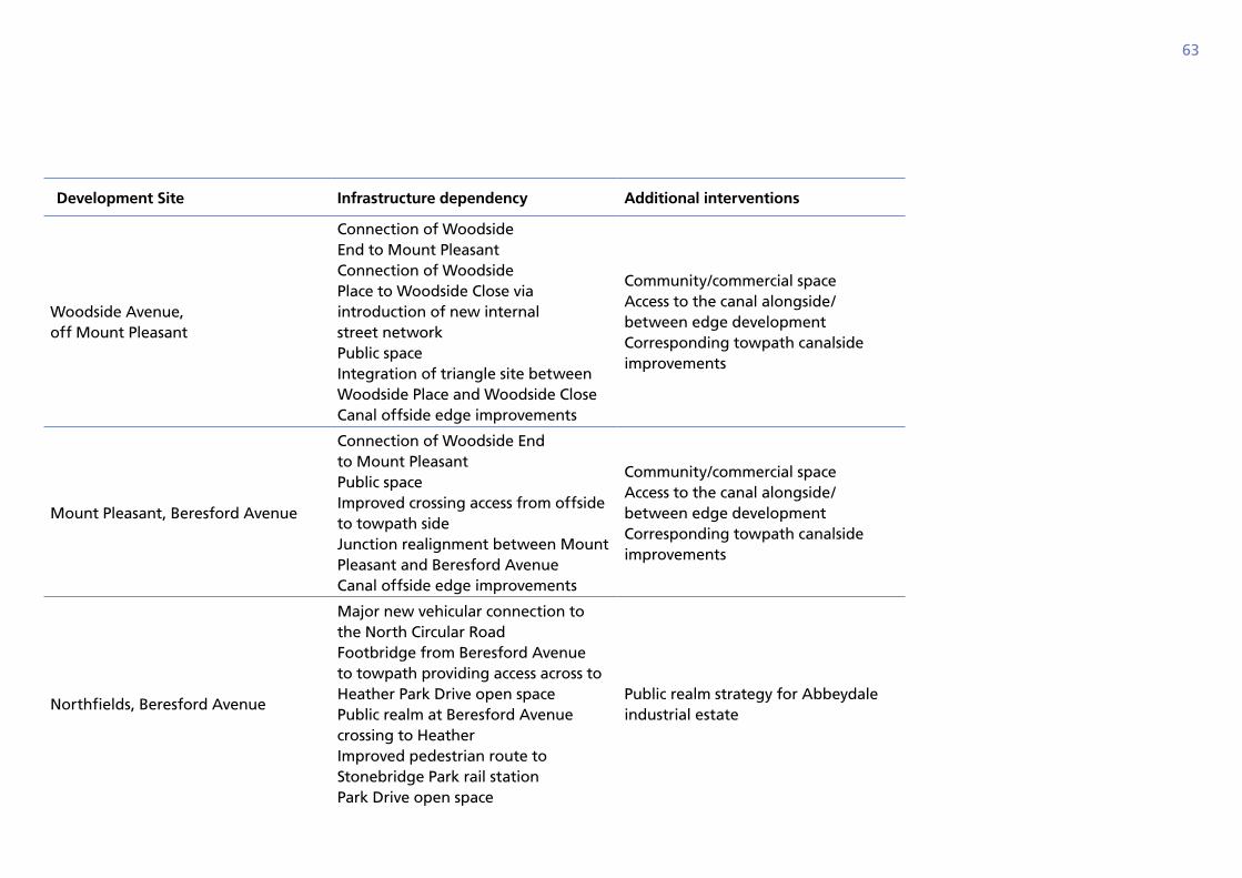
development site infrastructure dependency Additional interventions
Woodside Avenue, off Mount Pleasant
Connection of Woodside End to Mount Pleasant Connection of Woodside Place to Woodside Close via introduction of new internal street network Public space Integration of triangle site between Woodside Place and Woodside Close Canal offside edge improvements
Community/commercial space Access to the canal alongside/ between edge development Corresponding towpath canalside improvements
Mount Pleasant, Beresford Avenue
Connection of Woodside End to Mount Pleasant Public space Improved crossing access from offside to towpath side Junction realignment between Mount Pleasant and Beresford Avenue Canal offside edge improvements
Community/commercial space Access to the canal alongside/ between edge development Corresponding towpath canalside improvements
Northfields, Beresford Avenue
Major new vehicular connection to the North Circular Road Footbridge from Beresford Avenue to towpath providing access across to Heather Park Drive open space Public realm at Beresford Avenue crossing to Heather Improved pedestrian route to Stonebridge Park rail station Park Drive open space
Public realm strategy for Abbeydale industrial estate
64
11.8 delivering design quAlity
The council intends to continue to improve design quality in terms of the buildings and their settings, including the public realm. Set out below are a number of tools which could be used at appropriate times to achieve improved design quality.
Design Review Panel
To broaden the council’s approach to assessment of design proposals, a review panel has been established. This will ensure that the council is keeping up with broader standards and comparators throughout London. The panel will develop its role inviting post-completion assessment and critique from which lessons can be learned.
Submission of 3D models
In order for the council to fully assess the impacts of the scale and massing of a proposed development, all major applications for development are encouraged to submit basic 3D models in appropriate CAD format.
Design Principles
The design principles set out in this document should be the primary guidance for any application within the masterplan area and proposals will be expected to fully justify departures.
Local Planning Policy
Brent Council has established a credible policy framework through the UDP 2004 but it is improving the management of design within the Planning process through carefully composed and structured planning policies, which will be included in the Local Development Framework.
Supplementary Planning Guidance/Documents
The council considers that the fundamental requirements described as part of its SPG 17 ‘Design Guide for New Development’ are essential to ensure buildings demonstrate appropriate consideration of their context and the requirements of future occupiers.
Strategic Coordination
Brent Council will develop its strategic design aspirations by co-ordinating policy and ambition with that of regional and national agencies, including, GLA, EH, Design for London and other design focused organisations. Co-operation with and between these agencies will help create a credible and realistic policy base, enabling certainty from which high quality design can be brought forward.
65
Design Champion
The council has an elected member who promotes good design as a principal consideration throughout all of the council’s endeavours and activities. The design champion will expect the highest quality design in all proposals for redevelopment.
Competitive Interviews and Competitions
Where possible the council will encourage the procurement of significant landmark or signature buildings through competition. This should ensure the highest standards of design and innovation. The high quality architecture will set an example for others wishing to develop within Brent.
Approved Architect’s List
A list of architects with experience and reputations for providing high quality design schemes will be developed. It will provide a professional resource for those wishing to develop within Brent and a database of practices from which invitees to competitions could be taken.
Pre-application Advice
In order to expedite development proposals through the planning process and ensure the delivery of exemplar buildings, the council will offer pre-application advice through its planning service.
Rigorous Design Statements
The council will require the submission of a thorough Design and Access Statement explaining the reasoning and philosophy behind a design including considerations of materials and details.
Consultation Procedures
Often it is the shock of change, rather than the nature of change that causes problems in the delivery of good design. Brent Council will encourage applicants to carry out detailed and comprehensive independent consultation with local communities impacted by proposals. Consultation will enable local residents to be involved in the process of design development. All major landowners and key stakeholders should be consulted on all major developments. The Metropolitan Police Authority should be consulted on any proposed development consisting of over 50 residential units, 2,500 m² of floor space or 50 car parking spaces. Brent Council will also carry out its statutory duties in consulting with the local community before granting permissions.
Design for Living
High quality design is not just about aesthetics, it must consider the needs of people, the quality of their lives and the environment in which they live, work and play. The assessment of design must go further than the external appearance of the building; it must consider the quality of the internal and external spaces to ensure that they are adequate for the needs of all potential occupants.
66
appendix 1 appendix 2
Masterplan process
Alperton was initially identified for growth in 2005 through the preparation of the Core Strategy which was formally adopted as planning policy by the council in July 2010. Sustainability Appraisal of growth and development in Alperton has been provided by the appraisal of the Core Strategy and Site Specific Allocations Development Plan Documents.
Masterplan preparation began with a visioning exercise in the summer of 2009. The importance of a robust vision document was established at the outset to set an ambitious aspiration and harness support from stakeholders. The vision was drafted through informal but extensive consultation with local businesses, residents (through community leaders and interviews in the street), school children and shoppers as well as organisations such as British Waterways, the Greater London Authority and Trans-port for London. Consultants Fluid worked with Brent Council during this stage.
Since autumn 2009 the document has been developed in house by Brent Council with the support of CABE, the GLA, British Waterways and consultants MVA Transport.
Statutory consultation on the Draft Master Plan was carried out in early 2011 and the final draft approved at Executive in July 2011.
Policy References
Brent Local Development Framework: Core Strategy (adopted 2010).
Brent Local Development Framework: draft Site Specific Allocations (Examination in Public 2010).
Brent Supplementary Planning Document: Planning Obligations (2008).
Brent Supplementary Planning Guidance 17: Design guide for New Development (200#).
Mayor of London: London Plan ( consolidated with alterations 2008).
Mayor of London Park Royal Opportunity Area Planning Framework (2010).
Brent Affordable Housing Viability Study 2009
Brent Employment Land Study 2009
The Brent Placemaking Guide – Final Draft 2010
Disclaimer
The information contained within this masterplan is, as far as Brent Council is aware, correct. However, developers should satisfy themselves about any information contained within it. The council is not responsible for any loss arising from any error of information contained in the document. Potential purchasers and developers are advised to consult the relevant Brent Council officers about their specific proposals before making any application for redevelopment within this area. The masterplan does not bind Brent Council to grant consent for any particular development within the area.

67
68
Published by Brent Council Regeneration and Major Projects Unit, adopted July 11.
Designed by Brent Council Design Unit.
12.11BDU6557Brent