Embed Size (px)
Citation preview
Bremner Agricultural Impact Assessment
January 2019
2
Contents 1.0 Executive Summary .............................................................................................. 3 2.0 Planning and Context ............................................................................................ 4
2.1 Applicable Planning Policies and Regulations ......................................................... 5 2.1.1 Modernized Municipal Government Act ........................................................... 5 2.1.2 Edmonton Metropolitan Region Growth Plan (2017) ......................................... 5 2.1.3 Strathcona County Municipal Development Plan (2017) .................................... 6 2.1.4 Strathcona County Land Use Bylaw (2015) ..................................................... 7 2.1.5 Strathcona County Strategic Plan (2018 Update) ............................................. 7 2.1.6 Strathcona County Agriculture Master Plan (2015) .......................................... 7 2.1.7 Strathcona County Urban Agriculture Strategy (2016) ..................................... 8
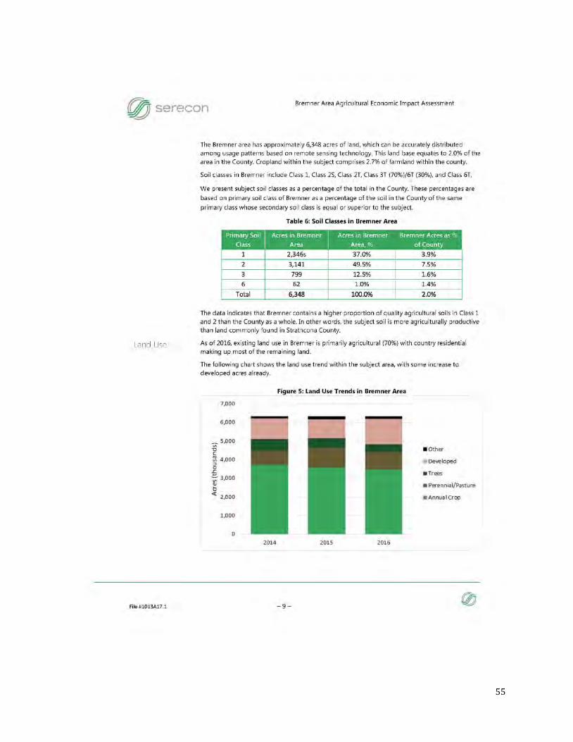
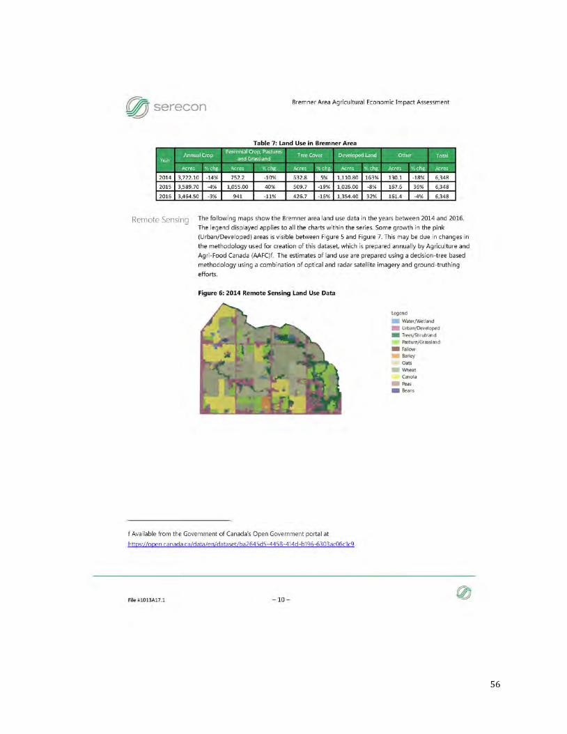
2.2. Biophysical Inventory ........................................................................................ 8 2.2.1 Soil Classification ........................................................................................ 8 2.2.2 Soil Capability and Land Suitability ................................................................ 9 2.2.3 Surface Drainage ...................................................................................... 13 2.2.4 Groundwater and Irrigation: ....................................................................... 15 2.2.5 Slope/Topography ..................................................................................... 16
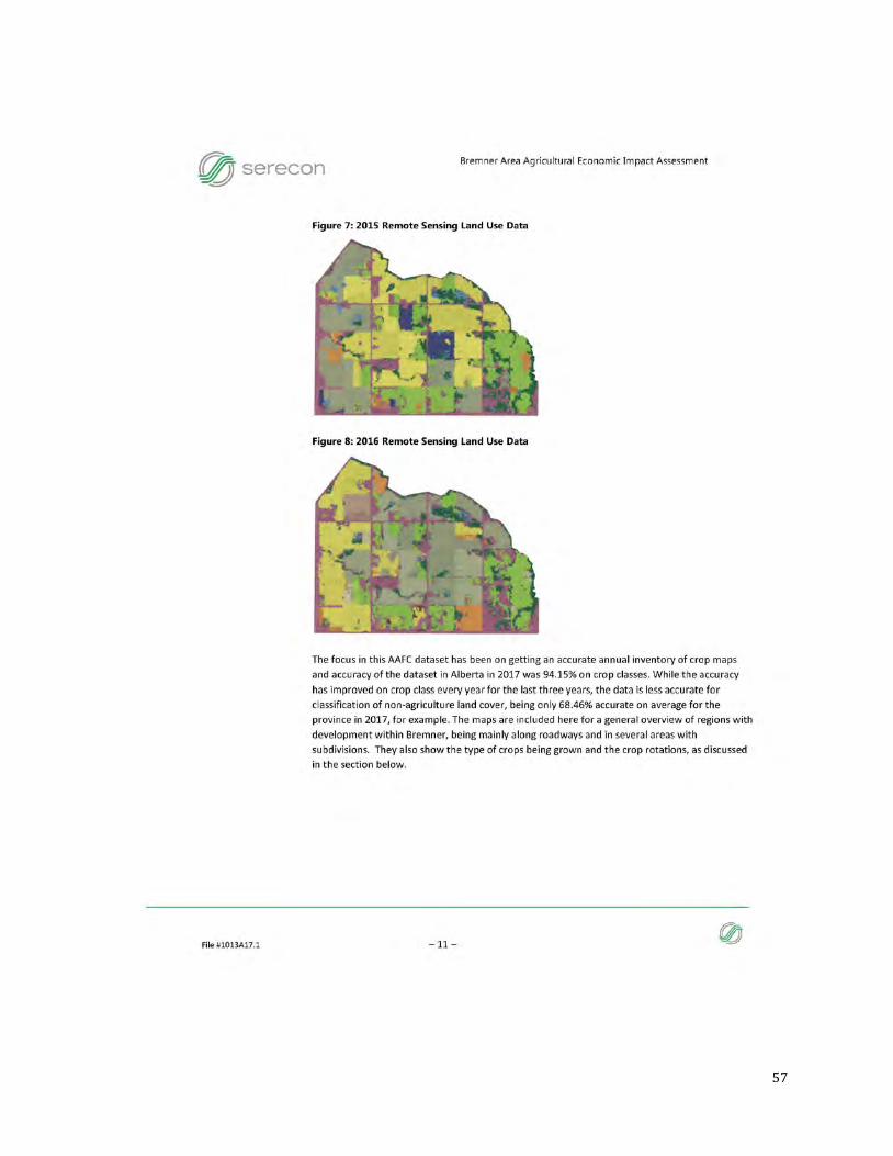
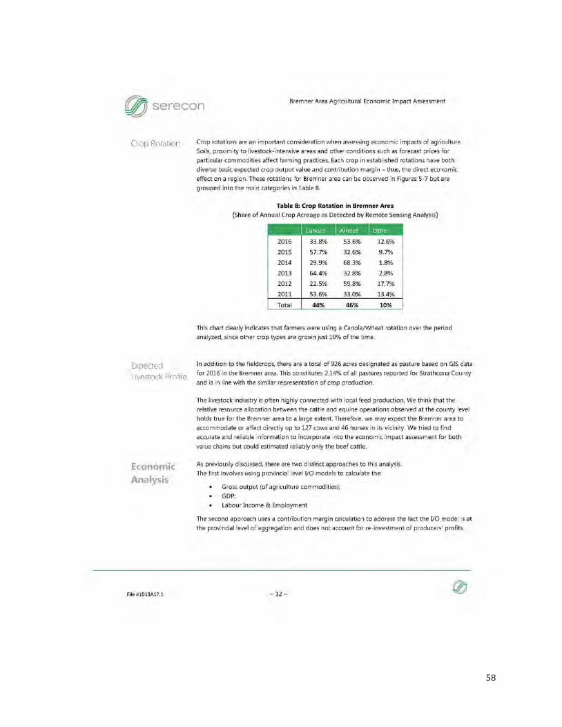
2.3 Agricultural Inventory ...................................................................................... 17 2.3.1 Existing Agricultural Production ................................................................... 17 2.3.2 Non-Agricultural Land Use .......................................................................... 18 2.3.3 Parcel Size, Configuration, and Agricultural Accessibility ................................. 19 2.3.4 Agricultural Economic Impact...................................................................... 20
2.4 Surrounding Lands .......................................................................................... 21 2.4.1 Surrounding Land Use Types ...................................................................... 21 2.4.2 Regional Land Use, Land Fragmentation and Conversion ................................ 22 2.4.3 Availability of Agricultural Services .............................................................. 23
3.0 Agricultural Viability ............................................................................................ 24 4.0 Potential Impacts on Agriculture ........................................................................... 24 5.0 Mitigation Measures ............................................................................................ 24 6.0 Discussion ......................................................................................................... 26 7.0 Limitations and Qualifications ............................................................................... 26 8.0 References ......................................................................................................... 26 Appendix A Bremner Development Forecast Phases ...................................................... 28 Appendix B Land Development Forecast ...................................................................... 29 Appendix C Water Act Registrations ............................................................................ 30 Appendix D Parcel Size and Zoning ............................................................................. 38 Appendix E Bremner Area Agricultural Economic Impact Assessment .............................. 41 Appendix F Proposed Topsoil Conservation and Management Plan .................................. 66
3
1.0 Executive Summary
The Bremner Urban Reserve, herein referred to as Bremner, is expected to accommodate a complete community. The area is being planned with the following principles in mind.
• Protect and Enhance the Natural Environment • Maintain and Support Agriculture • Reinforce and Diversify the Economy • Accommodate a Diversity of Housing • Provide Transportation Options for Everyday Travel • Create Strong, Distinctive and Safe Neighbourhoods • Establish a Hierarchy of Mixed-use Places • Provide a Full Range of Recreational and Cultural Amenities
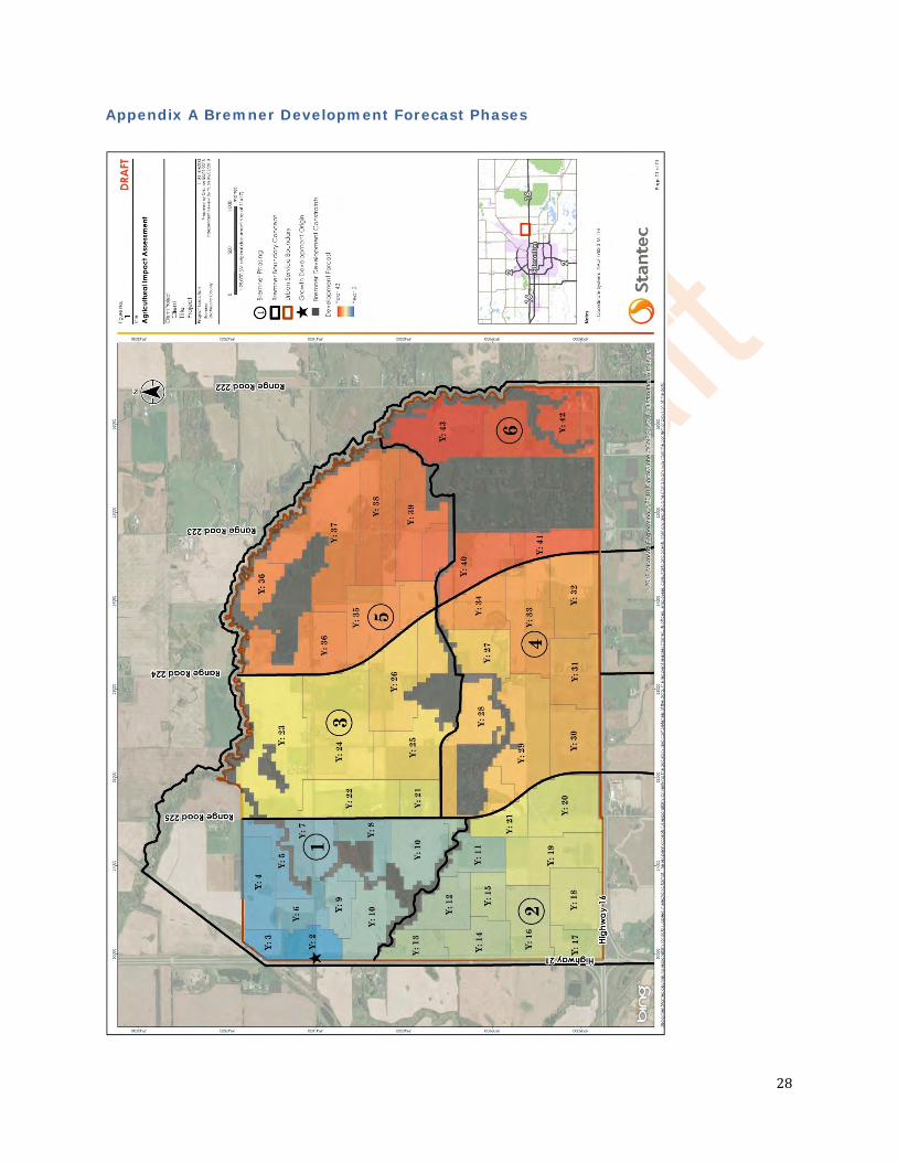
It is expected that Bremner will take about 40 years to develop. A Bremner Development Phase Plan is provided in Appendix A along with a Land Development Forecast in Appendix B.
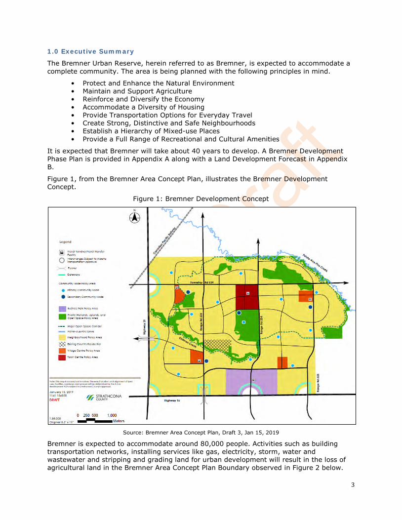
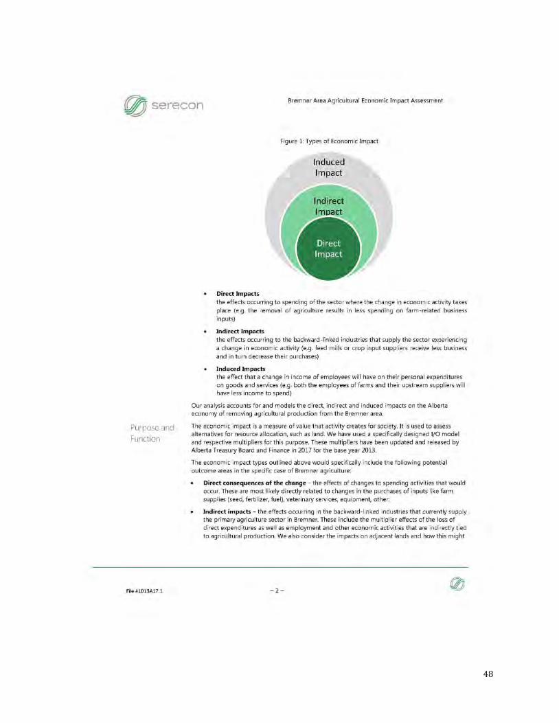
Figure 1, from the Bremner Area Concept Plan, illustrates the Bremner Development Concept.
Figure 1: Bremner Development Concept
Source: Bremner Area Concept Plan, Draft 3, Jan 15, 2019
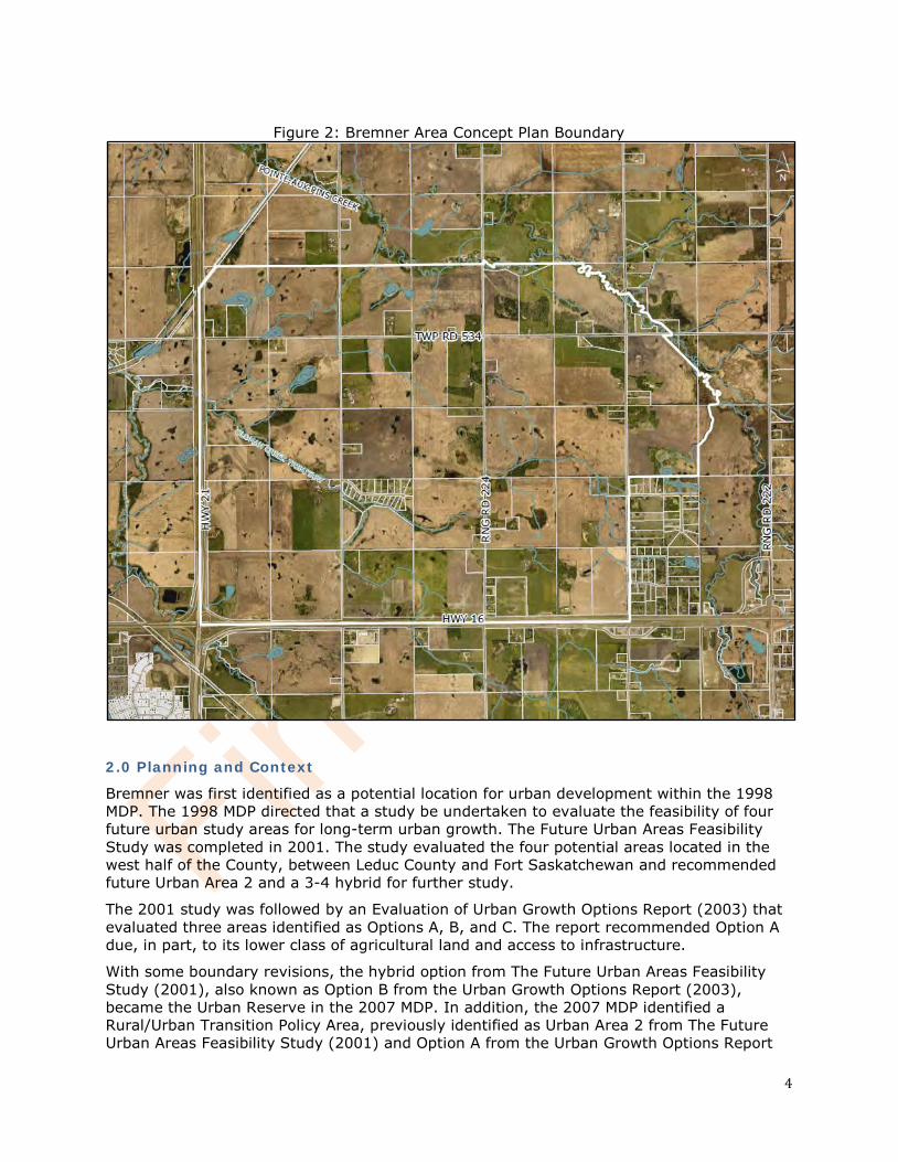
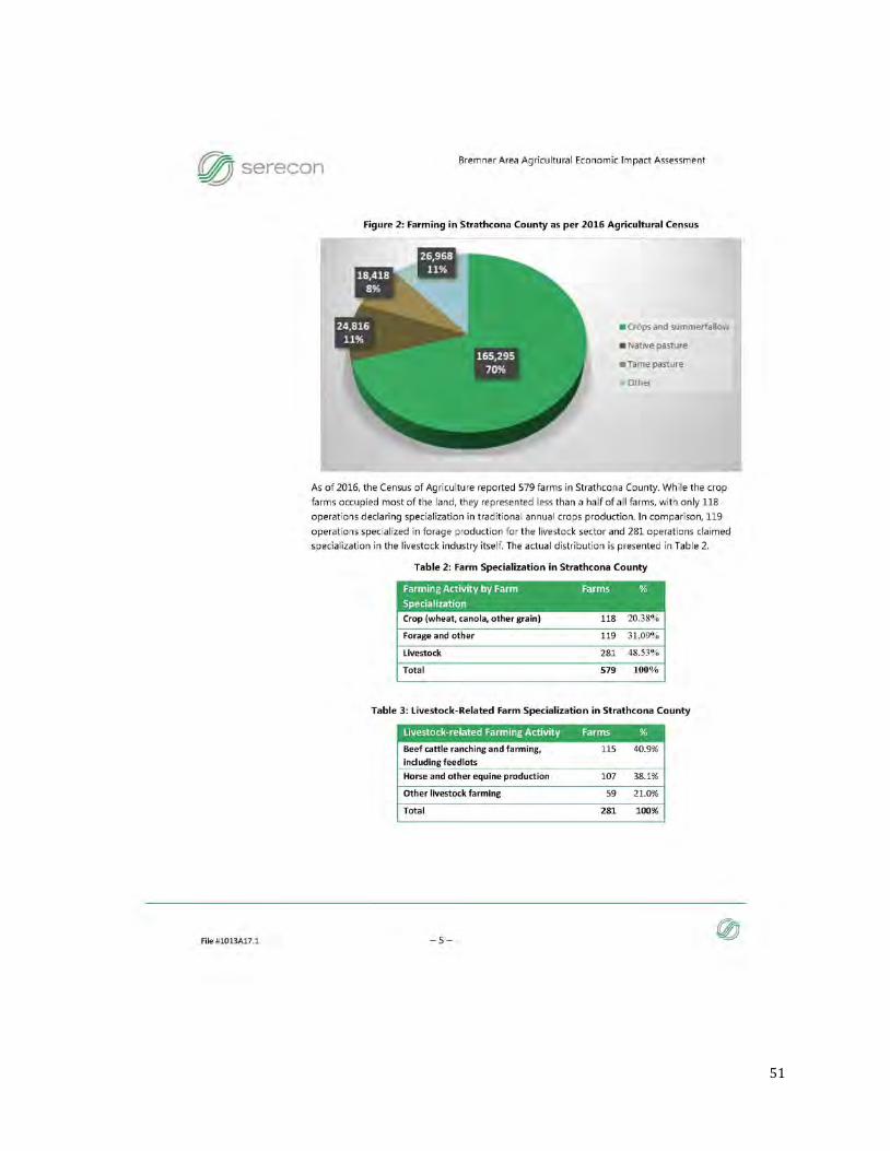
Bremner is expected to accommodate around 80,000 people. Activities such as building transportation networks, installing services like gas, electricity, storm, water and wastewater and stripping and grading land for urban development will result in the loss of agricultural land in the Bremner Area Concept Plan Boundary observed in Figure 2 below.
4
Figure 2: Bremner Area Concept Plan Boundary
2.0 Planning and Context
Bremner was first identified as a potential location for urban development within the 1998 MDP. The 1998 MDP directed that a study be undertaken to evaluate the feasibility of four future urban study areas for long-term urban growth. The Future Urban Areas Feasibility Study was completed in 2001. The study evaluated the four potential areas located in the west half of the County, between Leduc County and Fort Saskatchewan and recommended future Urban Area 2 and a 3-4 hybrid for further study.
The 2001 study was followed by an Evaluation of Urban Growth Options Report (2003) that evaluated three areas identified as Options A, B, and C. The report recommended Option A due, in part, to its lower class of agricultural land and access to infrastructure.
With some boundary revisions, the hybrid option from The Future Urban Areas Feasibility Study (2001), also known as Option B from the Urban Growth Options Report (2003), became the Urban Reserve in the 2007 MDP. In addition, the 2007 MDP identified a Rural/Urban Transition Policy Area, previously identified as Urban Area 2 from The Future Urban Areas Feasibility Study (2001) and Option A from the Urban Growth Options Report
5
(2003). By this time, the Urban Reserve was commonly referred to as Bremner and the Rural/Urban Transition Policy Area was commonly referred to as Colchester. The 2007 MDP required both areas to conduct growth management strategies prior to more detailed planning being completed.
In 2009, the Capital Region Growth Plan was created, which identified both Bremner and Colchester as Priority Growth Areas for future urban development. Amendments were made to the County’s MDP to reflect the Capital Region Growth Plan and identify both areas for future urban growth. In 2012, Council initiated the Bremner Growth Management Strategy which was completed in 2014. A growth management strategy for Colchester was subsequently completed in 2016. Following the completion of the two growth management strategies, in 2016 a Comparison Matrix was generated which compared and evaluated the results of both strategies. Upon reviewing the Comparison Matrix, Strathcona County Council endorsed the Growth Management Strategy for Bremner and amendments were approved to the MDP confirming the Bremner area lands south of Pointe-Aux-Pins Creek for urban development. In 2017, Strathcona County adopted a new MDP which continued to identify the 2,679 hectare (6,620 acres) Bremner Urban Reserve Policy Area for future urban growth, whereas Colchester was re-designated as a rural policy area. The boundaries of Bremner being south of Pointe-Aux-Pins Creek reflect the results from the Bremner Growth Management Strategy (2014) and the Metropolitan Area of the Edmonton Metropolitan Region Growth Plan, which replaced the Capital Region Growth Plan in 2017. During development of the Bremner Area Concept Plan, Bremner was further reduced to 2,118 ha (5,234 acres) as shown in Figure 2 above.
2.1 Applicable Planning Policies and Regulations
2.1.1 Modernized Municipal Government Act
The Modernized Municipal Government Act (MMGA) is responsible for providing the operational framework and governance model for all forms of local government in Alberta, including specialized municipalities. It also lays the basis for how municipalities operate, how their councils function and how residents work with their municipality. The MMGA has three main areas of focus:
1. Governance and Administration; 2. Planning and Development; and 3. Assessment and Taxation.
The MMGA enables municipalities to govern the development of lands within their boundaries in a manner that is logical, timely, economical and environmentally responsible. The MMGA requires that municipalities with a population more than 3,500 adopt a Municipal Development Plan. Strathcona County’s MDP provides a comprehensive long term land use policy framework that guides present and projected growth and development over the next 20 years and beyond.
2.1.2 Edmonton Metropolitan Region Growth Plan (2017)
The Edmonton Metropolitan Region (EMR) Growth Plan approved in 2017 provides a thirty year plan and a fifty year vision for the region’s growth and development. The population of the Edmonton Metropolitan Region is expected to double to 2.2 million by 2044; the growth plan addresses this population increase using the following guiding principles:
1. Collaborate and coordinate as a Region to manage growth responsibly;
6
2. Promote global economic competitiveness and regional prosperity; 3. Recognize and celebrate the diversity of communities and promote an excellent
quality of life across the Region; 4. Achieve compact growth that optimizes infrastructure investment; 5. Ensure effective regional mobility; 6. Ensure the wise management of prime agricultural resources; and 7. Protect natural living systems and environmental assets.
In 2017, a new policy area addressing agriculture was added to the EMR growth plan. The plan recognizes future food security issues and the economic value of agriculture in the region while lying out three agricultural objectives:
1. Identify and conserve an adequate supply of prime agricultural lands to provide a secure local food source for future generations;
2. Minimize the fragmentation and conversion of prime agricultural lands for non-agricultural uses; and
3. Promote diversification and value-added agriculture production and plan infrastructure to support the agricultural sector and regional food system.
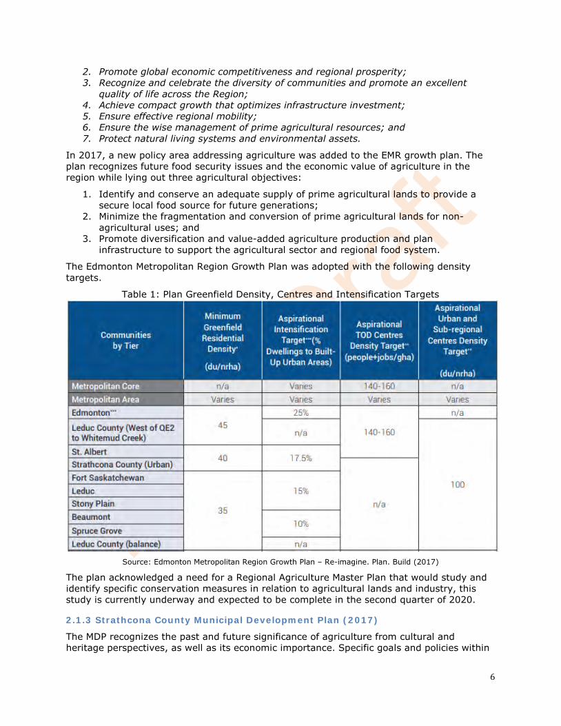
The Edmonton Metropolitan Region Growth Plan was adopted with the following density targets.
Table 1: Plan Greenfield Density, Centres and Intensification Targets
Source: Edmonton Metropolitan Region Growth Plan – Re-imagine. Plan. Build (2017)
The plan acknowledged a need for a Regional Agriculture Master Plan that would study and identify specific conservation measures in relation to agricultural lands and industry, this study is currently underway and expected to be complete in the second quarter of 2020.
2.1.3 Strathcona County Municipal Development Plan (2017)
The MDP recognizes the past and future significance of agriculture from cultural and heritage perspectives, as well as its economic importance. Specific goals and policies within
7
the MDP aim to diversify and support agri-business and promote public agriculture in both urban and rural areas.
Section 4.4 of the new MDP is specific to the Bremner Urban Reserve Policy Area and sets the long term development goal:
Bremner will be a complete community that is green, connected and diverse. It will incorporate green infrastructure, open space and urban agriculture into each community and neighbourhood. Communities and neighbourhoods within Bremner will be designed for compact, mixed-use and transit oriented development. The design of communities and neighbourhoods will encourage all residents to utilize active transportation for their daily living by creating a distinct town centre and smaller village centres that will provide residents with a variety of services, amenities, education and employment opportunities in close proximity to where they live.
This section also promotes continuing agricultural operations to continue as long as possible until such time that urban development occurs. Public agriculture, rooftop gardens and urban farms are to be promoted during urban development.
Other policies contained in the Agriculture Large and Small Holdings Policy Areas include ensuring road networks that allows for the safe and timely movement of agricultural equipment and goods in addition to requiring soil conservation and reclamation plans for aggregate extraction operations. Diversifying and supporting small and large agribusiness is also recognized as goals throughout the MDP.
2.1.4 Strathcona County Land Use Bylaw (2015)
The Land Use Bylaw has not yet been updated to reflect Bremner as part of the Urban Service Area. Most of the land in Bremner is currently zoned as Agriculture: General with some smaller areas zoned Recreation, Low Density Country Residential, Rural Residential/Agriculture and Direct Control. Updates to the Land Use Bylaw are expected following the completion of the Bremner Area Concept Plan.
2.1.5 Strathcona County Strategic Plan (2018 Update)
Strathcona County’s Strategic Plan outlines how the County’s activities align to achieve its vision which includes advancing diverse agricultural business and preserving the County’s agricultural heritage. This plan directs long term planning and provides the foundations for Strathcona County’s corporate and department business plans, sustainability plans and guides annual budget development.
With respect to agriculture, Strathcona County’s goal is to provide critical physical and technology infrastructure to enable and stimulate growth and diversify agricultural business.
The Strategic Plan also recognizes that appropriate and effective use of agricultural land ensures effective stewardship of water, land, air and energy resources.
2.1.6 Strathcona County Agriculture Master Plan (2015)
Strathcona County’s Agriculture Master Plan was approved in June 2015. The main goals of the plan were to assess the future of agriculture in the County and to identify strategies and policies that would support this desired future.
Included in the Agriculture Master Plan is a requirement for Agricultural Impact Assessments that inform decision making at all levels of the planning process. The Agricultural Impact Assessment addresses a proposed development’s effects on existing and future agricultural activities as well as recommends mitigation measures.
8
The Agricultural Master Plan recognizes that while there are challenges facing agriculture, there are also numerous opportunities for the industry and that without a strong commitment from all stakeholders these opportunities might not be realized. Four planning principals were developed to guide the Master Plan, they are:
• Supporting Policies – The long term success of agriculture in a metropolitan context can only be assured with strong supporting and integrated land use, food and agriculture sector development and infrastructure policies;
• Agriculture Land Conservation – The conversion or fragmentation of large tracks [of agricultural land] primary or unique agriculture lands to non-agricultural uses to accommodate growth (residential, commercial, industrial) will only be done as a last resort;
• Shared Leadership – The advancement of agriculture requires shared leadership including the municipality, residents and stakeholders within Strathcona County, and the Capital Region; and
• Proactive Agriculture – Changes in agriculture are both continuous and considerable, requiring dynamic and proactive approach in response to emerging trends and opportunities both urban and rural.
2.1.7 Strathcona County Urban Agriculture Strategy (2016)
Strathcona County adopted an Urban Agriculture Strategy in 2016. The County’s vision for urban agricultural is:
Urban agriculture is easily accessed and seen in Strathcona County; it contributes to creating a healthy, livable community by helping to grow food, relationships, and economy
in our community.
The strategy identified several goals to achieve its vision of urban agriculture:
• Build a sense of community, identity, and place; • Bring people together; • Connect urban and rural communities; • Build food literacy and awareness; • Support local economic development and entrepreneurship; • Expand food production; • Build shared leadership; and • Reflect Strathcona County’s natural history.
To meet these goals, the strategy focuses on building opportunities for community gardens, urban farms, home gardens, urban livestock, school agriculture programs and public agriculture and edible landscapes while providing education and coordination services to the community.
2.2. Biophysical Inventory
2.2.1 Soil Classification
Bremner is located in the Thick Black Soil Zone of Alberta and the dominant soils are Eluviated Black Chernozems and Orthic Dark Gray Chernozems developed on moderately fine till or glaciolacustrine parent materials. Wetland areas are predominantly Gleysols with the possibility of some Organics; areas adjacent to the creeks contain Gleyed Black Chernozems and miscellaneous Gleysols.
9
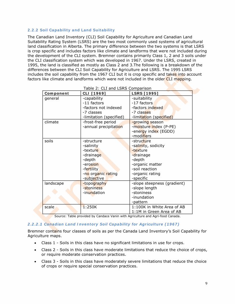
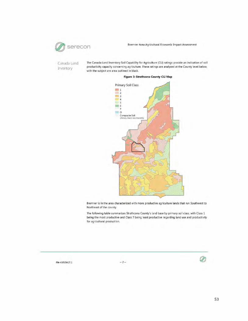
2.2.2 Soil Capability and Land Suitability
The Canadian Land Inventory (CLI) Soil Capability for Agriculture and Canadian Land Suitability Rating System (LSRS) are the two most commonly used systems of agricultural land classification in Alberta. The primary difference between the two systems is that LSRS is crop specific and includes factors like climate and landforms that were not included during the development of the CLI system. Bremner contains primarily Class 1, 2 and 3 soils under the CLI classification system which was developed in 1967. Under the LSRS, created in 1995, the land is classified as mostly as Class 2 and 3.The following is a breakdown of the differences between the CLI Soil Capability for Agriculture and LSRS. The 1995 LSRS includes the soil capability from the 1967 CLI but it is crop specific and takes into account factors like climate and landforms which were not included in the older CLI mapping.
Table 2: CLI and LSRS Comparison Component CLI [1969] LSRS [1995] general -capability
-11 factors -factors not indexed -7 classes -limitation (specified)
-suitability -17 factors -factors indexed -7 classes -limitation (specified)
climate -frost-free period -annual precipitation
-growing season -moisture index (P-PE) -energy index (EGDD) -modifiers
soils -structure -salinity -texture -drainage -depth -erosion -fertility -no organic rating -subjective
-structure -salinity, sodicity -texture -drainage -depth -organic matter -soil reaction -organic rating -specific
landscape -topography -stoniness -inundation
-slope steepness (gradient) -slope length -stoniness -inundation -pattern
scale 1:250K 1:100K in White Area of AB 1:1M in Green Area of AB
Source: Table provided by Candace Vanin with Agriculture and Agri-food Canada.
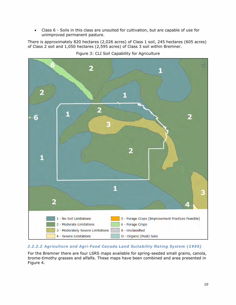
2.2.2.1 Canadian Land Inventory Soil Capability for Agriculture (1967)
Bremner contains four classes of soils as per the Canada Land Inventory’s Soil Capability for Agriculture maps.
• Class 1 - Soils in this class have no significant limitations in use for crops.
• Class 2 - Soils in this class have moderate limitations that reduce the choice of crops, or require moderate conservation practices.
• Class 3 - Soils in this class have moderately severe limitations that reduce the choice of crops or require special conservation practices.
10
• Class 6 - Soils in this class are unsuited for cultivation, but are capable of use for unimproved permanent pasture.
There is approximately 820 hectares (2,026 acres) of Class 1 soil, 245 hectares (605 acres) of Class 2 soil and 1,050 hectares (2,595 acres) of Class 3 soil within Bremner.
Figure 3: CLI Soil Capability for Agriculture
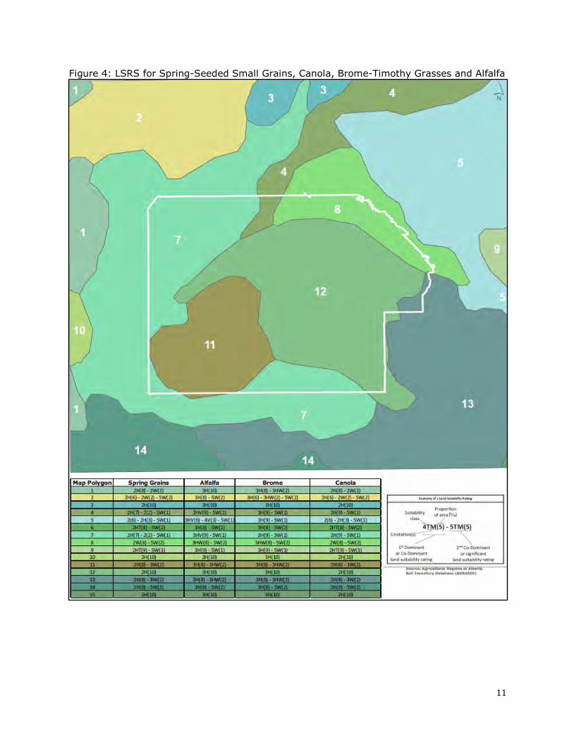
2.2.2.2 Agriculture and Agri-Food Canada Land Suitability Rating System (1995)
For the Bremner there are four LSRS maps available for spring-seeded small grains, canola, brome-timothy grasses and alfalfa. These maps have been combined and area presented in Figure 4.
11
Figure 4: LSRS for Spring-Seeded Small Grains, Canola, Brome-Timothy Grasses and Alfalfa
12
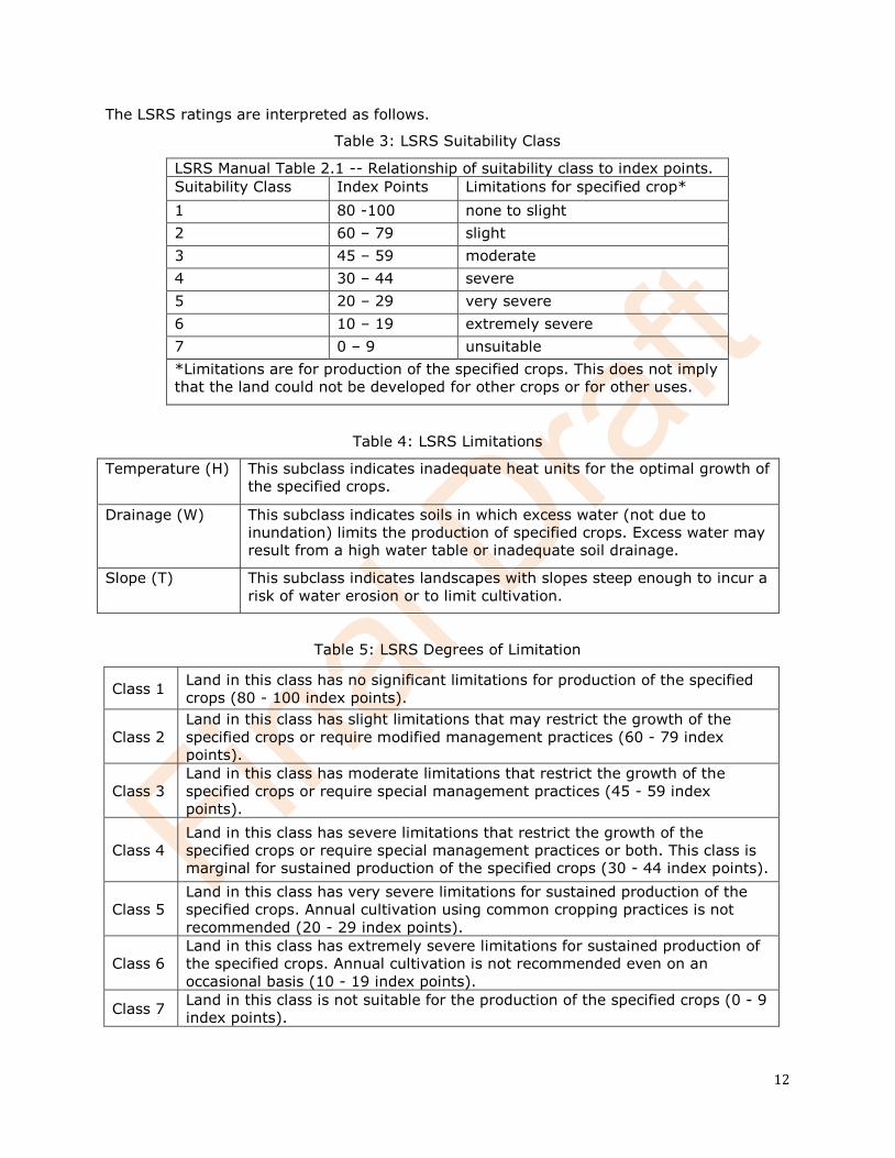
The LSRS ratings are interpreted as follows.
Table 3: LSRS Suitability Class
LSRS Manual Table 2.1 -- Relationship of suitability class to index points. Suitability Class Index Points Limitations for specified crop* 1 80 -100 none to slight 2 60 – 79 slight 3 45 – 59 moderate 4 30 – 44 severe 5 20 – 29 very severe 6 10 – 19 extremely severe 7 0 – 9 unsuitable *Limitations are for production of the specified crops. This does not imply that the land could not be developed for other crops or for other uses.
Table 4: LSRS Limitations
Temperature (H) This subclass indicates inadequate heat units for the optimal growth of the specified crops.
Drainage (W) This subclass indicates soils in which excess water (not due to inundation) limits the production of specified crops. Excess water may result from a high water table or inadequate soil drainage.
Slope (T) This subclass indicates landscapes with slopes steep enough to incur a risk of water erosion or to limit cultivation.
Table 5: LSRS Degrees of Limitation
Class 1 Land in this class has no significant limitations for production of the specified crops (80 - 100 index points).
Class 2 Land in this class has slight limitations that may restrict the growth of the specified crops or require modified management practices (60 - 79 index points).
Class 3 Land in this class has moderate limitations that restrict the growth of the specified crops or require special management practices (45 - 59 index points).
Class 4 Land in this class has severe limitations that restrict the growth of the specified crops or require special management practices or both. This class is marginal for sustained production of the specified crops (30 - 44 index points).
Class 5 Land in this class has very severe limitations for sustained production of the specified crops. Annual cultivation using common cropping practices is not recommended (20 - 29 index points).
Class 6 Land in this class has extremely severe limitations for sustained production of the specified crops. Annual cultivation is not recommended even on an occasional basis (10 - 19 index points).
Class 7 Land in this class is not suitable for the production of the specified crops (0 - 9 index points).
13
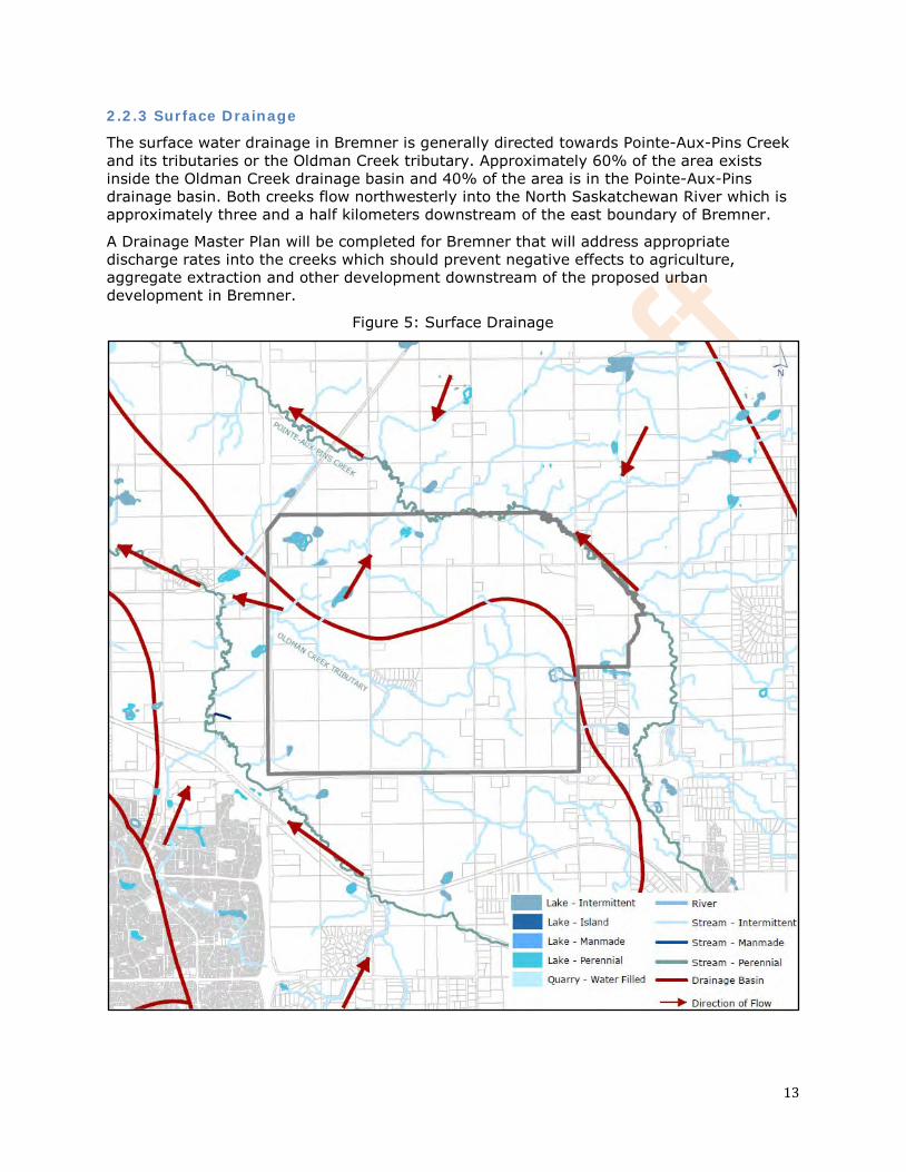
2.2.3 Surface Drainage
The surface water drainage in Bremner is generally directed towards Pointe-Aux-Pins Creek and its tributaries or the Oldman Creek tributary. Approximately 60% of the area exists inside the Oldman Creek drainage basin and 40% of the area is in the Pointe-Aux-Pins drainage basin. Both creeks flow northwesterly into the North Saskatchewan River which is approximately three and a half kilometers downstream of the east boundary of Bremner.
A Drainage Master Plan will be completed for Bremner that will address appropriate discharge rates into the creeks which should prevent negative effects to agriculture, aggregate extraction and other development downstream of the proposed urban development in Bremner.
Figure 5: Surface Drainage
14
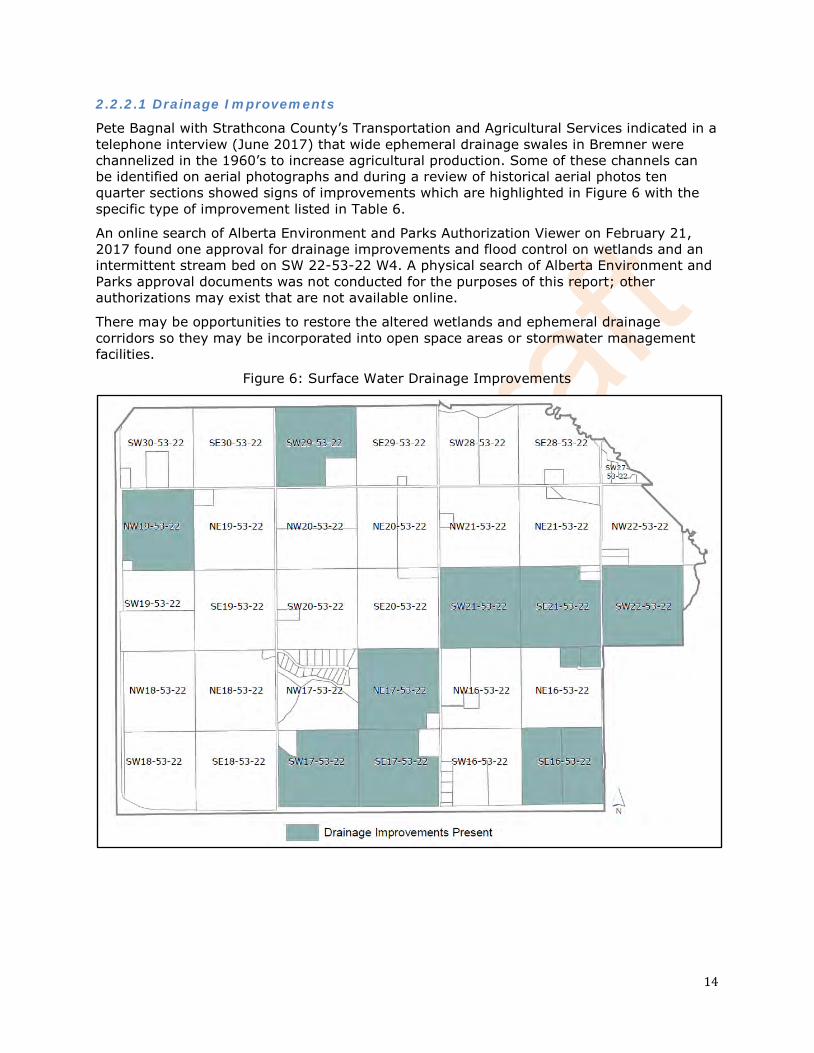
2.2.2.1 Drainage Improvements
Pete Bagnal with Strathcona County’s Transportation and Agricultural Services indicated in a telephone interview (June 2017) that wide ephemeral drainage swales in Bremner were channelized in the 1960’s to increase agricultural production. Some of these channels can be identified on aerial photographs and during a review of historical aerial photos ten quarter sections showed signs of improvements which are highlighted in Figure 6 with the specific type of improvement listed in Table 6.
An online search of Alberta Environment and Parks Authorization Viewer on February 21, 2017 found one approval for drainage improvements and flood control on wetlands and an intermittent stream bed on SW 22-53-22 W4. A physical search of Alberta Environment and Parks approval documents was not conducted for the purposes of this report; other authorizations may exist that are not available online.
There may be opportunities to restore the altered wetlands and ephemeral drainage corridors so they may be incorporated into open space areas or stormwater management facilities.
Figure 6: Surface Water Drainage Improvements
15
Table 6: Type of Surface Water Drainage Improvement
Location Type of Surface Water Drainage Improvement (based on historical aerial photo review)
SE 16-53-22 W4 - channelized natural drainage
SE 17-53-22 W4 - channelized natural drainage
SW 17-53-22 W4 - channelized natural drainage
NE 17-53-22 W4 - channelized natural drainage
NE 17-53-22 W4 - channelized natural drainage
NW 19-53-22 W4 - channelized natural drainage
SE 21-53-22 W4 - channelized natural drainage
SW 21-53-22 W4 - channelized natural drainage
SW 22-53-22 W4 - channelized natural drainage in watercourse and in wetlands, watercourse crossing installed
SW 29-53-22 W4 - channelized natural drainage
2.2.4 Groundwater and Irrigation:
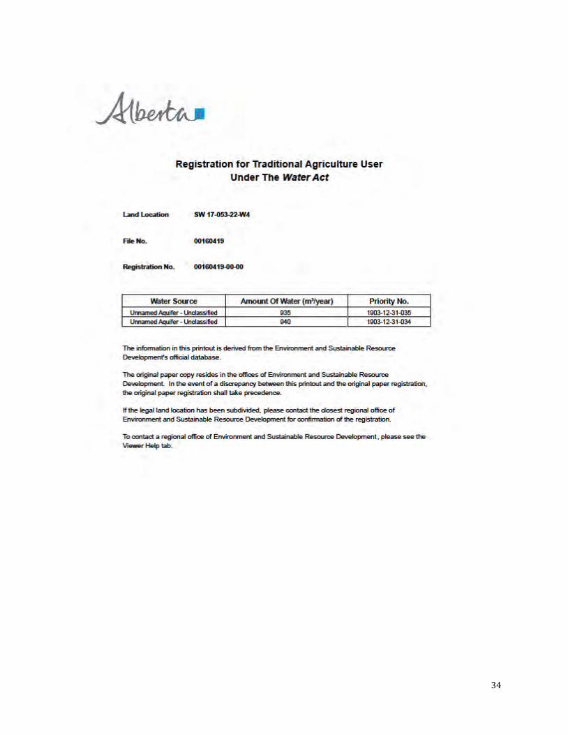
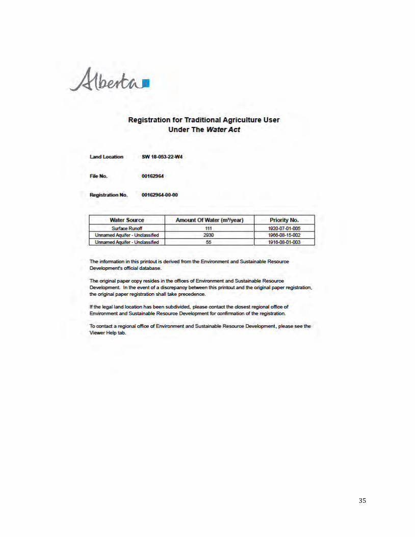
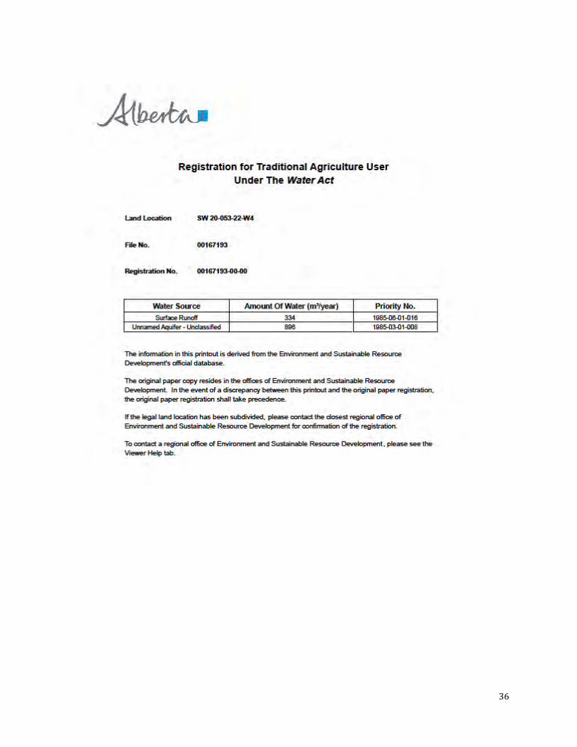
As per the Regional Ground Water Assessment (2001), groundwater in the study area comes mainly from the Bearpaw aquifer which is generally 80 to 100 meters thick and less than 100 meters below the surface. There is an estimated 10 to 50 cubic meters of water, per section, being pumped from this aquifer daily for a variety of uses including household and agricultural use. Groundwater in Bremner’s surficial deposits is generally high in total dissolved solids and sodium concentrations. The average total dissolved solids is 1,164 mg/L and the average sodium concentration is 219 mg/L, both are above the Government of Canada’s Guidelines for Canadian Drinking Water Quality (2017) of ≤500 mg/L total dissolved solids and ≤200 mg/L for sodium.
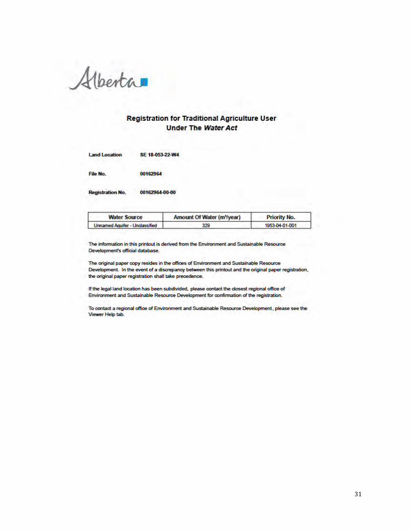
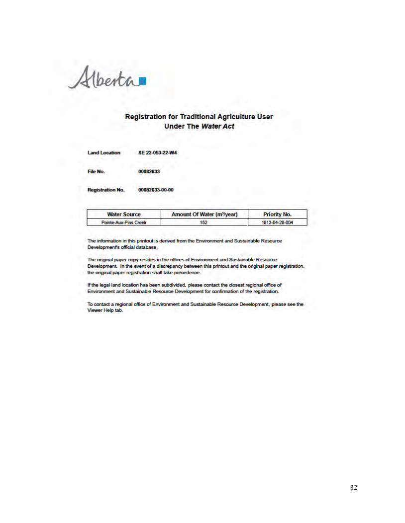
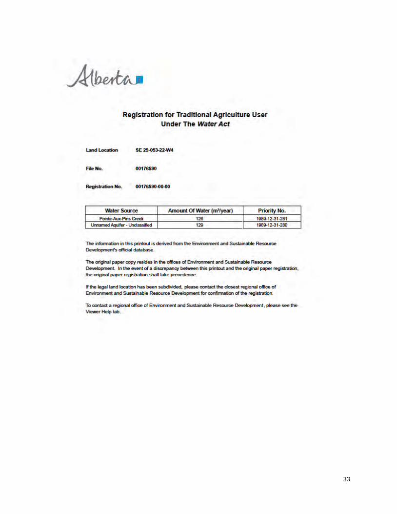
A search of Alberta Environment and Parks’ Authorization Viewer on February 23 and 27, 2017 found thirteen Traditional Agricultural Registrations under the Water Act for the purposes or raising animals and applying pesticides to crops. Table 7 shows the total of all registrations is 9,978 cubic meters of water annually, a copy of each registration is available in Appendix C.
16
Table 7: Water Licences
Land Location Water Source Amount of Water (m3/year)
Priority No.
SW 17-53-22 W4 Unnamed Aquifer – Unclassified 935 1903-12-31-035 SW 17-53-22 W4 Unnamed Aquifer – Unclassified 940 1903-12-31-034 SE 18-53-22 W4 Unnamed Aquifer – Unclassified 329 1953-04-01-001 SW 18-53-22 W4 Surface Runoff 111 1920-07-01-005 SW 18-53-22 W4 Unnamed Aquifer – Unclassified 2930 1966-08-15-002 SW 18-53-22 W4 Unnamed Aquifer – Unclassified 55 1916-08-01-003 SW 20-53-22 W4 Surface Runoff 334 1985-06-01-016 SW 20-53-22 W4 Unnamed Aquifer – Unclassified 896 1985-03-01-008 SE 22-53-22 W4 Pointe-Aux-Pins Creek 152 1913-04-29-004 SW 22-53-22 W4 Surface Runoff 2933 1913-04-29-002 SW 22-53-22 W4 Unnamed Aquifer – Unclassified 108 1913-04-29-001 SE 29-53-22 W4 Pointe-Aux-Pins Creek 126 1989-12-31-281 SE 29-53-22 W4 Unnamed Aquifer – Unclassified 129 1989-12-31-280
Total Amount of Water (m3/year) 9,978
2.2.5 Slope/Topography
The undulating and hummocky landscape of Bremner creates a diverse landscape with low to high relief land forms of varying elevations. Elevations range from 706 m near the southeast corner, to 642 m in Pointe-Aux-Pins Creek near the middle of the north boundary of Bremner. The landscape generally slopes northwestward as illustrated in Figure 7.
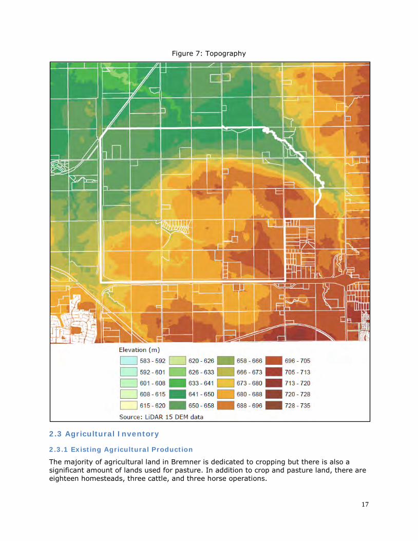
17
Figure 7: Topography
2.3 Agricultural Inventory
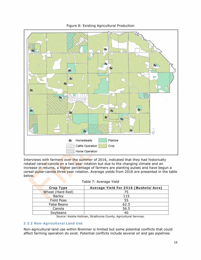
2.3.1 Existing Agricultural Production
The majority of agricultural land in Bremner is dedicated to cropping but there is also a significant amount of lands used for pasture. In addition to crop and pasture land, there are eighteen homesteads, three cattle, and three horse operations.
18
Figure 8: Existing Agricultural Production
Interviews with farmers over the summer of 2016, indicated that they had historically rotated cereal-canola on a two year rotation but due to the changing climate and an increase in returns, a higher percentage of farmers are planting pulses and have begun a cereal-pulse-canola three year rotation. Average yields from 2016 are presented in the table below.
Table 7: Average Yield
Crop Type Average Yield For 2016 (Bushels/Acre) Wheat (Hard Red) 75
Barley 115 Field Peas 55
Faba Beans 62.5 Canola 56.5
Soybeans 40 Source: Keisha Hollman, Strathcona County, Agricultural Services.
2.3.2 Non-Agricultural Land Use
Non-agricultural land use within Bremner is limited but some potential conflicts that could affect farming operation do exist. Potential conflicts include several oil and gas pipelines
19
that run along the west and south boundaries of Bremner. These pipelines are reclaimed and the surface above them continues to be used for agricultural purposes but there is potential for pipeline maintenance that could disrupt farming operations.
There is one Low Density Country Residential Subdivision that may cause increased local traffic which has the potential to affect farmers moving equipment or farm animals from time to time or seasonally.
Strathcona County’s Agricultural Services branch operates out of an historic homestead site just north of Bremner which produces additional vehicle traffic that may impede farming operations. This site is used for community events which have the potential to cause traffic conflicts.
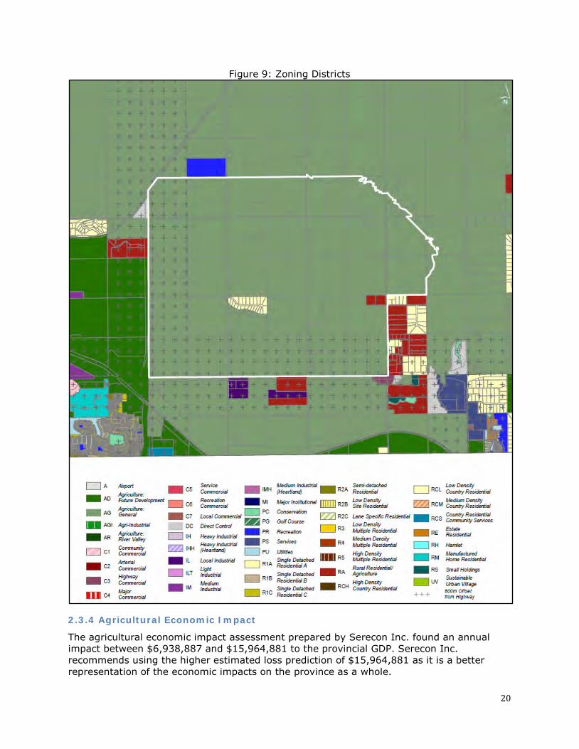
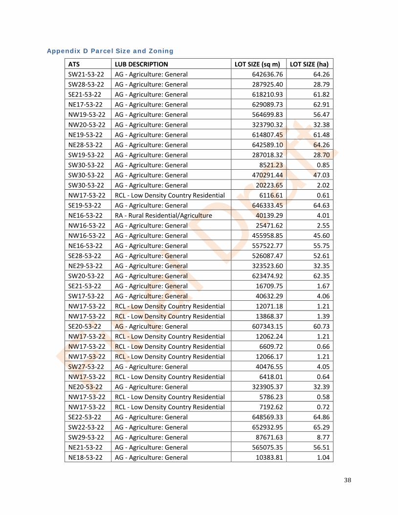
2.3.3 Parcel Size, Configuration, and Agricultural Accessibility
Currently there are few limitations to agricultural accessibility in Bremner and it can be accessed from the north, east, south and west from major highways and a series of Strathcona County owned township and range roads. A review of recent air photos (2017) showed that all parcels had at least one access and many of the larger parcels (larger than 16 ha) had multiple accesses. Parcels with drainage corridors that split the parcel often had visible culvert style crossings installed.
Access for agricultural operations will need to be maintained during the development of Bremner.
A table of parcel size and zoning of each Bremner parcel are provided in Appendix D. Figure 9 shows the current zoning districts for Bremner and the surrounding areas.
20
Figure 9: Zoning Districts
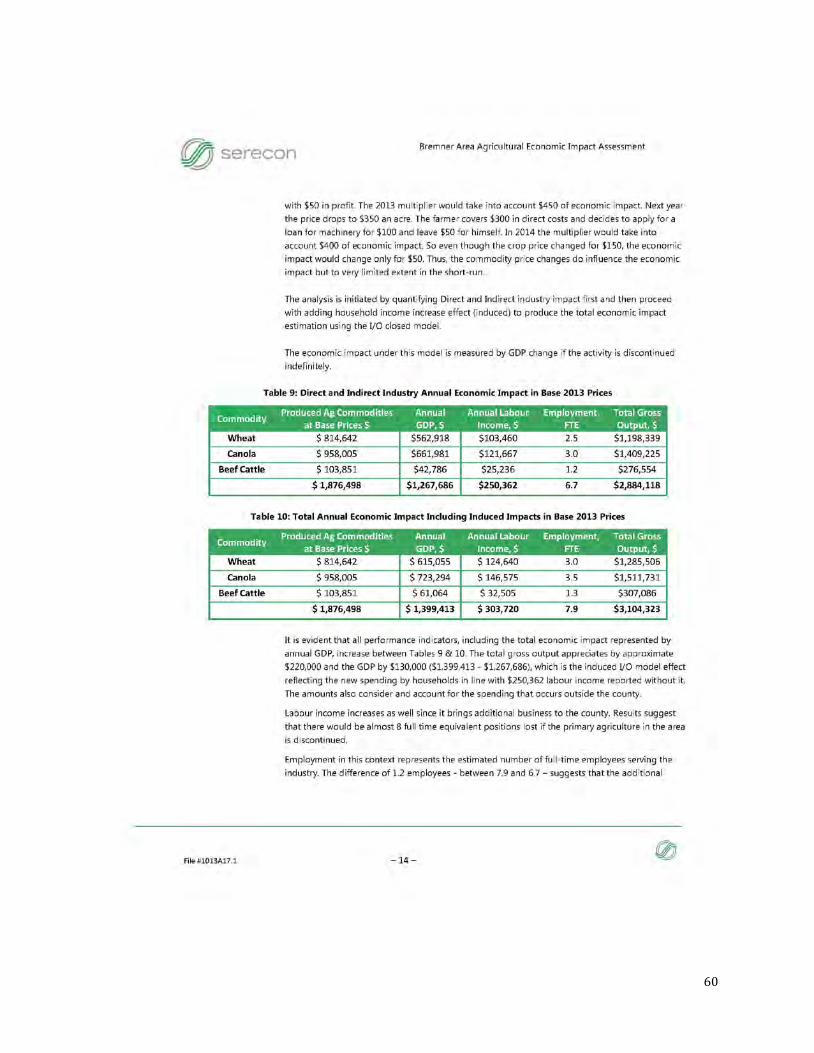
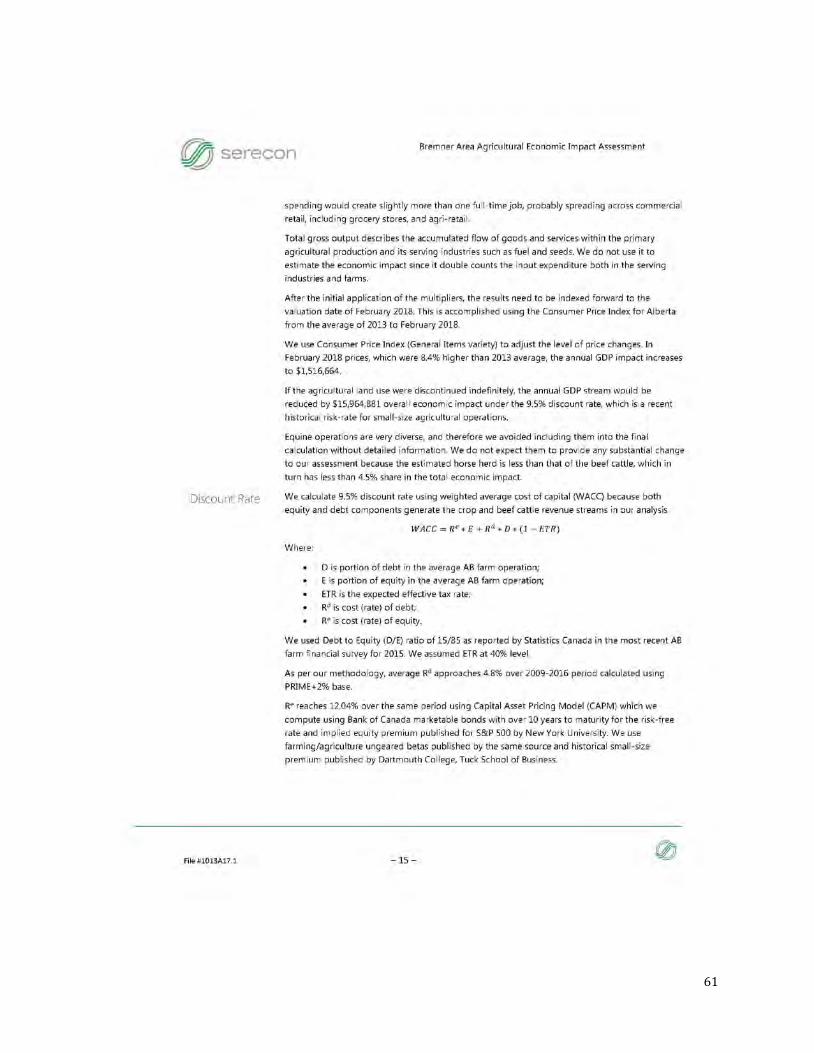
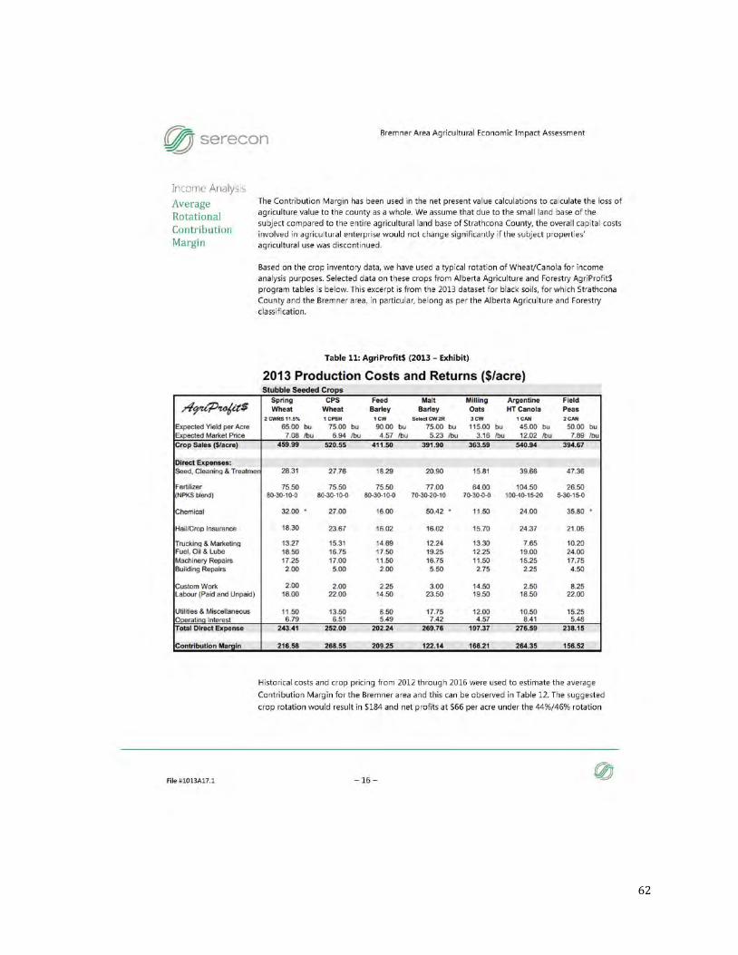
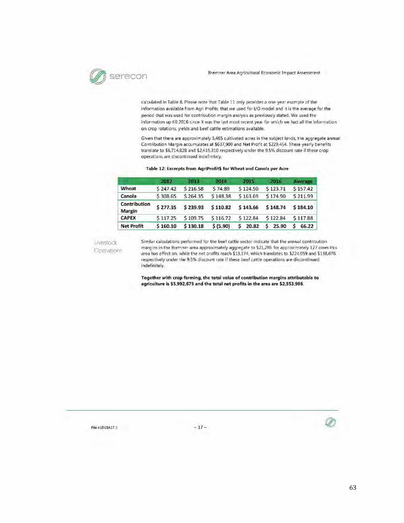
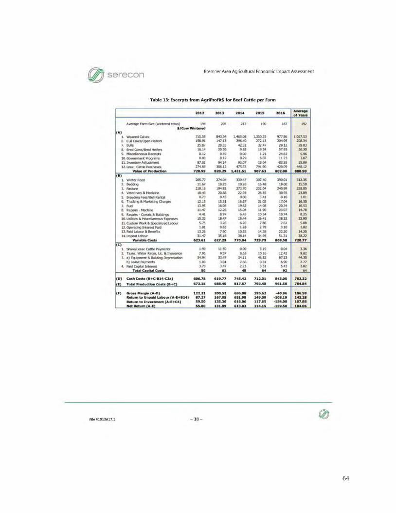
2.3.4 Agricultural Economic Impact
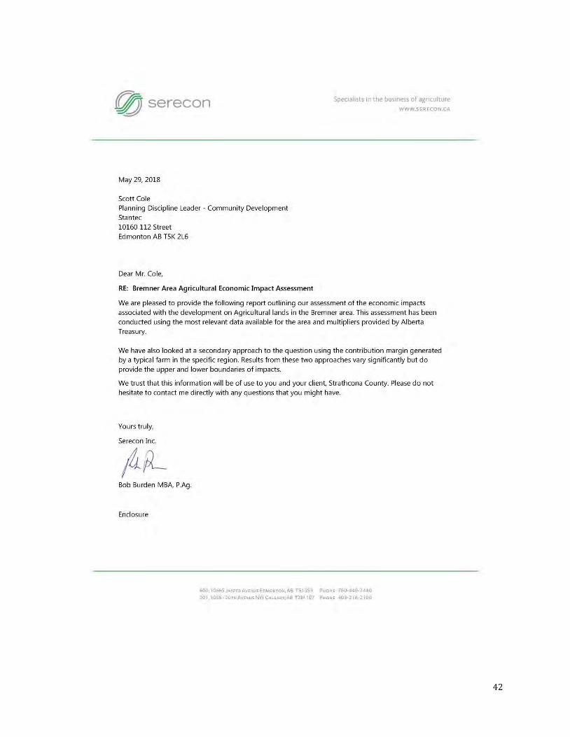
The agricultural economic impact assessment prepared by Serecon Inc. found an annual impact between $6,938,887 and $15,964,881 to the provincial GDP. Serecon Inc. recommends using the higher estimated loss prediction of $15,964,881 as it is a better representation of the economic impacts on the province as a whole.
21
Serecon’s report includes lands that are now excluded from the Bremner Area Concept Plan, including approximately 182 hectares (450 acres) of crop land and 61 hectares (150 acres) of perennial crops, pastures and grasslands. Consideration should be given to the economic impacts accordingly.
It should be noted that an area of approximately 82 hectares (200 acres) that was removed from the Bremner ACP boundary but was included in Serecon’s report is slated to become Strathcona County’s Multipurpose Agricultural Facility and that land will be removed from traditional agricultural production.
A detailed analysis of the economic impacts of developing Bremner is provided under a separate cover in Appendix E.
2.4 Surrounding Lands
2.4.1 Surrounding Land Use Types
Immediately west of Bremner is Cambrian Crossing which is included in the North of Yellowhead Area Concept Plan (ACP). The approved Cambrian Crossing Area Structure Plan (2013) has areas for industrial, residential and commercial development. Cambrian Crossing is expected to be constructed prior to Bremner with an interchange at Highway 21 and Township Road 534, as well as a flyover south of the interchange to connect Cambrian Crossing to Bremner. The remainder of Bremner’s western boundary abuts the West of 21 Area Concept Plan that includes light and medium industrial and commercial uses.
Directly south of Bremner, the Local Employment Area (LEA) that extends to the CN railway line is currently being studied as a potential area for light industrial and public service uses. The lands north and east of Bremner are intended to remain agricultural under the current MDP.
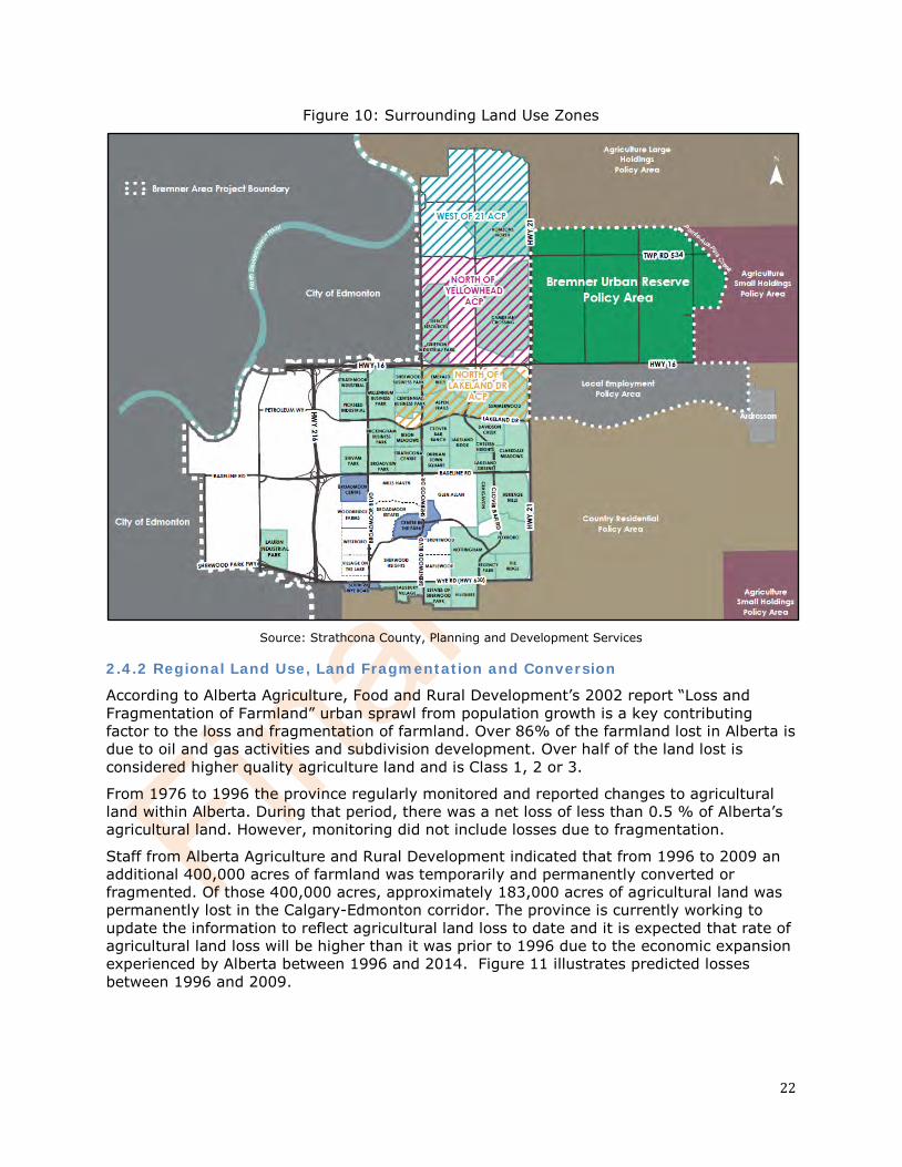
22
Figure 10: Surrounding Land Use Zones
Source: Strathcona County, Planning and Development Services
2.4.2 Regional Land Use, Land Fragmentation and Conversion
According to Alberta Agriculture, Food and Rural Development’s 2002 report “Loss and Fragmentation of Farmland” urban sprawl from population growth is a key contributing factor to the loss and fragmentation of farmland. Over 86% of the farmland lost in Alberta is due to oil and gas activities and subdivision development. Over half of the land lost is considered higher quality agriculture land and is Class 1, 2 or 3.
From 1976 to 1996 the province regularly monitored and reported changes to agricultural land within Alberta. During that period, there was a net loss of less than 0.5 % of Alberta’s agricultural land. However, monitoring did not include losses due to fragmentation.
Staff from Alberta Agriculture and Rural Development indicated that from 1996 to 2009 an additional 400,000 acres of farmland was temporarily and permanently converted or fragmented. Of those 400,000 acres, approximately 183,000 acres of agricultural land was permanently lost in the Calgary-Edmonton corridor. The province is currently working to update the information to reflect agricultural land loss to date and it is expected that rate of agricultural land loss will be higher than it was prior to 1996 due to the economic expansion experienced by Alberta between 1996 and 2014. Figure 11 illustrates predicted losses between 1996 and 2009.
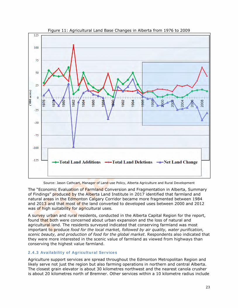
23
Figure 11: Agricultural Land Base Changes in Alberta from 1976 to 2009
Source: Jason Cathcart, Manager of Land-use Policy, Alberta Agriculture and Rural Development
The “Economic Evaluation of Farmland Conversion and Fragmentation in Alberta, Summary of Findings” produced by the Alberta Land Institute in 2017 identified that farmland and natural areas in the Edmonton Calgary Corridor became more fragmented between 1984 and 2013 and that most of the land converted to developed uses between 2000 and 2012 was of high suitability for agricultural uses.
A survey urban and rural residents, conducted in the Alberta Capital Region for the report, found that both were concerned about urban expansion and the loss of natural and agricultural land. The residents surveyed indicated that conserving farmland was most important to produce food for the local market, followed by air quality, water purification, scenic beauty, and production of food for the global market. Respondents also indicated that they were more interested in the scenic value of farmland as viewed from highways than conserving the highest value farmland.
2.4.3 Availability of Agricultural Services
Agriculture support services are spread throughout the Edmonton Metropolitan Region and likely serve not just the region but also farming operations in northern and central Alberta. The closest grain elevator is about 30 kilometres northwest and the nearest canola crusher is about 20 kilometres north of Bremner. Other services within a 10 kilometre radius include
24
a seed supplier, fertilizer distributer, fuel delivery service, veterinary services and farm equipment sales and repair. Bremner is well serviced with most farming necessities located less than an hour away by vehicle.
3.0 Agricultural Viability
Very little data exists on the minimum size of farm needed to be viable in Alberta and sustainable in the long term. According to the most recent Alberta Agriculture Statistics Yearbook (2015), the average farm size in Alberta is 740 hectares however; there is no information available about farm configurations and whether the average farm consists of parcels that are adjacent, spread apart in fragmented parcels. The current area being farmed in Bremner is approximately 2,000 hectares and there are over 100 landowners.
Due to its close proximity to the Edmonton Metropolitan Region, Bremner could also potentially support other types of farms such as market gardens, u-picks, tree nurseries, cannabis production facilities, greenhouses and floriculture operations which tend to be smaller in size.
4.0 Potential Impacts on Agriculture
Current land use conflicts include slow moving farm traffic, noise, dust and drainage issues. These issues are generally minor but since complaints have been tracked within the last three years, traffic speed on Hwy 624 on the east edge of Bremner has been predominant.
The most significant expected impacts to neighbouring farming operations are transportation issues, especially during planting, spraying and harvesting. Traffic volumes will increase as Bremner developments. Urban roads are not generally suited to transporting farm equipment such as combines, sprayers and tractors, which require large turning radiuses and wide accesses (at least 6 metres) into farmland.
It is currently unknown if there will be significant impacts to agri-business such as seed and equipment suppliers. Development of Bremner will proceed over approximately 40 years which may give supporting agri-businesses time to adjust to any loss of business created by the development of Bremner.
5.0 Mitigation Measures
Table 8: Mitigation Measures
Agri-tourism and Agri-business
Continue to provide opportunities for small scale agri-tourism and agri-businesses such as agricultural product processing, agricultural support services, agriculturally related home based businesses and associated sales within undeveloped areas of Bremner as transitional uses.
Encourage the provision of active transportation connections between Bremner and surrounding agricultural areas to encourage agri-tourism and agri-businesses within the rural area. Encourage the provision of active transportation connections to public agriculture opportunities and transitional agri-tourism and agri-business within Bremner. Provide way finding signs to agri-tourism and agri-businesses along active transportation, local roadways and major roadways.
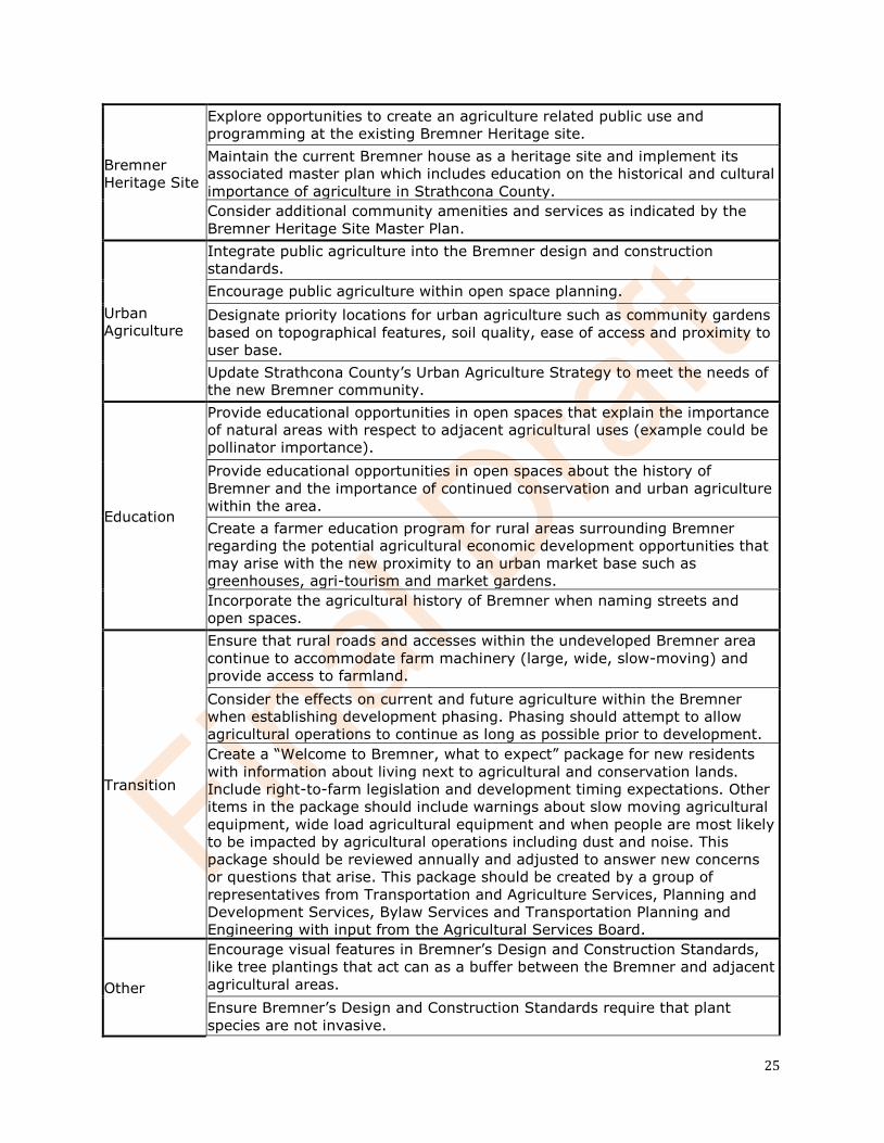
25
Bremner Heritage Site
Explore opportunities to create an agriculture related public use and programming at the existing Bremner Heritage site. Maintain the current Bremner house as a heritage site and implement its associated master plan which includes education on the historical and cultural importance of agriculture in Strathcona County. Consider additional community amenities and services as indicated by the Bremner Heritage Site Master Plan.
Urban Agriculture
Integrate public agriculture into the Bremner design and construction standards. Encourage public agriculture within open space planning. Designate priority locations for urban agriculture such as community gardens based on topographical features, soil quality, ease of access and proximity to user base. Update Strathcona County’s Urban Agriculture Strategy to meet the needs of the new Bremner community.
Education
Provide educational opportunities in open spaces that explain the importance of natural areas with respect to adjacent agricultural uses (example could be pollinator importance). Provide educational opportunities in open spaces about the history of Bremner and the importance of continued conservation and urban agriculture within the area. Create a farmer education program for rural areas surrounding Bremner regarding the potential agricultural economic development opportunities that may arise with the new proximity to an urban market base such as greenhouses, agri-tourism and market gardens. Incorporate the agricultural history of Bremner when naming streets and open spaces.
Transition
Ensure that rural roads and accesses within the undeveloped Bremner area continue to accommodate farm machinery (large, wide, slow-moving) and provide access to farmland. Consider the effects on current and future agriculture within the Bremner when establishing development phasing. Phasing should attempt to allow agricultural operations to continue as long as possible prior to development. Create a “Welcome to Bremner, what to expect” package for new residents with information about living next to agricultural and conservation lands. Include right-to-farm legislation and development timing expectations. Other items in the package should include warnings about slow moving agricultural equipment, wide load agricultural equipment and when people are most likely to be impacted by agricultural operations including dust and noise. This package should be reviewed annually and adjusted to answer new concerns or questions that arise. This package should be created by a group of representatives from Transportation and Agriculture Services, Planning and Development Services, Bylaw Services and Transportation Planning and Engineering with input from the Agricultural Services Board.
Other
Encourage visual features in Bremner’s Design and Construction Standards, like tree plantings that act can as a buffer between the Bremner and adjacent agricultural areas. Ensure Bremner’s Design and Construction Standards require that plant species are not invasive.
26
Where plant species are prone to disease or pests ensure that appropriate measures are taken through County programming and operations. Ensure the Bremner design and construction standards requires the reuse of topsoil within Bremner and create a topsoil management plan (Proposed Topsoil Conservation and Management Plan available in Appendix F) to support the design and construction standards. Ensure that developers are aware of clubroot management requirements to ensure that clubroot is not spread to other agricultural areas.
6.0 Discussion
While there are methods available to measure the economic loss of converting agricultural land to developed uses, there is currently no way for a single municipality to economically form a complete measure of the potential effects of land conversion on issues such as local and global food security, loss of ecosystem services provided by agricultural lands or social and cultural consequences of losing agricultural lands. A broader regional discussion may be needed to address the long term costs of lost ecosystem services provided by agricultural land such as flood and drought mitigation, water and air quality regulation, wildlife habitat services and pollination. In cases where agricultural lands are converted due to low servicing costs for urban development, a cost analysis that looks at ecosystem services loses may change the overall cost of development in the long term. What seems like a smart economic decision might not be. Ideally, an organization like the Edmonton Metropolitan Region Board would study and identify natural and agricultural lands for conservation taking all factors into consideration so that as the region grows there is firm direction on where growth should or should not occur based on long term environmental, economic and social sustainability.
7.0 Limitations and Qualifications
In conducting this assessment and rendering our recommendations, Strathcona County gives the benefit of its best judgment based on its experience and in accordance with generally accepted professional standards for this type of assessment. This report was submitted with the best available information to date and on the information provided. The recommendations made within this report are a professional opinion, no other warranty, expressed or implied is made. This report has been prepared for the exclusive use of Strathcona County for the purposes of assessing the agricultural impacts of the proposed development of Bremner. Any use which any third party makes of this report, or any reliance on or decisions to be made on it, are the responsibility of such third parties. Strathcona County accepts no responsibility for damages, if any, suffered by any other third party as a result of decisions made or actions based on this report.
8.0 References
Strathcona County (2017). Strathcona County Municipal Development Plan Bylaw 20-2017: Forwarding Our Future Together.
Strathcona County (2018), 2013-2030 Strategic Plan: Becoming Canada’s Most Livable Community.
27
Alberta Environment and Parks (February 23 and 27, 2017). Traditional Agriculture Registration Viewer. Retrieved from https://avw.alberta.ca/TraditionalAgricultureRegistrations.aspx
Kathol, C.P. and McPherson, R.A. 1975. Urban Geology of Edmonton, Bulletin 32.
Bayrock, L.A. and Hughes, G.M. 1962. Surficial Geology of the Edmonton District, Alberta. Research Council of Alberta.
Stein, R. 1976. Hydrogeology of the Edmonton Area, (northeast segment), Earth Sciences Report 76-1, Alberta Research Council.
Policy Secretariat, 2002. Loss and Fragmentation of Farmland, Resource Planning Group, Alberta Agriculture, Food and Rural Development.
Alberta Soil Information Centre. 2001. AGRASID 3.0: Agricultural Region of Alberta Soil Inventory Database. Edited by J.A. Brierley, T.C. Martin, and D.J. Spiess.
Government of Alberta. 2008. Land Use Framework. Available Online: https://www. landuse.alberta.ca/Documents/LUF_Land-use_Framework_Report-2008-12.pdf.
Rashford, B.S., C.T. Bastian, & J.G. Cole. 2011. Agricultural Land-Use Change in Prairie Canada: Implications for Wetland and Waterfowl Habitat Conservation. Canadian Journal of Agricultural Economics.
Qiu, F, L. Laliberte, B. Swallow, and S. Jeffrey. 2015. Impacts of fragmentation and neighbor influence on farmland conversion: A case study of the Edmonton-Calgary Corridor, Canada.
Hydrogeological Consultants Ltd. Agriculture and Agri-Food Canada. Prairie Farm Rehabilitation Administration. Strathcona County, Part of the North Saskatchewan River Basin Regional Groundwater Assessment, Parts of Tp 050 to 057, R 20 to 24, W4M.
Toma & Bouma Management Consultants. Stantec. 2015. Strathcona County | Agriculture Master Plan: A Time to Choose.
Intelligent Futures. Community Food Lab. 2015. Strathcona County Urban Agriculture Strategy.
Strathcona County. 2015. Land Use Bylaw 6-2015.
28
Appendix A Bremner Development Forecast Phases
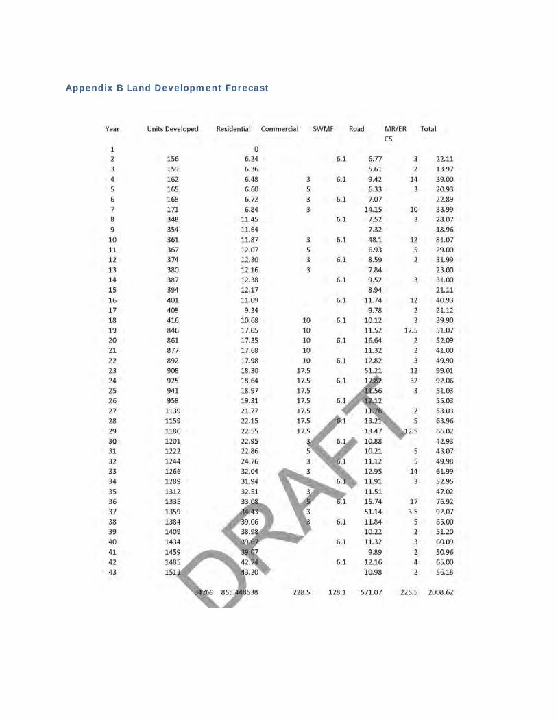
Appendix B Land Development Forecast

30
Appendix C Water Act Registrations
31
32
33
34
35
36

37
38
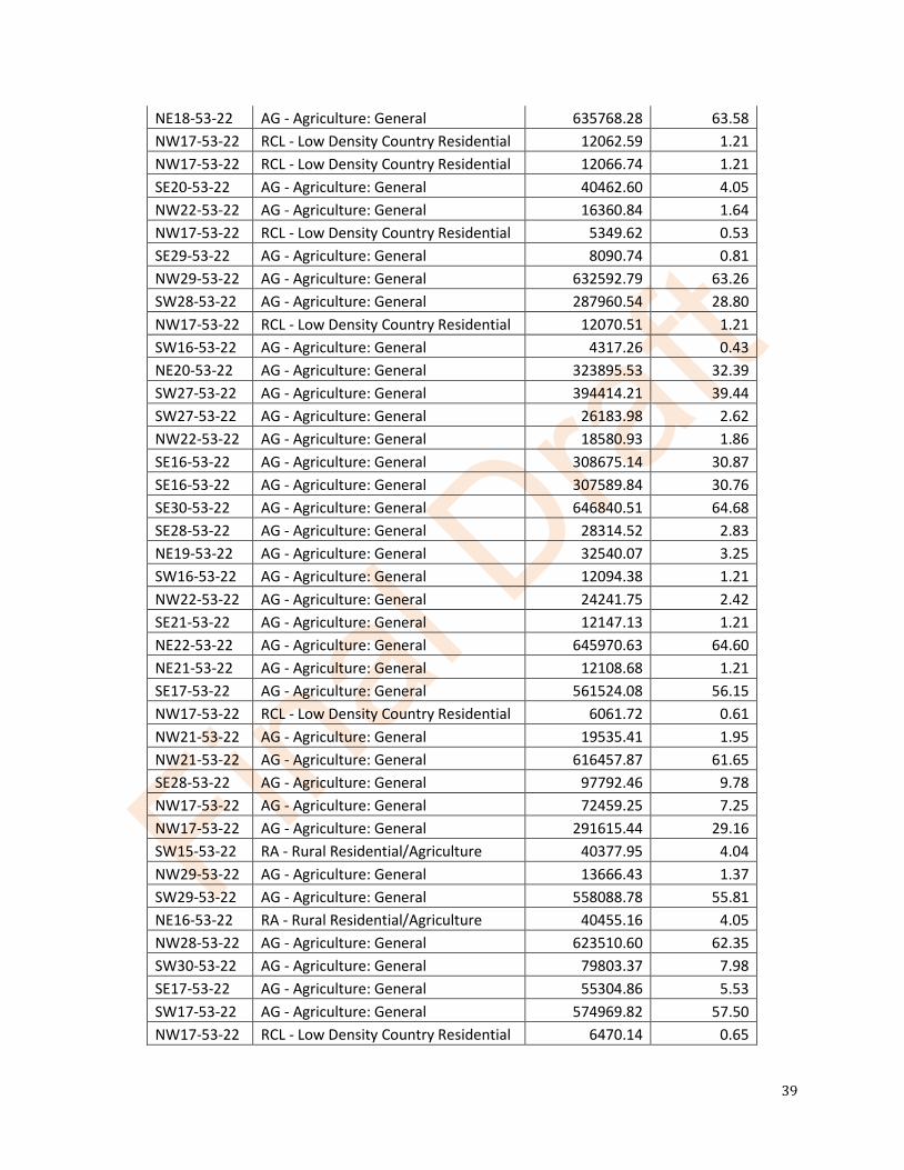
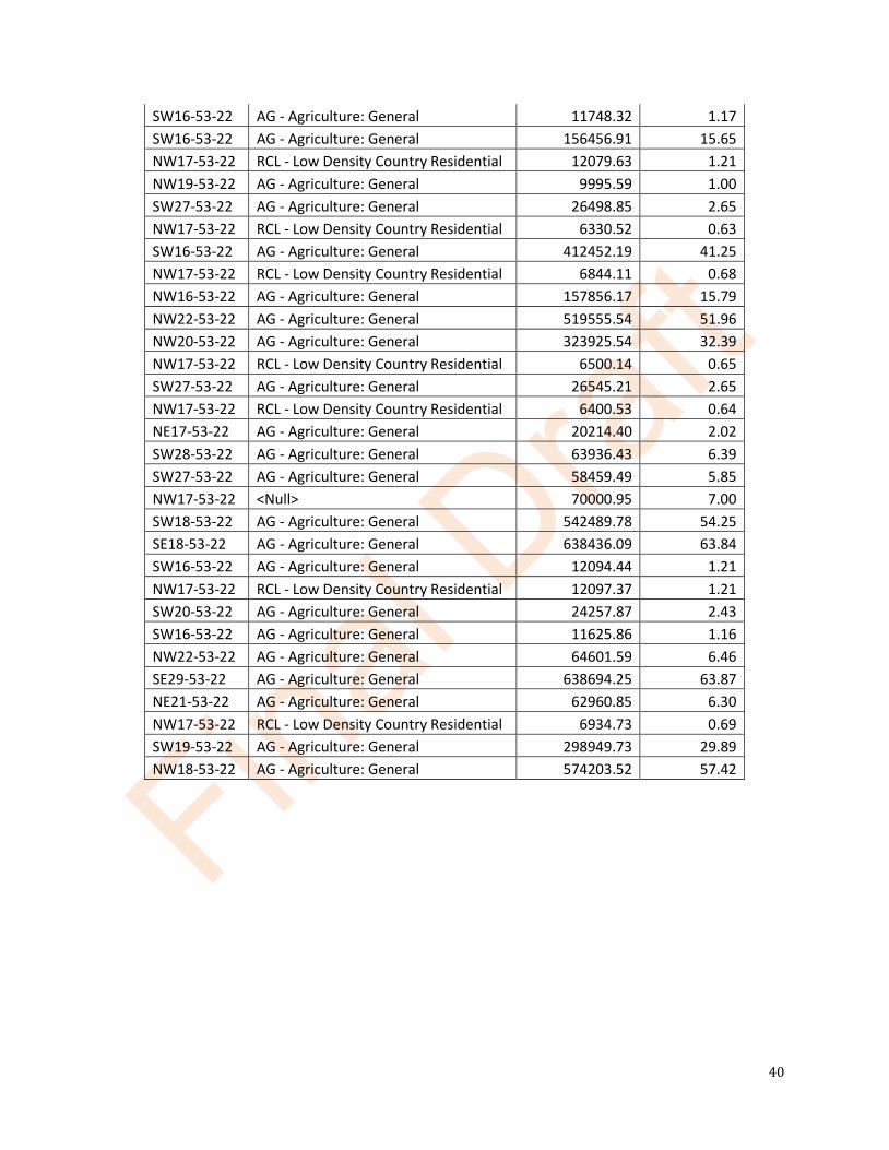
Appendix D Parcel Size and Zoning
ATS LUB DESCRIPTION LOT SIZE (sq m) LOT SIZE (ha) SW21-53-22 AG - Agriculture: General 642636.76 64.26 SW28-53-22 AG - Agriculture: General 287925.40 28.79 SE21-53-22 AG - Agriculture: General 618210.93 61.82 NE17-53-22 AG - Agriculture: General 629089.73 62.91 NW19-53-22 AG - Agriculture: General 564699.83 56.47 NW20-53-22 AG - Agriculture: General 323790.32 32.38 NE19-53-22 AG - Agriculture: General 614807.45 61.48 NE28-53-22 AG - Agriculture: General 642589.10 64.26 SW19-53-22 AG - Agriculture: General 287018.32 28.70 SW30-53-22 AG - Agriculture: General 8521.23 0.85 SW30-53-22 AG - Agriculture: General 470291.44 47.03 SW30-53-22 AG - Agriculture: General 20223.65 2.02 NW17-53-22 RCL - Low Density Country Residential 6116.61 0.61 SE19-53-22 AG - Agriculture: General 646333.45 64.63 NE16-53-22 RA - Rural Residential/Agriculture 40139.29 4.01 NW16-53-22 AG - Agriculture: General 25471.62 2.55 NW16-53-22 AG - Agriculture: General 455958.85 45.60 NE16-53-22 AG - Agriculture: General 557522.77 55.75 SE28-53-22 AG - Agriculture: General 526087.47 52.61 NE29-53-22 AG - Agriculture: General 323523.60 32.35 SW20-53-22 AG - Agriculture: General 623474.92 62.35 SE21-53-22 AG - Agriculture: General 16709.75 1.67 SW17-53-22 AG - Agriculture: General 40632.29 4.06 NW17-53-22 RCL - Low Density Country Residential 12071.18 1.21 NW17-53-22 RCL - Low Density Country Residential 13868.37 1.39 SE20-53-22 AG - Agriculture: General 607343.15 60.73 NW17-53-22 RCL - Low Density Country Residential 12062.24 1.21 NW17-53-22 RCL - Low Density Country Residential 6609.72 0.66 NW17-53-22 RCL - Low Density Country Residential 12066.17 1.21 SW27-53-22 AG - Agriculture: General 40476.55 4.05 NW17-53-22 RCL - Low Density Country Residential 6418.01 0.64 NE20-53-22 AG - Agriculture: General 323905.37 32.39 NW17-53-22 RCL - Low Density Country Residential 5786.23 0.58 NW17-53-22 RCL - Low Density Country Residential 7192.62 0.72 SE22-53-22 AG - Agriculture: General 648569.33 64.86 SW22-53-22 AG - Agriculture: General 652932.95 65.29 SW29-53-22 AG - Agriculture: General 87671.63 8.77 NE21-53-22 AG - Agriculture: General 565075.35 56.51 NE18-53-22 AG - Agriculture: General 10383.81 1.04
39
NE18-53-22 AG - Agriculture: General 635768.28 63.58 NW17-53-22 RCL - Low Density Country Residential 12062.59 1.21 NW17-53-22 RCL - Low Density Country Residential 12066.74 1.21 SE20-53-22 AG - Agriculture: General 40462.60 4.05 NW22-53-22 AG - Agriculture: General 16360.84 1.64 NW17-53-22 RCL - Low Density Country Residential 5349.62 0.53 SE29-53-22 AG - Agriculture: General 8090.74 0.81 NW29-53-22 AG - Agriculture: General 632592.79 63.26 SW28-53-22 AG - Agriculture: General 287960.54 28.80 NW17-53-22 RCL - Low Density Country Residential 12070.51 1.21 SW16-53-22 AG - Agriculture: General 4317.26 0.43 NE20-53-22 AG - Agriculture: General 323895.53 32.39 SW27-53-22 AG - Agriculture: General 394414.21 39.44 SW27-53-22 AG - Agriculture: General 26183.98 2.62 NW22-53-22 AG - Agriculture: General 18580.93 1.86 SE16-53-22 AG - Agriculture: General 308675.14 30.87 SE16-53-22 AG - Agriculture: General 307589.84 30.76 SE30-53-22 AG - Agriculture: General 646840.51 64.68 SE28-53-22 AG - Agriculture: General 28314.52 2.83 NE19-53-22 AG - Agriculture: General 32540.07 3.25 SW16-53-22 AG - Agriculture: General 12094.38 1.21 NW22-53-22 AG - Agriculture: General 24241.75 2.42 SE21-53-22 AG - Agriculture: General 12147.13 1.21 NE22-53-22 AG - Agriculture: General 645970.63 64.60 NE21-53-22 AG - Agriculture: General 12108.68 1.21 SE17-53-22 AG - Agriculture: General 561524.08 56.15 NW17-53-22 RCL - Low Density Country Residential 6061.72 0.61 NW21-53-22 AG - Agriculture: General 19535.41 1.95 NW21-53-22 AG - Agriculture: General 616457.87 61.65 SE28-53-22 AG - Agriculture: General 97792.46 9.78 NW17-53-22 AG - Agriculture: General 72459.25 7.25 NW17-53-22 AG - Agriculture: General 291615.44 29.16 SW15-53-22 RA - Rural Residential/Agriculture 40377.95 4.04 NW29-53-22 AG - Agriculture: General 13666.43 1.37 SW29-53-22 AG - Agriculture: General 558088.78 55.81 NE16-53-22 RA - Rural Residential/Agriculture 40455.16 4.05 NW28-53-22 AG - Agriculture: General 623510.60 62.35 SW30-53-22 AG - Agriculture: General 79803.37 7.98 SE17-53-22 AG - Agriculture: General 55304.86 5.53 SW17-53-22 AG - Agriculture: General 574969.82 57.50 NW17-53-22 RCL - Low Density Country Residential 6470.14 0.65
40
SW16-53-22 AG - Agriculture: General 11748.32 1.17 SW16-53-22 AG - Agriculture: General 156456.91 15.65 NW17-53-22 RCL - Low Density Country Residential 12079.63 1.21 NW19-53-22 AG - Agriculture: General 9995.59 1.00 SW27-53-22 AG - Agriculture: General 26498.85 2.65 NW17-53-22 RCL - Low Density Country Residential 6330.52 0.63 SW16-53-22 AG - Agriculture: General 412452.19 41.25 NW17-53-22 RCL - Low Density Country Residential 6844.11 0.68 NW16-53-22 AG - Agriculture: General 157856.17 15.79 NW22-53-22 AG - Agriculture: General 519555.54 51.96 NW20-53-22 AG - Agriculture: General 323925.54 32.39 NW17-53-22 RCL - Low Density Country Residential 6500.14 0.65 SW27-53-22 AG - Agriculture: General 26545.21 2.65 NW17-53-22 RCL - Low Density Country Residential 6400.53 0.64 NE17-53-22 AG - Agriculture: General 20214.40 2.02 SW28-53-22 AG - Agriculture: General 63936.43 6.39 SW27-53-22 AG - Agriculture: General 58459.49 5.85 NW17-53-22 <Null> 70000.95 7.00 SW18-53-22 AG - Agriculture: General 542489.78 54.25 SE18-53-22 AG - Agriculture: General 638436.09 63.84 SW16-53-22 AG - Agriculture: General 12094.44 1.21 NW17-53-22 RCL - Low Density Country Residential 12097.37 1.21 SW20-53-22 AG - Agriculture: General 24257.87 2.43 SW16-53-22 AG - Agriculture: General 11625.86 1.16 NW22-53-22 AG - Agriculture: General 64601.59 6.46 SE29-53-22 AG - Agriculture: General 638694.25 63.87 NE21-53-22 AG - Agriculture: General 62960.85 6.30 NW17-53-22 RCL - Low Density Country Residential 6934.73 0.69 SW19-53-22 AG - Agriculture: General 298949.73 29.89 NW18-53-22 AG - Agriculture: General 574203.52 57.42
41
Appendix E Bremner Area Agricultural Economic Impact Assessment
42
43
44
45
46
47
48
49
50
51
52
53
54
55
56
57
58
59
60
61
62
63
64
65
66
Appendix F Proposed Topsoil Conservation and Management Plan
Introduction
This plan is intended to provide guidance on topsoil conservation and management when developing in Bremner.
Context
As identified in the Bremner Agricultural Impact Assessment, all topsoil removed during the conversion of land from agricultural to residential/commercial/light industrial must be managed. Topsoil disposal in areas adjacent to Bremner has been identified as a primary negative impact of the land conversion and development. Additional negative impacts of excess topsoil disposal include, but are not limited to:
• unpermitted site grading • drainage alterations • wetland infilling • agricultural soil degradation • crop/soil disease transmission • road damage from unpermitted hauling • noise, dust and vibration disturbances to adjacent residents and farming operations
Strathcona County is developing strong urban agriculture programs to increase the footprint of edible plant and food cultivation in urban spaces. These plants require healthy, productive soil.
Urban soils tend to be poor quality, consisting of compacted subsoils covered with a thin layer of introduced topsoil. These soils are nutrient deficient, have poor structure and limited microbial activity. To create effective urban agriculture programs, proper soil must be available. Creating requirements at the planning and development stage to conserve topsoil will enable residents and municipal staff to immediately begin their urban agriculture projects.
Topsoil is essential for plant success, the deeper the topsoil, the easier it is for plants to grow deep, healthy roots which improves soil composition and structure and results in plants that are more resilient to disease and pest pressures. In turn, this results in decreased time and energy required by staff/residents to manage urban agriculture projects.
The ability of topsoil to absorb and retain water reduces the need for irrigation, which is especially important during the summer months when demand is high and water availability it low.
Topsoil Conservation Guidelines
Where possible, topsoil should be left undisturbed. Areas that are to be conserved such as Environmental and Municipal Reserve Lands are ideal places to limit stripping and grading activities that would disturb soils.
Topsoil Management Guidelines
Low Impact Development practices include increasing topsoil depths throughout the entire development with the intention to improve surface water quality, reduce water consumption and improve stormwater systems but those same practices also work to conserve and manage topsoil removed during development. The following topsoil conservation techniques (or BMPs) have been applied in other jurisdictions with success:
67
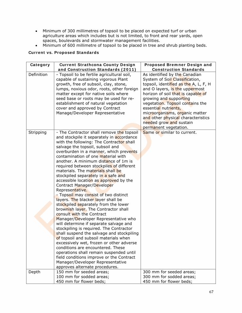
• Minimum of 300 millimetres of topsoil to be placed on expected turf or urban agriculture areas which includes but is not limited, to front and rear yards, open spaces, boulevards and stormwater management facilities.
• Minimum of 600 millimetre of topsoil to be placed in tree and shrub planting beds.
Current vs. Proposed Standards
Category Current Strathcona County Design
and Construction Standards (2011) Proposed Bremner Design and
Construction Standards Definition - Topsoil to be fertile agricultural soil,
capable of sustaining vigorous Plant growth, free of subsoil, clay, stone, lumps, noxious odor, roots, other foreign matter except for native soils where seed base or roots may be used for re-establishment of natural vegetation cover and approved by Contract Manage/Developer Representative
As identified by the Canadian System of Soil Classification, topsoil, identified as the A, L, F, H and O layers, is the uppermost horizon of soil that is capable of growing and supporting vegetation. Topsoil contains the essential nutrients, microorganisms, organic matter and other physical characteristics needed grow and sustain permanent vegetation.
Stripping - The Contractor shall remove the topsoil and stockpile it separately in accordance with the following: The Contractor shall salvage the topsoil, subsoil and overburden in a manner, which prevents contamination of one material with another. A minimum distance of 1m is required between stockpiles of different materials. The materials shall be stockpiled separately in a safe and accessible location as approved by the Contract Manager/Developer Representative. - Topsoil may consist of two distinct layers. The blacker layer shall be stockpiled separately from the lower brownish layer. The Contractor shall consult with the Contract Manager/Developer Representative who will determine if separate salvage and stockpiling is required. The Contractor shall suspend the salvage and stockpiling of topsoil and subsoil materials when excessively wet, frozen or other adverse conditions are encountered. These operations shall remain suspended until field conditions improve or the Contract Manager/Developer Representative approves alternate procedures.
Same or similar to current.
Depth 150 mm for seeded areas; 100 mm for sodded areas; 450 mm for flower beds;
300 mm for seeded areas; 300 mm for sodded areas; 450 mm for flower beds;
68
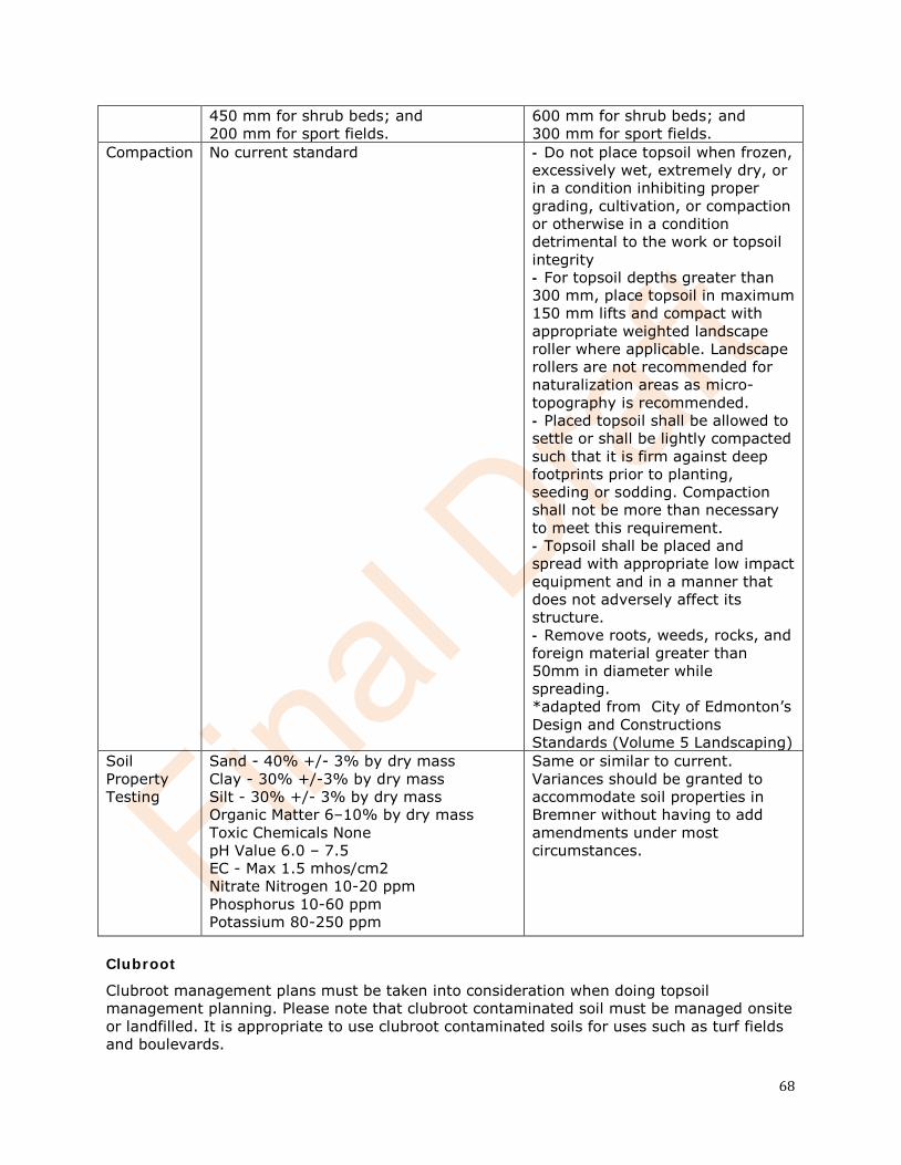
450 mm for shrub beds; and 200 mm for sport fields.
600 mm for shrub beds; and 300 mm for sport fields.
Compaction No current standard - Do not place topsoil when frozen, excessively wet, extremely dry, or in a condition inhibiting proper grading, cultivation, or compaction or otherwise in a condition detrimental to the work or topsoil integrity - For topsoil depths greater than 300 mm, place topsoil in maximum 150 mm lifts and compact with appropriate weighted landscape roller where applicable. Landscape rollers are not recommended for naturalization areas as micro-topography is recommended. - Placed topsoil shall be allowed to settle or shall be lightly compacted such that it is firm against deep footprints prior to planting, seeding or sodding. Compaction shall not be more than necessary to meet this requirement. - Topsoil shall be placed and spread with appropriate low impact equipment and in a manner that does not adversely affect its structure. - Remove roots, weeds, rocks, and foreign material greater than 50mm in diameter while spreading. *adapted from City of Edmonton’s Design and Constructions Standards (Volume 5 Landscaping)
Soil Property Testing
Sand - 40% +/- 3% by dry mass Clay - 30% +/-3% by dry mass Silt - 30% +/- 3% by dry mass Organic Matter 6–10% by dry mass Toxic Chemicals None pH Value 6.0 – 7.5 EC - Max 1.5 mhos/cm2 Nitrate Nitrogen 10-20 ppm Phosphorus 10-60 ppm Potassium 80-250 ppm
Same or similar to current. Variances should be granted to accommodate soil properties in Bremner without having to add amendments under most circumstances.
Clubroot
Clubroot management plans must be taken into consideration when doing topsoil management planning. Please note that clubroot contaminated soil must be managed onsite or landfilled. It is appropriate to use clubroot contaminated soils for uses such as turf fields and boulevards.
69
Other Considerations
If there is insufficient topsoil, variances may be granted to the developer and home builders so that topsoil does not have to be imported.
If excessive topsoil exists that cannot be used during development alternatives may be considered on a case by case basis.
References
Alberta Low Impact Development Partnership. 2016. Alberta Clean Runoff Action Guide (preliminary draft July 2016)
Okanagan Basin Water Board. The Partnership for Water Sustainability in BC. 2012. Topsoil Bylaws Tool Kit: An Appendix to the Green Bylaws Toolkit
Young, D. Morrison, C. (2012) Soil Management Best Practices Guide for Urban Construction [PowerPoint slides]. Retrieved from https://trieca.com/app/uploads/2016/07/Soil-Mgmt-Guideline-Mar-28-2012.pdf
City of Edmonton. (2014). Low Impact Development Practices Best Management Practices Design Guide Edition 1.1.
Cook, J. City of Vancouver. 2016. Top Soil Requirements In Vancouver: The Need, The Benefits, And The Next Steps.
City of Edmonton. (2017). Design and Construction Standards Volume 5: Landscaping.
Ritter, J. Ontario Ministry of Agriculture, Food and Rural Affairs. 2016. Factsheet: Importation of Soil onto Agricultural Land.
Case Studies and Examples
Currie Barracks Calgary http://albertawater.com/alberta-water-blog/2581-low-impact-development-and-flooding-a-drop-in-the-bucket-by-leta-van-duin
Village of Alix http://lombardnorth.ca/project/sustainable/
Box Grove, Ontario http://www.latornell.ca/wp-content/uploads/files/presentations/2016/Latornell_2016_T3F_Dean_Young.pdf


![BREMNER L. [Reframing Township Space. the Kliptown Project]](https://img.pdfslide.us/doc/110x75/577cd1ce1a28ab9e7895022f/bremner-l-reframing-township-space-the-kliptown-project.jpg)