Embed Size (px)
Citation preview
1
BRACING FOR DISASTER IN FOUR RIVERINE COMMUNITIES IN ILIGAN CITY
Dr. Liwayway S. Viloria
Dr. Nimfa L. Bracamonte
Dr. Myrma Jean A. Mendoza
Dr. Sulpecia L. Ponce
Amabelle A. Embornas
Jhona D. Landong
Department of Sociology
College of Arts and Social Sciences
MSUI-IIT, Iligan City
Abstract
This study aimed to determine the levels of vulnerability and disaster preparedness
among typhoon Sendong victims in four upland and lowland communities along the
Mandulog and Pugaan river systems. It tried to find out whether there were differences or
changes in the level of vulnerability and disaster preparedness between TS Sendong and TS
Pablo events. The results of this study are intended to inform and serve as a guide for
identifying areas that need appropriate disaster risk mitigation and prevention measures.
Using survey design, the study involved a total of 200 purposively chosen
respondents from four barangays. Aided by a structured questionnaire, the survey was
undertaken in May to July 2013. The quantitative data were analyzed using descriptive
statistics and t-test with the aid of SPSS.
With the Philippine Disaster Risk Reduction and Management System as framework,
the study revealed that there was a remarkable increase in respondents level of awareness of
the upcoming typhoons and their potential damages across the four barangay, from uncertain
in preSendong to high awareness in postSendong. A similar pattern was observed in their
awareness of climate change. Respondents preSendong high level of knowledge on
techniques of minimizing disaster risks likewise advanced to very high level.
Vulnerability was measured in terms of proneness to natural hazard, and level of
experiences in geo-hydro-meteorological hazard related losses and damages to properties
alongside family death, illnesses and injuries. Occurrences of flashfloods were perceived to
have increased from moderate in preSendong to high in post Sendong. However, storm surge
and sea level rise occurrences were relatively low as the barangays were mainly riverine.
Proneness of the communities to hazard due to nearness to river has significantly
increased after Sendong. Correspondingly, their houses have become significantly more
vulnerable to disaster given their proximity to a river and the predominantly single storey
design with light materials. With respect to infrastructures, the most vulnerable ones were the
bridges in the four barangays, all of which were damaged, followed by the drainage structures
and school buildings which were either heavily or partially damaged.

2
In terms of heavy-rains related losses or damages to properties, the four barangays
were perceived to have little experience in pre-Sendong but increased to moderate in post-
Sendong. Their estimated average cost of flash-flood related losses and damages to properties
were apparently much higher than what they could afford to immediately recover. Heavy-
rains and flashflood related family experiences in death, illnesses and injuries proved to be
significantly higher in post Sendong than in pre-Sendong.
Household disaster preparedness across the four barangays was significantly higher in
post Sendong than in pre Sendong. Similarly, the four barangay governments were better
prepared for Typhoon Pablo and for Typhoon Sendong, enabling them to achieve their goal
of zero casualty.
Keywords: disaster awareness, vulnerability, disaster preparedness, geo-hydro-
meteorological hazard
1. Introduction
In highlighting the need to uncover disaster risks as a way towards reconceptualizing
development, the “2011 Global Assessment Report on Disaster Risk Reduction” underscores
that a country’s or community’s capacity to downscale its vulnerability and reinforce its risk
governance ability indicates the extent to which disaster risks can be increased or reduced
(United Nations, 2011:18). Implicit in this statement is the importance of determining
people’s or a community’s vulnerability to disaster along with its capacity to manage risks.
This way, entry points or areas for appropriate mitigation may be identified and
correspondingly addressed towards making them disaster and climate change resilient.
Why are certain people more at risk or vulnerable to disaster than others? Greg
Bankoff (2006:1) has succinctly answered this in saying, “It is assumed that people are put’ at
risk’ from hazards because they are in the wrong spot at the wrong time…” And he further
opined that this unequal exposure to risk is generally attributable to the power relations
existing in each society. This vulnerability perspective entails jointly assessing the risks to
which people and their communities are exposed along with their capacities to manage risk
outcomes. Among the communities that are undoubtedly vulnerable to flooding, in particular,
is the December 2011 typhoon Sendong hard-hit upland and lowland communities lying
closely along the Mandulog and Pugaan river systems in Iligan City. A considerable number
of them were, and still residing in the river delta, if not riverbed. Prior to Sendong, these
communities had been occasionally struck by flashflood since 1953, but these were mostly
triggered by heavy rains and not by typhoons. The only recorded typhoons that they
experienced so far in pre Sendong were TS Lando in 2009 and another in 2007. These
however, did not result in losses to human lives, although there were recorded damages to
certain infrastructures, properties and crops.
In general, it may be said that Iligan City had been relatively free from massively
destructive typhoons or typhoon-induced flooding until the onslaught of the killer TS
Sendong, being geographically located outside the so-called typhoon belt despite the fact that
the Philippines has been noted as among the countries that sit within the Pacific ring of fire at
the same time located along the typhoon path making it either an origin or a destination of

3
typhoons averaging 20 a year, resulting to frequent flooding in certain areas. This condition
coupled with apparent lack of preparation despite the mandate of the 2010 enacted R.A.
10121 calling upon local government units to prepare, allocate budget, and implement their
respective Disaster Risk Reduction and Management (DRRM) plans, may be accounted for
the tremendous devastation which affected communities experienced during the onslaught of
TS Sendong, followed by Typhoon Pablo within a year’s time.
Unlike the communities frequented by typhoons such as those in the Bicol Region or
Batanes Island, the residents of Iligan had not fully geared themselves up to confront the
raging floodwaters brought by TS Sendong. That the effects of climate change is now being
harshly felt in Iligan City is a reverberating message that these two typhoons have released.
This is evident in the thousands of lives lost or unaccounted for and the millions of
infrastructure and private property losses, aside from biological and other environmental
damages which the TS Sendong related flash floods have brought about. By strengthening
adaptive capacities, the mortality risk, and various other forms or risks to economy, child
welfare and development, infrastructure, private properties and environment can be reduced
(United Nations, 2011:18). Addressing this issue certainly entails improvement in risk
governance capacity and reduction in vulnerability in low-and middle-income households and
communities. Imbedded in this approach is the need to identify underlying risk drivers such
as poverty or poor socio-economic conditions, badly planned development, or ecosystem
decline, and how these contribute to child welfare and development, as well as to internal
displacement. These links between risks and people’s and community survival and
development can be better understood when subjected to systematic investigation. It is
against this backdrop that this study was conducted, focusing on perceived disaster
vulnerabilities in relation to disaster preparedness of typhoon Sendong survivors in the four
upland and lowland communities along the Mandulog and Pugaan river systems in Iligan
City. This constitutes part of the project on DRRM in Iligan City. Results of this study can
serve as empirical input to crafting appropriate mitigating measures or adaptive strategies
towards attaining resilience to hazards and disasters.
There have been local studies on disaster vulnerability response, or impacts among
Sendong affected survivors in Iligan. Most of these, however, are undergraduate theses or
unpublished research. Besides, these studies were mostly focused on single affected
community. See for instance the undergraduate theses on a) Sendong preparedness and
vulnerabilities by Cuyno, Jimenez, and Lumpayao (2013) and Balabagan, Bodiongan, and
Romano (2013); b) Sendong response: through resource mobilization by the local and
international agencies undertaken by Amad and Tabada (2012), by the local government by
Anaya, Escuadra and Mamon (2012), Survivors’ response to humanitarian aid by Bao, Apal,
and Ampang (2013); c) Sendong effects on health, socio-economic and environmental
conditions by Lamoste, Patoy, and Solon (2012), Colance, Landong, and Manda (2012),
Cabartija, Jumamil, and Zuño (2012), Nellas, Panerio and Panerio (2012), Abundiente,
Gapor, and Santos (2013); d) Sendong recovery/ rehabilitation by Arsoler, Pagente and
Navales (2013), and Violanda and Cañares (2013)
On a higher academic plane, the dissertation of Judelyn M. Salon (2013) focused on
the empowerment of typhoon survivors and social legitimacy of social organizations in
disaster management.

4
Studying disaster risk or vulnerability necessitates a framework that integrates
management of geo-physical-chemical, living and human resources from the upland to the
lowlands and waters towards promoting conservation and sustainable resource use and
development. This is essentially what the “ridge-to-reef” approach mean, which anchors on
the ecosystem or watershed perspective (Climate Change Commission Philippines, 2013:21).
2. Objectives of the Study
Generally, this study aimed to determine the level of vulnerability and disaster
preparedness among typhoon Sendong victims in four upland and lowland communities lying
close to the Mandulog and Pugaan river systems. The results of this study are intended to
inform the affected residents, households and local government units and disaster risk
reduction and management councils and concerned people’s organization (POs),
nongovernment organizations, and other agencies and organizations in regard to areas that
need appropriate disaster risk mitigation and prevention measures. It tried to find out whether
there were differences or changes in levels of vulnerability and disaster preparedness between
TS Sendong and TS Pablo events.
3. Analytical Framework
The framework that has shaped and guided this study builds on the Philippine
Disaster Risk Reduction and Management System enshrined in Republic Act No. 10121
constituting a paradigm shift from disaster relief and response towards Disaster Risk
Reduction and Management (DRRM). This is an integrated, bottom-up and participatory
approach to disaster risk reduction process towards achieving genuine social and human
development. It mainly views disasters as a reflection of people’s vulnerability. In this sense,
determining people’s vulnerability becomes an imperative precondition to a systematic multi-
sectoral platform for disaster risk reduction. Thus, the National DRRM Plan for 2011-2028
has given priority to “identification of hazards, vulnerabilities, and risks…” The vision of the
country under the current long-term Philippine National DRRM Plan is “safer, adaptive and
disaster resilient Filipino communities towards sustainable development.” (NDRRMC
Secretariat, 2012). Four DRRM priority areas along with their long-term goals are crafted
toward achieving the vision, and there are a) Disaster Prevention and Mitigation, b) Disaster
Preparedness, c) Disaster Response, and d) Disaster Rehabilitation and Recovery. Each of
these areas is operationalized through its long-term goals, thus:
Disaster Prevention and Mitigation. Avoid hazards and mitigate their potential impacts by reducing
vulnerabilities and exposure and enhancing capacities of communities.
Disaster Preparedness. Establish and strengthen capacities of communities to anticipate, cope and
recover from the negative impacts of emergency occurrences and disasters.
Disaster Response. Provide life preservation and meet the basic subsistence needs of affected
population based on acceptable …
Disaster Rehabilitation and Recovery. Restore and improve facilities, livelihood and living conditions
and organizational capacities of affected communities, and reduced disaster risks in accordance with
the building back better principle.
These priority areas are not completely independent from one another, but rather tend
to come with certain overlaps with respect to their objectives or activities particularly
5
between two adjacent areas, such as between prevention and mitigation and preparedness,
between preparedness and response, between response and recovery, and between
rehabilitation and recovery and prevention and mitigation.
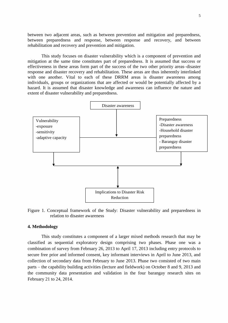
This study focuses on disaster vulnerability which is a component of prevention and
mitigation at the same time constitutes part of preparedness. It is assumed that success or
effectiveness in these areas form part of the success of the two other priority areas–disaster
response and disaster recovery and rehabilitation. These areas are thus inherently interlinked
with one another. Vital to each of these DRRM areas is disaster awareness among
individuals, groups or organizations that are affected or would be potentially affected by a
hazard. It is assumed that disaster knowledge and awareness can influence the nature and
extent of disaster vulnerability and preparedness.
Figure 1. Conceptual framework of the Study: Disaster vulnerability and preparedness in
relation to disaster awareness
4. Methodology
This study constitutes a component of a larger mixed methods research that may be
classified as sequential exploratory design comprising two phases. Phase one was a
combination of survey from February 26, 2013 to April 17, 2013 including entry protocols to
secure free prior and informed consent, key informant interviews in April to June 2013, and
collection of secondary data from February to June 2013. Phase two consisted of two main
parts – the capability building activities (lecture and fieldwork) on October 8 and 9, 2013 and
the community data presentation and validation in the four barangay research sites on
February 21 to 24, 2014.
Vulnerability
-exposure
-sensitivity
-adaptive capacity
Preparedness
-Disaster awareness
-Household disaster
preparedness
- Barangay disaster
preparedness
Disaster awareness
Implications to Disaster Risk
Reduction

6
In general, the larger research aimed to determine the disaster preparedness, response,
rehabilitation and adaptation strategies of four Typhoon Sendong affected lowland and
upland communities in Iligan City, particularly these located along the two river systems –
Hinaplanon (lowland) and Mandulog (upland) in Mandulog River, and Palao (lowland), and
Pugaan (upland) in Pugaan River.
This article focuses on the findings on disaster preparedness from the survey with 200
respondents from the said two lowland and two upland riverine barangay that were hit by
Typhoon Sendong. The hardest hit of the barangay was Hinaplanon, representing of the total
743 deaths, 635 missing, 6,577 houses totally damaged and 18,951 houses partially damaged.
Thus, in a Sangguniang Panglungsod Resolution No. 12-5815, 9 dated February 13, 2012 of
its purok and all purok in Bayug Island being wiped out by the typhoon have been declared
danger zones and thus unfit and unsuitable for residential settlement.
Fifty (50) household head respondents per barangay were ramdomly chosen among
residents of five purok worst-hit by Sendong. The twenty (20) purok involved are as follows
by barangay: Barangay Hinaplanon – Purok 1, 2A, 7, 10, 13, and 15; and Barangay Puga-an –
Purok 1A, 1C, 2A, 2B, and 5. The household head was either the husband or the wife who
was available at the time of the survey.
The survey questionnaire was constructed by the researchers themselves in light of the
concepts and principles of Disaster Risk Reduction and Management and Climate Change,
and instruments used by previous researchers. Prior to administrator in this survey, this
instrument was pretested and even used in other researches by students with the guidance of
the faculty. The questionnaire was translated to Cebuano to facilitate understanding and
interviewing respondents who most of whom were not articulate in English.
The survey was carried out with the assistance of ten data enumerators mainly
composed of Sociology Masteral and undergraduate students from MSU-IIT, Iligan City and
Central Mindanao University, Maramag, Bukidnon. For the purpose of leveling off, the data
enumerators underwent a pre-data gathering training conducted by the faculty researchers.
Two to three data enumerators were assigned to a barangay.
Within a month’s time (March to April 2013), the survey was accomplished. Since
most of the respondents were not capable of filling out the questionnaire by themselves,
individual interviews were conducted in their respective homes at their convenient time in
approximately one hour each.
Respondents who were not available at the time of the interview were immediately
replace through simple random sampling from the barangay list of Sendong survivors.

7
Figure 2. Geographic Map of Iligan City showing the research sites: Barangay Mandulog and
Hinaplanon along Mandulog river and Puga-an and Pala-o along Puga-an river
(see encircled four barangays).
5. Results
This section presents the findings of this study particularly on a) disaster awareness,
b) disaster vulnerabilities, and c) disaster preparedness.
Disaster Awareness
Disaster risk reduction efforts and readiness for effective disaster management hinges
on how substantially informed are governments, organizations, households, and individuals
on disaster and climate change. This section covers the respondents’ level of awareness of
upcoming typhoons, sources of information on typhoons, level of awareness of climate
change, and ways of reducing risks based on survey results. Analysis is guided by the
following fiduciary limit in five categories of values constituting the ranges of mean scores
on five point scaled measures: 4.3 -5.0 means Strongly Agree or very high, 3.5-4.2 means
Agree or high, 2.7-3.4 means Uncertain, 1.9-2.6 means Disagree or low and 1.0-1.8 means
Strongly Disagree or very low.
A remarkable increase is observed in respondents’ level of awareness of the upcoming
typhoons and their potential damages across the four barangay from pre-Sendong overall

8
mean score (ms) of 3.31 which means uncertain to pre-Pablo overall MS of 4.43 indicating
strong agreement or very high awareness. This is well substantiated by their average mean
score on items that capture a) the nature of typhoon (i.e., typhoon signal number with
corresponding speed in tropical cyclone winds, landfall location, date and estimated time
frame) at 3.22 (uncertain) in pre Sendong and 4.1 (agree or high awareness) in pre Pablo, and
b) the potential damages of typhoons under signal #2 and signal #3 at 3.21(uncertain) in pre
Sendong and 4.08 (agree or high awareness) in pre Pablo.
That direct exposure to a disaster event can enrich and thus awaken one’s disaster
consciousness is clearly shown in the findings. Indeed, direct experience in a phenomenon is
an effective way of acquiring and enhancing one’s knowledge and concern for disaster
resilience and resistance. Cuyno, Jimenez and Lumpayao (2013) have found a similar pattern
of leveling up the survivors’ disaster consciousness levels; in their undergraduate thesis in
Barangay Santiago, Iligan City. The positive role that direct experience plays in developing
learned responses to address difficulties during the disaster event was earlier explored and
confirmed, among other things, by E.M. Luna (2006) in a case study which he conducted in
Bula, Camarines Sur.
Sources of Information on Typhoons
Tropical Storm Sendong caused infrastructure damage, interrupted essential services,
and caused major public health risks and loss of lives. It is well understood that the level of
effectiveness of public communication strategies and the level of community disaster
preparedness can determine the success of disaster response. It was in this that the household
information sources accessed among the four barangay during the typhoons Sendong and
Pablo were determined.
Majority of the respondents from the four barangay were not aware about the storm
warning prior to Sendong landfall. Nevertheless, those who had prior knowledge about
Sendong used seven categories of communication media relative to the upcoming typhoon
Sendong on December 17, 2011, then typhoon Pablo on December 4, 2012: radio, television,
internet, Barangay/Purok officials, friends, relatives, and neighbors. The overall survey
results in terms of average percentages of responses across the four Barangay show that the
top four forms of communication media from which respondents learned about the upcoming
typhoon Sendong were as follows, in descending order: 1) friends (33.93%), 2) neighbors
(31.25%), 3) Internet (19.25%), and 4) television (9.48%). During Typhoon Pablo, a change
in the pattern of top four communication media can be seen from the following ranking: 1)
television (96.95%), 2) radio (93.94%), 3) relatives (93.83%), and 4) Barangay/Purok
officials (93.62%).
The influence of the traditional social network comprising friends and neighbors was
more pronounced during Typhoon Sendong followed by cyber network or internet, then by
the television. By contrast, dominance of the traditional social network waned during the
Typhoon Pablo with the ascendance of the most commonly used electronic mass media
which is television in the urban areas, followed by the radio, then relatives and Barangay and
Purok officials. After their experience in Sendong, the respondents may have gained trust in
the accuracy or reliability of weather reports through the television, then radio, relatives, and
Barangay/Purok officials. Remarkably, the media forms which did not surface among the top

9
four during the Typhoon Sendong, such as radio, relatives and Barangay/Purok officials have
become active during Typhoon Pablo.
Interestingly, the importance of traditional social network among Sendong Survivor
respondents has persisted in times of difficulties despite the emergence of electronic forms of
mass communication. And this traditional social network includes not only the kins by blood
but also friends and neighbors (with whom they can count on) who are residentially close or
available. In the studies of Lynch (1973, pp. 73-77, cited in Medina, 2001, p.34) on social
allies in Canama, Camarines Norte and in Miralao, Bulacan, this social network is referred to
as “clannishness”.
Perceptions on Climate Change
Fundamental to preparedness for hazards or disasters is one’s awareness of climate
change. Knowledge about why there is climate change and how this may affect weather
conditions, and thus potentially expose communities and environments to risks and/or
calamities can be an effective weapon to counteract vulnerabilities through increased
adaptation capacities.
How climate change aware were the respondents from the four barangay before
Sendong and after Sendong. Survey results indicate an overall trend from uncertain (ms=
3.49) to high (ms= 3.91) climate change awareness among respondents between Typhoons
Sendong and Pablo time periods, constituting an overall increase of .42 in mean score. This is
more evident in the mean scores on the following dimensions: 1) On geographic location of
the Philippines in the Pacific ring of fire (pre Sendong or pS = 3.72), pre-Pablo or pP = 4.41,
2) On global warming and climate change as causes of natural hazards (pS=3.66, pP=4.06),
and 3) On effects of climate change on weather conditions (pS=3.33, pP=3.75).
To what extent did respondents know about ways of reducing disaster risks? On the
whole, the respondents had high level of knowledge on techniques of minimizing disaster
risks (pS=3.68) in pre Sendong and very high in pre Pablo (4.31). These techniques include a)
accurate information (pS=3.72,pP=4.25), b) timely information dissemination (pS=3.64,
pP=4.44), and c) adequate preparation (pS=3.69, pP=4.24). Respondents were already
equipped with sufficient knowledge on the importance and role of correct and timely
information coupled with adequate disaster preparation even before the onslaught of
Sendong. And this was further enhanced when they experienced the wrath of Sendong, re-
echoing once again how a painful disaster experience could serve as an effective natural
learning episode.
Table 1. Summary of Mean Scores on Disaster Awareness Before and After Sendong
Dimension Before Sendong After Sendong Difference Interpretation
Mean Score Interpretation Mean Score Interpretation
1.Awareness of
upcoming
typhoons
3.31 Uncertain /
Moderate 4.02 Agree/ High 0.71 Increase
2.Awareness of
Climate Change 3.59 Agree/ High 4.00 Agree/ High 0.39 Increase
3.Awareness of
Reducing Risks 3.68 Agree/ high 4.31
Strongly Agree/
Very High 0.65 Increase
Overall 3.53 Agree/ High 4.11 Agree/ High 0.58 Increase
10
Vulnerabilities: Exposure to Hazard, Sensitivity and Adaptive Capacity
Vulnerability to hazard or disaster indicates the susceptibility of a given system to the
negative effects of a calamity or hazard, particularly when such effect goes beyond the
coping ability of the affected people or community utilizing its own resources. Republic Act
No. 10121, Section 3, has clearly defined vulnerability as the characteristics and
circumstances of a community, system or asset that make it susceptible to the damaging
effects of a hazard. Vulnerability may arise from various physical, social, economic, and
environmental factors such as poor design and construction of buildings, inadequate
protection of assets, lack of public information and awareness, limited official recognition of
risk and preparedness measures, and disregard for wise environmental management.
In essence, vulnerability is a combined function of these critical components:
exposure to hazard, impact and adaptive capacity. Viewed in the context of Rule 2 of the
Implementing Rules and Regulations of R.A 10121, exposure refers to the extent to which or
the chances that objects or elements at risk will get struck by hazard events in different
severity scales. These elements consist of communities, houses, or other elements in danger
zones. Impact means the degree of effect or change, whether direct or indirect, that disaster
may create on people’s lives, health, properties and environment. It is likewise referred to as
sensitivity. Basically, adaptive capacity is the capability of the human or natural systems to
adjust to actual or expected changes or effects of climatic stimuli or disaster to minimize
harm or exploit advantageous opportunities (RA 10121, Sec.3). This section focuses on
exposure and sensitivity to hazard; with an overview on adaptive capacity.
Exposure to Hazard
In this study, exposure to hazard among respondents is measured in terms of
proneness of elements that are subject to a specific hazard such as communities, houses or
other elements located in danger zones, experiences in geohydro-meteorological hazard
related losses and damages to properties alongside family death, illnesses and injuries. Heavy
rains, flashfloods, storm surge, sea level rise, and landslide comprise the hazards that this
study is concerned with.
The likelihood that communities, properties and environment will experience or will
be affected by hazards or disasters is referred to as proneness to hazard. Proneness was
determined on the basis of Likert-scaled items on the frequency of occurrence of natural
events, location and characteristics of the affected communities, properties and environment
before and after Typhoon Sendong.
Perceived Extent of Flashflood Occurrence Before and After Sendong. Flood occurs
when the water level of the stream/river overflows its banks or water discharge is high. This
may happen to a limited extent, as frequently as every two to three years in regions with
streams. Correspondingly, less severe floods happen more scarcely. Floods are mainly linked
to precipitation, either rain or snow (Montgomery, 1989:135).
Certain factors have been identified as mainly contributing to the occurrence of flood.
Topping these factors are the quantity of water involved (e.g. rain) and the rate at which it
goes into the stream system. “When the water input exceeds the capacity of the stream to
carry that water away downstream within its channel, the water overflows the banks” (Ibid).

11
Thus, the greater the water quantity and the faster it enters the stream system, the more likely
flood/ flashflood occurs when the carrying capacity of the stream is surpassed by the water
that goes into it (Espinueva, 2013).
Flashfloods before Sendong were perceived to be less frequent (m.s. =2.86 or moderate),
registering an overall increase of 1.06 in mean score or from “moderate frequency” to “high
frequency”. This increase can have unpleasant implications to people’s day to day activities,
occupation, livelihood, health, lives and properties, and environment among others.
Among the four barangays, Pala-o was highest in frequency of flashfloods with a
mean score of 3.14. Coming next was Puga-an (m.s.=2.93), then Mandulog (m.s.=2.8), and
lastly Hinaplanon (m.s.=2.53). Within a period of one year from Sendong, however, these
occurrence frequency levels have all increased in varying scale points ranging from 1.77
(Mandulog), 1.25 (Hinaplanon), 0.97 (Pala-o), then 0.29 (Puga-an).The barangay along
Mandulog river registered higher increase in flashflood occurrences than those in Puga-an
river.
Perceived Extent of Storm Surge Occurrence Before and After Sendong and Related
Losses and Damages. Similarly varying in frequent occurrences of storm surge hit the four
barangays before Sendong, although those along Puga-an River (Pala-o and Puga-an) were a
bit higher than those along the Mandulog River (Mandulog and Hinaplanon). After their
exposure to Sendong, slight increases were registered in terms of mean scores, with Pala-o
and Puga-an still garnering the first and second ranks.
Perceived Extent of Sea Level Rise Occurence Before. Perceived pre Sendong sea level
rise across the four barangays registered a low mean score of 1.89. Altogether, sea level rise
was scarcely experienced in these barangays because these are not generally coastal
barangays. These responses are the perceptions of the respondents regardless of their exact
household location at the time of the study. These perceptions may have come from relatives
or friends living in the coastal areas of the city.
After Sendong, the perceived sea level rise yielded an aggregate mean score of 2.04,
indicating an increase of 0.15, although Mandulog’s mean score has remained at 1.68
indicating no change whatsoever.
Botkin and Keller (2003) have stated that a sea level rise occurs primarily as a result
of the mix expansion of warming ocean water and secondarily due to the melting of glacial
ice. More serious consequences can result from sea level rise of about 1 meter or 3.3 feet.
With increased coastal erosion, communities would incur losses to properties and other
investments (Bother and Keller, 2003:476).
Community Hazard-Proneness Due to Location
Geographical proximity to hazard-prone areas puts the community at great risk of
various kinds of geo-hydro-meteorological hazards. Hazard proneness of the four barangay
and the respondents’ houses are examined in terms of their nearness to the river, sea, or
mountain.

12
Nearness to River. Both before and after Sendong all the four barangays were rated very
near a river – Barangays Mandulog (ms = 4.35, 4.57) and Hinaplanon (ms = 4.18, 4.34) were
very near the Mandulog River while Barangay Puga-an (ms = 4.42, 4.43) and Pala-o (ms =
4.16, 4.26) were very near the Puga-an River. Before Sendong, Puga-an was the nearest; but
after Sendong Mandulog turned out to be the nearest to the river and thus most prone to
flooding with a difference in mean score of 0.22. This means that after Sendong, the
Mandulog River widened, with silts flown from higher elevations. This increase in proneness
has been confirmed by t-test as significant at P-value = 0.010.
Table 2. Hazard-proneness due to geographic location of four barangays
Geographic Location
Before Sendong After Sendong
Difference Interpretation Mean
Score Interpretation
Mean
Score Interpretation
1. Near a river 4.28 High 4.4 Very High 0.12 Increase
2. Near the sea 1.87 Low 1.87 Low 0 No change
3. Both (Near the river and the
sea) 1.86 Low 1.88 Low 0.02 Increase
4. At the foot of the mountain 2.14 Low 2.08 Low -0.06 Decrease
5. On the mountain 2.14 Low 2.20 Low 0.06 Increase
Hazard Proneness of Houses
Propinquity of people to hazards can emerge from the location, structure and
materials with which their houses are constructed. In terms of these dimensions, this section
discusses the extent to which the houses where respondents dwelt were prone to hazard
events.
Hazard-Proneness of Respondents’ Houses Due to Nearness to River, Sea, Mountain
Potential exposure of people to hazard could be attributed to the geographic location
of the house where they reside. In this study, vulnerability of the respondents’ houses to
disaster is examined in terms of their nearness to river, sea, and mountain.
The houses of the respondents from the four barangay were highly vulnerable to disaster
before Sendong (ms = 4.21) in view of their proximity to a river. This condition became even
worse after Sendong with a mean score of 4.37 which is interpreted as “very high”. This
finding clearly converges with the data indicating the hazard proneness of the respondents’
barangay being located near a river.
With respect to proximity to a sea, to both river and sea, to the foot of the
hill/mountain, or on the mountain, the respondents’ houses were assessed as generally of low
vulnerability to hazard before Sendong and after Sendong. Vulnerability of their houses due
to nearness to sea obtained mean scores of 1.87 before Sendong and 1.86 after Sendong, due
to nearness to both river and sea posted mean scores of 1.85 before Sendong and 1.88 after
Sendong, due to location at the foot of the hill/mountain registered mean scores of 2.14
before Sendong and 2.08 after Sendong, and due to location on the mountain was rated with
mean scores of 2.11 before Sendong and 2.08 after Sendong.

13
Table 3. Hazard-proneness of houses due to geographic location by barangay
Barangay
Before Sendong After Sendong
Difference Interpretation Mean
Score Interpretation
Mean
Score Interpretation
1. Near a river 4.21 High 4.37 Very High 0.16 Increase
2. Near the sea 1.87 Low 1.86 Low -0.01 Decrease
3. Both (Near the river and the
sea) 1.85 Low 1.88 Low 0.03 Increase
4. At the foot of the mountain 2.14 Low 2.08 Low -0.06 Decrease
5. On the mountain 2.11 Low 2.08 Low -0.03 Decrease
These findings do not seem to corroborate with that of the location of the victims of
typhoon Pablo, in Compostela Valley and Davao Oriental where houses near the mountains
or on slopes, or near the seashore where the worst-hit, including the residents. This is even
worse in the case of typhoon Yolanda which devastated thousands of residents and structures
near the sea in Leyte, Samar, Bohol, Cebu, Iloilo, Negros, and other provinces in Visayas.
Hazard-Proneness of Respondents’ Houses Due to Structure and Building Materials
Like location, the structure and construction materials used can put houses at risk. In
the case of the houses of the respondents, the single storey design whether made with light
materials, concrete materials or mixed concrete and light materials were rated highly
vulnerable to hazard both before and after the occurrence of Sendong.
On the other hand, the two-storey house structures whether made with light materials
concrete materials, and mixed concrete and light materials were generally assessed with low
vulnerability to hazard/disaster before Sendong. After this disaster, however, their
vulnerability escalated to moderate level. This may be substantiated by the findings on
nearness to the river which likewise increased after the flood with the widening of the rivers
as a result of siltation and liquefaction based on on-site observation and interviews with
workshop participants during the community mapping phase of the study. This study
somehow corroborates with that of August 2012 Disaster Risk Assessment of Iligan City
conducted by the local government of Iligan with the technical assistance of the Region X
Housing and Land Use Regulatory Board and National Economic Development Authority
(cited in Iligan City Disaster Risk Reduction and Management Plan 2013-2020).
In sum, the vulnerability to hazard or disaster of the respondents’ households both
before and after the occurrence of Sendong may be attributed to the nearness of their
communities along with their houses to a river. Information from on-site observation and data
from informal interviews with participants in community mapping further revealed that a few
Purok near the mouth of the Iligan Bay were almost wiped out by the floodwaters brought
about by typhoon Sendong, leaving only a few damaged houses to which victims who have
nowhere to go have been forced to go back. These were the areas covered by the Bayug
Island, which is now declared a no-built zone by the Iligan City Sanggunian and to
discourage rebuilding damaged houses, if not building new ones, the City Government has
prohibited the restoration of water and power facilities.
Hazard-Proneness of Infrastructures/Facilities. Among the infrastructure facilities which
are vulnerable to hazards in the four barangay studied, the bridges were the most vulnerable
considering that Mandulog, Hinaplanon, Pugaan, and Palao all their bridges were damaged
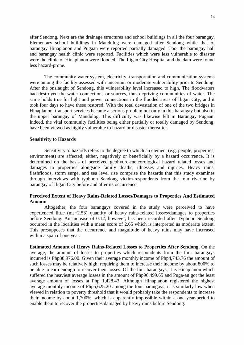
14
after Sendong. Next are the drainage structures and school buildings in all the four barangay.
Elementary school buildings in Mandulog were damaged after Sendong while that of
barangay Hinaplanon and Pugaan were reported partially damaged. Too, the barangay hall
and barangay health clinic were reported. Facilities which were less vulnerable to disaster
were the clinic of Hinaplanon were flooded. The Iligan City Hospital and the dam were found
less hazard-prone.
The community water system, electricity, transportation and communication systems
were among the facility assessed with uncertain or moderate vulnerability prior to Sendong.
After the onslaught of Sendong, this vulnerability level increased to high. The floodwaters
had destroyed the water connections or sources, thus depriving communities of water. The
same holds true for light and power connections in the flooded areas of Iligan City, and it
took four days to have these restored. With the total devastation of one of the two bridges in
Hinaplanon, transport services became a serious problem not only in this barangay but also in
the upper barangay of Mandulog. This difficulty was likewise felt in Barangay Pugaan.
Indeed, the vital community facilities being either partially or totally damaged by Sendong,
have been viewed as highly vulnerable to hazard or disaster thereafter.
Sensitivity to Hazards
Sensitivity to hazards refers to the degree to which an element (e.g. people, properties,
environment) are affected; either, negatively or beneficially by a hazard occurrence. It is
determined on the basis of perceived geohydro-meteorological hazard related losses and
damages to properties alongside family deaths, illnesses and injuries. Heavy rains,
flashfloods, storm surge, and sea level rise comprise the hazards that this study examines
through interviews with typhoon Sendong victim-respondents from the four riverine by
barangay of Iligan City before and after its occurrence.
Perceived Extent of Heavy Rains-Related Losses/Damages to Properties And Estimated
Amount Altogether, the four barangays covered in the study were perceived to have
experienced little (ms=2.53) quantity of heavy rains-related losses/damages to properties
before Sendong. An increase of 0.12, however, has been recorded after Typhoon Sendong
occurred in the localities with a mean score of 2.65 which is interpreted as moderate extent.
This presupposes that the occurrence and magnitude of heavy rains may have increased
within a span of one year.
Estimated Amount of Heavy Rains-Related Losses to Properties After Sendong. On the
average, the amount of losses to properties which respondents from the four barangays
incurred is Php38,976.00. Given their average monthly income of Php4,743.76 the amount of
such losses may be relatively high, requiring them to increase their income by about 800% to
be able to earn enough to recover their losses. Of the four barangays, it is Hinaplanon which
suffered the heaviest average losses in the amount of Php96,499.65 and Puga-an got the least
average amount of losses at Php 1,428.43. Although Hinaplanon registered the highest
average monthly income of Php5,625.20 among the four barangays, it is similarly low when
viewed in relation to poverty threshold that it would probably take the respondents to increase
their income by about 1,700%, which is apparently impossible within a one year-period to
enable them to recover the properties damaged by heavy rains before Sendong.

15
Estimated Amount of Heavy Rains-Related Damage to Properties before Sendong
The pattern in the estimated value of losses to properties due to heavy rains is
seemingly replicated in the estimated average amount of damages to properties before
Sendong, although the latter is slightly lower at Php 33,694.04 than that of the former which
is Php 38,976.90. By replicated pattern it means the distribution by barangay of the estimated
average amount.
Estimated Amount of Losses and Damages due to Flashfloods After Sendong. After the
occurrence of Sendong, the four affected barangays incurred an average estimated amount of
Php108,725.00 in losses to properties due to flashfloods. Hinaplanon suffered the highest
average amount of losses at Php 201, 666.00, followed by Mandulog at Php116,289.00, Pala-
o with Php62,727.00 and lastly by Puga-an valued at Php29,999.55. Notice that the barangays
(Hinaplanon and Mandulog) along the Mandulog river system suffered greater losses than
those along the Puga-an river system (Pala-o and Puga-an).
A similar pattern is observed among the four barangays concerning damages due to
flashfloods after Sendong. Their average damages in properties amounted to Php 90,924.00.
The adjacent barangays along the Mandulog river system, Mandulog and Hinaplanon, ranked
first and second in damages to properties in the amounts of Php144,464.00 and
Php120,800.00, respectively.
The trends in both losses and damages to properties after typhoon Sendong hit the
areas reflect the levels at which flashfloods occurred during the same period where barangays
along the Mandulog river system (Mandulog and Hinaplanon) more frequently experienced
flashfloods than those along Puga-an river system (Pala-o and Puga-an).
Only 2 or 1% of the total 200 respondents reported losses to their properties in the
aftermath of Sendong, one in Pala-o and one in Hinaplanon, with the average estimated
amounts of P79,999 and P5,000.00, respectively. These relatively low amounts of losses
should not come as a surprise since storm surge occurrences in the areas was quite rare or
infrequent.
With respect to damages to properties due to storm surge after Sendong, the average
estimated amount in Pala-o is Php204,999.00, which is four times as much as that in
Hinaplanon amounting to Php5,000.00. As with losses, only 2 out of the 200 respondents
reported to have suffered damages to their properties.
Perceived Extent of Sea-level Rise Related Losses and Damages. Of the four barangays,
only respondents from Hinaplanon reported losses attributable to perceived sea level rise after
Sendong, their values ranging from below Php 9,999.00 to Php 139,999.00, or an average of
Php 27,499.61. This could be due to the proximity of their community to the sea. Hinaplanon
ranked number one in terms of nearness to the sea, both before and after Sendong. In terms of
damage to property, sea level rise has affected only the respondents from Puga-an in the
average amount of Php 32,691.85.
16
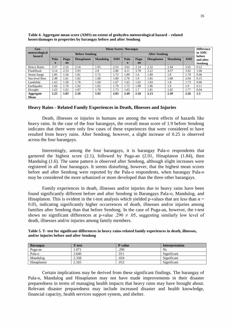
Table 4. Aggregate mean score (AMS) on extent of geohydro-meteorological hazard – related
losses/damages to properties by barangay before and after Sendong
Geo-
meteorological
hazard
Mean Scores / Barangay Difference
in AMC
before
and after
Sendong
Before Sendong After Sendong
Pala-
o
Puga-
an
Hinaplanon Mandulog AMS Pala-
o
Puga-
an
Hinaplanon Mandulog AMS
Heavy Rains 3.37 2.16 2.54 1.95 2.53 3.62 2.14 2.32 2.44 2.65 0.12
Flashflood 3.14 2.53 2.93 2.8 2.86 4.11 3.78 3.22 4.57 3.92 1.06
Storm Surge 1.85 1.56 1.81 1.72 1.73 1.89 1.6 1.89 1.8 1.79 0.06
Sea-level Rise 2.48 1.61 1.82 1.68 1.89 2.76 1.9 1.85 1.68 2.04 0.15
Landslide 1.63 1.58 1.78 1.69 1.67 1.65 1.62 1.83 1.8 1.73 0.06
Earthquake 1.66 1.76 1.92 1.82 1.79 1.75 1.98 1.96 1.9 1.9 0.11
Drought 1.63 1.62 1.87 1.78 1.73 1.65 1.7 1.81 1.92 1.77 0.04
Aggregate
Mean
2.25 1.83 2.10 1.92 2.03 2.49 2.10 2.13 2.30 2.26 1.3
Heavy Rains - Related Family Experiences in Death, Illnesses and Injuries
Death, illnesses or injuries in humans are among the worst effects of hazards like
heavy rains. In the case of the four barangays, the overall mean score of 1.9 before Sendong
indicates that there were only few cases of these experiences that were considered to have
resulted from heavy rains. After Sendong, however, a slight increase of 0.25 is observed
across the four barangays.
Interestingly, among the four barangays, it is barangay Pala-o respondents that
garnered the highest score (2.1), followed by Puga-an (2.01, Hinaplanon (1.84), then
Mandulog (1.6). The same pattern is observed after Sendong, although slight increases were
registered in all four barangays. It seems disturbing, however, that the highest mean scores
before and after Sendong were reported by the Pala-o respondents, when barangay Pala-o
may be considered the more urbanized or more developed than the three other barangays.
Family experiences in death, illnesses and/or injuries due to heavy rains have been
found significantly different before and after Sendong in Barangays Pala-o, Mandulog, and
Hinaplanon. This is evident in the t-test analysis which yielded p-values that are less than α =
0.05, indicating significantly higher occurrences of death, illnesses and/or injuries among
families after Sendong than that before Sendong. In the case of Puga-an, however, the t-test
shows no significant differences at p-value .290 ≠ .05, suggesting similarly low level of
death, illnesses and/or injuries among family members.
Table 5. T- test for significant differences in heavy rains-related family experiences in death, illnesses,
and/or injuries before and after Sendong
Barangay T-test P value Interpretation
Puga-an 1.071 .290 Ns
Pala-o 2.640 .011 Significant
Mandulog 2.338 .024 Significant
Hinaplanon 2.165 .012 Significant
Certain implications may be derived from these significant findings. The barangay of
Pala-o, Mandulog and Hinaplanon may not have made improvements in their disaster
preparedness in terms of managing health impacts that heavy rains may have brought about.
Relevant disaster preparedness may include increased disaster and health knowledge,
financial capacity, health services support system, and shelter.

17
On the other hand, Barangay Puga-an may have maintained experiences in relatively
low death, illnesses and/or injuries and its disaster preparedness after the Sendong disaster,
although a positive difference in mean score is observed at 0.43. The lack of significant
differences in such family experiences may be accounted to the fact that shortly before the
typhoon Sendong struck the barangay, the local government unit already had some disaster
preparations as an offshoot of the training on disaster risk reduction and management which
the punong barangay and other officials underwent. This was revealed by the incumbent
punong barangay herself during the key informant interview in May 2013. Whatever
improvements there is on the preparations made in December 2011, however, did not prove
statistically significant.
Flash-flood Related Family Experiences in death, illnesses and/or injuries
The Philippines being a typhoon prone country has had a number of experiences in
flash flooding. Among which are the Marikina River flooding due to Tropical Storm Ondoy
in September 2009 and the Agno River flooding during the Typhoon Pepeng in October 2009
(Ibid.).
That the flash-flood which typhoon Sendong brought about was among the worst that
ever happened so far in the Philippines has been an established fact resulting in thousands of
death and damages and losses to properties. The extent to which Sendong flash-flood could
be attributed for death, illnesses and/or injuries of family members is the focus of this section.
Table 6. Mean score (MS) on flash flood - related family experiences in death, illnesses and/or injuries by
barangay
Barangay Before Sendong After Sendong
Difference Remarks
Mean Score Interpretation Mean Score Interpretation
Pala-o 2.02 Low 2.85 Moderate 0.83 Increase
Pugaan 2.06 Low 2.75 Moderate 0.69 Increase
Hinaplanon 1.96 Low 3.14 Moderate 1.18 Increase
Mandulog 2.29 Low 3.49 High 1.2 Increase
Overall Mean
Score 2.08 Low 3.06 Moderate 0.98 Increase
There is a slight increase (.98) from “low” to ”moderate” extent in family experiences
in death, illnesses or injuries between the periods prior and after the Typhoon Sendong hit the
barangays. The t tests have yielded highly significant results with p value = .001<α = .01 for
all the four barangays, indicating more family members who have experienced death,
illnesses or injuries as a result of flash-flood in the aftermath of Sendong.
Table 7. T- test for significant difference in family experiences in death, illnesses, and/or injuries before
and after Sendong
Barangay t-test P value Interpretation
Puga-an 4.313 <.001 Significant
Pala-o 4.068 <.001 Significant
Mandulog 6.614 <.001 Significant
Hinaplanon 5.779 <.001 Significant
Of the four barangays, Mandulog got the highest mean score of 2.29 before Sendong
and 3.49 after Sendong, and correspondingly registering the highest increase at 1.2. This may
18
be attributed to its location being near the Mandulog River. Comparing the flood plain before
and after Sendong, the latter has remarkably widened as the heavy water flow further eroded
the soil, expanding even more both sides of the river banks.
In the case of Hinaplanon, it obtained the lowest rating prior to Sendong mean score
1.96 but gained the second highest mean score of 3.14 after Sendong. Adjacent to Barangay
Mandulog, Hinaplanon sits along the tail-end of the Mandulog River towards the coastline of
the Iligan Bay. This is where the Bayug Island is located, comprising 9 puroks which were
either heavily damaged or totally washed out during the Typhoon Sendong, leaving hundreds
of residents dead (drowned or buried under heavy silts and debris that were brought along by
the great volume of water together with the huge logs that rolled down from the headwaters
in Kapai River, Lanao del Sur. Bayug Island comprising 9 puroks, is now declared a danger
zone where construction of structures (e.g., houses) and establishment of facilities (e.g.,
power lines, water system) are no longer permitted by the City government of Iligan,
consistent with the provision of City Ordinance No.12 5815.
Extent of Storm Surges – Related Family Experiences in Death, Illnesses and/or Injuries
Storm surges occur when a typhoon hits a sea or ocean. They take the form of huge
waves that hit lands along the coast, with width spanning several kilometers and height that
could reach as high as two or three floors of houses. Without pre-emptive evacuation to much
higher grounds, storm surges could be as deadly as any strong natural hazards, killing
thousands of lives and damaging even entire communities. This is what happened to
Tacloban City and other coastal areas in Luzon, Visayas and Mindanao that were worst hit by
Super Typhoon Yolanda in November 7-8, 2013.
Fortunately, there were no strong storm surges in the aftermath of Sendong. Although
previous to Sendong, there may have been storm surges; those that occurred when Sendong
had a landfall in Iligan City, were not strong enough to cause destruction in the communities
that were located near the sea, such as a portion of Barangay Hinaplanon.
Sea Level Rise – Related Family Experiences in Death, Illnesses and Injuries
Sea level rise is another problem that may result from global warming (Botkin and
Keller, 2003, pp. 475), particularly when the glaciers and sea-ice melt and the temperature
rises or thermal expansion of ocean water. Other factors that may act together with global
warming and lead to sea level rise are land subsidence and compaction, and ground water
depletion. This phenomenon will be experienced by coastal regions where an estimated half
of the people of the Earth lives (Ibid., pp. 475-476).
In the case of the four barangays, sea level rise had been scarcely experienced before
Sendong. There was, however, a significantly little increase in sea level rise after Sendong as
experienced in Pala-o and Hinaplanon. Correspondingly, losses were incurred only in
Barangay Hinaplanon at an average of Php 27, 499.61 even as damages were experienced
only by Barangay Puga-an at an average of Php. 32, 691.85. Interestingly, these losses and
damages were found significantly higher than all other three barangays. These respondents
who claimed damages of properties due to sea level rise may have owned properties located
along coastal areas and not in the Barangay they are residing in at the time of the study.

19
With respect to sea level rise – related experiences in death, illnesses, and/or injuries,
the four barangays have very little experiences. In general mean score is 1.74, with very
slight variations in mean scores of Barangay Mandulog, Hinaplanon and Pugaan. It is only in
Barangay Pala-o which registered a significant difference before and after Sendong, with p-
value = .034 at α = 0.05. This means that families from Barangay Pala-o have been more
greatly affected by sea level rise after Sendong in terms of death, illnesses and/or injuries. It
is possible that these deaths, illnesses and/or injuries may have been incurred when they were
residing along the coastal areas and moved to Pala-o at the time of the study. Additionally,
the question on the effects of sea-level rise does not only report the respondents’ nuclear
family but may also include their relatives living along coastal areas.
Table 8. Aggregate mean score (AMS) on extent of geohydro-meteorological hazard – related family
experiences in death, illnesses, and/or injuries by barangay before and after Sendong. Geo-
meteorological
hazard
Mean Scores / Barangay Difference in
AMC before
and after
Sendong
Before Sendong After Sendong
Pala-o Puga-an Hinaplanon Mandulog OMC Pala-
o
Puga-
an
Hinaplanon Mandulog OMC
Heavy Rains 2.1 2.04 1.84 1.6 1.9 2.5 2.15 2.12 1.81 2.15 0.25
Flashflood 2.02 2.06 1.96 2.29 2.08 2.85 2.75 3.14 3.49 3.06 0.98
Storm Surge 1.75 1.83 1.56 1.71 1.71 1.77 1.92 1.67 1.78 1.78 0.07
Sea-level Rise 1.87 1.79 1.58 1.71 1.74 2.19 1.83 1.7 1.69 1.78 0.04
Landslide 1.59 1.81 1.6 1.71 1.68 1.58 1.87 1.7 1.73 1.7 0.05
Earthquake 2.1 2.04 1.84 1.6 1.9 2.53 2.15 2.12 1.81 2.15 0.25
Drought 1.59 1.79 1.62 1.69 1.68 1.58 2.27 1.64 1.8 1.83 0.15
Aggregate
Mean 1.86
low
1.91
Low
1.71
very low
1.76
very low
1.81
very
low
2.15
low
2.13
low
2.01
low
2.02
low
2.06
low
.26
very low
Table 9. T –test for significance of differences in geo-meteorological hazard – related family experiences
in death, illness and/or injuries before and after Sendong.
Barangay T-test P value Interpretation
1. Heavy rains
Puga-an 1.071 .290 ns
Pala-o 2.640 .011 significant
Mandulog 2.338 .024 significant
Hinaplanon 2.165 .012 significant
2. Flashflood
Puga-an 4.313 <.001 significant
Pala-o 4.068 <.001 significant
Mandulog 6.614 <.001 significant
Hinaplanon 5.779 <.001 significant
3. Sea level rise
Pala-o 2.183 .034 significant
Section Two: Disaster Preparedness
In the context of disaster risk reduction and management, preparedness consists of the
knowledge and capabilities which have been developed by various government and non-
government response and recovery entities, communities and individuals “to effectively
anticipate, respond to, and recover from, the impacts of likely imminent or current hazard
events or conditions.” Founded on formal, legal and budgetary framework and capacities,
disaster preparedness actions and activities are designed to reinforce the institutional,
community and individual capabilities required to adequately manage various sorts of
emergencies to allow for systematic transition processes towards sustained recovery (R.A.
10121, Sec. 3.j). Three levels of disaster preparedness are presented in this section –

20
household disaster preparedness, Barangay disaster preparedness, and government agencies/
humanitarian organization disaster preparedness.
Household Disaster Preparedness
The household disaster preparedness of the respondents from the four barangays was
determined in two time periods – before and after the occurrence of Sendong, in terms of
activities done or things prepared for the upcoming typhoon along information dissemination,
emergency survival readiness, and structural/environmental initiatives. As preconditions to
these sets of preparedness actions, are the questions whether or not they undertook
preparatory activities and their reasons for their affirmative or negative response. Findings
were based on survey results.
The respondents’ households were generally better prepared for disaster after
Sendong than before Sendong hit their barangays. Overall, they obtained “very low” ratings
before Sendong for the three composite disaster preparedness activities and remarkably
“moderate” (structural/environmental initiatives) to “very high” (emergency survival
readiness and information/dissemination after the occurrence of Sendong. It is only, however,
post Sendong higher preparedness through information/dissemination which has been t-test
confirmed as highly significant.
Confirmation of Disaster Preparation/Non-preparation and Reasons. Their very low
disaster preparedness before Sendong is supported by their admittance that they and their
families did not make the necessary preparatory activities (88.50%), with Mandulog
registering the highest confirmation of non-preparedness (98%), followed by Hinaplanon
(92%), then by Puga-an and lastly Pala-o (74%). Their lack of disaster preparation was
mainly because they did not expect it to happen (70%). Other reasons advanced include: a)
presumption that it was just a normal heavy rain, b) not having heard any warning, c) being
too busy to attend to weather reports, and d) disbelief in weather reports. For the very few
who prepared for Sendong (10.50%), their preparatory activities were based on a) the
information they themselves obtained from watching weather reports, b) their desire to ensure
the safety of their family, c) observation of the river level rise, d) both informed by watching
weather reports and observation of the river level rise, and e) being convinced by neighbors
to evacuate. These factors indicate the influence of mass media, concern for family,
neighborhood social network, and direct observation of potential hazard event or element.
Before Pablo, a much heightened confirmation of disaster preparation was indicated
by an overwhelming majority (97%) of the respondents across the four barangays; with Pala-
o taking the lead at 100%, followed by Puga-an (98%), Mandulog (96%), then Hinaplanon
(94%). Among the four barangays, Pala-o respondents stood out to have successfully
registered a full admission of their own household disaster preparedness for typhoon Pablo.
Yet, the apparently dramatic change in outlook from disaster unpreparedness to disaster
preparedness among the respondents from Puga-an, Mandulog and Hinaplanon equally
deserves a recognition. Being among the worst-hit by typhoon Sendong and are still in the
process of rehabilitation and recovery, they must have learned enormously from their painful
experiences in lives lost, illnesses or injuries incurred, and/or property losses or damages. The
data on impacts of flood along with their perceived vulnerabilities could provide further
insights and possible support of the findings on their household disaster preparedness.

21
Interestingly, the reasons that motivated them to prepare for typhoon Pablo were
seemingly different from those that influenced them to prepare for typhoon Sendong. The
former include a) listening to news report, b) warning from barangay officials regarding the
upcoming typhoon, and c) warning from certain NGOs such as the CFSI concerning the
approaching typhoon. These reasons bring to the forefront the positive role of mass media,
alongside that of the Local Government Officials and The Concerned NGOs in disaster risk
reduction and management. In the case of the local government officials, these findings
suggest that they have now taken on the lead responsibility which the Hyogo Framework to
which Philippines is one of the signatories and the R.A. 10121 have mandated them to
perform; an information which did not surface before Sendong. Similarly, concerned NGOs
have now become an active player in barangay early warning system.
Emergency Survival Readiness, Structural/Environmental Initiatives and Information
Dissemination.
The disaster preparedness of respondents’ households in the four barangays were
examined before Sendong and before Pablo along these dimensions: a) emergency survival
readiness, b) structural/environmental mitigation initiatives, and c) information/
dissemination.
Before the typhoon Sendong hit the areas, the respondents rated their household “very
low” in emergency survival readiness as expressed in terms of a) discussing among their
families as to what things to do, b) securing important papers/valuables, c) preparing
emergency kit enough for survival days (containing food, water, children’s milk, clothes,
flashlights/candles, and medicines/first aid kit), d) charging emergency lamps, e) transistor
radio, f) preparing transportation get-away and g) pre-empted evacuation. Note that the item
“charge cellphones” has no response (see table 5.54b, item 4.5), suggesting that the
respondents did not have cellphone units through which communications or contacting
people may be fast-tracked.
In regard to structural and environment aspect, the respondents had very little effort in
preparation for Sendong. The bulk of their preparatory activities were on cleaning drainage
(20%), and trimming trees (11%). Some of them fortified certain parts of their houses (9%)
and protected themselves from potential flood through sand bagging (3%). Of the total
respondents an average of only 11% (very low/little) did some structural and environmental
initiatives to reduce the potential adverse impacts of the upcoming flood.
Just as the respondents rated households “very low” in emergency survival readiness
and structural and environmental mitigation initiatives, they assessed their households “very
low” as well in disaster information/dissemination activities.
Comparatively speaking, their household level of disaster preparedness for Pablo
constitutes a remarkable improvement over that before Sendong. In preparation for the
landfall of typhoon Pablo, they obtained “very high” ratings for emergency survival readiness
with 81%, registering an increase of 65.5% from that for Sendong and for information
dissemination activities at 68% with an increase of 56% which has been confirmed
statistically significant by the t-test results. The respondents’ structural and environmental
preparatory activities were rated “moderate” (54%), which was 43% higher than that of
Sendong.

22
One more encouraging note , the respondents’ household disaster information and
dissemination preparedness for Pablo was proven significantly higher in the following
specific activities: a) alerted neighbor on the upcoming typhoon (p-value = .015), b)
discussed with neighbors about the need to help each other in cases of flood/landslide (p-
value = <.001), c) secured important telephone numbers/hotlines (p-value = <.001) and d)
informed relatives/friends of the possible disaster (p-value = .037).
Looking closer at the level of their household by barangay, Pala-o respondents’
households were more prepared than the three other groups for Sendong, whereas, Mandulog
respondents’ households were consistently lowest during the same period along the three
dimensions of household disaster preparedness. For Pablo, there seems to have no pattern in
their rank of disaster preparedness by barangay. In terms of river system, the data indicate
that households in barangays along the Puga-an River were more prepared (Pala-o and Puga-
an) both for Pablo and for Sendong than the households in barangays along the Mandulog
River (Hinaplanon and Pala-o).
Post Sendong/ Pre-Pablo Barangay Disaster Preparedness
Nearly a year after Sendong devastated Iligan City, another typhoon of stronger
magnitude that is Typhoon Pablo hit Mindanao on December 4, 2012, including Iligan City.
Comparatively, the four barangay were better prepared for Pablo than for Sendong enabling
them to achieve their goal of zero casualty.
BDRRM Plan. Fundamental to disaster preparedness is the formulation of Barangay Disaster
Risk Reduction and Management (BDRRM) Plan with corresponding budget allocation as
mandated by RA 10121. This was an output of the BDRRM planning workshop which the
City Disaster Risk Reduction and Management Office conducted with the Department of
Interior and Local Government among the officials of the 27 flood-prone barangays in 2012.
Among the activities outlined in their BDRRM Plans were disaster awareness, organization
of BDRRM committee, information dissemination/ communication mobilization, DRRM
trainings, rescue/ response equipment provision, evacuation preparation activities, and
structural and non-structural mitigation measures, among others.
Consistent with the provisions of RA 10121, the BDRRM committees were organized
in the four barangay. In the case of Mandulog, its BDRRMC was further subdivided into sub
committees on warning system, evacuation management, transportation, communication,
medical, relief distribution and management.
Disaster Preparedness Trainings. Capability building training activities were conducted
among the BDRRMC Officials and members, including purok presidents and community
volunteers in the areas of disaster risk reduction and management, community risk mapping
that involved identifying hazards and hazard-prone areas, response and rescue drills, and
climate change and impacts awareness, among others. These activities were organized and
conducted by the City Disaster Risk Reduction and Management Council, either singly or
jointly with certain NGOs or humanitarian aid groups such as the CSFI. In the case of
Pugaan, Hinaplanon and Palao, the CDRRMC played the role, while that in Mandulog was
conducted by the CSFI.

23
Community Mobilization Activities. At the purok level, mobilization activities have been
undertaken to intensify information/ dissemination drive on disaster awareness and
preparedness, especially in cases of heavy rains, flood, and landslide.
In Mandulog and Hinaplanon and Palao community disaster awareness activities were
beefed up through the purok presidents and other officers as frontliners. Local forms of early
warning and communication system were set up such as river water gauge, kuratong or
bamboo gong, and empty acetylene tank as improvised bell. These were reinforced with
hand-held radio sets issued to individuals or officials who were assigned to mobilize the
residents during emergency situations, including the barangay tanod, kagawad and the
punong bayan. Mobile phones were likewise used as a more advanced communication system
especially in more urbanized community like Palao.
Rescue/ Response Equipment. Certain equipment for disaster response/ rescue were
likewise made available in the four barangay. Among these are ropes, flashlights, whistle,
raincoats, and boots, as well as rescue vehicles.
Evacuation Preparation/ Activities. In their quest for zero casualty, the flood-prone
Barangay Mandulog and Pala-o conduct pre-emptive evacuation with vehicle provision.
Hinaplanon, on the other hand, prepared each evacuation center before the expected typhoon
could become very strong enough to hinder them from moving to safer grounds.
Structural/Non-Structural Mitigation. While hazards may not be totally eliminated, their
impacts can be minimized, if not avoided. Some structural and nonstructural mitigating
measures were resorted to by the four barangay. Mandulog undertook drainage cleaning and
implemented no build zone policy. Houses that were located in flood-prone areas were
dismantled and the residents thereof were relocated to the GMA Kapuso Village. Barangay
Hinaplanon, Puga-an, and Pala-o constructed river riprap and reconstructed the dilapidated
ones to minimize inundation. Tree-growing was likewise undertaken to minimize flooding.
6. Conclusion
This paper has shown how direct experience in disaster can reinforce knowledge,
concern, commitment to making the necessary actions towards better preparation and
response to potential hazards or disaster. In the context of the Philippine DRRM Plan which
has been adopted as the framework for the local DRRM plans at the city and barangay levels,
disaster awareness is further viewed as a foundation to all other dimensions of DRRM,
including disaster prevention and mitigation as well as disaster recovery and rehabilitation. It
is in furtherance of disaster knowledge and awareness that the Hyogo Framework, the
blueprint for the DRRM and Climate Change plans and programs of the Philippines along
with the other signatory countries (to the Hyogo Framework), the RA 10121 has mandated
the mainstreaming of the DRRM along with Climate Change adaptation into the school
curricula. Although there are already initial efforts along this direction more concrete and
relevant actions continue to challenge the academic institutions at all levels. With knowledge
on disaster vulnerabilities among the at risk households and communities, greater political
commitment and more appropriate and timely mitigating measures can be developed and
institutionalized at the purok and barangay levels, aside from making disaster preparedness as
a way of life. And this can be jointly pursued at the individual households as well. The
challenge therefore to the local governments is to ensure that their respective DRRM plans be
24
carried out at the larger level (purok and/or barangay) at the household level. At the larger
level, these plans must be integrated into their local development plans with corresponding
budgetary allocation from the local calamity fund. Monitoring and evaluation mechanisms
must likewise be made integral components of the local development plans to ensure that
desired outcomes are realized in the right quality, quantity, and time.
With respect to the process or manner by which DRRM would be practiced or
operationalized, households must be the focus with local government support, if possible
technically, administratively and even financially. The small steps that households take to
reduce risk and/or manage hazard or disaster would have far-reaching implications within a
larger barangay or social context. After all, it is the households and their practices that they
perform that constitute larger component of any community.
As Gibson Farbotko, Gill, Head & Waitt (cited in Elgar, 2013:582) connect the
household level issues and actions on sustainability to the wider social sphere, so with this
paper’s focus on household level as micro-level approach to barangay DRRM. In the words
of the same authors, “home spaces and the people and things that live in them are inextricably
linked into the social, technological and regulatory networks that make up suburbs, cities,
regions and nation.” (Ibid. p.582)
References
Books/ Journals
Bankoff, Greg .2006. Cultures of Coping: Adaptation to Hazard and Living with Disaster in
the Philippines. Philippines: Philippine Sociological Society, Inc.
Botkin, Daniel B. and Edward A. Keller. 2003. Environmental Science: Earth as a Living
Planet, 4th Edition. New York: John Wiley and Sons.
Elgar, Edward. 2013. Household Sustainability: Challenges and Dilemmas in Everyday Life
by C. Gibson, C. Farbotko, N. Gill, L. Head & G. Waitt (A Book Review). Journal of
Environmental Policy & Planning. Vol. 15, no. 4., pp. 582-584, Routledge-Taylor &
Francis Group.
Espinueva, Susan R. 2013. Hazard 102: Hydro-meteorological Hazards (Part 1) – Intro.
Lecture presented during the Training of Trainers on DRR/CCA for Local Partners,
January 8-11, 2013, Tagaytay City. A project on Enabling Cities in Cagayan de Oro
and Iligan City to cope with Climate Change/Project Climate Twin Phoenix.
Goco, Joyceline A. 2013. National Climate Policy Developments: Philippines. Paper
presented at Training of Trainers on DRR/CCA for Local Partners. January 8-11,
2013. Tagaytay City.
ICDRRMO, Iligan City Disaster Risk-Reduction and Management Plan 2013-2020
Iligan City Ordinance No. 12-5815

25
Luna, Emmanuel M. 2003. Endogenous System of Response to River Flooding as a Disaster
Subculture: A Case Study of Bula, Camarines Sur. Philippine Sociological Review.
Vol. 51. January-December.
Medina, Belen T.G. 2001. The Filipino Family. 2nd Ed. Diliman, Quezon City: The
University of the Philippines Press.
Montgomery, Carla W. 1989. Environmental Geology, 2nd Edition. Dubuque, Iowa: Wm. C.
Brown Publishers.
Republic Act 10121: The Philippine Disaster Risk Reduction and Management Act of 2010
and its Implementing Rules and Regulations. Cagayan de Oro City: Office of Civil
Defense-Regional Disaster Risk Reduction and Management Council Regional Center
No. 10, Department of National Defense, Republic of the Philippines.
Tauli-Corpuz, Victoria; Raymond de Chavez, Eleanor Baldo-Soriano, Helen Magata,
Christine Golocan, Maribeth Bugtong, Leah Enkiwe-Abayao, and Joji Carino. 2009:2.
Guide on Climate Change and Indigenous Peoples, 2nd Edition. Baguio City:
Tebtebba Foundation.
United Nations, 2011:18. United Nations International Strategy for Disaster Reduction
(UNISDR 2011) Global Assessment Report on Disaster Risk Reduction: Revealing
Risk, Redefining Development. Geneva, Switzerland: United Nations International
Strategy for Disaster Reduction.
United Nations. 2011. 2011 Global Assessment Report on Disaster Risk Reduction:
Revealing Risk, Redefining Development. International Strategy for Disaster Risk
Reduction: Online Edition. Geneva, Switzerland: United Nations Publication.
Webster’s Third New International Dictionary. 1961. Springfield, Massachusetts: GIC
Merriam Company.
Dissertation
Salon, Judelyn M. 2013. Empowerment of Environmental Migrants and Social Legitimacy of
Organizations in Disaster Management: The Case of Typhoon Sendong Victims in
Northern Mindanao. Doctoral Dissertation for Doctor in Sustainable Development
Studies. MSU-IIT, Iligan City. March.
Undergraduate Theses
2013
Abundiente, Romena T., Gapor, Lalainee L., Santos, Modest Febrazul B. Disaster Impacts
and Adaptation Practices among internally-displaced households as perceived by
Married men and women in Barangay Santiago, Iligan City. Undergraduate Thesis
for AB Sociology, October 2013.

26
Alferez, Georgette B., Estor, Aica Marie P., Paña, Alyanna Marie P., “Household Disaster
Preparedness, Response and Impact as Perceived by Fathers and Mothers: The Case
of Typhoons Sendong and Pablo Affected Purok 10, Upper Hinaplanon, Iligan City”.
An Undergraduate Thesis for AB Sociology, October 2013.
Arsoler, Hedda Ann, Pagente, Teddy, Navales, Jansen. “Living Condition of the Typhoon
Sendong Survivors: The Case of GMA Kapuso Village Beneficiaries in Mandulog,
Iligan City”. An Undergraduate Thesis for AB Sociology, October 2013.
Balabagan, Sittie Aina M., Bodiongan, Cherry Faith P., Romano, Charell R., “Vulnerability
to Sendong and Pablo Among Households in Barangay San Roque, Iligan City”.
Undergraduate Thesis for AB Sociology, October 2013.
Bao, Michael D., Jr., Apal, Jed Karlo D. & Ampang, Rica O.R. 2013. Social Response of
Sendong Survivors Towards Humanitarian Aid in Barinaut, Barangay San Roque,
Iligan City. Undergraduate Thesis for AB Sociology. MSU-IIT, Iligan City. March.
Cabartija, Davie Ross C., Jumamil, Jonemie A., Zuño, Ma. Janica D., “The Immediate and
Intermediate Health Effects of Typhoon Sendong in Iligan City”. An Undergraduate
Thesis for AB Sociology, October 2013.
Cuyno, Jeseryl L., Lovely Kimberly Lou J., Lumpayao, Redgie S., “Level of Awareness,
Preparedness, Vulnerability and Extent of Damages in Barangay Santiago, Iligan
City: A Comparative Study Between Typhoon Sendong and Pablo”. An
Undergraduate Thesis for AB Sociology, October 2013.
Violanda, Viena Mae D., Cañares, Lalaine L. 2013. Perceived Adaptive Capacity Among
Sendong Relocates in Barangay Sta. Elena, Iligan City. Undergraduate Thesis for AB
Sociology. MSU-IIT, Iligan City. October.
2012
Amad, Mary Rose R., and Phoebe Joy W. Tabada. Resource Mobilization during Tropical
Storm Sendong Disaster in Iligan City. Undergraduate Thesis. AB Sociology. MSU-
IIT. October 2012.
Colance, M.D.B., Jhona Landong, Hanah Manda. Effects of Tropical Storm Sendong Among
the Flood Victims in Rogongon, Iligan City: An Upland Experience. AB Sociology.
MSU-IIT. October 2012.
Lamoste, Patoy and Solon, Keisha. Living and Health Conditions among Selected Residents
in Sendong’s Worst Hit Puroks in Iligan City. Undergraduate thesis for AB Sociology.
MSU-IIT. October 2012.
Nellas, Catherine Jean A., Panerio, Frencis Joy A., Panerio, Ramil S., “Tropical Storm Washi
in Iligan City: Its Impacts on the Flood Survivors in Barangay Upper Hinaplanon”.
An Undergraduate Thesis for AB Sociology, October 2012.