Embed Size (px)
Citation preview
Boyd's HD Map of Wharton for Garmin by Boyd Ostroff, revised 1/10/2018
Here's a subset of the larger Map of the Pines HD formatted for use on your Garmin handheld. Unfortunately Garmin places some strict limitations on the use of this type of map. See the compatibility information below to determine how much of the map you can load on your GPS. For more coverage and flexibility, download the full version of Boyd's Map of the Pines HD. It will allow you select the exact portion of the map that you need. Compatibility: These devices are not compatible: Nuvi, Series Drive Series, Dezl Series, RV Series, Zumo 390/395/660, GPSMap 60, GPSMap 76, eTrexVista/Legend These devices can use one of the six maps at a time: Colorado, Dakota, Oregon, GPSMap62, GPSMap 78, Edge, Rino. eTrex 20/30/touch, Zumo 590/595, Alpha, Astro These devices can use five of the six maps at a time: GPSMap 64, Montana Please read the license agreement at the end of this document before installing the maps Map Installation Connect your GPS to your computer. You can install the map on either a card or internal memory. Browse to find the Garmin folder. If it does not already contain a folder named CustomMaps, create one. Copy the desired map files to the CustomMaps folder on your GPS.
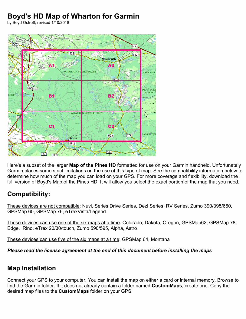
Enable the Custom Map in the Map Setup menu on the GPS. You'll need to zoom in to .2 miles or closer in order to see the map (zoom levels between 120 to 300 feet recommended)
You can install all six maps in Garmin Basecamp if desired. Click on Unlisted Data under My Collection, choose File > Import into "Unlisted Data", browse to the folder with the Custom Maps and select all of them. Now choose File > New List Folder and drag all six .kmz files to it. Click on your list folder and all Custom Maps will be displayed.

Also see the included blankmap folder. If desired you can install the blankmap to suppress the display of features from Basecamp's Global Map. Full documentation is found in the READ ME file. Download the full version of Boyd's Map of the Pines HD
Covers all of Southern New Jersey with portions of Pennsylvania, Delaware and Maryland. This universal format map works on your computer and compatible Garmin GPS. Use the free open source Mobile Atlas Creator program to export the exact area of the map that you need. A 28 page step by step tutorial with almost 100 illustrations will get you up to speed quickly! Download the map: https://boydsmaps.com/boyds-map-of-the-pines-hd/ Read the Mobile Atlas Creator tutorial: https://boydsmaps.com/docs/Using-Mobile-Atlas-Creator-with-Boyds-Maps.pdf Visit https://boydsmaps.com for more map downloads and information Boyd's Map of the Pines HD Data Sources Transportation New Jersey paved roads from the NJ Dept of Transportation Route number icons and highway exit numbers were created by the author Pennsylvania, Delaware and Maryland roads based on OpenStreetMap data About 1,500 miles of unpaved New Jersey roads were hand-traced by the author from aerial imagery and historical USGS 24k topo maps
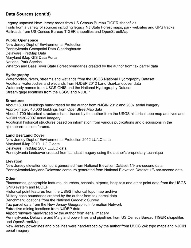
Data Sources (cont'd) Legacy unpaved New Jersey roads from US Census Bureau TIGER shapefiles Trails from a variety of sources including legacy NJ State Forest maps, park websites and GPS tracks Railroads from US Census Bureau TIGER shapefiles and OpenStreetMap Public Openspace New Jersey Dept of Environmental Protection Pennsylvania Geospatial Data Clearinghouse Delaware FirstMap Data Maryland iMap GIS Data Portal National Park Service Wharton and Bass River State Forest boundaries created by the author from tax parcel data Hydrography Waterbodies, rivers, streams and wetlands from the USGS National Hydrography Dataset Additonal waterbodies and wetlands from NJDEP 2012 Land Use/Landcover data Waterbody names from USGS GNIS and the National Hydrography Dataset Stream gage locations from the USGS and NJDEP Structures About 13,000 buildings hand-traced by the author from NJGIN 2012 and 2007 aerial imagery Approximately 46,000 buildings from OpenStreetMap data About 1,700 historical structures hand-traced by the author from the USGS historical topo map archives and NJGIN 1930-2007 aerial imagery Additional historical structures based on information from various publications and discussions in the njpinebarrens.com forums. Land Use/Land Cover New Jersey Dept of Environmental Protection 2012 LU/LC data Maryland iMap 2010 LU/LC data Delaware FirstMap 2007 LU/LC data Pennsylvania landcover created from Landsat imagery using the author's proprietary technique Elevation New Jersey elevation contours generated from National Elevation Dataset 1/9 arc-second data Pennsylvania/Maryland/Delaware contours generated from National Elevation Dataset 1/3 arc-second data Other Placenames, geographic features, churches, schools, airports, hospitals and other point data from the USGS GNIS system and NJDEP Historical point features from the USGS historical topo map archive Military base boundaries created by the author from tax parcel data Benchmark locations from the National Geodetic Survey Tax parcel data from the New Jersey Geographic Information Network Extractive mining locations from NJDEP data Airport runways hand-traced by the author from aerial imagery Pennsylvania, Delaware and Maryland powerlines and pipelines from US Census Bureau TIGER shapefiles and OpenStreetMap New Jersey powerlines and pipelines were hand-traced by the author from USGS 24k topo maps and NJGIN aerial imagery

LICENSE AGREEMENT Boyd's HD Map of Wharton for Garmin ("the map") is copyright © 2017 Boyd Ostroff. It is provided free of charge but is not open source software. Please read this license carefully. By installing the map on your computer and/or mobile device, you agree to all of its terms. You may install the map on any mobile devices that you own for personal, non-commercial use. You may redistribute the map for non-commercial purposes provided that all files contained in the distribution folder (including this one) are included in their original format. It must be provided free of charge. You may include screenshots of the map on social media and other sites if they are not used for commercial purposes. Credit would be appreciated. Any use of the map for purposes other than those described above requires the written consent of the author. You may not include the map or any part of it in a commercial product for sale. You may not include screenshots of the map to promote commercial products or services. You may not create derivative works from the data in the map. Map software is provided 'as-is', without any express or implied warranty. In no event will the author be held liable for any damages arising from the installation or use of this software. The map does not contain survey grade data and no representations are made as to its accuracy. The user assumes all risks associated with installation and use of this software. The map is intended for reference, educational and recreational purposes only. The author will not be held responsible for any inaccuracies and no responsibility is assumed for damages or other liabilities due to errors, installation, accuracy, availability, use or misuse of the data presented. The user should not assume they are permitted to drive or walk on a road or trail just because it appears on the map. Some of the roads and trails shown may be on private property or may have regulations prohibiting vehicular or other use. Some roads may not be passable and could be dangerous. It is the sole responsibility of the user to determine the suitability of any road shown on the map. Boundaries shown for parcels, openspace and military installations are approximate and may contain significant errors. It is the responsibility of the user to independently determine if they are permitted in these areas. In the field, stay alert and obey all posted signs regarding safety, ownership and usage regulations.