Embed Size (px)
Citation preview
Southwold
Walberswick
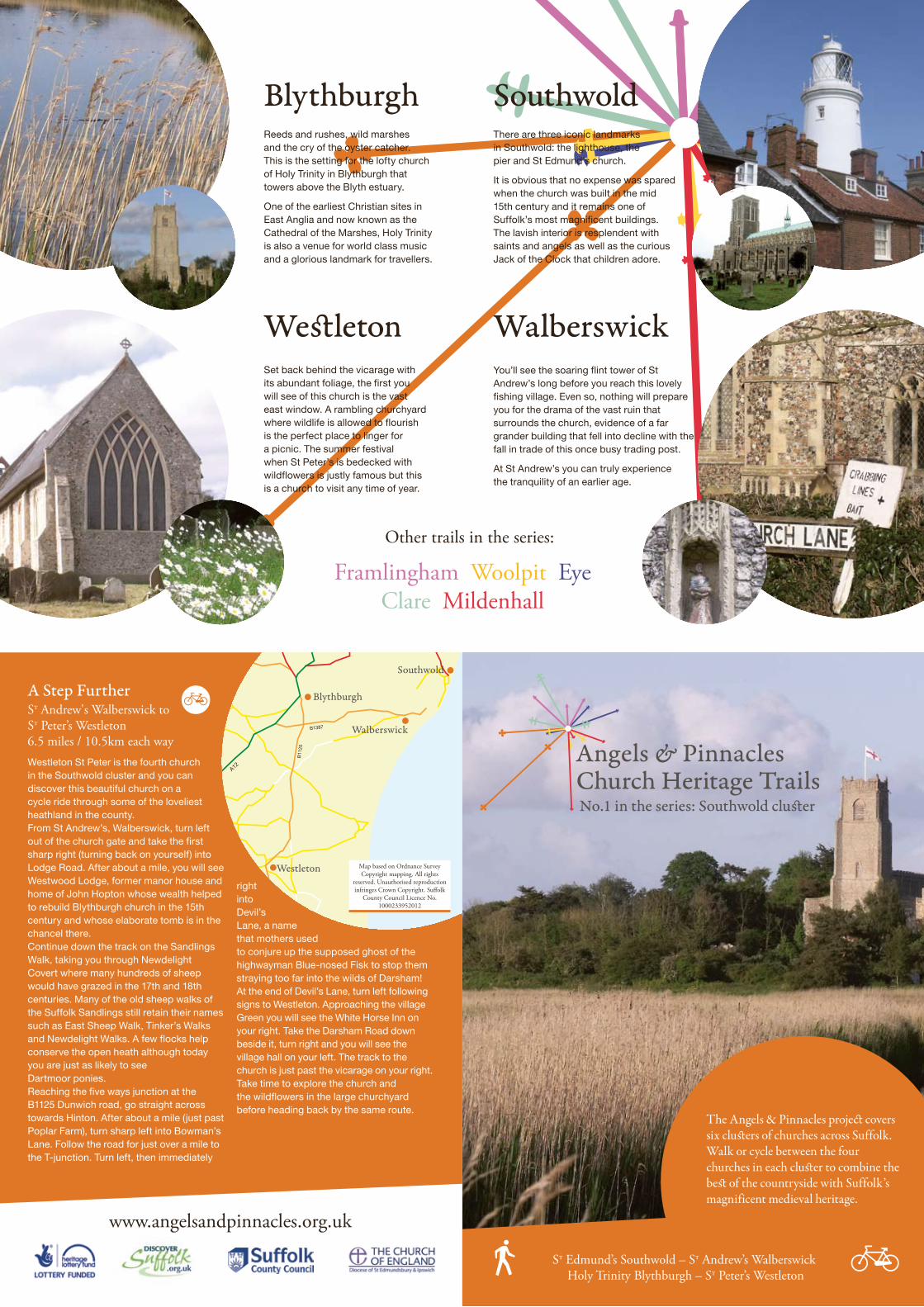
BlythburghThere are three iconic landmarks in Southwold: the lighthouse, the pier and St Edmund’s church.
It is obvious that no expense was spared when the church was built in the mid 15th century and it remains one of Suffolk’s most magnificent buildings. The lavish interior is resplendent with saints and angels as well as the curious Jack of the Clock that children adore.
You’ll see the soaring flint tower of St Andrew’s long before you reach this lovely fishing village. Even so, nothing will prepare you for the drama of the vast ruin that surrounds the church, evidence of a far grander building that fell into decline with the fall in trade of this once busy trading post.
At St Andrew’s you can truly experience the tranquility of an earlier age.
Reeds and rushes, wild marshes and the cry of the oyster catcher. This is the setting for the lofty church of Holy Trinity in Blythburgh that towers above the Blyth estuary.
One of the earliest Christian sites in East Anglia and now known as the Cathedral of the Marshes, Holy Trinity is also a venue for world class music and a glorious landmark for travellers.
WestletonSet back behind the vicarage with its abundant foliage, the first you will see of this church is the vast east window. A rambling churchyard where wildlife is allowed to flourish is the perfect place to linger for a picnic. The summer festival when St Peter’s is bedecked with wildflowers is justly famous but this is a church to visit any time of year.
Other trails in the series:
Framlingham Woolpit Eye Clare Mildenhall
A Step FurtherSt Andrew's Walberswick to St Peter’s Westleton6.5 miles / 10.5km each way
www.angelsandpinnacles.org.uk
Westleton St Peter is the fourth church in the Southwold cluster and you can discover this beautiful church on a cycle ride through some of the loveliest heathland in the county. From St Andrew’s, Walberswick, turn left out of the church gate and take the first sharp right (turning back on yourself) into Lodge Road. After about a mile, you will see Westwood Lodge, former manor house and home of John Hopton whose wealth helped to rebuild Blythburgh church in the 15th century and whose elaborate tomb is in the chancel there. Continue down the track on the Sandlings Walk, taking you through Newdelight Covert where many hundreds of sheep would have grazed in the 17th and 18th centuries. Many of the old sheep walks of the Suffolk Sandlings still retain their names such as East Sheep Walk, Tinker’s Walks and Newdelight Walks. A few flocks help conserve the open heath although today you are just as likely to see Dartmoor ponies. Reaching the five ways junction at the B1125 Dunwich road, go straight across towards Hinton. After about a mile (just past Poplar Farm), turn sharp left into Bowman’s Lane. Follow the road for just over a mile to the T-junction. Turn left, then immediately
right into Devil’s Lane, a name that mothers used to conjure up the supposed ghost of the highwayman Blue-nosed Fisk to stop them straying too far into the wilds of Darsham! At the end of Devil’s Lane, turn left following signs to Westleton. Approaching the village Green you will see the White Horse Inn on your right. Take the Darsham Road down beside it, turn right and you will see the village hall on your left. The track to the church is just past the vicarage on your right. Take time to explore the church and the wildflowers in the large churchyard before heading back by the same route.
B1387
A12
Walberswick
B11
25
Westleton
Blythburgh
Southwold
Church Heritage Trails
The Angels & Pinnacles project covers six clusters of churches across Suffolk. Walk or cycle between the four churches in each cluster to combine the best of the countryside with Suffolk’s magnificent medieval heritage.
No.1 in the series: Southwold cluster
St Edmund’s Southwold – St Andrew’s Walberswick Holy Trinity Blythburgh – St Peter’s Westleton
Map based on Ordnance Survey Copyright mapping. All rights
reserved. Unauthorised reproduction infringes Crown Copyright. Suffolk
County Council Licence No. 1000233952012
5
4
3
2
1
1
2
3
4
5
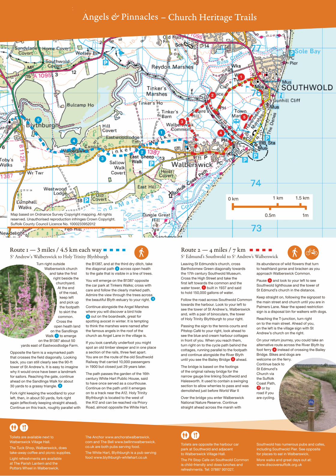
Leaving St Edmunds’s church, cross Bartholomew Green diagonally towards the 17th century Southwold Museum. Cross the High Street and take the first left towards the common and the water tower, built in 1937 and said to hold 150,000 gallons of water.
Follow the road across Southwold Common towards the harbour. Look to your left to see the tower of St Andrew’s, Walberswick and, with a pair of binoculars, the tower of Holy Trinity Blythburgh to your right.
Passing the sign to the tennis courts and Pitstop Café to your right, look ahead to see the blue and cream harbour cottages in front of you. When you reach them, turn right on to the cycle path behind the cottages, running parallel to the footpath and continue alongside the River Blyth until you see the Bailey Bridge ahead.
The bridge is based on the footings of the original railway bridge for the narrow gauge line linking Southwold and Halesworth. It used to contain a swinging section to allow wherries to pass and was demolished just before World War II
Over the bridge you enter Walberswick National Nature Reserve. Continue straight ahead across the marsh with
its abundance of wild flowers that turn to heathland gorse and bracken as you approach Walberswick Common.
Pause and look to your left to see Southwold lighthouse and the tower of St Edmund’s church in the distance.
Keep straight on, following the signpost to the main street and church until you are in Palmers Lane. Near the speed restriction sign is a disposal bin for walkers with dogs.
Reaching the T-junction, turn right on to the main street. Ahead of you, on the left is the village sign with St Andrew’s church on the right.
On your return journey, you could take an alternative route across the River Blyth by foot ferry instead of crossing the Bailey Bridge. Bikes and dogs are welcome on the ferry. Continue back to St Edmund’s Church via the Suffolk Coast Path,
or by road if you are cycling.
Turn right outside Walberswick church
and take the first right beside the
churchyard. At the end of the road, keep left and pick up the footpath to skirt the
common. Cross the
open heath land on the Sandlings
Walk to emerge on the B1387 about 50
yards east of Eastwoodlodge Farm.
Opposite the farm is a waymarked path that crosses the field diagonally. Looking back, you can still clearly see the 90-ft tower of St Andrew’s. It is easy to imagine why it would once have been a landmark for sailors. Reaching the gate, continue ahead on the Sandlings Walk for about 30 yards to a grassy triangle.
Fork right keeping the woodland to your left, then, in about 50 yards, fork right again (effectively keeping straight ahead). Continue on this track, roughly parallel with
the B1387, and at the third dry ditch, take the diagonal path across open heath to the gate that is visible in a line of trees.
You will emerge on the B1387 opposite the car park at Tinkers Walks; cross with care and follow the clearly marked path. Admire the view through the trees across the beautiful Blyth estuary to your right.
Continue alongside the Angel Marshes where you will discover a bird hide
out on the boardwalk, great for spotting avocet in winter. It is tempting to think the marshes were named after the famous angels in the roof of the church as Angel Lane in the village is.
If you look carefully underfoot you might spot an old timber sleeper and in one place a section of the rails, three feet apart. You are on the route of the old Southwold Railway that carried 10,000 passengers in 1900 but closed just 29 years later.
The path passes the garden of the 16th century White Hart Public House, said to have once served as a courthouse. Continue on the path until it emerges on to a track near the A12. Holy Trinity Blythburgh is located to the west of the A12 and can be reached via Priory Road, almost opposite the White Hart.
Route — 3 miles / 4.5 km each way Route 2 — 4 miles / 7 kmSt Andrew's Walberswick to Holy Trinity Blythburgh St Edmund’s Southwold to St Andrew’s Walberswick
Toilets are available next to Walberswick Village Hall.
The Tuck Shop, Walberswick, does take-away coffee and picnic supplies.
Light refreshments are available at The Parish Lantern and the Potters Wheel in Walberswick.
The Anchor www.anchoratwalberswick.com and The Bell www.bellinnwalberswick.co.uk are both pubs serving food.
The White Hart, Blythburgh is a pub serving food www.blythburgh-whitehart.co.uk
Toilets are opposite the harbour car park at Southwold and adjacent to Walberswick Village Hall.
The Pit Stop Cafe on Southwold Common is child-friendly and does lunches and refreshments. Tel: 07887 901027.
Southwold has numerous pubs and cafes, including Southwold Pier. See opposite for places to eat in Walberswick.
More walks and great days out at: www.discoversuffolk.org.uk
– Church Heritage Trails
Map based on Ordnance Survey Copyright mapping. All rights reserved. Unauthorised reproduction infringes Crown Copyright. Suffolk County Council Licence No. 1000233952012
3
4
5
1
2
1
2
3
4
5
0 km 1 km
0.5m 1m
1.5 km