Embed Size (px)
Citation preview

Blekinge Institute of Technology
International Master Programme
European Spatial Planning 2010/2011
Master Thesis
Supervisor: Prof. Jan-Evert Nilsson
The Compact City Form
-Case study of Shenzhen
Biyun Zhou and Lan Yu
Karlskrona, 15.05.2011

Table of Content
Abstract ........................................................... 1
Acknowledgements ................................................. 2
Introduction ........................................................ 3
1 Compact city theory ............................................. 6
1.1 The ideas behind the compact city .......................... 6
1.2 The concept of the compact city ............................ 8
1.3 The counter arguments .................................... 11
1.4 Conclusion ............................................... 12
2 Empirical case study – the city of Amsterdam .................... 15
2.1 Urban Planning in The Netherlands ........................ 15
2.2 Urban development in Amsterdam ......................... 16
2.3 The compact city policy ................................... 19
2.4 Conclusion ............................................... 24
3 Case study in China – the city of Shenzhen ...................... 25
3.1 Urban planning in China ................................... 25
3.2 Urban planning in the city of Shenzhen ..................... 28
3.3 Developing phases of Shenzhen urban planning ............ 32
3.4 Conclusion ............................................... 38
4 Application of the compact city strategy in Shenzhen ............. 39
4.1 Challenges of urban planning .............................. 39
4.1.1 Lack of land resources ............................... 39
4.1.2 Unbalanced development ............................ 40
4.1.3 Car-oriented Transportation .......................... 40
4.2 The compact city strategy in Shenzhen ..................... 42
4.2.1 Decentralized concentration .......................... 42
4.2.2 Urban regeneration .................................. 43
4.2.3 Public transport system .............................. 47
4.2.4 Encourage cycling in Shenzhen ...................... 48
5 Conclusion .................................................... 54
References ........................................................ 57
1
Abstract
Compact city is becoming a popular urban development form used frequently in the planning literatures around the world, especially in the Europe. In this paper, we analyze different views upon the compact city concept from different scholars and planners. According to the previous literatures, we consider that the compact city can be characterized by high density in settlements and activities, multiple land use and efficient public transport system. In the empirical part, we analyze why and how the city of Amsterdam has been implementing the compact city strategy, which is seen as a forerunner in this area, so that we can learn some experience from it. In our case of the Chinese metropolitan city – Shenzhen, we go through its planning phases from the emerging phase in 1979 to polycentric phase in 2007, and analyze its current challenges, such as lack of land resource, unbalanced development and car-oriented situation. Then we consider that the “decentralized concentration” model is a suitable way to apply the compact city idea in the future urban planning. In order to achieve the main factors of compact city form, urban regeneration should be carried out within existing area. Other complementary measures that we propose are improving public transport system and encouraging cycling. Key words: compact city, Amsterdam, Shenzhen

2
Acknowledgements
We would like to express our sincere appreciation to our supervisor Prof. Jan-Evert Nilsson. This thesis cannot have been finished without his help and support. We have learnt not only the knowledge of our thesis but also a strong sense of responsibility from him. We also want to thank Prof. Lars Emmelin, Eric Marcus, Sabrina Florkowski and Madureira Ana Mafalda for their help. Finally, we want to send our best regards to everyone who has given us support.
3
Introduction
The relationship between urban development form and sustainability is currently one of the most hotly debated issues on the international environmental agenda. The way that cities should be developed in the future, and the effect that their form can have on social and economic sustainability, are central to this debate (Jenks et al., 1996). The second half of the 20th century experienced the phenomenon of urban sprawl characterized by the rise in car ownership, the poorer public transport services, the decline in walking and cycling and the excessive growth of built up areas. These aspects have influenced the quality of the urban life. Space consumption by urban development has become a major concern not only in western countries, but throughout the world (Porter, 1997).
The compact urban development model has been widely considered as an effective way to improve urban sustainability in the economic, social and environmental dimensions, by controlling the urban sprawl. Rapid decentralization has been a feature of urban growth in most western countries following the Second World War, which has been a source of concern because of loss of landscape and the costs of providing infrastructure at a vastly increasing spatial scale. The compact city has been regarded as a counter strategy to reduce the spread of low density urban development and to preserve the countryside. The compact city requires not only more intense use of urban space, but also a greater mixture of uses in urban space (De Roo et al., 2000). However, critics also argue that increased density does not necessarily result in reduced use of automobiles and reduced trip making, and that high densification may cause severe environmental pollution and downgrade the quality of urban life.
In this thesis, we are going to analyze the compact city form in theory, by focusing on the benefits and weaknesses of this strategy as a basis for our further study. With the rapidly economic development in China, the urban sprawl, particularly in big cities, has obviously caused many problems. It is understandable that low density development and suburbanization are not suitable for China’s further development with large population and limited resources, which leads to a large amount of waste of land resources and decrease of energy efficiency. In the empirical part, we study the city of Amsterdam that is considered as a forerunner in the field of compact city policy. We present the reason why Amsterdam has carried out compact city strategy and what it has been done to implement this strategy.
Based on the theories and empirical study, the thesis focuses on the case of Shenzhen. After going through its planning history, we give a description of its current situation and challenges. Then we try to apply the compact city

4
strategy to its future urban plan with the aim to solve the problems facing Shenzhen’s development. Some policies and measures will be introduced to promote the application of compact city strategy, which is largely based on the experience from Amsterdam.
Methodology
In most of studies, a theoretical introduction and discussion is indispensable, because it is the foundation for our research and help us get a better knowledge of the subject we studied, and counter arguments of compact city is also important in our theoretical discussion since there are always two sides of every coin. Lessons and experiences from other countries and cities are essential to the case study of Shenzhen. The reason for choosing Amsterdam as an example is that it is considered as a pioneer in the field of compact city and it has been implemented the compact strategy for a long time. In this paper, we tried to address the following questions:
• What is the idea behind the Compact City Form?
• What are the different concepts and visions of Compact City Form?
• How has Amsterdam been carrying out the compact city strategy?
• What is the current situation facing Shenzhen?
• How can the compact city form be applied to the city of Shenzhen?
During our research and writing process, many kinds of literatures and sources have been used. The theoretical approach is largely based on books about theories of the compact city. From those materials, we analyzed and compared different concepts of compact city form as well as the counter arguments from various scholars, and ended up with a conclusion of our own understanding. For the planning systems and policies, we used research papers, planning acts and also books from official websites. For instance, the “Urban and Rural Planning Law of People’s Republic of China” and the “Cycling Master Plan” of the Netherlands are quoted.
Case study approach is essential in this paper. We chose the city of Shenzhen as our study case. The advantage is that we could go deeper into the case, while we could not come to any broader analysis. That means the policies and strategies we proposed for Shenzhen cannot fit in with other Chinese cities because of different conditions, which is also the limitation of this paper. During the study process, we used a lot of statistics and maps published by the
5
Netherlands, Chinese government, municipalities of Amsterdam and Shenzhen, and primary sources such as the “City Central” structure Plan in Amsterdam and the “Master Plans of Shenzhen Special Economic Zone (1986-2000)”. Academic journals, research papers, newspaper articles from BTH database, China national knowledge internet database, and general information and investigation from official websites in the EU and China completed our research.

6
1 Compact city theory
1.1 The ideas behind the compact city
During the 1950s to 1970s, many European cities experienced rapid urban sprawl at the cost of the functional integrity of their existing urbanized areas. This trend of urban development was driven by the need to overcome severe housing shortages following wartime destruction and disinvestment. Since then, a number of problems caused by urban sprawl have sprung up - unreasonable land use, low-efficient exploitation and overuse of natural resources, air pollution and traffic congestion caused by private vehicles, and degradation of living environment. Urban sprawl is considered as an unsustainable urban development form characterized by low density development, separation of where people live from where they work, waste of land use and high cost of energy and resources. Space consumption by urban development has become a major concern, not only in western societies, but throughout the world (Porter, 1997).
There is a widespread consensus that progress towards sustainable development is essential. In 1987, the “sustainable development” was introduced in the Brundtland Commission report and the environmental dimension stepped to a higher political position from then on. Reformation in planning system was seemed to be an efficient way to achieve the goal of sustainability and urban compactness. The link between urban form and sustainable development is considered to be strong, but not simple and direct (Jenks et al., 1996). It has been suggested that a sustainable city “must be of a form and scale appropriate to walking, cycling and efficient public transport, and with a compactness that encourages social interaction” (Elkin et al., 1991: 12). “…recently, much attention has focused on the relationship between urban form and sustainability, the suggestion being that the shape and density of cities can have implications for the future” (Jenks et al., 1996). By the 1980s, cities across the western world were full of advocates for “growth within” and the critical reconstruction of traditional, compact and multifunctional urban structure.
The term “compact city”, can be seen frequently in planning literatures since 1990. The compact city concept is designed to achieve sustainable development within the urban areas and to counteract the perceived negative social, economic and environmental impacts of urban sprawl. What is “compact city”? The original image of this city model can dates back to the medieval towns, with explicit restraint and limited all the daily activities within the city walls (Thomas and Cousins in Jenks, 1996). At that time, the city life

7
was to a large extent based on walking because of lacking modern means of transport. This kind of walking cities were characterized by “high density (100 to 200 people per hectare), mixed land use, and narrow streets in an organic form that fit the landscape” (Newman and Kenworthy, 1999). Due to the development of transport technology, this kind of city form gradually disappeared.
In the late twentieth century, some planners who opposed urban sprawl reintroduced the compact city concept. The word “compact city” was first proposed by George Dantzig & Thomas Saaty in 1973 in their book Compact City: A Plan for a Livable Urban Environment. Their aim is to “reduce urban sprawl and preserving open countryside. A quarter of a million people would live in a two mile wide, eight-level tapering cylinder. In a climate-controlled interior, travel distances between horizontal and vertical destinations would be very low, and energy consumption would be minimized” (Jenks et al., 1996: 19).
“The vision of the compact city has been dominated by the model of the densely developed core of many historic European cities…Perhaps it is not surprising that the strongest advocate for the compact city has been the European Community” (Jenks et al., 1996:5). The European Union has adopted policies instructing national and local governments to pursue sustainable urban development. In the Green Paper on the Urban Environment, the European Commission is especially concerned with the growth in the ownership of the cars (CEC, 1990). The European Union has recognized the negative effects on the social and environmental dimension by the urban expansion trend and come to focus on mixed land use development in existing urban areas, more residential development in the inner cities, and concentrate growth within urban boundaries (CEC, 1990). These guidelines for urban development, as a number of analysts point out, represent a strong commitment by the European Commission to the compact city (Breheny and Rookwood, 1993).
Many national governments in Western Countries have taken the compact city policy as a national planning strategy (Breheny, 1995). Friends of the Earth (Elkin et al., 1991), the British’s most influential environmental campaigning organization, has claimed that the compact city is a valuable solution to contain the urban sprawl. The United Kingdom developed a set of policies to encourage higher densification and to reduce transport energy consumption. This goal has been made as the central element of the UK strategy for sustainable development since 1990. In The Netherlands, the compact city policy was elevated to a national planning strategy in 1988. The goal was to protect valuable open space and minimize transport needs. In addition, the Australian government and New Zealand have also adopted policies

8
concerning building up the compact city over the past twenty years, despite that there is difference in how the compact city strategy is implemented.
In the United States of America, planners have become concerned about the issues caused by unlimited development and excessive suburbanization. In the year of 1997, “smart growth” was put forward by Parris N. Glendening, the Governor of Maryland. It calls for building a compact community suitable for walking, intensive housing development, mixed land use, revitalizing the existing areas, providing a variety of transportation choices and encouraging public participation in the process of decision making in urban planning and development (Zhou and Yu, 2010). The concept of “Smart growth” can be perceived as the compact city development form with American characteristics. Most states have adopted urban growth management programs by legislation. “Some local plans call for ‘urban villages’ which are higher density and mixed use development within built-up areas, thus reinforcing the multiple-centered urban form which has become the characteristic of U.S metropolitan areas over the last few decades” (De Roo and Miller, 2000: 6).
The United Nations’ conference on Environment and Development, held in June 1992 in Rio de Janeiro, put much emphasis on stimulating sustainable urban development (United Nations, 1992). “Local Agenda 21, a major result of this conference, calls for local authorities to work toward sustainability by developing efficient and environmentally friendly systems of public transport and non-motorized trip making” (De Roo and Miller, 2000). This commitment was to a large extent supported by the concept of compact city.
1.2 The concept of the compact city
There is a widespread belief that the compact city development form contributes to sustainability. Crane (1996) and Lowe (1991) argue that compact cities, developed at higher densities and with a mixture of uses, have an effect on sustainability. The discussion about the feasibility and effectiveness of the compact city has been going on for decades. The concept of the compact city has been defined by many authors and planners. However, most of the supporters of compact city do not have a decisive definition about it.
Dantzig and Saaty (1973) have tried to define the compact city by presenting the characteristics of the urban form: high dense settlements, less dependence on automobile and clear boundary from surrounding areas. They also figure out the spatial features of the compact city such as mixed land use, diversity of life and clear identity. Elkin’s image of compact city is centralized, high density and mixed land use in the city which is intensified and
9
self-sufficiency (Elkin et al., 1991). Lock (1995: 173) gives the definition of the compact city as the process of ensuring that “we make the fullest use of land that is already urbanized, before taking green fields.” According to Thomas and Cousins (1996), the initial impressions of the compact city “…invoke an intense medieval city, whose limits are clearly visible, and where the hubbub of activity is confined within the city’s walls”. While cities nowadays cannot return to the form of the past, and it is highly unlikely that urban planners advocate rebuilding walled cities. Williams (1999) thinks compact city with high density settlements are more socially sustainable because local facilities and services can be maintained due to high population densities and good accessibility. Furthermore, “…high density urban living is seen as a prerequisite for vitality, vibrancy, cultural activities and social interaction” (Williams, 1999: 168).
Australian scholars Newman and Kenworthy (1999) strongly supported the compact city with the idea that a compact city should be mixed used, high density of activities and residents. Their research shows that there is a negative relationship between the density of city and fuel use. In other words, the higher density a city has, the lesser fuel a city uses. The evidence of this experiment is based on data in America, European cities and Hongkong. The highest density city Hong Kong has the lowest fuel consumption while the United States ranks the first which is in low density.
Breheny divides the theories in urban planning history into two groups – centrists and decentrists, and then concludes with an attractive mode – the compromisers. Specifically, he believes that neither extremely compact nor extremely dispersed is suitable for urban development since both of them get rid of their disadvantages and just put emphasize on their merits. Given those analyses, he gives his own definition of the compact city, which is established in the existing areas with high density and multiple-use of land rather than develop the periphery area. Other scholars who are in the compromise seat are Scoffham and Vale. They argue that, in a compact city, the autonomy of neighborhood and local identity should be developed in priority rather than physical form (Jenks et al., 1996).
Hillman, a qualified architect and town planner, strongly believes compact city is a way for achieving sustainable development - compact city is an efficient way to prevent global warming by decreasing travel distances which could therefore reduce fuel use and air pollution. He argues that compact city means high density and it can bring high quality life to people. He thinks that urban sprawl leads to the decreasing of walking and cycling, and that the steadily growing car ownership is one of the main factors negatively affecting the quality of life. Furthermore, traffic congestion, accidents, air pollutions (related disease, such as respiratory diseases), and noise caused by cars are also jeopardizing the quality of life (Jenks et al., 1996).

10
According to Newman (2005), the two most important characteristics of the compact city are high-density and mixed-use of urban land, which means high efficient use of urban land to protect the countryside and prevent people from spending too much time on the way to work from “bedroom communities” to “office parks” by locating businesses among residential areas.
Burton (2002) concludes that “the so-called compact city has a variety of definitions but in general means a relatively high-density, mixed-use city, based on an efficient public transport system and dimensions that encourage walking and cycling.” In order to build a compact city, the better way is to increase the density and make the best use of land in existing boundary, or in other words - ‘intensifying’ cities. Williams et al. argue that implementation of the compact city should be taken at the local level so that citizens can enjoy high quality life in terms of reducing car use and space, and increasing land density (Williams in Jenks et al., 1996).
Ebenezer Howard comes up with a new compact city concept in his Social Cities, which presents a metropolitan-scale social city form comprising “town clusters” with “each town in the cluster being of different design from the others, and yet the whole forming part of one large and well-thought-out plan” (Howard, 1985: 102). This new compact city concept, known as the “decentralized concentration”, is much more suitable than the traditional concept when dealing with the planning issues in metropolitan cities like Amsterdam and Shenzhen. It is hard for metropolitan cities to apply the compact city strategy at the city level because the old city centre cannot provide enough accommodation and city functions for the whole population. Therefore, it could be an alternative to apply compact city strategy at the district level. “Urban village” put forward by Newman and Kenworthy is complementary to this concept, which aims to build compact districts within the cities. From their investigation of some examples in Europe and North America, the main characteristics of urban villages are summarized as follows (Newman and Kenworthy, 1999: 166):
- High-density land use to make sure that everything in the “village” is within
the walking and cycling distance.
- Multiple land use with business, offices, shops and other community
facilities integrated with residential areas.
- If community facilities, such as schools, child-care centers, recreation
centers and libraries, cannot within the village, they should always be nearby.
- Parking facilities are supposed to be placed underground if possible, with
11
the aim to build traffic-free and people-oriented environment.
- Maintaining considerable landscaping, including gardens on the top of
buildings and on balconies and attractive gardens in public space as well.
- Self-sufficient public transport in the village to meet local needs, but with
good rail and bus connection with the city centre.
1.3 The counter arguments
However, there are still some voices against the compact city. Thomas and Cousins argue that “there is evidence which suggests that these claims are at the very least romantic and dangerous, and do not reflect the hard reality of economic demands, environmental sustainability and social expectations. The overriding problem with the compact city is that it requires us to ignore the causes and effects of decentralization, and the benefits that it might bring.” (Thomas and Cousins in Jenks et al., 1996: 56). Breheny is also skeptical about whether the benefits from compact city will be more than the loss it could bring (Jenks et al., 1996).
The “green city” which proposed by CEC and Breheny is difficult to be achieved in a compact city as space is mostly occupied by intensified buildings. There would not be enough land for green space. More land demands and development for abandoned land in the city always bring depredation to precious natural resources, such as water conservation area and forests (Breheny, 1992b). And most of the attentions are paid to the high density central city, so rural areas around the city centre get less attention. Therefore, concentrated investment, financial support and activities in a compact city are bound to bring negative effects to economy in rural area (Breheny, 1992a).
The hypothesis of the compact city features reducing fuel consumption and traffic related pollution. But the situation in reality is opposite. Congestion is to be serious in high concentrated cities. Unsafe traffic and congestion bring about worse environment for pedestrian (Engwicht, 1992). Everyday commuting becomes a war between all kinds of vehicles: public transport – usually considered to be an effective solution for compact city – is locked in the traffic jam; trains, subways and buses are too crowded for people to find a seat; parking lots become scarce resource in a compact city even near citizen’s own house (Williams in Jenks et al., 1996). It is reported that the rising travel time and decreasing travel speed in traffic jam lead to high fuel consumption. Also, Congestion brings more noises, air pollution, reducing the quality of life.
In an ideal compact city, residents are supposed to get rid of their cars and

12
make full use of cycles, walking and public transportations. Here comes to the problem: how to let people give up their cars? Researches reflect that people are unlikely to stop using cars even in extremely crowded cities. What worse is that they are in favor of buying more cars (Balcombe and York, 1993, quoted in Lock, 1995: 174). Furthermore, cars, especially in developing countries, are considered to be a visible status symbol.
It is hard for governments to control people’s behavior, such as where to live and where to work. Take Kista, a district of Stockholm, as an example, the working area and residential area are connected by the Stockholm Metro blue line. The western part of Krista is residential area while the eastern part performs as a business centre (Kista: Science City Online, 2011). Shopping centre is located between them. However, people who live in the residential area normally do not work in the working area while employees in the working area live out of this district. People’s life style is beyond control of the governments and planners.
1.4 Conclusion
According to the previous literatures, there is a general agreement that the most important characteristics of “compact city” include high density and mixed land use. However, although it may be widely understood that the compact city is absolutely distinct from urban sprawl, there still remain many contentious questions about exactly how compact the compact city should be. Scoffham and Vale argue that it is essential to figure out “what the compact city is; whether the buildings should be built closer to each other; whether the population living in buildings should be increased; and what role a mixed urban land use play in the compact city” (Arbury Joshua, 2005:45).
When it comes to density, the assumption is that the higher the density is, the more sustainable a city would be. The question here is to what extent the density of the compact city reach that can be considered high. Should a city of 500 people per km2 be considered a compact city? Is 3000 or 4000 people per km2 still in the scope of high density and will not jeopardize the environment in a city? The answer will be varied between developed countries and developing countries. For instance, the population density in Chinese city Shenzhen and Hong Kong is 4,564 and 6480 people per km2 respectively. (Shenzhen government online, 2009a; Hong Kong SARG, 2011) While the population density in Amsterdam is 3,506 people per km2, which is considered densely populated among western countries. It is not an easy job to make similar decisive criteria for “high density” around the world, because of different history and varied forms of urban development between different countries such as European countries, America and Asian countries. Policies pursuing compact

13
city in Amsterdam is not likely to work in Hong Kong. High density alone is not a sufficient criteria for a compact city.
It is recognized that there is a conflict between high density and open space. In the process of urban development, the balance between the degree of density and recreation space should always be taken into account. Williams et al. (1996) thinks that high density usually equal to “town cramming” – losses of vibrancy and sustainability, especially open space. That is to say, the increasing number of buildings in a city would occupy the space which is supposed to be given to green land, such as parks. It seems that the higher the degree of density is in a city, the less green land there will be. While, this is not always true. If a compact city consists mainly of skyscrapers, with a lot of people living and working in them. Although the density is high, there is still space left for parks or other green amenities. If a compact city is dominated by a high density of lower houses, then there would be less room for green space.
Multiple land use has been identified as another complex aspect of the compact city. It is a new spatial concept aiming to counterbalance inefficiencies in land use inside and outside the built up area. Multiple land use has three dimensions: high efficiency in a piece of land; multiple functions in one land; creating more floor space by building high-rises and exploring underground space (Van Der Valk, 2002). The implementation of mixed land use can reduce the need for longer transports from working place to residential area by locating the business area closer to the residential area. In many cities, a new land use pattern has been put into practice – living on top of shops, which means locate the business on the first floor and residential place on the upper floors. This pattern enable people to walk to work or shopping, thus reducing the need of using private vehicles. As a matter of fact, different types of mixed land use development have been explored by the urban planning literatures, Burton (2002) divided multiple land use into two aspects. One is horizontal form that different uses of land locate neck and neck while the other one is vertical form which means all kinds of land use existing in one building. Mixed-use development always results in an increase in the activity density– “the increased use of existing buildings or sites; changes of use, which lead to an increase in activity; and increases in the numbers of people living in, working in, or travelling through an area” - should also be included into the nature of compact city (Williams in Jenks et al., 1996: 84).
What needs to be paid more attention to is the size of a compact city, which is missing in the previous planning literatures. As mentioned above, the compact city contributes to reducing commuting time by multiple land use, and encouraging walking and cycling. The initial image of a compact city is a medieval town that is too small when compared to the metropolitan cities in nowadays. So when it comes to big cities like those in China, how should

14
these cities be compact? What should these cities do to prevent from the widely use of private cars? One method to solve these problems is to develop public transport system. Public transport is very much important when we apply compact city to metropolitan cities with large areas.
Making full use of the existing land is also important in a compact city. Both the European Union and scholars like Breheny and Burton argue that compact city need to be established within the existing built-up areas. Therefore, how to regenerate these areas and to revitalize them are key factors in building compact cities. Given the complexity in different circumstances, regeneration policies also vary from city to city. In our case, we cannot directly put what have been done in Amsterdam to the city of Shenzhen, but we can always learn something from it.
In general, it is hard to give a common definition of the compact city. The compact city is not an explicit urban development model, but a guiding principle that can be used in urban planning with the aim of sustainable development. The compact city can be characterized by high density in both settlements and activities, multiple land use and efficient public transport system.
Shenzhen is an emerging city in China. As most developing cities all over the world, it has experienced extensive urban sprawl. Traffic congestion and low efficiency of land use are the main problems facing Shenzhen. According to the hypothesis of compact city, it can to some extent solve these problems. Building a compact city probably can be an alternative for future urban planning in Shenzhen.

15
2 Empirical case study – the city of Amsterdam
2.1 Urban Planning in The Netherlands
The Netherlands is a densely populated and highly urbanized country with a long-standing tradition of spatial planning. In the early 1980s, the compact city concept was welcomed by the Dutch authorities and planners, and it has become the heart of national, regional and local urbanization policy in The Netherlands since then (Dieleman et al., 1997). The fundamental idea is to intensify the use of land within existing settlements. This requires revitalization of city center and redevelopment of urban wasteland. The compact city was seen as the solution to the two main problems that the densely populated parts of the country were confronted with – rapid urbanization of open space and continued increase of mobility, contributing to better environment of both urban and rural areas. “Compact cities and restrictive building policy are corner stones of national spatial policy aimed at the prevention of uncontrolled urban sprawl” (Van der Valk, 2002).
During the mid-1980s, “concentration” became a leading principle in urban planning in The Netherlands preceded by post-war reconstruction, urban de-concentration and clustered de-concentration (Faludi and Van der Valk, 1994). The National Council for Physical Planning, i.e. the Dutch Ministerial Department for Land Use Planning, defined the compact city policy as one that, “more than any before, aimed at concentration of functions (living, working, provisions) in the city” (NPPC, 1985: 30).
“Historically, Dutch cities have already been reasonably compact”, as they were required by law to have defensive walls (De Roo and Miller, 2000). However, due to development of large-scale pre-war and post-war residential areas, suburban sprawl and scarcity of space made city planners reconsider the necessity of compactness in urban planning. Another important reason for the revival of compact urban development is the spatial structure of functions within the city, which can reduce the use of cars by integrate all functions at hand. Therefore, the compact city concept used in the Netherlands can be characterized as “intensive use of existing urban areas; concentration of functions instead of dispersion; mixing functions instead of separating them and building in high densities” (Bartelds and De Roo, 1995: 33).
“Urban planning in The Netherlands aims to create the physical conditions for a good living and production environment by reasonably allocating spaces for housing, work and recreation” (VROM, 1983: 10). Compactness is the key word in its planning policy. It focuses on “support of urban capacity; reduction of car use; promotion of the use of bicycle and public transport, and limiting the

16
urbanization of the countryside” (VROM, 1993: 6). Density and accessibility have become significant criteria for urban development.
2.2 Urban development in Amsterdam
Amsterdam is the capital and largest city of The Netherlands with a population of more than 750,000 and a density of 3,506 inhabitants/km2 (Amsterdam information, 2011). It is situated in the province of North Holland in the west of the country. The city is part of the Randstad Polycentric Region, with Utrecht, Rotterdam and The Hague as the other major cities. According to previous research, Amsterdam is one of the cities that have pursued policies of urban compactness and concentration for some time among various European cities. Nevertheless, like most European cities, Amsterdam followed an urban expansion strategy well into the 1970s.
The year 1896 saw a large-scale territorial expansion from 3250 ha to 4630 ha in the city of Amsterdam, due to the attainment of Nieuwer-Amstel. In 1900, the architect H.P. Berlage was responsible for designing work of the new development in Amsterdam-Zuid. Inspired by the classicist architecture of San Francisco and Chicago, he proposed a new urban style with uniform blocks (Fig.1), featuring broad avenues, spacious squares and the use of axes with monumental buildings instead of the traditional style with dull and cramped streets of the nineteenth century. “According to the plan, enclosed blocks of flats four or five storeys high were to be built along the streets…Powerful blocks of stone with clear lines, and tall buildings with unusual solutions for the corners were the recipe for an integrated façade on the main streets” (Pistor et al., 1994: 46).
Fig. 1 Berlage’s Plan-Zuid
Source: Berlage, 1917.

17
In 1923, the Amsterdam local authority set up the Garden City Commission, whose task was to investigate a more desirable type of urban expansion for the city of Amsterdam. The commission came up with three configurations for its decentralized development in the report 1929: garden districts, garden suburbs and garden cities. Inspired by E. Howard’s conception of “garden city”, the commission distinguished three types of the garden city, namely the “detached garden city”, “satellite garden city” and the “commuter garden city” (Pistor et al., 1994). The report did not draw any explicit conclusions on urban expansion, because each option had its own pros and cons.
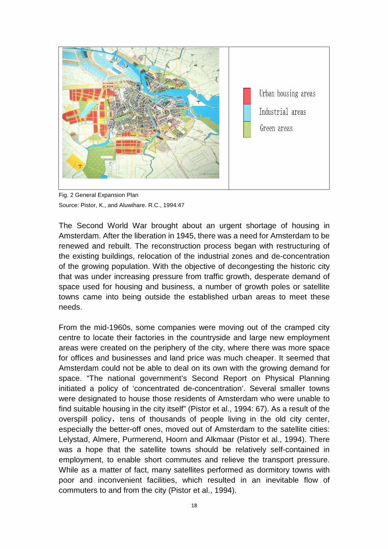
In the late 1920s, contentious debate was going on upon whether the city sought centralized growth or pursued a more dispersed and decentralized urban pattern. With the creation in 1928 of the Department of Urban Development, urban planners set out to produce a new plan of the development of Amsterdam (Pistor et al., 1994). C. Van Eesteren, the author of the General Expansion Plan (AUP), summarized the proposal of the department as “producing garden-city quality within the municipal boundaries” (De Roo and Miller, 2000: 83). Therefore, the AUP chose a centralized urban form, while the benefits of garden cities could be realized as well. (Fig. 2) The AUP was characterized by a functional separation of the four key architectural functions - housing, work, traffic and recreation. The residential district was situated in the west, close to the city centre; the industrial areas were located in the southeast and southwest of the city, along the Nordzee Kanaal, and the new recreation area is located in the south of the city (Pistor et al., 1994). The AUP was approved by the Amsterdam city council in 1935. However, due to the pre-war economic situation and World War Ⅱ , the plan was not implemented until the post-war reconstruction period. The residential areas occupied an essential position in the AUP. The idea was to build a large number of single-family houses beyond the circular railway. “Inspired by the thinking of the New Movement (Het Nierwe Bouwen) and the Dutch journal De 8 en Opbouw, the AUP chose for an open layout – building in strips rather than in closed blocks” (De Roo and Miller, 2000). Stripwise building was seen as the best way for vehicle accessibility and exposure to sunlight, which fit in well with the attempt of Van Eesteren to achieve garden city.
18
Fig. 2 General Expansion Plan
Source: Pistor, K., and Aluwihare. R.C., 1994:47
The Second World War brought about an urgent shortage of housing in Amsterdam. After the liberation in 1945, there was a need for Amsterdam to be renewed and rebuilt. The reconstruction process began with restructuring of the existing buildings, relocation of the industrial zones and de-concentration of the growing population. With the objective of decongesting the historic city that was under increasing pressure from traffic growth, desperate demand of space used for housing and business, a number of growth poles or satellite towns came into being outside the established urban areas to meet these needs.
From the mid-1960s, some companies were moving out of the cramped city centre to locate their factories in the countryside and large new employment areas were created on the periphery of the city, where there was more space for offices and businesses and land price was much cheaper. It seemed that Amsterdam could not be able to deal on its own with the growing demand for space. “The national government’s Second Report on Physical Planning initiated a policy of ‘concentrated de-concentration’. Several smaller towns were designated to house those residents of Amsterdam who were unable to find suitable housing in the city itself” (Pistor et al., 1994: 67). As a result of the overspill policy,tens of thousands of people living in the old city center, especially the better-off ones, moved out of Amsterdam to the satellite cities: Lelystad, Almere, Purmerend, Hoorn and Alkmaar (Pistor et al., 1994). There was a hope that the satellite towns should be relatively self-contained in employment, to enable short commutes and relieve the transport pressure. While as a matter of fact, many satellites performed as dormitory towns with poor and inconvenient facilities, which resulted in an inevitable flow of commuters to and from the city (Pistor et al., 1994).

19
Gradually, the uncontrolled urban sprawl resulted in a number of heavy problems to Amsterdam. The old city center was losing its vitality and became less attractive than before; economic functions in the inner city was deteriorated; facilities were jeopardized as particularly the better-off citizens left the town; and the public transport was also became an emergency. Between 1960 and 1980, Amsterdam experienced a loss of 200,000 inhabitants, from 869,000 in the 1960s to 676,000 in the 1980s (De Klerk, 1986). The urban sprawl was gradually emptying the city, with the recession of the urban economy. The key factors that had caused the urban sprawl can be assumed as follows: the demographic and economic development, the widespread ownership of private vehicles, people’s living behavior that preferred to live in a single-family house with garden rather than in an impersonal block of high-rise flats, the lack of space for new housing development and the deterioration of the old city center. City extension in Amsterdam was partly a result of the decentralization policies themselves, which had to a large extent weakened the historic centre’s economic position and hindered investment in the renovation of the deteriorating building stock.
2.3 The compact city policy
In the late 1970s, Amsterdam’s city council shifted away from overspill policies and started to focus on urban renewal. This was a radical counteraction to the previous policy of building satellite towns and was designed to reverse the negative effects of the overspill policy. Soon much more attention was paid to the importance of the center as a place to live, as well as attracting jobs and dealing with the traffic. Third Report on Urban Renewal (1978) was proposed with the objective to facilitate the establishment of the smaller business sectors in the city center, aiming at preserving and revitalizing the prosperity of the center and other older parts of the town.
During the period of renewal in the 1970s and 1980s, all efforts were made to renew the city of Amsterdam. “Key features were ‘building for the neighborhood’ (by which was meant: build exclusively social-sector houses and flats) and ‘conservation and repair’ (maintain existing building lines, put up new buildings on every site that has been cleared and, where possible, opt for renovation [the building stock in the old districts] instead of demolition)” (Pistor et al., 1994:76). Redevelopment of central locations particularly derelict industrial sites and docklands for urban high-density housing was undertaken as well, which largely improved the living environment in Amsterdam. Compared with other cities, Amsterdam performed incredibly well in the respect of urban renewal. Almost 130,000 dwellings were built and renovated, which indisputably had a beneficial impact on the city (Pistor et al., 1994).

20
Amsterdam’s Municipality set out to work towards a compact city since 1978. “The municipal council emphatically decided in favor of a radical change in its urbanization policies: instead of being a ‘dispersed’ city, Amsterdam must again become a compact city” (Pistor et al., 1994: 71). At the outset, the promotion of the compact city was not designed for spatial sustainability, but it was a directive to intensify the scarce urban space and try to preserve it (De Roo, 1996). As a result, a new master plan was proposed because of the change in planning policy, which was confronted with the goal of building a “compact city” in opposition to the “fragmented city” (Klusman and Teunissen, 1986). It is recognized that the separation of various functions has negative effects on the efficiency of land use. Amsterdam started to take multiple land use as its planning principle and try to accommodate as many city functions as possible in a compact urban form. It is this period that made Amsterdam a pioneer in compact city policies.
Because it was important for the city to become attractive to people of all income categories, particularly those with more money, there was a large scope of private-sector for-sale houses under construction. As a result of considerably increasing housing stock, the city attracted renewed interest in the second half of the 1980s. The population of Amsterdam, which had been declining for some years till less than 700,000, started to grow again (Pistor et al., 1994). Since 1997, Dutch government has formed the urban restructuring as its main policy. Its principal purpose is to make better neighbourhoods by pulling down or renewing low price social housings as well as establishing owner-occupied and rental apartments (Van Beckhoen et al., 2003). In Amsterdam, “subsidized housing units, as well as recipients of individual housing benefits, are scattered throughout the city, housing policy has sharply restricted spatial inequality of households by income” (Fainstein, 1997:298).
In the report De compacte stad gewogen (The Compact City Evaluated, RPD 1985) which was seen as the breakthrough of the compact city strategy, the National Spatial Planning Agency (Rijkspanologische Dienst; RPD) claimed the guiding principles on which the cities in The Netherlands should base their urban concentration policies. The main principles are: (De Roo, 1996: 53)
- To maintain and, if possible, increase the city’s population, limit the increase in the use of urban space, and increase the civic foundation of the city.
- To halt and reverse the unfavourable undermining of the city’s economic, social and cultural functions.
- To adapt the city to the growth in motorized traffic and promote public transport and low traffic speeds in the city.
21
- To enhance spatial and functional connection in the city.
- To utilize investments already made, particularly with regard to facilities.
In the 1990s, VINEX (the Fourth Report on Physical Planning Extra) reaffirmed the commitment to the concept of the compact city. The main issues of VINEX report are the concentration of activities in the city region in order to revitalize the urban economic base, to make efficient use of land and to reduce the car mobility in favor of public transport and cycling. The report also claims that new construction should be taken in urbanized areas with good accessibility to services and facilities to reduce mobility, then expanding to places at a short distance from built-up sites (Kruythoff and Teule, 1997).
Despite policies aimed at developing a compact city, commuter traffic by cars has grown extensively than ever before, which is seen as not strictly necessary but take a large amount of urban space. Therefore, traffic management has become a priority in the planning policy, and concrete actions have been taken to reduce the commuter traffic. New policies have been adopted include increasing the direct cost of travelling by car, reducing the available parking space and increasing the parking fees, encouraging citizens to use other means of transport or drive together, providing comfortable shuttle buses and increasing the number of bus-only lanes to make public transport more attractive and so on (Pistor et al., 1994). Commuter traffic can also be reduced when Amsterdam is able to meet the housing demands of the commuters, and when more businesses and office blocks are located near public transport interchange.
The 1994 Traffic and Street Layout Plan was designed to reduce car mobility in the centre by a third between 1994 and 2005. The space previously occupied by cars should be used by public transport, cyclists and pedestrians. Several important infrastructure projects were designed to enhance the accessibility to the centre, such as the IJ Boulevard (a new road and rail link along the IJ), the Piet Hein Tunnel in the Eastern Dock area and the Noord-Zuid metro line. Multi-storey and underground car parks will replace on-street parking spaces (Pistor et al., 1994). The goal of the traffic plan was to facilitate accessibility by bicycle and public transport and to relieve the traffic congestion, thus improving the quality of public open space.

22
Fig.3 Tram in Amsterdam
Source: Aaron Naparstek, 2006.
Developing an efficient public transport system is considered extremely important for implementing compact city policies. Amsterdam has developed various forms of public transport – metro, tram, train, bus and ferry. Travelling within Amsterdam is straight-forward and convenient. There is an extensive transport network that provides a connection between city districts. For commuters, a variety of methods can be chosen to get their destination as efficiently as possible. For years, all the city’s efforts were made to develop its tram service. The tram is the main mode of transport in the inner-city Amsterdam, featuring fast, non-polluting and efficient. (Fig.3)
Another popular means of transport for the citizens is cycling, which has a long history and culture in Amsterdam. Contrary to many other European countries, The Netherlands managed to hold on to this culture after the Second World War and even developed it further. In the 1950s, the proportions of journeys undertaken by bicycle rocked up to over seventy-five per cent (Langenberg, 2000). Thereafter, the bicycle use was declining for years, as a result of increased prosperity and the consequent growth in car ownership. Urban sprawl which caused longer distance between residential area and work places also called for the need of cars. However, during the past few decades, the declined number of bicycles has been growing again. On one hand, people are aware of that cycling is good for exercise and physical health, one the other hand, the Cycling Master Plan and other bicycle policies drawn up by the Amsterdam government as well as vigorous publicity also promote the use of bicycles. The Main Bicycle network is a fine system of cycle routes connecting major residential districts, employment areas, public transport and the city centre. Moreover, there are always places for bicycle parking near transport interchanges, thus making it easy for cyclers to change other public transport. (Fig. 4) Today there is a high rate of cycle ownership (around eighty percent) among adults over twenty (Langenberg, 2000).

23
Fig. 4 Bicycle parking in Amsterdam
Source: Aaron Naparstek, 2006.
With the population growth and increasing density of buildings, demands for urban space are considerably higher than ever before. Inevitably all eyes are turned to focus on the city’s green space. On the one hand, the city has been following the road to become more concentrated, on the other, the value of green space for recreation should be taken into consideration. Pursuing the balance between these two aspects is the policy priority that has been put on the agenda. The Structure Plan 1996 claims to protect the most important green areas from construction and to improve the quality of life and build a livable city for its citizens. The second National Environmental Policy Plan presents the contradictions between the compact urban development and the quality of the urban environment. Despite the irreversible trend towards increasing the density of building that the compact city requires, Amsterdam is making efforts to maintain sufficient green amenities within and around the city. In the year of 2005, the first Sustainability Report of the city of Amsterdam was published, presenting the strategies and measures of the city to pursue a sustainable urban development in terms of social, environmental and economic dimensions. The compact city is conceived as one of the strategies to achieve sustainable development.
During the past decades, policy measures pursuing the compact city have been implemented not only in the city centre of Amsterdam, but also in the surrounding districts of the city. The new district Amsterdam-Zuidas is a good example that has been strictly following the development strategy of compact city for years. The completely new plan for developing Zuidas is not only to build an area with a high concentration of service industries but a new city centre mixing housing and offices. It can be seen from the Fig.5 that the motorways and railways have been placed in the dock;the main roads designed for local traffic are well connected with the existing network in the neighbouring northern area; in the lower part of the photo exist a number of high-rise buildings. Today Zuidas is a large international business district
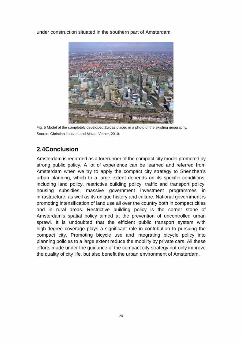
24
under construction situated in the southern part of Amsterdam.
Fig. 5 Model of the completely developed Zuidas placed in a photo of the existing geography.
Source: Christian Jantzen and Mikael Vetner, 2010.
2.4 Conclusion Amsterdam is regarded as a forerunner of the compact city model promoted by strong public policy. A lot of experience can be learned and referred from Amsterdam when we try to apply the compact city strategy to Shenzhen’s urban planning, which to a large extent depends on its specific conditions, including land policy, restrictive building policy, traffic and transport policy, housing subsidies, massive government investment programmes in infrastructure, as well as its unique history and culture. National government is promoting intensification of land use all over the country both in compact cities and in rural areas. Restrictive building policy is the corner stone of Amsterdam’s spatial policy aimed at the prevention of uncontrolled urban sprawl. It is undoubted that the efficient public transport system with high-degree coverage plays a significant role in contribution to pursuing the compact city. Promoting bicycle use and integrating bicycle policy into planning policies to a large extent reduce the mobility by private cars. All these efforts made under the guidance of the compact city strategy not only improve the quality of city life, but also benefit the urban environment of Amsterdam.

25
3 Case study in China – the city of Shenzhen
It has been recognized that the pace of economic development in Shenzhen is far beyond most of other cities in China. It is located in the Pearl River Delta in Guangdong Province in Southern part of China. Pearl River Delta is the fastest developed region in China and it also plays a key role in Chinese economic development. Therefore, any planning suggestion for it could be suitable for other areas in China (Jenks et al., 2000). In this chapter, the city Shenzhen will be analyzed as a typical case in Pearl River Delta. Shenzhen is considered to be a sort of laboratory within China. Researchers all over the world pay much attention to the extraordinary rapid growth, problems and experiences in Shenzhen planning field. It is said that Shenzhen, as a new city, is a representative example around the world which has almost all the attendant problems in the pace of urbanization. As a result of this, it would be necessary for the world to pay close attention to its growth, as the experience of Shenzhen planning is either useful for researching sustainable development for major cities or new cities in developing countries (Zacharias et al., 2010).
3.1 Urban planning in China
Urban planning in western countries has a long history and rich experiences. Strictly speaking, China began to make great progress in urban planning since 1978 when the “open door” policy brought China to the outside world and an economic reform started. Since then, China began to forge ahead at a spectacular speed both in economic and social aspects. However, while the whole world is surprised and inspired by the speed of Chinese development, negative effects caused by population explosion and environmental pollution become more and more serious. With the purpose of rapid economic growth, new area has been exploited and the size and number of urban area are expanding rapidly. It has been reported that “the number of cities rose from 640 in 1995 to 660 in 2002, while towns rose from 17,000 to 20,600 (Tang, 2004). Urban sprawl is becoming a typical phenomenon in China.
Land resource has been put into a serious situation because of urban sprawl. It is predicted that there will be 800 million people living in the city if the number of population in China can be controlled at 1.4 billion by 2020. Urban population will increase around 300 million in next 20 years and there will be ten million new urban residents every year. In addition, China’s urbanization level has risen from 33.4% to 43% with the occupation of cultivated land as high as 161 million hectare (Ma, 2007). But according to the requirements of “The General Plan for the Utilization of Land: 1997 - 2010”, the fixed standard consumption of the land for non-agriculture construction is 196.7 million

26
hectare. If the speed of urbanization keep at the same rate as mentioned above, the non-agricultural construction land would be run out by 2007 in reality (Ministry of Land and Resources, 1999). And that is why the new plan for the utilization of land from 2006 to 2020 has increased by 100 million hectare by 2010 and 300 million hectare by 2020 (Ministry of Land and Resources, 2006).
As result of this, it is obvious that the fast city expansion since 1990s is one of the causes which lead to tense situation of land resources. One of the solutions for land shortage problem in China is implementing compact city form, which may reduce land consumption per capita and increase the density of population.
Planned economy system dominated China for a long time until 1978. At that time, urban planning was fully in control of the state. But the situation has been changed since the economic reform in 1978. In the history of legal urban planning system, one of the most important milestones is the enactment of the “City Planning Act” in 1990 which gives legal assurance to formulation, implementation and management of urban planning. Laws and regulations relative to urban and rural planning at national levels have also been made in line with the City Planning Act. Since great changes, economic and population growth and the increasing importance of rural area, have taken place in the following years, a new law – “Urban and Rural Planning Law of People’s Republic of China” - was adopted in 2007 and come into force in 2008. Simultaneously provincial People’s Congress makes regulations in line with national law to implement it. Also a large quantity of standards and policies issued by local government at different levels and competent departments are made in line with national laws and regulations. Hence, a basic framework of urban planning legal system based on Urban and Rural Planning Law has formed, which also includes “Conservation Regulation of Famous Historical and Cultural City, Town and Village”, “Regulations on the Management of Landscape and Famous Sceneries” and “Regulations on the Management of Planning and Construction in Towns and Market Towns”.
The term “urban and rural planning” in national law contains the following contents: urban system planning, city planning, town planning, township planning and village planning. Among them, city and town planning is divided into overall planning and detailed planning, and meanwhile detailed planning consists of regulatory detailed planning and site detailed planning (SCNPC, 2007).
China has four planning system which covers national, provincial, city and county level. Among each level, a Planning Commission within corresponding government is in charge of making plans at each level. (Fig.6) The State

27
Council’s urban and rural competent department is in charge of the whole national urban and rural planning administration. Local people’s governments at or above the county level are, within the scope of their respective administrative regions, be responsible for relevant work in the urban and rural planning administration.
Fig. 6 Planning system in China
Source: drew by author according to urban and rural law of China.
The competent department of urban and rural planning under the State Council organizes and draws up urban system planning at national level with the cooperation of related departments under the State Council. And the national urban and rural planning guides the formulation of provincial urban system planning and cities’ overall planning (SCNPC, 2007).
Urban and rural planning should be examined and approved level by level. In the first place, the national urban system planning, reported by competent department of urban and rural planning under the State Council, needs to be examined and approved by the State Council. Secondly, the people’s governments of the provinces and autonomous regions organize the establishment of provincial urban system planning which is examined and approved by the State Council. Thirdly, the people’s governments of cities are responsible to arrange for the drawing up for overall city planning. The overall city planning of municipality directly under the Central Government have to be sent to be examined and approved by the State Council with the help of people’s government of municipality. The overall planning of the city, which is the location of people’s government of province and autonomous region or those cities designated by the State Council, need to be approved by people’s government of province and autonomous region, and then submitted to the

28
State Council for ratification. Other cities’ overall plans that are submitted by cities’ government have to be examined and approved by the provincial or autonomous region government. Furthermore, the overall planning of the town where the county people’s government is located is organized by county’s government and approved by people's government at the next higher level. The other towns’ governments organize the compilation of town overall planning and submit to people’s governments at a higher lever for ratification. In the meantime, the local people’s governments at different level should submit the urban system planning to the People’s Congress or the Standing Committee of the National People's Congress at the same level for discussion before submit to the governments at the higher level (SCNPC, 2007).
According to the Urban and Rural Planning Law, the overall/master planning of Shenzhen is organized by Shenzhen people’s government, and then submits the planning to Shenzhen’s Standing Committee of the National People’s Congress. After the consideration of the deliberation opinions from Standing Committee, Shenzhen government shall submit the overall planning to the government of Guangdong province to be approved and then submit to the State Council for final ratification.
3.2 Urban planning in the city of Shenzhen
Shenzhen is located north of Hong Kong and south of Dongguan in the eastern part of the Pearl River Delta in the Guangdong Province of Southern China. (Fig.7) It was established in 1979 and became a special economic zone together with Xiamen, Shantou and Zhuhai in 1980. The size of Shenzhen is 1,952.84 square kilometers with 8.9123 million residents. Among them, 2.4245 million (27.1%) residents have permanent hukou (household registration) while 6.4978 million (72.9%) were non-hukou households by the end of 2009 (Shenzhen Government Online, 2009a). Hukou is a resident permit approved by Chinese government. It is based on family groups in terms of a Hukou booklet in which contains family members’ name, gender, birth date, relationship with each other, marriage status, address, job and so on. Hukou is related to residents’ life such as medical care and job. For migrants, a Shenzhen household registration or hukou is the grail to live in one of the most developed city of China. It covers many benefits including social welfare and medical benefits, in accordance with free education. Shenzhen’s temporary residence card (juzhuzheng) has been designed to supplement the hukou system and eliminate discrimination for migrant workers. However, this strategy does not improve migrants’ quality of life. The Shenzhen Public Security Bureau is the only one that has received benefits by collecting new general information of those migrants (China Labour Bulletin, 2008).

29
Fig.7 Shenzhen in Guangdong Province in China and location of Hong Kong. Source: PanAsianBiz, 2011; Kev Lim, 2008.
As Fig. 7 shows, Shenzhen can take advantage of its proximity to Hong Kong. In the beginning, Shenzhen and Hong Kong are considered as the “factory” and “shop front” respectively because of Shenzhen’s cheap labour force and land price (Sun, 2005). Hong Kong’s investment increased to US$3.8 billion between 1979 and 1993, representing over 60% of the total foreign investments in Shenzhen. From 1999 to 2003, Hong Kong’s actual investments in Shenzhen accounted for more than 80% of the total foreign direct investments in Shenzhen (Bauhinia Foundation Reaserch Centre, 2007). It is reported that there were 2,580,000 people in Shenzhen employed by Hong Kong companies in 2002 (The Federation of Hong Kong Industries, 2003). Furthermore, Hong Kong exports and imports accounted for 41.9% and 3.7% of Shenzhen’s total exports and imports in 2003, reaching US$26.4 billion and US$ 20.4 billion respectively (Shenzhen Statistics Bureau, 2004). In “Shenzhen 2030 Development Strategy”, Shenzhen is expected to be a part of international metropolis with Hong Kong (Shenzhen Government. 2004).
With the cooperation with and investment from Hong Kong, Shenzhen has become one of the top mainland cities for economic returns in China. Its per capita GDP ranks No.1 compared to other major cities. Shenzhen is fourth on the Chinese mainland in terms of economic power and one of the cities that has generated the biggest economic returns. Shenzhen is a link between the Chinese mainland and Hong Kong, and an important transport hub in coastal southern China. The city leads in high-tech, financial services, foreign trade, shipping and creative cultural industries. It has undertaken a mission to pilot China's structural reform and a broader opening to the outside world (Shenzhen Government Online, 2009a).
30
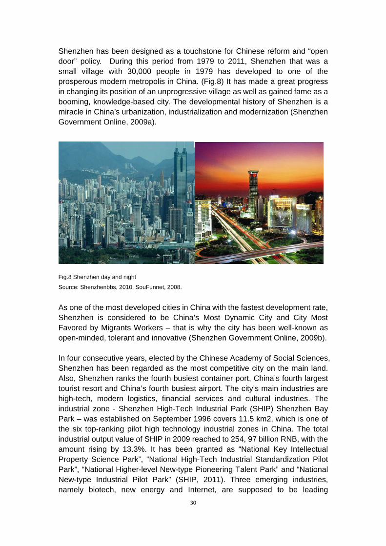
Shenzhen has been designed as a touchstone for Chinese reform and “open door” policy. During this period from 1979 to 2011, Shenzhen that was a small village with 30,000 people in 1979 has developed to one of the prosperous modern metropolis in China. (Fig.8) It has made a great progress in changing its position of an unprogressive village as well as gained fame as a booming, knowledge-based city. The developmental history of Shenzhen is a miracle in China’s urbanization, industrialization and modernization (Shenzhen Government Online, 2009a).
Fig.8 Shenzhen day and night
Source: Shenzhenbbs, 2010; SouFunnet, 2008.
As one of the most developed cities in China with the fastest development rate, Shenzhen is considered to be China’s Most Dynamic City and City Most Favored by Migrants Workers – that is why the city has been well-known as open-minded, tolerant and innovative (Shenzhen Government Online, 2009b).
In four consecutive years, elected by the Chinese Academy of Social Sciences, Shenzhen has been regarded as the most competitive city on the main land. Also, Shenzhen ranks the fourth busiest container port, China’s fourth largest tourist resort and China’s fourth busiest airport. The city’s main industries are high-tech, modern logistics, financial services and cultural industries. The industrial zone - Shenzhen High-Tech Industrial Park (SHIP) Shenzhen Bay Park – was established on September 1996 covers 11.5 km2, which is one of the six top-ranking pilot high technology industrial zones in China. The total industrial output value of SHIP in 2009 reached to 254, 97 billion RNB, with the amount rising by 13.3%. It has been granted as “National Key Intellectual Property Science Park”, “National High-Tech Industrial Standardization Pilot Park”, “National Higher-level New-type Pioneering Talent Park” and “National New-type Industrial Pilot Park” (SHIP, 2011). Three emerging industries, namely biotech, new energy and Internet, are supposed to be leading

31
high-tech industries proposed by Shenzhen’s government. The goal of output value is expected to reach to 650 billion RNB by 2015. As a pioneer, Shenzhen is deemed to be a low carbon city that combined economic development and environmental protection together. It is honored to be low energy consumption, low cost and high output and high profit (Shenzhen Government Online, 2009a).
Shenzhen is a sub-provincial city which covers six districts and two new zones (Fig.9): Luohu, Futian, Nanshan, Yantian, Bao’an, Longgang districts and Guangming and Pingshan new zones. The whole city has been included into the special economic zone according to the approval from Central Government in 2010 (Shenzhen Government Online, 2009a).
Fig.9 Administration of Shenzhen
Source: revised from mapsofnet, 2011.
Luohu is located in the south of Shenzhen, neighboring Futian district in the west, Yantian district in the east and Longgang district in the north. The number of population in Luohu is 885,000 in 2009, among which 434.900 have hukou (permanent residence). Luohu is the first district established in Shenzhen in October 1979. Yantian area, formally as one part of Luohu district, became an independent administrative district in 1997. The size of Luohu district is 78.36 km2, with 33.72 km2 built area. Most of the rest areas are covered by water conservation or Wutong mountain forest reserve. Luohu district contains ten sub-districts and 115 community committees (Luohu Government Online, 2011).
Futian district, built in 1990, is located in the central part of Shenzhen’s Special Economic Zone (SSEZ), with Overseas Chinese Town in the west and Shenzhen River in the south. It is the administrative, information, cultural,

32
commercial and financial center in Shenzhen since the Shenzhen Municipal Government and Municipal Committee of the CPC was set up in Futian district. This district, now covering an area of 78.04 km2, has 1,206,000 residents in 2009. The GDP of Futian district was as high as 149.824 billion yuan in 2008 (Futian Government Online, 2010).
Nanshan district, situated in the west of SSEZ, is the first region implemented China’s “open door” policy. It has 989,000 residents in 2009. Yantian district lies in the eastern part of SSEZ. It is famous for its tourism such as Dameisha and Xiaomeisha. The number of population is 228,000, of which 42,600 are permanent residents. It belonged to Luohu district until 1998. Its GDP rose to 25.1 billion by 2009. Bao’an is the center of the west Shenzhen which was established in 1993. It covers an area of 733 km2. By 2005, Bao’an’s GDP reached to 116.345 billion yuan. Longgang was built on January 1, 1993. It is situated in north east of Shenzhen which covers an area of 844.07 km2. In order to comply with Shenzhen’s new development model, Guangming district and Pingshan were built in 2007 and 2009 (Nanshan, Yantian, Bao’an, Longgang, Guangming and Pingshan Government Online, 2011).
3.3 Developing phases of Shenzhen urban planning
Generally speaking, the period of Shenzhen urban planning can be divided into four phases. That is the emerging phase (1979-1985), the foundation phase (1985-1996), transformation and expansion phase (1996-2001), and improvement and rectification phase (2001 till now). During the 30 years development of urban planning, a series of planning documents have driven the urbanisation process in Shenzhen.
During the period of the emerging phase, China’s centrally planned economy reached its boom by the end of the 1970s. New policies have been proposed to encourage economic development. “The government should use macro control policies such as economic means, laws and administrative measures to manage the national economy, to provide infrastructure and to improve the investment environment. It should refrain from interfering in an enterprise’s production activities” (Ng and Tang, 1999: 595). As a result of the national new policy and the geographic advantage – proximity to Hong Kong – Shenzhen was given to priority in developing export-oriented economy.
Shenzhen is the experimental field of the reform of Socialist Market Economy. Since the establishment of Special Economic Zone (SEZ) in 1980, the developing line was designed to industrial leading and emphasized on processing of given materials. In 1979, Shenzhen just has a total population of 30,000 within less than three square kilometers built up area. In the early days,

33
Shekou industrial area (in Nanshan district) is the first place to be developed. It is near the Shenzhen Bay and faces Hong Kong across the sea. By the end of 1985, Shekou became an industrial leading area with commercial, transportation, tourism development in the meantime. Shatoujiao (in Yantian district at present) and Luohu were also the focus of Shenzhen planning in the early days. In brief, this emerging phase witnessed that Shenzhen transformed from a lagging behind area to one of the developed area in China. Shekou, Shatoujiao and Luohu are three developing focus during this time.
The second stage is from 1985 to 1996 that is called “the cluster liner model”. After an array of studies by planners, the first master plan appeared in 1986 which was named as “the Master Plan of Shenzhen Special Economic Zone (1986-2000) (Shenzhen Government, 1986). This plan plays an important role not only to Shenzhen itself but also for cities all over the country. A great number of cities started to imitate it and make their own master plans after the Cultural Revolution. The development of infrastructure and expansion of land were paid much attention in this plan. (Fig.10)
Fig.10 The 1986 Plan of Shenzhen, containing the core of Shenzhen Economic Zone (not the whole area
in Shenzhen).
Source: Zacharias, J., and Tang, Y.Z., 2010, 217.
The plan takes full consideration of Shenzhen’s geographic situation – long and narrow topography. The model was fixed as “strip shaped cluster” or “cluster linear planning principle (dai zhuang zu tuan). There are five clusters from eastern to western area: Shatoujiao-Yantian, Luohu-Shangbu, Futian, Overseas Chinese Town, Nantou-Shekou and among them the Shennan Avenue is the central line (Shenzhen Government, 1986).
In light of the 1986 plan, Shenzhen turned attention to the investment in infrastructure to guarantee development in different clusters. Specifically, the development in Luohu, Shangbu and Nanshan area, including roads and other
34
infrastructures, has been taken first consideration. The Beihuan highway and the Binhe-Binhai expressway were established to decrease the burden of Shennan Avenue and made great progress in improving connections between different clusters (Zacharias et al., 2010). Land use is designed to be divided into different functions – residential area, production area, business centre, park and recreation area (Shenzhen Government, 1986). From a perspective of compact city form, this kind of single-functional land use is unreasonable and is a waste of land resource, while it was introduced at that time because there was less population, less developed and enough land resources during 1980s. Planners were not concerned with densification and mixed land use strategy.
As the pace of economic growth was more rapid than expected, the capacity of built up area Luohu and Shangbu is bogged down. With the purpose of solving this problem, the government proposed new plan to develop Futian district to release the heavy pressure in existing density area. Since then, Futian district became one of the city centres in the latter 1990s and its status had been upgraded.
The third phase is the “network model” between 1996 and 2006. In 1996, Shenzhen Municipal Government proposed comprehensive plan (1996-2010). The entire area of Shenzhen city, including Longgang and Bao’an was included in this plan. The development model shifts from strip-like model in the former 1986 plan towards network model. (Fig.11)
Fig.11 The 1996-2010 Plan of Shenzhen
Source: Shenzhen Urban Planning & Land Administration Bureau – Shenzhen Comprehensive Plan
(1996-2010).
This kind of development seems to be a form of undirected enlargement to

35
outside SSEZ. (Fig.12) There are three transport axes in the plan – the first one is in the western cluster from Nanshan to the northwest part through Bao’an district. The second one is from the center cluster towards Dongguan and the third one directs to northeast through Longgang.
Fig.12 Shenzhen Municipality: Strategy for development post 1996.
Source: Shenzhen Urban Planning & Land Administration Bureau – Shenzhen Comprehensive Plan
(1996-2010).
In the 1996 plan, three stages were proposed – 1996-2000, 2001-2010 and after 2011. In the first stage, the extensive urban form will be altered as compact form by intensifying the use of existing built-up land with the help of transport. In the period of stage two, the target is to make Shenzhen a high quality living city by developing financing, commerce, trade, information technology, transportation hi-tech industries and tourism. The last stage is to step onto the global stage and has a strong identity and image (Shenzhen Municipal Government, 2000).
In this plan, the population of SSEZ is supposed to be limited within 4.3 million by 2010 by controlling immigration. In the eastern urban cluster (Longgang), Yantian Port is to be developed as an international container transportation hub, Shatoujiao and Meisha designed to be tourist and business centres. At the same time, the western urban cluster (Nanshan) is to develop transport and logistics, education and tourism (Shenzhen Municipal Government, 1996). It is clear that the government tended to link all parts of the municipality together and try to diminish the unbalance and to achieve cohesion around the city. Besides it also plans to build green areas around the clusters to protect the ecosystem. However, this plan failed to control the development scale and therefore wasted the precious land resource.
In the fourth phase, the polycentric model plan has been carried out since 2007. With rapid process of industrialization in recent years, some problems

36
appearing in Shenzhen planning are referred to as “four difficulties” – lack of land resource, water shortage for urban use, population boom and environmental problem. In the meantime, the pressure from other cities in and outside China urges Shenzhen government to propose a new plan to meet new challenges. As a result, the Shenzhen Municipal People’s Congress approved the “Shenzhen 2030 Development Strategy” in 2005 with the purpose of solving existing problems and building a pioneering global city with sustainable development. This strategy not only considers the municipality of Shenzhen but also takes into account the relevant areas beyond Shenzhen (Shenzhen Municipal Government, 2004). The spatial structure of Shenzhen in this strategy goes through north to south, as well as cooperates with the west and expands to the east. (Fig.13) The entire city is divided into five sub-regions that are connected with each other by various axes (Shenzhen Municipal Government, 2004).
Fig.13 Spatial structure of Shenzhen
Source: Shenzhen 2030 Development Strategy
In 2007, Shenzhen government proposed the “Urban Comprehensive Plan (2007-2020)” that reflects polycentric pattern. (Fig.14) The urban structure in this plan is to develop the central city as a foundation and to build up three axes (west, center and east parts) and two stripes (south and north). Futian and Qianhai are to become two centres complementing each other. Futian centre includes the central part of Futian and Luohu district, and Qianhai centre consists of Qianhai, Houhai and the central part of Bao’an district. They have the responsibility to attract high-value-added activities and services. The western axis is the strategic corridor in promoting cooperation between Guangzhou, Shenzhen and Hong Kong as well as boosting coordinated
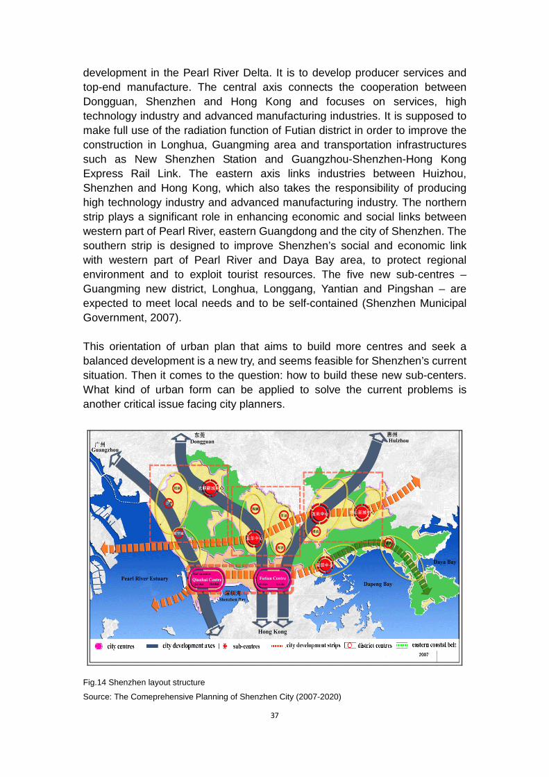
37
development in the Pearl River Delta. It is to develop producer services and top-end manufacture. The central axis connects the cooperation between Dongguan, Shenzhen and Hong Kong and focuses on services, high technology industry and advanced manufacturing industries. It is supposed to make full use of the radiation function of Futian district in order to improve the construction in Longhua, Guangming area and transportation infrastructures such as New Shenzhen Station and Guangzhou-Shenzhen-Hong Kong Express Rail Link. The eastern axis links industries between Huizhou, Shenzhen and Hong Kong, which also takes the responsibility of producing high technology industry and advanced manufacturing industry. The northern strip plays a significant role in enhancing economic and social links between western part of Pearl River, eastern Guangdong and the city of Shenzhen. The southern strip is designed to improve Shenzhen’s social and economic link with western part of Pearl River and Daya Bay area, to protect regional environment and to exploit tourist resources. The five new sub-centres – Guangming new district, Longhua, Longgang, Yantian and Pingshan – are expected to meet local needs and to be self-contained (Shenzhen Municipal Government, 2007).
This orientation of urban plan that aims to build more centres and seek a balanced development is a new try, and seems feasible for Shenzhen’s current situation. Then it comes to the question: how to build these new sub-centers. What kind of urban form can be applied to solve the current problems is another critical issue facing city planners.
Fig.14 Shenzhen layout structure
Source: The Comeprehensive Planning of Shenzhen City (2007-2020)

38
3.4 Conclusion During over 30 years planning period, Shenzhen has gone through extraordinary growth rate that set a good example for other cities in China. It has developed from the beginning of its development stage which just focused on three separate spots: Shekou, Shatoujiao and Luohu, to several clusters connected with each other in the central part of Shenzhen, then enlarge to outside city centre, and in the last stage that plan to build various city centre and sub-centres at the same time. The succession of Shenzhen’s planning experience is filled with both great progress and disadvantages in the meantime.
Even though 1986 plan brings about fast growth, it left some problems. The plan just focused on several random plots in formal Shenzhen Special Economic Zone (SSEZ) but neglected the development of peripheral area. In order to make a living, residents who live in surrounding towns and villages make great effort to compete with industries in center area by changing their farmland into factory. As a consequence, the surrounding areas of worse environment and low quality infrastructures became a common phenomenon in Shenzhen. More importantly, this plan failed in predicting the large number of immigrants from other cities in China. Some of the immigrants who has low income settled down in villages and towns because of its cheap housing and less planning control. Since 1996, Shenzhen government started to change its plan and enlarge its development to peripheral areas without proper control. This stage is inevitable in the planning history as the pace of fast growing economy always comes up with land expansion.
From the 1986 plan to 2007 plan, some urban problems still exist. For instance, the city village nowadays has hindered the communication around the city which is a challenge in implementing the compact city strategy in Shenzhen. As Shenzhen is seeking to be presented at international stage, it faces numerous obstacles caused by car-oriented situation, shortage of land resources and uncontrolled population growth and so on. In the following part, we are going to examine possible development form – the compact city form – for Shenzhen, based on the experience from Amsterdam, trying to solve the existing urban problems.

39
4 Application of the compact city strategy in Shenzhen
4.1 Challenges of urban planning
4.1.1 Lack of land resources
Shenzhen, in reality, focus on development at the heart of Shenzhen – Nanshan, Futian, Luohu and Yantian district. The development in these four districts is far beyond other areas in Shenzhen. In Shenzhen’s first development phase (1979-1985), Shekou (in Nanshan), Shatoujiao (in Yantian) and Luohu are three developing focuses that play a key role in urban planning history. Futian district were taken into account in the second phase (1985-1996) to solve the capacity problem in existing built-up area. In addition, they belong to the first special economic zone in which has its own legislative power granted in 1996. The core of SEZ is characterized by developed economy, high quality of life, high density of population, settlements and activities, and better infrastructures. The number of population in Luohu, Futian, Nanshan and Yantian district in 2009 are 885,000, 1,206,100, 989,000 and 228.000 respectively, accounting for approximately 37% of total population in Shenzhen. The size of the central Shenzhen is around 412 km2. That is to say, the density of this area is as high as 8,028/km2 (Luohu, Futian, Nanshan, Yantian Government Online, 2011). Therefore, it is difficult to further increase the density of central city of Shenzhen and it is also hard for the central area to accommodate enough housing for the whole population of Shenzhen.
Shenzhen’s vice major figured out that the scale of construction land in Shenzhen has increased from 3 km2 in 1979 to 717.7 km2 in 2008, with an annual increment of 30 km2. But according to Article 14 in the Master Plan 2007-2020, the urban construction land should be controlled within 900 km2. As a result, there are only 58 km2 of construction land left in the following ten years (China News, 2010). Land resource is under tense situation in Shenzhen. In addition, low efficiency in land use is also a main reason leading to a waste of land resources. “In 2007, the GDP output per km2 of Shenzhen is RMB 0.9 billion yuan, only 1/3 of the land-use efficiency of Singapore and 1/7 of Hong Kong” (Lu, 2009:3). Urban regeneration becomes a key mean to solve the land shortage problem and break the excessive exploitation of virgin land. The development pace for urban renewal and new built-up area should be designed as the Figure 15 shows (Lu, 2009), thus gradually improving the efficiency of land use.
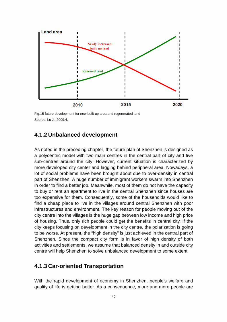
40
Fig.15 future development for new built-up area and regenerated land
Source: Lu J., 2009:4.
4.1.2 Unbalanced development
As noted in the preceding chapter, the future plan of Shenzhen is designed as a polycentric model with two main centres in the central part of city and five sub-centres around the city. However, current situation is characterized by more developed city center and lagging behind peripheral area. Nowadays, a lot of social problems have been brought about due to over-density in central part of Shenzhen. A huge number of immigrant workers swarm into Shenzhen in order to find a better job. Meanwhile, most of them do not have the capacity to buy or rent an apartment to live in the central Shenzhen since houses are too expensive for them. Consequently, some of the households would like to find a cheap place to live in the villages around central Shenzhen with poor infrastructures and environment. The key reason for people moving out of the city centre into the villages is the huge gap between low income and high price of housing. Thus, only rich people could get the benefits in central city. If the city keeps focusing on development in the city centre, the polarization is going to be worse. At present, the “high density” is just achieved in the central part of Shenzhen. Since the compact city form is in favor of high density of both activities and settlements, we assume that balanced density in and outside city centre will help Shenzhen to solve unbalanced development to some extent.
4.1.3 Car-oriented Transportation
With the rapid development of economy in Shenzhen, people’s welfare and quality of life is getting better. As a consequence, more and more people are
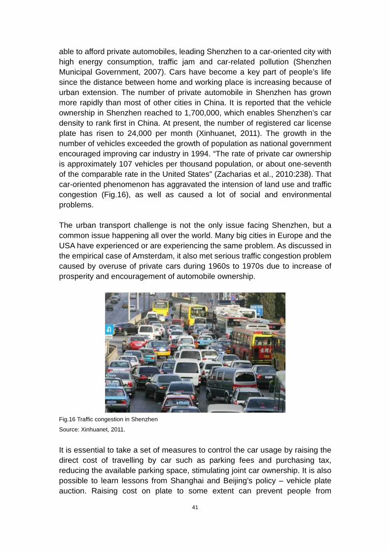
41
able to afford private automobiles, leading Shenzhen to a car-oriented city with high energy consumption, traffic jam and car-related pollution (Shenzhen Municipal Government, 2007). Cars have become a key part of people’s life since the distance between home and working place is increasing because of urban extension. The number of private automobile in Shenzhen has grown more rapidly than most of other cities in China. It is reported that the vehicle ownership in Shenzhen reached to 1,700,000, which enables Shenzhen’s car density to rank first in China. At present, the number of registered car license plate has risen to 24,000 per month (Xinhuanet, 2011). The growth in the number of vehicles exceeded the growth of population as national government encouraged improving car industry in 1994. “The rate of private car ownership is approximately 107 vehicles per thousand population, or about one-seventh of the comparable rate in the United States” (Zacharias et al., 2010:238). That car-oriented phenomenon has aggravated the intension of land use and traffic congestion (Fig.16), as well as caused a lot of social and environmental problems.
The urban transport challenge is not the only issue facing Shenzhen, but a common issue happening all over the world. Many big cities in Europe and the USA have experienced or are experiencing the same problem. As discussed in the empirical case of Amsterdam, it also met serious traffic congestion problem caused by overuse of private cars during 1960s to 1970s due to increase of prosperity and encouragement of automobile ownership.
Fig.16 Traffic congestion in Shenzhen
Source: Xinhuanet, 2011.
It is essential to take a set of measures to control the car usage by raising the direct cost of travelling by car such as parking fees and purchasing tax, reducing the available parking space, stimulating joint car ownership. It is also possible to learn lessons from Shanghai and Beijing’s policy – vehicle plate auction. Raising cost on plate to some extent can prevent people from

42
purchasing more cars. Other solutions, for instance, requiring that cars with odd numbers could get access to the road on Monday, Wednesday and Saturday while those with even numbers are available in the rest of the week. But on the other hand, this policy is limited for lacking consideration of the rich who do not care about the cost of vehicle plate and they are able to afford more than one cars for both odd and even numbers. As a result, this kind of policy will only work among the middle and low class.
4.2 The compact city strategy in Shenzhen
According to the different conditions in different cities, the compact city strategy should also be different. While, the main characteristic of the compact city is similar: high density, multiple land use and efficient public transport system. As to the case of Shenzhen, a metropolitan city in China, it is hard to further increase the density of the city centre and build a compact city as a whole, because the city centre cannot afford enough space for all the city functions serving all the population. Instead, we can introduce a “decentralized concentration” model for its plan, which means making its districts as compact as possible, so as to ease the pressure of the city centre. As a matter of fact, most of the land in Shenzhen has been built up. So urban regeneration needs to be carried out to rebuild the existing area with the aim to mix more functions together within limited space. Furthermore, encouraging people to use public transport and cycling rather than private cars are also important in a compact city, in order to reduce traffic congestion and vehicle related populations.
4.2.1 Decentralized concentration
Given the current situation that the Shenzhen government has already proposed to build up five sub-centres around the original city center, the “decentralized concentration” supported by some compact city proponents seems to be a feasible development form for Shenzhen’s future urban planning. This urban form can date back to Ebenezer Howard’s Social Cities, which present a metropolitan-scale social city form comprising “town clusters”. This new compact city concept can be used to deal with the planning issues in metropolitan cities like Amsterdam and Shenzhen. Due to considerably large scale of the territory, it is hard for metropolitan cities to apply the compact city theory at the city level. Instead, it is more feasible to apply it at the district level, building different compact districts within the city. Then, the compact city is seen more than a city form, but a planning concept that can be fitted into different levels. This kind of new strategy has been put into practice in Amsterdam, such as the example of Zuidas district as previously discussed.

43
As can be seen from the Urban Comprehensive Plan (2007-2020), Shenzhen’s government has set out to build up five sub-centres in addition to the existing Futian and Qianhai centres. However, how to build up self-contained sub-centres and how to prevent them from becoming “satellite towns” or “sleeping towns” are the key points in relation to the success of the planning. Stockholm’s sub-centres are considered to be successful examples of urban villages, which are compact and walkable with a variety of functions gathered together within a relatively small area. These sub-centres are all of a high density and connected with each other by rapid transit system. The general planning principles in Stockholm on which these sub-centres are based can be referenced to when making future planning for Shenzhen (Newman and Kenworthy, 1999: 173):
- Minimize distance from residential area to shopping area.
- Concentrate service functions in an easily accessible distance.
- Locate business and workplaces near residential areas.
- Apartment building should be within 500 meters from a station.
- Single-family housing should be within 300 meters from a station.
- Have variation of urban open space in design.
- Make bus-rail interchange available in every community.
The multiple land use is an important element in the compact city concept. Undoubtedly, it needs to be paid more attention when constructing the sub-centres in Shenzhen. The multiple land use refers to a mixture of various functions in one place, thus improving the efficient use of land within limited land resources. As a result, the sub-centres are able to accommodate housing, office buildings, shopping and recreation place as well as business centres, good facilities and other necessary public services to meet local needs. As discussed in the case of Amsterdam, during 1960s, many satellite towns performed as dormitory towns with poor and inconvenient facilities, and cannot offer sufficient employment, although there was a hope that the satellites should be relatively self-contained. What can be learned from it is that the sub-centres in Shenzhen should be able to supply all functions that the city centre has, becoming compact and self-contained. As a matter of fact, this is a process that is supposed to take a long time.
4.2.2 Urban regeneration

44
Shortage of land resource undoubtedly calls for regeneration in existing area, as some of the built-up areas are in low efficiency of land use and poor quality of living environment. Particularly the villages within the city and old industrial estates in Shenzhen are in need of reconstruction to catch up with Shenzhen’s fast urbanization pace.
Fig.17 City village in Shenzhen
Source: Liu D.P., 1984.
“City village” with poor infrastructure and unsafe residential buildings is common in the Pearl Delta. (Fig.17) Those living in the villages are low income group. Taking a closer look at Luohu district, there are more than 20 villages including Liantang, Tianxin, Sungang, Luofang, Shuiku, Yinglong and so on. The size of villages in Futian district is 301.926 hm2, accounting for 3.83% of total area of Futian (Wu, 2004). The forming of “city village” is attributed to fast urban expansion to peripheral areas. In the process of enlargement, some villages are left without corresponding reconstruction. Land in China is classified in two types: collectively owned by villages or permanently owned by government. In effect, villages are not allowed to transfer their land to the third party instead of governments. But it is not easy to persuade villages to make a deal with government for some economic reasons. In order to earn money, peasants rebuild their houses and rent to immigrants. Except city village, houses built in the 1980s - located near transport network - are out of date with poor quality buildings and shortage of local activities (Zacharias et al., 2010). Furthermore, it is reported that there are around 680 old industrial estates in Shenzhen which accounts for approximately 74% of total industrial estates. Among those old industrial areas, 87% are in charge by villages with small scale, poor quality factory building, and scattered, disordered allocation (Shenzhen Government, 2008).
High density and multiple land use are identified as characteristics of compact city. The existing of vacant and poor industrial estates, on the one hand, is a highly waste of land resources, and on the other hand, does not achieve

45
mixture of functions in one place and make full use of land resource efficiently. Moreover, city villages cut off the connection between different centres in Shenzhen without available infrastructure (especially public transportation) and similar cultural neighborhood, which would hinder Shenzhen’s development pace. There is no way to discard those undeveloped areas but governments and planners are required to strive as much as possible to regenerate them.
Shenzhen is lacking a competent authority dealing with urban regeneration. One of the experiences from the Netherlands is the assurance from government’s guidance, and interrelated policies and regulations. Specifically, the program - Investment Budget for Urban Regeneration (IUR) in the Netherlands – covers 30 major cities in the beginning phase and offers 23% of the budget for provinces regenerating urban area. Based on the case of the Netherlands, a 5-10 year development program is needed for cities urban regeneration policy which includes strategy plans of regeneration instead of details on all projects. The establishment of IUR in 1985 is considered to be a prerequisite for Dutch urban regeneration (Korthals Altes, 2002). The urban regeneration in Shenzhen does not have a budget support like IUR. As we seen from Dutch example, the IUR plays an important role in urban renewal in accordance with development plan as a precondition and guidance. Setting up competent urban regeneration authority in Shenzhen could have positive impact on the process of regeneration in terms of systematizing planning. It is possible to establish Urban Redevelopment Authority both at city level and district level with the power to plan, to supervise and corresponding direct financial support. As a result, this kind of department is capable of offering specific budget to urban regeneration. This, of course, requires the relevant authority under urban and rural competent department at national level. Furthermore, matched laws and regulations, such as “Urban Regeneration Measure” and “The Rules for Implementation of Urban Regeneration”, are required to cover every phase of urban regeneration, in which include governments’ rights and obligations, different renewal purpose for city village and old industrial area, and legal proceedings of urban renewal.
As discussed above, unbalanced development in Shenzhen is in a serious situation. The living habitats between various income groups vary heavily. Low income group, mostly are immigrants, live in city villages built in 1980s. How to improve living environment for low income population and connect each part of Shenzhen together are key points to achieve social balance in the process of urban regeneration. To deal with city villages, one alternative for Shenzhen government is to tear down and rebuild them. As we know, there are poor environment and infrastructures in city villages with low-density housing. Therefore, tearing down city villages is in accordance with the implementation of compact city strategy in Shenzhen. However, another problem would spring

46
up because the government needs to pay a large amount of money to compensate the residents living in city villages.
Given this situation, housing policy can be learnt from Dutch experience to help Shenzhen rebuild city villages. In the Netherlands, housing policy is seen to be an effective instrument to protect low income group’s life. As both planner and founder of housing construction, the government in Amsterdam has crucial effects on the physical development. Because of its double roles, government has ability to achieve socio-spatial mix of the city by deciding where to locate dwellings and who is supposed to live in the house. “Moreover, the very large public subsidy involved in housing construction, by keeping rent levels low and thereby raising disposable income, has contributed substantially to popular welfare, mitigating class differentiation and thereby weakening resistance to residential integration of different income groups” (Fainstein, 1997: 298). Accommodating different income groups is important in a compact city as learned in Amsterdam. In Shenzhen, housing policy can be seen as a tool to assist government in rebuilding city villages with densification policy. One of the big problems for government is to negotiate land’s deal price with city villages to rebuild those areas. Except the so called “money driven” reason for tenant, another fact is that a lot of residents are willing to live in this area because of the low rent. If they could be offered with low-rent housing in other places by the government, they would be likely to move out of the villages. Thus, the negotiation between government and city villages would become more efficient. Instead of totally tearing down the old habitats and city village, Shenzhen government also have an alternative to mix different income group by updating valuable area into cultural protection and attracting rich class to move into this area. As a result, local diversity and better facilities would revitalize this restructured area.
In the planning history of Amsterdam, separation of different functions was negative in a compact urban form. Since compact city was proposed in 1978, multiple land use began to integrate into planning principle. This strategy, stressed in Amsterdam’s compact city policy, could help to prevent fragmentation of Shenzhen’s city functions. The conversion of old industrial estates can be divided into three categories that are “function change”, “mixture of former industry and other compatible industry” and “updating transformation”. “Function change” means to rebuild the industrial estate into a new area with different functions such as residential, business centre in accordance with matched public installations. This kind of old industrial area is partly distributed in Shangbu, Meilin, Buxin within the city centre and partly near 107 National Road and Shenhui Highway. The second type of industrial area includes Nanyou, Tairan and Bagualing with better location, large scale and vivid industrial activity. Corresponding business, accommodation and catering services would be a better supplement for them. Industrial areas in
47
Shekou, Shatoujiao, Liantang, Jindi within the city centre and other over 50 industrial estates outside city centre with poor quality construction and facilities can be updated rather than transform them into business or residential functions.
4.2.3 Public transport system
The compact city form characterized by high-density strategy and mixed land use provides a good condition for developing an efficient public transport system. Nowadays, some seventy percent of the urban transport in Amsterdam is occupied by public transport and bicycles (Qianjiang Evening News, 2004). Compared with private cars, buses have absolute priority when travelling on the road. Like bicycles in Amsterdam, buses also have exclusive traffic lane, so that you can enjoy a barrier-free trip by bus. What is learned from the case of Amsterdam is that improving the public transport system is a necessary condition to reduce travelling by car, particularly for short trips.
As to the present condition of public transport system in Shenzhen, some changes have already taken place, such as the reform of bus fees, improvement of bus stops, extension of bus lines and introduction of exclusive bus lanes. The Shenzhen government also invests hundreds of millions yuan to ensure the operation of public transport every year. At present, the long-distance bus lines on the main roads serve for cross-district travelling from east to west, while the short-distance bus lines (extension bus lines) are used for inner-district and small-scale trip. However, the problem is the load rate of extension bus lines has been very low, which reflects the lack of preliminary investigation and comprehensive plan for routes and frequency of bus lines. Moreover, the traffic signal control remains at the level of a few year ago that exacerbates the urban traffic congestion. In order to make people willing to use public transport, continuous improvement in public transport and related infrastructure to make bus travelling faster, more convenient and more attractive to people is of great importance. Other complementary measures like higher parking fees and fewer parking space, and the fact of frequent traffic congestion would make it difficult to travel by car. Thus it is believed that more and more people would like to choose buses, metros and other public transport that are faster and more convenient.
In the future, urban transport plan in Shenzhen is also planned to focus on the development of public transport. The Master Plan 2007-2020 of Shenzhen has put the improvement of public transportation system in the priority position of the government agenda. The percentage of public transport use is expected to account for 70% of total transport use by 2020. The target of Shenzhen traffic plan is to build a rail-oriented system supplemented by Bus Rapid Transit and
48
regular bus system (Shenzhen Municipal Government, 2007). In the Master Plan, some new stations are expected to be built in the near future such as New Shenzhen Rail Station, Futian Rail Station and Shenzhen Eastern Rail Station. Among them, the New Shenzhen Rail Station is designed to become the most important hub in the city to serve both long distance transportation and cargo transportation activities (Shenzhen Municipal Government, 2007).
The existing metro system is in favor of the central SEZ areas, while in the latest metro development plan, four additional lines are currently under construction to expand the coverage of the metro to a greater extent, aiming to reach the sub-centres as well as the outlying Bao’an and Longgang development areas. These lines are also designed to link with the proposed high-speed rail system. A regional commuter rail system supplements the metro system to link the SEZ with other sub-centres and eventually Dongguan and other surrounding cities in the Pearl River Delta. The railway system under development are designed to improve accessibility to mass rapid transit over a large area of Shenzhen (Zacharias and Tang, 2010).
There is a hope that the intensive network of metro and rail system in Shenzhen may realize the possibility of non-motorised transport. A rail-based transport system with a set of interchange stations has been proposed by Shenzhen government. In the latest urban plan, six major interchange stations are to be constructed. These stations will have a good connection with metro lines, regional rail services and national high-speed rail lines. It remains a priority for Shenzhen to develop an efficient public transport not only for the linkage between different districts within the city of Shenzhen, but also for a better connection between Shenzhen and other cities in the Greater Pearl River Delta. Public transport is a way to carry more people with fewer vehicles, which can in turn ease the traffic pressure, conserve energy and protect the environment. It is believed that even though Shenzhen would be built more compact, the traffic condition could also be pleasant with less congestion and more comfort.
4.2.4 Encourage cycling in Shenzhen
The “decentralized concentration” model we assumed above is characterized by short distance between residential area to bus station or shopping centre. Thus, cycling, as a mean of transportation, is possible to enter into people’s daily commute because of its convenience for short distance travel. Moreover, as a complementary for public transportation, bicycle policy may become more feasible since bus, metro and train system will be improved as noted above. In the empirical case study of Amsterdam, a set of comprehensive bicycle plans have been carried out. Langenberg argued that this kind of transport makes

49
great contribution to the municipality’s transport system as well as reduces motorized traffic pressure. It is reported that the proportion of means of transportation in bicycle, car and public transport is 35%, 40% and 25% respectively. Amsterdam’s physical structure, the compact semi-circular form, is suitable for bicycle with flat terrain connected by many bridges. Cycling has a long history in Amsterdam (Langenberg, 2000). Since the late 1960s and early 1970s bicycle use has been encouraged by environmentalists and bicycle advocates. A council related to bicycle was established in 1978 with the purpose of solving transport problems. The number of bicycle users grew from 31% of all vehicle trips to 38% between mid-1980s and 2008 (City of Amsterdam, 2007 and 2009). As the increasing of bicycles during this period, the public transport share declined from 27% to 25% between 1985 and 2008. The rate of car travelers dropped from 42% in 1985 to 37% in 2008 (Dutch Bicycling Council, 2006; City of Amsterdam, 2007 and 2009). In 2006, a number of plans, for instance “Choosing for Cyclist: 2007-2010”, were put forward for overcoming bicycle related problems, such as travel safety, bicycle theft and parking room for bikes (City of Amsterdam, 2007).
For Dutch people, cycling is a very common and everyday transport mode. The prevalence of bicycles ranks first around the world, with more than one bicycle per person (Qianjiang Evening News, 2004). The integration of public transport and cycling system is the orientation that the transport development of Amsterdam is following up. The government encourages people to go to work by bicycle, even many senior government officials are cycling lovers. A lot of companies give preferential subsidies for the employees to buy bicycles and offer complete parking facilities. There are exclusive traffic lanes for bicycles on the road in Amsterdam that is separated from pedestrian and vehicles. Furthermore, for long-distance trip, bicycle is allowed to be carried onto the city rail-way transport. In the following analysis of applying bicycle policy to Shenzhen, some experience from Amsterdam will be referenced.
China was well-known as “bicycle kingdom” during the period of 1980s. Bicycle manufacturing was one of the leading industries in China in 1960s and 1970s. There were approximately 500 million bicycle owners in the 20th century. In other words, every two people owned a bicycle. At that time, bicycle was of great importance in people’s life that as the main travel tools. During the rush hours, (Fig.18) roads were swarmed with thousands of bicycles. Since 1994, the government started to encourages people to purchase private cars to motivate local economy, which led to growing number of car ownership. Nowadays, the streams of bicycles in the street were replaced by motor vehicles.
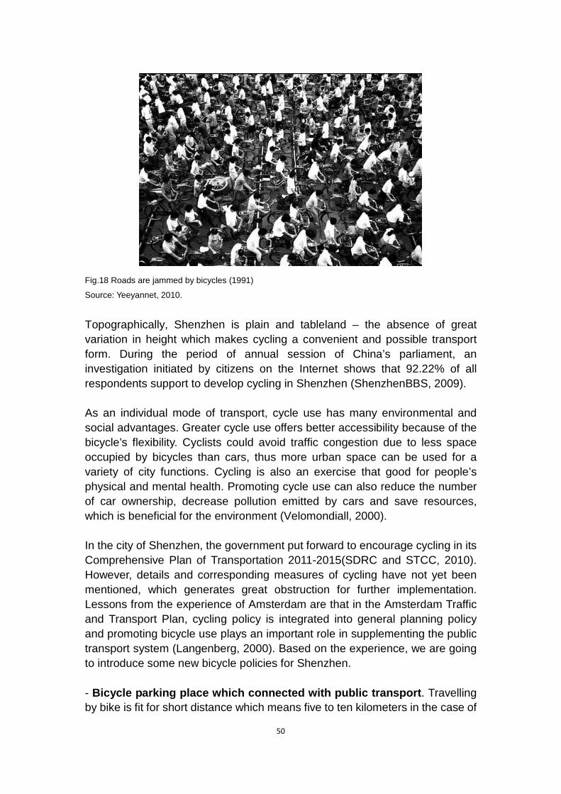
50
Fig.18 Roads are jammed by bicycles (1991)
Source: Yeeyannet, 2010.
Topographically, Shenzhen is plain and tableland – the absence of great variation in height which makes cycling a convenient and possible transport form. During the period of annual session of China’s parliament, an investigation initiated by citizens on the Internet shows that 92.22% of all respondents support to develop cycling in Shenzhen (ShenzhenBBS, 2009).
As an individual mode of transport, cycle use has many environmental and social advantages. Greater cycle use offers better accessibility because of the bicycle’s flexibility. Cyclists could avoid traffic congestion due to less space occupied by bicycles than cars, thus more urban space can be used for a variety of city functions. Cycling is also an exercise that good for people’s physical and mental health. Promoting cycle use can also reduce the number of car ownership, decrease pollution emitted by cars and save resources, which is beneficial for the environment (Velomondiall, 2000).
In the city of Shenzhen, the government put forward to encourage cycling in its Comprehensive Plan of Transportation 2011-2015(SDRC and STCC, 2010). However, details and corresponding measures of cycling have not yet been mentioned, which generates great obstruction for further implementation. Lessons from the experience of Amsterdam are that in the Amsterdam Traffic and Transport Plan, cycling policy is integrated into general planning policy and promoting bicycle use plays an important role in supplementing the public transport system (Langenberg, 2000). Based on the experience, we are going to introduce some new bicycle policies for Shenzhen.
- Bicycle parking place which connected with public transport. Travelling by bike is fit for short distance which means five to ten kilometers in the case of
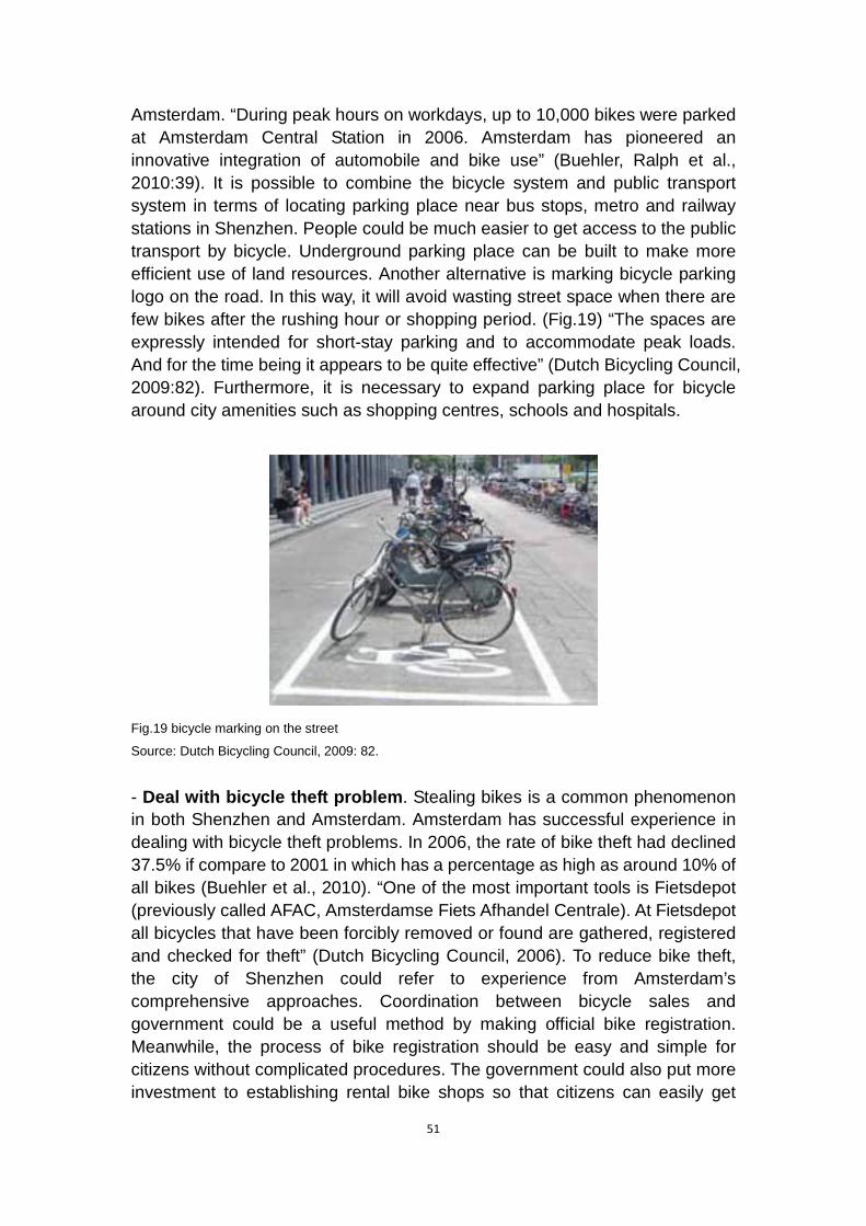
51
Amsterdam. “During peak hours on workdays, up to 10,000 bikes were parked at Amsterdam Central Station in 2006. Amsterdam has pioneered an innovative integration of automobile and bike use” (Buehler, Ralph et al., 2010:39). It is possible to combine the bicycle system and public transport system in terms of locating parking place near bus stops, metro and railway stations in Shenzhen. People could be much easier to get access to the public transport by bicycle. Underground parking place can be built to make more efficient use of land resources. Another alternative is marking bicycle parking logo on the road. In this way, it will avoid wasting street space when there are few bikes after the rushing hour or shopping period. (Fig.19) “The spaces are expressly intended for short-stay parking and to accommodate peak loads. And for the time being it appears to be quite effective” (Dutch Bicycling Council, 2009:82). Furthermore, it is necessary to expand parking place for bicycle around city amenities such as shopping centres, schools and hospitals.
Fig.19 bicycle marking on the street
Source: Dutch Bicycling Council, 2009: 82.
- Deal with bicycle theft problem. Stealing bikes is a common phenomenon in both Shenzhen and Amsterdam. Amsterdam has successful experience in dealing with bicycle theft problems. In 2006, the rate of bike theft had declined 37.5% if compare to 2001 in which has a percentage as high as around 10% of all bikes (Buehler et al., 2010). “One of the most important tools is Fietsdepot (previously called AFAC, Amsterdamse Fiets Afhandel Centrale). At Fietsdepot all bicycles that have been forcibly removed or found are gathered, registered and checked for theft” (Dutch Bicycling Council, 2006). To reduce bike theft, the city of Shenzhen could refer to experience from Amsterdam’s comprehensive approaches. Coordination between bicycle sales and government could be a useful method by making official bike registration. Meanwhile, the process of bike registration should be easy and simple for citizens without complicated procedures. The government could also put more investment to establishing rental bike shops so that citizens can easily get

52
access to bike. Thus “comfortable and safe routes with adequate storage capacity and the ability to take ones' cycle onto the train, tram or metro, will make the bicycle an attractive option for the initial and final legs of longer journeys” (Langenberg, 2000:3).
– Cycling safety. “Dutch traffic laws protect young cyclists and put the responsibility for an accident on the car driver. The only exception is when cyclists deliberately and flagrantly disobey traffic laws” (Buehler, Ralph et al., 2010:38). Similarly, according to Article 76 in “Road Traffic Safety Law of the Peoples Republic of China” (2007), car drivers have to take responsibility when accident happens between motor vehicle and non-motorized transportation. If there is evidence to prove pedestrian or non-motorized drivers to be wrong, car drives can be reduced punishment. Besides the guarantee from national law, Shenzhen needs to build separate bicycle path on the main roads. Moreover, the special traffic signal lights for bicycle in Amsterdam (Fig.20) also give some inspiration to Shenzhen’s bicycle planning.
Fig.20 Special traffic signals give cyclists priority in Amsterdam
Source: Buehler, R. and Pucher, J., 2010:39.
- Develop recreational cycle routes. Shenzhen is rich in natural resources and famous for beach resorts and forest reservation area, such as Dameisha, Xiaomeisha in Yantian district, Dapeng Bay and Mangrove Nature Reservation. Developing cycling route in and around Shenzhen can, on the one hand, facilitate tourism development which will boost Shenzhen’s economic development, and on the other hand, encourage people to travel by bike that is eco-friendly and healthy.
However, as Amsterdam is a city with long cycling history, most of the citizens

53
are willing to travel by bike while Shenzhen does not have similar cultural background, even though bike were popular during 1980s in China. The popularity of bicycle in 1980s in China is mostly because people did not have financial capacity to buy other vehicles. But the background in Amsterdam is different as it has advantages in physical structure. In order to encourage people to use bike as often as possible, motivating measures and publicity are necessary. Related restriction on cars as discussed above could be a contribution to bicycle policy such as higher parking fees, purchasing tax and vehicle plate auction. However, China is still in the developing period, so cars are considered as the status symbol in people’s mind. Therefore, asking people to use bicycles instead of cars seems to be hard to achieve and the impact of this bicycle strategy would be weak at the moment as we can imagine. Changing people’s awareness is not an easy job, which will be a long-run challenge for the government and the citizens as well.

54
5 Conclusion Our study focuses on the issue of compact city urban form. We started the paper with the aim to find out a clear definition of what the compact city is. In the matter of fact, we were confronted with a lot of definitions and critics about the concept of the compact city when we were going through the literature. Every planner and scholar has his or her own understanding of this kind of urban form. Moreover, it is not clear what kind of city can be considered as compact city. What criteria does the word “compactness” refer to?
Our research did not result in a clear and common definition of the compact city, and we did not find a consensus of what the benefits and detriments the compact city form will bring to the future urban development. Instead, we came to characterize the compact city by ourselves based on the features that were most frequently presented in the planning literatures. That is high-density both in built form and in activity, mixed land use and an efficient public transport system that can well serve the local people, in order to reduce the car dependency and save natural resources as well. Our aim of this study is to make use of the advantages that the compact city strategy has and to find out how a city applies this strategy in its urban planning system. After deeper understanding of the theory, we found that the compact city concept can not only be implemented at the city level, but also can fit the district level, which is useful when we study the city of Shenzhen.
When studying the case of Amsterdam, we found that there are variety of differences between the theory and practice. Putting the concept of compact city into practice is a much more complex issue than the concept itself, which calls for a collaboration between different policies, such as land use policy, traffic and transport policy, building policy and government investment. Furthermore, the cooperation between different actors of the city is also of great significance. The government has the right to set up the strategy to achieve the compact city, while the implementation of the strategy needs the efforts and awareness of all the citizens. Amsterdam, as a pioneer in the field of compact city, has gained impressive achievements in terms of multiple land use, complete public transport and cycling strategy.
It is obvious that each city has its unique history, culture and urban development process. We cannot formulate a common strategy of compact city to fit in with their diverse factors and circumstances. Whereas, some inspiring experience from the successful examples, like the city of Amsterdam, is worthy to be referenced when applying the compact city strategy in our case of Shenzhen.
Shenzhen, a border town before 1979, has experienced dramatic urban
55
development over the past 30 years. This city has transformed its urban planning form from cluster linear and network model to polycentric model from 1980 till now. Since the very beginning, Shenzhen government started to focus its development on enlarging its territory and making it as large as possible which leads to incomplete growth under over fast development pace. In general, Shenzhen is suffering from three challenges: unbalanced development, lacking of land resources and car-oriented status quo. Those obstacles, in turn, negatively stunt applying the compact city into Shenzhen. Responding to these problems, we learnt some experience from the city of Amsterdam and from the Netherlands, and therefore proposed related policies in order to try to find a way to implement compact city form in Shenzhen.
Unlike cities in Europe, Shenzhen covers a large area with a huge number of population. Such a metropolitan city is incapable to implement the compact city as a whole. But it is an opportunity to introduce the “decentralized concentration” form into Shenzhen’s compact development. This form is designed to establish compact districts as “urban village” within the city. This strategy could also be found in the successful experience in Zuidas district in Amsterdam. In this case, we assumed that this new form of compact city would be able to release unbalanced development in Shenzhen by making those “urban villages” relatively self-contained and highly concentrated. Thus, based on this new form, urban regeneration has also to be carried out to cope with land shortage problem.
More important, the compact form in Shenzhen cannot be achieved without efficient public transport system. As we known, Shenzhen nowadays is a car-oriented city. Therefore, a spatial development pattern with more environmentally and socially friendly transportation modes, such as public transport, is of great importance. As Verroen (1996:107) concludes, “urbanization…as close as possible to or between existing urban areas and with a good connection to high-quality public transport lead to the most favourable effects on mobility”. This fits in well with the characteristics of the compact city strategy, which seeks to reconnect transport with land use and particularly to facilitate transit-oriented development where higher-density, mixed-use areas built around high-quality transit systems provide a compact urban structure. This kind of urban form is believed to reduce the automobile dependence and environmental pollution caused by cars, thus improving the quality of people’s life.
The debate about the sustainability of the compact city form is under way. However, we did not put our focus on if this urban form is sustainable or not, because it is the issue that needs the test of the time. Every coin has its two sides. It is more feasible to talk about the “compact city” as the most effective planning strategy to counteract further urban sprawl rather than think it highly
56
as a way to achieve sustainable cities. Even the city of Amsterdam that has been following the compact city planning approach for decades is still exploring better strategy to achieve sustainable development. Is the compact city form suitable for Shenzhen’s future urban planning? The question cannot be answered for the moment because there are a number of factors and uncertainties that influence the development of the city. Only after the strategy is put into practice can we exam its effectiveness.
57
References
Aaron N., 2006. Eyes on the Street: Amsterdam [online]. Available at: < http://www.streetsblog.org/2006/10/06/eyes-on-the-street-amsterdam/> [Accessed February 26, 2011].
Amsterdam Information, 2011. Basic Facts [online]. Available at: <URL www.amsterdam.info/basics/history> [Accessed February 22, 2011].
Arbury, J., 2005. From Urban Sprawl to Compact City – An Analysis of Urban Growth Management in Auckland. Auckland University.
Bauhinia Foundation Reaserch Centre, 2007. Building a Hong Kong-Shenzhen Metropolis Research Report. Hong Kong: Bauhinia Foundation Research Centre.
Bartelds, H. and De Roo, G., 1995. Dilemma’s van de compacte stad, uitdagingen voor het beleid (Dilemma of the Compact City, Challenges to Policy Developments). The Hague: VUGA.
Breheny, M.J., 1992a. Sustainable development and urban form: an introduction. In: Breheny, M.J.. ed. Sustainable Development and Urban Form. London: Pion.
Breheny, M.J., 1992b. Sustainable Development and Urban Form. London: Pion.
Breheny, M., and Rookwood, R., 1993. Planning the sustainable city region, In: A Blowers (ed.), Planning for a sustainable environment. London: Earthscan.
Breheny, M., 1995. The Compact City and Transport Energy Consumption. Transaction of the Institute of British Geographers, 20(1), 81-101.
Buehler, R., and Pucher, J., 2010. Cycling to Sustainability in Amsterdam. Kentucky: The Kentucky Institute for the Environment and Sustainable Development [online]. Available at: <URL:http://policy.rutgers.edu/faculty/pucher/amsterdam.pdf> [Accessed March 22, 2011].
Burton, E., 2002, ‘Measuring urban compactness in UK towns and cities’ Environment and Planning B: Planning and Design, 29, 219-250.
Bao’an Government Online, 2011. Nature and Geography [online].

58
Available at: <URL:http://www.baoan.gov.cn/main/index/bafm/zrdl/> [Accessed March 1, 2011]
CEC (Commission of the European Community), 1990. Green Book of the Urban Environment. Brussels: EU.
China Development Gateway, 2006. Vice Minister of Defence denounces Scare of Land Supply [online]. Available at: <URL:http://cn.chinagate.cn/resource/2006-06/22/content_2350073.htm> [Accessed February 28, 2011].
China Labour Bulletin, 2008. What does it take to get a Shenzhen hukou? [online]. Available at: <URL: http://www.china-labour.org.hk/en/node/100354> [Accessed April 13, 2011].
China News, 2010. Shenzhen’s Construction Land in the Following Ten Years [online]. Available at: <URL:http://www.chinanews.com/estate/2010/12-21/2736907.shtml> [Accessed March 12, 2011].
City of Amsterdam, 2007. Choosing for the cyclist: Bicycle program 2007-2010. Amsterdam: Gemeente Amsterdam, Dienst Infrastructuur, Verkeer en Vervoer.
City of Amsterdam, 2009. Travel Survey 2008. Amsterdam: Gemeente Amsterdam, Dienst Infrastructuur, Verkeer en Vervoer.
Crane, P., 1996. On Form versus Function: Will the new urbanism reduce traffic, or increase it? Journal of Planning Education and Research, 61(2), 210-225.
Dantzig, G., and Saaty, T., 1973. Compact City: A Plan for a Livable Urban Environment. San Francisco: Freeman.
De Klerk, L., 1986. Il Piano da rimedio a procedura, Urbanistica, n.85.
De Roo, G., and Miller, D., 2000. Compact cities and Sustainable Urban Development: A Criticle Assessment of Policies and Plans from an International Perspective. Hampshire: Ashgate Publishing Company.
De Roo, G., 1996, Environmental Policies in the Netherlands: Too Good to be true. Ashgate, London.
Dieleman, F., Dijst, M., Spit, T., 1997. Planning the Compact City, the Randstad Holland Experience. Utrecht: NETHUR. Paper of the Urban

59
Research Centre, Utrecht.
Dutch Bicycling Council, 2009. Bicycle policies of the European Principles: continuous and integral [online]. Amsterdam: Fietsberaad Publication, 65-70. Available at: <URL:http://www.fietsberaad.nl/library/repository/bestanden/Fietsberaad_publicatie7_Engels.pdf> [Accessed March 24, 2011].
Elkin, T., McLaren, D. and Hillman, M., 1991. Reviving the City: Towards Sustainable Urban Development. London: Friends of the Earth.
Faludi, A., 1992. Growth Regions and the Future of Dutch Planning Doctrine, Sustainable Development and Urban Form. Edited by M.J. Breheny, Pion, London.
Faludi, A., and Van der Valk, A., 1994. Rule and Order: Dutch Planning Doctrine in the Twentieth Century. Dordrecht: Kluwer Academic Publishers.
Fainstein. Susan S., 1997. The Egalitarian City: The Restructuring of Amsterdam. International Planning Studies. 2(3), 295-314.
Futian Government Online, 2010. Overview [online]. Available at:
<URL:http://www.szft.gov.cn/zf/ftgk/gkxx/200712/t20071208_91719.html> [Accessed March 1, 2011].
Guangming Government Online, 2011. Overview [online]. Available at:
<URL:http://www.szgm.gov.cn/main/xqgk/jbqk/> [Accessed March 1, 2011].
Hong Kong Special Administrative Region Government, 2011. Hong Kong: the Facts [online]. Available at: <URL:http://www.gov.hk/en/about/abouthk/factsheets/docs/population.pdf> [Accessed February 25, 2011].
H.P. Berlage, 1917. Expansion Plan for Amsterdam Zuid (South) [online]. Available at: <URL:http://stadsarchief.amsterdam.nl/english/amsterdam_treasures/planning/uitbreidingsplan_berlage/index.en.html> [Accessed February 22, 2011].
Howard, E., 1985. Garden Cities of Tomorrow (new edition). Eastbourne: Attic Books.
Jantzen, C., and Vetner, M., 2008. Designing Urban Experiences. The Case of Zuidas, Amsterdam [online]. Available at: <URL:http://www.springerlink.com.miman.bib.bth.se/content/3907411l1174ul0

60
5/> [Accessed March 6, 2011].
Jenks, M., and Burgess, R., 2000. Sustainable Urban Forms for Developing Countries. London: Spon Press.
Jerks, M., Burton, E. and Williams, K. (eds), 1996. The Compact City: A Sustainable Urban Form? London of Britain: E & FN Spon.
Jolles, A., 2003. Planning Amsterdam. Scenarios for urban development 1928-2003, edited by Allard Jolles, Erik Klusman, Ben Teunissen, NAi Publishers, Rotterdam.
Kev Lim, 2008. The location of Hong Kong [online]. Available at: <URL: http://limkeesong.files.wordpress.com/2008/06/hong_kong_pol98.jpg> [Accessed February 25, 2011].
Kista: Science City Online. Available at: <URL: http://kista.com/> [Accessed February 28, 2011].
Klusman, E., and Teunissen, B., 1986. Prg 1935-1985: dal piano generale di espansione alla città compatta, Urbanistica, n.85.
Kruythoff, H., and Teule, R, 1997. Vinex Policy moves into the implementation phase. Journal of Housing and the Built environment, 12(1), 113-133.
Langenberg, P., 2000. Cycling in Amsterdam: Developments in the city [online]. Amsterdam. The Netherlands: Velo Mondial 2000. Available at: <URL: http://www.velomondial.net/velomondiall2000/PDF/LANGENBE.PDF> [Accessed February 28, 2011].
Liu D.P. 1984. City village in Shenzhen [online]. Available at: <URL: http://www.s1979.com/m/citystories/zhuanti/shenzhen30/sznews/2009/1208/6860.html> [Accessed April 11, 2011].
Lock, D., 1995. Room for more within city limits? Town and Country Planning, 64(7), 173-176.
Longgang Government Online, 2011. General Information [online]. Available at: <URL:http://www.lg.gov.cn/web/intro/profilesone.aspx> [Accesse March 1, 2011].
Lowe, M., 1991. Shaping Cities: The environmental and human dimensions. Washington, D.C.: Worldwatch.
61
Lu J., 2009. Spatial Planning in Shenzhen to Built a Low Carbon City. 45th ISOCARP Congress.
Luohu Government Online, 2011. General Information [online]. Available at: <URL:http://www.szlh.gov.cn/main/jrlh/lhgl/jbqk/index.shtml?catalogId=1220&id=1225> [Accessed February 28, 2011].
Mapsofnet. 2011. Shenzhen Districts [online]. Available at: <URL: http://mapsof.net/china/static-maps/png/shenzhen-districts> [Accessed February 25, 2011].
Ma, Y.M., 2007. The Birth and Development of Compact City. Modern Urban Research, (4), 10-16.
Ministry of Land and Resources, 1999. The Overall Programme of Land Use: 1997-2010 [online]. Available at: <URL:http://www.mlr.gov.cn/zwgk/ghjh/200710/t20071017_88615.htm> [Accessed February 28, 2011].
Ministry of Land and Resources, 2006. The Overall Programme of Land Use: 2006-2020 [online]. Available at: <URL:http://www.mlr.gov.cn/xwdt/jrxw/200810/t20081024_111040.htm> [Accessed February 28, 2011].
National People’s Congress, 2007. Road Traffic Safety Law of the Peoples Republic of China. Beijing: People’s Congress.
Newman, P., and Kenworthy, J., 1999. Sustainability and Cities: overcoming automobile dependence. Washington D.C.: Island Press.
Ng, M.K., and Tang, W.S.,1999. Urban System Planning in China: a case study of the Pearl River Delta. Urban Geography, 20(7), 591-616.
NPPC (National Physical Planning Council), 1985. De compacte stad gewogen (The Compact City Evaluated), Study Reports Nr. 27. The Hague: Dutch Ministry of Housing, Physical Planning and Environment.
PanAsianBiz, 2011. Shenzhen in Guangdong Province in China [online]. Available at <URL: http://www.panasianbiz.com/wp-content/uploads/2011/01/Shenzhen-China1.gif> [Accessed February 25, 2011].
Pingshan Government Online, 2011. Overview [online]. Available at: <URL:http://www.psxq.gov.cn/content/2010-09/27/content_4961588.htm>

62
[Accessed March 1, 2011].
Pistor, K., and Aluwihare. R.C., 1994. A city in progress: Physical Planning in Amsterdam. Amsterdam: Stadsdrukkerij Amsterdam.
Porter, D., 1997. Managing Growth in America’s communities. Washington, D.C.: Island Press.
Qianjiang Evening News, 2004. How does Amsterdam build up eco-transport system [online].Available at: <URL:http://www.cebike.com/news/html/200412/2004123011163256.htm> [Accessed April 13, 2011].
Scoffham, E., and Vale, B., 1996. ‘How compact is sustainable – how sustainable is compact?’ in Jenks, Burton and Williams (eds.) The Compact City: a sustainable urban form? E & FN Spoon, London: 66-73.
Standing Committee of the National People’s Congress, 2007. Urban and Rural Planning Law of the People’s Republic of China. The President of the People’s Republic of China (No.74).
ShenzhenBBS, 2009. Should Shenzhen Develop Bicycle Policy [online]. Available at: <URL: http://szbbs.sznews.com/viewthread.php?tid=523444> [Accessed March 24, 2011].
ShenzhenBBS, 2010. Daytime of Shenzhen [online]. Available at: <URL: http://bbs.szhome.com/commentdetail.aspx?id=100596572&projectid=220140> [Accessed February 26, 2011].
Shenzhen Government, 1986. Master Plan of Shenzhen Special Economic Zone (1986-2000). Shenzhen: Shenzhen Government.
Shenzhen Government, 2004. Shenzhen 2030 Development Strategy. [online] Available at: <URL: http://www.szpl.gov.cn/main/sz3/index.html> [Accessed March 2, 2011]
Shenzhen Municipal Government, 2000. Comprehensive Plan for Shenzhen (1996-2010). [online] Available at: <URL: http://www.szplan.gov.cn/main/csgh/ztgh/ztgh/guimo.htm > [Accessed March 2, 2011]
Shenzhen Municipal Government, 2007. Shenzhen Comprehensive Plan (2007-2020). [online]

63
Available at: <URL: http://www.szpl.gov.cn/main/zgca/crow.html> [Accessed March 2, 2011]
Shenzhen Government, 2008. The Notification of Accelerating Updating Old Industrial Estates. Shenzhen Government.
Shenzhen Government Online, 2009a. Overview [online]. Available at:
<URL:http://www.sz.gov.cn/cn/zjsz/szgl/200610/t20061030_92776.htm> [Accessed February 28, 2011].
Shenzhen Government Online, 2009b. Overall strength [online]. Available at: <URLhttp://www.sz.gov.cn/cn/zjsz/szgl/200610/t20061030_92775.htm> [Accessed February 28, 2011].
Shenzhen High-Tech Industrial Park (SHIP), 2011. Park Overview [online]. Available at: <URL:http://www.ship.gov.cn/index.asp?bianhao=361> [Accessed March 28, 2011].
Shenzhen Statistics Bureau, 2004. Statistics of Year Book of Shenzhen. Beijing: China Statistics Press.
SouFunnet, 2008. The Night of Shenzhen [online]. Available at: <URL: http://bbs.yc.soufun.com/2615373782~-1~50/30033602_30033602.htm> [Accessed February 26, 2011].
Sun, S.Q., 2005. Inter-governments Competition and Cooperation, and Political Economy Analysis – the Example of Shenzhen – Hong Kong Cooperation. Henan University of Science and Technology (01), 80-83.
Tang, K., 2004. Urban Planning System in China: Basic Facts and Reform Progress [online]. Department of Urban and Rural Planning, Ministry of Construction, P.R.China. Available at: <URL:http://www.adb.org/documents/events/2004/prc_planning_system_reform/tang4.pdf> [Accessed February 25, 2011].
The Federation of Hong Kong Industries, 2003. Made in PRD – the Changing face of HK Manufactures (part II and survey report). The Federation of Hong Kong Industries.
Thomas, L., and Cousins, W., 1996. ‘The Compact City: a successful, desirable and achievable urban form?’ in Jenks, Burton and Williams (eds.) The Compact City: a sustainable urban form? E & FN Spoon, London: 53-65.

64
Van der Valk, A., 2002. The Dutch planning experience. Landscape and Urban Planning, Vol (58), 201-210.
Velomondiall, 2000. The Amsterdam Declaration [online]. Available at: <URL: http://www.velomondial.net/velomondiall2000/Html/PROCEED/DECLARE.HTM> [Accessed March 25, 2011].
VROM (Dutch Ministry of Housing, Physical Planning and Environment), 1983. Verstedelijkingsnota (Urbanization Report). The Hague: SDU Publishers.
VROM (Dutch Ministry of Housing, Physical Planning and Environment), 1993. Vierde nota over de ruimtelijke ordening Extra deel 3 (Fourth Physical Planning Report Extra part 3). The Hague: SDU Publishers.
Williams, K., 1999. Urban intensification policies in England: problems and contradictions. Land Use Policy, 16(3), 167-178.
Willem K., and Korthals Altes., 2002. Local Government and the Decentralisation of Urban Regeneration Policies in The Netherlands. Urban Studies. 39(8), 1439-1452.
Wu X., 2004. Investigation on the Present Status of the “City Village” – Taking the Zhujiang Delta Area as an Example. The Planner Forum. 20(5), 5-7.
Xinhuanet, 2011. Car Limitation in Shenzhen – Appearance of Licence Plate Stocking [online]. Available at: <URL:http://news.xinhuanet.com/mrdx/2011-01/19/c_13697263.htm> [Accessed March 12, 2011].
Yantian Government online, 2011. Overview [online]. Available at: <URLhttp://www.yantian.gov.cn/main/ytgk/jjfz/index.shtml?catalogId=2185index.shtml?catalogId=2185> [Accessed March 1, 2011].
Yeeyan, 2010. Thirty Years of Bicycles in China [online]. Available at: <URL: http://article.yeeyan.org/view/68129/141594> [Accessed March 23, 2011].
Zacharias, J., and Tang, Y.Z., 2010. Restructuring and Repositioning Shenzhen, China’s New Mega City. Progress in Planning, 73, 209-249.
Zhang Y.Q., 2003. Research on the Development of Self-organization of Urban Space - the case study of Shenzhen. Nanjing: Southeast China University.
Zhou G.Y., and Yu L., 2010. Introduction of western modern urban planning theory. Nanjing: Southeast University Publisher.


![Review J. Comp. Theor. Nanoscience[1]](https://img.pdfslide.us/doc/110x75/577d2a091a28ab4e1ea889ff/review-j-comp-theor-nanoscience1.jpg)