Embed Size (px)
Citation preview
Albert Lea
FREEBORN CO.
M I N N E S O T AM I N N E S O T AI O W AI O W A
I35
69 65
25113
90
90
35
Myre-Big IslandState Park
Proposed Project
Hayward
Austin
Clarks Grove
Geneva
Alden
Glenville
Hartland
Emmons
Twin Lakes
Saint Paul
Freeborn County
Figure 1: Blazing Star State Trail - Myre-Big Island State Park to Hayward, Freeborn County
LegendBlazing Star State Trail - Proposed ProjectMinnesota State Trails - DevelopedState ParkInterstate Trunk HighwayU.S. Trunk HighwayMN Trunk HighwayDOT Roads - County HighwaysDOT Railroads
BRRT_County.mxd PAT 6/18/13
0 105Miles
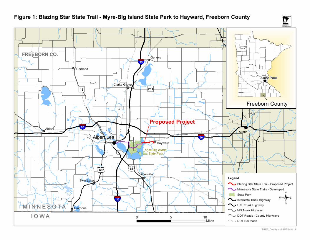
Hayward
Proposed Project, New Development
Blazing
State Trail
Existing Trail,Proposed New Pavement
Star
Figure 2: Blazing Star State Trail - Myre-Big Island State Park to Hayward, Freeborn County, USGS Map, 1:24,000
LegendProposed Extension - Blazing Star STMinnesota State Trail (Developed)
BSST_USGS.mxd PAT 6/18/13
0 10.5Miles
Public Water Access

65
35
35
6591
38
38
18
17
19
19
22
48
18
46
Albert Lea Lake
Albert Lea Lake
AlbertLea
Fountain Lake
PondPond
Shell RockRiver
(unpaved)
GooseLake
Little IslandPioneer Camp(primitive)
New York PointGroup Center
White FoxCampground
Big IslandCampground
Big Island
State Park
Frank Hall Park
Union
Pacific
Railroad
I&MRailroad
Union P
acific
Rail
road
Great Marsh
Bridge
© 7/2009, Minnesota Department of Natural Resources
Figure 3: Blazing Star State Trail (Developed)
State Trail (asphalt)
State Trail (unpaved)
Other Hiking/Biking Trails
Park Areas
Map Legend NORTH
Parking
Picnic/Rest Area
Toilet
Information
Camping
Scale in Miles
0 .25 .5 .75 1.0 Location inMinnesota of map area
Duluth
Mpls./St. Paul

¬«26
Underland Rd.
810th Ave.
Hayward
Albert Lea Lake
Ditch
No.
32
Myre-Big Island State Park
Existing trail, to be paved
Albert Lea Game Refuge
Albert Lea Game Refuge
Wetland Impact Locations;estimated total ~0.9 acres
Peter Lund
Drainage
Creek
Proposed Bridge
ProposedCulvert
¬«26
¬«38
¬«46
¬«92
¬«102¬«41
Figure 4: Blazing Star State Trail - Myre-Big Island State Park to Hayward Project Area, Including Land and Surface Water Features
BSST_NWI.mxd PAT 11/15/13
0 10.5Miles
/Legend
Proposed Extension - Blazing Star STProposed Project AreaMinnesota State Trail (Developed)State Park
National Wetlands Inventory1 - Seasonally Flooded Basin or Flat2 - Wet Meadow3 - Shallow Marsh4 - Deep Marsh5 - Shallow Open Water6 - Shrub Swamp7 - Wooded Swamp8 - BogsWildlife Refuge (State)
¬«26
Hayward
Underland Rd.
810th Ave.
Albert Lea Lake
Ditch
No.
32
Peter Lund
Drain
age
Creek
W
253
114
113
253
136
253
130
377
110
113
62
130
253
130
377
106B
377
1055
444106B
382B
253
106B
106B
377
253
414
377
253
104B
259B
83
1055
104B
102B
102B
130
106D2
113
377
444
377
102B
130
M-W
239
123
156B
104B
102B
106C2
376B
130
106B
104B
524
106B
376B
114
114
253
104D
130
104B
114
376B
1033 259B
286B
253381
114940
102B
114106B
253
130
940
130
286B
377
377
114
104B
376B
130
253238D2
286B
113
382B
102B
377
524
114
130
414
102B
102B
130
106B
102B
104D104C
114
377
102B
377
102B
106B
113
156B
253
114
380
113
377
102B
376B
104D
106B
102B
376B
130
377
381
1055
381
129
102B
247
130
62
253
130
524
130
382B
113
123
114
130 130
286B
102B
382B
130
940
253
106C2
106C2
104B
102C
944D2
1033
102C
102C
102B
286B
102B
1033
259C 156B
377
247
104B
940
104D
102B
382B
102B
253
106C2
106C2
102B
382B
102C
113
129
238D2
102B
102B27C
102B
102B
104B
1033
104D
104D
106B
286B
286B
102B
382B
944D2382B
253
259C
381
377
106B
94B
377
102B
102C
376B
106B
381
130
106B
102B
104D
130
130
104B
106B
253
102B
382B
113
102B
130
444
102B
113
106B
106C2
376B
130
106D2
106B
123
123
106C2
123
W
253
1033
106C2
106C2
114
377
1055
253
114
113
114
106B
130
104B
114
376B 253
102B
1055
130
102B
944C2
106C2
138B
130 130
238C2
102B
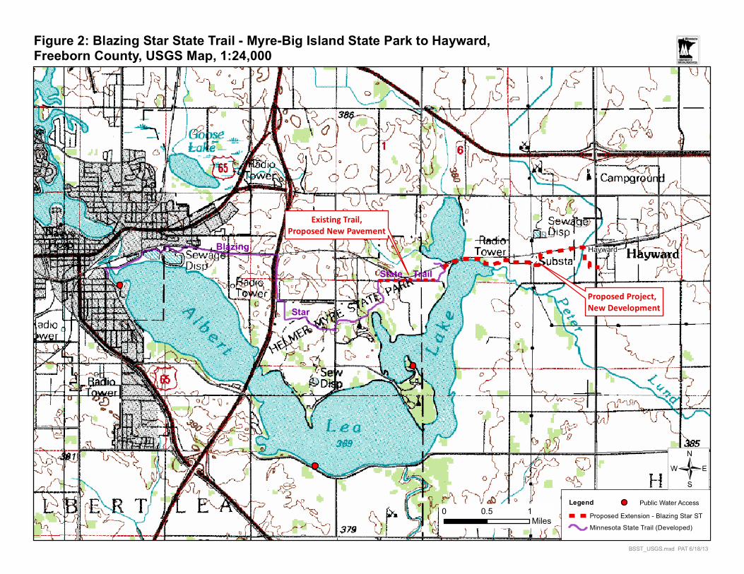
Figure 5: Blazing Star State Trail - Myre-Big Island State Park to Hayward - USDA, NRCS Soil Survey Map Units
BSST_soils.mxd PAT 11/15/2013
0 0.50.25Miles
LegendBlazing Star State Trail - Proposed Minnesota State Trail (Developed)Proposed Project Area
Soil Map Unit1027102B102C1033104B104C
104D1055106B106C2106D2110113
114123129130136138B156B
238B238C2238D2238E239247253
259B259C27C286B376B377380
381382B4144445245B62
83940944C2944D2944E94BM-W
W
/
Date:
Name: Reg. Number: ��������� ����
I HEREBY CERTIFY THAT THIS PLAN, SPECIFICATION OR REPORTWAS PREPARED BY ME OR UNDER MY DIRECT SUPERVISION,AND THAT I AM A DULY LICENSED PROFESSIONAL ENGINEER
UNDER THE LAWS OF THE STATE OF MINNESOTA���� ��� ����� �� �������
�������������� ���� ���� ��������� ���� ����� �����
������ ��
D2Sheet:
Req. Number: �� �!"���
�����������#���
���������$%&�'���
(���� )'�������
� ��������
�#������� ��������
���� ������������������
Survey: Designed:Drawn: Drawn:Checked: Checked:Horz datum: Vert datum:
�*+�, �$-��).� / "$�+�,�
W. NORDIN Y.STAM
C. RICE Y.STAM
Y. STAM T.REICH
NAD 83 ('96 ADJ) NGVD 1929
DEC 2011
MAR 2012
MAR 2012
3/08
6/09
6/09(���0��Section: 1 / � Township: � � Range: � N W
������� File Number: �*+� 12� � �
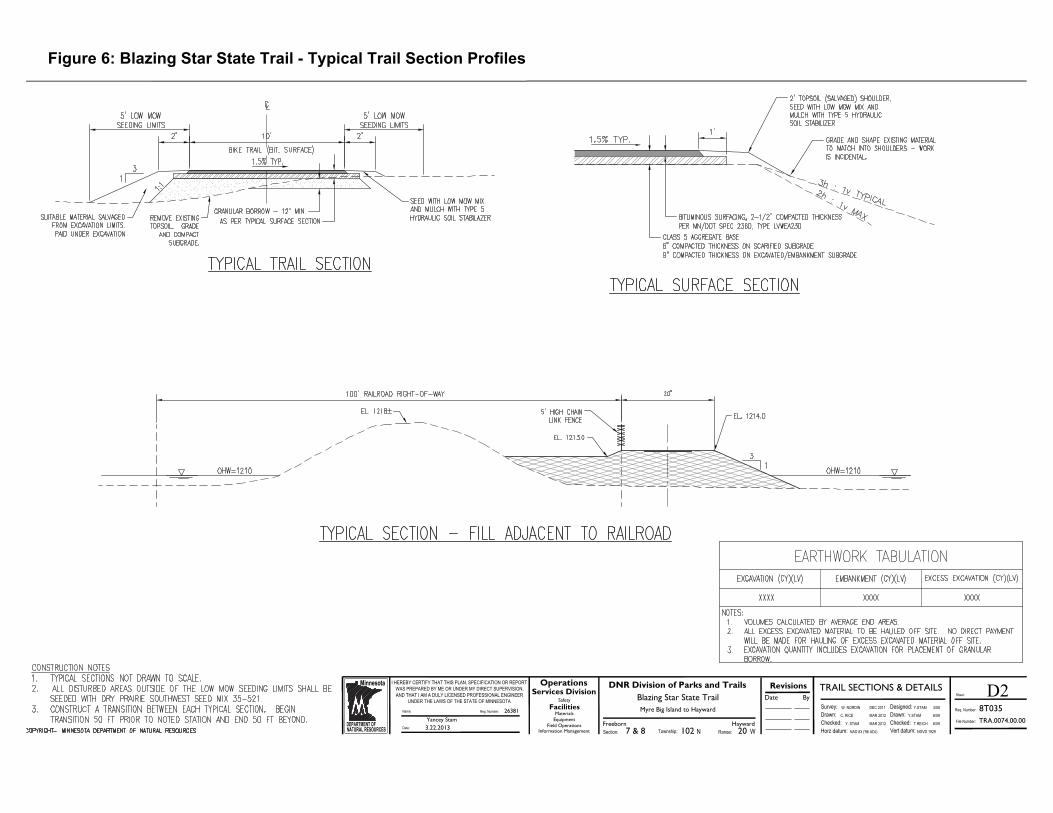
Figure 6: Blazing Star State Trail - Typical Trail Section Profiles
Date:
Name: Reg. Number: 26381Yancey Stam
I HEREBY CERTIFY THAT THIS PLAN, SPECIFICATION OR REPORTWAS PREPARED BY ME OR UNDER MY DIRECT SUPERVISION,AND THAT I AM A DULY LICENSED PROFESSIONAL ENGINEER
UNDER THE LAWS OF THE STATE OF MINNESOTAMyre Big Island to Hayward
DNR Division of Parks and TrailsBlazing Star State Trail
3.22.2013
L1Sheet:
Req. Number: 8T035Date
RevisionsBySafety
MaterialsEquipment
Field Operations
Facilities
Information Management
OperationsServices Division
Survey: Designed:Drawn: Drawn:Checked: Checked:Horz datum: Vert datum:
Plan and ProfileW. NORDIN Y.STAM
C. RICE Y.STAM
Y. STAM T.REICH
NAD 83 ('96 ADJ) NGVD 1929
DEC 2011
MAR 2012
MAR 2012
3/08
6/09
6/09FreebornSection: 7 & 8 Township: 102 Range: 20N W
Hayward File Number: TRA.0074.00.00.07
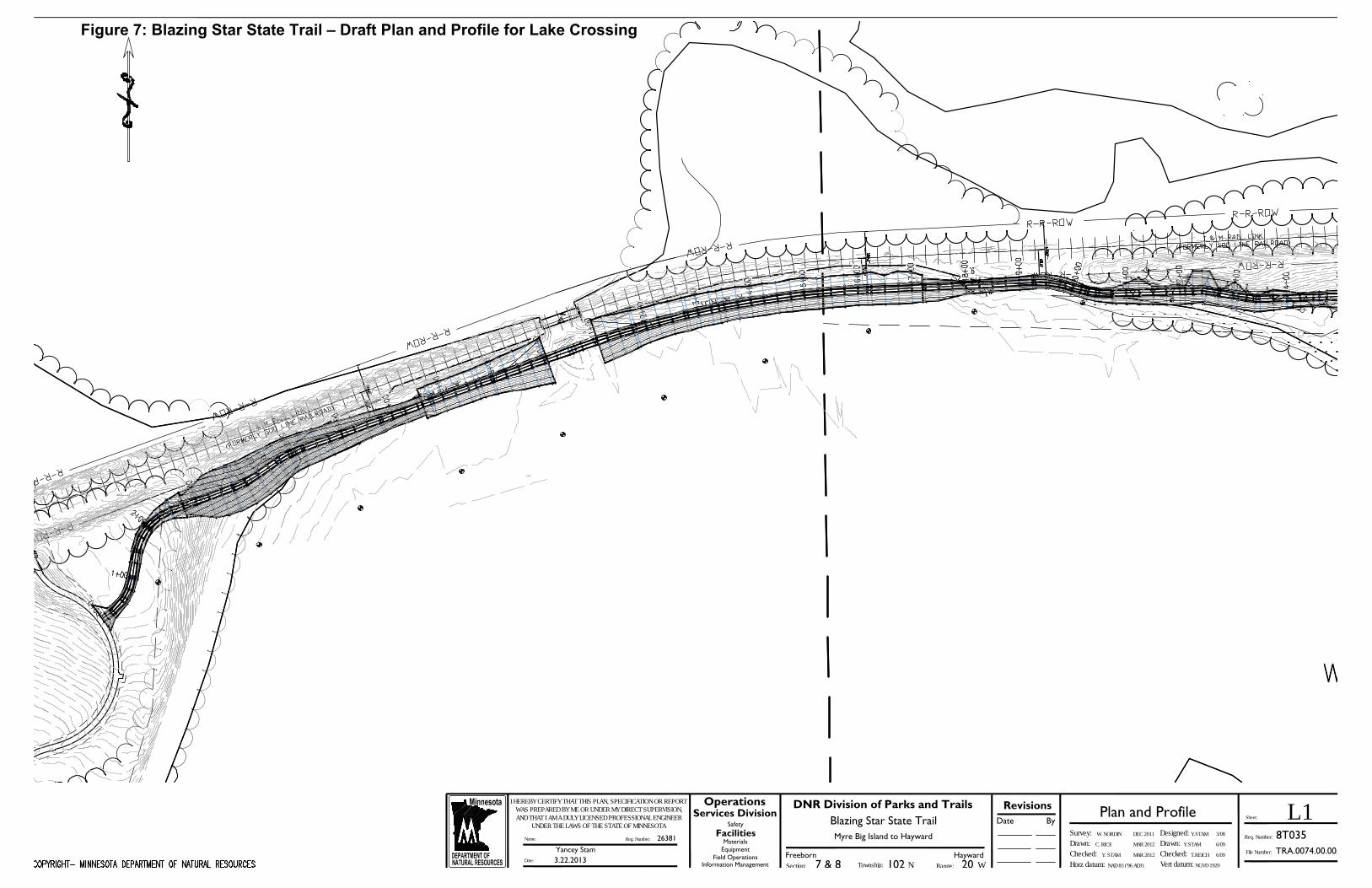
Figure 7: Blazing Star State Trail – Draft Plan and Profile for Lake Crossing


![[Teacher Name] presents: Blazing the Biodiversity Trail in Brazil](https://img.pdfslide.us/doc/110x75/568164d9550346895dd71fb4/teacher-name-presents-blazing-the-biodiversity-trail-in-brazil.jpg)