Embed Size (px)
Citation preview
Algebraic Thinking Math Project
Blazing the Trail
http://www.pbs.org/mathline Page 1
Connecting experiences in the everyday world with the fundamental ideas ofproportional reasoning is important for the development of algebraic thinking. Use of proportionality is indispensable in the formal study of algebra and fosteringproportional reasoning is a critical goal of late elementary and middle schoolmathematics.
Students will use and understand proportional reasoning to find actual distances asdepicted on maps.
Students estimate distances between landmarks as well as use a map and scales todetermine the actual distances.
For each group (outside): l Laminated maps with sturdy backing (e.g., cardboard)l Markers and pencilsl Cards marked with scale from mapl Stringl Compasses (directional and drawing)l Protractors
For each group (inside):l Enlarged map of orienteering course
Materials
Overview of the Lesson
Lesson Objective
Algebraic Thinking Focus
ATMP Lesson: Blazing the Trail Page 2
http://www.pbs.org/mathline PBS Mathline
l Calculatorl Ruler or marked card
Prior to the Lesson: Students should have some experience estimating distancesand working with scales on maps. It would be helpful, but not necessary; if theyhave worked with directional compasses, e.g., used compasses to set bearings andrun orienteering mini-courses.
You will need to set up the orienteering course prior to the lesson. A public parkworks well, but you can always use the school grounds or even the gymnasium.
See the Resources section of this lesson to learn more about orienteering.
1. Introduction: Explain to students that they are going to have the opportunity toapply some of the skills they have been studying in the classroom literally "in thefield." Review the procedures and have the students gather the materials they willneed for the excursion (including water).
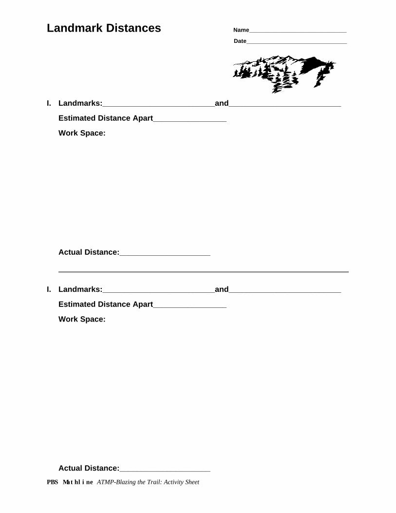
2. Practicing Skills: Have students practice shooting bearings at a few familiarlandmarks. Then have them estimate distances between two “landmarks” andcheck their estimates using a map.
See the Landmark Distances activity sheet at the end of this lesson.
3. Running the Course: Hand out data sheets for students to record the number ofpaces between positions and the verification phrase (name or phrase written by theteacher as a “code” to prove that students found the correct place) they find at eachposition.
Have all but the first group of students go to a place where they cannot see what ishappening. Then give the first group their initial directions (e.g., "Set a bearing for153° and go 300 paces"). Shortly after they are out of sight send off the secondgroup and continue this process until all groups have set out on the course.
Sample directions are at the end of this lesson.
4. Classroom Follow-up: Have students use the data they gathered to determine thedistances they traveled between positions on the course and the total distance ofthe course. Then have them use a map with the first bearing marked on it to findthe first position on the course. Finally, have students map the course by markingthe distances on a map for the actual distances they traveled while running theorienteering course.
Procedure
ATMP Lesson: Blazing the Trail Page 3
http://www.pbs.org/mathline PBS Mathline
"Students encounter proportional relationships when they…consider the relationshipbetween points on a map drawn to scale and the actual distance between thecorresponding locations in the world…Topics as apparently diverse as sales tax,slope, and similarity can all be seen to be related when thought about as instances ofproportional relationships…In order for students to see the connections among thesediverse experiences and topics, they must engage in reasoning about the underlyingproportional relationships."
NCTM Principles and Standards for School Mathematics (Draft), 1998
Students develop proportional reasoning according to a very personal timetable. Also,each child needs multiple experiences to establish facility with such reasoning. Overtime students can build a foundation for concepts such as slope and other algebraictopics.
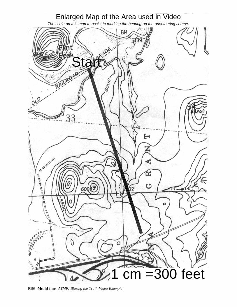
In preparation for this lesson, students need to have some experience with using scales on a map. Prior to the orienteering lesson, the students in the video classroompracticed several methods for finding actual distances between places employing ascale on a map. The students used the scale on a map to set a drawing compass at ameasure corresponding to a particular distance on that scale. By counting the numberof times needed to swing the compass around to get from one place to another on themap and then multiplying by the scale factor, they could make very good estimates foractual distances. The students also used a card or a piece of string marked accordingto the scale on a map to find estimates for real distances. This introduced proportionsinto the lesson based on the scale of the map.
In addition to practice with maps, the students worked with angles from 0 to 360° andlearned to use directional compasses to shoot a bearing. The Fieldbook from the BoyScouts of America provides excellent instructions for learning this skill. (See, also, theInternet sites listed in the Technology Connections section of this lesson.) Finally, thestudents did some work with proportions. They used paces and distance walked toestablish that their average pace was approximately 2.5 feet. Another tool they used to measure distances in these preliminary investigations was a trundle wheel, asshown in the video, borrowed from the local law enforcement agency.
It is also advisable to have students run a mini-course before they try a full-fledgedorienteering course. All of the educational objectives of the lesson can be achieved byusing shorter courses on school grounds or in the school gymnasium or cafeteria. Inthese cases, a pair or small group of students would run the course at a time so thatsubsequent groups will not be tempted to just follow the previous group. An olderstudent or volunteer could accompany each small group since the teacher would mostlikely be occupied in the classroom with the rest of the students.
Mathematically Speaking
ATMP Lesson: Blazing the Trail Page 4
http://www.pbs.org/mathline PBS Mathline
When students try to estimate real distances between landmarks outdoors, it isimportant that they understand that their distance from the landmarks affects theperception they have of the actual distance between the points. Students may havetrouble making reasonable estimates in these situations. With practice, however,students improve their estimating and develop a practical, life-long skill.
Making estimates of distances between places should be followed by finding the actualdistances to improve their skill in making estimates. As in the video, students can usemaps of the region to determine the actual distance between landmarks. The USGeological Survey has produced maps of every part of the country.
See the Resources section of this lesson.
Doing this work in the field immediately after making the estimates should havesubstantial impact on students' ability to improve their estimation skills. Thisexperience also provides an obvious reason to know how to use the scale on a map.Finally, activities like these provide points of reference for students as they buildmathematical meaning into their world.
As each group sets out for the first position (also referred to as a target or control sitein orienteering), the teacher should make sure they have the correct bearing. Thissafeguard promotes success on at least the first part of the course. It is stronglyrecommended that at least two students per group take each new bearing. It isimportant that the students do a sighting. That is, they identify an intermediate and adistant landmark that they can use to re-align themselves when needed. For example,they may have to go around a group of bushes or a ditch. In such cases, they can lineup on their sighting again on the far side of the obstacle and stay on course. As theyreach each intermediate landmark, they will need to choose a new sighting for the next bearing.
After students complete the course, follow-up with several activities in the classroombased on their field experience to promote the development of proportional reasoning.As in the video, students can convert the number of paces they traveled for each partof the course and the total number of paces for the entire course into feet using theinformation previously established (the average pace for the students in this class = 2.5feet). They can mark off the distance traveled along the first bearing using anenlargement of the area included in their course. Finally, the students can use theirknowledge of angles and scale to draw the entire course.
While all students may not use proportions or even proportional reasoning tocomplete these activities, the lesson provides tasks for which proportional reasoning isan appropriate problem solving strategy. The teacher can probe for and foster thisreasoning through modeling, sharing of student thinking, and questioning techniques.
ATMP Lesson: Blazing the Trail Page 5
http://www.pbs.org/mathline PBS Mathline
Geometry has been too underrepresented in the elementary and middle schoolmathematics curriculum, and activities that promote spatial reasoning have been evenmore underrepresented. Student performance on tasks involving geometry and spatialreasoning reflect that lack of emphasis (Clements and Battista, 1992). Geometry, andespecially similarity, is a rich source of realistic proportional reasoning problems.Maps provide a special application of similarity and a source of practical proportionalreasoning situations.
According to Lehrer (1999) mathematical reasoning about space is unlikely to developwithout more attention than it now receives in the elementary school. He has observedthat second and third grade students have successfully engaged in orienteeringactivities similar to those in this lesson, beginning with tasks in the classroom andmoving to their school playground and their neighborhood (Lehrer, 1999).
In an international study, Cai (1998) found that students in the United States usealgebraic strategies less frequently then students in Japan, and that this difference maybe related to instruction. According to Cai, use of algebraic strategies in whichstudents use an unknown in an equation and then solve the equation is commonamong elementary school students in China and Japan, but uncommon in the UnitedStates. Asking our students to seek multiple solutions to proportional reasoningproblems, including a solution in which the problem is represented by an equation,could help students move from comfortable but inefficient strategies to more powerfulalgebraic approaches.
The nature of the reasoning used by the students in the video to determine thedistance they walked is unclear. To determine how far 300 paces is if one pace is 2.5feet, some students used 300 as a unit, doubling 300 to get 600, halving 300 to get 150,and adding 150 to 600 to get 750 feet. Other students solved the problem bymultiplying 300 by 2.5, obtaining 750 feet, but the reason why they multiplied by 2.5 isunclear. Earlier the teacher had written this proportion on the board:
1 = 300 2.5 x
If the students used cross-multiplication they would get
1x = 2.5(300).
As Lesh, Post and Behr (1988) pointed out, cross-multiplication can be used to solveproportional reasoning problems, but it does not require the use of proportionalreasoning.
It is more likely that the students who multiplied used a unit factor approach (see TheUnit Factor as a Route into Linear Functions in the Bead-dazzling lesson). Using the
Related Research Findings
ATMP Lesson: Blazing the Trail Page 6
http://www.pbs.org/mathline PBS Mathline
rate of 2.5 feet per pace and the relationship
distance (in feet) = rate (in feet per pace) x number of paces.
In determining the distance between two points on the map, the students measuredthe distance (using a compass, a string, a ruler, or an index card) and then used themap scale, drawn as a number line with units in miles, to determine the distance. Thisrequires scale reading but not necessarily proportional reasoning. The maps includedwith these Blazing the Trail lesson materials do not include such a scale. Rather, thescale is reported as a rate, 1 cm = 300 feet. This requires students to figure out how touse the rate to get the distance in miles. Here again is an opportunity to use the unitfactor approach
distance (in feet) = rate (in feet per centimeter) x number of centimeters.Donald L. Chambers, University of Wisconsin-Madison
ReferencesCai, Jinfa. "Developing Algebraic Reasoning in the Elementary Grades." Teaching Children Mathematics
5 (1998): 225-229.Clements, Douglas H. and Michael T. Battista. "Geometry and Spatial Reasoning." Handbook of
research on Mathematics Teaching and Learning. Ed. Douglas A. Grouws. New York:Macmillan, 1992.
Lehrer, Richard, Cathy Jacobson, Vera Kemeny, and Dolores Strom. "Building on Children's Intuitionsto Develop Mathematical Understanding of Space." Mathematics Classrooms That PromoteUnderstanding. Eds. Elizabeth Fennema and Thomas A. Romberg. Mahwah: Lawrence ErlbaumAssociates, 1999.
l This lesson does not strictly follow the guidelines for traditional orienteering.Explore the sport of orienteering with your students. There are many excellentbooks, videos, and games available on the subject including lesson plans for avariety of ages. Also, see the Technology Connections and Resources sections ofthis lesson.
l With some experience, students can lay out a string course for younger children,using a map that you have drawn to scale. A string course is a short orienteeringcourse marked by string, ribbon, or yarn. The route that the string takes is shownon the map. When a student reaches the point circled on the map there is either amarking device (e.g., a marker or hole-punch) or bag of stickers for marking in theappropriate box on the map. The mathematical challenge for your students can beto (a) lay out a course as shown on a given map or (b) to accurately depict the routefor an actual trail on a map. Eventually, they can design and lay out standardorienteering courses as well.
Extensions
ATMP Lesson: Blazing the Trail Page 7
http://www.pbs.org/mathline PBS Mathline
l Let students search in books or on the internet for information about maps, using acompass, and orienteering. Many mathematical activities are suggested by suchsources. Appropriate internet sites include the following:
http://www.usgs.gov/fact-sheets/finding-your-way/finding-your-way.htmlhttp://ww.williams.edu:Biology/orienteering/http://www.orienteering.org/http://www2.aos.princeton.edu/rdslater/orienteering/http://www.uio.no/~kjetikj/compass/http://www.baoc.org/links.htmlhttp://www.concentric.net/~jimbaker/orienteering.htm
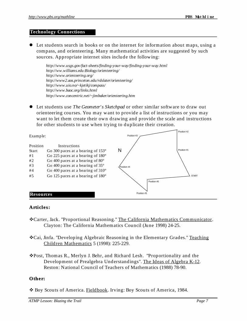
l Let students use The Geometer's Sketchpad or other similar software to draw outorienteering courses. You may want to provide a list of instructions or you maywant to let them create their own drawing and provide the scale and instructionsfor other students to use when trying to duplicate their creation.
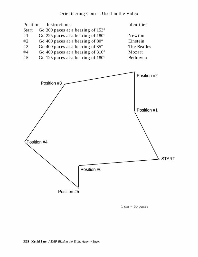
Example:
Position InstructionsStart Go 300 paces at a bearing of 153°#1 Go 225 paces at a bearing of 180°#2 Go 400 paces at a bearing of 80°#3 Go 400 paces at a bearing of 35°#4 Go 400 paces at a bearing of 310°#5 Go 125 paces at a bearing of 180°
Articles:Articles:
vCarter, Jack. "Proportional Reasoning." The California Mathematics Communicator. Clayton: The California Mathematics Council (June 1998) 24-25.
vCai, Jinfa. "Developing Algebraic Reasoning in the Elementary Grades." TeachingChildren Mathematics 5 (1998): 225-229.
vPost, Thomas R., Merlyn J. Behr, and Richard Lesh. "Proportionality and the Development of Prealgebra Understandings". The Ideas of Algebra K-12. Reston: National Council of Teachers of Mathematics (1988) 78-90.
Other:Other:
v Boy Scouts of America. Fieldbook. Irving: Boy Scouts of America, 1984.
Resources
Technology Connections
START
Position #1
Position #2
Position #3
Position #5
Position #4
Position #6
N
ATMP Lesson: Blazing the Trail Page 8
http://www.pbs.org/mathline PBS Mathline
vJackiw, Nicholas. The Geometer's Sketchpad softwareKey Curriculum Press, PO Box 2304, Berkeley, CA 94702-9983
vPrinciples and Standards for School of Mathematics (Draft), Reston, Virginia: National Council of Teachers of Mathematics (NCTM), 1998.http://www.nctm.org
vUS Geological Survey Mapshttp://mappings.usgs.gov/esic/order_forms/map_order.txt1-800-USA-MAPS or 1-800-HELP-MAPTo learn how to use a map or compass visit the following sites:http://info.er.usgs.gov/fact-sheets/finding-your-way/finding-your-way.htmlPart of the USGS site. A brief introduction to using maps and compasses.http://www.uio.no/~kjetikj/compass/Personal web site by Kjetil Kjernsmos. Provides detailed instructions for basics.http://www2.aos.princeton.edu/rdslater/orienteering/Comprehensive site about using maps and compasses. Includes resources andlinks. String lesson available.
Ideas are linked to the Principles and Standards for School Mathematics.
1. Considering the extra time and effort that they inevitably require, are field tripsrelated to mathematical objectives worth the effort?
2. Skills such as using a navigational compass are not likely to appear on a district orstate list of target mathematical objectives. In light of this fact, can a teacher justifythe time spent on teaching this skill in mathematics class? If so, how?
3. Many schools do not have a nearby space available for this type of activity. Howcould a teacher adapt the lesson and still obtain the same learning and motivationfor the students?
4. This lesson could be seen as an interdisciplinary effort that links social studies andmathematics. In your experience how valuable are such efforts? What other lessonshave you done successfully that link mathematics to other disciplines?
5. In what other real world contexts have you worked with students to promote thedevelopment of proportional reasoning?
6. How can activities involving opportunities for proportional reasoning bestructured to maximize the development of algebraic thinking?
Ideas for Online Discussion
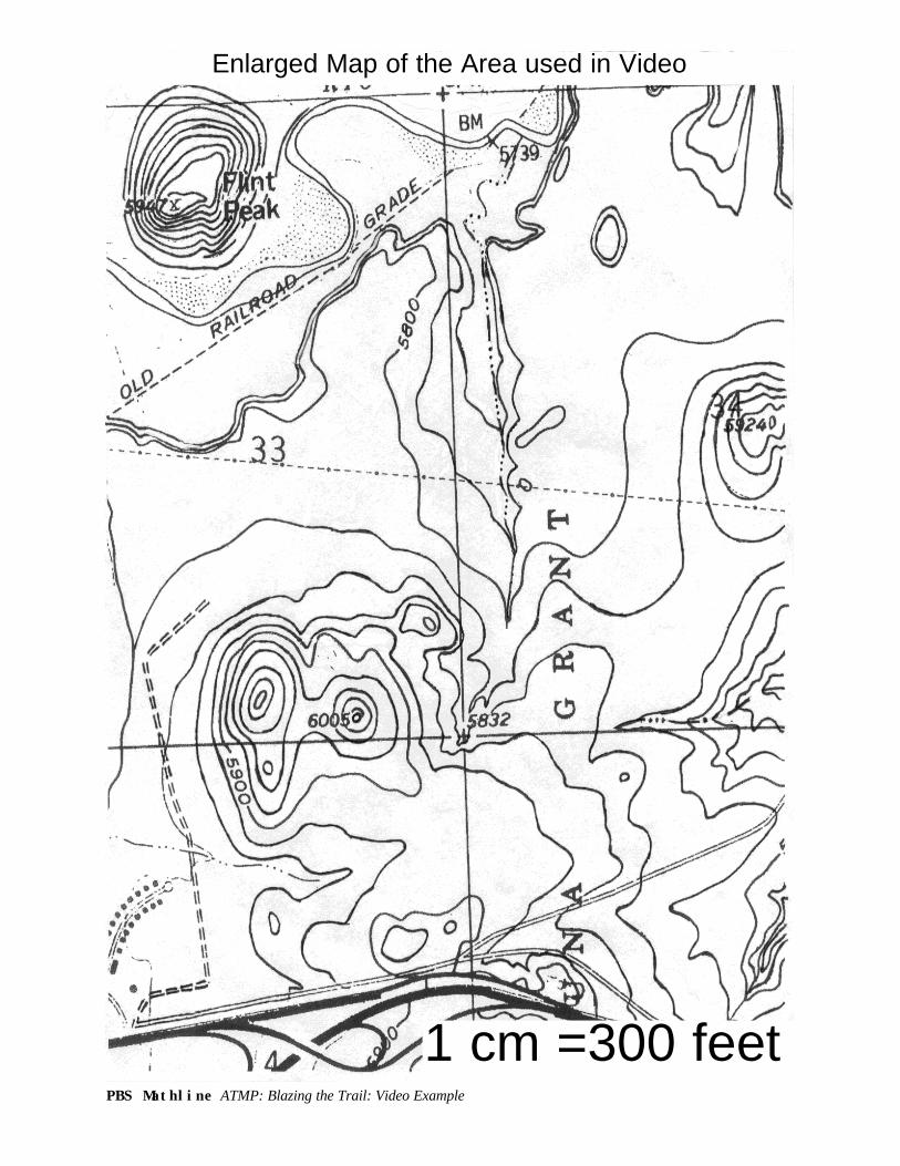
PBS Mathline ATMP: Blazing the Trail: Video Example
1 cm =300 feet
Enlarged Map of the Area used in Video
PBS Mathline ATMP: Blazing the Trail: Video Example
Start
1 cm =300 feet
Enlarged Map of the Area used in Video The scale on this map to assist in marking the bearing on the orienteering course.
PBS Mathline ATMP-Blazing the Trail: Activity Sheet
Orienteering Course Used in the Video
Position Instructions IdentifierStart Go 300 paces at a bearing of 153°#1 Go 225 paces at a bearing of 180° Newton#2 Go 400 paces at a bearing of 80° Einstein#3 Go 400 paces at a bearing of 35° The Beatles#4 Go 400 paces at a bearing of 310° Mozart#5 Go 125 paces at a bearing of 180° Bethoven
START
Position #1
Position #2
Position #3
Position #5
Position #4
Position #6
1 cm = 50 paces
PBS Mathline ATMP-Blazing the Trail: Activity Sheet
Landmark Distances Name______________________________
Date_______________________________
I. Landmarks:__________________________and__________________________
Estimated Distance Apart_________________
Work Space:
Actual Distance:_____________________
I. Landmarks:__________________________and__________________________
Estimated Distance Apart_________________
Work Space:
Actual Distance:_____________________


![[Teacher Name] presents: Blazing the Biodiversity Trail in Brazil](https://img.pdfslide.us/doc/110x75/568164d9550346895dd71fb4/teacher-name-presents-blazing-the-biodiversity-trail-in-brazil.jpg)