Embed Size (px)
Citation preview

Geomorphology 368 (2020) 107348
Contents lists available at ScienceDirect
Geomorphology
j ourna l homepage: www.e lsev ie r .com/ locate /geomorph
Biogeomorphological responses of nebkhas to historical long-term landuses in an arid coastal aeolian sedimentary system
Néstor Marrero-Rodríguez ⁎, Leví García-Romero, Carolina Peña-Alonso, Antonio I. Hernández-CorderoGrupo de Geografía Física y Medio Ambiente, Instituto de Oceanografía y Cambio Global, IOCAG, Universidad de Las Palmas de Gran Canaria, ULPGC, Spain
⁎ Corresponding author.E-mail addresses: [email protected] (N.
[email protected] (L. García-Romero), [email protected]@ulpgc.es (A.I. Hernández-Cordero).
https://doi.org/10.1016/j.geomorph.2020.1073480169-555X/© 2020 Elsevier B.V. All rights reserved.
a b s t r a c t
a r t i c l e i n f oArticle history:Received 3 March 2020Received in revised form 8 July 2020Accepted 10 July 2020Available online 19 July 2020
Keywords:Land usesNebkhasEnvironmental changesHistorical ecology
Coastal dunes have received growing attention in recent years because of the ecosystem services they provideand the high anthropic pressure that they have historically been subjected to and continue to endure. Such pres-sure especially affects arid dune fieldswhere any changes aremore noticeable due to their natural dynamics. Theaimof this paper is to analyze the relationship between thedegradation of an arid aeolian sedimentary system(ElMédano, Tenerife, Spain) due to historical long-term land uses and its subsequent biogeomorphological evolu-tion. The methodology combines historical sources (historical documents, aerial and common photographsand oral sources) and current ones (orthophotos, LiDAR data and field work). In order to analyze the responseof the system to these uses, 8 plots were chosen in which 3 different historical land uses had resulted in thetotal or partial elimination of the vegetation and landforms. Biogeomorphological variables were measured on461 nebkhas in these plots. The main results show that the historical land uses studied in this paper(aerodrome, aggregate extraction and crop cultivation) modified the entire system, with changes observed in thetopography, vegetation cover and sediment availability for transport. Changes in topography and distancefrom shore were important factors in its recovery capacity. This research contributes to our understanding ofthe different aeolian sedimentary dynamics that can be detected in the same dune field (especially with nebkhalandforms) and is of particular importance for making appropriate environmental management decisions to fa-cilitate the recovery of the ecosystem.
© 2020 Elsevier B.V. All rights reserved.
1. Introduction
The study of coastal dunes has attracted growing attention in recentyears because of the importance of the ecosystem services they provide(Miththapala, 2008; Everard et al., 2010; Barbier et al., 2011). However,human uses and direct/indirect anthropogenic pressure have led totheir rapid degradation in recent decades (Paskoff, 1993, 2001;Jackson and Nordstrom, 2011; Delgado-Fernandez et al., 2019).
The coastal aeolian systems of the planet have been exposed to aprocess of anthropic degradation related to traditional activities suchas grazing, obtaining firewood or agriculture (Tsoar and Blumberg,2002; Kutiel et al., 2004; Levin and Ben-Dor, 2004; Provoost et al.,2011) and to recent uses such as aggregate extraction, the constructionof urbanizations and tourist infrastructure, and recreational uses(Nordstrom and McCluskey, 1985; Nordstrom, 1994; Nordstrom,2004; Smith et al., 2017; García-Romero et al., 2019b; Delgado-Fernández et al., 2019). All these uses have induced environmentaltransformations whose consequences have been, among others,
Marrero-Rodríguez),pgc.es (C. Peña-Alonso),
changes in landforms and aeolian sedimentary activity (dune stabiliza-tion) (Cabrera-Vega et al., 2013; Hernández-Cordero et al., 2018), re-ductions of pioneer plants in mobile dunes and species richness(Kutiel et al., 1999; Curr et al., 2000; Dolnik et al., 2011; Faggi andDadon, 2011), sediment remobilization (Arens et al., 2013), acceleratederosion processes (García-Romero et al., 2016; García-Romero et al.,2019b), alteration of the direction and speed of wind flow(Hernández-Calvento et al., 2014; Smith et al., 2017; García-Romeroet al., 2019a), and on occasions surface reduction (Hernández-Corderoet al., 2018). It can be argued, therefore, that most of the surviving eco-systems are an expression of their resilience and that their evolutionafter the land uses is not restricted to the recovery of the original func-tions and characteristics but to the adaptation and reorganization of thecomponents of the landscape to the post-disturbance situation(Kombiadou et al., 2019).
Knowledge of the evolution of land uses, vegetation, landforms andenvironmental dynamics facilitates reconstruction of the historical tra-jectory of these ecosystems (Bürgi and Gimmi, 2007), as well as to un-derstand the mechanisms of response to the different disturbances. Inaddition, historical data can help to improve the accuracy of predictivemodels of ecosystem or species response to such impacts (Gimmi andBugmann, 2013). Historical reconstruction is therefore a useful tool

2 N. Marrero-Rodríguez et al. / Geomorphology 368 (2020) 107348
that can be employed to facilitate the implementation of managementstrategies that foster ecosystem resilience (Fritschle, 2009; Grossingeret al., 2007; Villagra et al., 2009), to confront new anthropic distur-bances caused by climate change (Petit and Prudent, 2010) or changesin land use (Jackson and Nordstrom, 2011), and to deal with changingenvironmental factors such as a reduced sediment contribution (Pyeand Blott, 2012; Hernández-Calvento et al., 2014). An awareness andunderstanding of the historical processes that have taken place can con-tribute to reducing the vulnerability of these ecosystems to new impacts(Peña-Alonso et al., 2018) through the application ofmanagementmea-sures adapted to the dynamics of socio-ecological processes(Garnasjordet et al., 2012).
In arid dune systems, the degradation process due to different his-torical land uses has led to the elimination of vegetation and associatedlandforms through sediment remobilization, as has happened for exam-ple in the Canary Islands (Spain) with particular reference to nebkhas(Marrero-Rodríguez et al., 2019). Meanwhile, more recent land usesand the abandonment of traditional ones have led to the stabilizationof sand sheets as the result of the plant recolonization processes(Tsoar and Blumberg, 2002; Kutiel et al., 2004; Marrero-Rodríguezet al., 2020). In other studies, recent land uses, associated especiallywith urban-tourismdevelopment, have been attributedwith causing al-terations to wind dynamics and a lower sand input, with a consequentreduction or disappearance of mobile dunes or an increase in deflationsurfaces and stabilized dunes (Hernández-Calvento et al., 2014; Smithet al., 2017; García-Romero et al., 2016, 2019a, 2019b).
Fig. 1. Location of the study area and historical limits of the aeolian system of El Médano. Botto2008.Aerial photo source: SDI Canarias (Canary Islands Government-Grafcan S.A.).
In the Canary Islands, coastal mobile dunes have been transformedinto nebkha fields over the last 60 years due to the abandonment of tra-ditional uses (Santana-Cordero et al., 2016a; Marrero-Rodríguez et al.,2020). Due to their specific properties, nebkhas represent patches ofhighwater and nutrient availability for plants and can affect plant diver-sity (El-Bana et al., 2003), which depends on the vegetation fixing thesand. Nebkhas play an important role in stabilizing surface sand sheets,preventing their erosion and facilitating the settlement and survival ofnew plants (Brown and Porembski, 1997; Blank et al., 1998; El-Banaet al., 2002a; El-Bana et al., 2003). Vegetation additionally increases ter-rain roughness (King et al., 2006), which in turn lowers the wind speedand, therefore, affects its transport capacity and its capacity to erode theaeolian sedimentary system.
Arid coastal dune systems can change over relatively short periods oftime (Hernández-Cordero et al., 2006) and are therefore a natural labo-ratory to investigate dune disturbances. The response of dune systemsafter erosion or remobilization processes has beenwell studied in refer-ence to hurricane effects (Morton et al., 1994; Houser and Hamilton,2009), uses that modified sediment transport such as grazing orobtaining firewood (Kutiel et al., 2004; Levin and Ben-Dor, 2004), land-form transformation (Tsoar and Blumberg, 2002) or ecological restora-tion projects (Xu et al., 2018). However, the analysis of the recoveryprocess of landforms and the recolonization of vegetation after the ces-sation of land uses which have affected them has been less studied. Thisis because in many cases the systems have been partially or totally ur-banized (Santana-Cordero et al., 2016b), with the constructions often
m right-hand corner: mean wind direction and speed in the study area between 1980 and

Table 1Aerial photographs, orthophotos and LiDAR data used.
Type (source) Year Scale Spatialresolution(m)
RMSa (m) Delineationerror (m)
Historical aerialphotographs
1964c 1:30,000 1 1.05–2.05 6.21987c 1:18,000 0.4 1.25–2.05 3.7
Orthophotos 2018c b 0.1 b 1.5 0.1LiDAR (DEM) 2009d – 1 – –
2015d – 1 – –
The delineation error was calculated according to Robinson et al. (1987).a RMS = root mean square.b Flight with GSD de 22.5 cm/píxel.c SDI Canarias (Canary Islands Government-Grafcan S.A.).d National Geographical Institute (Spain).
3N. Marrero-Rodríguez et al. / Geomorphology 368 (2020) 107348
occupying the areaswhere the sediment enters the aeolian sedimentarysystem (García-Romero et al., 2016). This makes it impossible to mea-sure biogeomorphological variables from the coastline inland and,using this information, study how the system has responded to the ces-sation of the historical land uses. In view of all the above, the aim of thisarticle is to analyze the transformation process of an aeolian sedimen-tary system situated in El Médano (Tenerife, Canary Islands, Spain),with particular emphasis on historical land uses. The subsequent pro-cess of plant recolonization and the development of associated land-forms (especially nebkhas) after the cessation of the different landuses that are identified in the study is also analyzed. A further aim isto determine the land uses that generated the greatest impact on theforedune and, therefore, on the rest of the system. The final aim is toidentify the different biogeomorphological gradients between thecoastline and the interior of the aeolian sedimentary system.
2. Study area
The aeolian sedimentary system of El Médano is located on thesouthern coast of the island of Tenerife, in themunicipality of Granadillade Abona (Fig. 1). The sediments are the result of a mixture of sandsfrom inland sources of local ravines and marine contributions inwhich organogenic and inland sands are mixed. The marine contribu-tions are transported along the coastal drift to the rocky ledges of Mon-taña Pelada, El Cabezo and Montaña Roja, which impede them fromcontinuing their journey. Once they have been deposited, the wind dy-namics take over, giving rise to the genesis of different landforms in-cluding climbing dunes and dunes associated to vegetation (Criadoet al., 2011). Finally, the action of the dominant ENE wind (Fig. 1 insert)transports the sand to the leeward sector, where the marine dynamicsintervene again redistributing the sediments. On the beach of MontañaPelada, the sediments ascend through the ravine until they reach theroad and the houses, and during episodes of intense rainfall, they arereturned to the beach. In the past, at Montaña Roja, sediments ranalong a sandy corridor approximately 1.6 km long in a NE-SWdirection,with LeocadioMachado beach acting as a sediment input sector and theSW sector of La Tejita and El Confital as a leeward sector where the sed-iment is again exposed tomarine dynamics (IGME, 1972). However, theSE of La Tejita sector also acts as a sediment input zone. This is mainlydue to the presence of Montaña Roja which also acts as a vortex that al-ters the circulation of the winds (from NE-SW to SW-NE) that push thesediments inland. This can be observed in the climbing dune located inthe SW of Montaña Roja or in the direction of the shadow dunes of LaTejita. It is likely that, in the past, this same process occurred in othersectors of the coast such as La Jaquita and El Cabezo today transformedby urbanization.
The climate is characterized by aridity, with an annual averagerainfall of 83 mm and annual average temperature of around 21 °C(García-Casanova et al., 1996). The vegetation that corresponds tothese conditions is shrubby with poor cover and is adapted to the con-ditions of salinity and sediment mobility, although there are importantinland variations where plant communities associated to ravines, rockyoutcrops and areas of strong flooding appear. Of particular importancein the study area are the different so-called Habitats of European Inter-est. These habitats are as follows: 1210 Annual vegetation of drift lines;2110 Embryonic shifting dunes; 92D0 Southern riparian galleries andthickets; and one priority habitat, 2130 Fixed coastal dunes with herba-ceous vegetation. The system is partially urbanized in the form of thetown of El Médano and scattered buildings towards Montaña Pelada.
3. Methodology
Themethodological process has twomain stages: i) characterizationof the historical evolution of the system and the identification of histor-ical land uses that significantly altered the system; ii) statistical analysisof the relationship between current nebkha characteristics and the
detected historical land uses. In this second stage, the gradients thatare detected in the measured variables (ratio between the variation ofthe value of a nebkha characteristic and its distance to the coast) are an-alyzed in depth to determine any difference between land uses in termsof biogeomorphological recovery/development.
3.1. Historical characterization and identification of land uses
The procedure to analysis the historical evolution of the studieddune system was carried out from an historical ecology perspective,using the historical information sources commonly used in such anapproach.
3.1.1. Documentary sources and historical bibliographic referencesAn analysis wasmade of numerous historical documents of differing
origin collected in themunicipal archive of Granadilla de Abona and thearchive of the Tenerife Friends of Nature Association (ATAN - AsociaciónTinerfeña de Amigos de la Naturaleza) - who have drawn up restorationplans and fought through the courts to protect the area - as well as dif-ferent historical bibliographies (De Olive, 1885; López-Soler, 1906;Escolar Serrano, 1984). Historical field photographs were also used tovisualize and determine the state of the system in the past. Thesewere found in private archives, ATAN's photographic collection andthe collections of the Foundation for Ethnography and the Developmentof Canary Crafts (FEDAC). In addition, the Jable search tool of the Univer-sity of Las Palmas de Gran Canaria Library was used to find and reviewrelevant articles in the local press and to obtain information from the re-cords of theOfficial Gazette of the Canary Islands Government regardinglicenses for the extraction of aggregates.
3.1.2. Historical aerial photographs, orthophotos and LiDAR dataThese sources (Table 1) were used to contrast information from his-
torical documents and interviews, to spatially determine environmen-tal/land use changes and the creation of urban nuclei, and to delimitthe historical area of the aeolian sedimentary system. The historical ae-rial photograph of 1964 (1:30,000) was georeferenced in a geographicinformation system (GIS) through checkpoints and was used, alongwith the rest of the aerial documents, to obtain spatial information onland cover (uses, vegetation and landforms). Light detection and rang-ing (LiDAR) measurements taken in 2009 and 2015 were also used toobtain digital elevation models (DEM) with a 1 m spatial resolution.Volumetric changes were calculated from these DEMs using the geo-morphic change detection technique developed by Wheaton et al.(2010a, 2010b). The DEM of difference (DoD) error (%) of the erosion:25.18 and the accumulation: 24.86 (Fig. 6).
3.1.3. Wind dataWind variables (mean wind speed and direction and percentage of
calms) were calculated from data recorded at a weather station

Fig. 2. Nebkha field in the study area. A) Lagoon location.
4 N. Marrero-Rodríguez et al. / Geomorphology 368 (2020) 107348
owned by AEMET (State Meteorology Agency in Spain) and situated inReina Sofía airport 2.5 km northwest of the study area (Fig. 1).
3.1.4. Field workTwo field campaignswere carried out in September of 2018 and Jan-
uary of 2019. In thefirst campaign, the objectiveswere to conduct inter-views, take repeat field photographs, and to contrast in the fieldinformation acquired in the interviews and from the analysis of aerialphotographs. With respect to the oral sources, three interviews wereconducted to collect information on human uses. The interviews werebased on a semi-structured conversation between an interviewer andan intervieweewith an open script following the oral historymethodol-ogy of Fogerty (2005). The interviews were carried out with peopleborn between 1942 and 1948, tourism-based camel owners and portworkers. During these campaigns, the locations of disused lime kilnsand bunkers were identified, as well as the locations of other activities,including areas used until relatively recently for the extraction of aggre-gates and areas currently in use for wastewater discharges. Areas withTraganum moquinii plant communities were also identified since thisplant plays an important role in the development of the foredune. Thelocational data was recorded with GPS for later incorporation into aGIS and used to identify the plants in the historical aerial photographsfollowing the methodology used by Hernández-Cordero et al. (2012).
Based on the information obtained from the historical sources andmapping the different historical land uses in GIS, eight plots (100 ×100 m) were selected for the purposes of this study along three tran-sects in areas affected by different land uses: an old aerodrome (A1, A2and A3), an aggregate extraction area (E1, E2 and E3) and a crop cultiva-tion area (C1 and C2) (red squares in Figs. 1 and 4). The possibility ofusing control plots was discarded because anthropic impacts have af-fected practically the entire system. Plot orientation follows as closelyas possible the line of sediment transport. Ideally, the C1 and C2 studyplot positions would have been situated and orientated slightly differ-ently, but due to the impact of the transit of people over a large numberof trails and the location of an old car parking area, these positionswerethe only feasible areas where it was possible to locate the plots andallow a study of the biogeomorphological responses related to cropsand, in thisway, obtain sufficient statistical data for the study. These his-torical land uses and therefore the plotswere selected for three reasons:i) the effects of the land uses in question stretched from the foreduneright into the aeolian system; ii) the areas are now free of any landuse; and iii) unlike the built-on land, there are variables in these areasthat can be measured to know the current nebkha characteristics. Inthe field work undertaken in January of 2019, data related to nebkhalandforms (Fig. 2) were collected, including morphological variables:height (m), longitudinal axis -or length- in the direction of thesedimentary dynamics and shadow dunes (m), and transverse axis -orwidth- perpendicular to the longitudinal axis (m); variables related tothe vegetation which form these landforms: percentage of vegetationcover, species richness (number of species per nebkha) and presence ofT. moquinii; plant status variables (presence/absence) in accordancewith Ley et al., 2007 as indicators of i) wind effect: exhumed roots, dryfront and dry plants, ii) marine incidence: dry front and dry plants.
T. moquinii is singled out as a vegetation variable because thisplant plays a key role in the foredune formation process and, there-fore, in the operation of the entire dune system. The individuals ofthis plant can grow up to 5 m tall, creating an aeolian shadow thatcan sometimes extend up to 20 m in length (Alonso et al., 2007;Pérez-Chacón et al., 2007), and hence functioning as a sedimenttrap that induces the formation of dunes. This shrub barrier in thesediment input area regulates the transit of sediment inland, slowingtheir advance and generating the set of permanent dunes that cre-ates the foredune (Hernández-Cordero et al., 2012).
In addition, the distance between each nebkha and the coast wascalculated from the 2018 orthophoto. The variables were measured inrelation to a total of 461 nebkhas and the 13 most commonly found
plant species (Table 2). These plants are herbaceous and shrubby spe-cies mainly associated with rocky and sandy coasts, as well as arid envi-ronments and sand dunes. Therefore, most are species resistant to saltspray, marine flood and/or water scarcity. Currently, there is little infor-mation on the response of these plants to sand burial, except forT. moquinii. These species respond positively to aeolian sedimentary dy-namics, accelerating its growth when buried by sand (Hernández-Cordero et al., 2015a; Viera-Pérez, 2015). T. moquinii is a pioneer speciesthat generates embryonic dunes and the foredune, but it is also presentin the most advanced stages of plant succession (Hernández-Corderoet al., 2012; Hernández-Cordero et al., 2019). Of the other species,most can develop in aeolian sedimentary systems with little sand vol-ume (sand sheets and nebkhas fields), as Astydamia latifolia, Atriplexglauca, Lotus sessilifolius, Polycarpaea nivea and Tetraena fontanesii,and/or stabilized dunes of dunefields, as Launaea arborescens, Plocamapendula and Salsola vermiculata (García-Casanova et al., 1996;Hernández-Cordero et al., 2015b; Hernández-Cordero et al., 2019). Sofar, fieldwork observations indicate that these species are not resistantto the burial of a large volume of sand, dying when the dune increasesits height.
3.2. Relationship between biogeomorphological processes and land uses
Based on the variables described in Section 3.1 with respect to the461nebkhas located in the eight study plots, a Spearman's bivariate cor-relation analysis was performed using SPSS in order to find patterns ofdune behavior from the variables considered and the distance to thecoast. The Kruskal-Wallis test was applied complemented by Dunnett'stest to identify statistically significant differences between the three his-torical land uses analyzed and thereby enable the specific identificationof diverse patterns among the land uses.
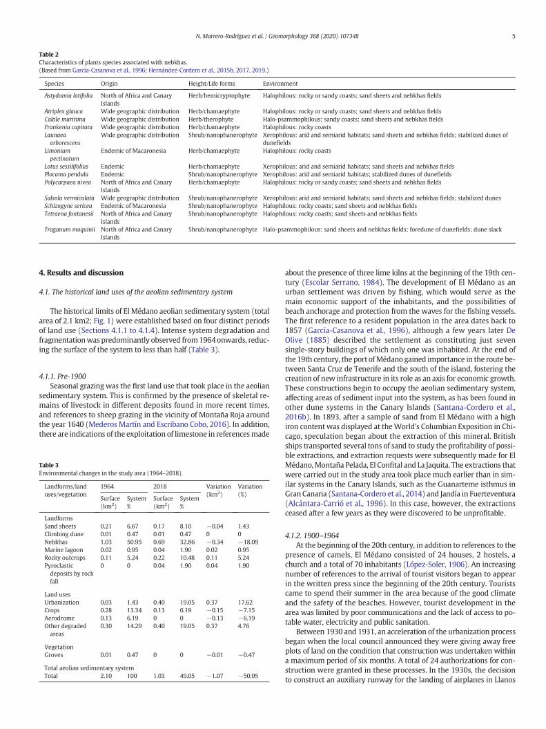
Table 2Characteristics of plants species associated with nebkhas.(Based from García-Casanova et al., 1996; Hernández-Cordero et al., 2015b, 2017, 2019.)
Species Origin Height/Life forms Environment
Astydamia latifolia North of Africa and CanaryIslands
Herb/hemicryptophyte Halophilous: rocky or sandy coasts; sand sheets and nebkhas fields
Atriplex glauca Wide geographic distribution Herb/chamaephyte Halophilous: rocky or sandy coasts; sand sheets and nebkhas fieldsCakile maritima Wide geographic distribution Herb/therophyte Halo-psammophilous: sandy coasts; sand sheets and nebkhas fieldsFrankenia capitata Wide geographic distribution Herb/chamaephyte Halophilous: rocky coastsLaunaeaarborescens
Wide geographic distribution Shrub/nanophanerophyte Xerophilous: arid and semiarid habitats; sand sheets and nebkhas fields; stabilized dunes ofdunefields
Limoniumpectinatum
Endemic of Macaronesia Herb/chamaephyte Halophilous: rocky coasts
Lotus sessilifolius Endemic Herb/chamaephyte Xerophilous: arid and semiarid habitats; sand sheets and nebkhas fieldsPlocama pendula Endemic Shrub/nanophanerophyte Xerophilous: arid and semiarid habitats; stabilized dunes of dunefieldsPolycarpaea nivea North of Africa and Canary
IslandsHerb/chamaephyte Halophilous: rocky or sandy coasts; sand sheets and nebkhas fields
Salsola vermiculata Wide geographic distribution Shrub/nanophanerophyte Xerophilous: arid and semiarid habitats; sand sheets and nebkhas fields; stabilized dunesSchizogyne sericea Endemic of Macaronesia Shrub/nanophanerophyte Halophilous: rocky coasts; sand sheets and nebkhas fieldsTetraena fontanesii North of Africa and Canary
IslandsShrub/nanophanerophyte Halophilous: rocky coasts; sand sheets and nebkhas fields
Traganum moquinii North of Africa and CanaryIslands
Shrub/nanophanerophyte Halo-psammophilous: sand sheets and nebkhas fields; foredune of dunefields; dune slack
5N. Marrero-Rodríguez et al. / Geomorphology 368 (2020) 107348
4. Results and discussion
4.1. The historical land uses of the aeolian sedimentary system
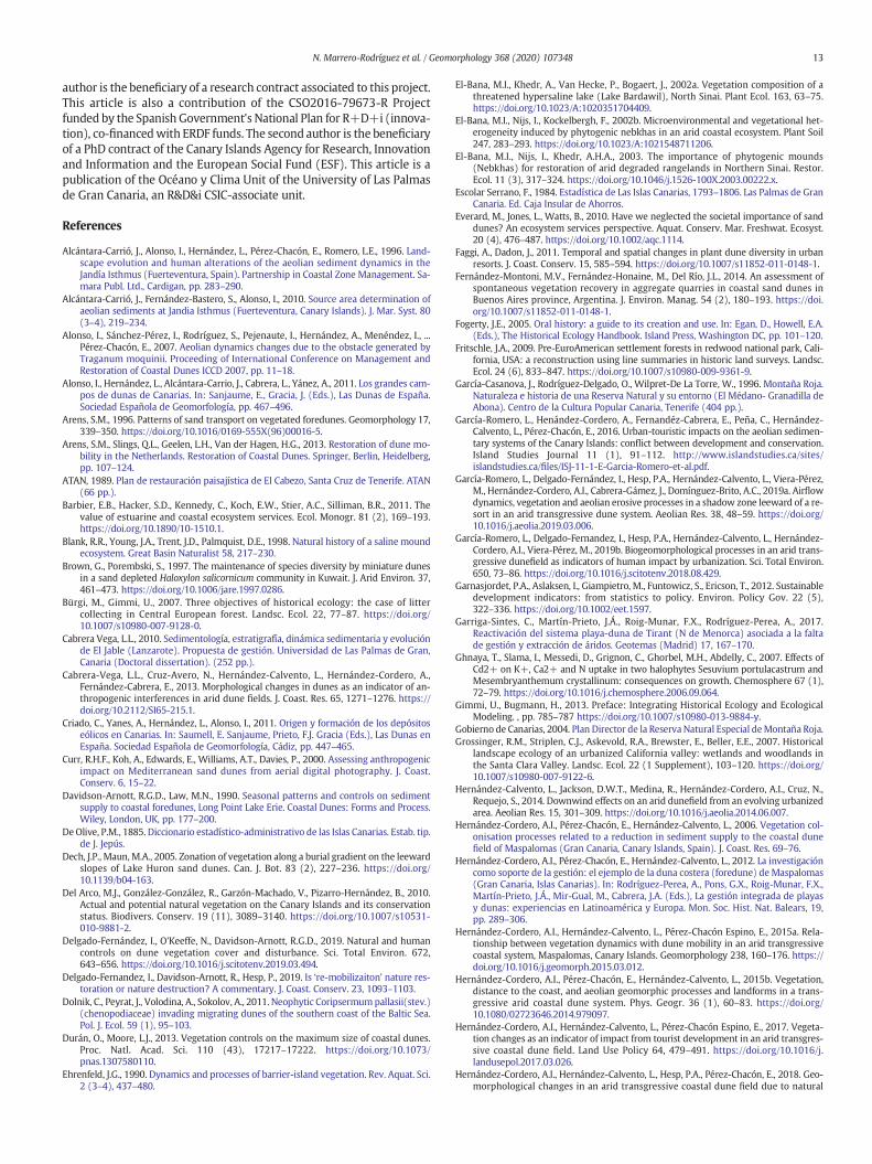
The historical limits of El Médano aeolian sedimentary system (totalarea of 2.1 km2; Fig. 1) were established based on four distinct periodsof land use (Sections 4.1.1 to 4.1.4). Intense system degradation andfragmentationwas predominantly observed from1964onwards, reduc-ing the surface of the system to less than half (Table 3).
4.1.1. Pre-1900Seasonal grazing was the first land use that took place in the aeolian
sedimentary system. This is confirmed by the presence of skeletal re-mains of livestock in different deposits found in more recent times,and references to sheep grazing in the vicinity of Montaña Roja aroundthe year 1640 (Mederos Martín and Escribano Cobo, 2016). In addition,there are indications of the exploitation of limestone in referencesmade
Table 3Environmental changes in the study area (1964–2018).
Landforms/landuses/vegetation
1964 2018 Variation(km2)
Variation(%)
Surface(km2)
System%
Surface(km2)
System%
LandformsSand sheets 0.21 6.67 0.17 8.10 −0.04 1.43Climbing dune 0.01 0.47 0.01 0.47 0 0Nebkhas 1.03 50.95 0.69 32.86 −0.34 −18.09Marine lagoon 0.02 0.95 0.04 1.90 0.02 0.95Rocky outcrops 0.11 5.24 0.22 10.48 0.11 5.24Pyroclasticdeposits by rockfall
0 0 0.04 1.90 0.04 1.90
Land usesUrbanization 0.03 1.43 0.40 19.05 0.37 17.62Crops 0.28 13.34 0.13 6.19 −0.15 −7.15Aerodrome 0.13 6.19 0 0 −0.13 −6.19Other degradedareas
0.30 14.29 0.40 19.05 0.37 4.76
VegetationGroves 0.01 0.47 0 0 −0.01 −0.47
Total aeolian sedimentary systemTotal 2.10 100 1.03 49.05 −1.07 −50.95
about the presence of three lime kilns at the beginning of the 19th cen-tury (Escolar Serrano, 1984). The development of El Médano as anurban settlement was driven by fishing, which would serve as themain economic support of the inhabitants, and the possibilities ofbeach anchorage and protection from the waves for the fishing vessels.The first reference to a resident population in the area dates back to1857 (García-Casanova et al., 1996), although a few years later DeOlive (1885) described the settlement as constituting just sevensingle-story buildings of which only one was inhabited. At the end ofthe 19th century, the port ofMédano gained importance in the route be-tween Santa Cruz de Tenerife and the south of the island, fostering thecreation of new infrastructure in its role as an axis for economic growth.These constructions begin to occupy the aeolian sedimentary system,affecting areas of sediment input into the system, as has been found inother dune systems in the Canary Islands (Santana-Cordero et al.,2016b). In 1893, after a sample of sand from El Médano with a highiron content was displayed at theWorld's Columbian Exposition in Chi-cago, speculation began about the extraction of this mineral. Britishships transported several tons of sand to study the profitability of possi-ble extractions, and extraction requests were subsequently made for ElMédano,Montaña Pelada, El Confital and La Jaquita. The extractions thatwere carried out in the study area took place much earlier than in sim-ilar systems in the Canary Islands, such as the Guanarteme isthmus inGran Canaria (Santana-Cordero et al., 2014) and Jandía in Fuerteventura(Alcántara-Carrió et al., 1996). In this case, however, the extractionsceased after a few years as they were discovered to be unprofitable.
4.1.2. 1900–1964At the beginning of the 20th century, in addition to references to the
presence of camels, El Médano consisted of 24 houses, 2 hostels, achurch and a total of 70 inhabitants (López-Soler, 1906). An increasingnumber of references to the arrival of tourist visitors began to appearin the written press since the beginning of the 20th century. Touristscame to spend their summer in the area because of the good climateand the safety of the beaches. However, tourist development in thearea was limited by poor communications and the lack of access to po-table water, electricity and public sanitation.
Between 1930 and 1931, an acceleration of the urbanization processbegan when the local council announced they were giving away freeplots of land on the condition that construction was undertaken withina maximum period of six months. A total of 24 authorizations for con-struction were granted in these processes. In the 1930s, the decisionto construct an auxiliary runway for the landing of airplanes in Llanos

6 N. Marrero-Rodríguez et al. / Geomorphology 368 (2020) 107348
de Rojas was made due to the occasional fog-related impossibility ofplanes landing at the airport in the north of the island. The aerodromewas opened in August 1935, but only sporadically received flightsuntil the 1960s.
Requests began to be made to create plant barriers in the El Cabezoarea, similar to the one built in Jandía in Fuerteventura (Alcántara-Carrió et al., 1996), to restrict the impact of wind-blown sand, indicatingthe presence of significant amounts of sand. After the end ofWorldWarII, and thanks principally to the construction of the island's southerncanal in the 1940swhich enabled the transfer ofwater fromnearbymu-nicipalities, tomato crop cultivation (extensively practiced in the islandsin general) made its first appearance in the area. Tomato plantationssprung up in Punta de El Cabezo, on the slopes of Montaña Roja, andthroughout practically the entire northern limit of the system.
The aerodrome was reconditioned in 1947 with a runway approxi-mately 750m long and 70mwide and an altered surface for its installa-tion of 0.13 km2. This rebuild involved the total elimination ofvegetation and associated landforms, as can be seen from the aerial pho-tography of 1964 and the field photograph (Fig. 4A). Despite the crea-tion of the aerodrome in 1935, the expansion of tourism came late tothis area of the island. However, in the same year as its rebuild, thegrowing importance of tourism is seen in the inauguration of El MédanoHotel which acted as a driving force behind future tourist developmentin the area.
With respect to the exploitation of limestone, there are only a fewreferences in the historical documents. The stone was brought fromFuerteventura and burned in the kilns located on the coast and thentaken to inland villages. According to oral sources, the firewood usedin the kilns was brought from pine forests and shrubs located around1000–1500 m above sea level (about 12 linear kilometers from ElMédano). The same sources reported that little grazing took place inthe system, and only on a seasonal basis since most of the herds werekept at higher altitudes and only descended to the coast when weather
Fig. 3. Evolution of the number of T. moquinii specimens in el Cabezo, La Tejita and Leocadio MMachado in 1990 (Author: J. García-Casanova) and 2019. Aerial photograph and orthophoto oAerial photo source: SDI Canarias (Canary Islands' Government-Grafcan S.A.).
conditions worsened. The presence of camels and mules used for trans-port purposes was common, but they tended to be fed with cereal cropremains and fodder plants. In this context, it is likely that two of the his-torical land uses that have been found to have had the greatest impacton aeolian sedimentary systems in other islands of the Canary Islandsand in Israel, namely the exploitation of vegetation to obtain fuel andfor grazing purposes (Santana-Cordero et al., 2016a; Tsoar andBlumberg, 2002; Kutiel et al., 2004) did not have the same importancein ElMédanodue to theproximity of pine forests and other grazing land.
4.1.3. 1964–1987In this period, the abandonment of tomato cultivation occurs at the
same time as tourism expands rapidly and extensively in the south ofTenerife and the exploitation of limestone ceases, replaced by the ce-ment trade and imported synthetic paints. In 1965, the General UrbanDevelopment Plan of themunicipality reclassified a large part of the ae-olian sedimentary system as land for development, requiring a PartialPlan for its urbanization which was published in 1968 but never exe-cuted. In the corresponding Plans, a strategy of massive occupation ofthe coast is proposed with a coastal road as the main axis and a centralroad in the town of El Médano. The expansion of the construction sectorand the demand for aggregates for the proposed new airport in thesouth of the island gave rise to the beginning of massive sand extrac-tions in 1970. These extractions, which are clearly visible in the field(Fig. 3), generated a depressed area into which water could seep athigh tide resulting in the formation of a small lagoon behind the currentcoastal dune. Extractions were carried out in an area covering some175,000 m2, and the approximate total volume of extracted materialamounted to 200,000m3 (Canary Islands Government, 2004). In conse-quence, the coastal dune that existed at the time and the associated veg-etation were eliminated (Fig. 4B), causing a significant decline inT. moquinii populations. The local aerodrome was finally closed in1975, the same year in which the Reina Sofía International Airport
achado between 1964 and 2019 (Graph). Repeat photograph of the foredune of Leocadiof the foredune of Leocadio Machado.

Fig. 4. Left: Main historical land uses in the study area and built surface in 1964, 1987 and 2018. Orthophoto source: SDI Canarias (Canary Islands Government-Grafcan S.A.). Right: A:Aerodrome (Author: Alemany Nuez, P., 1964); B: Aggregate extraction (Author: García-Casanova, J., 1990); C: Car parking areas at Leocadio Machado beach (Author: García-Casanova,J., 1990); D: Car parking area and materials for building at La Tejita beach (ATAN, 1989).
7N. Marrero-Rodríguez et al. / Geomorphology 368 (2020) 107348
was inaugurated in the south of the island. The urban developmentwork proposed years earlier finally began in 1985 and led to the disap-pearance of various plant communities, including the groves of Tamarixcanariensis (Table 3) shrubs whichwere situated next to the pier cover-ing an area of 0.01 km2 and forming part of the El Cabezo aeolian land-forms (ATAN, 1989).
4.1.4. From 1987 to the present dayIn 1987, Montaña Roja and the sandy corridor between Leocadio
Machado beach and La Tejita were declared a Nature Reserve of Na-tional Interest (Law 12/1987, of June 19, on the Declaration of NaturalSpaces of the Canary Islands). The same area was reclassified in 1994as a Special Nature Reserve (Law 12/1994, of December 19, on NaturalAreas of the Canary Islands). However, the associated planning instru-ment for the protection of the area (Master Plan) was not definitivelyapproved until October 2004. While most of the activities that used tobe carried out have now ceased, someof their impacts remain, includingfor example, the dumped debris and sewage, the effects of the continu-ous transit of vehicles that accessed the beach (Fig. 4C andD)or the con-ditioning of the esplanade of the beach of La Jaquita for soccer practice.The elimination of road traffic inside the aeolian system was one of themost important protection results. In 2001, when the Tenerife Govern-ment began its Trail Rehabilitation Program, the tracks were closed toroad traffic and a car parking area was created north of La Tejitabeach. Finally, in 2013 a wall was built around theMontaña Pelada sec-tor with the aim of stopping the flow of sand towards the interior of theurbanization. Despite the environmental protection that was affordedby the legislation described above, the brake on human impacts was in-sufficient tomaintain or restore the natural dynamics of the system, un-like what happened in other wind sedimentary systems which did in
fact benefit from the same legislation (Santana-Cordero et al., 2016a).The result of the evolution of human uses has been a reduction (be-tween 1964 and 2018) in the areas occupied by nebkhas to 0.69 km2
and an increase in flooded surfaces (0.04 km2). In addition, a significantamount of land has been occupied by urbanization (0.4 km2) or de-graded surfaces (0.4 km2) for the creation of car parking lots, debrisdumping or plots whose construction was abandoned (Table 3). Therehas also been a recovery in the populations of T. moquinii since 1987and an increase in the length of the foredune on Leocadio Machadobeach from102.8m in 1987 to 257m in 2018 (Fig. 3). Likewise, newde-posits of pyroclasts have been observed that have become detachedfrom the volcanic cones present in the limits of the wind system.
The reconstruction of the historical land uses shows that the impactthat traditional activities had on the ecosystemwas very limited, unlikeother similar ecosystems such as the coastal dunes of Israel (Tsoar andBlumberg, 2002; Kutiel et al., 2004; Levin and Ben-Dor, 2004) or othersuch systems in the Canary Islands (Marrero-Rodríguez et al., 2020;Santana-Cordero et al., 2016a). This seems to be due to the existenceof abundant pine forest resources in the vicinity and the late occupationof this system and its surroundings. In El Médano, only a small sectorwas used for agriculture and seasonal grazing when climatic conditionswere unfavorable at higher altitudes. It is the more recent land uses,which have mostly taken place since 1947 with the construction ofthe old airfield (urbanization, development of transport roads, aggre-gate extraction, recreational uses, among others), that are in all proba-bility responsible for the widespread degradation in the system(Fig. 5), as has been demonstrated in places such as Fire Island in NewYork and other sites in the Canary Islands (Nordstrom and McCluskey,1985; Nordstrom, 1994; Nordstrom, 2004; Cabrera-Vega et al., 2013;Hernández-Calvento et al., 2014; García-Romero et al., 2016).

Fig. 5. Ecosystem status before and after the historical land uses analyzed in this paper.
8 N. Marrero-Rodríguez et al. / Geomorphology 368 (2020) 107348
4.2. Statistical analysis of the biogeomorphological processes/gradients inthe sample plots
Statistically significant differences were found between the threeidentified historical land uses in the variables studied: morphologicalvariables - height (p b 0.01; K-W test X2 62.3), longitudinal axis (p b
0.01; K-W test X2 22.3) and transverse axis (p b 0.001; K-W test X2
16.6); vegetation variables - cover (p b 0.05; K-W test X2 145.1),T. moquinii distribution (p b 0.01; K-W test X2 13.7) and species richness(p b 0.01; K-W test X2 13.6); and plant status variables - dry plants (p b
0.0001; K-W test X2 13.5) and Dry front (p b 0; K-W test X2 30.1). Nostatistically significant differences were found between the differenthistorical land uses for the variable exhumed roots (Table 4).
With respect to height, longitudinal axis and transverse axis, the dunessituated in the crop cultivation area are higher than those situated in theaggregate extraction and aerodrome areas, while no significant differ-ences were found in the morphological variables between the lattertwo land uses. Crop cultivation ceased in the 1960s, and the period oftime that has passed since then may have enabled the recovery of thecorresponding plots. This recovery may also be due to the greater sandsupply of the dunes, a fundamental factor in dune size (Davidson-Arnott and Law, 1990), and not to exposure as detected by vanPuijenbroek et al. (2017), because in this case the aerodrome and aggre-gate extraction areas are more exposed. Perhaps in the case of ElMédano, exposure is not significant because there are no seasonalchanges throughout the year (unlike temperate regions), and themain reason for recovery is sand supply because its origin is a mixtureof inland sources (local ravines,with rainfall) andmarine sources (prac-tically all year).
The crop cultivation area has the highest cover and also the lowestspecies richness. This may be because the crops, being fertilized, cangive rise to the growth of opportunistic plants (ruderal and generalistspecies) which replace other native or indigenous species, reducingthe richness of species (Nordstrom, 2003; Levin et al., 2007). There isa lower presence of T. moquinii specimens in the aggregate extraction
area than in the aerodrome or crop cultivation areas (Dunnett's testExtr.-Cult. Mean dif = −0.112, p = 0.036; Dunnett's test Extr.-Aero.Mean dif = −0.160, p = 0.001), with no statistically significant differ-ences between the latter two areas. The results also show a statisticallysignificant higher number of plants with dry plants in the aggregate ex-traction area than in the crop cultivation or aerodrome areas, againwith no statistically significant differences between the latter twoareas. Likewise, the aggregate extraction area has the highest numberof plants with dry front, and the aerodrome area more than the crop cul-tivation area. In this case, the exposure of the dunes is an important fac-tor for vegetation development (Moreno-Casasola, 1986; Hesp, 2002).
With respect to distance to the coast, a gradientwas found in terms ofnebkha dimensions. The dimensions decrease as distance to the coast in-creases, as seen in the morphological parameters height (Spearman'srho = −0.806, p b 0.01) (Fig. 4), longitudinal axis (Spearman's rho =−0.765, p b 0.01) and transverse axis (Spearman's rho = −0.765, p b
0.01). This may be due to plant height diminishing as the distance tothe coast increases. The plants which attain a greater height (asTraganum moquinii) tend to occur with less frequency further inlandand increase in the first few meters of the foredune, as also reportedfor other arid dune systems (Hernández-Cordero et al., 2015b). That isto say, on the one hand the vegetation modifies the deposition of thesand (Hesp, 1983; Arens, 1996; Keijsers et al., 2014) and, on the other,the highest dunes in the first few meters of the foredune can affect thewind flow pattern, thus affecting sand deposition (Walker andNickling, 2002). This causes exposed nebkhas to present a higher overallgrowth compared to protected (i.e. inland) nebkhas (van Puijenbroeket al., 2017).
4.2.1. AerodromeImportant differences were found in dunemorphology between the
different plots of the aerodrome area, with a gradient in themorpholog-ical variables of the nebkhas which is dependent on distance to the coastas for example the height (R2=0.6524). The height of the closest dunesto the beach (sample plot A1) was generally above 1 m, whereas those

Table 4Kruskal-Wallis test results. Significant at 0.05 (bilateral).
Contrast statistics (a,b)
Height Axis_Long Axis_Trans Cover T. moquinii Species richness Exhumed roots Dry plants Dry front Coast distance
X2 62.3 22.4 16.6 145.1 13.7 13.6 4.6 13.5 30.1 48.6p 0 0 0 0 0.001 0.001 0.102 0.001 0 0a Kruskal-Wallis testb Grouping variable: area
Table 5Multiple comparisons (Dunnett's test) results. *Significant at 0.05 (bilateral). A = Aero-drome. E = Aggregate extraction. C = Crops.
Variables Historical landuses
Dunnett's test Sig.
Height A C −0.29378(*) 0E C −0.29411(*) 0E A −0.00033 1
Axis_Long A C −0.63137 0.461E C 0.70049 0.4E A 1.33186(*) 0.033
Axis_Trans A C −0.34924 0.494E C −0.08364 0.958E A 0.2656 0.632
Cover A C −35.12686(*) 0E C −26.78374(*) 0E A 8.34312(*) 0.002
T. moquinii A C 0.048 0.475E C −0.112(*) 0.036E A −0.160(*) 0.001
Species richness A C 0.414(*) 0.006E C 0.411(*) 0.007E A −0.004 0.999
Dry plants A C −0.004 0.994E C 0.146(*) 0.006E A 0.150(*) 0.002
Dry front A C 0.093(*) 0.028E C 0.215(*) 0E A 0.123(*) 0.001
Distance to the coast A C 89.69411(*) 0E C 10.63572 0.575E A −79.05839(*) 0
9N. Marrero-Rodríguez et al. / Geomorphology 368 (2020) 107348
in the third plot (A3) did not exceed 0.5 m (Fig. 6). The same pattern isrepeated for dune longitudinal axis and transverse axis, which in bothcases present a negative correlation with distance to the coast(Spearman's rho = −0.765; p b 0.01, in both cases) (Table 5). Giventhis correlation between dune morphology (height, longitudinal axisand transverse axis) and distance to the coast, it can justifiably be arguedthat there exists a gradient of recovery and that the foredune affected bythis historical land use is now stabilized, allowing plant species to estab-lish themselves (Hesp, 2002). The dunes closest to the coast are the firstto undergo recovery, whereas the speed of recovery is slower for thedunes further away from the coast as they take longer to begin to cap-ture sediment in significant amounts. In addition, the pattern of lowernebkha height as the distance to the coast increases is related to the de-crease in the number of larger-sized plant species, such as T. moquinii.
Distance to the coast also shows a strong correlation with cover, thepresence of T. moquinii and species richness in the aerodrome area(Table 5). Cover (Spearman's rho = −0.574, p b 0.01) shows the sametrend as that observed in the case of the morphological variables(height, longitudinal axis and transverse axis), generally exceeding 65%in the first two plots, but failing to exceed 40% in the third. This sametrend is also seen with the presence of T. moquinii (Spearman's rho =−0.557, p b 0.01), which decreases as distance to the coast increases.Changes in species richness are also complex, with a higher number ofspecies observed in the first and second plots (11 and 10, respectively)than in the third (7). Species richness in the first two plots may be re-lated to the fact that the shrub plants (T. moquinii, L. arborescens,among others) fix the sand and thereby change the environmental con-ditions (Brown and Porembski, 1997; Blank et al., 1998; El-Bana et al.,2002b), generating patches of water availability that allow herbaceousplants to establish themselves (e.g. L. sessilifolius). A further factor thatneeds to be taken into account is the higher sediment input in plotscloser to the coast. There is also an important variation of species be-tween plots (Fig. 7), with T. moquinii and L. arborescens dominatingthe plot closest to the coastline alongwith a high number of plants asso-ciated to them, such as P. nivea, S. vermiculata and C.maritima. In the sec-ond plot, T. moquinii and L. arborescens are less abundant, and P. nivea,S. vermiculata and S. sericea become the dominant species. Finally, inthe third plot, along with S. vermiculata and P. nivea, there is a larger
Fig. 6. Relationship between distance to the coast (m) and nebkha height (m) in theaerodrome, aggregate extraction and crop cultivation areas.
number of F. capitata and L. pectinatum individuals. This pattern is sim-ilar to that described for Maspalomas by Hernández-Cordero et al.(2015b), in that the gradient with the distance to the coastline andthe topography are factors that influence the establishment of individ-ual plant communities depending on their ecological requirements.
4.2.2. Aggregate extractionWith respect to the aggregate extraction area, the most important
consequences have been in the extractions made below sea level, thesubsequent disruption to the original slope, and the elimination of thesurface sand sheet, as occurs in other ecosystemswith similar character-istics (Fernández-Montoni et al., 2014; Price et al., 2005; Garriga-Sinteset al., 2017). As a result of the extractions, an underground filtering ofsea water generates a lagoon at high tide. However, in this case, thetrend shown by the morphological and vegetation variables is forthem to increase with distance to the coast (Table 6), with the exceptionof the T. moquinii variable (Spearman's rho = −0.395; p b 0.01). Thistrend is the opposite to that observed in both the crop cultivation andaerodrome plots. In addition, the variables show low or very low levelsof correlation (with the exception of species richness: Spearman's rho=0.606, p b 0.01). Such patterns are not common and are difficult to ex-plain in systems with natural sedimentary dynamics. In this particularcase, as can be seen in Fig. 4 (Aggregate extraction, R2: 0.0033), the ef-fect of aggregate extraction has been such that there is presently verylittle indication of a morphological gradient as was observed in thearea affected by the aerodrome. Distance to the coast cannot therefore

Fig. 7. Plant species in the nebkhas of each plot.
10 N. Marrero-Rodríguez et al. / Geomorphology 368 (2020) 107348
be considered a determining factor as it was in the aerodrome area(height: Spearman's rho = 0.195, p b 0.05; length: Spearman's rho =0.363, p b 0.01; width: Spearman's rho = 0.237, p b 0.01) (Table 6). Asa consequence of the topographic modifications generated by the ex-tractions, changes have occurred in the capacity of the vegetation to re-colonize the modified surface and, therefore, in the volume of retainedsand, as shown by Durán and Moore (2013). In this respect,T. moquinii, a crucial element in coastal dune formation (Hernández-Cordero et al., 2015a, 2015b) is only present in significant numbers inthe first plot (E1), whereas further inland it is practically non-existent(Fig. 7).
There are also important variations with respect to species rich-nesswhen compared with the crop cultivation and aerodrome areas.In this case, there has been an alteration of the natural characteris-tics, disrupting the influence of natural gradients (Nordstrom,2008). In consequence, the presence is found in the first plot ofonly T. moquinii, T. fontanesii and S. vermiculata (Fig. 7), whereas
Table 6Spearman's correlation between distance to the coast and nebkha morphological vari-ables, vegetation variables and plant status variables in the aerodrome, aggregate extrac-tion and crop cultivation areas. **Correlation significant at 0.01 (bilateral). *Correlationsignificant at 0.05 (bilateral).
Distance to the coast
AerodromeN = 174
Aggregate extractionN = 164
CropsN = 123
Spearman'sCorr.
Sig. Spearman'sCorr.
Sig. Spearman'sCorr.
Sig.
MorphologyHeight −0.806(**) 0 0.195(*) 0.012 −0.208(*) 0.021Axis_Long −0.765(**) 0 0.363(**) 0 −0.117 0.197Axis_Trans −0.765(**) 0 0.237(**) 0.002 −0.178(*) 0.049
VegetationCover −0.574(**) 0 0.136 0.082 −0.198(*) 0.028T. moquinii −0.557(**) 0 −0.395(**) 0 −0.096 0.293Speciesrichness
−0.376(**) 0 0.606(**) 0 0.145 0.11
Plant statusDry plants −0.172(*) 0.023 −0.152 0.053 −0.055 0.543Exhumedroots
−0.190(*) 0.012 −0.154(*) 0.049 0.071 0.433
Dry front −0.353(**) 0 0.322(**) 0 −0.17 0.06
in the other plots a total of 11 plant species are found. Thesethree species form halophilic plant communities which can toler-ate moderate waterlogging of the substrate. In addition, as re-ported by Hernández-Cordero et al. (2017), T. fontanesii evinceserosion processes as seen by the high presence of exhumed rootsin the foredune. However, the extractions that were made belowsea level have resulted in the creation of a lagoon which has a con-tinuous water content and fills up at high tide through filtrationfrom the beach. As no plants in the area are able to tolerate theseconditions, no colonization is taking place and, consequently, nosediment accumulation, as was also detected in Ley et al. (2007).The sand is being fixed by the vegetation in the plots further inlandwhere the extraction activities only eliminated the surface sandsheet. Thus, species richness has been altered as a result of changesin the influence of natural factors, including wind-borne sedimentinput, sea water flooding, topographic characteristics, and the in-fluence of the water table, among others (e.g. Moreno-Casasola,1986; Ehrenfeld, 1990; Dech and Maun, 2005; Lortie andCushman, 2007). The recovery process in the aggregate extractionarea differs depending on the plot in question and the type of ex-traction that was performed. As in other ecosystems (Price et al.,2005), the zones where the extractions were topographicallymore significant have had a lower capacity for recovery thanwhere only surface extraction of materials took place.
With respect to volumetric changes (Fig. 8), it can be seen that accu-mulation processes are only taking place in the foredune where vegeta-tion is present (especially T. moquinii). The rest of the area showsgeneralized erosion processes taking place between 2009 and 2015, es-pecially in the lagoon sector where the DEM profiles reveal a reductionin height. However, an increase in vegetation can also be observed in thecoastal dune and inland sectors.
4.2.3. CropsIn the crop cultivation area, no statistically significant differences
were found between various variables (length, species richness,T. moquinii, dry plants, dry front or exhumed roots) and distance to thecoast (Table 6). This pattern is reinforced by the absence of any signifi-cant correlation at the p b 0.01 level. Statistically significant correlationsat the p b 0.05 level were obtained in just 3 variables, though thesewerelow or very low (height: Spearman's rho = −0.208, p b 0.05; width:Spearman's rho = −0.178, p b 0.05; cover: Spearman's rho = −0.198p b 0.05). Thus, distance to the coast is not a determining factor in the

Fig. 8.Above left and center: Biogeomorphological evolution of the aggregate extraction area between 1994 and 2015, especially in the foredune. Above right: DoDs (2009–2015): Erosionand accumulation near the foredune and lagoon. Below: 2009 and 2015 DEM profiles (terrain and vegetation) extracted using LiDAR measurements. 1: Area closest to the coastline. 2:Lagoon area. 3: Area further southwest.
11N. Marrero-Rodríguez et al. / Geomorphology 368 (2020) 107348
crop area variables. The morphological variables of nebkha height andwidth presented the highest correlations. The correlation with heightwas greater than in the aggregate extraction area and, as in the case ofthe aerodrome area, the correlations were negative. Again, the pattern,though not statistically significant (Fig. 4, Crops; R2: 0.3516), is commonin the formation and development of the foredune and dune systems(Hesp, 2002). With respect to the plant species, T. moquinii is found inthe foredune (Plot C1) along with L. arborescens and S. vermiculata aswell as specimens of some other plants in fewer numbers. The mostdominant plant by far in the nebkhas of the second plot is S. vermiculata.
Special mention should also be made of the abundant presence ofMesembryanthemum crystallinum specimens in nebkhas in areas oflow sediment accumulation. Although this plant species does not ap-pear in Fig. 6, M. crystallinum has been identified as being indicative ofthe presence of heavy metals (Ghnaya et al., 2007) and tends to be
found in areas of agricultural practices and other anthropic activities(Del Arco et al., 2010), which explains why it appears only in thecrops area.
4.3. Relationships between current biogeomorphological processes and his-torical land uses
The current biogeomorphological processes that are taking place arethe result of changes induced in the landscape by historical land uses(Fig. 5). In this sense, the distance from the coastline and the conserva-tion of the characteristic topography of the system seem to be two keyelements in the biogeomorphological recovery process (Fig. 9). Thesetwo factors have been influenced and altered by historical land uses.Areas where waterlogging was practically zero now remain floodedthe entire year, changes in sediment accumulation areas have been

Fig. 9.Conceptual diagram showing the relationship between the capacity of the system torecover related to the distance to the coastline and the topographic disturbance.
12 N. Marrero-Rodríguez et al. / Geomorphology 368 (2020) 107348
induced, and the initial topography of the basement on which the aeo-lian landforms are located has been altered.
The anthropic modifications of climatic and topographic factorsuncovered in the present study are in addition to other alterationsthat have been found in similar systems such asMaspalomas (CanaryIslands, Spain), where urbanization resulted in wind flow modifica-tion (García-Romero et al., 2019a) and changes to the coastline(Hernández-Cordero et al., 2018). The historical land uses deter-mined in the present study have impacted on the characteristics ofthe current aeolian landforms (nebkhas) and the distribution ofplant species, as described in the previous section. Climatic, ecologi-cal and topographic factors are essential elements in the properfunctioning and natural recovery capacity of the system and, there-fore, any alteration to these factors must be taken into accountwhen carrying out restoration and management tasks. In referenceto plant communities, it is important to emphasize that species rich-ness increases as the level of stress associated with a high degree ofenvironmental alteration decreases. In this respect, A3 is the mostdegraded plot of the aerodrome area and the one with the least num-ber of species. In the case of the crop cultivation area, the plots have alower level of stress due to the low degradation of the topographyand the pyroclastic cover added by farmers that helps plant coloniza-tion by retaining moisture.
While the human uses of the system have been an important fac-tor in its biogeomorphological evolution, other factors are also in-volved which will need to be considered in future studies. Amongthese factors are the possible reduction in the contribution of sedi-ments from the erosion of land deposits (Alcántara-Carrió et al.,2010; Alonso et al., 2011) and in marine contributions whose de-crease has been determined in other systems of the archipelago(Cabrera Vega, 2010; Hernández-Calvento et al., 2014), climatechange (Petit and Prudent, 2010), and the presence of invasivealien species in the study area such as Oryctolagus cuniculus.
Nonetheless, the present work shows that historical land uses havehad more varied consequences than the elimination of vegetationcover and the consequent remobilization of sediments which havebeen found in other arid aeolian sedimentary systems of the CanaryIslands (Marrero-Rodríguez et al., 2020; Santana-Cordero et al.,2016a). Specifically, in relation to each land use, other consequenceswere identified: sand compaction to facilitate the takeoff of aircraft inthe case of the aerodrome; the breaking of the slope, remobilization of
sand sheets, excavation below sea level and the reduction of sedimentavailable in the system, in the case of aggregate extraction; finally, inthe case of the crop cultivation area, there has been a massive use ofphytosanitary products and fertilizers and the area is covered withpyroclasts which retain moisture. All of these factors have conditionedthe evolution of the landforms and vegetation after the cessation ofthe corresponding uses.
The methodology applied in the present work can be of interest notonly for areas with similar historical land uses, characteristics and pro-cesses as in El Médano, but also for semi-temperate regions (Mediterra-nean, for example) where there is a growing possibility of aridificationdue to climate change and other historical land uses that have featuredin aeolian sedimentary systems.
5. Conclusions
The environmental changes that have taken place in the aeoliansedimentary system of El Médano (Canary Islands, Spain), as wellas the current biogeomorphological processes, have been shown inthe present study to be strongly influenced, along with other factors,by historical land uses. The system presents different responses tothe three uses studied (aerodrome, aggregate extraction and crop cul-tivation), but it seems that the distance to the coastline and the con-servation of the characteristic topography of the system are the twomost important factors in the biogeomorphological recovery pro-cess. The second of these two factors have been influenced and al-tered by historical land uses creating flooded areas due toalterations to the initial topography of the system basement (E1and E2). This can be seen in the plots where the topography wasnot altered (A1, A2, A3, C1 and C2), as the status of the system iscloser to the ideal status as described in the scientific literature andto full environmental recovery. Low level impacts such as cropsmight not necessary lead to the loss of too much sediment from thesystem and recover relatively fast when the anthropogenic stress isremoved. However, when there is a level of impact that involve re-moving sediment from the system, the clearest example of thisbeing sand extractions, these result in negative sediment budgetsdue to intense ‘topographic damage’. The results indicate that theseareas didn't recover in 40 years, and that the higher the distance tothe coast is, the less they have recovered. It can therefore be con-cluded that the historical land uses analyzed in the present studyhave had more varied consequences than those determined to datefor arid aeolian sedimentary systems of the Canary Islands, namelythe elimination of vegetation cover and the consequent removal ofsediments. When the land uses cease, the system does not returnto its natural conditions but adapts and reorganizes depending onthe new conditioning factors (topography, availability of sediments,vegetation's ability to recolonize degraded areas, among others).This research also helps us to understand that sometimes differentenvironmental patterns in the same system may not be natural butrather the result of human activity and historical land uses. Suchknowledge can be especially useful to help make correct and moreappropriate decisions for the management of such areas.
Declaration of competing interest
The authors declare that there is not conflict of interest.
Acknowledgements
This research was funded by the Canary Government and theEuropean Regional Development Fund (ERDF) to develop the researchproject “Flood impact analysis in coastal tourist areas: The CanaryIslands—A natural laboratory of resilience” -ProId201710027-. The first
13N. Marrero-Rodríguez et al. / Geomorphology 368 (2020) 107348
author is the beneficiary of a research contract associated to this project.This article is also a contribution of the CSO2016-79673-R Projectfunded by the Spanish Government's National Plan for R+D+i (innova-tion), co-financedwith ERDF funds. The second author is the beneficiaryof a PhD contract of the Canary Islands Agency for Research, Innovationand Information and the European Social Fund (ESF). This article is apublication of the Océano y Clima Unit of the University of Las Palmasde Gran Canaria, an R&D&i CSIC-associate unit.
References
Alcántara-Carrió, J., Alonso, I., Hernández, L., Pérez-Chacón, E., Romero, L.E., 1996. Land-scape evolution and human alterations of the aeolian sediment dynamics in theJandía Isthmus (Fuerteventura, Spain). Partnership in Coastal Zone Management. Sa-mara Publ. Ltd., Cardigan, pp. 283–290.
Alcántara-Carrió, J., Fernández-Bastero, S., Alonso, I., 2010. Source area determination ofaeolian sediments at Jandia Isthmus (Fuerteventura, Canary Islands). J. Mar. Syst. 80(3–4), 219–234.
Alonso, I., Sánchez-Pérez, I., Rodríguez, S., Pejenaute, I., Hernández, A., Menéndez, I., ...Pérez-Chacón, E., 2007. Aeolian dynamics changes due to the obstacle generated byTraganum moquinii. Proceeding of International Conference on Management andRestoration of Coastal Dunes ICCD 2007, pp. 11–18.
Alonso, I., Hernández, L., Alcántara-Carrio, J., Cabrera, L., Yánez, A., 2011. Los grandes cam-pos de dunas de Canarias. In: Sanjaume, E., Gracia, J. (Eds.), Las Dunas de España.Sociedad Española de Geomorfología, pp. 467–496.
Arens, S.M., 1996. Patterns of sand transport on vegetated foredunes. Geomorphology 17,339–350. https://doi.org/10.1016/0169-555X(96)00016-5.
Arens, S.M., Slings, Q.L., Geelen, L.H., Van der Hagen, H.G., 2013. Restoration of dune mo-bility in the Netherlands. Restoration of Coastal Dunes. Springer, Berlin, Heidelberg,pp. 107–124.
ATAN, 1989. Plan de restauración paisajística de El Cabezo, Santa Cruz de Tenerife. ATAN(66 pp.).
Barbier, E.B., Hacker, S.D., Kennedy, C., Koch, E.W., Stier, A.C., Silliman, B.R., 2011. Thevalue of estuarine and coastal ecosystem services. Ecol. Monogr. 81 (2), 169–193.https://doi.org/10.1890/10-1510.1.
Blank, R.R., Young, J.A., Trent, J.D., Palmquist, D.E., 1998. Natural history of a saline moundecosystem. Great Basin Naturalist 58, 217–230.
Brown, G., Porembski, S., 1997. The maintenance of species diversity by miniature dunesin a sand depleted Haloxylon salicornicum community in Kuwait. J. Arid Environ. 37,461–473. https://doi.org/10.1006/jare.1997.0286.
Bürgi, M., Gimmi, U., 2007. Three objectives of historical ecology: the case of littercollecting in Central European forest. Landsc. Ecol. 22, 77–87. https://doi.org/10.1007/s10980-007-9128-0.
Cabrera Vega, L.L., 2010. Sedimentología, estratigrafía, dinámica sedimentaria y evoluciónde El Jable (Lanzarote). Propuesta de gestión. Universidad de Las Palmas de Gran,Canaria (Doctoral dissertation). (252 pp.).
Cabrera-Vega, L.L., Cruz-Avero, N., Hernández-Calvento, L., Hernández-Cordero, A.,Fernández-Cabrera, E., 2013. Morphological changes in dunes as an indicator of an-thropogenic interferences in arid dune fields. J. Coast. Res. 65, 1271–1276. https://doi.org/10.2112/SI65-215.1.
Criado, C., Yanes, A., Hernández, L., Alonso, I., 2011. Origen y formación de los depósitoseólicos en Canarias. In: Saumell, E. Sanjaume, Prieto, F.J. Gracia (Eds.), Las Dunas enEspaña. Sociedad Española de Geomorfología, Cádiz, pp. 447–465.
Curr, R.H.F., Koh, A., Edwards, E., Williams, A.T., Davies, P., 2000. Assessing anthropogenicimpact on Mediterranean sand dunes from aerial digital photography. J. Coast.Conserv. 6, 15–22.
Davidson-Arnott, R.G.D., Law, M.N., 1990. Seasonal patterns and controls on sedimentsupply to coastal foredunes, Long Point Lake Erie. Coastal Dunes: Forms and Process.Wiley, London, UK, pp. 177–200.
De Olive, P.M., 1885. Diccionario estadístico-administrativo de las Islas Canarias. Estab. tip.de J. Jepús.
Dech, J.P., Maun,M.A., 2005. Zonation of vegetation along a burial gradient on the leewardslopes of Lake Huron sand dunes. Can. J. Bot. 83 (2), 227–236. https://doi.org/10.1139/b04-163.
Del Arco, M.J., González-González, R., Garzón-Machado, V., Pizarro-Hernández, B., 2010.Actual and potential natural vegetation on the Canary Islands and its conservationstatus. Biodivers. Conserv. 19 (11), 3089–3140. https://doi.org/10.1007/s10531-010-9881-2.
Delgado-Fernández, I., O’Keeffe, N., Davidson-Arnott, R.G.D., 2019. Natural and humancontrols on dune vegetation cover and disturbance. Sci. Total Environ. 672,643–656. https://doi.org/10.1016/j.scitotenv.2019.03.494.
Delgado-Fernandez, I., Davidson-Arnott, R., Hesp, P., 2019. Is ‘re-mobilizaiton’ nature res-toration or nature destruction? A commentary. J. Coast. Conserv. 23, 1093–1103.
Dolnik, C., Peyrat, J., Volodina, A., Sokolov, A., 2011. Neophytic Coripsermumpallasii(stev.)(chenopodiaceae) invading migrating dunes of the southern coast of the Baltic Sea.Pol. J. Ecol. 59 (1), 95–103.
Durán, O., Moore, L.J., 2013. Vegetation controls on the maximum size of coastal dunes.Proc. Natl. Acad. Sci. 110 (43), 17217–17222. https://doi.org/10.1073/pnas.1307580110.
Ehrenfeld, J.G., 1990. Dynamics and processes of barrier-island vegetation. Rev. Aquat. Sci.2 (3–4), 437–480.
El-Bana, M.I., Khedr, A., Van Hecke, P., Bogaert, J., 2002a. Vegetation composition of athreatened hypersaline lake (Lake Bardawil), North Sinai. Plant Ecol. 163, 63–75.https://doi.org/10.1023/A:1020351704409.
El-Bana, M.I., Nijs, I., Kockelbergh, F., 2002b. Microenvironmental and vegetational het-erogeneity induced by phytogenic nebkhas in an arid coastal ecosystem. Plant Soil247, 283–293. https://doi.org/10.1023/A:1021548711206.
El-Bana, M.I., Nijs, I., Khedr, A.H.A., 2003. The importance of phytogenic mounds(Nebkhas) for restoration of arid degraded rangelands in Northern Sinai. Restor.Ecol. 11 (3), 317–324. https://doi.org/10.1046/j.1526-100X.2003.00222.x.
Escolar Serrano, F., 1984. Estadística de Las Islas Canarias, 1793–1806. Las Palmas de GranCanaria. Ed. Caja Insular de Ahorros.
Everard, M., Jones, L., Watts, B., 2010. Have we neglected the societal importance of sanddunes? An ecosystem services perspective. Aquat. Conserv. Mar. Freshwat. Ecosyst.20 (4), 476–487. https://doi.org/10.1002/aqc.1114.
Faggi, A., Dadon, J., 2011. Temporal and spatial changes in plant dune diversity in urbanresorts. J. Coast. Conserv. 15, 585–594. https://doi.org/10.1007/s11852-011-0148-1.
Fernández-Montoni, M.V., Fernández-Honaine, M., Del Río, J.L., 2014. An assessment ofspontaneous vegetation recovery in aggregate quarries in coastal sand dunes inBuenos Aires province, Argentina. J. Environ. Manag. 54 (2), 180–193. https://doi.org/10.1007/s11852-011-0148-1.
Fogerty, J.E., 2005. Oral history: a guide to its creation and use. In: Egan, D., Howell, E.A.(Eds.), The Historical Ecology Handbook. Island Press, Washington DC, pp. 101–120.
Fritschle, J.A., 2009. Pre-EuroAmerican settlement forests in redwood national park, Cali-fornia, USA: a reconstruction using line summaries in historic land surveys. Landsc.Ecol. 24 (6), 833–847. https://doi.org/10.1007/s10980-009-9361-9.
García-Casanova, J., Rodríguez-Delgado, O., Wilpret-De La Torre, W., 1996. Montaña Roja.Naturaleza e historia de una Reserva Natural y su entorno (El Médano- Granadilla deAbona). Centro de la Cultura Popular Canaria, Tenerife (404 pp.).
García-Romero, L., Henández-Cordero, A., Fernandéz-Cabrera, E., Peña, C., Hernández-Calvento, L., Pérez-Chacón, E., 2016. Urban-touristic impacts on the aeolian sedimen-tary systems of the Canary Islands: conflict between development and conservation.Island Studies Journal 11 (1), 91–112. http://www.islandstudies.ca/sites/islandstudies.ca/files/ISJ-11-1-E-Garcia-Romero-et-al.pdf.
García-Romero, L., Delgado-Fernández, I., Hesp, P.A., Hernández-Calvento, L., Viera-Pérez,M., Hernández-Cordero, A.I., Cabrera-Gámez, J., Domínguez-Brito, A.C., 2019a. Airflowdynamics, vegetation and aeolian erosive processes in a shadow zone leeward of a re-sort in an arid transgressive dune system. Aeolian Res. 38, 48–59. https://doi.org/10.1016/j.aeolia.2019.03.006.
García-Romero, L., Delgado-Fernandez, I., Hesp, P.A., Hernández-Calvento, L., Hernández-Cordero, A.I., Viera-Pérez, M., 2019b. Biogeomorphological processes in an arid trans-gressive dunefield as indicators of human impact by urbanization. Sci. Total Environ.650, 73–86. https://doi.org/10.1016/j.scitotenv.2018.08.429.
Garnasjordet, P.A., Aslaksen, I., Giampietro, M., Funtowicz, S., Ericson, T., 2012. Sustainabledevelopment indicators: from statistics to policy. Environ. Policy Gov. 22 (5),322–336. https://doi.org/10.1002/eet.1597.
Garriga-Sintes, C., Martín-Prieto, J.Á., Roig-Munar, F.X., Rodríguez-Perea, A., 2017.Reactivación del sistema playa-duna de Tirant (N de Menorca) asociada a la faltade gestión y extracción de áridos. Geotemas (Madrid) 17, 167–170.
Ghnaya, T., Slama, I., Messedi, D., Grignon, C., Ghorbel, M.H., Abdelly, C., 2007. Effects ofCd2+ on K+, Ca2+ and N uptake in two halophytes Sesuvium portulacastrum andMesembryanthemum crystallinum: consequences on growth. Chemosphere 67 (1),72–79. https://doi.org/10.1016/j.chemosphere.2006.09.064.
Gimmi, U., Bugmann, H., 2013. Preface: Integrating Historical Ecology and EcologicalModeling. , pp. 785–787 https://doi.org/10.1007/s10980-013-9884-y.
Gobierno de Canarias, 2004. Plan Director de la Reserva Natural Especial deMontaña Roja.Grossinger, R.M., Striplen, C.J., Askevold, R.A., Brewster, E., Beller, E.E., 2007. Historical
landscape ecology of an urbanized California valley: wetlands and woodlands inthe Santa Clara Valley. Landsc. Ecol. 22 (1 Supplement), 103–120. https://doi.org/10.1007/s10980-007-9122-6.
Hernández-Calvento, L., Jackson, D.W.T., Medina, R., Hernández-Cordero, A.I., Cruz, N.,Requejo, S., 2014. Downwind effects on an arid dunefield from an evolving urbanizedarea. Aeolian Res. 15, 301–309. https://doi.org/10.1016/j.aeolia.2014.06.007.
Hernández-Cordero, A.I., Pérez-Chacón, E., Hernández-Calvento, L., 2006. Vegetation col-onisation processes related to a reduction in sediment supply to the coastal dunefield of Maspalomas (Gran Canaria, Canary Islands, Spain). J. Coast. Res. 69–76.
Hernández-Cordero, A.I., Pérez-Chacón, E., Hernández-Calvento, L., 2012. La investigacióncomo soporte de la gestión: el ejemplo de la duna costera (foredune) de Maspalomas(Gran Canaria, Islas Canarias). In: Rodríguez-Perea, A., Pons, G.X., Roig-Munar, F.X.,Martín-Prieto, J.Á., Mir-Gual, M., Cabrera, J.A. (Eds.), La gestión integrada de playasy dunas: experiencias en Latinoamérica y Europa. Mon. Soc. Hist. Nat. Balears, 19,pp. 289–306.
Hernández-Cordero, A.I., Hernández-Calvento, L., Pérez-Chacón Espino, E., 2015a. Rela-tionship between vegetation dynamics with dune mobility in an arid transgressivecoastal system, Maspalomas, Canary Islands. Geomorphology 238, 160–176. https://doi.org/10.1016/j.geomorph.2015.03.012.
Hernández-Cordero, A.I., Pérez-Chacón, E., Hernández-Calvento, L., 2015b. Vegetation,distance to the coast, and aeolian geomorphic processes and landforms in a trans-gressive arid coastal dune system. Phys. Geogr. 36 (1), 60–83. https://doi.org/10.1080/02723646.2014.979097.
Hernández-Cordero, A.I., Hernández-Calvento, L., Pérez-Chacón Espino, E., 2017. Vegeta-tion changes as an indicator of impact from tourist development in an arid transgres-sive coastal dune field. Land Use Policy 64, 479–491. https://doi.org/10.1016/j.landusepol.2017.03.026.
Hernández-Cordero, A.I., Hernández-Calvento, L., Hesp, P.A., Pérez-Chacón, E., 2018. Geo-morphological changes in an arid transgressive coastal dune field due to natural
14 N. Marrero-Rodríguez et al. / Geomorphology 368 (2020) 107348
processes and human impacts. Earth Surf. Process. Landf. 43 (10), 2167–2180.https://doi.org/10.1002/esp.4382.
Hernández-Cordero, A.I., Peña-Alonso, C., Hernández-Calvento, L., Ferrer-Valero, N.,Santana-Cordero, A.M., García-Romero, L., Pérez-Chacón, Espino E., 2019. Aeoliansedimentary systems of the Canary Islands. In: Morales, J.A. (Ed.), The Spanish CoastalSystems. Springer, Cham, pp. 699–725.
Hesp, P.A., 1983. Morphodynamics of incipient foredunes in NSW, Australia. In:Brookfield, M.E., Ahlbrandt, T.S. (Eds.), Eolian Sediments and Processes. Elsevier,Amsterdam, pp. 325–342.
Hesp, P., 2002. Foredunes and blowouts: initiation, geomorphology and dynamics. Geo-morphology 48 (1–3), 245–268. https://doi.org/10.1016/S0169-555X(02)00184-8.
Houser, C., Hamilton, S., 2009. Sensitivity of post-hurricane beach and dune recovery toevent frequency. Earth Surf. Process. Landf. 34 (5), 613–628. https://doi.org/10.1002/esp.1730.
IGME, 1972. Geological Map 1:25.000. Sheet 1118 - (3-63) Granadilla de Abona. Serviciode publicaciones del ministerio de industria y energía.
Jackson, M.L., Nordstrom, K.L., 2011. Aeolian sediment transport and landforms in man-aged coastal systems: a review. Aeolian Res. 3 (2), 181–196. https://doi.org/10.1016/j.aeolia.2011.03.011.
Keijsers, J.G.S., Poortinga, A., Riksen, M.J.P.M., Maroulis, J., 2014. Spatio-temporal variabil-ity in accretion and erosion of coastal foredunes in the Netherlands: regional climateand local topography. PLoS One 9, e91115. https://doi.org/10.1371/journal.pone.0091115.
King, J., Nickling, W.G., Gillies, J.A., 2006. Aeolian shear stress ratio measurements withinmesquite-dominated landscapes of the Chihuahuan Desert, New Mexico, USA. Geo-morphology 82 (3–4), 229–244. https://doi.org/10.1016/j.geomorph.2006.05.004.
Kombiadou, K., Costas, S., Carrasco, A.R., Plomaritis, T.A., Ferreira, Ó., Matias, A., 2019.Bridging the gap between resilience and geomorphology of complex coastal systems.Earth Sci. Rev. 102934.
Kutiel, P., Zhevelev, H., Harrison, R., 1999. The effect of recreational impacts on soilandvegetation of stabilised coastal sand dunes in the Sharon Park, Israel. Ocean Coast.Manag. 42, 1041–1060. https://doi.org/10.1016/S0964-5691(99)00060-5.
Kutiel, P., Cohena, O., Shoshany, M., Shubb, M., 2004. Vegetation establishment on thesouthern Israeli coastal sand dunes between the years 1965 and 1999. Landsc.Urban Plan. 67, 141–156. https://doi.org/10.1016/S0169-2046(03)00035-5.
Levin, N., Ben-Dor, E., 2004. Monitoring sand dune stabilization along coastal dunes ofAshdod-Nizanim, Israel, 1945–1999. J. Arid Environ. 58, 335–355. https://doi.org/10.1016/j.jaridenv.2003.08.007.
Levin, N., Kidron, G.J., Ben-Dor, E., 2007. Surface properties of stabilizing coastal dunes:combining spectral and field analyses. Sedimentology 54, 771–788. https://doi.org/10.1111/j.1365-3091.2007.00859.x.
Ley, C., Gallego, J.B., Vidal, C., 2007. Manual de restauración de las dunas costeras.Dirección General de Costas, Ministerio de Medio Ambiente, Madrid (248 pp.).
López-Soler, J., 1906. Viaje a la Isla de Tenerife. Su descripción general y geografía (160pp.).
Lortie, C.J., Cushman, J.H., 2007. Effects of a directional abiotic gradient on plant commu-nity dynamics and invasion in a coastal dune system. J. Ecol. 95 (3), 468–481. https://doi.org/10.1111/j.1365-2745.2007.01231.x.
Marrero-Rodríguez, N., García-Romero, L., Pérez-Chacón, E., 2019. Identificando loscambios el paisaje por usos históricos en un sistema playa-duna mediante fotografíarepetida a largo plazo: el caso de El Médano (Tenerife, islas Canarias). Actas del XJornadas de Geomorfología Litoral. Castelldefels. 153–156.
Marrero-Rodríguez, N., García-Romero, L., Sánchez-García, M.J., Hernández-Calvento, L.,Espino, E.P.C., 2020. An historical ecological assessment of land-use evolution and ob-served landscape change in an arid aeolian sedimentary system. Sci. Total Environ.,137087 https://doi.org/10.1016/j.scitotenv.2020.137087.
Mederos Martín, A., Escribano Cobo, G., 2016. Prospección arqueológica alrededor delPuerto de Abona y Atalayas de las montañas de Magua, del Puerto y de la Centinela(Arico, Tenerife, Islas Canarias). Anuario de Estudios Atlánticos (37 pp.).
Miththapala, S., 2008. Seagrasses and Sand Dunes. vol. 3. IUCN.Moreno-Casasola, P., 1986. Sand movement as a factor in the distribution of plant com-
munities in a coastal dune system. Vegetatio 65 (2), 67–76. https://doi.org/10.1007/BF00044876.
Morton, R.A., Paine, J.G., Gibeaut, J.C., 1994. Stages and durations of poststorm beach re-covery, southeastern Texas coast. J. Coast. Res. 10, 884908.
Nordstrom, K.F., 1994. Beaches and dunes of human-anthropized coasts. Prog. Phys.Geogr. 18 (4), 497–516. https://doi.org/10.1177/030913339401800402.
Nordstrom, K.F., 2003. Beaches and Dunes of Developed Coasts. Cambridge UniversityPress.
Nordstrom, K.F., 2004. Beaches and Dunes of Developed Coasts. Cambridge UniversityPress.
Nordstrom, K., 2008. Beach and Dune Restoration. Cambridge University Press.
Nordstrom, K.F., McCluskey, J.M., 1985. The effects of houses and sand fences on the eo-lian sediment budget at Fire Island, New York. J. Coast. Res. 1 (1), 39–46.
Paskoff, R., 1993. Côtes en danger. Practiques de la Géographie, Masson, París (247 pp.).Paskoff, R., 2001. Dune management on the Atlantic coast of France: a case study. In:
Houston, J.A., Edmondson, S.E., Rooney, P.J. (Eds.), Coastal DuneManagement. SharedExperience of European Conservation Practice. Proceedings of the European Sympo-sium Coastal Dunes of the Atlantic Biogeographical Region, Southport, NW England,September 1998. Liverpool University Press, pp. 34–40.
Peña-Alonso, C., Gallego-Fernández, J.B., Hernández-Calvento, L., Hernández-Cordero, A.I.,Ariza, E., 2018. Assessing the geomorphological vulnerability of arid beach-dune sys-tems. Sci. Total Environ. 635, 512–525. https://doi.org/10.1016/j.scitotenv.2018.04.095.
Pérez-Chacón, E., Hernández-Calvento, L., Hernández-Cordero, A., Máyer-Suárez, P.,Pejenaute-Alemán, I., Romero-Martín, L., Sánchez-Pérez, I., Alonso-Bilbao, I.,Mangas-Viñuela, J., Menéndez-González, I., Rodríguez-Valido, S., 2007. Estudio de larelación existente entre la dinámica dunar y la vegetación en la Reserva Natural Espe-cial de las Dunas de Maspalomas. Informe Técnico (inédito) para el Cabildo de GranCanaria (111 pp.).
Petit, J., Prudent, G., 2010. Climate Change and Biodiversity in the European Union Over-seas Entities. IUCN, Gland, Switzerland and Brussels, Belgium (178 pp.).
Price, O., Milne, D., Tynan, C., 2005. Poor recovery of woody vegetation on sand and gravelmines in the Darwin region of the Northern Territory. Ecol. Manag. Restor. 6 (2),118–123. https://doi.org/10.1111/j.1442-8903.2005.00228.x.
Provoost, S., Jones, M.L.M., Edmondson, S.E., 2011. Changes in landscape and vegetation ofcoastal dunes in northwest Europe: a review. J. Coast. Conserv. 15 (1), 207–226.
van Puijenbroek, M.E., Nolet, C., Groot, A.V.D., Suomalainen, J.M., Riksen, M.J., Berendse, F.,Limpens, J., 2017. Exploring the contributions of vegetation and dune size to earlydune development using unmanned aerial vehicle (UAV) imaging. Biogeosciences14 (23), 5533–5549.
Pye, K., Blott, S.J., 2012. A geomorphological survey of Welsh dune systems to determinebest methods of dune rejuvenation. CCW Science Report No. 1002.
Robinson, A.H., Sale, R.D., Morrison, J.L., Muehrcke, P.C., 1987. Elementos de Cartografía.Omega. Barcelona. ES. 1987 (543 pp.).
Santana-Cordero, A., Monteiro-Quintana, M.L., Hernández-Calvento, L., 2014.Reconstructing the environmental conditions of extinct coastal dune systems usinghistorical sources: the case of the Guanarteme dune field (Canary Islands, Spain).J. Coast. Conserv. 18 (4), 323–337.
Santana-Cordero, A., Monteiro-Quintana, M.L., Hernández-Calvento, L., Pérez-Chacón, E.,García-Romero, L., 2016a. Long-term human impacts on the coast of La Graciosa, Ca-nary Islands. Land Degrad. Dev. 27 (3), 479–489. https://doi.org/10.1002/ldr.2369.
Santana-Cordero, A., Monteiro-Quintana, M.L., Hernández-Calvento, L., 2016b.Reconstruction of the land uses that led to the termination of an arid coastal dunesystem: the case of the Guanarteme dune system (Canary Islands, Spain), 1834–2012. Land Use Policy 55, 73–85. https://doi.org/10.1016/j.landusepol.2016.02.021.
Smith, A.B., Jackson, D.W.T., Cooper, J.A.G., Hernández-Calvento, L., 2017. Quantifying therole of urbanization on airflow perturbations and dunefield evolution. Earth’s Future5, 520–539. https://doi.org/10.1002/2016EF000524.
Tsoar, H., Blumberg, D.G., 2002. Formation of parabolic dunes from barchan and trans-verse dunes along Israel's Mediterranean coast. Earth Surf. Process. Landf. 27,1147–1161. https://doi.org/10.1002/esp.417.
Viera-Pérez, M., 2015. Estudio detallado de la duna costera deMaspalomas (Gran Canaria,Islas Canarias): interacción "Taganum moquinii"-dinámica sedimentaria eólica en unentorno intervenido. Recomendaciones de cara a su gestión. (Unpublished doctoraldissertation). Universidad de Las Palmas de Gran Canaria, Las Palmas de Gran Canaria(570 pp.).
Villagra, P.E., Defosse, G.E., del Valle, H.F., Tabeni, S., Rostagno, M., Cesca, E., Abraham, E.,2009. Land use and disturbance effects on the dynamics of natural ecosystems ofthe Monte Desert: implications for their management. J. Arid Environ. 73, 202–211.https://doi.org/10.1016/j.jaridenv.2008.08.002.
Walker, I.J., Nickling, W.G., 2002. Dynamics of secondary airflow and sediment transportover and in the lee of transverse dunes. Prog. Phys. Geogr. 26, 47–75. https://doi.org/10.1191/0309133302pp325ra.
Wheaton, J.M., Brasington, J., Darby, S.E., Merz, J.E., Pasternack, G.B., Sear, D.A., Vericat, D.,2010a. Linking geomorphic changes to salmonid habitat at a scale relevant to fish.River Res. Appl. 26, 469–486. https://doi.org/10.1002/rra.1305.
Wheaton, J.M., Brasington, J., Darby, S.E., Sear, D.A., 2010b. Accounting for uncertainty inDEMs from repeat topographic surveys: improved sediment budgets. Earth Surf. Pro-cess. Landf. 35, 136–156. https://doi.org/10.1002/esp.1886.
Xu, Z., Hu, R.,Wang, K., Mason, J.A., Wu, S.Y., Lu, H., 2018. Recent greening (1981–2013) intheMu Us dune field, north-central China, and its potential causes. Land Degrad. Dev.29, 1509–1520. https://doi.org/10.1002/ldr.2910.