Embed Size (px)
Citation preview

International Journal of Geosciences, 2017, 8, 265-275 http://www.scirp.org/journal/ijg
ISSN Online: 2156-8367 ISSN Print: 2156-8359
DOI: 10.4236/ijg.2017.82011 February 28, 2017
Assessing Biogeomorphological State of the Teesta River Flood Plain: A Study on Gangachara Upazila, Rangpur, Bangladesh
Sahidul Islam, Subaran Chandra Sarker*
Department of Geography and Environmental Science, Begum Rokeya University, Rangpur, Bangladesh
Abstract Teesta river flood plain is one of the most significant landscapes in Bangla-desh. The main theme of this research was to assess the present biogeomor-phological state (biomass, herbaceous vegetation species, density of all vegeta-tion species, flood plain extension mapping) of Teesta river flood plain under Gangachara upazila. The research work was conducted based on the objec-tives to prepare a map of Teesta river flood plain extension area, to estimate herbaceous vegetation (biomass, species types), and to find out the vegetation density to assess the present biogeomorphological state of study area. To pre- sent the flood plain area of Teesta river in the Gangachara upazila, base map has been used; herbaceous vegetation samples have been collected through quadrat method to estimate biomass (both in dry and before dry condition) using digital weight machine; vegetation density has been shown through NDVI of satellite image (Landsat-8) using red and NIR band in ArcGIS 10.1 software. From the results of this research, river flood plain area is found 68.5 sq. km; total 31 types of herbaceous species have been identified where Pou-zolzia indica is the most dominated species covering 11.59% of the total area; maximum DNs value of NDVI is found +0.475242 which represents the high-est vegetation density covering an area of 78 sq. km of the total area. The re-search may assist for the further study of river flood plain biogeomorphology throughout the country as well as in the world.
Keywords River Flood Plain, Biomass, NDVI, Herbaceous Vegetation, Quadrat
1. Introduction
River flood plains are among the most fertile and richest ecosystems on the
How to cite this paper: Islam, S. and Sar- ker, S.C. (2017) Assessing Biogeomorpholo- gical State of the Teesta River Flood Plain: A Study on Gangachara Upazila, Rangpur, Bangladesh. International Journal of Geosci- ences, 8, 265-275. https://doi.org/10.4236/ijg.2017.82011 Received: January 9, 2017 Accepted: February 25, 2017 Published: February 28, 2017 Copyright © 2017 by authors and Scientific Research Publishing Inc. This work is licensed under the Creative Commons Attribution International License (CC BY 4.0). http://creativecommons.org/licenses/by/4.0/
Open Access

S. Islam, S. C. Sarker
266
earth, thus, it has been very essential to manage properly. Biogeomorphological state of any river flood plain indicates the usefulness of it. Study of herbaceous vegetation (biomass, species types) through quadrat method, NDVI, is signifi-cantly helpful to bring out the present real scenario of biogeomorphological state of a river flood plain area. River flood plains are important landscapes features for retaining river nutrients and sediment loads [1]. The river flood plain is typ-ically defined as narrow strip on each side of the river channel [2]. Thus, flood plain lies between natural levee and flood basin and is lower in elevation than that of natural levee [3]. This is primarily due to periodical floodplain inunda-tion [4], thus is seasonal recruitment habitat [5] which replenishes the soil nu-trients and sustains a high level of landscape diversity. River flood plains are en-vironments that alternate between wet and dry phases, with lower lying parts being wet than dry and higher parts being more dry than wet [6]. Flood plains are habitat for terrestrial biota during dry phase, and in wet phase, flood plains are habitat for aquatic fauna and mobile species such as fishes, grasses, etc. [7]. Historically, humans have used rivers flood plain more than any other types of ecosystem [8]. The term biogeomorphology was first used in the eighties [9]; biogeomorphology is a relatively new discipline within the study of river flood plain system. Biogeomorphological (flora and fauna based on the development of land formation) state of any landscape helps us to understand the fertility, productivity as well as the total ecological scenario of the specific region [10]. Herbaceous vegetation species’ (density, biomass) study based on satellite im-ageries provides an idea of river flood plain ecology [11]. Biomass measurement of vegetation (herb, shrub and tree) using quadrat method is an important eco-logical property to understand the river flood plain landscape pattern [12]. Ve-getation types related to basin geomorphology will provide a basis for future re- storation planning regarding river flood plain [13].
The Teesta river flood plain presents a very typical biological and geomor-phological characteristic and behavior. This river channel represents a normal flow of the moribund and mature hydrological situations of a flood plain envi-ronment. Although the Teesta presently carries a very poor discharge of water, still it is the major river of the northern part of Bangladesh influencing greatly in the agricultural sector and as a major tributary of Jamuna River [14]. The Teesta river flood plain plays a vital role in the overall ecological and socio-economic life of Gangachara upazila. At least 75,000 [15] thousands of people Gangachara upazila are somehow dependent on the Teesta and its biogeomorphological set-tings. It is a time of concerning to study about river flood plain for ensuring the current human demand due to rapid growth of population and industrialization. River flood plain of Gangachara upazila developed by Teesta river flowing from the northern part of Bangladesh toward southern part as major tributary of Ja-muna river is biogeomorphologically as well as geopolitically significant to study. That is why assessment of herbaceous vegetation biomass using quadrat method and NDVI using Landsat satellite image were adopted to find out the present biogeomorphological state of Teesta river flood plain area.

S. Islam, S. C. Sarker
267
2. Study Area
River flood plain is one of the most significant landscapes that historically roles in livelihood of human being including socio economic as well as cultural as-pects through its diverse and effective ecological settings that is why it is consid-ered as biological super market. At present, river flood plain is more concerning issue throughout the world. In this research the study area biogeomorphologi-cally is facing vulnerable situation day by day as it is losing adequate amount of water discharge from upper stream due to geopolitical issues between Bangla-desh and India. It is time to think about the problem to manage the flood plain area. Teesta river flood plain is the most significant landscape in the north- western part of Bangladesh that falls in the old Himalayan piedmont plain com-prising of recent flood plain deposits [16]. The Teesta river flood plain in the Gangachara upazila presents a very typical biological and geomorphological characteristics or behavior. The present study area map provided from BWDB is located in the Gangachara upazila under the Rangpur district of northern part of Bangladesh. Figure 1 shows that Gangachara upazila is located between 25˚48' and 25˚57' north latitudes and between 89˚05' and 89˚21' east longitudes cover-ing an area 272.28 sq. km where total land area of 206.45 sq. km, is bounded by Kaliganj (Lalmonirhat) and Jaldhaka (Nilphamari) upazilas on the north, Rang-pur Sadar and Kaunia upazilas on the south, Aditmari and Lalmonirhat sadar upazilas on the east, Kishoreganj (Nilphamari) and Taraganj upazila on the west.
3. Materials and Methods 3.1. Materials
The research work has been conducted based on the both primary and secondary data sources; primary data has been collected through field survey regarding her-baceous vegetation from the study area. Secondary data were collected through
Figure 1. Map of the study area (Gangachara upazila).

S. Islam, S. C. Sarker
268
base map provided from BWDB, satellite image (Landsat-8) was collected from SPARSSO, and data has been processed using MS Excel, ArcGIS 10.1, and Arc-GIS 9.3 software.
3.2. Methods
The research work has been conducted based on considering about the biogeo-morphological state of Teesta river flood plain in Gangachara upazila, there has been selected the study about mapping of flood plain area, herbaceous vegeta-tion (biomass, species type), vegetation density, and where map of Teesta river flood plain extension area has been made using ArcGIS 9.3 software based on the study of base map provided by BWDB. For the measuring biomass of herba-ceous vegetation total 104 sampling area has been selected through quadrat me-thod using 1 square feet bamboo frame after the distance of every 200 meter that covered total area 104 sq. feet in river flood plain area, after collecting herba-ceous species from the river flood plain area biomass has been measured both in dry (40˚C oven drying) and before dry condition using digital weight machine, in the study of herbaceous vegetation, there have found 31 species in the river flood plain area that have been identified after the procedure of ICBN (Interna-tional Code of Botanical Nomenclature). Satellite image of vegetation condition of 2015 was acquired on March 8 (with a map projection of WGS_ 84) has been used for the NDVI mapping to know present state of vegetation scenario of the study area. The image was stacked in the ArcGIS 10.1 software for image classi-fication to make NDVI. Those three processes mostly help in assessing about the biogeomorphological state of river flood plain area as well as Teesta river flood plain in Gangachara upazila.
4. Result and Discussion
4.1. Mapping of Teesta River Flood Plain Extension Area in Gangachara Upazila
The study area showed in Figure 2 about the delineation of Teesta river flood plain area and other types of landformation in the Gangachara upazila.
Table 1 showed that total area of Gangachara upazila is 272.28 sq. km from where Teesta river flood plain area was found out 68.5 sq. km covered by 25.15% of the total area based on the measuring regularly inundated area by Teesta river in which average length in both bank side was 27.4 km and average wide of flood plain from bank up to 500 meter (0.5 km) toward landmass in southern part where as average width in the northern part was found 2 km.
Figure 3 represented total river flood plain area covering 25.15% of the total, and 74.85 % was covered by the other types of land formation in the study area.
4.2. Records of Herbaceous Vegetation of Teesta River Flood Plain in the Gangachara Upazila
The biomass pattern of study area has been estimated in square feet for every sample. Through the quadrat method sampling was taken. The depiction in the

S. Islam, S. C. Sarker
269
Figure 2. Teesta river flood plain extension area in the Gangachara upazila.
Figure 3. Amount of Teesta river flood plain area and other types in the Gangachara upazila. Table 1. Amount of Teesta river flood plain area and other types in the Gangachara upa-zila.
Total area (sq. km) Category Area Percentage (%)
272.28 River flood plain 68.5 25.15%
Others 203.78 74.85%
Table 2 narrates that the total sampling area was 104 square feet. Total biomass in green condition (before dry) was 7.719 kg/104 sq. feet; total biomass after dry of vegetation was 3.191 kg/104 sq. feet, and the difference between two biomass pattern (before dry and after dry of vegetation) is 4.528 kg/104 sq. feet. Total number of species population was 11,343, where species type total was 31.
4.2.1. Biomass Pattern of Herbaceous Vegetation of Teesta River Flood Plain in the Gangachara Upazila
Table 3 showed that the total sampling areas were 104 sq. feet, where total bio-mass of herbaceous vegetation 7.719 kg (before dry) that covered 70.75% of total area and 3.191 kg in (after dry) that covered 29.24% of total area.

S. Islam, S. C. Sarker
270
Table 2. Records of herbaceous vegetation (biomass, number of species type) of Teesta River flood plain area in the Gangachara upazila.
Total surveyed
area (sq. feet)
Total biomass
(before dry )
Total biomass
(after dry)
Difference between biomass
(before and after dry)
Total number of population
(density/sq. feet)
Total no. of identified
species
104 7.719 kg 3.191 kg 4.528 kg 11343 31
Table 3. Total amount of herbaceous vegetation biomass (before dry and after dry) in the Teesta river flood plain area (Gangachara upazila).
Total area (sq. feet) Biomass of herbaceous vegetation (Kg.) Percentage (%)
104
Biomass (before dry) 7.719 70.75 %
Biomass (after dry) 3.191 29.24 %
According to Figure 4 biomass before dry condition of herbaceous vegetation
was three times larger than biomass in after dry of vegetation; the difference was due to the result of drying vegetation in 40˚C in oven as moisture, water content and others content in the vegetation is lost. So, net biomass is 4.528 kg.
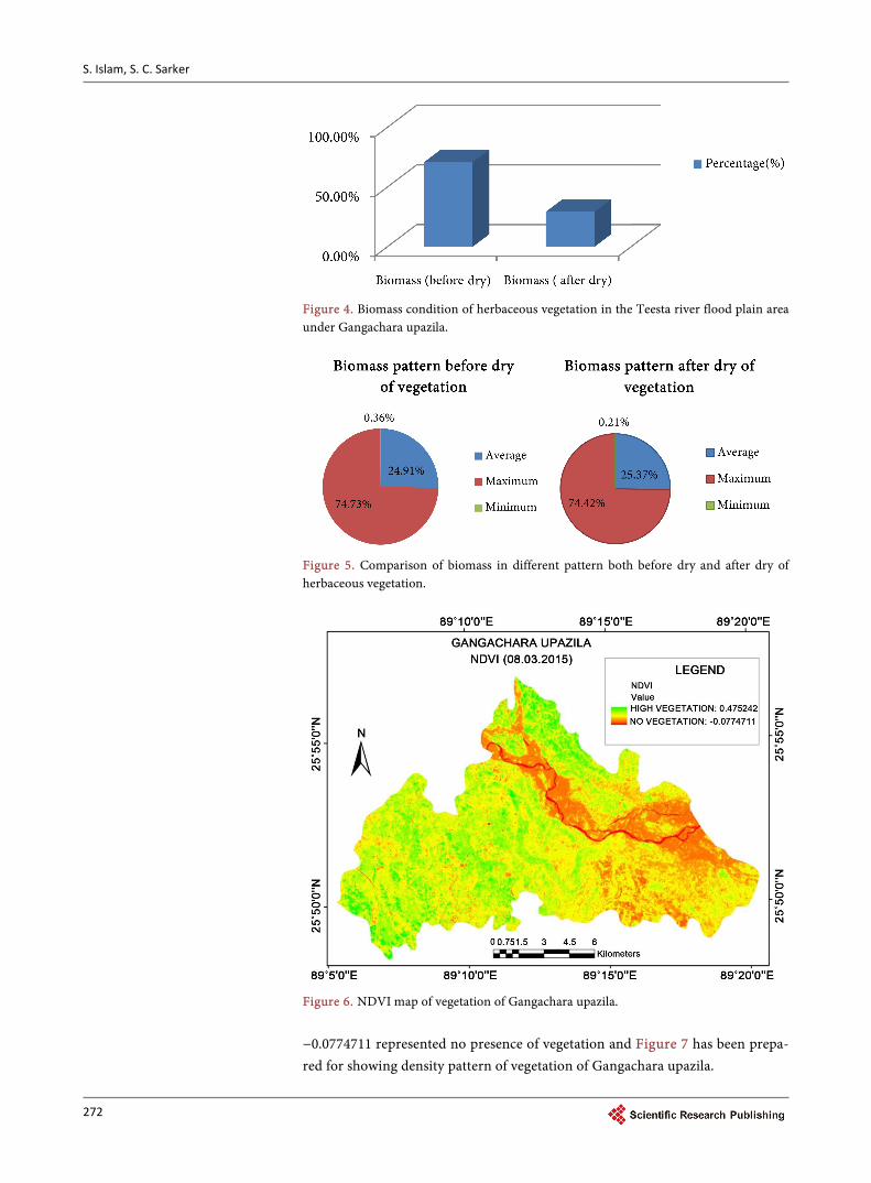
In Table 4, there has been shown biomass of herbaceous vegetation of the Tees-ta river flood plain area as average, maximum and minimum both in dry and before condition for comparative analysis through field survey. These patterns of biomass have been found through the measuring of the total 104 quadrat sam-ples separately in the study area. Each sample has been measured separately in where maximum value of a quadrat covered sample showed 0.210 gm/sq. feet in the before dry condition of herbaceous vegetation and that showed 0.088 gm/sq. feet in after dry condition. Like that a sample contained the value 0.001 gm/sq. feet represented minimum amount of biomass pattern which has been showed 0.00024 gm/sq. feet in after dry condition and average value of biomass were showed 0.07 gm/sq. feet and 0.03 gm/sq. feet comparatively in before dry and after dry condition of herbaceous vegetation. Figure 5 showed the comparison of biomass pattern in the study area.
4.2.2. Density of Identified Herbaceous Species in the Flood Plain of Gangachara Upazila
Table 5 represented that there has been found 31 types of herbaceous vegetation species in the study area. The most dominated species type of the Teesta river flood plain area in the Gangachara upazila was Pouzolzia indica (moishma ghas) that covered at about 11.59% of total area and the lowest type of species was Ca-locasia esculenta (kachu), Mimosa padica (lajjabati) etc. that covered 0.31 % of total area.
4.3. NDVI and Vegetation Density Map of Gangachara Upazila
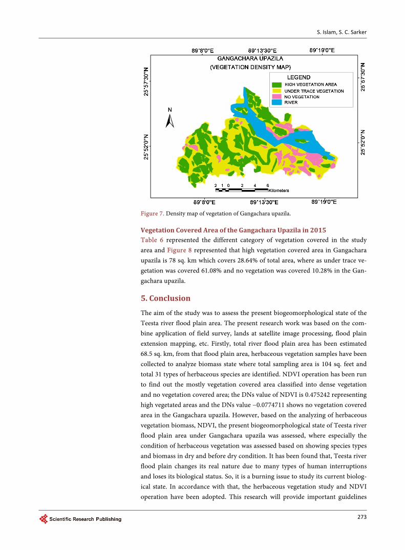
Figure 6 showed that, green color containing DN value 0.475242 represented highest vegetation covered area on the other hand red color containing DN value

S. Islam, S. C. Sarker
271
Table 4. Maximum, minimum and average amount of biomass (before dry and after dry) in the Teesta river flood plain area of Gangachara upazila.
Biomass of vegetation Category Amount (gm/sq. feet) Percentage (%)
Before dry Average 0.07 24.91 %
Maximum 0.210 74.73 % Minimum 0.001 0.36 %
After dry Average 0.03 25.37 %
Maximum 0.088 74.42 % Minimum 0.00024 0.21 %
Table 5. Density of identified herbaceous species in the Teesta river flood plain area of Gangachara upazila.
SL. NO. Local Name Scientific Name Density (%)
01 Moishma ghas Pouzolzia indica 11.59
02 Amrul Oxalis corniculata 9.09
03 Moina ghas Cymbopogan citratus 8.15
04 Chapra ghas Elusine indica 6.89
05 Durba ghas Cynodon dactylon 5.95
06 Kelna ghas Cyperus rotundus 5.64
07 Nunia shak Portulaca oleracea 5.64
08 Helencha Aristida leucas 4.38
09 Fotka Physalis micrantha 4.38
10 Bilaikhamchi Achyranthes aspera 4.38
11 Bicha ghas Kyllinga nemoralis 4.07
12 Kalmi Ipomoea aquatica 3.44
13 Okhra Chrysopgon aciculatus 3.44
14 Notay shak Amaranthus viridis 3.13
15 Keshuti Eclipta alba 2.50
16 Bhuishak Ludwigia hyssopifolia 2.50
17 Kanta morich Amaranthus spinosus 2.50
18 Muktajhuri Acalypha indica 1.56
19 Jhunjhuni ghas Croton bonplandia 1.56
20 Bish Dhekia Pteris pellucida 1.56
21 Bishkatali Persicaria barbata 1.56
22 Keshur Actinoscirpus grossus 1.25
23 Lal Bishkatali Persicaria acuminata 1.25
24 Kanshisa Leucas aspera 0.62
25 Foksa Cyperus laxus 0.62
26 Shada Dhekia Diplazium esculentum 0.62
27 Kachu Calocasia esculenta 0.31
28 Lajjabati Mimosa padica 0.31
29 Shoti Curcuma zedoaria 0.31
30 Pan pata Peperomia pellucida 0.31
31 Bish Kachu Alocasia cucullata 0.31
S. Islam, S. C. Sarker
272
Figure 4. Biomass condition of herbaceous vegetation in the Teesta river flood plain area under Gangachara upazila.
Figure 5. Comparison of biomass in different pattern both before dry and after dry of herbaceous vegetation.
Figure 6. NDVI map of vegetation of Gangachara upazila. −0.0774711 represented no presence of vegetation and Figure 7 has been prepa- red for showing density pattern of vegetation of Gangachara upazila.
S. Islam, S. C. Sarker
273
Figure 7. Density map of vegetation of Gangachara upazila.
Vegetation Covered Area of the Gangachara Upazila in 2015 Table 6 represented the different category of vegetation covered in the study area and Figure 8 represented that high vegetation covered area in Gangachara upazila is 78 sq. km which covers 28.64% of total area, where as under trace ve-getation was covered 61.08% and no vegetation was covered 10.28% in the Gan-gachara upazila.
5. Conclusion
The aim of the study was to assess the present biogeomorphological state of the Teesta river flood plain area. The present research work was based on the com-bine application of field survey, lands at satellite image processing, flood plain extension mapping, etc. Firstly, total river flood plain area has been estimated 68.5 sq. km, from that flood plain area, herbaceous vegetation samples have been collected to analyze biomass state where total sampling area is 104 sq. feet and total 31 types of herbaceous species are identified. NDVI operation has been run to find out the mostly vegetation covered area classified into dense vegetation and no vegetation covered area; the DNs value of NDVI is 0.475242 representing high vegetated areas and the DNs value −0.0774711 shows no vegetation covered area in the Gangachara upazila. However, based on the analyzing of herbaceous vegetation biomass, NDVI, the present biogeomorphological state of Teesta river flood plain area under Gangachara upazila was assessed, where especially the condition of herbaceous vegetation was assessed based on showing species types and biomass in dry and before dry condition. It has been found that, Teesta river flood plain changes its real nature due to many types of human interruptions and loses its biological status. So, it is a burning issue to study its current biolog-ical state. In accordance with that, the herbaceous vegetation study and NDVI operation have been adopted. This research will provide important guidelines

S. Islam, S. C. Sarker
274
Figure 8. Pattern of vegetation density of Gangachara upazila in 2015. Table 6. Vegetation density in the Gangachara upazila, 2015.
Total area (sq. km) Category Area (sq. km) Percentage (%)
272.28
High vegetation covered 78 28.64%
Under trace vegetation 166.28 61.08%
No vegetation 28 10.28%
for better use of river flood plain area as well as will assist river planners, re-searchers, engineers, administrator, geographer, farmers, and local inhabitants in their respective fields fruitfully.
Acknowledgements
Authors would like to acknowledge SPARSSO, BWDB and chairman of the De-partment of Botany of Carmichael College for providing necessary data for the purpose of completing the research work.
References [1] Harper, R.M. (1911) The Riverbank Vegetation of the Lower Apalachicola, and a
New Principal Illustrated Thereby. Torreya, 11, 225-234.
[2] Pressey, R.L. (1986) Wetlands of the River Murray. RMC Environmental Report 86/1, River Murray Commission.
[3] Dunbar, C.O. and Rodgers, J. (1957) Principles of Stratigraphy. Wiley International Edition, Toppan Company Ltd., Tokyo, 271-288.
[4] Cohen, W.B. and Goward, S.N. (2004) Landsat’s Role in Ecological Applications of Remote Sensing, Bioscience, 54, 535-545. https://doi.org/10.1641/0006-3568(2004)054[0535:LRIEAO]2.0.CO;2
[5] King, A.J., Humphries, P. and Lake, P.C. (2003) Fish Recruitment on Flood Plains: The Roles of Pattern of Flooding and Life History Characteristics. Canadian Journal Fisheries and Aquatic Science, 60, 773-786. https://doi.org/10.1139/f03-057
[6] Young, W.J. (2001) Rivers as Ecological System: The Murray Darling Basin. CSIRO Land and Water, Canberra.
[7] Leslie, D.J. (2001) River Murray Environmental Flows 2000-2001. Ecological Mana- gement and Restoration, 3, 221-223.
[8] Arthington, A.H., Stuart, E. and Anzel, B. (2002) Basic Principles and Ecological Consequences of Altered Flow Regims for Aquatic Bio Diversity. Environmental
S. Islam, S. C. Sarker
275
Management, 30, 492-507. https://doi.org/10.1007/s00267-002-2737-0
[9] Viles, H.A. (1988) Biogeomorphology. Blackwell, Oxford.
[10] Nislow, K.H. (2005) The Regulation of Peace River: A Case Study for River Manage- ment. River Research and Application, 18, 429-446.
[11] Nally, R. (2002) Habitat Change and Restoration: Responses of Forest Floor Mam-mal Species to Manipulations of Fallen Timber in Flood Plain Forest. Animal Biodi- versity and Conservation, 25, 41-51.
[12] Campbell, J.B. (1981) Spatial Correlation Effects upon Accuracy of Supervised Clas-sification of Land Cover. Photogrammetric Engineering & Remote Sensing, 47, 355- 363.
[13] Christine, F. (2015) Biotic Controls on CO2 and CH4 Exchange in Wetlands—A Closed Environment Study. Biogeochemistry, 64, 337-354. https://doi.org/10.1023/A:1024913730848
[14] Ahmed, A.U., Neelormi, S., Adri, N., Alam, M.S. and Nurruzzaman (2014) Climate Change, August 2007. Dhaka, 86.
[15] Bangladesh Bureau of Statistics (BBS) (2011) Statistical Year Book of Bangladesh.
[16] Khan, F.H. (1991) Geology of Bangladesh. University Press Limited, Dhaka, 207.
Submit or recommend next manuscript to SCIRP and we will provide best service for you:
Accepting pre-submission inquiries through Email, Facebook, LinkedIn, Twitter, etc. A wide selection of journals (inclusive of 9 subjects, more than 200 journals) Providing 24-hour high-quality service User-friendly online submission system Fair and swift peer-review system Efficient typesetting and proofreading procedure Display of the result of downloads and visits, as well as the number of cited articles Maximum dissemination of your research work
Submit your manuscript at: http://papersubmission.scirp.org/ Or contact [email protected]


![Physico-chemical properties and ichthyofauna diversity in ... Patra[1].pdf · carried out in respect in Karala River, a tributary of the river Teesta of West Bengal. The objectives](https://img.pdfslide.us/doc/110x75/5a775e1b7f8b9a1b688debec/physico-chemical-properties-and-ichthyofauna-diversity-in-patra1pdfaa.jpg)