Embed Size (px)
Citation preview

Biodiversity Impact Assessment
APPENDIX
A Survey of Vegetation and Flora Constraints: Bolivia Hill Road Re-alignment

Survey of Vegetation and Flora Constraints:
Bolivia Hill Road Re-alignment
Dr John T. Hunter B.Sc. (Hons 1st) PhD
December 2012
23 Kendall Rd, Invergowrie NSW, 2350 Ph. & Fax: (02) 6775 2452
Email: [email protected]

Bolivia Hill
Hewlett Hunter Pty Ltd (02) 6775 2452
i
Contents 1 Methodology .................................................................................................... 1 1.1 Site and species information....................................................... 1 1.2 Data management ....................................................................... 1 1.3 Multivariate analysis .................................................................. 2 1.4 Mapping ...................................................................................... 3 1.5 Tree and hollow density ............................................................. 3 1.6 Threatened species searches ....................................................... 3 2 Results .............................................................................................................. 4 2.1 Site stratification ........................................................................ 4 2.2 Floristics ...................................................................................... 5 2.3 Community definition ................................................................ 5 2.4 Description of plant communities ............................................ 12 2.4.1 Fuzzy Box – Yellow Box – Red Gum .................... 13 2.4.2 Fuzzy Box – Ribbon Gum – Red Gum .................. 15 2.4.3 Tea-tree – Bottlebrush ........................................... 17 2.4.4 Derived Grassland (Red Grass – Wiregrass) .......... 19 2.4.5 Derived Grassland (Wire Grass – Bamboo Grass).. 22 2.4.6 Carex Fen .............................................................. 24 2.4.7 Stringybark – Rough-barked Apple – Red Gum ..... 26 2.4.8 Red Gum – Rough-barked Apple – Fuzzy Box ...... 28 2.4.9 Stringybark – Banksia – Apple Box ....................... 30 2.4.10 Black Pine – Caley’s Ironbark - Kurrajong .......... 32 2.5 Communities and taxa of conservation significance ............... 35 2.5.1 Communities within the study area ........................ 35 2.5.2 Communities in proximity to the study area ........... 37 2.5.3 Threatened species found within the study area ..... 38 2.5.3.1 Acacia pycnostachya ........................ 38 2.5.3.2 Pimelea venosa ................................ 45 2.5.4 Threatened species in close proximity .................... 49 2.5.4.1 Boronia boliviensis ........................... 49 2.5.4.2 Eucalyptus boliviana ........................ 51 2.5.4.3 Homoranthus croftianus ................... 52 2.5.4.4 Thesium australe .............................. 53 2.6 Key threatening processes ........................................................ 54 References ......................................................................................................... 55 Appendix A: Site record forms ........................................................................ 56 Appendix B: Taxon list with authorities and common name ......................... 59 Appendix C: Locality and site information ..................................................... 72 Acknowledgements ........................................................................................... 78

Bolivia Hill
Hewlett Hunter Pty Ltd (02) 6775 2452
ii
Tables 1 Area and condition of threatened communities ........................................... 35

Bolivia Hill
Hewlett Hunter Pty Ltd (02) 6775 2452
iii
Plates 1 Photograph of Acacia pycnostachya flowering stem ..................................... 42 2 Photographs of Acacia pycnostachya seedling and suckering ...................... 43 3 Photographs of Acacia pycnostachya stands ................................................. 44 4 Photographs Pimelea venosa leaf and habitat .............................................. 48 5 Photograph of Boronia boliviensis................................................................. 50 6 Photographs of Eucalyptus boliviana ............................................................ 51 7 Photograph of Homoranthus croftianus ........................................................ 52 8 Photograph of Thesium australe.................................................................... 53

Bolivia Hill
Hewlett Hunter Pty Ltd (02) 6775 2452
iv
Figures 1 Summary dendrogram of full dataset of sites surveyed ................................. 5 2 Location of sites within Communities at Bolivia Hill ..................................... 6 3 Vegetation map of the Bolivia Hill Study Area .............................................. 7 4 Condition of vegetation within the Bolivia Hill Study Area .......................... 8 5 Proportion of introduced and native plants within sites ................................ 9 6 Predicted hollows per ha ............................................................................... 10 7 Stem density per ha ....................................................................................... 11 8 Mapped Threatened Ecological Communities ............................................. 36 9 Previous known locations of Acacia pycnostachya ........................................ 39 10 Acacia pycnostachya within the study area ................................................. 41 11 Location of Pimelea venosa within the study area ...................................... 47 12 Known locations of Boronia boliviensis ....................................................... 50 13 Known locations of Eucalyptus boliviana .................................................... 51 14 Known location of Homoranthus croftianus ............................................... 52 16 Known location of Thesium australe ........................................................... 53 17 Mapped condition of Community 3 ................................................................

Bolivia Hill
Hewlett Hunter (02) 6775 2452
1
Methodology 1.1 Site and species information Topological information was collected along with measurements of altitude, slope, aspect and horizontal elevation. Altitude was taken directly from topographic maps. Slope and horizontal elevation were measured using a ‘SUUNTO Optical Reading Clinometer’. Horizontal elevation was measured at eight equidistant compass bearings. Aspect was measured using a compass with reference to magnetic north. Information on soil, fires and other disturbances was also collected in a form amenable to the site survey data sheets supplied by the Northern Plains Region of the National Parks and Wildlife Service (Appendix A). Site location was derived from a Garmin GPSMap60CS with reference to topographic maps. Datum used was GDA94. Vegetation structure was derived using the system developed by Walker and Hopkins (1990). This method uses growth form, height and crown cover of the dominant taxa in each of the strata layers that are identifiable. Individual taxon data for each quadrat was recorded using the species data forms supplied by the Glen Innes Area of the National Parks and Wildlife Service (Appendix A). Species were scored in accordance with a modified Braun-Blanquet (1982) cover abundance six ranking scale. Cover codes are as follows: Cover Code Projected Canopy Cover 1 <5% few individuals 2 <5% any number of individuals 3 6-25% 4 26-50% 5 51-75% 6 >75% These methods will enable cross comparison of species records with other major vegetation surveys carried out by the New South Wales National Parks and Wildlife Service. 1.2 Data management ‘Paradox 12 for Windows’ (Corel 2006) a relational database, was used for data management, validation, storage and retrieval. ‘Parent’ tables were created with verified information that was used for data entry in ‘Child’ tables allowing consistency in data entry (for example the spelling of species names (Campbell 1984; McKenzie 1991; McKenzie et al. 1991)). Three ‘parent’ tables were created to store information with six ‘child’ tables used for referential integrity, validation and data entry. The three parent tables stored information relating to the taxa found and the

Bolivia Hill
Hewlett Hunter (02) 6775 2452
2
quadrats placed. The region number and site number were the relational fields used to link the three parent tables. These three record values were unique and duplicate values were not accepted by the database. The system was designed to minimise the number of keystrokes, and allow for subsequent specimen determinations and results of analyses to be incorporated later without disruption. Field data collected during a single field trip were added either at night in the field on a ‘note book’ computer or immediately on the days after returning from the field on the main computer. Thus, discrepancies could be sorted out while the relevant survey sites were fresh in the mind. Sorted data was exported to EXCEL spreadsheets prior to analysis. All site and species attributes are presented in EXCEL spreadsheets and included in the electronic form of this document that is held with the Narrabri office of the New South Wales National Parks and Wildlife Service and Information and Assessment Section Dubo (along with copies of all field datasheets). 1.3 Multivariate Analysis Initial exploratory analysis of sites was conducted using classification and ordination techniques available in PATN: Pattern Analysis Package (Belbin 2004). PATN was developed for manipulation, analysis and display of patterns in multivariate biological data (Belbin 1995a). Both classification and ordination were performed on data as each technique is complimentary and the use of both highlights anomalies produced by the other (Gauch 1982). Ordination will detect natural clusters if they are present and highlight overall trends clarifying relationships alluded to with classification (Belbin 1991; Belbin 1995a). However, strong discontinuities in survey data can affect the way ordination techniques display continuous variation (Faith 1991). Classification techniques will impose groups on continuous data even if they are not present (Belbin 1991; Faith 1991; Belbin 1995a). In such situations ‘chaining’ may occur whereby samples grow by accretion one by one rather than by fusion with other clusters (Goodall 1980). Even in such situations utility can be found in imposed divisions (Gauch 1982). Classification is useful in detecting outliers that may affect ordination procedures (strong discontinuity). This technique also aids in the detection of smaller groupings or trends within the data that may be difficult to see from an ordination where groupings may be less obvious (Faith 1991). Site classification was achieved using the Kulczynski association measure that is considered to be a superior measure of association with ecological data (Faith et al. 1987; Belbin 1995b). Agglomerative hierarchical clustering using flexible UPGMA (Unweighted Pair Group arithMetic Averaging) was used for group joining, this optimises the hierarchy and not the groups. UPGMA gives equal weight to objects not groups in the fusion process thereby groups are weighted proportionally to the number of objects contained (Belbin 1995b). This method has been widely tested and is the most frequently used classification technique (Gauch 1982; Belbin 1995b) and it provides the best fit between the association measure and the distances implied from the dendrogram (Belbin 1991). Flexible UPGMA enables the value of , which ranges

Bolivia Hill
Hewlett Hunter (02) 6775 2452
3
from –0.1 to 1.0 to be changed, this controls the amount of space dilation during the fusion process (Belbin 1991; Belbin 1995b). A value of –0.1 was used to enable slight dilation to occur; this has been shown to better recover known partitions (Belbin 1995b). 1.4 Mapping The results of the multivariate analysis techniques were used in order to circumscribe vegetation communities. The identity of each defined vegetation assemblage was tagged to the full floristic survey sites within the database. The locations of the identified communities and their condition score where then re-projected onto aerial images within ArcGIS 10.1. These sites, notes taken on traverses and structural characterisitcs seen on aerial images along with projected topographical information was used to assist in delineation of vegetation communities for mapping. This methodology follows the guidelines for vegetation mapping provided within the Native Vegetation Interim Type Standard (Sivertsen 2009) and considered by Benson (2004) to be the highest standard of technique for vegetation circumscription and mapping. 1.5 Tree and hollow density Within each of these full floristic quadrats a random stem of over 10 cm Diameter at Breast Height (130 cm) (DBH) was chosen as a central stem. From this central stem a minimum of 15 of the closest stems of over 10 cm DBH were recorded. The size of these stem plots were unbounded and depended on the distance to the last stem recorded. For each stem the identity of the species, its DBH (centimetres), height (meters) and distance to the central stem (meters) was recorded along with the number of hollows present. If multiple stems were present and achieved a DBH of 10 cm, then they were also measured. The information on the number of additional stems per individual and their DBH was linked in a database. 1.6 Threatened species searches Threatened species searches were carried out in conjunction with the general floristic plot surveys. At all survey locations (112 in total) a minimum of a 10 minute search was conducted around the site for threatened species. In addition threatened species were searched for along all traverses between survey sites. Almost all survey sites were walked into, thus, a significant amount of the study area was searched on foot.

Bolivia Hill
Hewlett Hunter (02) 6775 2452
4
Results 1.1 Site stratification Three previous floristic survey sites within the study area within the Nature Reserve by Hunter (2002). A single site was also placed within a fen community by Hunter & Bell (2009) during their investigation of the fen assemblages within the New England Bioregion. These four sites were incorporated into the analyses performed. A total of 90 full floristic survey sites and 22 Rapid (dominants only) sites were surveyed within the defined study area between October and November of 2012. Two major fires had occurred on the southern side of the highway and into Bolivia Hill Nature Reserve within the month preceding the survey. Although some sites were placed within these burnt areas, much of the area was left without survey sites due to the lack of extant vegetation. 49 previous sites had been placed within the Bolivia Nature Reserve and the numbering system follows on from the numbering system used during that survey. Hence, sites placed during this survey start at Site 50. 2.2 Floristics A total of 374 vascular plant taxa were found from 87 families and 239 genera (17% exotic). It should be noted that this survey was undertaken in a single year and single period during late spring. It is highly likely that this species list does not include a substantial number of additional species that may appear during different seasons and years.
Vegetation of Bolivia Hill
Hewlett Hunter Pty Ltd (02) 6775 2452
5
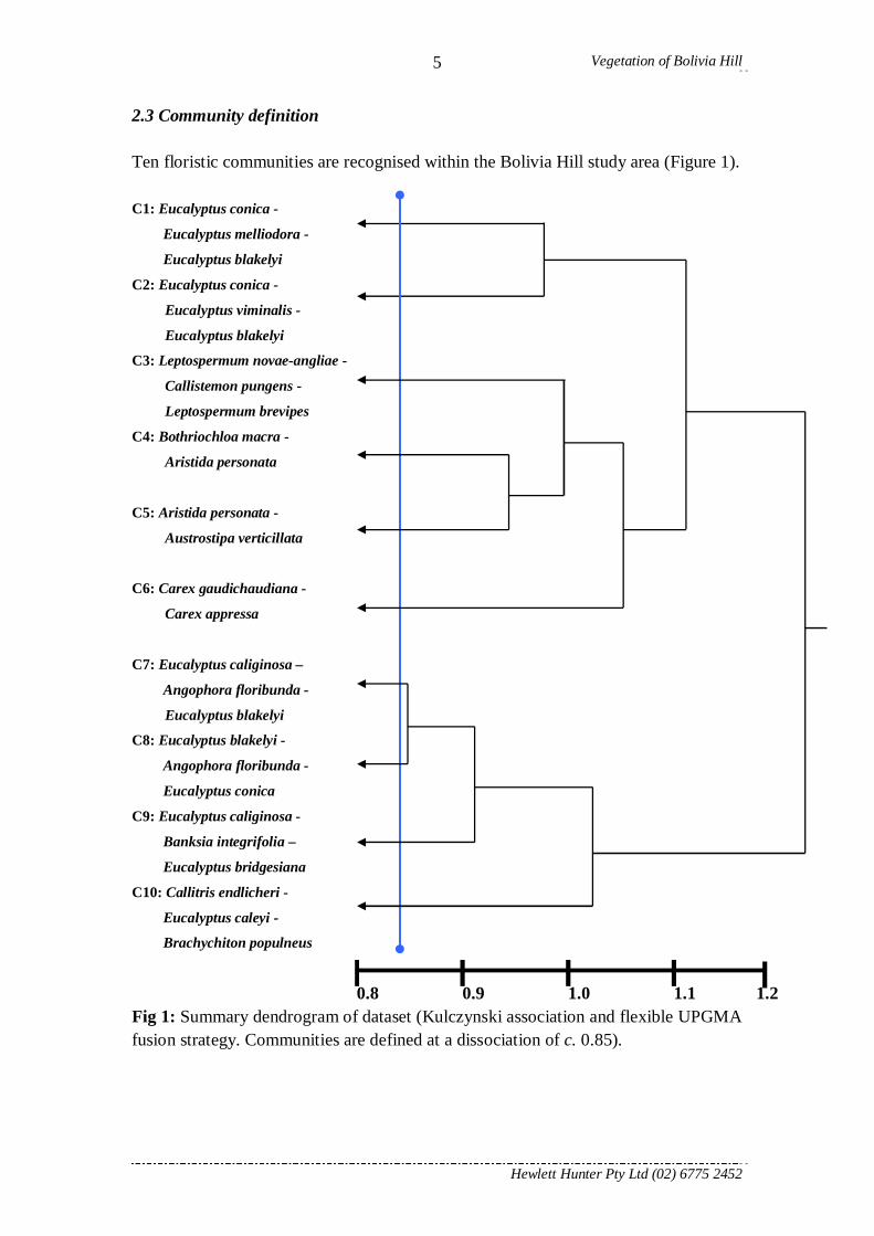
2.3 Community definition Ten floristic communities are recognised within the Bolivia Hill study area (Figure 1).
C1: Eucalyptus conica -
Eucalyptus melliodora -
Eucalyptus blakelyi
C2: Eucalyptus conica -
Eucalyptus viminalis -
Eucalyptus blakelyi
C3: Leptospermum novae-angliae -
Callistemon pungens -
Leptospermum brevipes
C4: Bothriochloa macra -
Aristida personata
C5: Aristida personata -
Austrostipa verticillata
C6: Carex gaudichaudiana -
Carex appressa
C7: Eucalyptus caliginosa –
Angophora floribunda -
Eucalyptus blakelyi
C8: Eucalyptus blakelyi -
Angophora floribunda -
Eucalyptus conica
C9: Eucalyptus caliginosa -
Banksia integrifolia –
Eucalyptus bridgesiana
C10: Callitris endlicheri -
Eucalyptus caleyi -
Brachychiton populneus
0.8 0.9 1.0 1.1 1.2 Fig 1: Summary dendrogram of dataset (Kulczynski association and flexible UPGMA fusion strategy. Communities are defined at a dissociation of c. 0.85).

Vegetation of Bolivia Hill
Hewlett Hunter Pty Ltd (02) 6775 2452
6
Fig 2: Location of sites within each floristic community at Bolivia Hill.

Vegetation of Bolivia Hill
Hewlett Hunter Pty Ltd (02) 6775 2452
7
Fig 3: Distribution of all mapping units within Bolivia Hill.

Vegetation of Bolivia Hill
Hewlett Hunter Pty Ltd (02) 6775 2452
8
Fig 4: Condition of the extant vegetation within the Bolivia Hill study area.

Vegetation of Bolivia Hill
Hewlett Hunter Pty Ltd (02) 6775 2452
9
Fig 5: Proportion of weedy and native species within sites. Figures based on proportion of summed cover/abundance scores.

Vegetation of Bolivia Hill
Hewlett Hunter Pty Ltd (02) 6775 2452
10
Fig 6: Predicted density of hollow bearing trees per ha from sites where this information was recorded. Larger circles indicate better habitat features for some fauna species.

Vegetation of Bolivia Hill
Hewlett Hunter Pty Ltd (02) 6775 2452
11
Fig 7: Stem density as calculated by cubic meters of stems. The larger the circle the larger the trees. This can be used as a general guide to age structure and for predicting old growth stand locations.

Bolivia Hill
Hewlett Hunter Pty Ltd (02) 6775 2452
12
2.4 Description of plant communities The species are listed in order of importance, species are listed the highest combined cover/abundance scores listed first. Not all species found are listed in these descriptions, only the most important taxa based on the method described. It is important to remember that this survey was conducted during a single season and year and therefore many species that have potential to occur in the study area are likely to have been missed and a fuller understanding of the complement of species present within the study areas would require additional surveys, specifically in late Autumn. The list of species within the descriptions is a reflection of survey effort, season of survey and prevailing regional climate. The following issues of taxonomic resolution may occur within the study area as intermediates between each of these pairs were found on occasions within the study area:
- the delineation of Eucalyptus banksii (Tenterfield Woollybutt) from Eucalyptus bridgesiana (Apple Box)
- the delineation of Eucalyptus viminalis (Manna Gum) from Eucalyptus dalrympleana subsp. heptantha (Mountain Gum), and
- the delineation of Eucalyptus blakelyi (Blakely’s Red Gum) with Eucalyptus dealbata (Tumbledown Red Gum).
All communities described have been assigned to state systems provided by Keith (2004) and to interim Plant Community Types (PCT) currently assigned to the Border Rivers Gwydir region by the NSW Office of Environment and Heritage.

Bolivia Hill
Hewlett Hunter Pty Ltd (02) 6775 2452
13
Community 1: Fuzzy Box – Yellow Box – Blakely’s Red Gum Grassy Woodland
PCT: No plant community types dominated by Fuzzy Box are described for the New England Region. Similar to 202 – Fuzzy Box woodland on colluvium and alluvial flats in the Brigalow Belt South Bioregion and Nandewar Bioregions. Keith: Western Slopes Grassy Woodlands. TEC Type: under broader scale mapping this unit may be included as a component of White Box – Yellow Box – Red Gum Grassy Woodlands but under this fine scale mapping it has been excluded. Fuzzy Box communities are considered Endangered within the Nandewar and Brigalow Belt South Bioregions. Full floristic sample sites (4): BH19, BH116, BH119, BH126. Rapid sample sites (0): none placed. No. of taxa: 66. Area mapped: 2.6 ha Good: 0 ha Moderate: 2.6 ha Poor: 0 ha TEC: 0 ha. Most common natives: listed in order of decreasing summed cover scores (fidelity x cover). Trees: Eucalyptus conica, Eucalyptus melliodora, Eucalyptus blakelyi, Angophora
floribunda, Acacia adunca. Shrubs: Pimelea curviflora subsp. divergens, Notelaea microcarpa. Climbers & trailers: Desmodium varians, Commelina cyanea. Ground cover: Microlaena stipoides, Dichondra repens, Oxalis perennans, Austrostipa
verticillata, Urtica incisa, Juncus usitatus, Bothriochloa macra, Geranium solanderi, Einadia nutans subsp. nutans, Carex inversa, Rumex brownii, Eragrostis leptostachya, Wahlenbergia communis, Stellaria flaccida, Solanum campanulatum, Lomandra multiflora, Eragrostis brownii, Einadia hastata, Chenopodium carinatum, Calotis

Bolivia Hill
Hewlett Hunter Pty Ltd (02) 6775 2452
14cuneifolia, Austrostipa rudis, Aristida personata, Vittadinia dissecta var. hirta, Scleranthus biflorus, Plantago varia, Mentha diemenica, Lomandra filiformis, Lagenophora stipitata, Glossocardia bidens, Dichondra sp. A, Dichelachne micrantha, Cynoglossum australe.
Introduced taxa: Paronychia brasiliana, Bromus brevis, Rosa rubiginosa, Cirsium vulgare, Verbena bonariensis, Solanum nigrum, Rubus anglocandicans, Medicago polymorpha, Hypochaeris glabra, Taraxacum officinale, Solanum triflorum, Plantago lanceolata, Conyza sumatrensis, Citrullus lanatus, Bidens subalternans, Acetosella vulgaris, Trifolium campestre, Paspalum dilatatum, Lolium perenne, Gamochaeta purpurea, Eragrostis curvula, Conyza bonariensis, Bidens pilosa, Alternanthera pungens.
Notes: this remnant community occurs primarily in extensively cleared agricultural lands in low land areas in the north east of the study area. This assemblage forms a transition from lower areas dominated by Eucalyptus conica (such as Community 2) and slightly elevated sites on shallower soils that commonly have Eucalyptus blakelyi (Blakely’s Red Gum) as a dominant (Community 8). Locations with a dominance of Eucalyptus melliodora (Yellow Box) and/or Eucalyptus blakelyi (Blakely’s Red Gum) would be considered to be part of the TEC of box gum woodlands of the TSC and EPBC Acts (as listed above). All mapped occurrences of these stands are dominated by Eucalyptus conica (Fuzzy Box) which is not considered to be a threatened association type within the New England Region. The understorey in the stands surveyed was largely comprised of grazing tolerant natives. Though areas dominated by Eucalyptus conica (Fuzzy Box) are not listed as an endangered community within the New England Tablelands Bioregion such areas should be considered at least as near threatened.

Bolivia Hill
Hewlett Hunter Pty Ltd (02) 6775 2452
15
Community 2: Fuzzy Box – Ribbon Gum – Blakely’s Red Gum Grassy Woodland
PCT: 921 – Manna Gum – Rough-barked Apple – Yellow Box grassy woodland/open forest of the New England Tableland Bioregion and NSW North Coast Bioregion also similar to 202 – Fuzzy Box woodland on colluvium and alluvial flats in the Brigalow Belt South Bioregion and Nandewar Bioregions. Keith: Western Slopes Grassy Woodlands. TEC Type: Fuzzy Box communities are considered Endangered within the Nandewar and Brigalow Belt South Bioregions.
Ribbon Gum - Mountain Gum - Snow Gum grassy open forest/woodland of the New England Tableland Bioregion - Endangered Ecological Community under TSC Act http://www.environment.nsw.gov.au/ThreatenedSpeciesApp/profile.aspx?id=20040
Full floristic sample sites (7): BH93, BH94, BH95, BH96, BH97, BH98, BH99. Rapid sample sites (1): BHR14. No. of taxa: 67. Area mapped: 24.6 ha Good: 4.3 ha Moderate: 20.1 ha Poor: 0.1 ha TEC: 12.8 ha Most common natives: listed in order of decreasing summed cover scores (fidelity x cover). Trees: Eucalyptus conica, Eucalyptus viminalis, Eucalyptus blakelyi, Brachychiton
populneus, Eucalyptus melliodora. Shrubs: Pimelea curviflora subsp. divergens, Acacia fimbriata, Pimelea neo-anglica,
Notelaea microcarpa, Lissanthe strigosa. Climbers & trailers: Rubus parvifolius, Glycine tabacina. Ground cover: Themeda triandra, Sorghum leiocladum, Geranium solanderi subsp.
solanderi, Dianella longifolia, Asperula conferta, Lespedeza juncea, Microlaena

Bolivia Hill
Hewlett Hunter Pty Ltd (02) 6775 2452
16stipoides, Carex inversa, Acaena novae-zelandiae, Lomandra multiflora, Echinopogon caespitosus, Ranunculus lappaceus, Pratia purpurascens, Lomandra longifolia, Dichondra sp. A, Dianella revoluta, Aristida personata, Scleranthus biflorus, Euchiton sphaericus, Echinopogon ovatus, Dichelachne micrantha, Calotis cuneifolia, Senecio quadridentatus, Senecio diaschides, Schenkia spicata, Oxalis perennans, Lomandra confertifolia subsp. pallida, Lissanthe strigosa, Gahnia aspera, Echinopogon mckiei, Dichondra repens, Cynoglossum australe, Chrysocephalum semipapposum, Cheilanthes sieberi, Bulbine bulbosa, Aristida vagans, Ajuga australis.
Introduced taxa: Eragrostis curvula, Rubus anglocandicans, Vicia villosa, Rosa rubiginosa, Plantago lanceolata, Verbena bonariensis, Hypochaeris radicata, Conyza bonariensis, Senecio madagascariensis, Phalaris arundinacea, Cirsium vulgare, Verbascum thapsus, Bidens pilosa, Taraxacum officinale, Paspalum dilatatum, Medicago polymorpha, Holcus lanatus, Andropogon virginicus.
Notes: this is an unusual and undescribed assemblage type that is probably unique to the region between Deepwater and Tenterfield. No assemblages are described with an association of Eucalyptus viminalis (Manna Gum) and Eucalyptus conica (Fuzzy Box). Some intermediates between Eucalyptus viminalis (Manna Gum) and Eucalyptus dalrympleana subsp. heptantha (Fuzzy Box) were noted within this vegetation type. Though areas dominated by Eucalyptus conica (Fuzzy Box) are not listed as an endangered community within the New England Tablelands Bioregion such areas should be considered at last as near threatened. The overstorey is intact however most of the understorey in the mapped units is dominated by Eragrostis curvula (African Lovegrass) which is listed as a Key Threatening Process (Invasion by Perennial Exotic Grasses) on the TSC Act. This assemblage is restricted to low lying areas of the north and eastern section of the study area and is most prevalent in the road and travelling stock reserves beside the current highway.

Bolivia Hill
Hewlett Hunter Pty Ltd (02) 6775 2452
17
Community 3: New England Tea-tree – Pungent Bottlebrush –Swamp Tea-tree Wet Heath
PCT: 518 – Heath swamps wetland on leucogranite and granite of the New England Tableland Bioregion & 607 – Montane bogs on the western fall of the New England Tableland Bioregion Keith: Montane Bogs and Fens. TEC Type:
Montane Peatlands and Swamps of the New England Tableland, NSW North Coast, Sydney Basin, South East Corner, South Eastern Highlands and Australian Alps Bioregions Endangered Ecological Community. http://www.threatenedspecies.environment.nsw.gov.au/tsprofile/profile.aspx?id=10936
Full floristic sample sites (4): .BH20, BH37, BH55, BH65 Rapid sample sites (1): BHR14. No. of taxa: 86. Area mapped: 1.5 ha Good: 0 ha Moderate: 1.5 ha Poor: 0 ha TEC: 1.5 ha Most common natives: listed in order of decreasing summed cover scores (fidelity x cover). Trees: Callitris endlicheri, Eucalyptus blakelyi, Eucalyptus andrewsii, Banksia integrifolia,
Acacia neriifolia. Shrubs: Leptospermum novae-angliae, Epacris microphylla, Callistemon pungens,
Leptospermum gregarium, Melichrus urceolatus, Hakea microcarpa, Aotus subglauca, Leptospermum minutifolium, Leptospermum arachnoides.
Climbers & trailers: none apparent.

Bolivia Hill
Hewlett Hunter Pty Ltd (02) 6775 2452
18Ground cover: Lepyrodia leptocaulis, Goodenia bellidifolia, Gonocarpus micranthus subsp.
ramosissimus, Fimbristylis dichotoma, Urtica dichotoma, Spiranthes sinensis, Goodenia gracilis, Gonocarpus micranthus subsp. micranthus, Digitaria breviglumis, Deyeuxia parviseta, Xyris complanata, Tripogon loliiformis, Schoenus apogon, Rhynchospora brownii, Gahnia aspera, Cymbopogon refractus, Bothriochloa macra, Aristida personata, Aristida calycina, Themeda triandra, Thelionema caespitosum, Sacciolepis indica, Rytidosperma racemosum, Pratia purpurascens, Murdannia graminea, Juncus vaginatus, Juncus usitatus, Imperata cylindrica, Haloragis heterophylla, Fimbristylis cinnamometorum, Eragrostis brownii, Empodisma minus, Drosera burmannii, Cyperus sphaeroideus, Cyperus sanguinolentus, Bulbostylis densa, Brachyscome stuartii, Boronia parviflora, Austrostipa scabra, Austrofestuca eriopoda.
Introduced taxa: Cyperus sesqiflorus, Hypochaeris radicata, Hypochaeris glabra, Andropogon virginicus, Aira cupaniana, Rubus anglocandicans, Paspalum dilatatum.
Notes: floristically this assemblage falls within the Peatlands endangered community listing which primarily occur on eastern flowing catchments (Hunter & Bell 2007). The formation of peat requires both waterlogging, acidic soils and is enhanced by cool climatic conditions. The area here is marginal for the formation of peat due to lower rainfall and slightly warmer temperatures. This community has been affected by past grazing and clearing activities and regular fire. These disturbance activities are known to negatively affect the formation of peat (Hunter & Bell 2007). Some erosion has occurred though the centre of these wet heaths within the Nature Reserve. This community type would be synonymous with the Hunter & Bell (2007) unit Community 6: Epacris microphylla – Leptospermum arachnoides known to occur in the western parts of the New England from the Malara Plateau south to Deepwater. This community is entirely restricted to the south eastern part of the study area within Bolivia Hill Nature Reserve.

Bolivia Hill
Hewlett Hunter Pty Ltd (02) 6775 2452
19
Community 4: Derived Grassland (Red Grass – Wiregrass)
PCT: areas not dominated by introduced grasses close to 619 – Derived Wire Grass grassland of the NSW Brigalow Belt South Bioregion and Nandewar Bioregion and in parts 569 – Derived Snow Grass +/- Wild Sorghum Tussock grassland of the NSW Northern Tablelands. Keith: Temperate Montane Grasslands. TEC Type: primarily
Ribbon Gum - Mountain Gum - Snow Gum grassy open forest/woodland of the New England Tableland Bioregion - Endangered Ecological Community under TSC Act http://www.environment.nsw.gov.au/ThreatenedSpeciesApp/profile.aspx?id=20040 But also White Box Yellow Box Blakely’s Red Gum grassy woodlands - Endangered Ecological Community under TSC Act http://www.environment.nsw.gov.au/ThreatenedSpeciesApp/profile.aspx?id=10837 White Box Yellow Box Blakely’s Red Gum grassy woodlands and derived native grasslands –Critcally Endangered Ecological Community under EPBC Act http://www.environment.gov.au/cgi-bin/sprat/public/publicshowcommunity.pl?id=43&status=Critically+Endangered
Full floristic sample sites (5): 54, 117, 118, 120, 124. Rapid sample sites (5): BHR08, BHR09, BHR11, BHR12, BHR16.

Bolivia Hill
Hewlett Hunter Pty Ltd (02) 6775 2452
20No. of taxa: 70. Area mapped: 127.5 ha Good: 0 ha Moderate: 0.2 ha Poor: 127.3 ha TEC: 36.2 ha Most common natives: listed in order of decreasing summed cover scores (fidelity x cover). Trees: Eucalyptus viminalis, Eucalyptus blakelyi, Angophora floribunda. Shrubs: Melichrus urceolatus, Leptospermum polygalifolium, Leptospermum brevipes. Climbers & trailers: Desmodium varians, Convolvulus angustissimus. Ground cover: Bothriochloa macra, Hypericum gramineum, Haloragis heterophylla,
Aristida personata, Wahlenbergia communis, Vittadinia muelleri, Schoenus apogon, Schenkia spicata, Eragrostis brownii, Dichelachne micrantha, Oxalis perennans, Lomandra filiformis, Lachnagrostis filiformis, Juncus usitatus, Juncus remotiflorus, Cynodon dactylon, Cymbopogon refractus, Sorghum leiocladum, Rumex brownii, Euchiton sphaericus, Epilobium billardierianum, Chrysocephalum semipapposum, Chloris truncata, Cheilanthes sieberi, Carex inversa, Aristida jerichoensis, Acaena novae-zelandiae, Vittadinia cuneata, Tripogon loliiformis, Scleranthus biflorus, Persicaria prostrata, Lomandra multiflora, Fimbristylis dichotoma, Eragrostis leptostachya, Echinopogon caespitosus, Crassula sieberiana, Chamaesyce drummondii, Arthropodium milleflorum.
Introduced taxa: Andropogon virginicus, Trifolium dubium, Briza minor, Gamochaeta purpurea, Trifolium campestre, Hypochaeris glabra, Eragrostis curvula, Acetosella vulgaris, Vulpia bromoides, Trifolium repens, Plantago lanceolata, Paronychia brasiliana, Hypochaeris radicata, Medicago polymorpha, Lolium perenne, Verbascum thapsus, Rubus anglocandicans, Rosa rubiginosa, Polygonum aviculare, Conyza bonariensis, Cirsium vulgare, Ciclospermum leptophyllum, Cerastium glomeratum, Anagallis arvensis.
Notes: this assemblage is of derived grasslands found primarily in heavily cleared agricultural lands in low lying areas to the north east of the study area but also found within several locations in the south and west of the study area extensive clearing has occurred. In most of this unit the understorey is native and would still fall within the endangered community determinations listed above. Much of this assemblage is dominated by species listed as a Key Threatening Process (Invasion of Exotic Perennial Grasses) on the TSC Act and include dense swards of Eragrostis curvula (African Lovegrass), Andropogon virginicus (Whiskey Grass) and Hyparrhenia hirta (Coolatai Grass). These species are highly invasive and detrimental to both biodiversity and agricultural productivity. It is highly important that the spread of these introduced grasses is not exacerbated.

Bolivia Hill
Hewlett Hunter Pty Ltd (02) 6775 2452
21This floristic assemblage has been further divided into five mapping units:
4a: Derived Grassland (Red Grass – Wiregrass) – largely a native composition as per photograph above. 4b: Derived Grassland – African Lovegrass – dominated by Eragrostis curvula.
4c: Derived Grassland – Whiskey Grass - dominated by Andropogon virginicus.
4d: Derived Grassland – Exotic Pasture –areas sown to improved pastures. 4e: Derived Grassland – Disturbed Creeklines – often dominated by introduced grasses

Bolivia Hill
Hewlett Hunter Pty Ltd (02) 6775 2452
22
Community 5: Derived Grassland (Wire Grass – Bamboo Grass)
PCT: areas not dominated by introduced grasses close to 619 – Derived Wire Grass grassland of the NSW Brigalow Belt South Bioregion and Nandewar Bioregion. Keith: Temperate Montane Grasslands. TEC Type: not a threatened community. Full floristic sample sites (2): BH72, BH91. Rapid sample sites (0): none placed. No. of taxa: 32 Area mapped: 1.6 ha Good: 0 ha Moderate: 0 ha Poor: 1.6 ha TEC: 0 ha Most common natives: listed in order of decreasing summed cover scores (fidelity x cover). Trees: Acacia neriifolia, Eucalyptus dealbata, Eucalyptus blakelyi. Shrubs: Bursaria spinosa, Melichrus urceolatus, Pimelea neo-anglica. Climbers & trailers: Glycine tomentella. Ground cover: Aristida personata, Vittadinia dissecta, Austrostipa verticillata, Austrostipa
scabra, Sporobolus creber, Panicum simile, Echinopogon caespitosus, Bothriochloa macra, Wahlenbergia communis, Cyperus fulvus, Cymbopogon refractus, Calotis lappulacea, Scleranthus biflorus, Schenkia spicata, Malvastrum coromandelianum, Juncus pauciflorus, Gahnia aspera, Dichondra repens, Coronidium scorpioides, Acaena novae-zelandiae.
Introduced taxa: Hyparrhenia hirta, Eragrostis curvula, Verbascum thapsus, Opuntia stricta.
Notes: found on highly disturbed and exposed areas associated with the railway cutting. These areas commonly dominated by the introduced Hyparrhenia hirta (Coolatai

Bolivia Hill
Hewlett Hunter Pty Ltd (02) 6775 2452
23Grass) which is listed as a Key Threatening Process (Invasion of Exotic Perennial Grasses) on the TSC Act. The original overstorey vegetation is likely to have included Eucalyptus caliginosa (Broad-leaved Stringybark), Eucalyptus dealbata (Tumbledown Gum) and Eucalyptus blakelyi (Blakely’s Red Gum) amongst others.