Embed Size (px)
Citation preview
WETLAND CONSERVATION PROJECT BIODIVERSITY AND SUSTAINABLE USE OF COASTAL WATERS - THE ROLE OF
INTEGRATED COASTAL ZONE MANAGEMENT
Integrated Management of Coastal Ecosystem Biodiversity in Sri Lanka: Muthurajawela Marsh Negombo Lagoon Estuarine System Case Study
By
Jayampafhy Samarakoon Euroconsult, Arnhem, Netherlands;
Consultant, Wetland Conservation Project, Central Environmental Authority, Maligawatte, Colombo 10, Sri Lanka
Experience paper prepared for the Workshop on Biodiversity and Sustainable Use of Coastal Waters convened by the Swedish .Scientific Committee on Biological Diversity, 21-25 August, Tjamo Marine Biological Laboratory, Stromstad, Sweden.
euroconsult w$>&\ii § 5 i p s o a\&jimyassu Central Environmental Authority
Note to the front cover S A f V \
^ indicates the approximate location of a wetland of international importance as identified in the Directory of Asian Wetlands (Scott, 1989); total 41 sites.
y indicates the approximate location of a wetland of national importance as identified in a local list
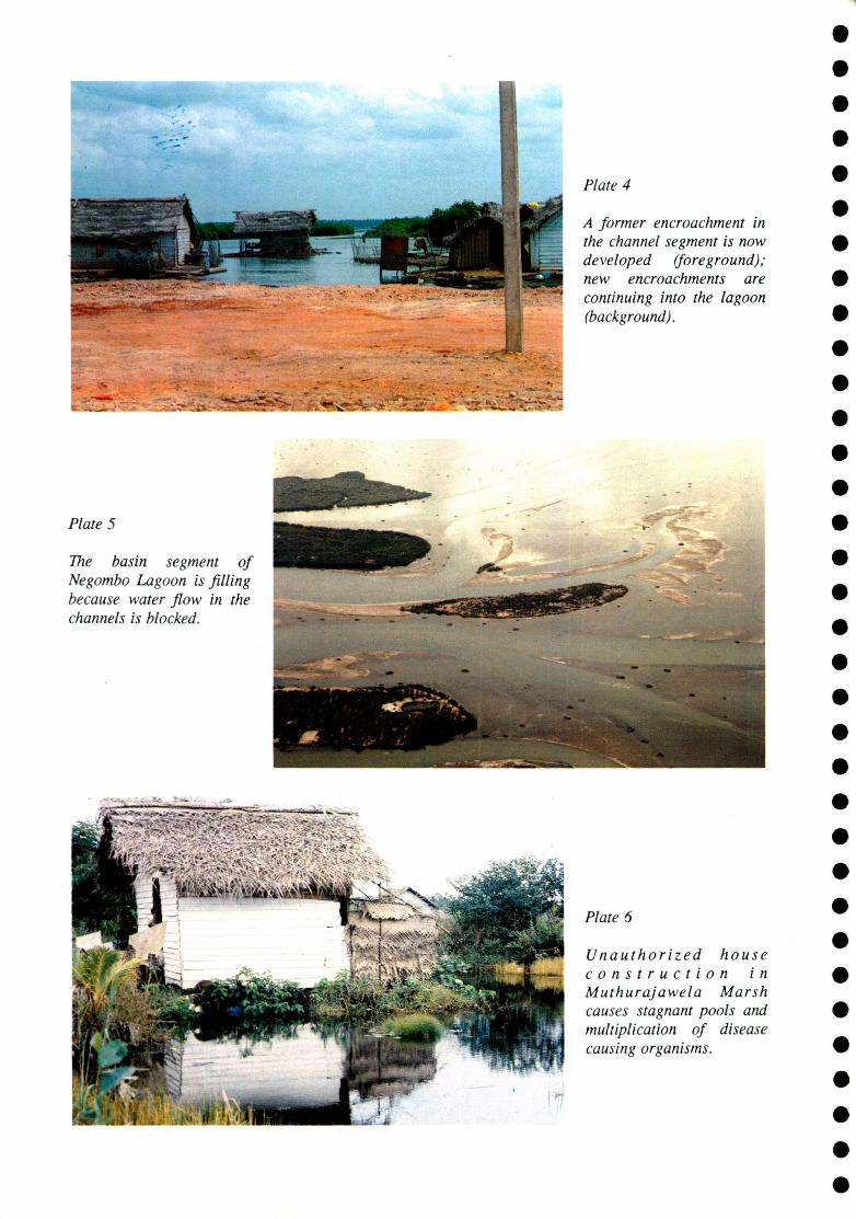
Plate 4
A former encroachment in the channel segment is now developed (foreground); new encroachments are continuing into the lagoon (background).
Plate 5
The basin segment of Negombo Lagoon is filling because water flow in the channels is blocked.
_
Plate 6
Unauthorized house construction in Muthurajawela Marsh causes stagnant pools and multiplication of disease causing organisms.
ABBREVIATIONS AND ACRONYMS
COP Conference of Parties (to the Convention on Biological Diversity) SBSTTA Subsidiary Body on Scientific, Technical and Technological Advice UNESCO United Nations Education, Scientific and Cultural Organization IAM Integrated Area Management LME Large marine eco-system UNCED United Nations Conference on Environment and Development ICZM Integrated Coastal Zone Management ICRM Integrated Coastal Resources Management ICM Integrated Coastal Management USAID United States Agency for International Development DSD Divisional Secretaries Division SLLRDC Sri Lanka Land Reclamation and Development Cooperation NGO Non-governmental Organization MUPO Muthurajawela United People Organization MMPSC Muthurajawela Master Plan Steering Committee CDC Community Development Council SEDEC Social and Economic Development Centre UNCHS United Nations Commission on Human Settlements (Habitat) CBO Community Base Organization DFAR Department of Fisheries and Aquatic Resources UNDP United Nations Development Programme NLIFO Negombo Lagoon Integrated Fishermen's Organization CEA Central Environmental Authority FAO Food and Agricultural Organization ADB Asian Development Bank GCEC Greater Colombo Economic Commission BOI Board of Investment
BIODIVERSITY AND SUSTAINABLE USE OF COASTAL WATERS - THE ROLE OF INTEGRATED COASTAL ZONE MANAGEMENT
To forge a collaborative code of behaviour for resource users and representatives of statutory bodies to enable management of Muthurajawela Marsh and Negombo Lagoon as an ecosystem for the use of present and future generations, MISSION STATEMENT, 1995
ABSTRACT: Ecosystem based Integrated Coastal Zone Management (ICZM) is a practical approach toward sustainable use of coastal waters while protecting marine biodiversity. Zoning can incorporate protected or managed areas for conservation of marine biodiversity as a part of integrated management of a coastal ecosystem. However, implementation of ICZM plans will be the actual measure of effectiveness of this approach. Implementing ICZM plans in developing countries, especially is difficult because the resource users generally include the poorest segments of the population as well as powerful individuals/groups capable of manipulating the planning and decision making process. In Sri Lanka an ICZM process for a, high value, urban peat marsh -barrier built estuarine ecosystem (Muthurajawela Marsh - Negombo Lagoon system) has been in operation since 1990. Strategic Zoning is the foundation of the plan and includes a Conservation Zone, Buffer Zone, Mixed Urban Zone and a Residential Zone. This plan acquired implementability because of political authorization from the highest level, harmonization of development (economic growth) with ecology and early enrollment of resource user communities in planning and plan implementation. A sandfill of 162 ha has been already completed to enable planned and integrated development of the Mixed Urban Zone, the Conservation Management Plan for the Conservation Zone (prepared as a second phase activity) is now being implemented, one group of encroacher communities has been relocated while providing them with assets (land and a permanent house), and a land use plan for the Buffer Zone shortly will be prepared. Community support was fostered by an awareness and adult education process which unified the leaders of the poorest resource user communities along the perception that they are a part of the estuarine ecosystem and that it cannot be managed to serve their livelihood needs by separating the system into parts. In addition, community development (youth training and womens' development) are integral components of the Conservation Management Plan which was completed through a process of community workshops. Since community participation was enrolled early and it was coupled to an empowerment process, the ICZM plan implementation could not be thwarted or deflected by political interference and other forms of emergent uncertainty. As the ICZM process matures, it is hoped that appropriate collaborative arrangements will be forged between the community of resource users and representatives of statutory bodies to facilitate management of the estuarine ecosystem for present and future generations. Some lessons that may be instructive for preparing implementable ICZM plans are: (i) ICZM plans should take into consideration at the outset the factors that will contribute to implementability, e.g legitimacy, (ii) provide a strong scientific and technical foundation by taking into consideration ecosystem structure and functioning, (iii) enrol community participation in planning and empower them through an information sharing process to face challenges that may subsequently arise from powerful political sources, (iv) if zoning is a part of the ICZM plan, flexibility must be introduced to make land allocation robust, and (v) ICZM planning and implementation will be more effective if undertaken gradually over an extended period.
Experience paper prepared for the Workshop on Biodiversity and Sustainable Use of Coastal Waters convened by the Swedish Scientific Committee on Biological Diversity, 21-25 August, Tjarno Marine Biological Laboratory, Stromstad, Sweden.
Integrated Management of Coastal Ecosystem Biodiversity in Sri Lanka: Muthurajawela Marsh -Negombo Lagoon Estuarine System Case Study
By
Jayampathy Samarakoon Euroconsult, Arnhem, Netherlands;
Consultant, Wetland Conservation Project, Central Environmental Authority, Maligawatte, Colombo 10, Sri Lanka
BIODIVERSITY AND SUSTAINABLE USE OF COASTAL WATERS - THE ROLE OF INTEGRATED COASTAL ZONE MANAGEMENT
Integrated Management of Coastal Ecosystem Biodiversity in Sri Lanka: Muthurajawela Marsh - Negombo Lagoon Estuarine System Case Study
By
Jayampathy Samarakoon Euroconsult, Arnhem, Netherlands;
Consultant, Wetland Conservation Project, Central Environmental Authority, Maligawatte, Colombo 10, Sri Lanka
To forge a collaborative code of behaviour for resource users and representatives of statutory bodies to enable management of Muthurajawela Marsh and Negombo Lagoon as an ecosystem for the use ofpresent and future generations. MISSION STATEMENT, 1995
1.0 INTRODUCTION At the first Conference of Parties (COP) to the Convention on Bological Diversity, a medium-term programme of work was adopted for the period 1995 - 1997. Following a proposal by Sweden, a "major ecosystem" will be treated at each of the coming sessions of the Conference of Parties. At the session in 1995, "Marine and Coastal Biodiversity" will be addressed. The issue of Marine and Coastal Biodiversity is also on the agenda for the first meeting of the Subsidiary Body on Scientific, Technical and Technological Advice (SBSTTA) under the Convention on Biological Diversity to be hosted by the United Nations Education, Scientific and Cultural Organization (UNESCO), later in 1995.
In 1993, the Swedish Parliament adopted a Strategy for Biological Diversity. As a part of the strategy, a National Scientific Committee on Biological Diversity was established, with a mandate to serve as a link between the government and the scientific community and to prepare Swedish participation in the SBSTTA. The workshop on "Biodiversity and Sustainable Use of Coastal Waters" is being convened by the Swedish Scientific Committee on Biodiversity, at Tjarno Marine Biological Laboratory, Stromstad to enable preparation of a background document for the SBSTTA meeting.
The participants invited to the workshop were requested to document case studies with the aim of clarifying the connection between scientific biological/ecological findings, and practical management and experience. This paper describes the implementation of Integrated Coastal Zone Management for a estuarine ecosystem in Sri Lanka with the intention of clarifying the manner in which the plan, based on a firm ecological foundation, acquired implementability. i 1.1 Coastal Protected Areas and Biodiversity The positive role of coastal protected areas in managing marine biodiversity has been widely recognized both among scientists concerned with conservation as well as coastal resource managers seeking to harmonize ecology with development (Unesco, 1984; Batisse, 1989; Carleton Ray, 1989; Salm and Clarke, 1984; Norse, 1993). The potential for transforming coastal protected areas into Biosphere Reserves having a conservation role (providing protection of genetic resources, species and ecosystems on a worldwide basis), logistic role (providing interconnected facilities for research and
Experience paper prepared for the Workshop on Biodiversity and Sustainable Use of Coastal Waters convened by the Swedish Scientific Committee on Biological Diversity, 21-25 August, Tjarno Marine Biological Laboratory, Stromstad, Sweden.
1
monitoring in the framework of an internationally coordinated scientific programme) and a development role (searching for rational and sustainable use of ecosystem resources and hence for close cooperation with the population concerned) has also been explored (Batisse, 1989). Norse (1993), following a comprehensive examination of the existing situation with regard to prevailing threats to marine biodiversity, concludes that the combination of integrated area management (IAM) within the territorial waters of individual nations, combined with the Large Marine Ecosystems (LMEs) concept of Sherman (1991), could be the best approach to conservation of marine biodiversity. "LMEs are regions of ocean space encompassing coastal areas from river basins and estuaries on out to the seaward boundary of continental shelves and the seaward margins of coastal current systems. These are relatively large regions on the order of 200,000 km2 or larger, characterized by distinct bathymetry, hydrography, productivity, and trophically dependent populations " (Sherman, 1994). Meanwhile the Land Ocean Interaction in the Coastal Zone (LOICZ) project of the International Geosphere Biosphere Programme (IGBP) is also seeking to promote research on' events in the coastal zones of nations which have global or at the least international implications. This convergence of international interest and action is underpinned by the UNCED declaration in 1992 with regard to coastal and ocean management which was endorsed by a majority of coastal nations.
The recommendation of Norse (1993) to combine Integrated Area Management (IAM) with the LMEs concept may be practical. IAM is another term for Integrated Coastal Zone Management (ICZM), or Integrated Coastal Resources Management (ICRM) or Integrated Coastal Management (ICM). Since this workshop on Biodiversity and Sustainable Use of Coastal Waters, uses ICZM, the same terminology will be used in this paper.
1.2 Integrated Coastal Zone Management ICZM involves the comprehensive assessment, setting of objectives, and planning and management of coastal systems and resources, taking into account traditional, cultural and historical perspectives and conflicting interests and uses; it is a continuous and evolutionary process for achieving sustainable development (Conference Statement, World Coast 2000, 1993). ICZM differs from other approaches to establishment of coastal protected areas fundamentally because of its exclusively national scope. ICZM addresses local problems and needs. Therefore it focuses on three operational objectives (World Bank, 1993):
strengthening sectoral management, for instance through training, legislation, staffing preserving and protecting the productivity and biological diversity of coastal ecosystems, mainly through prevention of habitat destruction, pollution and overexploitation promoting rational development and sustainable utilization of coastal resources.
Literature on the ICZM concept has grown rapidly with the recognition that urgent resource management problems exist in the coastal areas, Several international journals are now dedicated to coastal resources management issues. Implementation of correct policy is generally recognized as the most meaningful approach to ICZM. However, implementation of policy, correct or otherwise, is not automatic. White (1986, 1988) identified an array of issues and constraints that have arisen in attempts to create marine reserves in Southeast Asia. Yates (1994) analyzed the diverse causes for failure to implement ICZM policy for the Kepuluan Seribu Marine Park, Indonesia. The clearest inference from it is that the process of policy development must take into serious consideration the factors that facilitate implementation. As Batisse (1989) avers, how to do it, continues to be the problem. Holdgate (reported in Chua et al. 1994) highlighted six obstacles to action in natural resources management:
defective communication between scientists and those making social and political decisions; intellectual and cultural arrogance, especially dismissive of tradition and the "wisdom of the poor"; defective economics, leading to distorted valuation of natural resources and hence errors in cost/benefit analysis; defective governance, especially through sectoralism and over-centralization;
defective public information; and defective ethics.
It is in this context that the present case study may be useful, particularly since it is from a developing country where ICZM is relatively more difficult.
A national Coastal Zone Management Plan for Sri Lanka presently is being implemented with the major focus on erosion management (Coast Conservation Department, 1990; Lowry and Sadachran, 1993), while at the same time attention is being given to ecosystem-based ICZM. Various initiatives are underway; e.g for a coastal lagoon and a coral reef ecosystem under the Special Area Management component of the Coastal Resources Management Project (White and Samarakoon, 1994) with technical assistance from University of Rhode Island supported by the United States Agency for International Development (USAID).
The most significant of these initiatives is the ICZM process being implemented for a high value estuarine system (Muthurajawela Marsh - Negombo Lagoon system) by several government agencies since 1989 with technical assistance from Euroconsult under a bilateral agreement with the Netherlands. A Master Plan for the Muthurajawela Marsh - Negombo Lagoon estuarine system, which includes implementation of a, "managed area for conservation of biodiversity", the Conservation Zone, was prepared in a relatively brief period of 18 months, and was brought into implementation shortly after its completion. The planning and implementation process is now in the fifth year. It is of considerable interest to recognize the manner in which the obstacles identified, for instance, by Holdgate are being progressively overcome. The factors that substantially contributed toward plan implementability will be synthesized in Section 7.
2.0 THE SRI LANKAN SETTING Sri Lanka is an island (area 63,000 km2) with a coastline of about 1600 km. The majority of its 101 rivers radiate from the central hills and flow to the sea mainly along the western, southwestern, and eastern coastline. As a consequence, the Sri lankan coastline is characterized by numerous lagoons and estuaries which support multiple uses. The interaction between these ecosystems and the nearshore coastal waters is critical to fish and crustacean stocks on which the majority of coastal fishermen depend for income and occupation.
2.1 Estuarine Ecosystem Biodiversity Ecosystem diversity is the highest level of biological diversity, and it is relatively less understood by decision makers and the public, but no less important that species diversity (Norse, 1993). Estuaries in Sri Lanka differ based upon physical conditions (such as location, freshwater discharge, tidal mixing, sedimentation rate) and biological factors (such as plant and animal communities) which determine composition, structure and function. The major barrier built estuaries (Pritchard, 1958) in Sri Lanka are highly productive and support substantial small-scale fisher jobs. Some like the Muthurajawela Marsh-Negombo Lagoon barrier-built estuarine system is situated in dense urban locations, provide income and occupative to about 3000 fisher families, serve multiple uses and therefore have a high annual worth (Table 1). Stemming from their urban locations, threats also are serious to sustainable use of these coastal resource systems.
2.2 Developing Country Context - The Human Dimension In most developing countries where industrialization is in progress, that segment of the population is diminishing which is directly dependent on traditional agriculture and harvesting of natural resources for occupation and income. However, in Sri Lanka, perhaps, as in some South Asian, African and Latin American nations, the segment of the population which draws income from natural resource dependent activities has remained relatively unchanged. In this situation, depletion of the existing natural resources base by unintegrated development inevitably imposes severe economic hardship, aggravates poverty and compels segments of the population to be increasingly dependent upon state charity. In Sri Lanka populations dependent upon estuarine fishery resources for income and occupation are among the poorest and most dependent on state charity.
3
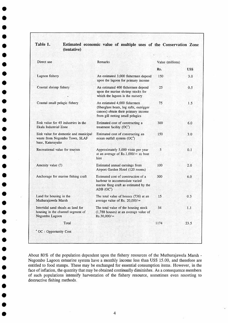
Table 1. Estimated economic value of multiple uses of (tentative)
the Conservation Zone
Direct use Remarks Value (millions)
Rs. US$
Lagoon fishery An estimated 3,000 fishermen depend upon the lagoon for primary income
150 3.0
Coastal shrimp fishery An estimated 400 fishermen depend upon the marine shrimp stocks for which the lagoon is the nursery
25 0.5
Coastal small pelagic fishery An estimated 4,000 fishermen (fiberglass boats, log rafts, outrigger canoes) obtain their primary income from gill netting small pelagics
75 1.5
Sink value for 45 industries in the Ekala Industrial Zone
Estimated cost of constructing a treatment facility (OC*)
300 6.0
Sink value for domestic and municipal waste from Negombo Town, SLAF base, Katunayake
Estimated cost of constructing an ocean outfall system (OC*)
150 3.0
Recreational value for tourists Approximately 5,000 visits per year at an average of Rs. 1,000/= as boat hire
5 0.1
Amenity value (?) Estimated annual earnings from Airport Garden Hotel (120 rooms)
100 2.0
Anchorage for marine fishing craft Estimated cost of construction of a harbour to accommodate varied marine fisng craft as estimated by the ADB (OC*)
300 6.0
Land for housing in the Muthurajawela Marsh
The total value of houses (736) at an average value of Rs. 20,000/=
15 0.3
Intertidal sand shoals as land for housing in the channel segment of Negombo Lagoon
The total value of the housing stock (1,788 houses) at an average value of Rs.30,000/=
54 1.1
Total 1174 23.5
* OC : Opportunity Cost
About 80% of the population dependent upon the fishery resources of the Muthurajawela Marsh -Negombo Lagoon estuarine system have a monthly income less than US$ 15.00, and therefore are entitled to food stamps. These may be exchanged for essential consumption items. However, in the face of inflation, the quantity that may be obtained continually diminishes. As a consequence members of such populations intensify harvestation of the fishery resource, sometimes even resorting to destructive fishing methods.
4
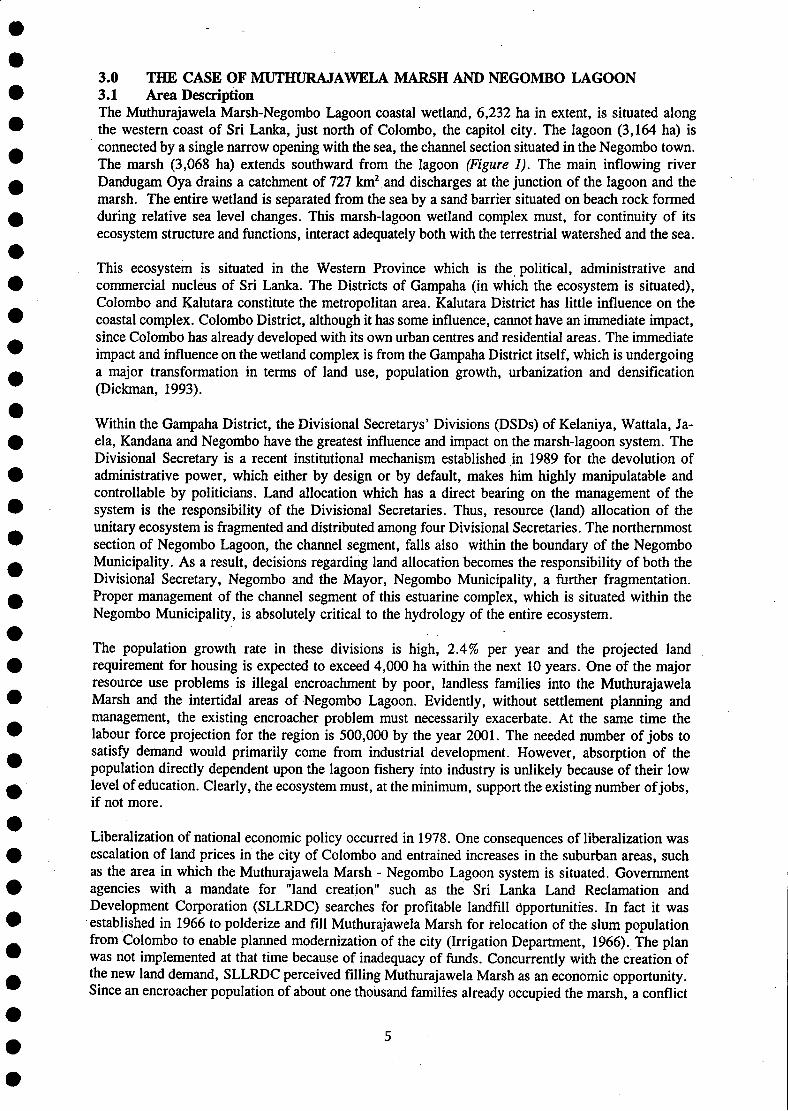
3.0 THE CASE OF MUTHURAJAWELA MARSH AND NEGOMBO LAGOON 3.1 Area Description The Muthurajawela Marsh-Negombo Lagoon coastal wetland, 6,232 ha in extent, is situated along the western coast of Sri Lanka, just north of Colombo, the capitol city. The lagoon (3,164 ha) is connected by a single narrow opening with the sea, the channel section situated in the Negombo town. The marsh (3,068 ha) extends southward from the lagoon (Figure 1). The main inflowing river Dandugam Oya drains a catchment of 727 km2 and discharges at the junction of the lagoon and the marsh. The entire wetland is separated from the sea by a sand barrier situated on beach rock formed during relative sea level changes. This marsh-lagoon wetland complex must, for continuity of its ecosystem structure and functions, interact adequately both with the terrestrial watershed and the sea.
This ecosystem is situated in the Western Province which is the political, administrative and commercial nucleus of Sri Lanka. The Districts of Gampaha (in which the ecosystem is situated), Colombo and Kalutara constitute the metropolitan area. Kalutara District has little influence on the coastal complex. Colombo District, although it has some influence, cannot have an immediate impact, since Colombo has already developed with its own urban centres and residential areas. The immediate impact and influence on the wetland complex is from the Gampaha District itself, which is undergoing a major transformation in terms of land use, population growth, urbanization and densification (Dickman, 1993).
Within the Gampaha District, the Divisional Secretarys' Divisions (DSDs) of Kelaniya, Wattala, Ja-ela, Kandana and Negombo have the greatest influence and impact on the marsh-lagoon system. The Divisional Secretary is a recent institutional mechanism established in 1989 for the devolution of administrative power, which either by design or by default, makes him highly manipulatable and controllable by politicians. Land allocation which has a direct bearing on the management of the system is the responsibility of the Divisional Secretaries. Thus, resource (land) allocation of the unitary ecosystem is fragmented and distributed among four Divisional Secretaries. The northernmost section of Negombo Lagoon, the channel segment, falls also within the boundary of the Negombo Municipality. As a result, decisions regarding land allocation becomes the responsibility of both the Divisional Secretary, Negombo and the Mayor, Negombo Municipality, a further fragmentation. Proper management of the channel segment of this estuarine complex, which is situated within the Negombo Municipality, is absolutely critical to the hydrology of the entire ecosystem.
The population growth rate in these divisions is high, 2.4% per year and the projected land requirement for housing is expected to exceed 4,000 ha within the next 10 years. One of the major resource use problems is illegal encroachment by poor, landless families into the Muthurajawela Marsh and the intertidal areas of Negombo Lagoon. Evidently, without settlement planning and management, the existing encroacher problem must necessarily exacerbate. At the same time the labour force projection for the region is 500,000 by the year 2001. The needed number of jobs to satisfy demand would primarily come from industrial development. However, absorption of the population directly dependent upon the lagoon fishery into industry is unlikely because of their low level of education. Clearly, the ecosystem must, at the minimum, support the existing number of jobs, if not more.
Liberalization of national economic policy occurred in 1978. One consequences of liberalization was escalation of land prices in the city of Colombo and entrained increases in the suburban areas, such as the area in which the Muthurajawela Marsh - Negombo Lagoon system is situated. Government agencies with a mandate for "land creation" such as the Sri Lanka Land Reclamation and Development Corporation (SLLRDC) searches for profitable landfill opportunities. In fact it was established in 1966 to polderize and fill Muthurajawela Marsh for relocation of the slum population from Colombo to enable planned modernization of the city (Irrigation Department, 1966). The plan was not implemented at that time because of inadequacy of funds. Concurrently with the creation of the new land demand, SLLRDC perceived filling Muthurajawela Marsh as an economic opportunity. Since an encroacher population of about one thousand families already occupied the marsh, a conflict
5
SRI LANKA
NEGOMBO
SEA
COLOMBO
PLANNING AREA
) To Dcmpe
PELIYAGODA
Figure 1. The Muthurajawela Marsh-Negombo Lagoon coastal complex
6
immediately ensued. In response to lobbying by interest groups the President of Sri Lanka ordered that a Master Plan for the Muthurajawela Marsh and Negombo Lagoon be prepared based upon an ecological survey. This case study also demonstrates the manner in which the Presidential order (political authorization from the highest level) was utilized for initiation of a carefully considered ICZM planning and implementation process.
The context in Sri Lanka within which the ICM process for Muthurajawela Marsh and Negombo Lagoon occurred may'be characterized as follows: The key national socio-economic features:
rising unemployment in a population of 17 million characterized by a high proportion of young (under 30 years), more than 50 % of the population earning an income which places them below the poverty line (less than US$ 400/= per year), high inflation which continually erodes the existing capacity to satisfy basic needs (food, clothing, shelter and medicine/health care), 70% of the population being rural and therefore dependent primarily on the productivity of natural systems while the national economic policy framework is oriented toward the satisfaction of needs of the urban minority, and the general aspiration of the youthful segment of the rural population to sever economic dependence on natural systems despite the scarcity of alternative occupations.
The key national socio-political features: geographic polarization of the population in a core-periphery dispersion, politicization of poverty, unemployment and landlessness in a manner that entrains extreme dependence upon party-political loyalties to acquire solutions to individuals' basic needs, extravagant election campaigning styles that reportedly compel politicians to divert attention from the socio-economic and natural resources problems to infrastructure development which have substantial payback, reported plundering of land and natural resources such as forest timber, wetlands by politicians and persons enjoying their patronage, and the suppression of opposition by extra-democratic methods, opposition (political and bureaucratic) to efforts of common property resource users in their attempts to take control of their own destinies, insensitive bureaucracies with diminishing public accountability whose apparent priority is pleasing political masters and their supporters, and the general inaccessibility of the political representatives.
Ostensibly, the context in Sri Lanka, may be regarded as having been hostile to ICZM planning and implementation which sought to ensure equity by mobilizing community and public participation in the planning and decision making process. Despite an unconducive environment, this case study demonstrates the manner in which the process of planning and implementation of ICZM for the Muthurajawela Marsh-Negombo Lagoon ecosystem is forging:
a package of technical and scientific solutions to resource management problems to enable sustainable coastal utilization, empowerment of the local resource users in acquiring an adequate response from political authorities, bureaucracies, scientists (particularly university academics) toward creating institutions appropriate for sustained ICM, and community development (including youth training and womens' participation), hopefully, resulting in poverty alleviation to facilitate lasting results.
3.2 Master Planning Concepts 3.2.1 SustainabUity The clearest lesson that can be drawn from the development experience in Sri Lanka is the entrainment of an increase in poverty among populations dependent upon agriculture and fisheries because of inadequate attention to equity issues. Frequently, development purportedly for the benefit
7
of the poor and the unemployed have had the opposite effect. In many instances the side effects of development have eroded the productivity of linked ecosystems. Many irrigation and flood protection projects in lowlying areas have cut off fresh water supplies to estuaries entraining the collapse of fisheries and loss of jobs, for which compensation is not paid. Therefore, from the outset sustainability of all activities coming within the planning and implementation process for the area was an imperative. Diverse conceptualizations and definitions of sustainability occur in the literature. For the purpose of ICZM planning (Master Plan preparation for Muthurajawela Marsh and Negombo Lagoon), a practical definition was forged (Samarakoon and Van Zon, 1991):
Sustainability of yield: presently the ecosystem provides a wide range of products (goods) and services to which a financial value could be given. The supply of these products and services must remain undepleted. Sustainability of function: the marsh and the estuary together constitutes an ecological system of which linkages and processes cannot be financially interpreted (e.g. seawater-freshwater mixing, biodiversity), but the continuity of which are essential for present and future yields. They must remain unchanged or become enhanced. Sustainability of investment: any development activity selected for implementation should necessarily mean that finances allocated to it will result in the anticipated benefits (cost recovery); the development activity should not merely transform existing conditions, which could lead to abandonment of the project and/or cause adverse side effects (externalities) on yield and function of the ecosystem which would compel non-beneficiaries to bear a cost.
3.2.2 Policy Development The fundamental requirement for integrated management of the Muthurajawela Marsh - Negombo Lagoon system was a policy. The proposed Master Plan was seen as evolution of a policy for management of the marsh - lagoon system. From the outset, however, implementation was regarded as the looming problem, since the total process was expected to proceed over a period of many years during which period the beginning conditions could change. Therefore serious thought was given to implementability of policy.
The three classes of variables that affect implementation were separated as (i) Tractability of the problem, (ii) Statutory variables and (iii) Non-statutory variables (Sabatier and Mazmanian, 1980). Implementation would be easiest where problems are selected such that the link between behaviour and a negative impact can be most easily documented, where the target group is relatively homogeneous and constitutes a small percentage of the population. Statutory variables include the ability of the responsible bureaucracies to enforce existing statutes (laws). In Sri Lanka statutory limitations are overwhelming since most existing laws are rarely enforced, and where enforcement occurs, consistency and fairness are highly questionable. Non-statutory variables include socioeconomic conditions, commitment of target groups, support by the media and the public, the role of constituency groups, the degree of support from high-level officials, basically the relevant political processes.
The tractability of problems differed between the Muthurajawela Marsh and Negombo Lagoon. The target groups were more homogeneous in the former than in the latter. The main statutory variables applicable to Muthurajawela Marsh were land tenure laws. In the case of Negombo Lagoon the applicable statutes are complex. With regard to non-statutory variables, both target group and political support were envisaged as most possible in Muthurajawela Marsh. Therefore, progressive planning and implementation was seen as the optimal strategy. Consequently, planning for integrated management of Negombo Lagoon was assigned to the "second phase activities".
3.2.3 Dealing With Uncertainty The planning effort was beset with three types of uncertainty relating to the probability of implementation:
Uncertainty of environmental values. The directive from the President of Sri Lanka that the Master Plan was to be based upon the findings of an ecological survey minimized this area
8
of uncertainty. The plan had to be environmentally friendly. However, government agencies with development mandates, generally regarded ecological concerns as a nuisance eventually to be brushed aside. Uncertainty of institutional relationships. This area of uncertainty was dealt with mainly by convening a high-level steering committee composed of heads of organizations and some prominent non-governmental organizations (NGOs). At the outset, the limitation of this approach was recognized since representatives of the resource users, the segment of the population that would eventually benefit or bear the cost of plan implementation, was not included. Recognizing the strong preference of existing bureaucracies to keep resource users (particularly the poor and the powerless, who generally cannot converse in English) out of planning discussions, a subtle approach was adopted for their progressive participation. That segment of the resource users who would be affected earliest by plan implementation were the illegal encroachers into the marsh (1,000 families). About 50% of this population was represented by a community-based organization, the Muthurajawela United Peoples' Organization (MUPO). Participation of this group was acquired by enrolling them as active partners in two areas of study which were their foremost concern, health and housing, in collaboration with the Medical Research Institute and the National Housing Development Authority. Uncertainty of information. This is the area of uncertainty which is relatively simple to deal with, since it merely involves collection of necessary information (scientific and technical studies). However, it was recognized that mere infusion of information would not make a plan implementable. The collected information had to relate to problems that had either economic or ecological significance that could be perceived in the same manner by political authorities, resource users and the public. The task of information collection was therefore focused upon die most relevant problems.
During the early discussions of the steering committee, it was evident that a detailed Master Plan was neither possible nor feasible within the period of 18 months allowed for the exercise (ecological survey and master plan preparation). The perception of the President of Sri Lanka as a strict disciplinarian, instilled the commitment that the plan should be delivered precisely on the deadline. As a consequence, the decision was made that an adequately flexible structure plan (strategic zoning) that gave full consideration to ecosystem structure and function would be more appropriate. Flexibility of a structure plan was expected to provide robustness which would facilitate implementation. In most countries, particularly in the west, strategic planning which is highly flexible is recognized as being more capable of achieving implementation (Friend and Hickling, 1987)
3.2.4 Imparting Legitimacy The planners recognized that the Master Plan had to acquire legitimacy if it was to be implemented. Therefore, fullest consideration was given. to the characteristics that impart legitimacy to a development (environmental management) plan (Faludi, 1987):
Identifying and taking advantage of development opportunities. Preventing side effects of development that would hurt the interests of others who are not beneficiaries of that development activity (externalities). Ensuring equity by providing the fullest consideration to the disadvantaged groups in a manner such that the development activity provides a flow of benefits to them.
Essentially, the goal of the Master Plan was harmonization of development (economic growth) with ecology.
3.2.5 Ecosystem Approach During conceptualization of the master planning process, unanimous agreement was acquired from the steering committee on the need for a system approach for arriving at planning decisions for the lagoon-marsh complex. However, strong reservations were expressed on the practicality of attempting to understand the system and its planning implications, in a neutral approach, within the given time frame of 18 months. Consequently, instead of getting mired in endless, system interconnections, the
9
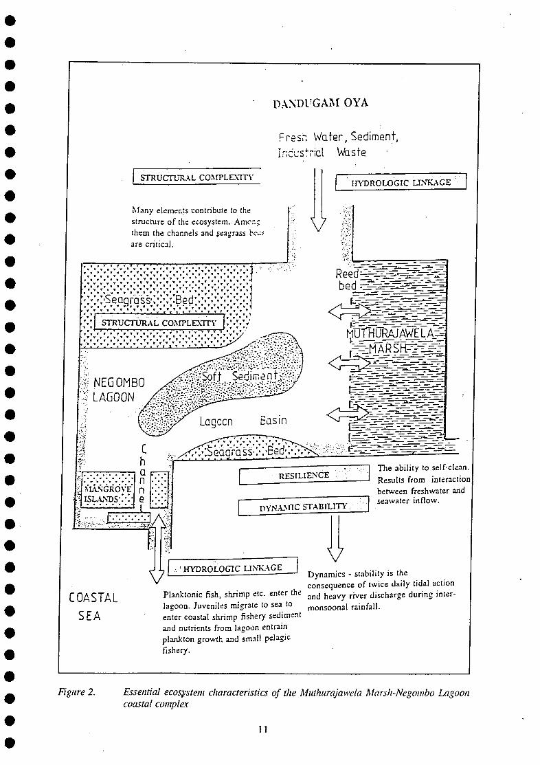
essential characteristics were addressed (Holling, 1978). These were found to be four essential characteristics that the coastal ecosystem shares with all other systems, artificial and natural, including the human body system, being linkages, structural complexity, resilience and dynamic stability (Figure 2).
Linkages. This 6,232 ha wetland ecosystem is linked both to land and the sea. Freshwater from a catchment of 727 sq km drains into the system by way of the Dandugam Oya. Volume of discharge varies seasonally with the rains and sets the tempo for variations in salinity and nutrient inflow. The same system connects by way of a single opening with the sea. Tidal inflow of sea water occurs twice daily. The interaction of freshwater and seawater is the fundamental processes that determines the magnitude of the system's harvestable biodiversity.
Structural complexity. The Muthurajawela-Negombo Lagoon ecosystem consists of the following interacting parts: channels, expanded basin, seagrass beds, mangroves, reed beds, soft mud bottom, intertidal sand shoals and the peaty marsh. Some of these distinctive habitats such as seagrasses, mangroves and reed beds, are themselves constituents of biodiversity. The others support large populations of microscopic plants, animals and bacteria which are critical elements that mediate the flow of energy to those components which give economic value to the system. Each of these habitat types can compensate to a limited extent for the loss or destruction of another. Already, the mangroves have been depleted to the extent that its former role is now performed mainly by the submerged seagrass beds and the reed beds. However these habitats are also under threat from destructive fishing practices as well as landfill. At some point the self-compensating capacity would be lost when biodiversity must sharply decline. Both seagrasses and mangroves are components that are adapted to build up sediment and to expand where sedimentation occurs (UNESCO, 1983). The equilibrium in structural complexity is associated with the dynamics of a system. When dynamism is lost, some components such as mangroves develop "cancerously" and accelerate the death of the system.
Resilience. An ecosystem has the ability to resist irreversible change and to correct seemingly irreversible changes. For instance, the sediment accumulation within Negombo Lagoon will be corrected to a substantial extent if the volume and rate of water flow through the system is restored. However, concurrently with sediment accumulation, there occurs an accumulation of nutrients and other substances which are capable of causing eutrophication (excessive production of microscopic plants). This would cause a collapse of the fishery in the lagoon. Restoration of the earlier status then becomes a slow and complicated process.
Dynamic stability. A coastal wetland such as Muthurajawela Marsh-Negombo Lagoon ecosystem is highly dynamic. The two elements that contribute to its dynamism are the tides and the river flow. Twice daily, sea water flows into the system and causes variation in the salinity of water. At intervals of six months, river discharge during the rainy season aggressively flushes the system of both salt water and sediments. The twice daily tidal changes and the twice yearly flushing by fresh water impart to the system a dynamism that relatively few organisms have the physiological capacity to tolerate. It is also because of the stresses imposed by dynamism that this ecosystem can support selected species such as some species of fish, shrimp and molluscs in superabundant quantity. As soon as this dynamism is lost, as it has already happened in numerous coastal wetlands in Sri Lanka, the harvestable biodiversity declines sharply. Additionally, loss of dynamism also entrains stagnation of water which results in an increase in harmful organisms, e.g. disease vectors such as mosquitos. The high diversity and abundance of mosquitos in the Muthurajawela segment of the ecosystem is mainly attributable to loss of dynamism.
The choice of the systemic features may be disputed. However, the manner in which the ecosystem cpncept could be conveyed to politicians, bureaucrats and the resource users (the lagoon fishermen
10
DANDUGAM OYA
Fresh Water, Sediment, Industrial Waste
STRUCTURAL COMPLEXITY
Many elements contribute to the structure of the ecosystem. Amor.c them the channels 3 n d seagrass Kv.< are critical.
HYDROLOGIC LINKAGE
*********** * S v v v . v y * * * * * ' * " • * * \ » • • J
SVanrass\v/"Bed; ,.^v-;v:v ,:l ' . v . v . v . v . v . X v . v . w * . 1
STRUCTURAL COMPLEXITY r J u f R U R ^ W E J ^
~~] The ability to self-clean ——' Results from interaction
between freshwater and seawater inflow.
V • HYDROLOGIC LINKAGE
COASTAL SEA
Dynamics - stability is the consequence of twice daily tidal action
Planktonic fish, shrimp etc. enter the a n d h e a v y r j v e r d i s c h a r g e during inter-lagoon. Juveniles migrate to sea to m o n s o o n a i rainfall, enter coastal shrimp fishery sediment and nutrients from lagoon entrain plankton growth and small pelagic fishery.
Figure 2. Essential ecosystem characteristics of the Muthurajawela Marsh-Negombo Lagoon coastal complex
11
in particular) was the primary determinant. The most effective manner was to compare an ecosystem with the human body system. On the basis of the four essential ecosystem characteristics stated above, communication with the fishing communities later proved to be highly effective.
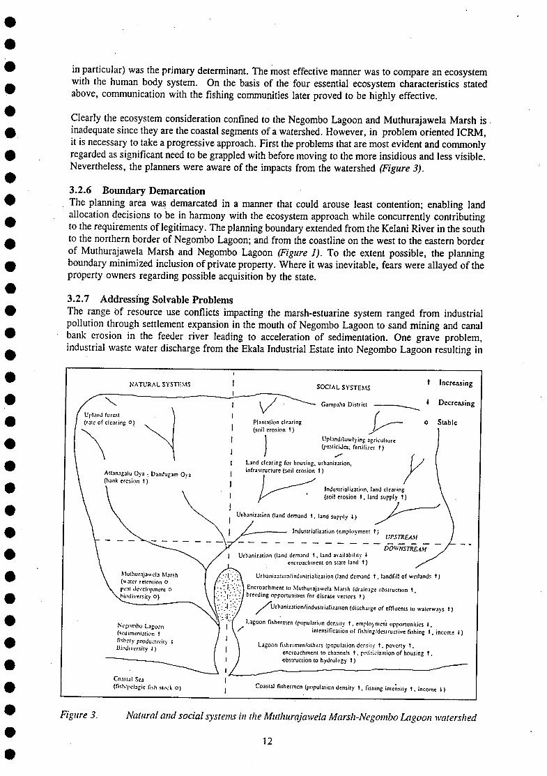
Clearly the ecosystem consideration confined to the Negombo Lagoon and Muthurajawela Marsh is inadequate since they are the coastal segments of a watershed. However, in problem oriented ICRM, it is necessary to take a progressive approach. First the problems that are most evident and commonly regarded as significant need to be grappled with before moving to the more insidious and less visible. Nevertheless, the planners were aware of the impacts from the watershed (Figure 3).
3.2.6 Boundary Demarcation The planning area was demarcated in a manner that could arouse least contention; enabling land allocation decisions to be in harmony with the ecosystem approach while concurrently contributing to the requirements of legitimacy. The planning boundary extended from the Kelani River in the south to the northern border of Negombo Lagoon; and from the coastline on the west to the eastern border of Muthurajawela Marsh and Negombo Lagoon (Figure J). To the extent possible, the planning boundary minimized inclusion of private property. Where it was inevitable, fears were allayed of the property owners regarding possible acquisition by the state.
3.2.7 Addressing Solvable Problems The range of resource use conflicts impacting the marsh-estuarine system ranged from industrial pollution through settlement expansion in the mouth of Negombo Lagoon to sand mining and canal bank erosion in the feeder river leading to acceleration of sedimentation. One grave problem, industrial waste water discharge from the Ekala Industrial Estate into Negombo Lagoon resulting in
N A T U R A L S V S T K M S S O C I A L S Y S T E M S * , N C R C A S I N S
I
Coastal Sea
(rub/pelagic fish stock O ) fishermen (population density t , fisning intensity t , income I )
Figure 3. Natural and social systems in the Muthurajawela Marsh-Negombo Lagoon watershed
12
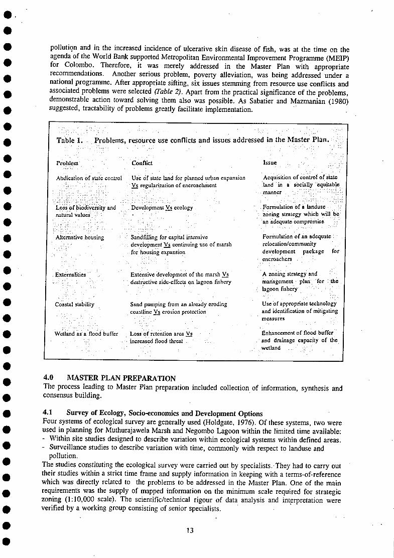
pollution and in the increased incidence of ulcerative skin disease of fish, was at the time on the agenda of the World Bank supported Metropolitan Environmental Improvement Programme (MEIP) for Colombo. Therefore, it was merely addressed in the Master Plan with appropriate recommendations. Another serious problem, poverty alleviation, was being addressed under a national programme. After appropriate sifting, six issues stemming from resource use conflicts and associated problems were selected (Table 2). Apart from the practical significance of the problems, demonstrable action toward solving them also was possible. As Sabatier and Mazmanian (1980) suggested, tractability of problems greatly facilitate implementation.
Table 1 . Problems, resource use conflicts and issues addressed in the Master Plan.
Problem Conflict Issue
Abdication of slate control Use of state land for planned urban expansion Vs regularization of encroachment
Acquisition of control of state land in a socially equitable manner
Loss of biodiversity and natural values
Development Vs ecology Formulation of a landuse zoning strategy which will bean adequate compromise
Alternative housing Sandfilling for capital intensive development Vs continuing use of marsh for housing expansion
Fonnulalion of an adequate relocation/community development package for encroachers
Externalities , Extensive development of the marsh Vs destructive side-effects on lagoon fishery
A zoning strategy and management plan for the lagoon fishery
Coastal stability Sand pumping from an already eroding coastline Vs erosion protection
Use of appropriate technology and identification of mitigating measures
Wetland as a flood buffer Loss of retention area Vs increased flood threat
Enhancement of flood buffer and drainage capacity of the wetland
4.0 MASTER PLAN PREPARATION The process leading to Master Plan preparation included collection of information, synthesis and consensus building.
4.1 Survey of Ecology, Socio-economics and Development Options Four systems of ecological survey are generally used (Holdgate, 1976). Of these systems, two were used in planning for Muthurajawela Marsh and Negombo Lagoon within the limited time available: - Within site studies designed to describe variation within ecological systems within defined areas. - Surveillance studies to describe variation with time, commonly with respect to landuse and
pollution. The studies constituting the ecological survey were carried out by specialists. They had to carry out their studies within a strict time frame and supply information in keeping with a terms-of-reference which was directly related to the problems to be addressed in the Master Plan. One of the main requirements was the supply of mapped information on the minimum scale required for strategic zoning (1:10,000 scale). The scientific/technical rigour of data analysis and interpretation were verified by a working group consisting of senior specialists.
13
Socio-economic information was collected using questionnaires completed by the Grama Niladharis and verified randomly by the specialist in charge of the task (Mahanama, 1991). The Grama Niladhari is the lowest ranking government officer in the state administrative service assigned to a cluster of villages consisting of about 300 households. He is personally familiar with individual households, income status, occupation, land tenure, landuse in the area assigned to him.
The development options survey was carried out by distributing a grid map of the planning area to the widest range of potential investors with a request and instructions for a response. Potential investors who responded positively were sent a large scale grid map on which their land requirements were mapped in greater detail for specified uses.
The information from the ecological, socio-economic and development options survey were synthesized in the Environmental Profile for Muthurajawela and Negombo Lagoon (Samarakoon and Van Zon, 1991) to enable the master planning team to carry out strategic zoning. The environmental profile was divided into three sections; Part A: described the present situation of the natural and physical resources in the area. Part B: described the ongoing changes in the area, both natural and man-induced, their trends and future projections if existing trends persist unaltered. Part C: described the available development options for the area, potential impacts as well as anticipated condition and fate of the resources of the area if adverse impacts are ignored. This third part presented the basic considerations to be included in the Master Plan for strategic zoning with the focus on sustainability as defined in Section 3.2.
4.2 Strategic Zoning The foundation of the Master Plan (GCEC/Euroconsult, 1991) was strategic land allocation (zoning), which addressed the issues of development, ecology and equity (Figure 4). It relates to a planning area of 10,694 ha consisting of the Muthurajawela Marsh (3,068 ha) and Negombo Lagoon (3.164 ha), being one continuous wetland, and the surroundings (4,462 ha). In response to the six problems, and in keeping with the requirements of legitimacy and sustainability, the Master Plan recommended the establishment of four zones;
Conservation Zone (91% of the continuous wetland, or 60% of the total planning area). The most significant function of this zone was expected to be preservation of the structure and functioning of the ecosystem to enable sustainable management of biodiversity to ensure protection of lagoon fisher jobs as well as to support multiple uses that would not deplete biodiversity.
Buffer Zone (6.4% of the continuous wetland). The significant function of this zone was expected to be flood buffer, and prevention of expansion of residential and industrial activity into the Conservation Zone. Generally state land which is unused attracts encroachment. Buffer Zone management would therefore include cost effective activities that are economically strong enough to prevent further urbanization such as recreational development, and which could enhance biodiversity, e.g. golf course, marsh botanic garden, herbal garden and some community recreational uses.
Mixed Urban Zone (2.5% of the continuous wetland). The significant function of this zone would be facilitation of integrated economic growth and employment generation.
Residential Zone, low to high density (on the east and west of the continuous wetland, 41.7% of the total planning area). Settlement planning and residential development were expected to occur for this zone in a manner that would provide for relocation of the encroacher population in the marsh to locations with healthier living conditions and better access to infrastructure.
14
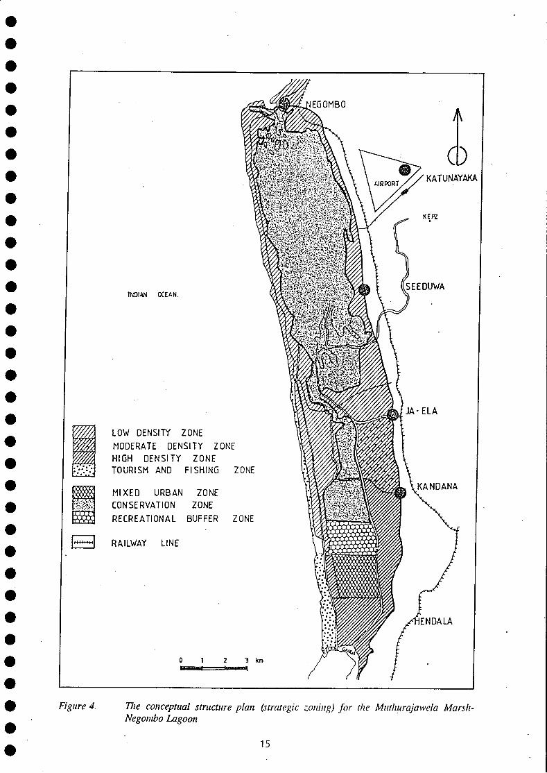
Figure 4. Tlie conceptual structure plan (strategic zoning) for the Muthurajawela Marsh-Negombo Lagoon
15
4.3 Authorization for Implementation The Master Plan was submitted for approval to the Cabinet of Ministers shortly after its completion. Based upon consultation with the relevant departments and agencies coming under the various ministries, approval was given for implementation with the directive that deviation from recommendations should not occur. However, the cabinet did not approve the establishment of the proposed new institutional mechanism for integrated management, a "management authority" with superseding legal powers. Instead, a multi-agency steering committee, without legal power, was convened for supervision and monitoring of implementation. An Additional Secretary to the Ministry of Finance and Planning which was directly under the President of Sri Lanka was appointed as the chairperson of the Muthurajawela Master Plan Steering Committee (MMPSC). Since this arrangement implied that implementation was occurring under the supervision of the highest political authority in the country, who also initiated the process, the local level politicians initially were highly coorperative (the consequences of the sudden demise of this President are addressed in Section 5.5.8).
5.0 MASTER PLAN IMPLEMENTATION 5.1 Programming and Feasibility Analysis The period 1991-1994 was designated for programming and feasibility analysis to enable the Master Plan to be tested and for it to acquire sensitivity to prevailing socio-political and socio-economic imperatives. In this process, the designed flexibility of the Master Plan acquired practicality that made implementation definitive. The plan was also crafted in a manner that would enable the separate components of the plan to be implemented independently under the responsible agency, but with coordination, supervision and monitoring by the integrating body (the MMPSC) which had community and NGO representation.
Programming and feasibility analysis included four main types of activities for which further planning was required, but on different levels of complexity. The four types of activity were, from the less to the more complex: (i) preparation of an environmental impact assessment for the sandfill in the Mixed Urban Zone, followed by landuse and business plan for the new land, (ii) developing relocation and community development packages for the encroacher communities living in the Muthurajawela Marsh, (iii) screening of investment proposals for the Buffer Zone and preparation of a landuse plan, and (iv) preparation of a Conservation Management Plan for the Conservation Zone, the second phase activity referred to in Section 3.2.1.
5.2 Mixed Urban Zone Development Sandfilling of the 162 ha assigned to Mixed Urban Development was the activity that could take off with least problems since the required steps were clear. It involved preparation of a feasibility analysis for the External Resources Department for mobilization of the necessary funds, followed by signing of a bilateral agreement, and preparation of a project specific environmental impact assessment. However, since 220 encroacher families were already resident at the sandfill site, they first had to be relocated.
5.2.1 Environmental Impact Assessment - Sandfill The filling of the Mixed Urban Zone required 4.8 million cubic meters of fill material. In accordance with the National Environmental Act, No. 47 of 1980 and environmental impact assessment is required for filling a wetland exceeding 4 ha in extent. The project proponent, SLLRDC, prepared the environmental impact assessment report for which conditional approval was given by the Central Environmental Authority, the project approving authority.
Filling of the Mixed Urban Zone was done by pumping sea sand collected by a trailing arm suction hopper dredger. Sand dredging and pumping were done in a manner that could not have any adverse impacts on the coastline which is already eroding. The adverse environmental impacts from any other form of filling (lateritic earth or river sand) were expected to outweigh the benefit of urban land creation.
16
A land use plan for the sandfill has since been prepared by the SLLRDC. In order to acquire optimal benefit from the Mixed Urban Zone Development, a business plan is now being prepared. One of the major socio-economic benefits from Mixed Urban Zone development will be labour absorption in construction work in the short term and employment generation in the loger term from industries that would be established.
5.2.2 Sandfill Related Relocation and Community Development Package A relocation and community development package was formulated in consultation with the target families. During the Ecological Survey which set the conditions for Master Plan preparation, public consultation occurred with regard to housing. At that time, the encroachers into the marsh expressed willingness to be relocated to sites which would be protected from floods and living conditions would be healthier. Their main request was ownership of a piece of land on which a permanent house could be constructed.
The package included relocation to a site as near as possible to the existing settlement, land praparation, provision of infrastructure (road access, pipe-borne water, electricity, sewage disposal), compensation proportionate to the land that had been developed at the encroachment site (e.g. coconut cultivation), financial assistance for construction of permanent houses on a self-help basis, a deed of ownership and establishment of autonomous community development councils (CDCs) with support from the National Housing Development Authority. The responsibility for the relocation programme, except, land preparation and infrastructure, was given to the Social and Economic Development Center (SEDEC), a highly respected Roman Catholic NGO. The relocation package ensured a drastic improvement in housing and health conditions for the previous encroacher community, while at the same time the equity issue was addressed such that the SLLRDC allocated a part of the anticipated, increased development value of the Mixed Urban Zone to paying the cost of relocation (UNCHS,
. 1991).
5.3 Relocation and Community Development The experience with relocation and community development to facilitate the sandfill in the Mixed Urban Zone was to serve as the foundation for formulating a programme for all encroacher communities in Muthurajawela Marsh. However, the sudden demise of the President of Sri Lanka, who initiated the process, opened a floodgate for interference by the politicians whose constituencies included the encroachers. This inteference entrained violent encounters as well as intimidation. The eventual consequence was that a segment of the population wanted on-site regularization, while a few communities living in the north of the marsh still request relocation to an area which is above flood level.
The strategic zoning of the Master Plan is adequately flexible to accommodate to request for on-site regularization of the encroacher communities. The Muthurajawela Marsh segment of the Conservation Zone has now been redemarcated in the conservation Management Plan for Muthurajawela marsh and Negombo lagoon (CEA/Euroconsult, 1994) in a manner that accommodates the land requirement for on-site regularization.
5.4 Buffer Zone - Integrated Land Use Planning Interest in developing the Buffer Zone has been shown by diverse investors. Since this zone was expected to serve three use functions, cost effective recreational development, flood buffer and community services, perceptions differed of how development should occur. Developers desired total control of the Buffer Zone for purposes of integrated management to protect their investments, wheras the local communities were apprehensive of its consequences. Therefore, the local communities desired to acquire use rights which could not be influenced by more politically powerful groups/individuals. In order to ensure that the Buffer Zone management meets the Master Plan objectives, a landuse plan for it will be prepared by the Wetland Conservation Project with technical assistance from Euroconsult, during the current Third Phase which is supported by the Netherlands Government.
1 7
5.5 Planning and Implementation of Conservation Management for the Conservation Zone The Conservation Zone is a high intensity multiple use area consisting of a marsh segment and the lagoon. The marsh provides land for housing, serves as a flood buffer and has a wide range of animals and plants. The Negombo Lagoon provides a much wider range of goods and services to the lagoon fisherfolk who are extremely poor and disorganized as well as to affluent individuals and groups who have direct access to and influence on political authorities. The existing policy for fisheries development in Sri Lanka focuses primarily on the mechanized marine fishery while concern for the poor traditional fishermen is piously expressed whereas little or no action is taken to improve their living conditions. The brackish water (estuary and lagoon) fishermen have in this process borne the cost of marine fishery development, where these bodies of water have been developed as anchorages. Negombo Lagoon is a major anchorage which serves about 400 boats with a displacement in excess of 5 metric tons and about 1000 smaller mechanized boats. Among others adverse impacts, fish and crustacean stocks harvested by lagoon fishermen have been adversely affected by oil pollution caused by waste oil discharges directly into the estuary.
5.5.1 The Elements The three essential elements of the Conservation Management Planning process were community empowerment, problem oriented technical studies, and integration by way of dialogue at the MMPSC.
5.5.2 Community Empowerment - Negombo Lagoon The foremost requirement of preparation of an implementable Conservation Management Plan for the Conservation Zone was recognized as obtaining community participation. It was formalized by submitting a workplan, which included community workshops as one of the elements of Conservation Management Plan preparation, to all relevant actors who had power to alter the approach, Viz.; the National Wetland Steering Committee, the Muthurajawela Master Plan Steering Committee and the Netherlands Government. The membership of the Master Plan Steering Committee included all relevant government agencies, the Roman Catholic Church, NGOs, a CBO, and later political representatives.
Empowerment: The United Nations Conference on Environment and Development (UNCED), Agenda 21 emphasized the need to enable communities and resource users to participate in planning, decision making and management of common property resources. This is radical departure from existing practice in Sri Lanka. Such participation implied that resource users acquire some measure of power to influence decisions that affect their own lives. Power after (Etzioni, 1968) is defined thus:
Political power: the capacity to introduce change in the face of resistance; a capacity to overcome a part or all of the resistance, and stemming from it, the capacity to influence the state and other downward institutionalized processes. Societal power: the capacity of a societal unit to gain its way in the face of resistance by other societal units.
Community empowerment continues to be the most formidable task in ICM in Sri Lanka because of the prevailing attitude of political leaders and bureaucrats. Some lessons may be extracted from the experience gained in this area during Conservation Management Plan preparation for the Conservation Zone of the Master Plan.
The foremost requirement of the encroacher population in the Muthurajawela Marsh segment of the Conservation Zone was an acceptable relocation package. The residents in the marsh segment were partially organized as the Muthurajawela United Peoples Organization (MUPO) along clear democratic principles, the leadership was committed to social uplift, they had acquired experience in lobbying, and the activities of the leadership were transparent. Even during the short period available for Master Plan preparation, it was possible to include some detailed management measures addressing the needs of these poor communities. Therefore, the major focu was Negombo Lagoon.
18
Negombo Lagoon This estuarine lagoon is a high value resource base with an annual economic worth exceeding US $ 20 million (Table J). About 3,000 fishermen from 26 villages surrounding the lagoon depend upon its fishery productivity for livelihood. The annual value of fish and crustaceans harvested from it is US $ 3 million. Because of the low level of literacy and education, access to alternative occupations is highly limited or unavailable for the lagoon fisherfolk. The priority need therefore was to organize the lagoon fishing community and instil the need for sustainable management of the lagoon resources as protection of their own livelihood.
Community workshops At the outset, it was evident that the lagoon fishermen from the different villages had diverse perceptions as well as common views regarding the health and functioning of the lagoon. The challenge was to get the lagoon fishermen from 26 villages to agree on a common analytical framework for sustainable management of the resources of Negombo Lagoon, required both for their own future as well as for biodiversity conservation. Only a common and shared analytical framework could result in the essential consensus on management measures. An ecosystem approach, based upon the four essential system characteristics, served as the foundation for development of such a common framework. Therefore, the workshops were intensively used to educate the communities in understanding (the need for) management of natural systems. The concept of carrying capacity was kept out of the workshop discussions, since the lagoon fishermen would look with suspicion upon any measures that would reduce access to the lagoon resources, especially in the absence of compensation or acceptable alternative occupations. Emphasis was placed on the message that fishermen are a part of the ecosystem they exploit; at the beginning most the fisherfolk regarded the Negombo Lagoon as something separate from their lives.
5.5.3 Workshop structure The objectives of the workshops were:
Share information with representatives of the lagoon fisher communities directed ultimately at instilling the mutual recognition that the Negombo Lagoon should be managed as a system Acquire information for incorporation into the Conservation Management Plan that would impart a high degree of acceptability for it among the lagoon fishermen and thereby divert the customary attitude of opposition to plan implementation to reasoned negotiation. Organize the lagoon fisherfolk in a manner that would enable them to enter into direct discussion with relevant political authorities such that their needs and aspirations would be given serious consideration, and to demonstrate that the only countervailing power that they possess, the vote, would be used effectively (empowerment). Provide training in agenda setting, problem identification and analysis, and guiding discussion toward technical solutions to problems.
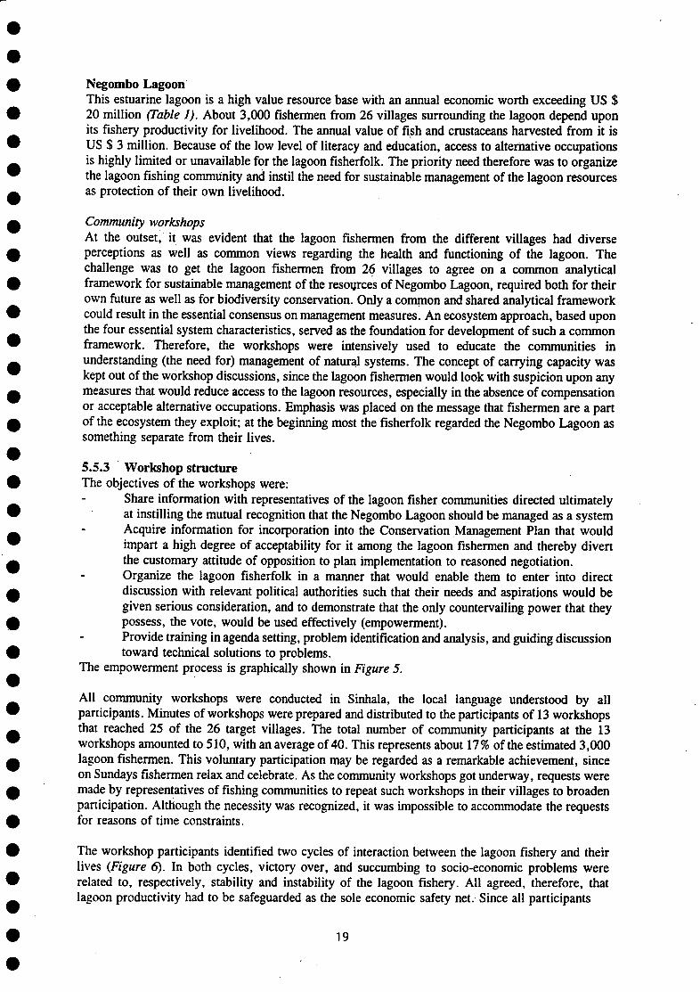
The empowerment process is graphically shown in Figure 5.
All commumty workshops were conducted in Sinhala, the local language understood by all participants. Minutes of workshops were prepared and distributed to the participants of 13 workshops that reached 25 of the 26 target villages. The total number of community participants at the 13 workshops amounted to 510, with an average of 40. This represents about 17% of the estimated 3,000 lagoon fishermen. This voluntary participation may be regarded as a remarkable achievement, since on Sundays fishermen relax and celebrate. As the community workshops got underway, requests were made by representatives of fishing communities to repeat such workshops in their villages to broaden participation. Although the necessity was recognized, it was impossible to accommodate the requests for reasons of time constraints.
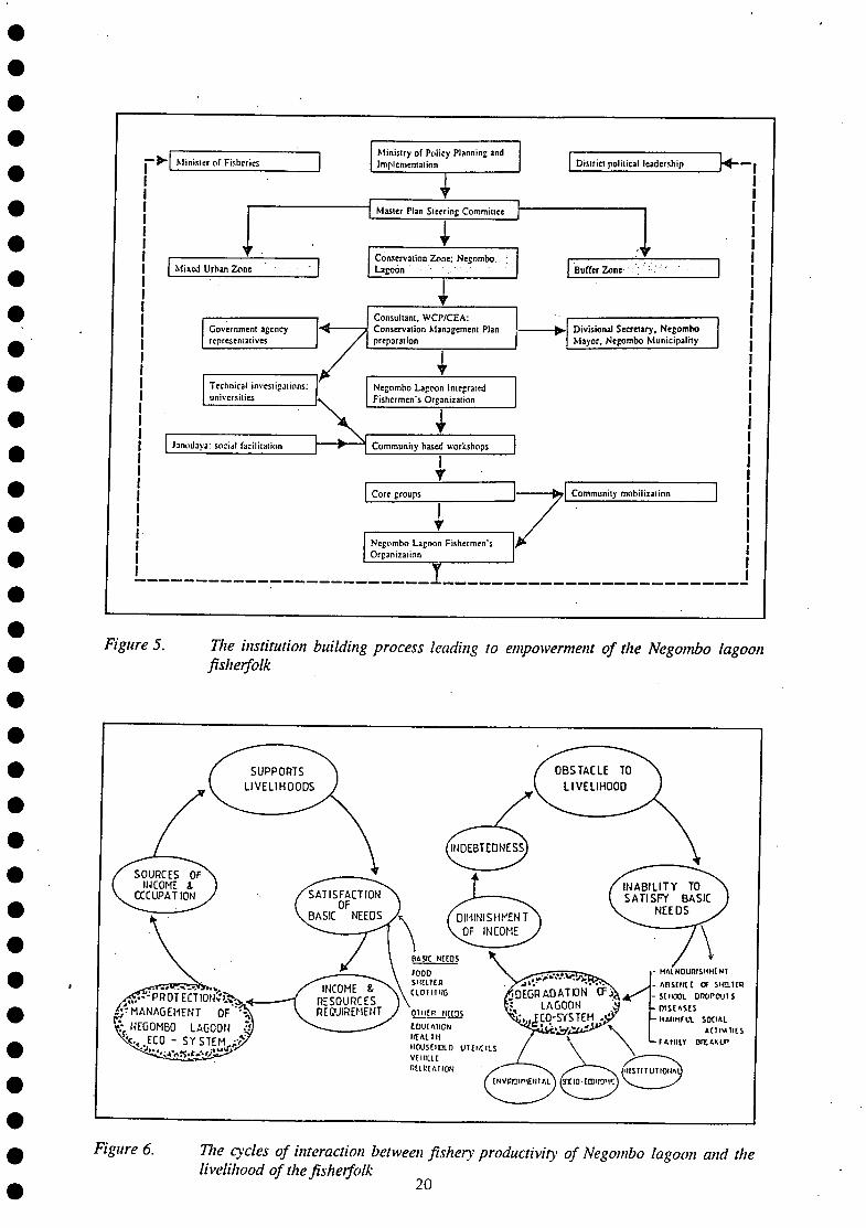
The workshop participants identified two cycles of interaction between the lagoon fishery and their lives (Figure 6). In both cycles, victory over, and succumbing to socio-economic problems were related to, respectively, stability and instability of the lagoon fishery. All agreed, therefore, that lagoon productivity had to be safeguarded as the sole economic safety net. Since all participants
19
Minister of Fisheries Ministry of Policy Planning 2nd implementation
J Master Plan Steering Committee
Mixed Urban Zone Conservation Zone: Negombo Lagoon
i
Technical investigations: universities
Negombo Lagoon Integrated Fishermen's Organization
\ V Janodaya: social facilitation Community based workshops Janodaya: social facilitation Community based workshops
y
Negombo Lagoon Fishermen's Organization
District political leadership
Buffer Zone
Consultant, W C P / C E A : Conservation Management Plan preparation
Government agency representatives
iff Consultant, W C P / C E A : Conservation Management Plan preparation
Divisional Secretary, Negombo Mayor, Negombo Municipality
Government agency representatives
Consultant, W C P / C E A : Conservation Management Plan preparation •
Divisional Secretary, Negombo Mayor, Negombo Municipality
Core groups Community mobilization Core groups Community mobilization
L I j
Figure 5. The institution building process leading to empowerment of the Negombo lagoon fisherfolk
Figure 6. Tfie cycles of interaction between fishery productivity of Negombo lagoon and the livelihood of the fisherfolk
2 0
realized at the end of a workshop that the lagoon had to be managed as a system, they agreed also that individual villages were incapable of bringing about the necessary change. They also agreed that the ecosystem approach, which was conveyed to them based upon a comparative analysis with the human body system, made sense and was appropriate. They recognized that they must perceive themselves as integral parts of the lagoon system.
Some problems identified at the community workshops were common to all the villages, while others were not. Prioritization of problems was based upon commonality and scored on a scale from 0 to 15. The synthesis of information was meant to set a common foundation for subsequent discussion by the core groups elected at the community workshops. At these workshops technical information was not given until the participants had thoroughly analyzed the problems as they, themselves perceived. The collective experience of the organizers was, where technical information is given at the beginning of a participatory workshop (in the form of a lecture), the participants become silent for a variety of reasons. For instance, the communities may be intimidated by the extent of mismatch between scientific perceptions of common problems and their own understanding based upon experience, mental maps and folk lore. In the present workshop approach, the technical presentation was made at the end of the session, and it was mainly meant to fortify the strength of the perceptions of the participants. Every effort was made to demonstrate that the comparative approach that they had adopted as successful fishermen, comparing mental maps of fishing locations, was the basic scientific approach to understanding nature.
5.5.4 Workshop findings Ecosystem-related problems There was total consensus on the fact that the two main adverse effects on fisheries pertained to ecosystem functioning, Viz:
obstruction of lagoon-sea water exchange stemming from sedimentation; and destruction of nursery areas (structural complexity).
Problems pertaining to dynamic stability of the system and to system resilience appeared not to have immediate relevance.
Socio-economics related problems Socio-economic causes of the problems that relate to the fisheries productivity of Negombo Lagoon were discussed most intensively at the community workshops. Two thematic viewpoints emerged:
sustainable management of the fishery resources of Negombo Lagoon cannot be feasible until and unless the socio-economic problems are integrated into the management framework; and enforcement of existing laws and regulations would lead to improvement of management of the fishery resources, but must occur without discrimination and political favouritism.
Institutional problems Two main categories of problems can be concluded from the analysis of the institutional problems as identified at the community workshops:
problems that stem from the existing polarization of political power, and the proclivity of national and local level agency officials to yield to higher level political influence to protect law breakers, and problems that stem from the absence of organization and dialogue among the communities that depend upon the productivity of the same ecosystem, and the consequent lack of leverage on common ecosystem-based issues that affect the everyday lives of members of these communities.
5.5.5 Workshop conclusions When an overview of the collected information was made, the following major conclusions could be drawn:
the Conservation Management Plan had to include sustainable exploitation of the lagoon fisheries resources, since this is a basic condition for conservation of the lagoon ecosystem
21
and its biodiversity; the Conservation Management Plan had to incorporate community development as a basic necessity in harmony with the needs and aspirations of the lagoon fishing communities; measures for pollution control had to be incorporated; alternative job opportunities had to be created; development of environmentally sound recreation and eco-tourism appears to provide one such mechanism apart from those that would be identified by way of participatory research during implementation of the Conservation Management Plan.
5.5.6 Demonstration of empowerment At the inception of the Conservation Management Planning process, a detailed workplan was submitted to the Muthurajawela Steering Committee for comments and discussion. A specific request was made to the Department of Fisheries arid Aquatic Resources (DFAR) to collaborate in the community workshop process in order that a fishery management plan and the ecosystem management plan would evolve harmoniously. DFAR took the position that its UNDP funded Fishery Management Unit (with expatriate staff) would independently prepare a fishery management plan for subsequent integration with the ecosystem management plan. Mid way in the community workshop process, as the fisherfolk were becoming organized and understood the problems that would stem from massive development of an anchorage at the lagoon outlet, a propaganda campaign commenced (organized lobbying). Attempts made by the Ministry of Fisheries and Aquatic Resources to thwart the community workshop process became ineffective. Eventually the Minister of Fisheries and Aquatic Resources was compelled to have a meeting with the Negombo Lagoon fishermen. During the meeting, spokesmen for the lagoon fishermen argued on technical grounds that planned construction work should not be undertaken at the lagoon outlet. The Minister was thereby persuaded to agree that only investigations into the total lagoon system would be undertaken and that any construction work would begin only after a complete analysis of the collected information. Since 1994 was an election year the fisherfolk, once organized, were in a position to demonstrate the impact they could have by exercising a block vote.
The lagoon fisherfolk, now organized as the Negombo Lagoon Integrated Fishermens' Organization (NLIFO), have already met the new Minister of Fisheries and presented him with a draft of the Conservation Management Plan prepared by the Wetland Conservation Project of the Central Environmental Authority. At the same time in a memorandum submitted to the Minister of Fisheries, the NLIFO has requested the DFAR's fishery management plan to be given to them for testing with its membership. The new minister has already given his commitment to ensure management of Negombo Lagoon as an ecosystem. During the empowerment process, the lagoon fisherfolk understood that as an organized group (with a block vote), access could be obtained to the political authorities without being deflected by bureaucrats. As a group they are now in a position to resist imposed change with which they do not agree.
Again, the experience here is that public and community participation provide the necessary momentum to plan implementation. It is necessary to recognize that plan implementation is a political process, while plan preparation has both political and technical ingredients.
5.5.7 Problem Oriented Technical Studies Four problems were selected for technical analysis to provide information for conservation management planning, Viz. sedimentation to provide guidance for a dredging plan that would restore hydrology, illegal settlement expansion in the channels segment of the lagoon to understand the potential solutions, impacts of fishing on the seagrass beds which serve as critical nursery areas, and an analysis of a traditional fishery method which embodies all ingredients that contribute to sustainable use of common property resources, the stake-net fishery. Some comments on the stake-net fishery, here will be instructive.
22
Stake-net Fishery: The stake-net fishery is a fishing method which evolved in response to the migration of penaeid shrimp from Negombo Lagoon. This fishery has been in existence for a period exceeding 100 years. It is managed entirely by the fisher communities. The factors that have contributed to its sustainability are:
Equal sharing of benefits: The stake-nets are fixed at predetermined stations, all of which are not equally profitable. Therefore rotation exists whereby all participants acquire turns at the more profitable stations. Democratic decision making: A stake-net fishery society exists in each participating village. Election of office bearers is by secret ballot while sequence of access to stake-net stations is by drawing lots. Limitation of access: A fisherman can use a stake net only by becoming a member of a stake-net society. Membership is not freely available. A member may transfer the use right to only one unmarried male member of his family. Only married males of a family of a member may apply for membership after demonstrating the ability to operate a stake net and also by demonstrating ownership of the necessary gear and craft. A code of behaviour and enforcement of penalties: A strict code of behaviour exists governing even decorum during meetings and drawing of lots and other relevant aspects. Violation of any of the rules of conduct results in the imposition of a penalty that the membership has not defied until now. Dealing with the free rider problem: Diverse attempts have been made by fishermen and politically influential persons to acquire use rights in the stake-net fishery. All such attempts have been effectively thwarted through united action by the membership of the stake-net societies.
Apart from the direct benefit from fishing, indirect benefits in the form of assistance during funerals and other welfare payments such a monthly allowance to widows of stake-net fishermen for a period of 12 months also exist.
5.5.8 Integration/Dialogue at the Steering Committee (MMPSC) Preparation of the Conservation Management Plan commenced in January 1993. The entire work plan for the process leading to plan preparation was submitted to the MMPSC to elicit discussion that would enable definition of scope and recognition of linkages to be forged. Until mid-1993 dialogue and harmonization of activities relevant to conservation management planning for the Conservation Zone proceeded smoothly. However, from May 1993, following the assasination of the President of Sri Lanka, political interference at the MMPSC made informed dialogue difficult. Eventually, politicians were invited to participate at the MMPSC meetings with predictable consequences. Instead of dialogue resulting in integration of relevant activities, community requirements were presented by politicians which deviated substantially from the same requirements previously submitted by CBOs. The clashes between politicians and CBO representaives became increasingly frequent. The autonomous decision making of the community members, based upon which information was conveyed to the MMPSC became progressively undermined. The reverse flow of information to the community members from the same politicians, eroded the credibility of CBO representatives among the membership. This process was aggravated by bureaucrats who had to please their political masters for survival. In the ensuing confusion the existing MMPSC was terminated and a fresh three-tiered committee convened based upon a Cabinet Memorandum in mid-1994.
The conspicuous feature of the three new committees was the elimination of community representation. Intuitively, it was obvious that this cumbersome, three-tiered structure which required participation of high-level bureaucrats could not effectively function, simply because of absence of a quorum. After a single meeting the institutional arrangement withered. Nevertheless the conservation management planning process was successfully completed by end of 1994 since adequate community participation had been acquired.
23
5.6 The Conservation Management Plan The Conservation Management Plan for Muthurajawela Marsh and Negombo Lagoon (CEA/Euroconsult, 1994) aims at restoration of ecosystemic structure and function by way of measures to maintain salt balance, prevent oil pollution, demarcation of boundaries to prevent further encroachment, fishery management to eliminate destructive fishing methods, promotion of recreational use, community development (youth training, womens'participation), public awareness among others (Table 4).
The institutional innovation is strengthening of the existing community organizations which came into existence during the conservation management planning process. This is expected to lead to a collaborative arrangement between the community and the agency representatives for implementing measures included in the CMP while forging changed patterns of behaviour among the diverse resource users based upon the recognition that proper management benefits all actors. The driving force is expected to be the demand for management that has emergeed from the communities.
5.7 Implementation of the Conservation Management Plan The Netherlands Government has already committed funds for implementation of some activities in the Conservation Management Plan, with technical assistance provided by Euroconsult, until December 1997. Implementation commenced in March 1995 under the Third Phase of the Wetland Conservation Project of the Central Environmental Authority.
Donor assistance has to be obtained for activities that are not supported by the Netherlands Government. Project proposals are now being prepared by the Wetland Conservation Project as well as NLIFO and MUPO to mobilize donor funds. Some of the activities will be autonomously implemented by the community organizations with technical assistance from the Wetland Conservation Project. Other activities will be carried out collaboratively by statutory bodies in collaboration with the community organizations. By the end of 1997, hopefully, a mechanism would evolve for effective ICZM in the long term.
6.0 EMERGENT UNCERTAINTY 6.1 Church opposition During the ecological survey and Master Plan preparation, efforts were made to enrol the participation of representatives of the Roman Catholic Church. The planners were given to understand that, since MUPO, a community based organization was already involved, the resource users' concerns would be adequately represented. However, when Cabinet approval was acquired, the Roman Catholic Church objected to its implementation based mainly on the grounds that promotion of tourism would entrain unacceptable social practices.
6.2 Ministry of Fisheries opposition In 1989 the fisheries sector review supported by FAO was completed. In it serious consideration was given to potential interactions between infrastructure development in productive estuaries and traditional fisheries. However, at the time the Master Plan was being completed in 1991, an Asian Development Bank (ADB) mission reviewed the sector report and identified a series of infrastructure projects. One of the projects identified was the development of a major anchorage in the outlet of Negombo Lagoon to provide for capitalization of the existing fishing fleet by shifting effort to larger boats, including the provision of facilities for international fishing craft. The assumption was that the traditional fisherfolk and those operating with relatively small mechanized craft would be progressively "phased out". The flow of benefits, the safety net, for those losing occupations was expected to be provided by the notoriously unreliable "trickle down effect" (ADB, 1992). The feature of interest from a ICZM viewpoint, was the fact that despite abundant lessons learnt from overcapitalization leading to the collapse of coastal fishery stocks (Brown, 1985), the Ministry of Fisheries and Aquatic Resources opted for a solution that could be predicted to become a problem. Worldwide lessons notwithstanding, the scale of investment in infrastructure development under the ADB project was high.
24
When the Master Plan for Muthurajawela Marsh and Negombo Lagoon was sent to the Cabinet of the Ministers for approval, the Ministry of Fisheries protested against the recommendation that Negombo Lagoon be declared a protected zone for ICZM supported by the necessary legal backing. The director of the Department of Fisheries and Aquatic Resources participated in investigations connected with the ecological survey, the master planning process and the consensus building workshops, a few months previously, and agreed with the recommendations of the Master Plan. The rationale for the protest therefore was mysterious and ununderstandable. As a result, the Muthurajawela Master Plan Steering Committee decided that protected area status would be confined only to the Muthurajawela Marsh to the segment.
6.4 Political opposition Opposition from the established political leaders, both national level parliamentary representatives and elected members of local bodies progressively, acquired momentum following the demise of the president of Sri Lanka in May 1993. The same national political leader who had previously expressed satisfaction with the Master Plan, commenced obstruction of its implementation by making conflicting demands: infringements of the Master Plan recommendations to provide land allocations to investors on the one hand, and protesting against the implementation of the equity component which involved relocation and community development for the poor encroachers into the marsh whose living conditions were abysmal. Technical aspects, such as the cost and difficulty of infrastructure supply to a dispersed population in a marshy wetland, condemned these communities to a life of perpetual hardship. One of the local level political leaders adopted a highly hostile stance by refuting the technical findings of the ecological survey and the foundation of the Master Plan, and by arousing the communities which were targeted for relocation.
A multiplicity of causes existed for political opposition. However, the most discernible were: apparent loss of personalized control over plan implementation by the politicians, in the reverse event, they would have acquired the image of "deliverers" of needs' satisfaction (effective in winning votes), inability to control the award of building contracts since housing development for the relocatees was to be on a self-help and cost-effective basis, and the rising image of MUPO as having effectively mediated a flow of benefits to the encroacher population by way of their participation in the master planning process.
Various attempts were made to disrupt the relocation process that preceded the sandfilling of the Mixed Urban Zone. A majority of the community members in the relocated community were members of MUPO. When the benefits of the relocation package were clearly understood, they were the first to move to their own "new land" even in the face of politically motivated violence. Once the process commenced, the operation was smoothly completed.
6.5 Community support The organized segment of the encroachers into the marsh segment, who were also members of the community based organization MUPO, consisting of about 50% of the marsh residents, were highly supportive of plan implementation. They took the initiative in land identification for relocation and in settlement planning with technical assistance from students from the Technical University, the Delft, Netherlands who had a long-term field study programme in the area. While this technical information was not definitive, the participatory planning approach had a powerful influence upon the community members since they felt that they were shaping their own future. MUPO also was represented at the Muthurajawela Steering Committee. The representative of MUPO vigourously participated at the steering committee meetings, frequently to the irritation of some heads of departments, who previously had not encountered open challenging of statements, which, at accustomed fora blithely would have passed. Strengthening of community participation in implementation will be the only certain way of preventing politicians' efforts to disrupt MUPO and the new organization NLIFO.
25
6.6 Funds for implementing the equity component The Master Plan Steering Committee deliberated for 18 months from October 1991 on getting implementation off the ground. The proposed sandfill project (with donor assistance) was swinging between possibility and probability. In this context of uncertainty, discussions frequently swung toward the implementation of the equity component: upgrading the living conditions of the encroacher population in the marsh. Invariably, all such discussions staled at the dead end of absence of state funds for implementation. The politicians who vigorously campaigned for the poor were unable to mobilize the necessary funds, on the average Rs 100,000/= (US $ 2,000) per family based upon the calculations of the Sri Lanka Land Reclamation and Development Corporation (SLLRDC).
In mid 1993, definitive arrangements were made for the aid-loan package that would result in the materialization of the sandfill project at a cost of about US $ 12 million. Simultaneously, the proposal for relocation and community development for the 230 families resident at the site of the sandfill was approved and the funds made available jointly by a donor and the SLLRDC, at a cost of about US $ 500,000. Progress toward implementation of the development of the Mixed Urban Zone was accelerated from that point in time.
The important inference is that the Government of Sri Lanka was not able to invest in social uplift despite, political rhetoric, and the campaign for poverty alleviation. The constraints includes the impossibility of disproportionate investment for a relatively small segment of the national population which had broken the law by encroaching into state land, while a larger number of law-abiding citizens continue to be without land for housing. In such situations the usual approach of the Government of Sri Lanka has been to regularize encroachments irrespective of the long-term adverse impacts of such unplanned and unintegrated landuse.
7.0 CONCLUSIONS AND CONSIDERATIONS FOR INTEGRATED COASTAL ZONE MANAGEMENT
The major conclusions that emerges from the experience in ecosystem based ICZM for Muthurajawela Marsh-Negombo Lagoon estuarine system are:
ICZM* is an effective approach to sustainable use of coastal waters and conservation of biodiversity since protected/managed zones can be incorporated into an appropriate land allocation framework.
The important lessons for ICZM, particularly in developing countries based upon the Sri Lankan experience are:
ICZM plans should take into consideration at the outset the factors that will contribute to implementability, e.g legitimacy,
provide a strong scientific and technical foundation by taking into consideration ecosystem structure and functioning,
enrol community participation in planning and empower them through an information sharing process to face challenges that may subsequently arise from powerful political sources,
if zoning is a part of the ICZM plan, flexibility must be introduced to make land allocation robust, and
ICZM planning and implementation will be more effective if undertaken gradually over an extended period.
26
ACKNOWLEDGEMENT
Thanks are due to the Swedish Scientific committee on Biological Diversity for inviting the author to the workshop and paying for travel and living expenses. Dr. J.C.J. Van Zon (Euroconsult), Team Leader. Wetland Conservation Project, CEA for valuable comments on the initial draft and Mr. K.M. Akram for his assistance in formatting and preparation of the final document at brief notice.
REFERENCES
ADB., 1992. Appraisal of the Fisheries Sector Project in the Democratic Socialist Republic of Sri Lanka. Asian Development Bank, Manila.
Battisse, M., 1989. Development and implementation of the biosphere reserve concept and its applicability to coastal regions. UNESCO/IUCN Workshop on the Application of the Biosphere Reserve Concept to Coastal Areas. San Francisco, 1989.
Carleton Ray, G., 1989. Sustainable use of the global ocean In; Changing the Global Environment: Perspectives on Human Development (D.B. Bodkin et al. eds.). Academic Press Inc., New York.
CEA/Euroconsult., 1994. Conservation Management Plan; Muthurajawela Marsh and Negombo Lagoon. CEA, Colombo 10.
Chua, T.E., J. Paw and D. Diamante., 1994. The 1994 Royal Colloquium on Tropical Coastal Zones; From knowledge to action. Tropical Coasts; A newsletter for policy makers, environmental mangers, scientists and resource users. Vol 1, No. 1, December 1994.
Coast Conservation Department., 1990. Coastal Zone Management Plan. Coast Conservation Department, Colombo 10.
Dickman, L.D., 1993. Land demand and development prospects in the impact area of the Muthurajawela Master Plan. Board of Investment of Sri Lanka, Colombo.
Etzioni, A., 1968.
The Active Society; A theory of societal and political processes. The Free Press, New York.
Faludi, A., 1987 A decision centered view of environmental planning. Pergamon Press, Oxford.
Friend, J. and A. Hickling., 1878. Planning under pressure; The strategic choice approach. Pergauron Press, Oxford.
GCEC/Euroconsult, 1991. Master Plan of Muthurajawela and Negombo Lagoon. Greater Colombo Economic Commission, Colombo.
Holdgate, M.W., 1976. In Symposium of Environmental Evaluation, Canterbury, 1975. Planning and Transport Research Advisory Council, Department of the Environment, London.
27
Holling, C.S., 1978. Adaptive Environmental Assessment and Management. International Institute for Applied Systems Analysis. Wiley-Inter-science, London.
Irrigation Department, 1966. Technical Report of Muthurajawela Reclamation for Housing. Government of Ceylon, Sessional Paper 21, 1966.
Lowry, K. and D. Sadacharan., 1993. Coastal Management in Sri Lanka. Coastal Management in Tropical Asia: A newsletter for practitioners. No 1. CRMP/CRC/USAID, Colombo
Mahanama, P.K.S., 1991. Ecological Survey of Muthurajawela; Socio-economic Survey. Area Administration Department, GCEC, Colombo.
Norse, E.A. (ed), 1993. Global Marine Biological Diversity; A strategy for building conservation into decision making. Island Press, Washington D.C.
Pritchard, D.W., 1967. What is an estuary: physical viewpoint. In: Estuaries (G. H. Lauff ed.) Amer. Assoc. Adv. Sci. Publ. No 83. Washington.
Sabatier, P. and D. Mazmanian., 1980. The implementation of public policy; A framework for analysis. Policy Studies Journal 8:538-560
Salm, R.V. and J. Clark, 1989. Marine and coastal protected areas; A guide for planners and managers. IUCN, Gland, Switzerland.
Samarakoon, J.I, and J.C.J. Van Zon., 1991 Environment profile of Muthurajawela and Negombo Lagoon. GCEC/Euroconsult, Colombo.
Sherman, K., 1994. Sustainability, biomass, yields, and health of coastal ecosystems, an ecological perspective. Mar. Ecol. Prog. Ser. Vol. 112: 277-301, 1994.
Sherman, K., 1991. The large marine ecosystem concept; A research and management strategy for living marine resources. Ecol. Applications Vol. l(4):349-360
UNCHS., 1991.
Evaluation of Relocation Experience. United Nations Center for Human Settlement (Habitat), Nairobi.
Unesco, 1983. Coral reefs, seagrass beds and mangroves; Their interaction in the coastal zone of the Caribbean. Unesco reports is marine science 23. Paris.
Unesco, 1984.
Action plan for biosphere reserves; Nature and Resources. Vol. 20, No 4.
Weber, P., 1995. Protecting Oceanic Fisheries and Jobs. In: State of the World, 1995 (Lester Brown et al. eds.). W.W Norton & Company, New York.
28
White, A.T., 1986. Marine reserves; How effective as management strategies for Philippines, Indonesian and Malayan coral reef environments? Ocean Management 10: 137-159.
White, A.T. and J.I. Samarakoon., 1994. Special Area Management for Coastal Resources; A first for Sri Lanka. Coastal Management in Tropical Asia; A newsletter for practitioners No. 2, March 1994.
White, A.T., 1988 Marine parks and reserves, management for coastal environments in South-east Asia. Manila: International Centre for living Aquatic Resources Management.
World Bank, 1993. Noordwijk Guidelines for Integrated Coastal Zone Management. Land, Water and Natural Habitats Division, Environment Department, World Bank Washington D.C.
Yates, B.F., 1994. Implementing Coastal Zone Management Policy: Kepulauan Seribu Marine Park, Indonesia. Coastal Management Vol. 22:235-249.
29