Embed Size (px)
Citation preview
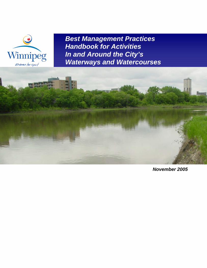
Best Management Practices Handbook for Activities In and Around the City’s Waterways and Watercourses
November 2005
City of Winnipeg
Best Practices Handbook for Activities In and Around the City’s Waterways and Watercourses
Preface The City of Winnipeg is fortunate to be situated on the Red and Assiniboine Rivers. These large rivers, and their tributaries, add considerable aesthetic, environmental, and recreational appeal and benefit to City residents, businesses and visitors. Collectively, these waterways and watercourses have become an integral part of the City’s infrastructure network providing pathways for drainage, pedestrians and vehicles. To ensure the proper function of this infrastructure network, the City is committed to an ongoing maintenance program, as well as to the construction of new capital works to accommodate growth. The City is also committed to the protection and stewardship of the important natural assets and values represented by its waterways and adjacent lands. While City of Winnipeg staff take a leading role in the protection and management of its natural values, environmental protection and stewardship are truly the responsibility of all Winnipegers. This Best Practices Handbook is intended to assist City staff in undertaking required maintenance activities in and around the City’s waterways and watercourses in a manner that protects and sustains these environmental values. Acknowledgements This document was developed with the assistance of a number of City of Winnipeg staff. In particular, the following Steering Committee representing various City Departments and Divisions provided guidance and specific input to its direction and development: Committee Chairman and Project Team Leader:
Don Kingerski, Riverbank Management Engineer, Planning, Property and Development
Steering Committee Members:
Tom Fred, Project Management Coordinator, Planning, Property and Development Cheryl Heming, City Naturalist, Public Works Jack Lubinski, Superintendent of Park Services (North), Public Works Brad Neirinck, Bridge Planning & Operations Engineer, Public Works Darcy Strandberg, Engineering Technologist, Water and Waste
Project Consultants:
Paul Schaap, Dillon Consulting Limited Janet Scott, Dillon Consulting Limited

City of Winnipeg
Best Practices Handbook for Activities In and Around the City’s Waterways and Watercourses
City of Winnipeg
Best Practices Handbook for Activities In and Around the City’s Waterways and Watercourses
i
TABLE OF CONTENTS
PART I: INTRODUCTION & BACKGROUND ...................................... 1
1.0 INTRODUCTION.......................................................................... 1 1.1 DOES THIS HANDBOOK APPLY TO MY WORK? .............................. 2 1.2 PURPOSE OF THE HANDBOOK ......................................................... 3 1.3 OVERVIEW OF THE HANDBOOK...................................................... 4 1.4 CALL CARD.................................................................................... 4
2.0 ENVIRONMENTAL LEGISLATION ........................................ 7 2.1 FISHERIES ACT............................................................................. 15
3.0 ENVIRONMENTALLY SENSITIVE LANDS......................... 19 3.1 WATERWAYS AND WATERCOURSES............................................. 19 3.2 RIPARIAN ZONE FUNCTIONS ........................................................ 21 3.3 FISH HABITAT IN THE CITY OF WINNIPEG.................................... 22
PART II: BEST MANAGEMENT PRACTICES ................................... 25
4.0 LINKING MUNICIPAL ACTIVITIES IN OR NEAR CITY WATERWAYS AND WATERCOURSES WITH BEST MANAGEMENT PRACTICES ................................................. 27
5.0 BEST MANAGEMENT PRACTICES ...................................... 53 PROJECT PLANNING AND SCHEDULING ................................................... 55 WORK SITE MANAGEMENT..................................................................... 57 VEGETATION MANAGEMENT .................................................................. 60 FISH AND WILDLIFE MANAGEMENT........................................................ 63 MATERIALS MANAGEMENT .................................................................... 66 EQUIPMENT SELECTION AND USE ........................................................... 68 SITE MONITORING................................................................................... 69 SITE RESTORATION ................................................................................. 71 EROSION CONTROLS ............................................................................... 73
Preservation of Existing Vegetation.................................................. 75 Planting and Seeding......................................................................... 76 Biotechnical Stabilization ................................................................. 78 Soil Bioengineering........................................................................... 80 Gravel Blankets................................................................................. 81
City of Winnipeg
Best Practices Handbook for Activities In and Around the City’s Waterways and Watercourses
ii
Riprap.................................................................................................82 Surface Drainage Management..........................................................83 Erosion Control Blankets and Matting ..............................................86 Mulching & Hydroseeding ................................................................88 Temporary Covers .............................................................................89
SEDIMENT CONTROLS ..............................................................................91 Sediment Basins, Ponds and Traps ....................................................92 Engineered Wetlands .........................................................................95 Vegetated Swales ...............................................................................96 Silt Fence ...........................................................................................97 Straw Logs .........................................................................................99 Permeable Ditch Berms/Energy Dissipaters....................................100 Slope Scarification/ Roughening .....................................................101 Check Dams and Ditch Blocks ........................................................103 Temporary Water Diversions...........................................................105 Silt Containment Curtains/Turbidity Barriers..................................107 Stormwater Inlet/Catch Basin Filters and Dams.............................108 Pipe Socks and Dewatering Bags ....................................................109
6.0 IMPORTANT CONTACTS AND RESOURCES ...................111 6.1 ADDITIONAL CONTACTS LIST .....................................................111 6.2 ADDITIONAL INFORMATION SOURCES ........................................112
7.0 NEXT STEPS ..............................................................................115
8.0 GLOSSARY.................................................................................119
9.0 REFERENCES............................................................................124
PART III: PROTOCOLS FOR ACTIVITIES IN AND AROUND THE CITY’S WATERWAYS AND WATERCOURSES ....................127
APPROVED PROTOCOLS FOR ACTIVITIES IN AND AROUND THE CITY’S WATERWAYS AND WATERCOURSES PROTOCOLS UNDER DEVELOPMENT FOR ACTIVITIES IN AND AROUND THE CITY’S WATERWAYS AND WATERCOURSES
City of Winnipeg
Best Practices Handbook for Activities In and Around the City’s Waterways and Watercourses
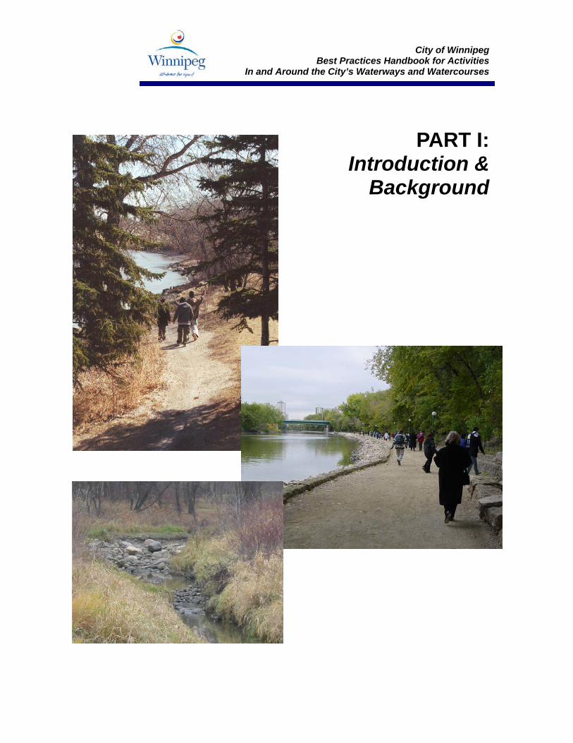
PART I: Introduction &
Background
City of Winnipeg
Best Practices Handbook for Activities In and Around the City’s Waterways and Watercourses
1
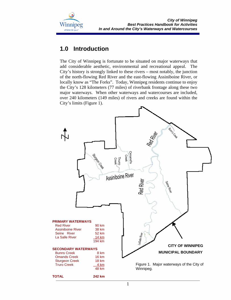
1.0 Introduction The City of Winnipeg is fortunate to be situated on major waterways that add considerable aesthetic, environmental and recreational appeal. The City’s history is strongly linked to these rivers – most notably, the junction of the north-flowing Red River and the east-flowing Assiniboine River, or locally know as “The Forks”. Today, Winnipeg residents continue to enjoy the City’s 128 kilometers (77 miles) of riverbank frontage along these two major waterways. When other waterways and watercourses are included, over 240 kilometers (149 miles) of rivers and creeks are found within the City’s limits (Figure 1).
CITY OF WINNIPEG
PRIMARY WATERWAYS Red River 90 km Assiniboine River 38 km Seine River 52 km La Salle River 14 km 194 km SECONDARY WATERWAYS Bunns Creek 8 km Omands Creek 16 km Sturgeon Creek 18 km Truro Creek 4 km 48 km TOTAL 242 km
Figure 1. Major waterways of the City of Winnipeg.
MUNICIPAL BOUNDARY
City of Winnipeg
Best Practices Handbook for Activities In and Around the City’s Waterways and Watercourses
2
In addition to their aesthetic and recreational appeal, Winnipeg’s waterways have also become an integral part of the City’s infrastructure network. However, ongoing maintenance of existing municipal infrastructure and the construction of capital projects to accommodate urban growth have the potential to lead to conflict when these activities are undertaken in or near water. Since 2000, the Department of Fisheries and Oceans (DFO) has taken a much more active role in the management of fish habitat and the enforcement of the Fisheries Act in the City of Winnipeg. This has necessitated a change in the manner by which City staff plan and conduct both capital and operations and maintenance activities near the City’s waterbodies and watercourses. With a corporate responsibility to comply with the Fisheries Act, and to support the protection of the City’s natural riparian (or streamside) habitat, Winnipeg is confronted with the competing objectives of cost-effectively operating and maintaining municipal services while providing environmental protection and enhancement when working near water. Recognizing this challenge, the City has developed this Best Management Practices (BMP’s) Handbook to assist City of Winnipeg staff in undertaking routine operations and maintenance activities along the City’s many waterways and watercourses. It has been developed to bring consistency to how these activities are undertaken, while at the same time achieving compliance with the Fisheries Act and other relevant legislation.
1.1 Does this Handbook Apply to My Work? If you are undertaking a project or routine maintenance activity near a waterway, watercourse or riparian area, this Handbook applies to your work. “Waterway” means a river, stream, creek or canal, whether natural, constructed or altered, and includes the frozen surface and bed of the hydraulic channel. A “watercourse” means a drain, ditch, drainage ditch, culvert, water channel, retention pond or waterway, whether natural, constructed, or altered. Major construction projects are not specifically covered in this Handbook. Typically, major construction projects have stand-alone environmental management plans and conditions that are established with the environmental regulators and must be followed as part of the construction phase. However, for contractors working on major construction projects,
City of Winnipeg
Best Practices Handbook for Activities In and Around the City’s Waterways and Watercourses
3
the BMP’s presented in this Handbook offer valuable information that can assist in the development of environmental protection measures to meet regulatory requirements.
1.2 Purpose of the Handbook This Handbook provides information that builds on the existing knowledge base of City of Winnipeg staff with regard to the protection of aquatic and riparian resources. It focuses on current environmental requirements, responsibilities and techniques relevant to routine operations and maintenance activities being conducted in and around the City’s waterways and watercourses. The Handbook is intended to serve the following purposes:
• To provide a resource that will guide and support City of Winnipeg staff in conducting their routine activities near water; and
• To provide staff with a reference document that will direct them to more detailed sources of information when necessary.
From a due diligence perspective, the Handbook is also intended to provide City of Winnipeg staff with sufficient knowledge to:
• Perform their duties in a manner that respects applicable laws, regulations, and guidelines related to environmental protection;
• Prepare for potential risks to the aquatic environment that a thoughtful and reasonable person would foresee; and
• Respond to these risks and incidents as effectively and quickly as is practicable.
The Handbook is a “living document”. It will be regularly updated as new information on best practices becomes available or there are changes in the regulatory requirements for work activities near waterways and watercourses. If a discrepancy arises between this document and legislation, the legislation will always take precedence.
City of Winnipeg
Best Practices Handbook for Activities In and Around the City’s Waterways and Watercourses
4
1.3 Overview of the Handbook For ease of use, this Handbook has been divided into three distinct parts:
Part 1. Background and Introduction: Provides the context to the development of the Handbook including relevant environmental legislation and an overview of environmentally sensitive areas within the City of Winnipeg. Part 2. Best Management Practices: Provides a listing of activities undertaken by City of Winnipeg staff and links them to a comprehensive set of BMP’s. This portion of the Handbook also includes a listing of contacts and technical resources available.
Part 3. Protocols to Guide City Activities: Provides protocols for specific City activities in and around Winnipeg waterways and watercourses that have been approved by local environmental regulators or are under development. Please note that, as of September 2005, no specific protocols have been approved by local environmental regulators.
If you are already familiar with this document, you may opt to turn directly to Part 2 for information about the BMPs that apply to your type of work or to Part 3 for specific work protocols. Remember, this Handbook will be periodically updated so it is important to refer back to the document whenever you are undertaking activities along the City’s waterways and watercourses. Ultimately, it is hoped that the full range of environmental values associated with Winnipeg’s waterways and watercourses will be recognized, protected and enhanced with the application of this Handbook.
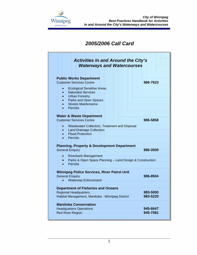
1.4 Call Card
If you have questions concerning this document, or for further information on working in and around the City’s waterways and watercourses, the following “Call Card” contacts have been identified to assist you.
City of Winnipeg
Best Practices Handbook for Activities In and Around the City’s Waterways and Watercourses
5
2005/2006 Call Card
Activities In and Around the City’s
Waterways and Watercourses
Public Works Department Customer Services Centre 986-7623
• Ecological Sensitive Areas • Naturalist Services • Urban Forestry • Parks and Open Spaces • Streets Maintenance • Permits
Water & Waste Department Customer Services Centre 986-5858
• Wastewater Collection, Treatment and Disposal • Land Drainage Collection • Flood Protection • Permits
Planning, Property & Development Department General Enquiry 986-3500
• Riverbank Management • Parks & Open Space Planning – Land Design & Construction • Permits
Winnipeg Police Services, River Patrol Unit General Enquiry 986-8504
• Waterway Enforcement Department of Fisheries and Oceans Regional Headquarters 983-5000 Habitat Management, Manitoba - Winnipeg District 983-5220 Manitoba Conservation Headquarters Operations 945-6647 Red River Region 945-7081
City of Winnipeg
Best Practices Handbook for Activities In and Around the City’s Waterways and Watercourses
7
2.0 Environmental Legislation There are three “driving forces” that guide all works conducted in and around water.
• First and foremost is environmental legislation (including federal, provincial and municipal legislation, regulations, guidelines and by-laws). These regulate or direct aspects of works that may have environmental impacts. City of Winnipeg employees, contractors, and all project proponents must meet these legal requirements. Compliance is not an option – it is a mandatory requirement and a responsibility that limits the City’s liability. If you don’t comply with the legal requirements, you are breaking the law.
• The second is public expectation. The citizens of Winnipeg, and the public in general, expect that City staff will do their part in protecting the City’s environmental values – and sometimes even demand that these requirements go beyond what is required by law. Public scrutiny can be both formal and informal. You are probably familiar, for example, with local environmental groups who serve as public stewards and “watchdogs” within the City.
• The final driving force is the City’s own corporate commitment to environmental protection. Through the development of plans, policies, and procedures, legal and public requirements are formally customized for implementation throughout the municipality.
Legislation and policy framework applicable to works proposed in and around watercourses in the City of Winnipeg are listed in Table 1. In addition to legislation that pertains to fish and fish habitat, it also includes details on other relevant legislation to consider when proposing activities in or around the City’s waterways and watercourses. Note that, depending on the project, other legislation and policies may also apply, beyond those listed in Table 1. A detailed summary of the federal Fisheries Act has also been provided, since this is the key piece of legislation governing operations and maintenance activities undertaken by City staff along watercourses. When working in and around water that supports, or has the potential to support, fisheries and aquatic resources it is every person’s responsibility to:
• Be aware of the legal, public and municipal requirements and expectations;
City of Winnipeg
Best Practices Handbook for Activities In and Around the City’s Waterways and Watercourses
9
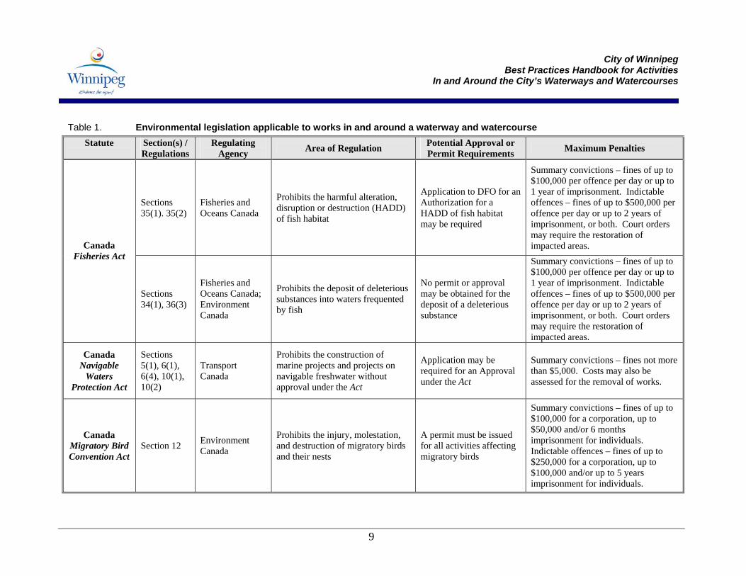
Table 1. Environmental legislation applicable to works in and around a waterway and watercourse Statute
Section(s) / Regulations
Regulating Agency Area of Regulation Potential Approval or
Permit Requirements Maximum Penalties
Sections 35(1). 35(2)
Fisheries and Oceans Canada
Prohibits the harmful alteration, disruption or destruction (HADD) of fish habitat
Application to DFO for an Authorization for a HADD of fish habitat may be required
Summary convictions – fines of up to $100,000 per offence per day or up to 1 year of imprisonment. Indictable offences – fines of up to $500,000 per offence per day or up to 2 years of imprisonment, or both. Court orders may require the restoration of impacted areas. Canada
Fisheries Act
Sections 34(1), 36(3)
Fisheries and Oceans Canada; Environment Canada
Prohibits the deposit of deleterious substances into waters frequented by fish
No permit or approval may be obtained for the deposit of a deleterious substance
Summary convictions – fines of up to $100,000 per offence per day or up to 1 year of imprisonment. Indictable offences – fines of up to $500,000 per offence per day or up to 2 years of imprisonment, or both. Court orders may require the restoration of impacted areas.
Canada Navigable
Waters Protection Act
Sections 5(1), 6(1), 6(4), 10(1), 10(2)
Transport Canada
Prohibits the construction of marine projects and projects on navigable freshwater without approval under the Act
Application may be required for an Approval under the Act
Summary convictions – fines not more than $5,000. Costs may also be assessed for the removal of works.
Canada Migratory Bird Convention Act
Section 12 Environment Canada
Prohibits the injury, molestation, and destruction of migratory birds and their nests
A permit must be issued for all activities affecting migratory birds
Summary convictions – fines of up to $100,000 for a corporation, up to $50,000 and/or 6 months imprisonment for individuals. Indictable offences – fines of up to $250,000 for a corporation, up to $100,000 and/or up to 5 years imprisonment for individuals.
City of Winnipeg
Best Practices Handbook for Activities In and Around the City’s Waterways and Watercourses
10
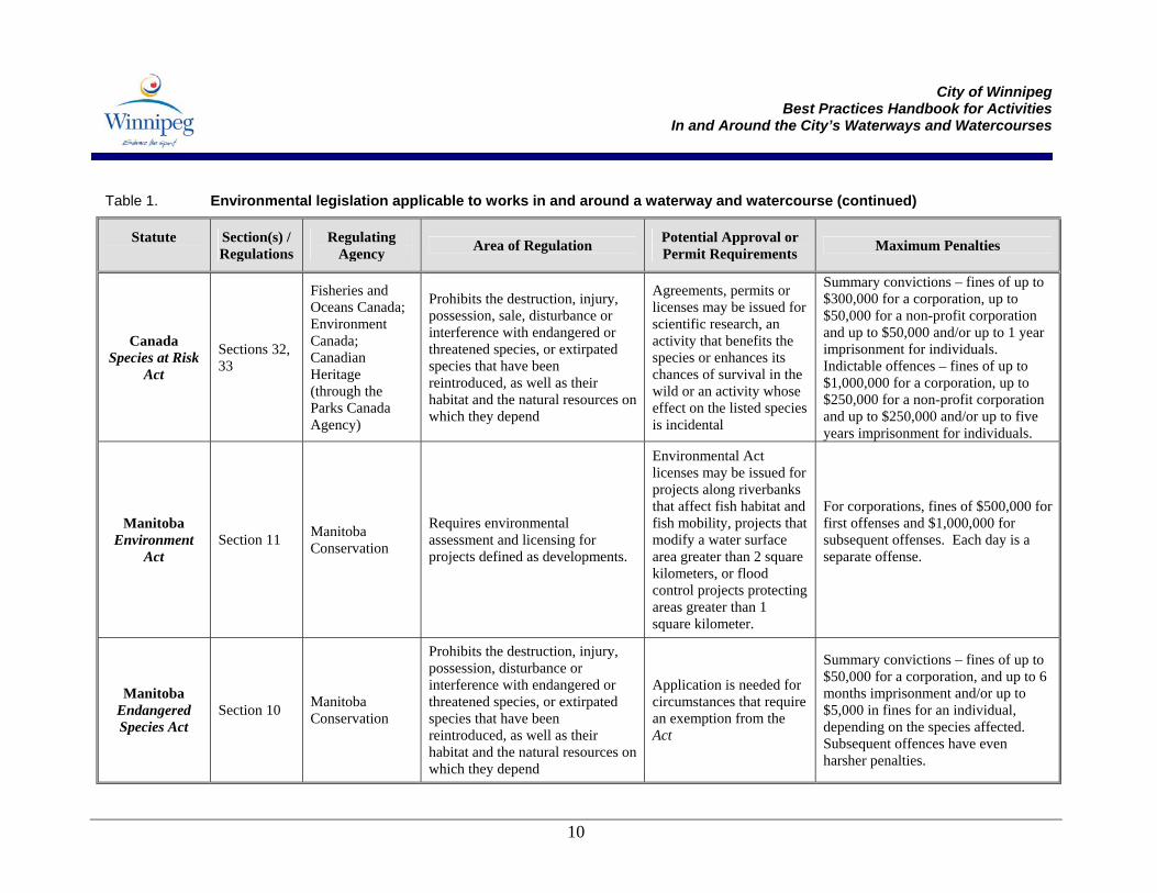
Table 1. Environmental legislation applicable to works in and around a waterway and watercourse (continued)
Statute
Section(s) / Regulations
Regulating Agency Area of Regulation Potential Approval or
Permit Requirements Maximum Penalties
Canada Species at Risk
Act
Sections 32, 33
Fisheries and Oceans Canada; Environment Canada; Canadian Heritage (through the Parks Canada Agency)
Prohibits the destruction, injury, possession, sale, disturbance or interference with endangered or threatened species, or extirpated species that have been reintroduced, as well as their habitat and the natural resources on which they depend
Agreements, permits or licenses may be issued for scientific research, an activity that benefits the species or enhances its chances of survival in the wild or an activity whose effect on the listed species is incidental
Summary convictions – fines of up to $300,000 for a corporation, up to $50,000 for a non-profit corporation and up to $50,000 and/or up to 1 year imprisonment for individuals. Indictable offences – fines of up to $1,000,000 for a corporation, up to $250,000 for a non-profit corporation and up to $250,000 and/or up to five years imprisonment for individuals.
Manitoba Environment
Act Section 11 Manitoba
Conservation
Requires environmental assessment and licensing for projects defined as developments.
Environmental Act licenses may be issued for projects along riverbanks that affect fish habitat and fish mobility, projects that modify a water surface area greater than 2 square kilometers, or flood control projects protecting areas greater than 1 square kilometer.
For corporations, fines of $500,000 for first offenses and $1,000,000 for subsequent offenses. Each day is a separate offense.
Manitoba Endangered Species Act
Section 10 Manitoba Conservation
Prohibits the destruction, injury, possession, disturbance or interference with endangered or threatened species, or extirpated species that have been reintroduced, as well as their habitat and the natural resources on which they depend
Application is needed for circumstances that require an exemption from the Act
Summary convictions – fines of up to $50,000 for a corporation, and up to 6 months imprisonment and/or up to $5,000 in fines for an individual, depending on the species affected. Subsequent offences have even harsher penalties.
City of Winnipeg
Best Practices Handbook for Activities In and Around the City’s Waterways and Watercourses
11
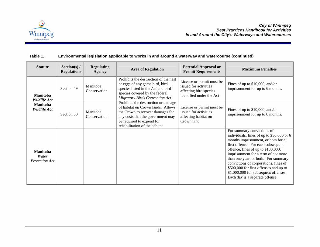
Table 1. Environmental legislation applicable to works in and around a waterway and watercourse (continued)
Statute
Section(s) / Regulations
Regulating Agency Area of Regulation Potential Approval or
Permit Requirements Maximum Penalties
Section 49 Manitoba Conservation
Prohibits the destruction of the nest or eggs of any game bird, bird species listed in the Act and bird species covered by the federal Migratory Birds Convention Act
License or permit must be issued for activities affecting bird species identified under the Act
Fines of up to $10,000, and/or imprisonment for up to 6 months. Manitoba
Wildlife Act Manitoba
Wildlife Act Section 50 Manitoba
Conservation
Prohibits the destruction or damage of habitat on Crown lands. Allows the Crown to recover damages for any costs that the government may be required to expend for rehabilitation of the habitat
License or permit must be issued for activities affecting habitat on Crown land
Fines of up to $10,000, and/or imprisonment for up to 6 months.
Manitoba Water
Protection Act
For summary convictions of individuals, fines of up to $50,000 or 6 months imprisonment, or both for a first offence. For each subsequent offence, fines of up to $100,000, imprisonment for a term of not more than one year, or both. For summary convictions of corporations, fines of $500,000 for first offenses and up to $1,000,000 for subsequent offenses. Each day is a separate offense.
City of Winnipeg
Best Practices Handbook for Activities In and Around the City’s Waterways and Watercourses
12
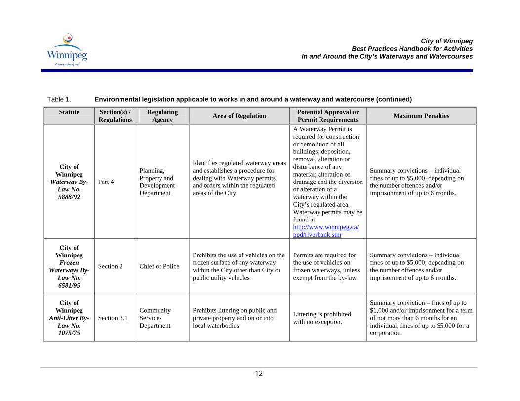
Table 1. Environmental legislation applicable to works in and around a waterway and watercourse (continued)
Statute
Section(s) / Regulations
Regulating Agency Area of Regulation Potential Approval or
Permit Requirements Maximum Penalties
City of Winnipeg
Waterway By-Law No. 5888/92
Part 4
Planning, Property and Development Department
Identifies regulated waterway areas and establishes a procedure for dealing with Waterway permits and orders within the regulated areas of the City
A Waterway Permit is required for construction or demolition of all buildings; deposition, removal, alteration or disturbance of any material; alteration of drainage and the diversion or alteration of a waterway within the City’s regulated area. Waterway permits may be found at http://www.winnipeg.ca/ ppd/riverbank.stm
Summary convictions – individual fines of up to $5,000, depending on the number offences and/or imprisonment of up to 6 months.
City of Winnipeg
Frozen Waterways By-
Law No. 6581/95
Section 2 Chief of Police
Prohibits the use of vehicles on the frozen surface of any waterway within the City other than City or public utility vehicles
Permits are required for the use of vehicles on frozen waterways, unless exempt from the by-law
Summary convictions – individual fines of up to $5,000, depending on the number offences and/or imprisonment of up to 6 months.
City of Winnipeg
Anti-Litter By-Law No. 1075/75
Section 3.1 Community Services Department
Prohibits littering on public and private property and on or into local waterbodies
Littering is prohibited with no exception.
Summary conviction – fines of up to $1,000 and/or imprisonment for a term of not more than 6 months for an individual; fines of up to $5,000 for a corporation.
City of Winnipeg
Best Practices Handbook for Activities In and Around the City’s Waterways and Watercourses
13
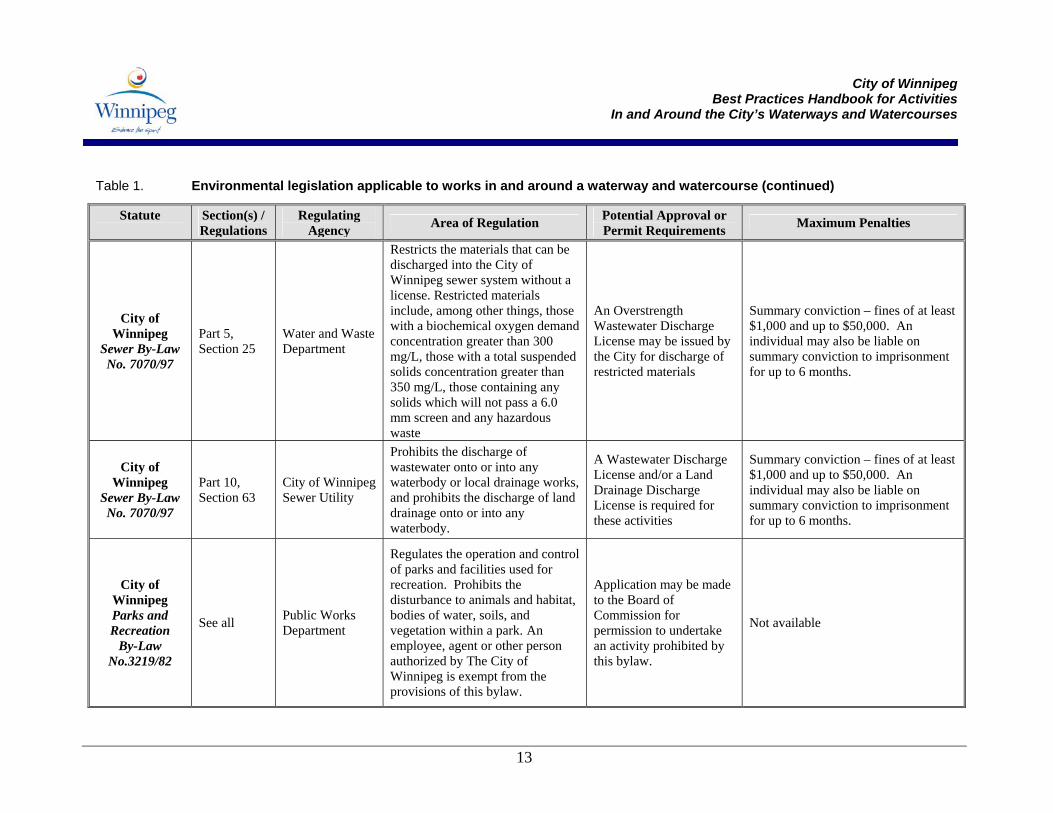
Table 1. Environmental legislation applicable to works in and around a waterway and watercourse (continued)
Statute
Section(s) / Regulations
Regulating Agency Area of Regulation Potential Approval or
Permit Requirements Maximum Penalties
City of Winnipeg
Sewer By-Law No. 7070/97
Part 5, Section 25
Water and Waste Department
Restricts the materials that can be discharged into the City of Winnipeg sewer system without a license. Restricted materials include, among other things, those with a biochemical oxygen demand concentration greater than 300 mg/L, those with a total suspended solids concentration greater than 350 mg/L, those containing any solids which will not pass a 6.0 mm screen and any hazardous waste
An Overstrength Wastewater Discharge License may be issued by the City for discharge of restricted materials
Summary conviction – fines of at least $1,000 and up to $50,000. An individual may also be liable on summary conviction to imprisonment for up to 6 months.
City of Winnipeg
Sewer By-Law No. 7070/97
Part 10, Section 63
City of Winnipeg Sewer Utility
Prohibits the discharge of wastewater onto or into any waterbody or local drainage works, and prohibits the discharge of land drainage onto or into any waterbody.
A Wastewater Discharge License and/or a Land Drainage Discharge License is required for these activities
Summary conviction – fines of at least $1,000 and up to $50,000. An individual may also be liable on summary conviction to imprisonment for up to 6 months.
City of Winnipeg Parks and Recreation
By-Law No.3219/82
See all Public Works Department
Regulates the operation and control of parks and facilities used for recreation. Prohibits the disturbance to animals and habitat, bodies of water, soils, and vegetation within a park. An employee, agent or other person authorized by The City of Winnipeg is exempt from the provisions of this bylaw.
Application may be made to the Board of Commission for permission to undertake an activity prohibited by this bylaw.
Not available
City of Winnipeg
Best Practices Handbook for Activities In and Around the City’s Waterways and Watercourses
14
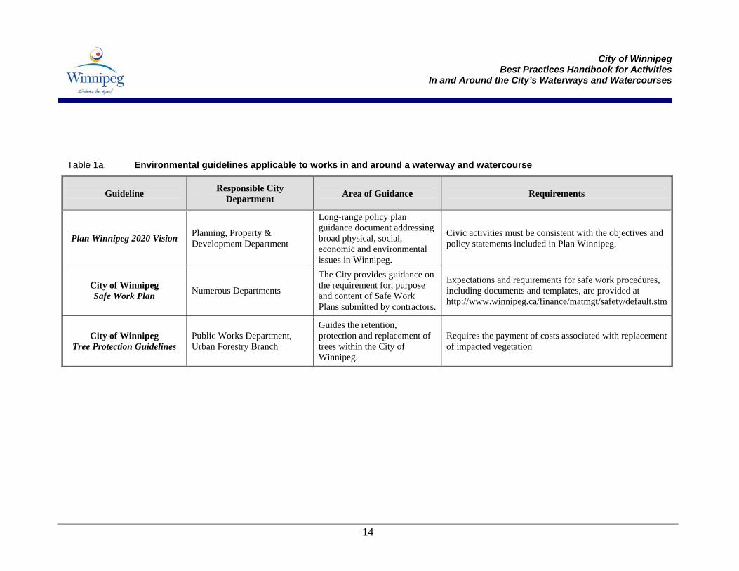
Table 1a. Environmental guidelines applicable to works in and around a waterway and watercourse
Guideline Responsible City Department Area of Guidance Requirements
Plan Winnipeg 2020 Vision Planning, Property & Development Department
Long-range policy plan guidance document addressing broad physical, social, economic and environmental issues in Winnipeg.
Civic activities must be consistent with the objectives and policy statements included in Plan Winnipeg.
City of Winnipeg Safe Work Plan Numerous Departments
The City provides guidance on the requirement for, purpose and content of Safe Work Plans submitted by contractors.
Expectations and requirements for safe work procedures, including documents and templates, are provided at http://www.winnipeg.ca/finance/matmgt/safety/default.stm
City of Winnipeg Tree Protection Guidelines
Public Works Department, Urban Forestry Branch
Guides the retention, protection and replacement of trees within the City of Winnipeg.
Requires the payment of costs associated with replacement of impacted vegetation
City of Winnipeg
Best Practices Handbook for Activities In and Around the City’s Waterways and Watercourses
15
• Recognize the potential impacts of their actions; • Ensure that the appropriate permits and authorizations from
regulatory bodies are in place prior to proceeding with maintenance and construction activities; and
• Conduct their work activities in a manner that complies with the law and protects the resource.
2.1 Fisheries Act While City of Winnipeg staff should be familiar with all legislation identified in Table 1, the federal Fisheries Act is the key piece of legislation that applies to all types of activities carried out in and around the City’s watercourses. The Fisheries Act is one of Canada’s oldest laws demonstrating the importance that has always been placed on the management of fisheries and fish habitat in Canada. The Act primarily serves to protect:
• Fish; • Fish habitat; and • The use of fish (i.e., through quotas, licenses).
Because the Fisheries Act is intended to apply to the full extent of Canada’s fisheries (i.e., freshwater and saltwater species and habitat from coast to coast to coast), the definitions of fish and fish habitat contained in the Fisheries Act are very broad. The Act defines fish and fish habitat as follows: Fish: All fish, shellfish, crustaceans and marine animals, and the
eggs, spawn, spat and juvenile stages of fish, shellfish, crustaceans and marine animals.
Fish Habitat: Spawning grounds and nursery, rearing, food supply
and migration areas on which fish depend directly or indirectly in order to carry out their life processes.
Based on the definition of fish habitat, any area that contributes in any way (i.e., directly or indirectly) to one or all life stages of a fish can be considered fish habitat.
Fish andFish HabitatDefinitions
City of Winnipeg
Best Practices Handbook for Activities In and Around the City’s Waterways and Watercourses
16
The Fisheries Act is administered by Fisheries and Oceans Canada (DFO). To ensure the conservation of fish and fish habitat, DFO enforces a number of rules to protect fish and fish habitat from land and water use activities and projects. The sections of the Act that are applicable to construction and maintenance activities conducted in and around a watercourse are: Subsection 34 (1), Subsection 36(3) These Subsections address impacts to fish and fish habitat caused by the addition of a deleterious substance to water. The Fisheries Act Subsection 34(1) defines a deleterious substance as:
“Any substance that, if added to any water, would degrade or alter or form part of a process of degradation or alteration of the quality of that water so that it is rendered or is likely rendered deleterious to fish or fish habitat or to the use by man of fish that frequent that water.”
Obvious deleterious substances that can impact fish and fish habitat include compounds like gasoline, oil and paint. Less obvious substances that are also considered to be “deleterious” include sediment, nutrients, wet concrete or concrete wash water and chlorinated water. Subsection 36(3) addresses the release of deleterious substances within fish habitat and states that:
“No person shall deposit deleterious substances in any type of water frequented by fish or in any place under any conditions where the deleterious substance may enter any such water.”
Subsection 35(1) This Subsection of the Fisheries Act addresses direct and indirect effects on fish and fish habitat and states that:
“No person shall carry on any work or undertaking that results in the harmful alteration, disruption or destruction of fish habitat.”
Routine maintenance activities in and around a waterway or watercourse that involve disturbance on the banks or within the wetted perimeter can have a profound impact on fish and fish habitat, both in the immediate area and downstream. Impacts to riparian (streamside) vegetation and changes to instream character may reduce habitat complexity and lower the productive capacity of fish habitat in the work area.
Important Fisheries Act Subsections
City of Winnipeg
Best Practices Handbook for Activities In and Around the City’s Waterways and Watercourses
17
Subsection 37(1) This Subsection of the Fisheries Act addresses direct and indirect effects on fish habitat. It states that if any work has the potential or is likely to result in the harmful alteration, disruption, or destruction (HADD) of fish habitat, then a notification must be submitted to DFO with applicable plans and details pertaining to the proposed works. These plans must include the appropriate information to allow DFO staff to determine whether proper mitigation measures have been incorporated into the project design to ensure the protection of fish and fish habitat. If the work to be carried out cannot avoid the HADD even with mitigation, and if the HADD is determined to not significantly affect fish and fish habitat, then an Authorization may be issued by DFO pursuant to Section 3(2) of the Fisheries Act. When issuing an Authorization, DFO typically applies the “no net loss of productive capacity” guiding principle from their Policy for the Management of Fish Habitat. This means that an equivalent or greater amount of habitat, similar to that altered, disrupted or destroyed by a project, must be created to achieve “no net loss” of fish habitat.
City of Winnipeg
Best Practices Handbook for Activities In and Around the City’s Waterways and Watercourses
19
3.0 Environmentally Sensitive Lands Environmentally sensitive lands are wetlands, steep slopes, watercourses, waterways, underground water recharge areas, riverbanks, natural plant and animal habitats, flood plains, and other landforms that are easily disturbed by development. These areas are important for their values in supporting fish and wildlife species. They may also contain rare or locally diminished ecosystems and landforms as well as sites of natural diversity that need protection. In its long-range policy plan guidance document, “Plan Winnipeg 2020 Vision”, the City of Winnipeg outlines strategies to protect environmentally sensitive lands that contain important pockets of natural flora and fauna or that are susceptible to damage from flooding or erosion. These include:
i. evaluating proposed developments that affect high-quality natural areas and encouraging the protection and preservation of such lands to the greatest extent possible;
ii. developing a lands plan which designates natural areas that are environmentally-sensitive and/or significant and provides measures for the possible acquisition, preservation, protection, and maintenance of such lands;
iii. protecting flood plains and unstable riverbank slopes by identifying susceptible areas and employing protective and preventive measures, including the possible acquisition of such lands, to reduce the risk of property damage where appropriate; and
iv. encouraging private landowner participation in support of riverbank management.
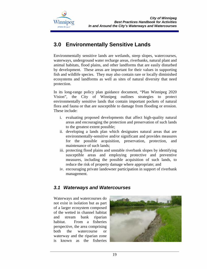
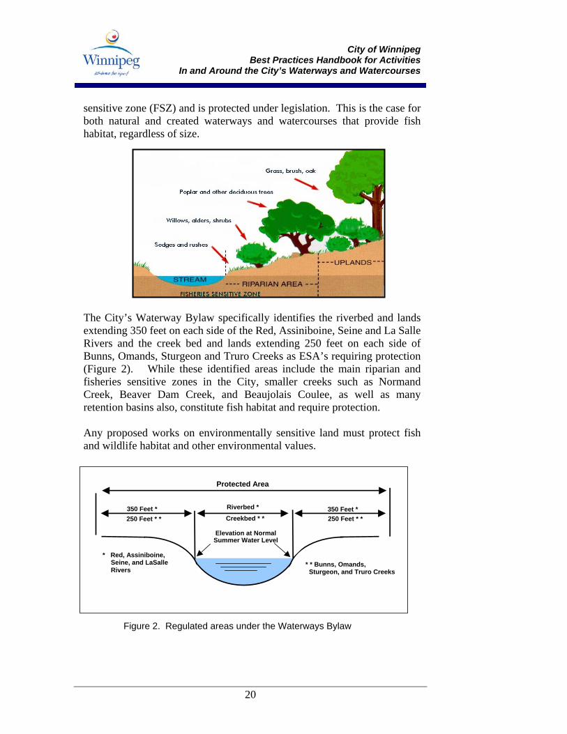
3.1 Waterways and Watercourses Waterways and watercourses do not exist in isolation but as part of a larger ecosystem composed of the wetted in channel habitat and stream bank riparian habitat. From a fisheries perspective, the area comprising both the watercourse or waterway and the riparian zone is known as the fisheries
City of Winnipeg
Best Practices Handbook for Activities In and Around the City’s Waterways and Watercourses
20
sensitive zone (FSZ) and is protected under legislation. This is the case for both natural and created waterways and watercourses that provide fish habitat, regardless of size.
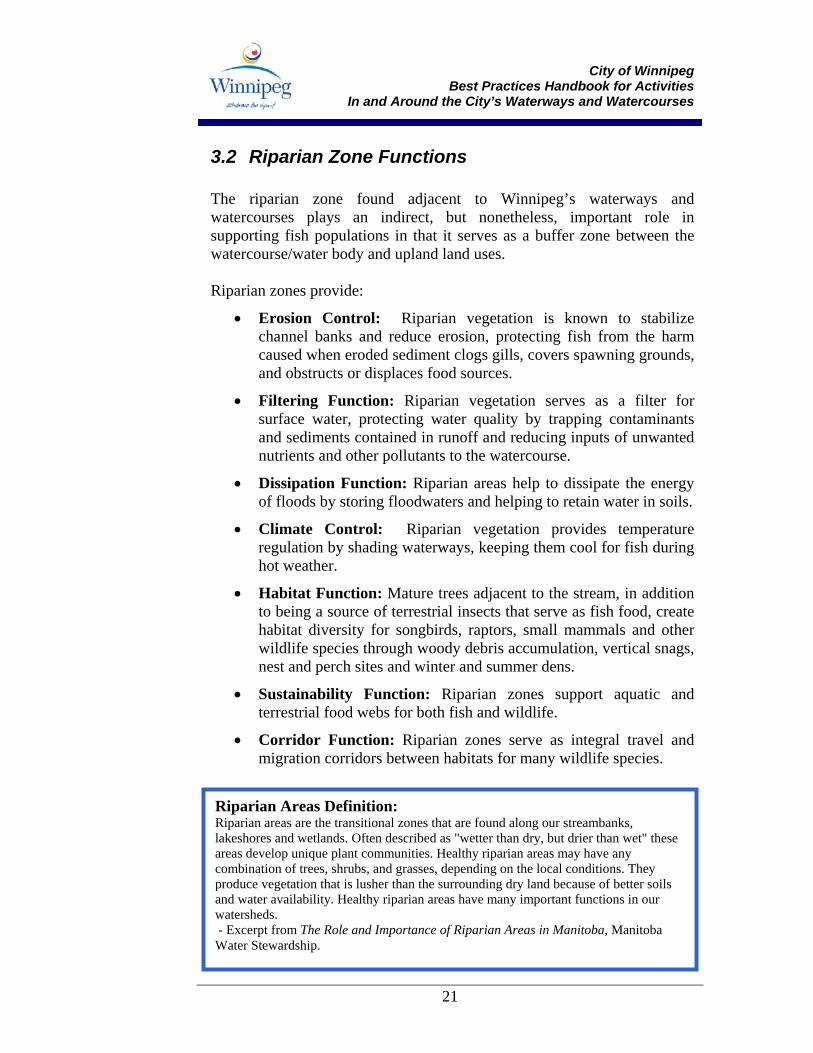
The City’s Waterway Bylaw specifically identifies the riverbed and lands extending 350 feet on each side of the Red, Assiniboine, Seine and La Salle Rivers and the creek bed and lands extending 250 feet on each side of Bunns, Omands, Sturgeon and Truro Creeks as ESA’s requiring protection (Figure 2). While these identified areas include the main riparian and fisheries sensitive zones in the City, smaller creeks such as Normand Creek, Beaver Dam Creek, and Beaujolais Coulee, as well as many retention basins also, constitute fish habitat and require protection. Any proposed works on environmentally sensitive land must protect fish and wildlife habitat and other environmental values.
Elevation at Normal Summer Water Level
350 Feet * 350 Feet *250 Feet * * 250 Feet * *
Riverbed *
Creekbed * *
* Red, Assiniboine, Seine, and LaSalle Rivers * * Bunns, Omands,
Sturgeon, and Truro Creeks
Protected Area
Figure 2. Regulated areas under the Waterways Bylaw
City of Winnipeg
Best Practices Handbook for Activities In and Around the City’s Waterways and Watercourses
21
3.2 Riparian Zone Functions The riparian zone found adjacent to Winnipeg’s waterways and watercourses plays an indirect, but nonetheless, important role in supporting fish populations in that it serves as a buffer zone between the watercourse/water body and upland land uses. Riparian zones provide:
• Erosion Control: Riparian vegetation is known to stabilize channel banks and reduce erosion, protecting fish from the harm caused when eroded sediment clogs gills, covers spawning grounds, and obstructs or displaces food sources.
• Filtering Function: Riparian vegetation serves as a filter for surface water, protecting water quality by trapping contaminants and sediments contained in runoff and reducing inputs of unwanted nutrients and other pollutants to the watercourse.
• Dissipation Function: Riparian areas help to dissipate the energy of floods by storing floodwaters and helping to retain water in soils.
• Climate Control: Riparian vegetation provides temperature regulation by shading waterways, keeping them cool for fish during hot weather.
• Habitat Function: Mature trees adjacent to the stream, in addition to being a source of terrestrial insects that serve as fish food, create habitat diversity for songbirds, raptors, small mammals and other wildlife species through woody debris accumulation, vertical snags, nest and perch sites and winter and summer dens.
• Sustainability Function: Riparian zones support aquatic and terrestrial food webs for both fish and wildlife.
• Corridor Function: Riparian zones serve as integral travel and migration corridors between habitats for many wildlife species.
Riparian Areas Definition: Riparian areas are the transitional zones that are found along our streambanks, lakeshores and wetlands. Often described as "wetter than dry, but drier than wet" these areas develop unique plant communities. Healthy riparian areas may have any combination of trees, shrubs, and grasses, depending on the local conditions. They produce vegetation that is lusher than the surrounding dry land because of better soils and water availability. Healthy riparian areas have many important functions in our watersheds. - Excerpt from The Role and Importance of Riparian Areas in Manitoba, Manitoba Water Stewardship.
City of Winnipeg
Best Practices Handbook for Activities In and Around the City’s Waterways and Watercourses
22
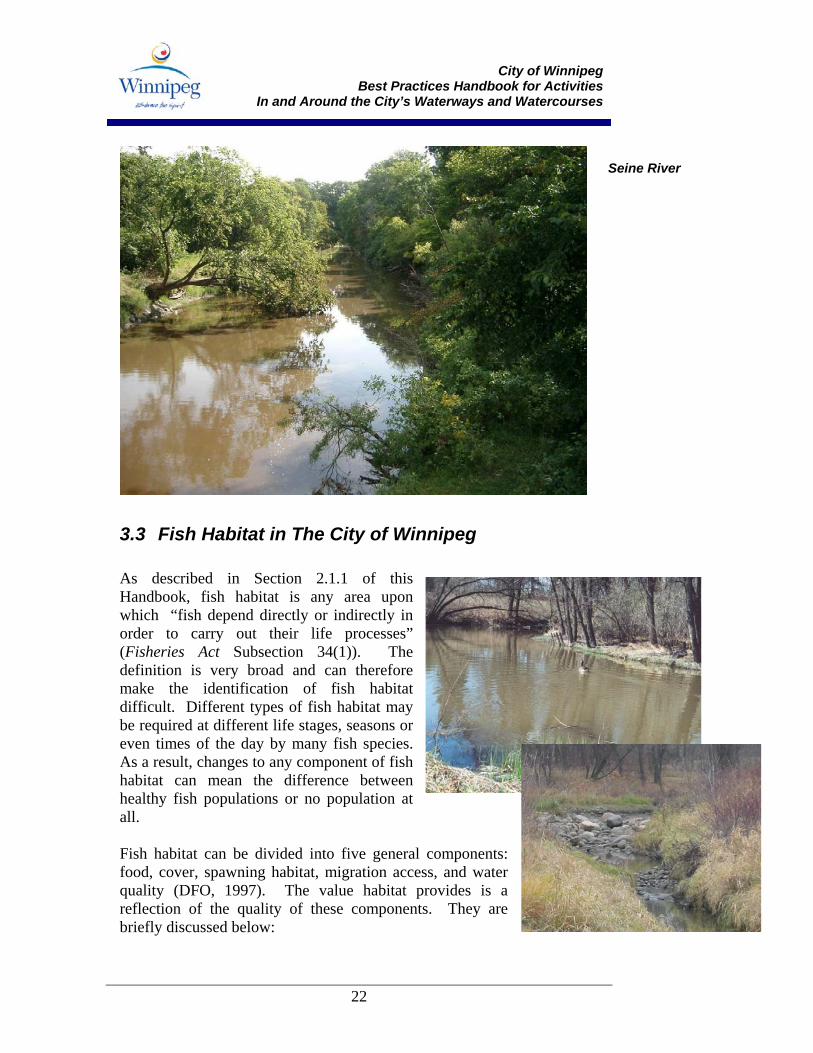
3.3 Fish Habitat in The City of Winnipeg As described in Section 2.1.1 of this Handbook, fish habitat is any area upon which “fish depend directly or indirectly in order to carry out their life processes” (Fisheries Act Subsection 34(1)). The definition is very broad and can therefore make the identification of fish habitat difficult. Different types of fish habitat may be required at different life stages, seasons or even times of the day by many fish species. As a result, changes to any component of fish habitat can mean the difference between healthy fish populations or no population at all. Fish habitat can be divided into five general components: food, cover, spawning habitat, migration access, and water quality (DFO, 1997). The value habitat provides is a reflection of the quality of these components. They are briefly discussed below:
Seine River
City of Winnipeg
Best Practices Handbook for Activities In and Around the City’s Waterways and Watercourses
23
FOOD: Fish require food of many different types to satisfy dietary requirements throughout all of their life stages. Food requirements can range from small, microscopic organisms (e.g., plankton, algae) to invertebrates and other fish. COVER: Cover is important in protecting fish from high water flows, from their predators, and from their prey. It can come in many forms including overhanging vegetation or instream elements such as woody debris and boulders. Overhanging cover also provides shade that helps regulate water temperatures. The function of temperature regulation is especially important during hot weather, when overhanging vegetation shades the water and keeps it cool. SPAWNING HABITAT: Each fish species has specific requirements for spawning and egg incubation that include bottom substrate size, water velocity and temperature. ACCESS: Most fish migrate at certain times of the year or during particular life stages. For example, white sucker, a species found in the Red River and its tributaries, migrates up rivers and streams in the early spring to spawn in gravelly areas or riffles. Restrictions in access, such as from improperly designed culverts, can prevent fish from reaching these critical habitats. WATER QUALITY: Good water quality is an important habitat requirement for fish. If the water quality becomes poor, such as through the introduction of chemical or physical substances (e.g., sediment) or by a change in temperature or dissolved oxygen, fish may be harmed or weakened to such a state that they are no longer able to carry out life processes such as feeding or spawning. Poor water quality may even kill. During the project planning stage, fish habitat areas that may be affected by site activities should be identified. It is important to exercise caution when examining a potential work site for its value as fish habitat because an area that appears to hold little value at one time of the year may have a very important fisheries function at another time. The value of seasonal habitats must not be overlooked and should be an important consideration when planning and scheduling construction and maintenance activities. As a rule of thumb, assume that all ditches, creeks and sloughs provide fish habitat until you are advised otherwise.
WHEN IN DOUBT AS TO WHETHER AN AREA CONTAINS FISH HABITAT, ALWAYS ASSUME THAT IT DOES.
City of Winnipeg
Best Practices Handbook for Activities In and Around the City’s Waterways and Watercourses
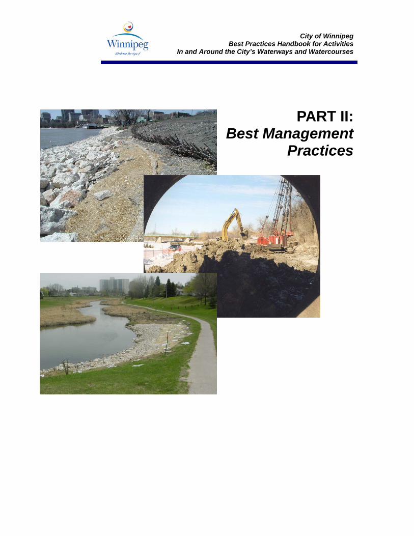
PART II:
Best Management Practices
City of Winnipeg
Best Practices Handbook for Activities In and Around the City’s Waterways and Watercourses
27
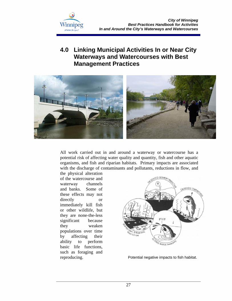
4.0 Linking Municipal Activities In or Near City Waterways and Watercourses with Best Management Practices
All work carried out in and around a waterway or watercourse has a potential risk of affecting water quality and quantity, fish and other aquatic organisms, and fish and riparian habitats. Primary impacts are associated with the discharge of contaminants and pollutants, reductions in flow, and the physical alteration of the watercourse and waterway channels and banks. Some of these effects may not directly or immediately kill fish or other wildlife, but they are none-the-less significant because they weaken populations over time by affecting their ability to perform basic life functions, such as foraging and reproducing.
Potential negative impacts to fish habitat.
City of Winnipeg
Best Practices Handbook for Activities In and Around the City’s Waterways and Watercourses
28
This Handbook provides guidance on how to plan and implement routine operations and maintenance activities along waterways and watercourses in the City of Winnipeg so that these types of effects are minimized or avoided. The Activity Table on the following pages provides an overview of routine maintenance works carried out by City of Winnipeg staff working in or near waterways, as well as their potential impacts to fish and/or fish habitat. Maintenance activities are listed alphabetically and are linked to the applicable best management practices (BMPs) identified in Section 5.0 of this Handbook. The list of activities is evolving and not all maintenance activities in or near waterways are included. Remember, all activities undertaken in or near waterways or watercourses have the potential to affect fish and fish habitat. It is therefore your responsibility to be aware of the potential impacts that your actions may have and the measures that can be implemented to mitigate these effects.
City of Winnipeg
Best Practices Handbook for Activities In and Around the City’s Waterways and Watercourses
29
Activity Table: Operations and Maintenance Activities In and Around Waterways and Watercourses– Potential Impacts and Best Management Practices
Activity Potential Impact Applicable Best Management Practice(s)-see Section 5.0
Bridge-related Construction, Repair and Maintenance
Bridge Deck Repairs Concrete deck patching involves the localized repair of existing concrete deck, barriers, sidewalks, girders and diaphragms. Work may include concrete cutting, sandblasting, application of surface patches and shotcrete.
All work with cement-containing compounds (e.g., concrete, cement, grouts) carried out over or near a waterway has the potential to harm fish and other aquatic organisms through the chemical alteration of water quality. As such these compounds are considered deleterious substances under the Fisheries Act. Materials of concern used or generated in deck patching include, but are not limited to:
• Raw material (concrete patching compounds, asphalt) • Curing compounds • Sealants • Concrete leachate • Contaminated wash water
The introduction of a small amount of these materials can result in fish death. During the preparation of deck surfaces, concrete dust, asphalt, sandblasting material, accumulated sediment or other contaminants from the bridge may be washed into a waterway where they can harm fish, aquatic organisms and vegetation.
Project Planning and
Scheduling Work Site Management Equipment Selection Site Monitoring Erosion and Sediment Control
City of Winnipeg
Best Practices Handbook for Activities In and Around the City’s Waterways and Watercourses
30
Activity Potential Impact Applicable Best Management Practice(s)-see Section 5.0
Bridge Repairs- Structural Steel Elements Structural steel bridge repairs include the installation of temporary bridge supports, removal and installation of steel, and surface preparation for painting.
Surface preparation, steel removal and steel installation may release materials that have the potential to harm fish, other aquatic organisms and vegetation. As such, they are considered to be deleterious substances under the Fisheries Act. Materials of concern include, but are not limited to:
• Welding debris • Paints, sealants and other steel coatings • Accumulated winter aggregate, de-icing compounds
Temporary supports erected in or near the waterway may disturb fish and aquatic organisms, banks, vegetation and bottom material. Machinery used for structural steel repair (e.g., cranes) operated in or near the waterway or on its banks may leak or spill fuel or hydraulic fluids into the waterway, affecting fish, other aquatic organisms and vegetation.
Project Planning and Scheduling
Work Site Management Fish and Wildlife Management Material Management Equipment Selection Site Monitoring Erosion and Sediment Control
Bridge Pier Rehabilitation Concrete pier rehabilitation involves the repair and restoration of existing concrete piers, including the installation of isolation measures such as cofferdams or sheet piling.
Concrete pier rehabilitation may involve the use of cement-containing compounds and the generation of cement-containing wastes (e.g., concrete, cement, grouts) over or near a waterway. These materials have the potential to harm fish and other aquatic organisms through the chemical alteration of water quality and as such, are considered deleterious substances under the Fisheries Act. The introduction of a small amount of these materials can result in fish death. Materials of concern that may be used or generated in concrete pier rehabilitation include, but are not limited to:
• Raw material (cement, concrete patching compounds); • Curing compounds and sealants; and • Concrete leachate and contaminated wash water.
During the surface preparation of concrete piers, sediment (gravel, sand and silt) or other contaminants (e.g., concrete dust) may be washed into a waterway where they can harm fish, aquatic organisms and vegetation. If sheet piling, piles or caissons are installed, species and habitat found on waterway bottoms may be disturbed. Machinery used may also disturb banks, vegetation and bottom material; decrease bank stability; and leak or spill fuel or hydraulic fluids into the waterway, affecting fish, other aquatic organisms and vegetation.
Project Planning and Scheduling
Work Site Management Material Management Equipment Selection Site Monitoring Erosion and Sediment Control.
City of Winnipeg
Best Practices Handbook for Activities In and Around the City’s Waterways and Watercourses
31
Activity Potential Impact Applicable Best Management Practice(s)-see Section 5.0
Bridge Surface Sweeping
Bridge sweeping involves the collection of accumulated winter aggregate and debris from bridge surfaces.
Accumulated winter aggregate (gravel, sand and silt) and debris found on bridge surfaces are likely to contain contaminants that have the potential to cause harm to fish, other aquatic organisms, and vegetation if swept into a waterway or deposited in riparian areas. As such, they are considered to be deleterious substances under the Fisheries Act. Contaminants of concern include, but are not limited to:
• De-icing compounds (road salts) • Vehicle fluids (oils and fuels) • Brake dust
In addition to the harmful effects of chemically-active contaminants, any sediment and debris that is released into the waterway by bridge sweeping may also:
• Affect fish directly through exposure or indirectly through changes in habitat.
• Reduce the number and diversity of bottom dwelling organisms (fish food) as sediment collects on the bottom of the waterbody.
• Clog fish spawning areas with sediment. • Reduce the survival of eggs and fry (newly-hatched fish) by smothering
them.
Project Planning and Scheduling
Work Site Management Material Management Equipment Selection Site Monitoring Erosion and Sediment Control
City of Winnipeg
Best Practices Handbook for Activities In and Around the City’s Waterways and Watercourses
32
Activity Potential Impact Applicable Best Management Practice(s)-see Section 5.0
Bridge Drain Cleaning Drain cleaning involved the removal of accumulated sediment and debris from bridge catch basins. A vactor suction truck is used to collect material from bridge drains.
Accumulated winter aggregate (gravel, sand and silt) and debris found on bridge drains are likely to contain contaminants that have the potential to cause harm to fish, other aquatic organisms, and vegetation if released into a waterway or deposited in riparian areas. As such, they are considered to be deleterious substances under the Fisheries Act. Contaminants of concern include, but are not limited to:
• De-icing compounds (road salts) • Vehicle fluids (oils and fuels) • Brake dust
In addition to the harmful effects of chemically active contaminants, any sediment and debris that may be released by drain cleaning may also harm fish, other aquatic organism, and vegetation. Machinery used to collect accumulated material from bridge drains that is operated over or near waterways may leak or spill fuel or hydraulic fluids into a waterway, affecting fish, other aquatic organisms and vegetation.
Work Site Management Material Management Equipment Selection Erosion and Sediment Control
Bridge Pier Cleaning Pier top cleaning involves the removal of accumulated winter aggregate (containing de-icing compounds) and bird feces from pier tops and adjacent structural bridge elements.
Accumulated winter aggregate (gravel, sand and silt) and debris found on bridge piers are likely to contain contaminants that have the potential to cause harm to fish, other aquatic organisms, and vegetation if released into a waterway or deposited in riparian areas. As such, they are considered to be deleterious substances under the Fisheries Act. Contaminants of concern include, but are not limited to:
• De-icing compounds (road salts) • Vehicle fluids (oils and fuels) • Brake dust
In addition to the harmful effects of chemically active contaminants, any sediment and debris that may be released to a waterway by pier top cleaning may also harm fish, other aquatic organism, and vegetation. Machinery used to clean accumulated material from bridge piers may leak or spill fuel or hydraulic fluids into a waterway, affecting fish and aquatic organisms.
Project Planning and Scheduling
Work Site Management Fish and Wildlife Management Material Management Equipment Selection Erosion and Sediment Control
City of Winnipeg
Best Practices Handbook for Activities In and Around the City’s Waterways and Watercourses
33
Activity Potential Impact Applicable Best Management Practice(s)-see Section 5.0
Bridge Superstructure Washing Bridge superstructure washing involves the high-pressure washing of structural bridge elements, traffic barriers, railings, and sidewalks and the cleaning of bridge drains.
Accumulated winter aggregate (gravel, sand and silt) and debris found on bridge surfaces are likely to contain contaminants that have the potential to cause harm to fish, other aquatic organisms, and vegetation if washed into a waterway or deposited in riparian areas. As such, they are considered to be deleterious substances under the Fisheries Act. Contaminants of concern include, but are not limited to:
• De-icing compounds (road salts) • Vehicle fluids (oils and fuels) • Brake dust • Chlorine (if chlorinated water is used in pressure washing).
In addition to the harmful effects of chemically-active contaminants, any sediment and debris that is released into the waterway by bridge washing may also:
• Affect fish directly through exposure or indirectly through changes in habitat.
• Reduce the number and diversity of bottom dwelling organisms (fish food) as sediment collects on the bottom of the waterbody.
• Clog fish spawning areas with sediment. • Affect the survival of eggs and alevins (newly-hatched fish) by
smothering them with sediment.
The use of machinery on waterway banks and the collection of runoff from washed bridge surfaces may also disturb adjacent banks and vegetation, decreasing bank stability. The application of high-pressure spray to bridge structures may disturb nesting birds. When operated near waterways, machinery used in bridge washing may accidentally release compounds that are harmful, including fuels and hydraulic fluids.
Project Planning and Scheduling
Work Site Management Vegetation Management Fish and Wildlife Management Material Management Equipment Selection Site Monitoring Erosion and Sediment Control
City of Winnipeg
Best Practices Handbook for Activities In and Around the City’s Waterways and Watercourses
34
Activity Potential Impact Applicable Best Management Practice(s)-see Section 5.0
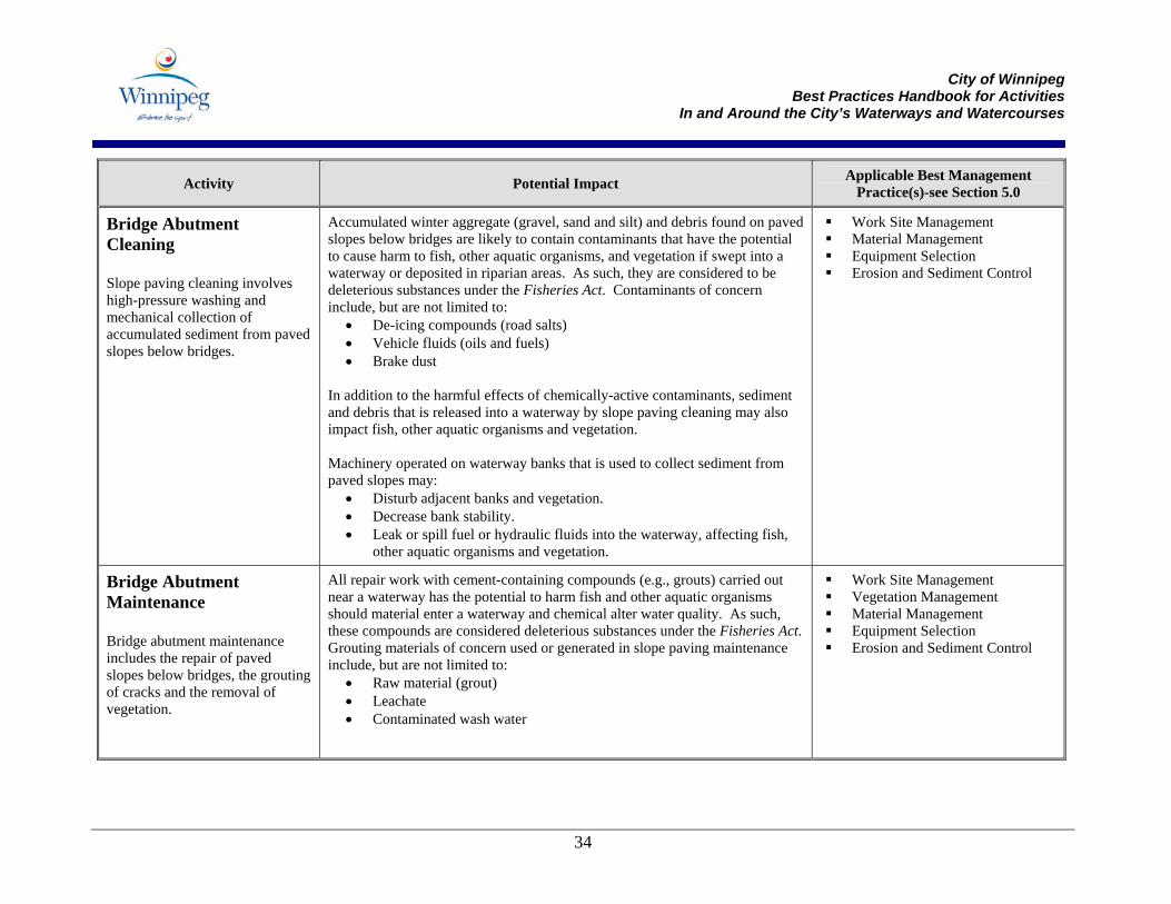
Bridge Abutment Cleaning Slope paving cleaning involves high-pressure washing and mechanical collection of accumulated sediment from paved slopes below bridges.
Accumulated winter aggregate (gravel, sand and silt) and debris found on paved slopes below bridges are likely to contain contaminants that have the potential to cause harm to fish, other aquatic organisms, and vegetation if swept into a waterway or deposited in riparian areas. As such, they are considered to be deleterious substances under the Fisheries Act. Contaminants of concern include, but are not limited to:
• De-icing compounds (road salts) • Vehicle fluids (oils and fuels) • Brake dust
In addition to the harmful effects of chemically-active contaminants, sediment and debris that is released into a waterway by slope paving cleaning may also impact fish, other aquatic organisms and vegetation. Machinery operated on waterway banks that is used to collect sediment from paved slopes may:
• Disturb adjacent banks and vegetation. • Decrease bank stability. • Leak or spill fuel or hydraulic fluids into the waterway, affecting fish,
other aquatic organisms and vegetation.
Work Site Management Material Management Equipment Selection Erosion and Sediment Control
Bridge Abutment Maintenance Bridge abutment maintenance includes the repair of paved slopes below bridges, the grouting of cracks and the removal of vegetation.
All repair work with cement-containing compounds (e.g., grouts) carried out near a waterway has the potential to harm fish and other aquatic organisms should material enter a waterway and chemical alter water quality. As such, these compounds are considered deleterious substances under the Fisheries Act. Grouting materials of concern used or generated in slope paving maintenance include, but are not limited to:
• Raw material (grout) • Leachate • Contaminated wash water
Work Site Management Vegetation Management Material Management Equipment Selection Erosion and Sediment Control
City of Winnipeg
Best Practices Handbook for Activities In and Around the City’s Waterways and Watercourses
35
Activity Potential Impact Applicable Best Management Practice(s)-see Section 5.0
Bridge Inspection Inspection of bridge structures involves the operation of a crane from the bridge deck and its extension over the waterway to allow inspection of the undersurface of the bridge.
The crane used for under bridge inspection may leak or spill fuel or hydraulic fluids into the waterway, affecting fish, other aquatic organisms and vegetation.
Work Site Management Equipment Selection
Deck Sealing Deck sealing involves the installation of a polymer overlay on bridge deck and sidewalk surfaces.
Materials used for deck sealing have the potential to harm fish, other aquatic organisms and vegetation. As such, they are considered to be deleterious substances under the Fisheries Act. Materials of concern include, but are not limited to:
• Sprayed concrete, or other cement-based products • Epoxy resins • Other sealants, paints or surface treatments
Deck sealing also involves the use of machinery. When operated near waterways, equipment may accidentally release compounds that are harmful, including fuels and hydraulic fluids.
Project Planning and Scheduling
Work Site Management Material Management Equipment Selection Erosion and Sediment Control
Expansion Joint Maintenance Expansion joint maintenance involves the cleaning and inspection of joints, the reinstallation of rubber seals, and the welding of broken steel plates.
Cleaning and repair of expansion joints may release materials that have the potential to harm fish, other aquatic organisms and vegetation. As such, they are considered to be deleterious substances under the Fisheries Act. Materials of concern include, but are not limited to:
• Chlorine (if chlorinated water is used in pressure washing) • Welding debris • Winter aggregate that has accumulated within the expansion joint.
Expansion joint maintenance also involves the use of equipment and machinery. When operated near waterways, machinery may accidentally release compounds that are harmful, including fuels and hydraulic fluids.
Work Site Management Material Management Equipment Selection Erosion and Sediment Control
City of Winnipeg
Best Practices Handbook for Activities In and Around the City’s Waterways and Watercourses
36
Activity Potential Impact Applicable Best Management Practice(s)-see Section 5.0
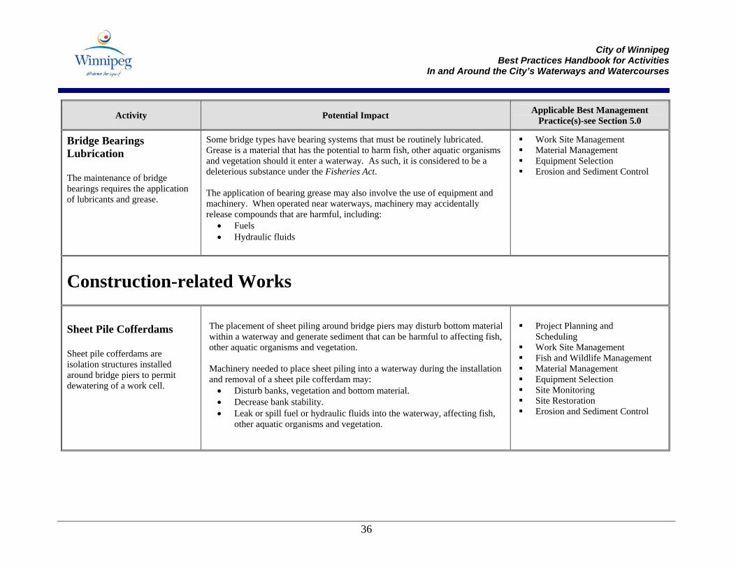
Bridge Bearings Lubrication The maintenance of bridge bearings requires the application of lubricants and grease.
Some bridge types have bearing systems that must be routinely lubricated. Grease is a material that has the potential to harm fish, other aquatic organisms and vegetation should it enter a waterway. As such, it is considered to be a deleterious substance under the Fisheries Act. The application of bearing grease may also involve the use of equipment and machinery. When operated near waterways, machinery may accidentally release compounds that are harmful, including:
• Fuels • Hydraulic fluids
Work Site Management Material Management Equipment Selection Erosion and Sediment Control
Construction-related Works
Sheet Pile Cofferdams Sheet pile cofferdams are isolation structures installed around bridge piers to permit dewatering of a work cell.
The placement of sheet piling around bridge piers may disturb bottom material within a waterway and generate sediment that can be harmful to affecting fish, other aquatic organisms and vegetation. Machinery needed to place sheet piling into a waterway during the installation and removal of a sheet pile cofferdam may:
• Disturb banks, vegetation and bottom material. • Decrease bank stability. • Leak or spill fuel or hydraulic fluids into the waterway, affecting fish,
other aquatic organisms and vegetation.
Project Planning and
Scheduling Work Site Management Fish and Wildlife Management Material Management Equipment Selection Site Monitoring Site Restoration Erosion and Sediment Control
City of Winnipeg
Best Practices Handbook for Activities In and Around the City’s Waterways and Watercourses
37
Activity Potential Impact Applicable Best Management Practice(s)-see Section 5.0
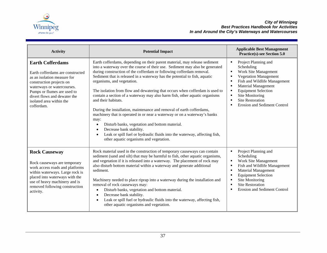
Earth Cofferdams Earth cofferdams are constructed as an isolation measure for construction projects on waterways or watercourses. Pumps or flumes are used to divert flows and dewater the isolated area within the cofferdam.
Earth cofferdams, depending on their parent material, may release sediment into a waterway over the course of their use. Sediment may also be generated during construction of the cofferdam or following cofferdam removal. Sediment that is released in a waterway has the potential to fish, aquatic organisms, and vegetation. The isolation from flow and dewatering that occurs when cofferdam is used to contain a section of a waterway may also harm fish, other aquatic organisms and their habitats. During the installation, maintenance and removal of earth cofferdams, machinery that is operated in or near a waterway or on a waterway’s banks may:
• Disturb banks, vegetation and bottom material. • Decrease bank stability. • Leak or spill fuel or hydraulic fluids into the waterway, affecting fish,
other aquatic organisms and vegetation.
Project Planning and Scheduling
Work Site Management Vegetation Management Fish and Wildlife Management Material Management Equipment Selection Site Monitoring Site Restoration Erosion and Sediment Control
Rock Causeway Rock causeways are temporary work access roads and platforms within waterways. Large rock is placed into waterways with the use of heavy machinery and is removed following construction activity.
Rock material used in the construction of temporary causeways can contain sediment (sand and silt) that may be harmful to fish, other aquatic organisms, and vegetation if it is released into a waterway. The placement of rock may also disturb bottom material within a waterway and generate additional sediment. Machinery needed to place riprap into a waterway during the installation and removal of rock causeways may:
• Disturb banks, vegetation and bottom material. • Decrease bank stability. • Leak or spill fuel or hydraulic fluids into the waterway, affecting fish,
other aquatic organisms and vegetation.
Project Planning and Scheduling
Work Site Management Fish and Wildlife Management Material Management Equipment Selection Site Monitoring Site Restoration Erosion and Sediment Control
City of Winnipeg
Best Practices Handbook for Activities In and Around the City’s Waterways and Watercourses
38
Activity Potential Impact Applicable Best Management Practice(s)-see Section 5.0
Ice Bridge Construction Ice bridge construction involves the creation of winter access routes on waterways by flooding water through holes in the ice onto the ice surface.
Ice bridge construction requires the operation of machinery on a waterway’s ice surface. When operated on frozen waterway surfaces, machinery may accidentally release compounds that are harmful, including:
• Fuels • Hydraulic fluids
Any debris or spilled material left on the frozen waterway surface will enter the watercourse during spring thaw and may potentially harm fish and other aquatic organisms. Construction activity may also damage riparian vegetation and compromise bank stability during access onto the ice surface.
Project Planning and Scheduling
Work Site Management Material Management Equipment Selection Erosion and Sediment Control
Winter Trail and Public Bank Access Construction and Removal Temporary winter trails and public bank accesses are constructed to permit recreational use of waterways in winter. These structures or trails are seasonally removed.
Construction activities in winter pose less risk to water quality and fish and wildlife species than works carried out at other times of the year. Snow blankets and temporarily protects banks, while frozen water surfaces contain materials such as sediment and prevent their entry to aquatic habitats. Despite this, winter trail and public bank access construction and removal activities can impact waterways and banks by:
• Depositing harmful materials or deleterious substances on frozen surfaces that will enter waterways or watercourse during thaw;
• Altering banks and exposing soils that become destabilized during thaw; and
• Damaging vegetation on banks during construction and removal.
Project Planning and Scheduling
Work Site Management Material Management Equipment Selection Erosion and Sediment Control Vegetation Management
Erosion Protection- Permanent Measures Erosion protection includes the application of rock riprap and other surface protection techniques to prevent the disturbance and loss of soil exposed riverbanks.
Properly selected and installed erosion control measures will help to prevent the erosion of soils and banks, however, improperly selected and installed erosion controls may have unplanned and undesirable effects, including but not limited to:
• Increasing erosion • Sediment introduction to a watercourse
Site Monitoring Site Restoration Erosion and Sediment Control
City of Winnipeg
Best Practices Handbook for Activities In and Around the City’s Waterways and Watercourses
39
Activity Potential Impact Applicable Best Management Practice(s)-see Section 5.0
Riprap Installation The installation of riprap includes the placement of large angular rock both above and below the waterline and, during site preparation, may include riverbank regarding and installation of geotextile fabric. Also see Erosion Protection in the Erosion and Sediment Controls subsection of Section 5.0.
While rock riprap placed near or in a waterway or watercourse provides a hardened edge for erosion protection, it may remove valuable areas of cover (i.e., cut banks) and decrease the habitat value of the waterway. In the event that bank excavation is required for riprap placement flush with adjacent grades and/or the rock material is sediment-laden or unwashed; fish, other aquatic organisms, and vegetation may be harmed by sediment released into a waterway. During the installation of rock riprap, construction activity may disturb banks, vegetation and bottom material; decrease bank stability; and leak or spill fuel or hydraulic fluids into the waterway, affecting fish, other aquatic organisms and vegetation.
Project Planning and Scheduling
Work Site Management Fish and Wildlife Management Material Management Equipment Selection Site Monitoring Site Restoration Erosion and Sediment Control
Support Pile Installation The installation of support piles includes the addition of piles to bridge, docks, piers and other in-water structures.
Installation of additional support piles may harm fish, other aquatic organisms and vegetation through the release of substances considered deleterious under the Fisheries Act, including sediment generated through the disturbance of bottom material and banks, and materials used in support pile construction. Machinery operated in or near the waterway or on its banks, including heavy pile driving and drilling equipment, may:
• Disturb banks, vegetation and bottom material. • Decrease bank stability. • Leak or spill fuel or hydraulic fluids into the waterway, affecting fish,
other aquatic organisms and vegetation.
Project Planning and Scheduling
Work Site Management Fish and Wildlife Management Material Management Equipment Selection Site Monitoring Erosion and Sediment Control
City of Winnipeg
Best Practices Handbook for Activities In and Around the City’s Waterways and Watercourses
40
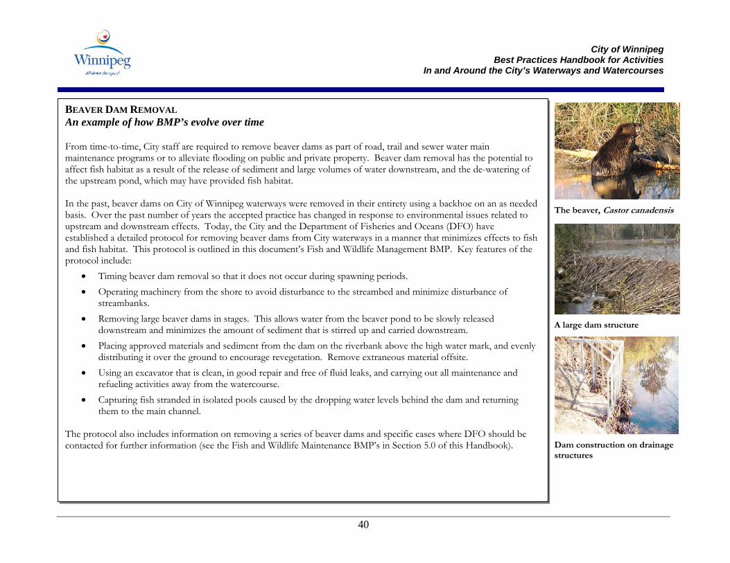
BEAVER DAM REMOVAL An example of how BMP’s evolve over time From time-to-time, City staff are required to remove beaver dams as part of road, trail and sewer water main maintenance programs or to alleviate flooding on public and private property. Beaver dam removal has the potential to affect fish habitat as a result of the release of sediment and large volumes of water downstream, and the de-watering of the upstream pond, which may have provided fish habitat. In the past, beaver dams on City of Winnipeg waterways were removed in their entirety using a backhoe on an as needed basis. Over the past number of years the accepted practice has changed in response to environmental issues related to upstream and downstream effects. Today, the City and the Department of Fisheries and Oceans (DFO) have established a detailed protocol for removing beaver dams from City waterways in a manner that minimizes effects to fish and fish habitat. This protocol is outlined in this document’s Fish and Wildlife Management BMP. Key features of the protocol include:
• Timing beaver dam removal so that it does not occur during spawning periods. • Operating machinery from the shore to avoid disturbance to the streambed and minimize disturbance of
streambanks. • Removing large beaver dams in stages. This allows water from the beaver pond to be slowly released
downstream and minimizes the amount of sediment that is stirred up and carried downstream. • Placing approved materials and sediment from the dam on the riverbank above the high water mark, and evenly
distributing it over the ground to encourage revegetation. Remove extraneous material offsite. • Using an excavator that is clean, in good repair and free of fluid leaks, and carrying out all maintenance and
refueling activities away from the watercourse. • Capturing fish stranded in isolated pools caused by the dropping water levels behind the dam and returning
them to the main channel. The protocol also includes information on removing a series of beaver dams and specific cases where DFO should be contacted for further information (see the Fish and Wildlife Maintenance BMP’s in Section 5.0 of this Handbook).
A large dam structure
The beaver, Castor canadensis
Dam construction on drainage structures
City of Winnipeg
Best Practices Handbook for Activities In and Around the City’s Waterways and Watercourses
41
Activity Potential Impact Applicable Best Management Practice
Maintenance-related Works
Outlet Maintenance Outlet maintenance involves the cleaning and minor repair of culvert outlet structures, headwalls, trash racks, and grating.
Outlet maintenance may require the clearing of debris, sediment and other accumulated materials from outlet structures. Any sediment and debris that is released by the maintenance activities into a waterway or watercourse may:
• Impact water quality to downstream areas. • Harm fish and other aquatic organisms directly. • Clog fish spawning areas with sediment. • Affect the survival of fish eggs and alevins (newly-hatched fish) by
smothering them with sediment.
Machinery that is operated near a waterway or watercourse and used to remove debris from culvert inlets and outlets may disturb banks and vegetation; decrease bank stability; and leak/spill fuel or hydraulic fluids.
Work Site Management Material Management Equipment Selection Erosion and Sediment Controls Fish and Wildlife Management
Retention Pond Management Maintenance of retention ponds requires the occasional removal of accumulated sediment and vegetation impacting flow conveyance and pond capacity.
Vegetated retention ponds help to filter stormwater and may also provide habitat for wildlife and bird species. Sediment generated from sediment or vegetation removal or other maintenance activities may harm to fish, other aquatic organisms, and vegetation if released into a waterway or deposited in riparian areas. Machinery, equipment and vehicles operated in or near a retention pond may:
• disturb or destabilize pond banks. • pose a risk of leaking fuels or lubricants to the pond and downstream
watercourses.
Work Site Management Vegetation Management Material Management Equipment Selection Erosion and Sediment Control
City of Winnipeg
Best Practices Handbook for Activities In and Around the City’s Waterways and Watercourses
42
Activity Potential Impact Applicable Best Management Practice
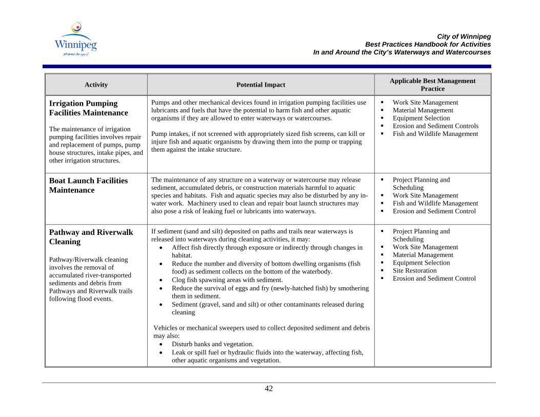
Irrigation Pumping Facilities Maintenance The maintenance of irrigation pumping facilities involves repair and replacement of pumps, pump house structures, intake pipes, and other irrigation structures.
Pumps and other mechanical devices found in irrigation pumping facilities use lubricants and fuels that have the potential to harm fish and other aquatic organisms if they are allowed to enter waterways or watercourses. Pump intakes, if not screened with appropriately sized fish screens, can kill or injure fish and aquatic organisms by drawing them into the pump or trapping them against the intake structure.
Work Site Management Material Management Equipment Selection Erosion and Sediment Controls Fish and Wildlife Management
Boat Launch Facilities Maintenance
The maintenance of any structure on a waterway or watercourse may release sediment, accumulated debris, or construction materials harmful to aquatic species and habitats. Fish and aquatic species may also be disturbed by any in-water work. Machinery used to clean and repair boat launch structures may also pose a risk of leaking fuel or lubricants into waterways.
Project Planning and Scheduling
Work Site Management Fish and Wildlife Management Erosion and Sediment Control
Pathway and Riverwalk Cleaning Pathway/Riverwalk cleaning involves the removal of accumulated river-transported sediments and debris from Pathways and Riverwalk trails following flood events.
If sediment (sand and silt) deposited on paths and trails near waterways is released into waterways during cleaning activities, it may:
• Affect fish directly through exposure or indirectly through changes in habitat.
• Reduce the number and diversity of bottom dwelling organisms (fish food) as sediment collects on the bottom of the waterbody.
• Clog fish spawning areas with sediment. • Reduce the survival of eggs and fry (newly-hatched fish) by smothering
them in sediment. • Sediment (gravel, sand and silt) or other contaminants released during
cleaning Vehicles or mechanical sweepers used to collect deposited sediment and debris may also:
• Disturb banks and vegetation. • Leak or spill fuel or hydraulic fluids into the waterway, affecting fish,
other aquatic organisms and vegetation.
Project Planning and Scheduling
Work Site Management Material Management Equipment Selection Site Restoration Erosion and Sediment Control
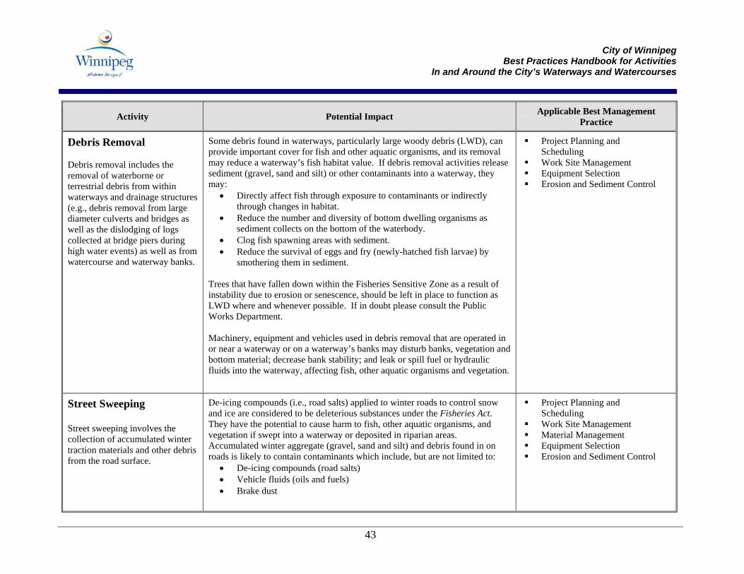
City of Winnipeg
Best Practices Handbook for Activities In and Around the City’s Waterways and Watercourses
43
Activity Potential Impact Applicable Best Management Practice
Debris Removal Debris removal includes the removal of waterborne or terrestrial debris from within waterways and drainage structures (e.g., debris removal from large diameter culverts and bridges as well as the dislodging of logs collected at bridge piers during high water events) as well as from watercourse and waterway banks.
Some debris found in waterways, particularly large woody debris (LWD), can provide important cover for fish and other aquatic organisms, and its removal may reduce a waterway’s fish habitat value. If debris removal activities release sediment (gravel, sand and silt) or other contaminants into a waterway, they may:
• Directly affect fish through exposure to contaminants or indirectly through changes in habitat.
• Reduce the number and diversity of bottom dwelling organisms as sediment collects on the bottom of the waterbody.
• Clog fish spawning areas with sediment. • Reduce the survival of eggs and fry (newly-hatched fish larvae) by
smothering them in sediment. Trees that have fallen down within the Fisheries Sensitive Zone as a result of instability due to erosion or senescence, should be left in place to function as LWD where and whenever possible. If in doubt please consult the Public Works Department. Machinery, equipment and vehicles used in debris removal that are operated in or near a waterway or on a waterway’s banks may disturb banks, vegetation and bottom material; decrease bank stability; and leak or spill fuel or hydraulic fluids into the waterway, affecting fish, other aquatic organisms and vegetation.
Project Planning and Scheduling
Work Site Management Equipment Selection Erosion and Sediment Control
Street Sweeping Street sweeping involves the collection of accumulated winter traction materials and other debris from the road surface.
De-icing compounds (i.e., road salts) applied to winter roads to control snow and ice are considered to be deleterious substances under the Fisheries Act. They have the potential to cause harm to fish, other aquatic organisms, and vegetation if swept into a waterway or deposited in riparian areas. Accumulated winter aggregate (gravel, sand and silt) and debris found in on roads is likely to contain contaminants which include, but are not limited to:
• De-icing compounds (road salts) • Vehicle fluids (oils and fuels) • Brake dust
Project Planning and Scheduling
Work Site Management Material Management Equipment Selection Erosion and Sediment Control
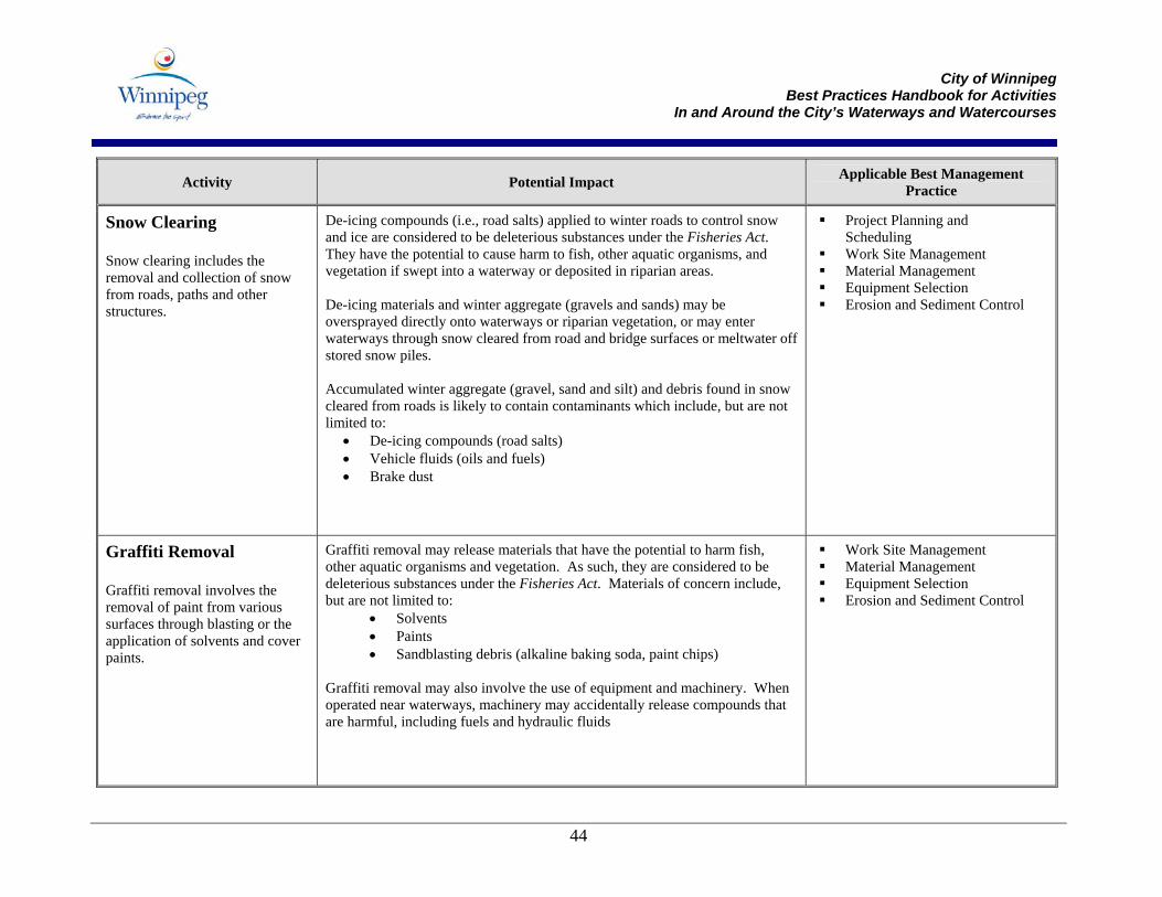
City of Winnipeg
Best Practices Handbook for Activities In and Around the City’s Waterways and Watercourses
44
Activity Potential Impact Applicable Best Management Practice
Snow Clearing Snow clearing includes the removal and collection of snow from roads, paths and other structures.
De-icing compounds (i.e., road salts) applied to winter roads to control snow and ice are considered to be deleterious substances under the Fisheries Act. They have the potential to cause harm to fish, other aquatic organisms, and vegetation if swept into a waterway or deposited in riparian areas. De-icing materials and winter aggregate (gravels and sands) may be oversprayed directly onto waterways or riparian vegetation, or may enter waterways through snow cleared from road and bridge surfaces or meltwater off stored snow piles. Accumulated winter aggregate (gravel, sand and silt) and debris found in snow cleared from roads is likely to contain contaminants which include, but are not limited to:
• De-icing compounds (road salts) • Vehicle fluids (oils and fuels) • Brake dust
Project Planning and Scheduling
Work Site Management Material Management Equipment Selection Erosion and Sediment Control
Graffiti Removal Graffiti removal involves the removal of paint from various surfaces through blasting or the application of solvents and cover paints.
Graffiti removal may release materials that have the potential to harm fish, other aquatic organisms and vegetation. As such, they are considered to be deleterious substances under the Fisheries Act. Materials of concern include, but are not limited to:
• Solvents • Paints • Sandblasting debris (alkaline baking soda, paint chips)
Graffiti removal may also involve the use of equipment and machinery. When operated near waterways, machinery may accidentally release compounds that are harmful, including fuels and hydraulic fluids
Work Site Management Material Management Equipment Selection Erosion and Sediment Control
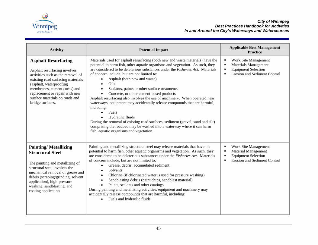
City of Winnipeg
Best Practices Handbook for Activities In and Around the City’s Waterways and Watercourses
45
Activity Potential Impact Applicable Best Management Practice
Asphalt Resurfacing Asphalt resurfacing involves activities such as the removal of existing road surfacing materials (asphalt, waterproofing membranes, cement curbs) and replacement or repair with new surface materials on roads and bridge surfaces.
Materials used for asphalt resurfacing (both new and waste materials) have the potential to harm fish, other aquatic organisms and vegetation. As such, they are considered to be deleterious substances under the Fisheries Act. Materials of concern include, but are not limited to:
• Asphalt (both new and waste) • Oils • Sealants, paints or other surface treatments • Concrete, or other cement-based products
Asphalt resurfacing also involves the use of machinery. When operated near waterways, equipment may accidentally release compounds that are harmful, including:
• Fuels • Hydraulic fluids
During the removal of existing road surfaces, sediment (gravel, sand and silt) comprising the roadbed may be washed into a waterway where it can harm fish, aquatic organisms and vegetation.
Work Site Management Materials Management Equipment Selection Erosion and Sediment Control
Painting/ Metallizing Structural Steel The painting and metallizing of structural steel involves the mechanical removal of grease and debris (scraping/grinding, solvent application), high-pressure washing, sandblasting, and coating application.
Painting and metallizing structural steel may release materials that have the potential to harm fish, other aquatic organisms and vegetation. As such, they are considered to be deleterious substances under the Fisheries Act. Materials of concern include, but are not limited to:
• Grease, debris, accumulated sediment • Solvents • Chlorine (if chlorinated water is used for pressure washing) • Sandblasting debris (paint chips, sandblast material) • Paints, sealants and other coatings
During painting and metallizing activities, equipment and machinery may accidentally release compounds that are harmful, including:
• Fuels and hydraulic fluids
Work Site Management Material Management Equipment Selection Erosion and Sediment Control
City of Winnipeg
Best Practices Handbook for Activities In and Around the City’s Waterways and Watercourses
46
Activity Potential Impact Applicable Best Management Practice
Epoxy Injection of Concrete/Timber Structures The filling of cracks in concrete and timber structures involves the drilling of cracked material, application of a surface gel and injection of epoxy
The drilling of concrete and timber structures required for epoxy injection can generate concrete dust and treated wood debris and can disturb any sediment that has accumulated on the structure. These materials, in addition to the surface gels and epoxies applied to concrete and timber cracks, have the potential to cause harm to fish, other aquatic organisms, and vegetation if released into a waterway or deposited in riparian areas. As such, they are considered to be deleterious substances under the Fisheries Act. Epoxy injection also involves the use of equipment and machinery. When operated near waterways, machinery may accidentally release compounds that are harmful, including fuels and hydraulic fluids.
Work Site Management Material Management Equipment Selection Erosion and Sediment Control
Painting Timber Timber painting includes the surface preparation of timbers and the application of paints and stains.
Surface preparation for timber painting may release materials that have the potential to harm fish, other aquatic organisms and vegetation. As such, they are considered to be deleterious substances under the Fisheries Act. Materials of concern include, but are not limited to:
• Paint debris • Treated wood debris • Sediment accumulated on timber structures
Paints and wood stains used to coat timbers are also deleterious substances that will cause harm should they enter a waterway. During timber painting, machinery operated over or near a waterway may accidentally release compounds that are harmful, including fuels and hydraulic fluids.
Work Site Management Material Management Equipment Selection Erosion and Sediment Control
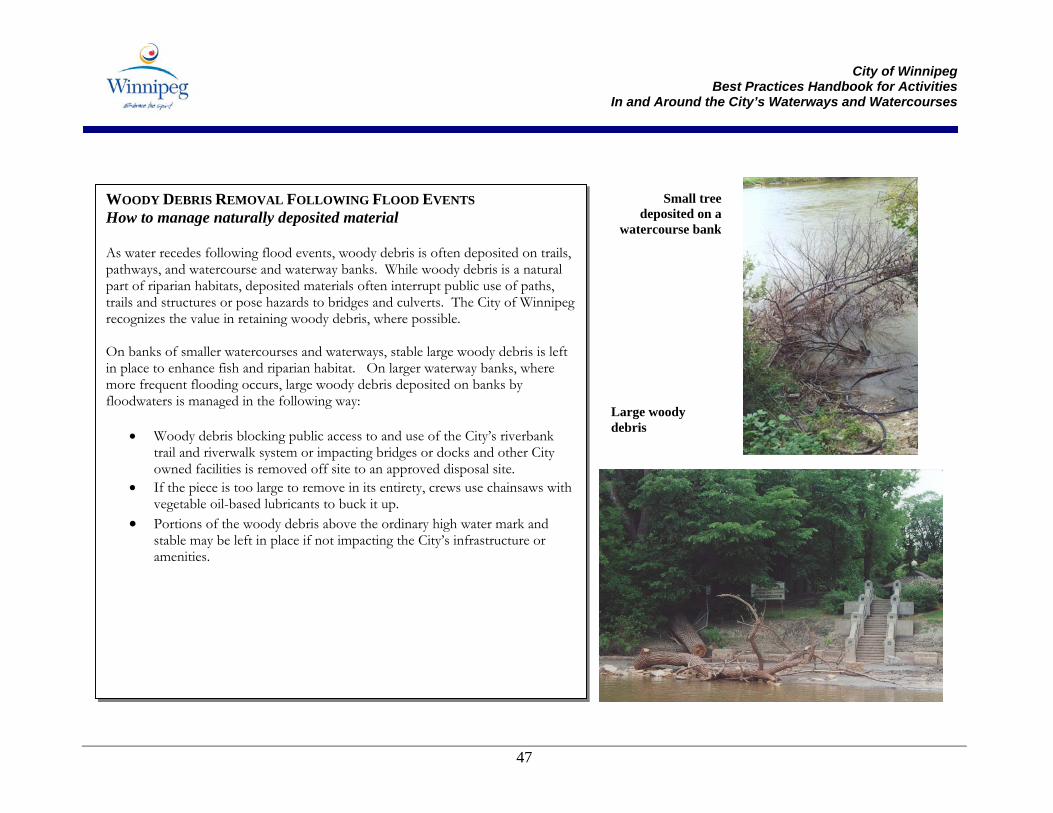
City of Winnipeg
Best Practices Handbook for Activities In and Around the City’s Waterways and Watercourses
47
WOODY DEBRIS REMOVAL FOLLOWING FLOOD EVENTS How to manage naturally deposited material As water recedes following flood events, woody debris is often deposited on trails, pathways, and watercourse and waterway banks. While woody debris is a natural part of riparian habitats, deposited materials often interrupt public use of paths, trails and structures or pose hazards to bridges and culverts. The City of Winnipeg recognizes the value in retaining woody debris, where possible. On banks of smaller watercourses and waterways, stable large woody debris is left in place to enhance fish and riparian habitat. On larger waterway banks, where more frequent flooding occurs, large woody debris deposited on banks by floodwaters is managed in the following way:
• Woody debris blocking public access to and use of the City’s riverbank trail and riverwalk system or impacting bridges or docks and other City owned facilities is removed off site to an approved disposal site.
• If the piece is too large to remove in its entirety, crews use chainsaws with vegetable oil-based lubricants to buck it up.
• Portions of the woody debris above the ordinary high water mark and stable may be left in place if not impacting the City’s infrastructure or amenities.
Large woody debris
Small tree deposited on a
watercourse bank
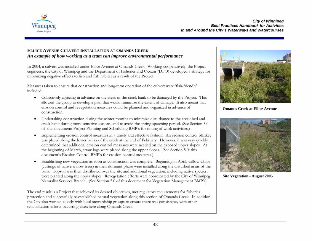
City of Winnipeg
Best Practices Handbook for Activities In and Around the City’s Waterways and Watercourses
48
ELLICE AVENUE CULVERT INSTALLATION AT OMANDS CREEK An example of how working as a team can improve environmental performance In 2004, a culvert was installed under Ellice Avenue at Omands Creek. Working cooperatively, the Project engineers, the City of Winnipeg and the Department of Fisheries and Oceans (DFO) developed a strategy for minimizing negative effects to fish and fish habitat as a result of the Project. Measures taken to ensure that construction and long-term operation of the culvert were ‘fish-friendly’ included:
• Collectively agreeing in advance on the areas of the creek bank to be damaged by the Project. This allowed the group to develop a plan that would minimize the extent of damage. It also meant that erosion control and revegetation measures could be planned and organized in advance of construction.
• Undertaking construction during the winter months to minimize disturbance to the creek bed and creek bank during more sensitive seasons, and to avoid the spring spawning period. (See Section 5.0 of this document: Project Planning and Scheduling BMP’s for timing of work activities.)
• Implementing erosion control measures in a timely and effective fashion. An erosion control blanket was placed along the lower banks of the creek at the end of February. However, it was very quickly determined that additional erosion control measures were needed on the exposed upper slopes. At the beginning of March, straw logs were placed along the upper slopes. (See Section 5.0: this document’s Erosion Control BMP’s for erosion control measures.)
• Establishing new vegetation as soon as construction was complete. Beginning in April, willow whips (cuttings of native willow trees) in their dormant phase were installed along the disturbed areas of the bank. Topsoil was then distributed over the site and additional vegetation, including native species, were planted along the upper slopes. Revegetation efforts were coordinated by the City of Winnipeg Naturalist Services Branch. (See Section 5.0 of this document for Vegetation Management BMP’s).
The end result is a Project that achieved its desired objectives, met regulatory requirements for fisheries protection and successfully re-established natural vegetation along this section of Omands Creek. In addition, the City also worked closely with local stewardship groups to ensure there was consistency with other rehabilitation efforts occurring elsewhere along Omands Creek.
Omands Creek at Ellice Avenue
Site Vegetation - August 2005
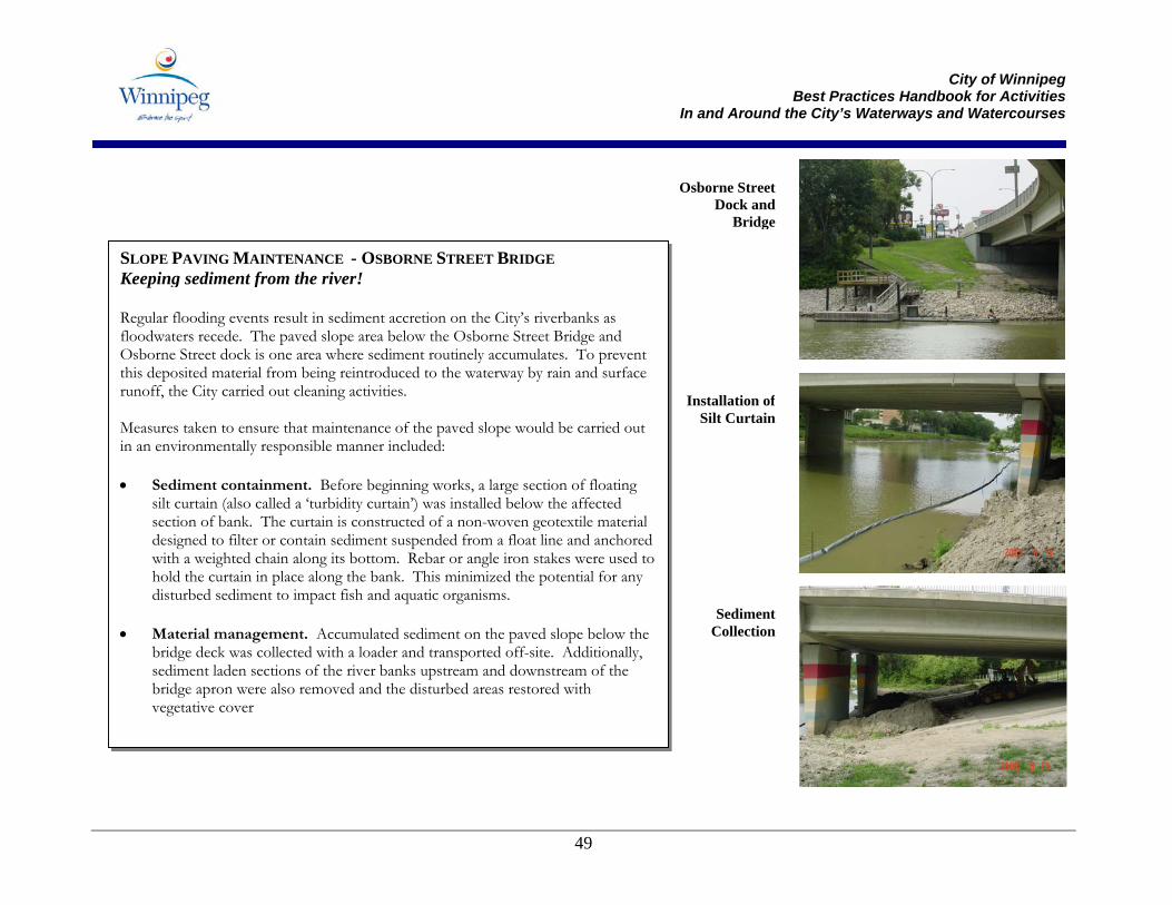
City of Winnipeg
Best Practices Handbook for Activities In and Around the City’s Waterways and Watercourses
49
SLOPE PAVING MAINTENANCE - OSBORNE STREET BRIDGE Keeping sediment from the river! Regular flooding events result in sediment accretion on the City’s riverbanks as floodwaters recede. The paved slope area below the Osborne Street Bridge and Osborne Street dock is one area where sediment routinely accumulates. To prevent this deposited material from being reintroduced to the waterway by rain and surface runoff, the City carried out cleaning activities. Measures taken to ensure that maintenance of the paved slope would be carried out in an environmentally responsible manner included: • Sediment containment. Before beginning works, a large section of floating
silt curtain (also called a ‘turbidity curtain’) was installed below the affected section of bank. The curtain is constructed of a non-woven geotextile material designed to filter or contain sediment suspended from a float line and anchored with a weighted chain along its bottom. Rebar or angle iron stakes were used to hold the curtain in place along the bank. This minimized the potential for any disturbed sediment to impact fish and aquatic organisms.
• Material management. Accumulated sediment on the paved slope below the
bridge deck was collected with a loader and transported off-site. Additionally, sediment laden sections of the river banks upstream and downstream of the bridge apron were also removed and the disturbed areas restored with vegetative cover
Osborne StreetDock and
Bridge
Installation ofSilt Curtain
SedimentCollection
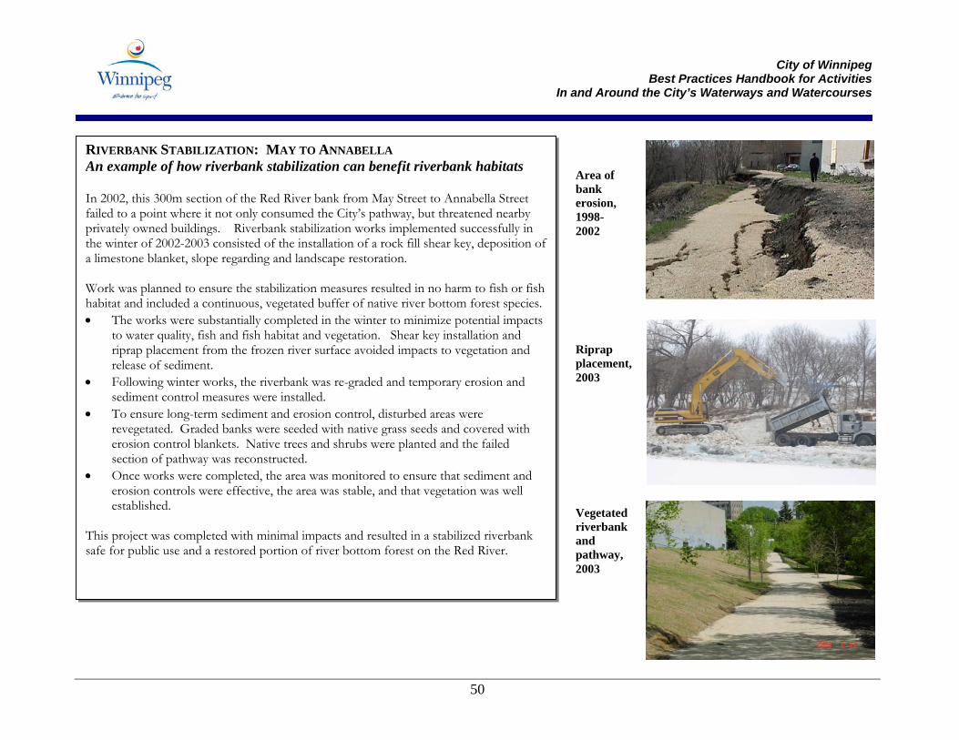
City of Winnipeg
Best Practices Handbook for Activities In and Around the City’s Waterways and Watercourses
50
RIVERBANK STABILIZATION: MAY TO ANNABELLA An example of how riverbank stabilization can benefit riverbank habitats In 2002, this 300m section of the Red River bank from May Street to Annabella Street failed to a point where it not only consumed the City’s pathway, but threatened nearby privately owned buildings. Riverbank stabilization works implemented successfully in the winter of 2002-2003 consisted of the installation of a rock fill shear key, deposition of a limestone blanket, slope regarding and landscape restoration. Work was planned to ensure the stabilization measures resulted in no harm to fish or fish habitat and included a continuous, vegetated buffer of native river bottom forest species.• The works were substantially completed in the winter to minimize potential impacts
to water quality, fish and fish habitat and vegetation. Shear key installation and riprap placement from the frozen river surface avoided impacts to vegetation and release of sediment.
• Following winter works, the riverbank was re-graded and temporary erosion and sediment control measures were installed.
• To ensure long-term sediment and erosion control, disturbed areas were revegetated. Graded banks were seeded with native grass seeds and covered with erosion control blankets. Native trees and shrubs were planted and the failed section of pathway was reconstructed.
• Once works were completed, the area was monitored to ensure that sediment and erosion controls were effective, the area was stable, and that vegetation was well established.
This project was completed with minimal impacts and resulted in a stabilized riverbank safe for public use and a restored portion of river bottom forest on the Red River.
Area of bank erosion, 1998-2002
Riprap placement, 2003
Vegetated riverbank and pathway, 2003
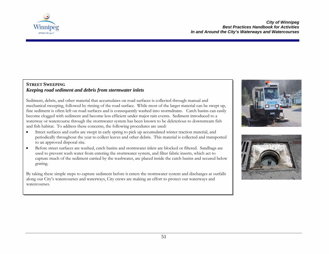
City of Winnipeg
Best Practices Handbook for Activities In and Around the City’s Waterways and Watercourses
51
STREET SWEEPING Keeping road sediment and debris from stormwater inlets Sediment, debris, and other material that accumulates on road surfaces is collected through manual and mechanical sweeping, followed by rinsing of the road surface. While most of the larger material can be swept up, fine sediment is often left on road surfaces and is consequently washed into stormdrains. Catch basins can easily become clogged with sediment and become less efficient under major rain events. Sediment introduced to a waterway or watercourse through the stormwater system has been known to be deleterious to downstream fish and fish habitat. To address these concerns, the following procedures are used: • Street surfaces and curbs are swept in early spring to pick up accumulated winter traction material, and
periodically throughout the year to collect leaves and other debris. This material is collected and transported to an approved disposal site.
• Before street surfaces are washed, catch basins and stormwater inlets are blocked or filtered. Sandbags are used to prevent wash water from entering the stormwater system, and filter fabric inserts, which act to capture much of the sediment carried by the washwater, are placed inside the catch basins and secured below grating.
By taking these simple steps to capture sediment before it enters the stormwater system and discharges at outfalls along our City’s watercourses and waterways, City crews are making an effort to protect our waterways and watercourses.
City of Winnipeg
Best Practices Handbook for Activities In and Around the City’s Waterways and Watercourses
53
5.0 Best Management Practices Best Management Practices (BMPs) are recommended techniques and guiding statements that, when followed, will allow you to undertake works in and around waterways and watercourses in a manner that will avoid, minimize or mitigate impacts to aquatic and riparian habitats, water quality and quantity, fish and wildlife species and public safety and property. The City’s primary objective in developing the following series of operational BMPs is to provide City staff and contractors with practical, economical and technically effective BMPs for routine maintenance activities. For ease of use, the BMPs included in this Handbook have been divided into two categories:
• Operational BMPs – a standard set of BMPs that apply to most operations and maintenance activities; and
• Erosion Control and Sediment Control BMPs – more specific solutions to manage erosion and sediment transport. The applicability of these BMPs will depend on the site and the activity being undertaken.
The BMPs recommended here do not represent an exhaustive list but rather a set of common BMPs that are applicable to routine City works in and around watercourses and waterways. Alternatives to and improvements on these best practices should not be overlooked when planning your proposed works. To assist in implementing these BMPs, use the Activity Table in Section 4.0 to assess the project and potential impacts, and then customize a project or site-specific set of BMPs to help you achieve compliance with environmental legislation. Qualified environmental professionals may also provide advice on the selection and application of BMPs including the use of alternative practices.
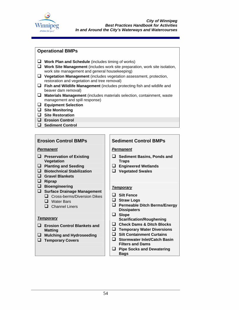
City of Winnipeg
Best Practices Handbook for Activities In and Around the City’s Waterways and Watercourses
54
Operational BMPs
Work Plan and Schedule (includes timing of works) Work Site Management (includes work site preparation, work site isolation,
work site management and general housekeeping) Vegetation Management (includes vegetation assessment, protection,
restoration and vegetation and tree removal) Fish and Wildlife Management (includes protecting fish and wildlife and
beaver dam removal) Materials Management (includes materials selection, containment, waste
management and spill response) Equipment Selection Site Monitoring Site Restoration Erosion Control Sediment Control
Erosion Control BMPs Sediment Control BMPs Permanent Permanent
Sediment Basins, Ponds and Traps Engineered Wetlands Vegetated Swales
Temporary
Preservation of Existing Vegetation Planting and Seeding Biotechnical Stabilization Gravel Blankets Riprap Bioengineering Surface Drainage Management Cross-berms/Diversion Dikes Water Bars Channel Liners
Temporary
Erosion Control Blankets and Matting Mulching and Hydroseeding Temporary Covers
Silt Fence Straw Logs Permeable Ditch Berms/Energy
Dissipaters Slope
Scarification/Roughening Check Dams & Ditch Blocks Temporary Water Diversions Silt Containment Curtains Stormwater Inlet/Catch Basin
Filters and Dams Pipe Socks and Dewatering
Bags
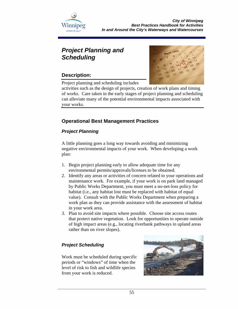
City of Winnipeg
Best Practices Handbook for Activities In and Around the City’s Waterways and Watercourses
55
Project Planning and Scheduling
Description: Project planning and scheduling includes activities such as the design of projects, creation of work plans and timing of works. Care taken in the early stages of project planning and scheduling can alleviate many of the potential environmental impacts associated with your works.
Operational Best Management Practices
Project Planning A little planning goes a long way towards avoiding and minimizing negative environmental impacts of your work. When developing a work plan: 1. Begin project planning early to allow adequate time for any
environmental permits/approvals/licenses to be obtained. 2. Identify any areas or activities of concern related to your operations and
maintenance work. For example, if your work is on park land managed by Public Works Department, you must meet a no-net-loss policy for habitat (i.e., any habitat lost must be replaced with habitat of equal value). Consult with the Public Works Department when preparing a work plan as they can provide assistance with the assessment of habitat in your work area.
3. Plan to avoid site impacts where possible. Choose site access routes that protect native vegetation. Look for opportunities to operate outside of high impact areas (e.g., locating riverbank pathways in upland areas rather than on river slopes).
Project Scheduling Work must be scheduled during specific periods or “windows” of time when the level of risk to fish and wildlife species from your work is reduced.
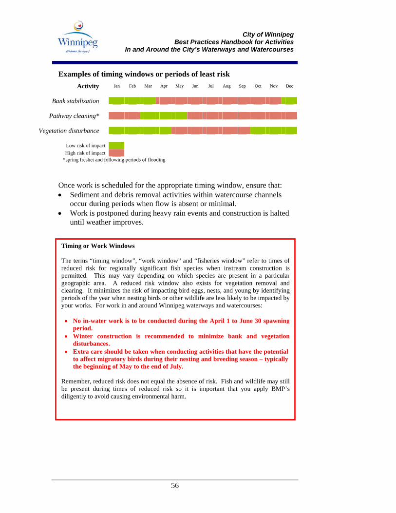
City of Winnipeg
Best Practices Handbook for Activities In and Around the City’s Waterways and Watercourses
56
Examples of timing windows or periods of least risk Activity Jan Feb Mar Apr May Jun Jul Aug Sep Oct Nov Dec
Bank stabilization
Pathway cleaning*
Vegetation disturbance
Low risk of impact High risk of impact
*spring freshet and following periods of flooding Once work is scheduled for the appropriate timing window, ensure that: • Sediment and debris removal activities within watercourse channels
occur during periods when flow is absent or minimal. • Work is postponed during heavy rain events and construction is halted
until weather improves.
Timing or Work Windows The terms “timing window”, “work window” and “fisheries window” refer to times ofreduced risk for regionally significant fish species when instream construction ispermitted. This may vary depending on which species are present in a particulargeographic area. A reduced risk window also exists for vegetation removal andclearing. It minimizes the risk of impacting bird eggs, nests, and young by identifyingperiods of the year when nesting birds or other wildlife are less likely to be impacted byyour works. For work in and around Winnipeg waterways and watercourses:
• No in-water work is to be conducted during the April 1 to June 30 spawningperiod.
• Winter construction is recommended to minimize bank and vegetationdisturbances.
• Extra care should be taken when conducting activities that have the potential to affect migratory birds during their nesting and breeding season – typically the beginning of May to the end of July.
Remember, reduced risk does not equal the absence of risk. Fish and wildlife may stillbe present during times of reduced risk so it is important that you apply BMP’sdiligently to avoid causing environmental harm.
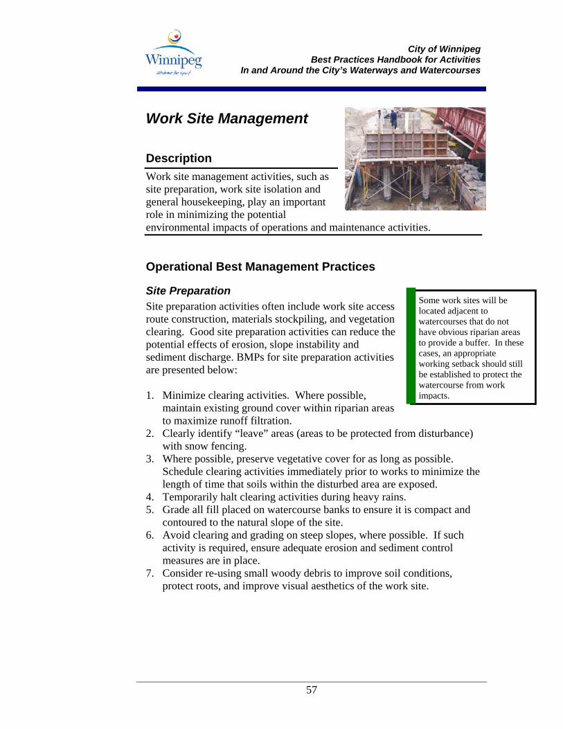
City of Winnipeg
Best Practices Handbook for Activities In and Around the City’s Waterways and Watercourses
57
Work Site Management
Description Work site management activities, such as site preparation, work site isolation and general housekeeping, play an important role in minimizing the potential environmental impacts of operations and maintenance activities.
Operational Best Management Practices
Site Preparation Site preparation activities often include work site access route construction, materials stockpiling, and vegetation clearing. Good site preparation activities can reduce the potential effects of erosion, slope instability and sediment discharge. BMPs for site preparation activities are presented below: 1. Minimize clearing activities. Where possible,
maintain existing ground cover within riparian areas to maximize runoff filtration.
2. Clearly identify “leave” areas (areas to be protected from disturbance) with snow fencing.
3. Where possible, preserve vegetative cover for as long as possible. Schedule clearing activities immediately prior to works to minimize the length of time that soils within the disturbed area are exposed.
4. Temporarily halt clearing activities during heavy rains. 5. Grade all fill placed on watercourse banks to ensure it is compact and
contoured to the natural slope of the site. 6. Avoid clearing and grading on steep slopes, where possible. If such
activity is required, ensure adequate erosion and sediment control measures are in place.
7. Consider re-using small woody debris to improve soil conditions, protect roots, and improve visual aesthetics of the work site.
Some work sites will be located adjacent to watercourses that do not have obvious riparian areas to provide a buffer. In these cases, an appropriate working setback should still be established to protect the watercourse from work impacts.
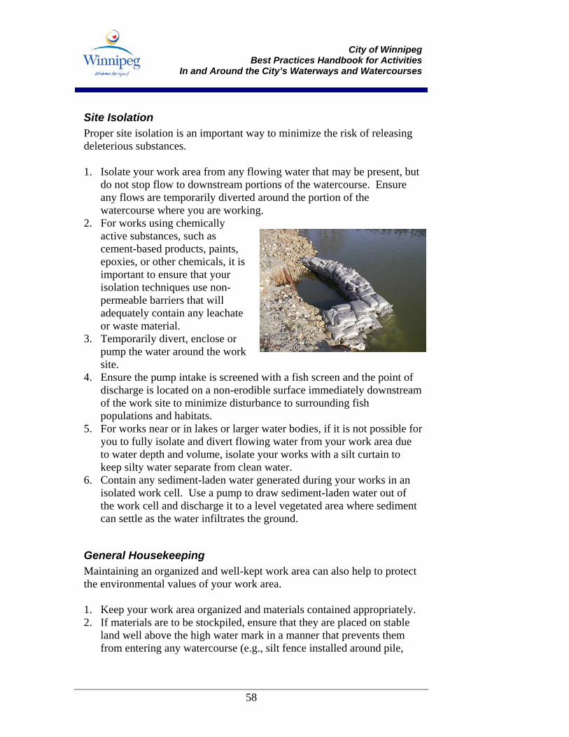
City of Winnipeg
Best Practices Handbook for Activities In and Around the City’s Waterways and Watercourses
58
Site Isolation Proper site isolation is an important way to minimize the risk of releasing deleterious substances. 1. Isolate your work area from any flowing water that may be present, but
do not stop flow to downstream portions of the watercourse. Ensure any flows are temporarily diverted around the portion of the watercourse where you are working.
2. For works using chemically active substances, such as cement-based products, paints, epoxies, or other chemicals, it is important to ensure that your isolation techniques use non-permeable barriers that will adequately contain any leachate or waste material.
3. Temporarily divert, enclose or pump the water around the work site.
4. Ensure the pump intake is screened with a fish screen and the point of discharge is located on a non-erodible surface immediately downstream of the work site to minimize disturbance to surrounding fish populations and habitats.
5. For works near or in lakes or larger water bodies, if it is not possible for you to fully isolate and divert flowing water from your work area due to water depth and volume, isolate your works with a silt curtain to keep silty water separate from clean water.
6. Contain any sediment-laden water generated during your works in an isolated work cell. Use a pump to draw sediment-laden water out of the work cell and discharge it to a level vegetated area where sediment can settle as the water infiltrates the ground.
General Housekeeping Maintaining an organized and well-kept work area can also help to protect the environmental values of your work area.
1. Keep your work area organized and materials contained appropriately. 2. If materials are to be stockpiled, ensure that they are placed on stable
land well above the high water mark in a manner that prevents them from entering any watercourse (e.g., silt fence installed around pile,
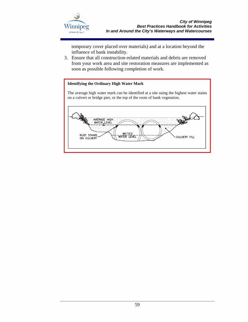
City of Winnipeg
Best Practices Handbook for Activities In and Around the City’s Waterways and Watercourses
59
temporary cover placed over materials) and at a location beyond the influence of bank instability.
3. Ensure that all construction-related materials and debris are removed from your work area and site restoration measures are implemented as soon as possible following completion of work.
Identifying the Ordinary High Water Mark The average high water mark can be identified at a site using the highest water stainson a culvert or bridge pier, or the top of the roots of bank vegetation.
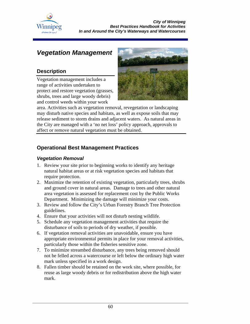
City of Winnipeg
Best Practices Handbook for Activities In and Around the City’s Waterways and Watercourses
60
Vegetation Management
Description Vegetation management includes a range of activities undertaken to protect and restore vegetation (grasses, shrubs, trees and large woody debris) and control weeds within your work area. Activities such as vegetation removal, revegetation or landscaping may disturb native species and habitats, as well as expose soils that may release sediment to storm drains and adjacent waters. As natural areas in the City are managed with a ‘no net loss’ policy approach, approvals to affect or remove natural vegetation must be obtained.
Operational Best Management Practices
Vegetation Removal 1. Review your site prior to beginning works to identify any heritage
natural habitat areas or at risk vegetation species and habitats that require protection.
2. Maximize the retention of existing vegetation, particularly trees, shrubs and ground cover in natural areas. Damage to trees and other natural area vegetation is assessed for replacement cost by the Public Works Department. Minimizing the damage will minimize your costs.
3. Review and follow the City’s Urban Forestry Branch Tree Protection guidelines.
4. Ensure that your activities will not disturb nesting wildlife. 5. Schedule any vegetation management activities that require the
disturbance of soils to periods of dry weather, if possible. 6. If vegetation removal activities are unavoidable, ensure you have
appropriate environmental permits in place for your removal activities, particularly those within the fisheries sensitive zone.
7. To minimize streambed disturbance, any trees being removed should not be felled across a watercourse or left below the ordinary high water mark unless specified in a work design.
8. Fallen timber should be retained on the work site, where possible, for reuse as large woody debris or for redistribution above the high water mark.
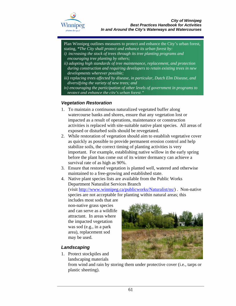
City of Winnipeg
Best Practices Handbook for Activities In and Around the City’s Waterways and Watercourses
61
Vegetation Restoration 1. To maintain a continuous naturalized vegetated buffer along
watercourse banks and shores, ensure that any vegetation lost or impacted as a result of operations, maintenance or construction activities is replaced with site-suitable native plant species. All areas of exposed or disturbed soils should be revegetated.
2. While restoration of vegetation should aim to establish vegetative cover as quickly as possible to provide permanent erosion control and help stabilize soils, the correct timing of planting activities is very important. For example, establishing native willow in the early spring before the plant has come out of its winter dormancy can achieve a survival rate of as high as 90%.
3. Ensure that restored vegetation is planted well, watered and otherwise maintained to a free-growing and established state.
4. Native plant species lists are available from the Public Works Department Naturalist Services Branch (visit http://www.winnipeg.ca/publicworks/Naturalist/ns/) . Non-native species are not acceptable for planting within natural areas; this includes most sods that are non-native grass species and can serve as a wildlife attractant. In areas where the impacted vegetation was sod (e.g., in a park area), replacement sod may be used.
Landscaping 1. Protect stockpiles and
landscaping materials from wind and rain by storing them under protective cover (i.e., tarps or plastic sheeting).
Plan Winnipeg outlines measures to protect and enhance the City’s urban forest, stating, “The City shall protect and enhance its urban forest by: i) increasing the stock of trees through its tree planting programs and
encouraging tree planting by others; ii) adopting high standards of tree maintenance, replacement, and protection
during construction and requiring developers to retain existing trees in new developments wherever possible;
iii) replacing trees affected by disease, in particular, Dutch Elm Disease, and diversifying the variety of new trees; and
iv) encouraging the participation of other levels of government in programs to protect and enhance the city’s urban forest.”
City of Winnipeg
Best Practices Handbook for Activities In and Around the City’s Waterways and Watercourses
62
2. When working around curbs and gutters divert any run-off away from storm drains. Protect storm drain inlets with covers or drain blocks, filter mats or catch basin liners to filter sediment from curbside run-off before it enters the storm sewer (see Catch Basin Liners - Sediment Control BMPs).
3. Collect landscape refuse (i.e., leaves and organic material) and place or dispose of in a manner that will prevent it from entering gutters, catch basins and watercourses.
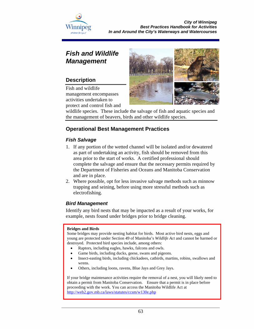
City of Winnipeg
Best Practices Handbook for Activities In and Around the City’s Waterways and Watercourses
63
Fish and Wildlife Management
Description Fish and wildlife management encompasses activities undertaken to protect and control fish and wildlife species. These include the salvage of fish and aquatic species and the management of beavers, birds and other wildlife species.
Operational Best Management Practices
Fish Salvage 1. If any portion of the wetted channel will be isolated and/or dewatered
as part of undertaking an activity, fish should be removed from this area prior to the start of works. A certified professional should complete the salvage and ensure that the necessary permits required by the Department of Fisheries and Oceans and Manitoba Conservation and are in place.
2. Where possible, opt for less invasive salvage methods such as minnow trapping and seining, before using more stressful methods such as electrofishing.
Bird Management Identify any bird nests that may be impacted as a result of your works, for example, nests found under bridges prior to bridge cleaning.
Bridges and Birds Some bridges may provide nesting habitat for birds. Most active bird nests, eggs and young are protected under Section 49 of Manitoba’s Wildlife Act and cannot be harmed or destroyed. Protected bird species include, among others:
• Raptors, including eagles, hawks, falcons and owls. • Game birds, including ducks, geese, swans and pigeons. • Insect-easting birds, including chickadees, catbirds, martins, robins, swallows and
wrens. • Others, including loons, ravens, Blue Jays and Grey Jays.
If your bridge maintenance activities require the removal of a nest, you will likely need to obtain a permit from Manitoba Conservation. Ensure that a permit is in place before proceeding with the work. You can access the Manitoba Wildlife Act at http://web2.gov.mb.ca/laws/statutes/ccsm/w130e.php
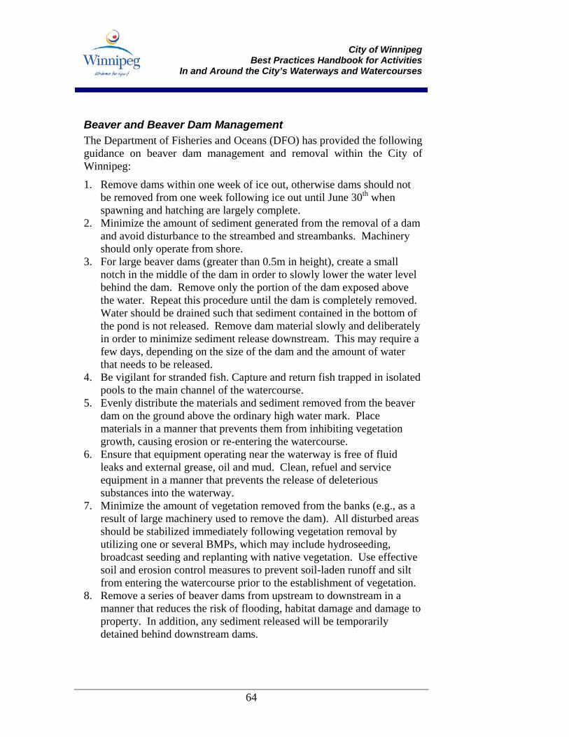
City of Winnipeg
Best Practices Handbook for Activities In and Around the City’s Waterways and Watercourses
64
Beaver and Beaver Dam Management The Department of Fisheries and Oceans (DFO) has provided the following guidance on beaver dam management and removal within the City of Winnipeg:
1. Remove dams within one week of ice out, otherwise dams should not be removed from one week following ice out until June 30th when spawning and hatching are largely complete.
2. Minimize the amount of sediment generated from the removal of a dam and avoid disturbance to the streambed and streambanks. Machinery should only operate from shore.
3. For large beaver dams (greater than 0.5m in height), create a small notch in the middle of the dam in order to slowly lower the water level behind the dam. Remove only the portion of the dam exposed above the water. Repeat this procedure until the dam is completely removed. Water should be drained such that sediment contained in the bottom of the pond is not released. Remove dam material slowly and deliberately in order to minimize sediment release downstream. This may require a few days, depending on the size of the dam and the amount of water that needs to be released.
4. Be vigilant for stranded fish. Capture and return fish trapped in isolated pools to the main channel of the watercourse.
5. Evenly distribute the materials and sediment removed from the beaver dam on the ground above the ordinary high water mark. Place materials in a manner that prevents them from inhibiting vegetation growth, causing erosion or re-entering the watercourse.
6. Ensure that equipment operating near the waterway is free of fluid leaks and external grease, oil and mud. Clean, refuel and service equipment in a manner that prevents the release of deleterious substances into the waterway.
7. Minimize the amount of vegetation removed from the banks (e.g., as a result of large machinery used to remove the dam). All disturbed areas should be stabilized immediately following vegetation removal by utilizing one or several BMPs, which may include hydroseeding, broadcast seeding and replanting with native vegetation. Use effective soil and erosion control measures to prevent soil-laden runoff and silt from entering the watercourse prior to the establishment of vegetation.
8. Remove a series of beaver dams from upstream to downstream in a manner that reduces the risk of flooding, habitat damage and damage to property. In addition, any sediment released will be temporarily detained behind downstream dams.

City of Winnipeg
Best Practices Handbook for Activities In and Around the City’s Waterways and Watercourses
65
9. Contact DFO prior to removal if: • The beaver dam is well established with maximum water depths
greater than 2m and is likely to provide year-round fish habitat; • The removal of the beaver dam will likely impact critical or
limiting fish habitat; or • The beaver dam is to be removed in winter.
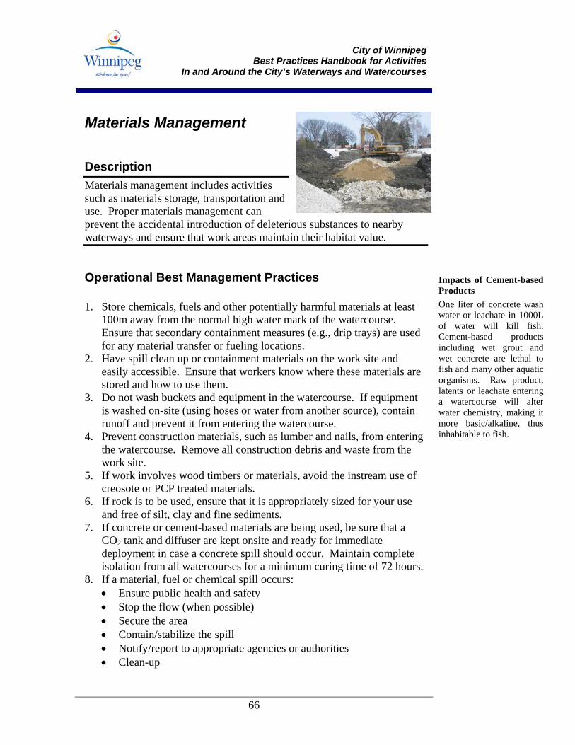
City of Winnipeg
Best Practices Handbook for Activities In and Around the City’s Waterways and Watercourses
66
Materials Management
Description Materials management includes activities such as materials storage, transportation and use. Proper materials management can prevent the accidental introduction of deleterious substances to nearby waterways and ensure that work areas maintain their habitat value.
Operational Best Management Practices 1. Store chemicals, fuels and other potentially harmful materials at least
100m away from the normal high water mark of the watercourse. Ensure that secondary containment measures (e.g., drip trays) are used for any material transfer or fueling locations.
2. Have spill clean up or containment materials on the work site and easily accessible. Ensure that workers know where these materials are stored and how to use them.
3. Do not wash buckets and equipment in the watercourse. If equipment is washed on-site (using hoses or water from another source), contain runoff and prevent it from entering the watercourse.
4. Prevent construction materials, such as lumber and nails, from entering the watercourse. Remove all construction debris and waste from the work site.
5. If work involves wood timbers or materials, avoid the instream use of creosote or PCP treated materials.
6. If rock is to be used, ensure that it is appropriately sized for your use and free of silt, clay and fine sediments.
7. If concrete or cement-based materials are being used, be sure that a CO2 tank and diffuser are kept onsite and ready for immediate deployment in case a concrete spill should occur. Maintain complete isolation from all watercourses for a minimum curing time of 72 hours.
8. If a material, fuel or chemical spill occurs: • Ensure public health and safety • Stop the flow (when possible) • Secure the area • Contain/stabilize the spill • Notify/report to appropriate agencies or authorities • Clean-up
Impacts of Cement-basedProducts One liter of concrete washwater or leachate in 1000Lof water will kill fish.Cement-based productsincluding wet grout andwet concrete are lethal tofish and many other aquaticorganisms. Raw product,latents or leachate enteringa watercourse will alterwater chemistry, making itmore basic/alkaline, thusinhabitable to fish.
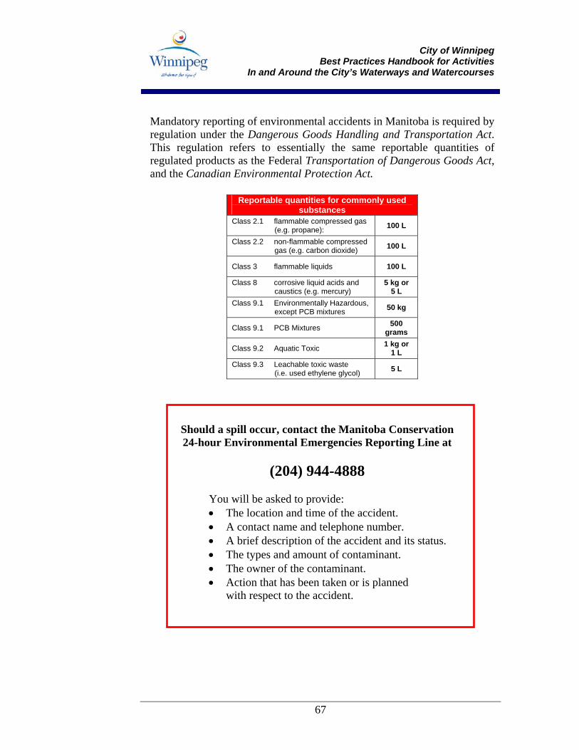
City of Winnipeg
Best Practices Handbook for Activities In and Around the City’s Waterways and Watercourses
67
Mandatory reporting of environmental accidents in Manitoba is required by regulation under the Dangerous Goods Handling and Transportation Act. This regulation refers to essentially the same reportable quantities of regulated products as the Federal Transportation of Dangerous Goods Act, and the Canadian Environmental Protection Act.
Reportable quantities for commonly used substances
Class 2.1 flammable compressed gas (e.g. propane): 100 L
Class 2.2 non-flammable compressed gas (e.g. carbon dioxide) 100 L
Class 3 flammable liquids 100 L
Class 8 corrosive liquid acids and caustics (e.g. mercury)
5 kg or 5 L
Class 9.1 Environmentally Hazardous, except PCB mixtures 50 kg
Class 9.1 PCB Mixtures 500 grams
Class 9.2 Aquatic Toxic 1 kg or 1 L
Class 9.3 Leachable toxic waste (i.e. used ethylene glycol) 5 L
Should a spill occur, contact the Manitoba Conservation 24-hour Environmental Emergencies Reporting Line at
(204) 944-4888
You will be asked to provide: • The location and time of the accident. • A contact name and telephone number. • A brief description of the accident and its status. • The types and amount of contaminant. • The owner of the contaminant. • Action that has been taken or is planned
with respect to the accident.
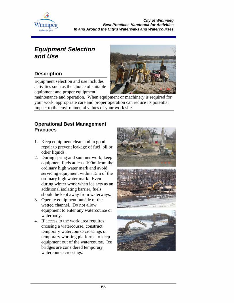
City of Winnipeg
Best Practices Handbook for Activities In and Around the City’s Waterways and Watercourses
68
Equipment Selection and Use
Description Equipment selection and use includes activities such as the choice of suitable equipment and proper equipment maintenance and operation. When equipment or machinery is required for your work, appropriate care and proper operation can reduce its potential impact to the environmental values of your work site.
Operational Best Management Practices 1. Keep equipment clean and in good
repair to prevent leakage of fuel, oil or other liquids.
2. During spring and summer work, keep equipment fuels at least 100m from the ordinary high water mark and avoid servicing equipment within 15m of the ordinary high water mark. Even during winter work when ice acts as an additional isolating barrier, fuels should be kept away from waterways.
3. Operate equipment outside of the wetted channel. Do not allow equipment to enter any watercourse or waterbody.
4. If access to the work area requires crossing a watercourse, construct temporary watercourse crossings or temporary working platforms to keep equipment out of the watercourse. Ice bridges are considered temporary watercourse crossings.
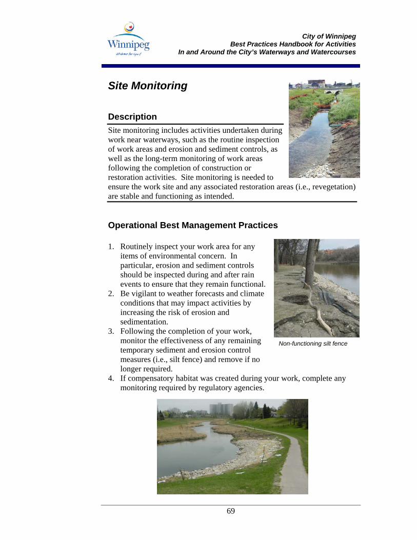
City of Winnipeg
Best Practices Handbook for Activities In and Around the City’s Waterways and Watercourses
69
Site Monitoring
Description Site monitoring includes activities undertaken during work near waterways, such as the routine inspection of work areas and erosion and sediment controls, as well as the long-term monitoring of work areas following the completion of construction or restoration activities. Site monitoring is needed to ensure the work site and any associated restoration areas (i.e., revegetation) are stable and functioning as intended.
Operational Best Management Practices 1. Routinely inspect your work area for any
items of environmental concern. In particular, erosion and sediment controls should be inspected during and after rain events to ensure that they remain functional.
2. Be vigilant to weather forecasts and climate conditions that may impact activities by increasing the risk of erosion and sedimentation.
3. Following the completion of your work, monitor the effectiveness of any remaining temporary sediment and erosion control measures (i.e., silt fence) and remove if no longer required.
4. If compensatory habitat was created during your work, complete any monitoring required by regulatory agencies.
Non-functioning silt fence
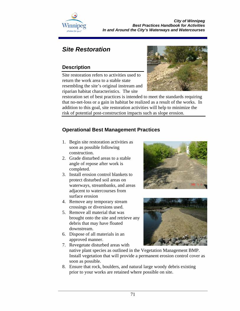
City of Winnipeg
Best Practices Handbook for Activities In and Around the City’s Waterways and Watercourses
71
Site Restoration
Description Site restoration refers to activities used to return the work area to a stable state resembling the site’s original instream and riparian habitat characteristics. The site restoration set of best practices is intended to meet the standards requiring that no-net-loss or a gain in habitat be realized as a result of the works. In addition to this goal, site restoration activities will help to minimize the risk of potential post-construction impacts such as slope erosion.
Operational Best Management Practices 1. Begin site restoration activities as
soon as possible following construction.
2. Grade disturbed areas to a stable angle of repose after work is completed.
3. Install erosion control blankets to protect disturbed soil areas on waterways, streambanks, and areas adjacent to watercourses from surface erosion
4. Remove any temporary stream crossings or diversions used.
5. Remove all material that was brought onto the site and retrieve any debris that may have floated downstream.
6. Dispose of all materials in an approved manner.
7. Revegetate disturbed areas with native plant species as outlined in the Vegetation Management BMP. Install vegetation that will provide a permanent erosion control cover as soon as possible.
8. Ensure that rock, boulders, and natural large woody debris existing prior to your works are retained where possible on site.
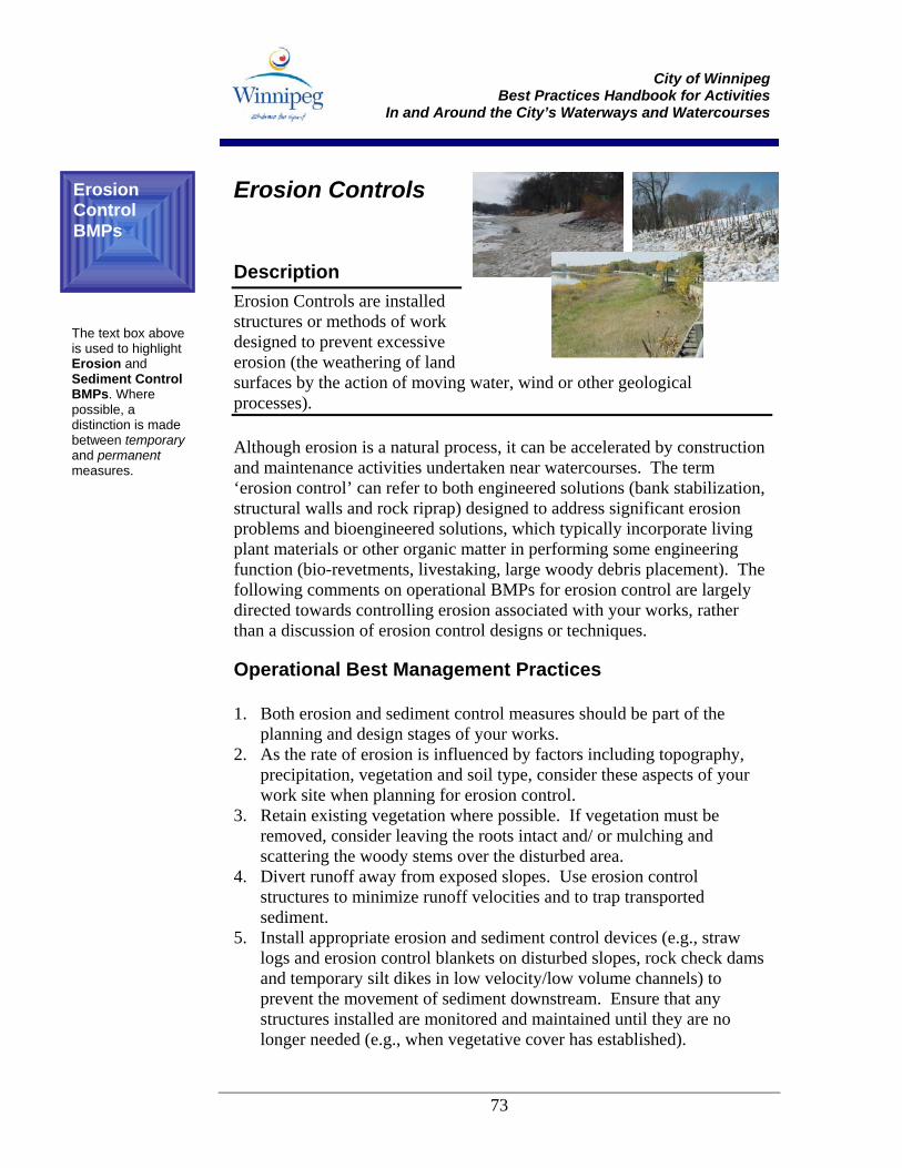
City of Winnipeg
Best Practices Handbook for Activities In and Around the City’s Waterways and Watercourses
73
Erosion Controls
Description Erosion Controls are installed structures or methods of work designed to prevent excessive erosion (the weathering of land surfaces by the action of moving water, wind or other geological processes). Although erosion is a natural process, it can be accelerated by construction and maintenance activities undertaken near watercourses. The term ‘erosion control’ can refer to both engineered solutions (bank stabilization, structural walls and rock riprap) designed to address significant erosion problems and bioengineered solutions, which typically incorporate living plant materials or other organic matter in performing some engineering function (bio-revetments, livestaking, large woody debris placement). The following comments on operational BMPs for erosion control are largely directed towards controlling erosion associated with your works, rather than a discussion of erosion control designs or techniques.
Operational Best Management Practices 1. Both erosion and sediment control measures should be part of the
planning and design stages of your works. 2. As the rate of erosion is influenced by factors including topography,
precipitation, vegetation and soil type, consider these aspects of your work site when planning for erosion control.
3. Retain existing vegetation where possible. If vegetation must be removed, consider leaving the roots intact and/ or mulching and scattering the woody stems over the disturbed area.
4. Divert runoff away from exposed slopes. Use erosion control structures to minimize runoff velocities and to trap transported sediment.
5. Install appropriate erosion and sediment control devices (e.g., straw logs and erosion control blankets on disturbed slopes, rock check dams and temporary silt dikes in low velocity/low volume channels) to prevent the movement of sediment downstream. Ensure that any structures installed are monitored and maintained until they are no longer needed (e.g., when vegetative cover has established).
Erosion Control BMPs
The text box above is used to highlight Erosion and Sediment Control BMPs. Where possible, a distinction is made between temporary and permanent measures.
City of Winnipeg
Best Practices Handbook for Activities In and Around the City’s Waterways and Watercourses
74
6. Minimize erosion by contouring exposed slopes to an appropriate steepness ratio and installing erosion controls promptly in order to minimize the length of time soil is left exposed.
Note: While the following select BMPs represent some of the most commonly used and preferred practices for Erosion Control in the City of Winnipeg, it should be remembered that there are many other options, techniques and materials that can be used to prevent and minimize erosion.
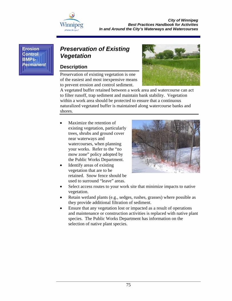
City of Winnipeg
Best Practices Handbook for Activities In and Around the City’s Waterways and Watercourses
75
Preservation of Existing Vegetation Description Preservation of existing vegetation is one of the easiest and most inexpensive means to prevent erosion and control sediment. A vegetated buffer retained between a work area and watercourse can act to filter runoff, trap sediment and maintain bank stability. Vegetation within a work area should be protected to ensure that a continuous naturalized vegetated buffer is maintained along watercourse banks and shores. • Maximize the retention of
existing vegetation, particularly trees, shrubs and ground cover near waterways and watercourses, when planning your works. Refer to the “no mow zone” policy adopted by the Public Works Department.
• Identify areas of existing vegetation that are to be retained. Snow fence should be used to surround “leave” areas.
• Select access routes to your work site that minimize impacts to native vegetation.
• Retain wetland plants (e.g., sedges, rushes, grasses) where possible as they provide additional filtration of sediment.
• Ensure that any vegetation lost or impacted as a result of operations and maintenance or construction activities is replaced with native plant species. The Public Works Department has information on the selection of native plant species.
Erosion Control BMPs- Permanent
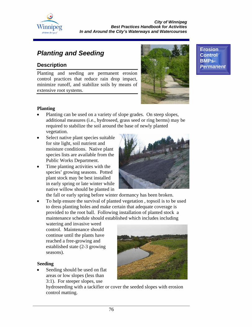
City of Winnipeg
Best Practices Handbook for Activities In and Around the City’s Waterways and Watercourses
76
Planting and Seeding Description Planting and seeding are permanent erosion control practices that reduce rain drop impact, minimize runoff, and stabilize soils by means of extensive root systems. Planting • Planting can be used on a variety of slope grades. On steep slopes,
additional measures (i.e., hydroseed, grass seed or ring berms) may be required to stabilize the soil around the base of newly planted vegetation.
• Select native plant species suitable for site light, soil nutrient and moisture conditions. Native plant species lists are available from the Public Works Department.
• Time planting activities with the species’ growing seasons. Potted plant stock may be best installed in early spring or late winter while native willow should be planted in the fall or early spring before winter dormancy has been broken.
• To help ensure the survival of planted vegetation , topsoil is to be used to dress planting holes and make certain that adequate coverage is provided to the root ball. Following installation of planted stock a maintenance schedule should established which includes including watering and invasive weed control. Maintenance should continue until the plants have reached a free-growing and established state (2-3 growing seasons).
Seeding • Seeding should be used on flat
areas or low slopes (less than 3:1). For steeper slopes, use hydroseeding with a tackifier or cover the seeded slopes with erosion control matting.
Erosion Control BMPs- Permanent
City of Winnipeg
Best Practices Handbook for Activities In and Around the City’s Waterways and Watercourses
77
• Spread seed mix immediately after the final site grading and ensure that other sediment controls are in place while the initial vegetation cover establishes.
• If possible, seed in early spring or early fall to take advantage of the optimal growing conditions. Avoid seeding immediately prior to forecast of a heavy rainfall.
• Select native seed mixes appropriate to your specific site conditions, soil characteristics and time of year.
• Loosen the soil surface through raking or scarification; apply any needed soil amendments (topsoil, organic matter); and seed with selected method and mixture. If broadcast seeding, cover the seeded area with a mulch material.
• Maintenance of the seeded area will include weed control, watering throughout the growing season and reseeding any areas of poor growth.
Note: The placement of sod is another vegetation technique that may be useful in some circumstances (e.g., to replace impacted vegetation on lawn areas). Commercial sods are most commonly formed of non-native grass species and can be a considerable attractant to some problematic wildlife species (e.g., Canada Geese), so their use should be limited.
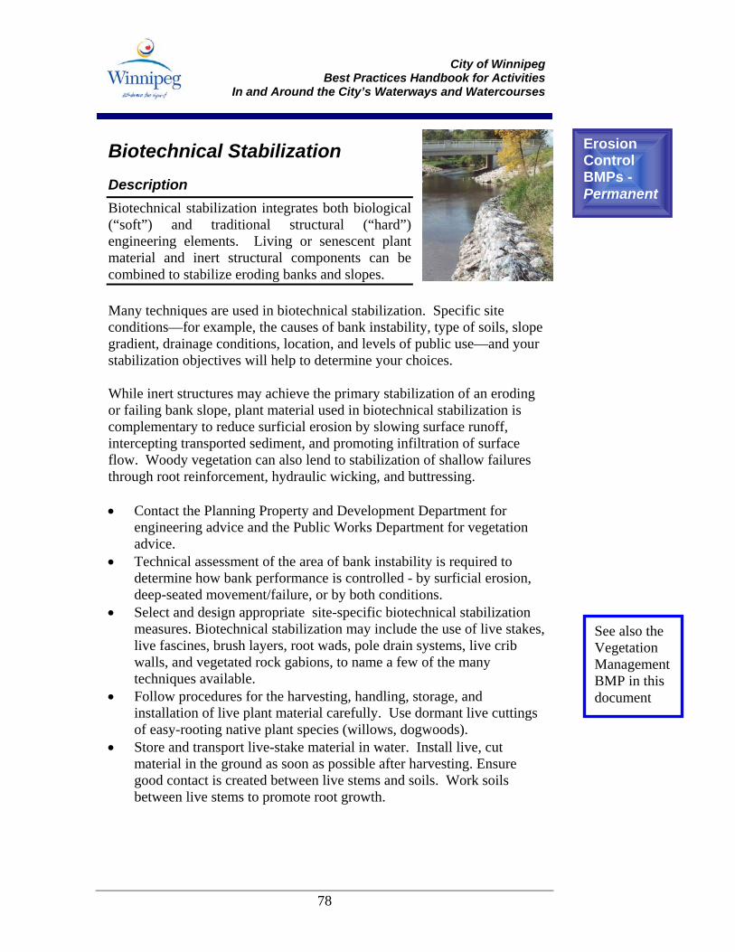
City of Winnipeg
Best Practices Handbook for Activities In and Around the City’s Waterways and Watercourses
78
Biotechnical Stabilization Description Biotechnical stabilization integrates both biological (“soft”) and traditional structural (“hard”) engineering elements. Living or senescent plant material and inert structural components can be combined to stabilize eroding banks and slopes. Many techniques are used in biotechnical stabilization. Specific site conditions—for example, the causes of bank instability, type of soils, slope gradient, drainage conditions, location, and levels of public use—and your stabilization objectives will help to determine your choices. While inert structures may achieve the primary stabilization of an eroding or failing bank slope, plant material used in biotechnical stabilization is complementary to reduce surficial erosion by slowing surface runoff, intercepting transported sediment, and promoting infiltration of surface flow. Woody vegetation can also lend to stabilization of shallow failures through root reinforcement, hydraulic wicking, and buttressing. • Contact the Planning Property and Development Department for
engineering advice and the Public Works Department for vegetation advice.
• Technical assessment of the area of bank instability is required to determine how bank performance is controlled - by surficial erosion, deep-seated movement/failure, or by both conditions.
• Select and design appropriate site-specific biotechnical stabilization measures. Biotechnical stabilization may include the use of live stakes, live fascines, brush layers, root wads, pole drain systems, live crib walls, and vegetated rock gabions, to name a few of the many techniques available.
• Follow procedures for the harvesting, handling, storage, and installation of live plant material carefully. Use dormant live cuttings of easy-rooting native plant species (willows, dogwoods).
• Store and transport live-stake material in water. Install live, cut material in the ground as soon as possible after harvesting. Ensure good contact is created between live stems and soils. Work soils between live stems to promote root growth.
Erosion Control BMPs - Permanent
See also the Vegetation Management BMP in this document
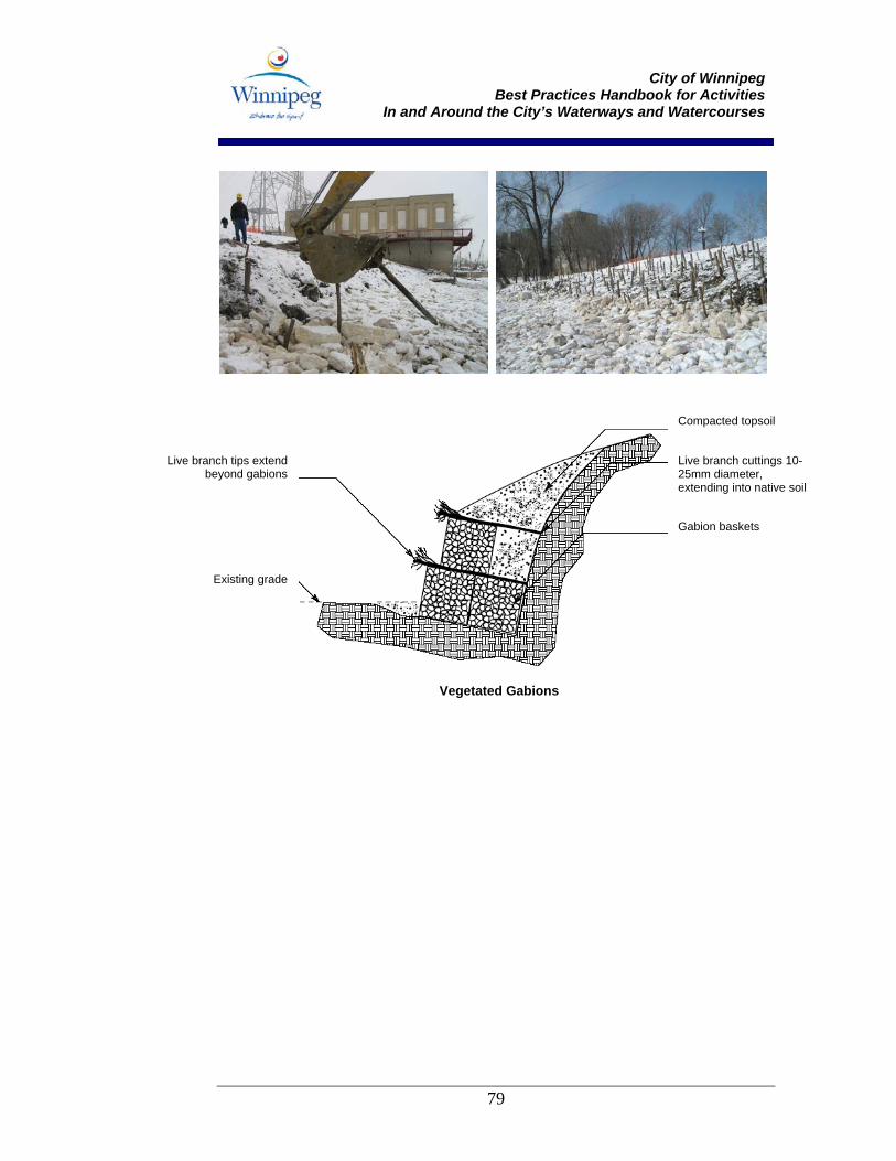
City of Winnipeg
Best Practices Handbook for Activities In and Around the City’s Waterways and Watercourses
79
Live branch tips extendbeyond gabions
Existing grade
Compacted topsoil
Live branch cuttings 10-25mm diameter, extending into native soil
Gabion baskets
Vegetated Gabions
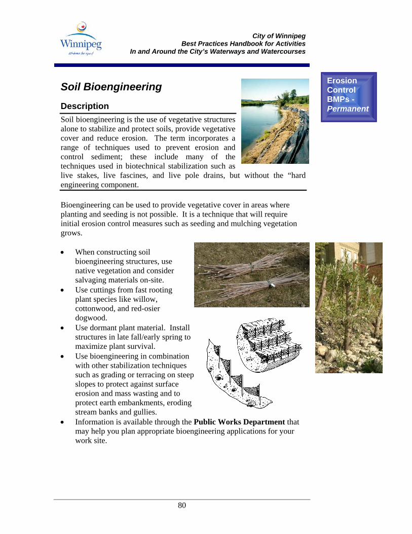
City of Winnipeg
Best Practices Handbook for Activities In and Around the City’s Waterways and Watercourses
80
Soil Bioengineering Description Soil bioengineering is the use of vegetative structures alone to stabilize and protect soils, provide vegetative cover and reduce erosion. The term incorporates a range of techniques used to prevent erosion and control sediment; these include many of the techniques used in biotechnical stabilization such as live stakes, live fascines, and live pole drains, but without the “hard engineering component. Bioengineering can be used to provide vegetative cover in areas where planting and seeding is not possible. It is a technique that will require initial erosion control measures such as seeding and mulching vegetation grows. • When constructing soil
bioengineering structures, use native vegetation and consider salvaging materials on-site.
• Use cuttings from fast rooting plant species like willow, cottonwood, and red-osier dogwood.
• Use dormant plant material. Install structures in late fall/early spring to maximize plant survival.
• Use bioengineering in combination with other stabilization techniques such as grading or terracing on steep slopes to protect against surface erosion and mass wasting and to protect earth embankments, eroding stream banks and gullies.
• Information is available through the Public Works Department that may help you plan appropriate bioengineering applications for your work site.
Erosion Control BMPs - Permanent
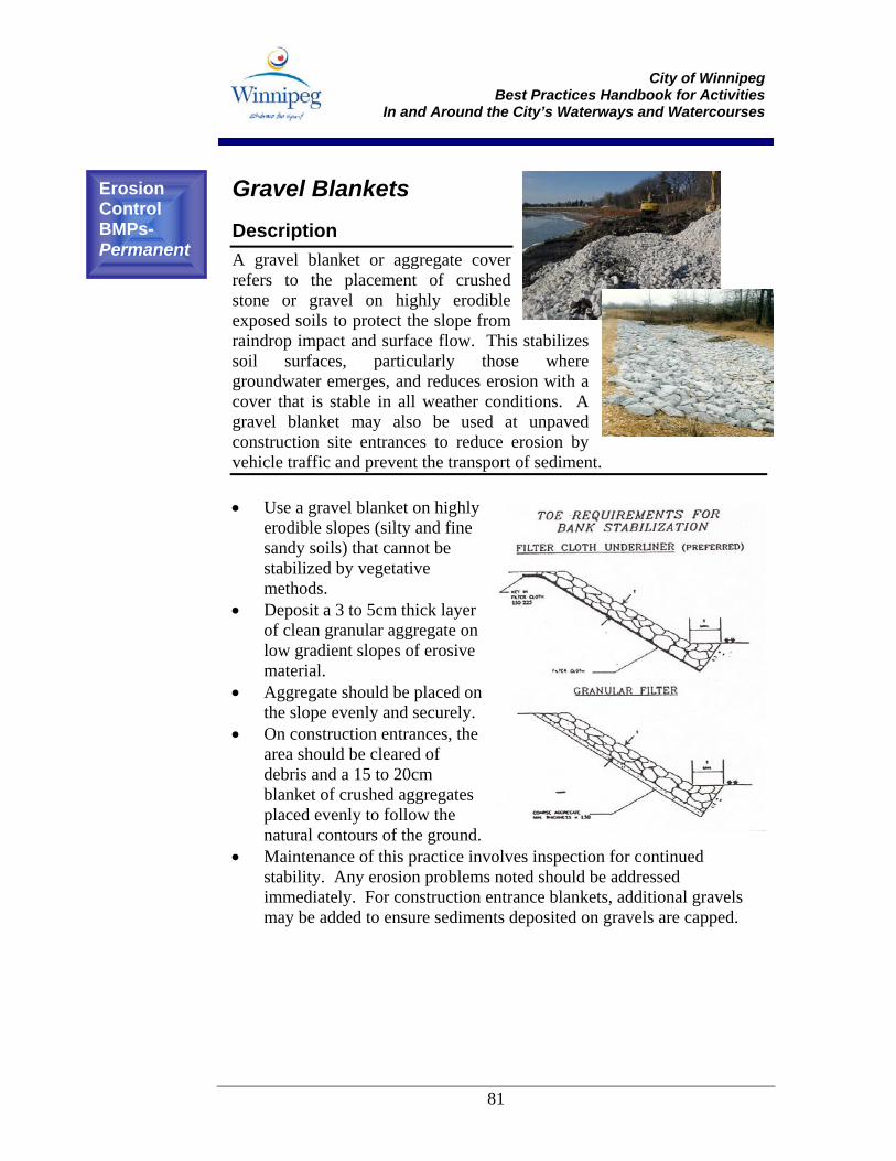
City of Winnipeg
Best Practices Handbook for Activities In and Around the City’s Waterways and Watercourses
81
Gravel Blankets Description A gravel blanket or aggregate cover refers to the placement of crushed stone or gravel on highly erodible exposed soils to protect the slope from raindrop impact and surface flow. This stabilizes soil surfaces, particularly those where groundwater emerges, and reduces erosion with a cover that is stable in all weather conditions. A gravel blanket may also be used at unpaved construction site entrances to reduce erosion by vehicle traffic and prevent the transport of sediment. • Use a gravel blanket on highly
erodible slopes (silty and fine sandy soils) that cannot be stabilized by vegetative methods.
• Deposit a 3 to 5cm thick layer of clean granular aggregate on low gradient slopes of erosive material.
• Aggregate should be placed on the slope evenly and securely.
• On construction entrances, the area should be cleared of debris and a 15 to 20cm blanket of crushed aggregates placed evenly to follow the natural contours of the ground.
• Maintenance of this practice involves inspection for continued stability. Any erosion problems noted should be addressed immediately. For construction entrance blankets, additional gravels may be added to ensure sediments deposited on gravels are capped.
Erosion Control BMPs- Permanent
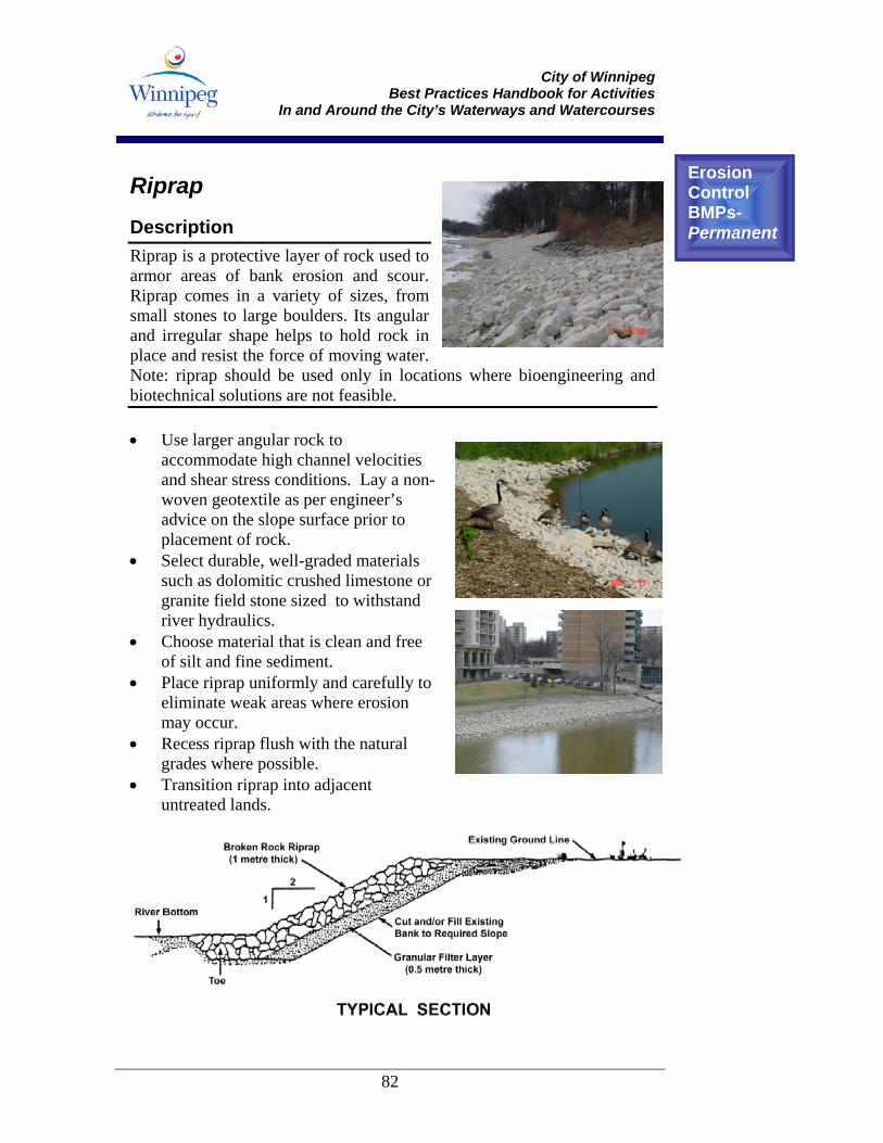
City of Winnipeg
Best Practices Handbook for Activities In and Around the City’s Waterways and Watercourses
82
Riprap Description Riprap is a protective layer of rock used to armor areas of bank erosion and scour. Riprap comes in a variety of sizes, from small stones to large boulders. Its angular and irregular shape helps to hold rock in place and resist the force of moving water. Note: riprap should be used only in locations where bioengineering and biotechnical solutions are not feasible. • Use larger angular rock to
accommodate high channel velocities and shear stress conditions. Lay a non-woven geotextile as per engineer’s advice on the slope surface prior to placement of rock.
• Select durable, well-graded materials such as dolomitic crushed limestone or granite field stone sized to withstand river hydraulics.
• Choose material that is clean and free of silt and fine sediment.
• Place riprap uniformly and carefully to eliminate weak areas where erosion may occur.
• Recess riprap flush with the natural grades where possible.
• Transition riprap into adjacent untreated lands.
Erosion Control BMPs- Permanent
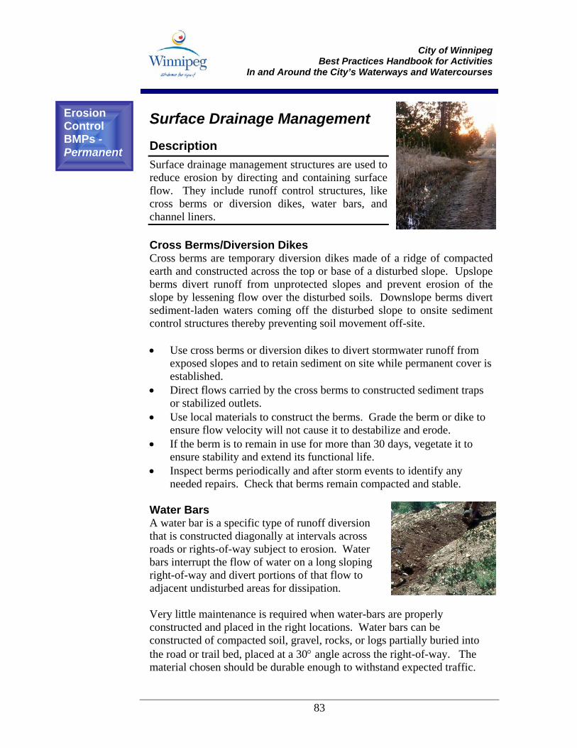
City of Winnipeg
Best Practices Handbook for Activities In and Around the City’s Waterways and Watercourses
83
Surface Drainage Management Description Surface drainage management structures are used to reduce erosion by directing and containing surface flow. They include runoff control structures, like cross berms or diversion dikes, water bars, and channel liners. Cross Berms/Diversion Dikes Cross berms are temporary diversion dikes made of a ridge of compacted earth and constructed across the top or base of a disturbed slope. Upslope berms divert runoff from unprotected slopes and prevent erosion of the slope by lessening flow over the disturbed soils. Downslope berms divert sediment-laden waters coming off the disturbed slope to onsite sediment control structures thereby preventing soil movement off-site. • Use cross berms or diversion dikes to divert stormwater runoff from
exposed slopes and to retain sediment on site while permanent cover is established.
• Direct flows carried by the cross berms to constructed sediment traps or stabilized outlets.
• Use local materials to construct the berms. Grade the berm or dike to ensure flow velocity will not cause it to destabilize and erode.
• If the berm is to remain in use for more than 30 days, vegetate it to ensure stability and extend its functional life.
• Inspect berms periodically and after storm events to identify any needed repairs. Check that berms remain compacted and stable.
Water Bars A water bar is a specific type of runoff diversion that is constructed diagonally at intervals across roads or rights-of-way subject to erosion. Water bars interrupt the flow of water on a long sloping right-of-way and divert portions of that flow to adjacent undisturbed areas for dissipation. Very little maintenance is required when water-bars are properly constructed and placed in the right locations. Water bars can be constructed of compacted soil, gravel, rocks, or logs partially buried into the road or trail bed, placed at a 30° angle across the right-of-way. The material chosen should be durable enough to withstand expected traffic.
Erosion Control BMPs - Permanent
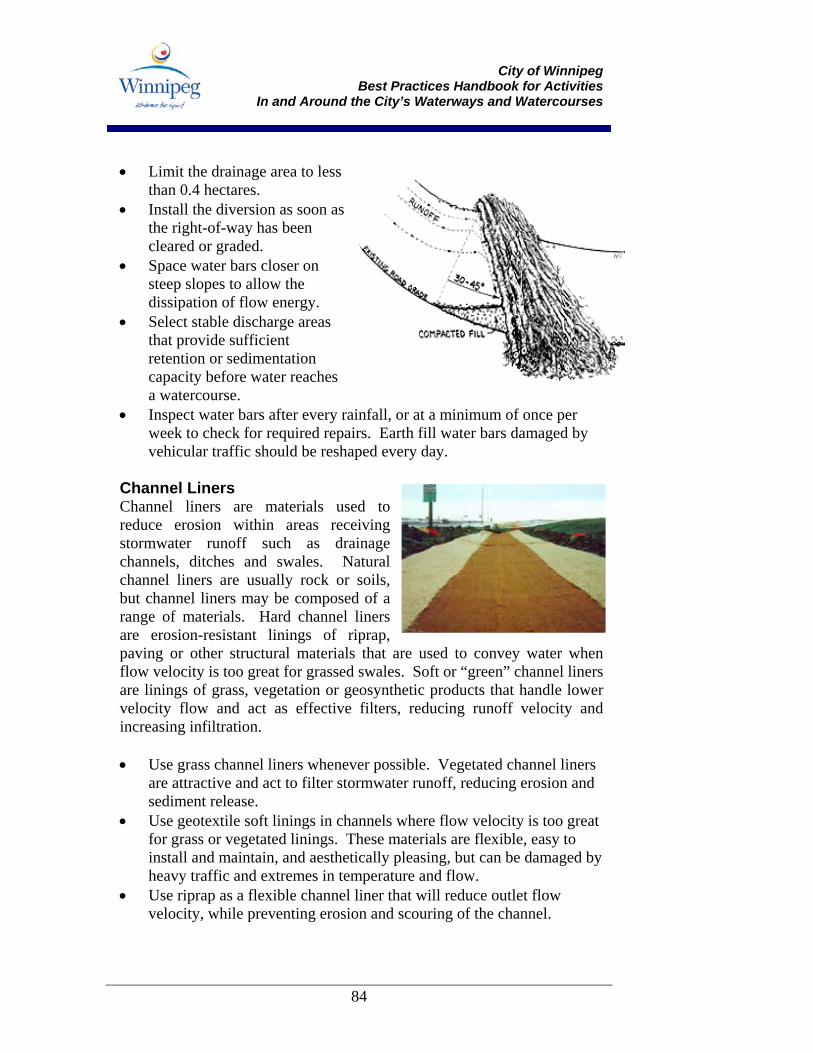
City of Winnipeg
Best Practices Handbook for Activities In and Around the City’s Waterways and Watercourses
84
• Limit the drainage area to less
than 0.4 hectares. • Install the diversion as soon as
the right-of-way has been cleared or graded.
• Space water bars closer on steep slopes to allow the dissipation of flow energy.
• Select stable discharge areas that provide sufficient retention or sedimentation capacity before water reaches a watercourse.
• Inspect water bars after every rainfall, or at a minimum of once per week to check for required repairs. Earth fill water bars damaged by vehicular traffic should be reshaped every day.
Channel Liners Channel liners are materials used to reduce erosion within areas receiving stormwater runoff such as drainage channels, ditches and swales. Natural channel liners are usually rock or soils, but channel liners may be composed of a range of materials. Hard channel liners are erosion-resistant linings of riprap, paving or other structural materials that are used to convey water when flow velocity is too great for grassed swales. Soft or “green” channel liners are linings of grass, vegetation or geosynthetic products that handle lower velocity flow and act as effective filters, reducing runoff velocity and increasing infiltration. • Use grass channel liners whenever possible. Vegetated channel liners
are attractive and act to filter stormwater runoff, reducing erosion and sediment release.
• Use geotextile soft linings in channels where flow velocity is too great for grass or vegetated linings. These materials are flexible, easy to install and maintain, and aesthetically pleasing, but can be damaged by heavy traffic and extremes in temperature and flow.
• Use riprap as a flexible channel liner that will reduce outlet flow velocity, while preventing erosion and scouring of the channel.
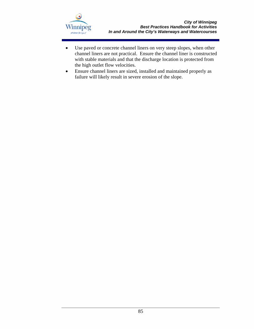
City of Winnipeg
Best Practices Handbook for Activities In and Around the City’s Waterways and Watercourses
85
• Use paved or concrete channel liners on very steep slopes, when other channel liners are not practical. Ensure the channel liner is constructed with stable materials and that the discharge location is protected from the high outlet flow velocities.
• Ensure channel liners are sized, installed and maintained properly as failure will likely result in severe erosion of the slope.
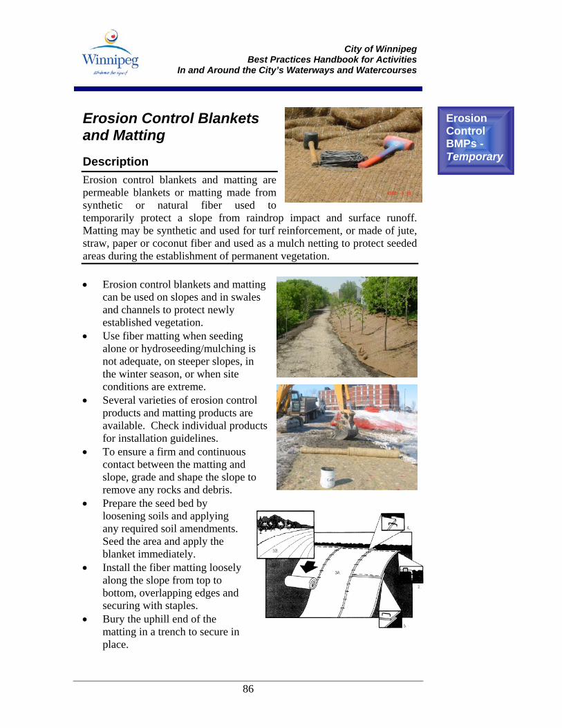
City of Winnipeg
Best Practices Handbook for Activities In and Around the City’s Waterways and Watercourses
86
Erosion Control Blankets and Matting Description Erosion control blankets and matting are permeable blankets or matting made from synthetic or natural fiber used to temporarily protect a slope from raindrop impact and surface runoff. Matting may be synthetic and used for turf reinforcement, or made of jute, straw, paper or coconut fiber and used as a mulch netting to protect seeded areas during the establishment of permanent vegetation. • Erosion control blankets and matting
can be used on slopes and in swales and channels to protect newly established vegetation.
• Use fiber matting when seeding alone or hydroseeding/mulching is not adequate, on steeper slopes, in the winter season, or when site conditions are extreme.
• Several varieties of erosion control products and matting products are available. Check individual products for installation guidelines.
• To ensure a firm and continuous contact between the matting and slope, grade and shape the slope to remove any rocks and debris.
• Prepare the seed bed by loosening soils and applying any required soil amendments. Seed the area and apply the blanket immediately.
• Install the fiber matting loosely along the slope from top to bottom, overlapping edges and securing with staples.
• Bury the uphill end of the matting in a trench to secure in place.
Erosion Control BMPs - Temporary
City of Winnipeg
Best Practices Handbook for Activities In and Around the City’s Waterways and Watercourses
87
• Inspect the matting periodically and after heavy rainfall events for erosion and undermining of the slope. Repair any failures immediately.
• Ensure that a berm is constructed along the top of slope to prevent water from running down the slope. Flows should be piped or otherwise conveyed along or down the slope to a safe discharge location.
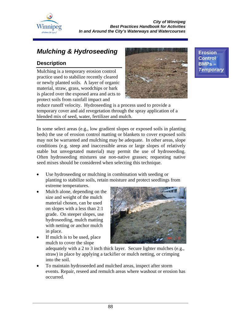
City of Winnipeg
Best Practices Handbook for Activities In and Around the City’s Waterways and Watercourses
88
Mulching & Hydroseeding Description Mulching is a temporary erosion control practice used to stabilize recently cleared or newly planted soils. A layer of organic material, straw, grass, woodchips or bark is placed over the exposed area and acts to protect soils from rainfall impact and reduce runoff velocity. Hydroseeding is a process used to provide a temporary cover and aid revegetation through the spray application of a blended mix of seed, water, fertilizer and mulch. In some select areas (e.g., low gradient slopes or exposed soils in planting beds) the use of erosion control matting or blankets to cover exposed soils may not be warranted and mulching may be adequate. In other areas, slope conditions (e.g. steep and inaccessible areas or large slopes of relatively stable but unvegetated material) may permit the use of hydroseeding. Often hydroseeding mixtures use non-native grasses; requesting native seed mixes should be considered when selecting this technique. • Use hydroseeding or mulching in combination with seeding or
planting to stabilize soils, retain moisture and protect seedlings from extreme temperatures.
• Mulch alone, depending on the size and weight of the mulch material chosen, can be used on slopes with a less than 2:1 grade. On steeper slopes, use hydroseeding, mulch matting with netting or anchor mulch in place.
• If mulch is to be used, place mulch to cover the slope adequately with a 2 to 3 inch thick layer. Secure lighter mulches (e.g., straw) in place by applying a tackifier or mulch netting, or crimping into the soil.
• To maintain hydroseeded and mulched areas, inspect after storm events. Repair, reseed and remulch areas where washout or erosion has occurred.
Erosion Control BMPs – Temporary
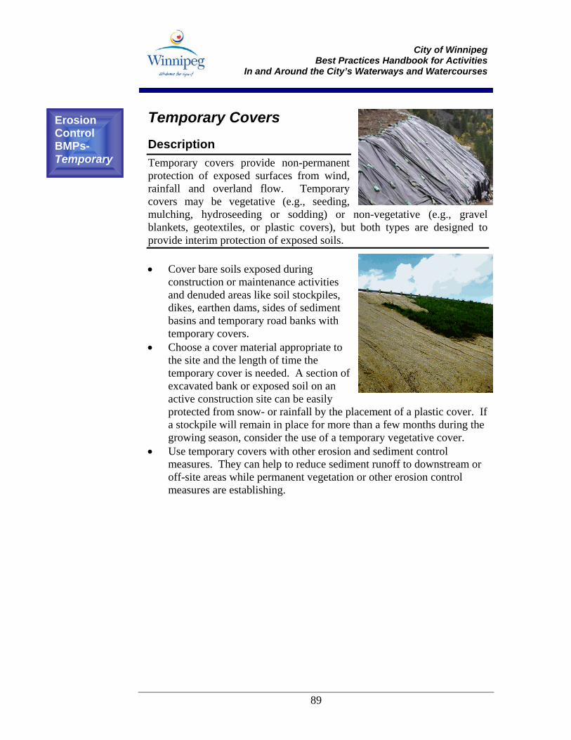
City of Winnipeg
Best Practices Handbook for Activities In and Around the City’s Waterways and Watercourses
89
Temporary Covers Description Temporary covers provide non-permanent protection of exposed surfaces from wind, rainfall and overland flow. Temporary covers may be vegetative (e.g., seeding, mulching, hydroseeding or sodding) or non-vegetative (e.g., gravel blankets, geotextiles, or plastic covers), but both types are designed to provide interim protection of exposed soils. • Cover bare soils exposed during
construction or maintenance activities and denuded areas like soil stockpiles, dikes, earthen dams, sides of sediment basins and temporary road banks with temporary covers.
• Choose a cover material appropriate to the site and the length of time the temporary cover is needed. A section of excavated bank or exposed soil on an active construction site can be easily protected from snow- or rainfall by the placement of a plastic cover. If a stockpile will remain in place for more than a few months during the growing season, consider the use of a temporary vegetative cover.
• Use temporary covers with other erosion and sediment control measures. They can help to reduce sediment runoff to downstream or off-site areas while permanent vegetation or other erosion control measures are establishing.
Erosion Control BMPs- Temporary
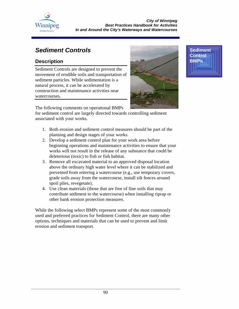
City of Winnipeg
Best Practices Handbook for Activities In and Around the City’s Waterways and Watercourses
90
Sediment Controls Description Sediment Controls are designed to prevent the movement of erodible soils and transportation of sediment particles. While sedimentation is a natural process, it can be accelerated by construction and maintenance activities near watercourses. The following comments on operational BMPs for sediment control are largely directed towards controlling sediment associated with your works.
1. Both erosion and sediment control measures should be part of the planning and design stages of your works.
2. Develop a sediment control plan for your work area before beginning operations and maintenance activities to ensure that your works will not result in the release of any substance that could be deleterious (toxic) to fish or fish habitat.
3. Remove all excavated material to an approved disposal location above the ordinary high water level where it can be stabilized and prevented from entering a watercourse (e.g., use temporary covers, grade soils away from the watercourse, install silt fences around spoil piles, revegetate).
4. Use clean materials (those that are free of fine soils that may contribute sediment to the watercourse) when installing riprap or other bank erosion protection measures.
While the following select BMPs represent some of the most commonly used and preferred practices for Sediment Control, there are many other options, techniques and materials that can be used to prevent and limit erosion and sediment transport.
Sediment Control BMPs
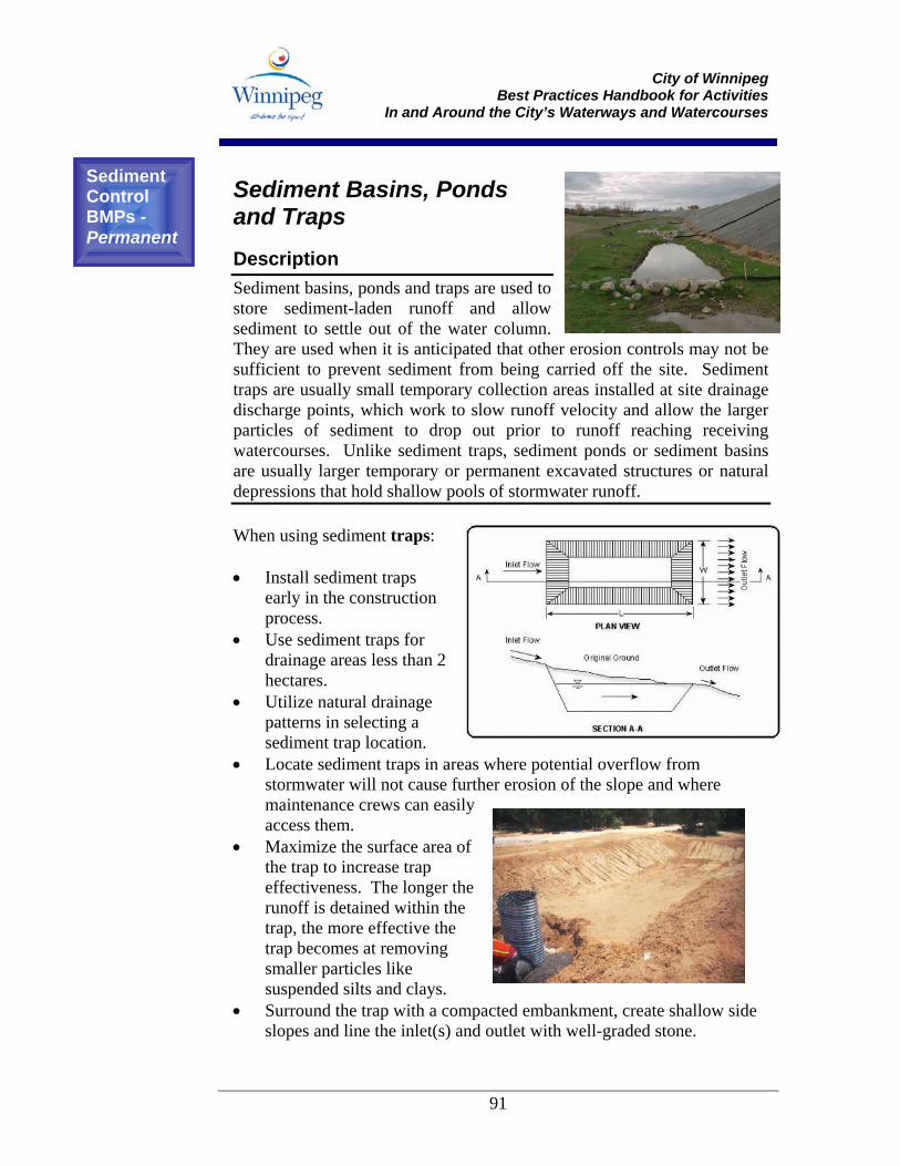
City of Winnipeg
Best Practices Handbook for Activities In and Around the City’s Waterways and Watercourses
91
Sediment Basins, Ponds and Traps Description Sediment basins, ponds and traps are used to store sediment-laden runoff and allow sediment to settle out of the water column. They are used when it is anticipated that other erosion controls may not be sufficient to prevent sediment from being carried off the site. Sediment traps are usually small temporary collection areas installed at site drainage discharge points, which work to slow runoff velocity and allow the larger particles of sediment to drop out prior to runoff reaching receiving watercourses. Unlike sediment traps, sediment ponds or sediment basins are usually larger temporary or permanent excavated structures or natural depressions that hold shallow pools of stormwater runoff. When using sediment traps: • Install sediment traps
early in the construction process.
• Use sediment traps for drainage areas less than 2 hectares.
• Utilize natural drainage patterns in selecting a sediment trap location.
• Locate sediment traps in areas where potential overflow from stormwater will not cause further erosion of the slope and where maintenance crews can easily access them.
• Maximize the surface area of the trap to increase trap effectiveness. The longer the runoff is detained within the trap, the more effective the trap becomes at removing smaller particles like suspended silts and clays.
• Surround the trap with a compacted embankment, create shallow side slopes and line the inlet(s) and outlet with well-graded stone.
Sediment Control BMPs - Permanent
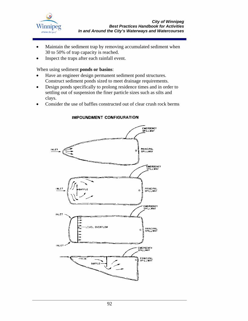
City of Winnipeg
Best Practices Handbook for Activities In and Around the City’s Waterways and Watercourses
92
• Maintain the sediment trap by removing accumulated sediment when 30 to 50% of trap capacity is reached.
• Inspect the traps after each rainfall event. When using sediment ponds or basins: • Have an engineer design permanent sediment pond structures.
Construct sediment ponds sized to meet drainage requirements. • Design ponds specifically to prolong residence times and in order to
settling out of suspension the finer particle sizes such as silts and clays.
• Consider the use of baffles constructed out of clear crush rock berms
City of Winnipeg
Best Practices Handbook for Activities In and Around the City’s Waterways and Watercourses
93
and/or non-woven filter fabric to promote a longer residence time. Baffles should extend the full width of the pond, rather than being staggered, to prevent increased velocity and subsequent re-suspension.
• Design the outflow structure to facilitate a top water decant, as typically the top several inches of the water column (surface) is the cleanest. This may be accomplished through the use of a non-perforated vertical riser pipe.
• Select sites and construct ponds prior to grading within the drainage area. Do not use sediment ponds in -line with continuously running water (live streams).
• Use ponds with large surface area-to-volume ratios for most effective sediment control.
• Use earthen dams for larger drainage areas and rock dams for smaller sites or where the dam is to be used as an overflow outlet.
• Inspect the basin or pond after every storm event to ensure proper drainage. Repair erosion of the dam or embankment immediately.
• Remove accumulated sediment from the pond when storage capacity reaches 50%.
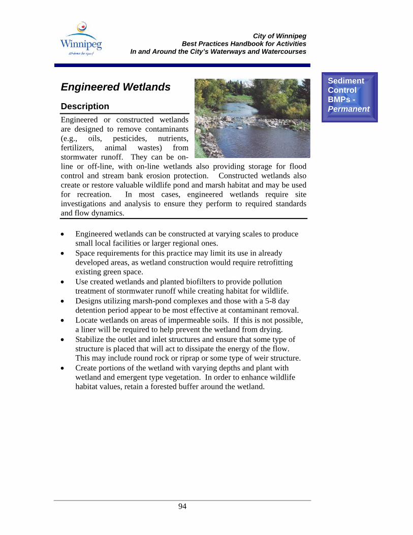
City of Winnipeg
Best Practices Handbook for Activities In and Around the City’s Waterways and Watercourses
94
Engineered Wetlands Description Engineered or constructed wetlands are designed to remove contaminants (e.g., oils, pesticides, nutrients, fertilizers, animal wastes) from stormwater runoff. They can be on-line or off-line, with on-line wetlands also providing storage for flood control and stream bank erosion protection. Constructed wetlands also create or restore valuable wildlife pond and marsh habitat and may be used for recreation. In most cases, engineered wetlands require site investigations and analysis to ensure they perform to required standards and flow dynamics. • Engineered wetlands can be constructed at varying scales to produce
small local facilities or larger regional ones. • Space requirements for this practice may limit its use in already
developed areas, as wetland construction would require retrofitting existing green space.
• Use created wetlands and planted biofilters to provide pollution treatment of stormwater runoff while creating habitat for wildlife.
• Designs utilizing marsh-pond complexes and those with a 5-8 day detention period appear to be most effective at contaminant removal.
• Locate wetlands on areas of impermeable soils. If this is not possible, a liner will be required to help prevent the wetland from drying.
• Stabilize the outlet and inlet structures and ensure that some type of structure is placed that will act to dissipate the energy of the flow. This may include round rock or riprap or some type of weir structure.
• Create portions of the wetland with varying depths and plant with wetland and emergent type vegetation. In order to enhance wildlife habitat values, retain a forested buffer around the wetland.
Sediment Control BMPs - Permanent
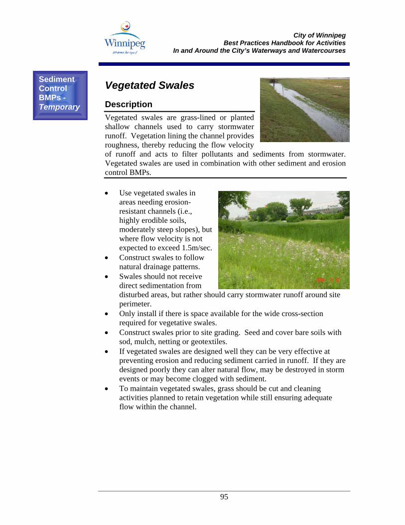
City of Winnipeg
Best Practices Handbook for Activities In and Around the City’s Waterways and Watercourses
95
Vegetated Swales Description Vegetated swales are grass-lined or planted shallow channels used to carry stormwater runoff. Vegetation lining the channel provides roughness, thereby reducing the flow velocity of runoff and acts to filter pollutants and sediments from stormwater. Vegetated swales are used in combination with other sediment and erosion control BMPs. • Use vegetated swales in
areas needing erosion-resistant channels (i.e., highly erodible soils, moderately steep slopes), but where flow velocity is not expected to exceed 1.5m/sec.
• Construct swales to follow natural drainage patterns.
• Swales should not receive direct sedimentation from disturbed areas, but rather should carry stormwater runoff around site perimeter.
• Only install if there is space available for the wide cross-section required for vegetative swales.
• Construct swales prior to site grading. Seed and cover bare soils with sod, mulch, netting or geotextiles.
• If vegetated swales are designed well they can be very effective at preventing erosion and reducing sediment carried in runoff. If they are designed poorly they can alter natural flow, may be destroyed in storm events or may become clogged with sediment.
• To maintain vegetated swales, grass should be cut and cleaning activities planned to retain vegetation while still ensuring adequate flow within the channel.
Sediment Control BMPs - Temporary
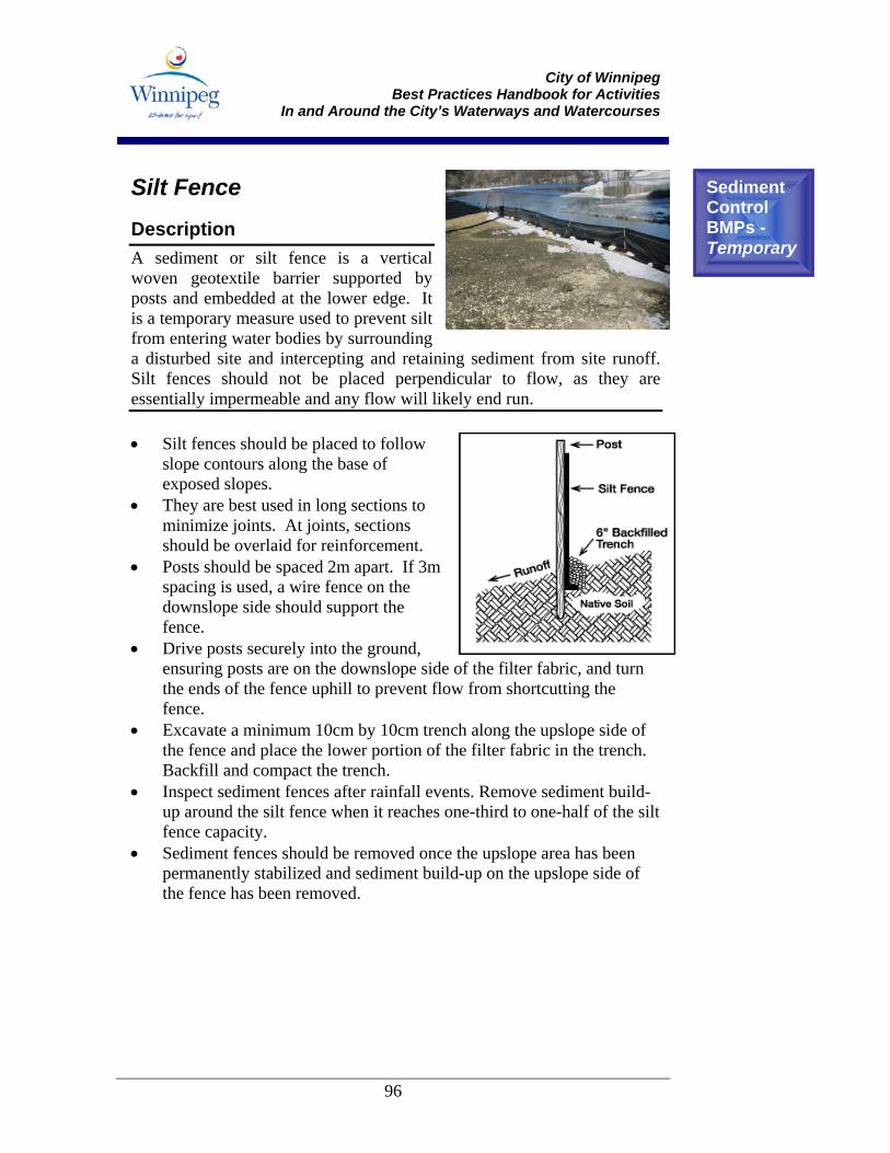
City of Winnipeg
Best Practices Handbook for Activities In and Around the City’s Waterways and Watercourses
96
Silt Fence Description A sediment or silt fence is a vertical woven geotextile barrier supported by posts and embedded at the lower edge. It is a temporary measure used to prevent silt from entering water bodies by surrounding a disturbed site and intercepting and retaining sediment from site runoff. Silt fences should not be placed perpendicular to flow, as they are essentially impermeable and any flow will likely end run. • Silt fences should be placed to follow
slope contours along the base of exposed slopes.
• They are best used in long sections to minimize joints. At joints, sections should be overlaid for reinforcement.
• Posts should be spaced 2m apart. If 3m spacing is used, a wire fence on the downslope side should support the fence.
• Drive posts securely into the ground, ensuring posts are on the downslope side of the filter fabric, and turn the ends of the fence uphill to prevent flow from shortcutting the fence.
• Excavate a minimum 10cm by 10cm trench along the upslope side of the fence and place the lower portion of the filter fabric in the trench. Backfill and compact the trench.
• Inspect sediment fences after rainfall events. Remove sediment build-up around the silt fence when it reaches one-third to one-half of the silt fence capacity.
• Sediment fences should be removed once the upslope area has been permanently stabilized and sediment build-up on the upslope side of the fence has been removed.
Sediment Control BMPs - Temporary

City of Winnipeg
Best Practices Handbook for Activities In and Around the City’s Waterways and Watercourses
97
Sediment fence used below exposed soil at a culvert outfall.
Sediment fence, while intercepting sediment from surface runoff, does little to address larger erosion problems.
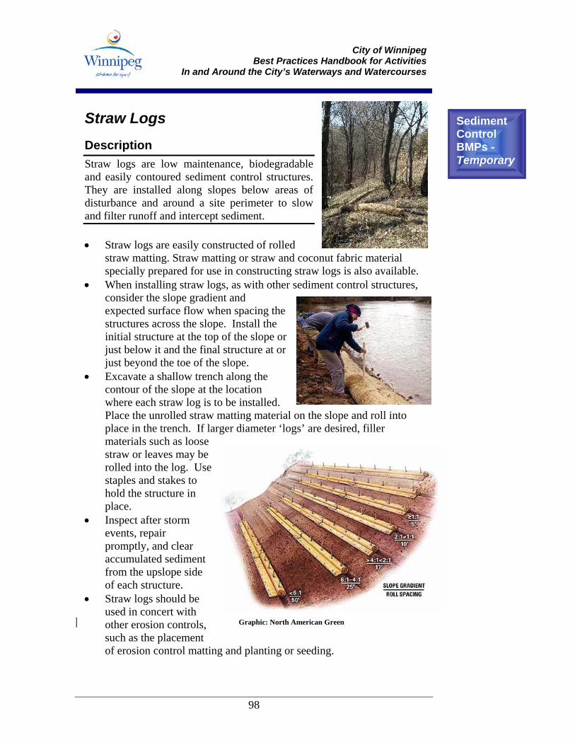
City of Winnipeg
Best Practices Handbook for Activities In and Around the City’s Waterways and Watercourses
98
Straw Logs Description Straw logs are low maintenance, biodegradable and easily contoured sediment control structures. They are installed along slopes below areas of disturbance and around a site perimeter to slow and filter runoff and intercept sediment. • Straw logs are easily constructed of rolled
straw matting. Straw matting or straw and coconut fabric material specially prepared for use in constructing straw logs is also available.
• When installing straw logs, as with other sediment control structures, consider the slope gradient and expected surface flow when spacing the structures across the slope. Install the initial structure at the top of the slope or just below it and the final structure at or just beyond the toe of the slope.
• Excavate a shallow trench along the contour of the slope at the location where each straw log is to be installed. Place the unrolled straw matting material on the slope and roll into place in the trench. If larger diameter ‘logs’ are desired, filler materials such as loose straw or leaves may be rolled into the log. Use staples and stakes to hold the structure in place.
• Inspect after storm events, repair promptly, and clear accumulated sediment from the upslope side of each structure.
• Straw logs should be used in concert with other erosion controls, such as the placement of erosion control matting and planting or seeding.
Sediment Control BMPs - Temporary
Graphic: North American Green
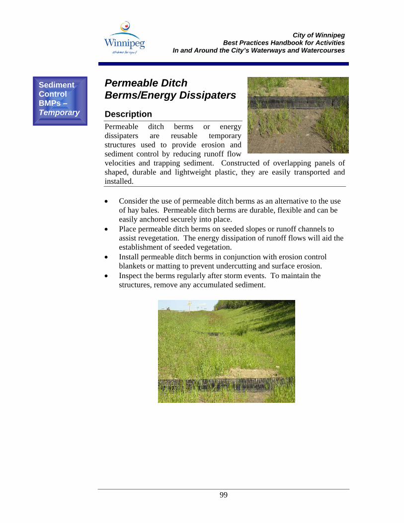
City of Winnipeg
Best Practices Handbook for Activities In and Around the City’s Waterways and Watercourses
99
Permeable Ditch Berms/Energy Dissipaters Description Permeable ditch berms or energy dissipaters are reusable temporary structures used to provide erosion and sediment control by reducing runoff flow velocities and trapping sediment. Constructed of overlapping panels of shaped, durable and lightweight plastic, they are easily transported and installed. • Consider the use of permeable ditch berms as an alternative to the use
of hay bales. Permeable ditch berms are durable, flexible and can be easily anchored securely into place.
• Place permeable ditch berms on seeded slopes or runoff channels to assist revegetation. The energy dissipation of runoff flows will aid the establishment of seeded vegetation.
• Install permeable ditch berms in conjunction with erosion control blankets or matting to prevent undercutting and surface erosion.
• Inspect the berms regularly after storm events. To maintain the structures, remove any accumulated sediment.
Sediment Control BMPs – Temporary
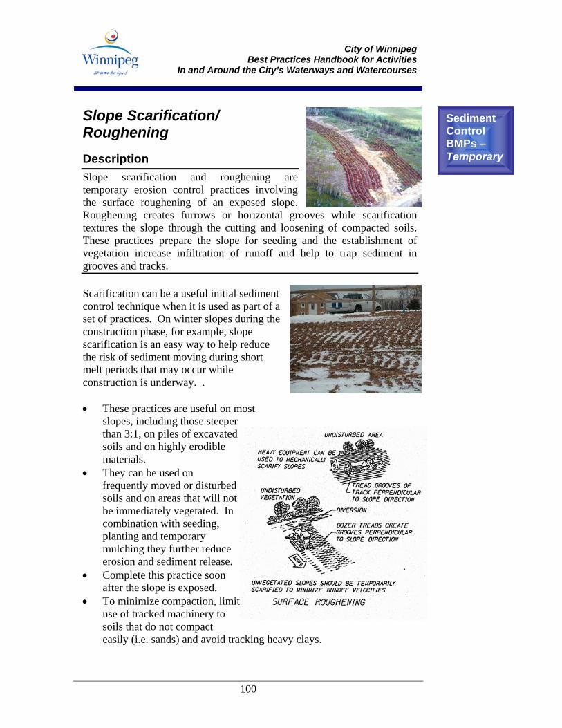
City of Winnipeg
Best Practices Handbook for Activities In and Around the City’s Waterways and Watercourses
100
Slope Scarification/ Roughening Description Slope scarification and roughening are temporary erosion control practices involving the surface roughening of an exposed slope. Roughening creates furrows or horizontal grooves while scarification textures the slope through the cutting and loosening of compacted soils. These practices prepare the slope for seeding and the establishment of vegetation increase infiltration of runoff and help to trap sediment in grooves and tracks. Scarification can be a useful initial sediment control technique when it is used as part of a set of practices. On winter slopes during the construction phase, for example, slope scarification is an easy way to help reduce the risk of sediment moving during short melt periods that may occur while construction is underway. . • These practices are useful on most
slopes, including those steeper than 3:1, on piles of excavated soils and on highly erodible materials.
• They can be used on frequently moved or disturbed soils and on areas that will not be immediately vegetated. In combination with seeding, planting and temporary mulching they further reduce erosion and sediment release.
• Complete this practice soon after the slope is exposed.
• To minimize compaction, limit use of tracked machinery to soils that do not compact easily (i.e. sands) and avoid tracking heavy clays.
Sediment Control BMPs – Temporary

City of Winnipeg
Best Practices Handbook for Activities In and Around the City’s Waterways and Watercourses
101
• Maintain roughened slopes through regular inspection after rainfall events. Heavy rains will erode soil surfaces and limit the effectiveness of slope texturing techniques. If grooves or tracks are washed away, re-roughen. If rills appear on the slope, fill, grade and reseed immediately.
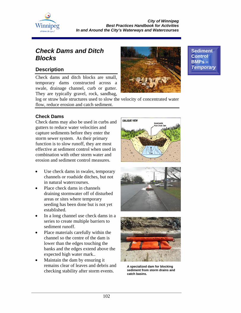
City of Winnipeg
Best Practices Handbook for Activities In and Around the City’s Waterways and Watercourses
102
Check Dams and Ditch Blocks Description Check dams and ditch blocks are small, temporary dams constructed across a swale, drainage channel, curb or gutter. They are typically gravel, rock, sandbag, log or straw bale structures used to slow the velocity of concentrated water flow, reduce erosion and catch sediment. Check Dams Check dams may also be used in curbs and gutters to reduce water velocities and capture sediments before they enter the storm sewer system. As their primary function is to slow runoff, they are most effective at sediment control when used in combination with other storm water and erosion and sediment control measures. • Use check dams in swales, temporary
channels or roadside ditches, but not in natural watercourses.
• Place check dams in channels draining stormwater off of disturbed areas or sites where temporary seeding has been done but is not yet established.
• In a long channel use check dams in a series to create multiple barriers to sediment runoff.
• Place materials carefully within the channel so the centre of the dam is lower than the edges touching the banks and the edges extend above the expected high water mark..
• Maintain the dam by ensuring it remains clear of leaves and debris and checking stability after storm events.
Sediment Control BMPs – Temporary
A specialized dam for blocking sediment from storm drains and catch basins.

City of Winnipeg
Best Practices Handbook for Activities In and Around the City’s Waterways and Watercourses
103
• Remove the check dam only after the area being drained is completely stabilized. All sediment accumulated on the upstream side of the dam should be excavated prior to dam removal.
Ditch Blocks Ditch blocks can be used in temporary ditches or permanent ditches not stabilized by vegetation to prevent the off-site transportation of sediments. • Use ditch blocks in drainages
constructed in erodible soils such as sands and silts and on steeper gradient channels.
• Earthen ditch blocks can be used to temporarily block flow from portions of ditch channels, to isolate disturbed areas from flow. Temporary diversion of water is required, through piping or pumping.
• Check dams are used as ditch blocks to reduce flow velocity, minimize erosion, and trap sediment from runoff in ditch channels. They can be used in any ditch requiring erosion protection.
• Rock check dams are generally used in higher flow velocities and slope gradients.
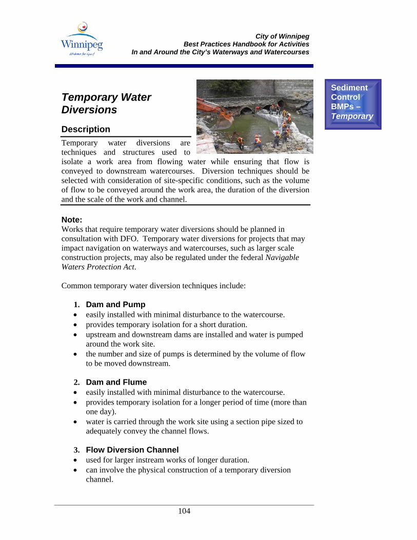
City of Winnipeg
Best Practices Handbook for Activities In and Around the City’s Waterways and Watercourses
104
Temporary Water Diversions Description Temporary water diversions are techniques and structures used to isolate a work area from flowing water while ensuring that flow is conveyed to downstream watercourses. Diversion techniques should be selected with consideration of site-specific conditions, such as the volume of flow to be conveyed around the work area, the duration of the diversion and the scale of the work and channel. Note: Works that require temporary water diversions should be planned in consultation with DFO. Temporary water diversions for projects that may impact navigation on waterways and watercourses, such as larger scale construction projects, may also be regulated under the federal Navigable Waters Protection Act. Common temporary water diversion techniques include:
1. Dam and Pump • easily installed with minimal disturbance to the watercourse. • provides temporary isolation for a short duration. • upstream and downstream dams are installed and water is pumped
around the work site. • the number and size of pumps is determined by the volume of flow
to be moved downstream. 2. Dam and Flume • easily installed with minimal disturbance to the watercourse. • provides temporary isolation for a longer period of time (more than
one day). • water is carried through the work site using a section pipe sized to
adequately convey the channel flows. 3. Flow Diversion Channel • used for larger instream works of longer duration. • can involve the physical construction of a temporary diversion
channel.
Sediment Control BMPs – Temporary
City of Winnipeg
Best Practices Handbook for Activities In and Around the City’s Waterways and Watercourses
105
• more expensive and time-consuming to construct, but may be required to ensure environmental protection requirements are met.
General considerations include the following: • Have all equipment and materials required for diversion (e.g., dam
materials, flume, pump) on-site prior to initiating your instream work. • Be sure that you have adequate hose or pipe length to carry the flow
around or through your work site. • Screen pump intakes with adequately sized fish-screens as outlined in
the Freshwater Intake End-of-Pipe Fish Screen Guideline (DFO, 1995) to prevent fish mortality.
• Ensure that scour protection (a non-erodible surface) is placed at the outlet of pumps and flumes to protect channel banks and bottoms from eroding.
• If a flow diversion channel is to be used, excavate it “in the dry” and ensure its banks are stable before connecting it to the watercourse. Sediment controls may be needed to prevent the release of sediment-laden waters from the new channel.
• Ensure a fish salvage has been conducted within any portion of a fish-bearing watercourse that will be dewatered or isolated from flows for an extended period of time.
• When removing temporary water diversions, consider the use of temporary sediment control devices (e.g., gravel non-woven filter fabric check dams or floating silt curtain) downstream of disturbed work areas to prevent the release of sediment.
• When dewatering isolated work cells, discharge all sediment-laden water to a nearby vegetated area where it can settle and infiltrate.
• Re-establish flow through the channel by slowly breaching the top dam to allow water to enter the work area. Allow sediment to settle out of the water column before removing lower dam and temporary diversion structures.
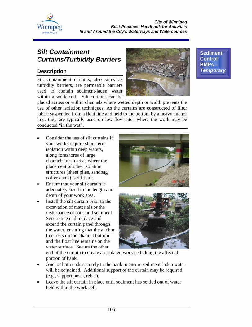
City of Winnipeg
Best Practices Handbook for Activities In and Around the City’s Waterways and Watercourses
106
Silt Containment Curtains/Turbidity Barriers Description Silt containment curtains, also know as turbidity barriers, are permeable barriers used to contain sediment-laden water within a work cell. Silt curtains can be placed across or within channels where wetted depth or width prevents the use of other isolation techniques. As the curtains are constructed of filter fabric suspended from a float line and held to the bottom by a heavy anchor line, they are typically used on low-flow sites where the work may be conducted “in the wet”. • Consider the use of silt curtains if
your works require short-term isolation within deep waters, along foreshores of large channels, or in areas where the placement of other isolation structures (sheet piles, sandbag coffer dams) is difficult.
• Ensure that your silt curtain is adequately sized to the length and depth of your work area.
• Install the silt curtain prior to the excavation of materials or the disturbance of soils and sediment. Secure one end in place and extend the curtain panel through the water, ensuring that the anchor line rests on the channel bottom and the float line remains on the water surface. Secure the other end of the curtain to create an isolated work cell along the affected portion of bank.
• Anchor both ends securely to the bank to ensure sediment-laden water will be contained. Additional support of the curtain may be required (e.g., support posts, rebar).
• Leave the silt curtain in place until sediment has settled out of water held within the work cell.
Sediment Control BMPs – Temporary
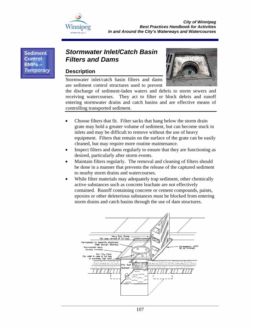
City of Winnipeg
Best Practices Handbook for Activities In and Around the City’s Waterways and Watercourses
107
Stormwater Inlet/Catch Basin Filters and Dams Description Stormwater inlet/catch basin filters and dams are sediment control structures used to prevent the discharge of sediment-laden waters and debris to storm sewers and receiving watercourses. They act to filter or block debris and runoff entering stormwater drains and catch basins and are effective means of controlling transported sediment. • Choose filters that fit. Filter sacks that hang below the storm drain
grate may hold a greater volume of sediment, but can become stuck in inlets and may be difficult to remove without the use of heavy equipment. Filters that remain on the surface of the grate can be easily cleaned, but may require more routine maintenance.
• Inspect filters and dams regularly to ensure that they are functioning as desired, particularly after storm events.
• Maintain filters regularly. The removal and cleaning of filters should be done in a manner that prevents the release of the captured sediment to nearby storm drains and watercourses.
• While filter materials may adequately trap sediment, other chemically active substances such as concrete leachate are not effectively contained. Runoff containing concrete or cement compounds, paints, epoxies or other deleterious substances must be blocked from entering storm drains and catch basins through the use of dam structures.
Sediment Control BMPs – Temporary
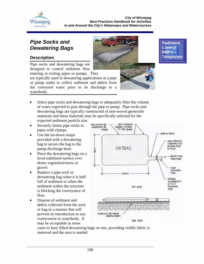
City of Winnipeg
Best Practices Handbook for Activities In and Around the City’s Waterways and Watercourses
108
Pipe Socks and Dewatering Bags Description Pipe socks and dewatering bags are designed to control sediment flow entering or exiting pipes or pumps. They are typically used in dewatering applications at a pipe or pump outlet to collect sediment and debris from the conveyed water prior to its discharge to a waterbody. • Select pipe socks and dewatering bags to adequately filter the volume
of water expected to pass through the pipe or pump. Pipe socks and dewatering bags are typically constructed of non-woven geotextile materials and these materials may be specifically selected for the expected sediment particle size.
• Securely fasten pipe socks to pipes with clamps.
• Use the tie-down straps provided with a dewatering bag to secure the bag to the pump discharge hose.
• Place the dewatering bags on a level stabilized surface over dense vegetation/straw or gravel.
• Replace a pipe sock or dewatering bag when it is half full of sediment or when the sediment within the structure is blocking the conveyance of flow.
• Dispose of sediment and debris collected from the sock or bag in a manner that will prevent its introduction to any watercourse or waterbody. It may be acceptable in some cases to bury filled dewatering bags on site, providing visible fabric is removed and the area is seeded.
Sediment Control BMPs – Temporary
City of Winnipeg
Best Practices Handbook for Activities In and Around the City’s Waterways and Watercourses
109
6.0 Important Contacts and Resources Effective communication is key to achieving compliance for project work completed in and around water. Primary City of Winnipeg contacts were provided on the Call Card provided in Section 1.4 (page 5) of this Handbook.
6.1 Additional Contacts List In addition to City of Winnipeg contacts provided on the Call Card in Section 1.4 of this Handbook, the following contact information for federal and provincial environmental agencies may be helpful.
Department of Fisheries and Oceans (Central and Arctic Region)
Regional Headquarters Freshwater Institute 501 University Crescent Winnipeg, MB R3T 2N6
Telephone: (204) 983-5000
Habitat Management Manitoba - Winnipeg District Telephone: (204) 983-5220
Manitoba Conservation
Headquarters Operations 200 Saulteaux Crescent Winnipeg MB R3J 3W3
Telephone: (204) 945-6647 Fax: (204) 945-7782
Red River Region 123 Main Street, Suite 160 Winnipeg MB R3C 1A5
Telephone: (204) 945-7081 Fax: (204) 948-2338
City of Winnipeg
Best Practices Handbook for Activities In and Around the City’s Waterways and Watercourses
110
6.2 Additional Information Sources The following Internet links provide additional information on fish and fish habitat and associated best management practices. These links are provided for information purposes only. To access the full text of applicable federal, provincial and City of Winnipeg legislation, try the following links: Canadian Department of Justice – provides alphabetized links to federal statutes and regulations, including the Fisheries Act, Migratory Birds Convention Act, and Navigable Waters Protection Act. http://laws.justice.gc.ca/en/ Laws of Manitoba – provides links to all provincial legislation and regulations. http://web2.gov.mb.ca/laws/statutes/index.php Bylaws of The City of Winnipeg- provides links to all consolidated Bylaws. http://www.winnipeg.ca/interhom/ The federal Department of Fisheries and Oceans Web sites contain information on responsibilities pertaining to the Fisheries Act: The Canada Fisheries Act. http://laws.justice.gc.ca/en/F-14/ DFO Habitat Conservation and Protection Guidelines (1998). http://www.dfo-mpo.gc.ca/canwaters-eauxcan/infocentre/guidelines-conseils/guides/fhmguide/index_e.asp DFO Policy for Management of Fish Habitat. http://www.dfo-mpo.gc.ca/canwaters-eauxcan/infocentre/legislation-lois/policies/fhm-policy/index_e.asp DFO Guidelines for Attaining No Net Loss. http://www.dfo-mpo.gc.ca/canwaters-eauxcan/infocentre/guidelines-conseils/guides/fhmcons/index_e.asp DFO Freshwater Intake End-of-Pipe Fish Screen Guideline http://www.dfo-mpo.gc.ca/Library/223669.pdf
City of Winnipeg
Best Practices Handbook for Activities In and Around the City’s Waterways and Watercourses
111
“What the Law Requires” information. http://www.dfo-mpo.gc.ca/canwaters-eauxcan/infocentre/guidelines-conseils/guides/law-lois/index_e.asp “Working In or Around Water?” Fact Sheet Series. http://www.dfo-mpo.gc.ca/canwaters-eauxcan/water-eau/index_e.asp “What You Should Know About Fish Habitat” Manitoba Fact Sheet 1. http://www.dfo-mpo.gc.ca/canwaters-eauxcan/infocentre/guidelines-conseils/factsheets-feuillets/manitoba/fact1_e.asp “What You Should Know About Fish Habitat and the Effects of Sediment” Manitoba Fact Sheet 6. http://www.dfo-mpo.gc.ca/canwaters-eauxcan/infocentre/guidelines-conseils/factsheets-feuillets/manitoba/fact6_e.asp For further standards and best practices documents, refer to the following Web sites: Manitoba Stream Crossing Guidelines for the Protection of Fish and Fish Habitat, prepared by DFO and Manitoba Conservation. http://www.gov.mb.ca/conservation/fish/images/stream.pdf Standards and Best Practices for Instream Works, BC Ministry of Water, Land and Air. http://wlapwww.gov.bc.ca/wld/documents/bmp/iswstdsbpsmarch2004.pdf Fish Habitat Manual, Alberta Transportation. http://www.trans.gov.ab.ca/Content/doctype123/production/fishhabitatmanual.htm Washington State Integrated Streambank Protection Guidelines. http://wdfw.wa.gov/hab/ahg/ispgdoc.htm For information on Manitoba’s fish and wildlife species, including species at risk, refer to the following Web sites: Flora and Fauna, City of Winnipeg, Naturalist Services – provides detailed lists of plant and animal species within the City of Winnipeg. http://www.winnipeg.ca/publicworks/naturalist/ns/ff/default.asp
City of Winnipeg
Best Practices Handbook for Activities In and Around the City’s Waterways and Watercourses
112
Managing Animals, Plants and Habitats, Manitoba Conservation – provides an overview of species at risk in Manitoba, biodiversity conservation and habitat management. http://www.gov.mb.ca/conservation/wildlife/managing/index.html Manitoba Fish Key, Manitoba Conservation – a guide to fish frequently caught by sport fishermen. http://www.gov.mb.ca/conservation/fish/images/fishkey1.pdf For maps, atlases, and habitat inventories relating to your project area, try the following links: City of Winnipeg Maps – a series of searchable Winnipeg maps. http://www.winnipeg.ca/interhom/maps/ City of Winnipeg, Naturalist Services, Winnipeg Natural Habitat Maps – an interactive map that provides species lists and habitat descriptions for parks and open spaces throughout Winnipeg. http://www.winnipeg.ca/publicworks/naturalist/ns/natural_areas/default.asp Urban Habitat Stewardship Resource Network – provides maps and descriptions of different habitat types within the City of the Winnipeg. http://www.gatewest.net/~cwhp/ For information on obtaining a Waterway Permit for construction along the City’s Waterways, try the following link: http://www.winnipeg.ca/ppd/riverbank.stm
City of Winnipeg
Best Practices Handbook for Activities In and Around the City’s Waterways and Watercourses
113
7.0 Next Steps This Handbook is a “living document”. It will be updated as new information on best practices becomes available, as changes occur in the regulatory requirements for work activities near waterways and watercourses, and as feedback is received from City staff and users of the Handbook. Updates will be posted on the City of Winnipeg website and an email notification will be sent to Handbook users. Several initiatives are currently underway to develop accepted protocols for maintenance activities regularly undertaken by City of Winnipeg staff. Cooperative agreements, for example, are being developed between the City, The Forks and Parks Canada to facilitate maintenance activities in and around the multiple jurisdictions found at the confluence of the Red and Assiniboine Rivers. It is hoped that a series of protocols, acceptable to local environmental regulators, can be developed to streamline the implementation of common maintenance activities completed in and around the City’s waterways and watercourses and protect the environmental attributes and values that they sustain. Finally, the City wants to make this document as useful and as user-friendly as possible. If you have any suggestions to improve this Handbook, please feel free to fill out the Feedback Form found on the following page.
City of Winnipeg
Best Practices Handbook for Activities In and Around the City’s Waterways and Watercourses
115
Feedback Form Please feel free to share your comments on any aspect of this document in the space provided below. Your input will be used to guide future development of this document. What do you like about the Best Practices Handbook?
What do you dislike about it? What would you like to see changed in the next version of this document? How can this document be made more useful to you? Other comments?
Please detach or copy and submit completed forms to:
Don Kingerski, P.Eng. Riverbank Management Engineer
Planning, Property & Development Department
City of Winnipeg
Best Practices Handbook for Activities In and Around the City’s Waterways and Watercourses
117
8.0 Glossary Alevin: for the first free-swimming stage of a juvenile fish which have recently hatched from the egg and during which the fish feeds off an attached yolk sac, which they eventually absorb.
Anadromous: Fish species that spawn in fresh water but spend a significant portion of their lives in the ocean (e.g., coho, chinook, chum, pink and steelhead salmon).
Aquatic Habitat: Areas associated with water that provide food, cover and other elements critical to the completion of an organism’s life cycle (e.g., bogs, swamps, riparian areas and streams).
Avoidance: Minimizing the effects of an undertaking on fish habitat through the identification and bypassing of areas of concern to fisheries. Bedload: Coarse granular material transported along the channel bottom in the lower layers of stream flow by rolling and bouncing, typically during elevated flow conditions.
Benthic Invertebrates: Animals lacking backbones that live in the substrates of aquatic systems. Benthos: The bottom of a stream or lake and the organisms which inhabit them. Berm: A ridge or small dike that breaks the continuity of a slope.
Best Management Practices (BMPs): A practice or combination of practices that are determined to be the most technologically and economically feasible means of preventing or managing potential impacts. Biodiversity: The diversity of plants, animals and other living organisms in all their forms and levels of organization and the evolutionary and functional processes that link them. Bioengineering: The use of living plant materials to perform some engineering function (e.g., enhanced soil stability).
City of Winnipeg
Best Practices Handbook for Activities In and Around the City’s Waterways and Watercourses
118
Biotechnical- The use of mechanical engineering elements along with complementary living plant material to stabilize banks and slopes. Buffer: The portion of the management zone that is directly adjacent to the leave area. Check Dam: A small dam constructed in a ditch or similar place to decrease water velocity and promote the accumulation of sediment. Similar definition as a silt trap.
Coffer Dam: A watertight enclosure built in a shallow river or creek, which is pumped dry to allow construction activities in the isolation of flowing water. Compensation: “The placement of natural habitat, increase in the productivity of existing habitat or maintenance of fish production by artificial means in circumstances dictated by social and economic conditions, where mitigation techniques and other measures are not adequate to maintain habitats for Canada’s fisheries resources” (DFO, 1986). Deleterious Substance: “Substance harmful to fish or fish habitat” (Canadian Fisheries Act, Section 36.3). DFO: Department of Fisheries and Oceans (federal). Diversion Dam: A barrier built within the active channel of a watercourse in order to divert water along a different flow path. Diversion Ditch: A ditch that directs water and silt into stabilized areas away from a watercourse. Due Diligence: A legal term that requires individuals on the job to maintain a reasonable standard of care. This term applies to environmental precautions but also to other areas such as safety, for example.
Dike: An impervious elongated mound of earth constructed to confine water or another liquid from entering or leaving an area of land. Environmentally Sensitive Areas (ESA’s): Areas requiring special management attention to protect important scenic values, fish and wildlife resources, historical and cultural values, and other natural systems or processes.
City of Winnipeg
Best Practices Handbook for Activities In and Around the City’s Waterways and Watercourses
119
Environmentally-sensitive Lands: Areas so designated include wetlands, steep slopes, waterways, underground water recharge areas, riverbanks, natural plant and animal habitats, flood plains, and other landforms that are easily disturbed by development. Erosion: The wearing away of soil and/or rock by water and/or wind action. Fish Habitat: The Fisheries Act defines fish habitat as “spawning grounds and nursery, rearing, food supply and migration areas on which fish depend directly or indirectly in order to carry out their life processes”. Fish habitat comprises physical, chemical and biological attributes of the freshwater, estuarine, marine and terrestrial (riparian) environment that directly or indirectly support fish populations. Fisheries: Includes “fish” populations, as well as the “habitat” that supports fish. The term “fish” includes “shellfish, crustaceans, marine animals, and the eggs, spawn, sperm, spat and juvenile stages of fish, shellfish, crustaceans and marine animals” (Fisheries Act). Fisheries Sensitive Zone (FSZ): An area, which encompasses the watercourse as well as associated riparian areas. Includes in-stream aquatic habitats, as well as the out-of-stream habitat features such as side channels and wetlands. Fisheries Window: A time of reduced risk for important commercial, sport and resident fish species when instream construction is permitted. In Maple Ridge, typically from Aug 1st to Sept 15th annually. Fry: The young stage of fishes (i.e., less than one year old), particularly after the yolk sac has been absorbed. Geotextile Filter Fabric: A synthetic material placed under erosion control material (i.e., riprap), with the primary functions of layer separation, aggregate confinement and distribution of load. Grade: The slope of road, channel, or natural ground. Habitat: The place where an organism lives and/or the conditions of that environment including the soil, vegetation, water and food. Habitat Enhancement: Any manipulation of habitat that improves its value and ability to meet the specified requirements of one or more species.
City of Winnipeg
Best Practices Handbook for Activities In and Around the City’s Waterways and Watercourses
120
Large Organic Debris (LOD): A large tree part, conventionally a piece greater than 10 cm in diameter and 1 m in length that contributes to stream channel stability, creates fish habitat diversity, and provides cover for fish and their predators. Harmful Alteration, Disruption or Destruction of Fish Habitat (HADD): The DFO define HADD of fish habitat as “any change in fish habitat that reduces its capacity to support one or more life processes of fish”. Leave Area: The area of land and vegetation adjacent to an aquatic area that is to remain in an undisturbed state, throughout and after the development process. Low Ground Pressure Machines: Machines that exert a total ground pressure of less than 43.4KPa (6.3lbs per square inch.). Migration: Fish movements between two or more separate habitats (e.g., from over-wintering habitat to spawning habitat). Mitigation: Actions taken during the planning, design, construction, and operation of a project to alleviate or reduce potential adverse effects on fish habitat, such as culvert design modifications to allow fish passage, timing constraints for instream work, and erosion control measures. No Net Loss: A working principle of the Federal DFO which strives to balance unavoidable habitat losses through avoidance, mitigation, and habitat replacement on a project-by-project basis. (DFO, 1986). Nursery Habitat: Habitat where juvenile fish feed or take refuge (e.g., backwater areas, shallow creek margins). Revegetation: The re-establishment of vegetation in disturbed areas. Riparian Vegetation: Vegetation adjacent to a watercourse, lake, swamp, or spring, that is generally critical for wildlife cover, fish food organisms, stream nutrients and large organic debris, and for stream bank stability. Riparian Zone: Riparian zones typically consist of vegetated corridors adjacent to streams and lakes. Riparian zones are areas of transition between aquatic and upland ecosystems and provide a vital source of nutrients, cover and temperature regulation.
City of Winnipeg
Best Practices Handbook for Activities In and Around the City’s Waterways and Watercourses
121
Riprap: Rock or stone placed on earth surfaces for protection of the soil against the erosive action of flowing water or precipitation. Salmonid: A general term that collectively refers to salmon species, trout and char. Sediment: Particulate matter that is entrained within, or settled out from, water. Silt: The fine particulate fraction of sediment. Silt Fence: A synthetic barrier erected to restrict the movement of unconsolidated material from a disturbed area to any sensitive areas. Spawning Habitat: Fish habitat associated with the breeding of fish. Stream: A watercourse, having an alluvial sediment bed, formed when water flows on a perennial or intermittent basis between continuous definable banks. Streambank: The area resulting from downward cutting “erosion”, or scour of the channel substrate by hydraulic forces . Depending on bank materials and erosive forces, streambanks can take a vertical, sloping or undercut form. Substrate: The bottom or bed materials of a water body or watercourse in which plants and organisms live and grow. Suspended Solids: Particulate matter, such as silt or clay, that is entrained within a water column (i.e., has not settled to the substrate) Water Body: Areas inundated by water either permanently, or intermittently for a period of time exceeding 2 weeks of the year. Watercourse: Means a drain, ditch, drainage ditch, culvert, water channel, retention pond or waterway, whether natural, constructed or altered. Waterway: A river, stream, creek or canal, whether natural, constructed or altered and includes the frozen surface and bed of a waterway. Woody Debris: Sound and rotting logs and stumps that provide cover for small animals and their predators (both fish and wildlife).
City of Winnipeg
Best Practices Handbook for Activities In and Around the City’s Waterways and Watercourses
122
9.0 References Alberta Transportation & Utilities. Fish Habitat Protection Guidelines For Stream Crossings. Edmonton, Alberta.
Canadian Watercourse Pipeline Crossing Committee. 1999. Watercourse Crossings.
Dane, B.G. 1978. A Review and Resolution of Fish Passage Problems at Culvert Sites in British Columbia. Department of Fisheries and Oceans, Habitat Protection Unit. Vancouver, B.C. Department of Fisheries and Oceans. 1986. Policy for the Management of Fish Habitat. Communications Directorate Fisheries and Oceans. Fish Habitat Management Branch. Ottawa, Ontario. Department of Fisheries and Oceans. 1990. Fish Habitat Enhancement: A Manual for Freshwater, Estuarine, and Marine Habitats. Prepared by M.A. Adams and I.W. Whyte. Department of Fisheries and Oceans and the Ontario Ministry of Natural Resources. 1993. Working Around Water. Fact sheet series produced by the DFO Communications Branch. Burlington, Ontario. Department of Fisheries and Oceans. 1997. Road Maintenance Activities and The Fisheries Act: A Guidance Document to Avoiding Conflict. Prepared by C.L. Stoneman, C.B. Portt and S. Metikosh. Canadian Manuscript Report of Fisheries and Aquatic Sciences, No. 2404.
International Erosion Control Association. 1998. Soil Stabilization Series Vol I. Methods and Techniques for Stabilizing Channels and Streambanks. International Erosion Control Association. 1998. Soil Stabilization Series Vol II. Methods and Techniques for Stabilizing Steep Slopes. International Erosion Control Association. 1998. Soil Stabilization Series Vol III. Methods and Techniques for Stabilizing Gullies and Using Check Dams.
City of Winnipeg
Best Practices Handbook for Activities In and Around the City’s Waterways and Watercourses
123
International Erosion Control Association. 1998. Soil Stabilization Series Vol IV. Erosion Control Product Performance and Evaluation. International Erosion Control Association. 1998. Soil Stabilization Series Vol V. Methods and Techniques for Using Bioengineering to Control Erosion. International Erosion Control Association. 1998. Soil Stabilization Series Vol VI. Strategies and Practices for Making Best Management. Ontario Ministry of Transportation. 1994. Environmental Manual Fisheries. Environmental Office of the Ministry of Transportation, Ontario. P.E.I. Department of Transportation and Public Works. 1994. Environmental Practices for Highway Construction and Maintenance. Scott, W.B. and Crossman, E.J. 1973. Freshwater Fishes of Canada. Fisheries Research Board of Canada, Ottawa. Now reprinted by Galt House Publications, Oakville, Ontario.
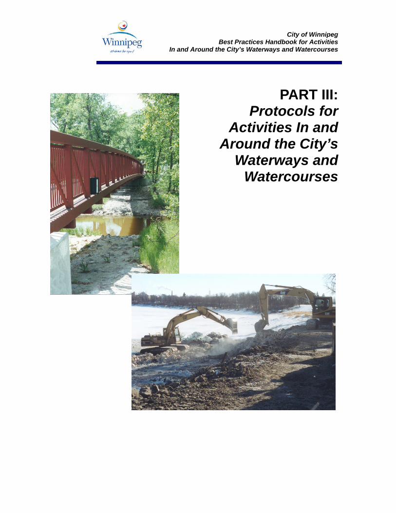
City of Winnipeg
Best Practices Handbook for Activities In and Around the City’s Waterways and Watercourses
PART III: Protocols for
Activities In and Around the City’s
Waterways and Watercourses
City of Winnipeg
Best Practices Handbook for Activities In and Around the City’s Waterways and Watercourses
Approved Protocols
For Activities In and Around the City’s Waterways and Watercourses
(DFO Operational Statements - Valid until March 31, 2006)
These documents may be accessed on the world-wide web at www.dfo-mpo.gc.ca/regions/central/habitat/os-eo/prov-terr/mb/index_e.htm
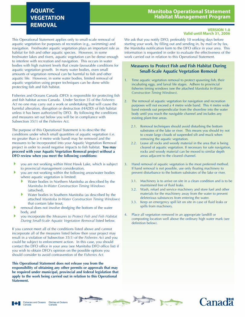
Manitoba Operational StatementHabitat Management Program
AQUATIC VEGETATIONREMOVAL
VERSION 1.0Valid until March 31, 2006
This Operational Statement applies only to small-scale removal ofaquatic vegetation for purposes of recreation (e.g., swimming) andnavigation. Freshwater aquatic vegetation plays an important role ashabitat for fish and other aquatic species. However, in somefreshwater lakes and rivers, aquatic vegetation can be dense enoughto interfere with recreation and navigation. This occurs in waterbodies with high nutrient levels that create favourable conditions foraquatic vegetation growth. In many water bodies, even smallamounts of vegetation removal can be harmful to fish and otheraquatic life. However, in some water bodies, limited removal ofaquatic vegetation using proper techniques can be done whileprotecting fish and fish habitat.
Fisheries and Oceans Canada (DFO) is responsible for protecting fishand fish habitat across Canada. Under Section 35 of the FisheriesAct no one may carry out a work or undertaking that will cause theharmful alteration, disruption or destruction (HADD) of fish habitatunless it has been authorized by DFO. By following the conditionsand measures set out below you will be in compliance withSubsection 35(1) of the Fisheries Act.
The purpose of this Operational Statement is to describe theconditions under which small quantities of aquatic vegetation (i.e.no greater than a 4 metre wide band) may be removed and themeasures to be incorporated into your Aquatic Vegetation Removalproject in order to avoid negative impacts to fish habitat. You mayproceed with your Aquatic Vegetation Removal project without aDFO review when you meet the following conditions:
you are not working within West Hawk Lake, which is subjectto provincial management consideration, you are not working within the following areas/water bodieswhere aquatic vegetation is limited:
Water bodies in Northern Manitoba as described by theManitoba In-Water Construction Timing Windows(attached),Water bodies in Southern Manitoba (as described by theattached Manitoba In-Water Construction Timing Windows)that contain lake trout,
removal does not involve dredging the bottom of the waterbody, andyou incorporate the Measures to Protect Fish and Fish HabitatDuring Small-Scale Aquatic Vegetation Removal listed below.
If you cannot meet all of the conditions listed above and cannotincorporate all of the measures listed below then your project mayresult in a violation of Subsection 35(1) of the Fisheries Act and youcould be subject to enforcement action. In this case, you shouldcontact the DFO office in your area (see Manitoba DFO office list) ifyou wish to obtain DFO's opinion on the possible options youshould consider to avoid contravention of the Fisheries Act.
This Operational Statement does not release you from theresponsibility of obtaining any other permits or approvals that maybe required under municipal, provincial and federal legislation thatapply to the work being carried out in relation to this OperationalStatement.
We ask that you notify DFO, preferably 10 working days beforestarting your work, by filling out and sending in, by mail or by fax,the Manitoba notification form to the DFO office in your area. Thisinformation is requested in order to evaluate the effectiveness of thework carried out in relation to this Operational Statement.
Measures to Protect Fish and Fish Habitat During Small-Scale Aquatic Vegetation Removal
1. Time aquatic vegetation removal to protect spawning fish, theirincubating eggs, and larval life stages. Adhere to provincialfisheries timing windows (see the attached Manitoba In-WaterConstruction Timing Windows).
2. The removal of aquatic vegetation for navigation and recreationpurposes will not exceed a 4 metre wide band. This 4 metre wideband extends out perpendicular from the shoreline into the waterbody until you reach the navigable channel and includes anyexisting plant-free areas.
2.1. Removal techniques should avoid disturbing the bottomsubstrates of the lake or river. This means you should try notto create large clouds of suspended silt and muck whenremoving the aquatic vegetation.
2.2. Leave all rocks and woody material in the area that is beingcleared of aquatic vegetation. If necessary for safe navigation,rocks and woody material can be moved to similar depthareas adjacent to the cleared channel.
3. Hand removal of aquatic vegetation is the most preferred method.If hand removal is not possible, use only floating machinery toprevent disturbance to the bottom substrates of the lake or river.
3.1. Machinery is to arrive on site in a clean condition and is to bemaintained free of fluid leaks.
3.2. Wash, refuel and service machinery and store fuel and othermaterials for the machinery away from the water to preventdeleterious substances from entering the water.
3.3. Keep an emergency spill kit on site in case of fluid leaks orspills from machinery.
4. Place all vegetation removed in an appropriate landfill orcomposting location well above the ordinary high water mark (seedefinition below).
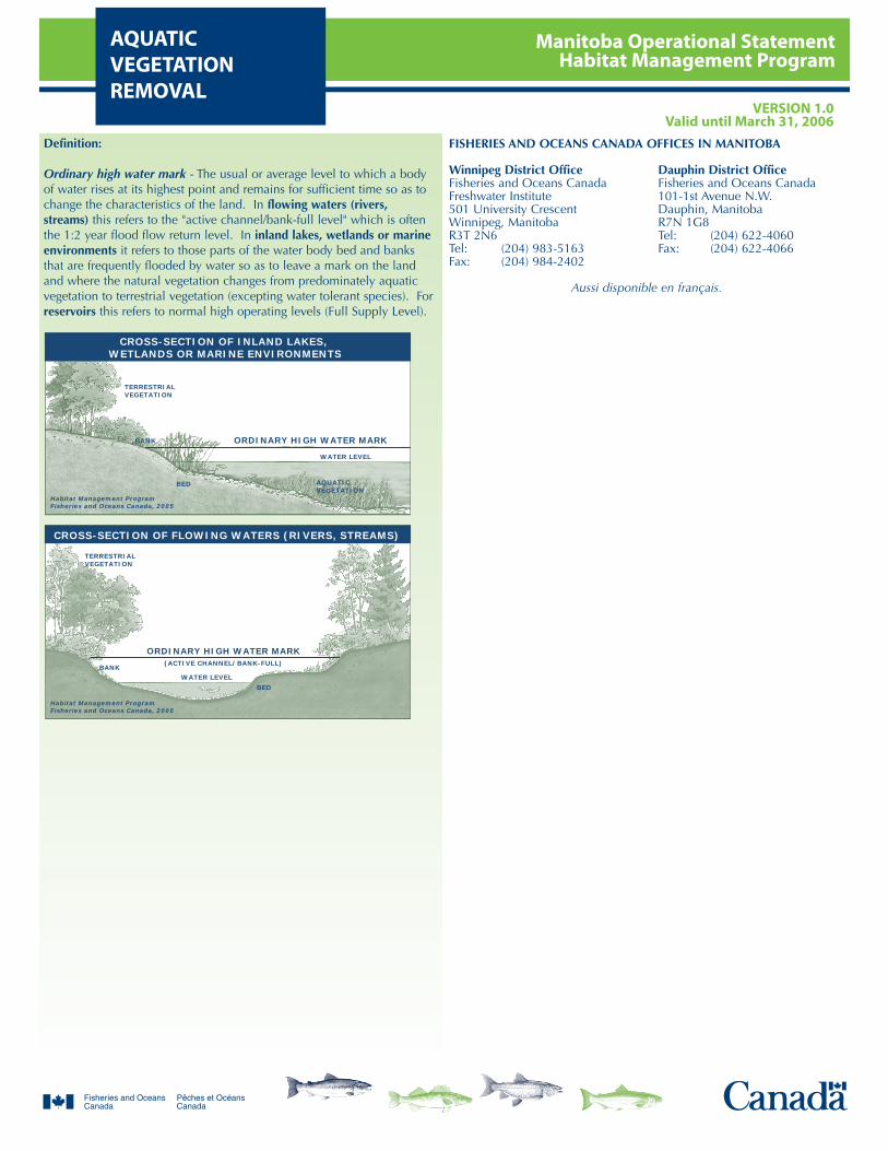
Manitoba Operational StatementHabitat Management Program
AQUATIC VEGETATIONREMOVAL
VERSION 1.0Valid until March 31, 2006
Definition:
Ordinary high water mark - The usual or average level to which a bodyof water rises at its highest point and remains for sufficient time so as tochange the characteristics of the land. In flowing waters (rivers,streams) this refers to the "active channel/bank-full level" which is oftenthe 1:2 year flood flow return level. In inland lakes, wetlands or marineenvironments it refers to those parts of the water body bed and banksthat are frequently flooded by water so as to leave a mark on the landand where the natural vegetation changes from predominately aquaticvegetation to terrestrial vegetation (excepting water tolerant species). Forreservoirs this refers to normal high operating levels (Full Supply Level).
TERRESTRIALVEGETATION
ORDINARY HIGH WATER MARK
ORDINARY HIGH WATER MARK
TERRESTRIALVEGETATION
BANK
BANK
Habitat Management ProgramFisheries and Oceans Canada, 2005
Habitat Management ProgramFisheries and Oceans Canada, 2005
AQUATICVEGETATION
BED
BED
(ACTIVE CHANNEL/BANK-FULL)
WATER LEVEL
WATER LEVEL
CROSS-SECTION OF INLAND LAKES, WETLANDS OR MARINE ENVIRONMENTS
CROSS-SECTION OF FLOWING WATERS (RIVERS, STREAMS)
FISHERIES AND OCEANS CANADA OFFICES IN MANITOBA
Winnipeg District Office Dauphin District OfficeFisheries and Oceans Canada Fisheries and Oceans CanadaFreshwater Institute 101-1st Avenue N.W.501 University Crescent Dauphin, ManitobaWinnipeg, Manitoba R7N 1G8R3T 2N6 Tel: (204) 622-4060Tel: (204) 983-5163 Fax: (204) 622-4066Fax: (204) 984-2402
Aussi disponible en français.
Manitoba Operational StatementHabitat Management ProgramBEACH CREATION
VERSION 1.0Valid until March 31, 2006
This Operational Statement addresses beach creation projects thatinvolve a small waterfront recreation area, located entirely above theordinary high water mark (see definition below). Although fishhabitat occurs throughout a water system, it is the riparian habitatthat is most sensitive to this type of beach development. Riparianvegetation occurs adjacent to the water body and directlycontributes to fish habitat by providing shade, cover, and spawningand food production areas, so should remain undisturbed to thegreatest extent possible. It is important to design your beach to meetyour needs while also protecting riparian areas.
Fisheries and Oceans Canada (DFO) is responsible for protecting fishand fish habitat across Canada. Under Section 35 of the FisheriesAct no one may carry out a work or undertaking that will cause theharmful alteration, disruption or destruction (HADD) of fish habitatunless it has been authorized by DFO. By following the conditionsand measures set out below you will be in compliance withSubsection 35(1) of the Fisheries Act.
The purpose of this Operational Statement is to describe theconditions under which it is applicable to your project and themeasures to be incorporated into the design, construction andmaintenance of your Beach Creation project in order to avoidnegative impacts to fish habitat. You may proceed with your BeachCreation project adjacent to freshwater lakes, rivers and streamswithout a DFO review when you meet the following conditions:
the proposed beach, associated structures and materials areplaced above the ordinary high water mark (see definitionbelow).the combined width for all existing and proposed shorelineimprovements (docks, boathouses, beaches) is less than 25%of the property's riparian area width (shoreline frontage width),andyou incorporate the Measures to Protect Fish and Fish Habitatwhen Creating a Beach listed below.
If you cannot meet all of the conditions listed above and cannotincorporate all of the measures listed below then your project mayresult in a violation of Subsection 35(1) of the Fisheries Act and youcould be subject to enforcement action. In this case, you shouldcontact the DFO office in your area (see Manitoba DFO office list) ifyou wish to obtain DFO's opinion on the possible options youshould consider to avoid contravention of the Fisheries Act.
This Operational Statement does not release you from theresponsibility of obtaining any other permits or approvals that maybe required under municipal, provincial and federal legislation thatapply to the work being carried out in relation to this OperationalStatement.
We ask that you notify DFO, preferably 10 working days beforestarting your work, by filling out and sending in, by mail or by fax,the Manitoba notification form to the DFO office in your area. Thisinformation is requested in order to evaluate the effectiveness of thework carried out in relation to this Operational Statement.
Measures to Protect Fish and Fish Habitat whenCreating a Beach
1. It is preferable to build the beach where sand, pebble or smallgravel substrates already exist and in a flat, gently sloping area toprevent the beach material from drifting into the water.
2. Do not take materials (i.e., rocks, logs) from the shoreline, frombelow the ordinary high water mark or from the lake or river bottomto build the beach.
3. Install effective sediment and erosion control measures beforestarting work to prevent sediment from entering the water body.Inspect them regularly during the course of construction to ensurethat they are functioning properly. Make all necessary repairs if anydamage is discovered.
4. Leave a vegetated strip or construct a small berm or edging out ofrocks or wood between the beach and the shoreline, linedappropriately with filter cloth to prevent beach sand from enteringinto the water. Locate this berm or edging above the ordinary highwater mark.
5. Use naturally rot-resistant untreated materials (e.g. cedar, hemlock,rocks, plastic) to build beach structures where possible. Treatedlumber may contain compounds that can be released into the waterand become toxic to the aquatic environment.
5.1. If treated lumber is used for beach structures it should beenvironmentally-friendly (see definition below).
5.2. Cut, seal and stain all lumber away from the water using onlyenvironmentally-friendly stains (see definition below). Allsealed and stained lumber should be completely dry beforeuse near water.
6. Operate machinery on land above the ordinary high water markand in a manner that minimizes disturbance to the banks of thewater body.
6.1. Machinery is to arrive on site in a clean condition and is to bemaintained free of fluid leaks.
6.2. Wash, refuel and service machinery and store fuel and othermaterials for the machinery away from the water to preventdeleterious substances from entering the water.
6.3. Keep an emergency spill kit on site in case of fluid leaks orspills from machinery.
7. While this Operational Statement does not cover the clearing ofriparian vegetation, the removal of select plants may be necessary toaccommodate the beach. This removal should be kept to aminimum.
8. Stabilize any waste materials removed from the work site, above theordinary high water mark (see definition below), to prevent themfrom entering any watercourse. Spoil piles could be contained withsilt fence, flattened, covered with biodegradable mats or tarps,and/or planted with preferably native grass or shrubs.
9. Vegetate any disturbed areas by planting and seeding preferablynative trees, shrubs or grasses and cover such areas with mulch to
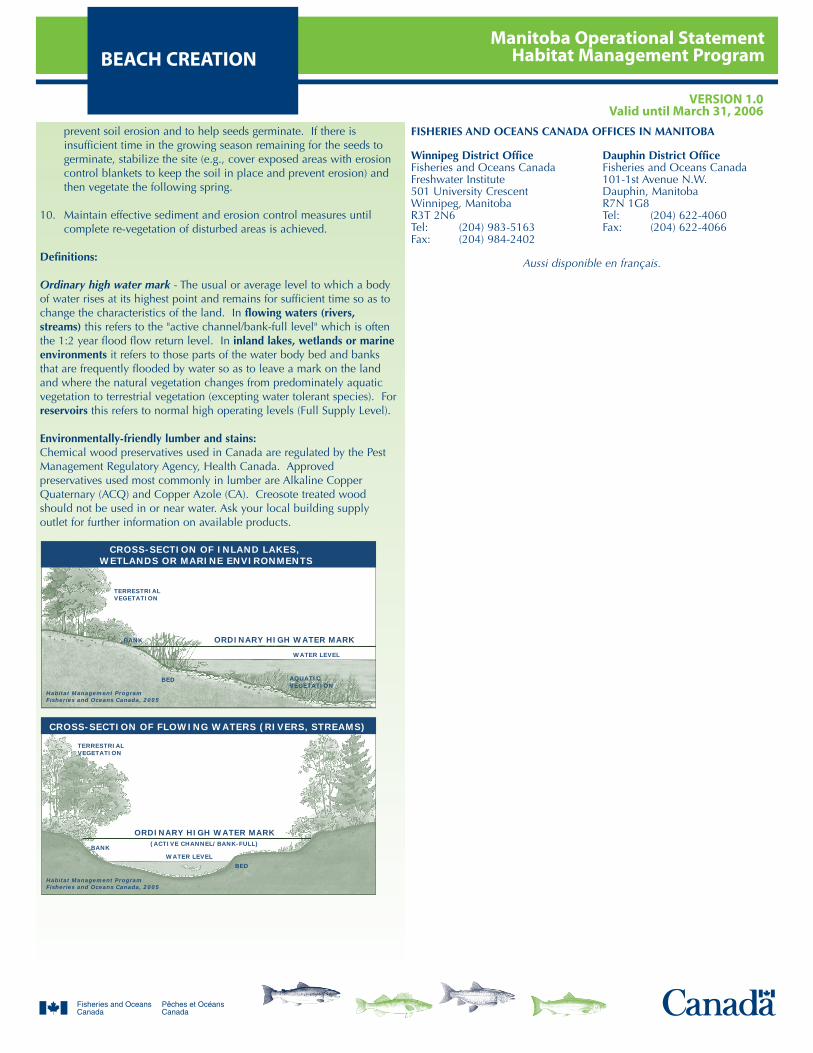
Manitoba Operational StatementHabitat Management ProgramBEACH CREATION
VERSION 1.0Valid until March 31, 2006
prevent soil erosion and to help seeds germinate. If there isinsufficient time in the growing season remaining for the seeds togerminate, stabilize the site (e.g., cover exposed areas with erosioncontrol blankets to keep the soil in place and prevent erosion) andthen vegetate the following spring.
10. Maintain effective sediment and erosion control measures untilcomplete re-vegetation of disturbed areas is achieved.
Definitions:
Ordinary high water mark - The usual or average level to which a bodyof water rises at its highest point and remains for sufficient time so as tochange the characteristics of the land. In flowing waters (rivers,streams) this refers to the "active channel/bank-full level" which is oftenthe 1:2 year flood flow return level. In inland lakes, wetlands or marineenvironments it refers to those parts of the water body bed and banksthat are frequently flooded by water so as to leave a mark on the landand where the natural vegetation changes from predominately aquaticvegetation to terrestrial vegetation (excepting water tolerant species). Forreservoirs this refers to normal high operating levels (Full Supply Level).
Environmentally-friendly lumber and stains:Chemical wood preservatives used in Canada are regulated by the PestManagement Regulatory Agency, Health Canada. Approvedpreservatives used most commonly in lumber are Alkaline CopperQuaternary (ACQ) and Copper Azole (CA). Creosote treated woodshould not be used in or near water. Ask your local building supplyoutlet for further information on available products.
TERRESTRIALVEGETATION
ORDINARY HIGH WATER MARK
ORDINARY HIGH WATER MARK
TERRESTRIALVEGETATION
BANK
BANK
Habitat Management ProgramFisheries and Oceans Canada, 2005
Habitat Management ProgramFisheries and Oceans Canada, 2005
AQUATICVEGETATION
BED
BED
(ACTIVE CHANNEL/BANK-FULL)
WATER LEVEL
WATER LEVEL
CROSS-SECTION OF INLAND LAKES, WETLANDS OR MARINE ENVIRONMENTS
CROSS-SECTION OF FLOWING WATERS (RIVERS, STREAMS)
FISHERIES AND OCEANS CANADA OFFICES IN MANITOBA
Winnipeg District Office Dauphin District OfficeFisheries and Oceans Canada Fisheries and Oceans CanadaFreshwater Institute 101-1st Avenue N.W.501 University Crescent Dauphin, ManitobaWinnipeg, Manitoba R7N 1G8R3T 2N6 Tel: (204) 622-4060Tel: (204) 983-5163 Fax: (204) 622-4066Fax: (204) 984-2402
Aussi disponible en français.
Manitoba Operational StatementHabitat Management ProgramBEAVER DAM
REMOVALVERSION 1.0
Valid until March 31, 2006
Beaver dams may need to be removed or breached periodically toprotect, maintain or construct infrastructure or to avoid the floodingof private and public land. Although beaver dams may provide fishhabitat by creating upstream ponds, stabilizing flows and addingwoody debris for cover, they may also present a barrier to fishmovement, alter sediment transport regimes and increase watertemperatures. Removal of beaver dams can negatively affect fish andfish habitat by de-watering the upstream pond, stranding fish andreleasing sediment and large volumes of water (that can be devoid ofoxygen, particularly in winter) downstream. The breaching orremoval of a beaver dam may not prevent future beaver activity inthe area. Persistent breaching or removal of a beaver dam canincrease the risk of negative impacts to fish habitat. In theseinstances, other beaver management techniques should beconsidered.
Fisheries and Oceans Canada (DFO) is responsible for protecting fishand fish habitat across Canada. Under Section 35 of the FisheriesAct no one may carry out a work or undertaking that will cause theharmful alteration, disruption or destruction (HADD) of fish habitatunless it has been authorized by DFO. By following the conditionsand measures set out below you will be in compliance withSubsection 35(1) of the Fisheries Act.
The purpose of this Operational Statement is to describe theconditions under which it is applicable to your project and themeasures to be incorporated into your Beaver Dam Removal projectin order to avoid negative impacts to fish habitat. You may proceedwith your Beaver Dam Removal Project without a DFO reviewwhen you meet the following conditions:
removal of the dam will not adversely affect a fishery, orrecreational or property uses that depend on the dam'sexistence, both upstream and downstream,removal activities are limited to removing or breaching thebeaver dam itself and do not involve channel modification(e.g., widening, straightening, ditching, etc.),individual detonations of more than one kilogram of explosiveswill not be used to remove the dam (diesel fuel and fertilizer isnot to be used as a type of explosive),the removal does not involve a beaver dam that is directlyconnected with a culvert or bridge (removal in these situationsis addressed in Operational Statements for CulvertMaintenance and Bridge Maintenance), andyou incorporate the Measures to Protect Fish and Fish Habitatwhen Removing Beaver Dams listed below.
If you cannot meet all of the conditions listed above and cannotincorporate all of the measures listed below then your project mayresult in a violation of Subsection 35(1) of the Fisheries Act and youcould be subject to enforcement action. In this case, you shouldcontact the DFO office in your area (see Manitoba DFO office list) ifyou wish to obtain DFO's opinion on the possible options youshould consider to avoid contravention of the Fisheries Act.
This Operational Statement does not release you from theresponsibility of obtaining any other permits or approvals that maybe required under municipal, provincial and federal legislation thatapply to the work being carried out in relation to this OperationalStatement.
We ask that you notify DFO, preferably 10 working days beforestarting your work, by filling out and sending in, by mail or by fax,the Manitoba notification form to the DFO office in your area. Thisinformation is requested in order to evaluate the effectiveness of thework carried out in relation to this Operational Statement.
Measures to Protect Fish and Fish Habitat whenRemoving Beaver Dams
1. For non-emergency beaver dam and debris removals (e.g., removalwith hand tools, machinery, explosives), time the activity to protectspawning fish, their incubating eggs and larval life stages byadhering to provincial fisheries timing windows (see the attachedManitoba In-Water Construction Timing Windows). Any proposal toconduct such work under ice-covered conditions requires priorreview by DFO.
2. Emergency beaver dam removal can be carried out at any timeduring the year. Emergencies include situations where carrying outthe project immediately is in the interest of preventing damage toproperty or the environment or is in the interest of public health orsafety. Your local DFO office is to be notified immediately. Youshould follow all other measures to the greatest extent possible.
3. Install effective sediment and erosion control measures beforestarting work to prevent the entry of sediment into the watercourse.Inspect them regularly during the course of construction to ensurethey are functioning properly. Make all necessary repairs if anydamage is discovered.
4. Operate machinery from outside of the water and in a manner thatminimizes disturbance to the banks or bed of the watercourse.
4.1. Machinery is to arrive on site in a clean condition and is to bemaintained free of fluid leaks.
4.2. Wash, refuel and service machinery and store fuel and othermaterials for the machinery away from the water to preventdeleterious substances from entering the water.
4.3. Keep an emergency spill kit on site in case of fluid leaks orspills from machinery.
5. Remove the dam gradually to allow the water to release slowly andprevent sediment at the bottom of the pond from being releaseddownstream. As the water levels drop in the upstream pond,increase the size of the opening to drain the pond to the desiredlevel. Dam removal activities should not result in any alteration tothe natural shoreline. The width of the breach opening of thebeaver dam should not exceed the width of the original streamchannel to prevent bank erosion and flooding of adjacentproperties. Any removal of a beaver dam should avoid severeflooding, downstream habitat damage and damage to property ofdownstream landowners (e.g., when a series of beaver dams is to beremoved, this should be done from downstream to upstream, etc.).

Manitoba Operational StatementHabitat Management ProgramBEAVER DAM
REMOVALVERSION 1.0
Valid until March 31, 2006
6. If blasting is required, individual detonations should be minimized(no more than one kilogram and preferably smaller). If largercharges are required, contact DFO prior to commencing the work.
7. Safely return any fish that become trapped in isolated pools, or thatare stranded in newly flooded areas, back to the main channel ofthe watercourse.
8. Stabilize any waste materials removed from the work site, above theordinary high water mark (see definition below), to prevent themfrom entering any watercourse. Spoil piles could be contained withsilt fence, flattened, covered with biodegradable mats or tarps,and/or planted with preferably native grass or shrubs.
9. While this Operational Statement does not cover the clearing ofriparian vegetation, the removal of select plants may be necessary toaccess and remove the beaver dam. This removal should be kept toa minimum.
10. Vegetate any disturbed areas by planting and seeding preferablynative trees, shrubs or grasses and cover such areas with mulch toprevent soil erosion and to help seeds germinate. If there isinsufficient time in the growing season remaining for the seeds togerminate, stabilize the site (e.g., cover exposed areas with erosioncontrol blankets to keep the soil in place and prevent erosion) andthen vegetate the following spring.
11. Maintain effective sediment and erosion control measures untilcomplete re-vegetation of disturbed areas is achieved.
Definition:
Ordinary high water mark - The usual or average level to which a bodyof water rises at its highest point and remains for sufficient time so as tochange the characteristics of the land. In flowing waters (rivers,streams) this refers to the "active channel/bank-full level" which is oftenthe 1:2 year flood flow return level. In inland lakes, wetlands or marineenvironments it refers to those parts of the water body bed and banksthat are frequently flooded by water so as to leave a mark on the landand where the natural vegetation changes from predominately aquaticvegetation to terrestrial vegetation (excepting water tolerant species). Forreservoirs this refers to normal high operating levels (Full Supply Level).
TERRESTRIALVEGETATION
ORDINARY HIGH WATER MARK
ORDINARY HIGH WATER MARK
TERRESTRIALVEGETATION
BANK
BANK
Habitat Management ProgramFisheries and Oceans Canada, 2005
Habitat Management ProgramFisheries and Oceans Canada, 2005
AQUATICVEGETATION
BED
BED
(ACTIVE CHANNEL/BANK-FULL)
WATER LEVEL
WATER LEVEL
CROSS-SECTION OF INLAND LAKES, WETLANDS OR MARINE ENVIRONMENTS
CROSS-SECTION OF FLOWING WATERS (RIVERS, STREAMS)
FISHERIES AND OCEANS CANADA OFFICES IN MANITOBA
Winnipeg District Office Dauphin District OfficeFisheries and Oceans Canada Fisheries and Oceans CanadaFreshwater Institute 101-1st Avenue N.W.501 University Crescent Dauphin, ManitobaWinnipeg, Manitoba R7N 1G8R3T 2N6 Tel: (204) 622-4060Tel: (204) 983-5163 Fax: (204) 622-4066Fax: (204) 984-2402
Aussi disponible en français.
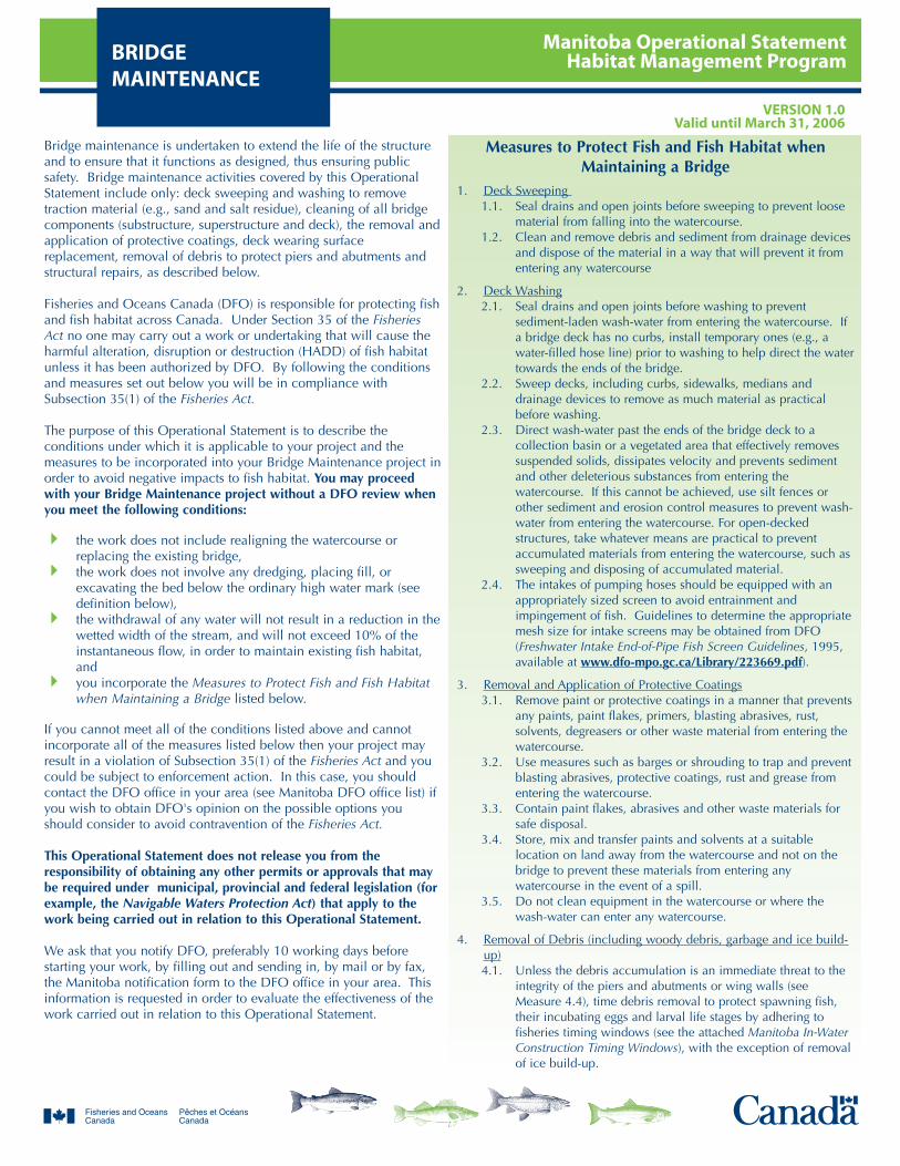
Manitoba Operational StatementHabitat Management ProgramBRIDGE
MAINTENANCEVERSION 1.0
Valid until March 31, 2006
Bridge maintenance is undertaken to extend the life of the structureand to ensure that it functions as designed, thus ensuring publicsafety. Bridge maintenance activities covered by this OperationalStatement include only: deck sweeping and washing to removetraction material (e.g., sand and salt residue), cleaning of all bridgecomponents (substructure, superstructure and deck), the removal andapplication of protective coatings, deck wearing surfacereplacement, removal of debris to protect piers and abutments andstructural repairs, as described below.
Fisheries and Oceans Canada (DFO) is responsible for protecting fishand fish habitat across Canada. Under Section 35 of the FisheriesAct no one may carry out a work or undertaking that will cause theharmful alteration, disruption or destruction (HADD) of fish habitatunless it has been authorized by DFO. By following the conditionsand measures set out below you will be in compliance withSubsection 35(1) of the Fisheries Act.
The purpose of this Operational Statement is to describe theconditions under which it is applicable to your project and themeasures to be incorporated into your Bridge Maintenance project inorder to avoid negative impacts to fish habitat. You may proceedwith your Bridge Maintenance project without a DFO review whenyou meet the following conditions:
the work does not include realigning the watercourse orreplacing the existing bridge,the work does not involve any dredging, placing fill, orexcavating the bed below the ordinary high water mark (seedefinition below),the withdrawal of any water will not result in a reduction in thewetted width of the stream, and will not exceed 10% of theinstantaneous flow, in order to maintain existing fish habitat,andyou incorporate the Measures to Protect Fish and Fish Habitatwhen Maintaining a Bridge listed below.
If you cannot meet all of the conditions listed above and cannotincorporate all of the measures listed below then your project mayresult in a violation of Subsection 35(1) of the Fisheries Act and youcould be subject to enforcement action. In this case, you shouldcontact the DFO office in your area (see Manitoba DFO office list) ifyou wish to obtain DFO's opinion on the possible options youshould consider to avoid contravention of the Fisheries Act.
This Operational Statement does not release you from theresponsibility of obtaining any other permits or approvals that maybe required under municipal, provincial and federal legislation (forexample, the Navigable Waters Protection Act) that apply to thework being carried out in relation to this Operational Statement.
We ask that you notify DFO, preferably 10 working days beforestarting your work, by filling out and sending in, by mail or by fax,the Manitoba notification form to the DFO office in your area. Thisinformation is requested in order to evaluate the effectiveness of thework carried out in relation to this Operational Statement.
Measures to Protect Fish and Fish Habitat whenMaintaining a Bridge
1. Deck Sweeping 1.1. Seal drains and open joints before sweeping to prevent loose
material from falling into the watercourse.1.2. Clean and remove debris and sediment from drainage devices
and dispose of the material in a way that will prevent it fromentering any watercourse
2. Deck Washing2.1. Seal drains and open joints before washing to prevent
sediment-laden wash-water from entering the watercourse. Ifa bridge deck has no curbs, install temporary ones (e.g., awater-filled hose line) prior to washing to help direct the watertowards the ends of the bridge.
2.2. Sweep decks, including curbs, sidewalks, medians anddrainage devices to remove as much material as practicalbefore washing.
2.3. Direct wash-water past the ends of the bridge deck to acollection basin or a vegetated area that effectively removessuspended solids, dissipates velocity and prevents sedimentand other deleterious substances from entering thewatercourse. If this cannot be achieved, use silt fences orother sediment and erosion control measures to prevent wash-water from entering the watercourse. For open-deckedstructures, take whatever means are practical to preventaccumulated materials from entering the watercourse, such assweeping and disposing of accumulated material.
2.4. The intakes of pumping hoses should be equipped with anappropriately sized screen to avoid entrainment andimpingement of fish. Guidelines to determine the appropriatemesh size for intake screens may be obtained from DFO(Freshwater Intake End-of-Pipe Fish Screen Guidelines, 1995,available at www.dfo-mpo.gc.ca/Library/223669.pdf).
3. Removal and Application of Protective Coatings3.1. Remove paint or protective coatings in a manner that prevents
any paints, paint flakes, primers, blasting abrasives, rust,solvents, degreasers or other waste material from entering thewatercourse.
3.2. Use measures such as barges or shrouding to trap and preventblasting abrasives, protective coatings, rust and grease fromentering the watercourse.
3.3. Contain paint flakes, abrasives and other waste materials forsafe disposal.
3.4. Store, mix and transfer paints and solvents at a suitablelocation on land away from the watercourse and not on thebridge to prevent these materials from entering anywatercourse in the event of a spill.
3.5. Do not clean equipment in the watercourse or where thewash-water can enter any watercourse.
4. Removal of Debris (including woody debris, garbage and ice build-up)4.1. Unless the debris accumulation is an immediate threat to the
integrity of the piers and abutments or wing walls (seeMeasure 4.4), time debris removal to protect spawning fish,their incubating eggs and larval life stages by adhering tofisheries timing windows (see the attached Manitoba In-WaterConstruction Timing Windows), with the exception of removalof ice build-up.
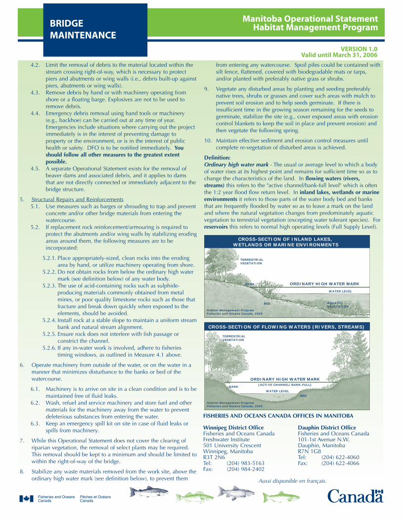
Manitoba Operational StatementHabitat Management ProgramBRIDGE
MAINTENANCEVERSION 1.0
Valid until March 31, 2006
4.2. Limit the removal of debris to the material located within thestream crossing right-of-way, which is necessary to protectpiers and abutments or wing walls (i.e., debris built-up againstpiers, abutments or wing walls).
4.3. Remove debris by hand or with machinery operating fromshore or a floating barge. Explosives are not to be used toremove debris.
4.4. Emergency debris removal using hand tools or machinery(e.g., backhoe) can be carried out at any time of year.Emergencies include situations where carrying out the projectimmediately is in the interest of preventing damage toproperty or the environment, or is in the interest of publichealth or safety. DFO is to be notified immediately. Youshould follow all other measures to the greatest extentpossible.
4.5. A separate Operational Statement exists for the removal ofbeaver dams and associated debris, and it applies to damsthat are not directly connected or immediately adjacent to thebridge structure.
5. Structural Repairs and Reinforcements5.1. Use measures such as barges or shrouding to trap and prevent
concrete and/or other bridge materials from entering thewatercourse.
5.2. If replacement rock reinforcement/armouring is required toprotect the abutments and/or wing walls by stabilizing erodingareas around them, the following measures are to beincorporated:
5.2.1. Place appropriately-sized, clean rocks into the erodingarea by hand, or utilize machinery operating from shore.
5.2.2. Do not obtain rocks from below the ordinary high watermark (see definition below) of any water body.
5.2.3. The use of acid-containing rocks such as sulphide-producing materials commonly obtained from metalmines, or poor quality limestone rocks such as those thatfracture and break down quickly when exposed to theelements, should be avoided.
5.2.4. Install rock at a stable slope to maintain a uniform streambank and natural stream alignment.
5.2.5. Ensure rock does not interfere with fish passage orconstrict the channel.
5.2.6. If any in-water work is involved, adhere to fisheriestiming windows, as outlined in Measure 4.1 above.
6. Operate machinery from outside of the water, or on the water in amanner that minimizes disturbance to the banks or bed of thewatercourse.
6.1. Machinery is to arrive on site in a clean condition and is to bemaintained free of fluid leaks.
6.2. Wash, refuel and service machinery and store fuel and othermaterials for the machinery away from the water to preventdeleterious substances from entering the water.
6.3. Keep an emergency spill kit on site in case of fluid leaks orspills from machinery.
7. While this Operational Statement does not cover the clearing ofriparian vegetation, the removal of select plants may be required.This removal should be kept to a minimum and should be limited towithin the right-of-way of the bridge.
8. Stabilize any waste materials removed from the work site, above theordinary high water mark (see definition below), to prevent them
from entering any watercourse. Spoil piles could be contained withsilt fence, flattened, covered with biodegradable mats or tarps,and/or planted with preferably native grass or shrubs.
9. Vegetate any disturbed areas by planting and seeding preferablynative trees, shrubs or grasses and cover such areas with mulch toprevent soil erosion and to help seeds germinate. If there isinsufficient time in the growing season remaining for the seeds togerminate, stabilize the site (e.g., cover exposed areas with erosioncontrol blankets to keep the soil in place and prevent erosion) andthen vegetate the following spring.
10. Maintain effective sediment and erosion control measures untilcomplete re-vegetation of disturbed areas is achieved.
Definition: Ordinary high water mark - The usual or average level to which a bodyof water rises at its highest point and remains for sufficient time so as tochange the characteristics of the land. In flowing waters (rivers,streams) this refers to the "active channel/bank-full level" which is oftenthe 1:2 year flood flow return level. In inland lakes, wetlands or marineenvironments it refers to those parts of the water body bed and banksthat are frequently flooded by water so as to leave a mark on the landand where the natural vegetation changes from predominately aquaticvegetation to terrestrial vegetation (excepting water tolerant species). Forreservoirs this refers to normal high operating levels (Full Supply Level).
TERRESTRIALVEGETATION
ORDINARY HIGH WATER MARK
ORDINARY HIGH WATER MARK
TERRESTRIALVEGETATION
BANK
BANK
Habitat Management ProgramFisheries and Oceans Canada, 2005
Habitat Management ProgramFisheries and Oceans Canada, 2005
AQUATICVEGETATION
BED
BED
(ACTIVE CHANNEL/BANK-FULL)
WATER LEVEL
WATER LEVEL
CROSS-SECTION OF INLAND LAKES, WETLANDS OR MARINE ENVIRONMENTS
CROSS-SECTION OF FLOWING WATERS (RIVERS, STREAMS)
FISHERIES AND OCEANS CANADA OFFICES IN MANITOBA
Winnipeg District Office Dauphin District OfficeFisheries and Oceans Canada Fisheries and Oceans CanadaFreshwater Institute 101-1st Avenue N.W.501 University Crescent Dauphin, ManitobaWinnipeg, Manitoba R7N 1G8R3T 2N6 Tel: (204) 622-4060Tel: (204) 983-5163 Fax: (204) 622-4066Fax: (204) 984-2402
Aussi disponible en français.
Manitoba Operational StatementHabitat Management ProgramCLEAR-SPAN
BRIDGESVERSION 1.0
Valid until March 31, 2006
This Operational Statement applies to the construction of only thosesmall-scale bridge structures that completely span a watercoursewithout altering the stream bed or bank, and that are a maximum oftwo lanes wide. A clear-span bridge is often more preferred than aculvert as no structures are placed on the stream bed or banks.
Clear-span bridge construction has the potential to negatively affectriparian habitat. Riparian vegetation occurs adjacent to thewatercourse and directly contributes to fish habitat by providingshade, cover, and spawning and food production areas. Only thevegetation required to be removed to meet operational and safetyconcerns for the crossing structure and the approaches should beremoved.
Fisheries and Oceans Canada (DFO) is responsible for protecting fishand fish habitat across Canada. Under Section 35 of the FisheriesAct no one may carry out a work or undertaking that will cause theharmful alteration, disruption or destruction (HADD) of fish habitatunless it has been authorized by DFO. By following the conditionsand measures set out below you will be in compliance withSubsection 35(1) of the Fisheries Act.
The purpose of this Operational Statement is to describe theconditions under which it is applicable to your project and themeasures to be incorporated into the design and construction ofsmall-scale, clear-span roadway or railway bridges in order to avoidnegative impacts to fish habitat. You may proceed with your Clear-Span Bridge project without a DFO review when you meet thefollowing conditions:
the bridge is no greater than two lanes in width and does notencroach on the natural channel width by the placement ofabutments, footings or armouring (e.g., rock and concrete)below the ordinary high water mark (see definition below) sothat there is no restriction to natural channel processes,the work does not include realigning the watercourse,disturbance to riparian vegetation is minimized,the work does not involve dredging, infilling or excavating thebed or bank of the watercourse, andyou incorporate the Measures to Protect Fish and Fish Habitatwhen Constructing Clear-Span Bridges listed below.
If you cannot meet all of the conditions listed above and cannotincorporate all of the measures listed below then your project mayresult in a violation of Subsection 35(1) of the Fisheries Act and youcould be subject to enforcement action. In this case, you shouldcontact the DFO office in your area (see Manitoba DFO office list) ifyou wish to obtain DFO's opinion on the possible options youshould consider to avoid contravention of the Fisheries Act.
This Operational Statement does not release you from theresponsibility of obtaining any other permits or approvals that maybe required under municipal, provincial and federal legislation (e.g.,the Navigable Waters Protection Act) that apply to the work beingcarried out in relation to this Operational Statement.
We ask that you notify DFO, preferably 10 working days beforestarting your work, by filling out and sending in, by mail or by fax,the Manitoba notification form to the DFO office in your area. This
information is requested in order to evaluate the effectiveness of thework carried out in relation to this Operational Statement.
Measures to Protect Fish and Fish Habitat whenConstructing Clear-Span Bridges
1. Avoid building on meander bends, braided streams, alluvial fans orany other area that is inherently unstable and may result in theerosion and scouring of the bridge structure.
2. Construct the bridge structure (including any approaches,abutments, armouring (rock and concrete) or footings) entirelyabove the ordinary high water mark (see definition below) and awayfrom areas with eroding or unstable banks.
3. Construct the bridge structure with sufficient freeboard to passfloating objects at high flows.
4. Design the bridge so that stormwater runoff from the bridge deck,side slopes and approaches is directed into a collection basin or avegetated area having suitable features to remove suspended solids,dissipate velocity and prevent sediment and other deleterioussubstances from entering the watercourse.
5. Generally, there are no restrictions on timing for the construction ofclear-span structures as they do not involve in-water work.However, if there are any activities with the potential to disruptspawning fish, their incubating eggs and larval life stages (e.g., in-water crossing of watercourse by machinery), these should adhereto provincial fisheries timing windows (see the attached ManitobaIn-Water Construction Timing Windows).
6. Machinery fording the watercourse to bring equipment required forconstruction to the opposite side of the watercourse should belimited to a one-time event (over and back) and occur only if anexisting crossing at another location cannot be used. If the streambed and banks are highly erodible (e.g., dominated by organicmaterials and silts) and erosion and degradation is likely to occur asa result of equipment crossing, then a temporary crossing structureor other practices should be used to protect these areas. Forinformation consult the Manitoba Stream Crossing Guidelines forthe Protection of Fish and Fish Habitat (Manitoba Natural Resourcesand DFO, 1996). The fording should also adhere to the timingwindows specified in Measure 5.
7. Install effective sediment and erosion control measures beforestarting work to prevent the entry of sediment into the watercourse.Pay particular attention to the ditches of road approaches. Inspectmeasures regularly during the course of construction and until anyrequired re-vegetation has established to ensure they are functioningproperly. Make all necessary repairs if any damage is discovered orif these measures are not effective at controlling erosion andsedimentation.
8. Operate machinery from outside of the water and in a manner thatminimizes disturbance to the banks of the watercourse.
8.1. Machinery is to arrive on site in a clean condition and is to bemaintained free of fluid leaks.
8.2. Wash, refuel and service machinery and store fuel and other
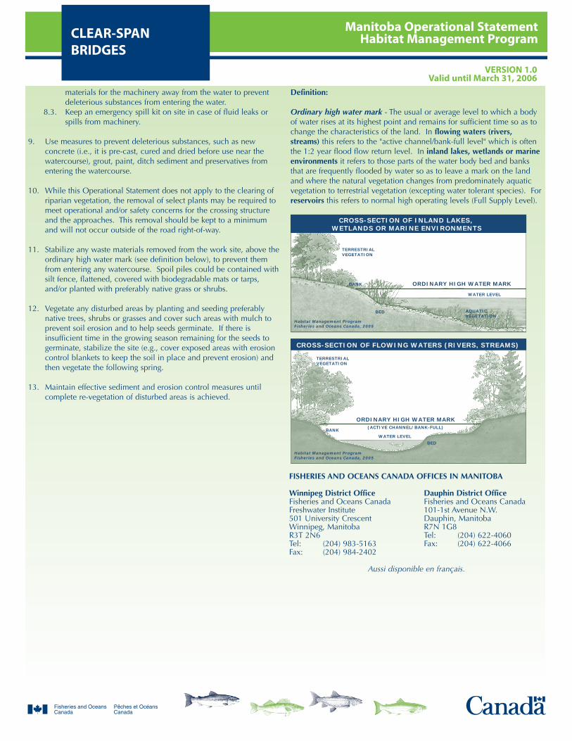
Manitoba Operational StatementHabitat Management ProgramCLEAR-SPAN
BRIDGESVERSION 1.0
Valid until March 31, 2006
materials for the machinery away from the water to preventdeleterious substances from entering the water.
8.3. Keep an emergency spill kit on site in case of fluid leaks orspills from machinery.
9. Use measures to prevent deleterious substances, such as newconcrete (i.e., it is pre-cast, cured and dried before use near thewatercourse), grout, paint, ditch sediment and preservatives fromentering the watercourse.
10. While this Operational Statement does not apply to the clearing ofriparian vegetation, the removal of select plants may be required tomeet operational and/or safety concerns for the crossing structureand the approaches. This removal should be kept to a minimumand will not occur outside of the road right-of-way.
11. Stabilize any waste materials removed from the work site, above theordinary high water mark (see definition below), to prevent themfrom entering any watercourse. Spoil piles could be contained withsilt fence, flattened, covered with biodegradable mats or tarps,and/or planted with preferably native grass or shrubs.
12. Vegetate any disturbed areas by planting and seeding preferablynative trees, shrubs or grasses and cover such areas with mulch toprevent soil erosion and to help seeds germinate. If there isinsufficient time in the growing season remaining for the seeds togerminate, stabilize the site (e.g., cover exposed areas with erosioncontrol blankets to keep the soil in place and prevent erosion) andthen vegetate the following spring.
13. Maintain effective sediment and erosion control measures untilcomplete re-vegetation of disturbed areas is achieved.
Definition:
Ordinary high water mark - The usual or average level to which a bodyof water rises at its highest point and remains for sufficient time so as tochange the characteristics of the land. In flowing waters (rivers,streams) this refers to the "active channel/bank-full level" which is oftenthe 1:2 year flood flow return level. In inland lakes, wetlands or marineenvironments it refers to those parts of the water body bed and banksthat are frequently flooded by water so as to leave a mark on the landand where the natural vegetation changes from predominately aquaticvegetation to terrestrial vegetation (excepting water tolerant species). Forreservoirs this refers to normal high operating levels (Full Supply Level).
TERRESTRIALVEGETATION
ORDINARY HIGH WATER MARK
ORDINARY HIGH WATER MARK
TERRESTRIALVEGETATION
BANK
BANK
Habitat Management ProgramFisheries and Oceans Canada, 2005
Habitat Management ProgramFisheries and Oceans Canada, 2005
AQUATICVEGETATION
BED
BED
(ACTIVE CHANNEL/BANK-FULL)
WATER LEVEL
WATER LEVEL
CROSS-SECTION OF INLAND LAKES, WETLANDS OR MARINE ENVIRONMENTS
CROSS-SECTION OF FLOWING WATERS (RIVERS, STREAMS)
FISHERIES AND OCEANS CANADA OFFICES IN MANITOBA
Winnipeg District Office Dauphin District OfficeFisheries and Oceans Canada Fisheries and Oceans CanadaFreshwater Institute 101-1st Avenue N.W.501 University Crescent Dauphin, ManitobaWinnipeg, Manitoba R7N 1G8R3T 2N6 Tel: (204) 622-4060Tel: (204) 983-5163 Fax: (204) 622-4066Fax: (204) 984-2402
Aussi disponible en français.

Manitoba Operational StatementHabitat Management ProgramCULVERT
MAINTENANCEVERSION 1.0
Valid until March 31, 2006
Culvert maintenance is undertaken to extend the life of the structureand to ensure that it functions as designed, thus ensuring publicsafety and safe fish passage. Culvert maintenance includes theremoval of accumulated debris (e.g., logs, boulders, garbage, icebuild-up) that prevents the efficient passage of water and fishthrough the structure. Culvert maintenance may also include thereinforcement of eroding inlets and outlets but does not includereplacing damaged or destroyed culvert bevel ends. Culvertsrequiring regular maintenance should be considered for futureremediation via redesign or reinstallation.
Fisheries and Oceans Canada (DFO) is responsible for protecting fishand fish habitat across Canada. Under Section 35 of the FisheriesAct no one may carry out a work or undertaking that will cause theharmful alteration, disruption or destruction (HADD) of fish habitatunless it has been authorized by DFO. By following the conditionsand measures set out below you will be in compliance withSubsection 35(1) of the Fisheries Act.
The purpose of this Operational Statement is to describe theconditions under which it is applicable to your project and themeasures to be incorporated into your Culvert Maintenance projectin order to avoid negative impacts to fish habitat. You may proceedwith your Culvert Maintenance project without a DFO review whenyou meet the following conditions:
it does not include realigning the watercourse, installing aculvert liner, or extending/replacing the existing culvert, it does not include any dredging, infilling (e.g., filling scourpools) or excavation of the bed or bank of the watercourse, and you incorporate the Measures to Protect Fish and Fish Habitatwhen Maintaining Culverts listed below.
If you cannot meet all of the conditions listed above and cannotincorporate all of the measures listed below then your project mayresult in a violation of Subsection 35(1) of the Fisheries Act and youcould be subject to enforcement action. In this case, you shouldcontact the DFO office in your area (see Manitoba DFO office list) ifyou wish to obtain DFO's opinion on the possible options youshould consider to avoid contravention of the Fisheries Act.
This Operational Statement does not release you from theresponsibility of obtaining any other permits or approvals that maybe required under municipal, provincial and federal legislation (e.g.,the Navigable Waters Protection Act) that apply to the work beingcarried out in relation to this Operational Statement.
We ask that you notify DFO, preferably 10 working days beforestarting your work, by filling out and sending in, by mail or by fax,the Manitoba notification form to the DFO office in your area. Thisinformation is requested in order to evaluate the effectiveness of thework carried out in relation to this Operational Statement.
Measures to Protect Fish and Fish Habitat whenMaintaining Culverts
1. Removal of Debris (including woody debris, garbage and ice build-up):1.1. Non-emergency debris removal should only be done by hand
or with machinery (e.g., backhoe). Time your material anddebris removal activities to protect spawning fish, theirincubating eggs and larval life stages by adhering to provincialfisheries timing windows (see the attached Manitoba In-WaterConstruction Timing Windows), with the exception of removalof ice build-up. Any proposal to conduct such work underice-covered conditions (except for removal of ice build-up)requires prior review by DFO.
1.2. Emergency debris removal using hand tools or machinery(e.g., backhoe) can be carried out at any time of year.Emergencies include situations where carrying out the projectimmediately is in the interest of preventing damage toproperty or the environment or is in the interest of publichealth or safety. The local DFO office is to be notifiedimmediately. You should follow all other measures to thegreatest extent possible.
1.3. Limit the removal of accumulated debris (i.e., branches,stumps, other woody materials, garbage, ice build-up, etc.) tothe area within the culvert, immediately upstream of theculvert and to that which is necessary to maintain culvertfunction and fish passage.
1.4. Explosives are not to be used to remove debris.1.5. Remove accumulated debris gradually to prevent downstream
erosion, flooding and the mobilization of sediment from theupstream ponded area. Gradual dewatering will also reducethe potential for stranding fish in upstream areas. Anyremoval of debris (including a beaver dam) should avoidsevere flooding, habitat damage and damage to property ofdownstream landowners (e.g., when a series of debris dams isto be removed, this should be done from downstream toupstream, etc.).
1.6. A separate Operational Statement exists for the removal ofbeaver dams and associated debris and it applies to dams thatare not directly connected or immediately adjacent to theculvert structure.
2. Install effective sediment and erosion control measures beforestarting work in order to prevent the entry of sediment into thewatercourse. Pay particular attention to the ditches of roadapproaches. Inspect them regularly during the course of the workand until any required re-vegetation is established to ensure theyare functioning properly. Make all necessary repairs andadjustments if any damage is discovered or if these measures arenot effective in controlling erosion and sedimentation.
3. Operate machinery from outside of the water and in a manner thatminimizes disturbance to the banks of the watercourse.
3.1. Machinery is to arrive on site in a clean condition and is to bemaintained free of fluid leaks.
3.2. Wash, refuel and service machinery and store fuel and othermaterials for the machinery away from the water to preventdeleterious substances from entering the water.
3.3. Keep an emergency spill kit on site in case of fluid leaks orspills from machinery.
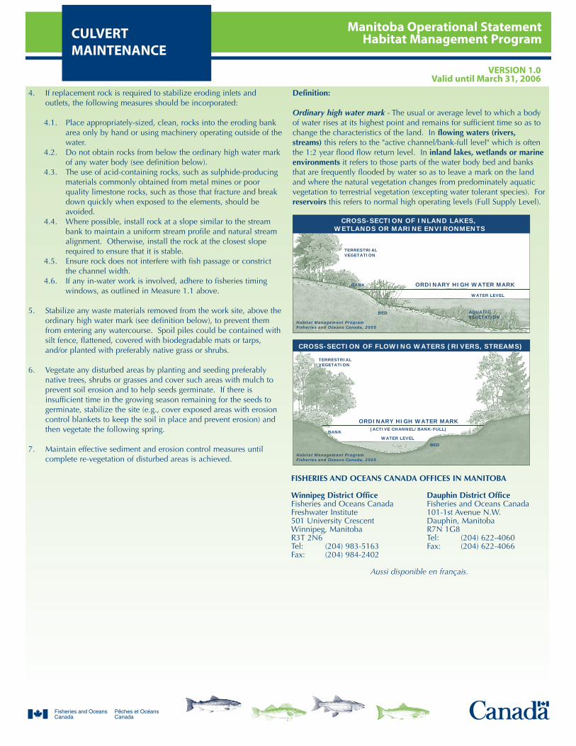
Manitoba Operational StatementHabitat Management ProgramCULVERT
MAINTENANCEVERSION 1.0
Valid until March 31, 2006
4. If replacement rock is required to stabilize eroding inlets andoutlets, the following measures should be incorporated:
4.1. Place appropriately-sized, clean, rocks into the eroding bankarea only by hand or using machinery operating outside of thewater.
4.2. Do not obtain rocks from below the ordinary high water markof any water body (see definition below).
4.3. The use of acid-containing rocks, such as sulphide-producingmaterials commonly obtained from metal mines or poorquality limestone rocks, such as those that fracture and breakdown quickly when exposed to the elements, should beavoided.
4.4. Where possible, install rock at a slope similar to the streambank to maintain a uniform stream profile and natural streamalignment. Otherwise, install the rock at the closest sloperequired to ensure that it is stable.
4.5. Ensure rock does not interfere with fish passage or constrictthe channel width.
4.6. If any in-water work is involved, adhere to fisheries timingwindows, as outlined in Measure 1.1 above.
5. Stabilize any waste materials removed from the work site, above theordinary high water mark (see definition below), to prevent themfrom entering any watercourse. Spoil piles could be contained withsilt fence, flattened, covered with biodegradable mats or tarps,and/or planted with preferably native grass or shrubs.
6. Vegetate any disturbed areas by planting and seeding preferablynative trees, shrubs or grasses and cover such areas with mulch toprevent soil erosion and to help seeds germinate. If there isinsufficient time in the growing season remaining for the seeds togerminate, stabilize the site (e.g., cover exposed areas with erosioncontrol blankets to keep the soil in place and prevent erosion) andthen vegetate the following spring.
7. Maintain effective sediment and erosion control measures untilcomplete re-vegetation of disturbed areas is achieved.
Definition:
Ordinary high water mark - The usual or average level to which a bodyof water rises at its highest point and remains for sufficient time so as tochange the characteristics of the land. In flowing waters (rivers,streams) this refers to the "active channel/bank-full level" which is oftenthe 1:2 year flood flow return level. In inland lakes, wetlands or marineenvironments it refers to those parts of the water body bed and banksthat are frequently flooded by water so as to leave a mark on the landand where the natural vegetation changes from predominately aquaticvegetation to terrestrial vegetation (excepting water tolerant species). Forreservoirs this refers to normal high operating levels (Full Supply Level).
TERRESTRIALVEGETATION
ORDINARY HIGH WATER MARK
ORDINARY HIGH WATER MARK
TERRESTRIALVEGETATION
BANK
BANK
Habitat Management ProgramFisheries and Oceans Canada, 2005
Habitat Management ProgramFisheries and Oceans Canada, 2005
AQUATICVEGETATION
BED
BED
(ACTIVE CHANNEL/BANK-FULL)
WATER LEVEL
WATER LEVEL
CROSS-SECTION OF INLAND LAKES, WETLANDS OR MARINE ENVIRONMENTS
CROSS-SECTION OF FLOWING WATERS (RIVERS, STREAMS)
FISHERIES AND OCEANS CANADA OFFICES IN MANITOBA
Winnipeg District Office Dauphin District OfficeFisheries and Oceans Canada Fisheries and Oceans CanadaFreshwater Institute 101-1st Avenue N.W.501 University Crescent Dauphin, ManitobaWinnipeg, Manitoba R7N 1G8R3T 2N6 Tel: (204) 622-4060Tel: (204) 983-5163 Fax: (204) 622-4066Fax: (204) 984-2402
Aussi disponible en français.
Manitoba Operational StatementHabitat Management Program
DOCK ANDBOATHOUSE CONSTRUCTION
VERSION 1.0Valid until March 31, 2006
Docks and boathouses are common features on the shorelines oflakes and rivers in Canada and are an important part of therecreational use of our waterways. The shoreline area in front ofyour cottage or waterfront property is also important habitat for avariety of aquatic organisms, including fish. Fish lay their eggs, feedand hide from predators in these shoreline areas. Building a dock orboathouse along your waterfront can impact this important habitat.
Fisheries and Oceans Canada (DFO) is responsible for protecting fishand fish habitat across Canada. Under Section 35 of the FisheriesAct no one may carry out a work or undertaking that will cause theharmful alteration, disruption or destruction (HADD) of fish habitatunless it has been authorized by DFO. By following the conditionsand measures set out below you will be in compliance withSubsection 35(1) of the Fisheries Act.
The purpose of this Operational Statement is to describe theconditions under which it is applicable to your project and themeasures to be incorporated into the design, construction, rebuildand repair of your dock or boathouse, in order to avoid negativeimpacts to fish habitat. You may proceed with your Dock orBoathouse project without DFO review when you meet thefollowing conditions:
you are not working within West Hawk Lake, which is subjectto provincial management consideration,it is a new repair or rebuild of a floating, cantilever or postdock or boathouse,it is a new, repair or rebuild of an open-faced crib dock builtentirely on natural bedrock or sand bottom with a totalcombined footprint (for both existing and proposed cribs) of15m2 or less,the total surface area for the entire dock and boathouse,located below the ordinary high water mark, including bothexisting and proposed structures combined, does not exceed50m2,it is not made of concrete or steel sheeting or any other skirtingthat isolates the area under the dock from the rest of the water,it does not require any dredging, blasting or infilling in thewater body,the combined width for all existing and proposed shorelineimprovements (docks, boathouses, beaches) is less than 25%of the property's riparian area width (shoreline frontage width),andyou incorporate the Measures to Protect Fish Habitat whenBuilding your Dock or Boathouse listed below.
If you cannot meet all of the conditions listed above and cannotincorporate all of the measures listed below then your project mayresult in a violation of Subsection 35(1) of the Fisheries Act and youcould be subject to enforcement action. In this case, you shouldcontact the DFO office in your area (see Manitoba DFO office list) ifyou wish to obtain DFO's opinion on the possible options youshould consider to avoid contravention of the Fisheries Act.
This Operational Statement does not release you from theresponsibility of obtaining any other permits or approvals that maybe required under municipal, provincial and federal legislation (e.g.,the Navigable Waters Protection Act) that apply to the work being
carried out in relation to this Operational Statement. Please notethat permanent structures (docks or boathouses) are not allowed onwaters regulated by Manitoba Hydro along the Winnipeg River.Docks must be removable types and boathouses must be built onshore above the ordinary high water mark (see definition below).Contact the Manitoba Hydro Shore Lands Permit Program for moreinformation.
We ask that you notify DFO, preferably 10 working days beforestarting your work, by filling out and sending in, by mail or by fax,the Manitoba notification form to the DFO office in your area. Thisinformation is requested in order to evaluate the effectiveness of thework carried out in relation to this Operational Statement.
Measures to Protect Fish Habitat when Building your Dock or Boathouse
1. Floating, cantilever and post docks, and marine railways (on posts)for boathouse access can be installed at any time.
2. Time the installation of crib docks with a total combined footprint(total area of cribbing in contact with the bottom) of up to 15m2 toprevent disruption of spawning fish, their incubating eggs and larvallife stages by adhering to provincial fisheries timing windows (seethe attached Manitoba In-Water Construction Timing Windows).
3. Construct cribs in an open faced manner and fill with large rocksthat provide crevices for fish and other small organisms to use.Leave enough space between cribs (two metres or more) and locatethem at least two metres from the ordinary high water mark (seedefinition below) to allow near shore water to circulate. Theconstruction of boathouses above the ordinary high water mark isstrongly encouraged in order to minimize impacts to fish habitat.
4. Materials (e.g., rock, logs) to build the dock should not be takenfrom the shoreline, from below the ordinary high water mark orfrom the lake or river bottom. Use clean materials that are free ofdirt.
5. If rocks, stumps or logs need to be moved on the lake or riverbottom or shoreline to build the dock, they are relocated to an areaof similar depth adjacent to the dock and not removed altogetherfrom the bottom or shoreline.
6. The entry of sediments from the construction site into the waterbody can harm fish and fish habitat. Ensure that the appropriatesediment and erosion control measures (i.e. silt fences) are in placebefore you start dock construction, particularly on sites witherodible soils such as sand and clay.
6.1. You and/or your contractor should inspect sediment anderosion control measures regularly during the course ofconstruction and make all necessary repairs if any damage isdiscovered (e.g., you see silt or sediment entering the water).
6.2. Avoid doing work during wet and rainy periods.
7. Use naturally rot-resistant, untreated materials (e.g. cedar, hemlock,rocks, plastic) as supports for dock structures that will be submergedin water and preferably for structures above water. Treated lumbermay contain compounds that can be released into the water andbecome toxic to the aquatic environment.
Manitoba Operational StatementHabitat Management Program
DOCK ANDBOATHOUSE CONSTRUCTION
VERSION 1.0Valid until March 31, 2006
7.1. If treated lumber is to be used for dock structures above water,it should be environmentally-friendly (see definition below).
7.2. Cut, seal and stain all lumber away from the water using onlyenvironmentally-friendly stains (see definition below). Allsealed and stained lumber should be completely dry beforeused near water.
7.3. Ensure plastic barrel floats are free of chemicals inside andoutside of the barrel before they are placed in water.
8. Whenever possible, construct the dock either from a barge or floaton the water or through the ice instead of using machinery from thebank of the water body.
9. Operate machinery from outside of the water and in a manner thatminimizes disturbance to the banks of the water body.
9.1. Machinery is to arrive on site in a clean condition and is to bemaintained free of fluid leaks.
9.2. Wash, refuel and service machinery and store fuel and othermaterials for the machinery away from the water to preventdeleterious substances from entering the water.
9.3. Keep an emergency spill kit on site in case of fluid leaks orspills from machinery.
10. If a concrete abutment is needed to secure your dock to land, installit entirely on land, above the ordinary high water mark. Theconcrete is to be pre-cast and cured away from the water before useto prevent seepage of potentially toxic substances into the waterbody.
11. While this Operational Statement does not cover the clearing ofriparian vegetation, the removal of select plants may be necessary toaccess the construction site. This removal should be kept to aminimum.
12. Vegetate any disturbed areas by planting and seeding preferablynative trees, shrubs or grasses and cover such areas with mulch toprevent soil erosion and to help seeds germinate. If there isinsufficient time in the growing season remaining for the seeds togerminate, stabilize the site (e.g., cover exposed areas with erosioncontrol blankets to keep the soil in place and prevent erosion) andvegetate the following spring.
13. Maintain effective sediment and erosion control measures untilcomplete re-vegetation of disturbed areas is achieved.
If you would like more detailed information on fish-friendly dockconstruction and maintenance practices to help you plan your project,please refer to the following document:
The Dock Primer - A Cottager's Guide to Waterfront-Friendly Docks http://www.dfo-mpo.gc.ca/regions/central/pub/dock-quais/index_e.htm(Prairies Edition)The "Dock Primer" contains additional helpful information. It also statesthat all docks must be reviewed. Please note however, that projectsfollowing this Operational Statement will not need DFO review.
Definitions:
Ordinary high water mark - The usual or average level to which a bodyof water rises at its highest point and remains for sufficient time so as tochange the characteristics of the land. In flowing waters (rivers,streams) this refers to the "active channel/bank-full level" which is oftenthe 1:2 year flood flow return level. In inland lakes, wetlands or marineenvironments it refers to those parts of the water body bed and banksthat are frequently flooded by water so as to leave a mark on the landand where the natural vegetation changes from predominately aquaticvegetation to terrestrial vegetation (excepting water tolerant species). Forreservoirs this refers to normal high operating levels (Full Supply Level).
Environmentally-friendly lumber and stains:Chemical wood preservatives used in Canada are regulated by the PestManagement Regulatory Agency, Health Canada. Approvedpreservatives used most commonly in lumber are Alkaline CopperQuaternary (ACQ) and Copper Azole (CA). Creosote treated woodshould not be used in or near water. Ask your local building supplyoutlet for further information on available products.
TERRESTRIALVEGETATION
ORDINARY HIGH WATER MARK
ORDINARY HIGH WATER MARK
TERRESTRIALVEGETATION
BANK
BANK
Habitat Management ProgramFisheries and Oceans Canada, 2005
Habitat Management ProgramFisheries and Oceans Canada, 2005
AQUATICVEGETATION
BED
BED
(ACTIVE CHANNEL/BANK-FULL)
WATER LEVEL
WATER LEVEL
CROSS-SECTION OF INLAND LAKES, WETLANDS OR MARINE ENVIRONMENTS
CROSS-SECTION OF FLOWING WATERS (RIVERS, STREAMS)
FISHERIES AND OCEANS CANADA OFFICES IN MANITOBA
Winnipeg District Office Dauphin District OfficeFisheries and Oceans Canada Fisheries and Oceans CanadaFreshwater Institute 101-1st Avenue N.W.501 University Crescent Dauphin, ManitobaWinnipeg, Manitoba R7N 1G8R3T 2N6 Tel: (204) 622-4060Tel: (204) 983-5163 Fax: (204) 622-4066Fax: (204) 984-2402
Aussi disponible en français.
Manitoba Operational StatementHabitat Management Program
HIGH-PRESSUREDIRECTIONALDRILLING
VERSION 1.0Valid until March 31, 2006
For the purpose of this Operational Statement, the term High-Pressure Directional Drilling (HPDD) means trenchless methods ofcrossing a watercourse, using pressurized mud systems. HPDD isused to install cables and pipelines for gas, water,telecommunications, fibre optics, power, sewer, oil and water linesunderneath watercourses. This method is preferable to open cut andisolated crossings because the cable or pipeline is drilled underneaththe watercourse with very little disturbance to its bed or banks.HPDD involves drilling a pilot bore-hole underneath the watercoursetowards a surface target on the opposite side and back reaming thebore-hole to the drill rig while pulling the pipe or cable alongthrough the hole. This process typically uses the freshwater gel mudsystem to transport drilled spoil, reduce friction and stabilize thebore-hole. The gel mud system is typically composed of a mixture ofclean, fresh water as the base, bentonite (clay-based drillinglubricant) or an alternative drilling lubricant as the viscosifier, andsynthetic polymers.
Successful HPDD is more favourable than an open-cut watercrossing because it minimizes the potential to impact fish and fishhabitat. This Operational Statement does not apply to any wet open-cut water crossing under any circumstance, nor does it apply whenthere is a high risk of a frac-out.
One of the risks associated with HPDD is the escape of drilling mudinto the environment as a result of a spill, tunnel collapse or therupture of mud to the surface, commonly known as a "frac-out". Afrac-out is caused when excessive drilling pressure results in drillingmud propagating vertically toward the surface. The risk of a frac-outcan be reduced through good geotechnical assessment practices andgood drill planning and execution. The extent of a frac-out can belimited by careful monitoring and having appropriate equipment andresponse plans ready in the event that one occurs.
Fisheries and Oceans Canada (DFO) is responsible for protecting fishand fish habitat across Canada. Under Section 35 of the FisheriesAct no one may carry out a work or undertaking that will cause theharmful alteration, disruption or destruction (HADD) of fish habitatunless it has been authorized by DFO. By following the conditionsand measures set out below you will be in compliance withSubsection 35(1) of the Fisheries Act.
The purpose of this Operational Statement is to describe theconditions under which it is applicable to your project and themeasures to be incorporated into your High-Pressure DirectionalDrilling project in order to avoid negative impacts to fish habitat.You may proceed with your HPDD project without a DFO reviewwhen you meet the following conditions:
a geo-technical assessment prepared by a qualified professionaldetermines that this drilling technique will be successful; ifthere is a high risk of a frac-out, this Operational Statementdoes not apply, you have a professionally-prepared emergency frac-outresponse plan and contingency crossing plan in place (on-siteand well-understood and readily available to all workers) thatoutlines the protocol to monitor the construction, to stop workin the event of a frac-out or spill, and to contain and clean-updrilling fluids and other deleterious substances, and
you incorporate the Measures to Protect Fish and Fish Habitatwhen High-Pressure Directional Drilling listed below.
This Operational Statement also describes contingency crossingmeasures for an isolated trenched crossing in the event of a frac-out.You may proceed with your contingency crossing plan without aDFO review when your project meets the following conditions:
the channel width of the watercourse is less than 5 meters fromordinary high water mark to ordinary high water mark (seedefinition below), andyou incorporate the Measures to Protect Fish and Fish Habitatfor Isolated Trenched Crossings in the Event of a Frac-out listedbelow.
Plans for contingency crossings of watercourses greater than 5metres wide from ordinary high water mark to ordinary high watermark, and contingency crossings during fisheries restricted activityperiods will require prior DFO review. Because of the timerequirements for DFO review, it is recommended that contingencyplans for HPDD in these circumstances be referred to DFO well inadvance of HPDD project commencement.
If you cannot meet all of the conditions listed above and cannotincorporate all of the measures listed below then your project mayresult in a violation of Subsection 35(1) of the Fisheries Act and youcould be subject to enforcement action. In this case, you shouldcontact the DFO office in your area (see Manitoba DFO office list) ifyou wish to obtain DFO's opinion on the possible options youshould consider to avoid contravention of the Fisheries Act.
This Operational Statement does not release you from theresponsibility of obtaining any other permits or approvals that maybe required under municipal, provincial and federal legislation (e.g.,the Navigable Waters Protection Act) that apply to the work beingcarried out in relation to this Operational Statement.
We ask that you notify DFO, preferably 10 working days beforestarting your work, by filling out and sending in, by mail or by fax,the Manitoba notification form to the DFO office in your area. Thisinformation is requested in order to evaluate the effectiveness of thework carried out in relation to this Operational Statement.
Measures to Protect Fish and Fish Habitat when High-Pressure Directional Drilling
1. Design the drill path to an appropriate depth below the watercourseto minimize the risk of a frac-out, as determined by a qualifiedprofessional, and to prevent the pipeline or cable from becomingexposed due to natural scouring of the stream bed. Ensure the drillentry and exit points are far enough from shorelines and streambanks to minimize disturbance to riparian areas, reduce the risk offrac-outs into the water body, and enable the containment of drillingfluids and other deleterious substances outside of the active streamchannel.
2. While this Operational Statement does not cover the clearing ofriparian vegetation, the removal of select plants may be necessary toaccess the construction site. This removal should be kept to a
Manitoba Operational StatementHabitat Management Program
HIGH-PRESSUREDIRECTIONALDRILLING
VERSION 1.0Valid until March 31, 2006
minimum and within the utility right-of-way.
3. Machinery fording the watercourse to bring equipment required forconstruction to the opposite side of the watercourse is limited to aone-time event (over and back) and is to occur only if an existingcrossing at another location cannot be used. If the stream bed andbanks are highly erodible (e.g., dominated by organic materials andsilts) and erosion and degradation is likely to occur as a result ofequipment fording, then a temporary crossing structure or otherpractice should be used to protect these areas. For informationconsult the Manitoba Stream Crossing Guidelines for the Protectionof Fish and Fish Habitat (Manitoba Natural Resources and DFO,1996). Any fording should adhere to provincial fisheries timingwindows in order to prevent disruption to spawning fish, theirincubating eggs and larval life stages (see the attached Manitoba In-Water Construction Timing Windows).
4. Operate machinery on land and in a manner that minimizesdisturbance to the banks of the watercourse.
4.1. Machinery is to arrive on site in a clean condition and is to bemaintained free of fluid leaks.
4.2. Wash, refuel and service machinery and store fuel and othermaterials for the machinery away from the water to preventdeleterious substances from entering the water.
4.3. Keep an emergency spill kit on site in case of fluid leaks orspills from machinery.
5. Ensure the drilling mud, sediment-laden water and any otherdeleterious substances are contained above the ordinary high watermark and do not enter any watercourse.
6. Monitor the watercourse to observe signs of surface migration ofdrilling mud (frac-out) during all phases of the work.
7. For the duration of the work, keep on-site and readily accessible inthe event of a frac-out, all material and equipment needed tocontain and clean-up releases of drilling mud, cuttings and otherwaste materials.
8. Implement your frac-out response plan immediately upon thedetection of a frac-out, a sediment release or spill of a deleterioussubstance. This plan is to include measures to, a) stop work;contain the drilling mud, cuttings and other waste materials andprevent their further migration into the watercourse; b) notify allapplicable authorities, including the closest DFO office; c) promptlyclean-up and appropriately dispose of the drilling mud, cuttings andother waste material in a location where it cannot re-enter anywatercourse; and d) ensure clean-up measures are suitably appliedso as not to result in further alteration of the bed and/or banks ofthe watercourse.
9. In the event of a frac-out, invoke the contingency crossing plan tore-drill at a more appropriate location and target depth (asdetermined by a geotechnical assessment done by a qualifiedprofessional) or if necessary, refer to the Measures to Protect Fishand Fish Habitat for Isolated Trenched Crossings in the Event of aFrac-out (see below) to isolate the watercourse to complete thecrossing in the dry at the current location.
Measures to Protect Fish and Fish Habitat for IsolatedTrenched Crossings in the Event of a Frac-out
10. The contingency crossing plan is to be followed to complete anisolated trenched crossing in the event of a frac-out when relocatingand re-drilling is not feasible. An isolated crossing (i.e., dam andpump, flume) involves isolating the work area and diverting the flowaround the construction site while completing the crossing in-the-dry. This Operational Statement does not provide for a wet open-cut trenched crossing under any circumstances.
11. Time the isolated crossing to protect spawning fish, their incubatingeggs and larval life stages. Adhere to provincial fisheries timingwindows, as identified in Measure 3 above. In the event of a frac-out, you may proceed with the isolated crossing as alreadyapproved by DFO (identified in the conditions above), if operatingwithin acceptable activity periods. If a frac-out occurs outside ofthese acceptable periods, you must contact the local DFO officeprior to proceeding with an isolated crossing in accordance withyour contingency crossing plan.
12. Temporary IsolationTemporary isolation is used to allow work "in the dry" whilemaintaining downstream flows. The following general measuresshould be used when isolating the trenched crossing construction.
12.1. Install effective sediment and erosion control measures beforestarting work to prevent entry of sediment into thewatercourse. Inspect them regularly during the course ofconstruction to ensure they are functioning properly.Immediately make all necessary repairs if any damage isdiscovered.
12.2. Use coffer dams such as aqua-dams, pea gravel or sand bags,concrete blocks, steel or wood wall, clean rock, sheet pile orother appropriate designs to separate the dewatered work sitefrom flowing water.
12.3. Use clean, washed material to build any granular coffer damsand face them with clean, washed granular material that isadequately sized (i.e., moderate sized rock and not sand orgravel) to hold the coffer dams in place during the work. Ifnecessary, the outside face of the coffer dams is to be linedwith heavy poly-plastic to make them impermeable to water.Material to build these dams should not be taken from belowthe ordinary high water mark (see definition below).
12.4. Design coffer dams to accommodate any expected high flowsof the watercourse during the construction period.
12.5. Minimize flow constriction to maintain unobstructed fishpassage, or only a very brief fish passage delay, and restoreoriginal flow as soon as work is completed.
12.6. Before starting trench construction, salvage any fish fromwithin the isolated area and return them safely to thedownstream portion of the watercourse.
12.7. Remove accumulated sediment and excess spoil from theisolated area and restore the bed and banks of thewatercourse to pre-construction condition before coffer damsare removed. Restore the original channel bottom gradientand substrate and cover the disturbed stream bed with a layerof clean granular material. Ensure banks are stabilized,adequately protected from erosion and re-vegetated,preferably with native species.
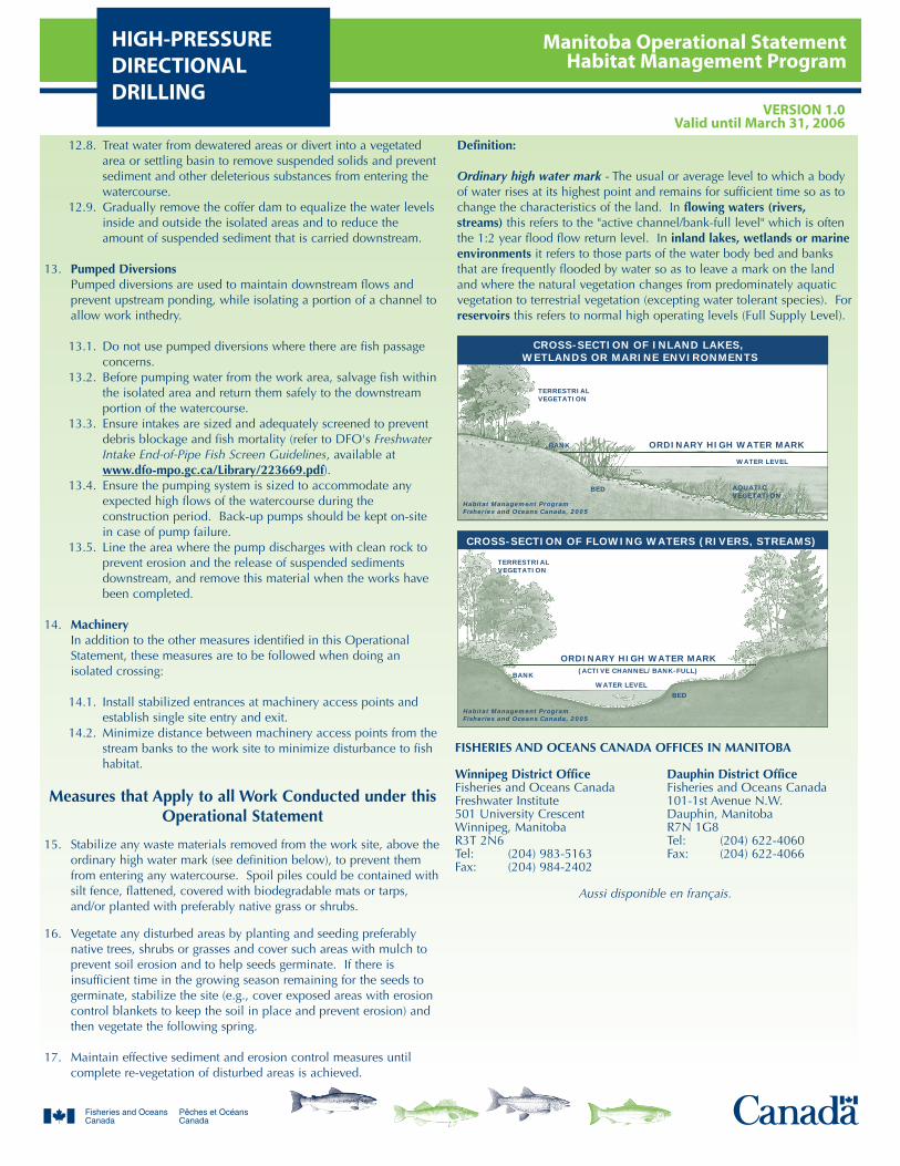
Manitoba Operational StatementHabitat Management Program
HIGH-PRESSUREDIRECTIONALDRILLING
VERSION 1.0Valid until March 31, 2006
12.8. Treat water from dewatered areas or divert into a vegetatedarea or settling basin to remove suspended solids and preventsediment and other deleterious substances from entering thewatercourse.
12.9. Gradually remove the coffer dam to equalize the water levelsinside and outside the isolated areas and to reduce theamount of suspended sediment that is carried downstream.
13. Pumped DiversionsPumped diversions are used to maintain downstream flows andprevent upstream ponding, while isolating a portion of a channel toallow work inthedry.
13.1. Do not use pumped diversions where there are fish passageconcerns.
13.2. Before pumping water from the work area, salvage fish withinthe isolated area and return them safely to the downstreamportion of the watercourse.
13.3. Ensure intakes are sized and adequately screened to preventdebris blockage and fish mortality (refer to DFO's FreshwaterIntake End-of-Pipe Fish Screen Guidelines, available atwww.dfo-mpo.gc.ca/Library/223669.pdf).
13.4. Ensure the pumping system is sized to accommodate anyexpected high flows of the watercourse during theconstruction period. Back-up pumps should be kept on-sitein case of pump failure.
13.5. Line the area where the pump discharges with clean rock toprevent erosion and the release of suspended sedimentsdownstream, and remove this material when the works havebeen completed.
14. MachineryIn addition to the other measures identified in this OperationalStatement, these measures are to be followed when doing anisolated crossing:
14.1. Install stabilized entrances at machinery access points andestablish single site entry and exit.
14.2. Minimize distance between machinery access points from thestream banks to the work site to minimize disturbance to fishhabitat.
Measures that Apply to all Work Conducted under thisOperational Statement
15. Stabilize any waste materials removed from the work site, above theordinary high water mark (see definition below), to prevent themfrom entering any watercourse. Spoil piles could be contained withsilt fence, flattened, covered with biodegradable mats or tarps,and/or planted with preferably native grass or shrubs.
16. Vegetate any disturbed areas by planting and seeding preferablynative trees, shrubs or grasses and cover such areas with mulch toprevent soil erosion and to help seeds germinate. If there isinsufficient time in the growing season remaining for the seeds togerminate, stabilize the site (e.g., cover exposed areas with erosioncontrol blankets to keep the soil in place and prevent erosion) andthen vegetate the following spring.
17. Maintain effective sediment and erosion control measures untilcomplete re-vegetation of disturbed areas is achieved.
Definition:
Ordinary high water mark - The usual or average level to which a bodyof water rises at its highest point and remains for sufficient time so as tochange the characteristics of the land. In flowing waters (rivers,streams) this refers to the "active channel/bank-full level" which is oftenthe 1:2 year flood flow return level. In inland lakes, wetlands or marineenvironments it refers to those parts of the water body bed and banksthat are frequently flooded by water so as to leave a mark on the landand where the natural vegetation changes from predominately aquaticvegetation to terrestrial vegetation (excepting water tolerant species). Forreservoirs this refers to normal high operating levels (Full Supply Level).
TERRESTRIALVEGETATION
ORDINARY HIGH WATER MARK
ORDINARY HIGH WATER MARK
TERRESTRIALVEGETATION
BANK
BANK
Habitat Management ProgramFisheries and Oceans Canada, 2005
Habitat Management ProgramFisheries and Oceans Canada, 2005
AQUATICVEGETATION
BED
BED
(ACTIVE CHANNEL/BANK-FULL)
WATER LEVEL
WATER LEVEL
CROSS-SECTION OF INLAND LAKES, WETLANDS OR MARINE ENVIRONMENTS
CROSS-SECTION OF FLOWING WATERS (RIVERS, STREAMS)
FISHERIES AND OCEANS CANADA OFFICES IN MANITOBA
Winnipeg District Office Dauphin District OfficeFisheries and Oceans Canada Fisheries and Oceans CanadaFreshwater Institute 101-1st Avenue N.W.501 University Crescent Dauphin, ManitobaWinnipeg, Manitoba R7N 1G8R3T 2N6 Tel: (204) 622-4060Tel: (204) 983-5163 Fax: (204) 622-4066Fax: (204) 984-2402
Aussi disponible en français.
Manitoba Operational StatementHabitat Management ProgramICE BRIDGES
VERSION 1.0Valid until March 31, 2006
Ice bridges and snowfills are two methods used for temporary winteraccess in remote areas. Ice bridges are constructed on largerwatercourses that have sufficient stream flow and water depth toprevent the ice bridge from coming into contact with the stream bedor restricting water movement beneath the ice. Snowfills, however,are temporary stream crossings constructed by filling a streamchannel that is dry or frozen to the bottom with clean compactedsnow.
This Operational Statement applies only to ice bridges, and onlythose constructed of clean (ambient) water, ice and snow, which willnot restrict water-flow at any time. This Operational Statement is notintended to cover ice roads that run along the length of a waterbody.
Ice bridge crossings provide cost-effective access to remote areaswhen watercourses are frozen. Because the ground is frozen, the icebridge can be built with minimal disturbance to the bed and banksof the watercourse. Ice bridges can still have negative effects on fishand fish habitat. Clearing shoreline and bank vegetation increasesthe erosion potential and instability of the banks and can lead todeposition of sediment into fish habitat. There is also potential for ablockage of fish passage during spring break-up.
Fisheries and Oceans Canada (DFO) is responsible for protecting fishand fish habitat across Canada. Under Section 35 of the FisheriesAct no one may carry out a work or undertaking that will cause theharmful alteration, disruption or destruction (HADD) of fish habitatunless it has been authorized by DFO. By following the conditionsand measures set out below you will be in compliance withSubsection 35(1) of the Fisheries Act.
The purpose of this Operational Statement is to describe theconditions under which it is applicable to your project and themeasures to be incorporated into the design, construction, anddecommissioning of your Ice Bridge project in order to avoidnegative impacts to fish habitat. You may proceed with your IceBridge project without a DFO review when you meet the followingconditions:
the ice bridge is constructed only of clean (ambient) water, iceand snow,the work does not include realigning the watercourse,dredging, placing fill, or excavating the bed or bank of thewatercourse, materials such as gravel, rock, soil, and loose woody materialare not used,where logs are required for use in stabilizing shorelineapproaches, they are clean and securely bound together, andthey are removed either before or immediately following springice-out,the withdrawal of any water will not exceed 10% of theinstantaneous flow, in order to maintain existing fish habitat,natural, under ice water flow is maintained where it occurs,andyou incorporate the Measures to Protect Fish and Fish Habitatwhen Constructing an Ice Bridge listed below.
If you cannot meet all of the conditions listed above and cannotincorporate all of the measures listed below then your project mayresult in a violation of Subsection 35(1) of the Fisheries Act and youcould be subject to enforcement action. In this case, you shouldcontact the DFO office in your area (see Manitoba DFO office list) ifyou wish to obtain DFO's opinion on the possible options youshould consider to avoid contravention of the Fisheries Act.
This Operational Statement does not release you from theresponsibility of obtaining any other permits or approvals that maybe required under municipal, provincial and federal legislation thatapply to the work being carried out in relation to this OperationalStatement.
We ask that you notify DFO, preferably 10 working days beforestarting your work, by filling out and sending in, by mail or by fax,the Manitoba notification form to the DFO office in your area. Thisinformation is requested in order to evaluate the effectiveness of thework carried out in relation to this Operational Statement.
Measures to Protect Fish and Fish Habitat whenConstructing an Ice Bridge
1. Use existing trails, winter roads or cut lines wherever possible asaccess routes to limit unnecessary clearing of additional vegetationand to prevent soil compaction.
2. While this Operational Statement does not cover the clearing ofriparian vegetation, the removal of select plants may be necessary toaccommodate the access. This vegetation removal should be keptto a minimum and should not be wider than the road surface.
3. Construct approaches using clean (ambient), compacted snow andice to a sufficient depth to protect the stream banks or shoreline.Clean logs may be used where necessary to stabilize approaches.
4. Where logs are used to stabilize the approaches of an ice bridge:
4.1. The logs are to be clean and securely cabled together so theycan be easily removed.
4.2. No logs or woody debris are to be left within the water bodyor on the banks or shoreline where they can wash back intothe water body.
5. Operate machinery from on land or on ice and in a manner thatminimizes disturbance to the banks of the water body.
5.1. Machinery is to arrive on site in a clean condition and is to bemaintained free of fluid leaks.
5.2. Wash, refuel and service machinery and store fuel and othermaterials for the machinery away from the water to preventdeleterious substances from entering the water or spreadingonto the ice surface.
5.3. Keep an emergency spill kit on site in case of fluid leaks orspills from machinery.
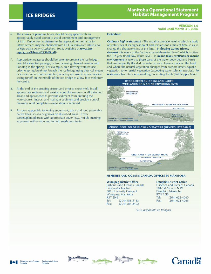
Manitoba Operational StatementHabitat Management ProgramICE BRIDGES
VERSION 1.0Valid until March 31, 2006
6. The intakes of pumping hoses should be equipped with anappropriately sized screen to avoid entrainment and impingementof fish. Guidelines to determine the appropriate mesh size forintake screens may be obtained from DFO (Freshwater Intake End-of-Pipe Fish Screen Guidelines, 1995, available at www.dfo-mpo.gc.ca/Library/223669.pdf).
7. Appropriate measures should be taken to prevent the ice bridgefrom blocking fish passage, or from causing channel erosion andflooding in the spring. For example, on a flowing watercourse,prior to spring break-up, breach the ice bridge using physical meansor create one or more v-notches, of adequate size to accommodatespring runoff, in the middle of the ice bridge to allow it to melt fromthe centre.
8. At the end of the crossing season and prior to snow-melt, installappropriate sediment and erosion control measures on all disturbedareas and approaches to prevent sediment from entering thewatercourse. Inspect and maintain sediment and erosion controlmeasures until complete re-vegetation is achieved.
9. As soon as possible following snow-melt, plant and seed preferablynative trees, shrubs or grasses on disturbed areas. Coverseeded/planted areas with appropriate cover (e.g., mulch, matting)to prevent soil erosion and to help seeds germinate.
Definition:
Ordinary high water mark - The usual or average level to which a bodyof water rises at its highest point and remains for sufficient time so as tochange the characteristics of the land. In flowing waters (rivers,streams) this refers to the "active channel/bank-full level" which is oftenthe 1:2 year flood flow return level. In inland lakes, wetlands or marineenvironments it refers to those parts of the water body bed and banksthat are frequently flooded by water so as to leave a mark on the landand where the natural vegetation changes from predominately aquaticvegetation to terrestrial vegetation (excepting water tolerant species). Forreservoirs this refers to normal high operating levels (Full Supply Level).
TERRESTRIALVEGETATION
ORDINARY HIGH WATER MARK
ORDINARY HIGH WATER MARK
TERRESTRIALVEGETATION
BANK
BANK
Habitat Management ProgramFisheries and Oceans Canada, 2005
Habitat Management ProgramFisheries and Oceans Canada, 2005
AQUATICVEGETATION
BED
BED
(ACTIVE CHANNEL/BANK-FULL)
WATER LEVEL
WATER LEVEL
CROSS-SECTION OF INLAND LAKES, WETLANDS OR MARINE ENVIRONMENTS
CROSS-SECTION OF FLOWING WATERS (RIVERS, STREAMS)
FISHERIES AND OCEANS CANADA OFFICES IN MANITOBA
Winnipeg District Office Dauphin District OfficeFisheries and Oceans Canada Fisheries and Oceans CanadaFreshwater Institute 101-1st Avenue N.W.501 University Crescent Dauphin, ManitobaWinnipeg, Manitoba R7N 1G8R3T 2N6 Tel: (204) 622-4060Tel: (204) 983-5163 Fax: (204) 622-4066Fax: (204) 984-2402
Aussi disponible en français.
Manitoba Operational StatementHabitat Management ProgramISOLATED PONDS
VERSION 1.0Valid until March 31, 2006
In this Operational Statement, isolated ponds include only thoseponds that are constructed to capture and store runoff water fromsnow-melt and heavy rainfall events for irrigation, livestock watering,golf courses or aesthetic purposes. This Operational Statement doesnot apply to aggregate extraction pits or quarries. Isolated ponds arecompletely separate from any watercourse and typically have little tono impact on fish or fish habitat. They do, however, present a risk ofspreading invasive aquatic species and/or diseases if they are locatedwithin a floodplain and new species are introduced into them; andthey can potentially alter groundwater flow and warm thegroundwater temperature. Groundwater flow and temperaturechanges are of particular concern in relation to coldwater streams.
Although fish habitat occurs throughout a water system, it is theriparian habitat that is most sensitive to isolated pond construction.Riparian vegetation occurs adjacent to the water body and directlycontributes to fish habitat by providing shade, cover and spawningand food production areas. It is important to design your isolatedpond to meet your needs while also protecting riparian areas.
Fisheries and Oceans Canada (DFO) is responsible for protecting fishand fish habitat across Canada. Under Section 35 of the FisheriesAct no one may carry out a work or undertaking that will cause theharmful alteration, disruption or destruction (HADD) of fish habitatunless it has been authorized by DFO. By following the conditionsand measures set out below you will be in compliance withSubsection 35(1) of the Fisheries Act.
The purpose of this Operational Statement is to describe theconditions under which it is applicable to your project and themeasures to be incorporated into the design, construction, andmaintenance of your Isolated Pond project in order to avoid negativeimpacts to fish habitat. You may proceed with the construction ofan Isolated Pond without a DFO review when you meet thefollowing conditions:
there is no inlet and/or outlet channel connecting the isolatedpond to the main channel of a watercourse,the pond is located at least 30 metres away from the ordinaryhigh water mark of a watercourse (see definition below),if located adjacent to a coldwater stream, the pond will notalter ordinary groundwater flow patterns (in either quantity ortemperature), and you incorporate the Measures to Protect Fish and Fish Habitatwhen Constructing an Isolated Pond listed below.
If you cannot meet all of the conditions listed above and cannotincorporate all of the measures listed below then your project mayresult in a violation of Subsection 35(1) of the Fisheries Act and youcould be subject to enforcement action. In this case, you shouldcontact the DFO office in your area (see Manitoba DFO office list) ifyou wish to obtain DFO's opinion on the possible options youshould consider to avoid contravention of the Fisheries Act.
This Operational Statement does not release you from theresponsibility of obtaining any other permits or approvals that maybe required under municipal, provincial and federal legislation (e.g.,with respect to activities in a floodplain, water-taking or capture,and the introduction of new species to the pond) that apply to thework being carried out in relation to this Operational Statement.
We ask that you notify DFO, preferably 10 working days beforestarting your work, by filling out and sending in, by mail or by fax,the Manitoba notification form to the DFO office in your area. Thisinformation is requested in order to evaluate the effectiveness of thework carried out in relation to this Operational Statement.
Measures to Protect Fish and Fish Habitat whenConstructing an Isolated Pond
1. You may proceed with isolated pond construction at any time of theyear.
2. While this Operational Statement does not cover the clearing ofriparian vegetation, the removal of select plants may be necessary toaccommodate the pond. This removal should be kept to aminimum.
3. Machinery is to arrive on site in a clean condition and is to bemaintained free of fluid leaks.
3.1. Wash, refuel and service machinery and store fuel and othermaterials for the machinery away from the watercourse toprevent deleterious substances from entering the water.
3.2. Keep an emergency spill kit on site in case of fluid leaks orspills from machinery.
4. Stabilize any waste materials removed from the work site, above theordinary high water mark (see definition below), to prevent themfrom entering any watercourse. Spoil piles could be contained withsilt fence, flattened, covered with biodegradable mats or tarps,and/or planted with preferably native grass or shrubs.
5. Vegetate any disturbed areas by planting and seeding preferablynative trees, shrubs or grasses and cover such areas with mulch toprevent soil erosion and to help seeds germinate. If there isinsufficient time in the growing season remaining for the seeds togerminate, stabilize the site (e.g., cover exposed areas with erosioncontrol blankets to keep the soil in place and prevent erosion) andthen vegetate the following spring.
6. Maintain effective sediment and erosion control measures untilcomplete re-vegetation of disturbed areas is achieved.
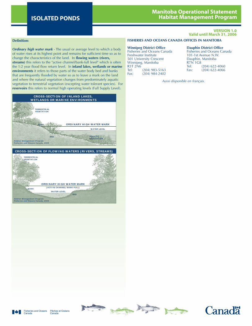
Manitoba Operational StatementHabitat Management ProgramISOLATED PONDS
VERSION 1.0Valid until March 31, 2006
Definition:
Ordinary high water mark - The usual or average level to which a bodyof water rises at its highest point and remains for sufficient time so as tochange the characteristics of the land. In flowing waters (rivers,streams) this refers to the "active channel/bank-full level" which is oftenthe 1:2 year flood flow return level. In inland lakes, wetlands or marineenvironments it refers to those parts of the water body bed and banksthat are frequently flooded by water so as to leave a mark on the landand where the natural vegetation changes from predominately aquaticvegetation to terrestrial vegetation (excepting water tolerant species). Forreservoirs this refers to normal high operating levels (Full Supply Level).
TERRESTRIALVEGETATION
ORDINARY HIGH WATER MARK
ORDINARY HIGH WATER MARK
TERRESTRIALVEGETATION
BANK
BANK
Habitat Management ProgramFisheries and Oceans Canada, 2005
Habitat Management ProgramFisheries and Oceans Canada, 2005
AQUATICVEGETATION
BED
BED
(ACTIVE CHANNEL/BANK-FULL)
WATER LEVEL
WATER LEVEL
CROSS-SECTION OF INLAND LAKES, WETLANDS OR MARINE ENVIRONMENTS
CROSS-SECTION OF FLOWING WATERS (RIVERS, STREAMS)
FISHERIES AND OCEANS CANADA OFFICES IN MANITOBA
Winnipeg District Office Dauphin District OfficeFisheries and Oceans Canada Fisheries and Oceans CanadaFreshwater Institute 101-1st Avenue N.W.501 University Crescent Dauphin, ManitobaWinnipeg, Manitoba R7N 1G8R3T 2N6 Tel: (204) 622-4060Tel: (204) 983-5163 Fax: (204) 622-4066Fax: (204) 984-2402
Aussi disponible en français.
Manitoba Operational StatementHabitat Management ProgramOVERHEAD LINE
CONSTRUCTIONVERSION 1.0
Valid until March 31, 2006
Overhead lines are constructed for electrical or telecommunicationtransmission across many watercourses that range in size from smallstreams and ponds to large rivers, lakes and reservoirs.
Although fish habitat occurs throughout a water system, it is theriparian habitat that is most sensitive to overhead line construction.Riparian vegetation occurs adjacent to the watercourse and directlycontributes to fish habitat by providing shade, cover, and spawningand food production areas. It is important to design and build youroverhead line project to meet your needs while also protectingriparian areas.
Fisheries and Oceans Canada (DFO) is responsible for protecting fishand fish habitat across Canada. Under Section 35 of the FisheriesAct no one may carry out a work or undertaking that will cause theharmful alteration, disruption or destruction (HADD) of fish habitatunless it has been authorized by DFO. By following the conditionsand measures set out below you will be in compliance withSubsection 35(1) of the Fisheries Act.
The purpose of this Operational Statement is to describe theconditions under which it is applicable to your project and themeasures to be incorporated into the design and construction of yourOverhead Line project in order to avoid negative impacts to fishhabitat. You may proceed with your Overhead Line project withouta DFO review when you meet the following conditions:
construction and/or placement of any temporary or permanentstructures are not required (e.g. islands, poles, crib works, etc.)below the ordinary high water mark (see definition below), and you incorporate the Measures to Protect Fish and Fish Habitatwhen Constructing Overhead Lines listed below.
If you cannot meet all of the conditions listed above and cannotincorporate all of the measures listed below then your project mayresult in a violation of Subsection 35(1) of the Fisheries Act and youcould be subject to enforcement action. In this case, you shouldcontact the DFO office in your area (see Manitoba DFO office list) ifyou wish to obtain DFO's opinion on the possible options youshould consider to avoid contravention of the Fisheries Act.
This Operational Statement does not release you from theresponsibility of obtaining any other permits or approvals that maybe required under municipal, provincial and federal legislation (e.g.,the Navigable Waters Protection Act) that apply to the work beingcarried out in relation to this Operational Statement.
We ask that you notify DFO, preferably 10 working days beforestarting your work, by filling out and sending in, by mail or by fax,the Manitoba notification form to the DFO office in your area. Thisinformation is requested in order to evaluate the effectiveness of thework carried out in relation to this Operational Statement.
Measures to Protect Fish and Fish Habitat whenConstructing Overhead Lines
1. Installing overhead lines under frozen conditions is preferable in allsituations in order to minimize impacts to substrate, riparianvegetation and aquatic habitat. On wet terrain (e.g., bogs), linesshould be installed under frozen conditions, where possible, orusing aerial methods (i.e., helicopter).
2. Machinery fording the watercourse to bring equipment required forconstruction to the opposite side of the watercourse should belimited to a one-time event (over and back). If the stream bed andbanks are highly erodible (e.g., dominated by organic materials andsilts) and significant erosion and degradation is likely to occur as aresult of equipment fording, then a temporary crossing structure orother practices are to be used to protect these areas. Forinformation, consult the Manitoba Stream Crossing Guidelines forthe Protection of Fish and Fish Habitat (Manitoba Natural Resourcesand DFO, 1996).
2.1. Time the machinery crossing to prevent disruption tospawning fish, their incubating eggs and larval life stages.Adhere to provincial fisheries timing windows (see theattached Manitoba In-Water Construction Timing Windows).
3. Operate machinery from outside of the water and in a manner thatminimizes disturbance to the banks of the watercourse.
3.1. Machinery is to arrive on site in a clean condition and is to bemaintained free of fluid leaks.
3.2. Wash, refuel and service machinery and store fuel and othermaterials for the machinery away from the water to preventdeleterious substances from entering the water.
3.3. Keep an emergency spill kit on site in case of fluid leaks orspills from machinery.
4. Install effective sediment and erosion control measures beforestarting work to prevent entry of sediment into the watercourse.Inspect them regularly during the course of construction and untilre-vegetation of disturbed areas is complete, and make all necessaryrepairs.
4.1. Avoid work during wet, rainy conditions, or use aerialmethods (i.e., helicopter) to install overhead lines.
5. While this Operational Statement does not cover the clearing ofriparian vegetation, the removal of select plants may be necessary toaccommodate the overhead line. This removal should be kept to aminimum and should not be wider than the right-of-way.
6. Stabilize any waste materials removed from the work site, above theordinary high water mark (see definition below), to prevent themfrom entering any watercourse. Spoil piles could be contained withsilt fence, flattened, covered with biodegradable mats or tarps,and/or planted with preferably native grass or shrubs.
7. Vegetate any disturbed areas by planting and seeding preferablynative trees, shrubs or grasses and cover such areas with mulch toprevent soil erosion and to help seeds germinate. If there isinsufficient time in the growing season remaining for the seeds to
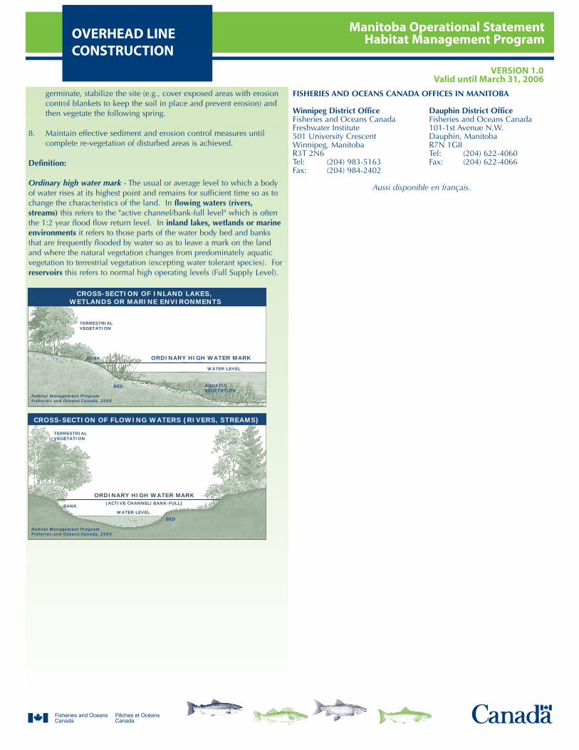
Manitoba Operational StatementHabitat Management ProgramOVERHEAD LINE
CONSTRUCTIONVERSION 1.0
Valid until March 31, 2006
germinate, stabilize the site (e.g., cover exposed areas with erosioncontrol blankets to keep the soil in place and prevent erosion) andthen vegetate the following spring.
8. Maintain effective sediment and erosion control measures untilcomplete re-vegetation of disturbed areas is achieved.
Definition:
Ordinary high water mark - The usual or average level to which a bodyof water rises at its highest point and remains for sufficient time so as tochange the characteristics of the land. In flowing waters (rivers,streams) this refers to the "active channel/bank-full level" which is oftenthe 1:2 year flood flow return level. In inland lakes, wetlands or marineenvironments it refers to those parts of the water body bed and banksthat are frequently flooded by water so as to leave a mark on the landand where the natural vegetation changes from predominately aquaticvegetation to terrestrial vegetation (excepting water tolerant species). Forreservoirs this refers to normal high operating levels (Full Supply Level).
TERRESTRIALVEGETATION
ORDINARY HIGH WATER MARK
ORDINARY HIGH WATER MARK
TERRESTRIALVEGETATION
BANK
BANK
Habitat Management ProgramFisheries and Oceans Canada, 2005
Habitat Management ProgramFisheries and Oceans Canada, 2005
AQUATICVEGETATION
BED
BED
(ACTIVE CHANNEL/BANK-FULL)
WATER LEVEL
WATER LEVEL
CROSS-SECTION OF INLAND LAKES, WETLANDS OR MARINE ENVIRONMENTS
CROSS-SECTION OF FLOWING WATERS (RIVERS, STREAMS)
FISHERIES AND OCEANS CANADA OFFICES IN MANITOBA
Winnipeg District Office Dauphin District OfficeFisheries and Oceans Canada Fisheries and Oceans CanadaFreshwater Institute 101-1st Avenue N.W.501 University Crescent Dauphin, ManitobaWinnipeg, Manitoba R7N 1G8R3T 2N6 Tel: (204) 622-4060Tel: (204) 983-5163 Fax: (204) 622-4066Fax: (204) 984-2402
Aussi disponible en français.
Manitoba Operational StatementHabitat Management Program
ROUTINEMAINTENANCEDREDGING
VERSION 1.0Valid until March 31, 2006
This Operational Statement deals with routine maintenance dredgingassociated with the removal of accumulated sediment from channelbeds to maintain the design depths of existing public use facilitiessuch as navigation channels, harbours, marinas, boat launches andport facilities. It does not include clean-out of channels for otherpurposes, such as agricultural drains or water intake installationand/or maintenance. Routine maintenance dredging is defined asdredging that has been conducted regularly (at least once within theprevious 5 years) and does not include any expansion of thepreviously dredged area. Dredging is typically conducted bymechanical methods such as clam buckets, draglines or backhoes.The largest threat to fish and fish habitat is from the increasedamount of suspended sediment introduced to the water columnduring the dredging process.
Fisheries and Oceans Canada (DFO) is responsible for protecting fishand fish habitat across Canada. Under Section 35 of the FisheriesAct no one may carry out a work or undertaking that will cause theharmful alteration, disruption or destruction (HADD) of fish habitatunless it has been authorized by DFO. By following the conditionsand measures set out below you will be in compliance withSubsection 35(1) of the Fisheries Act.
The purpose of this Operational Statement is to describe theconditions under which it is applicable to your project and themeasures to be incorporated into your Routine MaintenanceDredging project in order to avoid negative impacts to fish habitat.You may proceed with your Routine Maintenance Dredging projectwithout a DFO review when you meet the following conditions:
the site has been routinely dredged (at least once within theprevious 5 years), is in accordance with the results of aprevious government review and no expansion of the dredgedarea occurs,dredging of contaminated sediment does not occur,hydraulic methods such as propeller washing are not used(suction dredging is acceptable),the dredged material will not be used to infill the shoreline oradjacent wetlands, and you incorporate the Measures to Protect Fish and Fish Habitatwhen doing Routine Maintenance Dredging listed below.
If you cannot meet all of the conditions listed above and cannotincorporate all of the measures listed below then your project mayresult in a violation of Subsection 35(1) of the Fisheries Act and youcould be subject to enforcement action. In this case, you shouldcontact the DFO office in your area (see Manitoba DFO office list) ifyou wish to obtain DFO's opinion on the possible options youshould consider to avoid contravention of the Fisheries Act.
This Operational Statement does not release you from theresponsibility of obtaining any other permits or approvals that maybe required under municipal, provincial and federal legislation (e.g.,the Navigable Waters Protection Act) that apply to the work beingcarried out in relation to this Operational Statement.
We ask that you notify DFO, preferably 10 working days beforestarting your work, by filling out and sending in, by mail or by fax,the Manitoba notification form to the DFO office in your area. This
information is requested in order to evaluate the effectiveness of thework carried out in relation to this Operational Statement.
Measures to Protect Fish and Fish Habitat when doingRoutine Maintenance Dredging
1. Time routine maintenance dredging to protect spawning fish, theirincubating eggs and larval life stages. Adhere to provincial fisheriestiming windows (see the attached Manitoba In-Water ConstructionTiming Windows). Where possible, dredging should occur underwinter conditions when the area to be dredged is frozen to thebottom or when the area to be dredged is dry.
2. Isolate the work area using appropriate measures (e.g., silt curtains,etc.) to prevent re-suspended sediment from spreading to adjacentareas. Inspect isolation measures regularly and make all necessaryrepairs. Once dredging is completed, allow sufficient time topermit sediment to settle out and the water to be as clear inside theisolated area as outside the isolated area before removing sedimentcontrol measures.
3. Dredge on calm days to minimize the suspension of fine sedimentparticles into the water column and to ensure the sediment controlmeasures are not disturbed by wave action.
4. Minimize the amount of dredged material removed by onlydredging the area and depth required for navigation.
5. Remove all dredged material to a location outside of the ordinaryhigh water mark (see definition below) of any water body.
6. Operate machinery in a manner that minimizes disturbance to thebanks or bed of the water body.
6.1. Machinery is to arrive on site in a clean condition and is to bemaintained free of fluid leaks.
6.2. Wash, refuel and service machinery and store fuel and othermaterials for the machinery away from the water to preventdeleterious substances from entering the water.
6.3. Keep an emergency spill kit on site in case of fluid leaks orspills from machinery.
7. While this Operational Statement does not cover the clearing ofriparian vegetation, the removal of select plants may be necessary toaccess the dredged area. This removal should be kept to aminimum.
8. Stabilize any waste materials removed from the work site, above theordinary high water mark (see definition below), to prevent themfrom entering any watercourse. Spoil piles could be contained withsilt fence, flattened, covered with biodegradable mats or tarps,and/or planted with preferably native grass or shrubs.
9. Vegetate any disturbed areas by planting and seeding preferablynative trees, shrubs or grasses and cover such areas with mulch toprevent soil erosion and to help seeds germinate. If there isinsufficient time in the growing season remaining for the seeds togerminate, stabilize the site (e.g., cover exposed areas with erosioncontrol blankets to keep the soil in place and prevent erosion) andthen vegetate the following spring.
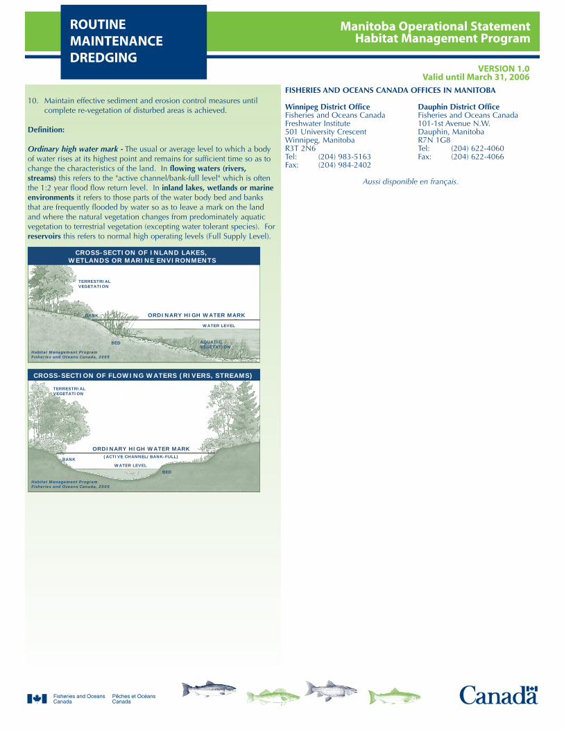
Manitoba Operational StatementHabitat Management Program
ROUTINEMAINTENANCEDREDGING
VERSION 1.0Valid until March 31, 2006
10. Maintain effective sediment and erosion control measures untilcomplete re-vegetation of disturbed areas is achieved.
Definition:
Ordinary high water mark - The usual or average level to which a bodyof water rises at its highest point and remains for sufficient time so as tochange the characteristics of the land. In flowing waters (rivers,streams) this refers to the "active channel/bank-full level" which is oftenthe 1:2 year flood flow return level. In inland lakes, wetlands or marineenvironments it refers to those parts of the water body bed and banksthat are frequently flooded by water so as to leave a mark on the landand where the natural vegetation changes from predominately aquaticvegetation to terrestrial vegetation (excepting water tolerant species). Forreservoirs this refers to normal high operating levels (Full Supply Level).
TERRESTRIALVEGETATION
ORDINARY HIGH WATER MARK
ORDINARY HIGH WATER MARK
TERRESTRIALVEGETATION
BANK
BANK
Habitat Management ProgramFisheries and Oceans Canada, 2005
Habitat Management ProgramFisheries and Oceans Canada, 2005
AQUATICVEGETATION
BED
BED
(ACTIVE CHANNEL/BANK-FULL)
WATER LEVEL
WATER LEVEL
CROSS-SECTION OF INLAND LAKES, WETLANDS OR MARINE ENVIRONMENTS
CROSS-SECTION OF FLOWING WATERS (RIVERS, STREAMS)
FISHERIES AND OCEANS CANADA OFFICES IN MANITOBA
Winnipeg District Office Dauphin District OfficeFisheries and Oceans Canada Fisheries and Oceans CanadaFreshwater Institute 101-1st Avenue N.W.501 University Crescent Dauphin, ManitobaWinnipeg, Manitoba R7N 1G8R3T 2N6 Tel: (204) 622-4060Tel: (204) 983-5163 Fax: (204) 622-4066Fax: (204) 984-2402
Aussi disponible en français.
Manitoba Operational StatementHabitat Management ProgramUNDERWATER
CABLESVERSION 1.0
Valid until March 31, 2006
The placement of cables on the beds of freshwater lakes and rivers isa common practice used to deliver utility services (i.e., electricityand telephone) across water bodies when overhead lines are notfeasible. The placement of underwater cables is more favourablethan using unconfined open trench methods, which bury the cableswithin the substrate of the lake or river. Placing cables on the bedsof freshwater lakes or rivers typically generates less sediment andavoids the need to use machinery in the water. In some instances,however, cables may need to be buried near to the shoreline foroperational safety reasons.
Fisheries and Oceans Canada (DFO) is responsible for protecting fishand fish habitat across Canada. Under Section 35 of the FisheriesAct no one may carry out a work or undertaking that will cause theharmful alteration, disruption or destruction (HADD) of fish habitatunless it has been authorized by DFO. By following the conditionsand measures set out below you will be in compliance withSubsection 35(1) of the Fisheries Act.
The purpose of this Operational Statement is to describe theconditions under which it is applicable to your project and themeasures to be incorporated into your Underwater Cable project inorder to avoid negative impacts to fish habitat. You may proceedwith your Underwater Cable project without a DFO review whenyou meet the following conditions:
unconfined open trench methods, including ploughing andwater-jetting, to bury cables are not used,underwater cables are not installed on or within known fishspawning habitat,cable trenching is limited to near shore areas and is to be nogreater in width than that required to accommodate the cable,any near shore excavation to bury the cable extends amaximum total of 10 meters below the ordinary high watermark (see definition below), but in no case will involve morethan 10% of a stream channel width (in total),explosives are not used to install the cable, andyou incorporate the Measures to Protect Fish and Fish Habitatwhen Placing Underwater Cables listed below.
If you cannot meet all of the conditions listed above and cannotincorporate all of the measures listed below then your project mayresult in a violation of Subsection 35(1) of the Fisheries Act and youcould be subject to enforcement action. In this case, you shouldcontact the DFO office in your area (see Manitoba DFO office list) ifyou wish to obtain DFO's opinion on the possible options youshould consider to avoid contravention of the Fisheries Act.
This Operational Statement does not release you from theresponsibility of obtaining any other permits or approvals that maybe required under municipal, provincial and federal legislation (e.g.,the Navigable Waters Protection Act) that apply to the work beingcarried out in relation to this Operational Statement.
We ask that you notify DFO, preferably 10 working days beforestarting your work, by filling out and sending in, by mail or by fax,the Manitoba notification form to the DFO office in your area. Thisinformation is requested in order to evaluate the effectiveness of thework carried out in relation to this Operational Statement.
Measures to Protect Fish and Habitat when PlacingUnderwater Cables
1. Subject to the conditions noted above, if necessary for safety and toprotect cables against ice scour, underwater cables may be buriednear shore. Whether the area is dry or wetted at the time ofconstruction, these measures are to be followed:
1.1. Time near shore isolated trench construction to protectspawning fish, their incubating eggs and larval life stages.Adhere to provincial fisheries timing windows (see theattached Manitoba In-Water Construction Timing Windows).
1.2. Install and maintain effective sediment control measures (e.g.,silt curtain) around the area to be trenched before, during andafter trenching to prevent re-suspended sediment fromspreading to adjacent areas. Inspect sediment controlmeasures regularly and make all necessary repairs if anydamage or leakage is discovered. Once trenching and cableinstallation is complete, allow sufficient time to permitsediment to settle out and the water to be as clear inside theisolated area as outside the isolated area before removingsediment control measures.
1.3. Any fish trapped within an enclosed area are to be safelyrelocated outside of the enclosed area to the main water body.
1.4. Any rock, cobble or gravel on the bed that is moved tofacilitate placement of the cable on the bottom of the waterbody is to be kept as close as possible to its original location.
1.5. Any covering of cables with rock should be carried out usinghand tools,
1.6. Any material that is temporarily removed from the bank of thewater body (below the ordinary high water mark) during thedry land trenching is to be stockpiled separately and returnedto its original location after the cable has been installed.
1.7. After excavation, restore the original contour, gradient andsubstrate of the water body bank, shore and bed prior toremoving isolation measures.
2. Operate machinery from outside of the water in a manner thatminimizes disturbance to the banks or bed of the water body.
2.1. Machinery is to arrive on site in a clean condition and is to bemaintained free of fluid leaks.
2.2. Wash, refuel and service machinery and store fuel and othermaterials for the machinery away from the water to preventdeleterious substances from entering the water.
2.3. Keep an emergency spill kit on site in case of fluid leaks orspills from machinery.
3. Stabilize any waste materials removed from the work site, above theordinary high water mark (see definition below), to prevent themfrom entering any watercourse. Spoil piles could be contained withsilt fence, flattened, covered with biodegradable mats or tarps,and/or planted with preferably native grass or shrubs.
4. While this Operational Statement does not cover the extensiveclearing of shoreline vegetation, the removal of select plants may benecessary to accommodate the cable. This removal should be keptto a minimum.
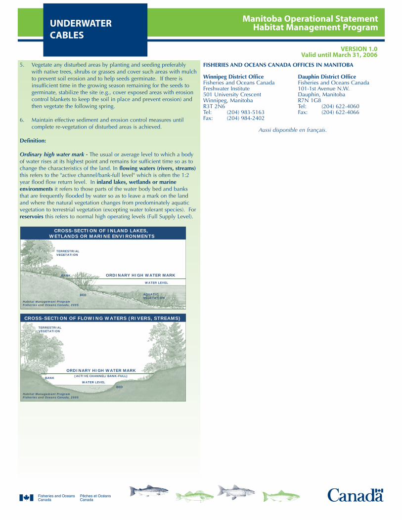
Manitoba Operational StatementHabitat Management ProgramUNDERWATER
CABLESVERSION 1.0
Valid until March 31, 2006
5. Vegetate any disturbed areas by planting and seeding preferablywith native trees, shrubs or grasses and cover such areas with mulchto prevent soil erosion and to help seeds germinate. If there isinsufficient time in the growing season remaining for the seeds togerminate, stabilize the site (e.g., cover exposed areas with erosioncontrol blankets to keep the soil in place and prevent erosion) andthen vegetate the following spring.
6. Maintain effective sediment and erosion control measures untilcomplete re-vegetation of disturbed areas is achieved.
Definition:
Ordinary high water mark - The usual or average level to which a bodyof water rises at its highest point and remains for sufficient time so as tochange the characteristics of the land. In flowing waters (rivers, streams)this refers to the "active channel/bank-full level" which is often the 1:2year flood flow return level. In inland lakes, wetlands or marineenvironments it refers to those parts of the water body bed and banksthat are frequently flooded by water so as to leave a mark on the landand where the natural vegetation changes from predominately aquaticvegetation to terrestrial vegetation (excepting water tolerant species). Forreservoirs this refers to normal high operating levels (Full Supply Level).
TERRESTRIALVEGETATION
ORDINARY HIGH WATER MARK
ORDINARY HIGH WATER MARK
TERRESTRIALVEGETATION
BANK
BANK
Habitat Management ProgramFisheries and Oceans Canada, 2005
Habitat Management ProgramFisheries and Oceans Canada, 2005
AQUATICVEGETATION
BED
BED
(ACTIVE CHANNEL/BANK-FULL)
WATER LEVEL
WATER LEVEL
CROSS-SECTION OF INLAND LAKES, WETLANDS OR MARINE ENVIRONMENTS
CROSS-SECTION OF FLOWING WATERS (RIVERS, STREAMS)
FISHERIES AND OCEANS CANADA OFFICES IN MANITOBA
Winnipeg District Office Dauphin District OfficeFisheries and Oceans Canada Fisheries and Oceans CanadaFreshwater Institute 101-1st Avenue N.W.501 University Crescent Dauphin, ManitobaWinnipeg, Manitoba R7N 1G8R3T 2N6 Tel: (204) 622-4060Tel: (204) 983-5163 Fax: (204) 622-4066Fax: (204) 984-2402
Aussi disponible en français.

Manitoba Operational StatementHabitat Management ProgramTIMING WINDOWS
VERSION 1.0Valid until March 31, 2006
MANITOBA IN-WATER CONSTRUCTION TIMINGWINDOWS FOR THE PROTECTION OF FISH AND
FISH HABITAT
Restricted activity timing windows have been identified for Manitobalakes and streams to protect fish during spawning and incubationperiods when spawning fish, eggs and fry are vulnerable todisturbance or sediment. During these spawning periods, no in-wateror shoreline work is allowed except under site- or project-specificreview and with the implementation of protective measures.Restricted activity periods are determined on a case by case basisaccording to the species of fish in the water body, whether those fishspawn in the spring, summer or fall, and whether the water body islocated in Northern or Southern Manitoba.
Timing windows are just one of many measures used to protect fishand fish habitat when carrying out a work or undertaking in oraround water. Be sure to follow all of the measures outlined in theOperational Statements to avoid negative impacts to fish habitat.
Figure 1: Southern and Northern Manitoba boundaries for spawning timing windows.
How To Determine Timing Windows
1. Determine the fish species living in the water body where you wishto do work. Consult the Province of Manitoba Angling Map(available from the Government of Manitoba map sales) whichdetails the fish present in most Manitoba lakes and streams, orcontact your local Fisheries and Oceans Canada (DFO) office.Pictures of most of these fish species can be found in the ManitobaAngler's Guide (sport fishing regulations).
2. Determine if the fish living in the water body spawn in the spring,summer, or fall according to Table 1. You can have one, two or allthree fish spawning types in one water body. In Manitoba,essentially all lakes and streams contain one or more of the springspawning fish listed, however far fewer contain summer or fallspawning fish.
3. Determine if the water body is located in Northern or SouthernManitoba according to Figure 1.
4. Use Table 2 to determine the in-water work timing restrictionsaccording to the location of a water body (North or South) and thetype of fish found within (spring, summer of fall spawners). Duringthese periods no in-water work (below the ordinary high watermark) is to occur without site- or project-specific review by DFO.
Table 1: Common spring, summer and fall spawning fish
Table 2: Timing Windows when no in-water work is to occur in order toprotect spawning fish and developing eggs and fry
* Carmine Shiner - This is a Species At Risk found only in SouthernManitoba in the Whitemouth River and its tributaries, the Bird River andits tributaries and the Pinawa Channel. This fish spawns from May 15 toJuly 15 and this extended summer spawning timing window should beapplied to those water bodies where it is found.
SpringSpawning Fish
SummerSpawning Fish
FallSpawning Fish
Northern PikeWalleye, SaugerYellow PerchSuckersSmallmouth BassArctic Grayling
Channel CatfishLake SturgeonGoldeye, MooneyeWhite BassFreshwater DrumCarmine Shiner*
Brook TroutLake TroutArctic CharLake Whitefish
SpringSpawning Fish
SummerSpawning Fish
FallSpawning Fish
NorthernManitoba
April 15 -June 30
May 15 - July 15
September 1 -May 15
SouthernManitoba
April 1 - June 15
May 1 - June 30*
September 15 -April 30
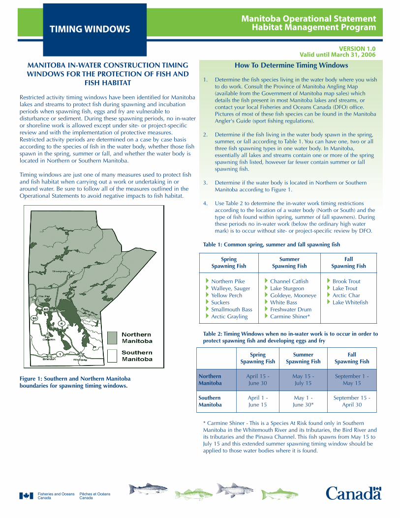
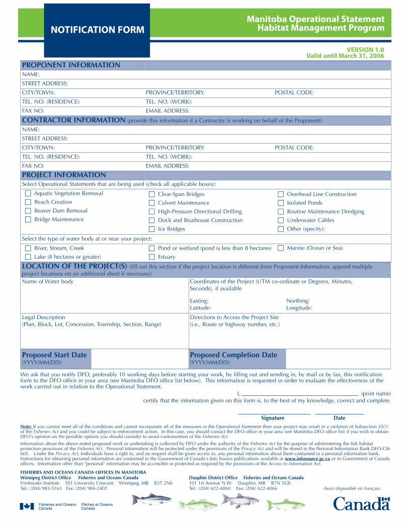
Manitoba Operational StatementHabitat Management ProgramNOTIFICATION FORM
VERSION 1.0Valid until March 31, 2006
PROPONENT INFORMATIONNAME:
STREET ADDRESS:
CITY/TOWN: PROVINCE/TERRITORY: POSTAL CODE:
TEL. NO. (RESIDENCE): TEL. NO. (WORK):
FAX NO: EMAIL ADDRESS:
CONTRACTOR INFORMATION (provide this information if a Contractor is working on behalf of the Proponent)
NAME:
STREET ADDRESS:
CITY/TOWN: PROVINCE/TERRITORY: POSTAL CODE:
TEL. NO. (RESIDENCE): TEL. NO. (WORK):
FAX NO: EMAIL ADDRESS:
PROJECT INFORMATIONSelect Operational Statements that are being used (check all applicable boxes):
Aquatic Vegetation Removal
Beach Creation
Beaver Dam Removal
Bridge Maintenance
Clear-Span Bridges
Culvert Maintenance
High-Pressure Directional Drilling
Dock and Boathouse Construction
Ice Bridges
Overhead Line Construction
Isolated Ponds
Routine Maintenance Dredging
Underwater Cables
Other (specify):
Select the type of water body at or near your project:
River, Stream, Creek
Lake (8 hectares or greater)
Pond or wetland (pond is less than 8 hectares)
Estuary
Marine (Ocean or Sea)
LOCATION OF THE PROJECT(S) (fill out this section if the project location is different from Proponent Information; append multipleproject locations on an additional sheet if necessary)Name of Water body Coordinates of the Project (UTM co-ordinate or Degrees, Minutes,
Seconds), if available
Easting: Northing:Latitude: Longitude:
Legal Description (Plan, Block, Lot, Concession, Township, Section, Range)
Directions to Access the Project Site(i.e., Route or highway number, etc.)
Proposed Start Date(YYYY/MM/DD):
Proposed Completion Date(YYYY/MM/DD):
We ask that you notify DFO, preferably 10 working days before starting your work, by filling out and sending in, by mail or by fax, this notificationform to the DFO office in your area (see Manitoba DFO office list below). This information is requested in order to evaluate the effectiveness of thework carried out in relation to the Operational Statement.
I, (print name) certify that the information given on this form is, to the best of my knowledge, correct and complete.
Signature DateNote: If you cannot meet all of the conditions and cannot incorporate all of the measures in the Operational Statement then your project may result in a violation of Subsection 35(1)of the Fisheries Act and you could be subject to enforcement action. In this case, you should contact the DFO office in your area (see Manitoba DFO office list) if you wish to obtainDFO's opinion on the possible options you should consider to avoid contravention of the Fisheries Act.
Information about the above-noted proposed work or undertaking is collected by DFO under the authority of the Fisheries Act for the purpose of administering the fish habitatprotection provisions of the Fisheries Act. Personal information will be protected under the provisions of the Privacy Act and will be stored in the Personal Information Bank DFO-CSI-605. Under the Privacy Act, Individuals have a right to, and on request shall be given access to, any personal information about them contained in a personal information bank.Instructions for obtaining personal information are contained in the Government of Canada's Info Source publications available at www.infosource.gc.ca or in Government of Canadaoffices. Information other than "personal" information may be accessible or protected as required by the provisions of the Access to Information Act.
FISHERIES AND OCEANS CANADA OFFICES IN MANITOBAWinnipeg District Office Fisheries and Oceans Canada Dauphin District Office Fisheries and Oceans CanadaFreshwater Institute 501 University Crescent Winnipeg, MB R3T 2N6 101 1st Avenue N.W. Dauphin, MB R7N 1G8Tel.: (204) 983-5163 Fax: (204) 984-2402 Tel.: (204) 622-4060 Fax: (204) 622-4066 Aussi disponible en français.
City of Winnipeg
Best Practices Handbook for Activities In and Around the City’s Waterways and Watercourses
Protocols Under Development
For Activities In and Around the City’s Waterways and Watercourses
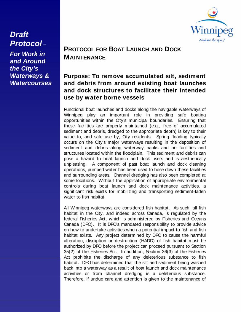
Draft
Protocol –
For Work in and Around the City’s Waterways & Watercourses
PROTOCOL FOR BOAT LAUNCH AND DOCK MAINTENANCE Purpose: To remove accumulated silt, sediment and debris from around existing boat launches and dock structures to facilitate their intended use by water borne vessels Functional boat launches and docks along the navigable waterways of Winnipeg play an important role in providing safe boating opportunities within the City’s municipal boundaries. Ensuring that these facilities are properly maintained (e.g., free of accumulated sediment and debris, dredged to the appropriate depth) is key to their value to, and safe use by, City residents. Spring flooding typically occurs on the City’s major waterways resulting in the deposition of sediment and debris along waterway banks and on facilities and structures located within the floodplain. This sediment and debris can pose a hazard to boat launch and dock users and is aesthetically unpleasing. A component of past boat launch and dock cleaning operations, pumped water has been used to hose down these facilities and surrounding areas. Channel dredging has also been completed at some locations. Without the application of appropriate environmental controls during boat launch and dock maintenance activities, a significant risk exists for mobilizing and transporting sediment-laden water to fish habitat. All Winnipeg waterways are considered fish habitat. As such, all fish habitat in the City, and indeed across Canada, is regulated by the federal Fisheries Act, which is administered by Fisheries and Oceans Canada (DFO). It is DFO’s mandated responsibility to provide advice on how to undertake activities when a potential impact to fish and fish habitat exists. Any project determined by DFO to cause the harmful alteration, disruption or destruction (HADD) of fish habitat must be authorized by DFO before the project can proceed pursuant to Section 35(2) of the Fisheries Act. In addition, Section 36(3) of the Fisheries Act prohibits the discharge of any deleterious substance to fish habitat. DFO has determined that the silt and sediment being washed back into a waterway as a result of boat launch and dock maintenance activities or from channel dredging is a deleterious substance. Therefore, if undue care and attention is given to the maintenance of
these facilities there is a strong possibility that silt and sediment could be discharged to fish habitat in contravention of the Act. This protocol provides the necessary BMPs and mitigation measures to avoid the HADD of fish habitat and to minimize the release of sediment-laden water to fish habitat during activities related to boat launch and dock cleaning and maintenance. The protocol will also be useful when notifying DFO of proposed instream works. Standard Operating Procedures for Boat Launch and Dock Maintenance: 1. The DFO must be notified prior to the commencement of boat
launch and dock cleaning activities.
2. No silt, sediment or other deleterious substances may be deposited into waterways at any time. All sediment, debris and other accumulated material should be collected and removed to an approved disposal facility.
3. Appropriate precautions must be taken to ensure mechanical equipment is in good working order, properly maintained and that fuels, lubricants and/or other petroleum products are not deposited within 30 metres of the ordinary high water mark of the waterway.
4. All reasonable efforts must be made to first mechanically remove accumulated silt, sediment and debris from the boat launch or dock. After all reasonable efforts to mechanically remove these materials, power washing with river water is permitted. All pumps drawing water from a waterway must have an approved fish screen on the suction end of the pump hose (see DFO’s Freshwater Intake End-of-Pipe Fish Screen Guideline, 1995).
5. All existing rock, cobble, boulders and woody debris found within the wetted channel and along the river margins must not be removed from the site as they are considered fish habitat features and must be preserved. An exception to this procedure will be granted when the safety of boat launch and dock users and/or navigation on the waterway is compromised.
6. When dredging of an area of waterway is required, floating silt curtain or other appropriate sediment control device should be installed around the proposed dredge site to contain the downstream movement of suspended sediment. The silt curtain/sediment control device should only be removed when water contained within is deemed to be of acceptable quality for release.
Draft Protocol –
For Work in and Around the City’s Waterways & Watercourses
PROTOCOL FOR RIVER WALKWAY MAINTENANCE Purpose: To remove accumulated silt, sediment and debris from the City of Winnipeg river walkway system Winnipeg’s river walkways, paralleling the City’s major waterways, are a popular community attraction and recreational destination for Winnipeg residents and visitors during low water conditions. Spring flooding typically occurs on the City’s major waterways resulting in the deposition of sediment and debris along waterway banks and, due to their close proximity, on the river walkways themselves. This sediment and debris can pose a hazard to walkway users, is aesthetically unpleasing and may easily be transported to the waterway during ensuing rains. A component of past river walkway cleaning operations, pumped water has been used to hose down the walkway and surrounding areas. Without the application of appropriate environmental controls during walkway maintenance, a significant risk exists for mobilizing and transporting sediment-laden water to fish habitat. All Winnipeg waterways are considered fish habitat. As such, all fish habitat in the City, and indeed across Canada, is regulated by the federal Fisheries Act, which is administered by Fisheries and Oceans Canada (DFO). It is DFO’s mandated responsibility to provide advice on how to undertake activities when a potential to impact fish and fish habitat exists. Any project determined by DFO to cause the harmful alteration, disruption or destruction (HADD) of fish habitat must be authorized by DFO before the project can proceed pursuant to Section 35(2) of the Fisheries Act. In addition, Section 36(3) of the Fisheries Act prohibits the discharge of any deleterious substance to fish habitat. DFO has determined that the silt and sediment being washed back into a waterway as a result of the river walkway cleaning is a deleterious substance. Therefore, if undue care and attention is given to river walkway maintenance, there is a strong possibility that silt and sediment could be discharged to fish habitat in contravention of the Act. This protocol provides the necessary BMP’s and mitigation measures to avoid the HADD of fish habitat and to minimize the release of sediment-laden water to fish habitat during activities related to river
walkway cleaning and maintenance. The protocol will also be useful when notifying DFO of proposed instream works. Standard Operating Procedures for River Walkway Maintenance: 1. A River Walk Cleanup Record of Activities sheet must be filled out
detailing the events of each day of cleaning as they occur (see attached).
2. The DFO must be notified prior to the commencement of walkway maintenance activities.
3. No silt, sediment or other deleterious substances may be deposited into waterways at any time. All debris and accumulated material on and along the walkway should be collected and removed to an approved disposal facility.
4. Before washing off a walkway or structure, a containment system must be set up downslope of the work area to collect any sediment-laden water generated by this activity. Sediment-laden water collected by the containment system must be filtered, retained or otherwise treated prior to discharge to a waterway.
5. Appropriate precautions must be taken to ensure mechanical equipment is in good working order, properly maintained and that fuels, lubricants and/or other petroleum products are not deposited within 30 metres of the ordinary high water mark of the waterway.
6. All pumps drawing water from a waterway must have an approved fish screen on the suction end of the pump hose (see DFO’s Freshwater Intake End-of-Pipe Fish Screen Guideline, 1995).
7. Potable water used for walkway washing purposes should not be allowed to directly enter a waterway without the appropriate application of a chlorine-neutralizing compound (e.g., sodium thiosulphate) or technique.
8. All existing rock, cobble, boulders and woody debris found along the river margins must not be removed from the site as they are considered fish habitat features and must be preserved.
Draft
Protocol –
For Work in and Around the City’s Waterways & Watercourses
PROTOCOL FOR FROZEN WATERWAYS MAINTENANCE ACTIVITIES AND PROGRAMS Purpose: To construct and maintain frozen waterway access ramps, trails and ice skating facilities Winnipeg’s frozen waterway trails, access ramps and ice-skating facilities are a popular community attraction for City residents and visitors during the winter months. While the Red River and other major waterways supporting winter trails and facilities may be frozen, it is still imperative that associated maintenance activities and programs take place in an environmentally responsible manner, utilizing appropriate best management practices (BMP’s) and mitigation measures in an effort to minimize impact to fish and fish habitat. All Winnipeg waterways are considered fish habitat. As such, all fish habitat in the City, and indeed across Canada, is regulated by the federal Fisheries Act which is administered by Fisheries and Oceans Canada (DFO). It is DFO’s mandated responsibility to provide advice on how to undertake activities when a potential impact to fish and fish habitat exists. Any project determined by DFO to cause the harmful alteration, disruption or destruction (HADD) of fish habitat must be authorized by DFO before the project can proceed pursuant to Section 35(2) of the Fisheries Act. In addition, Section 36(3) of the Fisheries Act prohibits the discharge of any deleterious substance to fish habitat. Constructing and maintaining a frozen waterway trail, access ramp and/or ice skating facility may appear relatively benign in light of the frozen nature of the waterway and surrounding environment. However pollutants, debris and materials deposited on or around a frozen waterway can find their way to the aquatic environment during spring melt. Because spring melt typically occurs over a relatively short time period, a “pulse” of accumulated deleterious and other substances (e.g., fuels, lubricants, sediment, paint) is released and can significantly deteriorate water quality and impact fish and fish habitat. Therefore, if undue care and attention is given to the maintenance of winter access ramps, trails and ice skating facilities,
there is a strong possibility that various deleterious substances could be discharged to fish habitat in contravention of the Act. This protocol provides the necessary BMPs and mitigation measures to avoid the HADD of fish habitat and to minimize the release of deleterious substances to fish habitat during construction and maintenance activities for frozen waterway access ramps, trails and ice skating facilities. Standard Operating Procedures for Frozen Waterways Maintenance Activities and Programs: 1. The DFO must be notified prior to the commencement of
construction and/or maintenance activities and/or programs on frozen waterways.
2. No silt, gravel, limestone or other deleterious substances may be deposited onto frozen waterways or riverbanks without notification to, and receipt of a Letter of Advice from, the DFO and authorization from a Waterway Engineer.
3. An application must be prepared and submitted to support the acquisition of a Frozen Waterway Bylaw Permit from the City of Winnipeg, Chief of Police. The application must be submitted at least 14 days prior to the proposed commencement of construction/maintenance activities. Construction/ maintenance activities must fully adhere to the terms and conditions stated on the permit.
4. A meeting with the City of Winnipeg, River Patrol Unit staff must be convened to determine when safe ice conditions exist to safely support desired maintenance equipment and public access.
5. Frozen waterways must not be accessed until written authority is granted by the Chief of Police in accordance with City of Winnipeg By-law #6581/95.
6. Equipment weights accessing frozen waterways must not exceed amounts stated on the Frozen Waterways By-law Permit.
7. Appropriate precautions must be taken to ensure mechanical equipment is in good working order, properly maintained and that fuels, lubricants and/or other petroleum products are not deposited within 30 metres of the normal high water mark of the waterway.
8. All fixtures and materials (rock, straw mulch and wood chips etc.) associated with the Frozen Waterways programs must be removed
when the River Patrol Unit advises that public access is no longer authorized due to deteriorating ice conditions.
9. All pumps drawing water from a waterway must have an approved fish screen on the suction end of the pump hose (see DFO’s Freshwater Intake End-of-Pipe Fish Screen Guideline, 1995).
10. Rock material used on access pads and other locations along the waterway must be clean and free of soil, silt, sand or other transportable substance.
11. All existing rock, boulders and woody debris are not to be removed from the site, but worked around where possible and relocated nearby, if necessary.


![Creative Activities Handbook - MOPS Creative Activities Handbook ]3 WeareGod’sworkmanship,created inChristJesustodogoodworks, whichGodpreparedinadvancefor ustodo. Ephesians2:10](https://img.pdfslide.us/doc/110x75/5b088f227f8b9a93738c9344/creative-activities-handbook-creative-activities-handbook-3-wearegodsworkmanshipcreated.jpg)