Embed Size (px)
Citation preview
Best Management Practices for
Livestock Production and Operations in Karst Areas
Harry Moore, P.G., Consulting Engineering Geologist and
Eric C. Drumm, P.E.,
Department of Biosystems Engineering and Soil Science
Sinkholes are found across much of East and Middle Tennessee in areas where the underlying rock (limestone and dolomite) is carved or dissolved by water to form caves and caverns through which much of the groundwater flows. These geologic features are referred to as karst geology or karst terrain, in which the ground surface is characterized by closed topographic depression features, or in the case of when the soil collapses into the underlying voids, sinkholes. Sinkholes and karst features are common in Tennessee, and details about the geologic conditions leading to karst and other information about Tennessee caves and sinkholes can be found in the series of publications, W 453-A: Guide to Caves and Sinkholes in Tennessee.pdf.
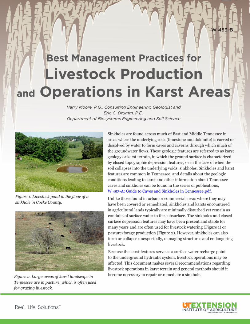
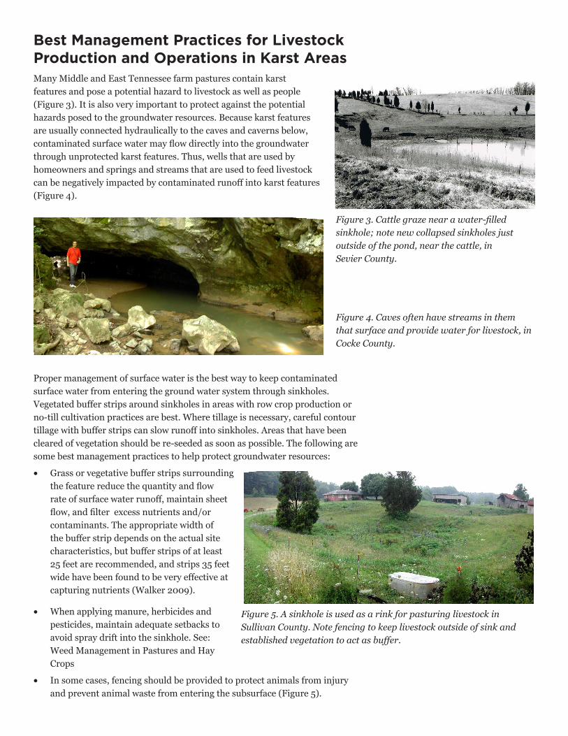
Unlike those found in urban or commercial areas where they may have been covered or remediated, sinkholes and karsts encountered in agricultural lands typically are minimally disturbed yet remain as conduits of surface water to the subsurface. The sinkholes and closed surface depression features may have been present and stable for many years and are often used for livestock watering (Figure 1) or pasture/forage production (Figure 2). However, sinkholes can also form or collapse unexpectedly, damaging structures and endangering livestock.
Because the karst features serve as a surface water recharge point to the underground hydraulic system, livestock operations may be affected. This document makes several recommendations regarding livestock operations in karst terrain and general methods should it become necessary to repair or remediate a sinkhole.
Figure 1. Livestock pond in the floor of a sinkhole in Cocke County.
Figure 2. Large areas of karst landscape in Tennessee are in pasture, which is often used for grazing livestock.
W 453-B
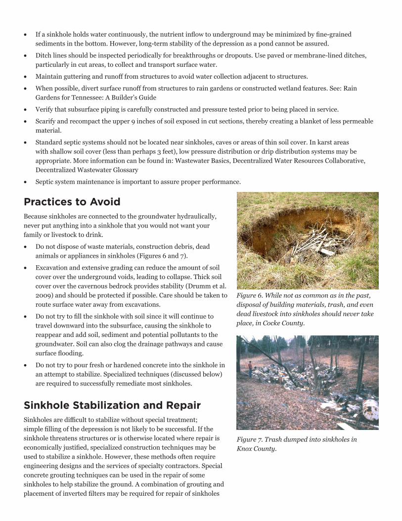
Best Management Practices for Livestock Production and Operations in Karst Areas Many Middle and East Tennessee farm pastures contain karst features and pose a potential hazard to livestock as well as people (Figure 3). It is also very important to protect against the potential hazards posed to the groundwater resources. Because karst features are usually connected hydraulically to the caves and caverns below, contaminated surface water may flow directly into the groundwater through unprotected karst features. Thus, wells that are used by homeowners and springs and streams that are used to feed livestock can be negatively impacted by contaminated runoff into karst features (Figure 4).
Figure 3. Cattle graze near a water-filled sinkhole; note new collapsed sinkholes just outside of the pond, near the cattle, in Sevier County.
Figure 4. Caves often have streams in them that surface and provide water for livestock, in Cocke County.
Proper management of surface water is the best way to keep contaminated surface water from entering the ground water system through sinkholes. Vegetated buffer strips around sinkholes in areas with row crop production or no-till cultivation practices are best. Where tillage is necessary, careful contour tillage with buffer strips can slow runoff into sinkholes. Areas that have been cleared of vegetation should be re-seeded as soon as possible. The following are some best management practices to help protect groundwater resources:
• Grass or vegetative buffer strips surroundingthe feature reduce the quantity and flowrate of surface water runoff, maintain sheetflow, and filter excess nutrients and/orcontaminants. The appropriate width ofthe buffer strip depends on the actual sitecharacteristics, but buffer strips of at least25 feet are recommended, and strips 35 feetwide have been found to be very effective atcapturing nutrients (Walker 2009).
• When applying manure, herbicides andpesticides, maintain adequate setbacks toavoid spray drift into the sinkhole. See:Weed Management in Pastures and HayCrops
• In some cases, fencing should be provided to protect animals from injuryand prevent animal waste from entering the subsurface (Figure 5).
Figure 5. A sinkhole is used as a rink for pasturing livestock in Sullivan County. Note fencing to keep livestock outside of sink and established vegetation to act as buffer.
Practices to AvoidBecause sinkholes are connected to the groundwater hydraulically, never put anything into a sinkhole that you would not want your family or livestock to drink.
• Do not dispose of waste materials, construction debris, deadanimals or appliances in sinkholes (Figures 6 and 7).
• Excavation and extensive grading can reduce the amount of soilcover over the underground voids, leading to collapse. Thick soilcover over the cavernous bedrock provides stability (Drumm et al.2009) and should be protected if possible. Care should be taken toroute surface water away from excavations.
• Do not try to fill the sinkhole with soil since it will continue totravel downward into the subsurface, causing the sinkhole toreappear and add soil, sediment and potential pollutants to thegroundwater. Soil can also clog the drainage pathways and causesurface flooding.
• Do not try to pour fresh or hardened concrete into the sinkhole inan attempt to stabilize. Specialized techniques (discussed below)are required to successfully remediate most sinkholes.
Sinkhole Stabilization and Repair Sinkholes are difficult to stabilize without special treatment; simple filling of the depression is not likely to be successful. If the sinkhole threatens structures or is otherwise located where repair is economically justified, specialized construction techniques may be used to stabilize a sinkhole. However, these methods often require engineering designs and the services of specialty contractors. Special concrete grouting techniques can be used in the repair of some sinkholes to help stabilize the ground. A combination of grouting and placement of inverted filters may be required for repair of sinkholes
• If a sinkhole holds water continuously, the nutrient inflow to underground may be minimized by fine-grainedsediments in the bottom. However, long-term stability of the depression as a pond cannot be assured.
• Ditch lines should be inspected periodically for breakthroughs or dropouts. Use paved or membrane-lined ditches,particularly in cut areas, to collect and transport surface water.
• Maintain guttering and runoff from structures to avoid water collection adjacent to structures.
• When possible, divert surface runoff from structures to rain gardens or constructed wetland features. See: RainGardens for Tennessee: A Builder’s Guide
• Verify that subsurface piping is carefully constructed and pressure tested prior to being placed in service.
• Scarify and recompact the upper 9 inches of soil exposed in cut sections, thereby creating a blanket of less permeablematerial.
• Standard septic systems should not be located near sinkholes, caves or areas of thin soil cover. In karst areaswith shallow soil cover (less than perhaps 3 feet), low pressure distribution or drip distribution systems may beappropriate. More information can be found in: Wastewater Basics, Decentralized Water Resources Collaborative,Decentralized Wastewater Glossary
• Septic system maintenance is important to assure proper performance.
Figure 6. While not as common as in the past, disposal of building materials, trash, and even dead livestock into sinkholes should never take place, in Cocke County.
Figure 7. Trash dumped into sinkholes in Knox County.
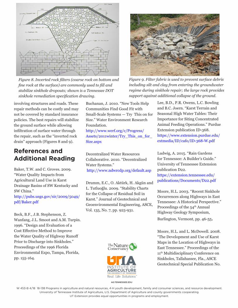
Figure 8. Inverted rock filters (coarse rock on bottom and fine rock at the surface) are commonly used to fill and stabilize sinkhole dropouts; shown is a Tennessee DOT sinkhole remediation specification drawing.
Figure 9. Filter fabric is used to prevent surface debris including silt and clay from entering the groundwater regime during sinkhole repair; the large rock provides support against additional collapse of the ground.
involving structures and roads. These repair methods can be costly and may not be covered by standard insurance policies. The best repairs will stabilize the ground surface while allowing infiltration of surface water through the repair, such as the “inverted rock drain” approach (Figures 8 and 9).
References and Additional ReadingBaker, T.W. and C. Groves. 2009. “Water Quality Impacts from Agricultural Land Use in Karst Drainage Basins of SW Kentucky and SW China.” http://pubs.usgs.gov/sir/2009/5049/pdf/Baker.pdf
Beck, B.F., J.B. Stephenson, Z. Wanfang, J.L. Smoot and A.M. Turpin. 1996. “Design and Evaluation of a Cost Effective Method to Improve the Water Quality of Highway Runoff Prior to Discharge into Sinkholes.” Proceedings of the 1996 Florida Environmental Expo, Tampa, Florida, pp. 155-164.
Buchanan, J. 2010. “New Tools Help Communities Find Good Fit with Small-Scale Systems — Try This on for Size.” Water Environment Research Foundation. http://www.werf.org/c/Progress/Assets/2011winter/Try_This_on_for_ Size.aspx
Decentralized Water Resources Collaborative. 2010. “Decentralized Water Systems.” http://www.ndwrcdp.org/default.asp
Drumm, E.C., O. Aktürk, H. Akgün and L. Tutluoğlu. 2009. “Stability Chartsfor the Collapse of Residual Soil inKarst.” Journal of Geotechnical andGeoenvironmental Engineering, ASCE,Vol. 135, No. 7, pp. 925-931.
Lee, B.D., P.R. Owens, L.C. Bowling and B.C. Joern. “Karst Terrain and Seasonal High Water Tables: Their Importance for Siting Concentrated Animal Feeding Operations.” Purdue Extension publication ID-368. https://www.extension.purdue.edu/extmedia/ID/cafo/ID-368-W.pdf
Ludwig, A. 2015. “Rain Gardens for Tennessee: A Builder’s Guide.” University of Tennessee Extension publication D22. https://extension.tennessee.edu/publications/Documents/D22.pdf
Moore, H.L. 2003. “Recent Sinkhole Occurrences along Highways in East Tennessee: A Historical Perspective.” Proceedings of the 54th Annual Highway Geology Symposium, Burlington, Vermont, pp. 46-55.
Moore, H.L. and L. McDowell. 2008. “The Development and Use of Karst Maps in the Location of Highways in East Tennessee.” Proceedings of the 11th Multidisciplinary Conference on Sinkholes, Tallahassee, Fla., ASCE Geotechnical Special Publication No.
W 453-B 4/18 18-138 Programs in agriculture and natural resources, 4-H youth development, family and consumer sciences, and resource development. University of Tennessee Institute of Agriculture, U.S. Department of Agriculture and county governments cooperating.
UT Extension provides equal opportunities in programs and employment.