Embed Size (px)
Citation preview
Bell
Init
S
la Diddy
Sta
tial Study
State of Ca
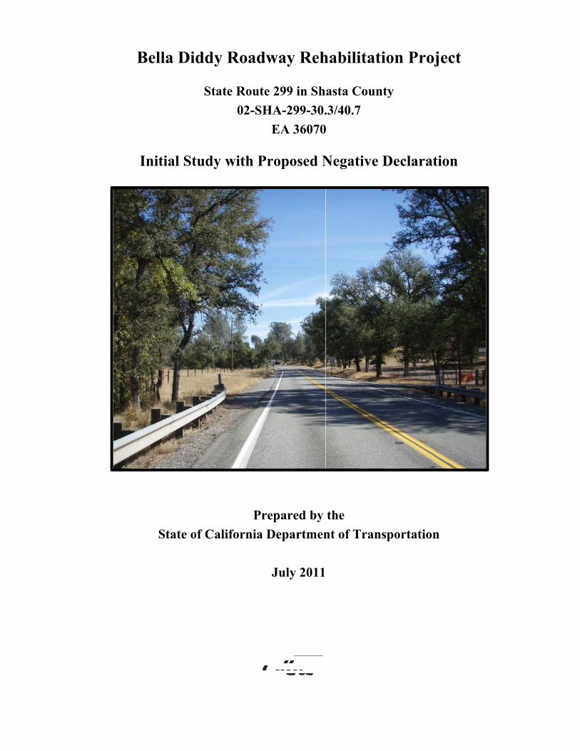
y Roadw
ate Route 02-SH
y with Pr
Prealifornia D
way Reh
299 in ShHA-299-30.
EA 36070
roposed N
epared by Departmen
July 2011
habilitat
asta Coun.3/40.7
0
Negative
the nt of Tran
tion Pro
nty
Declarat
nsportation
ject
tion
n
General Information About This Document
What’s in this document? The California Department of Transportation (Caltrans) has prepared this Initial Study, which examines the potential environmental impacts of alternatives being considered for the proposed project located in Shasta County, California. The document describes why the project is being proposed, the existing environment that could be affected by the project, and potential impacts from the project, and the proposed avoidance, minimization, and/or mitigation measures.
What should you do? • Please read this Initial Study. Additional copies of this document as well as the technical
studies are available for review at the Caltrans District 2 Office of Environmental Management, located at 1031 Butte Street, Redding, CA 96001. Copies of this document will also be available at the Shasta County Library – 1100 Parkview Avenue, Redding, CA 96001.
• We welcome your comments. If you have any concerns regarding the proposed project,
send your written comments to Caltrans by the deadline. Submit comments via U.S. mail to Caltrans at the following address:
Thomas Balkow, Environmental Branch Chief North Region Environmental Planning, Redding Office, MS 30 California Department of Transportation P.O. Box 496073, Redding, CA 96049-6073
Submit comments via email to: [email protected]
• Submit comments by the deadline: August 24, 2010
What happens next? After comments are received from the public and reviewing agencies, Caltrans may 1) give environmental approval to the proposed project, 2) do additional environmental studies, or 3) abandon the project. If the project is given environmental approval and funding is appropriated, Caltrans could design and construct all or part of the project.
For individuals with sensory disabilities, this document is available in Braille, large print, on audiocassette, or computer disk. To obtain a copy in one of these alternate formats, please call or write to Caltrans, Attn: Amber Kelley, North Region Environmental Planning, P.O. Box 496073, Redding, CA 96049-6073; Voice (530) 225-3510, or use the California Relay Service TTY number, 1-800-735-2929.
State of California SCH Number: Department of Transportation 02-SHA-299-30.3/40.7
EA 36070
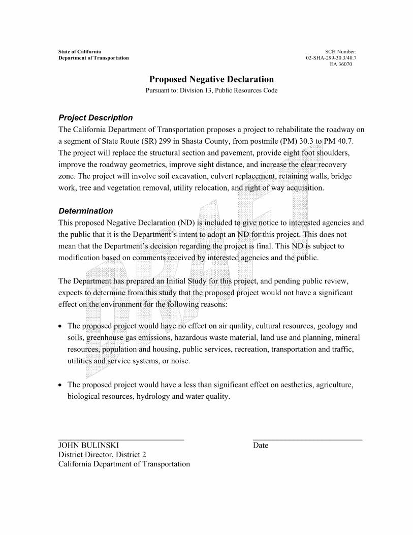
Proposed Negative Declaration Pursuant to: Division 13, Public Resources Code
Project Description The California Department of Transportation proposes a project to rehabilitate the roadway on a segment of State Route (SR) 299 in Shasta County, from postmile (PM) 30.3 to PM 40.7. The project will replace the structural section and pavement, provide eight foot shoulders, improve the roadway geometrics, improve sight distance, and increase the clear recovery zone. The project will involve soil excavation, culvert replacement, retaining walls, bridge work, tree and vegetation removal, utility relocation, and right of way acquisition. Determination This proposed Negative Declaration (ND) is included to give notice to interested agencies and the public that it is the Department’s intent to adopt an ND for this project. This does not mean that the Department’s decision regarding the project is final. This ND is subject to modification based on comments received by interested agencies and the public. The Department has prepared an Initial Study for this project, and pending public review, expects to determine from this study that the proposed project would not have a significant effect on the environment for the following reasons: • The proposed project would have no effect on air quality, cultural resources, geology and
soils, greenhouse gas emissions, hazardous waste material, land use and planning, mineral resources, population and housing, public services, recreation, transportation and traffic, utilities and service systems, or noise.
• The proposed project would have a less than significant effect on aesthetics, agriculture,
biological resources, hydrology and water quality. _______________________________ ___________________________ JOHN BULINSKI Date District Director, District 2 California Department of Transportation
Shasta-299 – Bella Diddy Roadway Rehabilitation Project 1
Proposed Project Project Title Bella Diddy Roadway Rehabilitation Project
Lead Agency Name, Address and Contact Person State of California, Department of Transportation P.O. Box 496073, Redding, CA 96049-6073 Thomas Balkow, (530) 225-3405 Project Location The proposed project is located on State Route (SR) 299 in Shasta County, from postmile (PM) 30.3 to PM 40.7 near the community of Bella Vista. Project Sponsor’s Name and Address State of California, Department of Transportation P.O. Box 496073, Redding, CA 96049-6073 Thomas Balkow, (530) 225-3405
Purpose and Need This project proposes to rehabilitate the roadway on a segment of SR 299 in Shasta County, from PM 30.3 to PM 40.7.
• The existing roadway has 11 to 12 foot lane widths, 0 to 10 foot paved shoulders
(the majority of this highway segment has no paved shoulders), and limited clear recovery zone for errant vehicles.
• Within this segment of highway, the pavement has a 70% distress rate.
• The aging structural section and distressed pavement requires frequent maintenance and repair.
Description of Project The project proposes to replace the roadway structural section, provide eight foot shoulders, improve the roadway geometrics, improve sight distance, and increase the clear recovery zone. The project will involve soil excavation, culvert extension and replacement, bridge work, retaining walls, tree and vegetation removal, utility relocation, controlled blasting, and right of way acquisition.
Shasta-299 – Bella Diddy Roadway Rehabilitation Project 2
The project will require approximately 240 working days over two construction seasons. Bridge construction, culvert work, and a portion of the cuts and fills will occur the first season. The second season will include the remainder of earthwork, culvert installation, pulverizing the existing pavement, asphalt placement, guardrail and sign installation, rumble strip installation, and pavement striping. The cuts and fills will require approximately 130,000 cubic yards of excavation. The soil material will be excavated from the cut areas then placed and compacted in embankment areas. Controlled blasting will be required in dense rock areas. The controlled blasting will cause rock to break internally, without sending debris into the air, creating excessive noise, or causing substantial vibration. The earthwork will be balanced within the project limits, so an off-site disposal area will not be necessary. There are three major stream crossing structures within the project limits:
• The Dry Creek Bridge currently has 8-foot shoulders and no work will be necessary at this location.
• The Salt Creek Bridge will be widened to provide 10-foot shoulders. Ten new
bridge piles will be installed and the bridge deck, abutments, and wing walls will be widened. New bridge railing and approach guardrail will be installed. The majority of this work will occur from the bridge deck and through the use of trestles, minimizing disturbance of the stream channel. Dewatering will be required when the bridge piles are installed. Traffic flow will be maintained using one-way traffic control.
• The Yank Creek crossing, also known as Lemm Creek, was constructed in 1933
and consists of three large box culverts. These box culverts will be replaced with a skewed single span bridge that will accommodate high flows, prevent debris from blocking flow, and eliminate any potential fish passage barriers. This work will occur during the summer months when Yank Creek is in a low-flow, no flow condition. A temporary traffic detour will be constructed north of the existing bridge in order to move vehicles away from the work area.
Multiple storm water drainages are channeled through culverts under the existing highway. The existing drainage facilities will be removed, abandoned, or extended depending on the location, and new drainage facilities will be installed as needed. Drainage work is limited only to areas required for construction.
Shasta-299 – Bella Diddy Roadway Rehabilitation Project 3
The existing structural section will be pulverized and new pavement will be installed. The individual driveway approaches will be paved. Earthwork and paving operations will be staged to allow traffic to pass through the construction site. Access to businesses and residences will be maintained through the duration of the project, and the contractor will coordinate with individual property owners for work at driveway connections. Additional right of way will be required from approximately 47 private property owners. The project includes relocation of utilities, fences, landscaping, and mailboxes. A 4-foot center median will be constructed along the existing passing lane located from PM 37.34 to PM 37.58. Rumble strips will be installed in the passing lane median as a safety feature. The majority of construction will occur during daylight hours, and although it is not anticipated, some night work may be required. If night work does occur, local ordinances will limit construction activities and noise levels. Construction equipment such as dozers, scrapers, compactors, backhoes, excavators, and dump trucks will be used to construct the project. Equipment will be staged, and materials will be stored, in existing upland areas within the project limits. Erosion control seed mix will be applied to all disturbed areas after construction. Temporary construction site Best Management Practices (BMPs) will be implemented under a contractor prepared Storm Water Pollution Prevention Plan. Temporary concrete washouts, stabilized construction entrances/exits, and fiber rolls have been identified as possible project BMPs. Water trucks will be used for compaction and dust control. Additional BMPs may be identified during preparation of the contract.
Surrounding Land Uses, Setting, and Zoning The project is located in central Shasta County and the land is in rolling to mountainous terrain. The first two miles of the project area consists mainly of small businesses, while the remainder of the project area is lined by rural residential and agricultural properties. The properties surrounding the project area are privately owned, and the land uses are listed as vacant, agriculture, commercial, and residential. A portion of these properties are listed as Williamson Act Prime Agricultural Land and Williamson Act Non-Prime Agricultural Land.
Shasta-299 – Bella Diddy Roadway Rehabilitation Project 4
State, Regional, and Local Plans and Programs The project is consistent with State and local transportation plans and programs, and has been identified by the Shasta County Regional Transportation Planning Agency as a programmed State Highway Operation and Protection Program (SHOPP) project in the 2010 Regional Transportation Plan.
The project area includes properties covered by the Land Conservation Act of 1965, commonly referred to as the Williamson Act; properties that are mapped as Grazing Lands; and properties that are mapped as Prime Farmland.
Permits and Approvals Needed
Permits will be required from the following resource agencies: • U.S. Army Corps of Engineers • California Regional Water Quality Control Board • California Department of Fish and Game
List of Attachments A. Vicinity Map
B. Climate Change
C. Project Plan Sheets
Shasta-299 – Bella Diddy Roadway Rehabilitation Project 5
CEQA Environmental Checklist 02-SHA-299 30.3/40.7 02-36070 Dist.-Co.-Rte. P.M/P.M. E.A.
This checklist identifies physical, biological, social and economic factors that might be affected by the proposed project. In many cases, background studies performed in connection with the project indicate no impacts. A NO IMPACT answer in the last column reflects this determination. Where there is a need for clarifying discussion, the discussion is included in the section following the checklist. The words "significant" and "significance" used throughout the following checklist are related to CEQA, not NEPA, impacts. The questions in this form are intended to encourage the thoughtful assessment of impacts and do not represent thresholds of significance.

Potentially Significant Impact
Less Than Significant with Mitigation
Less Than Significant Impact
No Impact
Shasta-299 – Bella Diddy Roadway Rehabilitation Project 6
I. AESTHETICS: Would the project:
a) Have a substantial adverse effect on a scenic vista
b) Substantially damage scenic resources, including, but not limited to, trees, rock outcroppings, and historic buildings within a state scenic highway
c) Substantially degrade the existing visual character or quality of the site and its surroundings?
d) Create a new source of substantial light or glare which would adversely affect day or nighttime views in the area?
II. AGRICULTURE AND FOREST RESOURCES: In determining whether impacts to agricultural resources are significant environmental effects, lead agencies may refer to the California Agricultural Land Evaluation and Site Assessment Model (1997) prepared by the California Dept. of Conservation as an optional model to use in assessing impacts on agriculture and farmland. In determining whether impacts to forest resources, including timberland, are significant environmental effects, lead agencies may refer to information compiled by the California Department of Forestry and Fire Protection regarding the state’s inventory of forest land, including the Forest and Range Assessment Project and the Forest Legacy Assessment Project; and the forest carbon measurement methodology provided in Forest Protocols adopted by the California Air Resources Board. Would the project:
a) Convert Prime Farmland, Unique Farmland, or Farmland of Statewide Importance (Farmland), as shown on the maps prepared pursuant to the Farmland Mapping and Monitoring Program of the California Resources Agency, to non-agricultural use?
b) Conflict with existing zoning for agricultural use, or a Williamson Act contract?
c) Conflict with existing zoning for, or cause rezoning of, forest land (as defined in Public Resources Code section 12220(g)), timberland (as defined by Public Resources Code section 4526), or timberland zoned Timberland Production (as defined by Government Code section 51104(g))?
d) Result in the loss of forest land or conversion of forest land to non-forest use?
e) Involve other changes in the existing environment which, due to their location or nature, could result in conversion of Farmland, to non-agricultural use or conversion of forest land to non-forest use?
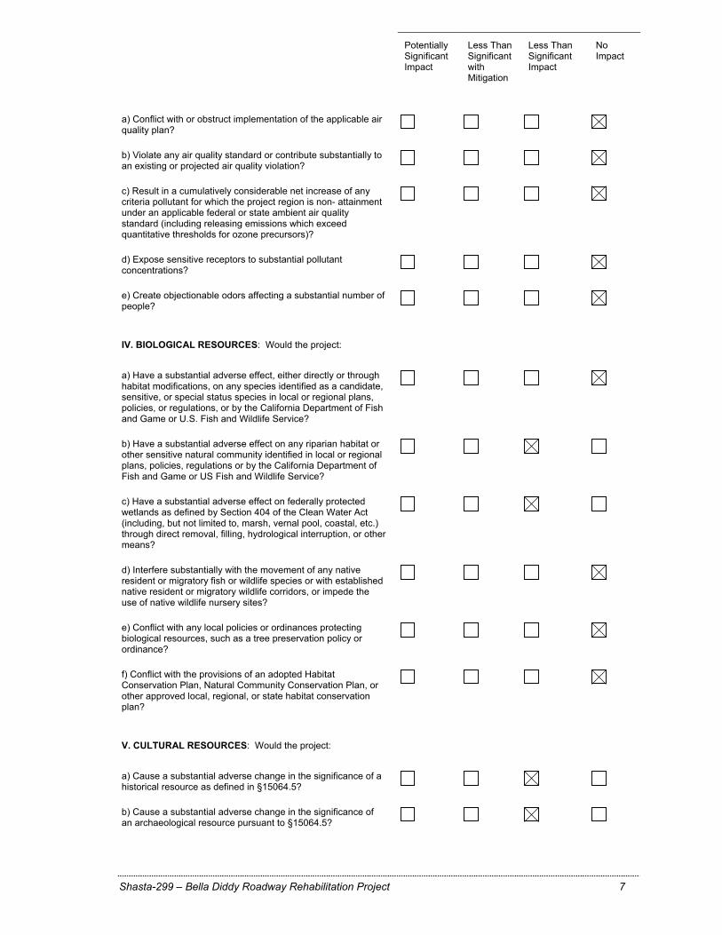
III. AIR QUALITY: Where available, the significance criteria established by the applicable air quality management or air pollution control district may be relied upon to make the following determinations. Would the project:
Potentially Significant Impact
Less Than Significant with Mitigation
Less Than Significant Impact
No Impact
Shasta-299 – Bella Diddy Roadway Rehabilitation Project 7
a) Conflict with or obstruct implementation of the applicable air quality plan?
b) Violate any air quality standard or contribute substantially to an existing or projected air quality violation?
c) Result in a cumulatively considerable net increase of any criteria pollutant for which the project region is non- attainment under an applicable federal or state ambient air quality standard (including releasing emissions which exceed quantitative thresholds for ozone precursors)?
d) Expose sensitive receptors to substantial pollutant concentrations?
e) Create objectionable odors affecting a substantial number of people?
IV. BIOLOGICAL RESOURCES: Would the project:
a) Have a substantial adverse effect, either directly or through habitat modifications, on any species identified as a candidate, sensitive, or special status species in local or regional plans, policies, or regulations, or by the California Department of Fish and Game or U.S. Fish and Wildlife Service?
b) Have a substantial adverse effect on any riparian habitat or other sensitive natural community identified in local or regional plans, policies, regulations or by the California Department of Fish and Game or US Fish and Wildlife Service?
c) Have a substantial adverse effect on federally protected wetlands as defined by Section 404 of the Clean Water Act (including, but not limited to, marsh, vernal pool, coastal, etc.) through direct removal, filling, hydrological interruption, or other means?
d) Interfere substantially with the movement of any native resident or migratory fish or wildlife species or with established native resident or migratory wildlife corridors, or impede the use of native wildlife nursery sites?
e) Conflict with any local policies or ordinances protecting biological resources, such as a tree preservation policy or ordinance?
f) Conflict with the provisions of an adopted Habitat Conservation Plan, Natural Community Conservation Plan, or other approved local, regional, or state habitat conservation plan?
V. CULTURAL RESOURCES: Would the project:
a) Cause a substantial adverse change in the significance of a historical resource as defined in §15064.5?
b) Cause a substantial adverse change in the significance of an archaeological resource pursuant to §15064.5?
Potentially Significant Impact
Less Than Significant with Mitigation
Less Than Significant Impact
No Impact
Shasta-299 – Bella Diddy Roadway Rehabilitation Project 8
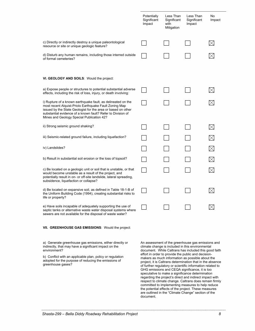
c) Directly or indirectly destroy a unique paleontological resource or site or unique geologic feature?
d) Disturb any human remains, including those interred outside of formal cemeteries?
VI. GEOLOGY AND SOILS: Would the project:
a) Expose people or structures to potential substantial adverse effects, including the risk of loss, injury, or death involving:
i) Rupture of a known earthquake fault, as delineated on the most recent Alquist-Priolo Earthquake Fault Zoning Map issued by the State Geologist for the area or based on other substantial evidence of a known fault? Refer to Division of Mines and Geology Special Publication 42?
ii) Strong seismic ground shaking?
iii) Seismic-related ground failure, including liquefaction?
iv) Landslides?
b) Result in substantial soil erosion or the loss of topsoil?
c) Be located on a geologic unit or soil that is unstable, or that would become unstable as a result of the project, and potentially result in on- or off-site landslide, lateral spreading, subsidence, liquefaction or collapse?
d) Be located on expansive soil, as defined in Table 18-1-B of the Uniform Building Code (1994), creating substantial risks to life or property?
e) Have soils incapable of adequately supporting the use of septic tanks or alternative waste water disposal systems where sewers are not available for the disposal of waste water?
VII. GREENHOUSE GAS EMISSIONS: Would the project:
a) Generate greenhouse gas emissions, either directly or indirectly, that may have a significant impact on the environment?
b) Conflict with an applicable plan, policy or regulation adopted for the purpose of reducing the emissions of greenhouse gases?
An assessment of the greenhouse gas emissions and climate change is included in this environmental document. While Caltrans has included this good faith effort in order to provide the public and decision-makers as much information as possible about the project, it is Caltrans determination that in the absence of further regulatory or scientific information related to GHG emissions and CEQA significance, it is too speculative to make a significance determination regarding the project’s direct and indirect impact with respect to climate change. Caltrans does remain firmly committed to implementing measures to help reduce the potential effects of the project. These measures are outlined in the “Climate Change” section of the document.

Potentially Significant Impact
Less Than Significant with Mitigation
Less Than Significant Impact
No Impact
Shasta-299 – Bella Diddy Roadway Rehabilitation Project 9
VIII. HAZARDS AND HAZARDOUS MATERIALS: Would the project:
a) Create a significant hazard to the public or the environment through the routine transport, use, or disposal of hazardous materials?
b) Create a significant hazard to the public or the environment through reasonably foreseeable upset and accident conditions involving the release of hazardous materials into the environment?
c) Emit hazardous emissions or handle hazardous or acutely hazardous materials, substances, or waste within one-quarter mile of an existing or proposed school?
d) Be located on a site which is included on a list of hazardous materials sites compiled pursuant to Government Code Section 65962.5 and, as a result, would it create a significant hazard to the public or the environment?
e) For a project located within an airport land use plan or, where such a plan has not been adopted, within two miles of a public airport or public use airport, would the project result in a safety hazard for people residing or working in the project area?
Potentially Significant Impact
Less Than Significant with Mitigation
Less Than Significant Impact
No Impact
Shasta-299 – Bella Diddy Roadway Rehabilitation Project 10
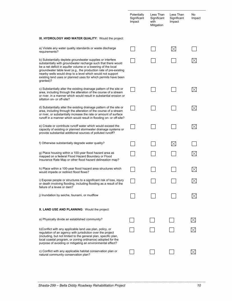
IX. HYDROLOGY AND WATER QUALITY: Would the project:
a) Violate any water quality standards or waste discharge requirements?
b) Substantially deplete groundwater supplies or interfere substantially with groundwater recharge such that there would be a net deficit in aquifer volume or a lowering of the local groundwater table level (e.g., the production rate of pre-existing nearby wells would drop to a level which would not support existing land uses or planned uses for which permits have been granted)?
c) Substantially alter the existing drainage pattern of the site or area, including through the alteration of the course of a stream or river, in a manner which would result in substantial erosion or siltation on- or off-site?
d) Substantially alter the existing drainage pattern of the site or area, including through the alteration of the course of a stream or river, or substantially increase the rate or amount of surface runoff in a manner which would result in flooding on- or off-site?
e) Create or contribute runoff water which would exceed the capacity of existing or planned stormwater drainage systems or provide substantial additional sources of polluted runoff?
f) Otherwise substantially degrade water quality?
g) Place housing within a 100-year flood hazard area as mapped on a federal Flood Hazard Boundary or Flood Insurance Rate Map or other flood hazard delineation map?
h) Place within a 100-year flood hazard area structures which would impede or redirect flood flows?
i) Expose people or structures to a significant risk of loss, injury or death involving flooding, including flooding as a result of the failure of a levee or dam?
j) Inundation by seiche, tsunami, or mudflow X. LAND USE AND PLANNING: Would the project:
a) Physically divide an established community?
b)Conflict with any applicable land use plan, policy, or regulation of an agency with jurisdiction over the project (including, but not limited to the general plan, specific plan, local coastal program, or zoning ordinance) adopted for the purpose of avoiding or mitigating an environmental effect?
c) Conflict with any applicable habitat conservation plan or natural community conservation plan?
Potentially Significant Impact
Less Than Significant with Mitigation
Less Than Significant Impact
No Impact
Shasta-299 – Bella Diddy Roadway Rehabilitation Project 11
XI. MINERAL RESOURCES: Would the project:
a) Result in the loss of availability of a known mineral resource that would be of value to the region and the residents of the state?
b) Result in the loss of availability of a locally-important mineral resource recovery site delineated on a local general plan, specific plan or other land use plan?
XII. NOISE: Would the project result in:
a) Exposure of persons to a generation of noise levels in excess of standards established in the local general plan or noise ordinance, or applicable standards of other agencies?
b) Exposure of persons to a generation of excessive groundborne vibration or groundborne noise levels?
c) A substantial permanent increase in ambient noise levels in the project vicinity above levels existing without the project?
d) A substantial temporary or periodic increase in ambient noise levels in the project vicinity above levels existing without the project?
e) For a project located within an airport land use plan or, where such a plan has not been adopted, within two miles of a public airport or public use airport, would the project expose people residing or working in the project area to excessive noise levels?
f) For a project within the vicinity of a private airstrip, would the project expose people residing or working in the project area to excessive noise levels?
XIII. POPULATION AND HOUSING: Would the project:
a) Induce substantial population growth in an area, either directly (for example, by proposing new homes and businesses) or indirectly (for example, through extension of roads or other infrastructure)?
b) Displace substantial numbers of existing housing, necessitating the construction of replacement housing elsewhere?
c) Displace substantial numbers of people, necessitating the construction of replacement housing elsewhere?
Potentially Significant Impact
Less Than Significant with Mitigation
Less Than Significant Impact
No Impact
Shasta-299 – Bella Diddy Roadway Rehabilitation Project 12
XIV. PUBLIC SERVICES:
a) Would the project result in substantial adverse physical impacts associated with the provision of new or physically altered governmental facilities, need for new or physically altered governmental facilities, the construction of which could cause significant environmental impacts, in order to maintain acceptable service ratios, response times or other performance objectives for any of the public services:
Fire protection?
Police protection?
Schools?
Parks?
Other public facilities?
.
XV. RECREATION:
a) Would the project increase the use of existing neighborhood and regional parks or other recreational facilities such that substantial physical deterioration of the facility would occur or be accelerated?
b) Does the project include recreational facilities or require the construction or expansion of recreational facilities which might have an adverse physical effect on the environment?
XVI. TRANSPORTATION/TRAFFIC: Would the project:
a) Conflict with an applicable plan, ordinance or policy establishing measures of effectiveness for the performance of the circulation system, taking into account all modes of transportation including mass transit and non-motorized travel and relevant components of the circulation system, including but not limited to intersections, streets, highways and freeways, pedestrian and bicycle paths, and mass transit?
b) Conflict with an applicable congestion management program, including, but not limited to level of service standards and travel demand measures, or other standards established by the county congestion management agency for designated roads or highways?
c) Result in a change in air traffic patterns, including either an increase in traffic levels or a change in location that results in substantial safety risks?
d) Substantially increase hazards due to a design feature (e.g., sharp curves or dangerous intersections) or incompatible uses (e.g., farm equipment)?
Potentially Significant Impact
Less Than Significant with Mitigation
Less Than Significant Impact
No Impact
Shasta-299 – Bella Diddy Roadway Rehabilitation Project 13
e) Result in inadequate emergency access?
f) Conflict with adopted policies, plans or programs regarding public transit, bicycle, or pedestrian facilities, or otherwise decrease the performance or safety of such facilities?
.
XVII. UTILITIES AND SERVICE SYSTEMS: Would the project:
a) Exceed wastewater treatment requirements of the applicable Regional Water Quality Control Board?
b) Require or result in the construction of new water or wastewater treatment facilities or expansion of existing facilities, the construction of which could cause significant environmental effects?
c) Require or result in the construction of new storm water drainage facilities or expansion of existing facilities, the construction of which could cause significant environmental effects?
d) Have sufficient water supplies available to serve the project from existing entitlements and resources, or are new or expanded entitlements needed?
e) Result in a determination by the wastewater treatment provider which serves or may serve the project that it has adequate capacity to serve the project’s projected demand in addition to the provider’s existing commitments?
f) Be served by a landfill with sufficient permitted capacity to accommodate the project’s solid waste disposal needs?
g) Comply with federal, state, and local statutes and regulations related to solid waste?
.
XVIII. MANDATORY FINDINGS OF SIGNIFICANCE
a) Does the project have the potential to degrade the quality of the environment, substantially reduce the habitat of a fish or wildlife species, cause a fish or wildlife population to drop below self-sustaining levels, threaten to eliminate a plant or animal community, substantially reduce the number or restrict the range of a rare or endangered plant or animal or eliminate important examples of the major periods of California history or prehistory?
b) Does the project have impacts that are individually limited, but cumulatively considerable? ("Cumulatively considerable" means that the incremental effects of a project are considerable when viewed in connection with the effects of past projects, the effects of other current projects, and the effects of probable future projects)?
c) Does the project have environmental effects which will cause substantial adverse effects on human beings, either directly or indirectly?
Shasta-299 – Bella Diddy Roadway Rehabilitation Project 14
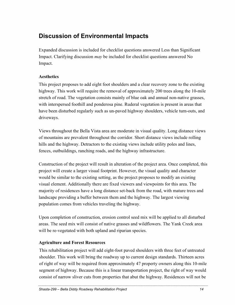
Discussion of Environmental Impacts Expanded discussion is included for checklist questions answered Less than Significant Impact. Clarifying discussion may be included for checklist questions answered No Impact. Aesthetics
This project proposes to add eight foot shoulders and a clear recovery zone to the existing highway. This work will require the removal of approximately 200 trees along the 10-mile stretch of road. The vegetation consists mainly of blue oak and annual non-native grasses, with interspersed foothill and ponderosa pine. Ruderal vegetation is present in areas that have been disturbed regularly such as un-paved highway shoulders, vehicle turn-outs, and driveways. Views throughout the Bella Vista area are moderate in visual quality. Long distance views of mountains are prevalent throughout the corridor. Short distance views include rolling hills and the highway. Detractors to the existing views include utility poles and lines, fences, outbuildings, ranching roads, and the highway infrastructure. Construction of the project will result in alteration of the project area. Once completed, this project will create a larger visual footprint. However, the visual quality and character would be similar to the existing setting, as the project proposes to modify an existing visual element. Additionally there are fixed viewers and viewpoints for this area. The majority of residences have a long distance set-back from the road, with mature trees and landscape providing a buffer between them and the highway. The largest viewing population comes from vehicles traveling the highway. Upon completion of construction, erosion control seed mix will be applied to all disturbed areas. The seed mix will consist of native grasses and wildflowers. The Yank Creek area will be re-vegetated with both upland and riparian species. Agriculture and Forest Resources
This rehabilitation project will add eight-foot paved shoulders with three feet of untreated shoulder. This work will bring the roadway up to current design standards. Thirteen acres of right of way will be required from approximately 47 property owners along this 10-mile segment of highway. Because this is a linear transportation project, the right of way would consist of narrow sliver cuts from properties that abut the highway. Residences will not be
Shasta-299 – Bella Diddy Roadway Rehabilitation Project 15
impacted. The project includes relocation of utilities, fences, mailboxes, and landscaping as applicable. The project has been designed to meet modern highway design standards, while minimizing the need for additional right of way. Agricultural land has been on the decline for many years in California, and consideration should be given when development encroaches upon it. Some of the concerns are: direct and indirect impacts that create non-farmable land, land use compatibility, the farm’s ability to continue production, the farm’s access to services, the farm’s ability to qualify for aid or tax reductions, the difficulty in creating new “quality” farmland, and the cumulative impact of multiple developments in a geographical area. These concerns are balanced with the type of development that is proposed, the amount of farmland that will be converted, and whether the project is “for the good of the public as a whole”. The lands surrounding the project area are privately owned and zoned as vacant, agriculture, commercial, and residential. These lands include: properties covered by the Land Conservation Act of 1965, commonly referred to as the Williamson Act; properties that are mapped as Grazing Lands; and properties that are mapped as Prime Farmland. The Land Conservation Act of 1965 – The Williamson Act: The Williamson Act enables local governments to enter into contracts with private landowners for the purpose of restricting specific parcels of land to agricultural or related open space use. In return, landowners receive property tax assessments which are much lower than normal because they are based upon farming and open space uses as opposed to full market value. Shasta County has a total of 169,127 acres enrolled in Williamson Act Contracts. There are three Williamson Act Land designations: Williamson Act Prime Agricultural Land (also listed as Prime Farmland below), Williamson Act Non-Prime Agricultural Land, and Williamson Act Land in Non Renewal.
Grazing Lands - California Department of Conservation, Land Resource Protection Division: Grazing Land is land on which the existing vegetation is suited to the grazing of livestock. In Shasta County Grazing Land relies exclusively on rain and snowfall for production of forage (non-irrigated). The Farmland Mapping and Monitoring Program identifies 412,731 acres of Grazing Land in Shasta County. Prime Farmland – California Department of Conservation, Land Resource Protection Division: Prime Farmland has the best combination of physical and chemical features able
Shasta-299 – Bella Diddy Roadway Rehabilitation Project 16
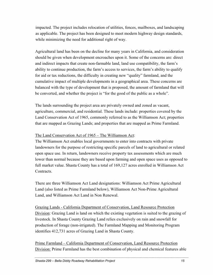
to sustain long-term agricultural production. This land has the soil quality, growing season, and moisture supply needed to produce sustained high yields. Land must have been used for irrigated agricultural production at some time during the four years prior to the mapping designation. The most recent mapping from the Department of Conservation’s Farmland Mapping and Monitoring Program shows that there are 12,290 acres of Prime Farmland in Shasta County. Table Ag-1 identifies the land use conservation and mapping designations that apply to the 13 acres impacted by the project. Some lands carry multiple designations.
Table Ag-1 Land Use Conservation & Mapping Designations
Designations Acreage to be Affected by Project
6.5 acres 6 acres 0.50 acres
Williamson Act Prime Agricultural X Williamson Act Non‐Prime Agricultural X Williamson Act Land in Non Renewal Prime Farmland X Grazing Land X X
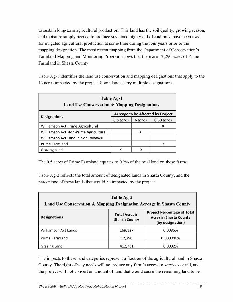
The 0.5 acres of Prime Farmland equates to 0.2% of the total land on these farms. Table Ag-2 reflects the total amount of designated lands in Shasta County, and the percentage of these lands that would be impacted by the project.
Table Ag-2 Land Use Conservation & Mapping Designation Acreage in Shasta County
Designations Total Acres in Shasta County
Project Percentage of Total Acres in Shasta County
(by designation)
Williamson Act Lands 169,127 0.0035%
Prime Farmland 12,290 0.000040%
Grazing Land 412,731 0.0032% The impacts to these land categories represent a fraction of the agricultural land in Shasta County. The right of way needs will not reduce any farm’s access to services or aid, and the project will not convert an amount of land that would cause the remaining land to be
Shasta-299 – Bella Diddy Roadway Rehabilitation Project 17
converted to other uses. The cumulative impact from this project is negligible, as there are no additional transportation projects planned for this area in the near future. The opportunity for high density development and growth is limited due to the distance of urbanized areas and the Williamson Act enrollment along this segment of highway. Biological Resources
Vegetation in the project area consists of foothill pine-blue oak woodland at higher elevations, with blue oak woodland and nonnative annual grassland dominating the lower elevations. Woody riparian vegetation occurs along creeks and drainages. Localized areas of vernal pools and seasonal wet meadows occur within the project limits. Seasonal wet meadows consist predominantly of depressions in roadside ditches. Vernal pools are outside the area of disturbance and neither the pools, or the hydrology will be impacted. The project area includes streams and drainages that are perennial, intermittent, and ephemeral. Dry Creek is a perennial stream that crosses the highway within the Bella Vista commercial area. The Dry Creek Bridge currently meets design standards, and there will be no work on the bridge, within the stream channel, or within the riparian zone at this location. Salt Creek, a perennial stream, is located near the center of the project, and is a tributary to Little Cow Creek. This very slow moving, almost stagnant, stream consists solely of irrigation tail-water runoff during the summer months. The area under, and surrounding, the bridge consists of wet pasture that is heavily used by cattle. The water temperatures reach more than seventy degrees during the summer and no special status fish are present. Salt Creek does not contain spawning habitat for salmonids. Yank Creek, an intermittent stream, is tributary to Dry Creek and Little Cow Creek, respectively. The creek is generally dry from mid-June to mid-November. Upstream of the highway crossing, the creek is a low-gradient channel that meanders through heavily grazed annual grassland, with very little riparian vegetation. Downstream the banks are more defined and moderate riparian exists, as cattle are not present in this portion of the stream. The creek does not support special status fish or spawning habitat. Although there is no indication of salmonid use in Yank Creek, the existing triple box culvert could create a barrier to fish passage. Potential fish passage will not be affected at Salt Creek, and will be significantly improved at Yank Creek. Replacing the Yank Creek culverts with a clear-span bridge will create a natural stream bottom, provide for potential fish passage, and increase the floodplain
Shasta-299 – Bella Diddy Roadway Rehabilitation Project 18
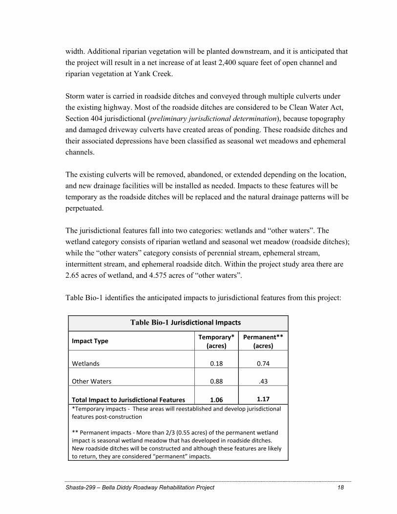
width. Additional riparian vegetation will be planted downstream, and it is anticipated that the project will result in a net increase of at least 2,400 square feet of open channel and riparian vegetation at Yank Creek. Storm water is carried in roadside ditches and conveyed through multiple culverts under the existing highway. Most of the roadside ditches are considered to be Clean Water Act, Section 404 jurisdictional (preliminary jurisdictional determination), because topography and damaged driveway culverts have created areas of ponding. These roadside ditches and their associated depressions have been classified as seasonal wet meadows and ephemeral channels. The existing culverts will be removed, abandoned, or extended depending on the location, and new drainage facilities will be installed as needed. Impacts to these features will be temporary as the roadside ditches will be replaced and the natural drainage patterns will be perpetuated. The jurisdictional features fall into two categories: wetlands and “other waters”. The wetland category consists of riparian wetland and seasonal wet meadow (roadside ditches); while the “other waters” category consists of perennial stream, ephemeral stream, intermittent stream, and ephemeral roadside ditch. Within the project study area there are 2.65 acres of wetland, and 4.575 acres of “other waters”. Table Bio-1 identifies the anticipated impacts to jurisdictional features from this project:
Table Bio-1 Jurisdictional Impacts
Impact Type Temporary* (acres)
Permanent** (acres)
Wetlands 0.18
0.74
Other Waters 0.88
.43 Total Impact to Jurisdictional Features 1.06
1.17
*Temporary impacts ‐ These areas will reestablished and develop jurisdictional features post‐construction ** Permanent impacts ‐ More than 2/3 (0.55 acres) of the permanent wetland impact is seasonal wetland meadow that has developed in roadside ditches. New roadside ditches will be constructed and although these features are likely to return, they are considered “permanent” impacts.

Shasta-299 – Bella Diddy Roadway Rehabilitation Project 19
Table Bio-2 identifies the anticipated increase and improvement to jurisdictional features from the project:
Table Bio-2 Jurisdictional Improvements
Improvement Type Permanent
(acres)
70/30 Intermittent Stream/Riparian Wetland 0.23
Fill of jurisdictional waters is limited only to those areas required for this roadway rehabilitation project, and work in jurisdictional waters will occur during low-flow or no-flow conditions. The project includes: the use of trestles at Salt Creek to limit stream disturbance; and placement of environmentally sensitive area (ESA) fencing to protect waters, vegetation, and vernal pools. Caltrans will coordinate with the U.S. Army Corps of Engineers, California Department of Fish and Game, and the Regional Water Quality Control Board for jurisdictional permits and to address the loss of jurisdictional features. Vegetation removal is limited to the extent necessary for construction of the project, and upon completion of construction, erosion control seed mix will be applied to all disturbed areas. The seed mix will consist of native grasses and wildflowers. Temporarily disturbed areas will be re-vegetated and restored to preconstruction conditions. Permanent re-vegetation will include upland and riparian planting.
Biological studies and surveys have confirmed that the project will not have an adverse effect on any special status species (plants and animals) or habitats. Federal Endangered Species Act - Section 7 consultations have been conducted, with the U.S. Fish and Wildlife Service and National Marine Fisheries Service, and have confirmed the absence of impact to Federal special status species. State listed special status species were not found during surveys, and will not be impacted. Vernal pools and vernal pool hydrology will not be impacted. The project will improve aquatic resource function, fish passage, and extent of riparian at Yank Creek. Cultural Resources
The historic property identification effort being conducted for this undertaking included a records search, archaeological and architectural field examinations, coordination with interested parties, and delineation of an area of potential effects. Coordination efforts included the Native American Heritage Commission, local Native American representatives, and the Shasta Historical Society.
Shasta-299 – Bella Diddy Roadway Rehabilitation Project 20
The identification effort has resulted in the discovery of four prehistoric archaeological sites, and segments of an abandoned road. The sites will undergo excavations to test for subsurface deposits. In addition, the abandoned road segments will be further evaluated by an architectural historian. No human skeletal remains were observed and it is not anticipated that this undertaking will have an adverse affect on any historic properties. If cultural materials are discovered during construction, all earth moving activity within and around the immediate discovery area would be halted until a qualified archaeologist can assess the nature and significance of the find. Hydrology and Water Quality The project includes widening the Salt Creek Bridge, and constructing a bridge at Yank Creek. In addition to these crossings, multiple storm water drainages are channeled through culverts under the existing highway. The existing drainage facilities will be removed, abandoned, or extended depending on the location, and new drainage facilities will be installed as needed. These drainage features outlet into upland areas, with no connectivity to jurisdictional channels. Dewatering will be required when installing the bridge piers at the Salt Creek Bridge. Receiving waters within the project’s hydrologic sub-areas are Clover Creek, Little Cow Creek, and Oak Run Creek. All of which are included in the Clean Water Act Section 303(d) impaired water bodies list. Oak Run Creek and Clover Creek are listed as impaired with fecal coliform. Downstream from Afterthought Mine, Little Cow Creek is listed for cadmium, copper, and zinc. Construction activities could trigger short-term impacts to receiving waters. These activities include constructing cut and fill slopes, drainage facility upgrades, use of heavy equipment, chemicals associated with paving and concrete work, and discharge of earthen material. The disturbed area is 85 acres, and approximately 130,000 cubic yards of soil will be excavated. Potential short-term water quality impacts include sediment discharges, increased turbidity in receiving waters, removing riparian vegetation, groundwater dewatering, and accidental fuel and lubricant leaks from heavy equipment. Implementing construction site Best Management Practices (BMPs) will significantly reduce or eliminate storm water pollution. An erosion control and sediment transport BMP combination will be implemented to address potential sediment and turbidity discharges during construction. These include applying disturbed ground protection products (bonded
Shasta-299 – Bella Diddy Roadway Rehabilitation Project 21
fiber matrix, straw mulch, plastic sheeting) to prevent erosion, and linear barriers (check dams, fiber rolls, silt fence, gravel berms) for reducing sediment transport. Construction site management provisions will address chemical pollution source control. The new California Regional Water Quality Control Board general permit will require frequent inspections and water quality sampling. The inspections and monitoring will help evaluate any BMP deficiencies. Groundwater that has been contaminated with cement or chemical related products cannot be discharged to either land or waters. This material will be contained and disposed of at an approved location. Potential long-term impacts may include filling jurisdictional waters, vegetation removal, increasing the amount of impervious surface, downstream impacts, roadway pollutants, erosion and sedimentation. Multiple measures will be implemented to prevent or reduce sediment discharges and increased receiving water turbidity. Existing sheet-flow patterns will be perpetuated wherever possible. In most locations, storm water runoff will flow to flat vegetated areas and soil infiltration will decrease the flows before they reach surface waters. Asphalt concrete dike will be installed along fill slopes to prevent surface erosion. At those locations, concentrated flows will be routed to downside drains for discharge onto upland locations. Culvert end treatments such as rock slope protection and flow spreading end treatments will dissipate flow energy and reduce erosion. Design BMPs implemented at the culvert inlets and outlets will also reduce any potential impacts. There will be a minor increase in flows to the project water-courses; however, the flow increase is negligible and downstream impacts are not anticipated. The project will not increase highway capacity and would not alter current average daily traffic levels; therefore, the project would not increase existing roadway pollutant conditions. Re-vegetation will include erosion control application, upland planting, and riparian planting. Permanent measures coupled with effective construction BMP implementation will address the potential short-term and long-term impacts from this project. The project will provide water quality benefits to the storm water drainages and at the Yank Creek crossing. Upgrading the storm water culverts and other hydraulic appurtenances will correct any existing deficiencies that may be causing erosion. Replacing the Yank Creek triple box culvert with a single span bridge will increase hydraulic capacity, provide the potential for fish passage, and reduce future maintenance related impacts to the channel.
Shasta-299 – Bella Diddy Roadway Rehabilitation Project 22
List of Preparers This Initial Study was prepared by the California Department of Transportation, North Region Office of Environmental Management, with input from the following staff:
THOMAS BALKOW, Senior Environmental Planner Contribution: Environmental management PHIL BAKER, Senior Transportation Engineer Contribution: Project management DANIEL FISHER, Transportation Engineer Contribution: Design TOM GRAVES, Transportation Engineer Contribution: Hazardous waste materials studies AMBER KELLEY, Associate Environmental Planner (Generalist) Contribution: Environmental coordination and document writer DAN MCGANN, Associate Environmental Planner (Archaeology) Contribution: Archaeological studies MICHAEL MOGEN, Transportation Engineer Contribution: Project Engineer, Design STEVE THORNE, Senior Hydraulic Engineer Contribution: Drainage studies MIGUEL VILLICANA, NPDES Coordinator Contribution: Water quality assessment DANIEL WHITLEY, Associate Environmental Planner (Biology) Contribution: Biological studies
Shasta-299 – Bella Diddy Roadway Rehabilitation Project 23
Appendix A - Vicinity Map
Shasta-299 – Bella Diddy Roadway Rehabilitation Project 24
Appendix B - Climate Change
Climate Change (CEQA)
Caltrans and its parent agency, the Business, Transportation, and Housing Agency, have taken an active role in addressing GHG emission reduction and climate change. Recognizing that 98 percent of California’s GHG emissions are from the burning of fossil fuels and 40 percent of all human made GHG emissions are from transportation (see Climate Action Program at Caltrans (December 2006), Caltrans has created and is implementing the Climate Action Program at Caltrans that was published in December 2006. This document can be found at: http://www.dot.ca.gov/docs/ClimateReport.pdf
According to Recommendations by the Association of Environmental Professionals on How to Analyze GHG Emissions and Global Climate Change in CEQA Documents (March 5, 2007), an individual project does not generate enough GHG emissions to significantly influence global climate change. Rather, global climate change is a cumulative impact. This means that a project may participate in a potential impact through its incremental contribution combined with the contributions of all other sources of GHG. In assessing cumulative impacts, it must be determined if a project’s incremental effect is “cumulatively considerable.” See CEQA Guidelines sections 15064(i)(1) and 15130. To make this determination the incremental impacts of the project must be compared with the effects of past, current, and probable future projects. To gather sufficient information on a global scale of all past, current, and future projects in order to make this determination is a difficult if not impossible task.
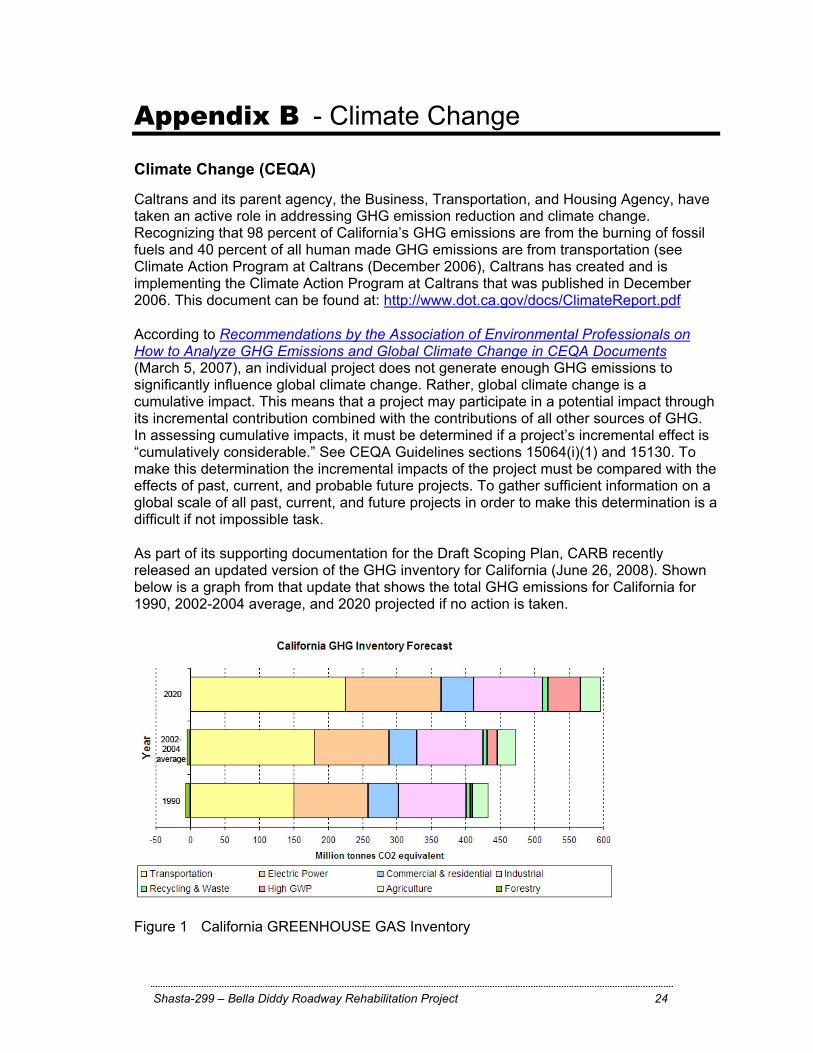
As part of its supporting documentation for the Draft Scoping Plan, CARB recently released an updated version of the GHG inventory for California (June 26, 2008). Shown below is a graph from that update that shows the total GHG emissions for California for 1990, 2002-2004 average, and 2020 projected if no action is taken.
Figure 1 California GREENHOUSE GAS Inventory
Shasta-299 – Bella Diddy Roadway Rehabilitation Project 25
Taken from : http://www.arb.ca.gov/cc/inventory/data/forecast.htm
Project Analysis The project will not increase the vehicular capacity of State Route 299 as the roadway will be re-constructed with the same lane configuration and capacity as the existing roadway. The proposed project is expected to rehabilitate the pavement and bring the roadway up to current design standards. Because the project would not increase capacity nor vehicle hours travelled, no increases in operational GHG emissions are anticipated. While construction emissions of greenhouse gases are unavoidable, there will likely be long term benefits with improved safety, operation, and smoother pavement surface.
Construction Emissions GHG emissions for transportation projects can be divided into those produced during construction and those produced during operations. Construction GHG emissions include emissions produced as a result of material processing, emissions produced by onsite construction equipment, and emissions arising from traffic delays due to construction. These emissions will be produced at different levels throughout the construction phase; their frequency and occurrence can be reduced through innovations in plans and specifications and by implementing better traffic management during construction phases. Even though the project is not anticipated to increase operational GHG emissions, the proposed project would generate some GHG emissions during construction.
CEQA Conclusion While construction will result in a slight increase in GHG emissions during construction, it is anticipated that the project will not result in any increase in operational GHG emissions. While it is Caltrans determination that in the absence of further regulatory or scientific information related to GHG emissions and CEQA significance, it is too speculative to make a significance determination regarding the project’s direct impact and its contribution on the cumulative scale to climate change, Caltrans is firmly committed to implementing measures to help reduce GHG emissions. These measures are outlined in the following section.
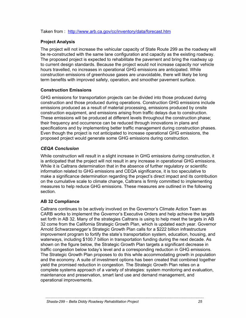
AB 32 Compliance Caltrans continues to be actively involved on the Governor’s Climate Action Team as CARB works to implement the Governor’s Executive Orders and help achieve the targets set forth in AB 32. Many of the strategies Caltrans is using to help meet the targets in AB 32 come from the California Strategic Growth Plan, which is updated each year. Governor Arnold Schwarzenegger’s Strategic Growth Plan calls for a $222 billion infrastructure improvement program to fortify the state’s transportation system, education, housing, and waterways, including $100.7 billion in transportation funding during the next decade. As shown on the figure below, the Strategic Growth Plan targets a significant decrease in traffic congestion below today’s level and a corresponding reduction in GHG emissions. The Strategic Growth Plan proposes to do this while accommodating growth in population and the economy. A suite of investment options has been created that combined together yield the promised reduction in congestion. The Strategic Growth Plan relies on a complete systems approach of a variety of strategies: system monitoring and evaluation, maintenance and preservation, smart land use and demand management, and operational improvements.
Shasta-299 – Bella Diddy Roadway Rehabilitation Project 26
Figure 3-2 Outcome of Strategic Growth Plan
As part of the Climate Action Program at Caltrans (December 2006, http://www.dot.ca.gov/docs/ClimateReport.pdf), Caltrans is supporting efforts to reduce vehicle miles traveled by planning and implementing smart land use strategies: job/housing proximity, developing transit-oriented communities, and high density housing along transit corridors. Caltrans is working closely with local jurisdictions on planning activities; however, Caltrans does not have local land use planning authority. Caltrans is also supporting efforts to improve the energy efficiency of the transportation sector by increasing vehicle fuel economy in new cars, light and heavy-duty trucks; Caltrans is doing this by supporting on-going research efforts at universities, by supporting legislative efforts to increase fuel economy, and by its participation on the Climate Action Team. It is important to note, however, that the control of the fuel economy standards is held by EPA and CARB. Lastly, the use of alternative fuels is also being considered; the Department is participating in funding for alternative fuel research at the UC Davis.
Adaptation Strategies: “Adaptation strategies” refer to how Caltrans and others can plan for the effects of climate change on the state’s transportation infrastructure and strengthen or protect the facilities from damage. Climate change is expected to produce increased variability in precipitation, rising temperatures, rising sea levels, storm surges and intensity, and the frequency and intensity of wildfires. These changes may affect the transportation infrastructure in various ways, such as damaging roadbeds by longer periods of intense heat; increasing storm damage from flooding and erosion; and inundation from rising sea levels. These effects will vary by location and may, in the most extreme cases, require that a facility be
Shasta-299 – Bella Diddy Roadway Rehabilitation Project 27
relocated or redesigned. There may also be economic and strategic ramifications as a result of these types of impacts to the transportation infrastructure. Climate change adaption must also involve the natural environment as well. Efforts are underway on a statewide-level to develop strategies to cope with impacts to habitat and biodiversity through planning and conservation. The results of these efforts will help California agencies plan and implement mitigation strategies for programs and projects. Executive Order S-13-08 (signed by Governor Sshwarzenegger in November 2008) directed the Business, Transportation, and Housing Agency to prepare a report to assess vulnerability of transportation systems to sea level rise affecting safety, maintenance and operational improvements of the system and economy of the state. The Department continues to work on assessing the transportation system vulnerability to climate change, including the effect of sea level rise. Prior to the release of the final Sea Level Rise Assessment Report (due to be released in December 2010 from the National Academy of Sciences), all state agencies that are planning to construct projects in areas vulnerable to future sea level rise were directed to consider a range of sea level rise scenarios for the years 2050 and 2100 in order to assess project vulnerability and, to the extent feasible, reduce expected risks and increase resiliency to sea level rise. However, all projects that have filed a Notice of Preparation, and/or are programmed for construction funding from 2008 through 2013, or are routine maintenance projects as of the date of Executive Order S-13-08 may, but are not required to, consider these planning guidelines. Sea level rise estimates should also be used in conjunction with information regarding local uplift and subsidence, coastal erosion rates, predicted higher high water levels, storm surge and storm wave data. (Executive Order S-13-08 allows some exceptions to this planning requirement.) This proposed project was programmed for construction funding in 2010, it is exempt at this time from the requirements to analyze the impacts of sea level rise as directed in Executive order S-13-08.
Currently, the Department is working to assess which transportation facilities are at greatest risk from climate change effects. However, without statewide planning scenarios for relative sea level rise and other climate change impacts, the Department has not been able to determine what change, if any, may be made to its design standards for its transportation facilities. Once statewide planning scenarios become available, the Department will be able review its current design standards to determine what changes, if any, may be warranted in order to protect the transportation system from sea level rise.
Shasta-299 – Bella Diddy Roadway Rehabilitation Project 28
Appendix C – Project Plan Sheets


![Ravel: Bolero 1st Bassoon solo · Berlioz: Symphonie Fantastique 2nd Bassoon mvt 4: 2m. before reh. 52 to 2m. after reh. 53 mvt 5: 8m. after reh. 63 to reh. 65 [] []](https://img.pdfslide.us/doc/110x75/5e8d468bdfea1718003f649b/ravel-bolero-1st-bassoon-solo-berlioz-symphonie-fantastique-2nd-bassoon-mvt-4.jpg)


![usuo.org...Kodály: Háry János Suite, Mvt. III Beginning to Reh. [1] Ravel: Ma Mère l'Oye Suite, Mvt. V 4 bars after Reh. [2] to 3 bars after Reh. [3]](https://img.pdfslide.us/doc/110x75/5e501c60d8dcbe38be0432bc/usuoorg-kodly-hry-jnos-suite-mvt-iii-beginning-to-reh-1-ravel.jpg)


![Shawn Lane - [Reh] - Power Solos](https://img.pdfslide.us/doc/110x75/552ba617550346b0478b47af/shawn-lane-reh-power-solos.jpg)