Embed Size (px)
Citation preview
United States Department of Agriculture Forest Service April 2011 Version 1.0
Travel Analysis Process San Juan National Forest
Columbine Ranger District
Beaver Meadows Landscape Responsible Official: Matthew Janowiak, District Ranger/Field Office Manager Abstract: This Travel Analysis Process Report documents a route-by-route analysis of all National Forest System roads on the Beaver Meadows Landscape and recommends the minimum road system needed for public access and forest management. The project is within the Columbine Ranger District, San Juan National Forest, Colorado. Location: Columbine Ranger District, San Juan National Forest
Archuleta & La Plata Counties, Colorado
Portions of Townships 34-37 North, Ranges 4-6 West, N.M.P.M.
For More Information Contact: Cam Hooley PO Box 439 Bayfield, CO 81122 970-884-1414
The U. S. Department of Agriculture (USDA) prohibits discrimination in all its programs and activities on the basis of race, color, national origin, gender, religion, age, disability, political beliefs, sexual
orientation, and marital or family status. (Not all bases apply to all programs.) Persons with disabilities who require alternative means for communication of program information (Braille, large print, audio
tape, etc.) should contact USDA’s TARGET center at 202-720-2600 (voice and TDD).
To file a complaint, write USDA, Director, Office of Civil Rights, Room 326-W, Whitten Building, 14th and Independence Avenue, SW, Washington, DC 20250-9410 or call 202-720-5964 (voice or TDD).
USDA is an equal-opportunity provider and employer
Beaver Meadows Landscape Travel Analysis Process
ii
TABLE OF CONTENTS LIST OF TABLES .................................................................................................................................. iii LIST OF MAPS ...................................................................................................................................... iii LIST OF ACRONYMS .......................................................................................................................... iv EXECUTIVE SUMMARY ..................................................................................................................... 1
Summary of Issues ................................................................................................................................................... 1 Analysis Performed ................................................................................................................................................. 2 Key Results and Findings ........................................................................................................................................ 2 How the Report will be Used .................................................................................................................................. 2
INTRODUCTION ................................................................................................................................... 3 Travel Management Rule ........................................................................................................................................ 3 Travel Analysis Process ........................................................................................................................................... 3 Forest Plan Direction ............................................................................................................................................... 4 Compliance with Forest Plan Direction ................................................................................................................. 4
Step 1. SETTING UP THE ANALYSIS ........................................................................................... 5 1.1 Purpose ......................................................................................................................................................... 5 1.2 Analysis Area ............................................................................................................................................... 5 1.3 Objectives ..................................................................................................................................................... 5 1.4 Specialist Roles ............................................................................................................................................. 6 1.5 Analysis Plan ................................................................................................................................................ 6 1.6 Information Needs ....................................................................................................................................... 6
Step 2. DESCRIBING THE SITUATION ........................................................................................ 8 2.1 Purpose ......................................................................................................................................................... 8 2.2 Road Management ....................................................................................................................................... 8 2.3 Geographic Information System and Corporate Database ...................................................................... 9 2.4 Existing Direction ...................................................................................................................................... 10 2.5 Existing Condition ..................................................................................................................................... 10
Step 3. IDENTIFYING ISSUES ..................................................................................................... 12 3.1 Purpose ....................................................................................................................................................... 12 3.2 Key Issues ................................................................................................................................................... 12
Step 4. ASSESSING BENEFITS, PROBLEMS, AND RISKS ...................................................... 14 4.1 Purpose ....................................................................................................................................................... 14 4.2 The Analysis Process ................................................................................................................................. 14 4.3 Criteria and Rankings Used in the Risk and Benefit Analysis............................................................... 14 4.4 Results of the Risk and Benefit Analysis .................................................................................................. 18
Step 5. DESCRIBING OPPORTUNITIES AND SETTING PRIORITIES ................................... 19 5.1 Purpose ....................................................................................................................................................... 19 5.2 Recommendations for Roads .................................................................................................................... 19 5.3 Minimum Road System ............................................................................................................................. 21 5.4 Process Used to Develop the Minimum Road System ............................................................................. 21 5.5 Beaver Meadows Landscape Minimum Road System ........................................................................... 22 5.6 Future Actions ............................................................................................................................................ 23
Step 6. REPORTING ....................................................................................................................... 24 APPENDIX A – MANAGEMENT AREA GUIDANCE ................................................................... A-1 APPENDIX B – ROAD MAINTENANCE COSTS ........................................................................... B-1 APPENDIX C - RISK/BENEFIT ANALYSIS RATIONALE AND METHODOLOGY ................. C-1 APPENDIX D - EXISTING ROAD SYSTEM MAP ......................................................................... D-1 APPENDIX E - RECOMMENDED MINIMUM ROAD SYSTEM MAP .......................................... E-1 APPENDIX F – ROAD RISK/BENEFIT SPREADSHEET ................................................................ F-1
Beaver Meadows Landscape Travel Analysis Process
iii
LIST OF TABLES Table 1. Miles of System Road by Maintenance Level ........................................................................ 10 Table 2. Landscape Wide Road Density by Management Area ............................................................ 11 Table 3: Road Risk and Benefit Categories .......................................................................................... 14 Table 4: Road Risk and Benefit Guidelines.......................................................................................... 15 Table 5. Miles of System Road in each Risk/Benefit Category ............................................................ 18 Table 6. Risk/Benefit Categories ........................................................................................................... 19 Table 7. Recommended Changes in System Road Miles ...................................................................... 22 Table B-1. Road Maintenance Costs ................................................................................................... B-3
LIST OF MAPS Management Areas Map ...................................................................................................................... A-7 Existing Road System Map................................................................ D-Error! Bookmark not defined. Recommended Road System Map ...................................................... E-Error! Bookmark not defined.
Beaver Meadows Landscape Travel Analysis Process
iv
LIST OF ACRONYMS ATV – All Terrain Vehicle
EA – Environmental Assessment
GIS – Geographic Information System, refers to the Forest Service graphical mapping databases
IDT – Interdisciplinary Team
INFRA – Infrastructure, refers to the Forest Service database with road information.
IRA – Inventoried Roadless Area (2001 Roadless Rule)
MA – Management Area, as defined by a set of guidance in the Forest Plan
ML – Maintenance Level, refers to Forest Service road maintenance levels
MVUM – Motor Vehicle Use Map
NEPA – National Environmental Policy Act
TAP – Travel Analysis Process
Beaver Meadows Landscape Travel Analysis Process
1
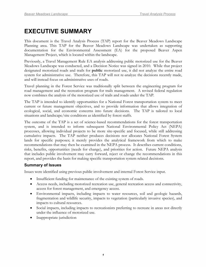
EXECUTIVE SUMMARY This document is the Travel Analysis Process (TAP) report for the Beaver Meadows Landscape Planning area. This TAP for the Beaver Meadows Landscape was undertaken as supporting documentation for the Environmental Assessment (EA) for the proposed Beaver Aspen Management Project, which is located within the landscape.
Previously, a Travel Management Rule EA analysis addressing public motorized use for the Beaver Meadows Landscape was conducted, and a Decision Notice was signed in 2010. While that project designated motorized roads and trails for public motorized use, it did not analyze the entire road system for administrative use. Therefore, this TAP will not re-analyze the decisions recently made, and will instead focus on administrative uses of roads.
Travel planning in the Forest Service was traditionally split between the engineering program for road management and the recreation program for trails management. A revised federal regulation now combines the analysis of the motorized use of trails and roads under the TAP.
The TAP is intended to identify opportunities for a National Forest transportation system to meet current or future management objectives, and to provide information that allows integration of ecological, social, and economic concerns into future decisions. The TAP is tailored to local situations and landscape/site conditions as identified by forest staffs.
The outcome of the TAP is a set of science-based recommendations for the forest transportation system, and is intended to inform subsequent National Environmental Policy Act (NEPA) processes, allowing individual projects to be more site-specific and focused, while still addressing cumulative impacts. The TAP neither produces decisions nor allocates National Forest System lands for specific purposes; it merely provides the analytical framework from which to make recommendations that may then be examined in the NEPA process. It describes current conditions, risks, benefits, opportunities (needs for change), and priorities for action. Future NEPA analysis that includes public involvement may carry forward, reject or change the recommendations in this report, and provides the basis for making specific transportation system related decisions.
Summary of Issues Issues were identified using previous public involvement and internal Forest Service input.
• Insufficient funding for maintenance of the existing system of roads. • Access needs, including motorized recreation use, general recreation access and connectivity,
access for forest management, and emergency access. • Environmental impacts, including impacts to water resources, soil and geologic hazards,
fragmentation and wildlife security, impacts to vegetation (particularly invasive species), and impacts to cultural resources.
• Social impacts, including impacts to recreationists preferring to recreate in areas not directly under the influence of motorized use.
• Inappropriate jurisdiction
Beaver Meadows Landscape Travel Analysis Process
2
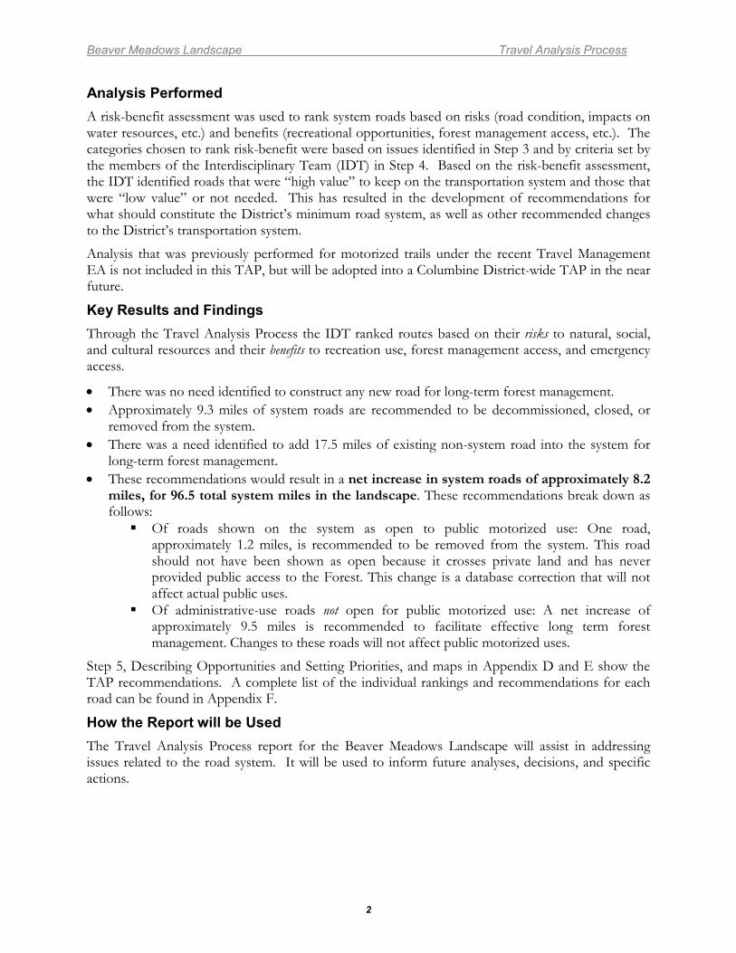
Analysis Performed A risk-benefit assessment was used to rank system roads based on risks (road condition, impacts on water resources, etc.) and benefits (recreational opportunities, forest management access, etc.). The categories chosen to rank risk-benefit were based on issues identified in Step 3 and by criteria set by the members of the Interdisciplinary Team (IDT) in Step 4. Based on the risk-benefit assessment, the IDT identified roads that were “high value” to keep on the transportation system and those that were “low value” or not needed. This has resulted in the development of recommendations for what should constitute the District’s minimum road system, as well as other recommended changes to the District’s transportation system.
Analysis that was previously performed for motorized trails under the recent Travel Management EA is not included in this TAP, but will be adopted into a Columbine District-wide TAP in the near future.
Key Results and Findings Through the Travel Analysis Process the IDT ranked routes based on their risks to natural, social, and cultural resources and their benefits to recreation use, forest management access, and emergency access.
• There was no need identified to construct any new road for long-term forest management. • Approximately 9.3 miles of system roads are recommended to be decommissioned, closed, or
removed from the system. • There was a need identified to add 17.5 miles of existing non-system road into the system for
long-term forest management. • These recommendations would result in a net increase in system roads of approximately 8.2
miles, for 96.5 total system miles in the landscape. These recommendations break down as follows: Of roads shown on the system as open to public motorized use: One road,
approximately 1.2 miles, is recommended to be removed from the system. This road should not have been shown as open because it crosses private land and has never provided public access to the Forest. This change is a database correction that will not affect actual public uses.
Of administrative-use roads not open for public motorized use: A net increase of approximately 9.5 miles is recommended to facilitate effective long term forest management. Changes to these roads will not affect public motorized uses.
Step 5, Describing Opportunities and Setting Priorities, and maps in Appendix D and E show the TAP recommendations. A complete list of the individual rankings and recommendations for each road can be found in Appendix F.
How the Report will be Used The Travel Analysis Process report for the Beaver Meadows Landscape will assist in addressing issues related to the road system. It will be used to inform future analyses, decisions, and specific actions.
Beaver Meadows Landscape Travel Analysis Process
3
INTRODUCTION Travel Management Rule In 2005, the U.S. Forest Service adopted the Travel Management Rule. The rule changes the way that the Forest Service regulates motor vehicles on National Forests and Grasslands. The Travel Management Rule requires that National Forests identify their minimum road system and designate roads, trails, and areas for motor vehicle use. This means that after the designation process is complete, the public will be able to operate motor vehicles only on the roads, trails, and areas that have been designated. The designations will not only list what roads, trails, and areas can be used, but also what types of vehicles can be used, and what time of year they can be used.
There are some exceptions to these designations, which include persons with a Forest Service permit specifically authorizing the otherwise prohibited act, any Federal, State or local law enforcement officer, or member of an organized rescue or firefighting force engaged in the performance of an official duty, and Forest Service administrative use.
The object of the Travel Management Rule is not to unnecessarily limit access to the Forest, but to protect the Forest from unmanaged use. The Forest Service must strike a balance in managing all types of recreational activities. To this end, a designated system of roads, trails, and areas for motor vehicle use, established with public involvement, will enhance public enjoyment of the National Forests while maintaining other important values and uses on National Forest System lands. The Travel Management Rule works to manage current use so future generations can continue to enjoy access to our National Forest System lands.
The travel management regulations (36 CFR 212.5(b)) require that the Forest Service “identify the minimum road system needed for safe and efficient travel and for administration, utilization, and protection of National Forest System lands”; and to identify the roads that “are no longer needed to meet forest resource management objectives and that, therefore, should be decommissioned or considered for other uses, such as for trails”.
Travel Analysis Process Before the Forest Service adopted the Travel Management Rule, the Roads Analysis Process described in the Forest Service Manual (7712.1) and publication FS-643, Roads Analysis: Informing Decisions about Managing the Transportation System was used. A Roads Analysis Report analyzing Maintenance Level (ML) 3, 4, and 5 roads across the San Juan National Forest was produced in July 2006. Direction for completing the TAP is provided in Forest Service Handbook 7709.55 Chapter 20. This TAP Report revises and updates the San Juan National Forest Roads Analysis Report, including adding ML 1 and 2 roads.
The Travel Analysis Process consists of six steps which are as follows:
Step 1: Setting Up the Analysis Step 2: Describing the Situation Step 3: Identifying Issues Step 4: Assessing Benefits, Problems, and Risks Step 5: Describing Opportunities and Setting Priorities Step 6: Reporting
Travel Analysis is an iterative, not a one-time, process. When conditions change, additional analysis may point to the need for revisions in the recommendations. In fact, a travel management route designation process will likely result in additional information and, perhaps, decisions that will then be reflected in changes to the recommendations in this report.
Beaver Meadows Landscape Travel Analysis Process
4
This TAP does not address non-motorized trail opportunities; it is focuses only on the motorized road system. This TAP does not re-analyze motorized trails for this landscape because an analysis was recently completed in 2010 under the Travel Management EA.
The TAP is not a decision process. Travel Analysis provides the analytical framework from which to make recommendations that may then be examined in the NEPA process, which provides the basis, including formal public involvement, for making decisions.
Forest Plan Direction The Forest Plan for the San Juan National Forest establishes programmatic direction for the management of National Forest System lands.
The San Juan National Forest is broken into discrete Management Areas. Management Areas (MA) provide management direction by emphasizing a particular resource and identifying associated guidelines (prescriptions) for management activities. The following management areas are located in the analysis area: 2B, 3A, 4B, 5B, 6B, 7E, 1.11, and 1.12. Applicable Forest-wide transportation General Direction statements as well as transportation related direction for each management area are located in Appendix A.
Compliance with Forest Plan Direction Development of the minimum road system and designation of roads recommended in this report are in compliance with Forest Plan direction.
Beaver Meadows Landscape Travel Analysis Process
5
STEP 1. SETTING UP THE ANALYSIS 1.1 Purpose The purpose of this step is to:
• Identify the analysis area • State objectives • Identify the roles of technical specialists • Develop a process plan and an analysis plan • Address information needs
1.2 Analysis Area The analysis area is the Beaver Meadows Landscape which is approximately 52,250 acres in size. Approximately 88% of the landscape is on National Forest System lands, the remaining acres are private lands within the boundaries of the National Forest.
1.3 Objectives The objective of this analysis is to provide scientific information for managing roads that are safe and responsive to public needs and desires, conform to the Forest Plan, are determined to be needed to meet resource and other management objectives, minimize adverse environmental impacts, and better reflect long-term funding expectations. All existing system roads within the analysis area are included in this Travel Analysis Process report. Not all non-system routes were analyzed in this TAP. Only non-system roads that were considered for addition to the transportation system are included in this TAP.
The TAP is intended to be a broad scale comprehensive look at the transportation network. The main objectives of the TAP are:
• Balance the need for access while minimizing risks by examining important resource, social, and economic issues related to roads;
• Furnish maps, tables, and narratives that display transportation management opportunities and strategies that address future access needs and environmental concerns;
• Identify the need for change by comparing the current road system to the desired condition; and
• Make recommendations to inform travel management decisions in subsequent NEPA documents.
Beaver Meadows Landscape Travel Analysis Process
6
1.4 Specialist Roles The Interdisciplinary Team (IDT) members and their primary discipline(s) or function are listed below:
Dave Crawford – Timber Cam Hooley – NEPA/Planning Nancy Berry – Travel Management Jed Botsford - Recreation Pete Merkel – Engineering Jared Whitmer – Range Jeff Redders – Ecology Skip Fischer – Wildlife Hon Schlapfer – Fire, Fuels, Emergency Access Eric Herchmer – Hydrology Amy Wise – Archeology Jessie Ramirez – GIS
1.5 Analysis Plan The IDT followed these steps in order to carry out the analysis:
• Review and assemble existing data, including the San Juan National Forest Roads Analysis Report, and the recent Travel Management decision.
• Verify accuracy of system road locations on maps. • Identify discrepancies between on-the-ground conditions, the Forest’s INFRA database,
geographic information system (GIS) database, and current management direction. Document and correct where possible these conditions and data discrepancies.
• Where possible, verify the current conditions of roads, including safety issues, surface type and environmental issues.
• Identify preliminary access and resource issues, concerns, and opportunities. • Identify additional issues, concerns, and opportunities through previous public involvement
and internal resource staffs. • Perform the analysis concurrently with other plans and projects ongoing on the District. • Recommend changes to the road system based on the findings of this TAP to develop the
minimum road system and improve the management of forest resources relating to the transportation system.
1.6 Information Needs Information needs were identified and the IDT worked to gather as much information as available about the following:
• Accurate location and condition of all system roads within the analysis area. A complete inventory of non-system routes was not required; however some of these routes were inventoried at the District’s discretion.
• Maintenance responsibility. • Assessment of previous and current opportunities, problems and risks for all roads in the
analysis area. • Soil, hydrology, vegetation, invasive species, wildlife, and cultural resources and areas where
they are being impacted by roads.
Beaver Meadows Landscape Travel Analysis Process
7
• Areas of special sensitivity, resources values, or both. • Public access and recreational needs and desires in the area, including access for nearby
landowners. • Conflicts among uses, public access, user safety, and accessibility. • Anticipated future levels of motor vehicle use and changes in motor vehicle technology. • Transportation needs for Forest management activities. • Transportation investments necessary to meet land management plan objectives. • Current observed road uses. • Economic costs and benefits. • Road management objectives. • Best management practices. • Forest Plan and other management direction. • Agency objectives and priorities. • Interrelationship with other governmental jurisdictions for roads. • Applicable federal, state, and local laws. • Public and user group values and concerns. • Forest-wide and project level road analyses. • Previous administrative decisions regarding travel management.
Beaver Meadows Landscape Travel Analysis Process
8
STEP 2. DESCRIBING THE SITUATION 2.1 Purpose The purpose of this step is to:
• Describe the existing management direction • Describe the existing road system
2.2 Road Management National Forest System Roads are managed in accordance with the Road Management Objectives established for the each road. These objectives stipulate the uses for which the road was designed and currently managed, maintenance levels, target maintenance frequencies and tasks, and other information.
National Forest System Roads are assigned a specific maintenance level that is based on a set of criteria which describes how each individual road will be maintained. This criteria includes considerations for resource protection, season of use, user comfort and safety, travel speed, traffic volume and type, and surface type.
Discussions about roads in this TAP report will use the Forest Service Maintenance Level (ML) terminology which includes ML 1-5: ML 1 (roads closed to public); ML 2 (high clearance vehicles); ML 3 (suitable for passenger car travel); ML 4 (suitable for passenger car travel, provides comfort at moderate speeds); and ML 5 (paved, or chip sealed). On the Beaver Meadows landscape, ML 1 and 2 roads are usually native surface and ML 3 and 4 Roads are usually surfaced with gravel.
Maintenance Levels 1-5 are described in more detail in the following paragraphs.
MAINTENANCE LEVEL 1. These are roads that have been placed in storage between intermittent uses. The period of storage must exceed 1 year. Basic custodial maintenance is performed to prevent damage to adjacent resources and to perpetuate the road for future resource management needs. Emphasis is normally given to maintaining drainage facilities and runoff patterns. Planned road deterioration may occur at this level. Appropriate traffic management strategies are "prohibit" and "eliminate". These roads are closed to public motorized use and are not shown on motor vehicle use maps.
Roads receiving level 1 maintenance may be of any type, class, or construction standard, and may be managed at any other maintenance level during the time they are open for traffic. However, while being maintained at level 1, they are closed to vehicular traffic but may be available and suitable limited administrative or permitted use and for nonmotorized uses.
MAINTENANCE LEVEL 2. Assigned to roads open for use by high clearance vehicles. Passenger car traffic, user comfort, and user convenience are not considerations. Warning signs and traffic control devices are not provided with the exception that some signing may be posted at intersections. Motorists should have no expectations of being alerted to potential hazards while driving these roads. Traffic is normally minor, usually consisting of one or a combination of administrative, permitted, dispersed recreation, or other specialized uses. Log haul may occur at this level. Appropriate traffic management strategies are either to “discourage or prohibit passenger cars” or “accept or discourage high clearance vehicles”.
MAINTENANCE LEVEL 3. Assigned to roads open and maintained for travel by a prudent driver in a standard passenger car. User comfort and convenience are not considered priorities. The Manual on Uniform Traffic Control Devices is applicable. Warning signs and traffic control devices are provided to alert motorists of situations that may violate expectations.
Beaver Meadows Landscape Travel Analysis Process
9
Roads in this maintenance level are typically low speed with single lanes and turnouts. Appropriate traffic management strategies are either "encourage" or "accept." "Discourage" or "prohibit" strategies may be employed for certain classes of vehicles or users.
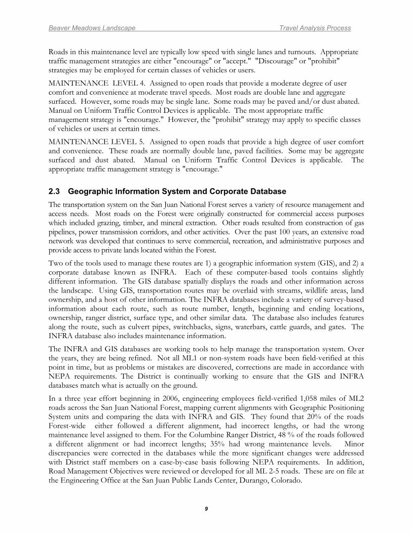
MAINTENANCE LEVEL 4. Assigned to open roads that provide a moderate degree of user comfort and convenience at moderate travel speeds. Most roads are double lane and aggregate surfaced. However, some roads may be single lane. Some roads may be paved and/or dust abated. Manual on Uniform Traffic Control Devices is applicable. The most appropriate traffic management strategy is "encourage." However, the "prohibit" strategy may apply to specific classes of vehicles or users at certain times.
MAINTENANCE LEVEL 5. Assigned to open roads that provide a high degree of user comfort and convenience. These roads are normally double lane, paved facilities. Some may be aggregate surfaced and dust abated. Manual on Uniform Traffic Control Devices is applicable. The appropriate traffic management strategy is "encourage."
2.3 Geographic Information System and Corporate Database The transportation system on the San Juan National Forest serves a variety of resource management and access needs. Most roads on the Forest were originally constructed for commercial access purposes which included grazing, timber, and mineral extraction. Other roads resulted from construction of gas pipelines, power transmission corridors, and other activities. Over the past 100 years, an extensive road network was developed that continues to serve commercial, recreation, and administrative purposes and provide access to private lands located within the Forest.
Two of the tools used to manage these routes are 1) a geographic information system (GIS), and 2) a corporate database known as INFRA. Each of these computer-based tools contains slightly different information. The GIS database spatially displays the roads and other information across the landscape. Using GIS, transportation routes may be overlaid with streams, wildlife areas, land ownership, and a host of other information. The INFRA databases include a variety of survey-based information about each route, such as route number, length, beginning and ending locations, ownership, ranger district, surface type, and other similar data. The database also includes features along the route, such as culvert pipes, switchbacks, signs, waterbars, cattle guards, and gates. The INFRA database also includes maintenance information.
The INFRA and GIS databases are working tools to help manage the transportation system. Over the years, they are being refined. Not all ML1 or non-system roads have been field-verified at this point in time, but as problems or mistakes are discovered, corrections are made in accordance with NEPA requirements. The District is continually working to ensure that the GIS and INFRA databases match what is actually on the ground.
In a three year effort beginning in 2006, engineering employees field-verified 1,058 miles of ML2 roads across the San Juan National Forest, mapping current alignments with Geographic Positioning System units and comparing the data with INFRA and GIS. They found that 20% of the roads Forest-wide either followed a different alignment, had incorrect lengths, or had the wrong maintenance level assigned to them. For the Columbine Ranger District, 48 % of the roads followed a different alignment or had incorrect lengths; 35% had wrong maintenance levels. Minor discrepancies were corrected in the databases while the more significant changes were addressed with District staff members on a case-by-case basis following NEPA requirements. In addition, Road Management Objectives were reviewed or developed for all ML 2-5 roads. These are on file at the Engineering Office at the San Juan Public Lands Center, Durango, Colorado.
Beaver Meadows Landscape Travel Analysis Process
10
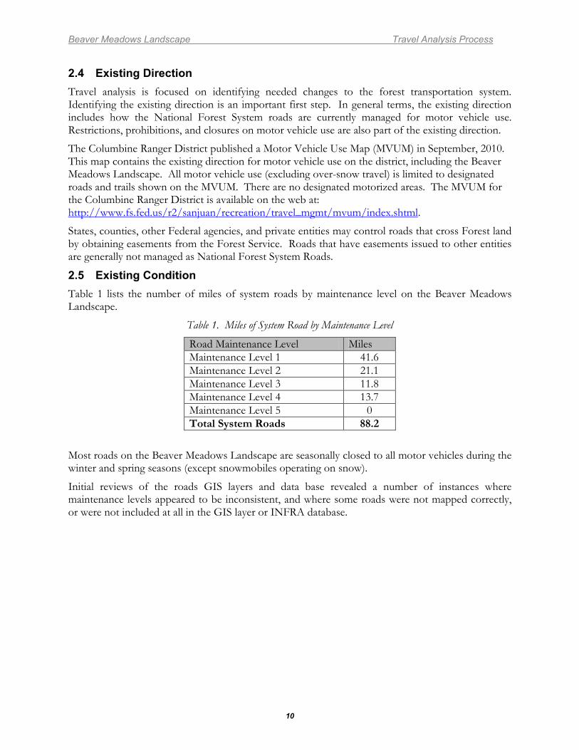
2.4 Existing Direction Travel analysis is focused on identifying needed changes to the forest transportation system. Identifying the existing direction is an important first step. In general terms, the existing direction includes how the National Forest System roads are currently managed for motor vehicle use. Restrictions, prohibitions, and closures on motor vehicle use are also part of the existing direction.
The Columbine Ranger District published a Motor Vehicle Use Map (MVUM) in September, 2010. This map contains the existing direction for motor vehicle use on the district, including the Beaver Meadows Landscape. All motor vehicle use (excluding over-snow travel) is limited to designated roads and trails shown on the MVUM. There are no designated motorized areas. The MVUM for the Columbine Ranger District is available on the web at: http://www.fs.fed.us/r2/sanjuan/recreation/travel_mgmt/mvum/index.shtml.
States, counties, other Federal agencies, and private entities may control roads that cross Forest land by obtaining easements from the Forest Service. Roads that have easements issued to other entities are generally not managed as National Forest System Roads.
2.5 Existing Condition Table 1 lists the number of miles of system roads by maintenance level on the Beaver Meadows Landscape.
Table 1. Miles of System Road by Maintenance Level
Road Maintenance Level Miles Maintenance Level 1 41.6 Maintenance Level 2 21.1 Maintenance Level 3 11.8 Maintenance Level 4 13.7 Maintenance Level 5 0 Total System Roads 88.2
Most roads on the Beaver Meadows Landscape are seasonally closed to all motor vehicles during the winter and spring seasons (except snowmobiles operating on snow).
Initial reviews of the roads GIS layers and data base revealed a number of instances where maintenance levels appeared to be inconsistent, and where some roads were not mapped correctly, or were not included at all in the GIS layer or INFRA database.
Beaver Meadows Landscape Travel Analysis Process
11
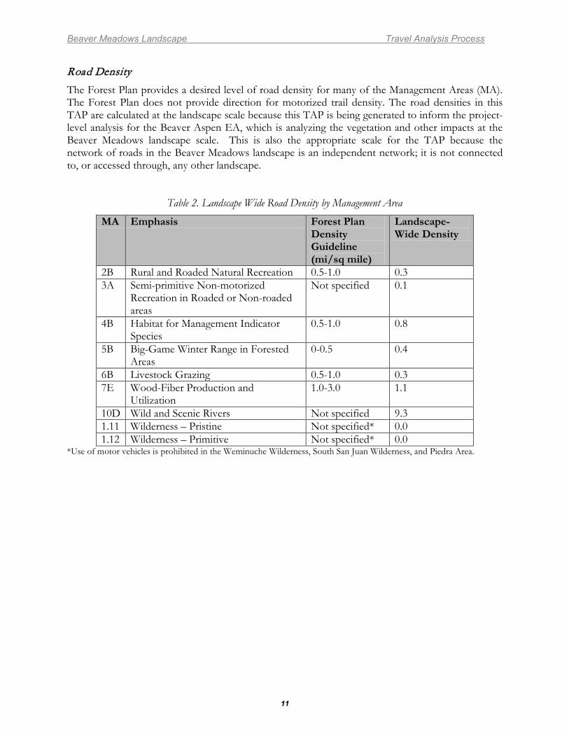
Road Density The Forest Plan provides a desired level of road density for many of the Management Areas (MA). The Forest Plan does not provide direction for motorized trail density. The road densities in this TAP are calculated at the landscape scale because this TAP is being generated to inform the project-level analysis for the Beaver Aspen EA, which is analyzing the vegetation and other impacts at the Beaver Meadows landscape scale. This is also the appropriate scale for the TAP because the network of roads in the Beaver Meadows landscape is an independent network; it is not connected to, or accessed through, any other landscape.
Table 2. Landscape Wide Road Density by Management Area
MA Emphasis Forest Plan Density Guideline (mi/sq mile)
Landscape- Wide Density
2B Rural and Roaded Natural Recreation 0.5-1.0 0.3 3A Semi-primitive Non-motorized
Recreation in Roaded or Non-roaded areas
Not specified 0.1
4B Habitat for Management Indicator Species
0.5-1.0 0.8
5B Big-Game Winter Range in Forested Areas
0-0.5 0.4
6B Livestock Grazing 0.5-1.0 0.3 7E Wood-Fiber Production and
Utilization 1.0-3.0 1.1
10D Wild and Scenic Rivers Not specified 9.3 1.11 Wilderness – Pristine Not specified* 0.0 1.12 Wilderness – Primitive Not specified* 0.0
*Use of motor vehicles is prohibited in the Weminuche Wilderness, South San Juan Wilderness, and Piedra Area.
Beaver Meadows Landscape Travel Analysis Process
12
STEP 3. IDENTIFYING ISSUES 3.1 Purpose The purpose of this step is to:
• Identify key issues related to management of the existing road system.
3.2 Key Issues The key issues were identified using recent public involvement and comments for travel management and Forest planning that addressed the Columbine Ranger District transportation system as well as input from Forest Service personnel. These issues are listed in random order and do not represent a hierarchy of importance.
1. Insufficient funding for maintenance of the existing system roads Inadequate maintenance reduces access for National Forest users and management, accelerates soil erosion by concentrating surface water flow, and affects water quality and aquatic habitat by increasing sediment into water courses and intermittent drainages. Funding for road maintenance is not adequate to maintain the existing system and perform needed monitoring. (See Appendix B for more information on road maintenance costs.)
2. Access Needs Motorized vehicle access, of various types, is needed in order to efficiently manage the Forest, provide recreational opportunities, and provide access for emergency response. a. Motorized Recreation Use: Roads are used for various types of motorized recreation
including driving for pleasure, 4-wheel driving, All Terrain Vehicle (ATV) and motorcycle riding, and snowmobile riding.
b. Recreation Access/Connectivity: Roads are often used to provide motor vehicle access to recreational activities occurring off roads, such as hiking, camping, hunting, firewood gathering, rock collecting, etc. Roads also can provide important connectivity to other roads and motorized trails.
c. Forest Management: Roads are used for access to forest management activities such as fuels reduction, timber harvest, grazing, mining, oil and gas development, noxious weed treatment, etc.
d. Emergency Access: Roads facilitate responding to emergencies such as fire suppression and search and rescue.
e. Need to obtain rights-of-way and access: Some Forest roads that cross private property do not have legal rights-of-way. Public and administrative access may be barred in the future if legal rights-of-way are not acquired, or data base errors need to be rectified.
Beaver Meadows Landscape Travel Analysis Process
13
3. Environmental Impacts There are concerns about damage from motor vehicle use, including: a. Impacts to water resources: Erosion and sediment transport off roads in areas with
perennial, intermittent, and ephemeral stream channels or wetlands may impair the ecological and hydrologic function of drainage channels;
b. Soil and Geologic Hazards: Portions of the analysis area have soils that erode easily. These soils are extremely susceptible to compaction, rutting, gullying, and development of mud holes. Some roads are susceptible to mass movement, such as landsliding and slumping.
c. Fragmentation and wildlife security: Motorized routes may fragment wildlife habitat, create barriers to movement, reduce wildlife habitat capability to sustain populations, and increase areas of disturbance.
d. Impacts to vegetation: Motor vehicle use may cause the spread of invasive species by dispersing seed sources.
e. Impacts to cultural resources: Motorized routes and use of these routes may impact cultural resources.
4. Inappropriate Jurisdiction
Portions of some roads may not be under the appropriate jurisdiction and would be better managed within a county road system, particularly where they provide access to large private inholdings and developments.
Beaver Meadows Landscape Travel Analysis Process
14
STEP 4. ASSESSING BENEFITS, PROBLEMS, AND RISKS
4.1 Purpose The purpose of this step is to:
• Describe the analysis process • Describe the criteria and rankings used in the risk and benefit analysis • Summarize the results of the risk and benefit analysis
4.2 The Analysis Process The risk and benefit criteria categories (Table 3) were developed by considering the issues from Step 3, the assessment of benefits, problems, and risks contained in the San Juan National Forest Roads Analysis Report, and additional knowledge and information from the Forest staff. The questions and answers for assessing the benefits, problems, and risks of the existing and potential road system contained in Step 4 of the San Juan National Forest Roads Analysis Report were reviewed and found to be applicable to this TAP and are not repeated in this document. Each road was then evaluated against the identified risks and benefits.
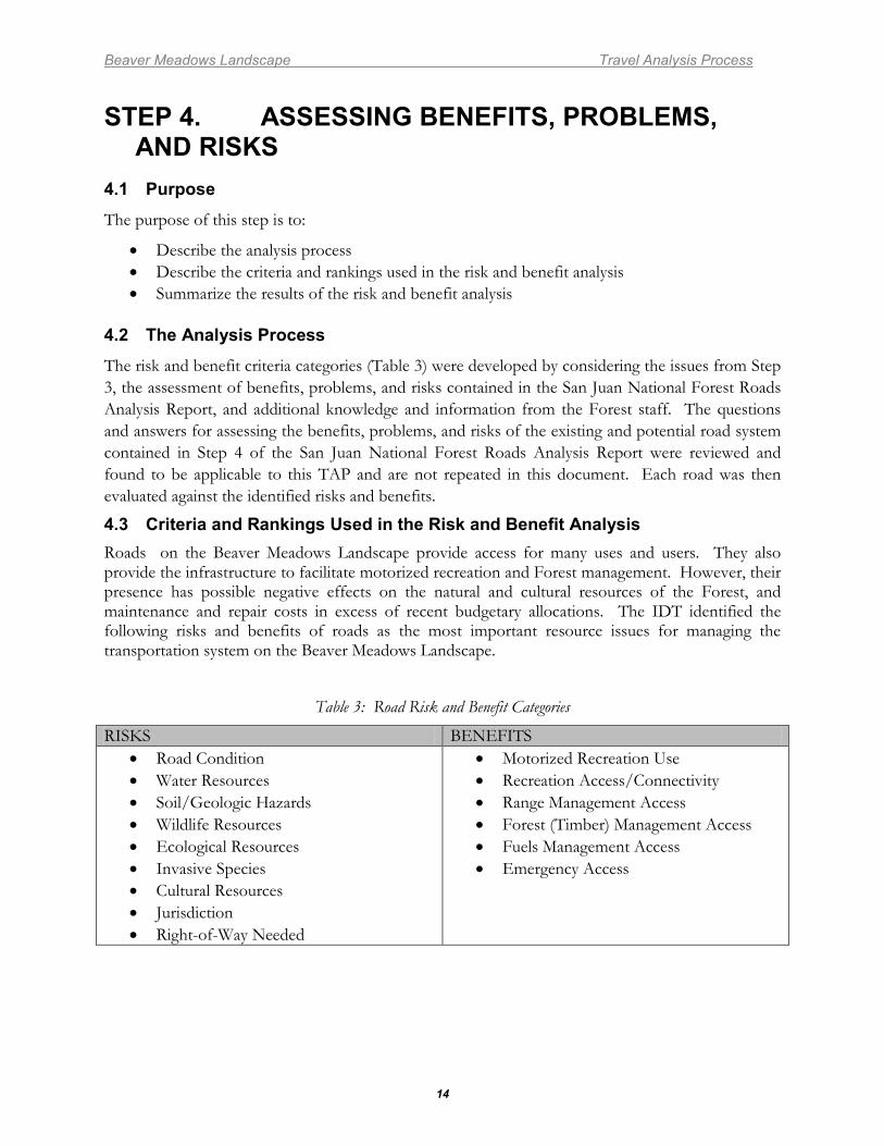
4.3 Criteria and Rankings Used in the Risk and Benefit Analysis Roads on the Beaver Meadows Landscape provide access for many uses and users. They also provide the infrastructure to facilitate motorized recreation and Forest management. However, their presence has possible negative effects on the natural and cultural resources of the Forest, and maintenance and repair costs in excess of recent budgetary allocations. The IDT identified the following risks and benefits of roads as the most important resource issues for managing the transportation system on the Beaver Meadows Landscape.
Table 3: Road Risk and Benefit Categories
RISKS BENEFITS • Road Condition • Water Resources • Soil/Geologic Hazards • Wildlife Resources • Ecological Resources • Invasive Species • Cultural Resources • Jurisdiction • Right-of-Way Needed
• Motorized Recreation Use • Recreation Access/Connectivity • Range Management Access • Forest (Timber) Management Access • Fuels Management Access • Emergency Access
Beaver Meadows Landscape Travel Analysis Process
15
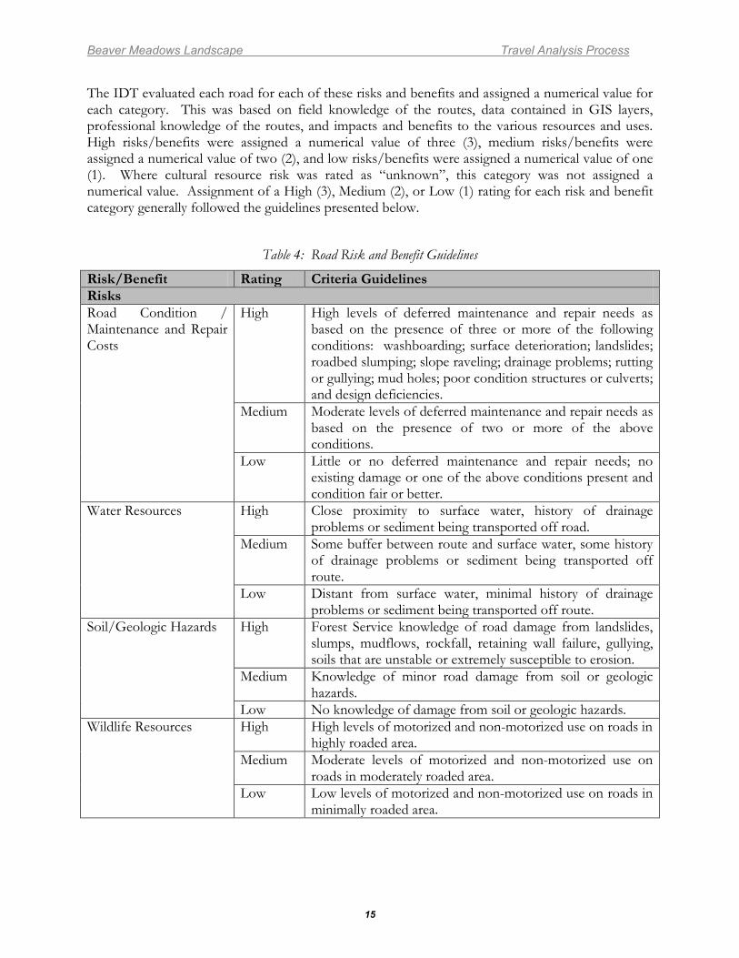
The IDT evaluated each road for each of these risks and benefits and assigned a numerical value for each category. This was based on field knowledge of the routes, data contained in GIS layers, professional knowledge of the routes, and impacts and benefits to the various resources and uses. High risks/benefits were assigned a numerical value of three (3), medium risks/benefits were assigned a numerical value of two (2), and low risks/benefits were assigned a numerical value of one (1). Where cultural resource risk was rated as “unknown”, this category was not assigned a numerical value. Assignment of a High (3), Medium (2), or Low (1) rating for each risk and benefit category generally followed the guidelines presented below.
Table 4: Road Risk and Benefit Guidelines
Risk/Benefit Rating Criteria Guidelines Risks Road Condition / Maintenance and Repair Costs
High High levels of deferred maintenance and repair needs as based on the presence of three or more of the following conditions: washboarding; surface deterioration; landslides; roadbed slumping; slope raveling; drainage problems; rutting or gullying; mud holes; poor condition structures or culverts; and design deficiencies.
Medium Moderate levels of deferred maintenance and repair needs as based on the presence of two or more of the above conditions.
Low Little or no deferred maintenance and repair needs; no existing damage or one of the above conditions present and condition fair or better.
Water Resources High Close proximity to surface water, history of drainage problems or sediment being transported off road.
Medium Some buffer between route and surface water, some history of drainage problems or sediment being transported off route.
Low Distant from surface water, minimal history of drainage problems or sediment being transported off route.
Soil/Geologic Hazards High Forest Service knowledge of road damage from landslides, slumps, mudflows, rockfall, retaining wall failure, gullying, soils that are unstable or extremely susceptible to erosion.
Medium Knowledge of minor road damage from soil or geologic hazards.
Low No knowledge of damage from soil or geologic hazards. Wildlife Resources
High High levels of motorized and non-motorized use on roads in highly roaded area.
Medium Moderate levels of motorized and non-motorized use on roads in moderately roaded area.
Low Low levels of motorized and non-motorized use on roads in minimally roaded area.
Beaver Meadows Landscape Travel Analysis Process
16
Risk/Benefit Rating Criteria Guidelines Risks Ecological Resources
High High road densities, high levels of motorized use, and high concentrations of sensitive ecological resources.
Medium Moderate road densities, moderate levels of motorized use, and moderate concentrations of sensitive ecological resources.
Low Low road densities, low levels of motorized use, and low concentrations of sensitive ecological resources.
Invasive Species High Numerous known populations of noxious weeds in vicinity of route corridor.
Medium Some known populations of noxious weeds in vicinity of route corridor.
Low No or few known populations of noxious weeds in vicinity of route corridor.
Cultural Resources
High Known historic properties within road prism or in vicinity of corridor.
Unknown Area of unknown archaeological potential, little or no archaeological survey and/or the presence of “needs data” sites.
Low No known or located historic properties within prism or in vicinity of corridor where archaeological potential has been largely assessed (through Class III archaeological inventory) or Level 3 or higher road where cultural resources are likely to be compromised.
Jurisdiction High Access to multiple private parcels or large private development(s).
Medium Access to few private parcels. Low No private access.
Rights-of-Way High Multiple or complex right-of-way issues Medium Few or non-critical rights-of-way issues. Low No rights-of-way issues.
Benefits Motorized Recreation Use
High Roads that are frequently used for motorized recreation activities (includes driving for pleasure, 4X4, ATV, motorcycle, or snowmobile use).
Medium Roads that are occasionally used for motorized recreation activities.
Low Roads that are rarely or never (ML1 roads) used for motorized recreation activities.
Recreation Access/Connectivity
High Roads that provide access to numerous or high value recreation opportunities and/or connectivity to many other motorized routes.
Medium Roads that provide access to some recreation opportunities and/or connectivity to some other motorized routes.
Low Roads that provide access to limited recreation opportunities and do not provide connectivity to other motorized routes.
Beaver Meadows Landscape Travel Analysis Process
17
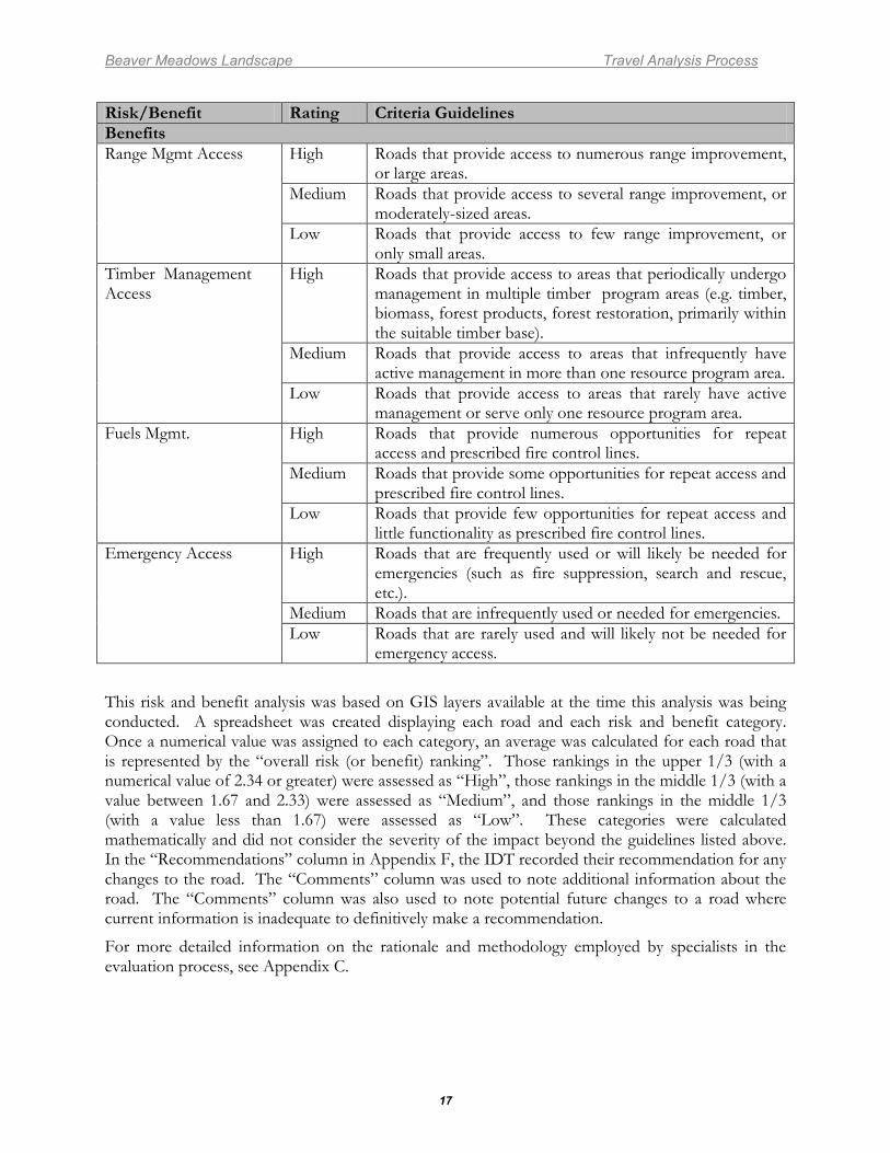
Risk/Benefit Rating Criteria Guidelines Benefits Range Mgmt Access High Roads that provide access to numerous range improvement,
or large areas. Medium Roads that provide access to several range improvement, or
moderately-sized areas. Low Roads that provide access to few range improvement, or
only small areas. Timber Management Access
High Roads that provide access to areas that periodically undergo management in multiple timber program areas (e.g. timber, biomass, forest products, forest restoration, primarily within the suitable timber base).
Medium Roads that provide access to areas that infrequently have active management in more than one resource program area.
Low Roads that provide access to areas that rarely have active management or serve only one resource program area.
Fuels Mgmt. High Roads that provide numerous opportunities for repeat access and prescribed fire control lines.
Medium Roads that provide some opportunities for repeat access and prescribed fire control lines.
Low Roads that provide few opportunities for repeat access and little functionality as prescribed fire control lines.
Emergency Access High Roads that are frequently used or will likely be needed for emergencies (such as fire suppression, search and rescue, etc.).
Medium Roads that are infrequently used or needed for emergencies. Low Roads that are rarely used and will likely not be needed for
emergency access.
This risk and benefit analysis was based on GIS layers available at the time this analysis was being conducted. A spreadsheet was created displaying each road and each risk and benefit category. Once a numerical value was assigned to each category, an average was calculated for each road that is represented by the “overall risk (or benefit) ranking”. Those rankings in the upper 1/3 (with a numerical value of 2.34 or greater) were assessed as “High”, those rankings in the middle 1/3 (with a value between 1.67 and 2.33) were assessed as “Medium”, and those rankings in the middle 1/3 (with a value less than 1.67) were assessed as “Low”. These categories were calculated mathematically and did not consider the severity of the impact beyond the guidelines listed above. In the “Recommendations” column in Appendix F, the IDT recorded their recommendation for any changes to the road. The “Comments” column was used to note additional information about the road. The “Comments” column was also used to note potential future changes to a road where current information is inadequate to definitively make a recommendation.
For more detailed information on the rationale and methodology employed by specialists in the evaluation process, see Appendix C.
Beaver Meadows Landscape Travel Analysis Process
18
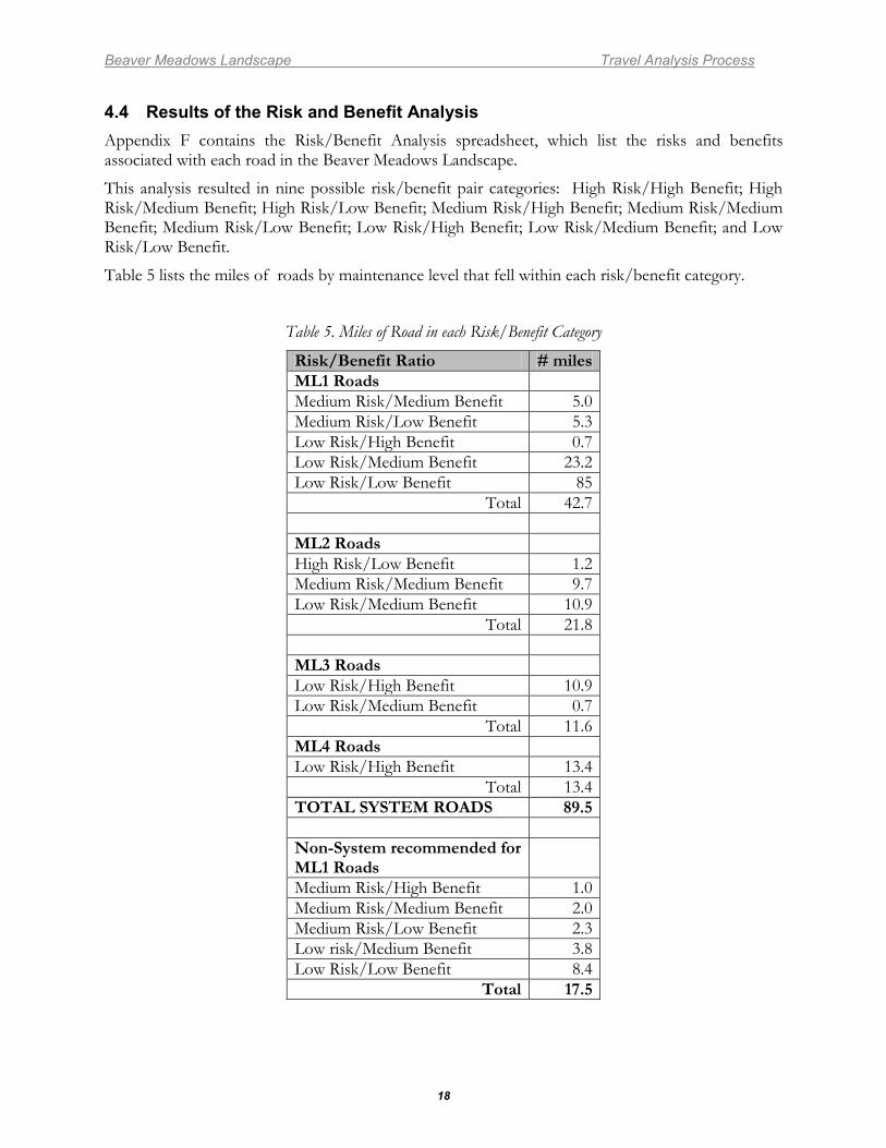
4.4 Results of the Risk and Benefit Analysis Appendix F contains the Risk/Benefit Analysis spreadsheet, which list the risks and benefits associated with each road in the Beaver Meadows Landscape.
This analysis resulted in nine possible risk/benefit pair categories: High Risk/High Benefit; High Risk/Medium Benefit; High Risk/Low Benefit; Medium Risk/High Benefit; Medium Risk/Medium Benefit; Medium Risk/Low Benefit; Low Risk/High Benefit; Low Risk/Medium Benefit; and Low Risk/Low Benefit.
Table 5 lists the miles of roads by maintenance level that fell within each risk/benefit category.
Table 5. Miles of Road in each Risk/Benefit Category
Risk/Benefit Ratio # miles ML1 Roads Medium Risk/Medium Benefit 5.0 Medium Risk/Low Benefit 5.3 Low Risk/High Benefit 0.7 Low Risk/Medium Benefit 23.2 Low Risk/Low Benefit 85
Total 42.7 ML2 Roads High Risk/Low Benefit 1.2 Medium Risk/Medium Benefit 9.7 Low Risk/Medium Benefit 10.9
Total 21.8 ML3 Roads Low Risk/High Benefit 10.9 Low Risk/Medium Benefit 0.7
Total 11.6 ML4 Roads Low Risk/High Benefit 13.4
Total 13.4 TOTAL SYSTEM ROADS 89.5 Non-System recommended for ML1 Roads
Medium Risk/High Benefit 1.0 Medium Risk/Medium Benefit 2.0 Medium Risk/Low Benefit 2.3 Low risk/Medium Benefit 3.8 Low Risk/Low Benefit 8.4
Total 17.5
Beaver Meadows Landscape Travel Analysis Process
19
STEP 5. DESCRIBING OPPORTUNITIES AND SETTING PRIORITIES
5.1 Purpose The purpose of this step is to:
• List recommendations for roads • Determine the minimum road system • Describe future actions
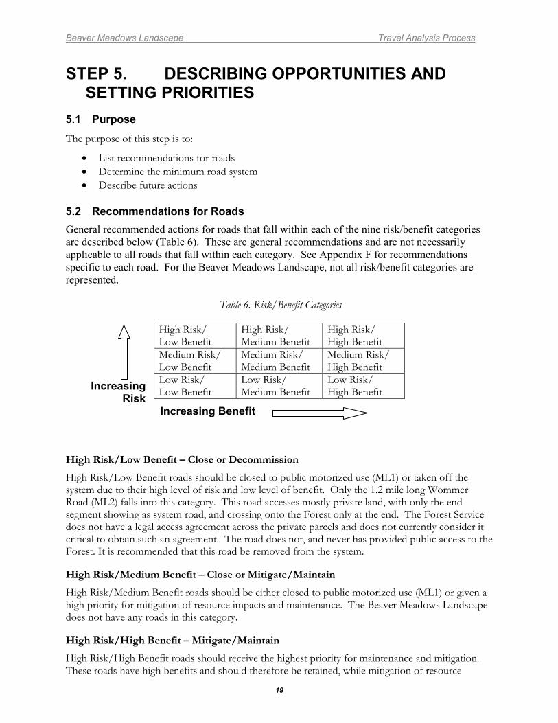
5.2 Recommendations for Roads General recommended actions for roads that fall within each of the nine risk/benefit categories are described below (Table 6). These are general recommendations and are not necessarily applicable to all roads that fall within each category. See Appendix F for recommendations specific to each road. For the Beaver Meadows Landscape, not all risk/benefit categories are represented.
Table 6. Risk/Benefit Categories
Increasing Risk
Increasing Benefit
High Risk/Low Benefit – Close or Decommission
High Risk/Low Benefit roads should be closed to public motorized use (ML1) or taken off the system due to their high level of risk and low level of benefit. Only the 1.2 mile long Wommer Road (ML2) falls into this category. This road accesses mostly private land, with only the end segment showing as system road, and crossing onto the Forest only at the end. The Forest Service does not have a legal access agreement across the private parcels and does not currently consider it critical to obtain such an agreement. The road does not, and never has provided public access to the Forest. It is recommended that this road be removed from the system.
High Risk/Medium Benefit – Close or Mitigate/Maintain
High Risk/Medium Benefit roads should be either closed to public motorized use (ML1) or given a high priority for mitigation of resource impacts and maintenance. The Beaver Meadows Landscape does not have any roads in this category.
High Risk/High Benefit – Mitigate/Maintain
High Risk/High Benefit roads should receive the highest priority for maintenance and mitigation. These roads have high benefits and should therefore be retained, while mitigation of resource
High Risk/ Low Benefit
High Risk/ Medium Benefit
High Risk/ High Benefit
Medium Risk/ Low Benefit
Medium Risk/ Medium Benefit
Medium Risk/ High Benefit
Low Risk/ Low Benefit
Low Risk/ Medium Benefit
Low Risk/ High Benefit
Beaver Meadows Landscape Travel Analysis Process
20
impacts and frequent maintenance should occur as soon as possible to reduce the risk level. The Beaver Meadows Landscape does not have any roads in this category.
Medium Risk/Low Benefit – Close, Decommission, or Mitigate/Maintain
Medium Risk/Low Benefit roads should be considered for closure to public motorized use (ML1), decommissioning, or mitigation or maintenance. There are three roads totaling 5.3 miles in this category. These are the end section of the High Point Rd #150, the Skunk Hollow Road #159, and the Devil’s Hole Road #741. All of these roads are ML1, and are recommended for removal from the system (although such action may prompt Tri-State Electric to request inclusion of the Skunk Hollow Rd into its operating plan to secure access to it’s Durango-Pagosa 115 Kv powerline). The Devil’s Hole Road is recommended to be designated a motorized trail.
Medium Risk/Medium Benefit – Mitigate/Maintain
Medium Risk/Medium Benefit roads should receive mitigation and maintenance, though secondary in priority to roads with high benefits or high risks that are being maintained on the system. There are 14.7 miles of road (2 ML2 and 4 ML1roads) in this category. These roads have some resource impacts but also provide benefits. They are important for public access and resource management needs, including the Grassy Mountain repeater road #802, and the lower portion of the First Notch Road #620. It is recommended that these roads be routinely maintained in order to reduce the risks.
Medium Risk/High Benefit – Mitigate/Maintain
Medium Risk/High Benefit roads should be given a high priority for maintenance and mitigation. These roads have high benefits and should be retained, while mitigation of resource impacts and regular maintenance should occur to reduce the risk level. The Beaver Meadows Landscape does not have any roads in this category.
Low Risk/Low Benefit – Maintain, Close, or Decommission
Low Risk/Low Benefit roads should be evaluated for maintaining, closing to public motorized use (ML 1), or removal from the system. Since the risks are low, they are not a priority for these activities. There are 8.5 miles of roads that fall into this category, all ML1 roads. It is recommended that 2.4 miles of these roads be decommissioned and removed from the system. The remaining 6.1 miles of these roads be maintained adequately to avoid deterioration.
Low Risk/Medium Benefit – Maintain
Low Risk/Medium Benefit roads should be retained in light of their importance to the public and/or management and their relatively low resource risk. Since the risks are low, they are not a priority for maintenance, but should be maintained adequately to avoid deterioration. There are 34.8 miles of roads in this category, including several ML3 and ML2 roads important for public access (Jungle Canyon Road #160, Beaver Slope Road #135.A, and the Lower Piedra Road #621), and numerous ML1 roads important for resource management needs. One section of ML1 road 0.4 miles long is recommended for decommissioning and removal from the roads system.
Low Risk/High Benefit – Maintain
Low Risk/High Benefit roads have high benefits and should be retained. Since the risks are low, they are not a priority for maintenance, but should be maintained adequately to avoid deterioration. There are 25miles of roads in this category, including the graveled portions of the
Beaver Meadows Landscape Travel Analysis Process
21
Beaver Meadows Rd #135 and First Notch Rd #610 , the graveled Bear Cr. Rd #604, and one ML1 road of 0.7 miles.
5.3 Minimum Road System The minimum road system is the road system determined to be needed to meet resource and other management objectives adopted in the relevant land and resource management plan (36CFR219), to meet applicable statutory and regulatory requirements, to reflect long-term funding expectations, to ensure that the identified system minimizes adverse environmental impacts associated with road construction, reconstruction, decommissioning, and maintenance. (36CFR 212.5(b))
Roads included in the minimum road system serve the Forest Service mission by providing access for Forest management activities, recreational opportunities, and utilization of Forest resources. The minimum road system includes roads designated for public motorized use (ML2-5) as well as administrative-use roads(ML1)that are necessary for forest management.
It is obvious from Appendix B on road maintenance costs that the annual cost to maintain the entire Forest road system to standard is considerably higher than the amount allocated by Congress. There is no precise number of miles of road that can be maintained under any given future budget scenario. By Forest Service policy (FSM 7705), passenger car roads open to public use (ML 3-5) are subject to the Highway Safety Act; and roads need to be maintained to prevent significant resource damage. However, beyond those requirements, there is a range of how well roads must be maintained and, therefore, a range of how many miles can be maintained with any given budget level. Nonetheless, it appears likely that future allocations will be inadequate to maintain the existing system to the prescribed level; and therefore reducing the size of the road system will allow us to be better able to maintain it. There is no minimum road system that is static over time. The recommended minimum road system developed in this process represents the best estimate of a current minimum road system. It is difficult to know what routes may be needed in the future. Therefore, the minimum road system may be revised in the future as conditions warrant.
Federal regulations require the Agency to identify roads that are no longer needed to meet forest resource management objectives and those that should be decommissioned or considered for other uses, such as conversion to trails. Roads that are not part of the recommended minimum road system are roads that are no longer needed, as best identified at this point in time; the list of roads that are no longer needed might include roads that will be part of the minimum road system identified in the future. Future NEPA analyses for various projects will consider the recommendations in this travel analysis report and will implement or revise the recommendations based on more site specific information.
5.4 Process Used to Develop the Minimum Road System In addition to the information produced in the Risk/Benefit Analysis Spreadsheet, the IDT considered issues such as the following in making recommendations on which roads should be part of the minimum road system:
• Are there any nonsystem or unmapped routes that should be part of the road system? • Is a Forest system road redundant with another road that leads to the same area? If so, one
of the roads is likely not needed. • Is a Forest system road located properly (i.e., in drainage bottoms, steep slopes, erodible
soils)? • Does the route create unacceptable resource impacts?

Beaver Meadows Landscape Travel Analysis Process
22
• If resource impacts are acceptable, is a Forest system road needed for public or administrative use?
• Is there an overriding need to use the road for administration of resources, or conversely, is there an overriding need to close the road because of resources issues?
The logic used by the staff specialists in forming recommendations asked whether there are resource reasons not to designate a route (risks), and whether there will be access or recreational needs provided by designating such a route (benefits). Generally, if there are benefits provided and no resource reasons not to designate, the route was recommended for designation. Generally, if there are resource reasons not to designate that cannot be mitigated or are not cost effective to mitigate, then the route was recommended to be removed from the road system. In some cases, routes were identified as not needed simply because they were redundant with other routes. In this manner, benefits and risks were compared in developing recommendations for the minimum road system.
The recommendations resulting from this final step of integrating all the considerations can be found in the spreadsheet in Appendix F.
5.5 Beaver Meadows Landscape Minimum Road System The results include changes to roads that are open to public motorized use (ML2-5) as well as to roads that are closed to public motorized use (ML1). Roads that are not needed are recommended to be removed from the system, closed to public motor vehicle use and/or decommissioned. Some roads are recommended to be added to the system.
The mileages for the minimum system compared with the existing condition are shown in the table below. In addition, the recommended road system is depicted on maps in Appendices D and E. Appendix F contains road-by-road recommendations.
Table 7. Recommended Changes in System Road Miles
Maintenance Level
Current Miles
Recommended Miles
Difference
5 0 0 0 4 13.7 0 -13.7 3 11.8 25.5 +13.7 2 21.1 19.9 -1.2
Sub-Total (Open Roads) 46.6 45.4 -1.2
1 41.6 51.1 +9.5 Total 88.2 96.5 +8.3
The IDT based their recommendations on risks to natural and cultural resources, and benefits to recreation use, forest management access, and emergency access. No upgrades to existing roads (i.e., changes to a higher maintenance level) were recommended. Portions of the Beaver Meadows Road #135 were recommended for downgrading from ML 4 to ML3, which will save maintenance costs. All existing ML3 roads were recommended for retention.
One ML2 road, 1.2 miles in length, is recommended to be taken off the system. This road accesses the Bear Creek area, and is called the Wommer Road in the databases. This should not be considered a system road because it accesses private land, it maintained by private entities, and there
Beaver Meadows Landscape Travel Analysis Process
23
is no public or administrative easement for reaching Forest lands. Therefore, the road is recommended to be taken off the system, but no on-the-ground changes will occur.
One of the inherent tasks of the TAP was to thoroughly examine the data and GIS mapping layer of the INFRA database. This examination revealed a number of inconsistencies in identifying roads needed for long-term forest management activities. In some areas, more roads than necessary for adequate management were shown; in other areas, too few were shown, even though there were numerous non-system roads in place. In a few instances, existing roads, whether system or non-system, were not shown in the database at all. Some of these existing routes that are needed for long-term forest management were recommended to be added to the system; none of these are currently open roads, and they are all recommended to be ML1, closed to public motorized use. No new road construction needed for long-term forest management was recommended. The IDT recommends that approximately 9.3 miles of system roads could be decommissioned, closed, or removed from the system, and that 17.5 miles of existing non-system and unmapped roads be added as ML1 roads; this is a net increase of approximately 8.2 miles over the existing system. This net increase in wholly within the ML1 category of roads, which would be closed to public motorized use; for this reason, the net increase would not change road density calculations.
There are approximately 4.3 miles of the roads recommended in this TAP to be added to the system that fall within the 2001 President’s Roadless Rule Inventoried Roadless Area (IRA). These are existing road prisms that would become ML1 administrative-use roads; primarily a change in the database. These recommendations are based on the assumption that the 2001 IRA will eventually be replaced by the more updated and refined inventory that was done for the proposed Colorado Roadless Rule. It is understood that if the 2001 IRA is re-instated, the recommendations for those roads would be to leave them off the system.
Under the recommended system, the maintenance needs will be slightly more than for the current system. Because the majority of the roads recommended to be added to the system are within the 7E Management Area, and they all fall within the suitable timber base, it is understood that the area is expected to be managed for wood product production. This type of management use requires a system of access roads that exist for the long-term, to be used in multiple entries over the years. Because of this, it is preferable to have ML1 system roads that receive at least minimal maintenance, than to have temporary roads built and rehabilitated multiple times in the same general locations. The ID team believes that this minimum road system will result in a more efficient transportation system that will protect soil and watershed health in a manner that is more desirable than the existing situation.
The recommended minimum road system focuses on logical reductions in ML2 and ML1 roads by removing redundant or unneeded roads, while providing a more efficient long-term transportation system that meets Forest Plan resource management goals and objectives while better protecting forest resource health and sustainability. Use of roads beyond this designated system should be short-term and temporary, such as access for fire suppression or prescribed burning, or temporary timber sale roads. Improving the ground cover, reducing erosion, reducing maintenance needs and discouraging unauthorized use are desired conditions which can be achieved by implementing the minimum system. In the future, there may be opportunities to transfer maintenance responsibilities and jurisdiction on portions of the Beaver Meadows road to County governments, further reducing Agency financial obligations.
5.6 Future Actions The minimum road system discussed in this document for the Beaver Meadows Landscape is a recommendation only. As stated previously, future NEPA analyses that include public involvement
Beaver Meadows Landscape Travel Analysis Process
24
may carry forward for implementation, reject, or change the recommendations in this report, and provide the basis for making specific road related decisions.
It should be noted that road maintenance needs and expenses must be considered together in developing the minimum road system. It is clear that the Columbine Ranger District cannot adequately afford to maintain the existing road system to the level it wishes were possible. However, creating a road system to match the available funds by simply closing and decommissioning roads will not result in a road system that meets the access needs for public and administrative purposes. Actions such as continuing to verify and update the INFRA inventory and database, lowering the maintenance levels of system roads as appropriate, converting roads to trails as appropriate, and decommissioning unneeded system roads will get us closer to achieving a fully functional, affordable minimum road system.
As recommendations in this TAP for removing roads from the system and/or decommissioning roads are implemented through future NEPA analyses and decisions (or different recommendations are adopted), assessments for physical actions to be taken on each road will need to be completed. Each road has its own set of circumstances and there is no action that would fit all situations equally; therefore site specific analyses would need to be conducted to determine the best course of action to close each road.
There are a variety of tools and methods that could be used, ranging from simple signing to full re-contour and tree planting. For example, a road that is not receiving any use and has already re-vegetated may not need any physical work performed on it at all. Some roads can be effectively decommissioned by placing traffic barriers at the beginning only, such as berms or boulders. Other roads may require a fence with extended wing fences to prevent illegal traffic. Finally, some roads may require ripping the entire length or re-contouring to discourage use. Topography, soil type, vegetation, usage patterns, budgets, and many other factors will influence the best method for closure of a particular road. Decisions to close or decommission a road may be made in a NEPA decision, but the exact method to be used may not be made until later when funding or opportunity arises. If this is the case, implementers must ensure that Forest Service specialists (e.g. Archeologist, Biologist, and Hydrologist) are involved in the design of the actions to be taken.
There are also a variety of methods to get these closures accomplished. The actual work could be done by in-house or contract crews using appropriated dollars, by using K-V moneys generated from timber receipts, or by special appropriations such as ARRA funds. The work could also be accomplished by a permittee as a condition of their permit, such as a timber sale contract, powerline special use permit, or other type of permit. Volunteer groups may also help to implement road closures.
Likewise, prioritization of physical work to close or decommission roads is dependent on many factors and cannot be established at a broad scale at this time. Those decisions should be part of project-level NEPA decisions. Factors such as other activities occurring in the area at the time, changing public usage patterns, and natural events such as fires will influence priorities.
STEP 6. REPORTING This document serves as the Travel Analysis Process Report for the Beaver Meadows Landscape on the Columbine Ranger District. It displays the recommended minimum road system as well as route-by-route recommendations.
Beaver Meadows Landscape Travel Analysis Process
A-1
APPENDIX A – MANAGEMENT AREA GUIDANCE Excerpts from Current Forest Plan for Management Areas within the Beaver Meadows
Landscape
Forest-wide General Direction
Riparian Area Management: Locate and construct arterial and collector roads to maintain the basic natural condition and character of riparian areas. Incorporate structures which provide for fish passage in all new roads and trails crossing perennial streams which support a fishery.
Close all newly constructed roads to public motorized use unless documented analysis shows: a) Use does not adversely impact other resources; b) Use is compatible with the ROS class established for the area; c) They are located in areas open to motorized use; d) They provide user safety; e) They serve an identified public need; f) The area accessed can be adequately managed; or g) Financing is available for maintenance or coop-maintenance can be arranged.
Manage road use by seasonal closure if: a) Use causes unacceptable damage to soil and water resources due to weather or seasonal conditions; b) Use conflicts with the ROS class established for the area; c) Use causes unacceptable wildlife conflict or habitat degradation; d) Use results in unsafe conditions due to weather conditions; e) They serve a seasonal public or administration need; f) Area accessed has seasonal need for protection or nonuse; or g) Use causes unacceptable damage to the road prism due to weather or seasonal conditions.
Keep existing roads open to public motorized use unless: a) Financing is not available to maintain the facility or manage the associated use of adjacent lands; b) Use causes unacceptable damage to soil and water resources; c) Use conflicts with the ROS class established for the area; d) They are located in areas closed to motorized use and are not “designated routes” in the Forest travel management direction; e) Use results in unsafe conditions unrelated to weather conditions; f) There is little or no public need for them; g) Use conflicts with wildlife management objectives; or h) Use causes unacceptable damage to the road prism.
Closed or restricted roads may be used for and to accomplish administrative purposes when: a) Prescribed in management area direction statements; b) Authorized by the Forest Supervisor; and c) In case of emergency.
Construct and reconstruct arterial and collector roads to meet multiple resource needs.
Construct and reconstruct local roads to provide access for specific resource activities such as campgrounds, trailheads, timber sales, range allotments, mineral leases, etc., with the minimum amount of earthwork.
Maintain all roads to the following minimum requirements: a) All arterial and open collectors – level 3; b) All open local roads – level 2; and All closed roads – level 1. Level 1 maintenance includes upkeep of drainage structures and vegetation cover necessary to prevent erosion.
Maintain structures, bridges, cattleguards, etc., to be structurally sound and safe for use.
Management Area 2B (Rural and Roaded-Natural Recreation Opportunities)
Management emphasis is for rural and roaded-natural recreation opportunities. Motorized and non-motorized recreation activities such as driving for pleasure, viewing scenery, picnicking, fishing,
Beaver Meadows Landscape Travel Analysis Process
A-2
snowmobiling, and cross-country skiing are possible. Conventional use of highway-type vehicles is provided for in design and construction of facilities. Motorized travel may be prohibited or restricted to designated routes, to protect physical and biological resources.
Provide roaded natural or rural recreation opportunities along Forest arterial, collector and local roads which are open to public motorized travel. Manage recreation use to provide moderate to high incidence of contact with other groups and individuals. Where arterial, collector or local roads or areas are closed to public motorized recreation travel, provide for dispersed non-motorized recreation with a moderate to high incidence of contact with other groups and individuals in a roaded natural or rural setting.
Prohibit motorized travel off system roads and trails except for designated areas, corridors, parking areas and camping areas.
Close roads and trails to motorized travel when the surface would be damaged to the degree that resulting runoff into adjacent water bodies would exceed sediment yield threshold limits.
Manage public use of roads with techniques such as, seasonal closure, time of day closures, etc.
Manage local constant roads for medium to high use (SADT above 50) and construct to all season standard.
Manage the area for a moderate density (one-half to one mile/square mile) of constant roads.
Manage local intermittent roads to accommodate light use (SADT 0-20). Close local roads to public use. Designate routes and areas which can be periodically opened to gathering firewood and operating oversnow vehicles.
Construct roads for dispersion of recreationists and pleasure driving. Construct or reconstruct local constant roads with full gravel support. Abate dust on high use (SADT above 195) roads. Construct local intermittent roads with no gravel support.
Maintain roads to provide quality motorized recreation opportunities and for public safety. Maintain local constant roads to maintenance levels four and five. Maintain local intermittent roads to maintenance level two when open for project activities.
On all nonforested areas, motorized trail and local road density is not to exceed 4 miles per square mile.
Management Area 3A (Semiprimitive, Nonmotorized Recreation in Roaded or Non-roaded Areas)
Management emphasis is for semi-primitive non-motorized recreation in both roaded and unroaded areas. Recreation opportunities such as hiking, horseback riding, hunting, cross-country skiing, etc., are available. Seasonal or permanent restrictions on human use may be applied to provide seclusion for wildlife such as nesting for raptorial birds, big game rearing areas, and mammals (mountain lion, wolverine, etc.) with large home ranges. Investments in compatible resource uses such as livestock grazing, mineral exploration and development, etc., occur; but roads are closed to public use.
Emphasize semi-primitive non-motorized recreation opportunities. Specific land areas or travel routes may be opened seasonally and with specific authorization to accomplish resource management activities. The area is never open for motorized recreation activities except for specifically identified motorized corridors through the area.
Beaver Meadows Landscape Travel Analysis Process
A-3
Provide facilities such as foot and horse trails, single lane local intermittent roads with primitive surface used as trails, development level 1 and 2 campgrounds, and necessary signing.
Local roads may be constructed for non-recreation purposes. Construct all roads with no gravel support.
Close local roads to public motorized use except for specifically identified motorized corridors through the area.
Maintain roads to minimum level necessary for administration and resource management entry. Maintain local intermittent roads to maintenance level 2 when open for project activities. Maintain local roads to level 1 during periods when access for resource utilization is not required.
Management Area 4B (Habitat for Management Indicator Species)
Management emphasis is on the habitat needs of one or more management indicator species. Species with compatible habitat needs are selected for an area. The goal is to optimize habitat capability, and thus numbers of the species. The prescription can be applied to emphasize groups of species, such as early succession dependent or late succession dependent, in order to increase species richness or diversity.
Recreation and other human activities are regulated to favor the needs of the designated species. Roaded-natural recreation opportunities are provided along Forest arterial and collector roads. Local roads and trails are either open or closed to public motorized travel. Semi-primitive motorized recreation opportunities are provided on those local roads and trails that remain open; semi-primitive non-motorized opportunities are provided on those that are closed.
Manage human recreational activities so they do not conflict with habitat needs of selected indicator species.
Provide roaded natural recreation opportunities as an overall objective. Both semi-primitive motorized and nonmotorized opportunities will be available until planned resource activities are implemented.
Restrict use to resolve people/wildlife conflicts, favoring wildlife in such conflicts.
Manage road use to provide for habitat needs of management indicator species including road closures and area closures, and to maintain habitat effectiveness.
Manage local constant roads to accommodate medium – light seasonal use. Regulate seasonal public use by closure if roadbed damage will occur and where travel conflicts with natural wildlife movements.
Manage the area for a moderate density (one-half to one mile/square mile) of constant roads.
Manage local intermittent roads to accommodate light use (SADT 0-20). Close to public use.
Construct transportation facilities to provide maximum economy of timber harvest and safety for the public while giving priority consideration to wildlife needs. Avoid winter range areas and unique wildlife habitats. Construct or reconstruct local constant roads with gravel support needed for timber operations and hauling. Construct local intermittent roads with no gravel support unless needed to extend logging seasons.
Beaver Meadows Landscape Travel Analysis Process
A-4
Maintain roads for a mix of resource uses and public safety. Maintain local constant roads to maintenance level 3. Maintain local intermittent roads to maintenance level 2 when open for project activities.
Management Area 5B (Big-Game Winter Range in Forested Areas)
Management emphasis is on forage and cover on winter ranges. Winter habitat for deer, elk, bighorn sheep, and mountain goats is emphasized. Treatments to increase forage production or to create and maintain thermal and hiding cover for big game are applied.
New roads other than short-term temporary roads are located outside of the management area. Short term roads are obliterated within one season after intended use. Existing local roads are closed and new motorized recreation use is managed to prevent unacceptable stress on big game animals during the primary big game use season.
Restrict use to resolve people/wildlife conflicts, favoring wildlife in such conflicts.
Provide roaded natural recreation opportunities as an overall objective. Both semi-primitive motorized and nonmotorized opportunities will be available until planned resource activities are implemented.
Do not provide parking or trail head facilities during winter.
Allow new roads in the management area only if needed to meet priority goals outside the management area or to meet big game goals on the management area. Obliterate temporary roads within one season after planned use ends.
New permanent or temporary roads constructed in the management area must meet the following criteria: 1) There is no feasible alternative to build the road outside the area, and the road is essential to achieve priority goals and objectives of contiguous management areas, or to provide access to land administered by other government agencies or to contiguous private land; 2) The State Fish and Wildlife agency has been fully involved in the road location, planning and alternative evaluation; 3) Planned management of road use during winter will prevent or minimize disturbance of wintering big game animals, or will allow hunting and other management activities needed to meet wildlife management objectives; 4) Roads are constructed to the minimum standards necessary to provide safety for the road use purpose; 5) Roads cross the winter range in the minimum distance feasible to facilitate the necessary use; and 6) Road traffic and road cut or fill slopes must not block big game movement in delineated migration routes or corridors.
Manage the area for a low density (zero to one-half mile/square mile) of constant roads.
Close existing roads, prohibit off-road vehicle use and manage non-motorized use to prevent stress on big game animals.
Opening of existing roads during winter can be approved if the following criteria are met: 1) There is no reasonable alternative for owners or managers of contiguous private land or public land to reach their lands during winter; 2) Road use, off-road vehicle use, or non-motorized use of the area is essential and is the minimum necessary to meet priority resource management goals and objectives; and 3) The State Fish and Wildlife Agency is fully involved in planning human use of area during winter.
Beaver Meadows Landscape Travel Analysis Process
A-5
Management Area 6B (Livestock Grazing)
This area is managed for livestock grazing. Investments are made in compatible resource activities. Dispersed recreational opportunities vary between semi-primitive non-motorized and roaded natural.
Provide roaded natural recreation opportunities as an overall objective. Both semi-primitive motorized and non-motorized opportunities will be available until planned resource activities are implemented.
Restrict use to resolve people/livestock conflicts, favoring livestock in such conflicts.
Manage local constant roads to accommodate medium-light seasonal use (SADT 10-50). Regulate seasonal public use by closure if roadbed damage will occur and where travel conflicts with livestock grazing.
Manage the area for a moderate density (one-half to one mile/square mile) of constant roads.
Manage local intermittent roads to accommodate light use (SADT 10-50). Close to public use.
Construct roads to accommodate livestock management with a mix of other resource activities. Design most facilities for multi-resource use. Construct or reconstruct local constant roads to 75% modified gravel support. Construct local intermittent roads with no gravel support unless needed to extend logging seasons.
Maintain roads for a mix of resource uses and public safety. Maintain local constant roads to maintenance level 3. Maintain local intermittent roads to maintenance level 2 when open for project activities.
Management Area 7E (Wood-Fiber Production and Utilization)
Management emphasis is on wood-fiber production and utilization of large roundwood of a size and quality suitable for sawtimber. Roaded-natural recreation opportunities are provided along Forest arterial and collector roads. Semi-primitive motorized recreation opportunities are provided on those local roads and trails that remain open. Semi-primitive non-motorized opportunities are provided on those that are closed.
Provide roaded natural recreation opportunities as an overall objective. Both semi-primitive motorized and nonmotorized opportunities will be available until planned resource activities are implemented.
Emphasize opportunities for dispersed motorized recreation and direct people to lesser-used areas.
Manage local constant roads to accommodate medium-light seasonal use (SADT 10-50). Regulate seasonal public use by closure if roadbed damage will occur.
Manage the area for a high density (one to three miles/square mile) of constant roads.
Mange local intermittent roads to accommodate light use (SADT 0-20). Close to public use.
Construct roads to support timber management activities along with a mix of other resource activities. Design most facilities for multi-resource use. Construct or reconstruct local constant roads to 75% modified gravel support. Construct local intermittent roads with no gravel support unless needed to extend logging seasons.
Provide parking areas for dispersed recreationists along system roads.
Beaver Meadows Landscape Travel Analysis Process
A-6
Maintain roads to support timber management activities along with a mix of other resource activities. Maintain local constant roads to maintenance level 3. Maintain local intermittent roads to maintenance level 2 when open for project activities.
Management Area 1.11 (Wilderness – Pristine)
Natural processes and conditions have not and will not be measurably affected by human use. These areas provide opportunities for solitude; travel in these environments require knowledge and skills, without dependence on management presence (trails, signs).
Prohibit man-made structures and facilities.
Management Area 1.12 (Wilderness – Primitive)
These areas of wilderness feature natural environmental conditions and offer a moderate degree of solitude. Natural processes and conditions have not been and will not be significantly affected by human activity (use). Areas are managed to protect ecological conditions with effects of human activity minimized.
Locate and design required access roads within the management area for authorized activities to minimize the biophysical and visual impact, and to facilitate restoration. Roads will not be authorized: on slopes steeper than 60%; in areas of high erosion hazard; in areas of high geologic hazard; in areas of low visual absorption capacity that are unlikely for successful restoration; and in areas which would adversely affect threatened and endangered plant and animal species.
Convert roads not needed for authorized activities to trails, or if they are not needed as part of the transportation system, restore them to the established VQO.
Construct or reconstruct trails only when needed to meet objectives of the wilderness transportation system.
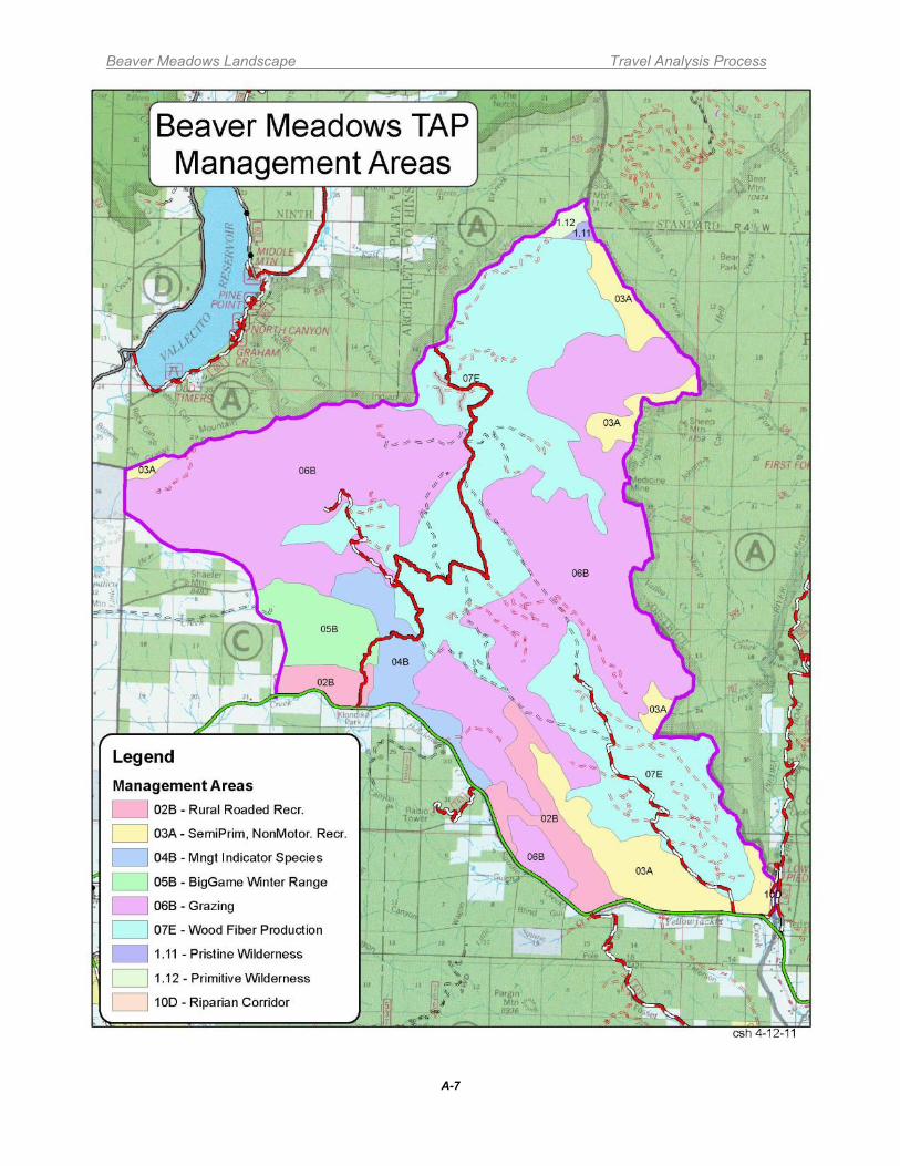
Beaver Meadows Landscape Travel Analysis Process
A-7
Management Areas Map
Beaver Meadows Landscape Travel Analysis Process
B-1
APPENDIX B – ROAD MAINTENANCE COSTS This appendix is meant to explain road maintenance costs on the San Juan National Forest for the purpose of travel analysis. Authority found at 16 USC 532 states “The Congress hereby finds and declares that the construction and maintenance of an adequate system of roads and trails within and near the national forests and other lands administered by the Forest Service is essential if increasing demands for timber, recreation, and other uses of such lands are to be met; that the existence of such a system would have the effect, among other things, of increasing the value of timber and other resources tributary to such roads; and that such a system is essential to enable the Secretary of Agriculture (hereinafter called the Secretary) to provide for intensive use, protection, development, and management of these lands under principles of multiple use and sustained yield of products and services.” 16 USC 535 states “The Secretary is authorized to provide for the acquisition, construction, and maintenance of forest development roads within and near the national forests and other lands administered by the Forest Service in locations and according to specifications which will permit maximum economy in harvesting timber from such lands tributary to such roads and at the same time meet the requirements for protection, development, and management thereof, and for utilization of the other resources thereof. Financing of such roads may be accomplished
•(1) by the Secretary utilizing appropriated funds, •(2) by requirements on purchasers of national forest timber and other products, including provisions for amortization of road costs in contracts, •(3) by cooperative financing with other public agencies and with private agencies or persons, or •(4) by a combination of these methods: Provided, That where roads of a higher standard than that needed in the harvesting and removal of the timber and other products covered by the particular sale are to be constructed, the purchaser of the national forest timber and other products shall not be required to bear that part of the costs necessary to meet such higher standard, and the Secretary is authorized to make such arrangements to this end as may be appropriate. The Secretary is authorized, under such rules and regulations as he shall prescribe, to permit the transfer of unused effective purchaser credit for road construction earned after December 16, 1975, from one timber sale to a purchaser to another timber sale to the same purchaser within the same National Forest.
36 CFR 212 addresses travel management. Subpart A is concerned with the administration of the Forest Transportation System and states that we must identify the minimum road system and unneeded roads. Subpart B talks about designating roads, trails, and areas. The Forest Service Manual outlines traffic management and operation strategies, maintenance criteria, and a road maintenance management system. Within this framework , the Line Officer has a high degree of latitude to adjust the way assets are managed.Road maintenance includes both annual maintenance and deferred maintenance. Annual maintenance activities for roads include blading, cleaning culverts and cattleguards, maintaining drainage structures, maintaining signing, and blade patching for Level 5 roads. This recurring maintenance is important for keeping the surface suitable for travel, and limiting resource damage that could occur from blocked culverts or improper drainage. In addition to annual maintenance, there are various other intermittent maintenance needs such as checking and maintaining Level 1 roads, installing or fixing gates, unexpected events such as
Beaver Meadows Landscape Travel Analysis Process
B-2
wind throws/blowdowns, mudslides or slumps, maintaining pavement every 5 years, roadside brushing every 10 years, and surface rock replacement on Level 3 and 4 roads. Deferred maintenance is maintenance that was not performed when it should have been or when it was scheduled and which, therefore, was put off or delayed for a future period. When allowed to accumulate without limits or consideration of useful life, deferred maintenance leads to deterioration of performance, increased costs to repair, and decrease in asset value. It is difficult to calculate on an annual basis the total for these intermittent funding needs so they are discussed in general terms. Road Maintenance Budget The San Juan National Forest budget allocation for road maintenance and management of roads averaged around $1,300,000 per year in the last three years. Of these amounts approximately 50% actually goes towards road maintenance activities. There are three Districts on the Forest that receive this money and of this, the Columbine Ranger District receives approximately 25% or $162,000 per year. Several sources of non-allocated funding sometimes contribute to road maintenance:
• The Forest Service, the Counties, and the State of Colorado have signed agreements (Schedule A) whereby the counties are paid to perform road maintenance on Forest Service roads (primarily blading of ML 3 and 4 roads). The counties are funded to perform this work through State of Colorado allocations of the Highway User Tax Funds. The work performed by the Counties partly offsets the deficit in appropriated road maintenance funding.
• Commercial undertakings such as timber sales, oil and gas wells, hauling from private lands, etc. have been charged a percentage of road maintenance costs or have conducted road maintenance actions as part of the project. Road maintenance is provided through these activities for the locations and timeframes when the commercial activity takes place.
• A limited amount of road maintenance or decommissioning has occurred after timber sales are complete through the collection of Knudsen-Vandenberg (KV) funds for sale area improvement.
• Recently, American Recovery and Reinvestment Act (ARRA) funding has been identified for surface replacement on paved roads, surface rock replacement on graveled roads, gate purchases and installation, and road decommissioning. In addition, Forest Service Legacy Funding has also been secured for these activities.
Beginning in 1999, the Forest conducted road condition surveys to determine the actual cost of maintaining the road system to standard. Work items were also recorded to determine the cost of road maintenance that was deferred in previous years due to lack of funding. Finally, road improvement work necessary to bring the roads up to the desired maintenance level was identified and documented in INFRA. There are many miles of ML 1 and 2 roads for which cost information is not available in INFRA. Analysis of the data collected showed that the District is substantially under-funded for the size of the road system it manages (see Table B-1).
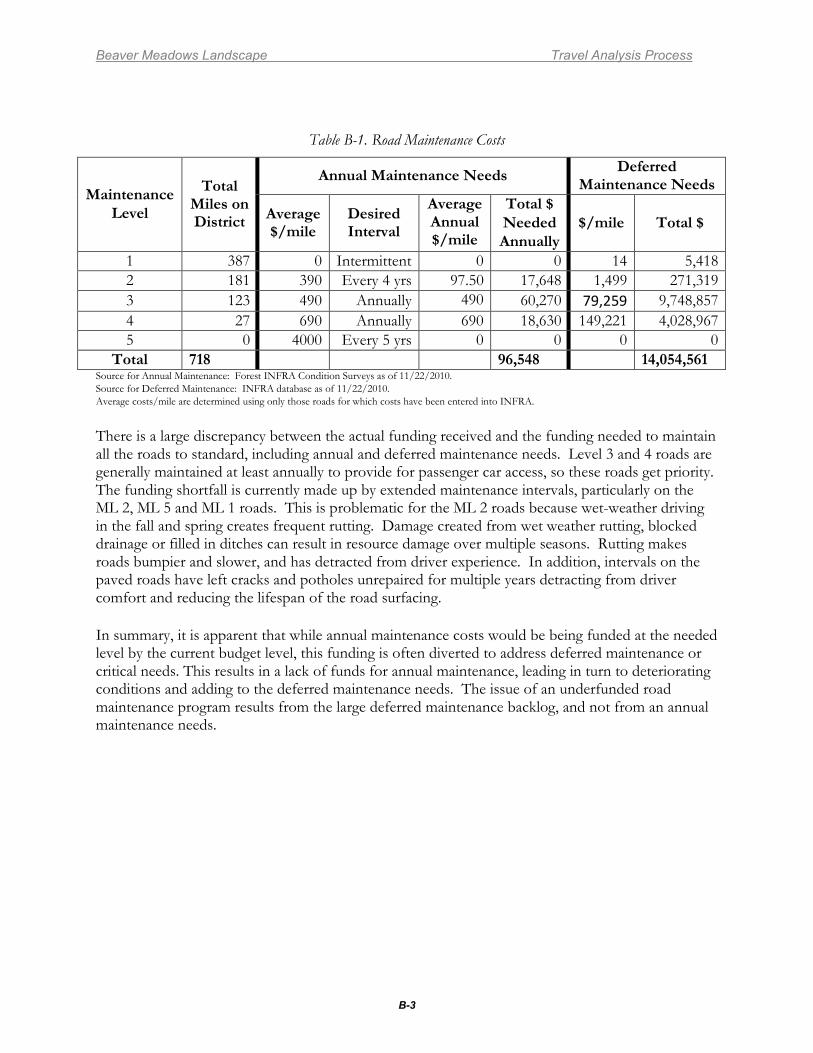
Beaver Meadows Landscape Travel Analysis Process
B-3
Table B-1. Road Maintenance Costs
Maintenance Level
Total Miles on District
Annual Maintenance Needs Deferred Maintenance Needs
Average $/mile
Desired Interval
Average Annual $/mile
Total $ Needed Annually
$/mile Total $
1 387 0 Intermittent 0 0 14 5,418 2 181 390 Every 4 yrs 97.50 17,648 1,499 271,319 3 123 490 Annually 490 60,270 79,259 9,748,857 4 27 690 Annually 690 18,630 149,221 4,028,967 5 0 4000 Every 5 yrs 0 0 0 0
Total 718 96,548 14,054,561 Source for Annual Maintenance: Forest INFRA Condition Surveys as of 11/22/2010. Source for Deferred Maintenance: INFRA database as of 11/22/2010. Average costs/mile are determined using only those roads for which costs have been entered into INFRA.
There is a large discrepancy between the actual funding received and the funding needed to maintain all the roads to standard, including annual and deferred maintenance needs. Level 3 and 4 roads are generally maintained at least annually to provide for passenger car access, so these roads get priority. The funding shortfall is currently made up by extended maintenance intervals, particularly on the ML 2, ML 5 and ML 1 roads. This is problematic for the ML 2 roads because wet-weather driving in the fall and spring creates frequent rutting. Damage created from wet weather rutting, blocked drainage or filled in ditches can result in resource damage over multiple seasons. Rutting makes roads bumpier and slower, and has detracted from driver experience. In addition, intervals on the paved roads have left cracks and potholes unrepaired for multiple years detracting from driver comfort and reducing the lifespan of the road surfacing. In summary, it is apparent that while annual maintenance costs would be being funded at the needed level by the current budget level, this funding is often diverted to address deferred maintenance or critical needs. This results in a lack of funds for annual maintenance, leading in turn to deteriorating conditions and adding to the deferred maintenance needs. The issue of an underfunded road maintenance program results from the large deferred maintenance backlog, and not from an annual maintenance needs.
Beaver Meadows Landscape Travel Analysis Process
C-1
APPENDIX C - RISK/BENEFIT ANALYSIS RATIONALE AND METHODOLOGY RISKS
Road are rated based on their existing condition. Routes in good condition are meeting the standards for the route. Although all routes require annual or routine maintenance, routes in poor condition also have deferred maintenance and repair needs in order to bring them back up to standard. Routes in poor condition may also be causing soil and watershed impacts as discussed below.
Condition/Maintenance and Repair Costs
A risk rating of 3 was assigned to roads currently in poor condition and with high levels of deferred maintenance and repair needs as based on the presence of three or more of the following conditions: washboarding; surface deterioration; landslides; roadbed slumping; slope raveling; drainage problems; rutting or gullying; mud holes; poor condition drainage structures or culverts; and design deficiencies. A risk rating of 2 was assigned to routes with moderate levels of deferred maintenance and repair needs as based on the presence of two or more of the above conditions. A risk rating of 1 was assigned to routes that are in fair or better condition with little or no deferred maintenance and repair needs, no existing damage, or one of the above conditions present.
Roads can affect water resources primarily by sediment being transported off road and trail surfaces into streams or wetlands. Open roads are devoid of vegetation and have compacted surfaces. A variety of drainage structures are used where they cross drainages and stream channels, such as fords, culverts, and log culverts. Areas of poor drainage can develop mud holes which are deepened and churn up sediment every time vehicles pass through them. Poor route location and inadequate drainage when the route was constructed can exacerbate watershed impacts. For example a route that is adjacent to and parallels a stream is more likely to have poor drainage and direct sediment inputs to the stream than a route that is located further away from the stream and contours along a slope. Drainage structures need to be maintained on a regular basis in order to remain fully functional. Inadequate maintenance can result in increased sediment being transported to streams or wetlands. Closed roads are mostly vegetated and have fewer impacts to water resources, although drainage structures can fail and cause sediment to be introduced to streams or wetlands if the roads are not inspected periodically and maintained as needed.
Water Resources
A risk rating of 3 was assigned to roads located in close proximity to surface water and/or with a history of drainage problems or sediment being transported off the road or trail. A risk rating of 2 was assigned to routes that have some vegetated buffer between the route and surface water and/or have some history of drainage problems or sediment being transported off the route. A risk rating of 1 was assigned to routes that are distant from surface water and/or have a minimal history of drainage problems or sediment being transported off the route.
Beaver Meadows Landscape Travel Analysis Process
C-2
Soil/Geologic Hazards Roads can affect soils primarily by causing erosion and loss of soil. Erosion from roads is increased in areas with soils with high erosion ratings, steep slopes, or routes with steep gradients. Poor route location, inadequate drainage structures, and inadequate maintenance can exacerbate soil impacts. Closed roads are mostly vegetated and have fewer erosion problems and impacts to soils, although drainage structures can fail and cause erosion if the roads are not inspected periodically and maintained as needed. Roads can either be affected by or cause impacts to geologic hazards, such as landslides, slumps, mudflows, or rockfalls. Poorly located routes can exacerbate landsliding. Routes can also be damaged by landslides, slumps, mudflows, or rockfalls, thereby increasing maintenance and repair costs. A risk rating of 3 was assigned to roads with a history of road damage from landslides, slumps, mudflows, rockfall, retaining wall failure, gullying, soils that are unstable or extremely susceptible to erosion. A risk rating of 2 was assigned to routes that have a history of minor route damage from soil or geologic hazards. A risk rating of 1 was assigned to routes with no history of damage from soil or geologic hazards. Wildlife Resources Three risk ratings were identified for wildlife resources for the Travel Analysis Report. The three ratings were low, moderate, or high, with a single risk rating provided for each road analyzed. The ratings focus on risks to habitat rather than risks to species as there are many species utilizing the diversity of habitats across the Beaver Meadows Landscape, and species response to disturbance associated with roads varies tremendously. A single risk rating that focuses on disturbance impacts to species would not suffice for all species, and a single risk rating that considers risks to both habitat and species would be difficult as individual roads are located in multiple habitats used by multiple species. Risk ratings focus on impacts to wildlife habitat based on road densities and use in a given area as explained below. The effects of roads on wildlife habitat depend on several important factors including their location within suitable habitat, densities within suitable habitat, and amount and type of use occurring. Roads provide access into areas that provide opportunities for an array of recreational use such as firewood collection, rock and mineral collection, collection of medicinal and edible plants, camping in dispersed and in designated areas, and other motorized and non-motorized uses year-round. Roads also provide access and opportunities for an array of forest management activities such as timber management, wildland and prescribed fire management, livestock grazing, oil and gas exploration, lands and special uses, and other activities. Recreational and forest management activities have the ability to negatively or positively affect wildlife habitat depending on their overall affect to key habitats (riparian and wetlands) and habitat attributes utilized for foraging, breeding, and security such as trees and shrubs, grass-forb vegetation, snags, and downed logs and other woody debris. Based on the above rationale, areas with high road and motorized trail densities are expected to receive higher levels of public and administrative use. In this scenario, there is higher probability of direct and indirect impacts to habitat or habitat attributes utilized by species for breeding, foraging, and security resulting in high risk to the resource. In contrast, areas with low road densities are expected to receive less use; therefore, the degree and probability of impacting habitat and/or key habitat attributes is expected to be less resulting in low risk to the resource. Areas with moderate
Beaver Meadows Landscape Travel Analysis Process
C-3
road densities are expected to receive moderate levels of public and administrative use, therefore resulting in moderate risk to the resource. Ecological Resources Motorized use could impact ecological resources by crushing or uprooting vegetation (resulting in deformation or mortality to plants and loss of ground cover), by removing plants and litter (resulting in mortality to plants and loss of ground cover), by causing soil erosion or soil compaction, and by introducing and/or spreading invasive plants that compete with native plants for space, water, and nutrients (Pickering et al. 2010, Monz et al. 2009). These impacts (which are often associated with unauthorized cross-country travel) could adversely affect the composition, structure, and function of the ecosystems in which they occur, and (in addition to affecting general ecological resources) could adversely affect sensitive ecological resources including rare plants, rare plant communities, alpine ecosystems, riparian area/wetland ecosystems, and aquatic ecosystems. The risk of these impacts occurring is high where there are high road densities, high levels of motorized use, and high concentrations of sensitive ecological resources because more roads likely means more motorized use and more use likely means more impacts, and because high concentrations of sensitive ecological resources means more potential for affects to these resources. The risk of these impacts occurring is low where there are low road densities, low levels of motorized use, and low concentrations of sensitive ecological resources because less roads likely means less motorized use and less use likely means less impacts, and because low concentrations of sensitive ecological resources means less potential for affects to these resources. The risk of these impacts occurring is medium where there are moderate road densities, moderate levels of motorized use, and moderate concentrations of sensitive ecological resources because moderate road densities likely means moderate motorized use and moderate use likely means moderate impacts, and because moderate concentrations of sensitive ecological resources means moderate potential for affects to these resources. Invasive Species Motor vehicle use has the potential to spread invasive species by dispersing the seed source. The three risk ratings identified for invasive species were low, moderate, or high, with a single risk rating provided for each road analyzed. Risk ratings were tied to both the size and distribution of existing noxious weed populations, as well as the potential for spread of invasive species. The invasive species considered for this analysis are the plant species listed on the Colorado Noxious Weed List. Risk level 1 was assigned to roads with only a few, small known noxious weed populations, or no know noxious weed populations. These populations do not appear to be spreading. Risk level 2 was assigned to roads with several known noxious weed populations, of any size. These populations have the potential to spread. Risk level 3 was assigned to roads with numerous, often large and contiguous, known noxious weed populations. These populations are often known to be spreading.
Beaver Meadows Landscape Travel Analysis Process
C-4
Cultural Resources Continued use and maintenance of roads has the potential to affect historic properties. Impacts are most commonly found within the road disturbance itself as sites are exposed and damaged through use. Specific site types outside of the road area can also be adversely affected by the presence and use of roads (e.g., rock art panels, structures, Traditional Cultural Properties). Many roads and trails have been in use since before the National Historic Preservation Act (1966) was passed or were constructed as standards for NHPA analysis were in development; many have not been formally inventoried for the presence of cultural resources according to modern standards. Roads which have already resulted in significant ground disturbance through their construction and maintenance (Road Maintenance Level 3 and higher) have already probably done the damage they are going to do to any sites which were located within the road prism. Continued use and maintenance of these roads has generally been considered exempt from field analysis as actions that “do not have the potential to cause effects on historic Properties" as per 36 CFR 800.3(a) and (a)(1). Generally maintenance level 3 roads (and higher) were considered exempt from further analysis and were awarded a “low” risk rating. However, sites may still exist and be impacted by continuing road use and maintenance along less improved dirt roads and motorized trails. The procedure used to award risk ratings along maintenance level 1 & 2 roads during the current analysis involved consulting GIS map layers and other available information to determine if a road or area had been inventoried for cultural resources according to modern standards (pedestrian inventory with transects of approximately 15 meters). Site records for resources located in or near roads were consulted to determine if formal determinations of eligibility to the NRHP had been made for cultural resources along roads. In cases where resources along maintenance level 1 & 2 roads qualified as historic properties (or in the case of some trails were considered likely to qualify as historic properties) risks were considered “high.” In cases where eligibility recommendations for sites along roads/trails were not available and/or there was inadequate inventory along the road, risks were rated as “unknown.” Only in cases where there was adequate inventory along a road and no “needs data” or “eligible” sites were known to exist along the road, were maintenance level 1 or 2 roads awarded a risk rating of “low.” The cultural resource road risk analysis was based on GIS layers available at the time this analysis was being conducted. The majority of roads within the analysis area do not have adequate inventory available to assess risks. These roads are classified as “unknown.” The “unknown” category is not weighted in the risk analysis. The analysis of motorized trails was undertaken on 12/8/2010 and was based on both information available in the GIS layer and on information as yet not reflected in that layer that was gathered during the 2010 summer field season. Additionally, historic maps were consulted to determine if a trail was historic; making it highly likely that it would qualify as an historic property. In the event a trail was an historic trail, risks were rated as “high.” Analysis was otherwise identical to that used in road analysis for a Level 1 & 2 road. Jurisdiction Roads that access private property where the majority of traffic on the road is related to the private property are better suited as county roads. Roads that provide access to multiple private parcels or large private development(s) were generally rated as 3. Roads that provide access to few private parcels were generally rated as 2. Roads that have no private access were generally rated as 1.
Beaver Meadows Landscape Travel Analysis Process
C-5
Rights-of-Way Acquisition Rights-of-way issues occur when private entities desire to use Forest Service Roads to access private property, and when the Forest Service does not hold an easement for roads providing access to National Forest System lands that cross private lands. It is critical for the Forest Service or counties to aquire easements where a formal deeded right-of-way does not exist for public access. Roads that have multiple or complex unresolved right-of-way issues are rated as 3. If only simple issues are unresolved, the rating is 2. If no unresolved right-of-way situations exist, the rating is 1. BENEFITS Motorized Recreation Use Roads are used for various types of motorized recreation including driving for pleasure, 4-wheel driving, ATV and motorcycle riding, and snowmobile riding. . To evaluate the general level of benefit provided by each road to motorized recreationists, each route was assigned a benefit rating of 1, 2, or, 3 according to its present level of use for recreation purposes. Routes that are frequently used for motorized recreation purposes were rated as 3, routes that are occasionally used for motorized recreation were rated as 2, and routes that are seldom or never used for motorized recreation were rated as 1. Use levels were based on the combined professional judgment and field experience of the District specialists, as there was little quantitative data on actual road usage on the District available to the specialists at the time of analysis. Recreation Access/Connectivity Roads are often used to provide motor vehicle access to recreational activities occurring off roads, such as hiking, camping, hunting, firewood gathering, rock collecting, etc. Roads also can provide important connectivity to other roads and motorized trails. To evaluate the level of this type of benefit, roads were assigned a rating of 3 if they provided access to numerous or high value recreation opportunities and/or connectivity to many other motorized routes, a rating of 2 if they provided access to some recreation opportunities and/or connectivity to other motorized routes, and a 1 if they provided access to limited recreation opportunities and/or connectivity to other motorized routes. Range Management Range management utilizes constructed features such as fences, gates, cattleguards, stock ponds, etc., to facilitate livestock distribution, regulate grazing impacts, and maintain livestock health and productivity. Roads and motorized trails are used to more efficiently move equipment and supplies into new construction projects, to access existing facilities for maintenance or reconstruction, or to remove unneeded or obsolete facilities. Roads that provide access to numerous range improvements, or large or critical areas are rated as 3. Roads that provide access to several range improvement, or moderately-sized areas are rated as 2. Roads that provide access to few range improvement, or only small or non-critical areas are rated as 1. Timber Management Access Roads provide motorized access to areas that periodically undergo various forest management activities such as timber harvest, biomass production or mastication, sale of miscellaneous forest products such as firewood, posts and poles or cones, reforestation, timber stand improvements, and forest restoration treatments. The Forest Plan contains direction to construct and maintain roads to support timber management activities along with a mix of other resource activities. Within those lands comprising the suitable timber base where a high forest cover is to be maintained, Forest Plan direction also established planned re-entry schedules of 10-40 years depending upon the forest cover type.
Beaver Meadows Landscape Travel Analysis Process
C-6
Roads that provide access to areas that periodically undergo management in multiple timber program areas (e.g. timber, biomass, forest products, forest restoration), primarily within the suitable timber base) were rated a 3. Roads that provide access to areas that infrequently have active management in more than one resource program area were rated a 2. Roads that provide access to areas that rarely have active management or serve only one resource program area were rated a 1. Fuels Fuels treatments involve removal or treatment of forest vegetation (fuels) through various means such as timber harvest, removal of biomass, mastication (mowing) of brush and small trees, and prescribed burning. To be most effective, it is usually recommended that mechanical treatments be followed with one or more prescribed burns. Once an area is treated, repeated prescribed fire treatments are often desired for both fuels management and ecosystem restoration and maintenance. Forests of ponderosa pine and warm-dry mixed conifer within the Wildland Urban Interface (WUI) are the primary target of these initial fuels and restoration treatments. Roads can provide ready access for deployment of prescribed burning personnel and equipment such as engines, dozers, and crew rigs, and often serve as permanent fire containment lines. Roads that provide numerous opportunities for repeat access and prescribed fire control lines are rated a 3. Roads that provide some opportunities for repeat access and prescribed fire control lines are rated a 2. Roads that provide few opportunities for repeat access and little functionality as prescribed fire containment lines are rated a 1. Emergency Access Roads - were rated as to their benefit for motor vehicle use for emergency access, primarily fire suppression and search and rescue. To evaluate the general level of benefit provided by each road to emergency access, each route was assigned a benefit rating of 1, 2, or, 3 according to its past use or expected future use for emergency access. Routes that receive high public use, provide access to areas with high public use, or provide access to or are adjacent to private property generally were rated as 3, routes that receive moderate public use, provide access to areas with moderate public use, or provide access to or are adjacent to sparsely populate private property generally were rated as 2, and routes that receive little or no public use, provide access to areas with low public use, or do not provide access to or are adjacent to private property generally were rated as 1. Past and expected future emergency access use levels were based on the combined professional judgment and field experience of the District specialists, as there was little quantitative data on actual emergency access usage on the District available to the specialists at the time of analysis.
Beaver Meadows Landscape Travel Analysis Process
D-1
APPENDIX D - EXISTING ROAD SYSTEM MAP
(see next page)
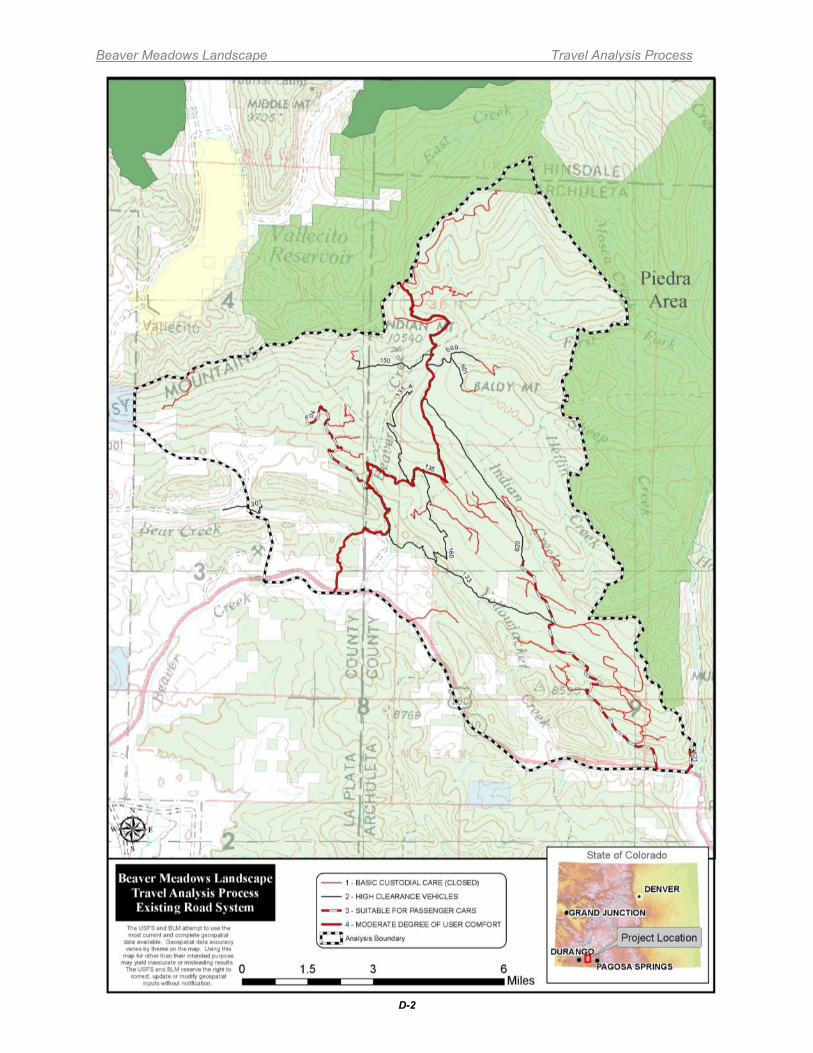
Beaver Meadows Landscape Travel Analysis Process
D-2
Beaver Meadows Landscape Travel Analysis Process
E-1
APPENDIX E - RECOMMENDED MINIMUM ROAD SYSTEM MAP
(see next page)
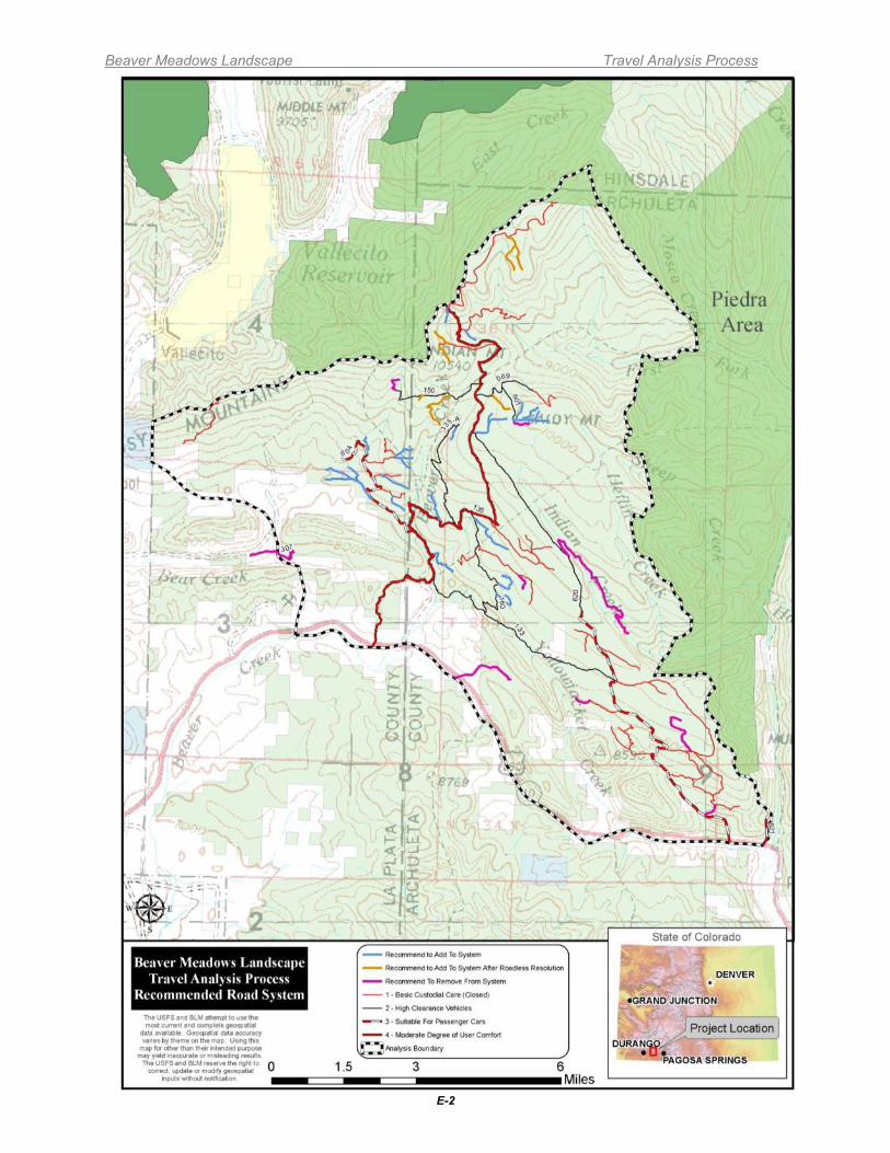
Beaver Meadows Landscape Travel Analysis Process
E-2

Beaver Meadows Landscape Travel Analysis Process
F-1
APPENDIX F – ROAD RISK/BENEFIT SPREADSHEETS
(in separate document)


![BEAVER PAGE - furharvesters.com · beaver page - 3-----|-----|----- con't eastern [ 18.00] | |](https://img.pdfslide.us/doc/110x75/5c12044b09d3f2602c8cd5df/beaver-page-beaver-page-3-cont-eastern-1800-.jpg)


![B. Beaver-Introduction to Probability and Statistics - Mendenhall, Beaver and Beaver [STUDENT's SOLUTION MANUAL]-Duxbury (2006)](https://img.pdfslide.us/doc/110x75/577c7f5e1a28abe054a444a7/b-beaver-introduction-to-probability-and-statistics-mendenhall-beaver-and.jpg)