Embed Size (px)
Citation preview
124 The Baylands and Climate Change: What We Can Do
PotreroPotreroHillsHills
GRIZZLYGRIZZLYBAYBAY
HONKERHONKERBAYBAY
NNUU
RRSS
EESS
LL OOUU
GGHH
CCUUTTOOFFFF SSLL OO UUGGHH
HHIILLLL SSLLOOUUGGHH
GG OO OO DDYY EE AARR
SSLL OO
UUGG
HH
MMOONNTTEEZZUUMM
AAS SL LO O
U UG G
H H
CCOORRDD
E EL LIIAA
SS LLOOUUGGHH
SSUU
II SSUU
NNSSLL
OOUU
GGHH
±
Bay/Channel
Tidal Flat
Tidal Marsh
Managed Pond
Salt Pond
Diked Wetland
Agriculture andOther Undeveloped Areas
Developed Areas
0 2
Miles
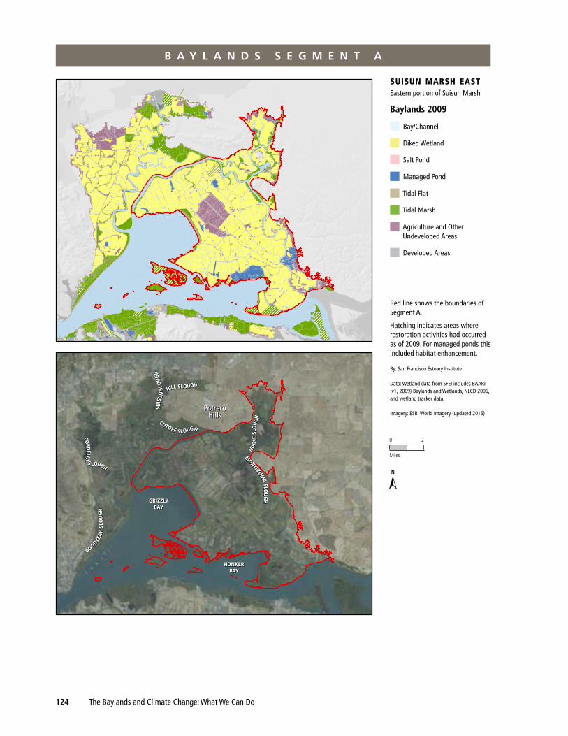
BAYLANDS 2009SUISUN MARSH EASTEAST
By: San Francisco Estuary Institute
Data: Wetland data from SFEI includesBAARI (v1, 2009) Baylands and Wetlands,NLCD 2006, and wetland tracker data
Imagery: ESRI World Imagery (updated 2015)
Hatching indicates areas whererestoration activities had occurred asof 2009. For managed ponds thisincluded habitat enhancement.
Red line shows boundaries ofSegment A
Eastern portion of SuisunMarsh
suisun marsh eastEastern portion of Suisun Marsh
Baylands 2009
Bay/Channel
Diked Wetland
Salt Pond
Managed Pond
Tidal Flat
Tidal Marsh
Agriculture and Other Undeveloped Areas
Developed Areas
Red line shows the boundaries of Segment A.
Hatching indicates areas where restoration activities had occurred as of 2009. For managed ponds this included habitat enhancement.
By: San Francisco Estuary Institute
Data: Wetland data from SFEI includes BAARI (v1, 2009) Baylands and Wetlands, NLCD 2006, and wetland tracker data.
Imagery: ESRI World Imagery (updated 2015)
0 2
Miles
n
➣
B a y l a n d S S e g m e n t a
Subregion Visions and Segment Actions | Suisun Subregion 125
Unique Opportunities
Segment A’s large size, current protected status (through the Suisun Marsh Preservation Act of 1977), and relative isolation make it an ideal location for habitat protection, enhancement, and restoration. Because of its location in the upper reach of the estuary, this segment offers a good opportunity to restore large areas of tidal marsh along the full salinity gradient. This segment contains the Montezuma Project currently under construction. Restoring tidal marsh at the periphery of Suisun Marsh would provide opportunities to reestablish the range of listed plants species, including the endangered soft bird’s-beak and Suisun thistle. There are also opportunities to restore vernal pools with tadpole shrimp in the adjacent uplands. Many diked wetlands in this segment are well suited for continued management for waterfowl and other species.
Segment Features and Setting
Historically, this area was predominantly tidal fresh and brackish marsh, arrayed as low-lying islands in Suisun Bay and as wide plains between the bay and the adjacent uplands. Inside this broad expanse of marshes were sloughs, channels, ponds, and small bays. Except for parts of Suisun Bay, the segment had relatively few areas of tidal flat. Adjoining the baylands, especially along Montezuma Slough and near Potrero Hills, were extensive areas of moist grasslands with vernal pools. The relatively steep topogra-phy of Potrero Hills provided a unique and narrow marsh–upland transition zone.
Today, this segment is one of the least urbanized areas of the baylands ecosystem. Most of the marshes are diked and are managed as duck clubs, but some tidal marsh occurs in Suisun Bay, along the edge of Grizzly Bay, and in many of the sloughs. There are extensive tidal flats in Grizzly Bay. There are alkaline-saline vernal pool complexes in the surrounding grasslands that grade into the upper tidal marsh zone. Water and soil salinity in the diked areas are intensively managed, and the natural variability of channel water salinities are influenced by delta outflow and water project operations. For example, the salinity control gates in Montezuma Slough are operated to maintain channel salinity levels similar to levels that would have occurred before the start of water diversions from the delta.
Implications of drivers of Change
The main drivers of change for segment A are climate change, sea-level rise, changes in upstream water quality and quantity, and managed wetland activities. As managed wetlands are converted to tidal wetlands, the regional water quality is expected to change, along with ecosystem functions. Salinity throughout segment A will likely be elevated for a longer duration each year as a consequence of sea-level rise and tidal restoration. Additionally, numerous areas within this segment are subsided and, with sea-level rise, current tidal and future restored tidal areas may become subtidal habitats. Wetland plant diversity in the managed and tidal habitats is expected to decrease with increasing salinities.
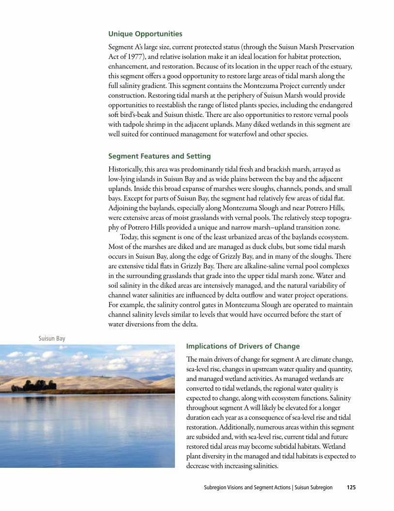
Suisun Bay
126 The Baylands and Climate Change: What We Can Do
Ultimately, opportunities for restoration in this segment may be largely shaped by cli-mate change and sea-level rise (SLR). Some managed wetlands may become unsustainable because of changes in flood-event frequency, unanticipated levee failures, high levee main-tenance costs, subsidence, and so on. Changes in upstream water quality (sediment supply, salinity, contaminants, temperature, etc.) or quantity (the amount of freshwater water coming into segment A) can significantly affect ecosystem function and the effectiveness of restoration projects. The presence of a portion of Highway 12 and natural gas production facilities and pipelines in this segment presents an added challenge. As the impacts of these main drivers of change become more pronounced, some existing regulatory obligations (e.g., the Water Rights Decision 1641 mandating salinity standards) may become unachiev-able, thereby necessitating a revision of some regulatory obligations.
Considerations for Implementing the actions
NEAR TERm (NOw TO mIDCENTuRy, PRIOR TO SLR CuRVE ACCELERATION)
The target of 5,000 to 7,000 acres of tidal restoration set forth in the Suisun Marsh Plan (SMP) is to be accomplished within the next 30 years. Contributions to this acreage could come from the Fish Restoration Program (FRP) and the Ecosystem Restoration Program (ERP), which are funded efforts. The Bay–Delta Conservation Plan (BDCP), if it is approved and funded, could also contribute to the SMP’s restoration acreage goal. A large portion of this tidal restoration acreage is likely to fall within segment A.
The impacts of salinity changes due to tidal restoration locally (within Suisun Marsh) and regionally (particularly in the western delta) should be assessed, as there are water-quality regulations—e.g., State Water Resources Control Board (SWRCB) D-1641—that must be met in both Suisun Marsh and the delta. For managed wet-lands, waterfowl habitat should be improved following best management practices, and general management practices should be promoted that reduce land subsidence and improve water quality.
LONG TERm (LATTER HALf Of THE CENTuRy, AfTER SLR CuRVE ACCELERATION)
The long-term vision for segment A is less certain. While achieving some tidal restora-tion goals is likely—such as restoring the remaining acreage described in the Fish Restoration Program Agreement (FRPA) or BDCP, restoration opportunities may be largely shaped by climate change and sea-level rise as managed wetlands become less sustainable because of changes in flood-event frequency, unanticipated levee failures, high levee maintenance costs, subsidence, and so on. As managed wetlands are converted to tidal wetlands, significant impacts to upstream water supply (e.g., more saline water) and ecosystem functions throughout Suisun Marsh and the delta are likely. Plans to contend with these challenges will be necessary for both large-scale tidal restoration and for the continued operation of managed wetlands.
Recommended actions
fOR HAbITATS AND THE LANDSCAPE IN GENERAL
◆ Restore large tidal marshes along the eastern side of Montezuma Slough, in the Nurse Slough area, near Denverton Creek, and at sites adjacent to Honker Bay.
Subregion Visions and Segment Actions | Suisun Subregion 127
Provide a tidal marsh corridor along the base of Potrero Hills between Nurse Slough and the marshes to the west.
◆ Enhance and restore a natural transition zone. Draft plans for a future connection to the Jepson Prairie, focusing on tidal marsh transitions, incorporating protec-tive buffers wherever possible, and thus creating shoreline migration space.
◆ Optimize managed marshes (duck clubs) to ensure continued support for a diverse suite of waterbirds, prevent subsidence, protect water quality, store carbon, and accumulate peat in the face of increasing salinities, sea-level rise, and other changes.
◆ Protect and enhance existing vernal pools and other seasonal wetlands adjacent to Montezuma Slough, in the Nurse Slough area, and north of Potrero Hills.
fOR PARTICuLAR wILDLIfE POPuLATIONS
◆ If duck clubs are converted to other habitat types, compensate for the loss of managed marsh habitat for waterbirds.
◆ Contain perennial pepperweed, eliminate populations in proximity to marsh–terrestrial transition zones and in high-elevation marsh, and prevent the spread of invasives coincident with marsh migration. In particular, exclude pepperweed from mature brackish tidal marshes that are not yet heavily infested. Avoid persis-tent soil-active herbicides that jeopardize the seed banks of desirable species.
◆ Implement aggressive control measures for the invasive plant yellow flag, which could become a serious problem.
Restoration Benefits
Restoring tidal marshes in this segment would benefit the black rail, Suisun song sparrow, and other tidal marsh species. It also would increase detrital input to this very productive part of the estuary and increase habitat for aquatic organisms, includ-ing delta smelt, longfin smelt, striped bass, outmigrating salmon, and other fishes. Restoring large amounts of tidal marsh along the Montezuma and Suisun Sloughs would increase tidal flow and thus improve water circulation and reduce the need for dredging. Expanding tidal marsh along the estuarine–terrestrial transition zone would provide opportunities for restoring plant communities. Enhancing vernal pools and other seasonal wetlands on the periphery of the Suisun Marsh would help restore their declining plant and animal communities. Improving the managed marsh would benefit waterfowl, other waterbirds, songbirds, and a variety of mammals.
CHALLENGES
Flood-control considerations, levee maintenance, sedimentation of tidal creeks, water-salinity management, and water-quality impacts are of concern. Key regional restoration plans that involve this segment include the Suisun Marsh Plan, Delta Plan, BDCP, and FRPA.