Embed Size (px)
Citation preview

03.2013 12810
Urban Design ReportBass & Flinders Gateway Site, Wollongong

Executive Summary 01
1.0 The Site 021.1 Ownership and details 02
2.0 Planning Context 032.1 Strategic Context 032.2 Council Planning Controls 062.3 Previous Studies & Proposals 09
3.0 Site Analysis 113.1 Regional Context 113.2 Character and Activity Areas 123.3 Surrounding Use & Built Form 143.4 Solar Amenity 143.5 Topography 153.6 Views and Vistas 173.7 Road network and city grid 183.8 Activity and Circulation 193.9 Links to the CBD 203.10 The Gateways to Wollongong 213.11 City Identity 22
4.0 Constraints and Opportunities 234.1 Constraints 234.2 Opportunities 244.3 Proposed Principles 25
Contents

Wollongong City Council’s (WCC) strategic planning documents identify this site as a key site within the city centre and adjacent to the identified Commercial Core boundary on Smith Street.
The two major challenges are the land use and urban form transition between the three surrounding activity/character areas:
■ the urban form and commercial and retail activities of the CBD
■ the architecturally diverse residential areas to the north-east
■ the enterprise corridor extending along the Princes Highway to the north.
Each of the three street frontages reflects these existing characters. Keira Street is an extension of the rectilinear city grid but due to limited traffic movement at the five way intersection, is a quiet mixed use street with some attractive mature trees. Keira Street between Crown and Smith Street is fronted by traditional, fine grained shop fronts featuring many restaurants and cafes. This urban design analysis identifies an opportunity to continue Keira Street’s traditional shop front and ‘eat street’ character on the western side of Keira Street between Smith and Campbell Street.
Campbell Street starts at the “Gilligan’s Island” roundabout with low rise, bulky goods retailing uses but is predominantly a residential street with a high school and coach terminus opposite the site.
Flinders Street sweeps past the site on a curved and sloping alignment as the main northern route to and from the city offering high volumes of vehicular passing trade but also access issues for the site. This study identifies inconsistencies between Council’s vision for Flinders Street as a ‘high street’ (CIP) and the RMS categorisation as a state road. For vehicular access to and from off street parking and servicing access, this report identifies the main access point as Keira Street with opportunities to be explored for left in only access from Flinders Street and left out only to Campbell Street.
Executive SummaryThe main LEP controls are a B6 Enterprise Corridor zoning, height (maximum 24m) and a FSR formula that approximates to 2.5:1. This study notes that the B6 zoning precludes restaurant uses, a desirable active ground floor use particularly on Kiera Street, and may reflect a superseded approach to how this site transitions between the enterprise corridor and the city centre.
Given the Flinders Street frontage and location of the site, this site has been considered a city ‘gateway’. ‘Gateway’ inspires multiple interpretations including built form as a distinctive landmark that will be appreciated by most people as a drive-by experience from Flinders Street. This urban design analysis suggests that given the location and viability of commercial ground floor uses outside the CBD, some responses may include:
■ iconic architecture,
■ marking the junction with the ’city grid’ and the Keira Street vista with taller buildings,
■ a true corner building at the Campbell and Flinders Street corner,
■ Flinders Street façades designed and lit at night to be appreciated at speed from passing vehicles.
The activity density of Wollongong focuses on Crown Street and radiates along Keira Street. On this site, pedestrian movement is concentrated on Keira Street as a relatively level route to and from the north eastern residential area and the CBD. Given the uses and character of the enterprise corridor/Princes Highway and topography, no pedestrian desire lines are identified through the site.
The block is currently held in multiple ownership. WCC is the major land owner with a consolidated parcel of lots at the southern corner extending to a single lot fronting on Campbell Street. The analysis notes that the other two block corners are in separate ownership, offering both opportunities and constraints for redevelopment.
0112810 | Bass & Flinders Gateway Site, Wollongong NSW

1.1 Ownership and detailsThe site is bounded by Flinders, Keira and Campbell Streets, Wollongong, and includes the following title particulars:
■ Lot 201 DP 801956
■ Lot 100 DP 712640
■ Lot 101 DP 1015945
■ Lot 1 & 2 DP 544681
■ Lot 12 DP 840017
■ Lots A & B DP 153806
■ Lots C & D DP 164178
■ Lot 3 & 4 DP 152256
■ Lots 11 & 12 DP 231424
■ Lot 1 DP 657220
■ Lot A DP 159938
1.0 The Site
Figure 1 – The site Figure 2 – Ownership & building footprint
Wang Long Oriental
Supermarket
Vet
The Gamesmen
Vacant
Vacant
Vacant
Vacant
Furniture Mart
Ezy Interactive
Repco
KEIR
A S
TREE
T
FIR
ST S
TREE
T
CH
UR
CH
STR
EET
YO
UN
G S
TRE
ET
CAMPBELL STREET
SMITH STREET
THROSBY DRIVE
CHARLOTTE STREET
FLINDERS STREET
DP 657220
DP 231424
DP 152256
DP 164178
DP 153806
DP 1015945
DP 1040159
DP
8400
17D
P 54
4681
DP
1599
38DP
7126
40
DP 801956
KEIR
A S
TREE
T
FIR
ST S
TREE
T
CH
UR
CH
STR
EET
YO
UN
G S
TRE
ET
CAMPBELL STREET
SMITH STREET
THROSBY DRIVE
CHARLOTTE STREETFLIN
DE
RS
STR
EE
T
Legend
The SiteWollongong City Council Owned LandMultiple OwnershipsExisting Building Footprint
0212810 | Bass & Flinders Gateway Site, Wollongong NSW

2.1 Strategic ContextIllawarra Regional Strategy, 2007The Strategy covers the local government areas of Wollongong, Shellharbour and Kiama, and presents a set of achievable goals between 2007 and 2031.
Wollongong is categorised as a Regional City, supported by Major Regional Centres of Warrawong and Shellharbour, and a Planned Major Regional Centre at Dapto.
The strategy has a strong focus on job creation and will assist in providing community and investor certainty, in regards to the region’s long-term growth. Wollongong is identified as having capacity for 10,000 new jobs and additional medium and high-density housing.
Information Source: How the Final Illawarra Regional Strategy Will Help the Wollongong Local Government Area [Fact Sheet], February 2007, Department of Planning
2.0 Planning Context
0312810 | Bass & Flinders Gateway Site, Wollongong NSW
47 600 more people38 000 new homes30 000 new jobs25 year plan7 major towns3 major regional centres1 regional city
n
0 2.5 5 10 15km
WOLLONGONG — REGIONAL CITYWollongong provides higher order administration, education and health services, cultural and recreational facilities and higher density commercial and residential development for the Region. The revitalisation of Wollongong City Centre, under the Cities Taskforce project, will refocus it as the regional city and strengthen its economic and employment significance.
MAJOR REGIONAL CENTREA concentration of medium to higher density living, business, employment, professional services, department stores, specialised shops including discount department stores and associated warehouses, transport logistics and bulky goods operations. Focal point for subregional road and transport networks and servicing for a number of districts.
WARRAWONGWarrawong town centre is an important commercial and retail centre, particularly for bulky goods. This role will be maintained.
SHELLHARBOUR CITY CENTREShellharbour City centre has grown rapidly over the last 30 years. It plays an important role in servicing the southern part of the Region. As the current residential estates reach completion, the focus for Shellharbour will shift towards urban renewal opportunities.
PLANNED MAJOR REGIONAL CENTRE
DAPTO With revitalisation and consolidation, Dapto town centre has the potential to develop into a Major Regional Centre. Residential growth at West Dapto and development of employment land at Kembla Grange will support this new role.
MAJORTOWNShopping and business centres for the district including warehouses, transport logistics and bulky goods, health and professional services mixed with medium density residential in the centre serving surrounding areas. Major towns: Corrimal, Unanderra (emerging), Figtree, Fairy Meadow (emerging), Albion Park, Warilla and Kiama.
TOWNSmall to medium concentrations of retail, health and other services, with lower density residential. Reliant on higher order centres for shopping and employment. The scale and character of the Region’s towns will be protected.
EMPLOYMENT LANDS Key employment lands include Wollongong City centre, Port Kembla precinct, University of Wollongong and Innovation Campus, the Illawarra Regional Airport, Kembla Grange industrial lands, Shellharbour City Centre, Shell Cove precinct and Kiama Town Centre. These sites provide a range of employment activities and will be protected by avoiding fragmentation or rezoning to non–employment related uses.
PROPOSED EMPLOYMENT LANDS —INVESITIGATIVE AREAS
Areas identified for employment investigation include Tallawarra Power Station, Illawarra Regional Airport and the Bombo Quarry sites.
NEW RELEASE AREA — WEST DAPTOWest Dapto is the priority new release area for the region and will deliver approximately 19,000 new dwellings over the next 30 to 40 years. The design of West Dapto is ongoing but will include new town centres, improved public transport opportunities and Kembla Grange employment lands.The West Dapto release area will also incorporate total water cycle management measures including harvesting and onsite reuse of stormwater and recycling of waste water for industrial use.
RURAL AND NATURAL RESOURCE AREASRural and agricultural lands provide important economic, environmental, social and cultural benefits to the Region and have value as a food producing resource to be protected for the long term.
BIODIVERSITY OUTSIDE CONSERVATION AREAS High value conservation areas will be protected by reducing pressure on these areas for urban development.
EXTRACTIVE MINERAL RESOURCESExisting and potential mineral and extractive areas, including sand and hard rock, will be protected. Management of these areas will need to address opportunities for biodiversity conservation. The region also contains extensive coal resources (not shown).
AIR AND SEA PORTSAir and sea ports will be strengthened to support their role for transportation, trade and tourism.
COMMERCIAL FISHERIES RESOURCES
EXISTING URBAN AREAUrban area includes residential and open space zones.
NATIONAL PARK & WORONORA AND METROPOLITAN SPECIAL AREAS
(WATER CATCHMENT)STATE FOREST
RAIL NETWORK AND STATION
MALDON—DOMBARTON RAIL CORRIDOR
PROPOSED ROAD
LOCAL GOVERNMENT AREA BOUNDARYRATEGY MAPILLAWARRA REGIONAL STRATEGY MAP
Figure 3 – Illawarra Regional Strategy Map

Wollongong City Centre Vision, 2007The Vision builds on the principles of:
■ Growing jobs in the heart of the City Centre;
■ Encouraging diversity of economic opportunities around the city core;
■ Creating a living city with mixed use development that supports the City Centre‘s employment role;
■ Developing a distinct role and character for the City Centre;
■ Providing for high quality design of public areas;
■ Enhancing transport links to and from the City Centre; and
■ Maintaining and enhancing the natural environment.
The vision designates the Flinders Street frontage of the site as being within the “Enterprise Corridor”. The site is at the south eastern edge of this area, and hence may be interpreted as a transition site to the commercial core and surrounding residential areas.
Wollongong City Centre Civic Improvement Plan, 2007
The Civic Improvement Plan (CIP) builds on the City Centre Vision and provides more detail for public domain improvements and infrastructure that may be required to achieve the desired outcomes.
The CIP designates the Flinders Street frontage of the site as being of “High Street” character, maintaining an active retail frontage, accommodating intense use and a high quality of public domain.
Campbell and Keira Streets are designated major residential streets.
0412810 | Bass & Flinders Gateway Site, Wollongong NSW
The Site
The Site
Figure 4 – City Centre Character Map
Source: Wollongong City Centre Vision, 2007
Figure 5 – Street Character Map
Source: Wollongong City Centre Civic Improvement Plan, 2007

Wollongong CBD Action Plan, November 2010The Wollongong CBD Action Plan addresses the following:
■ Co-ordination of all stakeholders to allow a unified approach in delivering the actions for the city centre;
■ Identification of new opportunities and initiatives that will continue drive the development of the city centre; and
■ Provide business confidence to existing and future operators in investing in Wollongong.
The action plan provides indicative timeframes for project implementation, including Council’s concept for the Western bypass along Throsby Drive. This action may aid in reducing the traffic flow along Flinders Street to the south and into the city centre.
Medium Term Projects (2013-16) includes preparations for the construction of the Western bypass (Throsby Drive to Denison Street), noted as number 2 on map.
Source: Wollongong CBD Action Plan, November 2010
0512810 | Bass & Flinders Gateway Site, Wollongong NSW

8
9
11
12
13
15
16
20
24
30
32
48
60
65
80
120
Cor
rimal
Stre
et
Flin
ders
Stre
et
Crown Street
Bourke Street
Wollongong
Fairy Meadow
North Wollongong
Gwynneville
Coniston
Mount Ousley
Keiraville
Balgownie
MangertonI
J
L
X
S
N
U2
U1
O2
O1
AAAB
AC
AA1
N
U2
L
J
U2
L
AA
S
O2
J
O2
O2
J
J
L
U2
S
J
S
AA
J
U2
S
U2
U2
L
S
U2
L
U2
J
J
U2
O2
J
X
AB
AA
O2
S
AC
U2
O2
AA
S
X
J
O2
J
J
AA
O2
J
O1
J
J
J
J
J
J
J
J
J
S
S
O2
J
J
J
X
S
O2
J
J
N
L
X
U2
J
O2
N
U2
NO1
0 0.8
Kilometers
Map Identification number:8450_COM_HOB_ _020_20101020
Scale 1:20,000 @ A3
N
Projection: GDA 1994MGA Zone 56
025
Height Of Buildings Map - Sheet HOB_
WOLLONGONG LOCALENVIRONMENTALPLAN 2009
025
002
007001
006
017 028
003
011
016
013 015 027
010 012 026
025
024
014
020 022
021
018
008
004
005
009
019
023
I
J
M
O2
Q
S
U1
U2
X
AA
AB
AC
L
N
O1
Maximum Height of Buildings (m)
CadastreCadastre 28.10.09 c Wollongong City Council
AA1
Cor
rimal
Stre
et
Flin
ders
Stre
et
Crown Street
Bourke Street
B2
E2
B6
B3
B4
R2
R1
R3
W1
W3W2
IN2
IN4
systems
SP3
SP2
SP1
RE1
RE2
IN1
B1
Cemetery
Hostels,
Road
Helipads,
Railway Mortuaries,
Educational Establishment
B1
R3
R2
B6
B6
R3SP3
RE1
R2
RE1
RE1
RE1
B6
R1
R2
B6
RE2
R1
R2
B1
R2
R3
Road SP2
R2
R1
SP2
RE1
R2
RE1
IN2
B6
B4
SP2
R2
RE1
SP1
RE1
B4
RE1
RE1
R1
R2
RE1
RE1
R1
RE1
R3
SP2
B6
RE1
Road
R2
SP2
RE1
B4
IN1
B6
B1
B6
RE1
RE1
SP1
R2
RE1
R1
R2
R3
RE1
RE1
RE1
B4
RE1
RE1R2
SP1
RE1
B2
R3
RE1
R2
R1
R2
R2
B3
R1
SP2
R2
RE1
B1
RE1
R2
Railway
SP1
R2
RE2
W3
B3
SP2
R2
B6
RE1
IN4
R1
B6
W1
B6
R1
RE1
SP2
B2
R2
SP2
IN1
RE1
SP3
B6
RE1
RE2
R2
RE1
B2
B6
E2
R2
RE2
RE1
R2
RE1
R2
R1
RE1
R2
B4
R1
R3
RE1
R1
E2RE1
B6
B3
B6
R1
IN2
R2
R2
SP2
R2
R3 RE1
B3
RE1
RE2
WOLLONGONG
FAIRY MEADOW
NORTH WOLLONGONG
GWYNNEVILLE
CONISTON
MOUNT OUSLEY
KEIRAVILLE
BALGOWNIE
SP1
Sewerage
Light Industries,
Funeral Homes,
Office Premises,
Seniors Housing,
Funeral Chapels,
Dwelling Houses,
Boarding Houses,
Boarding Houses,
Shop top Housing.
Sewerage systems
Business Premises,
UndertakingPublic Utility
Veterinary Hospitals.Serviced Apartments,
Neighbourhood Shops,
Neighbourhood Shops,
Multi Dwelling Housing,
Place of Public Worship,
Residential Flat Buildings,
Food and Drink Premises,
Food and Drink Premises,
Educational Establishment,
Recreation Facilities (major),
Wollongong Hospital Precinct:
Hotel or Motel Accommodation,
Wollongong Innovation Campus:
R2
SP2
B2
SP2
R3R2
RailwayRoad
Road
R2
RE1
SP2
SP2
RE1
Road
Road
RE1
SP2
RE1
MANGERTON
Map Identification number: 8450_COM_LZN_ _020_20111110
Scale 1:20,000 @ A3
N
Projection: GDA 1994MGA Zone 56
WOLLONGONG LOCALENVIRONMENTALPLAN 2009
Cadastre 10.11.11 c Wollongong City Council
002
007001
006
017 028
003
011
016
013 015 027
010 012 026
025
024
014
020 022
021
018
008
004
005
009
019
023
Major Development SEPP
CadastreMD
Land Zoning Map - sheet LZN_B1B2B3B4B6B7E1E2E3E4IN1IN2IN3IN4R1R2R3R4R5
RE1RE2RU1RU2RU4SP1SP2SP3W1W2W3
Neighbourhood Centre
Local Centre
Commercial Core
Mixed Use
Enterprise Corridor
Business Park
National Parks & Nature Reserves
Environmental Conservation
Environmental Management
Environmental Living
General Industrial
Light Industrial
Heavy Industrial
Working Waterfront
General Residential
Low Density Residential
Medium Density Residential
High Density Residential
Large Lot Residential
Public Recreation
Private Recreation
Primary Production
Rural Landscape
Rural Small Holdings
Infrastructure
Tourist
Natural Waterways
Recreational Waterways
Working Waterways
Special Activities
B1B2B3B4B6B7E1E2E3E4
IN1IN2IN3IN4R1R2R3R4R5RE1RE2RU1RU2RU4SP1SP2
SP3W1W2W3
025
025
0 0.4
KilometresWOLLONGONG
FAIRY MEADOW
NORTH WOLLONGONG
GWYNNEVILLE
CONISTON
MOUNT OUSLEY
KEIRAVILLE
BALGOWNIE
MANGERTON
Cor
rimal
Stre
et
Flin
ders
Stre
et
Crown Street
Bourke Street
I
S
V
D
D
D
S
D
S
I
D
D
D
S
S
D
D
D
D
D
S
S
D
S
S
D
S
D
I
S
S
D
I
D
S
S
I
S
I
S
D
S
S
I
S
D
D
D
S
S
D
S
S
D
I
D
D
I
I
I
D
I
D
D S
Map Identification number: 8450_COM_FSR_ _020_20111110
Scale 1:20,000 @ A3
N
Projection: GDA 1994MGA Zone 56
Floor Space Ratio Map - Sheet FSR_
WOLLONGONG LOCALENVIRONMENTALPLAN 2009
002
007001
006
017 028
003
011
016
013 015 027
010 012 026
025
024
014
020 022
021
018
008
004
005
009
019
023
0.3
0.5
0.75
1.5
2.5
3
Maximum Floor Space Ratio (n:1)
A
D
I
S
U
V
Cadastre
Cadastre 10.11.11 c Wollongong City Council
025
025
0 0.4
Kilometres
Figure 6 – Land Zoning Map (Wollongong LEP 2009)
Figure 7 – Floor Space Ratio Map (Wollongong LEP 2009)
Figure 8 – Height of Buildings Map (Wollongong LEP 2009)
B6 Enterprise Corridor
Permitted uses:
Advertising structures; Bulky goods premises; Business premises; Car parks; Child care centres; Community facilities; Depots; Entertainment facilities; Environmental facilities; Garden centres; Hardware and building supplies; Heavy industrial storage establishments; Hotel or motel accommodation; Industrial retail outlets; Landscaping material supplies; Light industries; Office premises; Passenger transport facilities; Places of public worship; Plant nurseries; Recreation areas; Recreation facilities (indoor); Recreational facilities (outdoor); Registered clubs; Respite day care centres; Roads; Service stations; Serviced apartments; Sex services premises; Shop top housing; Storage premises; Take away food and drink premises; Timber yards; Transport depots; Truck depots; Vehicle sales or hire premises; Veterinary hospitals; Warehouse or distribution centres
Does not permit cafes and restaurants or residential flat buildings.
FSR of between 2.5:1 and 3:1 dependant upon use and floor space mix.
Maximum height of 24m over the entire site.
2.2 Council Planning Controls
2.2.1 Wollongong Local Environmental Plan 2009
Wollongong City CentreThe site falls within the Wollongong City Centre Boundary. Special provisions apply due to this condition.
Land ZoningThe site is zoned as B6 Enterprise Corridor under the Wollongong Local Environmental Plan 2009 (WLEP 2009), the objectives of which are:
■ To promote businesses along main roads and to encourage a mix of compatible uses.
■ To provide a range of employment uses (including business, office, retail and light industrial uses).
■ To maintain the economic strength of centres by limiting retailing activity.
■ To encourage activities which will contribute to the economic and employment growth of Wollongong.
■ To allow some diversity of activities that will not:(a) significantly detract from the operation of existing or proposed
development, or(b) significantly detract from the amenity of nearby residents, or(c) have an adverse impact upon the efficient operation of the
surrounding road system.
Floor Space RatioThe base floor space ratio for the site is 1.5:1.
Due to the site being located in the Wollongong City Centre boundary,further Floor space ratio provisions apply:
■ For buildings used only for residential purposes a floor space ratio of 2.5:1 may apply.
■ For buildings used for purposes other than residential, a 3:1 floor space ratio may apply.
The FSR for the site will fall between 2.5 and 3:1, and is dependant upon the mix of floor space use.
Height of BuildingsThe site has a maximum height limit of 24m.
Key SitesThe site is classified as a Key Site under the WLEP 2009. This classification requires review of the proposed development by a design review panel.
0612810 | Bass & Flinders Gateway Site, Wollongong NSW

KEIR
A S
TREE
T
FIR
ST S
TREE
T
CH
UR
CH
STR
EET
YO
UN
G S
TRE
ET
CAMPBELL STREET
SMITH STREET
THROSBY DRIVE
CHARLOTTE STREET
FLIND
ER
S S
TRE
ET
B6 Enterprise CorridorFSR 2.5-3:1
Max Height: 24m4m setback to Flinders Street
Residential <12m height= side setback of 6mResidential 12-24m height= side setback of 9m
Residential floor plates above 12m must not exceed 900m2
Maximum building depth of 18m
Active street frontages required for mixed use development
No additional vehicular entry from Flinders
Street beyond existing
6x6m corner splay required
Figure 9 – LEP and DCP site specific controls
2.2.2 Wollongong Development Control Plan 2009
City Centre Character Areas The site is located within the Enterprise corridor.
The Wollongong Development Control Plan 2009 (WDCP 2009) focuses on promoting business activity along Flinders Street. Residential development incorporated in mixed use developments is encouraged within walking distance to rail station and in areas abutting the general residential zone to the east. The character of the area will be of an attractive city boulevard lined with trees and high quality buildings of medium scale.
Despite the WDCP 2009 provisions, the site is in transition and has been earmarked as a Gateway. Therefore these character visions may not reflect current thinking for the site by Council.
Relevant WDCP 2009 considerations include:
■ Building to street alignment and street setbacks
- 4m setback to Flinders Street.
- Balconies may project into front building setbacks.
- Minor projections into the front building liens and setbacks for sun shading devices, entry awnings and cornices are permissible.
- Corner properties are subject to a requirement to provide a 6m x 6m corner splay.
■ Vehicular footpath crossings
- No additional vehicle entry points will be permitted into the parking or service areas of development along Flinders Street.
■ Active Street Frontages
- Active street frontages in the form of non-residential uses on ground level are required for mixed use buildings in the Enterprise zone.
■ Communal open space
- Development with more than 10 dwellings must incorporate communal open space. The minimum size of this open space is to be calculated at 5m2 per dwelling.
■ Overshadowing
- Adjacent residential buildings and their public open space must receive 3 hours of direct sunlight between 9am and 3pm on 21 June.
0712810 | Bass & Flinders Gateway Site, Wollongong NSW

2.2.3 SEPP 65 - Residential Flat Design Code : Tools for improving the design of residential flat buildings
The Residential Flat Design Code (the Code) sets broad parameters within which good design of residential flat buildings can occur by illustrating the use of development controls and consistent guidelines (source: Residential Flat Design Code, page iii)
The Code is an important tool for consideration in the future planning and design of the site in question, particularly in regards to building separation distances and street setbacks.
Building separation controls should be set in conjunction with height controls and with controls for private/communal open space and deep soil zones. They are measured in metres, balcony to balcony or external wall to external wall.
Objectives
■ To ensure that new development is scaled to support the desired area character with appropriate massing and spaces between buildings.
■ To provide visual and acoustic privacy for existing and new residents.
■ To control overshadowing of adjacent properties and private or shared open space.
■ To allow for the provision of open space with appropriate size and proportion for recreational activities for building occupants.
■ To provide deep soil zones for stormwater management and tree planting, where contextual and site conditions allow.
Figure 10 – Building separation is proportionate to building height to facilitate better urban form and improved residential amenity.
Source: Residential Flat Design Code, page 28
0812810 | Bass & Flinders Gateway Site, Wollongong NSW

2.3 Previous Studies & Proposals
2.2.1 AEJ Scheme for Gateway Wollongong Pty Ltd (2012)
A mixed use development, illustrative concept prepared by Architect Edmiston Jones for the Gateway Wollongong P/L bid to Wollongong City Council.
Concept includes:
■ 215 residential units
■ >4,000m2 of commercial floor space
■ 319 car spaces
■ Public plaza space through the site
0912810 | Bass & Flinders Gateway Site, Wollongong NSW

2.2.2 Quattro Scheme
A development application dated September 2004 prepared by adm Projects for Sebvell Pty Ltd.
■ 281 residential units
■ 2 commercial units
■ 18 retail units
■ 5 home offices
■ 803 car parking spaces
1012810 | Bass & Flinders Gateway Site, Wollongong NSW

3.1 Regional ContextThe site is well located as a gateway for the City of Wollongong. Key elements include:
■ vehicular access from the north (via the Princes Highway) and from the south (via Crown Street).
■ within 1km of both Wollongong and North Wollongong rail stations
■ within walking distance of the major retailing centre of Crown Street Mall and Wollongong Central
■ within 1-2km of major educational and health facilities, including the University of Wollongong, the Innovation Campus and Wollongong Hospital
■ only 1km to Wollongong Harbour and beaches, cafes and restaurants
■ good exposure for retail options along the Flinders Street frontage
3.0 Site Analysis
Figure 11 – Regional Context
1112810 | Bass & Flinders Gateway Site, Wollongong NSW
CROWN STREET
FLIND
ER
S S
TRE
ET / P
RIN
CE
S H
IGH
WA
Y
KE
IRA
STR
EE
T
MALL
NORTHERN DISTRIB
UTOR
SO
UTH
ER
N F
RE
EW
AY
M1
PRINCES HIGHWAY
SO
UTH
CO
AS
T R
AIL
WA
Y L
INE
NORTH WOLLONGONG STATION
WOLLONGONG STATION
200m
500m
1km
200m
500m
1km
500m to Wollongong City Centre
(Crown Street Mall)1km
to Wollongong Hospital
1km to North Wollongong Beach
1.2km to Wollongong City Beach
2km to The University of Wollongong
Mount Keira
2km to
Innovation Campus
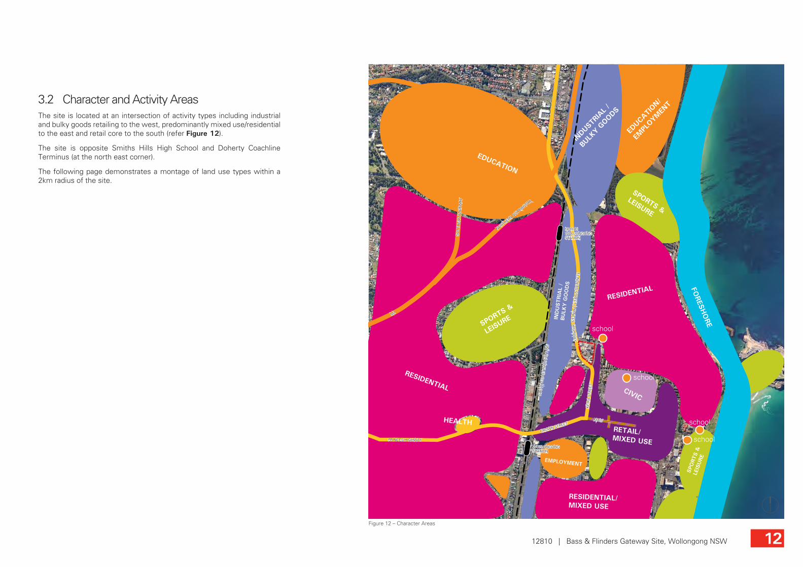
3.2 Character and Activity AreasThe site is located at an intersection of activity types including industrial and bulky goods retailing to the west, predominantly mixed use/residential to the east and retail core to the south (refer Figure 12).
The site is opposite Smiths Hills High School and Doherty Coachline Terminus (at the north east corner).
The following page demonstrates a montage of land use types within a 2km radius of the site.
Figure 12 – Character Areas
1212810 | Bass & Flinders Gateway Site, Wollongong NSW
FORESH
ORE
INDUST
RIAL
/
BULK
Y GOODS
IND
USTRIA
L /
BU
LKY
GO
OD
S
RETAIL/ MIXED USE
EMPLOYMENT
EDUCATION
EDUCA
TION/
EMPL
OYMEN
T
SPORTS &
LEISURE
SPORTS &
LEISURE
HEALTH
SPO
RTS
&
LEIS
URE
IND
USTRIA
L /
BU
LKY
GO
OD
S
RESIDENTIAL
CIVIC
RESIDENTIAL
RESIDENTIAL/MIXED USE
school
school
school
schoolCROWN STREET
FLIND
ER
S S
TRE
ET / P
RIN
CE
S H
IGH
WA
Y
KE
IRA
STR
EE
T
MALL
NORTHERN DISTRIB
UTOR
SO
UTH
ER
N F
RE
EW
AY
M1
PRINCES HIGHWAY
SO
UTH
CO
AS
T R
AIL
WA
Y L
INE
NORTH WOLLONGONG STATION
WOLLONGONG STATION
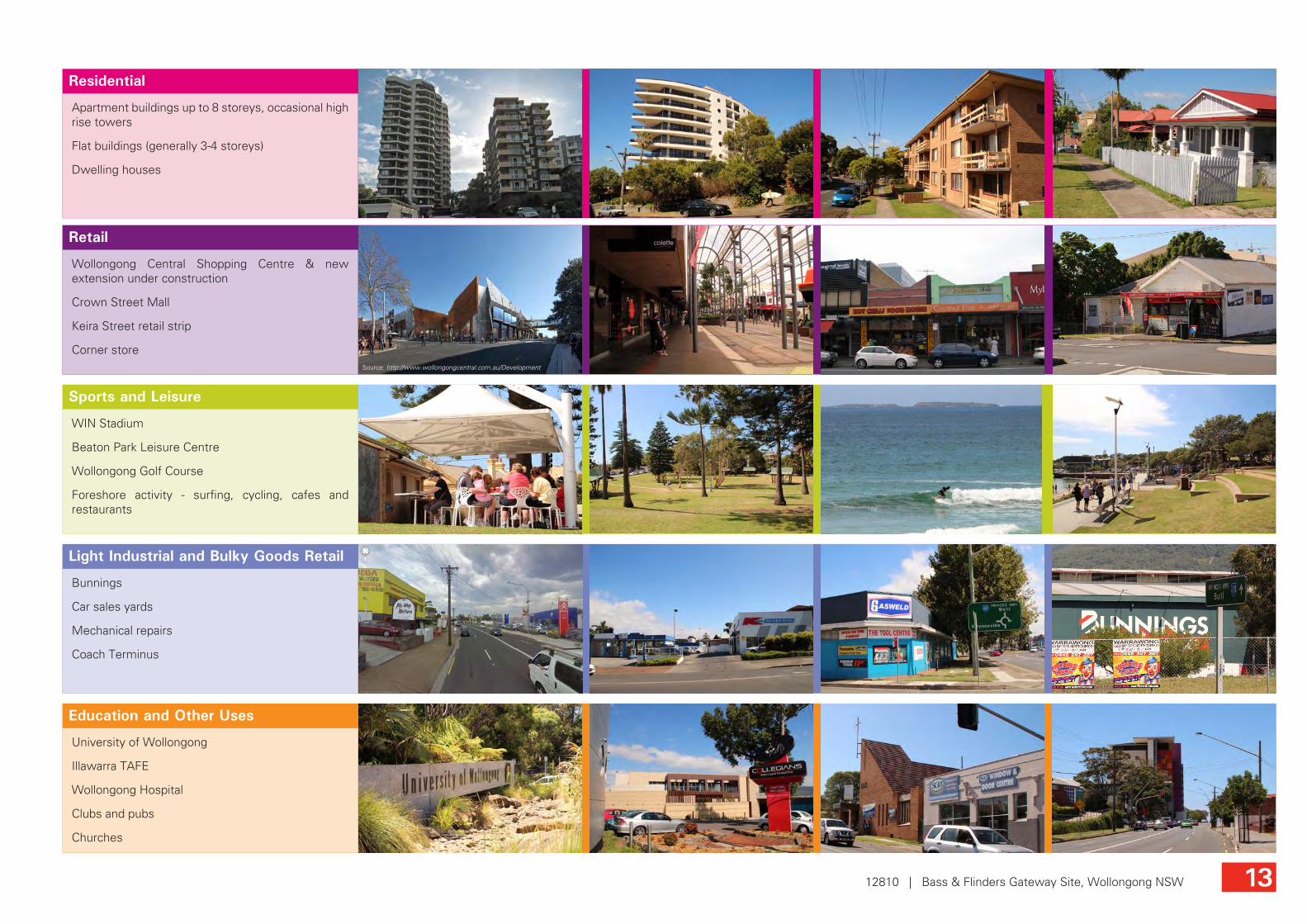
Education and Other Uses
Light Industrial and Bulky Goods Retail
Sports and Leisure
Retail
Residential
Apartment buildings up to 8 storeys, occasional high rise towers
Flat buildings (generally 3-4 storeys)
Dwelling houses
Wollongong Central Shopping Centre & new extension under construction
Crown Street Mall
Keira Street retail strip
Corner store
WIN Stadium
Beaton Park Leisure Centre
Wollongong Golf Course
Foreshore activity - surfing, cycling, cafes and restaurants
Bunnings
Car sales yards
Mechanical repairs
Coach Terminus
University of Wollongong
Illawarra TAFE
Wollongong Hospital
Clubs and pubs
Churches
Source: http://www.wollongongcentral.com.au/Development
1312810 | Bass & Flinders Gateway Site, Wollongong NSW

3.3 Surrounding Use & Built FormThe site is surrounded by varying uses and built form, as shown in Figure 13 opposite.
Built forms varies in height, bulk and scale, from single storey residential dwellings, to multi-level apartment blocks, and large floor plate warehousing and entertainment venues.
Whilst there are no heritage provisions on the site itself, there are a number of residential heritage items surrounding the site, including 2 lots immediately opposite the site, at the intersection of Keira and Campbell Streets.
3.4 Solar AmenityTo achieve solar access to >70% of apartments, avoid double loaded corridor apartment buildings on the east-west axis or use double aspect/crossover apartment buildings.
Figure 13 – Adjacent Landuses
Doherty Coachlines Terminus
Smiths Hill High School
School Open Space
Tennis Courts
Kmart Tyre & Auto Service
Carlovers Carwash
Bunnings
Gasweld Tool Centre
Bears Auto
Hospital
Collegians Club
Overboard Surf Skate Snow
Magnum Motorcycles
Peter Fitzgerald Real Estate
Lupa Wood Fired PizzaElla Bache
Red Square Cafe/Bar
Zoom Play and Party
Zone
Beauty to Impress
Keiraview Student Accomodation
Wellness Centre
Dominos Pizza
ColliersWollongong
Baptist Church
Window & Door Centre
22
3
3
4
1
1 1
1 1 1
1
4
1
2 + basement
3+ basement 6
+ basement
2+ basement3
14
+ basement
+1 retail
Wang Long Oriental
Supermarket
Vet
The Gamesmen
Vacant
Vacant
Vacant
Vacant
Furniture Mart
Ezy Interactive
Repco
KE
IRA
STR
EE
T
FIR
ST
STR
EE
T
CH
UR
CH
STR
EE
T
YO
UN
G S
TRE
ET
CAMPBELL STREET
SMITH STREET
THROSBY DRIVE
CHARLOTTE STREET
FLINDERS STREET
Legend
The SiteResidential/AccomodationServicesRetailLight Industry/Bulky GoodsEducationEntertainmentHealthReligionHeritage SitesResidential Flat Buildings (height in storeys)
2
1412810 | Bass & Flinders Gateway Site, Wollongong NSW

3.5 TopographyThe site is located approx. 4.5km east of the Illawarra escarpment and only 1km to the west of low lying land at the foreshore. The site sits slightly to the west of a prominent ridge line which runs north south, parallel to the Keira Street frontage.
To the east of the site and running between Campbell and Smith Streets, the topography forms a valley which runs all the way to the foreshore. This valley provides greater opportunity for water views from upper levels on the site.
Figure 14 – Topography of surrounding area
1512810 | Bass & Flinders Gateway Site, Wollongong NSW
CROWN STREET
FLIND
ER
S S
TRE
ET / P
RIN
CE
S H
IGH
WA
Y
KE
IRA
STR
EE
T
MALL
NORTHERN DISTRIB
UTOR
SO
UTH
CO
AS
T R
AIL
WA
Y L
INE
NORTH WOLLONGONG STATION
WOLLONGONG STATION
RIDGELINE
VALLEY
SADDLE
WA
TER LINE
Mt Keira Elevation 435m
ForeshoreThe Site RL 11-21
Rai
lway
Ridgeline
Mt KeiraRidgeline
Site
Foreshore View of escarpment looking south toward Wollongong

Figure 18 – Slope of site
The site falls toward the intersection of Flinders and Campbell Streets, with the highest point on the site at the southern corner (approx.RL 21). refer Figure 18. A fall in the landform of around 10m from this point to the western corner of the site, and a steep fall from the Keira Street frontage will influence the built form outcome. Existing vehicular access from Keira Steet is via relatively steep driveways.
1612810 | Bass & Flinders Gateway Site, Wollongong NSW
KE
IRA
STR
EE
T
FIR
ST
STR
EE
T
CH
UR
CH
STR
EE
T
YO
UN
G S
TRE
ET
CAMPBELL STREET
SMITH STREET
THROSBY DRIVE
CHARLOTTE STREET
FLIND
ER
S S
TRE
ET
RID
GE
LIN
ERL 21
RL 11
RL 17
10m fall
4m f
all
6m fall
2018
18
16
12
12
10
14
16
18
20 22
2426
22
2220
View looking west down Campbell Street (site on left)
View looking south up Keira Street (site on right)
View looking north west down Flinders Street
Keira Street access via steep driveway
A
A
C
CB
B
KE
IRA
STR
EE
T
SIT
E B
OU
ND
AR
Y
SIT
E B
OU
ND
AR
Y
FIR
ST
STR
EE
T
FLIN
DE
RS
STR
EE
T
RL 17RL 22
RL 11 RL 10
RL 21RL 14 RL 11
SIT
E B
OU
ND
AR
Y
SIT
E B
OU
ND
AR
Y
CA
MP
BE
LL S
TRE
ET
KE
IRA
STR
EE
T
SIT
E B
OU
ND
AR
Y
SIT
E B
OU
ND
AR
Y
RL 17RL 21RL 22 RL 20 RL 20FL
IND
ER
S S
TRE
ET
CA
MP
BE
LL S
TRE
ET
Figure 15 – Section A-A through Campbell Street
Figure 16 – Section B-B through Keira Street
Figure 17 – Section C-C through site fronting Flinders Street
1 in 6 slope
1 in 7 slope

3.6 Views and Vistas ■ The site is well positioned to take advantage of high level views to the ocean in the east and to the escarpment in the west.
■ Views to the ocean from the Keira Street edge of the site are expected to be achieved above levels 3-4 (i.e once the building reaches RL 27 on the Keira/Campbell corner and RL 29 on the Keira Smith/Flinders corner. NOTE: further investigation in regards to view capture should be undertaken to determine the impact of surrounding existing built form).
■ The location of the site with a frontage to busy Flinders Street provides a unique opportunity for a gateway architectural statement on a heavily trafficked road entry into the Wollongong CBD. Facades designed for appreciation by passing motorists may be one design response to the gateway role.
■ The are various view corridors from which the site is visible and may create a landmark. The site is well placed to provide a landmark at the intersections of Keira and Smith Streets, as shown in the photo below.
Figure 19 – Views to and from the site
1712810 | Bass & Flinders Gateway Site, Wollongong NSW
CROWN STREET
FLIND
ER
S S
TRE
ET / P
RIN
CE
S H
IGH
WA
Y
KE
IRA
STR
EE
T
MALL
NORTHERN DISTRIB
UTOR
SO
UTH
ER
N F
RE
EW
AY
M1
PRINCES HIGHWAY
SO
UTH
CO
AS
T R
AIL
WA
Y L
INE
NORTH WOLLONGONG STATION
WOLLONGONG STATION
Oce
an V
iew
s
Ocean Views
Views Towards Escarpment
View towards escarpment along Flinders Street at the intersection of Keira and Smith Streets
View towards the site looking north along Keira Street View towards the site from rail overpass on the Princes HwySource: Google Street View Source: Google Street View
The Site
The Site
The Site
2
1
1
3
2
3

3.7 Road network and city grid ■ The site demonstrates a termination point of the structured city grid pattern (to the south) and the commencement of a less formal roadway system and larger blocks in the north west.
■ The roundabout at the Flinders Street/Campbell Street intersection (affectionately known by locals as “Gilligan’s Island”), slows traffic along the Flinders Street frontage. This intersection may be signalised at some future time.
■ Keira Street is a 2 way street, with a left out only option onto Smith Street. There is no entry into Keira Street from Smith Street and Keira Street (south).
■ The site is well connected with the University via a free shuttle bus service which stops on Keira Street.
■ The existing north bound bus stop on Flinders Street has been proposed to be moved further south, closer to the corner of Smith Street.
■ The bus stops in the vicinity have been the topic of review.
■ Flinders Street is a classified road, a major north-south route and within RMS authority.
1812810 | Bass & Flinders Gateway Site, Wollongong NSW
CAMPBELL STREET
SMITH STREET
KE
IRA
STR
EE
T
FLIND
ER
S S
TRE
ET
University Shuttle Bus Route & Stop
Public Bus Stop
Favoured cycling route
Left out only
2 lane roundabout
Intersection of city grid and highway road system
Figure 20 – Junction of the city grid and the less formal roadway system
Figure 21 – Surrounding road network

3.8 Activity and Circulation ■ The major retail activity areas are focussed on the Crown Street Mall and the Wollongong Central development site. The southern end of Keira Street captures some of this pedestrian activity but it fades away to the north and the site.
■ Crown, Keria and Corrimal Streets are identified by Wollongong City Council as ‘eat streets’.
■ Keira Street meets the main pedestrian desire line between the residential areas to the north east and the CBD.
■ There are no activity areas to the north of the site generating pedestrian desire lines through the site.
Figure 22 – Activity areas and pedestrian intensity
1912810 | Bass & Flinders Gateway Site, Wollongong NSW
CH
UR
CH
STR
EE
T
BOURKE STREET
CO
RR
IMA
L S
TRE
ET
CAMPBELL STREET
SMITH STREET
CROWN STREET
THROSBY DRIVE
FLIND
ER
S S
TRE
ET / P
RIN
CE
S H
IGH
WA
Y
KE
IRA
STR
EE
T
SO
UTH
ER
N F
RE
EW
AY
NORTHERN DISTRIB
UTOR
MARKET STREET
BURELLI STREET
WIN Stadium
Golf Course
Wollongong City Beach
BunningsLeisure Centre
Wollongong Harbour
North Wollongong Beach
Cafes & Restaurants
Foreshore Park
Crown Street Mall
Keira Street RetailSO
UTH
CO
AS
T R
AIL
WA
Y L
INE
NORTH WOLLONGONG STATION
WOLLONGONG STATION
Legend
The SiteMajor Traffic RouteMinorTraffic RouteHeavy Pedestrian ActivityPedestrian ActivityLow Pedestrian ActivityDestination PointsActivity AreasPedestrian Desire Line from Residential to Retail hub

3.9 Links to the CBD ■ Keira Street is the strongest link from the site into the heart of the Wollongong CBD, in particular, Wollongong Central Shopping Centre and Crown Street Mall.
■ Streetscape upgrades are proposed for Keira Street from Market Street to Crown Street, and along Crown Street. There are also proposed upgrades to the Crown Street Mall.
■ There is a desire line along Keira Street for residents surrounding the site, as a relatively level route to and from the CBD.
■ There are no pedestrian desire lines through the site.
■ The Flinders Street frontage is highly exposed and trafficked by fast moving, noisy traffic. This site frontage is experienced by a driver and/or passengers at speed.
CAMPBELL STREET
SMITH STREET
BURELLI STREET
MARKET STREET
VICTORIA STREET
MALL
CROWN STREET
FLIND
ER
S S
TRE
ET / P
RIN
CE
S H
IGH
WA
Y
KE
IRA
STR
EE
T
RL 20
RL 20
RL 22
RL 22
RL 22
RL 20
RL 18
RL 16
RL 14
RL 12
RL 11
RL 19
No pedestrian desire
Residential pedestrian desire lines to city
Extent of possible streetscape improvements
Wollongong Central
Wollongong Central
Wollongong Central(under
construction)
Experience as driver - high speed
2012810 | Bass & Flinders Gateway Site, Wollongong NSW

University of Wollongong
Southern Gateway Centre(Bulli Tops)
North Wollongong Station
Crown Street Mall/Wollongong Central
Wollongong Station
Wollongong Hospital
Lighthouse
‘Links’ Seasideseniors community
200m
500m
1km
200m
500m
1km
3.10 The Gateways to Wollongong ■ When travelling into Wollongong from the north via the Princes Highway, the Southern Gateway Centre (located at Bulli Tops) marks the entry into the city. Whilst this landmark is visually strong and inviting for visitors, the centre is a long way from the heart of the CBD and is easily forgotten after travelling the winding road down Mount Ousley.
■ The southern access road to the Wollongong CBD is located at the bottom of Mount Ousley Road. While an attempt to signify a gateway has been made in the form of coloured paving and signage, the entry is still a while out of the heart of the CBD.
■ Entry from the south into the CBD is via Crown Street. The main landmark that signifies arrival in Wollongong is the large hospital on the hill. The termination of Crown Street with the Crown Street Pedestrian Mall creates a strong sense of arrival at the heart of the CBD.
■ As a “gateway” site, most people will experience the site from within a vehicle, travelling at speed on Flinders Street.
Wollongong Hospital provides a gateway landmark for Wollongong, along Crown Street
Southern Gateway Centre, Princes Highway, Bulli Tops
Crown Street Mall terminates the main vehicular access road into Wollongong from the south
‘Links Seaside’ developmentSource: http://www.irt.org.au/irt-links-seaside.asp
Wollongong and North Wollongong rail stations provide convenient access points for pedestrians to the site and the wider CBD
Extension of Wollongong Central shopping centre will provide a revitalised and iconic node for the retail hub
Source: http://www.wollongongcentral.com.au/development
2112810 | Bass & Flinders Gateway Site, Wollongong NSW
Source: Google Street View

3.11 City IdentityCities like Bilbao in Spain have been rejuvenated by bold, expressive architecture (Guggenheim Museum).
An icon building (Sydney Opera House) or architect (Gaudi, Barcelona) can become a brand image for a city.
These landmark buildings often have a cultural purpose (Federation Square, Melbourne) and/or make the most of waterside locations (MONA, Hobart).
Source: http://icreasymposium.eq.upc.edu/icreasymposium/venue/barcelona
Casa Batlló, Barcelona (Architect: Gaudi)
Source: http://artblart.files.wordpress.com/2011/07/mona-exterior.jpg
The Museum of Old and New Art (MONA), Hobart
Source: http://en.wikipedia.org/wiki/File:Federation_Square_(SBS_Building).jpg
Federation Square, Melbourne (Architect: Lab Architecture Studio & Bates Smart)
Source: http://sydney-city.blogspot.com.au/2010/11/sydney-opera-house-sydney-ferries-theme.html
Sydney Opera House
Source: http://www.hdwallpapers.in/guggenheim_museum_bilbao_spain-wallpapers.html
The Guggenheim Museum, Bilbao, Spain (Architect: Frank Gehry)
Source: http://en.wikipedia.org/wiki/File:San_Sebastian_Kursaal_noche.jpg
Kursaal Convention Centre and Auditorium, Spain (Architect: Rafael Moneo)
Source: http://www.americapictures.net/the-riverwalk-san-antonio-texas-united-states-04.html
San Antonio River Walk, Texas (Architect: Robert Hugman)
Source: http://www.greenroofs.com/projects/pview.php?id=846
The School of Art, Design and Media at Nanyang Technological University, Singapore (Architect: CPG Consultants)
2212810 | Bass & Flinders Gateway Site, Wollongong NSW

4.0 Constraints and Opportunities
Figure 23 – Constraints
KE
IRA
STR
EE
T
FIR
ST
STR
EE
T
CH
UR
CH
STR
EE
T
YO
UN
G S
TRE
ET
CAMPBELL STREET
SMITH STREET
THROSBY DRIVE
CHARLOTTE STREET
FLIND
ER
S S
TRE
ET
Multiple driveway entries
Cooling breezes in summer
Fragmented land ownership
Narrow sites for med-high rise
residential developments
Neighbouring bulky goods/industrial character
unnattractive
High speed, no stopping, noisy
Gusty western
winds
Pedestrian experience and safety to rail stations could be improved
Existing height controls do not allow icon tower form
Low pedestrian foot fall - no desire lines from city towards the north
Site is outside of Council’s plan of action/CBD vision
No entry
Enticing pedestrians to cross Smith Street and leave the CBD
Complicated 5 way junction
Potential overshadowing from
high rise development
edge to CBD
No safe pedestrian crossing across Flinders Street
4.1 Constraints
2312810 | Bass & Flinders Gateway Site, Wollongong NSW

Figure 24 – Opportunities
KE
IRA
STR
EE
T
FIR
ST
STR
EE
T
CH
UR
CH
STR
EE
T
YO
UN
G S
TRE
ET
CAMPBELL STREET
SMITH STREET
THROSBY DRIVE
CHARLOTTE STREET
FLIND
ER
S S
TRE
ET
Residential pedestrian desire lines to city
Existing mature street trees
Active street frontages
Extend Keira Street “eat street” with traditional 16m wide shop fronts built to the street boundary
Pedestrian scaled development
Residents/ tenants only
access through site
New laneways for access and servicing and
consolidated entry points
View
s to
esc
arpm
ent
High level view
s to ocean
Potential future diversion may reduce Flinders Street traffic
High speed and volume of passing trade (Flinders Street frontage), suits
wide frontage showoom retail built to street boundary (0m setback)
Confluence of activity areasEnterprise corridor/Highway meets city grid
Opportunity to consolidate whole of block and develop a consistent master plan
Potential entertainment facilities could compliment North Wollongong residential population, Keira Street and other city facilities
Planning strategy for enterprise corridor is “attractive city boulevard lined with trees”
Existing “eat street”
Vista opportunity
4.2 Opportunities
■ Shareway network through block serves multiple purposes:
- provides access to multiple on-site parking areas from minimum number of street access point
- equity of development potential across land ownership boundaries
- dual use of building setback and required building separations
- safer pedestrian experience as more activity
2412810 | Bass & Flinders Gateway Site, Wollongong NSW

4.3 Proposed Principles
KE
IRA
STR
EE
T
FIR
ST
STR
EE
T
CH
UR
CH
STR
EE
T
YO
UN
G S
TRE
ET
CAMPBELL STREET
SMITH STREET
THROSBY DRIVE
CHARLOTTE STREET
FLIND
ER
S S
TRE
ET
SHAREWAY
Residential SeparationFor buildings of heights 5-8 storeys: - 18m between habitable rooms - 13m between habitable and non-habitable rooms - 9m between non-habitable rooms
Ground Floor Activation - Keira StreetPromote a traditional active street frontage with a 0m ground floor setback based on current DCP setbacks in “Commercial core”
Residential Upper Level SetbackSetback residential upper levels 0-3m from building frontage.
Street Tree PlantingEnhance Keira Street by providing new street trees on the western side of the street.
Placemaking OpportunityLandmark public place.
Design for Solar AccessFor example, dual aspect apartment building on difficult SW orientation.
Flinders Street ExperienceIcon architecture opportunity, such as facade and lighting designed for appreciation by passing motorists.
Ground Floor Activation - Flinders Street0m ground floor setback to street edge to promote showroom retail.
Opportunity for Landscaped Open SpaceIncluding provision of communal open space for tenants and residents.
Vehicular AccessVehicular access utilises all street frontages. A lane/shareway provides access to car parking and loading bays and assures access for adjoining properties.
Maximum Residential Floorplate SizeDCP 2009 control: A maximum floorplate of 900m2 to reduce the bulk and scale of buildings and break up expanses of wall with modulation of form and articulation of facades.
900m2
4-6m Residential Setback to Campbell Street Maintain the residential character of Campbell Street by providing a consistent setback from the street edge.
Vehicular left in only
Alternative entry point
Vehicular in/out
Vehicular left in/out only
Showroom Retail
Local Shops & Services
Example of a shared drive/lane waySource: Google Street View
2512810 | Bass & Flinders Gateway Site, Wollongong NSW