Embed Size (px)
Citation preview
Wollongong Development Control Plan 2009 i
Part D –Locality Based DCPs / Precinct Plans
Chapter D13: Wollongong City Centre
Contents
1 INTRODUCTION 1 1.1 City Centre Character Areas 1
2 BUILDING FORM 5 2.1 General 5 2.2 Building to street alignment and street setbacks 5 2.3 Street frontage heights in commercial core 8 2.4 Building depth and bulk 9 2.5 Side and rear building setbacks and building separation 12 2.6 Mixed used buildings 15 2.7 Deep soil zone 18 2.8 Landscape design 19 2.9 Green roofs, green walls and planting on structures 19 2.10 Sun access planes 21 2.11 Development on classified roads 27
3 PEDESTRIAN AMENITY 27 3.1 General 27 3.2 Permeability 28 3.3 Active street frontages 30 3.4 Safety and security 32 3.5 Awnings 33 3.6 Vehicular footpath crossings 35 3.7 Pedestrian overpasses, underpasses and encroachments 38 3.8 Building exteriors 38 3.9 Advertising and signage 40 3.10 Views and view corridors 42
4 ACCESS, PARKING AND SERVICING 44 4.1 General 44 4.2 Pedestrian access and mobility 45
4.3 Vehicular driveways and manoeuvring areas 45 4.4 On-site parking 46 4.5 Site facilities and services 47
5 ENVIRONMENTAL MANAGEMENT 49 5.1 General 49 5.2 Energy efficiency and conservation 50 5.3 Water conservation 50 5.4 Reflectivity 51 5.5 Wind mitigation 52 5.6 Waste and recycling 52
6 GENERAL RESIDENTIAL DEVELOPMENT CONTROLS 54 6.1 SEPP 65 and Apartment Design Guide 54 6.2 Housing choice and mix 54 6.3 Dwelling houses 56 6.4 Multi dwelling housing 56 6.5 Dual occupancy 56 6.6 Basement Car parks 56 6.7 Communal open space 57 6.8 Private open space 57 6.9 Overshadowing 58 6.10 Solar access 59 6.11 Natural ventilation 59 6.12 Visual privacy 60 6.13 Acoustic Privacy 61 6.14 Storage 63
7 PLANNING CONTROLS FOR SPECIAL AREAS 63 7.1 Special areas with heritage items 64 7.2 Special areas and Development Standards 67
Part D –Locality Based DCPs / Precinct Plans Chapter D13: Wollongong City Centre
ii Wollongong Development Control Plan 2009
7.3 Non-residential development in the enterprise corridor zone 72
7.4 Special area design guidelines 75 7.5 Design excellence 76
8 WORKS IN THE PUBLIC DOMAIN 77
9 GLOSSARY / DEFINITIONS 78
Figures Figure 1.1: Map of DCP Area ......................................... 1 Figure 1.2: Land Zoning Map ......................................... 4 Figure 2.1: Building lines and street setbacks ..................... 7 Figure 2.2: Specific street alignment and street setbacks ....... 8 Figure 2.3: Permissible street frontage heights .................... 9 Figure 2.4: In the Commercial Core buildings are to be built to street alignment with upper level set back ....................... 10 Figure 2.5: In residential locations buildings to have landscaped setbacks ................................................................ 11 Figure 2.6: Building bulk controls .................................. 12 Figure 2.7: Building depth controls ................................ 12 Figure 2.8 (left): Side setbacks for all development in the Commercial Core ...................................................... 15 Figure 2.9: Side setbacks for all development in all zones except in the Commercial Core .............................................. 16 Figure 2.10: Rear setback for all development in all zones except in the Commercial Core .............................................. 16 Figure 2.11: Separation for multiple buildings on a single site in the Commercial Core and Mixed Use (city edge) zones ......... 16 Figure 2.12: Mixed use buildings ................................... 17 Figure 2.13: Communal Public Space with deep soil allows for tree planting and high quality landscape .......................... 18 Figure 2.14: Encourage high quality landscape on structures and in internal communal courtyards ................................... 20 Figure 2.15: Planting on root structures and terraces creates an interesting outlook from adjacent adjoining buildings ........... 20 Figure 2.16: Special building envelope control locations ....... 23 Figure 2.17 (top): Sun access diagram heights contours showing maximum heights above ground .................................... 24 Figure 2.18 (bottom) Sun access diagram, height contours showing maximum building heights above ground ............... 24 Figure 2.19: (top) Sun access diagram heights contours showing maximum building height above ground ........................... 25 Figure 2.20: (middle) Sun access diagram height contours showing maximum building height above ground ................ 25 Figure 2.21: (bottom) Sun access diagram height contours showing maximum building height above ground ................ 25
Figure 2.22: The sun access plane formula diagram ............ 26 Figure 3.1: Permeability ............................................. 29 Figure 3.2: Lanes and arcades add to the richness of a city ... 30 Figure 3.3: Active street frontages promote safe pedestrian environment ............................................................ 31 Figure 3.4: Active street frontages ................................ 32 Figure 3.5: Continuous street awnings offer good pedestrian amenity ................................................................. 33 Figure 3.6: Awnings .................................................. 35 Figure 3.7: Restrictions on vehicular entries ..................... 36 Figure 3.8: Driveway crossing dimensions ........................ 37 Figure 3.9: Select high quality masonry finishes with accent colours .................................................................. 40 Figure 3.10: Under awning signage ................................ 40 Figure 3.11: Signage Zones ......................................... 41 Figure 3.12: Significant views ...................................... 44 Figure 6.1: Natural ventilation ...................................... 60 Figure 7.1: Areas with special control/ principles ............... 64 Figure 7.2: St Michael's Cathedral and square................... 65 Figure 7.3: West Crown Street shops ............................. 68 Figure 7.4: View looking along Market Street to St. Michal's Cathedral ............................................................... 69 Figure 7.5: East Crown Street Shops.............................. 70 Figure 7.6: Market Square .......................................... 71 Figure 7.7: Natural Mutual Life Association Building, 1938 in Keira Street ............................................................ 72 Figure 7.8: Enterprise Corridor ...................................... 75
Document Control
Document ID: Wollongong DCP 2009 – D13 Wollongong City Centre
Adoption Date In Force Date
Revision Details
21 November 2016
14 December 2016
Updates resulting from sustainability review.
Part D –Locality Based DCPs / Precinct Plans Chapter D13: Wollongong City Centre
Wollongong Development Control Plan 2009 1
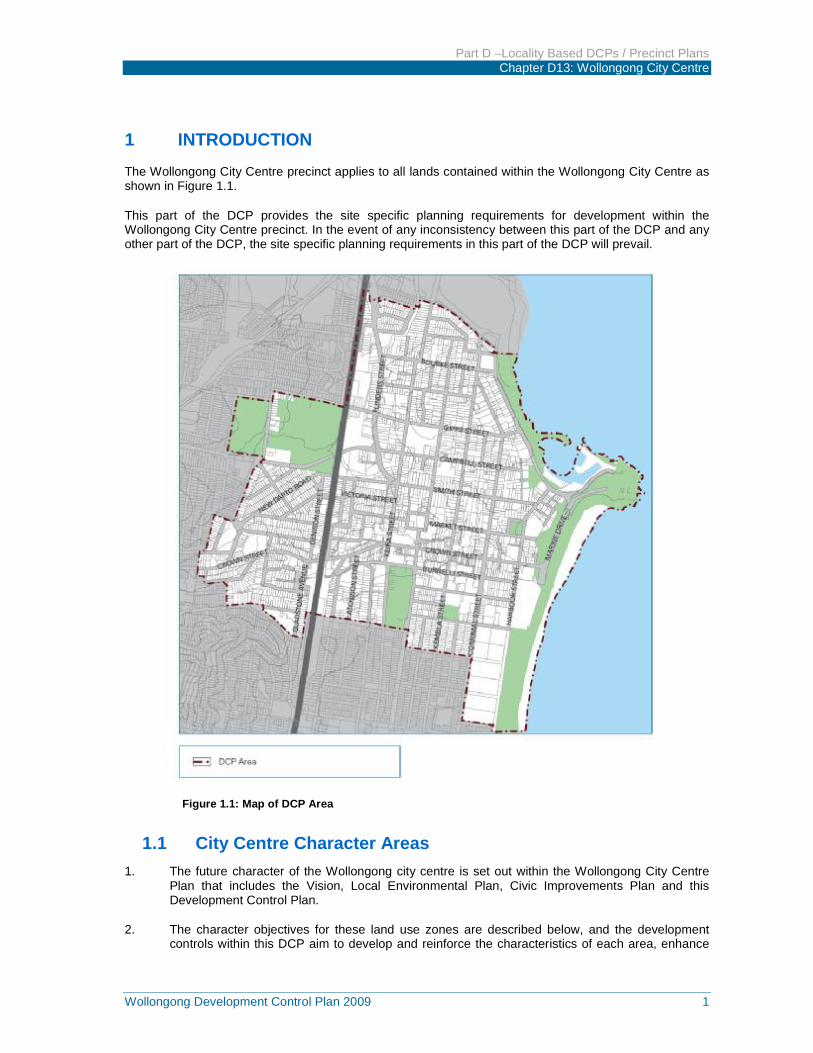
1 INTRODUCTION The Wollongong City Centre precinct applies to all lands contained within the Wollongong City Centre as shown in Figure 1.1.
This part of the DCP provides the site specific planning requirements for development within the Wollongong City Centre precinct. In the event of any inconsistency between this part of the DCP and any other part of the DCP, the site specific planning requirements in this part of the DCP will prevail.
Figure 1.1: Map of DCP Area
1.1 City Centre Character Areas 1. The future character of the Wollongong city centre is set out within the Wollongong City Centre
Plan that includes the Vision, Local Environmental Plan, Civic Improvements Plan and this Development Control Plan.
2. The character objectives for these land use zones are described below, and the development controls within this DCP aim to develop and reinforce the characteristics of each area, enhance
Part D –Locality Based DCPs / Precinct Plans Chapter D13: Wollongong City Centre
2 Wollongong Development Control Plan 2009
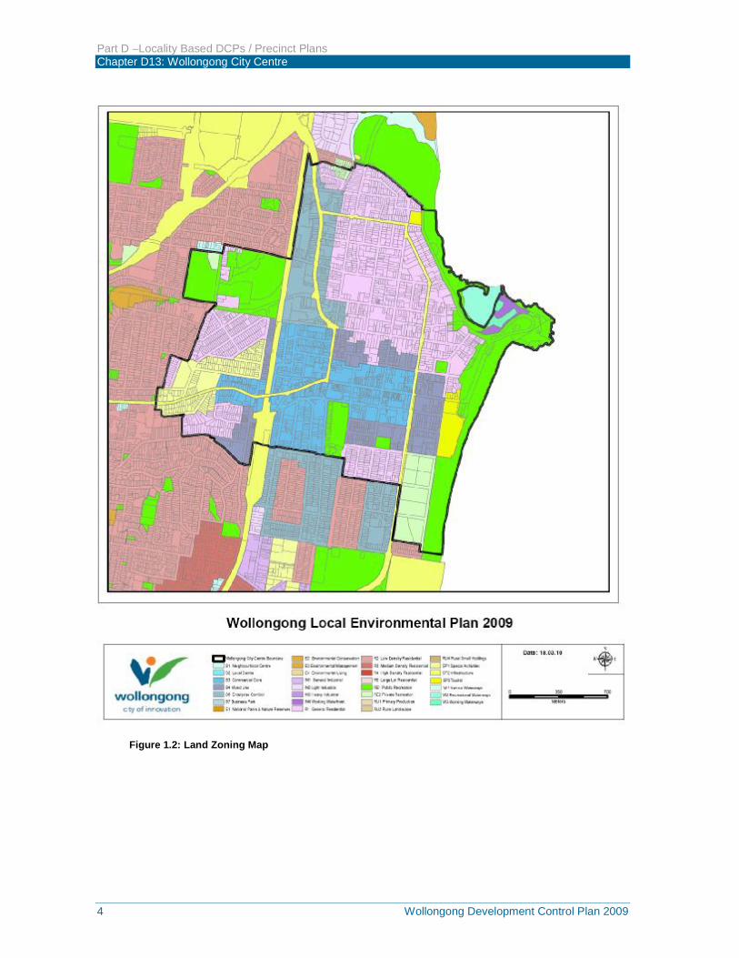
the vibrancy and activity along streets and provide for sustainable growth within the city centre. See Figure 1.2.
3. Commercial Core – provides for a wide range of retail, business, office, civic and cultural entertainment and community uses, including tourism and leisure uses, and residential uses within mixed use developments.
4. The commercial core is the ‘heart of the city’, where the focus is on high quality buildings, streetscapes, public art, outdoor eating and a collection of attractive public spaces such as a new forecourt to the railway station, rejuvenated MacCabe Park and Crown Street Mall, new civic square on Crown Street and an attractive collection of laneways and arcades. The primary retail focus is Crown Street Mall. The core retail area along Crown Street is generally characterised by street enclosing buildings forming continuous building facades that provide for an active street frontage to all commercial core streets. Streets are to have continuous awnings to give weather protection to concentrated pedestrian street activity.
5. Mixed Use (City Edge) – west of the railway station, this area provides for a mixture of compatible land uses to the commercial core, including commercial, retail, cultural, entertainment, tourism, leisure, recreation, social, educational, health and high density residential development.
6. The upgrading of the railway station will offer a safe and attractive street environment and railway/bus interchange facility. The scale of new development is to have a transition in scale between the high form at the station to a medium rise to the north and south of Crown Street. Pedestrian activity will focus around the railway station, in Crown Street and along Gladstone Avenue towards the TAFE campus. New development is to have active frontages and continuous awnings to protect pedestrian activity.
7. East of Corrimal Street, the Mixed Use (City Edge) provides for a mixture of compatible land uses to the commercial core, including commercial and retail, cultural and entertainment, tourism, leisure and recreation, social, educational, health and higher density residential development. The area is characterised by the relaxed beach character with residential buildings sitting in the landscape with more generous street setbacks. Buildings along Corrimal Street (between Market and Stewart Streets) and Crown Street (nb. northern side, east of Corrimal Street) are to be built to street alignment and have awnings and active street frontages.
8. North of Market Street and south of Stewart Street is a transition area between the commercial core and predominately residential areas to the north and south. It allows for high density residential development that can take advantage of views towards the escarpment and the foreshore, with retail and business uses encouraged at ground level along major streets. Building heights allow for view sharing and retention of significant views, with higher buildings located on the lower lying land along Burelli Street.
9. Special Activities – Hospitals and Medical Research and Development – is an area clustered around the Wollongong Hospital and along Crown Street, west of the railway station.
10. This area has an excellent potential to become a hub of innovation, education and research in the city centre. The area can be supported by student and nursing staff accommodation, medical centres, doctors’ surgeries, specialise rooms and associated uses. The upgrading of the railway station will offer a safe and attractive street environment and railway/bus interchange facility. The scale of new development is to be of a transition scale between the high buildings at the station to medium rise buildings to the north and south of Crown Street.
11. Enterprise Corridor – will promote business activity along Flinders Street, particularly business uses requiring larger footprint buildings and good vehicular access and exposure. The area will cater also for the complementary business, office, retail and light industrial uses. The importance of Flinders Street (the Princes Highway) as a business address is reinforced by increasing the scale and activation of buildings along the street, with service uses such as parking and goods storage away from street frontages. Residential development incorporated in mixed use developments, is encouraged within walking distance of the North Wollongong rail station and in
Part D –Locality Based DCPs / Precinct Plans Chapter D13: Wollongong City Centre
Wollongong Development Control Plan 2009 3
areas abutting the general residential zone to the east. The character of the area will be of an attractive city boulevard lined with trees and high quality buildings of medium scale with large showroom windows fronting the street with landscaped setbacks.
12. Tourist and Private Recreation – this area is largely occupied by existing entertainment and sporting uses (WIN Stadium). The precinct is to be activated by complementary uses that address the street and promote extended use of the area during non-event times. Complementary uses include tourist development, tourist facilities (restaurants, gyms) and convention centres. Improved integration of the area with the city is envisaged, with specific requirements for improved pedestrian linkages between the foreshore and the Mixed Use (City Edge) along Burelli, Stewart and Bank Streets and activation of Crown and Harbour Streets. The future vision for the area will be focusing on the ‘city beach’ character along the eastern edge of the city centre with alfresco dining and tourist uses facing the beach frontage.
13. General Residential – the general residential zone in Wollongong city centre is ideally located within easy walking distance to both the commercial core and the major recreational areas along the foreshore. The topography of the area allows for good view opportunities towards the escarpment and foreshore. Scale and form of new residential development should be compatible with the character of the locality, providing for higher density residential use, local convenience shops and longer stay tourist accommodation in serviced apartments.
14. Development controls aim to promote high levels of residential amenity, high quality landscaping and onsite open space provisions, combined with setbacks and building depth controls to ensure that building bulk and scale is compatible with good residential amenity, view sharing and a sustainable living environment.
15. Working Waterfront and Public Recreation – the waterfront area encompasses the working waterfront land use zone and those parts of the public recreation zone fronting the foreshore. The area offers recreational activities to the city, neighbouring residential areas and the wider Illawarra community. The natural and historic attributes of the area, including the State significant Belmore Basin Heritage Conservation Area, lighthouse, North Beach and natural features of the foreshore are to be protected commensurate with an increase in tourist and visitor use.
16. Scale and bulk of development is to consider the natural topography of the setting, with buildings of small scale, sympathetic to the setting.
17. Foreshore improvement works and enhanced community facilities and buildings are planned to improve visitor amenity and provide for a vibrant beachside and maritime environment. Boating and marine activities within the working waterfront zone combined with specialist shops and food outlets are encouraged in this area.
Part D –Locality Based DCPs / Precinct Plans Chapter D13: Wollongong City Centre
4 Wollongong Development Control Plan 2009
Figure 1.2: Land Zoning Map
Part D –Locality Based DCPs / Precinct Plans Chapter D13: Wollongong City Centre
Wollongong Development Control Plan 2009 5
2 BUILDING FORM
2.1 General 1. Building form and character refers to the individual elements of building design that collectively
contribute to the character and appearance of the built environment. The Wollongong City Centre LEP includes provisions for land use, building heights and sun access planes, floor space ratio and design excellence. The development provisions in this section of the DCP on building form are intended to encourage high quality design for new buildings, balancing character of Wollongong with innovation and creativity. The resulting built form and character of new development should contribute to an attractive public domain in central Wollongong and produce a desirable setting for its intended uses.
2. The controls in this section aim to:
a) Establish the scale, dimensions, form and separation of buildings appropriate for the setting in the city centre;
b) Achieve attractive and sustainable Wollongong city form within the city context;
c) Provide a strong definition of the public domain;
d) Achieve active street frontages with good physical and visual connections between buildings and the street;
e) Ensure there is consistency in the main street frontages of buildings having a common alignment;
f) Provide for pedestrian comfort and protection from weather conditions;
g) Define the public street to provide spaces that are clear in terms of public accessibility and safety, and are easy to maintain;
h) Ensure building depth and bulk is appropriate to the environmental setting and landform, allows for view sharing and provides good internal building amenity;
i) Ensure building separation is adequate to protect amenity, daylight penetration and privacy between adjoining developments;
j) Encourage mixed use development with residential components that achieve active street fronts and maintain good residential amenity;
k) Achieve an articulation and finish of building exteriors that contributes to a high quality and sustainable urban environment; and
l) Provide for high quality landscape to contribute to the amenity of the city centre and a sustainable urban environment.
2.2 Building to street alignment and street setbacks 2.2.1 General
1. Street setbacks and building alignments establish the front building line. They help to create the proportions of the street and can contribute to the public domain by enhancing streetscape character and the continuity of street facades. Street setbacks can also be used to enhance the setting and address for the building. They provide for landscape areas, entries to ground floor apartments and deep soil zones. Street setbacks are measured from the street boundary to the outside face of the external wall of the building.
2. In the commercial core, buildings are to be built up to the street alignment to reinforce the urban character and improve pedestrian amenity and activity at street level. Above street frontage height, tall buildings are to be set back to provide for sunlight to streets, and daylight to pedestrian areas and lower levels of other buildings. They offer comfortable wind conditions,
Part D –Locality Based DCPs / Precinct Plans Chapter D13: Wollongong City Centre
6 Wollongong Development Control Plan 2009
view corridors, an appropriate building scale for pedestrians, and good growing conditions for street trees. In the residential locations and some Mixed Use (City Edge) locations, buildings are to be setback to a consistent building line.
3. The definition of “building line or setback” is provided in the Wollongong City Centre LEP 2007.
2.2.2 Objectives a) To provide a hierarchy of street edges from commercial core with no street setbacks to residential
locations with landscaped setbacks.
b) To establish the desired spatial proportions of the street and define the street edge.
c) To increase a clear transition between public and private space.
d) To locate active uses, such as shopfronts, closer to pedestrian activity areas.
e) To assist in achieving visual privacy to apartments from the street.
f) To create good quality entry spaces to lobbies, foyers or individual dwelling entrances.
g) To allow an outlook to, and surveillance of, the street.
h) To allow for street landscape character, where appropriate.
i) To maintain shared views to the ocean.
j) To maintain sun access to the public domain.
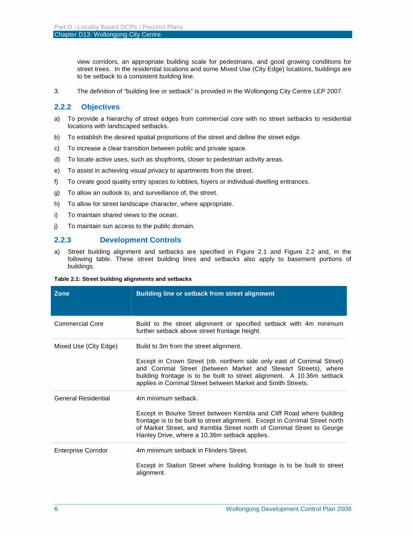
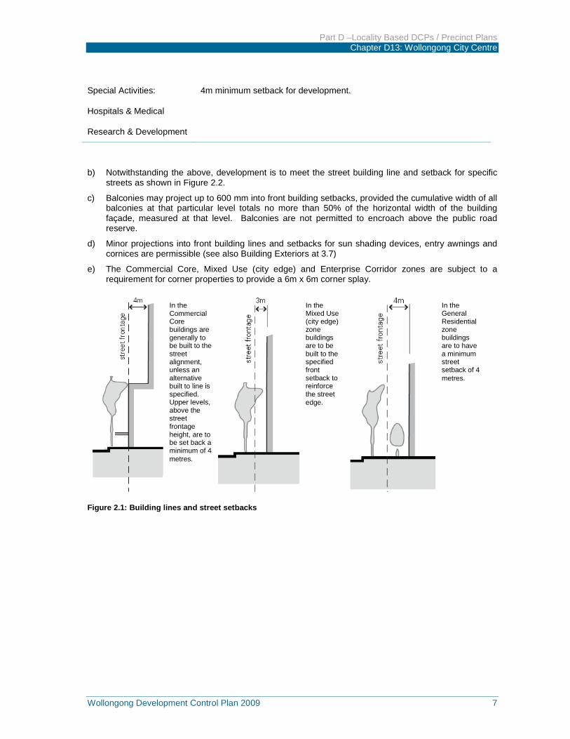
2.2.3 Development Controls a) Street building alignment and setbacks are specified in Figure 2.1 and Figure 2.2 and, in the
following table. These street building lines and setbacks also apply to basement portions of buildings.
Table 2.1: Street building alignments and setbacks
Zone Building line or setback from street alignment
Commercial Core Build to the street alignment or specified setback with 4m minimum further setback above street frontage height.
Mixed Use (City Edge) Build to 3m from the street alignment.
Except in Crown Street (nb. northern side only east of Corrimal Street) and Corrimal Street (between Market and Stewart Streets), where building frontage is to be built to street alignment. A 10.36m setback applies in Corrimal Street between Market and Smith Streets.
General Residential 4m minimum setback.
Except in Bourke Street between Kembla and Cliff Road where building frontage is to be built to street alignment. Except in Corrimal Street north of Market Street, and Kembla Street north of Corrimal Street to George Hanley Drive, where a 10.36m setback applies.
Enterprise Corridor 4m minimum setback in Flinders Street.
Except in Station Street where building frontage is to be built to street alignment.
Part D –Locality Based DCPs / Precinct Plans Chapter D13: Wollongong City Centre
Wollongong Development Control Plan 2009 7
Special Activities:
Hospitals & Medical
Research & Development
4m minimum setback for development.
b) Notwithstanding the above, development is to meet the street building line and setback for specific streets as shown in Figure 2.2.
c) Balconies may project up to 600 mm into front building setbacks, provided the cumulative width of all balconies at that particular level totals no more than 50% of the horizontal width of the building façade, measured at that level. Balconies are not permitted to encroach above the public road reserve.
d) Minor projections into front building lines and setbacks for sun shading devices, entry awnings and cornices are permissible (see also Building Exteriors at 3.7)
e) The Commercial Core, Mixed Use (city edge) and Enterprise Corridor zones are subject to a requirement for corner properties to provide a 6m x 6m corner splay.
Figure 2.1: Building lines and street setbacks
In the General Residential zone buildings are to have a minimum street setback of 4 metres.
In the Mixed Use (city edge) zone buildings are to be built to the specified front setback to reinforce the street edge.
In the Commercial Core buildings are generally to be built to the street alignment, unless an alternative built to line is specified. Upper levels, above the street frontage height, are to be set back a minimum of 4 metres.
Part D –Locality Based DCPs / Precinct Plans Chapter D13: Wollongong City Centre
8 Wollongong Development Control Plan 2009
Figure 2.2: Specific street alignment and street setbacks
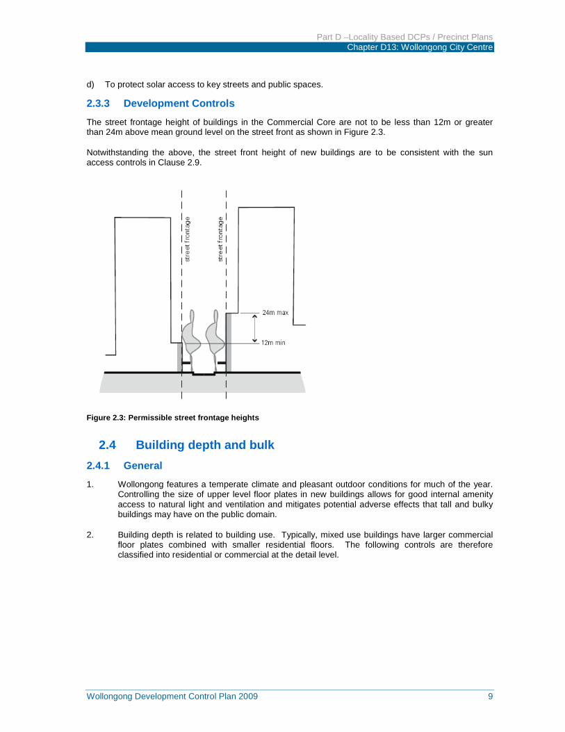
2.3 Street frontage heights in commercial core 2.3.1 General 1. Buildings built to the street alignment and with a height to street width ratio of approximately 1:1
give a sense of enclosure to the street that is appropriate for a city centre. In Wollongong, streets in the Commercial Core are generally 20 metres wide, generating a preferred street front height of between 12m and 24m, subject to context and sun access requirements.
2. Controls setting street front heights apply within the commercial core where buildings are to be built to the street alignment.
2.3.2 Objectives a) To achieve comfortable street environments for pedestrians in terms of daylight, scale, sense of
enclosure and wind mitigation as well as a healthy environment for street trees.
b) To reinforce the intrinsic character of Wollongong City Centre while enabling flexibility in building design.
c) To enhance the distinctive character of Special Areas with compatible development.
Part D –Locality Based DCPs / Precinct Plans Chapter D13: Wollongong City Centre
Wollongong Development Control Plan 2009 9
d) To protect solar access to key streets and public spaces.
2.3.3 Development Controls
The street frontage height of buildings in the Commercial Core are not to be less than 12m or greater than 24m above mean ground level on the street front as shown in Figure 2.3.
Notwithstanding the above, the street front height of new buildings are to be consistent with the sun access controls in Clause 2.9.
Figure 2.3: Permissible street frontage heights
2.4 Building depth and bulk 2.4.1 General 1. Wollongong features a temperate climate and pleasant outdoor conditions for much of the year.
Controlling the size of upper level floor plates in new buildings allows for good internal amenity access to natural light and ventilation and mitigates potential adverse effects that tall and bulky buildings may have on the public domain.
2. Building depth is related to building use. Typically, mixed use buildings have larger commercial floor plates combined with smaller residential floors. The following controls are therefore classified into residential or commercial at the detail level.
Part D –Locality Based DCPs / Precinct Plans Chapter D13: Wollongong City Centre
10 Wollongong Development Control Plan 2009
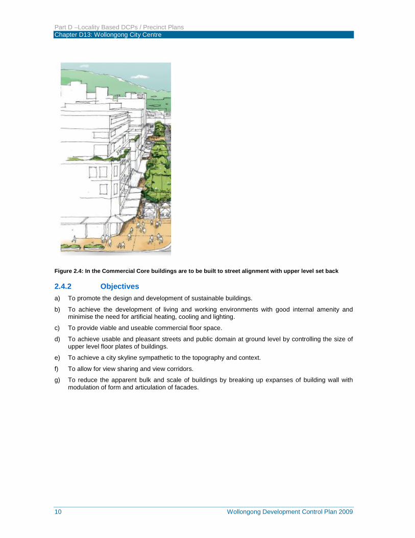
Figure 2.4: In the Commercial Core buildings are to be built to street alignment with upper level set back
2.4.2 Objectives a) To promote the design and development of sustainable buildings.
b) To achieve the development of living and working environments with good internal amenity and minimise the need for artificial heating, cooling and lighting.
c) To provide viable and useable commercial floor space.
d) To achieve usable and pleasant streets and public domain at ground level by controlling the size of upper level floor plates of buildings.
e) To achieve a city skyline sympathetic to the topography and context.
f) To allow for view sharing and view corridors.
g) To reduce the apparent bulk and scale of buildings by breaking up expanses of building wall with modulation of form and articulation of facades.
Part D –Locality Based DCPs / Precinct Plans Chapter D13: Wollongong City Centre
Wollongong Development Control Plan 2009 11
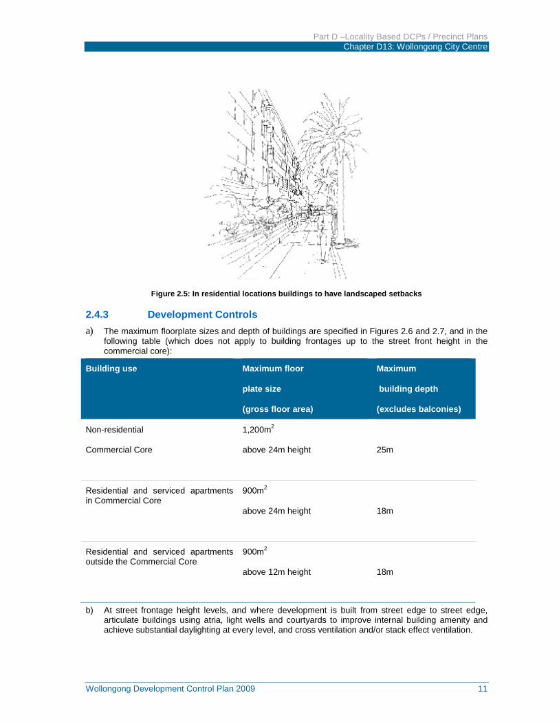
Figure 2.5: In residential locations buildings to have landscaped setbacks
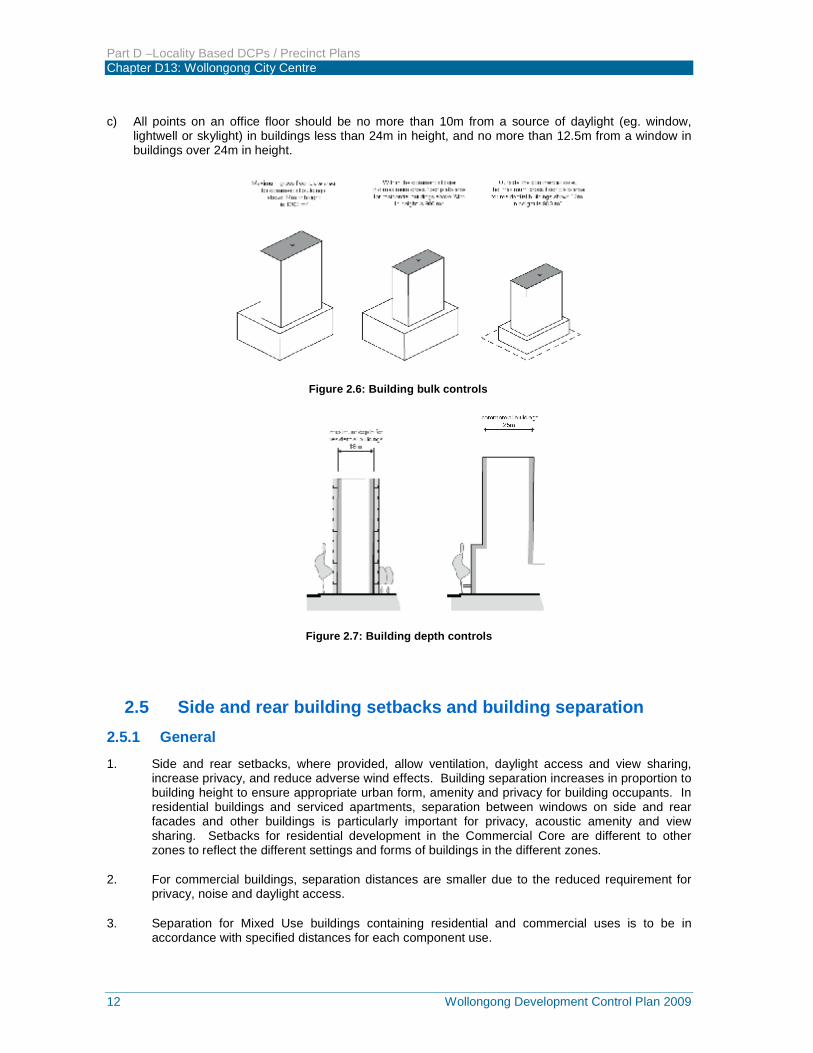
2.4.3 Development Controls a) The maximum floorplate sizes and depth of buildings are specified in Figures 2.6 and 2.7, and in the
following table (which does not apply to building frontages up to the street front height in the commercial core):
Building use Maximum floor
plate size
(gross floor area)
Maximum
building depth
(excludes balconies)
Non-residential
Commercial Core
1,200m2
above 24m height
25m
Residential and serviced apartments in Commercial Core
900m2
above 24m height
18m
Residential and serviced apartments outside the Commercial Core
900m2
above 12m height
18m
b) At street frontage height levels, and where development is built from street edge to street edge, articulate buildings using atria, light wells and courtyards to improve internal building amenity and achieve substantial daylighting at every level, and cross ventilation and/or stack effect ventilation.
Part D –Locality Based DCPs / Precinct Plans Chapter D13: Wollongong City Centre
12 Wollongong Development Control Plan 2009
c) All points on an office floor should be no more than 10m from a source of daylight (eg. window, lightwell or skylight) in buildings less than 24m in height, and no more than 12.5m from a window in buildings over 24m in height.
Figure 2.6: Building bulk controls
Figure 2.7: Building depth controls
2.5 Side and rear building setbacks and building separation 2.5.1 General 1. Side and rear setbacks, where provided, allow ventilation, daylight access and view sharing,
increase privacy, and reduce adverse wind effects. Building separation increases in proportion to building height to ensure appropriate urban form, amenity and privacy for building occupants. In residential buildings and serviced apartments, separation between windows on side and rear facades and other buildings is particularly important for privacy, acoustic amenity and view sharing. Setbacks for residential development in the Commercial Core are different to other zones to reflect the different settings and forms of buildings in the different zones.
2. For commercial buildings, separation distances are smaller due to the reduced requirement for privacy, noise and daylight access.
3. Separation for Mixed Use buildings containing residential and commercial uses is to be in accordance with specified distances for each component use.
Part D –Locality Based DCPs / Precinct Plans Chapter D13: Wollongong City Centre
Wollongong Development Control Plan 2009 13
4. The definition of “building line or setback” is provided in the Wollongong City Centre LEP 2009.
2.5.2 Objectives a) To ensure an appropriate level of amenity for building occupants in terms of daylight, outlook, view
sharing, ventilation, wind mitigation, and privacy.
b) To achieve usable and pleasant streets and public domain areas in terms of wind mitigation and daylight access.
2.5.3 Development Controls
Note: For the purpose of this section, commercial buildings means all non-residential buildings (including hotel accommodation, but not serviced apartments). Principal windows and balconies means the main window of a living room or main bedroom, or the edge of primary balcony of a dwelling.
a) The minimum building setbacks from the side and rear property boundaries are specified in Figures 2.8 to 2.11, and in the following table:
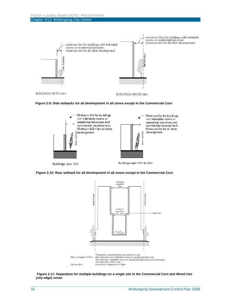
b) For multiple buildings on the same site in the Commercial Core and Mixed Use (city edge) zones, minimum separation distances are shown in Figure 2.12.
c) In mixed use buildings, setbacks for the residential component are to be the distances specified above for residential development in the specified zone.
d) If the specified setback distances cannot be achieved when an existing building is being refurbished or converted to another use, appropriate visual privacy levels are to be achieved through other means, for example, the construction of screens. These will be assessed on merit by the consent authority.
e) In certain circumstances, Council may consider a variation to the side and rear setback requirements through appropriate architectural features (eg splayed windows which achieve oblique outlooks) provided that:
i) A minimum separation between the main walls of 6 metres is maintained,
ii) Separation is between sections of building walls that include only service room windows,
iii) Views are available obliquely to site boundaries; and
iv) Privacy screens are provided to all balconies and windows for all units / suites along the building facade.
Part D –Locality Based DCPs / Precinct Plans Chapter D13: Wollongong City Centre
14 Wollongong Development Control Plan 2009
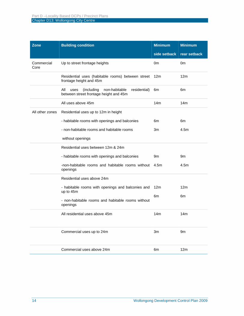
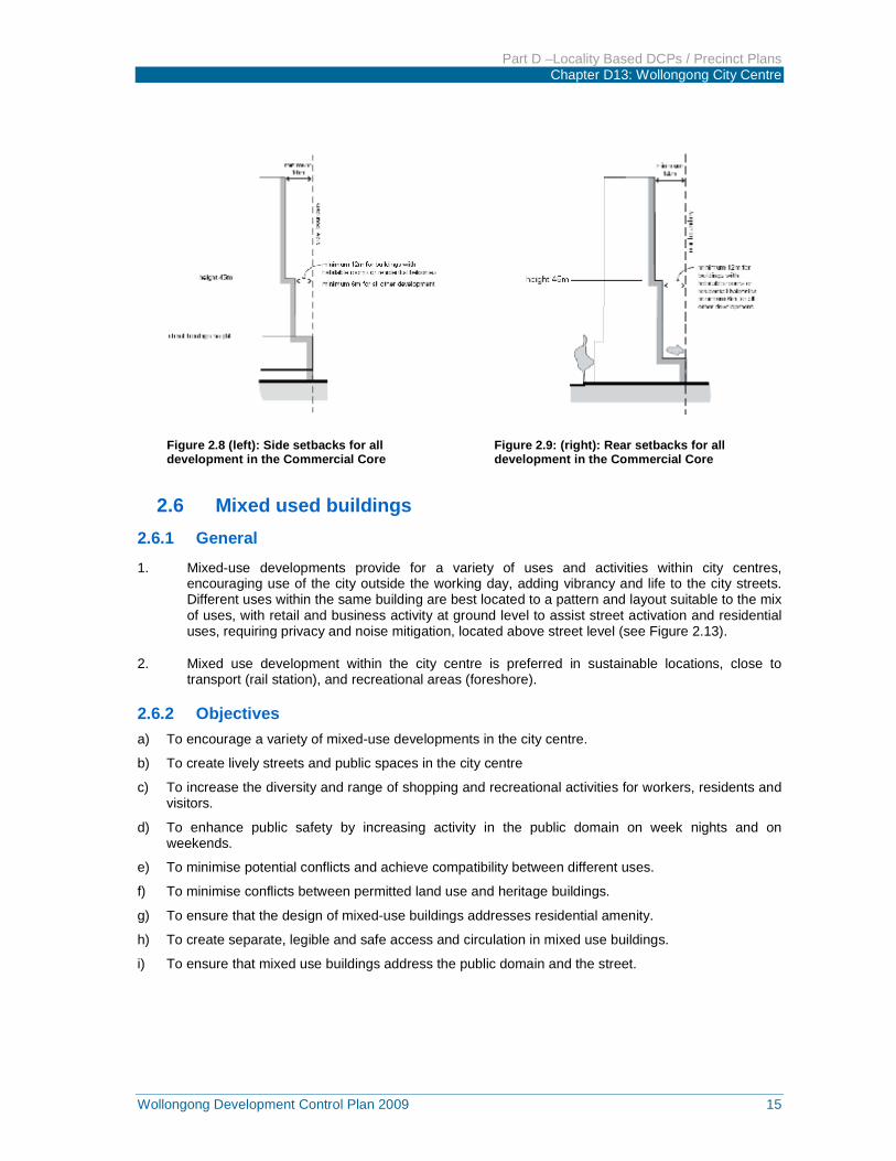
Zone Building condition Minimum
side setback
Minimum
rear setback
Commercial Core
Up to street frontage heights 0m 0m
Residential uses (habitable rooms) between street frontage height and 45m
12m 12m
All uses (including non-habitable residential) between street frontage height and 45m
6m 6m
All uses above 45m 14m 14m
All other zones Residential uses up to 12m in height
- habitable rooms with openings and balconies
- non-habitable rooms and habitable rooms
without openings
6m
3m
6m
4.5m
Residential uses between 12m & 24m
- habitable rooms with openings and balconies
-non-habitable rooms and habitable rooms without openings
9m
4.5m
9m
4.5m
Residential uses above 24m
- habitable rooms with openings and balconies and up to 45m
- non-habitable rooms and habitable rooms without openings
12m
6m
12m
6m
All residential uses above 45m
14m 14m
Commercial uses up to 24m
3m 9m
Commercial uses above 24m 6m 12m
Part D –Locality Based DCPs / Precinct Plans Chapter D13: Wollongong City Centre
Wollongong Development Control Plan 2009 15
2.6 Mixed used buildings 2.6.1 General
1. Mixed-use developments provide for a variety of uses and activities within city centres, encouraging use of the city outside the working day, adding vibrancy and life to the city streets. Different uses within the same building are best located to a pattern and layout suitable to the mix of uses, with retail and business activity at ground level to assist street activation and residential uses, requiring privacy and noise mitigation, located above street level (see Figure 2.13).
2. Mixed use development within the city centre is preferred in sustainable locations, close to transport (rail station), and recreational areas (foreshore).
2.6.2 Objectives a) To encourage a variety of mixed-use developments in the city centre.
b) To create lively streets and public spaces in the city centre
c) To increase the diversity and range of shopping and recreational activities for workers, residents and visitors.
d) To enhance public safety by increasing activity in the public domain on week nights and on weekends.
e) To minimise potential conflicts and achieve compatibility between different uses.
f) To minimise conflicts between permitted land use and heritage buildings.
g) To ensure that the design of mixed-use buildings addresses residential amenity.
h) To create separate, legible and safe access and circulation in mixed use buildings.
i) To ensure that mixed use buildings address the public domain and the street.
Figure 2.8 (left): Side setbacks for all development in the Commercial Core
Figure 2.9: (right): Rear setbacks for all development in the Commercial Core
Part D –Locality Based DCPs / Precinct Plans Chapter D13: Wollongong City Centre
16 Wollongong Development Control Plan 2009
Figure 2.9: Side setbacks for all development in all zones except in the Commercial Core
Figure 2.10: Rear setback for all development in all zones except in the Commercial Core
Figure 2.11: Separation for multiple buildings on a single site in the Commercial Core and Mixed Use (city edge) zones
Part D –Locality Based DCPs / Precinct Plans Chapter D13: Wollongong City Centre
Wollongong Development Control Plan 2009 17
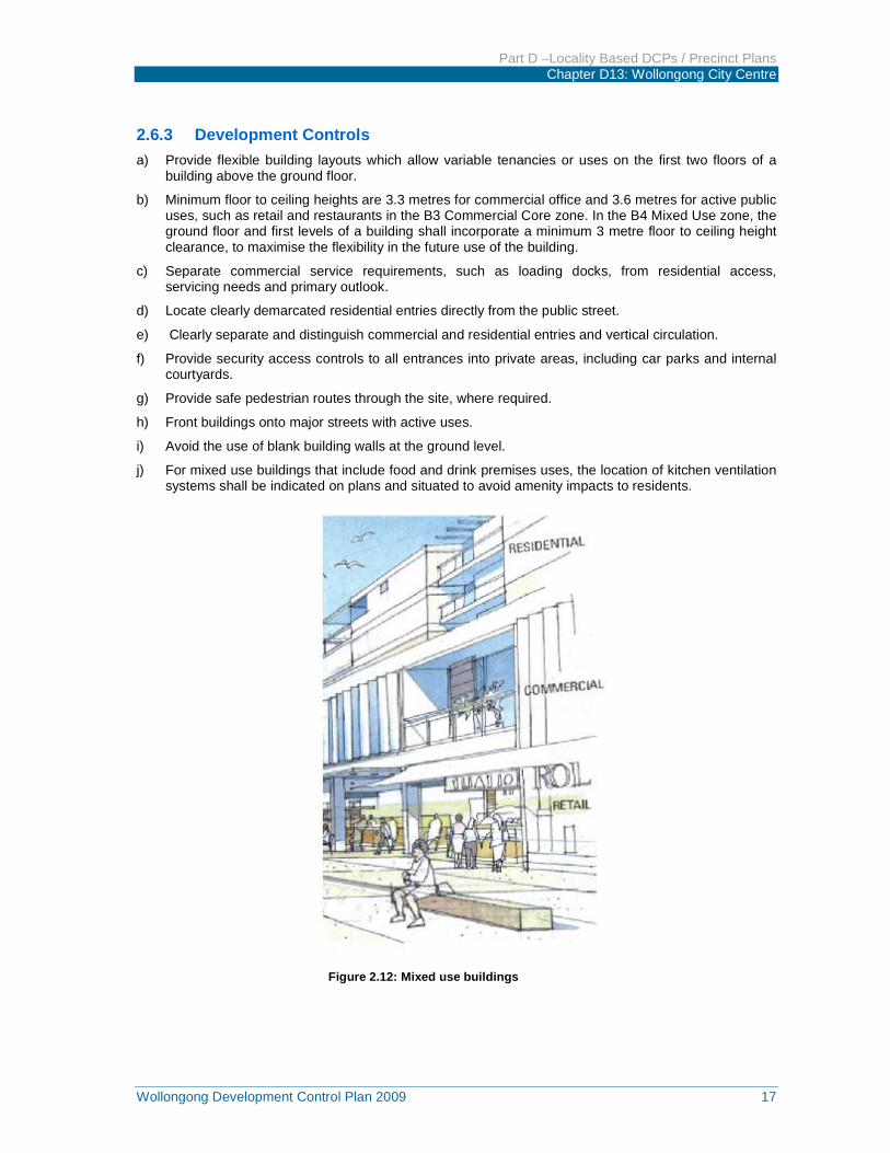
2.6.3 Development Controls a) Provide flexible building layouts which allow variable tenancies or uses on the first two floors of a
building above the ground floor.
b) Minimum floor to ceiling heights are 3.3 metres for commercial office and 3.6 metres for active public uses, such as retail and restaurants in the B3 Commercial Core zone. In the B4 Mixed Use zone, the ground floor and first levels of a building shall incorporate a minimum 3 metre floor to ceiling height clearance, to maximise the flexibility in the future use of the building.
c) Separate commercial service requirements, such as loading docks, from residential access, servicing needs and primary outlook.
d) Locate clearly demarcated residential entries directly from the public street.
e) Clearly separate and distinguish commercial and residential entries and vertical circulation.
f) Provide security access controls to all entrances into private areas, including car parks and internal courtyards.
g) Provide safe pedestrian routes through the site, where required.
h) Front buildings onto major streets with active uses.
i) Avoid the use of blank building walls at the ground level.
j) For mixed use buildings that include food and drink premises uses, the location of kitchen ventilation systems shall be indicated on plans and situated to avoid amenity impacts to residents.
Figure 2.12: Mixed use buildings
Part D –Locality Based DCPs / Precinct Plans Chapter D13: Wollongong City Centre
18 Wollongong Development Control Plan 2009
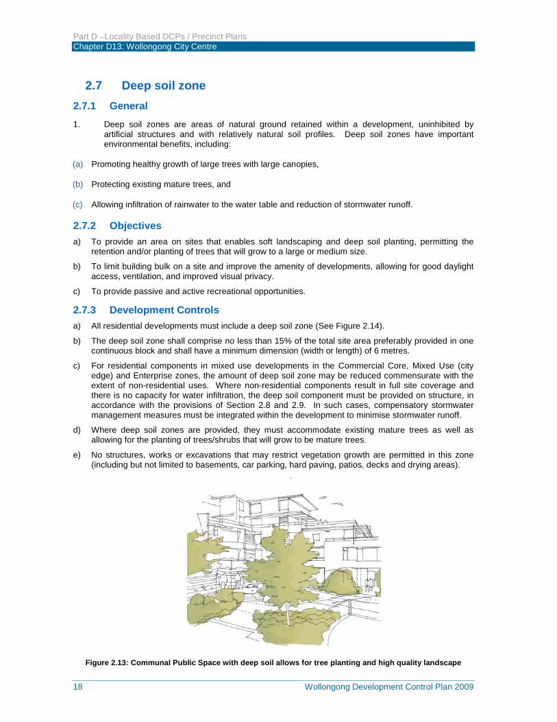
2.7 Deep soil zone 2.7.1 General 1. Deep soil zones are areas of natural ground retained within a development, uninhibited by
artificial structures and with relatively natural soil profiles. Deep soil zones have important environmental benefits, including:
(a) Promoting healthy growth of large trees with large canopies,
(b) Protecting existing mature trees, and
(c) Allowing infiltration of rainwater to the water table and reduction of stormwater runoff.
2.7.2 Objectives a) To provide an area on sites that enables soft landscaping and deep soil planting, permitting the
retention and/or planting of trees that will grow to a large or medium size.
b) To limit building bulk on a site and improve the amenity of developments, allowing for good daylight access, ventilation, and improved visual privacy.
c) To provide passive and active recreational opportunities.
2.7.3 Development Controls a) All residential developments must include a deep soil zone (See Figure 2.14).
b) The deep soil zone shall comprise no less than 15% of the total site area preferably provided in one continuous block and shall have a minimum dimension (width or length) of 6 metres.
c) For residential components in mixed use developments in the Commercial Core, Mixed Use (city edge) and Enterprise zones, the amount of deep soil zone may be reduced commensurate with the extent of non-residential uses. Where non-residential components result in full site coverage and there is no capacity for water infiltration, the deep soil component must be provided on structure, in accordance with the provisions of Section 2.8 and 2.9. In such cases, compensatory stormwater management measures must be integrated within the development to minimise stormwater runoff.
d) Where deep soil zones are provided, they must accommodate existing mature trees as well as allowing for the planting of trees/shrubs that will grow to be mature trees.
e) No structures, works or excavations that may restrict vegetation growth are permitted in this zone (including but not limited to basements, car parking, hard paving, patios, decks and drying areas).
Figure 2.13: Communal Public Space with deep soil allows for tree planting and high quality landscape

Part D –Locality Based DCPs / Precinct Plans Chapter D13: Wollongong City Centre
Wollongong Development Control Plan 2009 19
2.8 Landscape design 2.8.1 General 1. Landscape design includes the planning, design, construction and maintenance of all utility, open
space and garden areas. Good landscaping provides breathing space, passive and active recreational opportunities and enhances air quality in city centres. It is fundamental to the amenity and quality of outside space for residential flats and multi-dwelling housing.
2.8.2 Objectives a) To ensure landscaping is integrated into the design of development.
b) To add value and quality of life for residents and occupants within a development in terms of privacy, outlook, views and recreational opportunities.
c) To improve stormwater quality and control run-off.
d) To improve the microclimate and solar performance within the development.
e) To improve urban air quality and contribute to biodiversity.
2.8.3 Development Controls a) The following documents must be considered for site planning and landscape design:
i) Chapter E6 – Landscaping in the DCP.
ii) Wollongong City Centre Public Domain Technical Manual. (Appendix 2 to this DCP).
b) Remnant vegetation must be maintained throughout the site wherever practicable, particularly significant trees.
c) A long-term landscape management plan must be provided for all landscaped areas, in particular the deep soil landscape zone.
d) The plan must outline how landscaped areas are to be maintained for the life of the development.
e) Chapter E17 Preservation and Management of Trees and Other Vegetation in this DCP provides for the protection of all trees with a girth greater than 200mm or a height over three metres, or a spread over three metres.
2.9 Green roofs, green walls and planting on structures 2.9.1 General
1. The following controls apply in the Commercial Core, Mixed Use (city edge) and Enterprise zones for planting on roof tops or over car park structures, particularly for communal open space required as a component of mixed use residential development, and in non-residential developments where the landscaping proposed is not on natural ground e.g. green roofs and walls, podiums, rooftop gardens (Figures 2.15 and 2.16).
2.9.2 Objectives a) To contribute to the quality and amenity of open space on roof tops and internal courtyards.
b) To encourage the establishment and healthy growth of trees in urban areas.
c) To encourage the use of green walls and roofs in communal open space, and to enhance the environmental performance of the development.
Part D –Locality Based DCPs / Precinct Plans Chapter D13: Wollongong City Centre
20 Wollongong Development Control Plan 2009
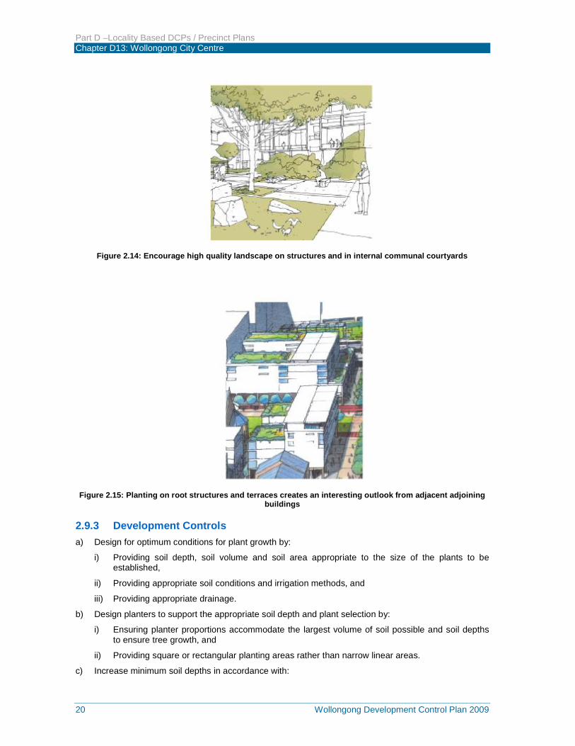
Figure 2.14: Encourage high quality landscape on structures and in internal communal courtyards
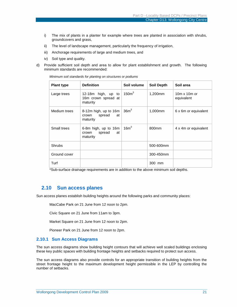
Figure 2.15: Planting on root structures and terraces creates an interesting outlook from adjacent adjoining buildings
2.9.3 Development Controls a) Design for optimum conditions for plant growth by:
i) Providing soil depth, soil volume and soil area appropriate to the size of the plants to be established,
ii) Providing appropriate soil conditions and irrigation methods, and
iii) Providing appropriate drainage.
b) Design planters to support the appropriate soil depth and plant selection by:
i) Ensuring planter proportions accommodate the largest volume of soil possible and soil depths to ensure tree growth, and
ii) Providing square or rectangular planting areas rather than narrow linear areas.
c) Increase minimum soil depths in accordance with:
Part D –Locality Based DCPs / Precinct Plans Chapter D13: Wollongong City Centre
Wollongong Development Control Plan 2009 21
i) The mix of plants in a planter for example where trees are planted in association with shrubs, groundcovers and grass,
ii) The level of landscape management, particularly the frequency of irrigation,
iii) Anchorage requirements of large and medium trees, and
iv) Soil type and quality.
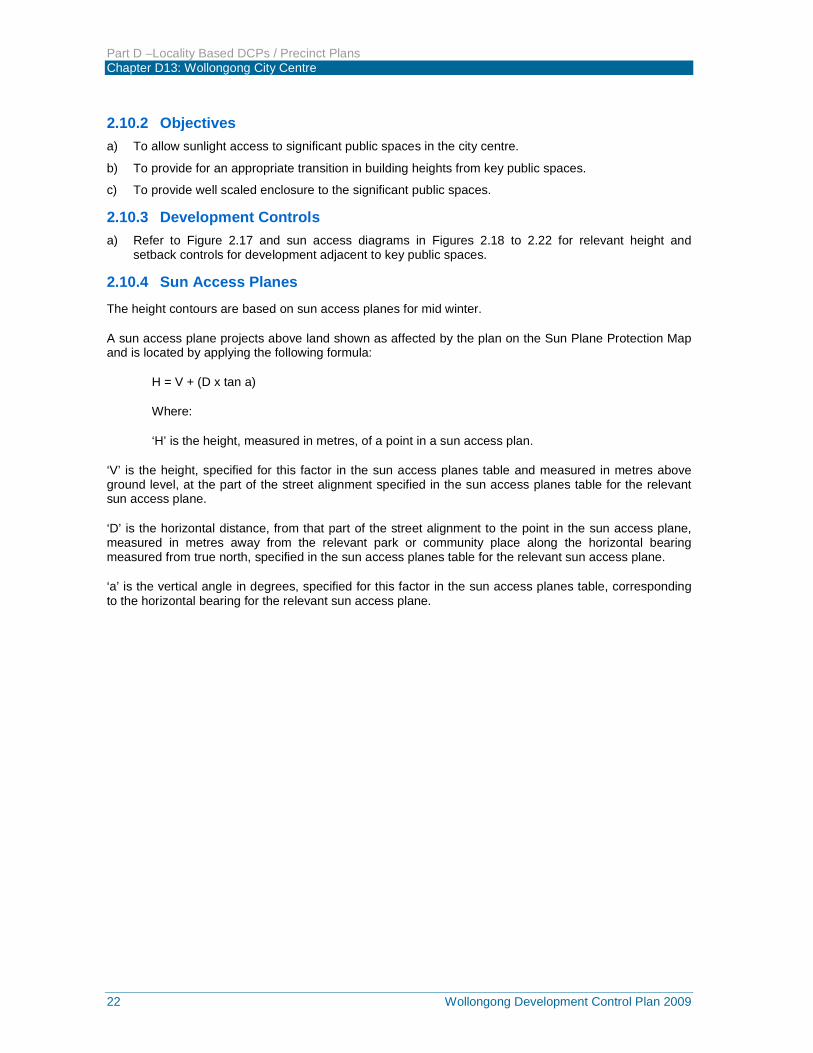
d) Provide sufficient soil depth and area to allow for plant establishment and growth. The following minimum standards are recommended:
Minimum soil standards for planting on structures or podiums
Plant type Definition Soil volume Soil Depth Soil area
Large trees 12-18m high, up to 16m crown spread at maturity
150m3 1,200mm 10m x 10m or equivalent
Medium trees 8-12m high, up to 16m crown spread at maturity
36m3
1,000mm 6 x 6m or equivalent
Small trees 6-8m high, up to 16m crown spread at maturity
16m3
800mm 4 x 4m or equivalent
Shrubs 500-600mm
Ground cover 300-450mm
Turf 300 mm
*Sub-surface drainage requirements are in addition to the above minimum soil depths.
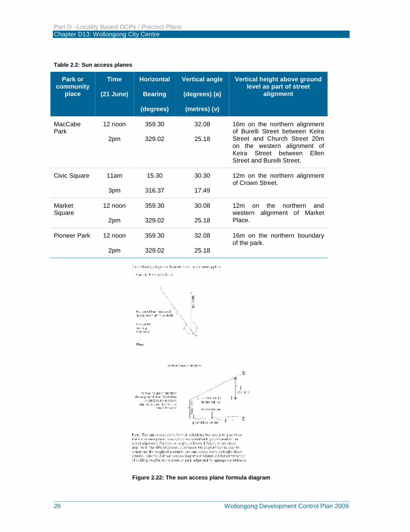
2.10 Sun access planes Sun access planes establish building heights around the following parks and community places:
MacCabe Park on 21 June from 12 noon to 2pm.
Civic Square on 21 June from 11am to 3pm.
Market Square on 21 June from 12 noon to 2pm.
Pioneer Park on 21 June from 12 noon to 2pm.
2.10.1 Sun Access Diagrams
The sun access diagrams show building height contours that will achieve well scaled buildings enclosing these key public spaces with building frontage heights and setbacks required to protect sun access.
The sun access diagrams also provide controls for an appropriate transition of building heights from the street frontage height to the maximum development height permissible in the LEP by controlling the number of setbacks.
Part D –Locality Based DCPs / Precinct Plans Chapter D13: Wollongong City Centre
22 Wollongong Development Control Plan 2009
2.10.2 Objectives a) To allow sunlight access to significant public spaces in the city centre.
b) To provide for an appropriate transition in building heights from key public spaces.
c) To provide well scaled enclosure to the significant public spaces.
2.10.3 Development Controls a) Refer to Figure 2.17 and sun access diagrams in Figures 2.18 to 2.22 for relevant height and
setback controls for development adjacent to key public spaces.
2.10.4 Sun Access Planes The height contours are based on sun access planes for mid winter.
A sun access plane projects above land shown as affected by the plan on the Sun Plane Protection Map and is located by applying the following formula:
H = V + (D x tan a)
Where:
‘H’ is the height, measured in metres, of a point in a sun access plan.
‘V’ is the height, specified for this factor in the sun access planes table and measured in metres above ground level, at the part of the street alignment specified in the sun access planes table for the relevant sun access plane.
‘D’ is the horizontal distance, from that part of the street alignment to the point in the sun access plane, measured in metres away from the relevant park or community place along the horizontal bearing measured from true north, specified in the sun access planes table for the relevant sun access plane.
‘a’ is the vertical angle in degrees, specified for this factor in the sun access planes table, corresponding to the horizontal bearing for the relevant sun access plane.
Part D –Locality Based DCPs / Precinct Plans Chapter D13: Wollongong City Centre
Wollongong Development Control Plan 2009 23
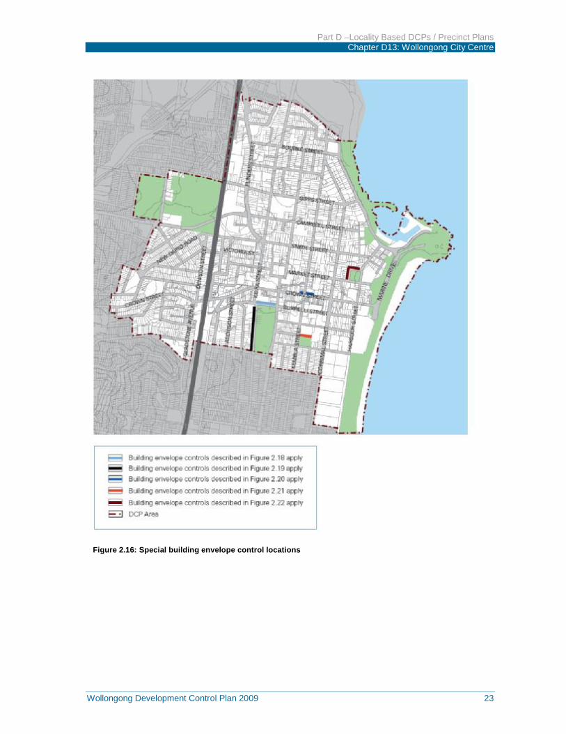
Figure 2.16: Special building envelope control locations
Part D –Locality Based DCPs / Precinct Plans Chapter D13: Wollongong City Centre
24 Wollongong Development Control Plan 2009
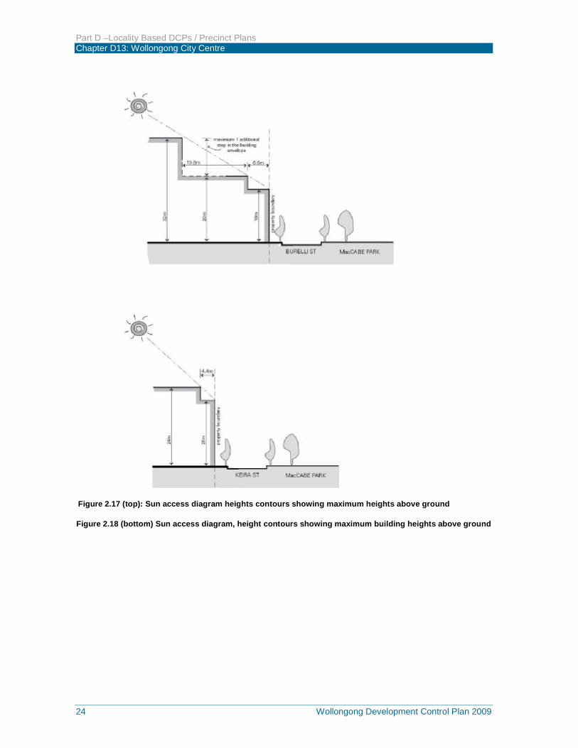
Figure 2.17 (top): Sun access diagram heights contours showing maximum heights above ground
Figure 2.18 (bottom) Sun access diagram, height contours showing maximum building heights above ground
Part D –Locality Based DCPs / Precinct Plans Chapter D13: Wollongong City Centre
Wollongong Development Control Plan 2009 25
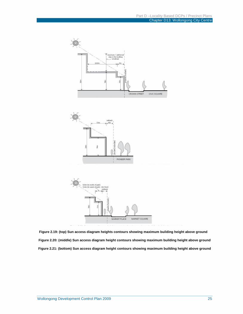
Figure 2.19: (top) Sun access diagram heights contours showing maximum building height above ground
Figure 2.20: (middle) Sun access diagram height contours showing maximum building height above ground
Figure 2.21: (bottom) Sun access diagram height contours showing maximum building height above ground
Part D –Locality Based DCPs / Precinct Plans Chapter D13: Wollongong City Centre
26 Wollongong Development Control Plan 2009
Table 2.2: Sun access planes
Park or community
place
Time
(21 June)
Horizontal
Bearing
(degrees)
Vertical angle
(degrees) (a)
(metres) (v)
Vertical height above ground level as part of street
alignment
MacCabe Park
12 noon
2pm
359.30
329.02
32.08
25.18
16m on the northern alignment of Burelli Street between Keira Street and Church Street 20m on the western alignment of Keira Street between Ellen Street and Burelli Street.
Civic Square 11am
3pm
15.30
316.37
30.30
17.49
12m on the northern alignment of Crown Street.
Market Square
12 noon
2pm
359.30
329.02
30.08
25.18
12m on the northern and western alignment of Market Place.
Pioneer Park 12 noon
2pm
359.30
329.02
32.08
25.18
16m on the northern boundary of the park.
Figure 2.22: The sun access plane formula diagram
Part D –Locality Based DCPs / Precinct Plans Chapter D13: Wollongong City Centre
Wollongong Development Control Plan 2009 27
2.11 Development on classified roads 2.11.1 Objectives a) To ensure that new development does not compromise the effective and ongoing operation and
function of classified roads; and
b) To prevent or reduce the potential impact of traffic noise and vehicle emission on development adjacent to classified roads.
2.11.2 Development Controls a) Consent must not be granted to the development of land that has a frontage to a classified road
unless the consent authority is satisfied that:
b) Where practicable, vehicular access to the land is provided by a road other than the classified road; and
c) The safety, efficiency and ongoing operation of the classified road will not be adversely affected by the proposed development as a result of:
i) The design of the vehicular access to the land, or
ii) The emission of smoke or dust from the proposed development, or
iii) The nature, volume or frequency of vehicles using the classified road to gain access to the land, and
d) The development is of a type that is not sensitive to traffic noise or vehicle emissions, or is appropriately located and designed, or includes measures, to ameliorate potential traffic noise or vehicle emissions within the site of the proposed development.
3 PEDESTRIAN AMENITY
3.1 General Pedestrian amenity incorporates all those elements of individual developments that directly affect the quality and character of the public domain. The pedestrian amenity provisions are intended to achieve a high quality of urban design and pedestrian comfort in the public spaces of the city centre. The pedestrian environment provides people with their primary experience of and interface with the city. This environment needs to be safe, functional and accessible to all. It should provide a wide variety of opportunities for social and cultural activities. The pedestrian environment is to be characterised by excellence of design, high quality materials and a standard of finish appropriate to a regional city centre. The city’s lanes, arcades and through site links should form an integrated pedestrian network providing choice of routes at ground level for pedestrians.
The controls in this section aim to increase the vitality, safety, security and amenity of streets, laneways, arcades and through site links by:
Encouraging future through site links,
Ensuring provision of awnings along the Commercial Core street frontages and Crown Street in Mixed Use (city edge),
Protecting significant views and vistas along streets, and
Mitigating adverse impacts on the street arising from driveway access crossings, advertising signage and selection of building finishes and materials.
Part D –Locality Based DCPs / Precinct Plans Chapter D13: Wollongong City Centre
28 Wollongong Development Control Plan 2009
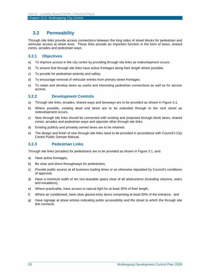
3.2 Permeability Through site links provide access connections between the long sides of street blocks for pedestrian and vehicular access at street level. These links provide an important function in the form of lanes, shared zones, arcades and pedestrian ways.
3.2.1 Objectives a) To improve access in the city centre by providing through site links as redevelopment occurs.
b) To ensure that through site links have active frontages along their length where possible.
c) To provide for pedestrian amenity and safety.
d) To encourage removal of vehicular entries from primary street frontages.
e) To retain and develop lanes as useful and interesting pedestrian connections as well as for service access.
3.2.2 Development Controls a) Through site links, arcades, shared ways and laneways are to be provided as shown in Figure 3.1.
b) Where possible, existing dead end lanes are to be extended through to the next street as redevelopment occurs.
c) New through site links should be connected with existing and proposed through block lanes, shared zones, arcades and pedestrian ways and opposite other through site links.
d) Existing publicly and privately owned lanes are to be retained.
e) The design and finish of new through site links need to be provided in accordance with Council’s City Centre Public Domain Manual.
3.2.3 Pedestrian Links
Through site links (arcades) for pedestrians are to be provided as shown in Figure 3.1, and:
a) Have active frontages,
b) Be clear and direct throughways for pedestrians,
c) Provide public access at all business trading times or as otherwise stipulated by Council’s conditions of approval,
d) Have a minimum width of 4m non-leasable space clear of all obstructions (including columns, stairs and escalators),
e) Where practicable, have access to natural light for at least 30% of their length,
f) Where air conditioned, have clear glazed entry doors comprising at least 50% of the entrance, and
g) Have signage at street entries indicating public accessibility and the street to which the through site link connects.
Part D –Locality Based DCPs / Precinct Plans Chapter D13: Wollongong City Centre
Wollongong Development Control Plan 2009 29
Figure 3.1: Permeability
Internal arcades will not be approved in preference to activation of an existing or required lane. Where developments front a lane that is also a pedestrian route, provide an active frontage and design details that create visual interest such as landscaping, awnings, paved finishes and good lighting.
3.2.4 Lanes a) New through site laneways for pedestrians and vehicles are to be provided as indicated in Figure
3.1.
b) Lanes are to:
i) have active frontages,
Part D –Locality Based DCPs / Precinct Plans Chapter D13: Wollongong City Centre
30 Wollongong Development Control Plan 2009
ii) be clear and direct throughways for pedestrians,
iii) provide public access at all times or as otherwise stipulated by Council’s conditions of approval,
iv) have a minimum width of 6m clear of all obstructions, and
v) have signage indicating public accessibility and the street to which the lane connects.
c) Where lanes are primarily used for building access and servicing, ‘safer by design’ principles must be demonstrated (refer to Section 3.3).
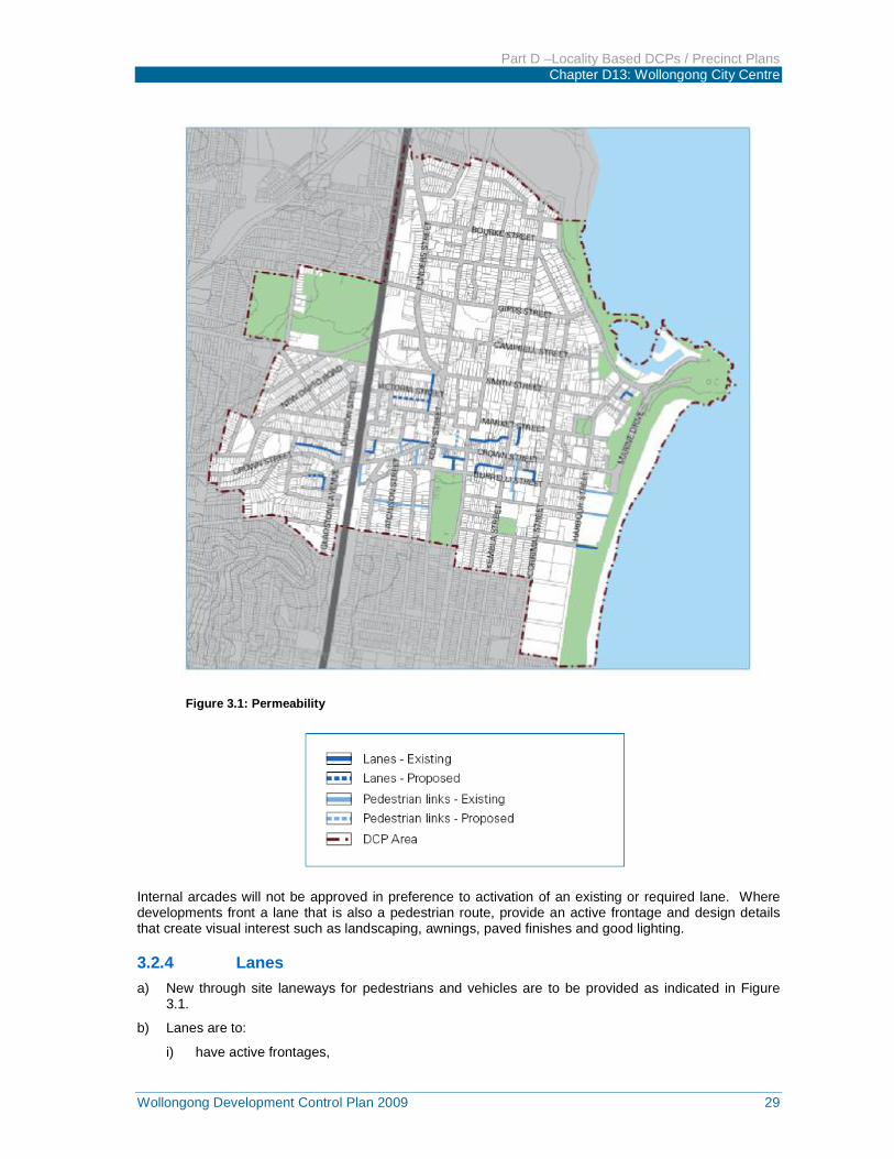
Figure 3.2: Lanes and arcades add to the richness of a city
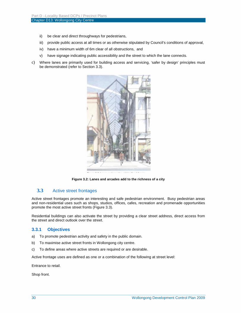
3.3 Active street frontages Active street frontages promote an interesting and safe pedestrian environment. Busy pedestrian areas and non-residential uses such as shops, studios, offices, cafes, recreation and promenade opportunities promote the most active street fronts (Figure 3.3).
Residential buildings can also activate the street by providing a clear street address, direct access from the street and direct outlook over the street.
3.3.1 Objectives a) To promote pedestrian activity and safety in the public domain.
b) To maximise active street fronts in Wollongong city centre.
c) To define areas where active streets are required or are desirable.
Active frontage uses are defined as one or a combination of the following at street level:
Entrance to retail.
Shop front.
Part D –Locality Based DCPs / Precinct Plans Chapter D13: Wollongong City Centre
Wollongong Development Control Plan 2009 31
Glazed entries to commercial and residential lobbies occupying less than 50% of the street frontage, to a maximum of 12 metres frontage.
Café or restaurant if accompanied by an entry from the street.
Active office uses, such as reception, if visible from the street.
Public building if accompanied by an entry.
Figure 3.3: Active street frontages promote safe pedestrian environment
3.3.2 Development Controls a) In commercial and mixed use development, active street fronts are encouraged in the form of non-
residential uses on ground level.
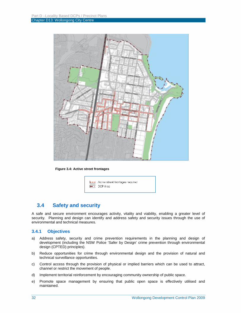
b) Active street fronts in the form of non-residential uses on ground level are required along streets, lanes and through site links shown in Figure 3.4 for all buildings in the Commercial Core and Tourist zones, and for mixed use buildings in the Mixed Use (city edge) and Enterprise zones.
c) Active ground floor uses are to be at the same general level as the footpath and be accessible directly from the street.
d) For all non-residential ground floor frontages outside the streets shown in Figure 3.4, provide clear glazing where ever possible to promote passive surveillance and contribute to street activity.
e) Restaurants, cafes and the like are to consider providing openable shop fronts.
f) Residential developments are to provide a clear street address and direct pedestrian access off the primary street front, and allow for residents to overlook all surrounding streets.
g) Provide multiple entrances for large developments including an entrance on each street frontage.
Part D –Locality Based DCPs / Precinct Plans Chapter D13: Wollongong City Centre
32 Wollongong Development Control Plan 2009
Figure 3.4: Active street frontages
3.4 Safety and security A safe and secure environment encourages activity, vitality and viability, enabling a greater level of security. Planning and design can identify and address safety and security issues through the use of environmental and technical measures.
3.4.1 Objectives a) Address safety, security and crime prevention requirements in the planning and design of
development (including the NSW Police ‘Safer by Design’ crime prevention through environmental design (CPTED) principles).
b) Reduce opportunities for crime through environmental design and the provision of natural and technical surveillance opportunities.
c) Control access through the provision of physical or implied barriers which can be used to attract, channel or restrict the movement of people.
d) Implement territorial reinforcement by encouraging community ownership of public space.
e) Promote space management by ensuring that public open space is effectively utilised and maintained.
Part D –Locality Based DCPs / Precinct Plans Chapter D13: Wollongong City Centre
Wollongong Development Control Plan 2009 33
3.4.2 Development Controls a) Ensure that the building design allows for casual surveillance of accessways, entries and driveways.
b) Avoid creating blind corners and dark alcoves that provide concealment opportunities in pathways, stairwells, hallways and carparks.
c) Provide entrances which are in visually prominent positions and which are easily identifiable, with visible numbering.
d) Where private open space is located within the front building alignment any front fencing must be of a design and/or height which allows for passive surveillance of the street.
e) Provide adequate lighting of all pedestrian access ways, parking areas and building entries. Such lighting should be on a timer or movement detector to reduce energy consumption and glare nuisance.
f) Provide clear lines of sight and well-lit routes throughout the development.
g) Where a pedestrian pathway is provided from the street, allow for casual surveillance of the pathway.
h) For large scale retail and commercial development with a GFA of over 5,000m², provide a ‘safety by design’ assessment in accordance with the CPTED principles.
i) Provide security access controls where appropriate.
j) Ensure building entrance(s) including pathways, lanes and arcades for larger scale retail and commercial developments are directed to signalised intersections rather than mid-block in the Commercial zone, Mixed Use (city edge) and Enterprise Corridor zones.
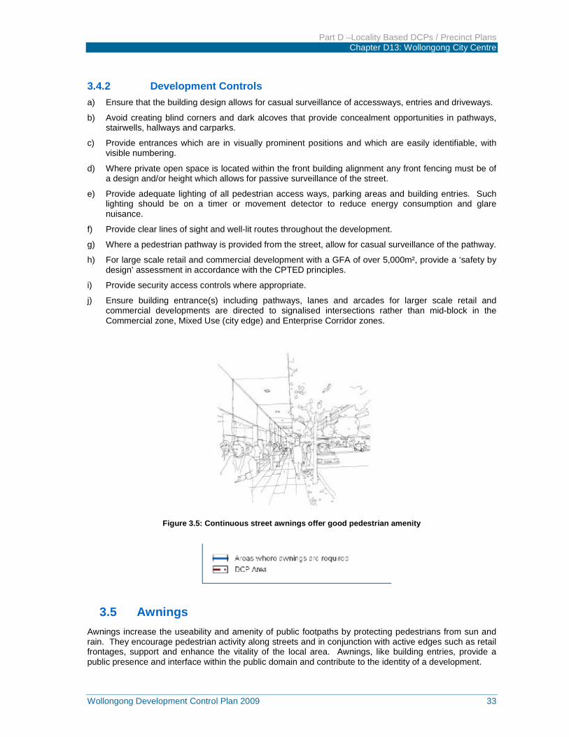
Figure 3.5: Continuous street awnings offer good pedestrian amenity
3.5 Awnings Awnings increase the useability and amenity of public footpaths by protecting pedestrians from sun and rain. They encourage pedestrian activity along streets and in conjunction with active edges such as retail frontages, support and enhance the vitality of the local area. Awnings, like building entries, provide a public presence and interface within the public domain and contribute to the identity of a development.
Part D –Locality Based DCPs / Precinct Plans Chapter D13: Wollongong City Centre
34 Wollongong Development Control Plan 2009
3.5.1 Objectives a) To provide shelter for public streets where most pedestrian activity occurs.
b) To address the streetscape by providing a consistent street frontage in the city centre.
3.5.2 Development Controls a) Continuous street frontage awnings are to be provided for all new developments as indicated in
Figure 3.6.
b) Awning design must match building facades and be complementary to those of adjoining buildings.
c) Wrap awnings around corners for a minimum six metres from where a building is sited on a street corner.
d) Awnings dimensions should generally be:
i) Minimum soffit height of 3.3 metres,
ii) Low profile, with slim vertical facias or eaves (generally not to exceed 300mm height),
iii) Setback a minimum of 1.2 metres from the kerb, and
iv) Generally minimum 2.4 metres deep.
e) To control sun access/protection, canvas blinds along the street edge may be permitted, subject to design merit and assessment.
f) Signage on blinds is not permitted.
g) Provide under awning lighting to facilitate night use and to improve public safety.

Part D –Locality Based DCPs / Precinct Plans Chapter D13: Wollongong City Centre
Wollongong Development Control Plan 2009 35
Figure 3.6: Awnings
3.6 Vehicular footpath crossings Vehicle crossings over footpaths disrupt pedestrian movement and threaten safety. The design of vehicle access to buildings also influences the quality of the public domain. Overly wide and high vehicle access points detract from the streetscape and the active use of street frontages.
The design and location of vehicle access to developments should minimise both conflicts between pedestrians and vehicles on footpaths, particularly along pedestrian priority places, and visual intrusion and disruption of streetscape continuity.
Design of driveways and vehicle access is to be in accordance with the provision of section 4.2.
3.6.1 Objectives a) To make vehicle access to buildings more compatible with pedestrian movements and the public
domain.
b) To ensure vehicle entry points are integrated into building design and contribute to high quality architecture.
Part D –Locality Based DCPs / Precinct Plans Chapter D13: Wollongong City Centre
36 Wollongong Development Control Plan 2009
3.6.2 Development Controls
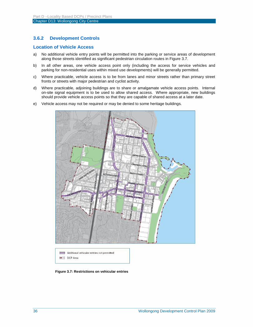
Location of Vehicle Access a) No additional vehicle entry points will be permitted into the parking or service areas of development
along those streets identified as significant pedestrian circulation routes in Figure 3.7.
b) In all other areas, one vehicle access point only (including the access for service vehicles and parking for non-residential uses within mixed use developments) will be generally permitted.
c) Where practicable, vehicle access is to be from lanes and minor streets rather than primary street fronts or streets with major pedestrian and cyclist activity.
d) Where practicable, adjoining buildings are to share or amalgamate vehicle access points. Internal on-site signal equipment is to be used to allow shared access. Where appropriate, new buildings should provide vehicle access points so that they are capable of shared access at a later date.
e) Vehicle access may not be required or may be denied to some heritage buildings.
Figure 3.7: Restrictions on vehicular entries
Part D –Locality Based DCPs / Precinct Plans Chapter D13: Wollongong City Centre
Wollongong Development Control Plan 2009 37
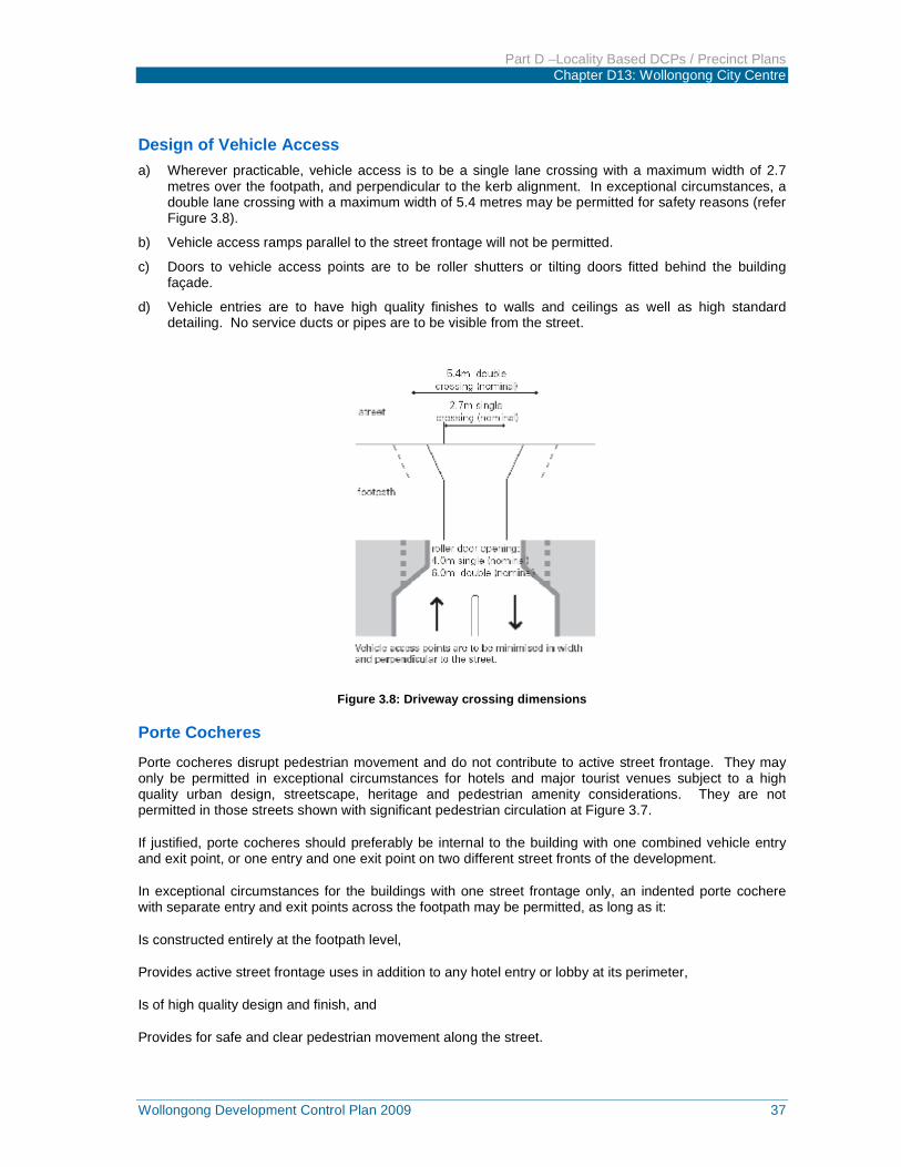
Design of Vehicle Access a) Wherever practicable, vehicle access is to be a single lane crossing with a maximum width of 2.7
metres over the footpath, and perpendicular to the kerb alignment. In exceptional circumstances, a double lane crossing with a maximum width of 5.4 metres may be permitted for safety reasons (refer Figure 3.8).
b) Vehicle access ramps parallel to the street frontage will not be permitted.
c) Doors to vehicle access points are to be roller shutters or tilting doors fitted behind the building façade.
d) Vehicle entries are to have high quality finishes to walls and ceilings as well as high standard detailing. No service ducts or pipes are to be visible from the street.
Figure 3.8: Driveway crossing dimensions
Porte Cocheres
Porte cocheres disrupt pedestrian movement and do not contribute to active street frontage. They may only be permitted in exceptional circumstances for hotels and major tourist venues subject to a high quality urban design, streetscape, heritage and pedestrian amenity considerations. They are not permitted in those streets shown with significant pedestrian circulation at Figure 3.7.
If justified, porte cocheres should preferably be internal to the building with one combined vehicle entry and exit point, or one entry and one exit point on two different street fronts of the development.
In exceptional circumstances for the buildings with one street frontage only, an indented porte cochere with separate entry and exit points across the footpath may be permitted, as long as it:
Is constructed entirely at the footpath level,
Provides active street frontage uses in addition to any hotel entry or lobby at its perimeter,
Is of high quality design and finish, and
Provides for safe and clear pedestrian movement along the street.
Part D –Locality Based DCPs / Precinct Plans Chapter D13: Wollongong City Centre
38 Wollongong Development Control Plan 2009
3.7 Pedestrian overpasses, underpasses and encroachments Streets represent important components of the public domain and provide the best potential amenity and safety when activated by pedestrians. Streets offer sky exposure, sunlight and air, a sense of orientation and direct access to the main frontages of buildings. A successful city street provides a comfortable interface between pedestrians and exposure for business. Generally, pedestrians should be encouraged to use the street level to enhance and contribute to street life, to promote activity and interest, and to maximise safety and security of the public domain. Wollongong’s climate does not warrant pedestrian isolation from the street, and any conflicts between pedestrians and vehicles are to be resolved at the street level.
Pedestrian overpasses are discouraged as they have a negative impact on the streetscape quality and on views and vistas along streets. New pedestrian underpasses will only be considered where they would directly connect to major transport nodes such as railway stations and substantially improve pedestrian safety and access.
3.7.1 Objectives a) To promote pedestrian activation of streets and public places.
b) To promote ‘safer by design’ and crime prevention principles.
c) To encourage pedestrian circulation at street level.
d) To protect views and vistas along streets.
3.7.2 Development Controls a) New overpasses over streets will generally not be approved. In exceptional circumstances, new
overpasses over service lanes may be considered by the consent authority subject to assessment of impacts on safety and crime prevention, streetscape amenity and activation of the public domain. In such circumstances, overpasses are to be fully glazed, not greater than 6 metres wide or more than one level high. Refer to AS 5100.1 – 2004.
b) Longitudinal development under the road reserve is not permitted. The siting of basement carparks beneath the road reserve is not permitted for private developments. Stratum road closures for this purpose will not be permitted.
c) Underpasses may be considered by the consent authority for direct connection under adjacent streets to railway stations:
i) Where they would substantially improve pedestrian safety and accessibility, and
ii) Incorporate active uses, particularly at entry and exit points.
d) Access to underpasses should be provided directly from a public footpath at the street alignment (rather than reducing the space of the footpath). This will ensure public access at all times and enhance the use and activities of the public domain.
e) All underpasses are to have a minimum width of 4.5 metres clear of all fixed obstructions, a minimum ceiling height of 4 metres and a minimum depth of 3 metres.
3.8 Building exteriors Wollongong’s cityscape and public domain is defined by its buildings, streets and public places. The maintenance and improvement of the public domain is dependent on a consistent approach to the design of new development including the articulation and finish of building exteriors.
3.8.1 Objectives
To ensure that new buildings in Wollongong:
a) Contribute positively to the streetscape and public domain by means of high quality architecture and robust selection of materials and finishes.
Part D –Locality Based DCPs / Precinct Plans Chapter D13: Wollongong City Centre
Wollongong Development Control Plan 2009 39
b) Provide richness of detail and architectural interest especially at visually prominent parts of buildings such as lower levels and roof tops.
c) Present appropriate design responses to nearby development that complement the streetscape.
d) Clearly define the adjoining streets, street corners and public spaces and avoid ambiguous external spaces with poor pedestrian amenity and security.
e) Maintain a pedestrian scale in the articulation and detailing of the lower levels of the building.
f) Contribute to a visually interesting skyline.
3.8.2 Development Controls a) Adjoining buildings (particularly heritage buildings) are to be considered in the design of new
buildings in terms of: i) Appropriate alignment and street frontage heights.
ii) Setbacks above street frontage heights.
iii) Appropriate materials and finishes selection.
iv) Façade proportions including horizontal or vertical emphasis.
v) The provision of enclosed corners at street intersections.
b) Balconies and terraces should be provided, particularly where buildings overlook parks and on low rise parts of buildings. Gardens on the top of setback areas of buildings are encouraged.
c) Articulate facades so that they address the street and add visual interest.
d) External walls should be constructed of high quality and durable materials and finishes with ‘self-cleaning’ attributes, such as face brickwork, rendered brickwork, stone, concrete and glass.
e) Finishes with high maintenance costs, those susceptible to degradation or corrosion from a coastal or industrial environment or finishes that result in unacceptable amenity impacts, such as reflective glass, are to be avoided.
f) To assist articulation and visual interest, avoid expanses of any single material.
g) Limit opaque or blank walls for ground floor uses to 30% of the street frontage.
h) Maximise glazing for retail uses, but break glazing into sections to avoid large expanses of glass.
i) Highly reflective finishes and curtain wall glazing are not permitted above ground floor level (see Section 5.3).
j) A materials sample board and schedule is required to be submitted with applications for development over $1 million or for that part of any development built to the street edge.
k) Minor projections up to 450mm from building walls in accordance with those permitted by the Building Code of Australia may extend into the public space providing it does not fall within the definition of gross floor area and there is a public benefit, such as:
i) Expressed cornice lines that assist in enhancing the streetscape,
ii) Projections such as entry canopies that add visual interest and amenity, and
iii) Provided that the projections do not detract from significant views and vistas (see Figure 3.12).
l) The design of roof plant rooms and lift overruns is to be integrated into the overall architecture of the building.
Part D –Locality Based DCPs / Precinct Plans Chapter D13: Wollongong City Centre
40 Wollongong Development Control Plan 2009
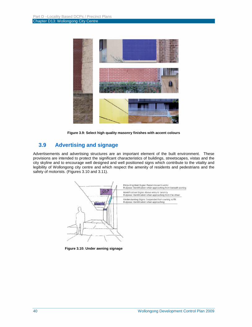
Figure 3.9: Select high quality masonry finishes with accent colours
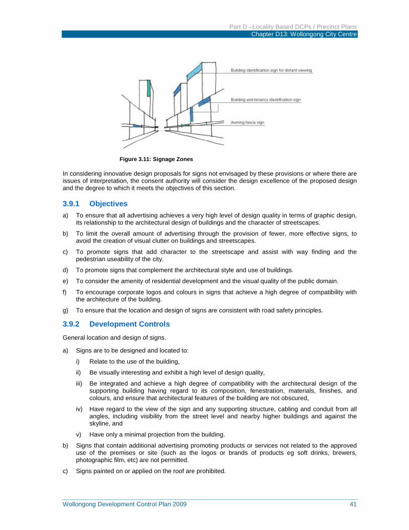
3.9 Advertising and signage Advertisements and advertising structures are an important element of the built environment. These provisions are intended to protect the significant characteristics of buildings, streetscapes, vistas and the city skyline and to encourage well designed and well positioned signs which contribute to the vitality and legibility of Wollongong city centre and which respect the amenity of residents and pedestrians and the safety of motorists. (Figures 3.10 and 3.11).
Figure 3.10: Under awning signage
Part D –Locality Based DCPs / Precinct Plans Chapter D13: Wollongong City Centre
Wollongong Development Control Plan 2009 41
Figure 3.11: Signage Zones
In considering innovative design proposals for signs not envisaged by these provisions or where there are issues of interpretation, the consent authority will consider the design excellence of the proposed design and the degree to which it meets the objectives of this section.
3.9.1 Objectives a) To ensure that all advertising achieves a very high level of design quality in terms of graphic design,
its relationship to the architectural design of buildings and the character of streetscapes.
b) To limit the overall amount of advertising through the provision of fewer, more effective signs, to avoid the creation of visual clutter on buildings and streetscapes.
c) To promote signs that add character to the streetscape and assist with way finding and the pedestrian useability of the city.
d) To promote signs that complement the architectural style and use of buildings.
e) To consider the amenity of residential development and the visual quality of the public domain.
f) To encourage corporate logos and colours in signs that achieve a high degree of compatibility with the architecture of the building.
g) To ensure that the location and design of signs are consistent with road safety principles.
3.9.2 Development Controls
General location and design of signs.
a) Signs are to be designed and located to:
i) Relate to the use of the building,
ii) Be visually interesting and exhibit a high level of design quality,
iii) Be integrated and achieve a high degree of compatibility with the architectural design of the supporting building having regard to its composition, fenestration, materials, finishes, and colours, and ensure that architectural features of the building are not obscured,
iv) Have regard to the view of the sign and any supporting structure, cabling and conduit from all angles, including visibility from the street level and nearby higher buildings and against the skyline, and
v) Have only a minimal projection from the building.
b) Signs that contain additional advertising promoting products or services not related to the approved use of the premises or site (such as the logos or brands of products eg soft drinks, brewers, photographic film, etc) are not permitted.
c) Signs painted on or applied on the roof are prohibited.
Part D –Locality Based DCPs / Precinct Plans Chapter D13: Wollongong City Centre
42 Wollongong Development Control Plan 2009
d) Corporate colours, logos and other graphics are encouraged to achieve a very high degree of compatibility with the architecture, materials, finishes and colours of the building and the streetscape.
e) In considering applications for new signs the consent authority must have regard to the number of existing signs on the site and in its vicinity and whether that signage is consistent with the provisions of this section and whether the cumulative impact gives rise to visual clutter.
f) A signage strategy shall be submitted with a development application for a building where the signage details are not known for future uses within the building. The strategy shall include elevations that indicate signage zones on the building into which future signs will be located and details of other controls relating to theme, illumination and size, where appropriate.
3.9.3 Illuminated signs a) Illuminated signs are not to detract from the architecture of the supporting building during daylight.
b) Illumination (including cabling) of signs is to be:
i) Concealed, or
ii) Integral with the sign, or
iii) Provided by means of carefully designed and located remote or spot lighting.
c) The ability to adjust the light intensity of illuminated signs is to be installed where the consent authority considers necessary.
d) A curfew may be imposed on the operation of illuminated signs where continuous illumination may impact adversely on the amenity of residential buildings, serviced apartments or other visitor accommodation, or have other adverse environmental effects.
e) Up-lighting of signs is prohibited. Any external lighting of signs is to be downward pointing and focused directly on the sign and is to prevent or minimise the escape of light beyond the sign.
3.9.4 Signs and Road Safety a) Signs are regarded as prejudicial to the safety of the travelling public if they:
i) Obscure or interfere with road traffic signs and signals or with the view of a road hazard, oncoming vehicles, or any other vehicle or person, or an obstruction which should be visible to drivers or other road users,
ii) Give instructions to traffic by use of the word ‘stop’ or other directions, which could be confused with traffic signs,
iii) Are of such a design or arrangement that any variable messages or intensity or lighting impair drivers’ vision or distract drivers’ attention, and
iv) Are situated at locations where the demand on drivers’ concentration due to road conditions are high such as at major intersection or merging and diverging lanes.
3.10 Views and view corridors Views contribute to the character and amenity of a city, enhancing the sense of place and identity. The physical setting of the Wollongong city centre between the coast and escarpment provides for special views of this natural setting and associated elements.
It is important that views to the ocean and the escarpment be maintained from as many points as possible at street level. In the redevelopment of some sites consideration should be given to opening up new significant views. Views are regarded as significant when they terminate at places of architectural, landscape, or cultural significance. This may include views of the foreshore, major parks or publicly significant objects or heritage buildings.
A silhouette is the outline of a building against the sky. The silhouettes of many buildings are significant and contribute to the identity of the commercial core of the city and its skyline. The massing and
Part D –Locality Based DCPs / Precinct Plans Chapter D13: Wollongong City Centre
Wollongong Development Control Plan 2009 43
arrangement of the skyline and existing building silhouettes should be carefully considered and proposed development should be carefully designed so that its appearance complements the city skyline.
3.10.1 Objectives a) To maintain and enhance views from the city centre to the foreshore, escarpment and significant
objects (such as the lighthouse) wherever possible.
b) To enhance views along city streets.
c) To protect silhouettes of the tops of major buildings or structures as seen against the sky or backdrop of the escarpment or foreshore.
3.10.2 Development Controls a) Existing views shown in Figure 3.12 are to be protected to the extent that is practical in the planning
and design of development.
b) The redevelopment of sites with potential to open a blocked view shown in Figure 3.12 must take into account the restoration of that view.
c) Align buildings to maximise view corridors between buildings.
d) Remove or avoid installation of built elements that obstruct significant views.
e) Carefully consider tree selection to provide views along streets in Figure 3.12 and keep under storey planting low where possible.
f) Site analysis must address views with the planning and design of building forms taking into account existing topography, vegetation and surrounding development.
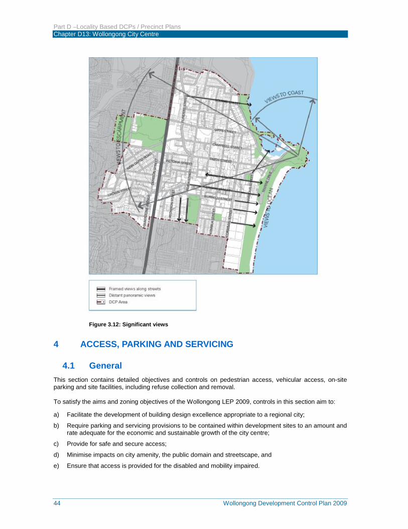
Part D –Locality Based DCPs / Precinct Plans Chapter D13: Wollongong City Centre
44 Wollongong Development Control Plan 2009
Figure 3.12: Significant views
4 ACCESS, PARKING AND SERVICING
4.1 General This section contains detailed objectives and controls on pedestrian access, vehicular access, on-site parking and site facilities, including refuse collection and removal.
To satisfy the aims and zoning objectives of the Wollongong LEP 2009, controls in this section aim to:
a) Facilitate the development of building design excellence appropriate to a regional city;
b) Require parking and servicing provisions to be contained within development sites to an amount and rate adequate for the economic and sustainable growth of the city centre;
c) Provide for safe and secure access;
d) Minimise impacts on city amenity, the public domain and streetscape, and
e) Ensure that access is provided for the disabled and mobility impaired.
Part D –Locality Based DCPs / Precinct Plans Chapter D13: Wollongong City Centre
Wollongong Development Control Plan 2009 45
4.2 Pedestrian access and mobility Any new development must be designed to ensure that safe and equitable access is provided to all, including people with a disability.
4.2.1 Objectives a) To provide safe and easy access to buildings to enable better use and enjoyment by people
regardless of age and physical condition, whilst also contributing to the vitality and vibrancy of the public domain.
b) To ensure buildings and places are accessible to people with a disability.
4.2.2 Development Controls a) Main building entry points should be clearly visible from primary street frontages and enhanced as
appropriate with awnings, building signage or high quality architectural features that improve clarity of building address and contribute to visitor and occupant amenity.
b) The design of facilities (including car parking requirements) for disabled persons must comply with the relevant Australian Standard (AS 1428 Pt 1 and 2, AS 2890 Pt 1, or as amended) and the Disability Discrimination Act 1992 (as amended).
c) The development must provide at least one main pedestrian entrance with convenient barrier free access in all developments to at least the ground floor.
d) The development must provide continuous access paths of travel from all public roads and spaces as well as unimpeded internal access.
e) Pedestrian access ways, entry paths and lobbies must use durable materials commensurate with the standard of the adjoining public domain (street) with appropriate slip resistant materials, tactile surfaces and contrasting colours in accordance with Council’s Public Domain Technical Manual.
f) Building entrance levels and footpaths must comply with the longitudinal and cross grades specified in AS 1428.1:2001, AS/NZS 2890.1:2004 and the Disability Discrimination Act.
4.3 Vehicular driveways and manoeuvring areas 4.3.1 Objectives a) To minimise the impact of vehicle access points and driveway crossovers on streetscape amenity,
pedestrian safety and the quality of the public domain by:
i) Designing vehicle access to required safety and traffic management standards;
ii) Integrating vehicle access with site planning, streetscape requirements, traffic patterns; and
iii) Minimising potential conflict with pedestrians.
4.3.2 Development Controls a) Driveways should be:
i) Provided from lanes and secondary streets rather than the primary street, wherever practical.
ii) Located taking into account any services within the road reserve, such as power poles, drainage pits and existing street trees.
iii) Located a minimum of 6 metres from the perpendicular of any intersection of any two roads.
iv) If adjacent to a residential development setback a minimum of 1.5m from the relevant side property boundary.
b) Vehicle access is to be designed to:
i) Minimise the impact on the street, site layout and the building façade design; and
ii) If located off a primary street frontage, integrated into the building design.
Part D –Locality Based DCPs / Precinct Plans Chapter D13: Wollongong City Centre
46 Wollongong Development Control Plan 2009
c) All vehicles must be able to enter and leave the site in a forward direction without the need to make more than a three point turn.
d) Design of driveway crossings must be in accordance with Council’s standard Vehicle Entrance Designs, with any works within the footpath and road reserve subject to a s138 Roads Act approval.
e) Driveway widths must comply with the relevant Australian Standards.
f) Car space dimensions must comply with the relevant Australian Standards.
g) Driveway grades, vehicular ramp width/grades and passing bays must be in accordance with the relevant Australian Standard, (AS 2990.1).
h) Vehicular ramps less than 20m long within developments and parking stations must have a maximum grade of 1 in 5 (20%). Ramp widths and design must be in accordance with AS 2890.1.
i) Access ways to underground parking should not be located adjacent to doors or windows of the habitable rooms of any residential development.
j) For residential development in the General Residential zone, use semi-pervious materials for all uncovered parts of driveways/spaces to provide for some stormwater infiltration.
4.4 On-site parking On-site parking includes underground (basement), surface (at-grade) and above ground parking, including parking stations.
Parking rates for commercial and retail development are specified within Part E of this DCP.
4.4.1 Objectives a) Facilitate an appropriate level of on-site parking provision in the city to cater for a mix of development
types.
b) Minimise the visual impact of on-site parking.
c) Provide adequate space for parking and manoeuvring of vehicles (including service vehicles and bicycles).
d) To promote Wollongong city centre as a more lively and vibrant place by providing parking incentives for certain developments in the city centre.
e) To encourage economic growth in the city centre.
f) To recognise the complementary use and benefit of public transport and non-motorised modes of transport such as bicycles and walking.
4.4.2 Development Controls
General (all development) a) On-site parking must meet the relevant Australian Standard (AS2890.1 2004 – Parking facilities, or
as amended).
b) Council may require the provision of a supporting geotechnical report prepared by an appropriately qualified professional as information to accompany a development application to Council.
c) Car parking and associated internal manoeuvring areas which are surplus to Council’s specified parking requirements will count towards the gross floor area, but not for the purpose of determining the necessary parking.
d) Any car parking provided in a building above ground level is to have a minimum floor to ceiling height of 2.8m so it can be adapted to another use in the future.
e) On-site vehicle, motorcycle and bicycle parking is to be provided in accordance with Part E of this DCP.
Part D –Locality Based DCPs / Precinct Plans Chapter D13: Wollongong City Centre
Wollongong Development Control Plan 2009 47
f) To accommodate people with disabilities, provide a minimum of 1% of the required parking spaces, or minimum of 1 space per development, (whichever is the greater) as an appropriately designated and signed disabled parking space.
Residential flat buildings a) On-site parking is to be accommodated underground, or otherwise integrated into the design of the
building.
Commercial developments within the commercial core and city edge zones a) On-site parking is to be accommodated underground, or otherwise integrated into the design of the
building.
Commercial developments and mixed use developments in all other zones a) The impact of any on-grade car parking must be minimised by:
i) Locating parking on the side or rear of the lot away from the street frontage;
ii) Provision of fencing or landscape to screen the view of cars from adjacent streets and buildings;
iii) Allowing for safe and direct access to building entry points; or
iv) Incorporating car parking into landscape design of the site (such as plantings between parking bays to improve views, selection of paving material and screening from communal and open space areas).
b) Natural ventilation should be provided to underground parking areas where possible, with ventilation grilles and structures;
i) integrated into the overall façade and landscape design of the development,
ii) not located on the primary street façade, and
iii) oriented away from windows of habitable rooms and private opens space areas.
4.5 Site facilities and services 4.5.1 Objectives a) To ensure that site facilities (such as clothes drying areas, mail boxes, recycling and garbage
disposal units/areas, screens, lighting, storage areas, air conditioning units and communication structures) are effectively integrated into the development and are unobtrusive.
b) To ensure that site services and facilities are adequate for the nature and quantum of development.
c) To establish appropriate access and location requirements for servicing.
d) To ensure service requirements do not have adverse amenity impacts.
4.5.2 Development Controls
Mail boxes a) Provide letterboxes for residential building and/or commercial tenancies in one accessible location
adjacent to the main entrance to the development.
b) They should be integrated into a wall where possible and be constructed of materials consistent with the appearance of the building.
c) Letterboxes shall be secure and large enough to accommodate articles such as newspapers.
Communication structures, air conditioners and service vents a) Locate satellite dish and telecommunication antennae, air conditioning units, ventilation stacks and
any ancillary structures:
Part D –Locality Based DCPs / Precinct Plans Chapter D13: Wollongong City Centre
48 Wollongong Development Control Plan 2009
i) Away from the street frontage,
ii) Integrated into the roof scape design and in a position where such facilities will not become a skyline feature at the top of any building, and
iii) Adequately setback from the perimeter wall or roof edge of buildings.
b) A master antennae must be provided for residential apartment buildings. This antenna shall be sited to minimise its visibility from surrounding public areas.
Waste (garbage) storage and collection General (all development) a) All development is to adequately accommodate waste handing and storage on-site. The size,
location and handling procedures for all waste, including recyclables, is to be determined in accordance with Council waste policies and advice from relevant waste handling contractors.
b) Access for waste collection and storage is preferred from rear lanes, side streets or rights of ways.
c) Waste storage areas are to be designed to:
i) Ensure adequate driveway access and manoeuvrability for any required service vehicles,
ii) Located so as not to create any adverse noise impacts on the existing developments or sensitive noise receptors such as habitable rooms of residential developments, and
iii) Screened from the public way and adjacent development that may overlook the area.
d) The storage facility must be well lit, easily accessible on grade for movement of bins, free of obstructions that may restrict movement and servicing of bins or containers and designed to minimise noise impacts.
Location requirements for Waste Storage Areas and Access a) Where waste volumes require a common collection, storage and handling area, this is to be located:
i) For residential flat buildings, enclosed within a basement or enclosed carpark,
ii) For multi-housing, at ground behind the main building setback and façade, or within a basement or enclosed carpark,
iii) For commercial, retail and other development, on-site in basements or at ground within discrete service areas not visible from main street frontages.
b) Where above ground garbage collection is prohibitive or impractical due to limited street frontage, or would create an unsafe environment, an on-site basement storage area must be provided.
c) Where a mobile compaction vehicle is required to enter the site, the access and circulation area shall be designed to accommodate a vehicle with the following dimensions:
Position Dimension
Vehicle length 12300mm
Vehicle width 3500mm
Vehicle height – travel
(Safe height in confined areas – top door closed and forks down)
3800mm
Vehicle height – operation
(Top door open with a bin at full tipping position) 6000mm
Part D –Locality Based DCPs / Precinct Plans Chapter D13: Wollongong City Centre
Wollongong Development Control Plan 2009 49
Service docks and loading/unloading areas a) Provide adequate space within any new development for the loading and unloading of
service/delivery vehicles.
b) Preferably locate service access off rear lanes, side streets or rights of way.
c) Screen all service doors and loading docks from street frontages and from active overlooking from existing developments.
d) Design circulation and access in accordance with AS2890.1.
Fire service and emergency vehicles a) For developments where a fire brigade vehicle is required to enter the site, vehicular access, egress
and manoeuvring must be provided to, from and on the site in accordance with the NSW Fire Brigades Code of Practice – Building Construction – NSWFB Vehicle Requirements.
b) Generally, provision must be made for NSW Fire Brigade vehicles to enter and leave the site in a forward direction where:
i) NSW Fire Brigade cannot park their vehicles within the road reserve due to the distance of hydrants from the building or restricted vehicular access to hydrants; or
ii) The site has an access driveway longer than 15m.
Utility Services
The provision of utility services and access for regular servicing and maintenance must be considered at the concept stage of site development.
a) Development must ensure that adequate provision has been made for all essential services including water, sewerage, electricity and telecommunications and stormwater drainage to the satisfaction of all relevant authorities.
b) The applicant must liaise with the relevant power authority with regard to the need for a conduit to be installed within the foot way area for the future provision of an underground power supply and extension of the conduit up to the wall of the existing or proposed building.
c) The development must ensure that ready connection of the building(s) can be made in future when underground power is installed and the overhead connection is replaced with a connection to the underground line.
d) The applicant must liaise with the power authority with regard to the retention, relocation, or removal of any existing power pole.
5 ENVIRONMENTAL MANAGEMENT
5.1 General This section deals with energy efficiency requirements of buildings, water use and conservation, wind and solar impacts and waste management.
5.1.1 Strategy To satisfy the aims and zoning objectives of the Wollongong City Centre LEP 2007, controls in this section aim to;
(a) Facilitate the development of building design excellence appropriate to a regional city,
(b) Ensure environmental impacts of new development are managed in a sustainable and economical way,
Part D –Locality Based DCPs / Precinct Plans Chapter D13: Wollongong City Centre
50 Wollongong Development Control Plan 2009
(c) Ensure a healthy environment,
(d) Provide an adequate and renewable supply of resources, and
(e) Ensure application, where appropriate, of the BASIX or National Built Environment Rating System (NABERS).
5.2 Energy efficiency and conservation The ability of development to optimise thermal performance, thermal comfort and day lighting will contribute to the energy efficiency of the buildings, provide increased amenity to occupants and reduce greenhouse emissions and, with them, the cost of supplying energy.
5.2.1 Objectives a) To reduce the necessity for mechanical heating and cooling.
b) To minimise greenhouse gas emissions.
c) To use natural climatic advantages of the coastal location such as cooling summer breezes, and exposure to unobstructed winter sun.
5.2.2 Development Controls
Residential New dwellings, including multi-unit development within a mixed use building and serviced apartments intended or capable of being strata titled, are to demonstrate compliance with State Environmental Planning Policy – Building Sustainability Index (BASIX). Council encourages all applicants to go beyond minimum BASIX requirements incorporating passive solar design and energy efficiency measures for residential development.
Non-Residential For all non-residential development:
a) Improve the control of mechanical space heating and cooling by:
i) Designing heating/cooling systems to target only those spaces which require heating or cooling, not the whole building.
b) Improve the efficiency of hot water systems by:
i) Insulating hot water systems, and
ii) Installing water saving devices, such as flow regulators, 3.5 stars rated shower heads, dual flush toilets and tap aerators.
c) Reduce reliance on artificial lighting and designing lighting systems to target only those spaces which require lighting at any particular ‘off peak’ time, not the whole building.
An energy efficiency report from a suitably qualified consultant is to accompany any development application for non-residential development with a construction cost of $1million or greater. This report must demonstrate commitment to achieving a minimum of 4 stars Green Star rating (design and as built tool) or 4 stars NABERS rating (energy tool) for the development.
5.3 Water conservation Building design can contribute to environmental sustainability by integrating measures for improved water quality and efficiency of use. Water can be conserved in two ways; by reducing water demand from the mains and re-using water, which would otherwise be lost, as run off or waste water. By integrating water
Part D –Locality Based DCPs / Precinct Plans Chapter D13: Wollongong City Centre
Wollongong Development Control Plan 2009 51
use efficiency; water collection and water reuse measures into building associated infrastructure design development can contribute to environmentally sustainable outcomes.
5.3.1 Objectives a) To reduce per-capita mains consumption of potable water.
b) To harvest rainwater and urban stormwater runoff for use.
c) To reduce wastewater discharge.
d) To capture, treat and reuse wastewater where appropriate.
e) To safeguard the environment by improving the quality of water run-off.
f) To ensure infrastructure design is complementary to current and future water use.
5.3.2 Development Controls
Residential New dwellings, including a residential component within a mixed use building and serviced apartments intended or capable of being strata titled, are to demonstrate compliance with State Environmental Planning Policy – Building Sustainability Index (BASIX). Council encourages all residential development to go beyond the minimum BASIX requirements and enhance the water efficiency for their development.
Non-residential a) The following water saving measures are to be incorporated into non-residential building. Water
fixtures (shower heads, taps, toilets, urinals etc) are to be 3.5 stars or better rated.
i) Appliances (dishwashers, clothes washers etc) are to be 3.5 stars or better rated with respect to water use efficiency. Demonstrate, if necessary, how these requirements will be achieved for replacement appliances, appliances not installed at construction or bought in by occupants following construction,
ii) Stormwater runoff control, capture and reuse, including water quality management in accordance with Council’s guidelines,
iii) Select water efficient plants and/or, indigenous vegetation for landscape in accordance with Council’s recommendations,
iv) Use non-potable water for watering gardens and landscape features, and
v) Operating details for swimming pools and water features including filling, draining and maintenance activities. Covers are to be included in the design and operational aspects of swimming pool installations.
b) Alternatives to the above water savings methods can be presented to Council and they will be assessed on merit.
5.4 Reflectivity Reflective materials used on the exterior of buildings can result in undesirable glare for pedestrians and potentially hazardous glare for motorists. Reflective materials can also impose additional heat load on other buildings. The excessive use of highly reflective glass should be discouraged. Buildings with a glazed roof, façade or awning should be designed to minimise hazardous or uncomfortable glare arising from reflected sunlight.
5.4.1 Objective a) To restrict the reflection of sunlight from buildings to surrounding areas and buildings.
Part D –Locality Based DCPs / Precinct Plans Chapter D13: Wollongong City Centre
52 Wollongong Development Control Plan 2009
5.4.2 Development Controls a) New buildings and facades should not result in glare that causes discomfort or threatens safety of
pedestrians or drivers.
b) Visible light reflectivity from building materials used on facades of new buildings should not exceed 20%.
c) Subject to the extent and nature of glazing and reflective materials used, a Reflectivity Report that analyses potential solar glare from the proposed development on pedestrians or motorists may be required.
5.5 Wind mitigation Windy conditions can cause discomfort and danger to pedestrians, and downdrafts from buildings can inhibit the growth of street trees. Conversely, moderate breezes that penetrate the streets can enhance pedestrian comfort and disperse vehicle emissions and air conditioning plant exhausts.
5.5.1 Objectives a) To ensure that new developments satisfy nominated wind standards and maintain comfortable
conditions for pedestrians.
b) To ensure that the moderate breezes are able to penetrate the streets of Wollongong city centre.
5.5.2 Development Controls a) To ensure public safety and comfort the following maximum wind criteria are to be met by new
buildings:
i) 10 metres/second in retail streets,
ii) 13 metres/second along major pedestrian streets, parks and public places, and
iii) 16 metres/second in all other streets.
b) Site design for tall buildings (towers) should:
i) Set tower buildings back from lower structures built at the street frontage to protect pedestrians from strong wind downdrafts at the base of the tower,
ii) Ensure that tower buildings are well spaced from each other to allow breezes to penetrate city centre,
iii) Consider the shape, location and height of buildings to satisfy wind criteria for public safety and comfort at ground level, and
iv) Ensure usability of open terraces and balconies.
c) A Wind Effects Report is to be submitted with the DA for all buildings greater than 32m in height,
d) For buildings over 50m in height, results of a wind tunnel test are to be included in the report.
5.6 Waste and recycling The minimisation of waste from development can reduce impacts on the public domain, contribute to the amenity of the building and limit the potential harmful impacts to the environment. Waste management refers to all stages of development from construction and use through to demolition. It also includes the way in which waste is stored and collected.
5.6.1 Objectives a) To minimise waste generation and disposal to landfill with careful source separation, reuse and
recycling.
b) To avoid the generation of waste through design, material selection and building practices.
Part D –Locality Based DCPs / Precinct Plans Chapter D13: Wollongong City Centre
Wollongong Development Control Plan 2009 53
c) To plan for the types, amount and disposal of waste to be generated during demolition, excavation and construction of the development.
d) To ensure efficient storage and collection of waste and quality design of facilities.
5.6.2 Development Controls a) All development must comply with Council’s Technical Policy for the Management of all Wastes
Associated with Building Sites.
Non-residential development a) Development applications for all non-residential development must be accompanied by a waste
management plan that addresses:
i) Best practice recycling and reuse of construction and demolition materials,
ii) Use of sustainable building materials that can be reused or recycled at the end of their life,
iii) Handling methods and location of waste storage areas in accordance with the provisions of Section 4.4.3 of this DCP, such that handling and storage has no negative impact on the streetscape, building presentation or amenity of occupants and pedestrians, and
iv) Procedures for the on-going sustainable management of green and putrescible waste, garbage, glass, containers and paper, including estimated volumes, required bin capacity and on-site storage requirements.
The waste management plan is to be prepared by a specialist waste consultant and is subject to approval by Council.
Residential development
Provision must be made for the following waste generation:
a) In developments not exceeding six dwellings, individual waste storage facilities may be permitted.
b) In development of more than six units or dwellings, or where the topography or distance to the street collection point makes access difficult for individual occupants, a collection and storage area is required. The storage area must be located in a position which is;
i) Not visible from the street,
ii) Easily accessible to dwelling occupants,
iii) Accessible by collection vehicles (or adequately managed by the body corporate to permit relocation of bins to the approved collection point),
iv) Has water and drainage facilities for cleaning and maintenance, and
v) Does not immediately adjoin private open space, windows or clothes drying areas.
c) Subject to Council collection policy, common garbage storage areas must be sized to either accommodate the number of individual bins required or to accommodate sufficient larger bins with the following minimum dimensions:
Bin size Dimensions
660 litres 1070 x 910 x 635mm
240 litres 1180 x 740 x 570mm
The size and number of the waste bins shall be determined having regard to the need for either on-site access by collection vehicles or the requirement for bins to be wheeled to the street for collection by a contractor. If transferred to the street for collection, the body corporate or a caretaker must be responsible for the movement of bins to their collection point.
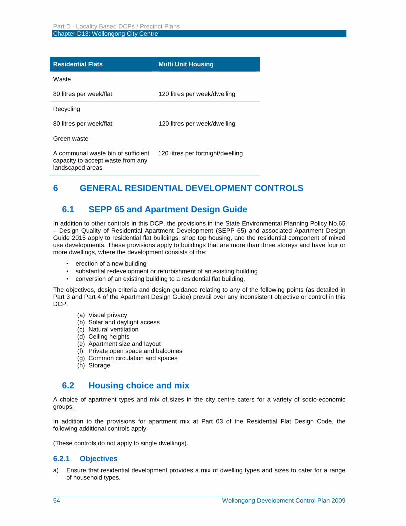
Part D –Locality Based DCPs / Precinct Plans Chapter D13: Wollongong City Centre
54 Wollongong Development Control Plan 2009
Residential Flats Multi Unit Housing
Waste
80 litres per week/flat
120 litres per week/dwelling
Recycling
80 litres per week/flat
120 litres per week/dwelling
Green waste
A communal waste bin of sufficient capacity to accept waste from any landscaped areas
120 litres per fortnight/dwelling
6 GENERAL RESIDENTIAL DEVELOPMENT CONTROLS
6.1 SEPP 65 and Apartment Design Guide In addition to other controls in this DCP, the provisions in the State Environmental Planning Policy No.65 – Design Quality of Residential Apartment Development (SEPP 65) and associated Apartment Design Guide 2015 apply to residential flat buildings, shop top housing, and the residential component of mixed use developments. These provisions apply to buildings that are more than three storeys and have four or more dwellings, where the development consists of the:
· erection of a new building · substantial redevelopment or refurbishment of an existing building · conversion of an existing building to a residential flat building.
The objectives, design criteria and design guidance relating to any of the following points (as detailed in Part 3 and Part 4 of the Apartment Design Guide) prevail over any inconsistent objective or control in this DCP.
(a) Visual privacy (b) Solar and daylight access (c) Natural ventilation (d) Ceiling heights (e) Apartment size and layout (f) Private open space and balconies (g) Common circulation and spaces (h) Storage
6.2 Housing choice and mix A choice of apartment types and mix of sizes in the city centre caters for a variety of socio-economic groups.
In addition to the provisions for apartment mix at Part 03 of the Residential Flat Design Code, the following additional controls apply.
(These controls do not apply to single dwellings).
6.2.1 Objectives a) Ensure that residential development provides a mix of dwelling types and sizes to cater for a range
of household types.
Part D –Locality Based DCPs / Precinct Plans Chapter D13: Wollongong City Centre
Wollongong Development Control Plan 2009 55
b) Ensure that dwelling layout is sufficiently flexible for residents’ changing needs over time.
c) Ensure a sufficient proportion of dwellings include accessible layouts and universally designed features to accommodate changing requirements of residents.
d) Ensure the provision of housing that will, in its adaptable features, meet the access and mobility needs of any occupant.
6.2.2 Development Controls a) Where residential units are proposed at ground level within the Mixed Use (City Edge) and Special
Activities zone, a report must be provided with the development application demonstrating how future commercial uses can be accommodated within the ground level design. The report must address:
i) Access requirements including access for persons with a disability (Compliance with Disability Discrimination Act 1992),
ii) Any upgrading works necessary for compliance with the Building Code of Australia, and
iii) Appropriate floor to ceiling heights.
b) To achieve a mix of living styles, sizes and layouts within each residential development, comply with the following mix and size:
i) Studio and one bedroom units must not be less than 10% of the total mix of units within each development,
ii) Three or more bedroom units must not be less than 10% of the total mix of units within each development, and
iii) For smaller developments (less than six dwellings) achieve a mix appropriate to locality.
c) For development built by (or on behalf of) the Department of Housing, an alternative mix of unit types may be approved, subject to housing needs being demonstrated by the Department.
d) For residential apartment buildings and multi-unit housing, 10% of all dwellings (or at least one dwelling) must be designed to be capable of adaptation for disabled or elderly residents. Dwellings must be designed in accordance with the Australian Adaptable Housing Standard (AS 4299-1995), which includes “pre-adaptation” design details to ensure visitability is achieved.
e) Where possible, adaptable dwellings shall be located on the ground floor, for ease of access. Dwellings located above the ground level of a building may only be provided as adaptable dwellings where lift access is available within the building. The lift access must provide access from the basement to allow access for people with disabilities.
f) The development application must be accompanied by certification from an accredited Access Consultant confirming that the adaptable dwellings are capable of being modified, when required by the occupant, to comply with the Australian Adaptable Housing Standard (AS 4299-1995).
g) Car parking and garages allocated to adaptable dwellings must comply with the requirements of the relevant Australian Standard for disabled parking spaces.
h) For all residential apartment / flat buildings, 10% of all dwellings (or at least 1 dwelling) must be designed to achieve the Silver Standards of the Livable Housing Design Guideline (Livable Housing Australia 2015). All proposed livable dwellings must be clearly identified on the submitted DA plans.
i) Ceiling heights of apartments must be selected to encourage the penetration of natural sunlight into all areas of the building. Provide the following minimum floor to ceiling heights, for residential zones, as required by the Residential Flat Design Code:
i) 2.7m minimum for all habitable rooms on all floors;
ii) 2.25m to 2.4m minimum for non-habitable rooms on all floors;
iii) for two storey apartments, 2.4m minimum for the second storey if 50% or more of the apartment has 2.7m minimum ceiling heights;
iv) for two storey units with a two storey void space, 2.4m minimum ceiling heights;
Part D –Locality Based DCPs / Precinct Plans Chapter D13: Wollongong City Centre
56 Wollongong Development Control Plan 2009
v) attic spaces, 1.5 minimum wall heights at edge of room with a 30 degree minimum ceiling slope.
6.3 Dwelling houses Where there is an inconsistency between the provisions of this part of the DCP and other parts of the DCP, this part of the DCP will prevail to the extent of the inconsistency.
6.4 Multi dwelling housing Where there is an inconsistency between the provisions of this part of the DCP and other parts of the DCP, this part of the DCP will prevail to the extent of the inconsistency.
6.5 Dual occupancy Where there is an inconsistency between the provisions of this part of the DCP and other parts of the DCP, this part of the DCP will prevail to the extent of the inconsistency.
6.6 Basement Car parks 6.6.1 Objective a) Integrate the siting, scale and design of basement parking into the site and building design.
6.6.2 Development Controls a) The scale and siting of the basement car park must not impact upon the ability of the development to
satisfy minimum landscaping and deep soil zone requirements.
b) The roof of any basement podium, measured to the top of any solid wall located on the podium, must not be greater than 1.2m above natural or finished ground level, when measured at any point on the outside walls of the building. On sloping sites, a change in level in the basement must be provided to achieve this maximum 1.2m height.
Generally variation to this 1.2m height will not be supported however Council recognises that there may be occasions where this standard cannot be achieved. Should such a circumstance arise, the additional portion of the basement podium above 1.2m height must be included in the total gross floor area calculation for the development.
c) In addition, the following must be satisfied: i) Landscaped terraces are provided in front of the basement podium to reduce the overall visual
impact;
ii) The height of the basement does not result in the building having a bulk and scale which dominates the streetscape; and
iii) The main pedestrian entry to the building is identifiable and readily accessible from the street frontage.
d) The following setbacks from front, side and rear boundaries apply to basement podiums:
i) Where the height of the basement podium (measured to the top of any solid wall located on the podium) is less than 1.2m above natural or finished ground level (whichever distance is greater), the basement podium may extend to the property boundary. A minimum 1.5m wide landscaped planter must be provided on the perimeter of any section of the basement podium which is located on a side or rear property boundary. Such planter must prevent direct access to the outer edge of the podium, to minimise direct overlooking of adjacent dwellings and open space areas.
ii) Any portion of the basement which exceeds 1.2m above natural or finished ground level (whichever distance is greater) must be setback from the property boundaries by a ratio 1:1
Part D –Locality Based DCPs / Precinct Plans Chapter D13: Wollongong City Centre
Wollongong Development Control Plan 2009 57
(height: setback). A minimum setback of 1.5m applies in this instance, with this area to be landscaped. For the purpose of determining the height of the basement, any solid walls located on the podium shall be included in the overall height calculation.
e) Where parking is provided in a basement, ventilation structures for the basement parking and air conditioning units must be orientated away from windows of habitable rooms and private open space areas. Ventilation grills must be integrated into the design of the façade of the building to minimise their visual impact.
f) The visual impact of all basement walls must be minimised through the use of various design techniques including well proportioned ground level articulation and relief, mixed finishes and materials, terracing and/or dense landscaping.
g) Basements must be protected from inundation from 100-year ARI flood levels (or greater).
6.7 Communal open space 6.7.1 Objectives a) Ensure that communal open spaces are of adequate size to be functional.
b) Provide communal open space which is accessible by all residents.
6.7.2 Development Controls a) Developments with more than 10 dwellings must incorporate communal open space. The minimum
size of this open space is to be calculated at 5m2 per dwelling. Any area to be included in the communal open space calculations must have a minimum dimension of 5m.
b) The communal open space must be easily accessible and within a reasonable distance from apartments, be integrated with site landscaping, allow for casual social interaction and be capable of accommodating recreational activities.
c) Where a minimum of 15% of the site is provided as a deep soil zone, combined use of part of the deep soil zone as communal open space may occur. The combined communal open space/deep soil area may be grassed but must not contain significant shade trees. A maximum of 1/3 of the required communal open space area may be combined with the deep soil zone.
d) Areas of the communal open space which are to be paved or which will contain shade structures, swimming pools or the like cannot be located within the deep soil zone.
e) The communal open space area must receive at least 3 hours of direct sunlight between 9.00am and 3.00pm on June 21.
6.8 Private open space 6.8.1 Objectives a) Ensure that private open spaces are of sufficient size to accommodate a range of uses and are
accessible and connected to indoor spaces where appropriate.
b) Ensure functionality of private open space by reducing overlooking and overshadowing of such spaces.
c) Reduce the dominance of balconies in determining building form.
6.8.2 Development Controls a) Private open space must be provided for each dwelling within a residential apartment building in the
form of a balcony, courtyard, terrace and/or roof garden.
b) Private open space for each dwelling within a residential apartment building must comply with the following:
Part D –Locality Based DCPs / Precinct Plans Chapter D13: Wollongong City Centre
58 Wollongong Development Control Plan 2009
i) The courtyard/terrace for the ground level dwellings must have a minimum area of 25m2 and a width of 2 metres. This area must be separated from boundaries by at least 1.5m with a vegetated landscaping bed and must not encroach upon deep soil zone landscaping areas.
ii) The primary private open area of at least 70% of the dwellings within a residential apartment building must receive a minimum of three hours of direct sunlight between 9.00am and 3.00pm on June 21.
iii) Private open space areas (courtyards) must not extend forward to the front building setback by greater than 900mm.
iv) Private open space should be sited in a location which provides privacy, solar access, and pleasing outlook and has a limited impact on neighbours.
v) Design private open spaces so that they act as direct extensions of the living areas of the dwellings they serve.
vi) Clearly define private open space through use of planting, fencing or landscaping features.
vii) Screen private open space where appropriate to ensure privacy.
viii) Provide balconies with operable screens or similar in locations where noise or high winds prohibit reasonable outdoor use (i.e. next to rail corridors, busy roads and tall towers).
c) Where private open space is provided in the form of a balcony, the following requirements must also be met: i) Avoid locating the primary balconies where they address side setbacks.
ii) The balcony must have a minimum area of 12m2 open space a minimum depth of 2.4 metres.
iii) The primary balcony of at least 70% of the dwellings within a multi dwelling housing development shall receive a minimum of three hours of direct sunlight between 9.00am and 3.00pm on June 21.
iv) Balconies must be designed and positioned to ensure sufficient light can penetrate into the building at lower levels.
v) Individual balcony enclosures are not supported. Balcony enclosures must form part of an overall building façade design treatment and should not compromise the functionality of a balcony as a private open space area.
6.9 Overshadowing 6.9.1 Objective a) Minimise the extent of loss of sunlight to living areas and private open space areas of adjacent
dwellings.
6.9.2 Development Controls a) The design of the development must have regard to the existing and proposed level of sunlight which
is received by living areas and private open space areas of adjacent dwellings. Sensitive design must aim to retain the maximum amount of sunlight for adjacent residents. Council will place greatest emphasis on the retention of sunlight within the lower density residential areas.
b) Adjacent residential buildings and their public spaces must receive at least 3 hours of direct sunlight between 9.00am and 3.00pm on 21 June.
c) In determining access to sunlight, overshadowing by fences, roof overhangs and changes in level must be taken into consideration. Overshadowing by vegetation should also be considered, where dense vegetation appears as a solid fence. Refer to Land and Environment Court Planning Principles – Parsonage vs Ku-Rin-Gai Council (2004).
d) In areas undergoing change, the impact of overshadowing on development likely to be built on adjoining sites must be considered, in addition to the impacts on existing development.
Part D –Locality Based DCPs / Precinct Plans Chapter D13: Wollongong City Centre
Wollongong Development Control Plan 2009 59
6.10 Solar access 6.10.1 Objective a) Provide an appropriate level of natural sunlight to living spaces to improve residential amenity and
minimise the use of artificial light.
6.10.2 Development Controls a) Residential apartment buildings must aim to maximise their level of northern exposure to optimise
the number of dwellings having a northern aspect. Where a northern aspect is available, the living spaces and balconies of such apartments must typically be orientated towards the north.
b) The development must maximise the number of apartments with a dual orientation. Single aspect, single storey apartments should preferably have a northerly or easterly aspect and a reduced depth to allow for access of natural light to all habitable spaces.
c) Shading devices should be utilised where necessary, particularly where windows of habitable rooms are located on the western elevation.
d) The living rooms and private open space of at least 70% of apartments should receive a minimum of three hours of direct sunlight between 9.00am and 3.00pm.
e) The number of single aspect apartments with a southerly aspect (south-westerly to south-easterly) is limited to a maximum of 10% of the total number of apartments proposed.
f) Provide vertical shading to eastern and western windows. Shading can take the form of eaves, awnings, colonnades, balconies, pergolas, external louvres and planting.
6.11 Natural ventilation 6.11.1 Objective a) Encourage apartment design which allows for natural ventilation of habitable rooms.
b) Provide natural ventilation in non-habitable rooms, where possible.
c) Reduce energy consumption by minimising the use of mechanical ventilation.
6.11.2 Development Controls a) Provide residential apartment buildings with a building depth of between 10 and 18m. The depth is
measured across the shortest dimension of the building. Dwellings should be a maximum depth of 21m measured from the outside of the balcony.
b) Variation to this standard will only be considered where it can be demonstrated that apartments will achieve the minimum requirements with regard to natural ventilation. This may be achieved where apartments have a wider frontage, or increased ceiling and window height to allow for greater penetration of natural light. The building depth is measured across the shortest access, excluding the depth of any unenclosed balconies.
c) A minimum of sixty percent (60%) of all residential apartments shall be naturally cross ventilated.
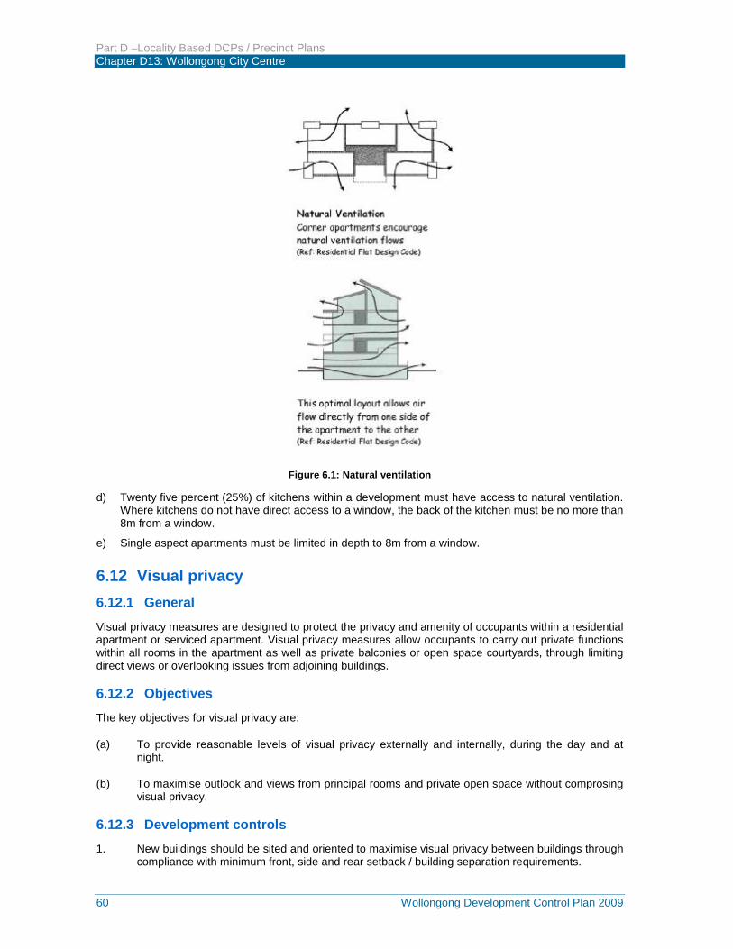
Part D –Locality Based DCPs / Precinct Plans Chapter D13: Wollongong City Centre
60 Wollongong Development Control Plan 2009
Figure 6.1: Natural ventilation d) Twenty five percent (25%) of kitchens within a development must have access to natural ventilation.
Where kitchens do not have direct access to a window, the back of the kitchen must be no more than 8m from a window.
e) Single aspect apartments must be limited in depth to 8m from a window.
6.12 Visual privacy 6.12.1 General
Visual privacy measures are designed to protect the privacy and amenity of occupants within a residential apartment or serviced apartment. Visual privacy measures allow occupants to carry out private functions within all rooms in the apartment as well as private balconies or open space courtyards, through limiting direct views or overlooking issues from adjoining buildings.
6.12.2 Objectives The key objectives for visual privacy are:
(a) To provide reasonable levels of visual privacy externally and internally, during the day and at night.
(b) To maximise outlook and views from principal rooms and private open space without comprosing visual privacy.
6.12.3 Development controls 1. New buildings should be sited and oriented to maximise visual privacy between buildings through
compliance with minimum front, side and rear setback / building separation requirements.
Part D –Locality Based DCPs / Precinct Plans Chapter D13: Wollongong City Centre
Wollongong Development Control Plan 2009 61
2. The internal layout of buildings should be designed to minimise any direct overlooking impacts occurring upon habitable rooms and private balcony / open space courtyards, wherever possible by separating communal open space and public domain areas from windows of rooms, particularly sleeping room and living room areas.
3. Buildings are to be designed to increase privacy without compromising access to sunlight and natural ventilation through the following measures:
(a) Off-setting of windows in new buildings from windows in existing adjoining building(s).
(b) Recessed balconies and / or vertical fin elements between adjoining balconies to improve visual privacy.
(c) Provision of solid, semi-solid or dark tinted glazed balustrading to balconies.
(d) Provision of louvers or screen panels to windows and / or balconies.
(e) Provision of perimeter landscaped screen / deep soil planting.
(f) Incorporating planter boxes onto apartment balconies to improve visual separation between apartments within the development and adjoining buildings.
(g) Provision of pergolas or shading devices to limit overlooking of lower apartments or private open space courtyards / balconies.
6.13 Acoustic Privacy Acoustic privacy is a measure of sound insulation between residential apartments and between external and internal spaces.
6.13.1 Objective
The main objective of acoustic privacy is to ensure a high level of amenity for occupants within residential apartments and / or serviced apartments in the development.
6.13.2 Development Controls
1. Residential apartments should be arranged in a mixed use building, to minimise noise transition between apartments by:
(a) Locating busy, noisy areas next to each other and quieter areas, next to other quieter areas (eg living rooms with living rooms and bedrooms with bedrooms);
(b) Using storage or circulation zones within an apartment to buffer noise from adjacent apartments, mechanical services or corridors and lobby areas; and
(c) Minimising the amount of party (shared) walls with other apartments.
2. All residential apartments within a mixed use development should be designed and constructed with double-glazed windows and / or laminated windows, solid walls, sealing of air gaps around doors and windows as well as insulating building elements for doors, walls, roofs and ceilings etc; to provide satisfactory acoustic privacy and amenity levels for occupants within the residential and / or serviced apartment(s).
3. Noise transmission from common corridors or outside the building is to be minimised by providing seals at entry doors.
4. In order to assist acoustic control of impact noise between units:
Part D –Locality Based DCPs / Precinct Plans Chapter D13: Wollongong City Centre
62 Wollongong Development Control Plan 2009
(a) A common wall shall have a Field Sound Transmission Class (FSTC) of not less than 50 if it separates;
(i) Sole occupancy units,
(ii) A sole occupancy unit from a plant room, stairway, public corridor, hallway or the like.
(b) A wall separating a bathroom, sanitary compartment, laundry or kitchen in one sole occupancy unit from a habitable room (other than a kitchen) in an adjoining unit, shall have an FSTC of not less than 55.
(c) A floor separating sole occupancy units must not have an FSTC less than 50.
5. In order to assist acoustic control of impact noise between units:
(a) A floor shall have an Impact Isolation Class (IIC) of not less than 50 if it separates;
(i) Habitable rooms of sole occupancy units
(ii) A sole occupancy unit from a plant room, stairway, public corridor, hallway or the like.
(b) A floor separating a bathroom, sanitary compartment, laundry or kitchen in one sole occupancy unit from a habitable room (other than a kitchen) in an adjoining unit, shall have an FSTC of not less than 55.
(c) Walls between sole occupancy units shall comply with the impact sound resistance standards specified in the BCA.
6. All residential buildings and serviced apartments are to be constructed so that the repeatable maximum L Aeq (1 hour) level not does exceed the following levels:
(a) In a naturally ventilated - windows closed condition:
(i) Sleeping areas (night time only: Hours - 2200-0700) - 35dB
(ii) Living areas (24 hours) - 45dB
(b) In a naturally ventilated - windows open condition, (ie, windows open up to 5% of the floor area, or attenuated natural ventilation open to 5% of the floor area):
(i) Sleeping areas (night time only: Hours - 2200-0700) - 45dB
(ii) Living areas (24 hours) - 55dB
(c) Where a naturally ventilated - windows open condition cannot be achieved, it is necessary to incorporate mechanical ventilation or air conditioning.
(d) The following repeatable maximum L Aeq (1 hour) levels shall not be exceeded when doors and windows are shut and mechanical ventilation or air conditioning is operating:
(i) Sleeping areas (night time only: Hours - 2200-0700) - 38dB
(ii) Living areas (24 hours) - 46dB
Note: These levels correspond to the combined measured level of external sources and the ventilation system operating normally.

Part D –Locality Based DCPs / Precinct Plans Chapter D13: Wollongong City Centre
Wollongong Development Control Plan 2009 63
7. The Statement of Environmental Effects (SEE) accompanying the development must demonstrate that the abovementioned noise criteria for windows to sleeping areas and living areas and Field Sound Transmission Class (FSTC) criteria for walls and floors have been met for each residential apartment or serviced apartment in the development through the provision of appropriate acoustic treatment measures. The proposed acoustic measures must also be shown on the required architectural floor layout and elevation plans for the development.
Alternatively, the Statement of Environmental Effects (SEE) may include an acoustical impact assessment study which outlines alternative acoustic treatment measures for any residential apartments and / or serviced apartments in the development. The acoustic impact assessment study must be carried out by a suitably qualified and experienced acoustic consultant (ie a person who is a Member of the Australian Acoustical Society, the Institution of Engineers or the Association of Australian Acoustical Consultants).
6.14 Storage 6.14.1 Objective
a) Provide accessible storage for larger household items which cannot be readily accommodated within dwellings.
6.14.2 Development Controls a) For residential apartment buildings provide a secure space to be set aside exclusively for storage as
part of the basement. The storage area must comply with the following requirements:
Dwelling Storage
Area
Storage
Volume
One bedroom apartments 3m2 3m3
Two bedroom apartments 4m2 8m3
Three or more bedroom apartments
5m2 10m3
7 PLANNING CONTROLS FOR SPECIAL AREAS The following controls are in addition to the general controls elsewhere in this part of the DCP. Controls for special areas apply to Heritage Conservation Areas and to special areas, including the Enterprise Corridor Zone, the Railway Precinct and the Civic and Cultural Precinct as identified in Figure 7.1.
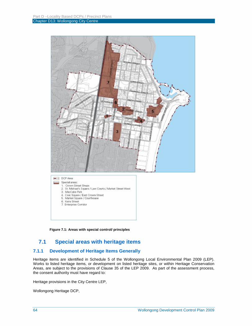
Part D –Locality Based DCPs / Precinct Plans Chapter D13: Wollongong City Centre
64 Wollongong Development Control Plan 2009
Figure 7.1: Areas with special control/ principles
7.1 Special areas with heritage items 7.1.1 Development of Heritage Items Generally
Heritage items are identified in Schedule 5 of the Wollongong Local Environmental Plan 2009 (LEP). Works to listed heritage items, or development on listed heritage sites, or within Heritage Conservation Areas, are subject to the provisions of Clause 35 of the LEP 2009. As part of the assessment process, the consent authority must have regard to:
Heritage provisions in the City Centre LEP,
Wollongong Heritage DCP,
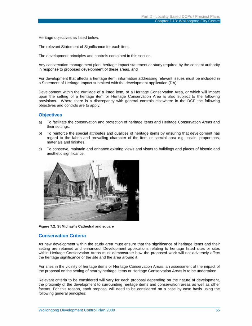
Part D –Locality Based DCPs / Precinct Plans Chapter D13: Wollongong City Centre
Wollongong Development Control Plan 2009 65
Heritage objectives as listed below,
The relevant Statement of Significance for each item,
The development principles and controls contained in this section,
Any conservation management plan, heritage impact statement or study required by the consent authority in response to proposed development of these areas, and
For development that affects a heritage item, information addressing relevant issues must be included in a Statement of Heritage Impact submitted with the development application (DA).
Development within the curtilage of a listed item, or a Heritage Conservation Area, or which will impact upon the setting of a heritage item or Heritage Conservation Area is also subject to the following provisions. Where there is a discrepancy with general controls elsewhere in the DCP the following objectives and controls are to apply.
Objectives a) To facilitate the conservation and protection of heritage items and Heritage Conservation Areas and
their settings.
b) To reinforce the special attributes and qualities of heritage items by ensuring that development has regard to the fabric and prevailing character of the item or special area e.g., scale, proportions, materials and finishes.
c) To conserve, maintain and enhance existing views and vistas to buildings and places of historic and aesthetic significance.
Figure 7.2: St Michael's Cathedral and square
Conservation Criteria
As new development within the study area must ensure that the significance of heritage items and their setting are retained and enhanced. Development applications relating to heritage listed sites or sites within Heritage Conservation Areas must demonstrate how the proposed work will not adversely affect the heritage significance of the site and the area around it.
For sites in the vicinity of heritage items or Heritage Conservation Areas, an assessment of the impact of the proposal on the setting of nearby heritage items or Heritage Conservation Areas is to be undertaken.
Relevant criteria to be considered will vary for each proposal depending on the nature of development, the proximity of the development to surrounding heritage items and conservation areas as well as other factors. For this reason, each proposal will need to be considered on a case by case basis using the following general principles:
Part D –Locality Based DCPs / Precinct Plans Chapter D13: Wollongong City Centre
66 Wollongong Development Control Plan 2009
a) Scale. The scale and bulk of any new building or work must be in scale with the original building and new development must not obstruct important views or vistas of the item. In the case of infill work in a conservation area, the scale of the new building must be similar to those around it. Where this is not feasible, sufficient curtilage around the heritage item must be included to assist interpretation of its heritage significance. In some circumstances, where site depth would allow, a higher building could be erected behind a heritage shopfront.
b) Siting. If the existing street façade of the building is sympathetic to the character of the street, then alteration must be avoided. New work is best located to the rear or side of the building.
c) Architectural form. The basic architectural form of any new work needs to respect what exists. Issues to consider are the roof form, proportion and location of windows and doors.
d) Architectural detailing. It is important to be aware of the particular era and architectural style of the building or buildings and make sure that any proposed changes are contextual to the period. For example, it is not appropriate to mix Victorian features with a California Bungalow. Overuse of historical architectural features on new work should be avoided, with preference given to uncomplicated interpretive forms and detailing.
e) Materials and finishes. Reuse existing materials where possible. New materials and detailing must be compatible with the original and consideration must be given to the colour, texture and type of materials and finishes.
f) Use. The best use for a building is usually the one for which it is built. Where this is not possible, a use sympathetic to the layout of the building and requiring minimal alterations will be more compatible.
g) Original fabric. It is important to minimise alterations to the original fabric and where possible, repair rather than replace individual elements, such as windows and doors.
h) The aging process. The patina of age on a building adds much to its character and significance. A worn step for example demonstrates the many years of feet crossing a threshold. Such features add to the uniqueness and character of a place and must be retained wherever this does not present a public safety risk.
i) Curtilage. There are three types of heritage curtilage:
i) Lot boundary. The lot boundary is the most common type of curtilage. It may contain associated buildings, gardens, walls, fences and the like which contribute to the significance of the property. The majority of built items in Wollongong are listed within their lot boundary curtilage.
ii) Reduced curtilage. This curtilage is less than the lot boundary of the property and it arises where the significance of the item and its interpretation is not dependant on having a large curtilage extending to a lot boundary. Examples are a large estate with sufficient land on the lot that can be subdivided independent of the heritage significance of any item on that land, or a new dwelling adjacent but not impacting on the existing heritage item on that land. In such cases, it is necessary to identify a curtilage that enables the heritage significance of the item to be retained, and
iii) Expanded curtilage. This curtilage is greater than the property boundary. An expanded curtilage may be required to protect that landscape setting or visual catchment of an item. For example, the significance of some properties includes a visual link between the property itself and a harbour, river or topographical feature.
j) Infill development. The key to successful infill development adjacent to a heritage item is reflected in design where the infill is of similar mass and character to the adjacent heritage building/s. This may comprise use of the vertical (versus square) windows, verandas, balconies, positive roof pitches (i.e. 25 to 35 degrees) and general façade detailing. Buildings and landscaping may establish a character of an area and provide a sense of continuity and recognised community value. Unsympathetic infill will disrupt the unity of a group of buildings and may spoil the existing character. Architectural ‘good manners’ are important in areas of special character. An infill building must not precisely imitate its neighbour but use recognisable tools such as massing, scale, setback and orientation, detailing and materials, roof forms and coursing lines to complement adjacent heritage items.
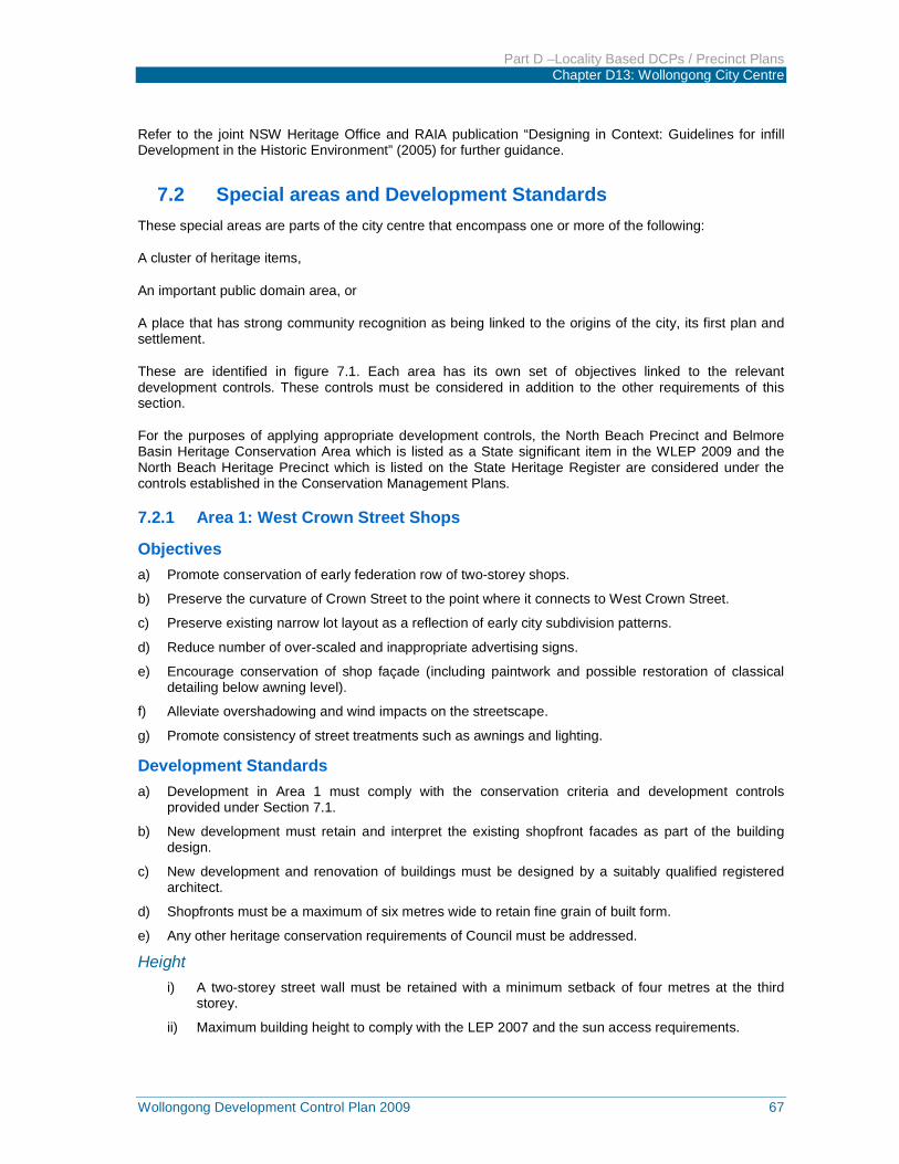
Part D –Locality Based DCPs / Precinct Plans Chapter D13: Wollongong City Centre
Wollongong Development Control Plan 2009 67
Refer to the joint NSW Heritage Office and RAIA publication “Designing in Context: Guidelines for infill Development in the Historic Environment” (2005) for further guidance.
7.2 Special areas and Development Standards These special areas are parts of the city centre that encompass one or more of the following:
A cluster of heritage items,
An important public domain area, or
A place that has strong community recognition as being linked to the origins of the city, its first plan and settlement.
These are identified in figure 7.1. Each area has its own set of objectives linked to the relevant development controls. These controls must be considered in addition to the other requirements of this section.
For the purposes of applying appropriate development controls, the North Beach Precinct and Belmore Basin Heritage Conservation Area which is listed as a State significant item in the WLEP 2009 and the North Beach Heritage Precinct which is listed on the State Heritage Register are considered under the controls established in the Conservation Management Plans.
7.2.1 Area 1: West Crown Street Shops
Objectives a) Promote conservation of early federation row of two-storey shops.
b) Preserve the curvature of Crown Street to the point where it connects to West Crown Street.
c) Preserve existing narrow lot layout as a reflection of early city subdivision patterns.
d) Reduce number of over-scaled and inappropriate advertising signs.
e) Encourage conservation of shop façade (including paintwork and possible restoration of classical detailing below awning level).
f) Alleviate overshadowing and wind impacts on the streetscape.
g) Promote consistency of street treatments such as awnings and lighting.
Development Standards a) Development in Area 1 must comply with the conservation criteria and development controls
provided under Section 7.1.
b) New development must retain and interpret the existing shopfront facades as part of the building design.
c) New development and renovation of buildings must be designed by a suitably qualified registered architect.
d) Shopfronts must be a maximum of six metres wide to retain fine grain of built form.
e) Any other heritage conservation requirements of Council must be addressed.
Height i) A two-storey street wall must be retained with a minimum setback of four metres at the third
storey.
ii) Maximum building height to comply with the LEP 2007 and the sun access requirements.
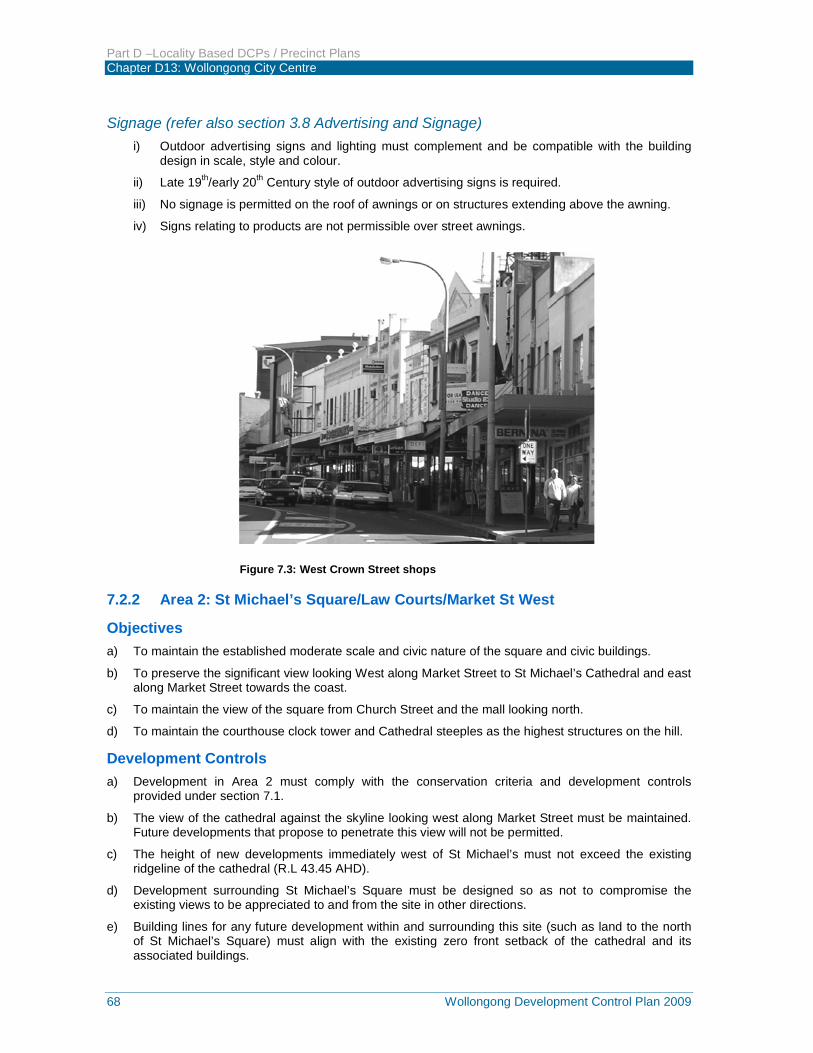
Part D –Locality Based DCPs / Precinct Plans Chapter D13: Wollongong City Centre
68 Wollongong Development Control Plan 2009
Signage (refer also section 3.8 Advertising and Signage) i) Outdoor advertising signs and lighting must complement and be compatible with the building
design in scale, style and colour.
ii) Late 19th/early 20th Century style of outdoor advertising signs is required.
iii) No signage is permitted on the roof of awnings or on structures extending above the awning.
iv) Signs relating to products are not permissible over street awnings.
Figure 7.3: West Crown Street shops
7.2.2 Area 2: St Michael’s Square/Law Courts/Market St West
Objectives a) To maintain the established moderate scale and civic nature of the square and civic buildings.
b) To preserve the significant view looking West along Market Street to St Michael’s Cathedral and east along Market Street towards the coast.
c) To maintain the view of the square from Church Street and the mall looking north.
d) To maintain the courthouse clock tower and Cathedral steeples as the highest structures on the hill.
Development Controls a) Development in Area 2 must comply with the conservation criteria and development controls
provided under section 7.1.
b) The view of the cathedral against the skyline looking west along Market Street must be maintained. Future developments that propose to penetrate this view will not be permitted.
c) The height of new developments immediately west of St Michael’s must not exceed the existing ridgeline of the cathedral (R.L 43.45 AHD).
d) Development surrounding St Michael’s Square must be designed so as not to compromise the existing views to be appreciated to and from the site in other directions.
e) Building lines for any future development within and surrounding this site (such as land to the north of St Michael’s Square) must align with the existing zero front setback of the cathedral and its associated buildings.
Part D –Locality Based DCPs / Precinct Plans Chapter D13: Wollongong City Centre
Wollongong Development Control Plan 2009 69
f) Four metre front setback to all new development fronting Market Street east of St Michael’s Church.
g) New development and renovation of buildings must be designed by a suitability qualified registered architect.
h) Shopfronts must be a maximum of six metres wide to retain fine grain of built form.
7.2.3 Area 3: MacCabe Park
Objectives a) To enhance the spatial definition of the edges of MacCabe Park.
b) To encourage a high level of daylight access to the public domain.
c) To promote passive surveillance and greater utilisation of the park.
d) To promote active and passive recreation opportunities.
Development Controls a) Development in Area 3 must comply with the conservation criteria and development controls
provided under section 7.1
b) Any development surrounding the park must comply with the street edge height requirements shown in sun access diagrams in Figure 2.17 of this DCP.
c) Any development of MacCabe Park must be in accordance with a plan of management for the park.
Figure 7.4: View looking along Market Street to St. Michal's Cathedral
7.2.4 Area 4: East Crown Street
Objectives a) To consolidate the remaining heritage character along east Crown Street between Kembla and
Corrimal Streets.
b) To promote appropriate and pleasant spatial links between the railway station and the foreshore.
c) To alleviate overshadowing and undesirable wind action on prominent public and private open spaces.
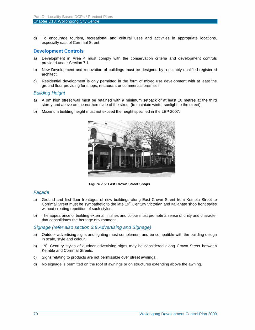
Part D –Locality Based DCPs / Precinct Plans Chapter D13: Wollongong City Centre
70 Wollongong Development Control Plan 2009
d) To encourage tourism, recreational and cultural uses and activities in appropriate locations, especially east of Corrimal Street.
Development Controls a) Development in Area 4 must comply with the conservation criteria and development controls
provided under Section 7.1.
b) New Development and renovation of buildings must be designed by a suitably qualified registered architect.
c) Residential development is only permitted in the form of mixed use development with at least the ground floor providing for shops, restaurant or commercial premises.
Building Height a) A 9m high street wall must be retained with a minimum setback of at least 10 metres at the third
storey and above on the northern side of the street (to maintain winter sunlight to the street).
b) Maximum building height must not exceed the height specified in the LEP 2007.
Figure 7.5: East Crown Street Shops
Façade a) Ground and first floor frontages of new buildings along East Crown Street from Kembla Street to
Corrimal Street must be sympathetic to the late 19th Century Victorian and Italianate shop front styles without creating repetition of such styles.
b) The appearance of building external finishes and colour must promote a sense of unity and character that consolidates the heritage environment.
Signage (refer also section 3.8 Advertising and Signage) a) Outdoor advertising signs and lighting must complement and be compatible with the building design
in scale, style and colour.
b) 19th Century styles of outdoor advertising signs may be considered along Crown Street between Kembla and Corrimal Streets.
c) Signs relating to products are not permissible over street awnings.
d) No signage is permitted on the roof of awnings or on structures extending above the awning.
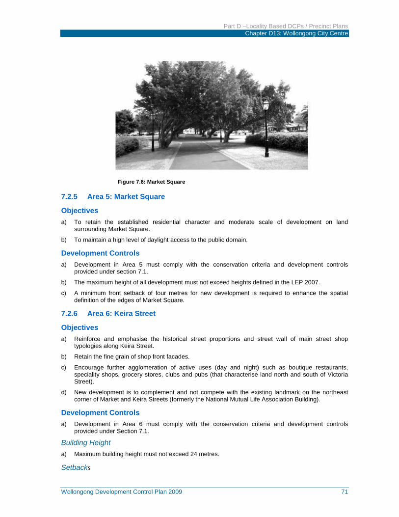
Part D –Locality Based DCPs / Precinct Plans Chapter D13: Wollongong City Centre
Wollongong Development Control Plan 2009 71
Figure 7.6: Market Square
7.2.5 Area 5: Market Square
Objectives a) To retain the established residential character and moderate scale of development on land
surrounding Market Square.
b) To maintain a high level of daylight access to the public domain.
Development Controls a) Development in Area 5 must comply with the conservation criteria and development controls
provided under section 7.1.
b) The maximum height of all development must not exceed heights defined in the LEP 2007.
c) A minimum front setback of four metres for new development is required to enhance the spatial definition of the edges of Market Square.
7.2.6 Area 6: Keira Street
Objectives a) Reinforce and emphasise the historical street proportions and street wall of main street shop
typologies along Keira Street.
b) Retain the fine grain of shop front facades.
c) Encourage further agglomeration of active uses (day and night) such as boutique restaurants, speciality shops, grocery stores, clubs and pubs (that characterise land north and south of Victoria Street).
d) New development is to complement and not compete with the existing landmark on the northeast corner of Market and Keira Streets (formerly the National Mutual Life Association Building).
Development Controls a) Development in Area 6 must comply with the conservation criteria and development controls
provided under Section 7.1.
Building Height a) Maximum building height must not exceed 24 metres.
Setbacks
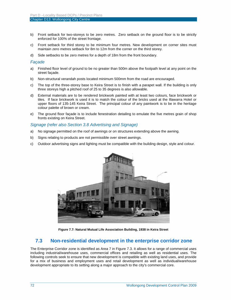
Part D –Locality Based DCPs / Precinct Plans Chapter D13: Wollongong City Centre
72 Wollongong Development Control Plan 2009
b) Front setback for two-storeys to be zero metres. Zero setback on the ground floor is to be strictly enforced for 100% of the street frontage.
c) Front setback for third storey to be minimum four metres. New development on corner sites must maintain zero metres setback for 8m to 12m from the corner on the third storey.
d) Side setbacks to be zero metres for a depth of 18m from the front boundary.
Façade a) Finished floor level of ground to be no greater than 500m above the footpath level at any point on the
street façade.
b) Non-structural verandah posts located minimum 500mm from the road are encouraged.
c) The top of the three-storey base to Keira Street is to finish with a parapet wall. If the building is only three storeys high a pitched roof of 25 to 35 degrees is also allowable.
d) External materials are to be rendered brickwork painted with at least two colours, face brickwork or tiles. If face brickwork is used it is to match the colour of the bricks used at the Illawarra Hotel or upper floors of 135-145 Keira Street. The principal colour of any paintwork is to be in the heritage colour palette of brown or cream.
e) The ground floor façade is to include fenestration detailing to emulate the five metres grain of shop fronts existing on Keira Street.
Signage (refer also Section 3.8 Advertising and Signage) a) No signage permitted on the roof of awnings or on structures extending above the awning.
b) Signs relating to products are not permissible over street awnings.
c) Outdoor advertising signs and lighting must be compatible with the building design, style and colour.
Figure 7.7: Natural Mutual Life Association Building, 1938 in Keira Street
7.3 Non-residential development in the enterprise corridor zone The Enterprise Corridor zone is identified as Area 7 in Figure 7.3. It allows for a range of commercial uses including industrial/warehouse uses, commercial offices and retailing as well as residential uses. The following controls seek to ensure that new development is compatible with existing land uses, and provide for a mix of business and employment uses and retail development as well as individual/warehouse development appropriate to its setting along a major approach to the city’s commercial core.
Part D –Locality Based DCPs / Precinct Plans Chapter D13: Wollongong City Centre
Wollongong Development Control Plan 2009 73
The following controls apply to all non-residential development and are in addition to controls elsewhere in this part of the DCP. Where the controls in this section differ (except in relation to residential development), they shall override the requirement elsewhere in this part of the DCP.
7.3.1 Objectives a) To ensure that new development is compatible with surrounding land uses.
b) To promote streets with pedestrian activity, amenity and safety.
c) To promote high quality well designed buildings.
d) To provide for buildings fronting the street and legible street addresses and access.
e) To ensure that high quality materials and finishes are used for buildings and the public domain.
f) To provide for infiltration of stormwater below the ground surface and reduce stormwater runoff.
g) To improve pedestrian and vehicle access and connections within the zone and with the city centre.
h) To minimise and control vehicle access off Flinders Street (Princes Highway).
i) To promote Flinders Street as a ‘boulevard’ providing a gateway entrance to the commercial core.
j) To ensure that new development has appropriate access.
k) To discourage subdivisions of land into small lots without a detailed plan.
7.3.2 Development Controls
Land use a) In determining a development application, Council is to consider the suitability of proposed
development in terms of its compatibility with existing development and impact on the amenity of surrounding properties relating to noise, vibration, odour, fumes, smoke, dust, waste and light spillage.
b) Preferred areas for residential and mixed development are in 400m radius of North Wollongong Railway Station, to the eastern side of the area, abutting the general residential zone, and near open space areas (refer figure 7A).
c) Preferred areas for commercial, retail and enterprise uses are fronting Flinders Street and on the southern part of the zone away from open space.
d) Commercial office uses and retail uses in new mixed use development are to be located at ground level addressing the street frontage.
Building form a) Buildings are to front the street and provide a clear street address.
b) Buildings are to present legible vehicle and pedestrian access points.
c) Servicing areas and mechanical/electrical plants are to be screened from view from the public domain.
d) A maximum of two advertising signs is allowed per building. Each sign is to relate to the use of the building. Refer to Section 3.7 of this part of the DCP for further controls and guidelines for signs.
Landscaping a) Front building setbacks, including any car parking areas, are to include landscaping.
b) Use existing and new drainage lines and channels for landscaped open space and stormwater management measures such as detention.
c) No fences are to be provided on street frontages.

Part D –Locality Based DCPs / Precinct Plans Chapter D13: Wollongong City Centre
74 Wollongong Development Control Plan 2009
Access, road connections and parking a) Vehicle and pedestrian access points are to be clear and legible.
b) Driveways should be located more than 6m from an intersection or break in median strip, 25m from traffic lights and 1.5m to side boundaries.
c) Car parking for commercial office and retail buildings, service areas and storage yards are to be located to the rear of buildings in basements – not on the street frontage.
d) Industrial/warehouse buildings may have some car parking located in the front street setback subject to being integrated with approved landscaping.
Subdivision a) The minimum site area for subdivision that is not part of a development application for building
envelopes is 1,000 square metres.
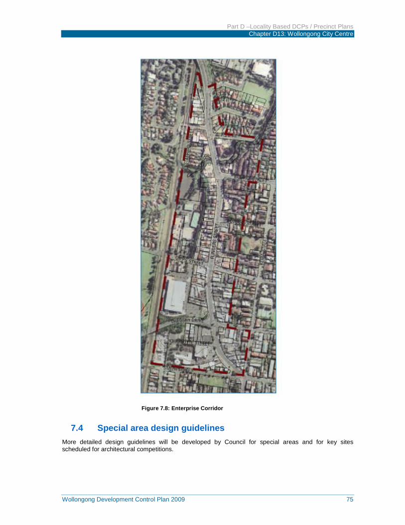
Part D –Locality Based DCPs / Precinct Plans Chapter D13: Wollongong City Centre
Wollongong Development Control Plan 2009 75
Figure 7.8: Enterprise Corridor
7.4 Special area design guidelines More detailed design guidelines will be developed by Council for special areas and for key sites scheduled for architectural competitions.
Part D –Locality Based DCPs / Precinct Plans Chapter D13: Wollongong City Centre
76 Wollongong Development Control Plan 2009
7.5 Design excellence 7.5.1 Design Review Panel 1. Any Development Application for land within the Wollongong City Centre for a development
proposal involving a height of 35 metres or more and / or having a capital value of more than $1,000,000 on a key site (ie being a site shown edged heavy black and distinctively coloured on the Key Sites Map in Wollongong Local Environmental Plan 2009) will be referred to the Design Review Panel for appropriate assessment, prior to determination of the application.
2. The Design Review Panel will also consider any Development Application for land within the Wollongong City Centre, where an applicant wishes architectural design advice on their development proposal, prior to determination of the application.
3. The Design Review Panel will consider applications at the pre-lodgement stage, in order to provide upfront design advice prior to the formal lodgement of the Development Application.
4. The Design Review Panel will consider whether the development exhibits design excellence and will have regard to the following matters:
(a) Whether a high standard of architectural design, materials and detailing appropriate to the building type and location will be achieved,
(b) Whether the form and external appearance of the proposed development will improve the quality and amenity of the public domain,
(c) Whether the proposed development detrimentally impacts on view corridors,
(d) Whether the proposed development detrimentally overshadows an area shown on the Sun Plane Protection Map in Wollongong Local Environmental Plan 2009 and taking into account the sun access diagram requirements under clause 2.10 in this chapter of the DCP,
(e) How the proposed development addresses the following matters:
(i) The suitability of the land for development,
(ii) Existing and proposed uses and use mix,
(iii) Heritage issues and streetscape constraints,
(iv) The location of any tower proposed, having regard to the need to achieve an acceptable relationship with other towers (existing or proposed) on the same site or on neighbouring sites in terms of separation, setbacks, amenity and urban form,
(v) Bulk, massing and modulation of buildings,
(vi) Street frontage heights,
(vii) Environmental impacts such as sustainable design, overshadowing, wind and reflectivity,
(viii) The achievement of the principles of ecologically sustainable development,
(ix) Pedestrian, cycle, vehicular and service access, circulation and requirements,
(x) Impact on, and any proposed improvements to the public domain.
Part D –Locality Based DCPs / Precinct Plans Chapter D13: Wollongong City Centre
Wollongong Development Control Plan 2009 77
8 WORKS IN THE PUBLIC DOMAIN Any development requiring works to be carried out within the public domain in the Wollongong City Centre will be subject to compliance with the requirements of the Wollongong City Centre Public Domain Technical Manual at Appendix 2 to this DCP and any other specific Council requirements.
Part D –Locality Based DCPs / Precinct Plans Chapter D13: Wollongong City Centre
78 Wollongong Development Control Plan 2009
9 GLOSSARY / DEFINITIONS Above awning sign
A projecting sign on top of an awning.
Awning
An awning is a predominantly horizontal structure that projects over a footpath from the host building to provide weather protection for pedestrians.
Awning fascia sign
A sign on the fascia of an awning or verandah.
Fascia sign
A sign on the fascia of an existing awning or verandah.
Habitable room Any room or area used for normal domestic activities, including living, dining, family, lounge, bedrooms, study, kitchen, sun room and play room.
Identification sign
A sign used to identify a site, building, building use or tenant.
Illuminated sign A sign which is internally or externally lit by artificial lighting whether that lighting is integral to or separate from the sign, including signs that have flashing or sequenced lighting, spotlighting, directional, projected or laser lighting.
Lane
An external space which is uncovered and open to the sky and which provides permanent pedestrian and/or vehicle connections through the city fabric at all hours.
Through site link
An enclosed or partly enclosed arcade within a development that has a public character, provides right of way and is open and accessible at each end.
Non-habitable room
Spaces of a specialised nature not occupied frequently or for extended periods, including bathrooms, toilets, pantries, walk-in wardrobes, corridors, lobbies, photographic darkrooms and clothes drying rooms.
Porte cochere
A porch, often used in hotel development, large enough for vehicles such as tourist coaches to pass through.
Projecting wall sign A sign projecting in either a horizontal or vertical direction from the wall of a building.

Part D –Locality Based DCPs / Precinct Plans Chapter D13: Wollongong City Centre
Wollongong Development Control Plan 2009 79
Promotional sign
A sign on land or a building that advertises either:
Goods or services not provided by an occupier of a significant portion of the premises on which the sign is attached, or
An event or activity not conducted on the land or in the building.
Roof sign A sign above parapet level of a building on the uppermost structural elements and attached to lift motor and plant rooms.
Silhouette
A building outline viewed against the sky.
Street alignment The boundary between land allotments and a street or lane.
Street frontage height The vertical distance measured in metres at the centre of the street frontage from the average of the street levels at each end of the frontage to the parapet level of the frontage. The parapet level is the horizontal plane in which at least two thirds of the length of the top of the façade is situated. No part of the façade is to be less than 80 per cent of the height.
Under awning sign
A sign located below or otherwise supported from the underside of an awning.
View
An extensive or long range prospect of particular objects or geographic features.
Vista
A view along a street terminated by a building or structure such as an obelisk.